
Bloomingdale City Zoning Code
ARTICLE IV
GENERAL PROVISIONS
Sec. 400.- Use of land or buildings.
The regulations set by this ordinance within each district shall be the minimum regulations and shall apply uniformly to each class or kind of structure or land, except as hereinafter provided.
(400.1) No land or buildings shall hereinafter be used or occupied, and no building or parts shall hereafter be constructed, erected, altered, or moved, unless in conformity with all of the regulations herein specified for the district in which it is located.
(400.2) No building or other structure shall hereafter be erected or altered:
(a)
To exceed the original size or bulk.
(b)
To accommodate or house a greater number of families.
(c)
To occupy a greater percentage of lot area.
(d)
To have narrower or smaller rear yards, front yards, side yards, or other open spaces than herein required; or in any other manner contrary to the provisions of this ordinance.
(400.3) No part of a yard, or other space, or off-street parking or loading required about or in connection with any building for the purpose of complying with this ordinance, shall be included as part of a yard, open space, or off-street parking or loading space similarly required for any other building.
Sec. 401. - Lot reduction prohibited.
No yard or lot existing at the time of passage of this ordinance shall be reduced in dimension or area below the minimum requirements set forth herein. Yards or lots created after the effective date of this ordinance [shall conform hereto].
Sec. 402. - Public street frontage.
No building shall be erected on a lot which does not abut for at least 25 feet on a public street.
Sec. 403. - One principal building on a lot.
Only one principal building and its customary accessory building may hereafter be erected on any one lot.
Sec. 404. - Planted buffer strips.
Where commercial or industrial districts abut residential districts, a ten-foot wide planted buffer strip shall be provided along the abutting property lines, and the ten feet shall be added to the side or rear yard requirements as well as the lot width unless specified in the ordinance.
Sec. 405. - Vision clearance.
In all districts no fence, wall, shrubbery, or other obstruction to vision between the heights of two and a half feet and ten feet above the finished grade of streets shall be erected, permitted, or maintained within 20 feet of the intersection of the right-of-way lines of streets or of streets and railroads.
Sec. 406. - Corner lots.
On lots having frontage on more than one street at an intersection, the minimum front yard requirement may be reduced to one-half the regulated distance on the portion of the lot fronting on the street or streets of less importance. However, in no case shall the setback be reduced to less than 15 feet. The minimum front yard for the portion of the lot fronting on the street of greater importance shall be provided in accordance with the provisions established by this ordinance for the district in which the lot is located.
Sec. 407. - Double frontage lots.
On lots having frontage on two streets, but not located on a corner, the minimum front yard shall be provided on each street in accordance with the provisions of this ordinance. On lots having frontage on more than two streets, the minimum front yard shall be provided in accordance with the regulations set forth in this ordinance on at least two of the street frontages.
Sec. 408. - Front yard requirements.
The setback requirements of this ordinance shall not apply to any lot where the average setback on already built upon lots located wholly or in part within 100 feet on each side of such lot and within the block and zoning district and fronting on the same street as such lot is less than the minimum required setback. In such cases, the setback of such a lot may be less than the requirement setback but not less than the average of the existing setbacks on the developed lots. However, in no case shall setbacks be less than 15 feet.
Sec. 409. - Code requirements.
All structures shall meet the requirements of all adopted codes in effect including, but not limited to, [the] building code, fire prevention code, and housing code. Where such codes exceed the minimum requirements of this ordinance, the stricter provisions shall apply.
Sec. 410. - Site plans required for property contiguous to property with a more restrictive zoning classification or abutting or fronting onto arterial or collector streets.
(a)
General. Before a building permit is issued for the development of a site which either (1) is contiguous to property with a more restrictive zoning classification or (2) fronts onto or abuts a street classified as an arterial or collector under the provisions of article IX, Code section 900, of Bloomingdale's Subdivision Ordinance, site plans similar to those required for planned unit developments by Code section 1004 of the Zoning Ordinance shall be submitted for review and approval by the planning commission. For purposes of interpreting this Code section, contiguous properties would include properties which do not directly abut each other, but would directly abut each other if not separated by the width of (1) any street or street right-of-way, (2) any creek or river, or (3) any right-of-way of a railroad or other public service corporation. The site plans to be submitted shall show adjacent property, including property lying across any adjacent street; the proposed traffic and pedestrian circulation; the location, type and dimension of buffer areas; the arrangement and types of uses; dedications and reservation of lands, setbacks, permanent open spaces, and protective covenants that apply; hours of operation (where applicable); and such other plan elements, design standards, and controls as may be deemed reasonably necessary by the planning commission to accomplish the purposes of the city's zoning code. The plans shall also include a facade elevation plan which must indicate that the structure to be placed on the site in question will be visually compatible with adjacent or surrounding development in terms of the following:
(1)
Building orientation and scale.
(2)
Exterior construction materials, including texture and color.
(3)
Roof shape, window and door openings, porches and balconies.
(4)
Fences, landscaping and buffers.
(5)
Driveway and parking orientation, in keeping with the established character in the area.
(6)
The architectural style or structure and the facade architectural treatment.
(7)
Scale, design and location of exterior signs. Special sign restrictions may be required based on the location and character of the development and surrounding area.
When such plans have been approved, they shall be certified to the city administrator by the chairman of the planning commission. Building permits shall be issued only for improvements and developments on the site which conform to the approved plans. Until such plans have been so certified, the site shall not be cleared or graded.
(b)
Exceptions. One- and two-family dwellings shall be exempted from the review procedures of this section; provided that where such development is subject to review under provisions contained elsewhere in the city's Code, such other review provisions shall not be waived.
(Ord. of 6-18-1998(3))
Sec. 411. - Planned development overlay district (PDOD).
(a)
Planned development overlay district (PDOD) requirements. Approval for development within a PDOD consists of a two-step process. A general development plan is required for review and approval during the rezoning process to inform the planning commission and city council of the intended development. Following approval of the general development plan, a specific development plan shall be submitted and approved prior to any development, including clearing, grading or subdivision.
(1)
General development plan required.
a.
Any petition to create a planned development overlay district submitted hereafter shall be accompanied by a general development plan as set forth herein.
b.
The general development plan shall include development design(s), total floor area of the primary land uses, residential dwelling unit density, if applicable, land uses, buffers and screening, hours of operation and other items as may be required by the mayor and council. All future development shall be consistent with the approved general development plan.
c.
Such plans shall promote an environment of stable and desirable character in harmony with the established or proposed land use pattern in surrounding areas.
(2)
Finding of unusual or extraordinary conditions.
a.
When the planning commission finds, in conjunction with a petition to rezone any property, that there are unusual or extraordinary conditions, circumstances or concerns which warrant consideration by the mayor and council, the planning commission shall submit the general development plan along with its recommendations to the mayor and council for consideration and approval as part of the rezoning action.
b.
Where the planning commission finds, in conjunction with a proposal for the creation of a PDOD initiated by the planning commission or the mayor and council, that there are unusual or extraordinary conditions, circumstances or concerns which affect the site in question and which warrant consideration by the mayor and council, the planning commission may recommend design standards and controls for the affected properties which, if approved by the mayor and council, shall be incorporated into any general development plan for the site(s) in question.
c.
Upon approval of the general plan by the mayor and council, such plan shall constitute the approved land use for the site. Any change in land use which is not consistent with the approved general development plan shall be resubmitted in the same manner as the original general development plan and shall require review and recommendation by the planning commission and review and approval by the mayor and council.
d.
Any special design standards or special conditions adopted by the mayor and council at the time of rezoning shall become a part of the approved general development plan and shall apply until a subsequent site plan is submitted and approved by the mayor and council in accordance with article XIV, amendments.
e.
No development shall occur until approval of the specific development plan has been submitted and approved. However, if the applicant can demonstrate that there are unusual or extraordinary conditions, circumstances or concerns which warrant consideration by the mayor and council, the applicant may petition to receive a land disturbance activity (LDA) permit prior to approval of the specific development plan. Such petition shall be reviewed and approved by mayor and council prior to any development activity.
(3)
Planning commission initiation of PDOD rezoning. The planning commission may, on its own motion, recommend approval of a PDOD. If such recommendation is approved by the mayor and council, the developer(s) shall be required to conform to the requirements as specified herein.
(b)
General development plan. The general development plan for a proposed PDOD shall show adjacent property, including property lying across any adjacent street, the proposed traffic and pedestrian circulation; the location, type and dimension of buffer areas; the arrangement and types of uses including the square footage (total gross floor area) and acreage of each use(s) (i.e., type retail sales, offices, industrial, warehousing, etc.) and such other plan elements and reasonable design criteria as may be deemed necessary by the planning commission to accomplish the purposes of the zoning program.
(1)
Standards. Roadway capacity issues, orientation of buildings, buffers and screening, outdoor storage, hours of operations, exterior sound systems, and lighting issues shall be regulated under a PDOD to enhance the purposes and intent of the Bloomingdale zoning program as follows:
a.
Roadway capacity. When a PDOD abuts an arterial or collector street, the developer of the land in such district shall provide, construct, and install such improvements as the planning commission may recommend and the mayor and council may require, as appropriate, to offset reductions in the traffic capacity of the streets that will be caused by access into and egress from the development within the PDOD. Required improvements may include but not be limited to the installation of a frontage road, installation of street medians to control left turning movements into and out of the development, installation of turning lanes, traffic signal installations, or other traffic flow protective measures.
b.
Garages and bays. Where any nonresidential structure within this district contains four or more garages or bays, it shall not be oriented towards a single public right-of-way, a residential zoning district, or an existing residential use. However, if the mayor and council, upon a recommendation by the planning commission, determines that such structures are visually compatible with the surrounding land uses after reviewing the development plan in accordance with this section, the garages and bays within such structure shall be allowed to be oriented towards a single public right-of-way but not toward a residential zoning district or any existing residential use unless found to be totally separated and physically screened from the view of any residential property or zoning district allowing residential uses.
c.
Visual buffer and screening. Visual buffers and screening for any development within a PDOD shall be installed in accordance with the requirements established by the mayor and council, upon a recommendation from the planning commission, to protect the adjoining property values and privacy. However, such buffer and screening element shall not be less than the screening standards of section 404, planted buffer strips, herein.
d.
Storage. Except where otherwise provided in this zoning ordinance, all storage shall occur within an enclosed building. However, outdoor storage shall not be visible from any adjacent zoning district that does not allow outdoor storage nor from any public right-of-way.
e.
Hours of operation. Nonresidential activities located adjacent to, across a utility or street right-of-way from, or otherwise in close proximity to residential properties or zoning districts that allow residential uses may be restricted to the hours of operation the use is open for business or for other activities including deliveries. Where it is felt necessary by the mayor and council to protect the character and livability of the residential neighborhoods, such hours may be limited as a condition of the approval of the specific development plan.
f.
Exterior lighting and noise sources. All exterior lighting or visible lighting fixtures shall be downlit and glare shall be deflected, shaded and focused away from adjacent property and public rights-of-way, but may be of sufficient intensity to discourage vandalism and theft. Any noises or sounds generated on the site may be regulated to protect the character of the adjoining areas. The sound intensity level and/or duration may be restricted by the mayor and council to prevent the sounds from extending across property lines, especially during the evening hours or when the use is adjacent to, or in the vicinity of, noise sensitive land use activities.
(c)
Specific development plan. Following approval of the general development plan by the mayor and council, no development shall take place until specific development plans (or subdivision plats, where required) shall have been submitted for review and are approved, as follows:
(1)
Where the general development plan has been approved by the mayor and council, the developer or his successor in title shall submit to the planning commission a plat that meets the requirements of the approved general site plan. The planning commission shall review the specific development plan and make a recommendation to the mayor and council for its action. The plat shall be in compliance with the approved general land use plan for the entire development site, or for the specific phase in question, including all off-site improvements, location and dimensions of buffers and easements, dedications and reservations of lands, setbacks, permanent open spaces, protective covenants that apply, other conditions for development as approved by the mayor and council, and the signature of all owners of land shown on the plat. Upon a finding by the mayor and council that the plat is consistent with the approved general plan, they shall approve the specific plat and shall record (at the expense of the developer or property owner) the plat with the clerk of council and the clerk of the superior court of Chatham County. The property owner/developer shall be provided a copy of the recording data, including a copy of the certified approved specific development plan or plat. No development shall occur which is not shown on the approved specific development plat.
(2)
Specific development plans shall include a plat of the site showing adjacent property, including property lying across any right-of-way or access way and shall indicate in detail the layout of proposed streets and curb cuts; parking areas; amenities such as open spaces, landscapes and buffer areas; pedestrian and bicycle trails; major drainage ways; school locations; church locations; locations of public facilities; building arrangements; commercial areas; lotting arrangements; and other significant details as may be reasonably recommended by the planning commission and/or required by the mayor and council.
(3)
Specific development plans or plats shall also identify measures to be taken to preserve the traffic capacity of abutting streets as recommended by the planning commission and/or required by the mayor and council. The construction or installation of such protective measures where required by the mayor and council shall be the responsibility of the developer and may include but not be limited to provisions for frontage roads, construction of street medians to control conflicting turning movements, channelization of traffic, intersection improvements, etc.
(4)
A facade elevation plan for any proposed structure shall be submitted with the specific development plan or plat. Such structure(s) shall be visually compatible with adjacent or surrounding development in terms of the conditions of section 410 herein.
(5)
Specific development plans or plats approved by the mayor and council shall be certified by the city clerk and submitted to the building inspector for the issuance of applicable permits. Developments requiring subdivision actions shall be processed in accordance with the provisions of the City of Bloomingdale subdivision regulations. No development shall take place within a PDOD that is not shown on a certified specific development plan or plat without special approval by city council, as described above [in subsection] (a)(2)e.
(6)
If property within a PDOD zone is to be developed in phases, specific development plans may be submitted in phases.
(d)
Variances. Development standards shall be applied as provided elsewhere in this chapter for the particular zoning district. All variances approved by the mayor and council as part of a general development plan shall be noted on the specific development plan or plat. Variances from the requirements of this chapter may be approved at the request of the developer on a finding that such variances would:
(1)
Be in keeping with the overall character of the area.
(2)
Would not be contrary to the purpose and intent of this chapter.
(3)
Would not be detrimental to existing or proposed surrounding uses.
(4)
Would serve the public purposes to a degree equal to or greater than the standards replaced.
(e)
Overlay district. When an area is rezoned to a PDOD classification, the letter "P" shall be placed in front of the standard zoning classification identification for the area in question (e.g., an area zoned N-C which is rezoned to a PDOD classification shall be indicated as P-N-C).
(f)
Tree conservation plan. Within a PDOD, a tree conservation plan shall indicate areas of existing tree cover to be retained and areas proposed for removal. All trees of greater than six inches DBH (diameter at breast height, or four feet above the base of the tree) shall be identified, unless located in a cluster of ten or more trees to be saved, and shown on the specific development plan or plat. All trees in buffer or screening areas shall be maintained on the site unless specifically approved to be removed and so noted on the approved specific development plan or plat. The mayor and council shall approve a tree conservation plan upon a finding that the tree cover proposed to be removed is:
(1)
Necessary to accomplish the development plan in a logical manner; and/or
(2)
Required in connection with the execution of the approved development plan and will result in sufficient damage to a specific tree or group of trees, as certified by a registered arborist or landscape architect, to cause its (their) eventual destruction within a short period of time upon the completion of the project. A short period shall be defined herein to be a time lapse of less than five years from the phase of construction impacting the tree(s);
(3)
Not located in a required buffer area and would not be needed to help screen the proposed site development from adjoining properties.
(g)
No development activity to occur until specific development plan or plat is approved. No property within a PDOD shall be cleared or subdivided until after a specific development plan or plat has been approved as provided for herein, as described above [in subsection] (a)(2)e. Following approval of a specific development plan, all clearing and subdivision activity shall be consistent with the approved plan.
(Ord. of 2-6-2003(2), § 3(411); Ord. of 9-20-2007)
Sec. 450. - Highway 80 Corridor Overlay District.
[450.01]
Purpose and findings. The purpose of this overlay district is to maintain Bloomingdale's character as the city accommodates new growth. The corridor included in this overlay district serves as a gateway into the city and therefore the appearance and function of this corridor is of vital importance. The intended character of the corridor is articulated so that property owners, the community, and city officials have a common understanding for evaluating proposals as required by this ordinance. The purposes of this ordinance are to:
(a)
Maintain long-term mobility function, including limiting the number of conflict points;
(b)
Promote improved pedestrian and vehicular circulation;
(c)
Encourage designs that create a desirable relationship between individual buildings, circulation systems and adjacent areas;
(d)
Allow a mixture of complimentary land uses that may include housing, retail, offices, commercial, and civic uses where appropriate;
(e)
Develop commercial and mixed-use areas that are safe, comfortable and attractive to pedestrians and motorists;
(f)
Provide roadway, pedestrian, bicycle, and public transit connections to residential areas;
(g)
Provide transitions and buffers between high traffic streets and residential neighborhoods;
(h)
Achieve a complementary aesthetic design through high quality architecture and construction with attention to placement, relationship, and orientation of structures to provide greater compatibility with surrounding land uses.
(i)
Maintain natural beauty and scenic, cultural, and historic character of the Highway 80 corridor, particularly distinctive views, vistas, and visual continuity.
[450.02.]
Intent. The intended character and vision for Highway 80 is an arterial corridor providing primary east-west access for traveling through the City of Bloomingdale and is an area where commercial development is likely to increase. Incremental development of commercial land uses along a rural or suburbanizing corridor can result in hazardous travel conditions, inefficient use of the transportation network, and loss of community character. As development increases in the Highway 80 corridor, the City of Bloomingdale must consider the cumulative impacts of individual development decisions on the corridor. The vision for Highway 80 is to provide an attractive corridor which supports commercial, office, and mixed-use development. In general, all development shall front Highway 80 and landscaping shall soften the transition from Highway 80 to the development, but not obstruct the visual connection to development. Landscaping at the western gateway should be consistent with the rural and agricultural character of the surrounding area. Access management is a high priority in this corridor. In addition, existing residential development should be respected, especially as it relates to the historic city core between Cherry and Poplar Streets. Non-residential uses in this area are strongly encouraged to maintain the existing scale of the buildings to protect the character of the neighborhood.
[450.03.]
Definitions.
Amenity shall mean pedestrian shelters, gazebos, decorative paving, pathways and sidewalks, landscaping, retention ponds when designed according to the specifications of this ordinance, signage when scaled to the pedestrian and constructed of materials and sizes specified in this ordinance, and other aesthetic features and characteristics approved by the planning commission.
Corridor shall mean all lands identified on the City of Bloomingdale's official zoning map.
Gateway shall mean an entrance into the city along for all corridors governed by this ordinance.
Street tree shall mean a tree selected for its large canopy at maturity, approved by the planning commission.
[450.04.]
Applicability. This ordinance shall apply to all properties in their entirety abutting U.S. Highway 80 on the north and south side of the roadway with an exhibit map being part of the ordinance showing the overlay district boundaries. The boundaries of the highway corridor overlay districts may be adjusted based upon a natural or manmade feature upon a recommendation by the planning commission and the approval of city council.
[450.05.]
Permitted uses within the corridor.
(a)
Uses in the overlay district shall be governed by use restrictions and the dimensional requirements for the underlying zoning district in which the property is located. In addition, uses shall be subject to the specific use provisions of this corridor overlay district, as applicable. In the event of a conflict between the regulations of the underlying district and the corridor overlay district, this Code shall govern.
(b)
Planned development overlay district (PDOD) requirements do not supersede this overlay ordinance.
(c)
The inclusion for provisions for uses listed within this corridor overlay district does not guarantee that the use is permitted within the corridor. The applicant shall be responsible for applying for the appropriate zoning as desired.
(d)
It is anticipated that properties directly adjoining Highway 80 will contain primarily commercial uses, but could also be developed with civic spaces, institutional uses and residences. Mixed uses, including residential use in the same building as commercial, office or other uses, are also encouraged within the corridor. Agriculture, public uses and semi-public uses shall be permitted within the corridor according to the underlying zoning district.
[450.06.]
Non-Conforming Uses. Nonconforming uses shall comply with Appendix A, Article VII of this ordinance.
[450.07.]
Access and gateway regulations.
(a)
Interparcel connections. Linking residential subdivisions and mixed-use developments using interparcel connections and pathways or trails may be required to facilitate vehicle and non-vehicular (pedestrians, cyclists, etc.) movements in the area. Pedestrian paths should be direct and convenient. Interparcel connections between properties in commercial areas shall be provided where feasible to minimize the need for auto traffic movements on the street system.
(b)
Access driveways. It is the intent of the city to minimize the number of separate commercial driveways, thereby reducing the potential for vehicular crashes and pedestrian injuries. If adjacent lots have direct vehicular access to a side street, the city may require that the access be through a common or joint driveway using interparcel connections between properties. Any access from private properties onto state highways shall be coordinated through the City of Bloomingdale prior to requesting the access connection from the Georgia Department of Transportation.
(c)
Traffic control. Traffic control features, including signs, pavement markings, etc. shall be prepared in accordance with the guidance of the Manual on Uniform Traffic Control Devices (MUTCD) published by the Institute of Transportation Engineers (ITE). The developer is responsible for the initial installation of the devices and the maintenance thereof until the public (City of Bloomingdale or other public entity) accepts the street for maintenance.
(d)
Medians. Roads and entrances to developments connecting with the corridor are encouraged to include center medians for a distance of at least 200 feet from the right-of-way. Medians are desired because they improve traffic safety and can be planted with vegetation to enhance the overall appearance of the corridor, as well as provided refuge for pedestrians.
(e)
Vehicular access to site. Subdivision of lots within the corridors shall not be allowed if designed so that each lot has its own individual access to the major road and no other access. Each pod of development, or if subdivided, each lot including outparcels, must be connected with on-site access to a frontage road or interconnecting driveway. Single family residences in the overlay district are exempted from this requirement, and are allowed to have individual driveways.
(f)
Pedestrian access. Pedestrian access shall be provided to individual developments and each establishment within the development. Pedestrians should not have to walk in and along parking aisles, driveways or roadways to get from any one building to another; rather, pedestrian ways shall be well defined, take as direct a path as possible, and they should be separated where practical from automobile access ways. Wherever possible, sidewalks should also be provided so that users can walk between commercial areas and surrounding residential districts in as direct a path as possible.
(g)
Sidewalks. It is the intent of the City of Bloomingdale to provide a sidewalk network on both sides of all roads within the corridor. Sidewalks on individual properties must connect to any existing sidewalk system within the right-of-way and to adjacent parcels where compatible, as determined by the planning commission. Where no public sidewalk system is provided, sidewalks shall be laid out in such a way that they can be connected in the future to sidewalks on adjoining properties, so as to create a seamless, interconnected network of sidewalks within the corridor.
(h)
Pedestrian crossings. Where medians are installed, pedestrian access shall be provided across the median as approved by the planning commission. Pedestrian improvements at intersections should be made to ensure that pedestrians can travel safely from one development to another and from one side of the street to another.
[450.08.]
Parking location and design.
(a)
Location of parking areas. Buildings should be located at the corner of sites closest to the road intersection, so that the line of sight to parking areas is blocked by buildings and so that the travel path from public sidewalks is shortened. Parking shall be located in a way that it is not visually dominant. Parking is encouraged to be located to the side or rear of buildings. Parking located exclusively between buildings and the road is discouraged.
(b)
Screening of parking areas. When parking areas are provided in a front yard (in between the road and a principal building), they are encouraged to be visually screened by an evergreen hedge planted between the right-of-way and parking areas to obscure visibility of the parking lot from view from the corridor. While the negative aesthetic impact of parking areas should be lessened, the screen should not obstruct direct visibility of the principal building. Appropriate height, location and type of screening shall be determined by the planning commission.
(c)
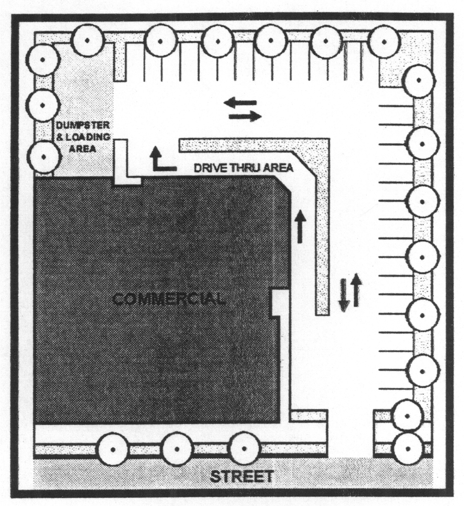
Service and delivery areas. Some commercial buildings may require regular or periodic delivery of goods and services, which is facilitated by a designated service and delivery area separate from parking facilities for customers and other users. Wherever possible, these service and delivery areas, which may consist of parking and loading docks for vans and heavy trucks, should be located at the rear of the building and screened from public view. However, due to lot size and surrounding land uses (such as an adjacent residential district), dedicated service and delivery areas may be deemed by the planning commission to be inappropriate for the property and/or land use.
(d)
Shared parking. Shared parking is encouraged when multiple uses are located close to one another and their parking demands differ by time of day or day of the week (e.g., church and an indoor theater).
(e)
Shade trees. Shade trees shall be provided in all parking areas. No greater than ten spaces shall be established without a separation by a canopy tree island no less than 400 square feet in size per tree.
[450.09.]
Amenity zones within developments.
(a)
Established. An amenity zone, as defined, is recommended for properties within the corridor overlay district. The amenity zone shall be devoted to aesthetically-pleasing and interest-creating features, such as pedestrian plazas, landscaping, public art, or other approved pedestrian oriented features. Signs that are scaled to the pedestrian are permitted within amenity zones in accordance with the Bloomingdale signage ordinance.
(b)
Uses and improvements. Pedestrian-oriented outdoor spaces are especially encouraged within amenity zones. Gathering spaces may include formal parks, town greens, small parks/plazas and other places for pedestrian comfort and public interaction. These spaces should be integrated purposefully into the overall design of the development and not merely be residual areas left over after buildings and parking lots are sited. These spaces should also be placed directly adjacent to the areas that generate the users, such as street corners, shops and restaurants, stores, day care centers and dwellings.
(c)
Street furniture. Within amenity zones, street furniture (e.g., benches, trash receptacles), pedestrian-scale lighting (e.g., street lamps and bollards) and sensitively arranged uses such as outdoor patios should be provided to encourage human interaction and street life. Street furniture, including benches and trash receptacles (waste bins) should be provided wherever necessary. Advertising shall not [be] permitted on street furniture.
[450.10.]
Landscaping.
(a)
Amenity zones. Amenity zones shall be landscaped according to a landscape and streetscape plan approved by the planning commission.
(b)
Gateways. The entrances to the city should provide attractive landscape elements and signage designed to appeal to motorists entering the community. Owners of property adjacent to the city's gateways shall not create a landscaped area or amenity zone that is in conflict with the appearance and character of the gateway signage and plantings.
Wherever possible, the landscape elements on private property contiguous to the gateways should be of a nature that is continuous to and supportive of the formal landscape elements on the public right-of-way. Recommended plant materials are native flora and drought-resistant plants.
(c)
Gateway signage. No gateway signs shall be permitted other than those designated by the City of Bloomingdale.
(d)
Western gateway. The area surrounding Highway 80 at its western boundary near Effingham County is predominately rural in character, with agricultural lands, forests and wetlands on both sides of the highway. Due to the sensitive nature of the area, commercial development is encouraged to maintain visual buffers that are contextual with their rural surroundings. The developed area surrounding Jimmy Deloach Parkway at the intersection with Highway 80 shall serve as a transition from the rural gateway to the commercial corridor.
(e)
Medians. Where medians are provided, they shall be landscaped with trees, ground cover, flowers and/or small shrubs that will not interfere with sight visibility of motorists or pedestrians.
(f)
Street trees. Street trees provide a good contrast to buildings and pavement and help soften the built environment. They enliven streetscapes by blending natural features with built features. Street trees also help buffer pedestrians from vehicles and offer summer shade. Street trees are recommended at no more than 40-foot intervals along the entire property fronting the corridor. Street trees shall be placed outside the right-of-way of Highway 80, if permitted by the city engineer given available visibility considerations.
(g)
Tree protection. Every effort should be made through the design, layout, and construction of developments within the corridor to incorporate and preserve as many trees as possible.
(h)
Tree conservation plan. Within the corridor overlay district, a tree conservation plan shall indicate areas of existing tree cover to be retained and areas proposed for removal. All trees of greater than six inches DBH (diameter at breast height, or four feet above the base of the tree) shall be identified, unless located in a cluster of ten or more trees to be saved, and shown on the specific development plan or plat. All trees in buffer or screening areas shall be maintained on the site unless specifically approved to be removed and so noted on the approved specific development plan or plat. The mayor and council shall approve a tree conservation plan upon a finding that the tree cover proposed to be removed is:
(1)
Necessary to accomplish the development plan in a logical manner; and/or
(2)
Required in connection with the execution of the approved development plan and will result in sufficient damage to a specific tree or group of trees, as certified by a registered arborist or landscape architect, to cause its (their) eventual destruction within a short period of time upon the completion of the project. A short period shall be defined herein to be a time lapse of less than five years from the phase of construction impacting the tree(s);
(3)
Not located in a required buffer area and would not be needed to help screen the proposed site development from adjoining properties.
(i)
Perimeter buffers. When a single-family residence abuts the boundary of a commercial development, a vegetated buffer of at least ten feet in width shall be planted along the entire property line between the non-single family development and a single-family residence. Perimeter buffers may be penetrated by utilities and sidewalks and, if determined appropriate by the planning commission.
(j)
Corridor buffers. Each development plan shall provide a minimum visual buffer between the right-of-way line of the subject corridor and all proposed structures and parking areas. The buffer setback may leave naturally occurring buffer vegetation intact for its softening effect. This buffer shall be enhanced or created in the absence of naturally occurring vegetation.
[450.11.]
Provisions for specific uses.
(a)
Big box retail development. "Big box" development (individual retail establishments with 60,000 square feet or more floor area in one building) are encouraged to be designed with variations in the facade to reduce monotony and create visual interest.
(b)
Communication towers. Communication towers shall be set back a minimum of twice the tower's height from the right-of-way of Highway 80. See the telecommunications ordinance for further requirements.
(c)
Fences and walls. Where provided and where visible from the corridor, fences and walls should be composed of brick, stone wood, or other materials as approved by the planning commission. Landscaping should be used to minimize or soften the appearance from the public right-of-way. Chain link fencing shall not be permitted except in side or rear yards and shall be screened with vegetation to a height of six feet. Agricultural land uses are exempted from this requirement.
(d)
Drive-through facilities. Drive-through facilities are encouraged to be located to the rear or side of the building and shall not abut an amenity zone.
Courtesy: City of Atlanta, "Quality of Life Development Codes" 2003
(e)
Gas station pump islands. Gas station pump islands are encouraged to be located behind or to the side of the principal building and substantially obstructed (except for as may be viewed through approved driveway entrances and exits) from view from the corridor.
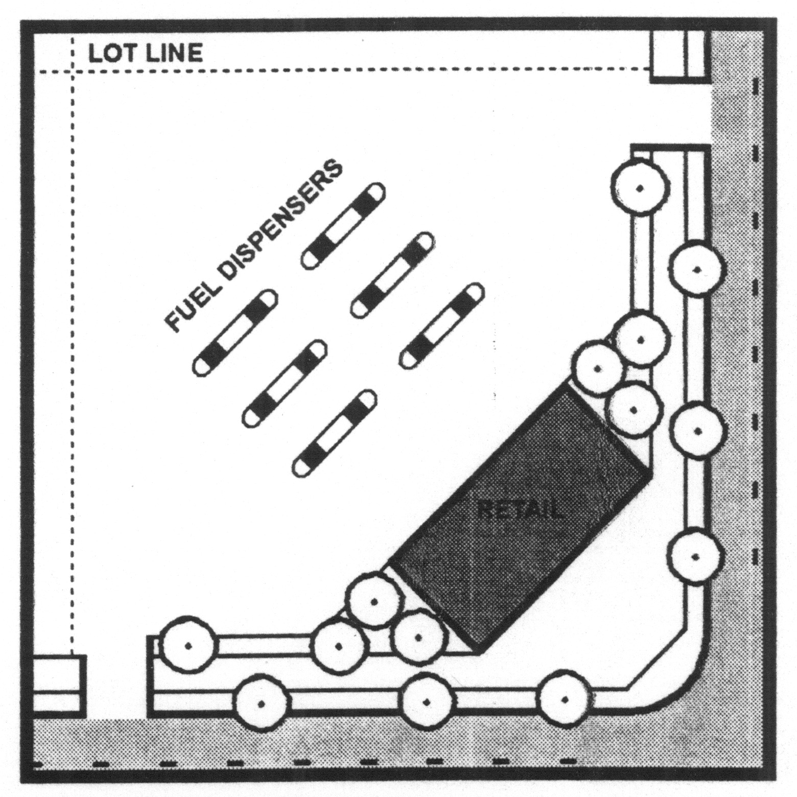
Courtesy: City of Atlanta, "Quality of Life Development Codes" 2003
(f)
Stormwater detention facilities. Design of stormwater detention facilities as amenities is encouraged when the facility is located within an amenity zone or landscaped area of the development. Open storm drainage and detention areas visible from the corridor should be incorporated into the design of the development as an attractive amenity. Wet-bottom basins are encouraged. Dry basins, where used, shall be sloped adequately to, ensure proper surface drainage and designed so slopes and bottoms can be easily maintained and extensively landscaped. Bio-retention facilities are also encouraged within parking areas, as an alternative or complement to conventional detention facilities. The vegetation and overall design of a bio-retention facility should enhance the overall appearance of the development.
[450.12.]
Architecture.
(a)
Architecture standards generally. The design of structures and their materials and colors should be visually compatible with the overall appearance and character of Bloomingdale.
Placement generally. Buildings should be arranged so that they help frame and define the corridor, driveways, or intersecting roads, thus giving deliberate form to streets and sidewalk areas. At least 50 percent of the front building facade of a principal building must orient towards (face) the corridor or an internal street or driveway, so as to effectively frame and define the streetscape and provide convenient pedestrian access along those streets to the buildings.
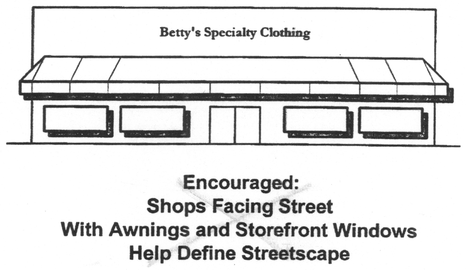
Image courtesy of: Georgia Dept. of Community Affairs, "Model Code: Alternatives to Conventional Zoning" 2004
(1)
Building walls. Lengthy, featureless facades and building walls lining the corridor should be avoided. Large, flat, blank expenses on a facade are not acceptable and shall not be permitted. Building walls shall not extend more than 200 linear feet parallel to the corridor unless the front facade of the building changes at the building line (i.e., front setback in relation to the corridor) by at least five feet or the front building facade is designed in a way that breaks up the building face into discrete architectural elements. There should be some differentiation between the building base and the top, which can be accomplished with building articulation or details at the roof line. Building articulation can be accomplished through the following:
(2)
Facade modulation: stepping back or extending forward a portion of the facade;
(3)
Providing bay windows or repeating window patterns at regular intervals;
(4)
Providing a porch, patio, deck, covered entry to portions of the facade at the ground level or in the case of two or more story buildings, balconies;
(5)
Changing the roofline by alternating dormers, or using stepped roofs, gables or other roof elements;
(6)
Changing materials with the change in building plane.
Multiple buildings on the same site should be designed to create a cohesive visual relationship among the buildings. All exterior facades of buildings should employ architectural elements (color, material, design, etc.) which are complementary to one another.
(b)
Screening of buildings. For buildings which do not front the corridor, the vegetated buffer shall be of adequate depth and plantings to fully screen the sides and/or backs of buildings from view of the right-of-way. In particular, in no instance shall the rear yards or backs of buildings be visible from the corridor.
(c)
Building materials. Corrugated and/or sheet metal siding and prefabricated steel panels are strongly discouraged on a building. All non-residential building exteriors visible from the corridor are encouraged to be constructed of brick, stone, wood or other materials as approved by the planning commission. The building facade shall be reviewed by the planning commission.
(d)
Windows. Windows are encouraged to be provided on the facade of all buildings within 100 feet of Highway 80 and facing the corridor. A minimum of 25 percent of the ground floor facade area should be composed of non-reflective and transparent windows.
(e)
Rooftop mechanical equipment. Any mechanical equipment located on the roof of a building should be screened from view from the right-of-way of the corridor by the building roof, a parapet wall or by other screening approved by the planning commission. Such equipment should be as inconspicuous as possible from other viewpoints, as well. In the case of flat roofs, cooling and air handling equipment may be located within a roof depression to comply with this requirement. Where such screening is not feasible in the planning commission's opinion, equipment shall be painted or screened in a manner as to minimize its visibility.
(f)
Gutters and downspouts. Sheet metal gutters and downspouts should be of a color or painted to a color that is compatible with the other colors on the building facade.
(g)
Minimum area, bulk regulations and height requirements. Shall be in accordance with the requirements of the underlying zoning district.
[450.13.]
Existing conditions analysis and site plan required. Any new development within the corridor overlay district shall not be granted any city permits until the site plan of the proposed development has been approved in accordance with Appendix A, § 411 of this Code.
(Ord. of 2-21-2008)