
Bloomington City Zoning Code
CHAPTER 20
02 - ZONING DISTRICTS
20.02.010 - Zoning districts established.
(a)
Summary Table of Zoning Districts. The following zoning districts are established as shown in Table 02-1. All development shall comply with all other applicable regulations in this UDO including, without limitation, Chapter 20.03 (Use Regulations) and Chapter 20.04 (Development Standards and Incentives).
_____
Table 02-1. Summary Table of Zoning Districts
_____
(b)
Base Zoning Districts.
(1)
Sections 20.02.020 through 20.02.040 use a common structure to describe the purpose for each base zoning district, an illustrative image, a summary of dimensional standards, and any district-specific standards.
(2)
Each of the Residential, Mixed-Use, and nonresidential base zoning districts listed in Table 02-1 authorizes the land uses listed for that base district in Chapter 20.03, Use Regulations, subject to the development standards applicable to that type of development in Chapter 20.04, Development Standards and Incentives, the subdivision standards in Chapter 20.05 (Subdivision Standards) and the requirements for development approval in Chapter 20.06 (Administration and Procedures).
(3)
The materials shown in Sections 20.02.020 through 20.02.040 are summaries of basic provisions applicable to the base zoning districts. In the event of an inconsistency between the provisions of Sections 20.02.020 through 20.02.040 and the provisions in Chapters 20.03, 20.04, 20.05, 20.06, or 20.07, the provisions of Chapters 20.03, 20.04, 20.05, 20.06, or 20.07, as applicable, shall apply.
(4)
On the Official Zoning Map a standard zoning district shall be labeled using the two- or three-character abbreviation shown in Table 02-1.
(c)
Planned Unit Development Districts.
(1)
Planned Unit Development districts are separate base zoning districts negotiated with the Planning and Transportation Department and the Plan Commission and approved by City Council pursuant to those procedures shown in Chapter 20.06 (Administration and Procedures).
(2)
On the Official Zoning Map an approved Planned Unit Development zoning district shall be labeled "PUD."
(d)
Overlay Zoning Districts.
(1)
The Overlay zoning districts shown in Table 02-1 supplement, but do not replace, the base zoning district regulations in the areas where the Overlay zoning districts are applied.
(2)
An Overlay zoning district may add restrictions on the use of property in the underlying base zoning district or may remove restrictions on the use of property in the underlying zoning district, or both.
(3)
In the event of an inconsistency between the Overlay zoning district regulations and the base zoning district regulations, the Overlay zoning district regulations shall apply.
(4)
The Official Zoning Map designates where Overlay zoning districts apply.
(e)
Official Zoning Map Revisions.
(1)
Only persons authorized by the Planning and Transportation Director may revise the Official Zoning Map when amendments are passed. Such revisions shall be made as soon as possible after the effective date of the amendment.
(2)
During the time it takes for the formal electronic version of the Official Zoning Map to be reprinted for public display, hand-drawn lines and text on an authorized printed copy of the previous Official Zoning Map will be appropriate to note zoning district changes. Revisions may be made at any time to correct drafting or clerical errors and omissions in the Official Zoning Map but shall not have the effect of amending the Official Zoning Map.
(f)
Standards. Zoning district boundaries on the Official Zoning Map shall be interpreted as follows:
(1)
Zoning district boundaries shown within or parallel to the lines of roads, easements, and transportation rights-of-way shall be deemed to follow the centerline of the affected road, easement, or right-of-way.
(2)
Zoning district boundaries indicated as following or being parallel to section or fractional sectional lines, lot lines, or City corporate boundary lines shall be construed as following or paralleling such lines.
(3)
Zoning district boundaries indicated as approximately following the centerline of streams, rivers, or other bodies of water shall be construed to follow such centerlines.
(4)
Where a zoning district boundary divides a lot or parcel, or follows or crosses property that is not subdivided, the location of such boundary, unless indicated by legal description with distance and bearing or other dimension, shall be determined by the scale of the Official Zoning Map by the Planning and Transportation Director.
(5)
Whenever any street, alley, public right-of-way, railroad right-of-way, waterway, or other similar area is vacated by proper authority, the zoning districts adjoining each side of vacated areas shall be extended automatically to the center of the vacated area. All areas included in the vacation shall after the vacation be subject to all regulations of the extended zoning districts. In the event of a partial vacation, the adjoining zoning district, or zoning district nearest the portion vacated, shall be extended automatically to include all of the vacated area.
(6)
Any disputes as to the exact zoning district boundaries shall be determined by the Planning and Transportation Director. The Planning and Transportation Director may refuse to make a determination when he or she cannot definitely determine the location of a zoning district boundary. In such cases, the Planning and Transportation Director shall refer the interpretation to the Plan Commission. The Plan Commission may then interpret the location of the zoning district boundary with reference to the scale of the Official Zoning Map and the purposes set forth in all relevant provisions of the UDO. All zoning district boundary determinations made pursuant to this section may be appealed to the Board of Zoning Appeals.
(g)
Overlay District Applicability. The overlay district boundaries on the Official Zoning Map shall be interpreted as follows:
(1)
An overlay district shall be noted on the Official Zoning Map with a hatch or textured pattern and be noted as such on the map legend.
(2)
A lot that is fully covered (bounded) by an overlay district shall be interpreted to be subject to the overlay district standards found in Section 20.02.060 (Overlay Districts).
(3)
A lot that is partially covered (transected) by an overlay district shall be interpreted to be subject to the overlay district standards to the extent the lot area is covered by the overlay district.
(Amd. of 1-14-2020; Ord. No. 21-22, § II (Att. A), 4-21-2021; Ord. No. 22-36, § 2(Att. A), 1-30-2023; Ord. No. 23-04, § 2(Att. A), 4-19-2023)
20.02.020 - Residential zoning districts.
(a)
Reserved.
(b)
R1: Residential Large Lot.
(1)
Purpose. The R1 district is intended to accommodate single family residential development on relatively large lots plus a limited number of related civic uses while ensuring compatibility with surrounding patterns of development. This district may also serve as a transition between estate development and medium-lot development.
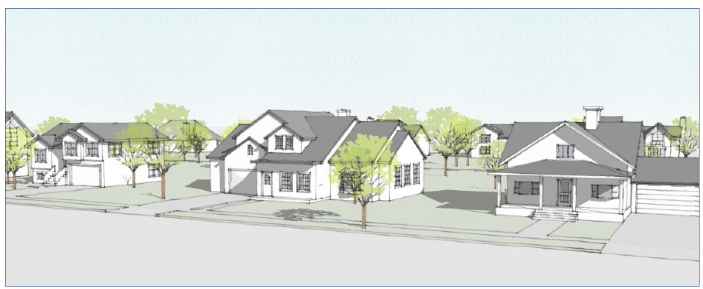
Figure 3: Illustrative Scale and Character
(2)
Dimensional Standards. The following table is a summary of the district-specific dimensional standards. Additional standards from Section 20.04.020 (Dimensional Standards) also apply.
_____
Table 02-3. R1 District Dimensional Standards
Notes:
[1] See Section 20.04.110 (Incentives) for alternative standards.
[2] Or equal to the setback of the primary structure, whichever is greater.
_____
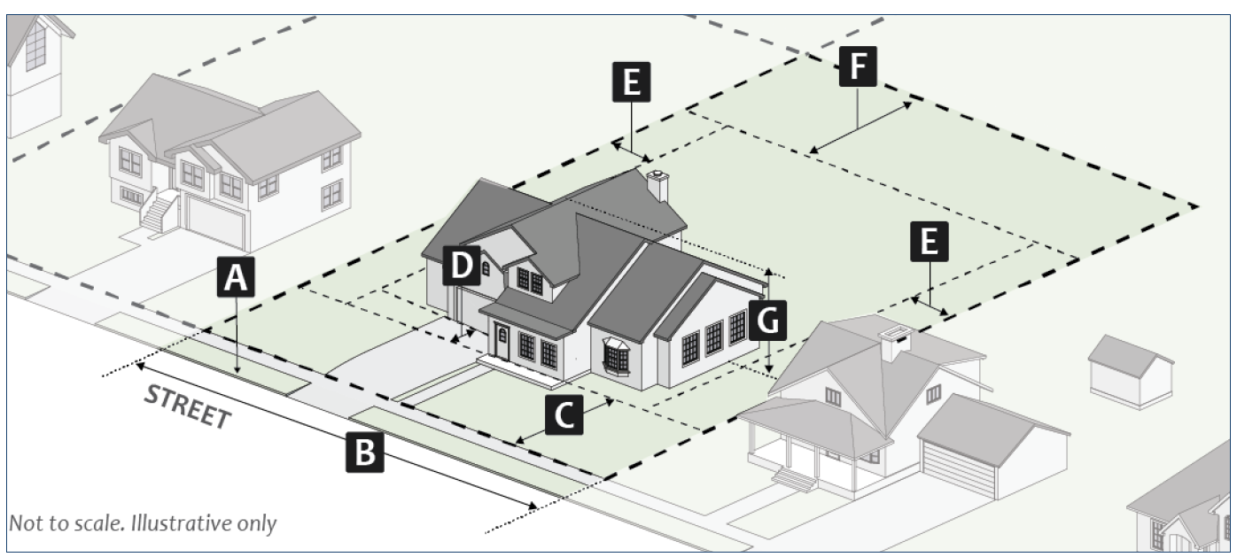
Figure 4: R1 District Dimensional Standards
(c)
R2: Residential Medium Lot.
(1)
Purpose. The R2 district is intended to accommodate residential development on medium-sized lots in single-family neighborhoods, plus a limited number of related civic uses, while ensuring compatibility with surrounding patterns of development. This district may be used as a transition between large-lot residential development and small-lot residential development.
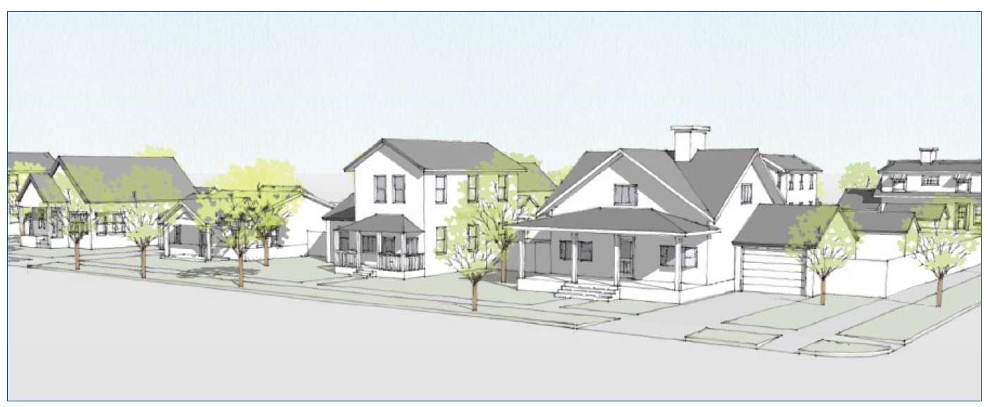
Figure 5: Illustrative Scale and Character
(2)
Dimensional Standards. The following table is a summary of the district-specific dimensional standards. Additional standards from Section 20.04.020 (Dimensional Standards) also apply.
_____
Table 02-4. R2 District Dimensional Standards
Notes:
[1] See Section 20.04.110 (Incentives) for alternative standards.
[2] Or equal to the setback of the primary structure, whichever is greater.
[3] Legally established lots of record that are less than the minimum lot width may reduce the required setback up to two feet.
_____
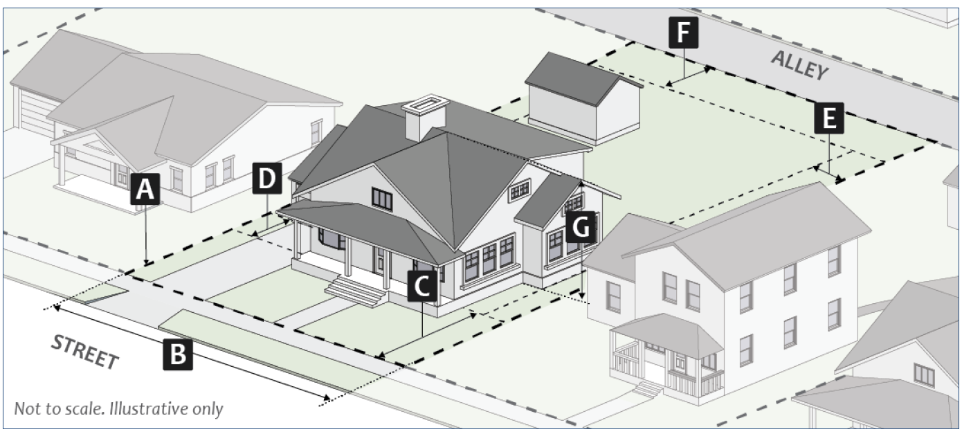
Figure 6: R2 District Dimensional Standards
(d)
R3: Residential Small Lot.
(1)
Purpose. The R3 district is intended to protect and enhance established residential neighborhoods by increasing the viability of owner-occupied and affordable dwelling units through small-lot subdivisions, accessory dwelling units, and property improvements compatible with surrounding development patterns. The conversion of existing housing stock to more intense land uses is discouraged. This district may be used as a transition between medium-lot residential development and neighborhood-scale residential, commercial, and institutional development.
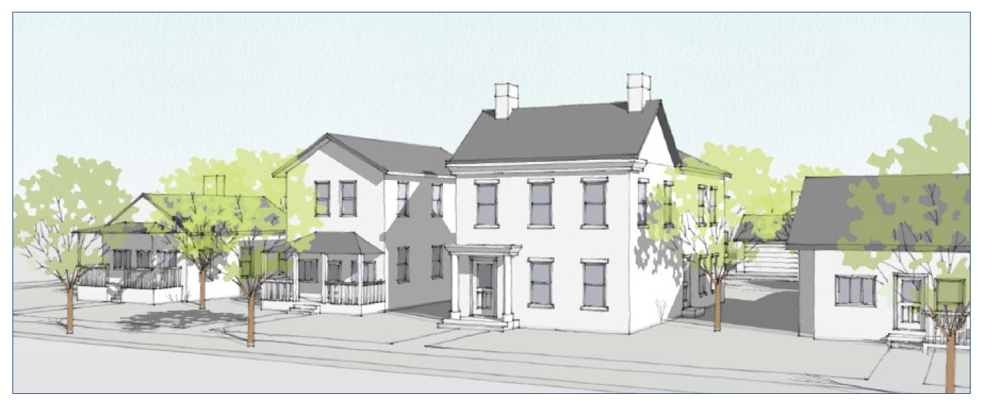
Figure 7: Illustrative Scale and Character
(2)
Dimensional Standards. The following table is a summary of the district-specific dimensional standards. Additional standards from Section 20.04.020 (Dimensional Standards) also apply.
_____
Table 02-5. R3 District Dimensional Standards
Notes:
[1] See Section 20.04.110 (Incentives) for alternative standards.
[2] Legally established lots of record that are less than the minimum lot width may reduce the required setback up to two feet.
[3] Side primary building setbacks shall be reduced by two feet if adjacent to a platted alley. Rear primary building setbacks shall be reduced by ten feet if adjacent to a platted alley.
_____
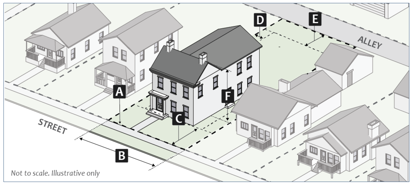
Figure 8: R3 Dimensional Standards
(e)
R4: Residential Urban.
(1)
Purpose. The R4 district is intended to accommodate residential uses on small urban scale lots that offer a diverse mix of housing opportunities consistent with the Comprehensive Plan and other adopted plans. Properties in the R4 district typically have access to many public services that are accessible to pedestrians, cyclists, and vehicles. This district may be used as a transition between small-lot residential development and urban-scale residential, commercial, and institutional development.
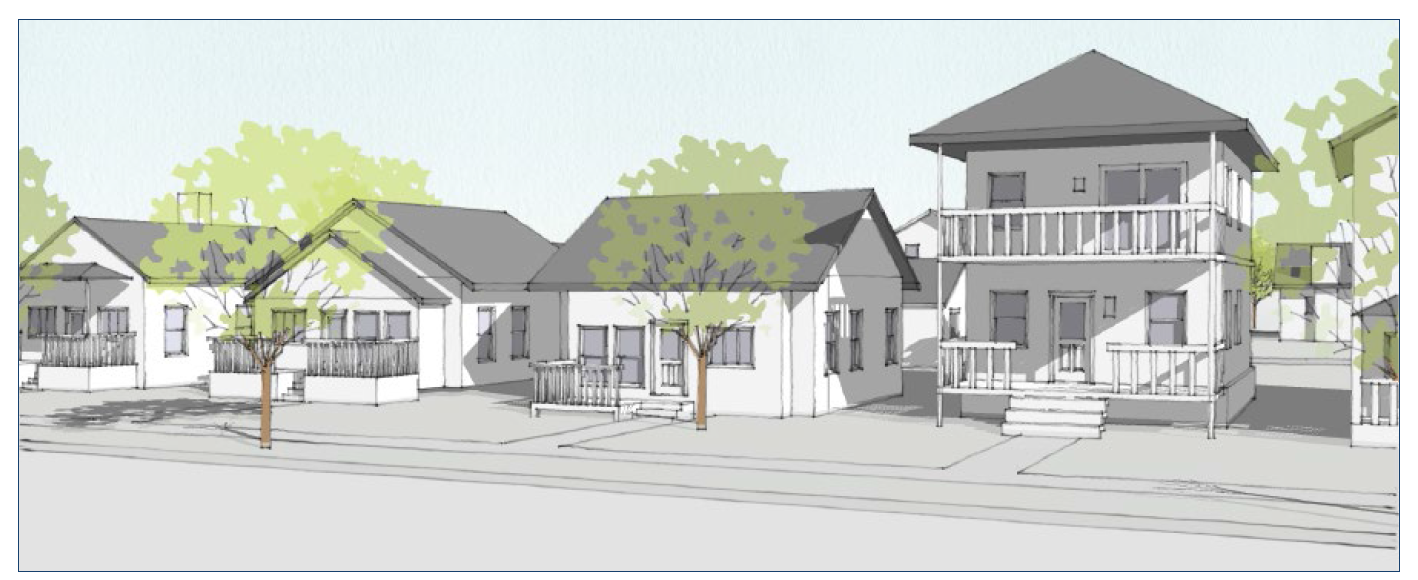
Figure 9: Illustrative Scale and Character
(2)
Dimensional Standards. The following table is a summary of the district-specific dimensional standards. Additional standards from Section 20.04.020 (Dimensional Standards) also apply.
_____
Table 02-6. R4 District Dimensional Standards
[1] Side primary building setbacks shall be reduced by two feet if adjacent to a platted alley. Rear primary building setbacks shall be reduced by ten feet if adjacent to a platted alley.
_____
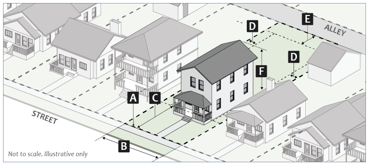
Figure 10: R4 Dimensional Standards
(f)
RM: Residential Multifamily.
(1)
Purpose. The RM district is intended to accommodate medium scale residential development, plus related civic and residential-supportive uses, at a scale that is larger than neighborhood-scale but smaller than urban-scale to ensure an adequate mix of housing types throughout the community. This district may be used as a transition between urban neighborhoods and more intense residential, commercial, and institutional development.
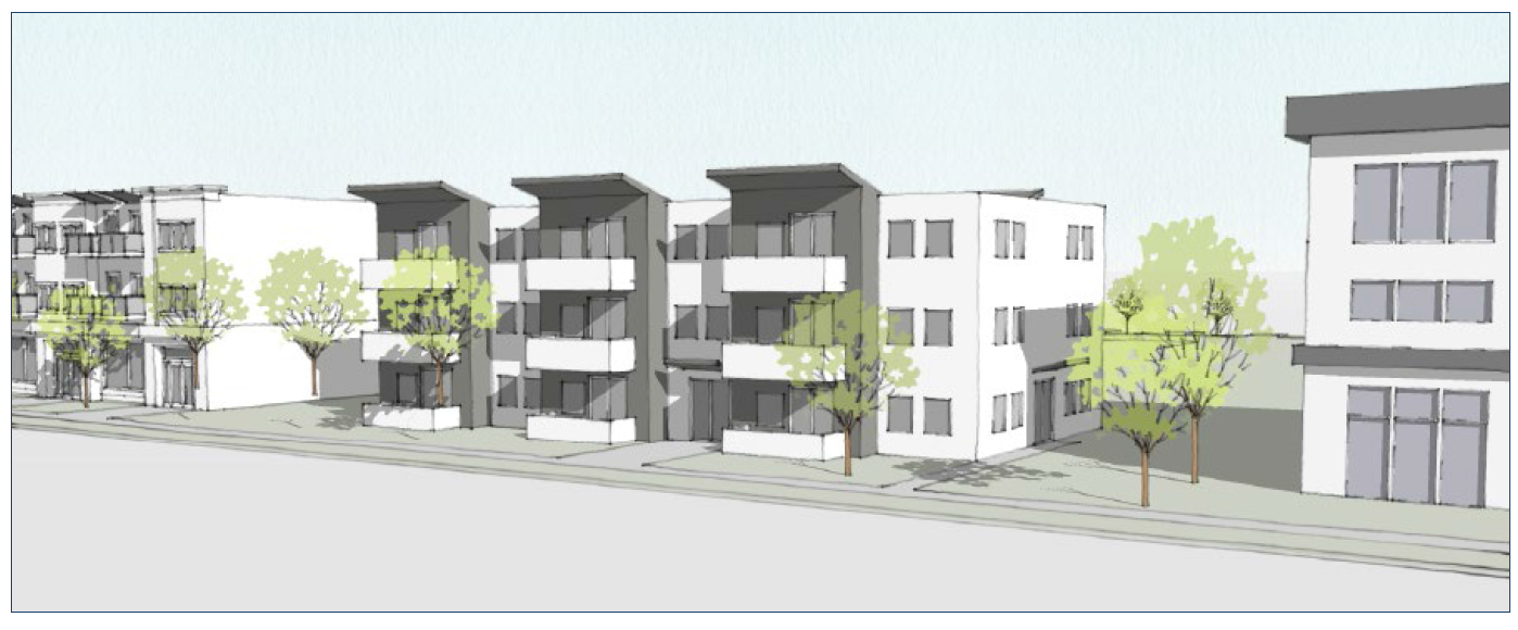
Figure 11: Illustrative Scale and Character
(2)
Dimensional Standards. The following table is a summary of the district-specific dimensional standards. Additional standards from Section 20.04.020 (Dimensional Standards) also apply.
_____
Table 02-7. RM District Dimensional Standards
Notes:
[1] Or equal to the setback of the primary structure, whichever is greater.
[2] Buildings abutting a property in the R1, R2, R3, or R4 zoning district shall comply with the standards in Section 20.04.070(d)(5) (Neighborhood Transition Standards).
[3] See Section 20.04.110 (Incentives) for alternative standards.
[4] The front building setback shall be determined by the standards of the base zoning district.
_____
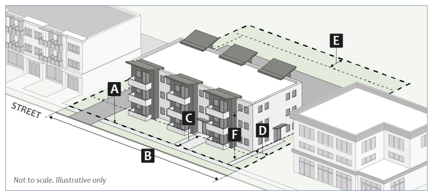
Figure 12: RM Dimensional Standards
(g)
RH: Residential High-Density Multifamily.
(1)
Purpose. The RH district is intended to accommodate high-intensity multifamily residential development, plus related civic and residential-supportive uses, to provide an adequate mix of housing types throughout the community. This district can also serve as a transition between other lower-density districts and the downtown or university areas.
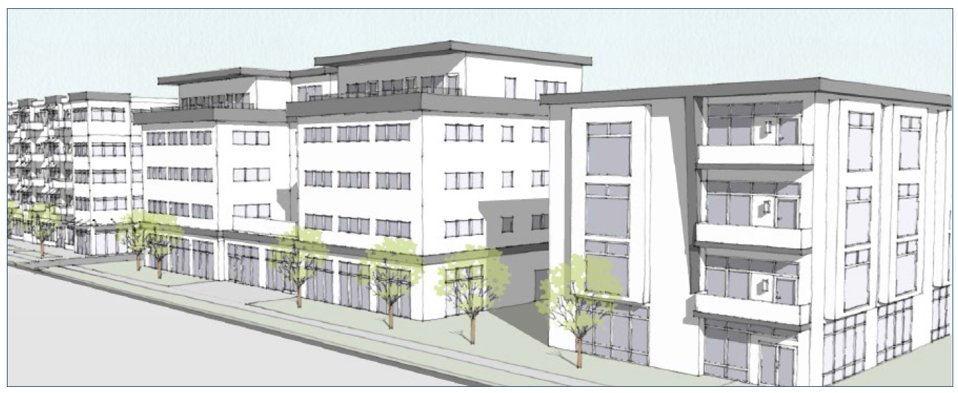
Figure 13: Illustrative Scale and Character
(2)
Dimensional Standards. The following table is a summary of the district-specific dimensional standards. Additional standards from Section 20.04.020 (Dimensional Standards) also apply.
_____
Table 02-8. RH District Dimensional Standards
Notes:
[1] Or equal to the setback of the primary structure, whichever is greater.
[2] Buildings abutting a property in the R1, R2, R3, or R4 zoning district shall comply with the standards in Section 20.04.070(d)(5) (Neighborhood Transition Standards).
[3] See Section 20.04.110 (Incentives) for alternative standards.
[4] The front building setback shall be determined by the standards of the base zoning district.
_____
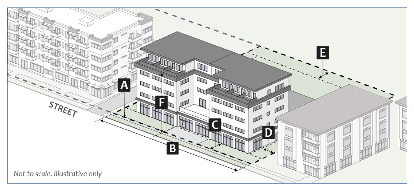
Figure 14: RH Dimensional Standards
(h)
RMH: Manufactured/Mobile Home Park.
(1)
Purpose. The RMH district is intended to accommodate for manufactured housing developments with shared amenities in order to promote and preserve housing opportunities.
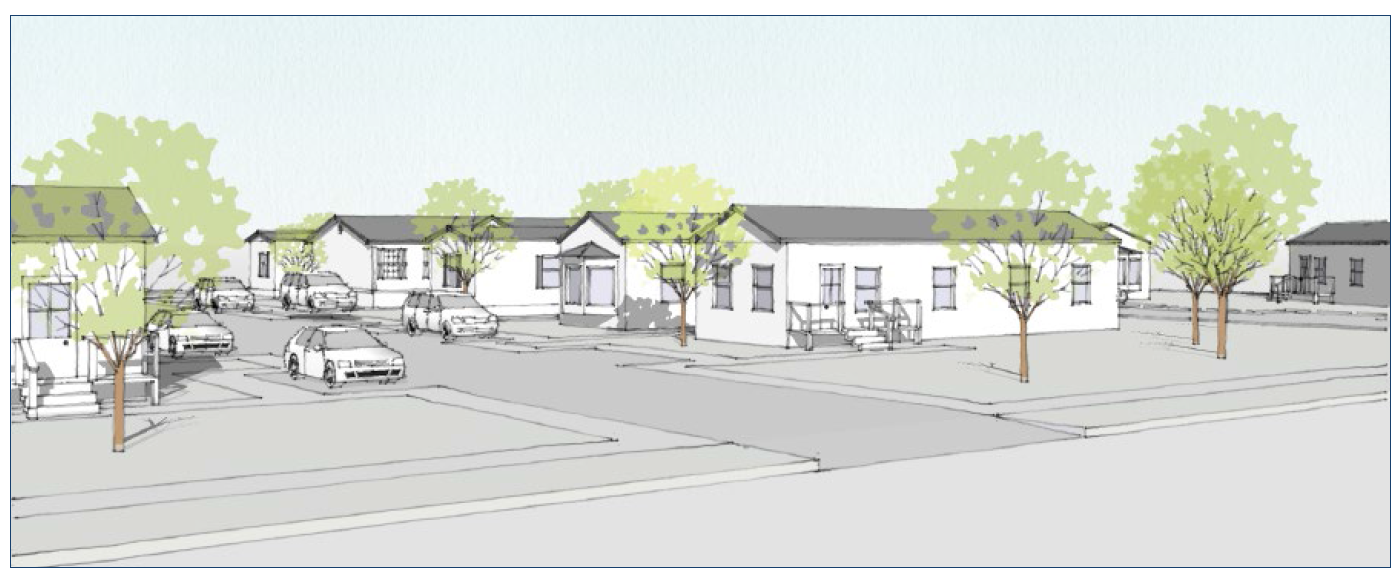
Figure 15: Illustrative Scale and Character
(2)
Dimensional Standards. The following table is a summary of the district-specific dimensional standards. Additional standards from Section 20.04.020 (Dimensional Standards) also apply.
_____
Table 02-9. RMH District Dimensional Standards
_____
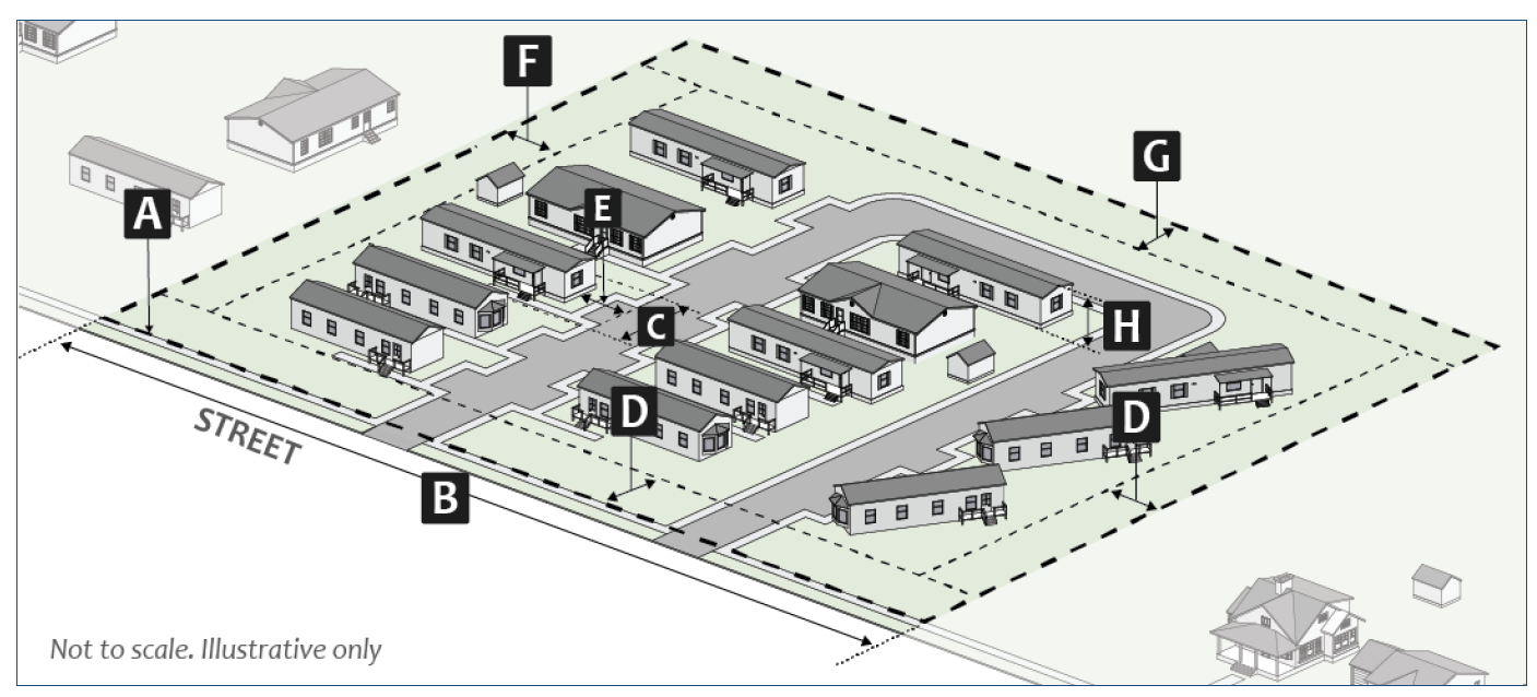
Figure 16: RMH Dimensional Standards
(Amd. of 1-14-2020; Ord. No. 21-15, § II (Att. A), 4-21-2021; Ord. No. 21-22, § II (Att. A), 4-21-2021; Ord. No. 22-08, § 2(Att. A), 5-18-2022; Ord. No. 2024-03, § II(Att. A), 4-10-2024; Ord. No. 2024-05, § II(Att. A), 4-10-2024; Ord. No. 2025-12, § II(Att. A), 5-21-2025)
20.02.030 - Mixed-use zoning districts.
(a)
MS: Mixed-Use Student Housing.
(1)
Purpose. The MS district is intended to accommodate an adequate supply and mix of housing opportunities for students in areas adjacent or within easy walking distance to campus and along nearby commercial corridors and with easy access to campus-serving public transit and to university-provided parking, such as the area located directly west, southwest, and northwest of Memorial Stadium. The district is intended to have a high percentage of student-oriented housing units, including larger developments that might not be permitted in other districts, but not totally exclusive of other types of residential housing units. This district should not be located in close proximity to the MD district but may also provide MS related commercial and retail-supportive uses.
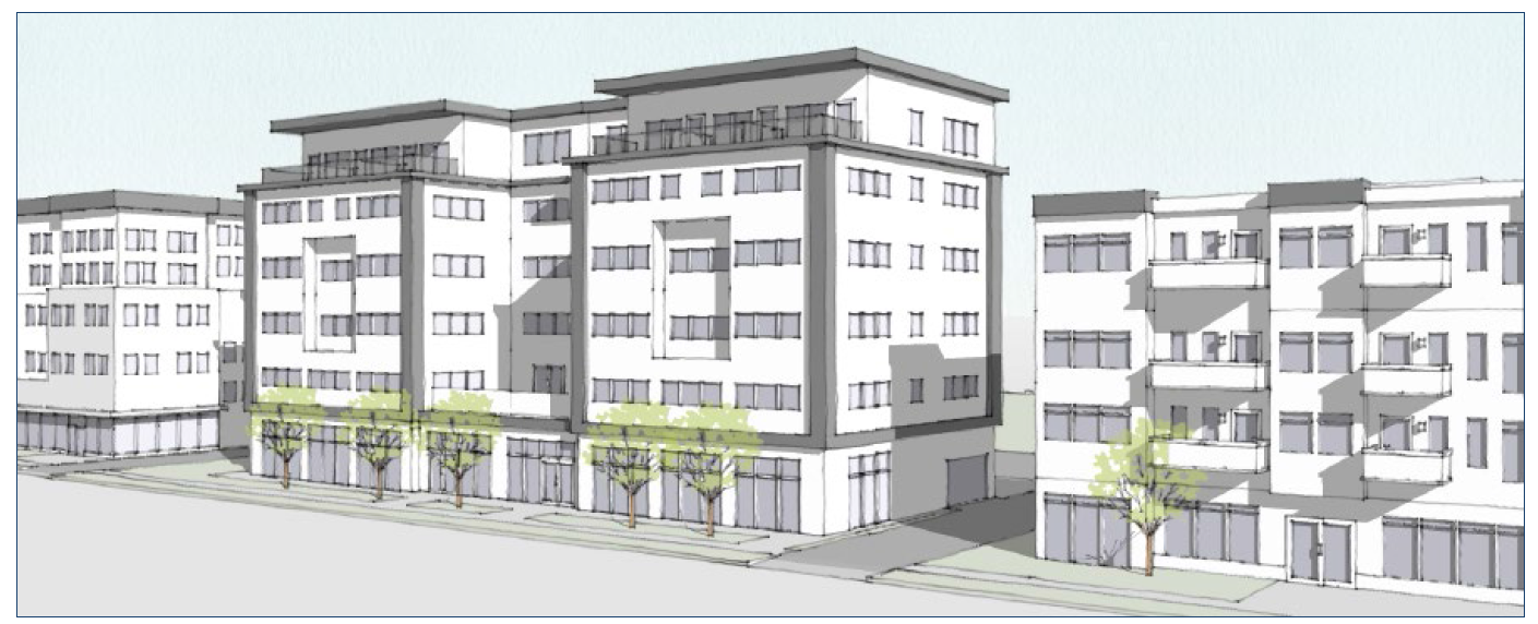
Figure 17: Illustrative Scale and Character
(2)
Dimensional Standards. The following table is a summary of the district-specific dimensional standards. Additional standards from Section 20.04.020 (Dimensional Standards) also apply.
_____
Table 02-10. MS District Dimensional Standards
Notes:
[1] Buildings abutting a property in the R1, R2, R3, or R4 zoning district shall comply with the standards in Section 20.04.070(d)(5) (Neighborhood Transition Standards).
[2] Where a nonresidential use is proposed on the ground floor, the minimum floor to ceiling height on the ground floor shall be twelve feet.
[3] The front building setback shall be determined by the standards of the base zoning district.
_____
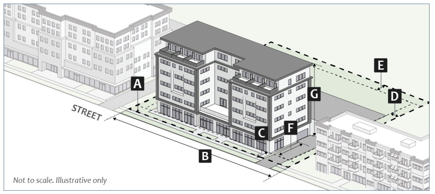
Figure 18: MS Dimensional Standards
(b)
MN: Mixed-Use Neighborhood Scale.
(1)
Purpose. The MN district is intended to promote a mix of neighborhood-scale residential, commercial, and institutional uses with pedestrian-oriented design and multi-modal transportation availability, in order to promote context sensitive neighborhood-serving development at nodes and corridors near low- and medium-density residential neighborhoods.
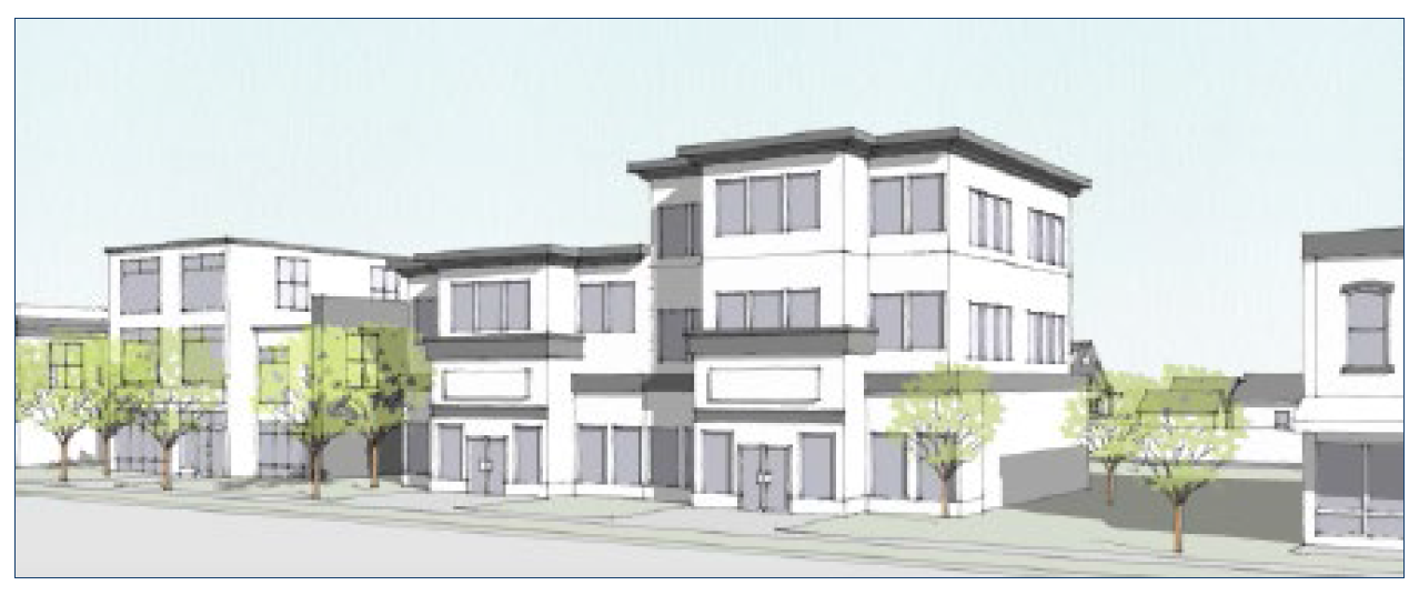
Figure 19: Illustrative Scale and Character
(2)
Dimensional Standards. The following table is a summary of the district-specific dimensional standards. Additional standards from Section 20.04.020 (Dimensional Standards) also apply.
_____
Table 02-11. MN District Dimensional Standards
Notes:
[1] Buildings abutting a property in the R1, R2, R3, or R4 zoning district shall comply with the standards in Section 20.04.070(d)(5) (Neighborhood Transition Standards).
[2] Where a nonresidential use is proposed on the ground floor, the minimum floor to ceiling height on the ground floor shall be twelve feet.
[3] See Section 20.04.110 (Incentives) for alternative standards.
_____
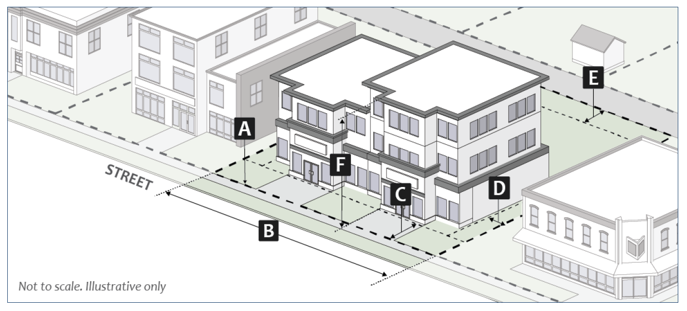
Figure 20: MN Dimensional Standards
(c)
MM: Mixed-Use Medium Scale.
(1)
Purpose. The MM district is intended to accommodate medium-scaled projects with a mix of housing and storefront retail, professional office, civic and/or residential uses at a scale that is larger than neighborhood-scale but smaller than destination commercial uses or high-density residential development.
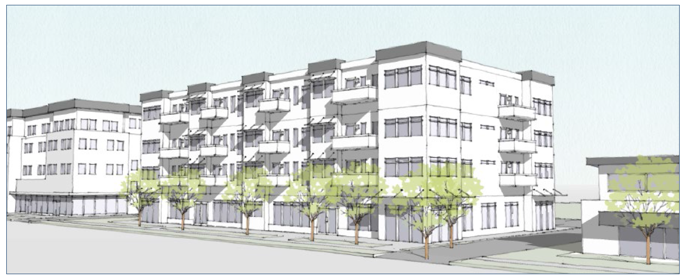
Figure 21: Illustrative Scale and Character
(2)
Dimensional Standards. The following table is a summary of the district-specific dimensional standards. Additional standards from Section 20.04.020 (Dimensional Standards) also apply.
_____
Table 02-12. MM District Dimensional Standards
Notes:
[1] Buildings abutting a property in the R1, R2, R3, or R4 zoning district shall comply with the standards in Section 20.04.070(d)(5) (Neighborhood Transition Standards).
[2] Where a nonresidential use is proposed on the ground floor, the minimum floor to ceiling height on the ground floor shall be twelve feet.
[3] See Section 20.04.110 (Incentives) for alternative standards.
_____
Figure 22: MM Dimensional Standards
(d)
MC: Mixed-Use Corridor.
(1)
Purpose. The MC district is intended to accommodate medium-scaled developments with a mix of storefront retail, professional office, and/or residential dwelling units along arterial and collector corridors at a scale larger than the neighborhood-scale uses accommodated by the MN zoning district.
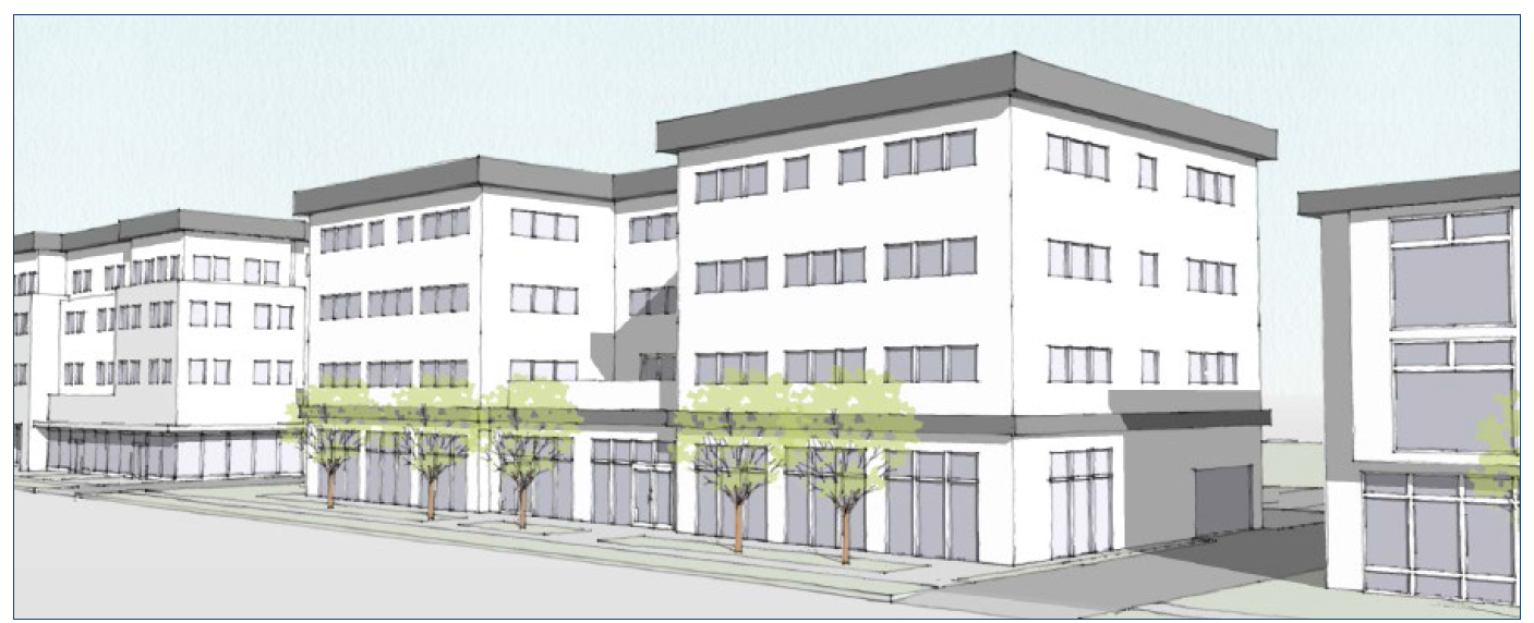
Figure 23: Illustrative Scale and Character
(2)
Dimensional Standards. The following table is a summary of the district-specific dimensional standards. Additional standards from Section 20.04.020 (Dimensional Standards) also apply.
_____
Table 02-13. MC District Dimensional Standards
Notes:
[1] Buildings abutting a property in the R1, R2, R3, or R4 zoning district shall comply with the standards in Section 20.04.070(d)(5) (Neighborhood Transition Standards).
[2] Where a nonresidential use is proposed on the ground floor, the minimum floor to ceiling height on the ground floor shall be twelve feet.
[3] See Section 20.04.110 (Incentives) for alternative standards.
_____
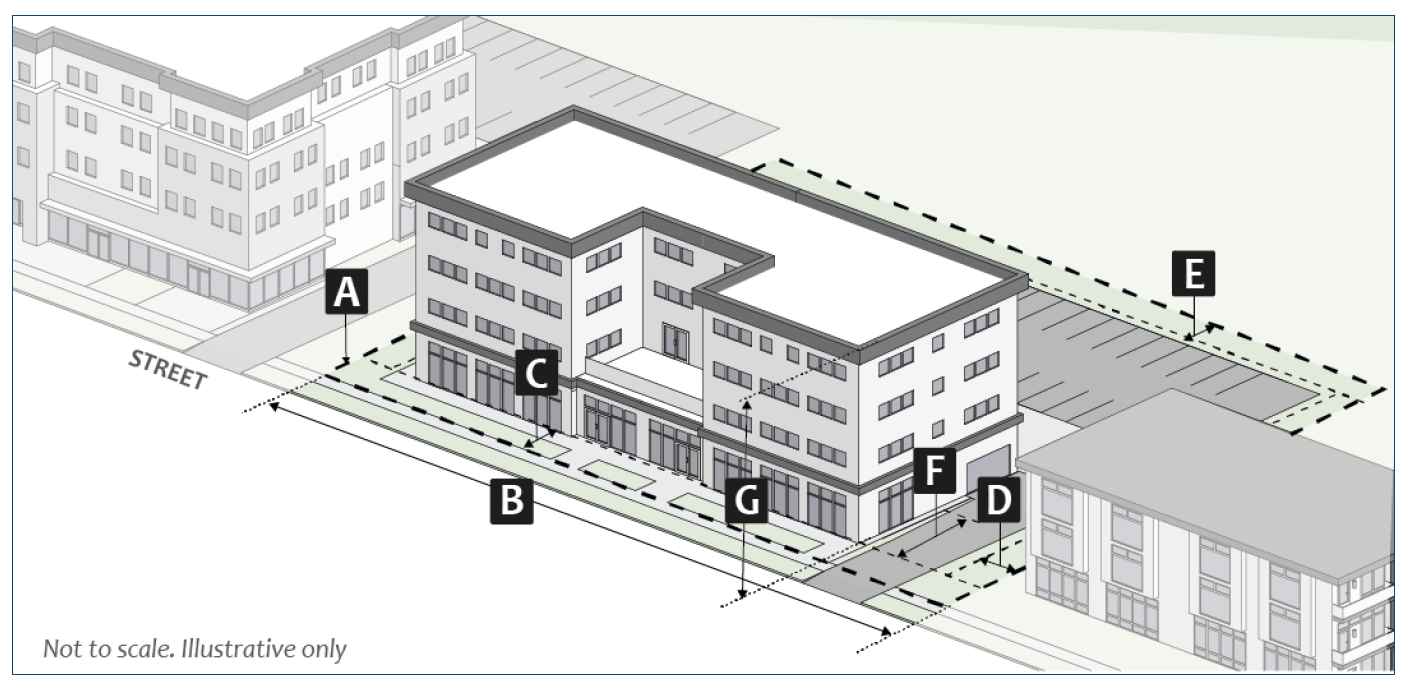
Figure 24: MC Dimensional Standards
(e)
ME: Mixed-Use Employment.
(1)
Purpose. The ME district is intended to provide a mixture of office-related uses and medium-scale multifamily residential uses that provide significant employment opportunities for the community and the surrounding region.
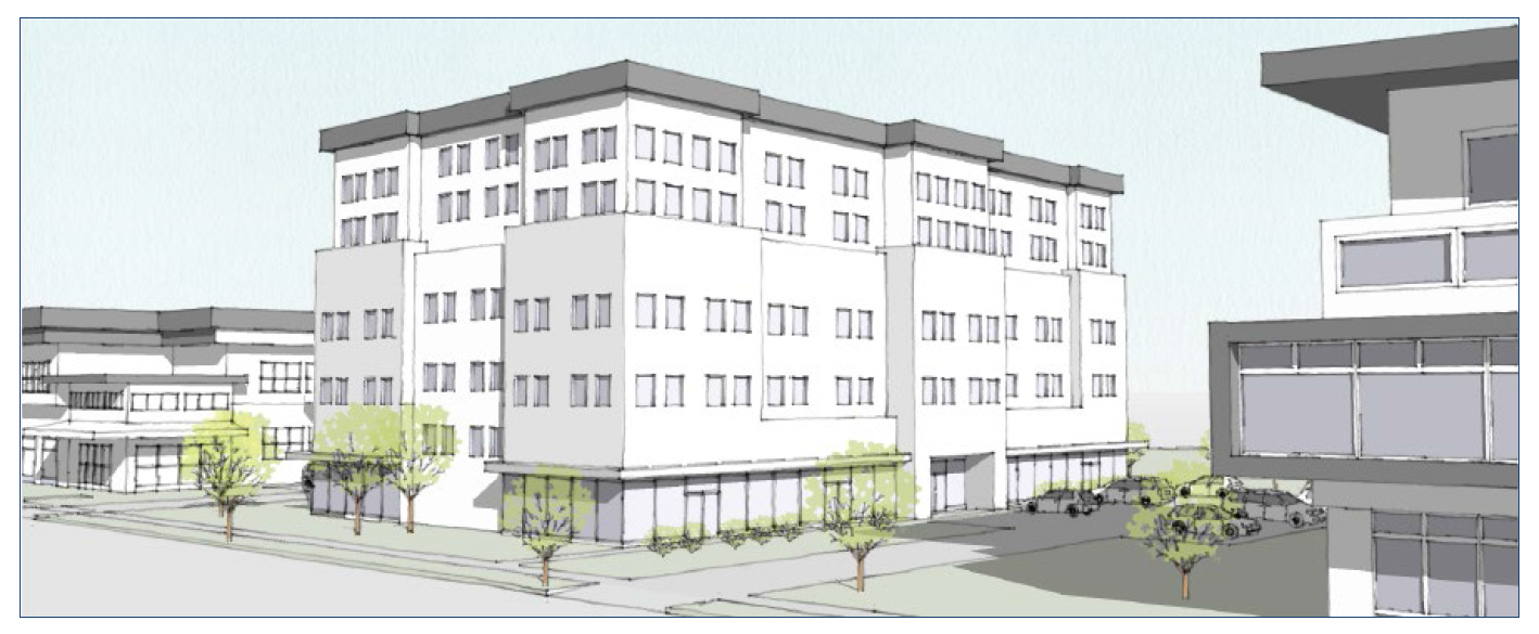
Figure 25: Illustrative Scale and Character
(2)
Dimensional Standards. The following table is a summary of the district-specific dimensional standards. Additional standards from Section 20.04.020 (Dimensional Standards) also apply.
_____
Table 02-14. ME District Dimensional Standards
Notes:
[1] Buildings abutting a property in the R1, R2, R3, or R4 zoning district shall comply with the standards in Section 20.04.070(d)(5) (Neighborhood Transition Standards).
[2] Where a nonresidential use is proposed on the ground floor, the minimum floor to ceiling height on the ground floor shall be twelve feet.
[3] See Section 20.04.110 (Incentives) for alternative standards.
_____
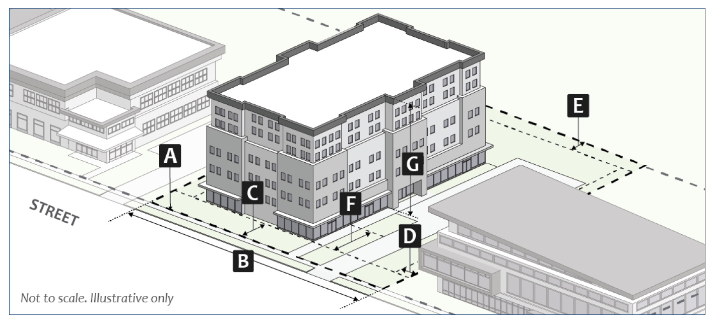
Figure 26: ME Dimensional Standards
(f)
MI: Mixed-Use Institutional.
(1)
Purpose. The MI district is intended to provide regulations for properties that serve as community institutions, including but not limited to parks, schools, cemeteries, golf courses, religious institutions, nonprofit gathering places, and similar uses, regardless of public or private ownership.
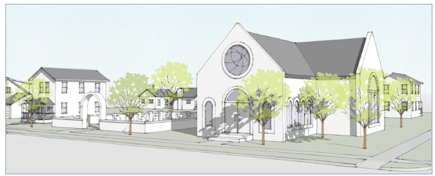
Figure 27: Illustrative Scale and Character
(2)
Dimensional Standards. The following table is a summary of the district-specific dimensional standards. Additional standards from Section 20.04.020 (Dimensional Standards) also apply.
_____
Table 02-15. MI District Dimensional Standards
Notes:
[1] Buildings abutting a property in the R1, R2, R3, or R4 zoning district shall comply with the standards in Section 20.04.070(d)(5) (Neighborhood Transition Standards).
[2] Where a nonresidential use is proposed on the ground floor, the minimum floor to ceiling height on the ground floor shall be twelve feet.
[3] See Section 20.04.110 (Incentives) for alternative standards.
_____
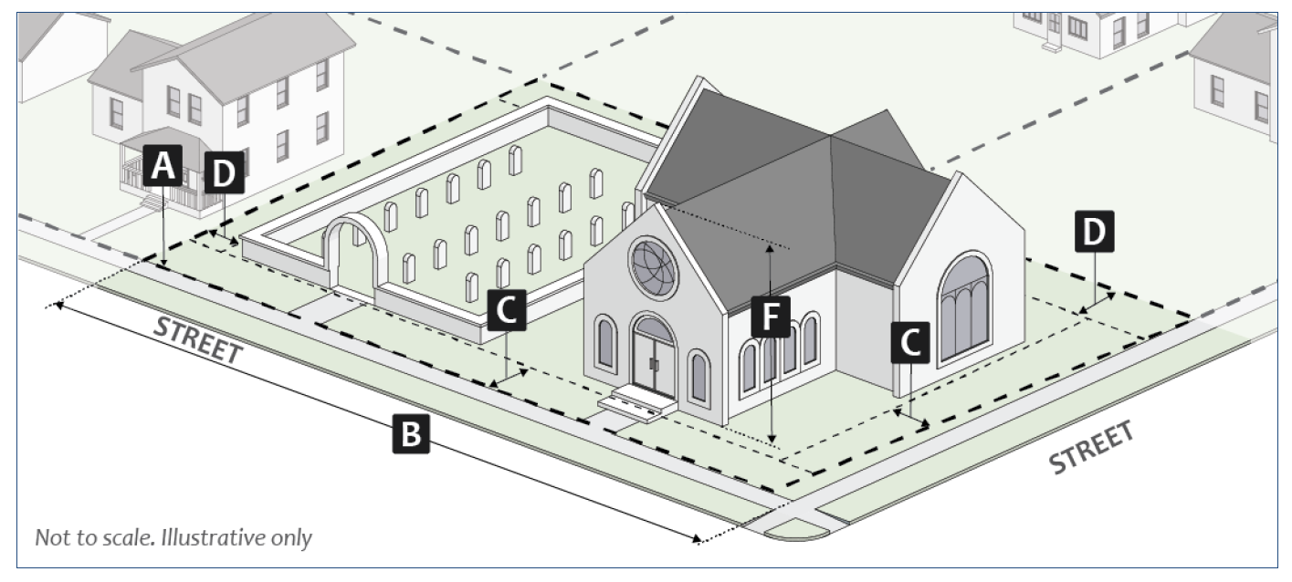
Figure 28: MI Dimensional Standards
(g)
MD: Mixed-Use Downtown.
(1)
Purpose. The MD district is intended to protect and enhance the character of the central business district, to guide new development and redevelopment activities in the downtown area, and to promote a mix of moderate- to high-density development with active street edges. The zoning district is divided into six different Downtown Character Overlays and permitted size and scale of buildings vary among those Downtown Character Overlays to ensure that projects are compatible in mass and scale with historic structures in the surrounding areas.
(2)
Other Applicable UDO Sections. All development shall comply with all other applicable regulations in this UDO including, without limitation, the Downtown Character Overlay regulations in Section 20.02.060(a), the permitted use regulations in Chapter 20.03 and development regulations in Chapter 20.04.
(3)
Dimensional Standards. Dimensional standards for the Downtown Character Overlays are shown in Section 20.02.030(g)(4) through 20.02.030(g)(9) below.
(4)
MD-CS: Mixed-Use Downtown—Courthouse Square Downtown Character Overlay.
(A)
Purpose. The Mixed-Use Downtown Courthouse Square (MD-CS) Character Area is intended to maintain the historic character of downtown by providing a diverse mix of traditional commercial retail uses at the street level to capitalize on, maintain and enhance the pedestrian activity, and to visually define the sidewalk edges with interesting buildings that respect the established context of traditional commercial storefront buildings.
Figure 29: Illustrative Scale and Character
(B)
Dimensional Standards. The following table is a summary of the district-specific dimensional standards. Additional standards from Section 20.04.020 (Dimensional Standards) also apply.
_____
Table 02-16. MD-CS Dimensional Standards
Notes:
[1] Buildings abutting a property in the R1, R2, R3, or R4 zoning district shall comply with the standards in Section 20.04.070(d)(5) (Neighborhood Transition Standards).
[2] Where a nonresidential use is proposed on the ground floor, the minimum floor to ceiling height on the ground floor shall be twelve feet.
[3] See Section 20.04.110 (Incentives) for alternative standards.
[4] Buildings that include one or more dwelling units that meet the definition of "Student Housing or Dormitory" shall be subject to the maximum building heights established in Section 20.03.030(b)(13) (Student Housing or Dormitory).
_____
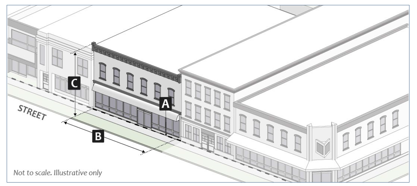
Figure 30: MD-CS Downtown Character Overlay Dimensional Standards
(5)
MD-DC: Mixed-Use Downtown—Downtown Core Downtown Character Overlay.
(A)
Purpose. The Mixed-Use Downtown Core (MD-DC) Character Area is intended to draw upon the design traditions exhibited by historic commercial buildings by providing individual, detailed storefront modules that are visually interesting to pedestrians, and to promote infill and redevelopment of sites using residential densities and building heights that are higher in comparison to other character areas within the downtown.
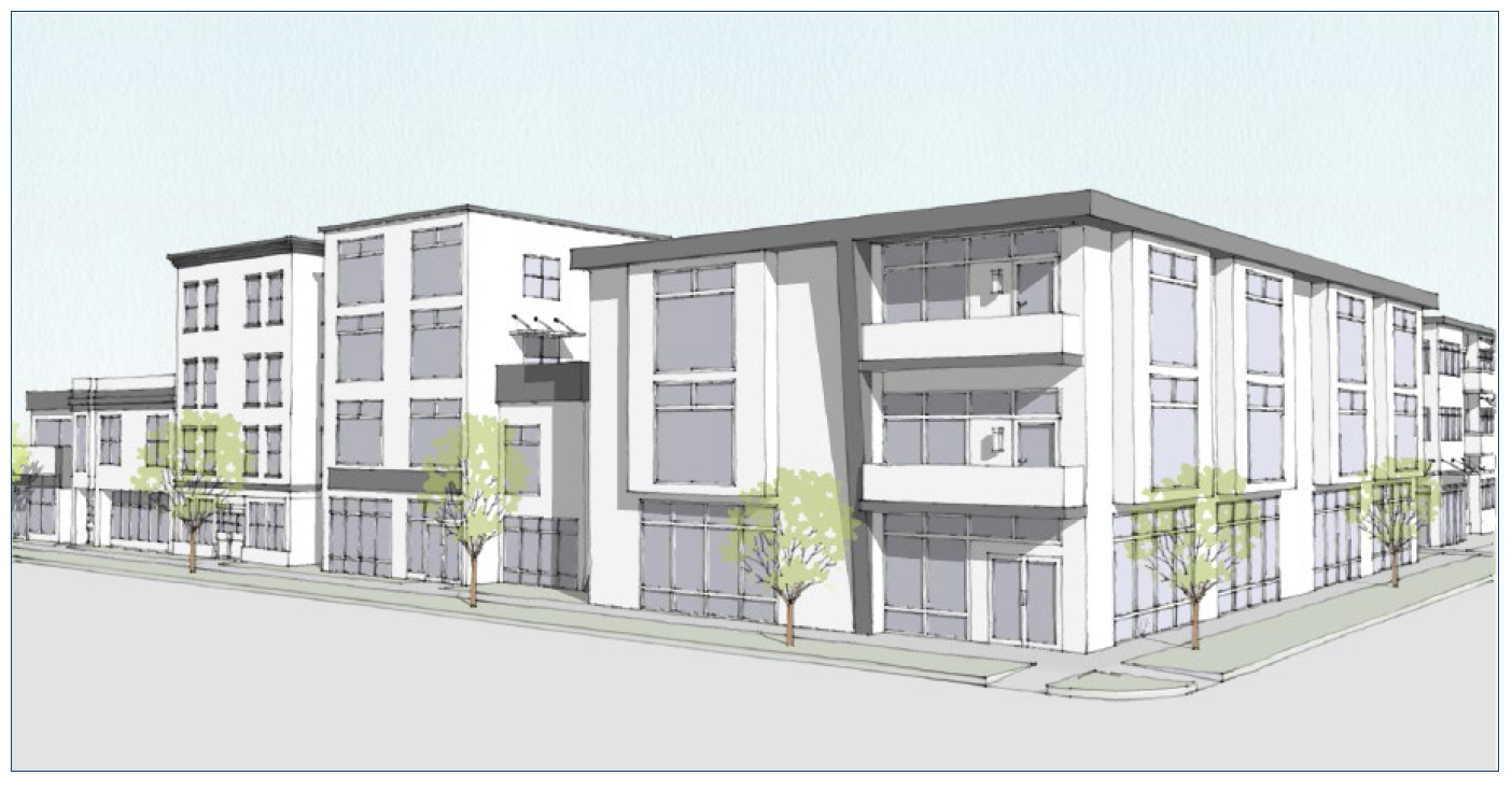
Figure 31: Illustrative Scale and Character
(B)
Dimensional Standards. The following table is a summary of the character area specific dimensional standards. Additional standards from Section 20.04.020 (Dimensional Standards) also apply.
_____
Table 02-17. MD-DC Dimensional Standards
Notes:
[1] Buildings abutting a property in the R1, R2, R3, or R4 zoning district shall comply with the standards in Section 20.04.070(d)(5) (Neighborhood Transition Standards).
[2] Where a nonresidential use is proposed on the ground floor, the minimum floor to ceiling height on the ground floor shall be twelve feet.
[3] See Section 20.04.110 (Incentives) for alternative standards.
[4] Buildings that include one or more dwelling units that meet the definition of "Student Housing or Dormitory" shall be subject to the maximum building heights established in Section 20.03.030(b)(13) (Student Housing or Dormitory).
_____

Figure 32: MD-DC Downtown Character Overlay Dimensional Standards
(6)
MD-UV: Mixed-Use Downtown—University Village Downtown Character Overlay.
(A)
Purpose. The Mixed-Use Downtown University Village (MD-UV) Character Area is intended to serve as a dynamic and key transitional activity center that connects the Courthouse Square with Indiana University, to promote infill and redevelopment of sites using moderate residential densities for the University Village Area and higher residential densities along the Kirkwood Corridor (Washington Street to Indiana Avenue) and to protect and maintain the unique character of the converted residential structures along Restaurant Row (4th Street between Lincoln Street and Dunn Street).
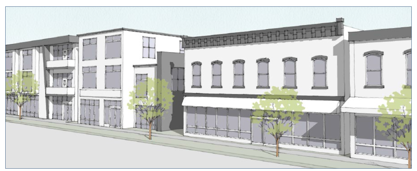
Figure 33: Illustrative Scale and Character
(B)
Dimensional Standards. The following table is a summary of the character area specific dimensional standards. Additional standards from Section 20.04.020 (Dimensional Standards) also apply.
_____
Table 02-18. MD-UV Dimensional Standards
Notes:
[1] Buildings abutting a property in the R1, R2, R3, or R4 zoning district shall comply with the standards in Section 20.04.070(d)(5) (Neighborhood Transition Standards).
[2] Where a nonresidential use is proposed on the ground floor, the minimum floor to ceiling height on the ground floor shall be twelve feet.
[3] See Section 20.04.110 (Incentives) for alternative standards.
[4] Buildings that include one or more dwelling units that meet the definition of "Student Housing or Dormitory" shall be subject to the maximum building heights established in Section 20.03.030(b)(13) (Student Housing or Dormitory).
_____
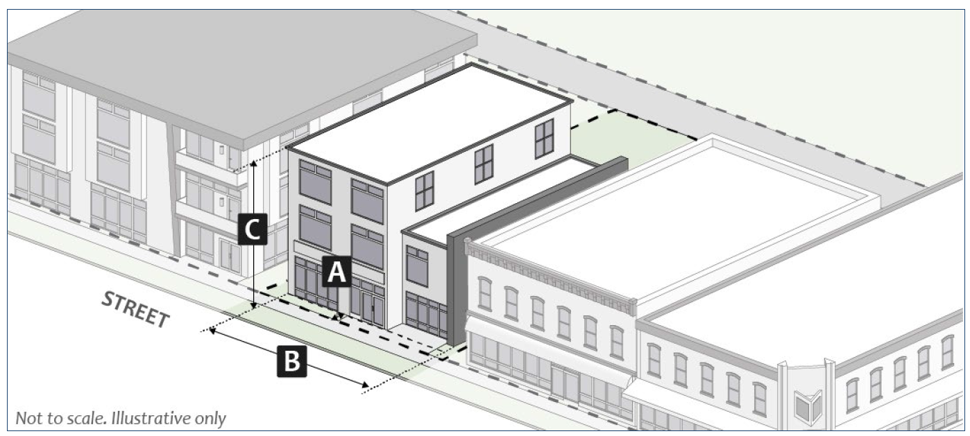
Figure 34: MD-UV Downtown Character Overlay Dimensional Standards
(7)
MD-DE: Mixed-Use Downtown—Downtown Edges Downtown Character Overlay.
(A)
Purpose. The Mixed-Use Downtown Edges (MD-DE) Character Area is intended to guide both new development and redevelopment activities to ensure that new development is compatible in mass and scale with historic structures in the Downtown Edges Character Area, and to create a transitional zone between downtown commercial and core residential development where design reflects a mix of traditional commercial storefronts and residential development configurations.
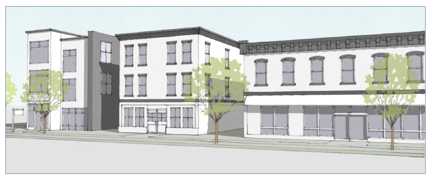
Figure 35: Illustrative Scale and Character
(B)
Dimensional Standards. The following table is a summary of the character area specific dimensional standards. Additional standards from Section 20.04.020 (Dimensional Standards) also apply.
_____
Table 02-19. MD-DE Dimensional Standards
Notes:
[1] Buildings abutting a property in the R1, R2, R3, or R4 zoning district shall comply with the standards in Section 20.04.070(d)(5) (Neighborhood Transition Standards).
[2] Where a nonresidential use is proposed on the ground floor, the minimum floor to ceiling height on the ground floor shall be twelve feet.
[3] See Section 20.04.110 (Incentives) for alternative standards.
[4] Buildings that include one or more dwelling units that meet the definition of "Student Housing or Dormitory" shall be subject to the maximum building heights established in Section 20.03.030(b)(13) (Student Housing or Dormitory).
_____
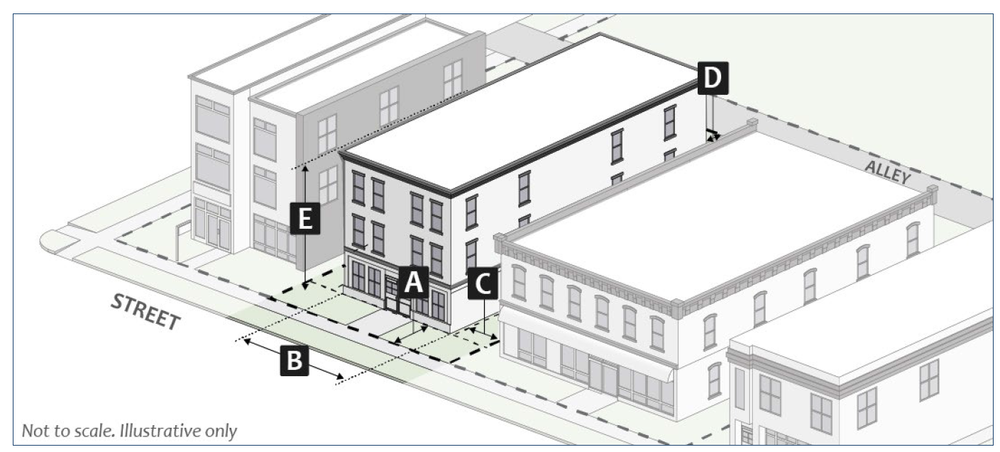
Figure 36: MD-DE Downtown Character Overlay Dimensional Standards
(8)
MD-DG: Mixed-Use Downtown—Downtown Gateway Downtown Character Overlay.
(A)
Purpose. The Mixed-Use Downtown Gateway (MD-DG) Character Area is intended to draw upon architectural detailing and thoughtful site planning to reflect the vital transitional nature of the district to the overall arrival and departure sequence to the downtown area and to create active mixed-use developments that link to adjacent neighborhoods and the downtown circulation network.
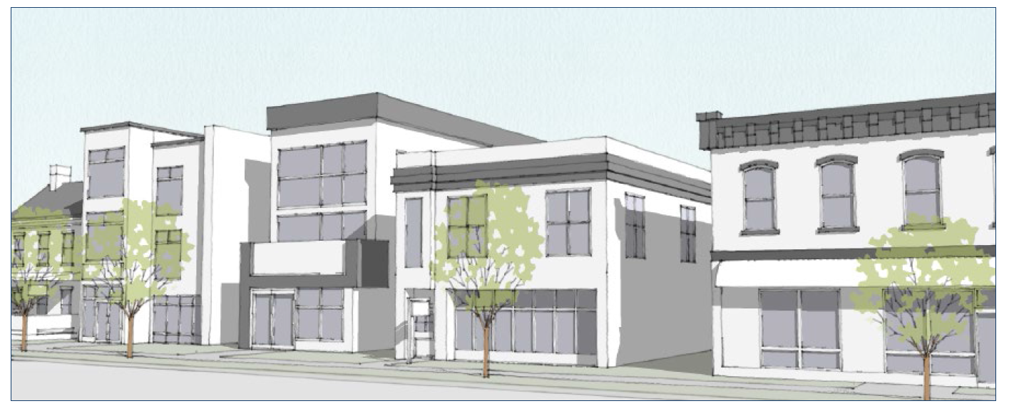
Figure 37: Illustrative Scale and Character
(B)
Dimensional Standards. The following table is a summary of the character area specific dimensional standards. Additional standards from Section 20.04.020 (Dimensional Standards) also apply.
_____
Table 02-20. MD-DG Dimensional Standards
Notes:
[1] Buildings abutting a property in the R1, R2, R3, or R4 zoning district shall comply with the standards in Section 20.04.070(d)(5) (Neighborhood Transition Standards).
[2] Where a nonresidential use is proposed on the ground floor, the minimum floor to ceiling height on the ground floor shall be twelve feet.
[3] See Section 20.04.110 (Incentives) for alternative standards.
[4] Buildings that include one or more dwelling units that meet the definition of "Student Housing or Dormitory" shall be subject to the maximum building heights established in Section 20.03.030(b)(13) (Student Housing or Dormitory).
_____
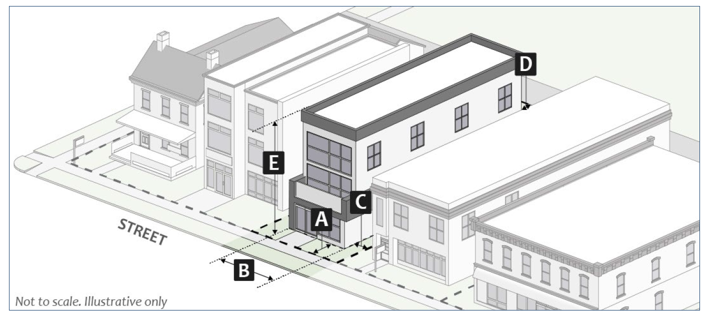
Figure 38: MD-DG Downtown Character Overlay Dimensional Standards
(9)
MD-ST: Showers Technology Downtown Character Overlay.
(A)
Purpose. The Mixed-Use Downtown—Showers Technology Character Area is intended to draw upon architectural detailing and thoughtful site planning to complement the mass and scale of existing historic structures, draw upon neo-traditional design concepts to extend the street grid and to create publicly accessible open space, integrate development that is strategically planned to promote mixed-use development focused on light industrial, manufacturing, and office uses where live/work, young professional, single-family, empty nester and retiree housing markets are targeted.
Figure 39: Illustrative Scale and Character
(B)
Dimensional Standards. The following table is a summary of the character area specific dimensional standards. Additional standards from Section 20.04.020 (Dimensional Standards) also apply.
_____
Table 02-21. MD-ST Dimensional Standards
Notes:
[1] Buildings abutting a property in the R1, R2, R3, or R4 zoning district shall comply with the standards in Section 20.04.070(d)(5) (Neighborhood Transition Standards).
[2] Where a nonresidential use is proposed on the ground floor, the minimum floor to ceiling height on the ground floor shall be twelve feet.
[3] See Section 20.04.110 (Incentives) for alternative standards.
[4] Buildings that include one or more dwelling units that meet the definition of "Student Housing or Dormitory" shall be subject to the maximum building heights established in Section 20.03.030(b)(13) (Student Housing or Dormitory).
_____
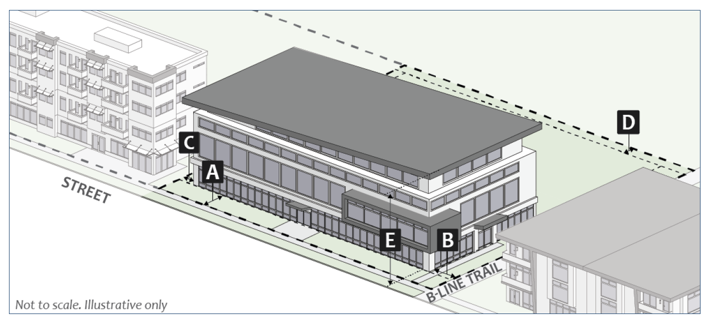
Figure 40: MD-ST Downtown Character Overlay Dimensional Standards
(h)
MH: Mixed-Use Healthcare.
(1)
Purpose. The MH district is intended to allow for the continued viability of medical related uses surrounding the current hospital site during the transition of the hospital from this zoning district to its new site in northeast Bloomington, and to control redevelopment of land surrounding the old hospital site while planning for redevelopment of the area is underway.
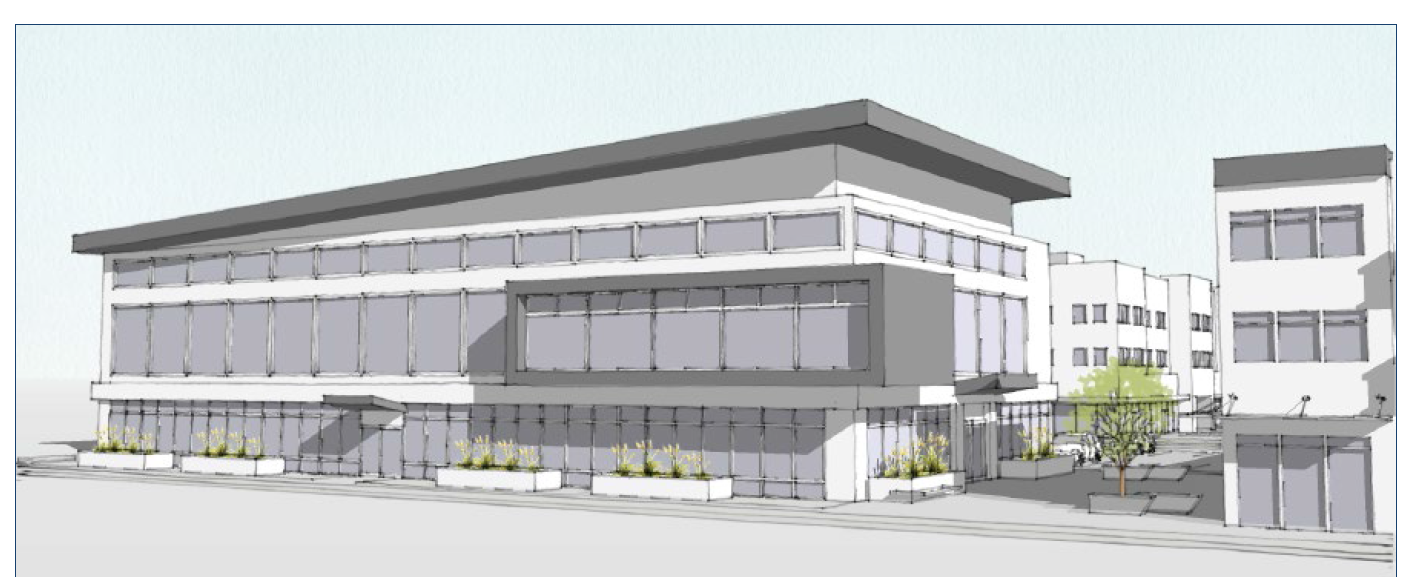
Figure 41: Illustrative Scale and Character
(2)
Dimensional Standards. The following table is a summary of the district-specific dimensional standards. Additional standards from Section 20.04.020 (Dimensional Standards) also apply.
_____
Table 02-22. MH District Dimensional Standards
Notes:
[1] Buildings abutting a property in the R1, R2, R3, or R4 zoning district shall comply with the standards in Section 20.04.070(d)(5) (Neighborhood Transition Standards).
[2] Where a nonresidential use is proposed on the ground floor, the minimum floor to ceiling height on the ground floor shall be twelve feet.
[3] See Section 20.04.110 (Incentives) for alternative standards.
_____
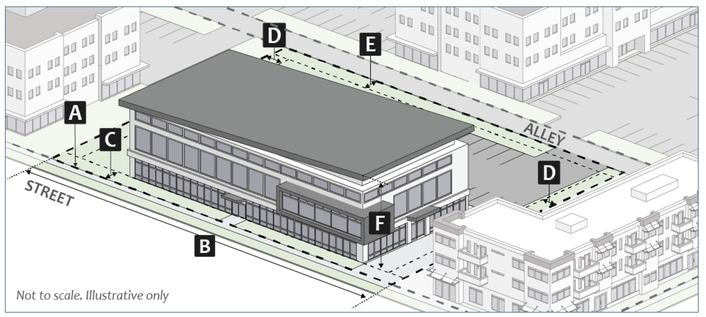
Figure 42: MH Dimensional Standards
(Amd. of 1-14-2020; Ord. No. 21-15, § II (Att. A), 4-21-2021; Ord. No. 21-22, § II (Att. A), 4-21-2021; Ord. No. 22-08, § 2(Att. A, B), 5-18-2022; Ord. No. 2024-03, § II(Att. A), 4-10-2024; Ord. No. 2025-12, § II(Att. A), 5-21-2025)
20.02.040 - Nonresidential zoning districts.
(a)
EM: Employment.
(1)
Purpose. The EM district is intended to accommodate existing and future employment uses that provide basic employment needs for Bloomington and the surrounding region, while ensuring that the site design, uses, and development scale are consistent with adjacent development.
Figure 43: Illustrative Scale and Character
(2)
Dimensional Standards. The following table is a summary of the district-specific dimensional standards. Additional standards from Section 20.04.020 (Dimensional Standards) also apply.
_____
Table 02-23. EM District Dimensional Standards
Notes:
[1] Buildings abutting a property in the R1, R2, R3, or R4 zoning district shall comply with the standards in Section 20.04.070(d)(5) (Neighborhood Transition Standards).
_____
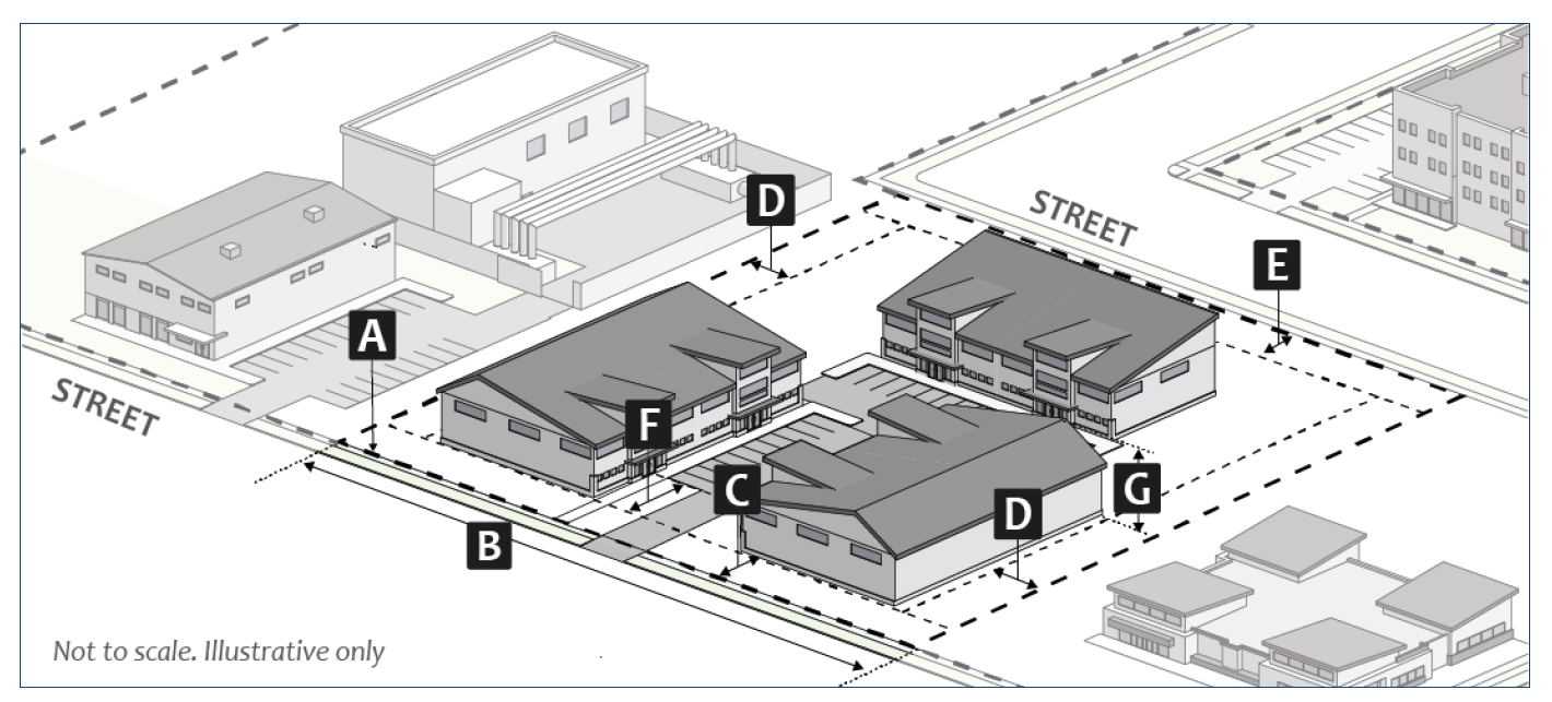
Figure 44: EM Dimensional Standards
(b)
PO: Parks and Open Space.
(1)
Purpose. The PO district is intended to accommodate and protect City-owned parks and open spaces and to limit structures and land uses to those compatible with the City's management plans for such properties.
Figure 45: Illustrative Scale and Character
(2)
Dimensional Standards. The following table is a summary of the district-specific dimensional standards. Additional standards from Section 20.04.020 (Dimensional Standards) also apply.
_____
Table 02-24. PO District Dimensional Standards
_____
Figure 46: PO Dimensional Standards
(3)
Additional PO District Standards.
(A)
All land uses, structures, and development in the PO district shall comply with all other provisions of this UDO unless specifically exempted in this UDO or through subsection (B) below.
(B)
In the event of a conflict between the provisions of this UDO and the provisions of an adopted City management plan, rule, or regulation applicable to that park or open space land or facility, the provisions of this UDO shall apply.
(Amd. of 1-14-2020; Ord. No. 21-22, § II (Att. A), 4-21-2021; Ord. No. 2024-03, § II(Att. A), 4-10-2024)
20.02.050 - Planned Unit Development (PUD) district.
(a)
Purpose. The purpose of the Planned Unit Development (PUD) district is to encourage new and imaginative concepts in urban design and land development to promote and improve the health, safety, and general welfare of the residents of the City and to create distinct developments with unique urban design, mixed uses, enhanced ecosystems services, and substantial additional benefit to the City that would not otherwise be required by this UDO. The PUD district is also intended to accommodate innovative development layouts that preserve the natural, environmental and scenic features of the site or address challenges presented by specific site conditions.
(b)
Qualifying Standards. A petition for rezoning into a Planned Unit Development (PUD) district shall only be considered if the petition meets the following criteria, as determined by the Planning and Transportation Director:
(1)
The proposed PUD zoning district includes a minimum of five acres of land;
(2)
The land included in the proposed PUD zoning district is not within the Mixed-Use Downtown (MD) zoning district;
(3)
Where residential dwelling units are proposed, the total dwelling units proposed must include, at a minimum, the percentage of permanently income-limited units required in 20.04.110(c)(2)(A) Tier 1, at the AMI percentages listed in that section and the development will be subject to the applicable standards established in Section 20.04.110(c) (Affordable Housing), unless the City otherwise adjusts or releases this requirement;
(4)
The proposed PUD could not be developed using conventional zoning districts or standards established in this UDO;
(5)
The land included in the proposed PUD is under single ownership or control. Single control of property under multiple ownership may be considered when the petition includes enforceable agreements, covenants, or commitments that run to the benefit of the City and that the City may require to be recorded if the PUD is approved; and
(6)
The proposed PUD zoning district embraces the following highly-valued design features:
(A)
Protection of specific natural, environmental, or scenic resources or green spaces; and/or
(B)
Retaining natural landforms throughout the development; and/or
(C)
Low impact development design features throughout the development; and/or
(D)
Solar orientation of building forms and other passive energy-efficient design strategies throughout the development.
(7)
The proposed PUD zoning district embraces several highly-valued design features, as determined by the Planning and Transportation Director, including but not limited to:
(A)
No block perimeter greater than one thousand four hundred feet in the development;
(B)
Centralized gathering and recreation spaces of an appropriate size for the entire development, or designed to serve an area larger than the entire development;
(C)
Internally and externally connected park, trail, and open space system;
(D)
Community-level renewable energy production.
(c)
Permitted Uses.
(1)
The permitted uses in a PUD district ordinance are subject to the approval of the Plan Commission and Common Council.
(2)
The permitted uses shall be determined based on consistency with the Comprehensive Plan, the existing zoning district designation of the area being rezoned to a PUD district, the land uses contiguous to the area being rezoned to a PUD district, and the development standards and design standards of the UDO.
(3)
If the terms of the PUD approved by Common Council do not clearly address the availability of specific uses in all or part of the development, then the uses and Use-Specific Standards that would otherwise be applicable to development of the same character and scale if it were zoned into one of the base zoning districts in Sections 20.02.020 through 20.02.040, as determined by the Planning and Transportation Director, shall apply.
(d)
Development Standards.
(1)
The development standards in a PUD district ordinance are subject to the approval of the Plan Commission and Common Council.
(2)
The development standards shall be determined based on consistency with the Comprehensive Plan, the existing zoning district designation of the area being rezoned to a PUD, and the development and design standards of the UDO.
(3)
If the terms of the PUD approved by Common Council do not state that the development standards or subdivision standards differ from those listed in Chapter 20.04 (Development Standards and Incentives) or Chapter 20.05 (Subdivision Standards), then the standards in those Chapters that would otherwise be applicable to development of the same type and scale if it were not zoned PUD, as determined by the Planning and Transportation Director, shall apply.
(e)
Review and Approval Procedures. Procedures and criteria for review and approval of a PUD district are in Section 20.06.070(c) (Rezoning to Planned Unit Development (PUD)).
(Amd. of 1-14-2020; Ord. No. 2026-02, § 2(Att. A), 1-16-2026)
20.02.060 - Overlay districts.
(a)
DCO: Downtown Character Overlay District. The following standards apply within the Downtown Character Overlays located in the Mixed-Use Downtown MD zoning district and are intended to implement the Downtown Vision and Infill Strategy Plan. In case of a conflict between the standards in this Section 20.02.060(a) and the standards in the underlying MD zoning district, the provisions in this section shall apply.
(1)
West Kirkwood Corridor.
(A)
The construction of new buildings on lots between Kirkwood Avenue and its adjacent alleys to the north and south, between Rogers Street and Adams Street, as more specifically mapped in the plan for West Kirkwood, shall comply with the architectural standards outlined in the plan for West Kirkwood.
(B)
All portions of the building facade facing the street above three stories in the DC Character Area, and portions of the building facade facing the street above two stories in the DG and ST Character Areas, shall step back from the lower story vertical facade/wall plane a minimum of fifteen feet.
(2)
Required Building Entrances.
(A)
At least one pedestrian entrance shall be provided for any primary building facade facing a public street.
(B)
At least one pedestrian entrance shall be provided per one hundred feet of building frontage along the B-line trail.
(C)
Required pedestrian entrances shall incorporate a landscaped plaza area that provides three or more of the following plaza amenities:
i.
Benches (minimum of two);
ii.
Bike racks;
iii.
Public art or water feature;
iv.
Drinking fountain;
v.
Trash receptacles;
vi.
Landscaped areas or planters; or
vii.
Enhanced exterior light fixtures, such as wall sconces or light coves.
(D)
At least one pedestrian entrance to each primary building shall be constructed at an elevation that is within three feet of the adjacent sidewalk elevation.
(E)
Pedestrian entrances on facades located within zero to five feet of the front property line shall be recessed a minimum of four feet into the front building facade.
(3)
Orientation of Entrances.
(A)
Any facade of a primary building facing a public street shall be considered a primary facade.
(B)
The primary pedestrian entrance shall not be located on a building facade adjacent to an alley.
(C)
For structures located within the Kirkwood Corridor, the primary pedestrian entrance shall be oriented to Kirkwood Avenue.
(D)
For structures located within Restaurant Row, the primary pedestrian entrance shall be oriented to 4th Street.
(4)
Primary Building Roof Design.
(A)
All primary buildings shall incorporate the roof shapes shown in the following table:
_____
Table 02-25. Primary Building Roof Design
_____
(B)
Where roofs with parapets are permitted, the parapet height shall not exceed fifteen percent of the supporting wall height.
(C)
Where sloped roofs are permitted, the roof shall have at least an 8:12 pitch.
(5)
Upper Floor Facade Stepbacks. All primary buildings shall comply with the following standards for upper floor stepbacks:
(A)
The first three stories of building facade in the DC Character Area, and the first two stories in the DG and ST Character Areas shall comply with the build-to range in Section 20.02.010 (Dimension Standards).
(B)
All portions of the building facade facing the street above two stories in the DG and ST character areas and above three stories in all other character areas shall step back from the lower story vertical facade/wall plane a minimum of fifteen feet.
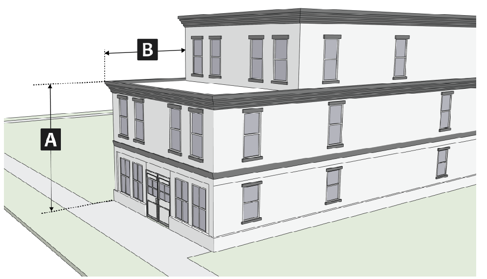
Figure 47: Upper Floor Facade Stepbacks
(6)
Windows and Doors on Primary Facades. All primary facades of a primary building shall meet the window and door design standards shown in the following table:
_____
Table 02-26. Windows and Doors on Primary Facades
_____
(7)
Primary Pedestrian Entrances. All primary facades of a primary building shall incorporate the levels of window and door areas, and shall meet the window and door design standards shown in the following table:
_____
Table 02-27. Primary Pedestrian Entrances
_____
(8)
Facade Articulation. The following standards apply to all street facing and non-street facing facades of primary buildings:
(A)
Belt Courses. In the CS and DC Downtown Character Overlays:
i.
Building facades shall incorporate exterior horizontal belt course design elements for the building base, middle and cap through techniques such as copestone, dripstone, string course, water table, and/or plinth using natural stone or masonry.
ii.
Building facades shall incorporate exterior vertical banding techniques using natural stone or masonry to visually define building subdivisions of wall planes, modules, or building facade focal points.
(B)
Other Articulation Required. Each facade of a primary building facing a street or the B-Line Trail shall be articulated through recessing, banding, articulation of exterior materials, or change of materials, by incorporating patterns that:
i.
Are offset by a minimum depth (projecting or recessing) of five percent of the total facade length, at a minimum of five feet, and the offset shall extend the length and height of its module; and
ii.
Vary or repeat based on the maximum facade module lengths shown in the table below.
_____
Table 02-28. Primary Building Articulation
_____
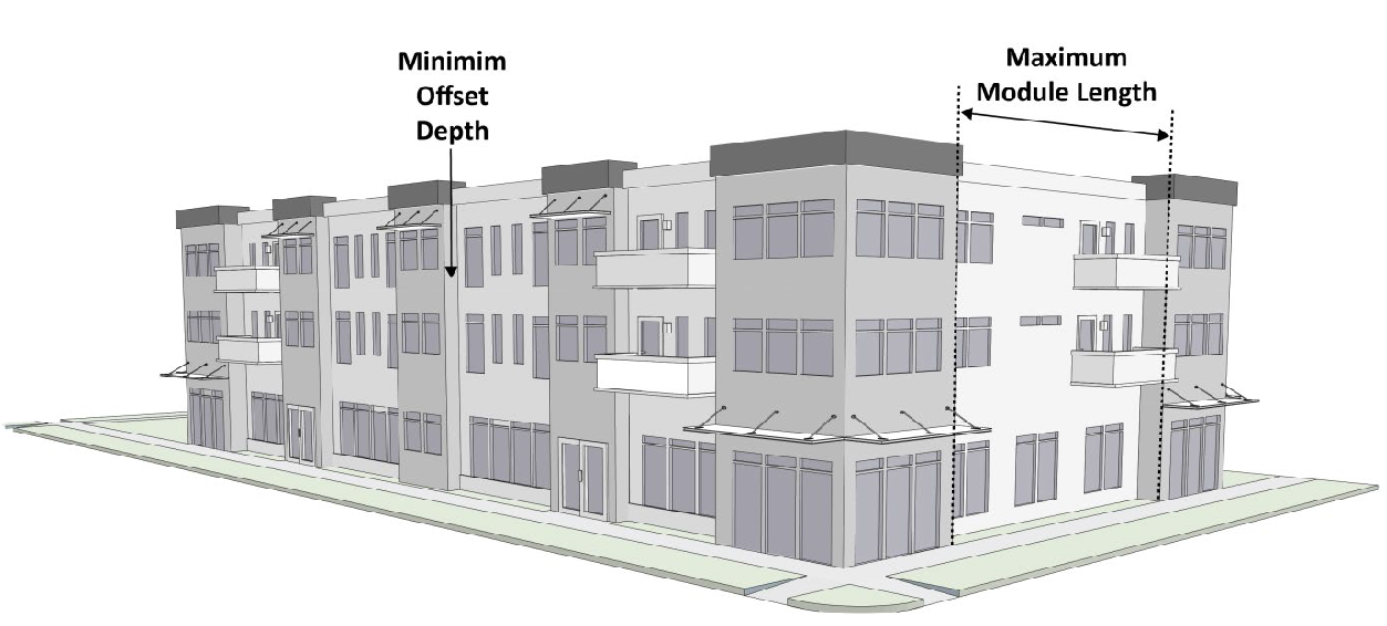
Figure 48: Primary Building Articulation
(9)
Facade Materials. All street and non-street facing facades of a primary building shall comply with the materials requirements shown in the following table:
_____
Table 02-29. Facade Materials
Notes:
[1] All exterior finish materials shall have a non-reflective, low reflectance, or matte finish.
[2] May only be used as a secondary facade material on floors above the first floor.
_____
(10)
Design Guidelines. Petitioners are encouraged to comply with design guidance in the following Guidelines contained in the Downtown Vision and Infill Strategy Plan to the degree that compliance with those Guidelines does not create an inconsistency with the standards in Sections 2.21.1 through 2.21.8 above.
(A)
Site plan: Guidelines 3.1 and 3.2.
(B)
Architectural character: Guidelines 3.3 and 3.4.
(C)
Mass, scale and form: Guidelines 3.5, 3.6, 3.7, 3.8 and 3.9.
(D)
Exterior building materials: Guidelines 3.10, 3.11 and 3.12.
(E)
Upper story windows: Guidelines 3.13 and 3.14.
(F)
Entries: Guidelines 3.15 and 3.16.
(G)
Pedestrian interest: Guidelines 3.17, 3.18 and 3.19.
(H)
Mechanical equipment and service utilities: Guidelines 3.20, 3.21, 3.22 and 3.23.
(I)
Parking structures: Guidelines 3.24 and 3.25.
(J)
Lighting: Guidelines 3.26, 3.27 and 3.28.
(b)
TRO: Transform Redevelopment Overlay.
(1)
Purpose. The TRO is intended to promote redevelopment that establishes a brand new identity for land use and natural attributes in order to significantly change the area from its current condition. Development principles include mixed-use, green building, grid circulation, higher densities, diversity of housing types, and workforce/affordable housing. The overlay is intended to encourage public and private investment to improve and stimulate the economic vitality and social character of areas within the TRO.
(2)
Applicability. The Transform Redevelopment Overlay may be established in a district other than R1, R2, R3, RMH, MS, MD, or PUD subject to Section 20.06.070(b) Zoning Map Amendment. In no case shall the TRO overlap with another overlay district.
(3)
Other Applicable UDO Sections. The Transform Redevelopment Overlay shall supersede the regulations of the underlying base zoning district for all specific regulations that are included within this section. If no specific and differing regulations are included, the regulations of the underlying base zoning district shall apply.
(4)
Dimensional Standards. The following table is a summary of the Transform Redevelopment Overlay dimensional standards. Additional Standards from the underlying base zoning district from Section 20.40.010 (Dimensional Standards) shall apply if no specific standard is included below.
_____
Table 02-30: TRO District Dimensional Standards
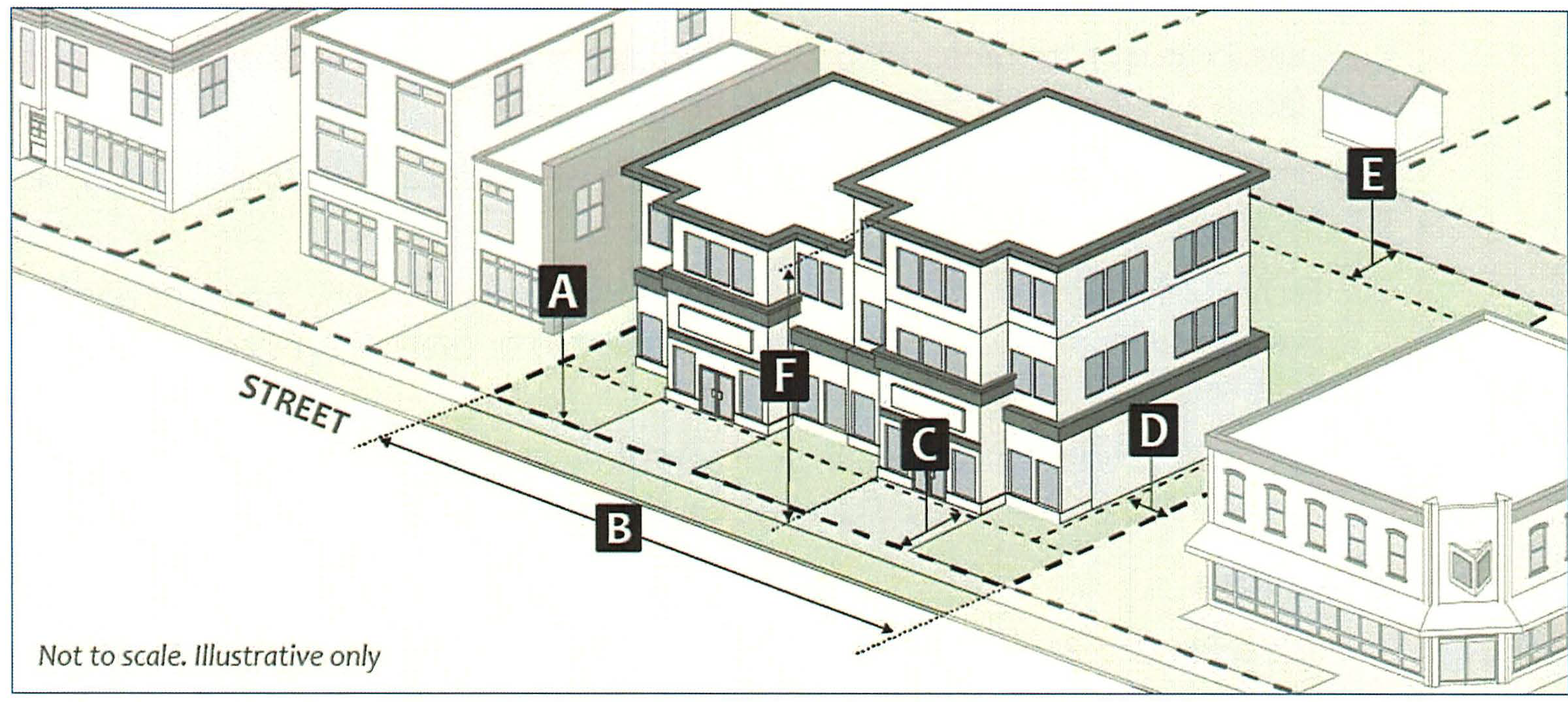
Figure 47: TRO Dimensional Standards
(5)
Allowed Use Table Modifications.
(A)
Excluded Uses. The following uses are prohibited within the TRO: Fraternity or sorority house; Opioid rehabilitation home, small; Crematory; Mortuary; Methadone treatment facility; Kennel; Country club; Sexually oriented business; Check cashing; Building supply store; Firearm sales; Pawn shop; Liquor or tobacco sales; Retail sales, big box; Vehicle fuel station; Student housing or dormitory.
(B)
Permitted Uses. The following uses are permitted within the TRO: Dwelling, single-family (attached)*; Dwelling, duplex*; Dwelling, triplex*; Dwelling, fourplex*; Dwelling, multifamily**; Dwelling, live/work*; Restaurant**.
* = base zoning district use-specific standards apply
** = overlay use-specific standards apply only
(6)
Use-Specific Standards. The lists of Permitted, Conditional, Accessory, Conditional Accessory, and Temporary uses listed in Table 3-1 (Allowed Use Table) are modified within the TRO as follows:
(A)
Dwelling, Multifamily.
(i)
For structures with frontage along a street, identified in the Transportation Plan as Main Street, Shared Street, or General Urban, and structures along the B-Line Trail, each dwelling unit located on the ground floor shall be located at least twenty feet behind each building facade facing a public street, or the B-Line Trail.
(ii)
Ground floor dwelling units with a front building wall facing a street shall be raised two to five feet above the sidewalk level.
(iii)
Each dwelling unit shall have direct access to a covered balcony, patio, or porch with an average depth of at least five feet located adjacent to or overlooking a common open space, right-of-way, or B-Line Trail.
(iv)
Any portions within the ground floor of a structure used for vehicular parking shall be located at least twenty feet behind the building facade facing a public street.
(B)
Restaurant.
(i)
In the RM and RH zoning districts, the restaurant shall contain no more than five thousand gross square feet of floor area.
(7)
Access and Connectivity.
(A)
Driveways and Access
(i)
Alley Access. A driveway accessing the street shall be prohibited if the side or rear setback is adjacent via a platted alley.
(ii)
Surface Material. Except for single-family, duplex, triplex, and fourplex uses, entrances and drives shall be constructed solely of permeable pavers.
(8)
Parking and Loading.
(A)
Minimum Vehicle Parking Requirement. Minimum vehicle parking requirements shall not apply to developments in the TRO.
(B)
Maximum Vehicle Parking Allowance:
(i)
Household Living Uses. Maximum vehicle parking allowance listed in Table 04-10: Maximum Vehicle Parking Allowance, shall apply to developments in the TRO, except multifamily uses, which shall be limited to a maximum of 0.5 spaces per bedroom.
(ii)
All Other Uses. The maximum vehicle parking allowance, listed in Table 04-10: Maximum Vehicle Parking Allowance, shall be reduced by fifty percent in the TRO.
(C)
Surface Material. Except for single-family, duplex, triplex, and fourplex residences and parking structures all vehicle parking shall be constructed solely of permeable pavers.
(9)
Site and Building Design.
(A)
Street Lighting Plans Generally:
(i)
Pedestrian scaled street lighting shall be provided as approved by the Board of Public Works.
(ii)
Pedestrian scaled street lighting shall not exceed fifteen feet in height. Additional street lighting may be required, as determined to be necessary by the City Engineer and approved by the Board of Public Works.
(B)
Building Design.
(i)
Exceptions.
1.
Single-family, duplex, triplex, and fourplex dwellings shall not be subject to the architectural standards of this Section 20.02.050(b). Such residential dwellings units shall be subject to the architectural standards of Section 20.04.070(d)(3) (Building Design).
2.
Restoration and rehabilitation of structures designated as "Notable" or "Outstanding" on the City of Bloomington Survey of Historic Sites and Structures or those buildings in local historic districts shall not be subject to the architectural standards of this Section 20.02.050(b). Such buildings shall be subject to the procedures outlined in Section 20.06.050(c) (Demolition Delay Permit) as required.
(ii)
Materials. All facades of a primary building shall consist of one or more of the following primary and secondary exterior finished materials:
1.
Primary Exterior Finish Materials:
a.
Masonry;
b.
Brick;
c.
Natural Stone;
d.
Transparent Glass;
e.
Cementitious siding;
f.
Precast concrete;
g.
Metal (except corrugated); or
h.
Wood.
2.
Secondary Exterior Finish Materials:
a.
Stucco, plaster, or similar systems (excluding EIFS);
b.
Split-faced block; or
c.
Other products that replicate the appearance and durability of the above materials, as approved by staff.
3.
Prohibited Exterior Finish Materials:
a.
EIFS;
b.
Vinyl; and
c.
Highly reflective materials.
(iii)
Primary Pedestrian Entry.
1.
At least one primary pedestrian entrance shall be provided from a sidewalk adjacent to every facade facing a street, public park, or the B-Line trail.
a.
Public access to nonresidential uses shall be provided at sidewalk grade via a sidewalk adjacent to a facade facing a street, public park, or the B-Line trail.
b.
Pedestrian entrances located within zero to five feet of the front property line shall be recessed a minimum of four feet into the front building facade.
2.
Pedestrian entries shall incorporate at least one of the following architectural design features:
a.
A portico;
b.
A buttress and arched entry;
c.
Pilasters or a facade module projecting from the exterior wall plane;
d.
A raised corniced entryway parapet (which may exceed building height by up to three feet) or a gable;
e.
Rusticated masonry;
f.
A front porch; or
g.
Other architectural designs as approved by the staff.
(iv)
Landscaped Frontage and Courtyards
1.
Landscaped Frontage: Front building setbacks shall not generate unusable or dead space. Portions of a property between the right-of-way and the primary facade of a structure shall include a landscaped space which screens blank walls and is planted with grass or other vegetative ground cover. Landscaped outdoor commercial space, including outdoor seating, may be utilized to meet this requirement when contiguous with a commercial use. Landscaped private yards or patio areas may be utilized to meet this requirement when adjacent to a dwelling unit.
2.
Courtyards: Primary buildings shall include courtyards equal to five percent of the building's total footprint. In no case shall a required courtyard be less than two hundred fifty square feet. The courtyard shall be visible from a sidewalk. Pedestrian entrances are permitted and encouraged to access from the courtyard. Mixed-use structures which feature a commercial use on the ground floor are exempt from this requirement. Reconfiguration of open space required by this UDO does not satisfy this requirement. Courtyards shall include one of the following features:
a.
A plaza space with ornamental paving and integral landscape planters;
b.
A landscaped patio area with outdoor seating for at least eight persons;
c.
A landscaped garden area; or
d.
Other landscaped areas as approved by the staff.
(v)
Exterior Facades.
1.
Generally: All facades of a primary building shall incorporate the following design elements to avoid blank, uninterrupted walls:
a.
A minimum of twenty percent of the total wall/facade area of all upper floor facades shall contain transparent glass or framed facade openings; and
2.
Primary buildings with frontage along streets identified in the Transportation Plan as Main Street, Shared Street, or General Urban or along the B-Line Trail; or portions of primary buildings containing ground floor nonresidential uses shall incorporate the following design elements to avoid blank, uninterrupted walls:
a.
A minimum of sixty percent of the total wall/facade area of all ground floor facades shall contain transparent glass or framed facade open areas consisting of display windows, or entries and doors; and
b.
A canopy, awning, or other roof-like cover intended to protect from the weather with an average depth of at least five feet is required along at least sixty percent of the first floor of all primary facades. Retractable awnings may be used to meet this requirement; and
3.
All other facades of a primary building shall incorporate the following design elements to avoid blank, uninterrupted walls:
a.
A minimum of twenty percent of the total wall/facade area of all ground floor residential facades shall contain transparent glass or framed facade open areas consisting of entries and doors; and
b.
A canopy, awning, or other roof-like cover intended to protect from the weather with an average depth of at least five feet is required along at least twenty percent of the first floor of all primary facades. Retractable awnings may be used to meet this requirement.
(vi)
Building Size Maximum.
1.
Building Floor Plate. The maximum building floor plate for a structure in the TRO shall be five thousand square feet per building, pursuant to the measurement standards in Section 20.040.020(g) (Building Floor Plate). However, if either the affordable housing incentive codified at Section 20.04.110(c) or the sustainable development incentive codified at Section 20.40.110(d) has been earned, the maximum building floor plate shall be ten thousand square feet per building. If both the affordable housing incentive codified at Section 20.04.110(c) and the sustainable development incentive codified at Section 20.040.10(d) have been earned, the maximum building floor plate shall be fifteen thousand square feet per building.
2.
Building Height. The maximum building height shall not exceed the underlying base zoning district, except as necessary to accommodate additional height earned through this section:
a.
Eligibility. In addition to the eligibility criteria in Section 20.04.110(c)(2), affordable housing projects seeking increased maximum primary structure height shall comply with the following criteria:
i.
The building shall contain six or more dwelling units; and
ii.
Unit size and bedroom mix for deed-restricted units shall be comparable to those for market-rate units.
b.
Tier 1 Projects. Projects that meet the Tier 1 affordability standards may increase the primary structure height by two floors of building height, not to exceed twenty-four feet, beyond the maximum primary structure height established for the zoning district where the project is located, as identified in Section 20.04.020 (Dimensional Standards).
c.
Tier 2 Projects. Projects that meet the Tier 2 affordability standards may increase the primary structure height by two floors of building height, not to exceed twenty-four feet, beyond the maximum primary structure height established for the zoning district where the project is located, as identified in Section 20.04.020 (Dimensional Standards).
d.
Projects achieving both Tier 1 and Tier 2 affordability standards may increase the primary structure height of four floors of building height, not to exceed forty-eight feet, beyond the maximum primary structure height established for the zoning district where the project is located, as identified in Section 20.04.020 (Dimensional Standards).
e.
Sustainable Development Bonus.
i.
Tier 1 Projects: Projects that are eligible for increased primary structure height for affordable housing and sustainable development shall be eligible for one additional floor of building height, not to exceed twelve feet.
ii.
Tier 2 Projects: Projects that are eligible for increased primary structure height for affordable housing and sustainable development shall be eligible for one additional floor of building height, not to exceed twelve feet. The additional floor of building height granted under this subsection shall be limited to fifty percent of the building footprint area of primary structure, and that additional floor shall be set back at least ten feet further than the lower floors of the building.
(10)
Landscaping, Buffering, and Fences.
(A)
Buffer Yards. Developments within the TRO are not required to provide buffer yards.
(B)
Landscaping.
(i)
Interior Plantings. The minimum landscape area on a site, as established in this section or areas not covered by an impervious surface or required buffer yard shall be planted with the following:
1.
A minimum of one canopy tree per five hundred square feet. Open areas less than ten feet in width may substitute ornamental trees for required canopy trees.
a.
Tree location should maximize visibility between windows and the street.
2.
A minimum of eight shrubs per five hundred square feet. One ornamental tree may be substituted for every four shrubs; however, a substitution shall not exceed fifty of the required shrubs.
3.
Shrubs and ornamental trees along foundation walls of a structure shall be planted no closer than two feet and eight feet respectively from the foundation wall.
ii.
Parking Lot Perimeter Plantings. See Section 20.04.080(h)(1).
iii.
Parking Lot Landscape Bumpouts, Islands, and Endcaps. See Section 20.04080(h)(2).
(11)
Subdivision Standards. All subdivisions within the Transform Redevelopment Overlay shall be designed according to the Infill Subdivision (IS) type specified in this Chapter and Chapter 20.05.
(A)
Development Standards.
_____
Table 02-31: IS Subdivision Development Standards
Notes:
[1] Required to meet Transportation Plan guidance.
[2] Where on-street parking is provided, it shall comply with the standards in 20.04.060(0) (On-street Parking Standards for Private Streets).
_____
(B)
Lots.
(i)
Design.
1.
All new lots shall have frontage on a public street right-of-way or shall be part of a cottage home development with frontage on a public street right-of-way.
(12)
Departures.
(A)
Purpose. Departures are provisions that allow for form based adjustment or deviations from the dimensional, numeric, or building and site design standards of this UDO for properties within the Transform Redevelopment Overlay. Such departures are intended to meet the goals of the specific standard while providing exceptional architectural design which would not otherwise be permitted. Departures are intended to provide an alternative means of compliance by providing greater flexibility when necessary to achieve the goals of the Comprehensive Plan and the Transform Redevelopment Overlay. Departures are not variances and are not intended to circumvent the variance process.
(B)
Applicability.
(i)
Any site plan, or portion of a site plan, as determined by the Planning and Transportation Director to offer a unique and beneficial design under the criteria in this section may be considered for a departure.
(ii)
Any project that would qualify for minor site plan review but would require a departure as allowed in this section shall be required to undergo major site plan review.
(C)
Limitations on Departures.
(i)
The departure procedure shall not apply to any proposed modification or deviation that results in:
1.
A change in permitted uses or mix of uses;
2.
A deviation from building or fire codes;
3.
A deviation from engineering standards;
4.
Requirements for public roadways, utilities, or other public infrastructure or facilities; or
5.
A change to a development standard where that same standard was already modified through a separate administrative adjustment or variance.
(D)
Departure Review Process.
(i)
Petition Submittal and Handling. A petition for departure shall only be submitted and reviewed concurrently with a petition for a major site plan review. Each UDO standard shall be considered a separate departure request as it relates to the approval criteria, but multiple departures may be considered in one departure petition.
(ii)
Review and Decision.
1.
The Plan Commission shall review and decide the departure petition based on the following criteria:
a.
The proposed departure and development shall be consistent with and shall not interfere with the achievement of the goals and objectives of the Comprehensive Plan and any other applicable adopted plans and policies;
b.
Provides adequate public services and facilities;
c.
Will not create a hardship or adverse impacts on adjacent properties unless adequately mitigated;
d.
Is of a technical nature and is required to provide for an exceptional architectural design which will:
i.
Significantly enhance the visual appeal of the building;
ii.
Significantly enhance the perceived quality of the building facades visible from public streets; and
iii.
Strengthen the public-private interaction at the street level.
(Amd. of 1-14-2020; Ord. No. 21-15, § II (Att. A), 4-21-2021; Ord. No. 21-16, § II (Att. A), 4-21-2021; Ord. No. 22-08, § 2(Att. A), 5-18-2022; Ord. No. 22-36, § 2(Att. A, B), 1-30-2023; Ord. No. 23-04, § 2(Att. A), 4-19-2023; Ord. No. 2024-03, § II(Att. A), 4-10-2024; Ord. No. 2024-05, § II(Att. A), 4-10-2024; Ord. No. 2025-12, § II(Att. A), 5-21-2025)