
Bloomington City Zoning Code
CHAPTER 20
04 - DEVELOPMENT STANDARDS AND INCENTIVES
20.04.010 - Applicability.
(a)
New Development. The requirements of this chapter shall apply to all new development pursuant to Section 20.01.020 (Authority, Applicability, and Jurisdiction), unless otherwise exempted in this chapter.
(b)
Activities that Trigger Compliance.
(1)
Construction of any new primary structure on a lot shall require compliance with all standards in this chapter unless an exception is stated in this UDO.
(2)
Table 04-1 identifies activities that trigger compliance for conforming sites and structures with specific development standards contained in Chapter 20.04 (Development Standards and Incentives). These standards shall not exempt development activity that falls below the thresholds identified in Table 04-1 from complying with applicable standards of this UDO or any applicable federal, state, or local regulations. Additional information on applicability is provided in the referenced sections.
(3)
Section 20.06.090(f) (Nonconforming Site Features) identifies activities that trigger full and limited compliance for lawful nonconforming sites and structures with specific development standards contained in Chapter 20.04 (Development Standards and Incentives).
(4)
For purposes of this section, "entire site" shall mean the total area of the lot on which development is occurring. "Disturbed area" shall mean those areas of the lot or those portions of the structure that are included in the project area or that are affected by the proposed development activity.
_____
Table 04-1. Development Standards Compliance Thresholds for Conforming Sites and Structures
(Amd. of 1-14-2020; Ord. No. 21-15, § II (Att. A), 4-21-2021; Ord. No. 21-18, § II (Att. A), 4-21-2021)
_____
20.04.020 - Dimensional standards.
(a)
Purpose. This section is intended to provide dimensional standards and uniform methods of measurement for interpretation and enforcement of the lot and building standards in this UDO.
(b)
Applicability. Compliance with this Section 20.04.020 (Dimensional Standards) shall be required pursuant to Section 20.04.010 (Applicability).
(c)
General Dimensional Standards. The following tables, Table 04-2 through Table 04-5, establishes the dimensional standards for Residential, Mixed-Use, and other zoning districts contained in Chapter 20.02 (Zoning Districts). In case of a conflict between the dimensions shown in this Section 20.04.020 and the dimensions shown for individual districts in Chapter 20.02 (Zoning Districts), the provisions of this Section 20.04.020 shall govern.
(1)
Residential Zoning Districts. Dimensional standards for Residential zoning districts are shown in Table 04-2 (Residential District Dimensional Standards).
(2)
Mixed-Use Zoning Districts. Dimensional standards for Mixed-Use zoning districts are shown in Table 04-3 (Mixed-Use District Dimensional Standards).
(3)
Downtown Character Overlays. Dimensional standards for the Downtown Character Overlays are shown in Table 04-4 (Downtown Character Overlay Dimensional Standards).
(4)
Nonresidential Zoning Districts. Dimensional standards for Nonresidential zoning districts are shown in Table 04-5 (Nonresidential District Dimensional Standards).
_____
Table 04-2. Residential District Dimensional Standards
Notes:
[1] Any single-family, duplex, triplex, or fourplex development shall be subject to the R4 residential lot standards, except that the front building setback shall be determined by the standards of the base's zoning district.
[2] See Section 20.04.110 (Incentives) for alternative standards.
[3] Or the median front setback of abutting residential structures, whichever is less.
[4] Or equal to the setback of the primary structure, whichever is greater.
[5] Legally established lots of record that are less than the minimum lot width may reduce the required setback up to two feet.
[6] Buildings abutting a property in the R1, R2, R3, or R4 zoning district shall comply with the standards in Section 20.04.070(d)(5) (Neighborhood Transition Standards).
[7] Side primary building setbacks shall be reduced by two feet if adjacent to a platted alley. Rear primary building setbacks shall be reduced by ten feet if adjacent to a platted alley.
_____
Table 04-3. Mixed-Use District Dimensional Standards
Notes:
[1] Buildings abutting a property in the R1, R2, R3, or R4 zoning district shall comply with the standards in Section 20.04.070(d)(5) (Neighborhood Transition Standards).
[2] Where a nonresidential use is proposed on the ground floor, the minimum floor to ceiling height shall be twelve feet.
[3] See Section 20.04.110 (Incentives) for alternative standards.
[4] Lots zoned MM north of 1st Street, south of 2nd Street east of Maple Street (extending south of 2nd Street to 1st Street) and west of Morton Street shall have an impervious surface coverage maximum of eighty-five percent.
[5] Lots zoned MM north of 1st Street, east of Maple Street (extending south of 2nd Street to 1st Street) and west of Morton Street shall have a minimum landscape area of fifteen percent.
[6] Lots zoned MM north of 1st Street south of 2nd Street east of Maple Street (extending south of 2nd Street to 1st Street), and west of Morton Street shall have minimum side and rear building setbacks of zero feet.
[7] Any single-family, duplex, triplex, or fourplex development shall be subject to the R4 residential lot standards, except that the front building setback shall be determined by the standards of the base's zoning district.
_____
Table 04-4. Downtown Character Overlay Dimensional Standards
Notes:
[1] Buildings abutting a property in the R1, R2, R3, or R4 zoning district shall comply with the standards in Section 20.04.070(d)(5) (Neighborhood Transition Standards).
[2] Where a nonresidential use is proposed on the ground floor, the minimum floor to ceiling height shall be twelve feet.
[3] See Section 20.04.110 (Incentives) for alternative standards. Additional height incentives shall not be available for student housing or dormitories.
[4] Buildings that include one or more dwelling units that meet the definition of "Student Housing or Dormitory" shall be subject to the maximum building heights established in Section 20.03.030(b)(13) (Student Housing or Dormitory).
_____
Table 04-5. Nonresidential District Dimensional Standards
Notes:
[1] When adjacent to the R1, R2, R3, or R4 zoning district, the minimum setback shall be increased by one foot for each foot of building height over thirty feet.
_____
(d)
Lot and Space Requirements.
(1)
Minimum Lot Dimensions. No space that is needed to meet the width, setback, area, open space, impervious surface coverage, parking, landscaping, or other requirements of this UDO for a lot or building may be sold, leased, or subdivided away from such lot or building. All lots affected by a proposed subdivision shall meet the standards of this UDO.
(2)
Number of Primary Buildings or Uses per Lot.
(A)
Except for projects approved as cottage development pursuant to Section 20.03.030(b)(7) (Dwelling, Cottage Development), only one principal building for single-family, duplex, triplex, or fourplex uses, with permitted accessory buildings, may be located on a lot or parcel. Every dwelling shall have legal means of access to a right-of-way.
(B)
Where a lot or parcel is used for multifamily, mixed-use, commercial, or industrial purposes, more than one primary building may be located upon the lot when such buildings conform to all requirements of this UDO applicable to the uses and district.
(C)
No lot shall be divided to contain more dwelling units than are permitted by the regulations of the zoning district in which they are located.
(e)
Setbacks.
(1)
Measurement.
(A)
Setbacks referred to in this UDO shall be measured as stated in Chapter 20.07 (Definitions), under the term "setback" and "build-to range."
(B)
For private streets, setbacks shall be measured from the edge of the curb, easement, or right-of-way, whichever distance is greater.
(C)
Where existing right-of-way is wider than that proposed on the Transportation Plan, the setback shall be measured from the existing right-of-way.
(D)
For lots of record with no street frontage, a minimum building setback of ten feet is required from the property line where access is gained. All other lot lines shall be considered side lot lines for the purposes of setbacks.
(E)
The minimum front building facade at the build-to range percentage shall be determined by calculating the width of the principal building that is within the build-to range divided by the total width of the lot at the street frontage.
(2)
Single-Family Attached and Multifamily Dwellings.
(A)
Multifamily dwellings on one lot shall be construed as one structure for purpose of measuring setbacks.
(B)
For purposes of setback calculations for side-by-side single-family attached or multifamily dwellings, only those dwelling units that do not share a common wall with an adjacent unit (end units) shall observe the required side setback for the district.
(3)
Exceptions to Setback Requirements.
(A)
The setback exceptions established in Table 04-6 shall not authorize the encroachment of any development across property lines or into a public right-of-way.
(B)
Every part of a required setback shall be unobstructed from ground level to the sky, except as follows:
_____
Table 04-6. Authorized Exceptions to Setback Requirements
_____
(C)
Where this UDO establishes a maximum setback from the front property line, that maximum setback may be increased by up to five feet to accommodate access required by the Americans with Disabilities Act, utility or access easements, or to prevent encroachment of building projections over the public right-of-way.
(D)
For parking and building setback purposes, Interstate 69 is not considered a front.
(4)
Through Lots. On a through lot, the Planning and Transportation Director shall determine which lot line shall be deemed the front lot line based on the existing and/or proposed building orientation of surrounding lots. Through lots adjacent to an arterial street shall comply with the standards established in Section 20.05.050(j)(7)(A)iii. (Buffer).
(f)
Building Height.
(1)
Measurement. Maximum building heights are expressed in both overall dimension and the number of stories, where applicable.
(A)
Stories. Story height is measured between the floor of a story to the floor of the story above it. For single-story buildings and the uppermost story of a multistory building, the measurement shall be from the floor of the story to the ceiling.
(B)
Overall Dimension. The height of buildings shall be measured as the vertical distance from the average finished grade surface of the building, structure, or wall exposed above the ground surface to the highest point of the roof, parapet wall, or uppermost part.
Figure 50: Building Height
(2)
Exceptions to Height Requirements. No building or structure or part of a building or structure shall exceed the maximum building height within any zoning district unless authorized in Table 04-7, or elsewhere in this UDO.
_____
Table 04-7. Authorized Exceptions to Height Requirements
_____
(g)
Building Floor Plate.
(1)
The area of the lot covered by the primary building shall be included in the calculation of building floor plate in all districts.
(2)
The area of a lot covered by accessory buildings, parking garages, carports, and utility and storage sheds shall not be included in this calculation.
(h)
Minor Modification. Minor modifications to some of the dimensional standards in this section may be available through the minor modification process in Section 20.06.080(a) (Minor Modification), which may be approved by staff during the petition process without the need to apply for a variance, provided that the criteria in Section 20.06.080(a) are met.
(Amd. of 1-14-2020; Ord. No. 21-15, § II (Att. A), 4-21-2021; Ord. No. 21-18, § II (Att. A), 4-21-2021; Ord. No. 21-22, § II (Att. A), 4-21-2021; Ord. No. 22-08, § II(Att. A), 5-18-2022; Ord. 22-10, § II(Att. A), 5-18-2022; Ord. No. 23-04, § 2(Att. A), 4-19-2023; Ord. No. 23-06, § 2(Att. A), 4-19-2023; Ord. No. 2024-03, § II(Att. A), 4-10-2024; Ord. No. 2024-04, § II(Att. A), 4-10-2024; Ord. No. 2025-12, § II(Att. A), 5-21-2025)
20.04.030 - Environment.
(a)
Purpose. The Bloomington area is characterized by a wide variety of environmental features that affect the way land is developed. These features include karst geology (sinkholes, caves, springs, etc.), wetland areas, steep slopes, mature tree stands, and water resources such as lakes, streams and other surface watercourses. It is prudent and necessary that every area that becomes the subject of a petition for development be routinely scrutinized for the presence of environmental features in order to protect and enhance these environmental features and help mitigate the climate and extinction emergencies as well as the public health, ecology, and welfare.
(b)
Applicability. Compliance with this Section 20.04.030 (Environment) shall be required pursuant to Section 20.04.010 (Applicability) and the specific applicability criteria established in Sections 20.04.030(c) (Steep Slopes) through 20.04.030(i) (Lake Watershed Areas).
(c)
Steep Slopes.
(1)
Applicability. This section shall apply to all land-disturbing activities on properties that contain naturally occurring steep or excessive slopes.
(2)
Slope Measurement. For the purposes of this section, the percent slope shall be calculated by dividing the number of feet of elevation change between the top and toe of the slope in question by the horizontal distance of the slope in question, then multiply by one hundred to acquire a percent figure.
(3)
Easements. All slope areas required to be preserved subject to this section shall be placed within conservation easements pursuant to the standards of Section 20.05.040 (Easements).
(4)
Excessive Slopes. Areas of land where the pre-development slopes are twenty-five percent or greater shall not be disturbed for any improvements with the exception of utility lines.
(5)
Steep Slopes. Any development on slopes between twelve percent and less than twenty-five percent shall be allowed a maximum disturbance of fifty percent of the total slope area. Priority for slope preservation shall be given to slope areas that exhibit one or more of the following characteristics:
(A)
Presence of highly erodible soils as identified in the Web Soil Survey produced by the National Cooperative Soil Services and operated by the USDA Natural Resources Conservation Service;
(B)
Adjacent to slopes of greater than eighteen percent;
(C)
Adjacent to water resources;
(D)
Adjacent to other environmental features that are required to be preserved as part of this UDO; or
(E)
Presence of tree cover on fifty percent or more of the surface area of the slope.
(6)
Construction Measures. Any development on slopes twelve percent or greater and less than twenty-five percent shall incorporate construction measures such as retaining walls and walkout basements as well as current preferred practices for erosion control measures during construction, as provided in Title 13 (Stormwater) of the Bloomington Municipal Code.
(7)
Street Grades. Arterial and collector streets shall not exceed grades of six percent and local streets or alleys shall not exceed grades of eight percent unless the petitioner demonstrates that steeper grades will minimize disturbances to existing topography.
(8)
Street Design. All drives and streets shall follow the topography with a minimum of cutting and filling.
(9)
Soil Constraints. When unstable or contaminated soils are found, the effect of cutting and filling, alterations to slope, and the stabilization measures required to either avoid or address unstable or contaminated soils shall be minimized to the maximum extent practicable, given the soil condition to be avoided or mitigated.
(10)
Overlapping Preservation Areas. Where acreage set aside to fulfill the conservation or buffer requirements in Section 20.04.030(d), Section 20.04.030(f), Section 20.04.030(g), and Section 20.04.030(h) also meets the requirements for steep slope preservation under this section, such acreage shall be counted toward fulfillment of all applicable requirements.
(d)
Drainage.
(1)
Applicability. All proposed site plans submitted for approval, under the provisions of this UDO, shall provide for the collection and management of all surface water drainage.
(2)
Exemption. The construction of single-family, duplex, triplex, fourplex, Mobile home, and manufactured home dwellings on existing lots of record where fully engineered drainage infrastructure is in place prior to occupancy of the home shall be exempt from the requirements of this Section 20.04.030 (Environment).
(3)
Poorly Drained Sites. Development proposed for sites that are adjacent to a floodplain area, located in an area with converging drainage flows, located in an area characterized by documented drainage problems, or located in an area with closed, depressed contour lines as shown on the City's GIS maps shall be subject to a higher level of drainage plan review. Site plans for these areas shall submit documentation that finished floor elevations of structures shall be at least two feet above areas that would be flooded during a one hundred-year storm event.
(4)
Dry Hydrants. Any development that incorporates a retention pond with a standing pool of water of at least ten thousand cubic feet in volume shall provide a dry hydrant that meets the specifications of the National Fire Protection Association (NFPA) Standard on Water Supplies for Suburban and Rural Fire Fighting, NFPA 1142 Chapter 9 (2001 Edition), or any subsequent amendment thereto.
(e)
Riparian Buffers.
(1)
Applicability.
(A)
This subsection shall apply to all land development activities on properties that are contiguous with or contain intermittent or perennial streams. However, lots of record of less than one-half acre in size shall not be subject to 20.04.030(e)(6) (Intermediate Zone) nor 20.04.030(e)(7) (Fringe Zone) of this section.
(B)
Any new, non-single-family development that is exempt from providing riparian buffer zones as outlined in 20.04.030(e)(1), shall provide at least a twenty-five-foot wide streamside buffer zone in compliance with the design standards of 20.04.030(e)(5). Additionally, two of the following best management practices, including plans for post-installation maintenance of such practices, shall be incorporated into the site design:
i.
Use of one hundred percent native vegetation;
ii.
Use of permeable pavement for one hundred percent of all the on-site parking areas;
iii.
Biofiltration swales; or
iv.
Fifty percent vegetated roof.
(2)
Adjacent Properties. Where intermittent or perennial streams are present on adjacent properties, and where required buffer zones for such streams would extend onto the subject property, the buffer zones required by this subsection (e) shall be established.
(3)
Easements. All riparian buffer zones required to be preserved subject to this subsection (e) shall be placed within riparian buffer easements pursuant to the standards of Section 20.05.040 (Easements).
(4)
Graduated Buffer Zones. All intermittent or perennial streams shall be protected by a riparian buffer composed of three distinct zones. These zones shall be defined as:
(A)
Streamside Zone (Zone 1). The primary function of the streamside zone is to ensure stream-bank stabilization.
(B)
Intermediate Zone (Zone 2). The primary function of the intermediate zone is to protect soil particles that trap nutrients and chemicals.
(C)
Fringe Zone (Zone 3). The primary function of the fringe zone is to filter runoff, and to maximize infiltration, water storage, and nutrient absorption.
(5)
Streamside Zone Design. The streamside zone (Zone 1) shall be designed as follows:
(A)
Location. Immediately adjacent to the stream channel.
(B)
Buffer Width.
i.
For the main branches of Jackson Creek south of 2nd Street and Clear Creek south of Grimes Lane, the width of this zone shall be a minimum of fifty feet on each side of the stream, measured from the centerline of the stream.
ii.
For all other streams, the width of this zone shall be a minimum of twenty-five feet on each side of the stream, measured from the centerline of the stream.
(C)
Vegetation Requirements. All vegetative cover within this zone shall consist of undisturbed, existing vegetation, except that invasive and nonnative plants may be removed with permission from the Planning and Transportation Department. In cases where little or no existing vegetation is present, only native, water tolerant species shall be planted. Acceptable species for planting within buffer zones are listed in Section 20.04.080(d) (Permitted Plant Species). Plant spacing and density for new vegetation within buffer zones shall comply with current preferred practices for each plant type.
(D)
Disturbance Activities. Only the following land disturbance activities may be allowed within this zone, subject to approval of the City Planning and Transportation Department:
i.
Utility installation; if no alternative location is available;
ii.
Street crossings, where necessary to achieve connectivity;
iii.
Bicycle and/or pedestrian crossings, where necessary to achieve connectivity;
iv.
Connector path and multi-use trail constructed with a permeable surface.
(6)
Intermediate Zone Design. The intermediate zone (Zone 2) shall be designed as follows:
(A)
Location. Immediately outside the streamside zone (Zone 1).
(B)
Buffer Width. The required width shall be a minimum twenty-five feet on each side, measured perpendicularly from the outer boundary of Zone 1.
(C)
Vegetation Requirements. All vegetative cover within this zone shall consist of undisturbed, existing vegetation, except that invasive and nonnative plants may be removed with permission from the Planning and Transportation Department. In cases where little or no existing vegetation is present, only native, water tolerant species shall be planted. Acceptable species for planting within buffer zones are listed in Section 20.04.0B0(d) (Permitted Plant Species). Plant spacing and density for new vegetation within buffer zones shall comply with current preferred practices for each plant type.
(D)
Disturbance Activities. Only the following land disturbance activities may be allowed within this zone, subject to approval of the City Planning and Transportation Department:
i.
Utility installation; if no alternative location is available;
ii.
Street crossings, where necessary to achieve connectivity;
iii.
Bicycle and/or pedestrian crossings, where necessary to achieve connectivity;
iv.
Connector path and multi-use trail constructed with a permeable surface.
(6)
Intermediate Zone Design. The intermediate zone (Zone 2) shall be designed as follows:
(A)
Location. Immediately outside the streamside zone (Zone 1).
(B)
Buffer Width. The required width shall be a minimum twenty-five feet on each side, measured perpendicularly from the outer boundary of Zone 1.
(C)
Vegetation Requirements. Vegetative cover within this zone shall consist of undistu1·bed, existing vegetation, supplemented by native, groundcover and edge vegetation except that invasive and non-native plants may be removed with permission from the Planning and Transportation Department. In cases where little or no existing vegetation is present, only native, water tolerant species shall be planted. Appropriate species for planting within buffer zones are listed in Section 20.04.0S0(d) (Permitted Plant Species). Plant spacing and density for new vegetation within buffer zones shall comply with current preferred practices for each plant type.
(D)
Disturbance Activities. Only the following land-disturbing activities may be allowed within this zone, subject to approval of the Planning and Transportation Department:
i.
All activities allowed in Zone 1 (streamside zone); and
ii.
Stormwater management facilities.
(7)
Fringe Zone Design. The fringe zone (Zone 3) shall be designed as follows:
(A)
Location. Immediately outside the intermediate zone (Zone 2).
(B)
Buffer Width. The required width shall be a minimum of twenty-five feet measured perpendicular from the outer boundary of Zone 2.
(C)
Vegetation Requirements. The vegetative cover for the outer zone shall be native grasses, sedges, and forbs that perform phytofiltration, except that invasive and non-native plants may be removed with permission from the Planning and Transportation Department. In addition, woody plants may be utilized where appropriate. Appropriate species for planting within buffer zones are listed in Section 20.04.080(d) (Permitted Plant Species). Plant spacing and density for new vegetation within buffer zones shall comply with current preferred practices for each plant type.
(D)
Disturbance Activities. Only the following land-disturbance activities may be allowed within this zone, subject to approval of the City Planning and Transportation Department:
i.
All activities allowed within Zones 1 and 2.
ii.
Streets, as needed to achieve connectivity where no reasonable alternative route can be identified and where a need for new streets has been established, as required by adopted City regulations and Common Council policy.
(8)
Additional Riparian Buffer Design Standards.
(A)
Riparian buffer design shall be fitted to the topography and soil conditions of the site. Preference shall be given to preserving existing vegetation within riparian buffer areas. Protection of tree crowns and root zones within the dripline shall be required for all trees planned for retention.
(B)
Temporary vegetation, sufficient to stabilize the soil, may be required on all disturbed areas as needed to prevent soil erosion. New plantings shall be given sufficient water and protection to ensure reestablishment.
(C)
In order to ensure vegetative diversity, a minimum of nine different plant species shall be used within the overall riparian buffer area. At least three of these species shall be trees selected from Section 20.04.080(d) (Permitted Plant Species).
(D)
No alteration to the shoreline or bed of a stream or creek shall be made unless written approval is obtained from the appropriate governmental agencies. Alterations subject to this requirement include, but are not limited to, filling, damming, or dredging of a stream, creek, ditch, or wetland.
(9)
Riparian Buffer Maintenance. Management of riparian buffers shall be limited to the minimum necessary, with no alterations of forest understory, except for the removal of nonnative or invasive species. Limited mowing may occur in Zone 3 but shall be prohibited in Zones 1 and 2.
(f)
Karst Geology.
(1)
Applicability.
(A)
This section shall apply to all land-disturbing activities on properties that contain surface and subsurface karst features.
(B)
In the event an undetected karst feature is formed on a developed lot or parcel, the Planning and Transportation Director may authorize emergency remediation measures subject to guidance from the City Senior Environmental Planner.
(2)
Adjacent Properties. Where surface or subsurface karst features are present on adjacent properties, and where required conservation areas for such karst features would extend onto the subject property, the buffer zones required by this subsection (f) shall be established.
(3)
Compound Karst Features. For the purposes of this subsection, compound karst features shall be defined as any two or more karst features where the last closed contour of the features are located within one hundred feet of each other. The outer boundary of the compound karst feature shall be drawn by connecting the last closed contour at its widest point of each individual karst feature with a tangential line.
(4)
Karst Conservancy Easement (KCE). All karst features shall be protected by Karst Conservancy Easements (KCE). Such easements shall be established in accordance with the following standards:
(A)
No land-disturbing activity, permanent or temporary structures, or the placement of any fill material shall be allowed within a KCE.
(B)
The outer perimeter of the KCE shall be protected with silt fencing and/or tree protection fencing during the entire period of construction.
(C)
For all individual karst features, the KCE shall encompass the entire feature and all of the area within twenty-five feet horizontally from the last closed contour line of the feature. The last closed contour line shall be as shown on the City's Geographic Information System (GIS) using a contour interval of two feet. When the City has reason to doubt the accuracy of the GIS data, the City shall use field verification to determine the location of the last closed contour.
(D)
For all compound karst features, the KCE shall encompass the entire outer boundary of the compound karst feature as defined in Section 20.04.030(f)(3) (Compound Karst Features) above and all of the area within twenty-five feet horizontally from the outer boundary of the compound karst feature.
(5)
Setback. No structures shall be located within ten feet of a Karst Conservancy Easement.
(6)
Stormwater Discharge. Stormwater discharge into a karst feature shall not be increased over, or substantially reduced below its pre-development rate.
(7)
Stormwater Detention. Karst conservancy easements shall not be used for stormwater detention. Drainage shall be designed to route runoff through vegetative filters or other filtration measures before entering a karst feature.
(8)
Disturbance. No land-disturbing activity, mowing, or temporary or permanent structure shall be allowed within the sinkhole nor within twenty-five feet of the last closed contour of the sinkhole.
(9)
Spring or Cave Entrances. Spring or cave entrances shall not be modified except for the placement of a gate to prevent human access.
(g)
Wetlands.
(1)
Applicability. This section shall apply to all land-disturbing activities on properties containing wetlands.
(2)
Adjacent Properties. Where wetlands are present on adjacent properties, and where required buffer areas for such wetlands would extend onto the subject property, the buffer zones required by this subsection (g) shall be established.
(3)
Compliance with Other Regulations Also Required. In addition to the standards of this UDO, all determined and delineated jurisdictional wetlands subject to disturbance shall be governed by Indiana Department of Natural Resources (DNR), Indiana Department of Environmental Management (IDEM), and Army Corps of Engineers regulations.
(4)
Disturbance. No land-disturbing activity, mowing, or temporary or permanent structure shall be allowed within twenty-five feet of a wetland.
(5)
Wetland Conservancy Easement. A wetland buffer area extending twenty-five feet from a delineated wetland shall be placed within a conservancy easement consistent with the standards of Section 20.05.040 (Easements) and shall be protected with silt fencing, tree protection fencing, or both, during the entire period of construction.
(6)
Draining. Draining of a delineated wetland is prohibited.
(7)
Stormwater Discharge. Stormwater discharge into a wetland shall not be increased over, or substantially reduced below, its preexisting rate.
(h)
Tree and Forest Preservation.
(1)
Applicability. This section shall apply to all land-disturbing activities on properties containing closed-canopy wooded areas.
(2)
Retention of Existing Canopy. The following table shall be used to determine the minimum amount of existing vegetation canopy that must be retained during land-disturbance activity.
_____
Table 04-8. Minimum Required Vegetation Canopy
_____
(3)
Preference to Stands of Vegetation. The retention standards outlined above shall be applied to retain high-quality stands of native trees, undisturbed woodlands, and corridors of contiguous vegetation in priority over individual specimen trees, or younger stands of vegetation. No more than ten percent of the canopy retention standard shall be met by preserving individual trees not included within preferred wooded areas as defined in this subsection (h). Where individual specimen trees are to be preserved, preference shall be given to protecting heritage trees that are of particular value due to their type, size or age.
(4)
Smaller Parcels. For parcels of land less than two acres, the preservation standards in Table 04-8 (Minimum Required Vegetation Canopy) may be altered by the City Planning and Transportation Director to allow preservation of individual specimen trees or tree lines along property borders in lieu of the minimum required vegetation canopy.
(5)
Overlapping Preservation Areas. Where acreage set aside to fulfill the conservation or buffer requirements found in Sections 20.04.030(c) (Steep Slopes), 20.04.030(d) (Drainage), 20.04.030(f) (Karst Geology), and 20.04.030(g) (Wetlands) also meets the requirements for tree and forest preservation under Section 20.04.030(h)(2) (Retention of Existing Canopy), such acreage shall be counted toward fulfillment of all applicable requirements.
(6)
Conservancy or Tree Preservation Easement. Where contiguous areas of at least eight thousand seven hundred twelve feet (one-fifth acre) of tree cover are required to be preserved, a conservancy and/or tree preservation easement shall be required per Section 20.05.040 (Easements). The edges of such easements shall be delineated ten feet beyond the driplines of the trees to be preserved.
(7)
Tree Protection During Construction. A tree protection zone shall be installed per Section 20.04.080(c)(3) and inspected by the Planning and Transportation Department prior to any land-disturbing activities. The tree protection zone and the tree protection barrier shall remain undamaged and unmoved during the entire duration of construction. If a petitioner believes the conditions of a tree protection zone cannot be established, they shall contact the Planning and Transportation Department and the Urban Forester in order to develop an individual plan for tree protection.
(i)
Lake Watershed Areas.
(1)
Applicability. This section shall apply to all land-disturbing activities on properties located within the watersheds of Lake Monroe and Griffy Lake as delineated on the City's Geographic Information System (GIS).
(2)
Exception. Single-family, duplex, triplex, fourplex, mobile home, and manufactured home dwellings on existing lots of record shall not be subject to the requirements of this section.
(3)
Geotechnical Report. When required by the Planning and Transportation Director, based on potential development impacts, site plans, subdivision plats, and Planned Unit Development plans shall include a report prepared by a geotechnical consultant that addresses soil stabilization, erosion/siltation control and stormwater runoff quality. The geotechnical consultant who prepares the required report shall be a licensed professional engineer.
(4)
Site Design. Site design shall locate structures and land-disturbing activities so as to avoid tree concentrations. Streets, parking areas, and building pads shall conform closely to existing contours and minimize grading.
(5)
Steep Slopes. The maximum slope on which buildings may be constructed shall be twelve percent. No disturbance shall occur on any slope greater than twelve percent, measured as described in Section 20.04.020 (Dimensional Standards).
(6)
Redundant Stormwater Quality Measures. Sites greater than one acre shall incorporate redundant stormwater runoff quality mitigation measures. The ongoing maintenance of these measures shall be ensured through a binding, recordable commitment that provides for all the following:
(A)
Periodic third-party inspection and report;
(B)
A homeowner's association with financing capability;
(C)
City authorization to order maintenance;
(D)
City authorization to seek injunctive relief;
(E)
City authorization to perform necessary maintenance and charge the homeowner's association for such work; and
(F)
Provisions, meeting the standards of the administrative manual, for responsibility of individual lot owners in the event the owners' association fails or refuses to perform.
(Amd. of 1-14-2020; Ord. No. 21-18, § II (Att. A), 4-21-2021; Ord. No. 23-06, § 2(Att. A), 4-19-2023; Ord. No. 2024-03, § II(Att. A), 4-10-2024; Ord. No. 2024-03, § II(Att. A), 4-10-2024; Ord. No. 2024-04, § II(Att. A), 4-10-2024; Ord. No. 2024-17, § II(Att. A), 9-18-2024; Ord. No. 2025-12, § II(Att. A), 5-21-2025)
20.04.040 - Floodplain.
(a)
Purpose. The flood hazard areas of the City of Bloomington are subject to periodic inundation which results in loss of life and property, health and safety hazards, disruption of commerce and governmental services, extraordinary public expenditures for flood protection and relief, and impairment of the tax base, all of which adversely affect the public health, safety, and general welfare. Additionally, structures that are inadequately elevated, floodproofed, or otherwise protected from flood damage also contribute to the flood loss. In order to minimize the threat of such damages and to achieve the purposes hereinafter set forth, these regulations are adopted. It is the purpose of this ordinance to promote the public health, safety, and general welfare and to minimize public and private losses due to flood conditions in specific areas by provisions designed to:
(1)
Protect human life and health;
(2)
Minimize expenditure of public money for costly flood control projects;
(3)
Minimize the need for rescue and relief efforts associated with flooding and generally undertaken at the expense of the general public;
(4)
Minimize prolonged business interruptions;
(5)
Minimize damage to public facilities and utilities such as water and gas mains, electric, telephone, and sewer lines, streets, and bridges located in floodplains;
(6)
Help maintain a stable tax base by providing for the sound use and development of flood prone areas in such a manner as to minimize flood blight area;
(7)
Ensure that those who occupy the areas of special flood hazard assume responsibility for their actions;
(8)
Minimize the impact of development on adjacent properties within and near flood prone areas;
(9)
Ensure that the flood storage and conveyance functions of the floodplain are maintained;
(10)
Minimize the impact of development on the natural, beneficial values of the floodplain;
(11)
Prevent floodplain uses that are either hazardous or environmentally incompatible;
(12)
Meet community participation requirements of the National Flood Insurance Program;
(13)
Restricting or prohibiting uses which are dangerous to health, safety, and property due to water hazards, or which result in damaging increases in flood heights or velocities;
(14)
Requiring that uses vulnerable to floods, including facilities, which serve such uses, be protected against flood damage at the time of initial construction;
(15)
Controlling the alteration of natural floodplains, stream channels, and natural protective barriers, which help accommodate or channel flood waters;
(16)
Controlling filling, grading, dredging, excavating, and other development which may increase flood damage; and
(17)
Preventing or regulating the construction of flood barriers, which will unnaturally divert flood, waters or which may increase flood hazards in other areas.
(b)
Applicability.
(1)
This Section 20.04.040 (Floodplain) shall apply to all areas of special flood hazard (SFHAs) within the jurisdiction of the City of Bloomington, Indiana including any additional areas of special flood hazard annexed by the City of Bloomington, Indiana.
(2)
No structure shall hereafter be located, extended, converted or structurally altered within the SFHA without full compliance with the terms of this UDO and other applicable regulations.
(3)
No land or stream within the SFHA shall hereafter be altered without full compliance with the terms of this UDO and other applicable regulations.
(c)
General Standards.
(1)
Basis for Establishing the Areas of Special Flood Hazard.
(A)
The regulatory flood elevation, floodway, and fringe limits for the studied SFHAs within the jurisdiction of the City, delineated as an "AE Zone" on the Flood Insurance Study dated December 17, 2010 and the Flood Insurance Rate Map dated December 17, 2010 shall be determined from the one-percent annual chance flood profiles in the Flood Insurance Study of the City of Bloomington, Indiana and the corresponding Flood Insurance Rate Maps (FIRM) dated December 17, 2010 as well as any subsequent updates, amendments, or revisions, prepared by the Federal Emergency Management Agency with the most recent date. Should the floodway limits not be delineated on the Flood Insurance Rate Map for a studied SFHA designated as an "AE Zone", the limits of the floodway will be according to the best available flood layer as provided by the Indiana Department of Natural Resources.
(B)
The regulatory flood elevation, floodway, and fringe limits for each of the SFHAs within the jurisdiction of the City, delineated as an "A Zone" on the Flood Insurance Study dated December 17, 2010 and the Flood Insurance Rate Map, dated December 17, 2010, as well as any subsequent updates, amendments, or revisions, prepared by the Federal Emergency Management Agency with the most recent date, shall be according to the best available flood layer provided by the Indiana Department of Natural Resources, provided the upstream drainage area from the subject site is greater than one square mile. Whenever a party disagrees with the best available flood layer data, the party needs to replace existing data with better data that meets current engineering standards. To be considered, this data must be submitted to the Indiana Department of Natural Resources for review and subsequently approved.
(C)
In the absence of a published FEMA map, or absence of identification on a FEMA map, the regulatory flood elevation, floodway, and fringe limits of any watercourse in the community's known flood prone areas shall be according to the best available flood layer as provided by the Indiana Department of Natural Resources, provided the upstream drainage area from the subject site is greater than one square mile.
(D)
Upon issuance of a Letter of Final Determination (LFD), any more restrictive data in the new (not yet effective) mapping/study shall be utilized for permitting and construction (development) purposes, replacing all previously effective less restrictive flood hazard data provided by FEMA.
(2)
Establishment of Floodplain Development Permit. A floodplain development permit shall be required in conformance with the provisions of this ordinance prior to the commencement of any development activities in areas of special flood hazard as established in Section 20.06.050(d).
(3)
Compliance.
(A)
No structure shall hereafter be located, extended, converted, or structurally altered within the SFHA without full compliance with the terms of this ordinance and other applicable regulations.
(B)
Where an existing or proposed structure or other development is affected by multiple flood zones, by multiple base flood elevations, or both, the development activity must comply with the provisions of this ordinance applicable to the most restrictive flood zone and the most conservative (highest) base flood elevation affecting any part of the existing or proposed structure; or for other developments, affecting any part of the area of the development.
(C)
No land or stream within the SFHA shall hereafter be altered without full compliance with the terms of this ordinance and other applicable regulations.
(4)
Abrogation and Greater Restrictions. This section is not intended to repeal, abrogate, or impair any existing easements, covenants, or deed restrictions. However, where this section and another conflict or overlap, whichever imposes the more stringent restrictions shall prevail.
(5)
Discrepancy between Mapped Floodplain and Actual Ground Elevations.
(A)
In cases where there is a discrepancy between the mapped floodplain (SFHA) with base flood elevations provided (riverine or lacustrine Zone AE) on the FIRM and the actual ground elevations, the elevation provided on the profile or table of still water elevations shall govern.
(B)
If the elevation of the site in question is below the base flood elevation, that site shall be included in the SFHA and regulated accordingly.
(C)
If the natural grade elevation of the site in question is at or above the base flood elevation and a LOMA or LOMR-FW is obtained, the floodplain regulations will not be applied provided the LOMA or LOMR-FW is not subsequently superseded or invalidated.
(6)
Interpretation.
(A)
In the interpretation and application of this ordinance all provisions shall be:
(i)
Considered as minimum requirements;
(ii)
Liberally construed in favor of the governing body; and
(iii)
Deemed neither to limit nor repeal any other powers granted under state statutes.
(7)
Warning and Disclaimer of Liability. The degree of flood protection required by this UDO is considered reasonable for regulatory purposes and is based on available information derived from engineering and scientific methods of study. Larger floods can and will occur on rare occasions. Therefore, this UDO does not create any liability on the part of the City of Bloomington, the Indiana Department of Natural Resources, or the State of Indiana, for any flood damage that results from reliance on this UDO or any administrative decision made lawfully thereunder.
(8)
Penalties for Violation. Failure to obtain a Floodplain Development Permit in the SFHA or failure to comply with the requirements of a Floodplain Development Permit or conditions of a variance shall be deemed to be a violation of this ordinance. All violations shall be considered a common nuisance and be treated as such in accordance with the provisions of the Zoning Code for the City.
(A)
The City shall inform the owner that any such violation is considered a willful at to increase flood damages and therefore may cause coverage by a Standard Flood Insurance Policy to be suspended.
(B)
Nothing herein shall prevent the City from taking such other lawful action to prevent or remedy any violations. All costs connected therewith shall accrue to the person or persons responsible.
(d)
Administration.
(1)
Designation of Administrator. The Common Council of the City of Bloomington hereby appoints the Planning Director (or their designee) to administer and implement the provisions of this ordinance and is herein referred to as the Floodplain Administrator.
(2)
Floodplain Development Permit and Certification Requirements. An application for a floodplain development permit shall be made to the Floodplain Administrator for all development activities located wholly within, partially within, or in contact with an identified special flood hazard area. Such application shall be made by the owner of the property or his/her authorized agent, herein referred to as the applicant, prior to the actual commencement of such construction on a form furnished for that purpose. Such applications shall include, but not be limited to plans drawn to scale showing the nature, location, dimensions, and elevations of the area in question; existing or proposed structures, earthen fill, storage of materials or equipment, drainage facilities, and the location of the foregoing. Specifically, the following information is required:
(A)
Application Stage.
(i)
A description of the proposed development;
(ii)
Location of the proposed development sufficient to accurately locate property and structure(s) in relation to existing roads and streams;
(iii)
A legal description of the property site;
(iv)
For the reconstruction, rehabilitation, or improvement of an existing structure, or an addition to an existing building, a detailed quote and description of the total work to be completed including but not limited to interior work, exterior work, and labor as well as a certified valuation of the existing (pre-improved or pre-damaged) structure;
(v)
A site development plan showing existing and proposed development locations and existing and proposed land grades;
(vi)
Verification that connection to either a public sewer system or to an approved on-site septic system is available and approved by the respective regulatory agency for proposed structures to be equipped with a restroom, kitchen or other facilities requiring disposal of wastewater;
(vii)
Plans showing elevation of the top of the planned lowest floor (including basement) of all proposed structures in Zones A, AE. Elevation should be in NAVD 88;
(viii)
Plans showing elevation (in NAVD 88) to which any non-residential structure will be floodproofed;
(ix)
Plans showing location and specifications for flood openings for any proposed structure with enclosed areas below the flood protection grade;
(x)
Plans showing materials to be used below the flood protection grade for any proposed structure are flood resistant;
(xi)
Plans showing how any proposed structure will be anchored to resist flotation or collapse;
(xii)
Plans showing how any electrical, heating, ventilation, plumbing, air conditioning equipment and other service facilities are designed and/or located. Elevation should be in NAVD 88;
(xiii)
Description of the extent to which any watercourse will be altered or relocated as a result of proposed development. A hydrologic and hydraulic engineering analysis is required, and any watercourse changes submitted to DNR for approval. Once DNR approval is obtained, a FEMA Conditional Letter of Map Revision must be obtained prior to construction. (See Section 20.04.040(d)(3)(H) and Section 20.04.040(d)(5) for additional information.)
(xiv)
Any additional information, as requested by the Floodplain Administrator, which may be necessary to determine the disposition of a proposed development or structure with respect to the requirements of this ordinance.
(B)
Finished Construction.
(i)
Upon completion of construction of any structure requiring certification of elevation, an elevation certificate which depicts the "as-built" lowest floor elevation and other applicable elevation data is required to be submitted by the applicant to the Floodplain Administrator. The elevation certificate shall be prepared by or under the direct supervision of a registered land surveyor and certified by the same.
(ii)
Upon completion of construction of an elevated structure constructed on fill, a fill report is required to be submitted to the Floodplain Administrator to verify the required standards were met, including compaction.
(iii)
Upon completion of construction of a floodproofing measure, a floodproofing certificate is required to be submitted by the applicant to the Floodplain Administrator. The floodproofing certificate shall be prepared by or under the direct supervision of a registered professional engineer or architect and certified by same.
(3)
Duties and Responsibilities of the Floodplain Administrator.
The Floodplain Administrator and/or designated staff is hereby authorized and directed to enforce the provisions of this ordinance. The administrator is further authorized to render interpretations of this ordinance, which are consistent with its spirit and purpose.
Duties and Responsibilities of the Floodplain Administrator shall include, but are not limited to:
(A)
Enforce the provisions of this ordinance.
(B)
Evaluate application for permits to develop in special flood hazard areas to assure that the permit requirements of this ordinance have been satisfied.
(C)
Interpret floodplain boundaries and provide flood hazard and flood protection elevation information.
(D)
Issue permits to develop in special flood hazard areas when the provisions of these regulations have been met or refuse to issue the same in the event of noncompliance.
(E)
Advise permittee that additional Federal, State and/or local permits may be required. If specific Federal, State and/or local permits are known, require that copies of such permits be provided and maintained on file with the floodplain development permit.
(F)
Conduct substantial damage determinations to determine whether existing structures, damaged from any source and in special flood hazard areas, must meet the development standards of these regulations.
(G)
For applications to improve structures, including alterations, movement, enlargement, replacement, repair, change of occupancy, additions, rehabilitations, renovations, substantial improvements, repairs of substantial damage, and any other improvement of or work on such buildings and structures, the Floodplain Administrator shall:
(i)
Verify and document the market value of the pre-damaged or pre-improved structure;
(ii)
Compare the cost to perform the improvement; or the cost to repair a damaged building to its pre-damaged condition; or, the combined costs of improvements and repair, if applicable, to the market value of the pre-damaged or pre-improved structure. The cost of all work must be included in the project costs, including work that might otherwise be considered routine maintenance. Items/activities that must be included in the cost shall be in keeping with guidance published by FEMA to ensure compliance with the NFIP and to avoid any conflict with future flood insurance claims of policyholders within the community;
(iii)
Determine and document whether the proposed work constitutes substantial improvement or repair of substantial damage; the determination requires evaluation of previous permits issued for improvements and repairs as specified in the definition of "substantial improvement' for proposed work to repair damage caused by flood, the determination requires evaluation of previous permits issued to repair flood-related damage as specified in the definition of substantial damage; and
(iv)
Notify the applicant if it is determined that the work constitutes substantial improvement or repair of substantial damage and that compliance with the applicable general and specific standards in Section 20.04.040(e) of this ordinance are required.
(H)
Notify adjacent communities and the State Floodplain Coordinator prior to any alteration or relocation of a watercourse and submit copies of such notifications to FEMA.
(I)
Ensure that construction authorization has been granted by the Indiana Department of Natural Resources for all development projects subject to Section 20.04.040(e)(2)(A), 20.04.040(e)(2)(C)(i), and Section 20.04.040(e)(2)(D) of this ordinance. Maintain a record of such authorization (either copy of actual permit/authorization or floodplain analysis/regulatory assessment).
(J)
Verify the upstream drainage area of any proposed development site near any watercourse not identified on a FEMA map to determine if Section 20.04.040(d)(3)(l) is applicable.
(K)
Assure that maintenance is provided within the altered or relocated portion of said watercourse so that the flood-carrying capacity is not diminished.
(L)
Verify and record the actual elevation of the lowest floor (including basement) of all new or substantially improved structures, in accordance with Section 20.04.040(d)(2).
(M)
Verify and record the actual elevation to which any new or substantially improved structures have been floodproofed in accordance with Section 20.04.040(d)(2).
(N)
Make on-site inspections of projects in accordance with Section 20.04.040(d)(4).
(O)
Coordinate with insurance adjusters prior to permitting any proposed work to bring any flood-damaged structure covered by a standard flood insurance policy into compliance (either a substantially damaged structure or a repetitive loss structure) to ensure eligibility for ICC funds.
(P)
Ensure that an approved connection to a public sewer system or an approved on-site septic system is planned for any structures (residential or non-residential) to be equipped with a restroom, kitchen or other facilities requiring disposal of wastewater.
(Q)
Provide information, testimony, or other evidence as needed during variance hearings.
(R)
Serve notices of violations, issue stop-work orders, revoke permits and take corrective actions in accordance with Section 20.04.040(d)(4).
(S)
Maintain for public inspection and furnish upon request local permit documents, damaged structure inventories, substantial damage determinations, regulatory flood data, SFHA maps, Letters of Map Change (LOMC), copies of DNR permits, letters of authorization, and floodplain analysis and regulatory assessments (letters of recommendation), federal permit documents, and "as-built" elevation and floodproofing data for all buildings constructed subject to this ordinance in accordance with Section 20.04.040(d)(4).
(T)
Coordinate map maintenance activities and associated FEMA follow-up in accordance with Section 20.04.040(d)(5).
(U)
Utilize and enforce all Letters of Map Change (LOMC) or Physical Map Revisions (PMR) issued by FEMA for the currently effective SFHA maps of the community.
(V)
Request any additional information which may be necessary to determine the disposition of a proposed development or structure with respect to the requirements of this ordinance.
(4)
Administrative Procedures.
(A)
Inspections of Work in Progress. As the work pursuant to a permit progresses, the floodplain administrator shall make as many inspections of the work as may be necessary to ensure that the work is being done according to the provisions of the local ordinance and terms of the permit. In exercising this power, the administrator has a right, upon presentation of proper credential, to enter on any premises within the territorial jurisdiction at any reasonable hour for the purposes of inspection or other enforcement action.
(B)
Stop Work Orders.
(i)
Upon notice from the floodplain administrator, work on any building, structure or premises that is being done contrary to the provisions of this ordinance shall immediately cease.
(ii)
Such notice shall be in writing and shall be given to the owner of the property, or to his agent, or to the person doing the work, and shall state the conditions under which work may be resumed.
(C)
Revocation of Permits.
(i)
The floodplain administrator may revoke a permit or approval, issued under the provisions of this ordinance, in cases where there has been any false statement or misrepresentation as to the material fact in the application or plans on which the permit or approval was based.
(ii)
The floodplain administrator may revoke a permit upon determination by the floodplain administrator that the construction, erection, alteration, repair, moving, demolition, installation, or replacement of the structure for which the permit was issued is in violation of, or not in conformity with, the provisions of this ordinance.
(D)
Floodplain Management Records.
(i)
Regardless of any limitation on the period required for retention of public records, records of actions associated with the administration of this ordinance shall be kept on file and maintained under the direction of the Floodplain Administrator in perpetuity. These records include permit applications, plans, certifications, Flood Insurance Rate Maps; Letter of Map Change; records of issuance of permits and denial of permits; determinations of whether proposed work constitutes substantial improvement or repair of substantial damage; required design certifications and documentation of elevations required by this ordinance; notifications to adjacent communities, FEMA, and the state related to alterations of watercourses; assurances that the flood carrying capacity of altered watercourses will be maintained; documentation related to appeals and variances, including justification for issuance or denial; and records of enforcement actions taken pursuant to this ordinance.
(ii)
These records shall be available for public inspection at the City of Bloomington Planning and Transportation Department.
(E)
Periodic Inspection. Once a project is completed, periodic inspections may be conducted by the Floodplain Administrator to ensure compliance. The Floodplain Administrator shall have a right, upon presentation of proper credential, to enter on any premises within the territorial jurisdiction of the department at any reasonable hour for the purposes of inspection or other enforcement action.
(5)
Map Maintenance Activities. To meet NFIP minimum requirements to have flood data reviewed and approved by FEMA, and to ensure that Bloomington's flood maps, studies and other data identified in Section 20.04.040(c)(1) accurately represent flooding conditions so appropriate floodplain management criteria are based on current data, the following map maintenance activities are identified:
(A)
Requirement to Submit New Technical Data.
(i)
For all development proposals that impact floodway delineations or base flood elevations, the community shall ensure that technical data reflecting such changes be submitted to FEMA within six months of the date such information becomes available. These development proposals include:
a.
Floodway encroachments that increase or decrease base flood elevations or alter floodway boundaries;
b.
Fill sites to be used for the placement of proposed structures where the applicant desires to remove the site from the special flood hazard area;
c.
Alteration of watercourses that result in a relocation or elimination of the special flood hazard area, including the placement of culverts; and Subdivision or large-scale development proposals requiring the establishment of base flood elevations.
(ii)
It is the responsibility of the applicant to have required technical data for a Conditional Letter of Map Revision or Letter of Map Revision and submitted to FEMA. The Indiana Department of Natural Resources will review the submittals as part of a partnership with FEMA. The submittal should be mailed to the Indiana Department of Natural Resources at the address provided on the FEMA form (MT-2) or submitted through the online Letter of Map Change website. Submittal and processing fees for these map revisions shall be the responsibility of the applicant.
(iii)
The Floodplain Administrator shall require a Conditional Letter of Map Revision prior to the issuance of a floodplain development permit for proposed floodway encroachments that increase the base flood elevation.
(iv)
Floodplain development permits issued by the Floodplain Administrator shall be conditioned upon the applicant obtaining a Letter of Map Revision from FEMA for any development proposal subject to this section.
(B)
Right to Submit New Technical Data. The Floodplain Administrator may request changes to any of the information shown on an effective map that does not impact floodplain or floodway delineations or base flood elevations, such as labeling or planimetric details. Such a submission shall include appropriate supporting documentation made in writing by the City of Bloomington Planning and Transportation Department Director and may be submitted to FEMA at any time.
(C)
Annexation/Detachment. Upon occurrence, the Floodplain Administrator shall notify FEMA in writing whenever the boundaries of the Bloomington have been modified by annexation or the community has assumed authority over an area, or no longer has authority to adopt and enforce floodplain management regulations for a particular area. In order that the City of Bloomington's Flood Insurance Rate Map accurately represent Bloomington's boundaries, include within such notification a copy of a map of Bloomington suitable for reproduction, clearly showing the new corporate limits or the new area for which Bloomington has assumed or relinquished floodplain management regulatory authority.
(e)
Provisions for Flood Hazard Reduction. All development shall comply with the provisions of this Section 20.04.040(e). Petitions for new or revised subdivisions shall also comply with the standards in Section 20.05.050(c).
(1)
Conditional Uses. The following are conditional uses in the floodway and floodway fringe, subject to approval under Section 20.06.050(b) (Conditional Use Permit).
(A)
Transportation facilities, including, but not limited to, bridges, streets or drives;
(B)
Any other flood-tolerant or open space uses, such as storage of materials not subject to flood damage that do not contain hazardous pollutants;
(C)
Parking lots constructed solely of permeable pavers;
(D)
Recreational equipment; and
(E)
Buildings/structures.
(2)
Floodplain Status Standards.
(A)
Standards for Identified Floodways (Riverine). Located within SFHAs, established in Section 20.04.040(c)(1), are areas designated as floodways. The floodway is an extremely hazardous area due to the velocity of floodwaters, which carry debris, potential projectiles, and has erosion potential. Under the provisions of the Flood Control Act (IC 14-28-1) a permit for construction in a floodway from the Indiana Department of Natural Resources is required prior to the issuance of a local building permit for any excavation, deposit, construction, or obstruction activity located in the floodway. This includes land preparation activities such as filling, grading, clearing, and paving undertaken before the actual start of construction of the structure. General licenses and exemptions to the requirements of the Flood Control Act (IC 14-28-1 and 312 IAC 10) may apply to qualified additions/improvements to existing lawful residential structures, rural bridges, logjam removals, wetland restoration, utility line crossings, outfall projects, creek rock removal, and prospecting.
(i)
If the site is in a regulatory floodway as established in Section 20.04.040(c)(1), the Floodplain Administrator shall require the applicant to forward the application, along with all pertinent plans and specifications, to the Indiana Department of Natural Resources and apply for approval for construction in a floodway, provided the activity does not qualify for a general license or exemption (IC 14-28-1 or 312 IAC 10).
(ii)
No action shall be taken by the Floodplain Administrator until approval has been granted by the Indiana Department of Natural Resources for construction in the floodway, or evidence provided by an applicant that the development meets specified criteria to qualify for a general license or exemption to the requirement of the Flood Control Act. The Floodplain Development Permit shall meet the provisions contained in this article.
(iii)
The Floodplain Development Permit cannot be less restrictive than an approval issued for construction in a floodway issued by the Indiana Department of Natural Resources, or the specified criteria used to qualify for a general license or exemption to the Flood Control Act for a specific site/project. However, a community's more restrictive regulations (if any) shall take precedence.
(iv)
In floodway areas identified on the FIRM, development shall cause no increase in flood levels during the occurrence of the base flood discharge without first obtaining a Conditional Letter of Map Revision and meeting requirements of Section 20.04.040(d)(5)(A). A Conditional Letter of Map Revision cannot be issued for development that would cause an increase in flood levels affecting a structure and such development should not be permitted.
(v)
In floodway areas identified by the Indiana Department of Natural Resources through detailed or approximate studies but not yet identified on the effective FIRM as floodway areas, the total cumulative effect of the proposed development, when combined with all other existing and anticipated development, shall not adversely affect the efficiency of, or unduly restrict the capacity of the floodway. This adverse effect is defined as an increase in the elevation of the regulatory flood of at least fifteen-hundredths (0.15) of a foot as determined by comparing the regulatory flood elevation under the project condition to that under the natural or pre-floodway condition as proven with hydraulic analyses.
(vi)
For all projects involving channel modifications or fill (including levees) the City shall submit the data and request that the Federal Emergency Management Agency revise the regulatory flood data per mapping standard regulations found at 44 CFR § 65.12.
(B)
Standards for Identified Fringe (Riverine). If the site is in the fringe (either identified on the FIRM or identified by the Indiana Department of Natural Resources through detailed or approximate studies and not identified on a FIRM), the Floodplain Administrator may issue the local Floodplain Development Permit provided the provisions contained in this article have been met.
(C)
Standards for SFHAs without Established Base Flood Elevation and/or Floodways/Fringes (Riverine).
(i)
Drainage area upstream of the site is greater than one square mile:
If the site is in an identified floodplain where the limits of the floodway and fringe have not yet been determined, and the drainage area upstream of the site is greater than one square mile, the Floodplain Administrator shall require the applicant to forward the application, along with all pertinent plans and specifications, to the Indiana Department of Natural Resources for review and comment.
No action shall be taken by the Floodplain Administrator until written approval from the Indiana Department of Natural Resources (approval for construction in a floodway, letter of authorization, or evidence of general license qualification) or a floodplain analysis/regulatory assessment citing the one-percent annual chance flood elevation and the recommended Flood Protection Grade has been received from the Indiana Department of Natural Resources.
Once the Floodplain Administrator has received the proper written approval, evidence of general license qualification, or floodplain analysis/regulatory assessment approving the proposed development from the Indiana Department of Natural Resources, a Floodplain Development Permit may be issued, provided the conditions of the Floodplain Development Permit are not less restrictive than the conditions received from the Indiana Department of Natural Resources and the provisions contained in this section have been met.
ii.
Drainage area upstream of the site is less than one square mile:
If the site is in an identified floodplain where the limits of the floodway and fringe have not yet been determined and the drainage area upstream of the site is less than one square mile, the Floodplain Administrator shall require the applicant to provide an engineering analysis showing the limits of the floodplain and one-percent annual chance flood elevation for the site.
Upon receipt, the Floodplain Administrator may issue the local Floodplain Development Permit, provided the provisions contained in this article have been met.
(D)
SFHAs not Identified on a Map.
(i)
If a proposed development site is near a waterway with no SFHA identified on a map, the Floodplain Administrator shall verify the drainage area upstream of the site. If the drainage area upstream of the site is verified as being greater than one square mile, the Floodplain Administrator shall require the applicant to forward the application, along with all pertinent plans and specifications, to the Indiana Department of Natural Resources for review and comment.
(ii)
No action shall be taken by the Floodplain Administrator until written approval from the Indiana Department of Natural Resources (approval for construction in a floodway, letter of authorization, or evidence of general license qualification) or a floodplain analysis/regulatory assessment citing the one-percent annual chance flood elevation and the recommended Flood Protection Grade has been received from the Indiana Department of Natural Resources.
(iii)
Once the Floodplain Administrator has received the proper written approval, evidence of general license qualification, or floodplain analysis/regulatory assessment approving the proposed development from the Indiana Department of Natural Resources, a Floodplain Development Permit may be issued, provided the conditions of the Floodplain Development Permit are not less restrictive than the conditions received from the Indiana Department of Natural Resources and the provisions contained in this article have been met.
(3)
General Standards. In all areas of special flood hazard, the following provisions are required:
(A)
All new construction, reconstruction or repairs made to a repetitive loss structure, and substantial improvements shall be anchored to prevent flotation, collapse or lateral movement of the structure;
(B)
New construction and substantial improvements shall be constructed with materials and utility equipment resistant to flood damage below the FPG;
(C)
New construction and substantial improvements must incorporate methods and practices that minimize flood damage;
(D)
Electrical, heating, ventilation, plumbing, air conditioning equipment, and other service facilities shall be located at/above the FPG for residential structures. Electrical, heating, ventilation, plumbing, air conditioning equipment, and other service facilities shall be located at/above the FPG or designed so as to prevent water from entering or accumulating within the components below the FPG for non-residential structures. Water and sewer pipes, electrical and telephone lines, submersible pumps, and other waterproofed service facilities may be located below the FPG;
(E)
New and replacement water supply systems shall be designed to minimize or eliminate infiltration of floodwaters into the system;
(F)
New and replacement sanitary sewage systems shall be designed to minimize or eliminate infiltration of floodwaters into the system;
(G)
On-site waste disposal systems shall be located and constructed to avoid impairment to them or contamination from them during flooding;
(H)
Any alteration, repair, reconstruction, or improvements to a structure that is in compliance with the provisions of this ordinance shall meet the requirements of "new construction" as contained in this ordinance;
(I)
Base flood elevation data shall be provided for subdivision proposals and other proposed development (including manufactured home parks and subdivisions), which is greater than the lesser of fifty lots or five acres;
(J)
Where an existing or proposed structure or other development is affected by multiple flood zones, by multiple base flood elevations, or both, the development activity must comply with the provisions of this ordinance applicable to the most restrictive flood zone and the highest base flood elevation affecting any part of the existing or proposed structure; or for other developments, affecting any part of the area of the development;
(K)
Drainage paths must be provided to guide floodwaters around and away from proposed structures to be constructed on slopes in areas of shallow flooding, designated as Zone AO or Zone AH on the FIRM;
(L)
Fill projects that do not involve a structure must be protected against erosion and scour during flooding by vegetative cover, riprap, or bulk heading. If vegetative cover is used, the slopes shall be no steeper than three feet horizontal to one foot vertical.
(4)
Specific Standards. In all areas of special flood hazard where base flood elevation data or flood depths have been provided, as set forth in Section 20.04.040(c)(1), the following provisions are required:
(A)
Building Protection Requirement. In addition to the general standards described in Section 20.04.040(e)(3) structures to be located in the SFHA shall be protected from flood damage below the FPG. This building protection requirement applies to the following situations:
(i)
Construction or placement of a residential structure;
(ii)
Construction or placement of a non-residential structure;
(iii)
Addition or improvement made to an existing structure where the cost of the addition or improvement equals or exceeds fifty percent of the value of the existing structure (excluding the value of the land). An addition and/or improvement project that is continuous in scope or time is considered as one project for permitting purposes;
(iv)
Reconstruction or repairs made to a damaged structure where the costs of restoring the structure to its before damaged condition equals or exceeds fifty percent of the market value of the structure (excluding the value of the land) before damage occurred (the costs of any proposed additions or improvements beyond restoring the damaged structure to its before damaged condition must be included in the cost);
(v)
Installing a manufactured home on a new site or a new manufactured home on an existing site;
(vi)
Installing a travel trailer or recreational vehicle on a site for more than one hundred eighty days;
(vii)
Reconstruction or repairs made to a repetitive loss structure; and
(viii)
Addition or improvement made to any existing structure with a previous repair, addition or improvement constructed since the community's first floodplain ordinance.
(B)
Residential Construction.
(i)
New construction or substantial improvement of any residential structures shall meet provisions described in Section 20.04.040(e)(2) and Section 20.04.040(e)(3).
(ii)
In Zone A and Zone AE. new construction or substantial improvement of any residential structure shall have the lowest floor; including basement, at or above the FPG. Should solid foundation perimeter walls be used to elevate a structure, openings sufficient to facilitate the unimpeded movements of floodwaters shall be provided in accordance with the standards of Section 20.04.040(e)(4)(C)(v). Should fill be used to elevate a structure, the standards of 20.04.040(e)(4)(C)(vi) must be met.
(iii)
In Zone AH, new construction or substantial improvement of any residential structure shall have the lowest floor; including basement, at or above the FPG. Should solid foundation perimeter walls be used to elevate a structure, openings sufficient to facilitate the unimpeded movements of floodwaters shall be provided in accordance with the standards of Section 20.04.040(e)(4)(B)(v). Should fill be used to elevate a structure, the standards of Section 20.04.040(e)(B)(vi) must be met. Drainage paths must be provided to guide floodwaters around and away from proposed structures to be constructed on slopes.
(iv)
In Zone AO, new construction or substantial improvement of any residential structure shall have the lowest floor, including basement, elevated two feet greater than the flood depth specified on the FIRM above the highest adjacent grade. If no flood depth is specified, the community shall use two feet as the minimum depth. Should solid foundation perimeter walls be used to elevate a structure, openings sufficient to facilitate the unimpeded movements of floodwaters shall be provided in accordance with the standards of Section 20.04.040(e)(4)(B)(v). Should fill be used to elevate a structure, the standards of Section 20.04.040(e)(4)(B)(vi) must be met. Drainage paths must be provided to guide floodwaters around and away from proposed structures to be constructed on slopes.
(v)
Fully enclosed areas formed by foundation and other exterior walls below the flood protection grade shall meet the following requirement:
1.
Designed to preclude finished living space and designed to allow for the automatic entry and exit of floodwaters to equalize hydrostatic flood forces on exterior walls. Flood openings must be designed and installed in compliance with criteria set out in FEMA Technical Bulletin 1. Flood openings must be designed and certified by a registered design professional (requires supporting engineering certification or make/model specific ICC-ES Report), or meet the following criteria for non-engineered flood openings:
a.
Provide a minimum of two openings on different sides of an enclosure. If there are multiple enclosed areas, each is required to meet the requirements for enclosures, including the requirement for flood openings in exterior walls (having a total net area of not less than one square inch for every one square foot of enclosed area);
b.
The bottom of all openings shall be no more than one foot above the higher of the final interior grade (or floor) and the finished exterior grade immediately under each opening;
c.
Doors and windows do not qualify as openings;
d.
Openings may be equipped with screens, louvers, valves or other coverings or devices provided they permit the automatic flow of floodwaters in both directions;
e.
Openings are to be not less than three inches in any direction in the plane of the wall. This requirement applies to the hole in the wall, excluding any device that may be inserted such as typical foundation air vent device.
2.
The floor of such enclosed area must be at or above grade on at least one side.
(vi)
A residential structure may be constructed on fill in accordance with the following
1.
Fill shall be placed in layers no greater than one foot deep before compacting to ninety-five percent of the maximum density obtainable with either the Standard or Modified Proctor Test method. The results of the test showing compliance shall be retained in the permit file;
2.
Fill shall extend five feet beyond the foundation of the structure before sloping below the BFE;
3.
Fill shall be protected against erosion and scour during flooding by vegetative cover, riprap, or bulk heading. If vegetative cover is used, the slopes shall be no steeper than three feet horizontal to one feet vertical;
4.
Fill shall not adversely affect the flow of surface drainage from or onto neighboring properties;
5.
Fill shall be composed of clean granular or earthen material.
(vii)
A residential structure may be constructed using a stem wall foundation (also called chain wall, raised-slab-on-grade, and slab-on-stem-wall-with-fill). Any backfilled stem wall foundation (also called chain wall, raised-slab-on-grade, and slab-on-stem-wall-with-fill) must be backfilled with compacted structural fill, concrete, or gravel that supports the floor slab. No flood openings are required for this type of construction.
(C)
Non-Residential Construction.
(i)
New construction or substantial improvement of any non-residential structures (excludes accessory structures) shall meet provisions described in Section 20.04.040(e)(2) and applicable general standards described in Section 20.04.040(e)(3).
(ii)
In Zone A and Zone AE, new construction, or substantial improvement of any commercial, industrial, or non-residential structure (excludes accessory structures) shall either have the lowest floor, including basement, elevated to or above the FPG or be floodproofed to or above the FPG. Should solid foundation perimeter walls be used to elevate a structure, openings sufficient to facilitate the unimpeded movements of floodwaters shall be provided in accordance with the standards of Section 20.04.040(e)(4)(C)(v). Should fill be used to elevate a structure, the standards of Section 20.04.040(e)(4)(C)(vi) must be met.
(iii)
In Zone AH, new construction or substantial improvement of any non-residential structure (excludes accessory structures) shall have the lowest floor, including basement, elevated at least to the FPG or be floodproofed to or above the FPG. Should solid foundation perimeter walls be used to elevate a structure, openings sufficient to facilitate the unimpeded movements of floodwaters shall be provided in accordance with the standards of Section 20.04.040(e)(4)(C)(v). Should fill be used to elevate a structure, the standards of Section 20.04.040(e)(4)(C)(vi) must be met. Drainage paths must be provided to guide floodwaters around and away from proposed structures to be constructed on slopes.
(iv)
In Zone AO, new non-residential construction or substantial improvements of any non-residential structure (excludes accessory structures) shall either:
(v)
Have the lowest floor, including basement, elevated at least two feet greater than the flood depth number specified on the FIRM (If no flood depth number is specified, two feet shall be used as the flood depth.) above the highest adjacent grade. Should solid foundation perimeter walls be used to elevate a structure, openings sufficient to facilitate the unimpeded movements of floodwaters shall be provided in accordance with the standards of Section 20.04.040(e)(4)(C)(v). Should fill be used to elevate a structure, the standards of Section 20.04.040(e)(4)(C)(vi) must be met. Drainage paths must be provided to guide floodwaters around and away from proposed structures to be constructed on slopes; or
(vi)
Be floodproofed to an elevation at least two greater than the flood depth number specified on the FIRM (If no flood depth number is specified, two feet shall be used as the flood depth.) above the highest adjacent grade.
(vii)
Fully enclosed areas formed by foundation and other exterior walls below the flood protection grade shall meet the following requirement:
1.
Designed to preclude finished living space and designed to allow for the automatic entry and exit of floodwaters to equalize hydrostatic flood forces on exterior walls. Flood openings must be designed and installed in compliance with criteria set out in FEMA Technical Bulletin 1. Flood openings must be designed and certified by a registered design professional (requires supporting engineering certification or make/model specific ICC-ES Report), or meet the following criteria for non-engineered flood openings:
a.
Provide a minimum of two openings on different sides of an enclosure. If more than one enclosed area is present, each must have openings on exterior walls (having a total net area of not less than one square inch for every one square foot of enclosed area);
b.
The bottom of all openings shall be no more than one foot above the higher of the final interior grade (or floor) and the finished exterior grade immediately under each opening;
c.
Doors and windows do not qualify as openings;
d.
Openings may be equipped with screens, louvers, valves or other coverings or devices provided they permit the automatic flow of floodwaters in both directions;
e.
Openings are to be not less than three inches in any direction in the plane of the wall. This requirement applies to the hole in the wall, excluding any device that may be inserted such as typical foundation air vent device.
2.
The floor of such enclosed area must be at or above grade on at least one side.
(viii)
A nonresidential structure may be constructed on fill in accordance with the following:
1.
Shall be placed in layers no greater than one foot deep before compacting to ninety-five percent of the maximum density obtainable with either the Standard or Modified Proctor Test method. The results of the test showing compliance shall be retained in the permit file;
2.
Shall extend five feet beyond the foundation of the structure before sloping below the BFE;
3.
Shall be protected against erosion and scour during flooding by vegetative cover, riprap, or bulk heading. If vegetative cover is used, the slopes shall be no steeper than three feet horizontal to one foot vertical;
4.
Shall not adversely affect the flow of surface drainage from or onto neighboring properties;
5.
Shall be composed of clean granular or earthen material.
(ix)
A nonresidential structure may be floodproofed in accordance with the following:
1.
A Registered Professional Engineer or Architect shall certify that the structure has been designed so that below the FPG, the structure and attendant utility facilities are watertight and capable of resisting the effects of the regulatory flood. The structure design shall take into account flood velocities, duration, rate of rise, hydrostatic pressures, and impacts from debris or ice. Such certification shall be provided to the Floodplain Administrator.
2.
Floodproofing measures shall be operable without human intervention and without an outside source of electricity.
(x)
A nonresidential structure may be constructed using a stem wall foundation (also called chain wall, raised-slab-on-grade, and slab-on-stem-wall-with-fill). Any backfilled stem wall foundation must be backfilled with compacted structural fill, concrete, or gravel that supports the floor slab. No flood openings are required for this type of construction.
(D)
Manufactured Homes and Recreational Vehicles.
(i)
These requirements apply to all manufactured homes to be placed on a site in the SFHA:
1.
The manufactured home shall be elevated on a permanent foundation such that the lowest floor shall be at or above the FPG and securely anchored to an adequately anchored foundation system to resist flotation, collapse, and lateral movement.
2.
Fully enclosed areas formed by foundation and other exterior walls below the FPG shall be designed to preclude finished living space and designed to allow for the entry and exit of floodwaters to automatically equalize hydrostatic flood forces on exterior walls as required for elevated structures in Section 20.04.040(e)(4)(B)(v).
3.
Flexible skirting and rigid skirting not attached to the frame or foundation of a manufactured home are not required to have openings.
(i)
Recreational vehicles placed on a site in the SFHA shall either:
1.
Be on site for less than one hundred eighty days and be fully licensed and ready for use on a public highway (defined as being on its wheels or jacking system, is attached to the site only by quick disconnect type utilities and security devices, and has no permanently attached additions), or
2.
Meet the requirements for "manufactured homes" as stated earlier in this section.
(E)
Accessory Structures. Within SFHAs, new construction or placement of an accessory structure must meet the following standards:
(i)
Shall have a floor area of four hundred square feet or less;
(ii)
Use shall be limited to parking of vehicles and limited storage;
(iii)
Shall not be used for human habitation;
(iv)
Shall be constructed of flood resistant materials;
(v)
Shall be constructed and placed on the lot to offer the minimum resistance to the flow of floodwaters;
(vi)
Shall be firmly anchored to prevent flotation;
(vii)
Service facilities such as electrical and heating equipment shall be elevated or floodproofed to or above the FPG;
(viii)
Shall be designed to allow for the entry and exit of floodwaters to automatically equalize hydrostatic flood forces on exterior walls as required for elevated structures in Section 20.04.040(e)(4)(C)(vii); and
(ix)
Shall not have subsequent additions or improvements that would preclude the structure from its continued designation as an accessory structure.
(F)
Free-standing Pavilions, Gazebos, Decks, Carports, and Similar Development. Within SFHAs, new construction or placement of free-standing pavilions, gazebos, decks, carports, and similar development must meet the following standards:
(i)
Shall have open sides (having not more than one rigid wall);
(ii)
Shall be anchored to prevent flotation or lateral movement;
(iii)
Shall be constructed of flood resistant materials below the FPG;
(iv)
Any electrical, heating, plumbing and other service facilities shall be located at/above the FPG;
(v)
Shall not have subsequent additions or improvements that would preclude the development from its continued designation as a free-standing pavilion, gazebo, carport, or similar open-sided development.
(G)
Above Ground Gas or Liquid Storage Tanks. Within SFHAs, all newly placed aboveground gas or liquid storage tanks shall meet the requirements for a non-residential structure as required in Section 20.04.040(e)(4)(C).
(5)
Standards for Subdivision and Other New Developments
(A)
All subdivision proposals and all other proposed new development shall be consistent with the need to minimize flood damage.
(B)
All subdivision proposals and all other proposed new development shall have public utilities and facilities such as sewer, gas, electrical, and water systems located and constructed to minimize flood damage.
(C)
All subdivision proposals and all other proposed new development shall have adequate drainage provided to reduce exposure to flood hazards.
(D)
In all areas of special flood hazard where base flood elevation data area not available, the applicant shall provide a hydrologic and hydraulic engineering analysis that generates base flood elevations for all subdivision proposals and all other proposed new development (including manufactured home parks and subdivisions), which is greater than the lesser of fifty lots or five acres, whichever is less.
(E)
All subdivision proposals shall ensure safe access into/out of SFHA for pedestrians and vehicles (especially emergency responders).
(F)
Streets, blocks lots, parks and other public grounds shall be located and laid out in such a manner as to preserve and utilize natural streams and channels. Wherever possible the floodplains shall be included within parks or other public grounds.
(6)
Standards for Critical Facilities. Construction of new critical facilities shall be, to the extent possible, located outside the limits of the SFHA. Construction of new critical facilities shall be permissible within the SFHA if no feasible alternative site is available. Critical facilities constructed within the SFHA shall have the lowest floor elevated to or above the FPG at the site. Floodproofing and sealing measures must be taken to ensure that toxic substances will not be displaced by or released into floodwaters. Access routes elevated to or above the FPG shall be provided to all critical facilities to the extent possible.
(Amd. of 1-14-2020; Ord. No. 21-18, § II (Att. A), 4-21-2021; Ord. No. 23-06, § 2(Att. A), 4-19-2023; Ord. No. 2024-03, § II(Att. A), 4-10-2024; Ord. No. 2025-12, § II(Att. A), 5-21-2025)
20.04.050 - Access and connectivity.
(a)
Purpose. The purpose of this section is to reduce vehicle miles traveled and related greenhouse gas emissions by encouraging walking, cycling, and transit by integrating sidewalks and bicycle routes in new development and redevelopment, and by providing for shorter and more direct routes between many destinations.
(b)
Applicability. Compliance with this Section 20.04.050 (Access and Connectivity) shall be required pursuant to Section 20.04.010 (Applicability) and the specific applicability criteria established in Sections 20.04.050(c) (Driveways and Access) through 20.04.050(e) (Public Transit).
(c)
Driveways and Access.
(1)
Number of Drives.
(A)
Single-Family, Duplex, Triplex, and Fourplex Residential Uses. For single-family, duplex, triplex, and fourplex residential uses, a maximum of one driveway access point shall be permitted, regardless of the number of street frontages, except that a circle drive shall be permitted according to the following standards:
i.
The maximum circle drive width shall be ten feet;
ii.
The lot shall have a minimum of one hundred twenty feet of street frontage on the street the circle drive will access; and
iii.
The minimum distance between the driveway access points of a circle drive shall be sixty feet, measured from the inside edge of each driveway where it intersects the public right-of-way.
(B)
All Other Uses. No property shall be permitted to have more than two driveway access points per street frontage.
(2)
Location and Separation of Drives.
(A)
Generally.
i.
Except as allowed under Section 20.04.050(c)(3)(B)(i), no entrance or drive shall be installed:
1.
Closer to a street than the existing or proposed front building wall running less than forty-five degrees from parallel to the street right-of-way or ingress/egress easement, except as allowed in Section 20.04.050(c)(1)(A) for circular drives.
ii.
For nonresidential uses located on corner lots, drive access shall be located on the street assigned the lower functional classification according to the Transportation Plan.
iii.
Multifamily dwelling developments may use garages with individual driveways accessing the street provided that the street being accessed is designated a local street and consistent with access management by the Transportation Plan or is a private street.
(B)
Street Classification. The classification of all streets shall be as indicated on the Transportation Plan as contained in the Comprehensive Plan.
(C)
Distance Calculations.
i.
The distances applicable to the standards outlined in this Section 20.04.050 (Access and Connectivity) shall be determined as follows:
1.
By measuring from the intersection right-of-way line to the back of curb or edge of pavement (whichever is less) of the entrance or drive; or
2.
By measuring from the back of curb or edge of pavement of the first entrance or drive to the back of curb or edge of pavement (whichever is less) to the second entrance or drive. These measurements are taken along the right-of-way line.
ii.
If the parcel is not large enough to achieve the separation required below, then the drive shall be installed at a location farthest from the intersection subject to approval by the City Engineer.
iii.
The width of an allowed driveway shall be measured along the typical driving path at its maximum width.
iv.
Driveway and street separation standards shall apply along the same side of the street only.
(D)
Arterial or Collector Streets.
i.
Single-Family, Duplex, Triplex, and Fourplex Residential Uses. No entrance or drive along an arterial or collector street shall be installed within fifty feet of any intersecting street.
ii.
All Other Uses.
1.
No entrance or drive along an arterial or collector street shall be installed:
a.
Within one hundred fifty feet of any intersecting street.
b.
Within one hundred feet of another driveway entrance.
2.
If the distance separation requirement cannot be met, then the entrance or drive shall be located equidistant from the two adjacent drives, or as approved by the City engineer.
(E)
Local Streets.
i.
Single-Family, Duplex, Triplex, and Fourplex Residential Uses. No entrance or drive along a local street shall be installed within thirty feet of any intersecting street.
ii.
All Other Uses.
1.
No entrance or drive along a neighborhood street shall be installed:
a.
Within one hundred feet of any intersecting street.
b.
Within fifty feet of another driveway entrance.
2.
If the distance separation requirement cannot be met, then the entrance or drive shall be located equidistant from the two adjacent drives, or as approved by the City engineer.
(F)
Improved Alley Access in the R1, R2, R3, R4, RM, MS, and MD Districts. A driveway accessing the street shall be prohibited if the side or rear setback is accessible via an improved alley. Required parking spaces pursuant to Section 20.04.060 (Parking and Loading), shall be accessed directly from the adjacent alley.
(3)
Driveway and Access Design.
(A)
Generally.
i.
The City Engineering Department shall determine curb radii and other construction standards for all entrances based on the smallest design vehicle possible and to still accommodate the most common vehicle and occasional larger vehicles with appropriate encroachments, and whether an acceleration lane, deceleration lane, or passing blister is required.
ii.
Driveways shall not impede the flow of drainage. Where driveway culverts are necessary to accommodate drainage, the culvert pipe size shall be determined by a licensed engineer to prevent flooding.
(B)
Driveway Pavement Widths.
i.
Single-Family, Duplex, Triplex, and Fourplex Residential Uses. The width of a driveway between the required front building setback and the street shall not exceed eighteen feet.
ii.
All Other Uses. No entrance or drive located in the front yard of a property shall exceed the following pavement widths for two-way traffic (if one-way, the measurements shall be one-half of the below requirements):
1.
Twenty-four feet if from a nonresidential use onto an arterial or collector street. The City engineer may authorize a thirty-four-foot entrance to accommodate heavy truck use.
2.
Twenty-four feet if from a nonresidential use onto a local street.
3.
Twenty-four feet if from a mixed-use or multifamily residential use onto any type of street.
(C)
Surface Material.
i.
Unless specifically stated otherwise in this UDO, all entrances and drives shall be asphalt, concrete, or other material approved by the City.
ii.
The Planning and Transportation Director may approve structurally engineered, permeable parking pavers for entrances and drives provided these areas are intended for low intensity or intermittent vehicular use and pavers are designed and used to mitigate the negative environmental impacts of impervious surfaces.
iii.
Areas using permeable pavers shall not be counted in impervious surface calculations.
iv.
For new development, all driveway aprons onto a street shall be constructed of concrete.
v.
Enlargement or modification of an existing driveway shall require the driveway apron to be surfaced with asphalt or concrete.
vi.
Drive cuts shall ramp to meet the pedestrian and/or bicycle facility in order to keep the pedestrian and/or bicycle facility at the same grade, unless approved by the City Engineer due to site elevation constraints.
vii.
Surface materials for single-family residential driveways shall be as required in Section 20.04.060(i)(7) (Surface Material).
(4)
Connectivity. Where properties have adjacent street or access drive stubs intended for connection, these stubs shall be extended and connected on the developing property.
(5)
Vision Clearance Triangle.
(A)
Applicability.
i.
A vision clearance triangle shall be maintained at every street intersection. Vision clearance triangles may be required at other vehicular connections as determined by staff.
ii.
Vision clearance triangles for intersections may be reduced upon a determination by the City Engineering Department that such a reduction is not expected to have a significant impact on vehicle, bicycle, or pedestrian safety at the intersection and such a reduction is within engineering standards or guidelines for vehicle, bicycle, or pedestrian modes.
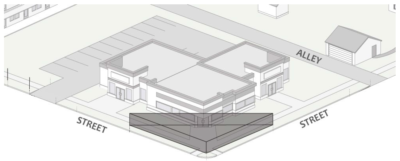
Figure 51: Vision Clearance Triangle
(B)
Vision Clearance Triangle Leg Lengths. The vision clearance triangle leg lengths shall be as specified in the most current edition of the Policy on Geometric Design of Highways and Streets published by the American Association of State Highway and Transportation Officials. Deviation from these standards shall require written approval from the City Engineering Department.
(C)
Vertical Clear Area. No primary or accessory structures, landscaping, fences, walls or signs shall be placed in or to project into the vision clearance triangle between the heights of two and one-half feet and nine feet above the crown of the adjacent street.
(d)
Pedestrian and Bicycle Circulation.
(1)
Purpose. To reduce greenhouse gas emissions and improve the health and quality of life of City residents by providing safe, convenient, and attractive pedestrian and bicycle transportation paths, sidewalks, trails, and other facilities throughout the City.
(2)
Applicability. Pedestrian facilities shall be required on both sides of all streets, with the exception of new single-family, duplex, and triplex residences built on existing legal lots of record on non-classified (local) streets with no adjacent pedestrian facilities, and additions to existing residential structures. All required trails and connector paths shall be provided. Where there are conflicting standards in this UDO and the most recently adopted Transportation Plan, the Planning and Transportation Director shall determine which standard governs.
(3)
Inspection and Acceptance. Prior to the recommendation of issuance of a final certificate of occupancy, all transportation facilities located within the adjoining public right-of-way or dedicated easements shall be inspected for compliance with standards adopted by the City of Bloomington, the Bloomington Public Transportation Corporation, and/or AASHTO standards.
(4)
Pedestrian Network Required.
(A)
All developments shall integrate an interior and exterior pedestrian network comprised of concrete sidewalks or asphalt paths for pedestrian transportation and recreation. This network shall include pedestrian facilities along street frontages, multiuse trails where indicated on the Transportation Plan, and pedestrian connector paths between developments and public destinations (e.g., schools, parks, hospitals), nearby trails, other developments, and vacant land.
(B)
All concrete sidewalk and asphalt path improvements shall be constructed as per city planning and transportation department and engineering department requirements.
(C)
All buildings shall have a sidewalk connection from the building entrance to the adjacent public street.
(5)
Type of Pedestrian Facility. Required pedestrian facilities shall be as indicated in the Transportation Plan, unless it is determined by the Planning and Transportation Director that such facility should be altered to match adjacent facilities.
(6)
Width. The minimum width of required pedestrian facilities shall be as indicated in the Transportation Plan unless specifically noted in Table 05-5 (Subdivision Development Standards).
(7)
Placement. To the extent possible, all required sidewalks shall be located one foot inside the right-of-way to be dedicated to the City. If utility poles, trees, or other physical characteristics complicate installation, then the sidewalk or path may extend into individual lots or common area if the area of encroachment is placed within a pedestrian easement. In situations of limited existing right-of-way, a minimum five-foot-wide tree plot is required and any portions of required pedestrian facilities that are not located within the right-of-way must be placed within a pedestrian easement.
(8)
Minimum Tree Plot Width. All sidewalks shall be spaced away from the back of curb to provide a tree plot and to provide pedestrian separation from vehicles. This minimum distance shall be as indicated in the Transportation Plan. Except as specified elsewhere in this UDO, tree plots may not be less than five feet and shall be planted with ground cover. The Planning and Transportation Director may allow tree grates, tree boxes, or other appropriate streetscape treatments in areas that anticipate increased pedestrian traffic.
(9)
Administrative Adjustment. When the petitioner can demonstrate the need to modify or alter certain design standards relating to pedestrian facilities as described below, those standards may be modified or altered by approval of the Planning and Transportation Director. In addition, these provisions may be adjusted to allow compliance with the standards of Section 20.04.050 (Access and Connectivity).
(10)
Paths, Sidewalks, and Trails.
(A)
Construction Standards. All path, sidewalk, and trail improvements shall be constructed as per the City of Bloomington standards and/or AASHTO requirements.
(B)
Additional Facility Amenities. Additional amenities shall be required in accordance with the design standards identified in the Transportation Plan.
(C)
Sidewalks.
i.
Material and Width. Sidewalks shall be constructed of durable, smooth, and skid resistant material approved by the City and a minimum width of five feet.
ii.
External Sidewalks. Sidewalks shall be located a minimum of one foot inside the public right-of-way or within a pedestrian easement along all abutting street frontages.
iii.
Internal Sidewalks. Sidewalks shall be provided that link abutting streets to primary entrances of primary buildings on the site, link separate facilities within the site to each other, and provide access to adjoining transit stops. Internal sidewalks shall not be required for lots containing primary single-family, duplex, triplex, or fourplex dwelling uses.
iv.
Separation. Sidewalks shall have a minimum separation of five feet from the curb, or edge of pavement where no curb exists. In situations where the minimum separation cannot be achieved due to constraints such as limited public right-of-way, mature trees, or unsuitable topography, the sidewalk location may be designed to avoid the constraints, provided that a pedestrian easement is established for any locations where the sidewalk is not within the public right-of-way, and that the minimum five foot separation is maintained.
1.
In situations where the sidewalk must be located within a pedestrian easement on private property, the portions of the sidewalk within the pedestrian easement shall not count toward the maximum impervious surface coverage or against the minimum landscape area for the property.
2.
In situations where the City Planning and Transportation Department has determined that a pedestrian easement is not feasible due to right-of-way width constraints or site elevation constraints, the City Planning and Transportation Department may approve the following design options:
a.
A ten-foot-wide sidewalk with reduced vegetated plot width.
b.
Integral sidewalk with a minimum six-inch curb and six-foot wide sidewalk.
v.
Cross-Slopes. All sidewalks (over entrances and drives, intersections, etc.) shall be constructed to comply with the Americans with Disabilities Act and all applicable adopted City standards.
(D)
Multiuse Paths. Where multiuse paths are identified on the Transportation Plan, or as construction of new streets warrants the provision of multiuse paths, as determined by the Planning and Transportation Director, such facilities shall be provided as follows:
i.
Minimum Width. Ten feet.
ii.
Surface. Multiuse paths shall be paved with asphalt. Alternative surface materials, such as ADA-compliant permeable pavers, may be authorized by the Planning and Transportation Department in order to mitigate environmental impacts.
iii.
Location. Multiuse paths shall be constructed a minimum of one foot inside the public right-of-way line or within a pedestrian easement along all abutting street frontages.
iv.
Separation. Multiuse paths shall have a minimum separation of five feet from the curb, or edge of pavement where no curb exists. In situations where the minimum separation cannot be achieved due to constraints such as limited public right-of-way, mature trees, or unsuitable topography, the multiuse path location may be designed to avoid the constraints, provided that a pedestrian easement is established for any locations where the multiuse path is not within the public right-of-way, and that the minimum five foot separation is maintained.
1.
In situations where the multiuse path must be located within a pedestrian easement on private property, the portions of the multiuse path within the pedestrian easement shall not count toward the maximum impervious surface coverage for the property.
2.
In situations where the City Planning and Transportation Department has determined that a pedestrian easement is not feasible, the City Planning and Transportation Department may approve a five-foot-wide multiuse path with reduced vegetated plot width.
v.
Cross-Slopes. All multiuse paths (over entrances and drives, intersections, etc.) shall be constructed to comply with the Americans with Disabilities Act and all applicable adopted City standards.
(E)
Bike Lanes. Where development projects include the construction of new public streets and redevelopment projects include alteration of existing right-of-way that are identified as having bike lanes in the Transportation Plan, such facilities shall be provided as follows:
i.
Type. The type of bicycle facility required shall be determined by the Transportation Plan.
ii.
Minimum Width. A minimum of five feet, or as indicated in the Transportation Plan. Any adjacent curb and gutter shall not be included in the bike lane width measurement.
iii.
Location. Striped bike lanes shall be located at the outer edge of the street, adjacent to the curb, or as indicated in the most recent Transportation Plan.
iv.
Substitution. Substitution of a ten-foot-wide multiuse path may be allowed if approved by the City Planning and Transportation Department and such substitution is consistent with the most recent Transportation Plan.
(F)
Multiuse Trails. Where multiuse trails are identified on the Transportation Plan, such facilities shall be provided as follows:
i.
Minimum Width. Pavement width shall be a minimum of twelve feet, and the paved trail shall have two-foot-wide shoulders on both sides and shall be surfaced as determined by the parks and recreation department.
ii.
Surface. Multiuse trails shall be paved with asphalt. Alternative surface materials may be authorized by the City Planning and Transportation Department to mitigate environmental impacts.
iii.
Dedication. All multiuse trails shall be dedicated to the City parks and recreation department within rights-of-way of at least fifty feet in width. Right-of-way width for multiuse trails may be reduced by the City Planning and Transportation Department after approval by the City parks and recreation department.
(G)
Connector Paths. Where a development is adjacent to a public park, school, commercial area, or existing or proposed multiuse trail as identified in the Transportation Plan, connector paths shall be provided as follows:
i.
The design of any required connector path that will connect to a public park or multiuse trail shall be subject to the approval of the City parks and recreation department. The parks and recreation department may waive the connector path requirement if it determines that the proposed connection to a public park or multiuse trail is not desirable or is redundant to existing facilities.
ii.
Minimum Width. Connector paths shall be a minimum of ten feet in width.
iii.
Surface. Connector paths shall be constructed of asphalt or concrete. Alternative surface materials may be authorized by the City Planning and Transportation Department to mitigate environmental impacts.
iv.
Easement. Connector paths shall be contained within pedestrian easements of at least twenty feet in width pursuant to Section 20.05.040 (Easements).
v.
Undeveloped Properties. Where vacant or undeveloped properties are adjacent to a property under development, connector paths shall be stubbed to the property line to allow for future connection when adjacent properties are developed.
(e)
Public Transit.
(1)
General Standards.
(A)
For the purposes of this section, transit facilities shall include:
i.
Benches;
ii.
Shelters; or
iii.
Other similar transit stop amenities.
(B)
Where a development is required to install one or more transit facilities, the type and location of such facilities shall be as determined by the Bloomington Public Transportation Corporation. Where such facilities are proposed within the public right-of-way, approval by the City Board of Public Works shall also be required.
(C)
The Bloomington Public Transportation Corporation may waive a required transit facility if that corporation deems it unnecessary based on existing facilities.
(2)
Existing Public Transportation Routes.
(A)
Transit Facility. For any development of at least twenty dwelling units, or for any nonresidential development of at least twenty thousand square feet gross floor area, developed adjacent to one or more public transportation routes, a transit facility shall be constructed on all routes for which one or more of the following criteria are met:
i.
The proposed development is expected to generate public transit usage; or
ii.
The nearest existing transit facility on the route is more than one-fifth of one mile (one thousand fifty-six feet) away from the closest primary building on the site, measured along rights-of-way; or
iii.
The routes do not cross or overlap in a fashion that would allow the placement of a single transit facility to serve all routes. In such a case, the busier routes shall receive the facility.
(B)
Location. The transit facility shall occupy:
i.
A site within or adjacent to the right-of-way on which the public transportation route is established; or
ii.
Another site approved by the Bloomington Public Transportation Corporation that is or will be contained within a transit facility easement.
(C)
Pedestrian Accessibility. Transit facilities shall be connected to the public sidewalk system and ADA-accessible routes.
(3)
Future Public Transportation Routes.
(A)
Transit Facility Easement. For any development where one or more public transportation routes are reasonably expected to exist on adjacent public streets in the future, and where the development is expected to generate public transit usage, transit facility easements shall be established on each future route if one or more of the following criteria exist:
i.
Route Overlap. The routes do not cross or overlap in a fashion that would allow the placement of a single transit facility to serve all routes; or
ii.
Insufficient Right-of-Way. Insufficient right-of-way exists to reasonably allow a transit facility and/or transit service access.
(B)
Location. Transit facility easements shall occupy:
i.
A site adjacent to the right-of-way on which the public transportation route is established; or
ii.
Another site as approved by the Bloomington Public Transportation Corporation.
(4)
Transit Facilities and Easements.
(A)
Pedestrian Traffic. Public transit facilities shall be designed so that they will not interfere with the normal flow of pedestrian traffic on public or private sidewalks.
(B)
Construction Standards. Public transit facilities shall be built to meet the requirements of the Bloomington Public Transportation Corporation.
(C)
Setback Exemption. Public transit facilities shall be exempt from the building setback standards of the zoning district.
(D)
Minimum Easement Depth. Ten feet.
(E)
Minimum Easement Width. Fifteen feet.
(F)
Recording of Easements. See Section 20.05.040 (Easements).
(5)
Bus Turnout Areas.
(A)
Bus Turnout. Bus turnout areas shall be constructed in conjunction with a transit route if a transit stop is warranted, as determined by the Bloomington Public Transportation Corporation and the City, and the street on which the public transportation route is established is classified as a primary arterial on the most recent Transportation Plan.
(B)
Dimensional Standards. Bus turnout areas shall be built to the dimensional requirements of the Bloomington Public Transportation Corporation.
(C)
Construction Standards. The engineering design of bus turnout areas shall be coordinated with the City Planning and Transportation Department.
(Amd. of 1-14-2020; Ord. No. 20-07, § I(Att. B), 4-15-2020; Ord. No. 21-15, § II (Att. A), 4-21-2021; Ord. No. 21-18, § II (Att. A), 4-21-2021; Ord. No. 22-08, § II(Att. B), 5-18-2022; Ord. No. 22-10, § II(Att. A), 5-18-2022; Ord. No. 23-06, § 2(Att. A), 4-19-2023; Ord. No. 2024-03, § II(Att. A), 4-10-2024; Ord. No. 2024-04, § II(Att. A), 4-10-2024; Ord. No. 2025-12, § II(Att. A), 5-21-2025)
20.04.060 - Parking, loading, and storage.
(a)
Purpose. This section is intended to regulate the amount and design of off-street parking and loading for different land uses and to help protect the public health, safety, and general welfare by:
(1)
Avoiding and mitigating traffic congestion;
(2)
Providing necessary access for service and emergency vehicles;
(3)
Providing for safe and convenient interaction between motor vehicles, bicycles, and pedestrians;
(4)
Encouraging multi-modal transportation options and enhanced pedestrian safety;
(5)
Providing flexibility to respond to the transportation, access, and loading impacts of various land uses in different areas of the City;
(6)
Reducing stormwater runoff, reducing heat island effect from large expanses of pavement, improving water quality, and minimizing dust pollution; and
(7)
Avoiding and mitigating the adverse visual impact of large concentrations of exposed parking.
(b)
Applicability. Compliance with this Section 20.04.060 (Parking and Loading) shall be required pursuant to Section 20.04.010 (Applicability) and the specific applicability criteria established in Sections 20.04.060(d) (Minimum Vehicle Parking Requirement) through 20.04.060(1) (Minimum Bicycle Parking Required).
(c)
Parking Calculations.
(1)
Generally.
(A)
All parking and loading requirements that are based on square footage shall be calculated on the basis of gross floor area of the subject use, unless otherwise specified.
(B)
Parking spaces designed or designated exclusively for recreational vehicles, motorcycles, scooters, and other two-wheeled vehicles shall not be included in the calculation of minimum or maximum vehicle parking requirements.
(C)
Parking spaces intended for storage of business vehicles, such as fleet vehicles, delivery vehicles, or vehicles on display associated with sales or rental shall not be included in the calculation of minimum or maximum vehicle parking requirements unless otherwise stated. Businesses with parking areas designed exclusively for vehicle display shall provide a minimum of one van accessible ADA parking space.
(D)
When measurements of the maximum number of required parking spaces for vehicles or bicycles result in a fractional number, any fraction of one-half or larger shall be rounded down to the next lowest whole number.
(E)
Lots containing more than one use shall provide parking and loading based on the shared parking calculations in Section 20.04.060(g)(1) (Shared Parking Facilities).
(2)
Unlisted Uses. For uses not listed in Table 04-9 (Minimum Vehicle Parking Requirements) or Table 04-10 (Maximum Vehicle Parking Allowance), the City Planning and Transportation Department is authorized to do any of the following:
(A)
Apply the minimum or maximum off-street parking space requirement specified in Table 04-9 (Minimum Vehicle Parking Requirements) or Table 04-10 (Maximum Vehicle Parking Allowance), for the listed use that is deemed most similar to the proposed use as determined by the City Planning and Transportation Department (based on operating characteristics, the most similar related occupancy classification, or other factors related to potential parking demand determined by the department).
(B)
Establish the minimum or maximum off-street parking space and loading requirements based on a parking study prepared by the petitioner according to Sections 20.04.060(g) (Adjustments to Minimum Parking Requirements) or 20.04.060(h) (Adjustments to Maximum Parking Allowance).
(d)
Minimum Vehicle Parking Requirement.
(1)
Applicability.
(A)
Generally. Each development or land use subject to this section pursuant to Section 20.04.060 (Parking and Loading) shall provide at least the minimum number of vehicle parking spaces required for each land use listed in Table 04-9 (Minimum Vehicle Parking Requirements).
(B)
MD District. Minimum parking requirements do not apply to development in the Courthouse Square Character Area or the Downtown Core Character Area south of 4th Street.
_____
Table 04-9. Minimum Vehicle Parking Requirements
Notes:
[1] See Section 20.04.110 (Incentives) for alternative standards.
[2] Minimums shall only apply to multifamily development within or adjacent to the R3 zoning district and all multifamily development in the MD zoning district.
[3] Minimum parking for duplexes, triplexes, and fourplexes only applies in the R1, R2, R3, and R4 districts.
_____
(e)
Maximum Vehicle Parking Allowance. In no case shall any land use or development subject to this Section 20.04.060 (Parking and Loading) provide more than the maximum number of vehicle parking spaces allowed for each land use listed in Table 04-10 (Maximum Vehicle Parking Allowance).
_____
Table 04-10. Maximum Vehicle Parking Allowance
_____
(f)
Accessible Parking.
(1)
Accessible spaces shall be provided and designed as required to meet the requirements of the Americans with Disabilities Act (ADA) and the Indiana Building Code (IBC).
(2)
Each accessible space shall be located adjacent to an access aisle and as close as reasonably practicable to the building entrance most accessible for persons with disabilities.
(3)
All accessible spaces shall be striped and have vertical signs identifying them as accessible spaces per the Indiana Manual on Uniform Traffic Control Devices.
(4)
Required accessible spaces shall count towards the number of maximum parking spaces permitted, unless the maximum allowed number of parking spaces is twenty-five spaces or less.
(g)
Adjustments to Minimum Parking Requirements. The amount of vehicle parking required pursuant to Table 04-9 (Minimum Vehicle Parking Requirements), may be adjusted by the factors listed in this Section 20.04.060(g) (Adjustments to Minimum Parking Requirements). These adjustments may be applied as part of the calculation of parking requirements and do not require discretionary approval by the City.
(1)
Shared Parking Facilities.
(A)
Generally.
i.
When reviewing a shared parking proposal, the City Planning and Transportation Department shall consider any additional reductions in minimum parking requirements that might otherwise apply pursuant to subsections (2) through (5) below, but such additional reductions shall not apply to further reduce the shared parking requirements approved by the City Planning and Transportation Department.
ii.
Where a minimum number of parking spaces are required by Table 04-9 (Minimum Vehicle Parking Requirements), the owners of two or more properties may join together to provide the required parking spaces for their respective uses. Upon request by the owners and after review of the request, the City Planning and Transportation Department may authorize the shared use of parking facilities subject to the following:
iii.
In a shared parking arrangement, each property shall provide a minimum of sixty percent of the individual parking requirements provided in Table 04-9 (Minimum Vehicle Parking Requirements). In no case shall the total combined parking spaces be less than one hundred twenty percent of the greater individual parking requirement.
iv.
Any property using shared parking facilities shall be located within six hundred feet of such parking facility, using established sidewalks and crosswalks where available.
(B)
Shared Parking Agreement. The property owner seeking leased spaces shall provide a recordable zoning commitment to the Planning and Transportation Department stating that in the case where leased spaces are no longer available, that an adequate parking alternative will be provided.
(2)
Proximity to Transit. Except for single-family, duplex, triplex, fourplex, mobile home, and manufactured home residential uses, the minimum parking required for development within one-quarter mile, measured radially in a straight line, of a fixed transit station or transit route stop shall be reduced from those shown in Table 04-9 (Minimum Vehicle Parking Requirements) by fifteen percent.
(3)
Affordable and Senior Housing. The minimum number of required vehicle parking spaces for multifamily residential structures shall be reduced by thirty-five percent if:
(A)
The multifamily residential structure qualifies for the affordable housing incentives pursuant to Section 20.04.110 (Incentives); or
(B)
A minimum of seventy-five percent of the dwelling units are restricted for lease or sale by persons sixty-five years of age or older.
(4)
On-Street Parking. Any on-street parking space in which more than one-half of the area of the parking space abuts the subject property, may be counted toward the minimum number of required vehicle parking spaces on a one-to-one basis, subject to the following:
(A)
On-street parking may not be used to meet the minimum off-street parking requirements for single-family, duplex, triplex, fourplex, mobile home, and manufactured home residential uses.
(B)
On-street parking that is subject to residential parking permit restrictions or other time restrictions shall not be used to meet any minimum vehicle parking requirements for any use.
(C)
Each on-street parking space may only be counted once toward the parking requirements of the abutting lot, regardless of the number of individual buildings or tenants on the lot.
(D)
On-street parking spaces shall be available for general public use at all times. No signage or actions limiting general public use of on-street spaces shall be permitted.
(E)
No development or use approved with an on-street parking credit shall be considered nonconforming if the on-street parking is later removed by City action and the remaining off-street vehicle parking does not meet the minimum off-street parking requirements of this chapter.
(5)
Modification of Minimum Parking Requirement Based on Parking Study. If a petitioner submits a parking demand study demonstrating that anticipated off-street vehicle parking demand for the proposed development, use, or combination of uses will be less than that calculated from Table 04-9 (Minimum Vehicle Parking Requirements), and the City Planning and Transportation Department determines that the information and assumptions used in the study are reasonable and that the study accurately reflects anticipated off-street vehicle parking demand for the proposed development, use, or combination of uses, the City Planning and Transportation Department may authorize a reduction in required off-street parking spaces based on that study.
(h)
Adjustments to Maximum Parking Allowance. No use shall provide vehicle parking spaces in an amount exceeding the maximum established in Table 04-10 (Maximum Vehicle Parking Allowance), unless approved by the City Planning and Transportation Department based on the following:
(1)
The proposed development has unique or unusual characteristics that typically do not apply to comparable developments, uses, or combinations of uses, such as high sales volume per floor area or low parking turnover, that create a parking demand that exceeds the maximum ratio;
(2)
The petitioner submits a parking demand study demonstrating that anticipated off-street vehicle parking demand for the proposed development, use, or combination of uses will be more than that calculated from Table 04-10 (Maximum Vehicle Parking Allowance), and the City Planning and Transportation Department determines that the information and assumptions used in the study are reasonable and that the study accurately reflects maximum reasonably anticipated off-street vehicle parking demand for the proposed development, use, or combination of uses; and
(3)
Any parking provided above the maximum required in Table 04-10 (Maximum Vehicle Parking Allowance), is constructed in a parking structure or with approved pervious surfaces.
(i)
Vehicle Parking Location and Design.
(1)
Applicability. The standards in Section 20.04.060(i) (Vehicle Parking Location and Design) shall apply to all surface and aboveground vehicle parking and maneuvering areas.
(2)
Location.
(A)
Generally.
i.
All parking spaces required to serve buildings or uses erected or established after the effective date of this ordinance shall be located on the same lot as the building or use served, unless otherwise allowed pursuant to 20.04.060(g)(1).
ii.
Parking areas shall be designed to ensure safe and easy ingress, egress, and movement through the interior of the lot.
iii.
No park strip shall be used for parking unless otherwise approved by the City Planning and Transportation Department based on considerations of pedestrian and traffic safety, visual appearance, and buffering.
iv.
All parking shall comply with parking landscape standards in Section 20.04.080 (Landscaping, Buffering, and Fences).
v.
For single-family, duplex, triplex, fourplex, mobile home, and manufactured home residential uses, Parking shall be prohibited within the setback between the street and the building except on a driveway that meets the provisions of this Section 20.04.060.
vi.
No commercial vehicles or trailers shall be parked overnight at a residence unless that home is occupied by the business owner or employee.
(B)
In the R1, R2, R3, R4, RM, RH, MS, and MD Districts.
i.
Parking for single-family, duplex, triplex, fourplex, mobile home, and manufactured home residential uses shall be prohibited within the required front building setback between the street and the building except on a single drive not exceeding eighteen feet in width.
ii.
In cases where the side or rear setback area is accessible via an improved alley, no front yard drive or parking shall be permitted. In the R1, R2, R3, and R4 districts, the required parking area shall directly access the alley and be limited to twenty feet in depth and twenty feet in width. Depth of required parking areas may exceed twenty feet if leading to a vehicular entrance of a detached garage or carport. In the MD, MS, RM, and RH districts, the required parking area shall directly access the alley. Determinations of whether an alley allows for safe access shall be made by the City Planning and Transportation Department.
iii.
For lots at the corner of a street and the alley, the driveway on the alley shall be setback fifteen feet from the intersection of the street and the alley.
(3)
Dimensions of Parking Spaces and Drive Aisles. All on-site parking and maneuvering areas shall be constructed according to the following minimum dimensional standards and per Table 04-11:
(A)
All parking aisles shall terminate with a bump-out for turnaround maneuverability.
Figure 52: Illustrative Scale and Character
_____
Table 04-11. Parking Dimensions (in feet) [2]
Notes:
[1] End spaces may be a minimum of twenty feet in length where no obstruction exists.
[2] Parking spaces for motorcycles may be provided and must be a minimum of three feet in width and six feet in length.
_____
(B)
If the petitioner can provide different acceptable standards based on a professionally recognized source of parking lot design, the City Planning and Transportation Department may approve alternative standards pursuant to the minor modification process outlined in Section 20.06.080(a) (Minor Modification).
(4)
Stacked Parking. Stacked parking arrangements are permitted.
(5)
Back-Out Parking.
(A)
Generally. All on site vehicle parking areas shall be designed to avoid the need for vehicles to back onto public streets when exiting the parking space, unless otherwise stated in this UDO.
(B)
Exceptions. Single-family, duplex, triplex, and fourplex uses in any zoning district shall be permitted to back-out directly onto an alley or a public street, other than an arterial street.
(C)
Back-Out Parking Waiver. Back-out parking within the required side or rear setback may be allowed onto adjacent alleys subject to the following standards:
i.
The lot in question does not exceed twenty thousand feet in area;
ii.
A maximum of eight back-out parking spaces are permitted per site;
iii.
Parking shall directly access an improved alley; and
iv.
Parking spaces shall be designed to be no less than forty-five degrees to the alley.
(6)
Stormwater Drainage.
(A)
Water draining from a parking lot shall not flow across a sidewalk.
(B)
All parking lots, excluding drives that do not afford direct access to abutting parking spaces, shall have a slope of five percent or less.
(7)
Surface Material.
(A)
Except for dwelling, single-family (detached), dwelling, single-family (attached), dwelling, duplex, dwelling, triplex, and dwelling, fourplex residences or as stated in subsection (6) above, or an exception is provided elsewhere in this UDO, all areas used for parking shall be hard surface of concrete, asphalt, brick pavers, or other approved material. Where crushed stone parking surfaces are approved, they shall be contained within a raised, permanent border.
(B)
All new driveway aprons onto a street shall be surfaced with concrete. Enlargement or modification of an existing driveway shall require the driveway apron to be surfaced with concrete, except that the driveway apron for a single-family, duplex, triplex, or fourplex use on a local street may use asphalt or concrete.
(C)
Areas using permeable parking pavers shall not count towards impervious surface calculations.
(D)
Except for single-family, duplex, triplex, fourplex, mobile home, and manufactured home residential uses, and display areas for vehicle sales and rental uses, all off-street parking spaces shall be striped or otherwise designated to clearly mark each space.
(E)
All driving lanes and parking aisles in parking lots shall be curbed, unless an alternative design allowing for adequate stormwater management is approved.
(8)
Electric Vehicle Charging. Parking areas with fifty or more parking spaces shall provide a minimum of one parking space dedicated to electric vehicles for every twenty-five parking spaces provided on site. If more than six EV charging stations are required, at least one shall be an ADA van accessible parking space. The provision of three or fewer electric vehicle parking spaces shall not count toward the maximum allowed number of parking spaces. The provision of four or more electric vehicle parking spaces shall count toward the maximum allowed number of parking spaces. The electric vehicle parking space shall be:
(A)
Located on the same lot as the principal use;
(B)
Signed in a clear and conspicuous manner, such as special pavement marking or signage, indicating exclusive availability to electric vehicles; and
(C)
Outfitted with a standard electric vehicle charging station.
(9)
Parking Area Landscaping. All development shall comply with Section 20.04.080(h) (Parking Lot Landscaping).
(10)
Parking Area Lighting. All development shall comply with Section 20.04.090 (Outdoor Lighting).
(11)
Pedestrian and Bicycle Circulation. All development shall comply with Section 20.04.050 (Access and Connectivity).
(j)
Loading Area Location and Design.
(1)
Applicability. This Section 20.04.060(j) (Loading Area Location and Design) shall apply to all loading areas.
(2)
Location. Loading berths shall be located at the rear of a structure.
(3)
Design.
(A)
Loading berths shall be paved with asphalt or concrete.
(B)
Loading berths shall be effectively screened from view from adjacent public streets and residential uses by solid building walls, constructed of similar building materials as the primary structure and not less than six feet in height.
(C)
The design of loading berth areas shall prevent any portion of any vehicle using the loading facility from projecting into a public right-of-way.
(k)
Drive-Through Facilities and Vehicle Stacking Areas.
(1)
Applicability. The following standards apply for all uses with vehicle stacking and/or drive-through facilities.
(2)
Minimum Number of Vehicle Stacking Spaces. All uses with drive-through facilities shall provide the minimum number of on-site stacking spaces indicated in Table 04-12 (Minimum Vehicle Stacking Space Requirements), and shall comply with the standards in this Section 20.04.060(k) (Drive-Through Facilities and Vehicle Stacking Areas).
_____
Table 04-12. Minimum Vehicle Stacking Space Requirements
_____
(l)
Minimum Bicycle Parking Required.
(1)
Applicability. The following standards shall apply to all uses except for single-family, duplex, triplex, fourplex, mobile home, and manufactured home residential uses.
(2)
Required Bicycle Parking Spaces.
(A)
Generally.
i.
Each development subject to this Section 20.04.060(l) (Minimum Bicycle Parking Required) shall provide a minimum of six bicycle parking spaces or the number of bicycle parking spaces required in Table 04-13 (Minimum Bicycle Parking Requirements), whichever is more.
ii.
The minimum number of bicycle parking spaces required in Table 04-13 (Minimum Bicycle Parking Requirements) shall be based on the total number of vehicle parking spaces provided on site or in a permitted off site location to serve the principal uses.
_____
Table 04-13. Minimum Bicycle Parking Requirements
_____
(B)
Mixed-Use Developments. Developments with both nonresidential and residential uses shall provide the cumulative required number of bicycle parking spaces as calculated for the respective nonresidential and residential requirements in Table 04-13 (Minimum Bicycle Parking Requirements).
(C)
Cottage Development. A minimum of one class II bicycle parking space is required per dwelling unit. Secure garages may count toward this requirement, but a minimum of four class II bicycle parking spaces shall be provided.
(D)
Building Expansions or Changes in Use. Building expansions or changes in use that require additional vehicle parking spaces pursuant to Section 20.04.060(b) (Applicability) shall also require additional bicycle parking spaces based on the percentages in Table 04-13 (Minimum Bicycle Parking Requirements), as applied to the building expansion area or the additional parking required by the change in use.
(E)
When No On-Site Vehicle Spaces are Provided. Where no vehicle parking spaces are provided on site, one bicycle parking space shall be required for every five thousand square feet of gross floor area in each primary building, or a minimum of six bicycle parking spaces, whichever is greater.
(F)
Existing Public Bicycle Parking Spaces. Permanent bicycle parking spaces available for public use, such as City-installed bicycle racks or bike corrals that exist at the time of development, expansion, or change in use, and are located within fifty feet of the primary entrance to the primary building may be used to satisfy up to six required bicycle parking spaces.
(G)
Bicycle Parking Reduction. Subject to the approval of the Planning and Transportation Department, the number of bicycle parking spaces may be reduced if:
i.
Unique or unusual characteristics exist on a development site that would preclude safe travel of bicycles to and from the site; or
ii.
Existing bicycle parking facilities are located within the public right-of-way and within fifty feet of the building's main entrance, provided that no more than six bicycle parking spaces in the right-of-way can be counted toward the development requirements.
(m)
Bicycle Parking Location and Design.
(1)
Location.
(A)
Rights-of-Way. Bicycle parking spaces shall not be located fully or partially within a public right-of-way without prior approval of the City.
(B)
Access and Pedestrian Obstruction. All required bicycle parking spaces shall be located so that a minimum three-foot clear pedestrian passage space is provided to all sides of a standard six-foot bicycle parked in each required space, and so that there is at least fifty-four inches of clearance remaining for ADA compliance on pedestrian pathways.
(C)
Design and Proximity. Required bicycle parking spaces shall be designed to allow bicycles to be secured with a lock to a fixed object and shall be located within fifty feet of the main entrance of each primary building on site.
(D)
Collocation. Bicycle parking facilities may be located in a non-required vehicular automobile parking space so long as it is not a parking space required to comply with the Americans with Disabilities Act and the location meets the other provisions of this section.
(E)
Distribution. Buildings with twelve bedrooms or more shall provide a minimum of two exterior class II bicycle parking spaces per residential building. These spaces shall count toward fulfilling the total site requirement for bicycle parking.
(2)
Design.
(A)
Generally.
i.
Bicycle parking location and design shall comply with City of Bloomington standards in the administrative manual.
ii.
Bicycle parking shall accommodate two points of contact that are separated horizontally.
iii.
Bicycle parking shall be accessible from the pedestrian/bicycle way without the need to lift the bicycle over a curb.
iv.
Bicycle parking shall be located no farther than the closest motor vehicle parking space, excluding accessible vehicle parking spaces.
(B)
Type.
i.
All bicycle parking requirements shall be met using either long-term class I or short-term class II bicycle security facilities.
ii.
For multifamily residential uses, developments with twenty-five or more dwelling units shall provide:
1.
A minimum of one-half of the total required bicycle parking spaces as covered, short-term class II bicycle parking facilities; and
2.
A minimum of one-quarter of the total required bicycle parking spaces as long-term class I facilities.
iii.
For nonresidential and mixed-use developments with more than twenty thousand square feet of gross floor area, all required bicycle parking facilities shall be class II covered spaces.
(C)
Surface. Bicycle parking areas shall be placed on a paved surface composed of concrete, asphalt, brick pavers, or the like. Bark mulch, crushed stone, stone, rock, dirt, sand or grass shall not be permitted as a surface for bicycle parking areas.
(n)
Use of Parking Areas.
(1)
Exclusive Use.
(A)
Unless a shared parking agreement has been established in accordance with Section 20.04.060(g)(1) (Shared Parking Facilities), required vehicle and bicycle parking spaces shall be designed, maintained and used exclusively for the tenants, occupants, and customers of the buildings or uses on the site.
(B)
Excess or unused vehicle or bicycle parking spaces or loading spaces may not be rented or leased to the general public or to those who are not tenants, occupants and customers of the buildings or uses where the parking is located unless:
i.
Otherwise allowed pursuant to Section 20.04.060(g)(1) (Shared Parking Facilities); or
ii.
A vehicle parking garage is listed as a permitted or Conditional Use in the zoning district where the parking lot or parking garage is located pursuant to Table 03-1 (Allowed Use Table).
(2)
Storage of Vehicles or Equipment. Vehicle parking spaces, including both required and excess parking spaces, shall not be used for storing vehicles that are not used in conjunction with the primary use of the lot. In addition, all outdoor parking of vehicles in all zoning districts shall comply with the following standards:
(A)
Vehicles and trailers shall not be stored or parked on an unimproved surface.
(B)
Stored or parked vehicles shall not block, impede, or otherwise encroach upon a sidewalk.
(C)
Stored or parked vehicles shall not be used for other purposes, including, but not limited to, living quarters, or storage of materials.
(3)
Motor Vehicle Repair.
(A)
Motor vehicle repair work in parking areas shall be permitted in residential districts, provided that the vehicle under repair is owned by the occupant of the residential property; the frequency, duration, and scope of such use is reasonable and customary as accessory to the residential use; and no business is being conducted in conjunction with such repair use.
(B)
Motor vehicle repair work in parking areas, including both required and excess parking spaces, shall be prohibited in all other zoning districts.
(C)
A maximum of three wrecked or inoperable vehicles awaiting repair may be stored on site at one time. No such vehicle shall be stored on site in excess of thirty days.
(4)
Vehicles and Trailers. Except for uses where auto repair is authorized, the parking of vehicles or trailers of any type without current license plates or in an inoperable condition shall be prohibited for periods in excess of thirty days, unless such vehicle or trailer is completely enclosed within a building or within an approved salvage or scrap yard.
(5)
Storage, Occupancy, or Similar Uses. Vehicles, campers or tractor/trailers of any type shall not be used for the purpose of storage, occupancy, or similar use.
(o)
On-street Parking Standards for Private Streets. The following standards related to on-street parking apply to all developments where the City has approved the use of private streets that have not been dedicated to the City.
(1)
No Parking Signs. Any side of a street where parking is not permitted shall be clearly delineated with yellow curbs or no parking signs noting such restrictions.
(2)
Bump-outs.
(A)
Bump-outs may be required at street intersections where on-street parking is used. Where required, bump-outs shall use a six-inch standing curb, unless the City determines that a curb and gutter is required based on considerations of public safety, utility design, or site constraints.
(B)
Bump-outs shall be designed to extend a minimum of eight feet from the curb line and may not reduce the travel lane widths below the standards of the Transportation Plan. The City may allow alternative bump-out widths based on considerations of public safety, utility design, or site constraints.
(C)
Bump-outs shall be installed at angles greater than ninety degrees away from the street curb to facilitate street maintenance and shall use designs approved by the Transportation and Traffic Engineer based on considerations of pedestrian and traffic safety and efficient maintenance.
(p)
Outdoor Storage. In all zoning districts, except for the Ml zoning district, outdoor storage of equipment, materials, waste or scrap materials, and pallets is prohibited. Shipping containers, cargo containers, and portable on-demand storage units may not be used for long-term storage, and may only be located on a lot or parcel, unless otherwise approved by the Municipal Code:
(1)
To provide storage for construction projects during the period of an approved construction project on the same lot or parcel; or
(2)
During the process of being loaded or unloaded, the duration of which may not exceed seventy-two consecutive hours.
(Amd. of 1-14-2020; Ord. No. 20-07, § I(Att. B), 4-15-2020; Ord. No. 21-15, § II (Att. A), 4-21-2021; Ord. No. 21-18, § II (Att. A), 4-21-2021; Ord. No. 21-22, § II (Att. A), 4-21-2021; Ord. No. 22-08, § II(Att. A), 5-18-2022; Ord. No. 22-10, § II(Att. A), 5-18-2022; Ord. No. 23-06, § 2(Att. A), 4-19-2023; Ord. No. 23-10, § 2(Att. A), 6-21-2023; Ord. No. 2024-03, § II(Att. A), 4-10-2024; Ord. No. 2024-04, § II(Att. A), 4-10-2024; Ord. No. 2024-17, § II(Att. A), 9-18-2024; Ord. No. 2025-11, § II(Att. A), 5-21-2025; Ord. No. 2025-12, § II(Att. A), 5-21-2025; Ord. No. 2025-29, § II(Att. A), 8-6-2025; Ord. No. 2025-41, § II(Att. A), 11-19-2025)
20.04.070 - Site and building design.
(a)
Purpose. The intent of this Section 20.04.070 (Site and Building Design), is to establish site and building design standards that foster high-quality, attractive, and sustainable development that is compatible with Bloomington's principles and policies. The standards are further intended to:
(1)
Protect and enhance the character and quality of Bloomington's neighborhoods;
(2)
Protect and enhance the long-term market value of property within Bloomington;
(3)
Enhance the human and pedestrian scale of new developments and ensure compatibility between residential neighborhoods and adjacent nonresidential uses;
(4)
Mitigate negative visual impacts arising from the scale, bulk, and mass of large buildings and centers;
(5)
Promote building designs and construction practices that are sustainable and adaptable to multiple uses for extended building lifecycles;
(6)
Minimize negative impacts of on-site activities to adjacent uses; and
(7)
Balance the community's economic and aesthetic concerns.
(b)
Applicability.
(1)
Compliance with this Section 20.04.070 (Site and Building Design) shall be required pursuant to Section 20.04.010 (Applicability) and the specific applicability criteria established in Sections 20.04.070(c) (MD District) through 20.04.070(e) (Projects Abutting to Historic Buildings).
(2)
Any exterior renovation of a building shall comply with this Section 20.04.070 (Site and Building Design) for the portions of the building affected by the renovation. If the renovation is proposed for only a portion of a building, the Planning and Transportation Director may waive compliance with the site and building design standards if that renovation would be inconsistent with the overall design of the existing structure.
(c)
MD District.
(1)
Generally. Notwithstanding subsections (d) and (e) below, all construction activity shall be subject to the design standards set forth in the applicable Downtown Character Overlay as specified in Section 20.02.030(g) (MD: Mixed-Use Downtown) and Section 20.02.060(a) (DCO: Downtown Character Overlay District).
(2)
Street Lighting Plans in the MD District. All certified street lighting plans proposed for the MD district shall be consistent with the design recommendations of the City of Bloomington Downtown Vision and Infill Strategy Plan and shall comply with the following:
(A)
Generally.
i.
Pedestrian scaled street lighting shall be provided as approved by the Board of Public Works.
ii.
Pedestrian scaled street lighting shall not exceed fifteen feet in height.
(B)
Lighting Fixture Styles.
i.
Lighting fixture styles shall generally conform to the prevailing pattern of street lighting found on adjacent properties and street block faces.
ii.
All pedestrian scaled street lighting in the MD district shall be of a traditional design style (gas lamp, acorn, or similar decorative style) except as otherwise provided below.
iii.
Properties in the following Downtown Character Overlays may use traditional or contemporary design styles:
1.
Downtown core;
2.
University village (excluding Kirkwood Corridor and Restaurant Row);
3.
Downtown gateway; and
4.
Showers technology.
(d)
Building Design.
(1)
Third-Party Review. The Planning and Transportation Director may retain an independent third-party consultant to review any proposed building design in order to assist with review of compliance with the standards in this Section 20.04.070(d) (Building Design). Where the decision on an application is made by the Plan Commission or City Council (as shown in Table 06-1), the consultant may offer alternative compliant design option(s) that addresses each element of building design addressed in this Section 20.04.070(d) (Building Design). The body making the final decision on the application may approve some or all of the suggested design options if it determines that the suggested option:
(A)
Significantly enhances the visual appeal of the building;
(B)
Significantly enhances the perceived quality of the building facades visible from public streets;
(C)
Creates no adverse impacts on surrounding properties beyond those that would be permitted if the standards in this Section 20.04.070(d) (Building Design) were applied; and
(D)
Strengthens the public-private interaction at the street level.
(2)
Mixed-Use and Nonresidential.
(A)
Applicability. The following standards shall apply to parcels in the MN, MM, MC, MS, ME, MI, and MH zoning districts.
(B)
Exceptions. Single-family detached, duplex, triplex, and fourplex dwellings shall not be subject to the architectural standards of this Section 20.04.070(d)(1) (Third Party Review). Such residential dwelling units shall be subject to the architectural standards in Section 20.04.070(d)(3) (Residential).
(C)
Materials. All facades of a primary building shall consist of one or more of the following primary and secondary exterior finish materials:
i.
Primary Exterior Finish Materials.
1.
Cementitious siding;
2.
Masonry;
3.
Brick;
4.
Natural stone;
5.
Precast concrete;
6.
Split-faced block; and/or
7.
Transparent glass.
ii.
Secondary Exterior Finish Materials.
1.
Wood;
2.
EIFS;
3.
Metal panel or siding (minimum twenty-six gauge) factory fabricated and finished system with smooth, embossed, or consistent rib pattern and concealed fasteners (except corrugated); or
4.
Other products that replicate the appearance and durability of the above materials, as approved by the staff.
(D)
Exterior Facades. All facades of a primary building shall incorporate three or more of the following design elements in each module to avoid blank, uninterrupted walls, except that buildings less than forty feet in width shall incorporate a minimum of two of the design elements. A module can be a maximum of forty feet in width.
i.
Awning or canopy that extends at least twenty-four inches from the building face;
ii.
Change in building facade height in relation to the adjacent modules of a minimum of five feet of difference, except that buildings twenty-five feet or less in height may utilize a minimum of two feet of difference;
iii.
A regular pattern of transparent glass constituting a minimum of fifty percent of the total wall/facade area of the first-floor facade/elevation and a minimum of thirty percent of each upper floor on each facade/elevation;
iv.
Wall elevation recesses and/or projections, the depth that are at least three percent of the horizontal width of the building facade and extend from the ground to the top of the building.
(E)
Patterns. All facades of a primary building visible from any roadway shall contain the following color and texture changes:
i.
Facades shall consist of at least one primary and one secondary color.
ii.
At least one of these elements, either texture or color, shall repeat horizontally across the facade.
iii.
Variations in texture and color elements shall repeat vertically a minimum of every thirty feet.
(F)
Eaves and Roofs. Buildings with sloped roofs (those greater than three to twelve pitch) visible from any roadway shall contain overhanging eaves, extending no less than two feet past the supporting walls. Flat roofs (those less than three to twelve pitch) shall include a parapet on supporting walls.
(G)
Three-Hundred-Sixty-Degree Architecture. Those sides of a building that are not visible from the street frontage shall have a finished facade that is similar to the visible facades in terms of materials and architectural detailing.
(H)
Primary Pedestrian Entry.
i.
One primary pedestrian entrance shall be provided for every facade facing a street.
ii.
On corner or through lots, the facade facing the higher classified street shall have the primary pedestrian entrance. For purposes of this section, I-69 shall not be used as the higher classified street.
iii.
The pedestrian entry shall contain at least three of the following architectural details:
1.
Pilasters, change in building mass, or a distinct facade module projection;
2.
Public art display;
3.
Prominent building address, building name, and enhanced exterior light fixtures, such as wall sconces or light coves;
4.
Raised corniced entryway parapet; or
5.
Recessed or framed sheltered element of at least three feet in depth to protect pedestrians from weather;
6.
Integral planters or wing walls that incorporate landscaping or seating.
(I)
Windows on Primary Facades. All first-story windows on the facade of a primary structure shall be transparent and shall not make use of dark tinting or reflective glass.
(J)
Anti-Monotony Standards. In the case of new construction of multifamily units, any development containing more than three individual buildings shall incorporate the following variations to break up monotony in design:
i.
Differences in rooflines;
ii.
Differences in building footprint;
iii.
Differences in the number of floors per building.
(K)
Street Addresses.
i.
Street address displays shall consist of Arabic numerals (e.g., one, two, three…) no less than eight inches in height. For multifamily uses, the address display shall be a minimum of five inches and a maximum of ten inches in height.
ii.
Street address displays shall be placed above all exterior entrances visible from a public street, private drive, or parking lot.
iii.
All street addresses shall contrast with the color of the surface on which they are mounted, shall consist of reflective materials, and shall be clearly visible and identifiable from the street.
(3)
Residential.
(A)
Applicability. The following standards shall apply to the construction, expansion, addition, or alteration of any building in the R1, R2, R3, R4, RM, RH and RMH zoning districts.
(B)
Materials. Primary exterior finish building materials used on residential dwellings shall consist of any of the following:
i.
Horizontal lap siding (e.g., vinyl, cementitious, wood);
ii.
V-grooved tongue-and-groove siding;
iii.
Wood-grained vertical siding materials in a board-and-batten or reverse batten pattern;
iv.
Cedar or other wood materials;
v.
Stucco, plaster, or similar systems (excluding EIFS);
vi.
Stone;
vii.
Split face block, ground face block, or brick;
viii.
Cast or cultured stone;
ix.
Cast in place concrete;
x.
Earthen structural materials;
xi.
Metal panel or siding (minimum twenty-fix gauge) factory fabricated and finished system with smooth, embossed, or consistent rib pattern and concealed fasteners (except corrugated); or
xii.
Other materials that replicate the look and durability of the above materials, as approved by the staff.
(C)
Minimum Coverage. Exterior finish building materials listed above, or a combination of such materials, shall extend from roofline to within six inches of finished grade.
(D)
Foundations. All buildings shall be placed on permanent foundations.
(E)
Roofs.
i.
For attached and detached single-family dwellings, duplex, triplex, fourplex, and multifamily dwelling units that have sloped roofs, the roof shall consist of shingles, shakes, tile, standing-seam metal, or V-rib metal. Additions to attached or detached single-family dwelling units may use flat roofs (less than a three to twelve roof pitch).
ii.
Primary structures larger than one thousand square feet of gross floor area may use a flat roof (less than three to twelve roof pitch) with a parapet and shall comply with any applicable standards established in Section 20.03.030 (Use-Specific Standards).
(F)
Rain Gutters and Downspouts. Rain gutters and downspouts are required.
(G)
Uniform Architecture. When the rear or side facade of a newly constructed building is adjacent to a street, the architecture of these facades shall be made to match that of the front facade. Such matching shall occur through use of similar materials, window/doorway openings, variation in rooflines, or fenestration.
(H)
Patterns. In the case of new construction of multifamily units in the RM and RH zoning districts, all facades of a primary building visible from any roadway shall contain the following color and texture changes:
i.
Facades shall consist of at least one primary and one secondary color.
ii.
At least one of these elements, either texture or color, shall repeat horizontally across the facade.
iii.
Variations in texture and color elements shall repeat vertically a minimum of every thirty feet.
(I)
Primary Pedestrian Entry. In the case of new construction of multifamily units in the RM and RH zoning districts, the following standards shall apply:
i.
One primary pedestrian entrance shall be provided for every facade facing a street.
ii.
On corner or through lots, the facade facing the higher classified street shall have the primary pedestrian entrance. For purposes of this section, I-69 shall not be used as the higher classified street.
iii.
The pedestrian entry shall contain at least three of the following architectural details:
1.
Pilasters, change in building mass, or a distinct facade module projection;
2.
Public art display;
3.
Prominent building address, building name, and enhanced exterior light fixtures such as wall sconces or light coves;
4.
Raised corniced entryway parapet; or
5.
Recessed or framed sheltered element of at least three feet in depth to protect pedestrians from weather;
6.
Integral planters or wing walls that incorporate landscaping or seating.
(J)
Exterior Facades. In the case of new construction of multifamily units in the RM and RH zoning districts, all facades of a primary building shall incorporate three or more of the following design elements in each module to avoid blank, uninterrupted walls, except that buildings less than forty feet in width shall incorporate a minimum of two of the design elements. A module can be a maximum of forty feet in width.
i.
Awning or canopy that extends at least twenty-four inches from the building wall to which it is attached;
ii.
Change in building facade height in relation to the adjacent modules of a minimum of five feet of difference, except that buildings twenty-five feet or less in height may utilize a minimum of two feet of difference;
iii.
A regular pattern of transparent glass constituting a minimum of fifty percent of the total wall/facade area of the first-floor facade/elevation facing a street for nonresidential uses;
iv.
A regular pattern of transparent glass constituting a minimum of thirty percent of the total wall/façade area of the first-floor facade/elevation facing a street for residential uses;
v.
Wall elevation recesses and/or projections, the depth that are at least three percent of the horizontal width of the building façade;
vi.
Projecting porches, balconies, or entry stoops at relevant elevations.
(K)
Anti-Monotony Standards. In the case of new construction of multifamily units, any development containing more than three individual buildings shall incorporate the following variations to break up monotony in design:
i.
Differences in rooflines;
ii.
Differences in building footprint.
(4)
Refuse and Recycling Containers. Except for single-family, duplex, triplex, and fourplex dwellings, all uses shall provide adequate space on site for refuse and recycling containers. Such areas shall comply with the standards in Section 20.04.080(m)(3) (Loading, Service, and Refuse Areas).
(5)
Neighborhood Transition Standards.
(A)
Setbacks. Buildings abutting a property in the R1, R2, R3, or R4 zoning district shall comply with the minimum building setback of the adjacent Residential zoning district along the common property line or the minimum building setback of the zoning district where the building is located, whichever is greater. When adjacent to the R1, R2, R3, or R4 zoning district, the minimum setback shall be increased by one foot for each foot of building height over thirty feet.
(B)
Building Height.
i.
Any portion of a building within fifty feet of a property in the R1, R2, R3, or R4 zoning district shall not exceed the maximum building height allowed in the abutting residential district or the maximum building height of the zoning district where the building is located, whichever is lower. Where a lot abuts two or more residential districts, the residential district with the lowest maximum building height shall govern. Portions of buildings within fifty feet are not eligible for additional building height under Section 20.04.110 (Incentives).
ii.
Any portion of a building between fifty feet and one hundred feet of a property in the R1, R2, R3, or R4 zoning district shall not exceed the maximum building height allowed in the abutting residential district, plus one story (not to exceed fifteen feet); or the maximum building height of the zoning district where the building is located, whichever is lower. Where a lot abuts two or more residential districts, the residential district with the lowest maximum building height shall govern. Portions of buildings between fifty feet and one hundred feet are not eligible for additional building height under Section 20.04.110 (Incentives).
iii.
Any portion of a building beyond one hundred feet from a property in the R1, R2, R3, or R4 zoning district shall not exceed the allowed building height of the zoning district where the building is located. Portions of buildings beyond one hundred feet are eligible for additional building height under Section 20.04.110 (Incentives).
iv.
Building features referenced in Table 04-7 (Authorized Exceptions to Height Requirements), shall be designed to minimize visibility from adjacent residential districts and fit within the allowed building height of the zoning district where the building is located, to the maximum extent practicable.
Figure 3.2 E: Building Height in Transition Areas
(6)
Street Addresses.
(A)
Street address displays shall consist of Arabic numerals (e.g., one, two, three…) no less than three inches in height.
(B)
Street address displays shall be placed on the front of the structure and on the mailbox post where mailboxes are located along the street.
(C)
All street addresses shall contrast with the color of the surface on which they are mounted, shall consist of reflective materials, and shall be clearly visible and identifiable from the street.
(e)
Projects Abutting to Historic Buildings. The following standards shall apply to all facades of primary buildings in the MS, MN, MM, MC, ME, MI, MD, and MH zoning districts that are visible from the road frontage:
(1)
Building Height Stepdowns. Buildings abutting the side of outstanding and/or notable structures as identified in either one or both of the City of Bloomington Survey of Historic Sites and Structures or the Indiana State Historic Architectural and Archaeological Research Database shall incrementally step down upper stories at each respective facade module to within one story or fourteen feet, whichever is less, above the highest elevation of the respective abutting historic structure.
(2)
Alignment with Setbacks. Notwithstanding the provisions of Section 20.04.020 (Dimensional Standards), new buildings abutting the side of an outstanding and/or notable structure as identified in either one or both of the City of Bloomington Survey of Historic Sites and Structures or the Indiana State Historic Architectural and Archaeological Research Database shall align their respective facades to match the front setback established by a surveyed structure rather than the required build-to line.
(3)
Alignment with Belt Courses. Where a building facade is required to incorporate horizontal belt course elements pursuant to Section 20.02.060(a)(8)(A) (Belt Courses), the required horizontal elements shall visually align with similar horizontal design elements of abutting historic structures.
(4)
Belt Courses.
(A)
Building facades shall incorporate exterior horizontal belt course design elements for the building base, middle and cap through techniques such as copestone, dripstone, string course, water table, and/or plinth using natural stone or masonry.
(B)
Building facades shall incorporate exterior vertical banding techniques using natural stone or masonry to visually define building subdivisions of wall planes, modules, or building facade focal points.
(f)
Universal Design.
(1)
In multifamily residential buildings and student housing and dormitory buildings constructed after April 18, 2020 that contain more than twenty-five dwelling units, at least twenty percent of the dwelling units shall incorporate at least one entrance at grade level and not requiring any steps up or down or a ramp for entry.
(2)
In addition, one of the following additional elements of "universal design" is required:
(A)
All interior doorways with at least thirty-two-inch wide openings;
(B)
At least one bathroom with thirty-two-inch counter height;
(C)
At least one bathroom with wall reinforcements for handrails; and/or
(D)
All light switches installed between forty-four and forty-eight inches in height.
(g)
Solar Ready Building Design. All new construction of primary structures shall meet either (1) or (2) below:
(1)
Design building as solar or renewable energy ready and incorporate the following into the site plan:
(A)
Roof load bearing specifications shall be sized to bear the weight of a solar installation;
(B)
The roof shall be oriented to maximize solar capacity and roof types shall be compatible with solar installation mounting;
(C)
Non-solar rooftop equipment (HVAC systems, chimneys, vents) shall be placed to avoid shading of solar equipment and maximize the amount of continuous roof space;
(D)
Electrical panels shall be sized to accommodate a future solar system and space shall be allocated in the utility room o outside for a solar DC-AC inverter; and
(E)
Conduit for wiring shall be placed from the roof to the electrical panel.
(2)
Submit a completed U.S. EPA Renewable Energy Ready Home Solar Site Assessment or another approved solar-ready assessment is required.
Modifications to either (1) or (2) above can be approved by the Director of Planning and Transportation.
(Amd. of 1-14-2020; Ord. No. 21-15, § II (Att. A), 4-21-2021; Ord. No. 21-18, § II (Att. A), 4-21-2021; Ord. No. 21-22, § II (Att. A), 4-21-2021; Ord. No. 22-10 § II(Att. A), 5-18-2022; Ord. No. 23-04, § 2(Att. A), 4-19-2023; Ord. No. 23-06, § 2(Att. A), 4-19-2023; Ord. No. 2024-03, § II(Att. A), 4-10-2024; Ord. No. 2024-04, § II(Att. A), 4-10-2024; Ord. No. 2025-12, § II(Att. A), 5-21-2025)
20.04.080 - Landscaping, buffering, and fences.
(a)
Purpose. The landscaping standards are intended to improve Bloomington's vegetated environment and foster development that will protect and preserve the appearance, character, health, safety and welfare of the community. Additionally, the standards are intended to foster an aesthetically pleasing development that will protect and improve Bloomington's biodiversity and the ecological services provided by native species and ecosystems. Trees, vegetation, fences, walls, and other landscape elements are essential components of a project. These components act to enhance the visual quality of developments, screen land uses, and better integrate the built and natural environments.
(b)
Applicability. Compliance with this Section 20.04.080 shall be required pursuant to Section 20.04.010 (Applicability) or the specific applicability criteria established in Sections 20.04.080(1) (Vacant Lot Landscaping) and 20.04.080(n) (Fences and Walls).
(c)
General Landscaping.
(1)
Placement of Landscape Materials.
(A)
Rights-of-Way and Easements. It shall be the responsibility of the property owner to install and maintain landscape material in rights-of-way or easements, where such improvements are permitted. Plant species shall be approved by either the City or the easement holder.
(B)
Utility Infrastructure.
i.
Trees shall be located to avoid significant interference with overhead or underground utilities, including lateral connections.
ii.
Large canopy trees shall be planted at least ten feet from public sanitary sewer, water service lines, and natural gas lines. Medium and small trees shall be planted at least five feet from public sanitary sewer, water service lines, and natural gas lines, except that medium and small trees planted less than five feet from public sanitary sewer, water service lines, and natural gas lines may be approved by the Planning and Transportation Director.
iii.
A tree crown may project over a right-of-way or easement.
iv.
All landscape plans shall also be reviewed by the utilities department to ensure that there are no conflicts between proposed landscape and utility lines.
v.
Where utility lines pass overhead of a tree plot, medium or small trees may be used with approval of the Urban Forester.
vi.
Where utility lines or tree plat widths are an impediment to planting large, canopy trees in a tree plot, the Urban Forester may approve medium or small trees.
(C)
Vehicular and Pedestrian Movement. Plant materials shall be located to avoid interference with vehicular and pedestrian movement and shall not project over sidewalks, paths, or trails below a height of eight feet. Plant materials shall not project over street curbs or pavement within rights-of-way or access easements below a height of fifteen feet.
(D)
Vision Clearance. Landscape materials shall be located to avoid interference with visibility per Section 20.04.050(c)(4) (Vision Clearance Triangle).
(E)
Green Infrastructure. All green infrastructure facilities, including detention basins, bioswales, and raingardens shall be planted with only native seed and/or plugs.
(F)
Installation Prior to Occupancy. All landscaping required by the approved site plan shall be installed and inspected prior to issuance of a recommendation for final occupancy, unless an extension is approved by the Planning and Transportation Department for weather-related or unique circumstances.
(2)
Plant Material Standards.
(A)
Live Plantings. All plant material shall be living and healthy. Dead, ailing, diseased or artificial plants shall not be recognized as contributing to required landscape treatments.
(B)
Species Identification. New plantings shall have species identification tags on the plant or paid purchase identification labels on the plants during the final inspection. A receipt with purchase order for plantings may be submitted prior to inspection in lieu of tags or labels on site.
(C)
Prohibited Plant Species. Species identified as invasive, detrimental, or noxious shall not be planted under any circumstances and will not be counted toward landscape requirements. Unless specifically approved by the City Urban Forester or Senior Environmental Planner, the use of columnar trees is not allowed.
(D)
Species Diversity.
i.
On sites that require an aggregate total of twenty or more new trees, any given genus of tree shall be limited to a maximum of twenty percent of the total number of newly planted trees on site. On sites that require an aggregate total of forty or more shrubs, any given genus of shrubs shall be limited to a maximum of thirty percent.
ii.
Where shrubs are required to be planted, up to fifteen percent of the total number of required shrubs may be substituted with perennial forb species, graminoids, or ferns. This does not apply to shrubs required as part of a landscape buffer requirement per Section 20.04.080(g). Any substituted plants used toward parking lot perimeter requirements shall be species that typically grow to be at least four feet in height, and shall be maintained in accordance with Section 20.04.120(a) (Landscaping).
(E)
New Planting Sizes. The following minimum sizes shall apply to all required plant material:
i.
Deciduous Trees. All newly planted deciduous trees shall be at least two-inch caliper.
ii.
Evergreen Trees. All newly planted evergreen trees shall be at least six feet in height.
iii.
Shrubs. Shrubs shall be at least three-gallon container size and a minimum of eighteen inches in height.
(F)
Substitution.
i.
Public Art. The Planning and Transportation Department may allow up to five percent of the minimum landscape area requirement to be replaced with public art. Public art shall not replace required buffer yard landscaping as required by Section 20.04.080(g) or required parking lot landscaping required by Section 20.04.080(h) and shall not count towards impervious surface area on the lot.
ii.
Existing Vegetation.
1.
The City Planning and Transportation Department may permit the substitution of required on-site landscape excluding street tree requirements with existing vegetation provided that the existing vegetation is in good health and quality and is found on the permitted plant list in this UDO.
2.
Vegetation preserved to meet the requirements of Section 20.04.030(h), (Tree and Forest Preservation), may be substituted for required landscaping, provided it meets the requirements of Section 20.04.080(c)(2).
3.
Existing vegetation listed in Section 20.04.080(d), shall be credited towards required landscaping based on the following values:
[a]
Deciduous Trees. A credit of one tree per every four inches DBH of an existing qualified deciduous tree is earned. No single existing tree shall count towards more than four individual required trees.
[b]
Evergreen Trees. A credit of one tree per every twelve feet in height of an existing qualified evergreen tree is earned. No single existing tree shall count towards more than three individual required trees.
[c]
Shrubs. A credit of one shrub per every one existing qualified shrub is earned.
(G)
Ground Cover.
i.
Except in the PO zoning district, turf grass and other vegetative ground cover shall be used for all landscaped areas, except as listed below. Crushed rock or gravel is not allowed as ground cover.
1.
Parking lot bumpouts, islands, endcaps smaller than three hundred twenty-four square feet may use mulch.
2.
Areas within twenty-four inches of a building foundation and underneath staircases may use decorative mulch or decorative stone.
3.
For single-family, duplex, triplex, and fourplex uses, mulch, and decorative stone may only be used in defined landscape beds with raised borders and occupy no more than thirty percent of a property.
ii.
Except as provided in Section 20.04.080(c)(2)(G)(i), decorative mulch shall not be used as groundcover except no more than four feet in diameter surrounding shrubs, no more than one foot in diameter from perennials and grasses, and shall be no more than six feet in diameter surrounding trees.
iii.
Except as provided in Section 20.04.080(c)(2)(G)(i), decorative stone may not be used as groundcover.
iv.
Approved stormwater detention and retention facilities may utilize decorative mulch or stone on a one-time basis at time of installation as allowed or required by City of Bloomington Utilities. Landscaping stone or riprap or other non-vegetative material may be incorporated in stormwater treatment alternatives, such as swales or culvert outfalls, as approved by City of Bloomington Utilities.
v.
Mulch is allowed for use on defined paths with raised borders that are less than four-foot-wide. Areas used for paths shall count as impervious surface coverage.
(3)
Tree Protection.
(A)
Any existing trees intended to be preserved and counted toward minimum landscape requirements shall be protected during the entire duration of construction by a Tree Protection Barrier. The Tree Protection Barrier shall be installed at the Tree Protection Zone and be at least four feet tall, highly visible, sturdy, and have warning signs on or near it for the duration of the construction activity.
(B)
Construction activities shall be prohibited within the tree protection zone, a three-foot minimum radius surrounding the dripline of the tree.
(C)
No equipment or supply storage, equipment movement, rest or picnicking area, or any land disturbing activities shall be allowed in the tree protection zone.
(4)
Alternatives Authorized. A reduction in the count, configuration, or location of required landscaping materials may be allowed when alternatives are justified by site or development conditions. The petitioner shall provide justification for the use of alternatives and shall demonstrate how compliance with the standard(s) from which a deviation is sought will be achieved to the maximum extent practicable.
(A)
Conditions that may justify approval of an alternative landscape plan include:
i.
Unique lot size or configuration;
ii.
The presence of existing utility or other easements; or
iii.
Preservation of natural vegetation.
(B)
The City Planning and Transportation Department may approve alternative landscape plans that do not meet the specific requirements stated in this Section 20.04.080, when the petitioner demonstrates and the City Planning and Transportation Department determines that the alternatives meet all of the following criteria:
i.
Are consistent with the purposes of this Section 20.04.080;
ii.
Do not include invasive vegetation included in an adopted city, county, or state list of prohibited or invasive species;
iii.
Provide equal or superior buffering of adjacent properties from anticipated impacts of the proposed development; and
iv.
Provide equal or superior visual appearance of the property when viewed from a public right-of-way.
(d)
Permitted Plant Species. All plant material shall be selected from this Section 20.04.080(d) or from the list of approved species outlined in the City of Bloomington Utilities Department Stormwater Design Manual. Substitutions to the list shall be submitted to the City Planning and Transportation Department for approval.
(1)
Street Trees. Trees suitable for planting along public streets and highways, and in locations where low maintenance and hardy constitution are required are established in Table 04-14: Permitted Street Tree.
(2)
Interior Trees. Trees suitable for the interior of a site are established in Table 04-15: Permitted Interior Tree Species. Permitted street tree species listed in Table 04-14: Permitted Street Tree Species may also be used as interior trees, except the parenthesized trees, which are prohibited for interior trees.
(3)
Shrubs. Shrubs suitable for individual, screen, biohedge uses, up to twelve feet at mature height are established in Table 04-16: Permitted Shrub Species.
(4)
Forbs. Forbs, or flowering, nongrassy herbaceous plants suitable for infill, aesthetics, and cover are established in Table 04-17: Permitted Herbaceous (Forb) Flowering Perennial Plant Species.
_____
Table 04-14. Permitted Street Tree Species
Table 04-15. Permitted Interior Tree Species
Table 04-16. Permitted Shrub Species
Table 04-17. Permitted Herbaceous (Forb) Flowering Perennial Plant Species
(e)
Prohibited Plant Species. Species identified in Table 04-18 (Prohibited Plant Species) are considered unacceptable and shall not be planted because of invasive characteristics, weak wood, and/or abundant litter.
Table 04-18. Prohibited Plant Species
_____
(f)
Street Trees.
(1)
Number. The minimum number of required street trees to be planted shall be one large canopy tree for every thirty feet of property that abuts a public right-of-way. If medium or small trees are allowed, two medium or small trees can be substituted for each large canopy tree.
(2)
Type. Street tree species shall be subject to approval by the City's Urban Forester based on hardiness, seasonal appearance, species diversity, carbon sequestration, and contribution to shading and cooling.
(3)
Location.
(A)
Freeway/Expressway. Street trees along a limited-access highway shall be planted within fifteen feet of the property line that abuts the limited-access highway. No trees shall be planted in the right-of-way.
(B)
Arterial, Collector, Local or Private Street. Street trees along an arterial, collector, local, or private street shall be planted in a minimum five-foot-wide tree plot between the sidewalk and the curb. If a tree plot is not available, then the street trees shall be planted within the front yard immediately adjacent to the street and within four feet of any public pedestrian facilities. Street trees planted within the front yard shall not count towards other landscaping requirements.
(C)
Separation. The spacing between adjacent street trees shall be no less than ten feet from the center of one tree to the next. Street trees shall be planted no more than thirty feet apart, from the center of one tree to the next, except that street trees with separation exceeding thirty feet may be approved by the Planning and Transportation Department because of site constraints, such as utility or driveway location.
(D)
Tree Grates. Street trees may be planted in a minimum five foot by five-foot tree pit covered with an ADA compliant cast iron grate to maintain a flush grade with adjacent sidewalks.
(E)
Planting. All street trees shall be planted, stabilized, and mulched according to this UDO and the Administrative Manual.
(F)
Vision Clearance.
i.
Street trees shall be planted outside the vision clearance triangle, as defined in Section 20.04.050(c)(4) (Vision Clearance Triangle), or within that portion of the vision clearance triangle behind the sidewalk.
ii.
Low-branching species shall not be allowed within fifty feet of an intersection.
iii.
Locations for street trees within fifty feet of an intersection shall be approved by the City Engineering Department.
iv.
Street trees shall be located a minimum of ten feet from a driveway cut, traffic control sign, or streetlight, and a minimum of three feet from a fire hydrant.
(4)
MD District.
(A)
Generally. Street trees shall be planted in a minimum five foot by five-foot tree pit covered with an ADA compliant cast iron grate to maintain a flush grade with adjacent sidewalks, subject to approval by the City Urban Forester.
(B)
Alternatives. The following street tree planting methods may be used in lieu of the five-foot by five-foot grate, subject to approval by the transportation and traffic engineer.
i.
Street trees may be planted in a minimum five-foot-wide grassed tree plot area; or
ii.
Street trees may be planted in a large curbed planting area.
(g)
Buffer Yards.
(1)
Purpose. Buffer yards are required to mitigate or minimize potential nuisances such as noise, light, glare, dirt, litter, signs, parking, or storage areas and to provide a transition between incompatible uses.
(2)
General Standards.
(A)
Responsibility. The developer or owner of the property being developed is responsible for installing and maintaining in perpetuity the buffer yard at the time of that development. The adjacent property owner shall not be required to participate in the installation of the buffer yard.
(B)
Location. All required buffer yard areas shall be provided entirely on the subject property. The required buffer yards shall be installed despite the presence of alleys, streams or other features that may separate the two properties.
(C)
Plant Material. All plant material used to meet the buffer yard requirements shall meet the standards of this section, and shall be selected from the list of permitted plant species in Section 20.04.080(d) (Permitted Plant Species).
(D)
Planned Unit Development. For development adjacent to a Planned Unit Development, or for a Planned Unit Development adjacent to existing development, the zoning district that most closely matches the predominant use of the Planned Unit Development shall be used to determine the buffer yard type, as determined by the decision-making body.
(E)
Credit Toward Other Requirements. New landscaping that is required to meet these buffer yard requirements shall not count toward other site or parking lot landscaping requirements.
(F)
Prohibited Uses. Buildings, parking areas, swimming pools, refuse areas and dumpsters, or drive aisles are not allowed within buffer yards.
(3)
Buffer Yard Types. Required buffer yards shall be installed according to the following standards:
_____
Table 04-19. Required Buffer Yard Types
Notes:
[1] The buffer yard setback is measured from the property line along the boundary between the subject and adjoining properties.
_____
(4)
Buffer Yard Requirements. Buffer yards shall be required by the developing use pursuant to Table 04-20 (Required Buffer Yards).
_____
Table 04-20. Required Buffer Yards
_____
(h)
Parking Lot Landscaping.
(1)
Parking Lot Perimeter Treatment. Parking lots shall be screened from streets and adjacent uses using a combination of plant materials, decorative fences, decorative walls, and/or earthen berms. Parking lots with four or more spaces shall have the following perimeter treatment:
(A)
Minimum Landscape Width.
i.
Generally. A landscape area a minimum of eight feet in width shall be provided along all parking lot perimeter areas abutting another property or a public right-of-way. This standard does not apply to those portions of a development site where shared parking, access, or other site features adjoin at the property line.
ii.
MD Zone District. A minimum of one of the following perimeter landscape treatments shall be applied in the MD zoning district:
1.
A landscape area a minimum of five feet in width shall be provided along all surface parking lot perimeter areas abutting another property or a public right-of-way. This standard does not apply to those portions of a development site where shared parking, access, or other site features adjoin at the property line; or
2.
A decorative wall shall be installed along the perimeter of the parking area except for parking spaces where vehicles back out into the public right-of-way. Decorative walls shall be a minimum of thirty inches and a maximum of forty-two inches in height and may incorporate breaks to allow for pedestrian movement.
(B)
Trees.
i.
Number. Parking lot perimeter areas shall contain a minimum of one tree per four parking spaces.
ii.
Type. A minimum of seventy-five percent of the required trees shall be large, canopy trees.
iii.
Location. Trees shall be planted within ten feet of the parking lot edge.
(C)
Shrubs.
i.
Number. Parking lot perimeter areas shall contain a minimum of three shrubs per one parking space.
ii.
Location. Shrubs shall be planted within five feet of the parking lot edge. In situations where there is a sidewalk immediately adjacent to a parking area, the required shrubs must be within five feet of the edge of the sidewalk.
iii.
Height. Shrubs planted in parking lot perimeter areas shall be selected from species that grow to a minimum height of four feet.
(2)
Landscape Bumpouts, Islands, and Endcaps.
(A)
Number. Parking lots with twelve or more parking spaces shall provide one landscape bumpout, island, or endcap per every ten parking spaces.
(B)
Minimum Area. The width and length of each required landscape bumpout, island, or endcap shall be equal to the width and length of the adjacent parking space.
(C)
Minimum Planting. Each landscape bumpout, island, or endcap shall contain at least one large canopy tree and four shrubs or native grasses. Where a bumpout, island, or endcap area is equal to the width and length of two parking spaces, a minimum of two large canopy trees and eight shrubs or native grasses shall be provided. Required trees within bumpouts, islands, or endcaps do not count toward required street tree totals, required parking lot perimeter area tree totals, or required interior plantings tree totals.
(D)
Stormwater Filtration. Parking lot bumpouts, islands, or endcaps shall be installed in order to meet Title 13 (Stormwater) of the Bloomington Municipal Code.
(E)
Placement. Landscape bumpouts, islands, or endcaps shall be installed to control vehicular circulation and define major drives. Such islands shall be placed at intervals of no more than ten consecutive spaces.
(i)
Multifamily Development Landscaping.
(1)
Interior Plantings. The minimum landscape area on a site not covered by a structure, parking lot, accessway, required buffer yard, or other pervious surface as established in Section 20.04.020 (Dimensional Standards) shall be planted with the following:
(A)
A minimum of fourteen large canopy trees, five evergreen trees, and five medium or small canopy trees per acre.
(B)
A minimum of thirty-six shrubs per acre, with a minimum of fifty percent of the required shrubs being evergreen species. One ornamental tree may be substituted for every four shrubs; however, substitution shall not exceed fifty percent of the required shrubs.
(C)
Shrubs and ornamental trees along foundation walls of structures shall be planted no closer than two feet and eight feet respectively from the foundation wall.
(2)
Parking Lot Landscaping. See Section 20.04.080(h) (Parking Lot Landscaping).
(j)
MD District Landscaping.
(1)
Interior Plantings. Any areas of a site not covered by a structure, parking lot, or required buffer yard shall be planted with the following:
(A)
A minimum of one canopy tree per five hundred square feet. Open areas less than ten feet in width may substitute ornamental trees for required canopy trees.
(B)
A minimum of eight shrubs per five hundred square feet, where a minimum of fifty percent of the required shrubs shall be evergreen. One ornamental tree may be substituted for every four shrubs; however, substitution shall not exceed fifty percent of the required shrubs.
(C)
Shrubs and ornamental trees along foundation walls of structures shall be planted no closer than two feet and eight feet respectively from the foundation wall.
(2)
Parking Lot Perimeter Plantings. See Section 20.04.080(h)(1) (Parking Lot Perimeter Treatment).
(3)
Parking Lot Landscape Bumpouts, Islands, and Endcaps. See Section 20.04.080(h)(2) (Landscape Bumpouts, Islands, and Endcaps).
(k)
Mixed-Use and Nonresidential Landscaping.
(1)
Interior Plantings. The minimum landscape area on a site, as established in Section 20.04.020 (Dimensional Standards) or areas not covered by an impervious surface or required buffer yard shall be planted with the following:
(A)
A minimum of nine large canopy trees, three evergreen trees, and three medium or small canopy trees per acre. A minimum of seventy-five percent of the required trees shall be canopy trees.
(B)
A minimum of twenty-seven shrubs per acre, where a minimum of fifty percent of the required shrubs shall be evergreen. One ornamental tree may be substituted for every four shrubs; however, substitution shall not exceed fifty percent of the required shrubs.
(C)
Shrubs and ornamental trees along foundation walls of structures shall be planted no closer than two feet and eight feet respectively from the foundation wall.
(2)
Parking Lot Perimeter Plantings. See Section 20.04.080(h)(1) (Parking Lot Perimeter Treatment).
(l)
Vacant Lot Landscaping.
(1)
Applicability. Except for lots where the primary land use is urban agriculture, vacant lots with frontage on a public street shall be subject to the requirements of this Section 20.04.080(l) (Vacant Lot Landscaping).
(2)
Timing. Landscaping or ground cover shall be installed as required in Section 20.04.080(l)(3) (Planting Requirements) on the lot where demolition activity has occurred within one hundred eighty days after the issuance of a demolition permit, unless:
(A)
The City Planning and Transportation Department has granted an extension of time due to the need for more time to complete demolition activities or due to the presence of seasonal or inclement weather; or
(B)
A site plan has been approved for the reuse of the property. If an approved site plan has expired and has not been renewed, landscaping as outlined in Section 20.04.080(l)(3) (Planting Requirements) shall be installed within one hundred eighty days after site plan expiration.
(3)
Planting Requirements.
(A)
For lots of one-half acre or less, the entire lot containing the demolition activity shall be covered with grass or other suitable ground cover. No ground cover is required in locations where existing vegetation, remaining structures, or parking areas serving such remaining structures still exist.
(B)
For lots greater than one-half acre, one of the following landscaping options must be selected:
i.
The entire area disturbed for demolition shall be covered with grass or other suitable ground cover; or
ii.
A ten-foot-wide planting area shall be installed along the property line bordering the entire area disturbed for demolition from any public street. Evergreen shrubs that grow to a minimum height of at least four feet shall be planted every three feet within these planting areas.
(m)
Screening.
(1)
Roof-Mounted Mechanical Equipment.
(A)
Roof-mounted mechanical equipment shall be screened by a parapet wall or similar feature that is an integral part of the building's architectural design.
(B)
The parapet wall or similar feature shall be sufficient to screen the mechanical equipment from all sides when viewed from ground-level.
(C)
Facilities for the operation of active or passive solar energy systems and other alternate energy systems shall be exempt from the screening requirements.
(2)
Ground-Mounted Mechanical Equipment. The following standards shall apply to all uses except for single-family, duplex, triplex, fourplex, mobile home, and manufactured home residential uses.
(A)
Outdoor ground-mounted mechanical equipment which relates to power supply, watering, heating, ventilating, and similar purposes (including but not limited to subpanels, transformers, air conditioners, heating, cooling and ventilating equipment, kitchen hoods and vents, swimming pool equipment, pumps and heaters, propane tanks), and all other mechanical equipment shall be located where it is not visible from public open space, public trails, public streets, or from adjacent properties to the maximum extent practicable.
(B)
In cases when ground-mounted mechanical equipment outside of the right-of-way is visible from a public open space, public trail, public street, or adjacent property, the equipment shall be screened from view by a solid wall or fence or a vegetative screen that satisfy the following criteria, except that ground-mounted equipment within ten feet of an improved platted alley does not require screening:
i.
The wall or fence shall be of a height equal to or greater than the height of the mechanical equipment being screened and shall be compatible with the architecture and landscaping of the development; or
ii.
The vegetative screen shall be planted along the full length of the equipment to be screened and shall be of a height equal to or greater than the height of the equipment to be screened at the time of planting.
iii.
If a piece of ground mounted equipment can not be screened from view, then options for public art shall be explored for the equipment with the City Economic and Sustainable Development Department. If art can be installed, it shall be.
(C)
Screening of ground-mounted solar energy equipment is not required.
(3)
Loading, Service, and Refuse Areas.
(A)
Outdoor loading, service, and refuse areas shall be integrated into the building design if possible or shall be located where they are not visible from public open space, public trails, public streets, or from adjacent properties, to the maximum extent practicable.
(B)
Refuse areas shall not be located within the front setback and shall be a minimum of five feet from side and rear property lines, except for:
i.
Side and rear locations adjacent to alleyways;
ii.
Side and rear locations adjacent to the R1, R2, R3, and R4 zoning districts shall have a minimum twenty-five-foot setback from the respective property lines.
(C)
In cases when loading, service, and refuse areas are visible from a public open space, public trail, public street, or adjacent property, the loading, service, and refuse areas shall be screened from view by:
i.
A solid wall or fence a minimum of six feet in height, or high enough to ensure that the contents of the enclosure are not visible from adjacent parcels or public rights-of-way. Such enclosures shall match the general design and materials of the primary structure (but excluding unfinished CMU block). At least one side of such fence or wall shall incorporate a movable gate for access.
ii.
The use of chain-link fencing for loading, service, or refuse area screening, including the access gate, shall be prohibited.
(4)
Design.
(A)
Outdoor trash receptacles, dumpsters, compactors and similar containers shall be placed on an impervious surface.
(B)
Screened outdoor storage facilities shall be adequately protected from damage by vehicles through the installation of bollards and shall be properly maintained and kept in good repair at all times.
(n)
Fences and Walls.
(1)
Applicability. Unless otherwise provided below, this Section 20.04.080(n) (Fences and Walls) shall apply to all new development.
(A)
Fences and walls used to screen trash receptacles, mechanical equipment, and other areas requiring screening are exempt from the height limits in Section 20.04.080(n)(3) (Fence and Wall Height); however they shall not be less than six feet in height.
(B)
Utility substation and transmission facilities, quarry and stone processing, jails, detention facilities, kennels, and prisons are exempt from Section 20.04.080(n)(3) (Fence and Wall Height).
(C)
Retaining walls are exempt from the height standards but shall be constructed in accordance with manufacturer's specifications or generally accepted engineering standards.
(D)
Fences and walls used to screen swimming pools shall not be less than five feet in height or greater than eight feet in height.
(E)
Fences and walls located in the PO and MI zoning districts are exempt from height standards.
(F)
Decorative features of fences such as post tops are exempt from height requirements provided, they extend no more than twelve inches from the top of the fence and are spaced at least eight feet apart.
(G)
Fences intended exclusively to protect food garden plots from animals shall not be more than twelve feet in height. The portion of the fence that exceeds five feet in height shall, by the use of voids and solids via latticework or other similar techniques, be of open construction. This portion of the fence shall be constructed of materials widely accepted in the fence industry for garden protection.
(2)
Fence and Wall Location.
(A)
Fences and walls shall be permitted up to the property line.
(B)
No fence or wall shall be located within a public or private easement unless written permission from the easement holder has been granted.
(3)
Fence and Wall Height.
(A)
Interior Lots.
i.
Behind the front building wall of the primary structure, fences and walls shall not exceed a combined height of eight feet, except as provided in subsection (1)(G) above.
ii.
Forward of the front building wall of the primary structure, fences and walls shall not exceed four feet in height.
(B)
Corner Lots. On corner lots where the structure has two front building walls, one frontage shall be considered a secondary front building wall.
i.
Fences and walls along the front setback of the front building wall shall comply with Section 20.04.080(n)(3)(A) (Interior Lots).
ii.
Fences and walls along the lot frontage of the secondary front building wall, shall not exceed four feet forward of the build to line or the building setback line, whichever applies.
iii.
Behind the build to line or front building setback line, on the secondary front building wall, fences and walls shall not exceed eight feet in height, except as provided in subsection (1)(G) above.
iv.
The portion of fences up to and between the build to line/building setback line and the secondary front building wall that exceed five feet in height, shall, by use of voids and solids via latticework or other similar techniques, be of open construction. This portion of the fence shall be constructed of materials widely accepted in the fence industry for permanent open-topped fencing.
v.
Any determinations as to the secondary front building wall shall be decided by the City Planning and Transportation Department.
(C)
Through Lots. On through lots where the structure has two front building walls, one frontage shall be considered a secondary front building wall.
i.
Fences and walls along the front setback of the front building wall shall comply with Section 20.04.080(n)(3)(A) (Interior Lots).
ii.
Fences and walls greater than four feet in height, along the lot frontage of the secondary front building wall, when adjacent to a local street or secondary collector street, shall meet the building setback.
iii.
Fences and walls greater than four feet in height, along the lot frontage of the secondary front building wall, when adjacent to a primary collector street or arterial street, shall be set back at least ten feet from the property line.
iv.
The portion of fences up to and between the build to line/building setback line and the secondary front building wall that exceed five feet in height, shall, by use of voids and solids via latticework or other similar techniques, be of open construction. This portion of the fence shall be constructed of materials widely accepted in the fence industry for permanent open-topped fencing.
v.
Where no primary structure exists on the parcel, fences and walls shall not exceed four feet in height, except as provided in subsection (1)(G) above.
(4)
Fence and Wall Design.
(A)
Prohibitions. Except in the EM zoning district, the following shall be prohibited from use as a component of a fence or wall:
i.
Barbed wire;
ii.
Security wire;
iii.
Sharpened top spikes;
iv.
Electrified wires; and
v.
Other similar elements or materials.
(B)
Orientation. Fences and walls shall present the nonstructural face outward towards adjacent parcels and any adjacent public right-of-way.
(C)
Vision Clearance. Fences and walls shall meet all vision clearance standards in Section 20.04.050(c)(5) (Vision Clearance Triangle).
(Amd. of 1-14-2020; Ord. No. 21-15, § II (Att. A), 4-21-2021; Ord. No. 21-18, § II (Att. A), 4-21-2021; Ord. No. 21-22, § II (Att. A), 4-21-2021; Ord. No. 22-10, § II(Att. A), 5-18-2022; Ord. No. 23-04, § 2(Att. A), 4-19-2023; Ord. No. 23-06, § 2(Att. A), 4-19-2023; Ord. No. 2024-03, § II(Att. A), 4-10-2024; Ord. No. 2024-04, § II(Att. A), 4-10-2024; Ord. No. 2024-17, § II(Att. A), 9-18-2024; Ord. No. 2025-11, § II(Att. A), 5-21-2025; Ord. No. 2025-12, § II(Att. A), 5-21-2025)
20.04.090 - Outdoor lighting.
(a)
Purpose. The lighting standards are intended to encourage lighting practices and systems that conserve energy and resources; minimize light pollution, glare, and light trespass while maintaining nighttime safety, security, and enjoyment of property; and curtail the degradation of the nighttime visual environment; and to minimize disturbance to sensitive plants and animals.
(b)
Applicability. Compliance with this Section 20.04.090 (Outdoor Lighting) shall be required pursuant to Section 20.04.010 (Applicability) and the specific applicability criteria established below:
(1)
Change in Use. If there is any change in use of the property, the provisions of this Section 20.04.090 (Outdoor Lighting) shall apply when the new use commences. Changes in use within multi-tenant centers shall not require the individual tenant or the entire center to comply with the provisions of this section.
(2)
Modification, Replacement, or Addition of Outdoor Lighting. Modification, replacement or addition of outdoor lighting fixtures constituting twenty-five percent or more of the permitted lumens for the parcel, no matter the actual amount of lighting already on a site, shall trigger compliance for the entire site.
(3)
Exemptions.
(A)
Temporary Carnivals and Festivals. Lighting for temporary festivals and carnivals are exempt but shall be turned off within thirty minutes of the last event.
(B)
Emergency Lighting. Emergency lighting, used by police, fire fighting, or medical personnel, or at their direction, is exempt from all requirements of this Section 20.04.090 (Outdoor Lighting).
(C)
Traffic Control Lighting. Traffic control lighting is exempt from the provisions of this Section 20.04.090 (Outdoor Lighting).
(D)
Lighted Flags. Up to three flagpoles and flags are exempt from the provisions of this Section 20.04.090 (Outdoor Lighting). All other outdoor lighted flags shall conform to the provisions of this section.
(E)
Holiday Lighting. Holiday lighting and seasonal decorations using typical unshielded low-intensity incandescent lamps are exempt from the provisions of this section.
(F)
Low-Intensity Lighting.
i.
No shielding is required for a light fixture with a bulb rated at two hundred sixty lumens or less.
ii.
Full shielding is not required for a light fixture with a bulb rated at more than two hundred sixty lumens and less than one thousand lumens when the bulbs are installed inside frosted glass or other translucent covers and shielded on top.
iii.
The total lumens of bulbs specified in subsections 20.04.090(b)(3)(F)i. and 20.04.090(b)(3)(F)ii. above, when not motion detector activated, shall not exceed two thousand lumens per building, or one thousand lumens per exterior entryway, whichever is less.
(G)
Swimming Pool and Fountain Lighting. Underwater lighting used for the illumination of swimming pools and fountains is exempt from the lamp type and shielding standards, though it shall conform to all other provisions of this section.
(c)
General Standards.
(1)
Conformance with Applicable Codes. All outdoor illuminating devices shall be installed in conformance with the provisions of this UDO and all applicable building and electrical codes.
(2)
Initial Lumens. For the purposes of this chapter "lumens" means "initial lumens." The acceptability and shielding restrictions applicable to a particular lamp are decided by its initial lumen output, not wattage; check manufacturer's specifications.
(3)
Prohibitions.
(A)
Laser Source Light. The use of laser, strobe, and/or flashing source light or any similar high intensity light for outdoor advertising or entertainment is prohibited.
(B)
Searchlights. The operation of searchlights is prohibited except when used by civil authorities for purposes of public safety.
(C)
Towers. Tower lighting shall not be permitted unless required by the Federal Aviation Administration (FAA).
(4)
Light Trespass.
(A)
All lighting fixtures shall be installed so that light trespass from any property line, except a property line abutting a public street, shall not exceed one footcandle at a point one meter beyond the property line. Properties bordered by Rl R2, R3, R4, or RMH are allowed no more than 0.5 footcandles at a point one meter beyond the property line adiacent to those districts.
(B)
Properties bordered by R1, R2, R3, R4, or RMH are allowed no more than one-half footcandles at a point one meter beyond the property line adjacent to those districts.
(C)
Measurements of light readings along any portion of a property line of the subject property shall be taken with a light meter facing the light source at a height of five feet, using any orientation of the light meter. The maximum reading shall be used.
(5)
Glare. All lighting fixtures shall be installed so as not to cause glare at or beyond the property line and shall not be aimed toward traffic.
(A)
Shielding.
i.
All lighting fixtures, except motion detector-activated lighting, shall be fully shielded so that the lighting element is not visible to an observer at any property line, except as stated otherwise in this Section 20.04.090 (Outdoor Lighting).
ii.
Unless otherwise specified, all lighting fixtures shall be full cutoff type as installed.
iii.
A lighting fixture may beam light upward only if all upward light is reflected back down by a canopy, roof, or other such structure.
iv.
Full shielding is not required for motion detector activated lighting of less than one thousand eight hundred lumens, provided the light cycles off no more than ten minutes after coming on.
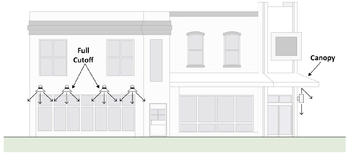
Figure 53: Exterior Light Shielding
(B)
Floodlights and Spotlights.
i.
Floodlights and spotlights shall be fully shielded so that the light element is not visible to an observer on any property either zoned or used for residential purposes and is not visible to an observer on any public right-of-way.
ii.
The centerline beam of a floodlight or spotlight shall be aimed no higher than forty-five degrees above vertical; however, light fixtures that cast illumination over more than ninety degrees shall be aimed such that no light shall be cast above the horizontal.
(6)
Landscape Lighting
(A)
When planting materials are lighted, high-pressure sodium lamps and low-intensity incandescent lamps shall not be used.
(B)
Lighting of any tree protection area or conservation easement, including but not limited to those required by Section 20.04.030 (Environment), is prohibited.
(d)
Multifamily Residential Lighting. A parcel occupied by a multifamily dwelling shall not be illuminated by more than six thousand lumens per primary structure, including a maximum of two thousand lumens per building entryway of any combination of motion detector activated lighting and bulbs rated at no more than one thousand lumens.
(e)
Mixed-Use and Nonresidential Lighting.
(1)
Adjacent to Residential Districts. Mixed-use and nonresidential uses bordered by any R1, R2, R3, R4, or RMH zoning district shall be allowed a total light output of not more than forty thousand lumens per acre. Provided, regardless of parcel size, the allowance shall be sufficient to provide a maximum of two thousand five hundred lumens per entryway with motion detector activated lighting counted as one-half lumens.
(2)
Use-Specific Conditions.
(A)
Canopies, Pavilions, or Drive-Through Bays.
i.
Illuminance. The canopy, pavilion, or drive-through bay shall be designed to achieve no greater than the minimal illuminance level of a service station pump island as recommended by the Illuminating Engineering Society of North America (IESNA RP-33: Lighting for Exterior Environments).
ii.
Shielding. All light fixtures mounted on or recessed into the lower surface of canopies, pavilions, or drive-through bays shall be full cutoff, fully shielded and use flat lenses. Such fixtures shall be recessed so the fixture does not extend below the lower horizontal surface of the canopy, pavilion, or drive-through bay.
(B)
Outdoor Recreational Facilities.
i.
Illuminance. All lighting installations shall be designed to achieve no greater than the minimal illuminance levels for the activity as recommended by the Illuminating Engineering Society of North America (IESNA RP-6: Sports and Recreational Area Lighting).
ii.
Light Trespass. All lighting fixtures shall be installed so that light trespass from any property line, except a property line abutting a public street, shall not exceed two footcandles at a point one meter beyond the property line.
iii.
Restriction. Field lighting for all outdoor recreational facilities shall be turned off within thirty minutes after the completion of the last event of the night.
(C)
Parking Lots and Outdoor Display Lots or Areas.
i.
Illuminance. The parking lot shall be designed to achieve no greater than the minimal illuminance levels for the given land use as recommended by the Illuminating Engineering Society of North America (IESNA RP-33: Lighting for Exterior Environments). However, a parking lot shall also be designed to achieve a minimum illuminance level of one lux.
ii.
Curfew. Lighting for outdoor display lots and parking lots with more than twenty parking spaces shall be reduced by half no later than eleven p.m., or within thirty minutes after closing of the business, whichever is later.
(Amd. of 1-14-2020; Ord. No. 21-22, § II (Att. A), 4-21-2021; Ord. No. 2024-03, § II(Att. A), 4-10-2024; Ord. No. 2024-04, § II(Att. A), 4-10-2024; Ord. No. 2025-12, § II(Att. A), 5-21-2025)
20.04.100 - Signs.
(a)
Purpose. The intent of these sign standards is to:
(1)
Accomplish the goals of the Comprehensive Plan;
(2)
Avoid unnecessary proliferation of signs;
(3)
Provide developments with appropriate identification;
(4)
Create a consistent streetscape;
(5)
Maintain and enhance the aesthetic environment of the City;
(6)
Eliminate potential hazards to motorists and pedestrians resulting from sign clutter; and
(7)
Promote the health, safety, and welfare of the residents of the City of Bloomington.
(8)
No part of these standards shall in any way be interpreted to infringe upon those rights guaranteed by the First Amendment to the United States Constitution or Article 1, Section 9 of the Indiana Constitution.
(b)
Applicability. No sign or advertising device shall be established, altered, changed, erected, constructed, reconstructed, moved, divided, enlarged, demolished or maintained except in compliance with this Section 20.04.100 (Signs).
(c)
Permit Requirements.
(1)
Generally. A sign permit shall be required for all signs located, erected, constructed, reconstructed, moved, or altered unless specifically exempted by this Section 20.04.100 (Signs).
(2)
Signs Not Requiring a Permit. The following signs are exempt from the requirement to obtain a sign permit, unless specifically required by another subsection of this Section 20.04.100 (Signs).
(A)
Public Signs. Any signs erected, or required to be erected, by a unit of local, state, or federal government. City of Bloomington public signs are exempt from signage regulations.
(B)
Small Signs. Any sign of not more than one and one-half square feet in area. Such signs are exempt from signage regulations except 20.04.100(f)(1) through (f)(4) and must be less than six feet tall if freestanding.
(C)
Temporary Signs.
i.
In all zoning districts, each property is allowed to have two signs, neither of which shall exceed five square feet in area, and one additional sign that shall not exceed eight square feet in area and shall not exceed six feet in height if freestanding.
ii.
In nonresidential and Mixed-Use zoning districts, each vacant property, or property that is under construction, is allowed to have one sign that shall not exceed thirty-two square feet in area and shall not exceed six feet in height if freestanding.
iii.
In all nonresidential and Mixed-Use zoning districts, each vacant tenant space, or tenant space that is under construction, is allowed to have one sign that shall not exceed thirty-two square feet in area that shall be attached to the wall of the vacant space.
(D)
Murals. Murals are exempt from the requirement to obtain a sign permit.
(E)
Window Signs. Window signs shall not exceed twenty-five percent of the glass area of any individual window or glass door frame and shall not count towards the wall sign allowance of the use or property.
(F)
Sandwich Board Signs. Sandwich board signs shall comply with the standards of this section.
(d)
Sign Measurements. Sign height and sign area measurements shall be calculated as follows:
(1)
Wall Signs. The area of wall signs shall be calculated as the smallest regular geometric figure needed to circumscribe any images, text, or other identifying trait placed on a structure.
(2)
Freestanding Signs.
(A)
The area of freestanding signs shall be calculated as the smallest regular geometric figure needed to circumscribe the sign, exclusive of supporting structures.
(B)
The height of a freestanding sign shall be measured from the grade beneath the sign or from the crown of the adjacent street, whichever is higher. The ground beneath a sign shall not be raised to artificially change the point at which the sign height is measured.
(3)
Double-Faced Signs. For all freestanding, projecting, or temporary signs permitted by this chapter, a double-faced sign may be erected. Only the face area of one of the two sides shall be considered the face area of the entire sign. In such cases, the two sign faces shall be identical in area, shall be placed back to back, and shall be separated by a distance of no more than two feet.
(e)
Prohibited Sign Types. The following signs are prohibited in all zoning districts unless specifically authorized by another provision of this Section 20.04.100 (Signs) or Section 20.03.030(h)(3):
(1)
Animated Signs. Signs that use any motion picture, laser, or visual projection of images or text.
(2)
Bench Signs. A sign located on the seat or back of a bench placed on or adjacent to a public right-of-way.
(3)
Imitation of Public Signs. Signs that purport to be, are in imitation of, or resemble a public sign as described by the Manual on Uniform Traffic Control Devices. Examples include but are not limited to stop signs, yield signs, or pedestrian crossing signs.
(4)
Off-Premises Signs. Signs advertising goods, products, services, events or activities not located, sold or offered on the premises or tenant space on which the sign is located, except for signs as provided in Section 20.04.100(c)(2)(B) (Small Signs), Section 20.04.100(c)(2)(C) (Temporary Signs), Section 20.04.100(k)(7) (Sandwich Board Signs), and Section 20.04.100(l)(7) (Sandwich Board Signs).
(5)
Vehicle Signs. Vehicles, vans, trailers or trucks that are parked continuously in the same general location to be used to display signs. This does not prohibit vehicle or trailer owners from having vehicles or trailers with signs, provided the vehicles or trailers are in use on a regular basis, are not continuously parked in one parking lot or parking space, and are not being used to serve in the same manner as an additional freestanding sign or temporary sign.
(6)
Intermittent Lights. Signs that have intermittent blinking, flashing, or fluttering lights, including any device that has a changing light intensity, brightness of color, or gives such illusion, including but not limited to strobe lights.
(7)
Pole Signs. Signs that are mounted on a freestanding pole or other support that is not part of or attached to a building or structure.
(8)
Temporary Signs. Any temporary sign not specifically permitted in Section 20.04.100(i)(9) (Temporary Signs), Section 20.04.100(j)(7) (Temporary Signs), Section 20.04.100(k)(5) (Temporary Signs), and Section 20.04.100(l)(6) (Temporary Signs) or specifically exempted in Section 20.04.100(c)(2)(C) (Temporary Signs), including but not limited to pennants, streamers, balloons, inflatable signs, spinners, and feather flags.
(9)
Electronic Reader Board Signs. Any electronic reader board sign not specifically permitted in Section 20.04.100(g)(3) (Electronic Reader Boards).
(f)
Prohibited Sign Locations. Signs shall not be installed at any of the following locations:
(1)
Public Easement. In any public easement, unless the sign is a public sign authorized by Section 20.04.100(c)(2)(A) (Public Signs), or is further authorized by the City.
(2)
Public Right-of-Way. In any public right-of-way, unless the sign is an approved wall, awning, or projecting sign; or is authorized by Section 20.04.100(k)(9), Section 20.04.100(l)(3), Section 20.04.100(l)(7); or the sign is a public sign authorized by Section 20.04.100(c)(2)(A) and is further authorized by the City.
(3)
Roofs. On the roof of a building, or extending above the eave, roof line or parapet of a building, except that signs may be located on the vertical portion of a mansard roof if no vertical wall space is available on the wall space associated with that tenancy or occupancy below and excepting that signs may be placed on top of awnings.
(4)
Vision Clearance Triangle. Within a vision clearance triangle as specified in Section 20.04.050(c)(4) (Vision Clearance Triangle).
(5)
Miscellaneous. On any traffic control signs, highway construction signs, fences, railings, utility poles, street signs, trees or other natural objects.
(g)
General Design Standards. Unless otherwise stated in this UDO, the following standards apply to all signs.
(1)
Freestanding Signs. All freestanding signs shall comply with the following standards:
(A)
Setback. All freestanding signs shall be set back a minimum of two feet from the proposed right-of-way line or outside of the required clear zone of a public sidewalk, whichever is greater, unless specifically approved by the City's transportation and traffic engineer.
(B)
Mounting. All freestanding signs shall be permanently affixed to the ground.
(C)
Base. Sign bases shall conform to the following standards:
i.
Sign bases shall have an aggregate width, including support structures, of at least forty percent of the total horizontal width of the sign; or have supports that are less than twenty-five percent of the vertical height of the sign.
ii.
The base and exposed foundation of all freestanding signs shall be covered with a finished material such as brick, stone, metal, or wood.
(D)
Cap. A decorative cap may extend up to eighteen inches above the height limit specified in this Section 20.04.100 (Signs). The decorative cap shall have no identifying text, images, or identifying traits.
(E)
Landscaping.
i.
For any new freestanding sign, a landscaped area located around the entire base of a freestanding sign is required.
ii.
The landscaped area shall contain materials consisting of shrubs, spread no greater than three feet on center, and densely planted perennial ground cover.
iii.
The landscaped area shall be greater than or equal to the freestanding sign face area.
(F)
Illumination. Sign lighting shall comply with the light trespass regulations in Section 20.04.090 (Outdoor Lighting) and also may not exceed one footcandle at a distance of six feet from the sign fence.
(2)
Changeable Copy. Unless specified otherwise in this UDO, signs may incorporate areas for changeable copy, provided that and combination of the changeable copy area and any electronic reader board component area combined does not exceed forty percent of the total sign area.
(3)
Electronic Reader Boards. Unless otherwise provided in this UDO, electronic reader boards may only be utilized when incorporated into permanent signage, subject to the following:
(A)
The electronic reader board portion may not exceed thirty square feet or forty percent of the total area of any sign face (whichever is less).
(B)
Any combination of the electronic reader board area and any changeable copy area combined does not exceed more than forty percent of the total area of any sign face, and that information is displayed in increments of no less than twenty seconds.
(C)
Electronic reader boards are not allowed on signs larger than one hundred twenty-five square feet.
(4)
Wall Signs. Wall signs shall be located on any exterior portion of the building that is occupied by the use or portion of a building that is occupied by the use if the building has multiple uses.
(h)
Waiver of Right to Damages.
(1)
The Plan Commission, the Board of Zoning Appeals, and the City Planning and Transportation Department are each authorized to request waivers of the right to and receipt of damages pursuant to Indiana Code § 22-13-2-1.5, Indiana Code § 36-7-2-5.5, and Indiana Code § 32-24, in connection with any petition for a permit or other approval that may involve erection of a new sign or removal or alteration of a lawfully erected sign, including a lawful nonconforming sign.
(2)
Waivers may be requested from the following:
(A)
The petitioner;
(B)
The property owner;
(C)
The sign owner; and
(D)
Any other person with an interest in the site or the sign.
(3)
The owner and/or the petitioner shall be responsible for obtaining waivers from all persons listed in Section 20.04.100(h)(2).
(i)
Residential District Sign Standards.
(1)
Applicability. This section applies to the R1, R2, R3, R4, RM, RH, and RMH zoning districts.
(2)
Single-Family and Condominium Subdivision. Each subdivision shall be permitted one freestanding sign per development entrance, subject to the following standards:
(A)
Freestanding Sign Area. The maximum sign area shall not exceed thirty-two square feet per side.
(B)
Freestanding Sign Height. The maximum height shall not exceed six feet in height.
(C)
Changeable Copy. Changeable copy shall be prohibited as part of a freestanding sign.
(D)
Number. The permitted subdivision sign may be replaced with two signs of a maximum sixteen square feet in area per sign if a sign is placed on each side of the entrance.
(E)
Wall Signage. No wall signage is permitted.
(3)
Multifamily.
(A)
Multifamily developments containing between three and fourteen dwelling units shall be permitted one wall sign not to exceed twenty-four square feet per development.
(B)
Multifamily developments containing at least fifteen dwelling units shall be permitted:
i.
One freestanding sign per development vehicle entrance, not to exceed thirty-two square feet per side in maximum sign area and not to exceed six feet in height; and
ii.
One wall sign per building not to exceed twenty-four square feet each.
(4)
Conforming Nonresidential Uses. For any nonresidential use approved as a permitted use or Conditional Use, the provisions of Section 20.04.100(k) (MN District Sign Standards) shall apply. These provisions may be modified by action of the Board of Zoning Appeals as part of a Conditional Use Approval.
(5)
Legal Nonconforming Multifamily Residential Uses. Legal nonconforming multifamily residential uses in Single Family zoning districts with at least three units shall be permitted wall signage not to exceed ten square feet in area but shall not be permitted any freestanding signs. This subsection supersedes Section 20.04.100(i)(3)(A).
(6)
Legal Nonconforming Nonresidential Uses. Legal nonconforming nonresidential uses shall be permitted:
(A)
Wall signage not to exceed ten square feet in area;
(B)
On lots with less than thirty feet of street frontage, no freestanding signs; and
(C)
On lots with thirty feet or more of street frontage, one freestanding sign not to exceed twelve square feet in maximum area per side, and not to exceed four feet in height.
(7)
Illumination. Signs within residential districts shall not be internally illuminated nor contain an electronic reader board.
(8)
Window Signs. Window signs are not permitted for residential uses.
(9)
Temporary Signs. In addition to the temporary signs exempted under Section 20.04.100(c)(2)(C) (Temporary Signs), conforming nonresidential uses and multifamily structures with at least fifteen dwelling units are permitted to display temporary signage provided that the temporary signs comply with the following standards:
(A)
All temporary signs shall receive a sign permit from the City Planning and Transportation Department before being displayed;
(B)
A maximum of three temporary signs per display period described below are permitted;
(C)
Temporary sign types shall be limited to freestanding portable signs or materials not prohibited in Section 20.04.100(e)(8) (Temporary Signs);
(D)
Temporary signs shall not exceed sixteen square feet in area per side;
(E)
Freestanding temporary signs shall not exceed six feet in height; and
(F)
External illumination of temporary signs is prohibited.
(G)
Display of temporary signs shall be permitted for a maximum of three periods of up to thirty days per period, per calendar year. These permitted periods may be combined into one or two periods per year provided that the total display period does not exceed ninety days.
(j)
MS, MM, MC, ME, MI, MH, EM, and PO District Sign Standards.
(1)
Applicability. This sign standards section applies to the MS, MM, MC, ME, MI, MH, EM, and PO zoning districts.
(2)
Wall Signs. The following standards shall apply to wall signs for individual uses or tenants within a multi-tenant center:
(A)
Allowance.
i.
Individual Nonresidential Uses. The cumulative square footage of all wall signs shall not exceed one and one-half square feet per lineal foot of primary facade facing a public or private street.
ii.
Multi-Tenant Center. The cumulative square footage of all wall signs for any individual tenant shall not exceed one and one-half square feet per lineal foot of the tenant's facade width facing either a public or private street or facing a parking area if no street frontage is adjacent. For purposes of this Section 20.04.100(j) (MS, MM, MC, ME, MI, MH, EM, and PO District Sign Standards), only one facade of the building may be used to measure the sign allowance, with the exception of corner locations in multi-tenant buildings, which shall be permitted to use the side facade as additional facade width.
iii.
Size Limits. No non-residential use shall be limited to less than thirty square feet of wall signage. Uses with less than two hundred thousand square feet of building area shall not be permitted to exceed three hundred square feet of wall signage. Uses with two hundred thousand square feet or more of building area shall not be permitted to exceed four hundred square feet of wall signage.
(B)
Maximum Projection. Except an awning sign, no part of a wall sign shall project more than twelve inches from the wall or face of the building to which it is attached. Signs on awnings may not extend more than twelve inches above the awning and any support structures shall not be visible.
(C)
Location. Wall signs for individual tenants within a multi-tenant nonresidential center shall be located on a wall of the tenant's lease space.
(D)
Multi-Tenant Nonresidential Centers. In addition to other wall signs permitted in this Section 20.04.100(j)(2) (Wall Signs), multi-tenant nonresidential centers shall be permitted a single wall sign not exceeding twenty square feet in area.
(3)
Projecting Signs. A five square foot projection sign is allowed on a tenant's lease space. Projecting signs shall count toward wall signage allotment.
(4)
Freestanding Signs. The following standards shall apply to all freestanding signs:
(A)
Number.
i.
Freestanding signs shall not be permitted on lots with thirty feet or less of public street frontage.
ii.
Lots with greater than thirty feet and less than five hundred feet of frontage on a public street are permitted one freestanding sign.
iii.
Lots with five hundred feet or more of public street frontage, one freestanding sign shall be permitted for each two hundred fifty feet of public street frontage.
iv.
The number of signs allowed per street frontage shall be determined based on the length of frontage on each street. Each frontage is regulated separately, and total square footages may not be aggregated.
v.
In no case shall any lot have more than four freestanding signs.
(B)
Area.
i.
Individual Nonresidential Uses.
1.
Freestanding signs on lots with greater than thirty feet and less than fifty feet of public street frontage shall not exceed twenty square feet.
2.
Freestanding signs on lots with at least fifty feet and less than seventy-five feet of public street frontage shall not exceed thirty square feet.
3.
Freestanding signs on lots with at least seventy-five feet of public street frontage shall not exceed forty-five square feet.
4.
Where a lot has more than one public street frontage, each street frontage shall be regulated independently.
ii.
Multi-Tenant Nonresidential Centers.
1.
Freestanding signs for centers with less than twenty thousand square feet of gross floor area are permitted a maximum sign area based on individual nonresidential use allowances listed in the above Section 20.04.100(j)(3)(B)i. (Individual Nonresidential Uses).
2.
Freestanding signs for centers with at least twenty thousand and less than thirty-five thousand square feet of gross floor area shall not exceed sixty square feet.
3.
Freestanding signs for centers with at least thirty-five thousand and less than fifty thousand square feet of gross floor area shall not exceed seventy-five square feet.
4.
Freestanding signs for centers with at least fifty thousand square feet of gross floor area shall not exceed one hundred twenty-five square feet.
5.
Individual tenant panels shall not exceed thirty-six square feet.
6.
Outlots that are not counted toward center square footages shall be permitted freestanding signage based on individual nonresidential uses in Section 20.04.100(j)(3)(B)i. (Individual Nonresidential Uses).
7.
Replacement or switch-out of individual tenant panels on a multi-tenant sign shall not require compliance of the entire freestanding sign but shall require a sign permit.
8.
The gross floor area calculations described in this Section 20.04.100(j)(3)(B)ii. (Multi-Tenant Nonresidential Centers) shall not include any square footage associated with a residential use.
(C)
Height.
i.
For individual nonresidential uses and multi-tenant centers of less than twenty thousand square feet of gross floor area, the maximum freestanding sign height shall be six feet.
ii.
For multi-tenant centers with at least twenty thousand square feet and less than fifty thousand square feet of gross floor area, the maximum freestanding sign height shall be eight feet.
iii.
For multi-tenant centers with at least fifty thousand square feet of gross floor area, the maximum sign height shall be fifteen feet.
iv.
The gross floor area calculations described in this Section 20.04.100(j)(3)(C) (Height) shall not include any square footage associated with a residential use.
(D)
Separation. Where a lot is permitted multiple freestanding signs, no two freestanding signs shall be within one hundred feet of each other, as measured along the public right-of-way.
(E)
Changeable Copy. A maximum of eighty percent of any freestanding sign may be dedicated to changeable copy.
(5)
Permanent Display Cabinets. Permanent display cabinets shall be subject to the following standards:
(A)
Permanent display cabinets may incorporate interchangeable signage such as banners, flyers, posters, and menus.
(B)
Permanent display cabinets shall count toward the wall signage square footage allowance of the use.
(C)
Individual display cabinets shall not exceed sixteen square feet in area per display cabinet, measured at the outer edge of the cabinet frame.
(D)
A permanent display cabinet shall not exceed eight feet in height from ground level.
(E)
The permanent display cabinet shall be framed with wood, metal, or other durable material, and enclosed with a transparent cover.
(6)
Drive-Through Uses. In addition to the signs listed in this Section 20.04.100 (Signs):
(A)
Structures with a drive-through shall be permitted one additional sign at the entrance to or for each area connected to a drive-through lane, provided that the sign has only one face, the maximum area of that sign face does not exceed thirty-six square feet, and the height of the sign does not exceed six feet. These signs shall be allowed to have twenty percent as electronic reader board and shall be exempt from the landscaping requirements of Section 20.04.100(g)(1)(E).
(B)
Structures with a drive-through shall be permitted two additional freestanding signs, with a maximum sign face area that does not exceed four square feet, and the height of the sign does not exceed four feet.
(C)
Structures with a drive-through shall be permitted one additional sign at the ordering location of each drive-through, provided that the sign(s) has only one face, the maximum area of that sign face does not exceed twelve square feet, and the height does not exceed five feet. These signs shall be allowed to have one hundred percent as electronic reader board and shall be exempt from the landscaping requirements of Section 20.04.100(g)(1)(E).
(7)
Multifamily Dwelling Uses. The following standards apply to multifamily dwelling uses:
(A)
Multifamily developments containing between three and fourteen dwelling units shall be permitted one wall sign not to exceed twenty-four square feet per development.
(B)
Multifamily developments containing at least fifteen dwelling units shall be permitted:
(i)
One freestanding sign per development vehicle entrance, not to exceed thirty-two square feet per side in maximum sign area and not to exceed six feet in height; and
(ii)
One wall sign per building not to exceed twenty-four square feet each.
(8)
Temporary Signs. In addition to the temporary signs exempted under Section 20.04.100(c)(2)(C) (Temporary Signs), each property is allowed to display temporary signage provided that the temporary signs comply with the following standards:
(A)
All temporary signs shall receive a sign permit from the Planning and Transportation Department prior to being displayed.
(B)
The following numbers of signs are permitted:
i.
Individual nonresidential uses shall be permitted a maximum of three temporary signs.
ii.
Multifamily structures with at least fifteen dwelling units shall be permitted a maximum of three temporary signs.
iii.
Individual tenants within nonresidential centers shall be permitted a maximum of one temporary sign.
(C)
Temporary sign types shall be limited to freestanding portable signs or materials not prohibited in Section 20.04.100(e)(8) (Temproary Signs).
(D)
Temporary signs shall not exceed sixteen square feet.
(E)
Freestanding temporary signs shall not exceed six feet in height.
(F)
External illumination of temporary signs is prohibited.
(G)
Display of temporary signs shall be permitted for a maximum of three periods of up to thirty days per period, per calendar year. These permitted periods may be combined into one or two periods per year provided that the total display period does not exceed ninety days.
(k)
MN District Sign Standards.
(1)
Applicability. This sign standards section applies to the MN zoning districts.
(2)
Wall Signs. The following standards apply to wall signs for individual uses or tenants within a multi-tenant center:
(A)
Allowance.
i.
Individual Nonresidential Uses. The cumulative square footage of all wall signs shall not exceed one square foot per lineal foot of primary structure that faces a public or private street.
ii.
Multi-Tenant Centers. The cumulative square footage of all wall signs for any individual use shall not exceed one square feet per lineal foot of the facade width associated with the use facing either a public or private street or facing a parking area if no street frontage is adjacent. For purposes of this section, only one facade of the building will be used to measure allowance with the exception of corner locations in multi-tenant buildings, which shall be permitted to use the side facade as additional facade width.
iii.
Limits. No non-residential use shall be limited to less than twenty square feet of wall signage and no use or tenant shall be permitted to exceed one hundred square feet of wall signage.
(B)
Location. No wall signage shall be located on a side or rear building facade facing a residential use. Wall signs for individual tenants within a multi-tenant nonresidential center shall be located on a wall of the tenant's lease space.
(C)
Maximum Projection. No part of a wall sign, other than an awning sign, shall protrude more than twelve inches from the wall or face of the building to which it is attached. Signs on awnings may not extend more than twelve inches above the awning and any support structures shall not be visible.
(3)
Projecting Signs. A five square foot projecting sign is allowed on a tenant's lease space. Projecting signs shall count toward wall signage allotment.
(4)
Freestanding Signs. The following standards apply to permanent freestanding signs:
(A)
Lots with thirty feet or less of public street frontage shall not be permitted any freestanding signs. Lots with more than thirty feet of public street frontage on a single street are permitted a maximum of one freestanding sign.
(B)
No freestanding sign shall exceed fifteen square feet in area per side.
(C)
No freestanding sign shall exceed four feet in height.
(D)
Internally illuminated signs are prohibited.
(5)
Permanent Display Cabinets. Permanent display cabinets shall be subject to the following standards:
(A)
Permanent display cabinets may incorporate interchangeable signage such as banners, flyers, posters, and menus.
(B)
Permanent display cabinets shall count toward the wall signage allowance of the use.
(C)
Individual display cabinets shall not exceed sixteen square feet in area per display, measured at the outer edge of the cabinet frame.
(D)
A permanent display cabinet shall not exceed eight feet in height from ground level.
(E)
The permanent display cabinet shall be framed with wood, metal, or other durable material, and enclosed with a transparent cover.
(6)
Multifamily Dwelling Uses. Multifamily developments shall be permitted one wall sign not to exceed twenty-four square feet.
(7)
Temporary Signs. In addition to the temporary signs exempted under Section 20.04.100(c)(2)(C) (Temporary Signs), each property is allowed to display temporary signage provided that the temporary signs comply with the following standards:
(A)
All temporary signs shall receive a sign permit from the Planning and Transportation Department prior to being displayed.
(B)
The following numbers of signs are permitted:
i.
Individual nonresidential uses shall be permitted a maximum of three temporary signs.
ii.
Multifamily structures with at least fifteen dwelling units shall be permitted a maximum of three temporary signs.
iii.
Individual tenants within nonresidential centers shall be permitted a maximum of one temporary sign.
(C)
Temporary sign types shall be limited to freestanding portable signs or materials not prohibited in Section 20.04.100(e)(8) (Temporary Signs).
(D)
Temporary signs shall not exceed sixteen square feet.
(E)
Freestanding temporary signs shall not exceed six feet in height.
(F)
External illumination of temporary signs is prohibited.
(G)
Display of temporary signs shall be permitted for up to a maximum of three periods of up to thirty days per period, per calendar year. These permitted periods may be combined into one or two periods per year provided that the total display period does not exceed ninety days.
(8)
Electronic Reader Boards. Electronic reader boards are not permitted in this zoning district.
(9)
Sandwich Board Signs. Properties immediately adjacent to a public sidewalk shall be permitted to place sandwich board signs in the public sidewalk provided the following criteria are met.
(A)
Number. Each property shall be permitted one sandwich board sign. If a property contains more than one tenant, additional sandwich board signs shall be permitted, provided the number of sandwich boards in front of a single property shall be limited to ensure that no sandwich board sign shall be placed within eight linear feet of another sandwich board sign, measured from the base of each sign.
(B)
Design.
i.
Sign face area shall not exceed five square feet.
ii.
Sign face width shall not exceed two feet, nine inches measured at the widest point of the sign face.
iii.
Sign height shall not exceed four and one-half feet measured from the ground to the top of the sign.
iv.
Signs shall be truly portable and shall not be permanently affixed to any structure or sidewalk.
(C)
Placement. Sandwich board signs shall meet the following placement criteria.
i.
Signs shall be placed only on sidewalks with a minimum width of seven feet.
ii.
Signs shall be removed from the public sidewalk at the end of each business day.
iii.
Signs shall be located a maximum of two feet from the building; or in the tree plot outside of the sidewalk.
iv.
Signs shall be placed a minimum of forty-eight inches from all obstructions within the sidewalk including newspaper boxes, outdoor tables and seating, trees and tree grates, bicycle racks, trash receptacles and any other item impeding pedestrian or wheelchair movement.
v.
Signs shall be placed a minimum of eight feet from a building corner or pedestrian crosswalk.
vi.
Sign placement shall meet all requirements of the Americans with Disabilities Act (ADA).
vii.
Signs shall not be placed within the right-of-way of the B-Line Trail. Sandwich board signs for properties with frontage along the trail shall be placed on the property between the building and the trail right-of-way.
(l)
MD District Sign Standards.
(1)
Applicability. This sign standards section applies to the MD zoning districts.
(2)
Wall Signs. The following standards apply to wall signs for individual uses and tenants within a multi-tenant center:
(A)
Allowance.
i.
Individual Nonresidential Uses. The cumulative square footage of all wall signs shall not exceed one and one-half square feet per lineal foot of primary structure that faces a public or private street.
ii.
Multi-Tenant Centers.
1.
First Story. The cumulative square footage of all permanent wall signs for an individual use shall not exceed one and one-half square feet per lineal foot of the use's facade width facing either a public or private street or parking area if no street frontage is adjacent for locations on the first floor. For purposes of this section, only one facade of the building will be used to measure allowance with the exception of corner locations in multi-tenant buildings, which shall be permitted to use the side facade as additional facade width.
2.
Upper Story Uses.
a.
Uses located above the first story shall be permitted a wall sign allowance equal to fifty percent of the total allowance permitted for first story uses as provided in Section 20.04.100(l)(2)(A)ii.1 (First Story), above.
b.
The sign shall be located on the lease space or along a wall within five feet of the lease space.
3.
Additional Sign. Multi-tenant centers shall be permitted a single wall or projecting sign that does not exceed twenty square feet in area.
4.
Additional Sign. Multi-tenant centers shall be permitted a single wall sign that does not exceed twenty square feet in area.
iii.
Multifamily. Developments containing more than two units shall be permitted wall signage that shall not cumulatively exceed twenty-four square feet.
iv.
Limits. No property shall be limited to less than twenty square feet of wall signage and no use or tenant shall exceed one hundred square feet of wall signage.
(B)
Location. Wall signs for individual tenants within a multi-tenant center shall be located on the tenant's lease space, except as regulated in Section 20.04.100(l)(2)(A)ii.2. (Upper Story Retail Uses), above.
(C)
Maximum Projection. No part of a wall sign, other than a projecting sign or awning, shall project more than twelve inches from the wall or face of the building to which it is attached. Signs on awnings may not extend more than twelve inches above the awning and any support structures shall not be visible.
(3)
Projecting Signs. The following standards apply to projecting signs:
(A)
Any property that uses a freestanding sign shall be prohibited from using a projecting sign.
(B)
A maximum of one projecting sign is permitted per tenant per street frontage.
(C)
A minimum separation of one hundred feet shall be provided between all projecting signs on the same building facade.
(D)
Projecting signs shall be limited to a maximum of fifty-four square feet in area.
(E)
Projecting sign areas shall count toward overall wall sign square footage allowance.
(F)
No part of a projecting sign shall protrude more than ninety-six inches from the wall or face of the building to which it is attached. Those support structures located between the building and the sign only shall be counted toward this allowance.
(G)
Projecting signs shall be located adjacent to the tenant's lease space and shall be installed at least seven feet above the pavement.
(H)
The petitioner for a projecting sign shall provide information verifying that the building facade containing the projecting sign can tolerate anticipated wind loading.
(4)
Freestanding Signs. The following standards apply to permanent freestanding signs.
(A)
The erection of freestanding signs shall be prohibited on any property frontage immediately adjacent to the B-Line Trail right-of-way.
(B)
Lots with thirty feet or less of public street frontage are not permitted any freestanding signs. Properties with more than thirty feet of public street frontage on a single street are permitted a maximum of one freestanding sign.
(C)
Freestanding signs shall not exceed fifteen square feet.
(D)
Freestanding signs shall not exceed four feet in height.
(E)
No freestanding sign shall be allowed unless the primary structure on a lot is set back from the public right-of-way by a minimum of fifteen feet.
(F)
Internally illuminated signs and electronic reader boards are prohibited.
(G)
Changeable copy shall be prohibited as part of a freestanding sign.
(5)
Permanent Display Cabinets. Permanent display cabinets shall be subject to the following standards:
(A)
Permanent display cabinets may incorporate interchangeable signage such as banners, flyers, posters, and menus.
(B)
Permanent display cabinets shall count toward the wall signage allowance of the use.
(C)
Individual display cabinets shall not exceed sixteen square feet in area per display, measured at the outer edge of the cabinet frame.
(D)
A permanent display cabinet shall not exceed eight feet in height from ground level.
(E)
The permanent display cabinet shall be framed with wood, metal, or other durable material, and enclosed with a transparent cover.
(6)
Temporary Signs. In addition to the temporary signs exempted under Section 20.04.100(c)(2)(C) (Temporary Signs), each property is allowed to display temporary signage provided that the temporary signs comply with the following standards:
(A)
All temporary signs shall receive a sign permit from the Planning and Transportation Department prior to being displayed.
(B)
The following numbers of signs are permitted:
i.
Individual nonresidential uses shall be permitted a maximum of three temporary signs.
ii.
Multifamily structures with at least fifteen dwelling units shall be permitted a maximum of three temporary signs.
iii.
Individual tenants within nonresidential centers shall be permitted a maximum of one temporary sign.
(C)
Temporary sign types shall be limited to freestanding portable signs or materials not prohibited in Section 20.04.100(e)(8) (Temporary Signs).
(D)
Temporary signs shall not exceed sixteen square feet.
(E)
Freestanding temporary signs shall not exceed six feet in height.
(F)
External illumination of temporary signs is prohibited.
(G)
Display of temporary signs shall be permitted for up to a maximum of three periods of up to thirty days per period, per calendar year. These permitted periods may be combined into one or two periods per year provided that the total display period does not exceed ninety days.
(7)
Sandwich Board Signs. Properties immediately adjacent to a public sidewalk shall be permitted to place sandwich board signs in the public sidewalk provided the following criteria are met.
(A)
Number. Each property shall be permitted one sandwich board sign. If a property contains more than one tenant, additional sandwich board signs shall be permitted, provided the number of sandwich boards in front of a single property shall be limited to ensure that no sandwich board sign shall be placed within eight linear feet of another sandwich board sign, measured from the base of each sign.
(B)
Design.
i.
Sign face area shall not exceed five square feet per sign per face.
ii.
Sign face width shall not exceed two feet, nine inches measured at the widest point of the sign face.
iii.
Sign height shall not exceed four and one-half feet measured from the ground to the top of the sign.
iv.
Signs shall be truly portable and shall not be permanently affixed to any structure or sidewalk.
(C)
Placement. Sandwich board signs shall meet the following placement criteria.
i.
Signs shall be placed only on sidewalks with a minimum width of seven feet.
ii.
Signs shall be removed from the public sidewalk at the end of each business day.
iii.
Signs shall be located a maximum of two feet from the building; or in the tree plot outside of the sidewalk.
iv.
Signs shall be placed a minimum of forty-eight inches from all obstructions within the sidewalk including newspaper boxes, outdoor tables and seating, trees and tree grates, bicycle racks, trash receptacles and any other item impeding pedestrian or wheelchair movement.
v.
Signs shall be placed a minimum of eight feet from a building corner or pedestrian crosswalk.
vi.
Sign placement shall meet all requirements of the ADA.
vii.
Signs shall not be placed within the right-of-way of the B-Line Trail. Sandwich board signs for properties with frontage along the trail shall be placed within the setback between the building and the trail right-of-way.
(Amd. of 1-14-2020; Ord. No. 20-07, § I(Att. B), 4-15-2020; Ord. No. 21-18, § II(Att. A), 4-21-2021; Ord. No. 21-22, § II(Att. A), 4-21-2021; Ord. No. 22-10, § II(Att. A, B), 5-18-2022; Ord. No. 23-04, § 2(Att. A), 4-19-2023; Ord. No. 23-06, § 2(Att. A), 4-19-2023; Ord. No. 2024-03, § II(Att. A), 4-10-2024; Ord. No. 2024-04, § II(Att. A), 4-10-2024; Ord. No. 2025-12, § II(Att. A), 5-21-2025)
20.04.110 - Incentives.
(a)
Applicability. These affordable housing and sustainable development incentives are available to all development, except for student housing or dormitory projects located in the MD zoning district.
(b)
General Standards. The following standards apply to all projects seeking the affordable housing or sustainable development incentives in this Section 20.04.110 (Incentives).
(1)
Neighborhood Transition Standards.
(A)
All projects abutting a property in the R1, R2, R3, or R4 zoning district shall comply with the neighborhood transition standards established in Section 20.04.070(d)(5) (Neighborhood Transition Standards).
(B)
Where a primary structure's maximum height incentive is in conflict with the neighborhood transition standards established in Section 20.04.070(d)(5) (Neighborhood Transition Standards), the neighborhood transition standards shall govern. The petitioner may request relief from the neighborhood transition standards in accordance with the development standards variance procedure pursuant to Section 20.06.080(b) (Variance).
(2)
Waiver of Fees.
(A)
When a petition qualifies for one or more of the incentives in this Section 20.04.110 (Incentives), filing fees for the Plan Commission and/or Board of Zoning Appeals shall be waived.
(B)
When a petition that qualifies for one or more of the incentives in this Section 20.04.110 (Incentives) has been approved by the decision-making body:
i.
Sewer hook-on fees for the project may be waived or reduced by the Utilities Service Board.
(3)
Administration.
(A)
A petition for these development incentives shall be included with a petition for development approval.
(B)
Projects that qualify for the affordable housing incentive and/or the sustainable development incentive established in Section 20.04.110 (Incentives), shall have the site plan portion of the petition processed as a minor (rather than major) site plan, except when the project is adjacent to a lot in the R1, R2, R3, or R4 zoning districts or contains more than fifty dwelling units.
(C)
Staff shall determine if the project is eligible to receive incentives and if it satisfies the criteria established in this Section 20.04.110 (Incentives).
(D)
Where the final approval authority determines that the project satisfies the criteria of this Section 20.04.110 (Incentives), the final approval authority may authorize the modifications to development standards otherwise applicable to the project to allow the use of the approved incentives, but may not modify the neighborhood transition standards in Section 20.04.070(d)(5) (Neighborhood Transition Standards).
(E)
The City may withhold issuance of a certificate of zoning compliance or recommendation for a certificate of occupancy until verification that the project satisfies the affordable housing and/or sustainable development standards approved as part of the development petition.
(c)
Affordable Housing.
(1)
Purpose. The purpose of these standards is to encourage the provision of affordable housing for very low-, low-, and moderate-income households. Affordable housing is necessary to help maintain a diverse housing stock and to allow all residents to have better access to jobs and to improve their economic status.
(2)
Eligibility. Projects that satisfy one of the following criteria shall be eligible for the incentives established in subsection (5) below:
(A)
Tier 1.
i.
At least sixty percent of the total gross floor area of the building (including additional area awarded with an incentive) is dedicated to residential dwellings; and
ii.
A minimum of fifteen percent of the total dwelling units (including those on floors awarded with an incentive) are income-restricted permanently, unless otherwise adjusted or forfeited by the City, to households earning less than ninety percent of the HUD AMI for Monroe County, Indiana; or
(B)
Tier 2.
i.
At least sixty percent of the total gross floor area of the building (including additional area awarded with an incentive) is dedicated to residential dwellings; and
ii.
A minimum of seven percent of the total dwelling units (including those on floors awarded with an incentive) are income-restricted permanently, unless otherwise adjusted or forfeited by the City, to households earning below ninety percent of the HUD AMI for Monroe County, Indiana; and
iii.
A minimum of eight percent of the total dwelling units (including those on floors awarded with an incentive) are income-restricted permanently, unless otherwise adjusted or forfeited by the City, to households earning below seventy percent of the HUD AMI for Monroe County, Indiana.
(3)
Nonresidential Projects. Nonresidential projects that satisfy the following criteria shall qualify for the incentives established in subsection (5) below:
(A)
A linkage study has been approved by the City demonstrating that the proposed project results in an increased demand for affordable dwelling units in Bloomington; and
(B)
The petitioner takes one of the following actions in response to the findings of the linkage study:
i.
The petitioner constructs at least the number of affordable dwelling units required to offset the increased demand for affordable housing calculated based on the linkage study, and each of those affordable dwelling units (a) is located off site, and (b) is deed-restricted to meet the tier 1 or tier 2 criteria for affordability levels and length of income restriction in Section 20.04.110(c) (Affordable Housing), and (c) complies with the standards in Section 20.04.110(c)(6) (Other Standards); or
ii.
The petitioner purchases at least the number of existing market-rate dwelling units required to offset the increased demand for affordable housing calculated based on the linkage study, and each purchased market-rate unit is converted to an affordable dwelling unit that (a) is deed-restricted to meet the tier 1 or tier 2 criteria for affordability levels and length of income restriction in Section 20.04.110(c) (Affordable Housing), and (b) complies with the standards in Section 20.04.110(c)(6) (Other Standards); or
iii.
The petitioner submits a payment-in-lieu of the construction or purchase of affordable dwelling units described in subsection (i) and (ii) above, pursuant to Section 20.04.110(c)(7) (Payment-in-Lieu), calculated on a per bedroom rate, in an amount sufficient to at least offset the increased demand for affordable housing calculated based on the linkage study.
(4)
Student Housing or Dormitory Projects. Student housing or dormitory projects located in the Mixed-Use Downtown (MD) zoning district shall not be eligible for the incentives established in subsection (5) below. Student housing or dormitory projects located in other zoning districts shall be eligible for the incentives established in subsection (5) below if they meet the eligibility criteria outlined in subsection (2) above.
(5)
Affordable Housing Incentives.
(A)
Reduced Bulk Requirements. The following dimensional standards shall apply to single-family (detached) and duplex residential lots in the R1, R2, R3, and R4 zoning districts that are also intended for owner-occupancy that meet either of the two criteria in subsection (2) above:
i.
The minimum lot area for subdivision may be reduced up to fifty percent.
ii.
The minimum lot width for subdivision may be reduced up to forty percent.
iii.
The side building setbacks may be reduced to five feet regardless of the number of stories.
iv.
The rear building setback may be reduced to fifteen feet.
v.
The maximum impervious surface coverage may be increased to eighty percent.
vi.
Where these standards conflict with the neighborhood transition standards established in Section 20.04.070(d)(5) (Neighborhood Transition Standards), the neighborhood transition standards shall govern.
(B)
Primary Structure Height.
i.
Eligibility. In addition to the eligibility criteria in Section 20.04.110(c)(2) (Eligibility), affordable housing projects seeking increased maximum primary structure height shall comply with the following criteria:
1.
The building shall contain six or more dwelling units; and
2.
Unit size and bedroom mix for deed-restricted units shall be comparable to those for market-rate units.
ii.
Tier 1 Projects. Projects that meet the tier 1 affordability standards may increase the primary structure height by one floor of building height, not to exceed twelve feet, beyond the maximum primary structure height established for the zoning district where the project is located, as identified in Section 20.04.020 (Dimensional Standards).
iii.
Tier 2 Projects. Projects that meet the Tier 2 affordability standards may increase the primary structure height by two floors of building height, not to exceed twenty-four feet, beyond the maximum primary structure height established for the zoning district where the project is located, as identified in Section 20.04.020 (Dimensional Standards). Projects that meet the Tier 2 affordability standards may increase the maximum impervious surface coverage allowance by ten percent, and may decrease the landscape area by ten percent.
iv.
Sustainable Development Bonus.
1.
Tier 1 Projects. Projects that are eligible for increased primary structure height for affordable housing and sustainable development shall be eligible for one additional floor of building height, not to exceed twelve feet.
2.
Tier 2 Projects. Projects that are eligible for increased primary structure height for affordable housing and sustainable development shall be eligible for one additional floor of building height not to exceed twelve feet. The additional floor of building height granted under this subsection (iv)(2) shall be limited to fifty percent of the building footprint area of the primary structure, and that additional floor shall be set back at least ten feet further than the lower floors of the building.
(6)
Other Standards. The following standards shall apply to all affordable housing projects seeking incentives under this Section 20.04.110(c) (Affordable Housing).
(A)
Agreement Required. Petitioners shall enter into an affordable housing program or agreement administered by the federal, state, or local governments, or an organization approved by those governments to ensure that no person shall sell, rent, purchase, or lease an affordable housing unit created pursuant to this Section 20.04.110(c) (Affordable Housing) except to income-eligible households and in compliance with the provisions of this section.
(B)
Advertising Requirement. Proof that the income eligible will be marketed and leased similar to the market-rate units is required before occupancy can be issued.
(C)
Location.
i.
All affordable units constructed or rehabilitated under this Section 20.04.110(c) (Affordable Housing) shall be located either on site or within one thousand three hundred twenty feet of the project site. Required affordable dwelling units shall not be located in less desirable locations than market-rate units and shall not, on average, be less accessible to public amenities, such as open space, than the market rate units.
ii.
Affordable housing shall be indistinguishable from market-rate units, integrated with the rest of the development, and shall be compatible with the market rate units in design, appearance, construction and quality of materials.
iii.
If provided off site, the petition for construction of required affordable dwelling units shall be processed simultaneously with the project for which the incentive was approved. No petition for development shall be approved if a related petition for required affordable housing units is denied or the number of required affordable dwelling units is reduced.
(7)
Payment-in-Lieu.
(A)
The dollar amount provided as a payment-in-lieu of providing housing must be based on the minimum percentage of eligible units as described in the Administrative Manual. A payment-in-lieu option is only available in petitions for projects that contain more than thirty dwelling units, may be authorized by an agreement with the City, and all payments will be deposited into the Housing Development Fund.
(B)
The provisions of this Section 20.04.110(c)(7) (Payment-in-Lieu) shall become effective no later than the effective date of the UDO, by which time administrative procedures for calculating, collecting, accounting for, and spending payments-in-lieu in compliance with all applicable law shall be adopted and publicly available in the administrative manual within the Planning and Transportation Department. The procedures used for calculating, collecting, accounting for, and spending shall be reviewed frequently and updated as local housing market conditions change. The calculations may use or be based upon one or more of the following methods:
i.
Housing and urban development (HUD) annual rents based on area median income;
ii.
Area median income (per person, income bracket, etc.);
iii.
Rental rates per unit or per bedroom;
iv.
Utility rates allowances per unit;
v.
Tiered rental rates based on percentages above and/or below AMI; and
vi.
Payment contribution rates.
(d)
Sustainable Development.
(1)
Purpose. The Comprehensive Plan recognizes sustainability as a key component of nurturing Bloomington's environmental integrity. The following incentives are intended to encourage the use of sustainable development, rehabilitation, and retrofit practices in Bloomington beyond the baseline standards required by this UDO.
(2)
Eligibility. Projects seeking the sustainable development incentives established in Section 20.04.110(d)(3) (Sustainable Development Incentives) shall meet the qualifying criteria established in Section 20.04.110(a) (Applicability), shall be located on a previously developed lot(s) served by water and sewer utilities for at least five years prior to construction of petitioner's project, and shall satisfy one of the following two options below:
(A)
Option 1. Projects seeking the sustainable development incentives established in Section 20.04.110(d)(3) (Sustainable Development Incentives) shall demonstrate compliance with the following qualifying criteria:
i.
Storm Water. The development site shall provide low impact development stormwater management by installing permanent infiltration or collection features (e.g., swale, culvert outfall, rainwater cistern) that can retain one hundred percent of the runoff from at minimum, the ninety-fifth percentile (eightieth percentile for development in the MD zoning district) of regional rainfall events, based on the daily rainfall data and the methodology in the U.S. Environmental Protection Agency (EPA) Technical Guidance on Implementing the Stormwater Runoff Requirements for Federal Projects under Section 438 of the Energy Independence and Security Act or a successor or replacement document issued by the EPA.
ii.
Light Colored Hardscaping. At least eighty percent of horizontal hardscaping materials shall be installed with a solar reflectance index (SRI) of eighty-six or greater. The SRI shall be calculated in accordance with ASTM E1980.
iii.
Covered Parking.
1.
A minimum of ninety percent of parking spaces shall be provided under cover. Any roof used to shade, or cover parking shall:
a.
Have a three-year aged SRI of at least seventy-eight; or
b.
Be seventy-five percent covered by energy generation systems, such as solar thermal collectors or photovoltaics.
2.
Parking calculations shall include all existing and new off-street parking spaces that are leased or owned by the project, including parking that is outside the project boundary but is used by the project. On-street parking in public rights-of-way is excluded from these calculations.
3.
Parking spaces within a parking structure shall count toward meeting this standard.
iv.
Solar Energy, Cool or Vegetated Roof. Provide a roof meeting the standards in subsections (1), (2), (3) or (4) below. Roofs containing vegetation must follow landscaping standards pursuant to Sections 20.04.080(c) (General Landscaping), 20.04.080(d) (Permitted Plant Species), and 20.04.080(e) (Prohibited Plant Species).
1.
Solar Energy. Install an on-site solar photovoltaic system covering an area anywhere on the building or lot equal to or greater than thirty-five percent of the total roof area of all primary buildings, or an area equal to or greater than an amount required to provide forty percent of estimated annual average electricity used in all primary buildings. Other renewable energy devices may be used in place of on-site solar panels so long as evidence of equivalent electricity generation capacity is provided.
2.
Cool Roof. Install a cool roof on at least seventy percent of the total roof surface using roofing materials that have an aged SRI equal to or greater than the values in Table 04-21. If aged SRI is not available, the roofing material shall have an initial SRI equal to or greater than the values in Table 04-21.
Table 04-21. Minimum Solar Reflectance Index (SRI)
3.
Vegetated Roof. Install a vegetated roof on at least seventy percent of the total roof surface using native or adapted plant species. Vegetated roofing shall comply with ASTM E2400-06: Standard Guide for Selection, Installation, and Maintenance of Plants for Green Roof Systems.
4.
Combination Roof. Install a combination solar energy, cool roof and vegetated roof, with each portion meeting the applicable standards in subsections 1., 2. and 3. above, and together covering at least seventy percent of the roof surface.
v.
Building Efficiency. Design the project to achieve improved building energy performance beyond the minimum required building code standards by:
1.
Demonstrating that the project qualifies for a minimum of seventeen points from the LEED v4.1 BD+C Optimize Energy Performance Credit; or
2.
Demonstrating that the project qualifies for a minimum of one hundred points from the Assessing Energy Performance Standards, as provided in Section 3.3.1.1 of the Green Globes for New Construction v1.5 Technical Reference Manual.
(B)
Option 2. Projects seeking the sustainable development incentives established in Section 20.04.110(d)(3) (Sustainable Development Standards) shall submit proof that the project is being reviewed and expects to receive certification by the following verified third-party sustainability programs:
i.
Silver Certification by the U.S. Green Building Council (USGBC) Leadership in Energy and Environmental Design (LEED) rating system;
ii.
Silver Certification by the Home Innovation National Green Building Standard (NGBS) Green Certified rating system;
iii.
Petal Certification by the International Living Future Institute Living Building Challenge (LBC) rating system; or
iv.
Three Green Globes Certification by the Green Building Initiative (GBI) Green Globes Certification rating system;
v.
Another verified third-party sustainability program producing equal or greater sustainability benefits to at least one of the programs listed in subsections i. through iv. above, as determined by the Planning and Transportation Director.
(3)
Sustainable Development Incentives.
(A)
Single-Family, Duplex, Triplex, and Fourplex Uses.
i.
Single-family and duplex residential projects in the R1, R2, and R3 zoning districts that satisfy the sustainable development criteria in Option 1 or Option 2 above shall be eligible for the reduced bulk requirements established in Section 20.04.110(c)(5)(A) (Reduced Bulk Requirements).
ii.
Single-family, duplex, triplex, and fourplex residential uses that satisfy the sustainable development criteria in option 1 or option 2 above shall not be eligible for additional primary structure height.
(B)
All Other Uses. Projects that satisfy the sustainable development criteria in option 1 or option 2 above shall be eligible for additional primary structure height as established below:
i.
One floor of building height, not to exceed twelve feet, beyond the maximum primary structure height established for the zoning district where the project is located, as identified in Section 20.04.020 (Dimensional Standards).
ii.
Projects that qualify for the affordable housing incentives in Section 20.04.110(c) (Affordable Housing) in addition to the sustainable development incentive in Section 20.04.110(d)(2) (Eligibility) shall be eligible for the additional incentive height described in Section 20.04.110(c)(5)(B)iv. (Sustainable Development Bonus).
(Amd. of 1-14-2020; Ord. No. 21-18, § II (Att. A), 4-21-2021; Ord. No. 21-22, § II (Att. A), 4-21-2021; Ord. No. 21-23, § II(Att. A), 6-14-2021; Ord. No. 22-10, § II(Att. B), 5-18-2022; Ord. No. 23-04, § 2(Att. A), 4-19-2023; Ord. No. 23-06, § 2(Att. A), 4-19-2023; Ord. No. 2024-04, § II(Att. A), 4-10-2024; Ord. No. 2026-01, § 2(Att. A), 2-4-2026; Ord. No. 2026-02, § 2(Att. A), 1-16-2026)
20.04.120 - Operation and maintenance.
(a)
Landscaping. Developers and their successors in interest shall be responsible for the regular maintenance of all landscaping elements in perpetuity. Failure to maintain all landscaping is a violation of this UDO. Specifically:
(1)
All plant material, including plant material on vegetated roofs, shall be maintained alive, healthy, and free from disease and pests;
(2)
All landscape structures including, but not limited to, vegetated roof infrastructure, raised landscape planters, fences, and walls shall be repaired or replaced periodically to maintain a structurally sound and aesthetic condition;
(3)
Ground cover shall be maintained in compliance with Title 6 (Health and Sanitation) of the Bloomington Municipal Code; and
(4)
Public sidewalks shall be maintained in compliance with Title 12 (Streets, Sidewalks, and Storm Sewers) of the Bloomington Municipal Code.
(b)
Outdoor Lighting. All lighting fixtures that are required to be shielded shall be installed and maintained so that they maintain compliance with all standards for shielded fixtures as specified in this Section 20.04.090 (Outdoor Lighting).
(c)
Signs. All signs and components thereof shall be kept in good repair and in safe, clean, neatly painted, and working condition.
(Amd. of 1-14-2020; Ord. No. 2024-04, § II(Att. A), 4-10-2024; Ord. No. 2024-17, § II(Att. A), 9-18-2024)