
Boston City Zoning Code
ARTICLE 26
SQUARES + STREETS DISTRICTS
Section 26-1.- Purpose of squares + streets districts.
Squares + Streets Districts are areas characterized by a mix of uses, significant transit service, and high levels of pedestrian activity. The purpose of these districts is to support and increase the mix of uses, support walkability, encourage adaptive reuse, and designate areas as appropriate for infill development and housing supply growth, to be delivered as the result of coordinated City planning and investment. Squares + Streets districts and their purposes are listed in this Section 26-1 in order of increasing intensity:
A.
The S0 Transition Residential district is a primarily residential mixed use district that provides a transition from mixed-use and high-activity Squares + Streets to lower- activity residential areas. S0 also provides some flexibility for other active, commercial, and community serving uses, such as small retail spaces, on the ground floor of buildings. Residential uses are limited to no more than 14 dwelling units. Of the Squares + Streets districts, S0 has the smallest building footprint and lot coverage requirements and the largest yards and Permeable Area of Lot.
B.
The S1 Main Street Living district is a mixed-use district where buildings generally have principally residential uses. S1 also provides more opportunity for active and commercial uses, such as banks, museums, restaurants, and retail spaces. S1 requires small-scale side and front yards and minimum Permeable Area of Lot.
C.
The S2 Main Street Mixed Use district is a small- to medium-scale mixed-use district that allows more active and many commercial uses, especially on the ground floor. S2 buildings can fill the width of the lot to help create a continuous and active main street. S2 includes requirements for Outdoor Amenity Space and a maximum for the blank wall of a facade.
D.
The SC Shopping and Commercial Nodes district is a small-scale, commercial-oriented mixed-use district. It allows a wide range of active and commercial uses, including on upper stories, to encourage commercial growth. SC allows buildings to fill the width of the lot, has a small requirement for Outdoor Amenity Space, allows shorter Height and smaller Building Floor Plates.
E.
The S3 or S3-6 Active Main Street district is a mixed-use district of medium-scale buildings. In addition to residential, the S3 or S3-6 district allows more commercial and active uses on upper floors, such as hotels and offices. S3 or S3-6 requires Active Uses on the ground floor and prohibits dwelling units on the ground floor primary lot frontage. The district also introduces a more restrictive building lot coverage for large lots.
F.
The S4 Active Squares district is a mixed-use district characterized by medium to large-scale mixed-use buildings with the widest range of allowed uses among the Squares + Street districts. Commercial, hospitality, and entertainment uses are allowed throughout the building, and Active Uses are required on the ground floor.
G.
The S5 Placemaker Squares is a mixed use district intended for areas in the heart of high activity squares, closest to transit, with high street frontage, and surrounding density. It is characterized by the largest-scale mixed-use buildings of Squares + Streets districts. S5 allows the same wide range of uses as S4, with ground floor Active Use and higher Outdoor Amenity Space requirements.
(Text Amd. No. 470, § 1, 4-23-2024; ; Text Amd. No. 494, § 1, 1-12-2026)
Section 26-2. - Establishment of squares + streets districts.
A.
This Section 26-2, together with Section 3-1 (Establishment of Zoning Districts) establishes eight Squares + Streets Districts (S0, S1, S2, SC, S3, S3-6, S4, and S5). A Squares + Streets District is indicated by the designation "S0", "S1", "S2", "Sc", "S3", "S3-6", "S4", or "S5" on any official zoning map of the City of Boston. The provisions of Article 26 and the remainder of this Code constitute the zoning regulations in a Squares + Streets District. Unless otherwise specified in this Article, where conflicts exist between a provision of this Article and the remainder of this Code, the provision of this Article shall govern.
B.
Use Regulations Applicable in Squares + Streets Districts. Use regulations for Squares + Streets districts are set forth in Article 8 (Regulation of Uses) and in Table A of this Article.
C.
Dimensional Regulations Applicable in Squares + Streets Districts. Dimensional Regulations for Squares + Streets districts are set forth in Table B of this Article. The illustrations included in Figure 1 of this Article depict the dimensional standards set forth in Table B. Where conflicts exist between an illustration or other graphic and the text of any provision of this Code, the text shall govern.
D.
Parking and Loading Regulations Applicable in Squares + Streets Districts. Parking regulations for Squares + Streets districts are set forth in Article 23 (Off-Street Parking). Loading regulations for Squares + Streets are set forth in Article 24 (Off-Street Loading).
E.
Within a Squares + Streets District, no Planned Development Area shall be permitted.
FIGURE 1: ILLUSTRATED LOT AND BUILDING ENVELOPE STANDARDS
| Illustrated Lot Standards | ||
|---|---|---|
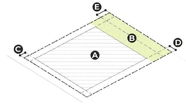 | A | Building Lot Coverage |
| B | Permeable Area of Lot | |
| C | Front Yard | |
| D | Side Yard | |
| E | Rear Yard | |
| Illustrated Building Envelope Standards | ||
|---|---|---|
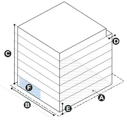 | A | Building Floor Plate |
| B | Building Width | |
| C | Building Height | |
| D | Highest Story Rear Stepback | |
| E | Ground Floor Ceiling Height | |
| F | Ground Floor Active Use Requirement | |
(Text Amd. No. 470, § 1, 4-23-2024; Text Amd. No. 478, § 4, 1-22-2025; Text Amd. No. 482, § 2, 7-3-2025; Text Amd. No. 494, § 1, 1-12-2026)
TABLE A: - ADDITIONAL USE AND PERFORMANCE STANDARDS
Uses and use categories have the meanings set forth in Article 8 Table A. Defined dimensional standards have the meanings set forth in Article 2.
Footnotes to Table A (Additional Use and Performance Standards)
1.
Active Uses are not required when the principal use(s) is a Civic Use, Open Space Use or a Shelter Facility, as defined in Article 8 Table A; or when a Proposed Project is an affordable housing development project in which at least 60% of units income restricted at 100% or below of AMI and reviewed under Article 80 Small or Large Project Review.
2.
For any project that is subject to or has elected to comply with Large Project Review or Small Project Review under the provisions of Article 80, the required Ground Floor Active Use width and depth may be located along any Building Facade through such review process.
(Text Amd. No. 470, § 1, 4-23-2024; Text Amd. No. 478, § 4, 1-22-2025; Text Amd. No. 494, § 1, 1-12-2026)
TABLE B: - DIMENSIONAL REGULATIONS
Footnotes to Table B
1.
If a dwelling unit is located on the ground floor abutting a Front Yard, as defined in Article 2 and Section 18-4, the Front Yard must have a minimum depth of 4 feet.
2.
In the case of attached buildings, yards are to be measured from the exterior building facade as if it was one structure.
3.
Unless the district is established on an official zoning map as "S3-6), in which case the maximum Building Height shall be 75 feet and 6 stories.
(Text Amd. No. 470, § 1, 4-23-2024; Text Amd. No. 478, § 4, 1-22-2025; Text Amd. No. 494, § 1, 1-12-2026)