
Brentwood City Zoning Code
ARTICLE VII
VEHICLE ACCESS CONTROL
Sec. 78-481.- Purpose and intent.
The purpose and intent of this article is as follows:
(1)
To promote the overall safety of motorists and pedestrians.
(2)
To reduce interference with through traffic by other vehicles or pedestrians entering, leaving and crossing the public roads.
(3)
To ensure safe access to and from public roads by emergency vehicles.
(4)
To promote the general welfare by preserving and upgrading the traffic carrying capacity of public roads.
(Ord. No. 91-63, § 1(11-2401), 1-27-92)
Sec. 78-482. - Definitions.
The following words, terms and phrases, when used in this article, shall have the meanings ascribed to them in this section, except where the context clearly indicates a different meaning:
Acceleration lane means a speed-change lane, including tapered areas, for the purpose of enabling a vehicle entering a roadway to increase its speed to a rate of which it can more safely merge with through traffic.
Access means any private driveway or other point of vehicle access such as a street, road or highway that intersects or connects to the general street system.
Access plan means a plan that designates access location(s) to a public road through a detailed engineering design and in conformance with the zoning ordinance.
Applicant means the owner of property or authorized representative of owner applying for an access permit.
Approach taper means the longitudinal distance from the point where the traffic approaching a left turn storage lane must shift laterally to the point where the bay taper begins.
Bay taper means the longitudinal distance from the point where the transition into a left or right turn storage lane begins to the point where the full width of the left turn or right turn storage lane begins.
Commercial access means a driveway serving commercial uses defined in the zoning ordinance including but not limited to zoning districts C-1, C-2 and C-3.
Curb radius means the circular arc that connects the intersection of two curbed streets or the intersection of a curbed street and a curbed driveway.
Deceleration lane means a speed change lane, including tapered areas, for the purpose of enabling a vehicle to make a safer right turn movement from a public roadway by allowing the vehicle to slow down in a dedicated lane separate from the primary through traffic lanes of the roadway.
Departure taper means the longitudinal distance from the point where through traffic beyond an intersection begins to shift laterally to the point where the through lane is adjacent and parallel to the centerline.
Driveway means an access that is not a public street, road or highway.
Left turn storage lane means an additional dedicated traffic lane located on the inside of the primary through traffic lanes used to store vehicles with left turning movements across the opposite traffic lanes in a manner so as to minimize interference with traffic using the through travel lane(s).
Median means a portion of a highway street or driveway separating the opposing traffic flow and designed to prevent crossover movements by vehicles.
Mph means the rate of speed measured in miles traveled per hour.
Private road easement means a recorded grant of a property right by one or more property owner(s) to other property owners to permit vehicular access to and from a public road by virtue of a privately maintained road, including but not limited to frontage or rear access roads.
Radius return means the points where the radius connecting two intersecting streets becomes tangent to the streets.
Right-of-way means a strip of land acquired by reservation, dedication or condemnation and intended to be occupied by a public road and other public utilities.
Service institution access means a driveway serving service institutional uses defined in the zoning ordinance including but not limited to zoning districts SI-1, 2, 3, 4 and 5.
Shared access easement. See definition for "private road easement" in this section.
State highway means an officially designated highway or route of the state and therefore subject to the rules and regulations of the state department of transportation.
Taper means a gradual narrowing or widening in roadway width so as to add or drop a traffic lane.
(Ord. No. 91-63, § 1(11-2402), 1-27-92)
Cross reference— Definitions and rules of construction generally, § 1-2.
Sec. 78-483. - Designation of public roads.
(a)
Arterial roads. For the purposes of this section, the following roads within the corporate boundaries of the city shall be designated as arterial roads:
(1)
Carothers Parkway North from Moores Lane to the southern boundary of the city.
(2)
Church Street East from Franklin Road to the eastern boundary of the city limits.
(3)
Concord Road (S.R. 253) from Franklin Road to the eastern boundary of the city limits.
(4)
Crockett Road from Wilson Pike to Concord Road.
(5)
Edmondson Pike from the northern boundary of the city limits to Concord Road.
(6)
Franklin Road (S.R. 6) from the northern boundary of the city (south of Old Hickory Boulevard) to Moores Lane.
(7)
Granny White Pike from the northern boundary of the city (south of Old Hickory Boulevard) to Murray Lane.
(8)
Green Hill Boulevard from Crockett Road to the proposed terminus at Old Smyrna Road.
(9)
Hillsboro Road (S.R. 106) within the city limits.
(10)
Holly Tree Gap Road within the city limits.
(11)
Mallory Lane from Old Mallory Station Road (only applies to properties abutting Mallory Lane inside the corporate limits) to Moores Lane (S.R. 441).
(12)
Maryland Way from Franklin Road to Granny White Pike.
(13)
Moores Lane (S.R. 441) from Franklin Road to Wilson Pike.
(14)
Murray Lane from Franklin Road to the western boundary of the city.
(15)
Old Smyrna Road from Wilson Pike to the eastern boundary of the city limits (west of Edmondson Pike).
(16)
Ragsdale Road from Sunset Road to Split Log Road.
(17)
Raintree Parkway from Crockett Road to Wilson Pike.
(18)
Split Log Road within the city limits.
(19)
Sunset Road from Concord Road to the eastern boundary of the city.
(20)
Waller Road from Concord Road to the southern boundary of the city.
(21)
Wilson Pike (S.R. 252) from Church Street East to the southern boundary of the city (south of Split Log Road).
(b)
Collector roads. For the purposes of this section, the following roads within the corporate boundaries of the city shall be designated as collector roads:
(1)
Arrowhead Drive.
(2)
Belle Rive Drive.
(3)
Bluff Road.
(4)
Brentwood Boulevard.
(5)
Cadillac Drive.
(6)
Carriage Hills Drive.
(7)
Charity Drive.
(8)
Concord Pass.
(9)
Eastpark Drive.
(10)
General George Patton Drive.
(11)
Gordon Petty Road.
(12)
Johnson Chapel Road West.
(13)
Jones Parkway.
(14)
Knox Valley Drive.
(15)
Lipscomb Drive.
(16)
Mallory Lane (north of Moores Lane).
(17)
Manley Lane.
(18)
McGavock Road.
(19)
Paddock Village Court.
(20)
Pinkerton Road.
(21)
Powell Place South.
(22)
Service Merchandise Boulevard.
(23)
Service Merchandise Drive.
(24)
Stanfield Road.
(25)
Steeplechase Drive.
(26)
Sunset Road (north of Concord Road)
(27)
Virginia Way.
(28)
Walnut Hills Drive.
(29)
Ward Circle.
(30)
Westpark Drive.
(31)
Westwood Place (south of Maryland Way).
(32)
Wilson Pike Circle.
(33)
Winners Circle South.
(c)
Local roads. All other roads formally accepted for perpetual maintenance by the city and not designated as an arterial or collector street shall be considered local roads.
(Ord. No. 91-63, § 1(11-2403), 1-27-92; Ord. No. 95-04, § 1(11-2403), 2-23-95; Ord. No. 96-39, § 1, 10-28-96; Ord. No. 97-25, § 1, 11-24-97; Ord. No. 2001-23, § 1—3, 12-17-2001)
Sec. 78-484. - General conditions/requirements.
(a)
Submission of plan for approval. The location and design of driveways and/or accesses providing vehicular access from arterial, collector and local roads to any existing lot or lots proposed for creation by the subdivision of property in all zoning districts shall be specified in an access plan submitted by the applicant to the planning commission for review and approval provided, however, that all residential accesses to collector and local roads shall be subject to approval by the city manager or his designee. No curbs or rights-of-way shall be cut, paved or otherwise altered until a permit approving the access plan has been secured from the planning and codes department and any other governmental agency owning or controlling the road right-of-way.
(b)
Appeals from decisions of city manager or designee. Whenever the city manager or his designee rejects or refuses to approve the location and design of a residential access on a collector or local road, or when it is claimed that an equally good or more desirable access plan can be employed for the specific location, or when it is claimed that the true intent and meaning of this article or any of the regulations thereunder have been misconstrued or wrongly interpreted, the owner of such property or his duly authorized agent may appeal the decision of the city manager or his designee to the planning commission. Notice of appeal shall be in writing and filed within 60 days after the decision is rendered by the city manager or his designee. A fee of $30.00 shall accompany such notice of appeal. Appeals under this section shall be on forms provided by the city manager or his designee.
(c)
Traffic impact study. The planning commission may require at no cost to the city a traffic impact study by a qualified registered professional engineer using the standard format specified by the Institute of Transportation Engineers (ITE) publication "Traffic Access and Impact Studies for Site Development" dated September 1989 or the latest subsequent edition to assess the traffic impacts of a proposed access to the adjoining and nearby public roadways and intersections when the expected number of trips generated by the proposed building or land use exceeds an estimated 1,000 vehicle trips per day or 100 peak hour vehicle trips per day. In addition, the planning commission may require a traffic impact study for sites that generate less than 1,000 vehicle trips per day or 100 peak hour vehicle trips per day if such sites are located at or near high volume intersections or other locations where such land use may constitute a threat or danger to the safe and efficient flow of traffic. The planning commission may waive this provision if a traffic study has been completed within the last three years from which needed traffic data can be extrapolated. Unless otherwise specified by the planning commission, the study shall address trip generation and directional distribution, traffic assignment to roadways and access locations, 24-hour and a.m. and p.m. peak hour traffic forecasting (nonsite and onsite), capacity analysis and level of service for adjoining roadways and nearby intersections before and after the proposed full development and recommendations for roadway improvements and traffic control installation and/or modifications to existing signals. All traffic data used in the study shall be consistent with land use and density data as referenced in Trip Generation, fifth edition, 1991, published by the Institute of Transportation Engineers, or the latest subsequent edition; current city and state traffic counts for surrounding public roadways; and the marketing study for the proposed building or land use.
(d)
Approval for specific land use. Any access existing as of February 1, 1992, shall be approved for the existing land use only. Any access approved under this chapter shall be approved for the land use(s) specified in the access plan. Any change in such land use(s) that would increase traffic shall require a new approval of access by the city. When a site existing at the time of this article is redeveloped in a manner so as to generate an increase in traffic, the existing driveways shall be brought into conformity with the provisions of this article to the greatest extent feasible or possible.
(e)
Expiration of approval. Any access plan for commercial or service institution land uses including related offsite public road improvements approved hereunder shall be constructed within 18 months of approval or such approval shall terminate. If unusual or extraordinary circumstances exist which prevent the applicant from completing the proposed project and related access within the 18-month deadline, a one-time six-month extension may be requested in writing by the applicant and may be approved by the city manager or his designee. Requests for extension beyond that time, and/or modification to the existing approved access plan, shall be approved by the planning commission.
(f)
Bond requirements. Prior to the issuance of a written approval of the access plan for commercial or service institution uses, the applicant may be required to provide a cash deposit, bond, certified check or other form of security acceptable to the city and pursuant to city procedures and requirements sufficient to complete access, roadway and traffic control improvements on the public right-of-way as specified in the approved plan. The improvements shall be constructed in accordance with specifications established in the subdivision regulations. The city manager or his designee shall set the amount and time of the bond, based on the estimated cost of the implementation of the approved plan. Within 30 days of the notice by the applicant of completion of all provisions of the approved plan, the city shall determine acceptance or identify items necessary to satisfactorily complete the project. The developer/contractor shall warrant the performance of the improvements on the right-of-way for a period of one year from acceptance of the project. A maintenance bond in the form of a cash deposit, bond, certified check or other form of security acceptable to the city and pursuant to city procedures and requirements may be required to guarantee the project for an additional period of one year following the warranty period. Upon final acceptance, cash deposits, or unexpended or unobligated funds thereof shall be refunded, or other legal arrangements terminated.
(g)
Prohibition of unsafe access. Notwithstanding any other provisions of this Code to the contrary, any access may be denied based on commonly accepted and applied traffic engineering principles which demonstrate a potential threat or danger to the public and/or affect the safe and efficient flow of traffic.
(Ord. No. 91-63, § 1(11-2404), 1-27-92)
Sec. 78-485. - Access plan.
An access plan is required for each building or use of land. Such an access plan may be submitted by the applicant as a part of the site plan, or in the case of issuance of a residential building permit, such information may be included on the plot plan at the time of application of a building permit. A separate access permit shall be required for each dwelling. Such plan shall specify the intended use(s) of the property.
(1)
For commercial and service institution uses. The access plan, minimally drawn to a scale of not less than one inch equals 50 feet, shall be submitted to the planning and codes department. The plan shall denote the location of the driveway(s) on the lot and length of all property lines abutting the public road; distances from adjacent intersections (nearest point of tangency of the curve of the intersecting road pavement to the nearest point of radius return of the driveway); access sight distance relative to any vertical or horizontal curves and the normal operating speed/grade/lane configuration of the public road; area proposed for roadway construction on the right-of-way including the width and length of driveways and deceleration/acceleration lanes, radius of curves, typical pavement section, type of concrete curbs and any relocation of sidewalks; location of existing overhead and underground utilities, hydrants and drainage structures and any proposed relocations; right-of-way and road improvements proposed for dedication to the city and a traffic control plan which shall include signing to be maintained by the contractor during the construction of the improvements.
(2)
For residential uses. The access plan for residential use shall include the following information: proposed location of driveway on the lot from the side property line, distance of driveway from the radius return of any public street abutting the lot, the width and radius of driveway curve, and location of existing overhead and on-grade utilities, drainage structures and fire hydrants.
(Ord. No. 91-63, § 1(11-2405), 1-27-92)
Sec. 78-486. - Design criteria.
The following minimum standards shall apply in the design of driveways to public roads:
(1)
Number of driveways permitted. Access to an arterial, collector or local roads shall be provided to any lot either by means of a shared access easement(s), private road easement(s) including frontage or rear access roads or direct accessway(s).
a.
Arterial roads (see figure 1).
1.
Where the provision of shared access easements or private road easements to serve multiple lots with different ownership is unavailable or deemed unnecessary by the city, there shall be no more than one driveway to any arterial roadway from any single lot with less than 600 feet of frontage on that roadway.
2.
Lots having between 600 and 1200 feet of frontage to any arterial roadway may have a second driveway provided that, in the opinion of the planning commission, additional driveways are justified based on trip generation or topography and/or the impact to traffic safety and movement on the public roadway is minimal and/or benefitted by the second driveway.
3.
Lots having in excess of 1200 feet of frontage to any arterial road may have additional driveways provided that in the opinion of the planning commission, additional driveways are justified based on trip generation or topography and/or the impact on traffic safety and movement in the public roadway is minimal and/or benefitted by the additional driveways.
4.
All driveways serving the same lot shall be a minimum of 250 feet apart, measured from the nearest point of the radius return of the two driveways.
5.
Access to a corner lot fronting on two arterial roads shall be required to have access from the road with the lower average daily traffic volume. Access to a corner lot fronting on an arterial road and bordered by a collector or local road shall be required to have access only from the collector or local road. A property may be allowed to have an additional driveway from the abutting arterial road provided that, in the opinion of the planning commission, the driveway is justified based on trip generation or topography and/or the impact on traffic safety and movement on the public roadway is minimal and/or benefitted by the driveway. Approval of such driveway may be conditioned upon other geometric improvements by the applicant that mitigate traffic impact.
b.
Collector roads (see figure 2).
1.
For commercial and service institution uses, there shall be no more than one driveway to a collector road from any lot with 300 feet or less of frontage on that roadway.
2.
For commercial and service institution uses, lots having more than 300 feet of frontage to any collector road may have more than one driveway provided that, in the opinion of the planning commission, the additional driveway is justified based on trip generation or topography and/or the impact on traffic safety and movement on the public roadway is minimal and/or benefitted by the driveway. The driveways shall be a minimum of 150 feet apart measured from the nearest point of the radius return of the two driveways.
3.
Access to a corner lot fronting on two collector roads shall be required to have access from the road with the lower average daily traffic volume. Access to a corner lot fronting on a collector road and bordered by a local road shall be required to have access only from the local road. A property may be allowed to have an additional driveway from the abutting collector road provided that, in the opinion of the planning commission for commercial and service institution uses or the city manager or his designee for residential uses, the driveway is justified based on trip generation or topography and/or the impact on traffic safety and movement on the public roadway is minimal and/or benefitted by the driveway.
4.
For residential uses, lots having more than 100 feet of frontage to any collector road may have two driveways, provided that, in the opinion of the city manager or his designee, the additional driveway has minimal impact on traffic safety and movement on the public roadway. The driveways shall be a minimum of 50 feet apart measured from the nearest point of the radius return of the two driveways.
c.
Local roads (see figure 3).
1.
There shall be no more than one driveway to a local road from any lot with 100 feet or less of frontage on that roadway.
2.
Lots having more than 100 feet of frontage to any local road may have a maximum of two driveways, provided that, in the opinion of the planning commission for commercial and service institution uses or the city manager or his designee for residential uses, the additional driveway is justified based on trip generation, topography and/or minimal impact on traffic.
3.
Lots having more than 300 feet of road frontage may have more than two driveways, provided that, in the opinion of the planning commission, each additional driveway is justified based on trip generation, topography and/or minimal impact on traffic.
(2)
Minimum distance from intersection (see figures 4, 5 and 6). No driveway to an arterial road shall be established within 150 feet of an intersecting public road. On collector roads, no driveway shall be established within 75 feet of an intersecting public road. On local roads, no driveway shall be established within 50 feet of an intersecting public road. Measurements shall be made along the edge of the pavement from the nearest point of tangency of the curve of the intersecting road pavement to the nearest point of radius return of the driveway.
(3)
Minimum distance between driveways on separate lots (see figures 4, 5 and 6). For commercial and service institution uses, the following standards shall apply. No two driveways serving separate lots on an arterial road shall be less than 250 feet apart. On collector roads, no two driveways serving separate lots shall be less than 150 feet apart. On local roads, no two driveways serving separate lots shall be less than 20 feet apart. The distance between driveways shall be measured from the nearest point of the radius return of the two driveways. The minimum separation distance may be reduced provided that, in the opinion of the planning commission and using commonly accepted and applied traffic engineering principles, the following conditions exist:
a.
Where the use of shared access or private road easements is not feasible or possible.
b.
Where exceptional topographic constraints or unusual site conditions at the driveway location (such as in-place utility or drainage features) which would make strict application of the standard exceptionally and/or practitionally difficult or unduly harsh.
c.
Where application of this article would conflict with other sections of this article.
d.
Where such reduction would not constitute a threat or danger to the safe and efficient flow of traffic.
(4)
Minimum distance from property line. No residential, commercial or service institution driveway, other than a shared driveway as authorized under subsection (8) of this section, shall extend beyond a straight line projection of any side or rear lot line; provided, however, such provisions may be waived subject to the written approval of the city manager or his designee and the adjoining property owner.
(5)
Deceleration lanes (see figure 7). Approval of a commercial or service institution use driveway to an arterial road may be conditioned upon construction of a deceleration lane. Such lanes may be required in conjunction with each driveway to collector roads where a proposed building or land use will increase traffic volumes on the existing road to a total in excess of 1,000 vehicle trips daily or 100 peak hour vehicle trips per day. The deceleration lane, a minimum of 12 feet in width measured from the face of the curb or edge of the shoulder line to the center of the lane line, shall be constructed to city standards with the length measured from the centerline of the driveway according to the following criteria:
Minimum
Deceleration Lane
The minimum dimensions of the deceleration lane may be reduced, provided that, in the opinion of the planning commission, using commonly accepted and applied traffic engineering principles, the following conditions exist:
a.
Where exceptional topographic constraints or unusual site conditions at the driveway location (such as in-place utility or drainage features) which would make strict application of the standard exceptionally and/or practically difficult or unduly harsh.
b.
Where such reduction would not constitute a threat or danger to the safe and efficient flow of traffic.
(6)
Acceleration lane. In instances of unusual topography or traffic safety considerations, the planning commission may require construction of an acceleration lane for commercial and service institution uses. The length of taper and total length shall be determined by the planning commission using commonly accepted and applied traffic engineering principles.
(7)
Left turn storage lane (see figure 8). Approval of a commercial and service institution use driveway to an arterial road and/or collector road which does not have an exclusive left turn storage lane may be conditioned upon construction of a left turn storage lane with appropriate median and/or pavement markings. The requirement and design of each storage lane including paved approach, bay and departure tapers shall be determined from the recommendations of the traffic study and approved by the planning commission using commonly accepted and applied traffic engineering principles.
(8)
Shared access easements (see figures 9 and 10).
a.
In the resubdivision of property, the planning commission may require the formal establishment of private driveway easements or may impose other conditions that require multiple lots or parcels to have shared vehicle access locations to arterial and collector roads such as through the use of rear access roads or private frontage roads where, in accordance with commonly accepted and applied traffic engineering principles, such is necessary to provide for the safe and efficient flow of traffic upon such streets.
b.
Where shared access easements are required, the approved subdivision plat shall state that the transfer of lots shall be subject to the provision of such easements which shall provide for a guaranteed unrestricted right of access to all other owners providing such easements. Such plat shall further state that all owners of lots subject to shared access easements shall be required to execute an agreement specifying responsibility for construction and perpetual maintenance of such easements in accordance with the approved access plan. The agreement shall specify that the parties thereto shall hold the city harmless from any and all liabilities resulting from unsafe conditions on the shared access easement. Copies of such agreements from the current owners of all lots through which shared access easements are to run shall be filed with the city manager or his designee. Construction on the shared access easement shall not be commenced until all such agreements are thus filed. Copies of all subsequent amendments to such agreements shall also be filed with the city manager or his designee.
c.
If the owners fail to maintain any shared access easement in a safe and stable driving condition for the motorists, the city manager or his designee, after appropriate notice, may remedy the condition and bill the owners for all reasonable costs. Should the owners fail to pay the city the amount of such charge within 30 days from receipt of a certified invoice, the amount of the invoice shall be certified to the city attorney who shall process a lien on the properties upon which the expenditure was made.
(9)
Driveways; minimum length/restrictions (see figure 11). All driveways for commercial and service institution uses must extend a minimum of 20 feet into the property from the lot line abutting the public road before the edge of the driveway may be intersected by a parking lot space, aisle or drive. The minimum length of this restricted driveway may be extended where, in the opinion of the planning commission, anticipated traffic volumes and commonly accepted and applied traffic engineering principles justify the need for longer, controlled storage lanes.
(10)
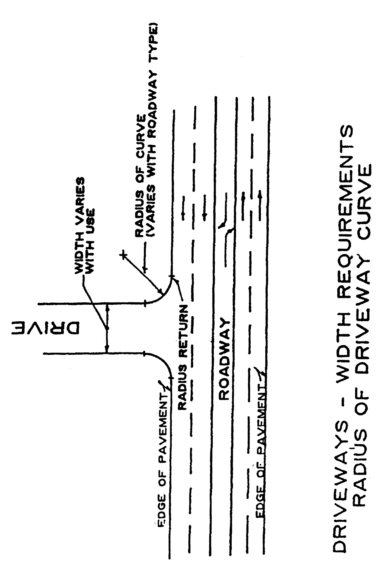
Driveways; width requirements (see figure 12). The width of driveways, measured at the nearest points of the radius return, shall meet the following requirement:
Driveways to commercial and service institution uses may exceed the maximum width stated herein, provided that, in the opinion of the planning commission, the need to provide safer turning movements for truck traffic to or from such property, and/or the number of trips generated to or from such property justifies the need for additional driveway lanes.
(11)
Boulevard-type driveways. Boulevard-type driveways in which ingress and egress lanes are separated by a minimum six-inch raised concrete curb median may exceed the maximum two-way width provided the individual ingress or egress lane does not exceed the limits of one-way access width and the median does not exceed 14 feet in width. Additionally, the location of any monuments, walks, vegetation or signage must not be located in the median in such a way as to interfere with driver vision and safety entering and exiting onto a street.
(12)
Radius of driveway curve (see figure 12). The radius of curve connecting the edge of the deceleration or acceleration lane or through-traffic lane and edge of driveway shall meet the following requirements:
The radius of the driveway curve to commercial or service institution uses may exceed the maximum length stated herein, provided that, in the opinion of the planning commission, the need to provide safer turning movements for truck traffic to or from such property, and/or the number of trips generated to or from such property justifies the need for additional radius length.
(13)
Pavement markings, signage. Driveways with more than one ingress or egress lane shall have the pavement surfaced marked with centerlines, lane lines, channelizing lines, stop lines and symbol arrows plus traffic control signage in accordance with the requirements of the Manual on Uniform Traffic Control Devices, Tennessee Department of Transportation, Traffic Engineering Division, January 1988, or subsequent revisions. Such pavement markings and signage shall be continually maintained by the property owner in good condition and visible to drivers at all times.
(14)
Residential driveway standards. In addition to the design criteria in the previous subsections, any new residential driveway that is constructed shall meet or exceed the following minimum standards where applicable:
a.
When the length of the driveway from the street to the front of the dwelling exceeds 500 feet, the minimum required width for the driveway shall be increased to 12 feet and provisions shall be made for turnouts on the driveway every 500 feet in length to facilitate access by fire engines and two-way vehicle circulation.
b.
Driveways shall be located a minimum of five feet away from any adjoining side lot line.
c.
The maximum grade of any portion of a driveway shall not exceed 20 percent for paved surfaces and ten percent for unpaved surfaces, with a maximum cross slope of five percent.
d.
The minimum inside turning radius for any curve section of a driveway shall be 20 feet, and the minimum overhead clearance for vehicles shall be 14 feet.
e.
Any incorporated bridges or above grade spans for a driveway shall be designed to accept vehicles weighing up to 50,000 pounds (gross vehicle weight).
f.
A paved turnaround pad shall extend at least 30 feet from the rear of any garage or carport enclosure. This distance may be reduced to 24 feet if a paved extension of the driveway is provided beyond the last garage entrance to permit adequate turning movement in exiting the garage on a paved surface. The length and radius of the driveway turnaround section shall be subject to approval by the engineering department.
g.
In addition to any necessary crossing of a public utility and/or drainage easement to access the abutting road, a driveway may be located within other recorded public utility and/or drainage easement areas subject to determination and approval by the engineering department that the easement is not needed for public purposes.
(Ord. No. 2002-23, §§ 2, 3, 12-9-2002; Ord. >No. 2007-12, §§ 11, 12, 4-23-2007)
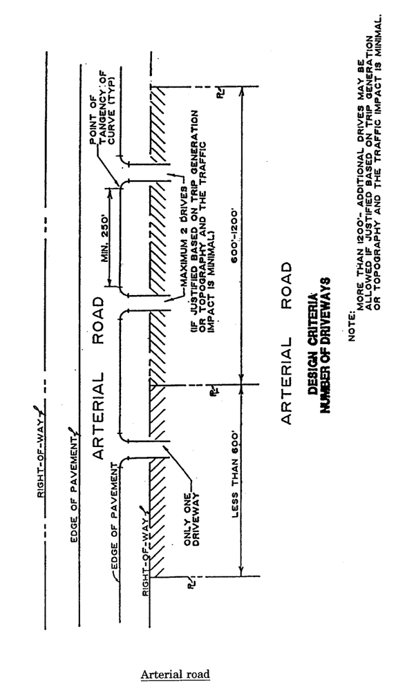
Arterial road
Driveways-Width Req.
(Ord. No. 91-63, § 1(11-2406), 1-27-92; Ord. No. 92-45, § 1, 9-14-92; Ord. No. 99-26, §§ 1, 2, 1-24-2000; Ord. No. 2000-29, § 1, 11-27-2000)