
Brownsville City Zoning Code
4.2
Zoning Procedures.
4.2.1 - Noticing, Hearings, and Action.
A.
Noticing requirements.
1.
Generally.
a.
Notice is required to be provided as shown in 2.1.7.
b.
No hearing may be held on an Application unless sufficient notice is provided.
c.
Applicability of Notice Requirements in HP Overlay.
d.
A request to expand or contract the boundary of the HP overlay, or to rezone a property within the HP overlay, is subject to additional notice requirements associated with hearings before the Historic Preservation and Design Review Board (HPDRB) under 4.2.3C.
e.
Published Notice and Written Notice of Public Hearing for Zoning Changes Involving Real Property.
2.
Published Notice. Notice of the public hearing to occur before the City Commission shall be accomplished by publishing the purpose, date, time, and place of the public hearing in the official newspaper of the City before the fifteenth (15th) calendar day prior to the date of the public hearing.
3.
Written Notice for Protest (also referred to as "Mailed Notice").
a.
Before the fifteenth (15th) calendar day, written notice of the public hearing before the Plan Commission on a proposed change in a zoning classification shall be sent to each owner, as indicated by the most recently approved municipal tax roll, of real property within two hundred (200) feet of the property on which the change in classification is proposed.
b.
Said written notice shall be served by depositing the notice, postage paid, in the regular United States mail.
c.
If written notice as required is not sent before the fifteenth (15th) calendar day prior to the date of the hearing, then the hearing must be delayed until this notice requirement is met.
d.
Such notice shall include:
(i)
Legal description of the property and the street address or approximate location within the City;
(ii)
Present zoning classification of the property and the zoning sought by the applicant. If not a rezoning, then the nature or intent of the Application shall be described;
(iii)
The date, time, and place of hearing;
(iv)
The web site that contains the zoning map and information regarding the rezoning;
(v)
The phone number where questions may be answered; and
(vi)
Other information as may be necessary to provide adequate and timely public notice.
4.
"Published Notice" of Public Hearing for Zoning Changes Involving Regulation Text.
a.
For requests involving proposed changes to the text of the zoning regulations, notice of the City Commission public hearing shall be accomplished by publishing the purpose, date, time, and place of the public hearing in the official newspaper of the City before the fifteenth (15th) calendar day prior to the date of the public hearing.
b.
Changes in the zoning text that do not change zoning district boundaries (i.e., that do not involve specific real property) do not require written notification to individual property owners.
5.
Published Notice and Written Notice of an Appeal of a City Administrative or Interpretative Decision to the Board of Adjustment.
a.
For an Appeal of a City Administrative or Interpretative Decision, the Board of Adjustment shall fix a reasonable time for the hearing of an appeal, give the public notice by written notice in the mail addressed to all owners of real property located within two hundred (200) feet of the property on which the appeal is made, and by publication of notice of such hearing in the City's official newspaper.
b.
Both the mailed and published notice shall be given before the fifteenth (15th) calendar day prior to the date for the hearing.
c.
At the hearing, any party may appear in person or by Attorney or by agent.
6.
Additional Rules and Procedures Established.
a.
The City Commission may, at its option, establish additional rules and procedures for public notification of proposed zoning changes and development proposals (e.g., required plans, plats, etc.), which may include, but not be limited to, the posting of a sign(s) on any property that is proposed for a zoning change or development by the applicant or its agent(s).
b.
The City Commission may, by policy enacted through a resolution, direct notice of a Zoning Map Amendment (Rezoning) beyond two hundred (200) feet. Failing to adhere to such notice does not constitute a procedural violation and does not alter the protest area.
c.
Knowledge of and adherence to such rules and procedures, if so established by the City, shall be the responsibility of the applicant and shall be required as part of a zoning change or development application.
B.
Hearing procedures.
1.
The City will not hold a public hearing required for an application under this section unless the hearing has been property noticed under 4.2.1A above.
2.
During every required public hearing, the board or commission conducting the hearing must allow any parties with interest in interest or citizens to submit information and comments verbally or in writing.
3.
A board or commission authorized to hold a public hearing under this section may adopt its own rules of order governing the conduct of hearings and the presentation of information and comments pursuant to Chapter 551 of the Texas Government Code.
C.
Conditions of approval and decision-making criteria.
1.
In acting upon an application listed under this section, the City Commission or Responsible Official shall, at a minimum, consider and make findings based on any criteria listed under the section related to the application.
2.
Unless otherwise specified, failure to make findings based upon each individual condition or criteria shall not invalidate a decision on any application if the decision or action does not:
a.
Authorize a use or action prohibited under this UDC; and
b.
Does not deny the applicant any procedural rights under this section.
3.
For decisions that are discretionary, such as a zoning text or map amendment or a Specific Use Permit, the City Commission may impose additional conditions beyond those listed in this section that the City Commission believes will further the public health, safety, welfare, and interest.
D.
Required time for action.
1.
This section governs the processing and approval of zoning-related applications as listed in this section. For processing and approval of subdivision-related applications, see 3.2 Subdivision Plats.
2.
Action by the City on an application submitted under this section will take place in accordance with the deadlines published in this section or a City-adopted calendar or schedule.
3.
In the event of a conflict between a deadline or time limitation listed in this UDC and a City-adopted calendar or schedule, this UDC shall govern.
4.
By adopting this section, the City Commission intends that the City administer and enforce all Application deadlines consistent with State Law, including TLGC Chapter 245.
5.
If an applicable deadline does not appear in this UDC or a City-adopted calendar or schedule, the City will enforce the deadline consistently with TLGC Chapter 245.
6.
Modification of an Application. The applicant may modify any complete application following its Official Vesting Date, and prior to the expiration of the period, if any, during which the City is required to act on the application.
7.
Modifications Requested by the City. If the modification is for revisions requested by the City, and the modification is received at least ten (10) business days prior to the time scheduled for decision on the application, then the Responsible Official or commission will decide the application within the period for decision prescribed by this UDC (see 2.3. Application Submittal Procedures).
8.
Modifications Not Requested by the City.
a.
Unless otherwise specified, in all other instances (e.g., when the applicant chooses to submit a revised application because of a change in development decisions), the modified application will extend the time for deciding the application for a period equal to the maximum time allowed to decide the original application, if any.
b.
The extension of the time for deciding the application shall commence on the date the applicant submits the modified application.
4.2.2 - Zoning Text and Map Amendments.
A.
Process requirements.
1.
Zoning Amendments Require City Commission Approval. The City Commission may, from time to time, amend, supplement, or change, by ordinance, the boundaries of the districts shown on the Official Zoning Map, or the regulations established in this Article, consistent with State Law.
2.
Planning and Zoning Commission Recommendation Required for all Amendments. The City Commission will not take action on any proposed amendment until the Planning and Zoning Commission holds a public hearing and issues a recommendation on the amendment.
3.
Petitions Submitted to the City Commission.
a.
Any person or corporation having a proprietary interest in any property may petition the City Commission for a change or amendment to the zoning provisions of this Ordinance; or
b.
The Plan Commission may, on its own motion or on request from the City Commission, study and propose zoning changes and amendments for the City Commission's consideration.
B.
Two types of zoning amendments.
1.
Zoning Map Amendment (Rezoning). A Zoning Map Amendment (Rezoning) is a change or modification to the boundaries of any zoning district within the City's Zoning Map.
2.
Zoning Text Amendment. A Zoning Text Amendment is the change of the text within this Ordinance and does not include change or modification to the boundaries of any zoning districts.
C.
Rezoning historic preservation zoning map. See 4.2.3. Historic Preservation Zoning Map Amendments.
D.
Planning and zoning commission recommendation requires public hearing.
1.
The Planning and Zoning Commission shall hold a public hearing on any application for any amendment or change prior to making its recommendation and report to the City Commission.
2.
In the case of a Zoning Map Amendment (Rezoning):
a.
Written notice of all public hearings before the Planning and Zoning Commission on a proposed Zoning Map Amendment (Rezoning) shall be sent to all owners of real property within the zoning amendment area and within two hundred (200) feet of the zoning amendment area or property on which the change is requested.
b.
Such notice shall be given not less than fifteen (15) calendar days before the date set for hearing by posting such notice, properly addressed and postage paid, to each taxpayer as the ownership appears on the last approved City tax roll or County tax roll for the area affected.
c.
The requested Zoning Map Amendment (Rezoning) must be in accordance with the adopted Comprehensive Plan.
d.
For selected zoning districts, each rezoning application shall be accompanied by a Site Plan (see 4.2.4 Site Plan).
Figure 4.2.1. Overview of the Zoning Text and Map Amendment Process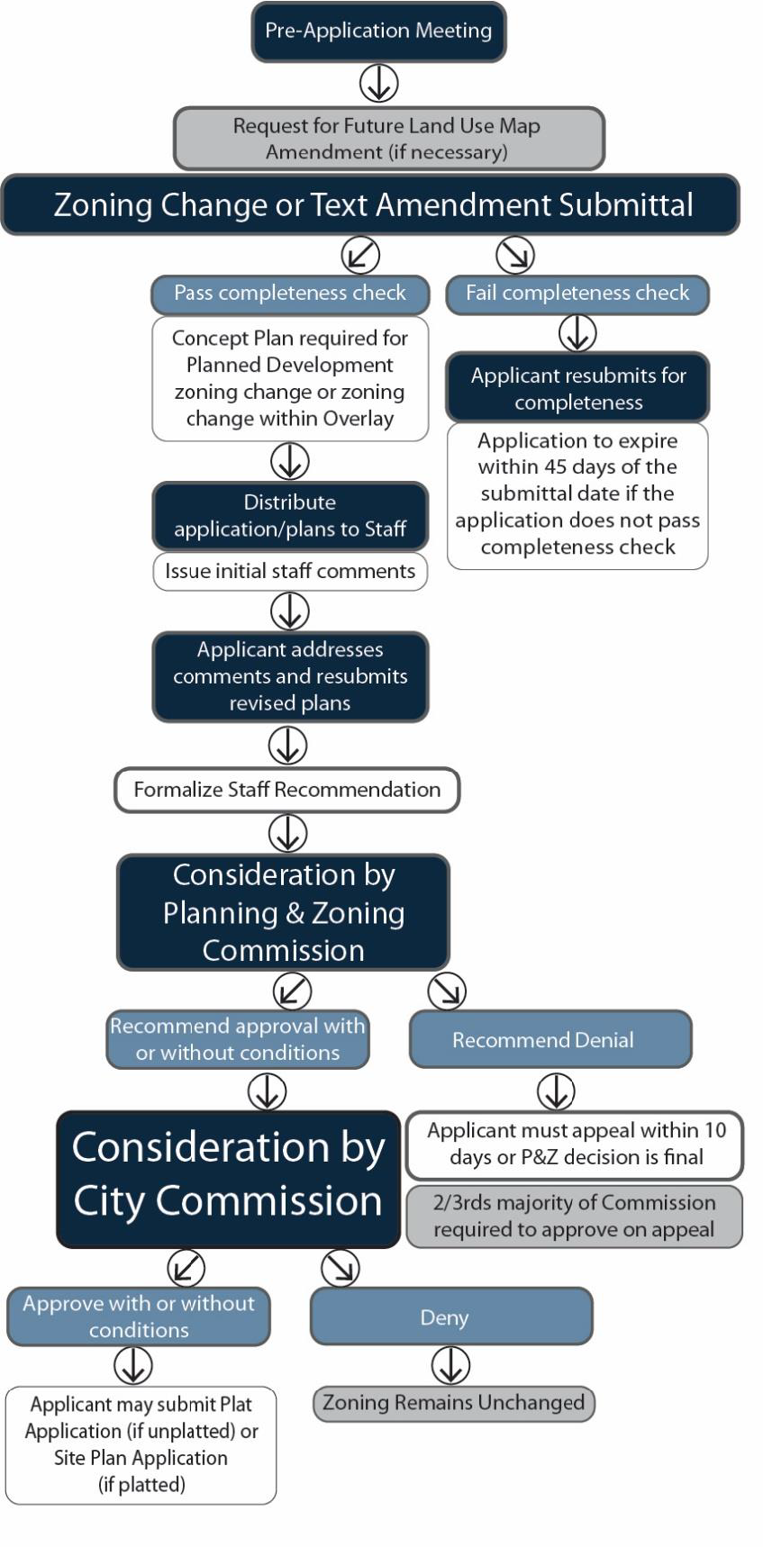
E.
City commission decision and public hearing required.
1.
A public hearing shall be held by the City Commission before adopting any proposed amendment.
2.
Notice of the time and place of the hearing must be published in a newspaper of general circulation in the City before the fifteenth (15th) calendar day before the date of the hearing.
F.
Three-fourths city commission vote required for protested amendments.
1.
If qualified property owners file a protest with the City Secretary against a proposed Zoning Map Amendment consistent with 2 below, the Zoning Map Amendment will not become effective except by a three-quarter (3/4) vote of the City Commission.
2.
Two Types of Eligible Protesters:
a.
Protesters Within the Zoning Amendment Area. The property owners, duly signed and acknowledged, of twenty (20) percent or more of the lots or land area included within a proposed amendment boundary.
b.
Protesters Outside of the Zoning Amendment Area. The property owners, duly signed and acknowledged, of twenty (20) percent or more of the lots or land area within a two hundred (200) foot radius of the exterior boundary of the area included in a proposed amendment.
G.
Calculation example. Assume that the two hundred (200) foot buffer surrounding the area subject to rezoning includes ten (10) acres. If an individual owns two (2) acres within the buffer, his/her protest would constitute twenty (20) percent (see Figure 4.2-2. Calculation of Notification Area).
Figure. 4.2-2. Calculation of Notification Area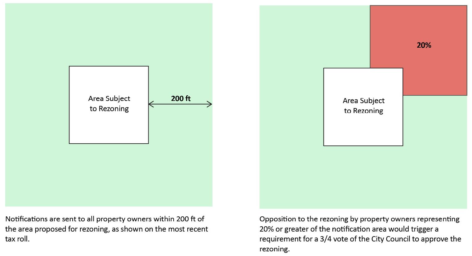
H.
Three-fourths city commission vote required after planning and zoning commission denial.
1.
If the Planning and Zoning Commission votes to recommend denial of an application for zoning map amendment, the recommendation of denial is considered final unless the applicant appeals within ten (10) days of the Commission's decision.
2.
The applicant is responsible for paying any appeal fees that appear in the City's adopted Fee Schedule at the time the applicant files the appeal with the Planning Director.
3.
The City Commission must vote by a three-quarter (3/4) majority or greater to approve the application on appeal.
I.
Effect of city commission decision.
1.
If the City Commission approves the request, the Planning Director will revise the Official Zoning Map and reference the date of City Commission action and the ordinance number adopting the zoning change.
2.
If the City Commission denies the request, the applicant may not submit the same request for at least one (1) year following the date of the City Commission's decision.
4.2.3 - Historic Preservation Zoning Map Amendments.
A.
Process requirements.
1.
Historic Preservation (HP) Zoning Changes Require City Commission Approval. The City Commission may change, by ordinance, the boundaries of the HP overlay or a base zoning district within the HP overlay as shown on the Official Zoning Map (referred to in this section as HP rezoning).
2.
HPC and PZ Commission Recommendation Required for all HP Rezonings. The City Commission will not take action on any proposed HP rezoning until the Historic Preservation Commission (HPC) and Planning and Zoning Commission each hold a public hearing and issue a recommendation on the HP rezoning.
3.
Initiation of HP Rezoning.
a.
The City Manager or their designee or any person or corporation having a proprietary interest in any property may petition the City Commission for a change to the HP overlay; or
b.
The HPC may, on its own motion or on request from the City Commission, study and propose HP overlay changes for the City Commission's consideration.
B.
Preservation officer and HPC action.
1.
A request for HP rezoning must include a complete application provided by the Historic Preservation Officer (HPO).
C.
Public Notice and Sign Posting for HP Rezoning.
1.
In addition to the notification requirements listed under 4.2.1, prior to the public hearing before the HPC, the HPO shall send written notice according to the following procedure:
(i)
At least seventy-two (72) hours before the public hearing before the HPDRB, the HPO will send written notice of the public hearing to the representative of each Qualified Neighborhood Organization within three hundred (300) feet of the boundary of the proposed HP rezoning and to each property owner within the boundary of the proposed HP rezoning.
(ii)
The HPO shall serve the written notice by depositing the notice, postage paid, in the regular United States mail.
(iii)
The written notice must include:
(1)
Legal description of the property and the street address or approximate location within the City;
(2)
Present zoning classification of the property and the zoning sought by the applicant. If the request is to expand or contract the HP overlay, the notice shall include a description of the area of expansion or contraction;
(3)
The date, time, and place of hearing;
(4)
The web site that contains the zoning map and information regarding the rezoning;
(5)
The phone number where questions may be answered; and
(6)
Other information as may be necessary to provide adequate and timely public notice.
Figure 4.2-3. Overview of HP Zoning Change Process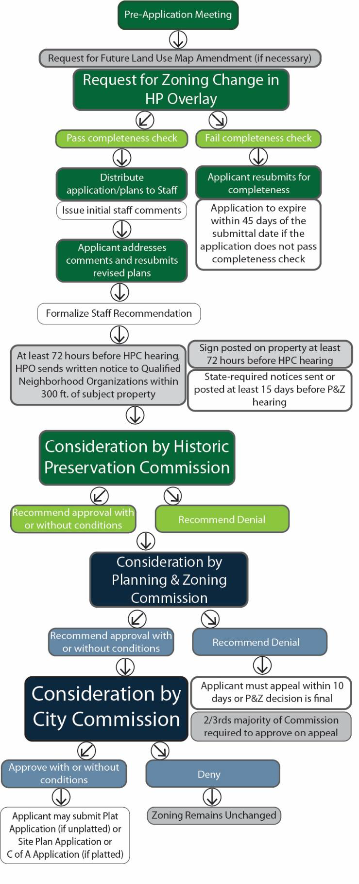
a.
The sign shall state that the property is the subject of an HP rezoning application;
b.
The HPO shall furnish and post the sign on the property proposed to be rezoned;
c.
The applicant must maintain the sign continuously on the property in a place visible from the abutting street until the City Commission makes its decision on the HP zoning map amendment;
d.
If more than one street abuts the property or the property has more than three hundred (300) feet of frontage, the HPO may require more than one sign on the property.
3.
Effect of Posted Sign Maintenance. If the sign becomes lost or damaged due to theft, weather, or other cause beyond the control of the applicant, it will not invalidate a public hearing, the adoption of any proposed HP rezoning, or any other official action concerning such zoning map amendment.
D.
Planning and zoning commission recommendation requires public hearing.
1.
Following review and recommendation by the Historic Preservation Officer and the HPC, the Planning and Zoning Commission shall hold a public hearing on any application for any HP zoning change prior to making its recommendation and report to the City Commission.
2.
The Planning Director will provide notice of the public hearing in accordance with 4.2.1.
E.
City commission decision and public hearing required.
1.
Following review and recommendation by the Planning and Zoning Commission, a public hearing shall be held by the City Commission before adopting any proposed HP rezoning.
2.
The Planning Director will provide notice of the public hearing in accordance with 4.2.1.
F.
Three-fourths city commission vote required for protested amendments. The requirements of 4.2.2F. apply to any qualified protest of a request HP rezoning.
G.
Three-fourths city commission vote required after planning and zoning commission denial.
1.
If the Planning and Zoning Commission votes to recommend denial of an application for zoning map amendment, the recommendation of denial is considered final unless the applicant appeals within ten (10) days of the Commission's decision.
2.
The applicant is responsible for paying any appeal fees that appear in the City's adopted Fee Schedule at the time the applicant files the appeal with the Planning Director.
3.
The City Commission must vote by a three-quarter (3/4) majority or greater to approve the application on appeal.
H.
Effect of city commission decision.
1.
If the City Commission approves the request, the Planning Director will revise the Official Zoning Map and reference the date of City Commission action and the ordinance number adopting the zoning change.
2.
If the City Commission denies the request, the applicant may not submit the same request for at least one (1) year following the date of the City Commission's decision.
4.2.4 - Site Plan.
A.
Purpose.
1.
The purpose of the Site Plan process is to coordinate and expedite review of proposed improvements to property. Through Site Plan review, the City and other jurisdictional agencies can effectively apply the standards of this UDC and other applicable development standards to Multi-Family, Mixed-Use, and Nonresidential development.
2.
This process is intended to promote the efficient use of land, safe vehicular and pedestrian circulation, appropriate provision of landscaping, open space, parking, screening, and Lighting.
B.
Design standards and specifications. All Site Plans must conform with applicable requirements and regulations found in the following documents or articles:
1.
Article 3. Subdivision Regulations;
2.
Article 4. Zoning Regulations;
3.
Fire Code;
4.
Building Code;
5.
Engineering Criteria Manual;
6.
Any design standards and specification approved by the City Commission following adoption of this UDC.
C.
Site plan applicability.
1.
The following applications require Site Plan approval:
a.
A request for approval to construct one (1) or more residential buildings consisting of more than three (3) units per building;
b.
A request for approval to construct residential and nonresidential uses in the same building (Mixed-Use);
c.
A request for approval to construct a nonresidential development;
d.
A request for approval to construct a building within a Planned Development district, unless otherwise exempted in this UDC or in the ordinance adopting the Planned Development district;
e.
A request for a shared nonresidential facility within a residential Subdivision, such as a clubhouse, pool house, or gated entry maintained by a Homeowners' Association;
f.
A request for approval of a Specific Use Permit, unless otherwise exempted in 4.2.7 or this UDC; or
g.
Expansion or reconstruction of a building identified in this subsection 4.2.4C.1 or an existing building that changes from a use not listed in this subsection 4.2.4C.1 to a use identified in this subsection 4.2.4C.1 or a use that requires a Specific Use Permit.
2.
Residential development that is platted and consists of three (3) or fewer units is exempt from the requirement to Site Plan and may apply for a building permit by submitting a Plot Plan (see 4.2.8B.7.c).
Figure 4.2-4. Overview of the Site Plan Process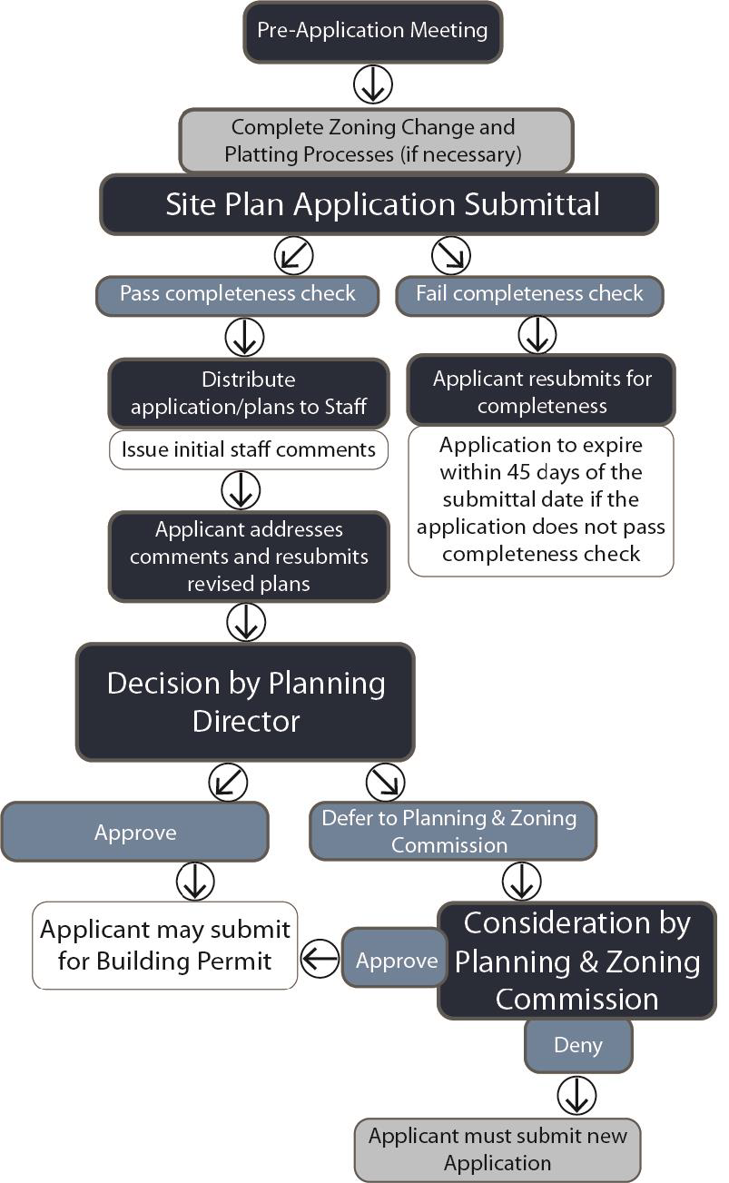
D.
Fees, forms, and procedures.
1.
The City's adopted Fee Schedule will establish fees relating to the Site Plan approval process.
2.
The City will not approve a Site Plan for a property until the property owner provides evidence demonstrating payment of indebtedness (see 2.3.3E).
3.
The City is hereby authorized to prepare application forms that include requirements for information, checklists, architectural or engineering drawing sizes and contents, contact information for the property owner, applicant, and technical consultants, and any other information necessary to review the application for compliance with City codes.
4.
The applicant is responsible for scheduling and attending a Pre-Application meeting and submitting the application by the deadline indicated on the City's published Development Schedule.
5.
The Planning Director is responsible for maintaining and making available the application forms.
6.
The application forms may be revised or changed at any time without notice.
E.
Approval process.
1.
Administrative Site Plan.
a.
The Planning Director is responsible for approving a Site Plan with no associated Specific Use Permit if it meets all the requirements of the UDC and the following criteria:
(i)
The Site Plan complies with the regulations of this UDC, the underlying zoning district, and all other applicable development regulations;
(ii)
The Site Plan ensures the efficient use of land, safe vehicular and pedestrian circulation, appropriate provision of Landscaping, Lighting, Fencing and Screening, and Parking;
(iii)
The property is served or will be served by Adequate Public Facilities;
(iv)
The Site Plan coordinates and correctly documents Public Facilities or their construction;
(v)
The Site Plan does not conflict with any requirements or standards of Article 3. Subdivision Regulations or the applicant has obtained the necessary Subdivision Waiver;
(vi)
The Site Plan provides for coordination of streets consistent with the Future Thoroughfare Plan, including providing deceleration lanes, median openings, and turn bays, and provides access between properties, where practical, through one (1) or more driveway stub-outs (see 3.4.7C) and one (1) or more Cross Access Easements;
(vii)
The design and location of parking areas and loading facilities ensures that all spaces are usable and safely located (see 4.6.2);
(viii)
The Site Plan provides sufficient landscaping and screening to adequately buffer and shield lights, noise, movement, or activities from abutting properties and complement and integrate the design and location of buildings into the overall site design (see 4.6.3 Landscaping and 4.6.4 Fencing and Screening);
(ix)
The Site Plan provides sufficient width and suitable grade to accommodate potential traffic and to provide access for garbage disposal, firefighting and emergency equipment.
b.
The Planning Director may authorize review and approval of a Site Plan simultaneously with review and approval of a building permit.
c.
The Planning Director will deny any Site Plan application that does not meet the criteria listed in a above.
Figure 4.2-5. Overview of the Site Plan Approval Process.
(i)
Exterior Lighting is designed to ensure the safety of visitors to the site and to building occupants, and minimizes Glare and reflection of light upon abutting properties (see 4.6.7);
(ii)
The Site Plan provides and configures open space in a way that ensures such areas are usable for the planting and sustenance of trees and shrubs, provides an area for safe pedestrian paths and for seating and shaded areas, contributes to the objectives of 4.6.3 Landscaping., and prevents large expanses of paved area;
(iii)
The Site Plan protects and conserves soil from erosion by wind or water; and
(iv)
The Site Plan complies with 5.6. Stormwater Management.
d.
Planning Director Action.
(i)
The Planning Director will inform the applicant of any deficiencies and provide instructions for the resubmittal of corrected plans in accordance with the City's adopted Development Schedule.
(ii)
The Planning Director may not deny a Site Plan but may defer any Site Plan he or she refuses to approve to the Planning and Zoning Commission for approval or denial.
e.
Letter of Decision. The Planning Director will issue an official Letter of Decision within ten (10) calendar days of the date the Site Plan is approved or denied.
2.
Site Plan with Specific Use Permit Request. A Site Plan associated with a Specific Use Permit must conform with the following criteria (for process to approve a Specific Use Permit without a Site Plan, see 1 above):
a.
After the Planning Director determines a Site Plan application is complete (see 2.3.4), the Planning Director will conduct an administrative technical review of the application.
b.
The purpose of the review is to determine the following:
(i)
The Site Plan and associated Specific Use Permit comply with the regulations of this UDC, the underlying zoning district, and all other applicable development regulations;
(ii)
The Site Plan and associated Specific Use Permit promote the goals and objectives of the Comprehensive Plan;
(iii)
The property is served or will be served by adequate public facilities;
(iv)
Buildings and structures utilized in the operation of the Specific Use Permit are adequate to support the use or can be improved to support the use;
(v)
The Site Plan coordinates and correctly documents Public Improvements or their construction;
(vi)
The Site Plan and associated Specific Use Permit prevent or mitigate any adverse impacts, including overcrowding and congestion;
(vii)
The Site Plan and associated Specific Use Permit does not conflict with any requirements or standards of Article 3. Subdivision Regulations or the applicant has obtained the necessary Subdivision Waiver (see 3.5.1);
(viii)
The Site Plan provides for coordination of streets consistent with the Transportation Plan, including providing deceleration lanes, median openings, and turn bays, and provides access between properties, where practical, through one (1) or more driveway stub-outs (see 3.4.7C) or one (1) or more Cross Access Easements;
(ix)
The design and location of parking areas and loading facilities ensures that all spaces are usable and safely located (see 4.6.2);
(x)
The Site Plan provides sufficient landscaping and screening to adequately buffer and shield lights, noise, movement, or activities from abutting properties and complement and integrate the design and location of buildings into the overall site design (see 4.6.3 Landscaping and 4.6.4 Fencing and Screening);
(xi)
The Site Plan provides sufficient width and suitable grade to accommodate potential traffic and to provide access for garbage disposal, firefighting and emergency equipment;
(xii)
Exterior Lighting is designed to ensure the safety of visitors to the site and to building occupants, and minimizes Glare and reflection of light upon abutting properties (see 4.6.7);
(xiii)
The Site Plan provides and configures open space in a way that ensures such areas are usable for the planting and sustenance of trees and shrubs, provides an area for safe pedestrian paths and for seating and shaded areas, contributes to the objectives of 4.6.3 Landscaping, and prevents large expanses of paved area;
(xiv)
The Site Plan protects and conserves soil from erosion by wind or water; and
(xv)
The Site Plan complies with 5.6. Stormwater Management.
c.
Use of Existing Building.
(i)
If the Site Plan and Specific Use Permit request involves use or expansion of existing buildings or structures, the Building Official may conduct an inspection of buildings or structures to be utilized or expanded with the Specific Use Permit prior to or after the applicant submits an application for Specific Use Permit to determine the adequacy of the buildings or structures to support the proposed use and to make recommendations for improvements to the buildings or structures.
(ii)
The City Commission may condition approval of the Site Plan with Specific Use Permit on compliance with the Building Official's recommendations, and the Building Official may withhold a Certificate of Occupancy if the buildings or structures do not comply with the conditions.
d.
Public Hearings Required. The Planning Director will review the Site Plan according to the criteria in b above and will prepare a report with a recommended action to the Planning and Zoning Commission.
(i)
The Planning Director will post public notice and mail individual notices to property owners within 200 feet of the subject property describing the request for Site Plan associated with a Specific Use Permit according to the same requirements found in 4.2.1.
(ii)
The Planning and Zoning Commission will conduct a public hearing, consider the report and recommendation of the Planning Director, and make recommendation to the City Commission.
(iii)
If the Planning and Zoning Commission recommends denial of a Site Plan with associated Specific Use Permit, City Commission may only approve the application by a two-thirds (2/3rds) majority.
(iv)
The City Commission may, after conducting a public hearing, vote to approve, approve with conditions, or deny the Site Plan and associated Specific Use Permit.
(v)
If the City Commission denies the request, the applicant may not submit the same request for at least one (1) year following the date of the City Commission's decision.
e.
Letter of Decision. Once City Commission approves, approves with conditions, or denies the Site Plan and associated Specific Use Permit, the Planning Director will issue an official Letter of Decision within ten (10) calendar days.
F.
Site plan effect of approval.
1.
By approving a Site Plan, the City authorizes the applicant to apply for approval of a Building Permit and to receive approval of Construction Plans associated with the property for which the Site Plan was approved.
2.
During the time the Site Plan remains valid, the City will not apply additional requirements concerning building placement, streets, drives, parking, landscaping, or screening.
3.
Site Plan approval is separate and distinct from other permits and approvals required by the UDC or other regulatory agencies.
G.
Amendments to approved site plans. The Planning Director may administratively approve changes from an approved Site Plan without requiring the applicant to submit a new Site Plan, if the requested changes meet the following criteria:
1.
Adjustments of no more than ten percent (10%) or fifty (50) feet in any direction, whichever is less, to the location or configuration of roadways, sidewalks, utilities, parking areas, buildings, landscape features (shrubs and trees), ponds, or any other improvements depicted on the Site Plan.
2.
Adjustments of no more than five percent (5%) to the building square footage of any individual building to be constructed within the area of the Site Plan. Administrative adjustments made by the Planning Director must comply with limitations (minimum or maximum) on impervious cover, height, or floor area for the district.
3.
Adjustments of no more than five percent (5%) to the parking required within the area of the Site Plan.
4.
Is a minor adjustment to flat work such as curbs, sidewalks, streets, decks, and other paved areas if there is no net increase in impervious coverage within the area of the Site Plan.
5.
Adjusts any building facade, including adjustments to materials, colors, windows, weather protection such as awnings and porticos, or building height adjustments of ten (10) feet or less. The Planning Director is not authorized to make an administrative adjustment that increases residential unit density, adds one or more floors, or reduces compliance with any architectural or building height requirements of this UDC.
6.
Is a minor adjustment to landscaping shown on the Site Plan, provided that the revision complies with 4.6.3.
7.
Does not authorize the construction or relocation of any retaining wall, regardless of whether the retaining wall is shown on the Site Plan.
H.
Dormant Site Plans and Site Plan Expiration.
1.
Other than Site Plans associated with an SUP, a Site Plan approval expires two (2) years from the approval date unless an applicant or property owner demonstrates Progress Toward Completion or a new Site Plan is approved for the property.
2.
If other plans, plats, permits or other activity qualifying as Progress Toward Completion are approved for a portion of the property for which a Site Plan has been approved, the Site Plan for the remaining portion will expire unless otherwise exempted from expiration by this UDC, a Development Agreement, or by State Law.
3.
If a Site Plan expires, all vesting claims shall also expire on the property, and the applicant must submit a new Site Plan subject to the regulations in place at the time.
I.
Revocation of site plan approval. The City may revoke approval of a Site Plan if the City determines that the applicant has not met the conditions of approval or if the Site Plan contains, or is based upon, incorrect information or if approval was obtained using fraud or deceit.
J.
Additional development, site modifications, or redevelopment. Following the completion of improvements shown on an approved Site Plan, additional development, site modifications, or redevelopment of the site shall be permitted subject to the approval of a revised Site Plan, which shall be considered a new project and shall require submittal and approval of a revised Site Plan.
4.2.5 - Certificate of Appropriateness and Demolition in the HP Overlay.
A.
Applicability. This Section 4.2.5 applies to existing buildings or structures within the HP Overlay district. For new development or construction within the HP Overlay district, see 4.6.11. Development in the Historic Overlay.
B.
Fees, forms, and procedures.
1.
A Certificate of Appropriateness is required prior to issuance of a Building Permit, permit for a Sign, or Certificate of Occupancy.
2.
If the work requires permitting, the Building Official must transmit a signed letter to the Historic Preservation Officer (HPO) certifying that the application for Building Permit, Sign Permit, or Certificate of Occupancy is complete.
3.
The City's adopted Fee Schedule will establish fees relating to the Certificate of Appropriateness approval process.
4.
The City will not approve a Certificate of Appropriateness for a property until the property owner provides evidence demonstrating payment of indebtedness (see 2.3.3E).
5.
The City is hereby authorized to prepare application forms that include requirements for information, checklists, architectural drawing sizes and contents, contact information for the property owner, applicant, and technical consultants, and any other information necessary to review the application for compliance with City codes.
6.
The HPO is responsible for maintaining and making available the application forms applicable to a request for a Certificate of Appropriateness.
7.
The application forms may be revised or changed at any time without notice consistent with the UDC.
C.
Exemptions. The following are exempt from the requirement to obtain a Certificate of Appropriateness:
1.
Routine maintenance of existing landscaping.
2.
Removal of a non-historic fence.
3.
Replacement of window glass.
4.
Changing the message on a marque or changeable message sign.
5.
Installing a banner (see 5.3.3C.2).
D.
Heritage officer action.
1.
The HPO will inform the applicant of any deficiencies within ten (10) business days of the date the applicant files the application for a Certificate of Appropriateness and will provide instructions for the resubmittal of corrected plans in accordance with TLGC Chapter 245.
2.
The HPO may require the applicant to attend a pre-application meeting prior to submitting an application.
3.
A completed application must include the following:
a.
Proposed building elevations, if the work will affect a building facade;
b.
Site plan, if the work will include an addition to the building or installation of fences, walls, ramps, hardscape, accessory buildings, driveways, sidewalks, patios, decks, or other addition or installation;
c.
Photographic documentation of the original building condition, if available; and
d.
Specifications, drawings, material samples, or other reasonable request for information made by the HPO.
4.
The HPO is authorized to administratively approve any application for a Certificate of Appropriateness that meets the following conditions:
a.
Ordinary Repair and Maintenance.
(i)
Repair using the same material and design as the original building or structure and the repair requires no structural modifications.
(ii)
Repainting using the same color.
(iii)
Reroofing using the same type and color of material.
(iv)
Repair of sidewalks and driveways using the same type and color of materials.
b.
Doors and Entrances.
(i)
Removal of a non-historic or non-contributing door and replacement with a door that is more appropriate to the era of the building's construction.
(ii)
Removal of burglar bars.
(iii)
Repair or minor modification to exterior steps or stairways using the same material and design as the original.
(iv)
Reopening of an enclosed porch if the removal returns the porch to its original condition, materials, and appearance.
c.
Windows.
(i)
Removal of non-historic windows if replaced by windows that match the original windows in materials and design.
(ii)
Restoring original window openings.
(iii)
Removal of non-historic shutters or metal awnings.
(iv)
Repair of window framing.
(v)
Installation of vents or louvers if placed within an existing opening and there is no modification to the building other than removal of glazing panels.
(vi)
Removal of burglar bars.
d.
Siding.
(i)
Removal of non-historic siding if the removal uncovers or exposes historic siding. HPC approval is required if the historic siding is missing or damaged and requires replacement following removal of non-historic siding.
e.
Roofing (Change of Materials or Color).
(i)
Removal of composite roof shingles if replaced with original roofing materials, including clay tiles or metal.
(ii)
Change of composite roof color.
(iii)
Change of metal roof color.
(iv)
Replacement of guttering.
f.
Accessory Structures.
(i)
Construction of, or addition to, an accessory building or structure in the rear yard and not visible from the street.
(ii)
Construction of, or addition to, an accessory building or structure less two hundred (200) square feet in a rear yard but where one or more sides are visible from a street, if the proposed building or structure matches the architecture, materials, and style of the primary building on any side visible from a street.
g.
Rear Additions.
(i)
An addition to the rear of a building if the addition is less than two hundred (200) square feet, expands an existing non-historic section of the building, including an earlier addition or area that uses non-historic materials, matches the existing roof ridgeline, and is not visible from a street.
h.
Painting.
(i)
Reasonable changes to paint color on an existing painted surface consistent with the rest of the historic district or landmark characteristics.
(ii)
Paint removal, pressure washing using water only, or graffiti removal, if performed using the most recent Standards for Rehabilitation published by the Office of the Secretary of the Interior or successor standards.
i.
Landscaping.
(i)
Replacement of paved or impervious areas with sod or landscaping.
(ii)
Sprinkler system installation.
(iii)
Replacement of landscaping or sod areas with xeriscaping, if the replacement complies with 4.6.3 and 5.1, is in character with the historic district, and does not remove any historic or Contributing Elements.
(iv)
New plantings that comply with 4.6.3 and that are in character with the historic district.
j.
Hardscaping.
(i)
Extension or expansion of a driveway if the new driveway area measures no more than twelve (12) feet in width not to exceed fifty percent (50%) of the lot width.
(ii)
Construction of a parking pad no more than eight (8) feet wide and extending perpendicular to an existing driveway on the same lot a distance of not more than eighteen (18) feet, unless the driveway loops back to the street with a design that meets the specifications required for the street type to which the driveway connects (see 3.4.7).
(iii)
Sidewalks within the property that are less than eight (8) feet in width are exempt from depth or length restrictions provided they are constructed with concrete or a material consistent with a historic sidewalk based on photo documentation.
k.
Fences, Railings, and Walls.
(i)
Replacement of chain link, plywood, vinyl, or other non-historic fence material with wood, wrought iron, garden loop, or masonry fence that is consistent with fences in the historic district.
(ii)
Recreation of a historic fence or handrail based on photo documentation.
(iii)
New fence, railing, or wall within the side or rear yard or property line that does not replace an existing fence, railing, or wall.
l.
Signs.
(i)
Changes to content or configuration, such as changes of copy, re-painting, or re-facing the sign, and that do not change the location, area, or Lighting of the sign.
(ii)
Signs consistent with a master sign plan previously approved by the HPC.
(iii)
New permanent signs listed under 5.3.
m.
Other New Construction Located Behind the Building and Not Visible from a Street.
n.
Other Changes, Repair, or Additions.
(i)
Interior work.
(ii)
Changes to awning fabric color consistent with the historic district or landmark characteristics.
(iii)
Renewal of an expired Certificate of Appropriateness if the expired Certificate complies with this UDC.
(iv)
Removal of a prohibited element or feature; if the HPO determines that removal has the potential to damage or destroy other historic elements on the building, the HPO may defer approval to the HPC.
(v)
Emergency measures to protect a feature or element, including weatherization or stabilization.
(vi)
Foundation repair.
(vii)
Installation of mechanical units such as HVAC, if screened in accordance with 4.6.4.
(viii)
Electrical repair or installation other than Solar Panels or Solar Arrays.
(ix)
Plumbing repair or installation.
(x)
Satellite Earth Station less than one (1) meter or amateur radio antenna less than forty (40) feet, if located behind the front building line.
(xi)
Glass replacement.
(xii)
Dumpster screening if the material is consistent with the primary building on the same lot.
(xiii)
Other rooftop equipment if screened in accordance with 4.6.4.
5.
Administrative Action within Fourteen Days. Upon submittal of a completed application (see 4.2.5D.1), the HPO will approve or deny an application that meets the criteria for administrative approval in 4.2.5D.4 above and that meets the criteria for approval listed in Subsection B.f below within fourteen (14) business days of the date the application is determined to be complete.
6.
Criteria for Approval.
a.
In consideration of an application for Certificate of Occupancy, the HPO and HPC must refer to any design guidelines adopted by the City Commission to evaluate the proposed work.
b.
In addition, the preservation commission must consider specific factors related to the following:
(i)
The degree to which the proposed work is consistent with the applicable design guidelines;
(ii)
The degree to which the proposed work would destroy or alter all or part of a historic feature, element, or resource;
(iii)
The degree to which the proposed work would serve to isolate the historic resource from its surroundings, or introduce visual elements that are out character with a historic feature, element, or resource;
(iv)
The degree to which the proposed work is compatible with the significant characteristics of a historic feature, element, or resource; and
(v)
The purposes and intent of the HP district regulations and this UDC.
7.
Application Forwarded to HPC for Approval or Denial.
a.
If the application does not meet the criteria for administrative approval in 4.2.5D.4 above, or the HPO refuses to approve the application for any reason, the HPO will forward the application to the HPC.
b.
The HPO or HPC may request that the applicant provide additional documentation supporting the request, including architectural records and specifications.
8.
Appeal of Administrative Action. The applicant or any interested party may appeal the decision of the HPO to the HPC within ten (10) days of the date of decision.
E.
HPC action.
1.
The HPC will approve or deny an application within thirty-five (35) calendar days of the date the application is determined to be complete.
2.
If an application is denied without prejudice due to insufficient information, the applicant may resubmit the request at any time.
3.
If an application is denied with prejudice, the applicant may not resubmit the request until six (6) months have elapsed from the date of HPC decision.
4.
Failure of the HPC to take action on the request within thirty-five (35) days constitutes approval of the request unless the applicant agrees to or requests an extension of the thirty-five (35) day period.
F.
Letter of decision. The Heritage Officer will issue an official Letter of Decision within ten (10) business days of the date the Certificate of Appropriateness is approved or denied.
G.
Request for demolition.
1.
Applicability.
a.
This Subsection F. applies to any application for demolition in the HP overlay. No demolition, partial demolition, substantial alteration, or relocation of a building, structure, object, or other resource in the HP overlay shall occur until an application for demolition is approved.
b.
The HPO may administratively approve applications for demolition permits for non-contributing minor outbuildings within the HD such as carports, detached garages, sheds, and greenhouses determined by the HPO to not possess historical or architectural significance either as a stand-alone building or structure, or as part of a complex of buildings or structures on the site.
2.
Evidence of Unreasonable Economic Hardship. The applicant bears the burden of proof that a building or structure constitutes an unreasonable economic hardship. In considering a request for demolition, the HPC may require that the applicant provide the following:
a.
The owner cannot make reasonable beneficial use of or realize a reasonable rate of return on a structure or site, regardless of whether that return represents the most profitable return possible, unless the proposed demolition or relocation is allowed;
b.
The structure and property cannot be reasonably adapted for any other feasible use, whether by the current owner or by a purchaser, that would result in a reasonable rate of return; and
c.
The owner has failed to find a purchaser or tenant for the property during the previous two years, despite having listed the property on the MLS, or for sale by owner with proof of advertising and or other substantive proof of effort to sell the property during that period.
d.
The evidence of unreasonable economic hardship introduced by the owner may, where applicable, include proof that the owner's affirmative obligations to maintain the structure or property make it impossible for the owner to realize a reasonable rate of return on the structure or property.
3.
Relief for Low-Income Resident Homeowner.
a.
When a low-income resident homeowner is unable to meet the requirements set forth in this section, the HPC may waive some or all of the requested information or request substitute information that the low-income resident homeowner may obtain without incurring undue costs.
b.
If the HPC cannot make a determination based on information submitted and an appraisal has not been provided, then the HPC may request that an appraisal be made by the City within sixty (60) days, which will result in the application for demolition being held until the appraisal is complete.
4.
HPC Consideration. The HPC must consider the public benefits obtained from retaining the cultural resource.
a.
As evidence that an unreasonable economic hardship exists, the owner may submit the following information to the HPC by affidavit:
(i)
For all structures and property:
(1)
The past and current use of the structures and property;
(2)
The name and legal status (e.g., partnership, corporation) of the owners;
(3)
The original purchase price of the structures and property;
(4)
The assessed value of the structures and property according to the two most recent tax assessments;
(5)
The amount of real estate taxes on the structures and property for the previous two years;
(6)
The date of purchase or other acquisition of the structures and property;
(7)
Principal balance and interest rate on current mortgage and the annual debt service on the structures and property, if any, for the previous two years;
(8)
All appraisals obtained by the owner or applicant within the previous two years in connection with the owner's purchase, financing or ownership of the structures and property;
(9)
Any listing of the structures and property for sale or rent price asked and offers received;
(10)
Any consideration given by the owner to profitable adaptive uses for the structures and property;
(11)
Any replacement construction plans for proposed improvements on the site;
(12)
Financial proof of the owner's ability to complete any replacement project on the site, which may include but not be limited to a performance bond, a letter of credit, a trust for completion of improvements, or a letter of commitment from a financial institution; and
(13)
The current fair market value of the structure and property as determined by a qualified appraiser.
(14)
Any property tax exemptions claimed in the past five years.
b.
For income-producing structures and property:
(i)
Annual gross income from the structure and property for the previous two years;
(ii)
Itemized operating and maintenance expenses for the previous two years; and
(iii)
Annual cash flow, if any, for the previous two years.
c.
Loss of significance.
(i)
An applicant may provide to the HPC information which may show a loss of significance in regards to the subject of the application in order to receive HPC approval of the demolition.
(ii)
If, based on the evidence presented, the HPC finds that the structure or property is no longer historically, culturally, architecturally or archeologically significant it may make a recommendation for approval of the demolition.
(iii)
In making this determination, the HPC must find that the owner has established by a preponderance of the evidence that the structure or property has undergone significant and irreversible changes which have caused it to lose the historic, cultural, architectural or archeological significance, qualities or features which qualified the structure or property for such designation.
(iv)
Additionally, the HPC must find that such changes were not caused either directly or indirectly by the owner, and were not due to intentional or negligent destruction or a lack of maintenance rising to the level of a demolition by neglect.
(v)
The HPC shall not consider or be persuaded to find loss of significance based on the presentation of circumstances or items that are not unique to the property in question and not shared by other similar properties in the HP district.
d.
Proposed Replacement of Structure to be Demolished. For property located within a historic district, the HPC shall be guided in its decision by balancing the contribution of the property to the character of the HP Overlay with the special merit of the proposed replacement project.
(i)
Documentation and Strategy.
(1)
Applicants that have received a COA regarding demolition may be required to document buildings, objects, sites or structures which are intended to be demolished with photographs and provide them to the HPO.
(2)
Applicants may be required to prepare for the HPO a salvage strategy for reuse of building materials deemed valuable by the HPO for other preservation and restoration activities.
(3)
Applicants that have received an approval of a COA regarding demolition shall be permitted to receive a demolition permit without additional HPC action on demolition, following the HPC's recommendation of a COA for new construction.
(4)
Permits for demolition and construction may be issued simultaneously if requirements for new construction are met, and the property owner provides financial proof of his ability to complete the project.
(5)
When the HPC recommends approval of a certificate for buildings, objects, sites, structures designated as historic, or for resources in the HP district, permits shall not be issued until all plans for the site have received approval from all appropriate City commissions and departments.
(6)
Permits for parking lots shall not be issued, nor shall an applicant be allowed to operate a parking lot on such property, unless such parking lot plan was approved as a replacement element for the demolished object or structure.
e.
Additional Request for Information.
(1)
In the event that the HPO or HPC determines that any additional information described above is necessary in order to evaluate whether an unreasonable economic hardship exists, the HPO shall notify the owner.
(2)
Failure by the owner to submit such information within 15 days after receipt of such notice may be grounds for denial of the owner's claim of unreasonable economic hardship.
5.
Postponement to Explore Alternatives to Demolition.
a.
The HPC may postpone action on the demolition request for up to sixty (60) days from the date the application is considered complete (see 4.2.5A). The HPC may institute the sixty (60) day period if it finds that the building or structure proposed for demolition exhibits one or more of the following characteristics:
(i)
Character, interest, or value as part of the historic development, heritage or cultural characteristics of the City, state, or county.
(ii)
Location as the site of a significant historic event.
(iii)
Identification with a person who significantly contributed to the cultural and development of the City.
(iv)
Contribution to the City's economic, social, or historical context.
(v)
Portrayal of the environment of a group of people in an era of history characterized by a distinctive architectural style.
(vi)
Embodiment of distinguishing characteristics of an architectural type or specimen.
(vii)
Identification as the work of an architect or master builder whose individual work has influenced the development of the City.
(viii)
Embodiment of elements of architectural design, detail, materials, or craftsmanship that represent a significant architectural innovation.
(ix)
Relationship to other distinctive buildings, sites, or areas which are eligible for preservation according to a plan based on historic, cultural, or architectural motif.
(x)
Unique location of singular physical characteristics representing an established and familiar visual feature of a neighborhood, community, or the City as a whole.
(xi)
Archaeological value in that it has produced or can be expected to produce data effecting theories of historic or prehistoric interest.
b.
The HPC must use this additional time to find alternatives to demolition.
c.
If a feasible alternative is not found within the sixty (60) day period, the HPC shall forward the request for demolition to the City Commission.
6.
Issuance of permit.
a.
When the HPC recommends approval of a COA regarding demolition of buildings, objects, sites, or structures in historic districts or historic sites that have been determined to be contributing, permits shall not be issued until all plans for the site have received approval from the City Commission.
b.
Upon receiving the recommendation of the HPC, the City Commission must decide upon the request within thirty (30) days. If the City Commission does not issue a decision on the request within thirty (30) days, the request is automatically approved.
c.
Once the replacement plans are approved a fee shall be assessed for the demolition based on the approved replacement plan square footage. The fee must be paid in full prior to issuance of any permits and shall be deposited into a City account directed by the HPO for the benefit and or rehabilitation of local historic resources including the prevention of demolition by neglect.
d.
Fees shall be as follows and are in addition to any fees charged by the building department:
(i)
0—2,500 square feet = $1,500.00
(ii)
2,501—10,000 square feet = $4,000.00
(iii)
10,001—25,000 square feet = $10,000.00
(iv)
25,001—50,000 square feet = $20,000.00
(v)
Over 50,000 square feet = $30,000.00
7.
Treatment of Site Following Demolition.Following the demolition or removal of an historic resource located in the HP district, the applicant must do the following within sixty (60) days of demolition:
a.
Remove all traces of previous construction, including foundation;
b.
Grade, level, sod and seed the lot to prevent erosion and improve drainage, and
c.
Repair, at the applicant's expense, any damage to public rights-of-way, including sidewalks, curbs and streets, that may have occurred in the course of removing the building, object, or structure and its appurtenances.
8.
Prevention of demolition by neglect.
a.
Applicability.
(i)
The exterior features of any historic resource, objects, sites, or structures (including but not limited to structural elements, building materials, fences, light fixtures, steps, pavement, paths or any other appurtenant feature), or any type of outdoor advertising sign shall be preserved against decay and deterioration and kept free from certain structural defects.
(ii)
The property owner must, upon written request by the HPO, repair such exterior features if they are found to be deteriorating, or if their condition is contributing to deterioration, including but not limited to any of the following defects:
(1)
Deteriorated or inadequate foundation (including piers, and perimeter beams), defective or deteriorated flooring or floor supports or flooring or floor supports or joists of insufficient size to carry imposed loads with safety;
(2)
Members of walls, partitions or other vertical supports that split, lean, list or buckle due to defective material or deterioration. Members of walls, partitions or other vertical supports that are of insufficient size to carry imposed loads with safety;
(3)
Members of ceilings, roofs, ceiling and roof supports, or other horizontal members which sag, split, or buckle due to defective materials or deterioration. This includes members of ceilings, roofs, ceiling and roof supports or other horizontal members that are of insufficient size to carry imposed loads with safety;
(4)
Fireplaces or chimneys that lean, list, bulge or settle due to defective material or deterioration. This includes fireplaces or chimneys which are of insufficient size or strength to carry imposed loads with safety;
(5)
Deteriorated or ineffective waterproofing of exterior walls, roofs, foundations or floors, including broken windows or doors, including the following:
(a)
Defective protection or lack of weather protection for exterior wall coverings, including lack of paint, or weathering due to lack of paint or other protective covering.
(b)
Any fault or defect in the building which renders same structurally unsafe or not properly watertight.
(6)
In addition, the owner or other person having legal custody and control of an historic landmark or a building, object, site, or structure located in an historic district must keep all property, including vacant property, clear of all weeds, fallen trees or limbs, debris, abandoned vehicles, and all other refuse as specified under the City's minimum housing codes and ordinances.
b.
Petition to Correct Defects due to Neglect.
(i)
The HPO and the HPC are authorized to work with a property owner to encourage maintenance and stabilization of structures and identify resources available before taking enforcement action under this section.
(ii)
The HPC, on its own initiative, or the HPO, under direction from the HPC, may file a petition with the Building Official petitioning that the City require correction of defects or repairs to any structure covered by this section so that such structure shall be preserved and protected in accordance with the purposes of this UDC and other applicable City ordinances.
c.
Emergency Stabilization and Repair.
(i)
No structure may be demolished due to a public safety hazard until it has been inspected by the HPO.
(ii)
The HPC has the right to delay demolition for up to sixty (60) days to consider alternative measures to secure the structure.
(1)
If the HPC authorizes alternative measures to secure the structure, the HPO must determine a plan for the further protection of the structure in consultation with the Building Official and Fire Marshal.
(2)
If no plan is developed, the HPC may approve an order for demolition and require documentation of the property and a plan for salvage (see 4.d(i) above).
(iii)
When applicable, a recommendation about the feasibility of rehabilitation shall be made by the HPC based upon a report from the HPO.
(iv)
The City may repair deterioration that is jeopardizing the long-term viability of a structure and charge the costs to the owner as a lien against the property.
d.
Enforcement, Violations, and Penalties.
(i)
A violation under this Subsection is any act of commission or omission contrary to this 4.2.5.
(ii)
The imposition of any penalty authorized in this Section does not preclude any aggrieved party from instituting civil action against a violation of this Section.
(iii)
Prior to bringing any citation or penalty against a property owner, the HPO must serve notice to the property owner listing the violations under this Section and providing a reasonable period of time to cure the violations.
(iv)
If the property owner fails to respond to the notice, cure the violation, or submit a plan to stabilize and repair the structure by the date listed in the notice, the City is authorized to begin abatement procedures, including the issuance of fines.
(v)
Each day a violation of this Section is permitted to exist constitutes a separate offense.
(vi)
The penalties for violation of this Section are as follows:
(1)
Any person who constructs, reconstructs, alters, restores, renovates, relocates, stabilizes, repairs or demolishes any building, object, site, or structure in violation of this section must restore the building, object, site, or structure to its appearance or setting prior to the violation.
(a)
Any action to enforce this provision shall be brought by the City of Brownsville.
(b)
This remedy may be in addition to any criminal prosecution and penalty related to the violation.
(2)
If construction, reconstruction, alteration, restoration, renovation, relocation, stabilization, or repair of a landmark or of any building, object, site or structure found to have significance or located in the HP district, or on publicly-owned land, or on a public right-of-way occurs without a permit, the property owner or person responsible may be fined up to $2,000.00 and the license of the company, individual, principal owner, or its or his successor in interest performing such construction, reconstruction, alteration, restoration, renovation, relocation, stabilization, or repair may be revoked for a period of three years.
(3)
If demolition of an historic site or of any building, object, site, or structure found to have significance or located in an historic district or located on publicly-owned property, or on a public right-of-way occurs without a permit, the property owner or person responsible may be fined up to $2,000.00 and the license of the company, individual, principal owner; or its or his successor in interest performing such demolition may be revoked for a period of five years.
(4)
The fines paid for violations of this section shall be deposited into a City account directed by the HPO for the benefit and or rehabilitation of local historic resources including the prevention of demolition by neglect (see 4.2.5G.8 above).
4.2.6 - Planned Development District.
A.
Purpose.
1.
The base zoning districts established in 4.1.1 are intended to facilitate a broad range of development within appropriate areas of the City. However, the City recognizes that there are a variety of development types as well as unique areas within the City.
2.
Therefore, the intent of this section to provide a mechanism for a specialized zoning district that facilitates the creation of developments that are unique due to one or more of the following factors:
a.
Natural setting or location on a highly visible or challenging property;
b.
The mixture of uses or the relationship between those uses;
c.
Coordination of multiple developers with particular specialties.
3.
The Planned Development District is intended to establish specific development standards that ensure each Planned Development exceeds the standards of the equivalent base zoning districts.
B.
Minimum area required for a planned development district.
1.
The minimum size for a Planned Development District is two (2) contiguous acres.
2.
The minimum access width to a Planned Development District from a public street is fifty (50) feet.
3.
The minimum gross size of an individual lot is 1,500 square feet with a minimum width of twenty (20) feet. Any lot under 3,000 square feet must provide compensating open space within the Planned Development District. The compensating open space shall be no less than 1,500 square feet per lot, in addition to other applicable open space requirements under 4.6.3, and shall have direct frontage along or within a public or private street.
C.
Use of Planned Development District. The City Commission, at its discretion and in conformance to the Comprehensive Plan, may approve a Planned Development District to accomplish any of the following on a certain property:
1.
Provide for a mix of any number or types of uses, provided each use requested appears on the Permitted Use Chart (see 4.4.3) at the time the City Commission approves the Planned Development District. An applicant may not use a Planned Development District to propose or authorize new uses not found on the Permitted Use Chart.
2.
Provide for integrated design and placement of buildings using regulations that govern the bulk, height, footprint, and separation of buildings.
3.
Preserve or enhance areas with environmentally significant natural features.
4.
Provide for shared open space that supports a variety of temporary uses or events with flexible provisions for gathering, parking, vending, circulation, and staging.
5.
Allow for alternate means of integrating or buffering uses proposed within the Planned Development District.
6.
Creation of a coordinated and integrated transportation system throughout the district, including the provision of on and off-street parking, provided that the plan facilitates multiple transportation modes, provides sufficient emergency vehicle access, adequately manages stormwater runoff, and that any street not conforming to a standard street typology in this UDC are privately owned and maintained and placed within a separate lot deed restricted for shared use.
D.
Fees, forms, and procedures.
1.
The City's adopted Fee Schedule will establish fees relating to the Planned Development District approval process.
2.
The City will not approve a Planned Development District for a property until the property owner provides evidence demonstrating payment of indebtedness (see 2.3.3E).
3.
The City is hereby authorized to prepare application forms that include requirements for information, checklists, architectural or engineering drawing sizes and contents, contact information for the property owner, applicant, and technical consultants, and any other information necessary to review the application for compliance with City codes.
4.
The applicant is responsible for submitting the application by the deadline indicated on the City's published Development Schedule.
5.
The Planning Director is responsible for maintaining and making available the application forms applicable to a Planned Development District request.
6.
The application forms may be revised or changed at any time without notice consistent with the UDC.
E.
Pre-application meeting. The Planning Director may require that a Pre-Application Meeting take place prior to submittal of an application for a Planned Development District (see 2.2.1).
F.
Planned development master plan required.
1.
An application for a Planned Development District must be accompanied by a Planned Development Master Plan.
2.
The Planned Development Master Plan shall consist of two components:
a.
Planned Development (PD) Design Statement; and
b.
Planned Development (PD) Concept Plan.
3.
The Planning Director, Planning and Zoning Commission, or City Commission may also require the applicant to produce other supporting maps demonstrating how the Planned Development District will meet the goals of this section and the Comprehensive Plan.
4.
PD Design Statement. The PD Design Statement is a written report containing each of the following elements:
a.
The name or title of the development authorized by the Planned Development District (PD);
b.
Identification of the base district or districts upon which the PD regulations are based and a list of all standards applicable to the base district(s) that the applicant proposes to modify with the PD;
c.
A list of requested Subdivision Waivers. Approval of a Subdivision Waiver with the PD will govern approval of the Preliminary Plat and Final Plat;
d.
List of property owners and developers. If a master developer initiates the application, the PD Design Statement must contain, if known, a list of prospective developers for subsequent phases or areas within the PD;
e.
A description of the location of the PD and its relationship to abutting land uses, whether existing or proposed, or the zoning of neighboring properties. The description should address at a minimum properties and land uses within one-quarter (1/4) mile of the PD. The Planning Director, Planning and Zoning Commission, or City Commission may require that the description include properties outside of this area based on the size of the proposed PD or the projected impact or relationship between the proposed PD and abutting or adjoining districts;
f.
A description of existing and proposed streets that abut, connect to, or may be impacted by the proposed PD;
g.
A description of proposed streets within the PD, including any waivers to applicable street standards (see 3.5.1. Subdivision Waiver Petition), street design and streetscape concepts, and the relationship of the proposed streets with existing or proposed streets outside the PD;
h.
Written and illustrated description of the function and design of the PD, including acreage or square footage breakdown of land uses, sub-districts, or areas, building types, relationships between buildings, streets, and open space, residential density (if applicable), and proposed restriction of uses, building orientation, site access, and other characteristics that will define the district or other information deemed helpful or necessary by the applicant or the City. Images may be CAD rendered or images of existing locations;
i.
Analysis of existing elevation, slope, soils, tree cover, and drainage characteristics and the strategies the PD will utilize to protect and preserve these features in their natural condition;
j.
Topographic map with minimum five (5) foot contour intervals;
k.
Analysis of drainage area acreage and existing flood plain, if any;
l.
Identification of existing and proposed utilities and Public Facilities;
m.
Description of proposed phasing or sequence of development;
n.
Additional material requested by the City.
5.
PD Concept Plan.
a.
The PD Concept Plan (Concept Plan) is a graphic representation of the master plan for a PD.
b.
The Concept Plan must be consistent with the PD Design Statement.
c.
The Concept Plan must be created to a legible scale and contain sufficient detail to articulate the physical plan for implementing the components of the PD Design Statement within the context of the proposed PD.
d.
Examples of components that should be included in the Concept Plan include locations of proposed streets, property lines, landmark features, entryway features, building locations, parking locations, common areas to be constructed with each phase of development and identification of the developer or developers responsible for constructing the common features, anticipated location of stormwater management facilities and the timing and responsibility for construction.
6.
Approval of Planned Development Master Plan. Upon approval by City Commission, the Planned Development Master Plan will become part of the ordinance authorizing the Planned Development District.
7.
Expiration of Planned Development Master Plan.
a.
The Planned Development Master Plan will expire one (1) year from the date of approval if the applicant has made no Progress Towards Completion within the Planned Development District.
b.
If the Planned Development Master Plan expires, the applicant must submit a new Planned Development Master Plan for approval according to the procedures specified in this 4.2.6F above.
c.
Expiration of the Planned Development Master Plan does not invalidate the Planned Development District. Any new Planned Development Master Plan must comply with the Planned Development District regulations set forth in the adopting ordinance and with this UDC.
G.
Approval process.
1.
The Planning Director will review the Planned Development District according to the criteria in this 4.2.6 and will prepare a report with a recommended action to the Planning and Zoning Commission.
2.
The Planning Director will post public notice and mail individual notices to property owners within 200 feet of the subject property describing the request for a Planned Development District according to the same requirements applicable to a zoning change request (see 4.2.2 Zoning Text and Map Amendments).
3.
The Planning and Zoning Commission will conduct a public hearing, consider the report and recommendation of the Planning Director, and make recommendation to the City Commission.
4.
The City Commission may, after conducting a public hearing, vote to approve, approve with conditions, or deny the Planned Development District.
5.
Once City Commission approves, approves with conditions, or denies the Planned Development District, the Planning Director will issue an official Letter of Decision within ten (10) calendar days.
H.
Requirement to submit preliminary plat for planned development district.
1.
If the applicant proposes to create a Subdivision of the approved Planned Development District, the applicant must prepare a Preliminary Plat following approval of the Planned Development District (see 3.2.1 Preliminary Plat).
2.
If a recorded Plat exists and is sufficient for the purposes of implementing the Planned Development District, the Planning Director may waive the requirement to provide a Preliminary Plat with approval of the Planned Development District.
I.
Requirement to submit final plat for planned development district.
1.
After Preliminary Plat approval, the applicant must prepare a Final Plat for the Planned Development District or for each phase of development. The Final Plat shall include all elements required for a Final Plat in 3.2.2 along with the following:
a.
Provisions for the ownership and maintenance of Common Areas and Stormwater Management Facilities that are not placed in City Right-of-Way.
b.
Dedication of the Common Areas and Stormwater Management Facilities listed in Subitem a above to a Homeowners Association along with a copy of the documents establishing the Homeowners Association.
2.
If the applicant and City agree that a sufficient Final Plat exists and is of record, the applicant must submit proof of the items listed in Subsection I.1.a above before obtaining permits for construction, including a Building Permit.
J.
Requirement to submit site plan for planned development district. The applicant must submit a Site Plan for review and approval before receiving a permit to begin construction within the Planned Development District, including a Building Permit.
K.
Planned development districts approved prior to UDC.
1.
A Planned Development District approved prior to adoption of this UDC is governed by the ordinance that created the original Planned Development or the most recent amendment to the ordinance.
2.
If the ordinance establishing the Planned Development District provides for an expiration date, the expiration date in the ordinance will control. If the ordinance does not provide for an expiration date, the project will expire according to 4.2.6F.7 above.
3.
Following adoption of this UDC, any amendment to a Planned Development District created prior to adoption of this UDC must comply with this 4.2.6.
L.
Amendments to Approved Planned Development Districts.
1.
The Planning Director may approve a request for a minor amendment to an approved Planned Development District (PD) if the Planned Development Master Plan is unexpired and the requested change meets the following criteria:
a.
The request does not have the effect of altering the PD boundaries.
b.
The request does not have the effect of authorizing uses that are prohibited or are not listed within the ordinance adopting the PD or amendment thereto or removing uses that are authorized.
c.
The request does not increase or reduce land allocated to a particular use or uses in a way that is inconsistent with the ordinance adopting the PD or amendment thereto.
d.
The request does not increase or decrease the residential density authorized in the PD by more than ten percent (10%).
e.
The request would not result in a net increase of impervious coverage or net decrease in park or landscaped area.
2.
If the Planning Director finds that the request does not meet the above criteria, the applicant must submit the request to the City Commission as a Planned Development District request in accordance with the procedures of this 4.2.6.
4.2.7 - Specific Use Permit.
A.
Purpose. The uses listed under the various districts within the Use Chart as "S" are so classified because the City Commission has found that these uses may, because of their nature or intensity, be incompatible with other permitted uses in the same district or compatible only with mitigation imposed through standards and conditions attached to the use.
B.
Specific Use Permit Applicability.
1.
The designation of a use as permissible by Specific Use Permit (SUP) does not mean that City Commission will approve the use at any location in the zoning district.
2.
Approval of a SUP does not authorize any use other than the particular use authorized in the SUP.
3.
A SUP is a land use entitlement granted to a particular property or location and may be transferred from owner to owner so long as the SUP remains unexpired (see Section 4.2.7H.).
4.
No Specific Use Permit may be enlarged, extended, or relocated unless City Commission approves a new Specific Use Permit.
Compatibility Conditions.
5.
The Planning and Zoning Commission may recommend, and City Commission may require other conditions and safeguards with approval of any SUP for the purpose of protecting other properties within the same or abutting zoning district.
6.
The Planning and Zoning Commission or City Commission, in evaluating the SUP request, may require any additional information beyond that required by the Planning Director or this Section 4.2.7., including studies, data, or expert evaluation of the location, function, or characteristics of any use or building proposed in connection with the SUP.
7.
No SUP may be approved that is not in conformance with the Comprehensive Plan and this UDC.
C.
Pre-Application meeting and site pre-inspection.
1.
The Planning Director may require that a Pre-Application Meeting take place prior to submittal of an application for SUP (see 2.2.1).
2.
The Building Official may conduct an inspection of buildings or structures to be utilized with the Specific Use Permit prior to or after the applicant submits an application for Specific Use Permit to determine the adequacy of the buildings or structures to support the proposed use and to make recommendations for improvements to the buildings or structures.
3.
The City Commission may condition approval of the Specific Use Permit on compliance with the Building Official's recommendations, and the Building Official may withhold a Certificate of Occupancy if the buildings or structures do not comply with the conditions imposed by the City Commission.
Figure 4.2-6. Overview of the SUP Approval Process
1.
The City's adopted Fee Schedule will establish fees relating to the SUP approval process.
2.
The City will not approve a SUP for a property until the property owner provides evidence demonstrating payment of indebtedness (see 2.3.3E).
3.
The City is hereby authorized to prepare application forms that include requirements for information, checklists, architectural or engineering drawing sizes and contents, contact information for the property owner, applicant, and technical consultants, and any other information necessary to review the application for compliance with City codes.
4.
The applicant is responsible for submitting the application by the deadline indicated on the City's published Development Schedule.
5.
the Planning Director is responsible for maintaining and making available the application forms applicable to a SUP request.
6.
The application forms may be revised or changed at any time without notice consistent with the UDC.
E.
Approval Process. The applicant for Specific Use Permit must submit information sufficient for the City review and evaluate the request, including a written description of the requested use and an informal sketch of the building, floor space, or existing site proposed for use (for process to approve a Specific Use Permit with a Site Plan see 4.2.4E.2. Site Plan with Specific Use Permit Request).
1.
After the Planning Director issues a determination of completeness for the application (see 2.3.4), the Planning Director will conduct an administrative technical review of the application.
2.
The purpose of the review is to determine the following:
a.
The Specific Use Permit complies with the regulations of this UDC, the underlying zoning district, and all other applicable development regulations;
b.
The Specific Use Permit promotes the goals and objectives of the Comprehensive Plan;
c.
The property is served or will be served by Adequate Public Facilities;
d.
Buildings utilized in the operation of the Specific Use Permit are adequate to support the use or can be modified or improved to support the use;
e.
The Specific Use Permit prevents or mitigates adverse development impacts, including overcrowding and congestion;
f.
The Specific Use Permit provides landscaping and screening which adequately buffer and shield lights, noise, movement, or activities from abutting properties and complement and integrate the design and location of buildings into the overall site design;
g.
The design and location of parking areas and loading facilities ensures that all spaces are usable and safely located;
h.
Sufficient width and suitable grade are provided to accommodate potential traffic and to provide access for garbage disposal, firefighting and emergency equipment;
i.
Exterior Lighting is designed to ensure the safety of visitors to the site and to building occupants, including the minimization of Glare and reflection upon abutting properties;
j.
Any other applicable requirements of 4.2.4E.2.b.
3.
The Planning Director will review the Site Plan according to the criteria in subitem G.2 above and will prepare a report with a recommended action to the Planning and Zoning Commission.
a.
The Planning Director will post public notice and mail individual notices to property owners within 200 feet of the subject property describing the request for Site Plan associated with a Specific Use Permit according to the same requirements applicable to a zoning change request (see 4.2.1).
b.
The Planning and Zoning Commission will conduct a public hearing, consider the report and recommendation of the Planning Director, and make recommendation to the City Commission.
c.
The City Commission may, after conducting a public hearing, vote to approve, approve with conditions, or deny the Site Plan and associated Specific Use Permit.
4.
Once City Commission approves, approves with conditions, or denies the Site Plan and associated Specific Use Permit, the Planning Director will issue an official Letter of Decision within ten (10) calendar days.
5.
If the Planning and Zoning Commission votes unanimously to recommend denial of a Specific Use Permit, City Commission may only approve the application by a two-thirds (2/3rds) majority.
F.
Specific Use Permit Effect of Approval.
1.
By approving a SUP, the City authorizes the applicant to apply for approval of a Building Permit and to receive approval of Construction Plans associated with the property for which the SUP was approved.
2.
The City Commission will not grant an SUP unless the applicant is willing to accept and agree to be bound by and comply with the ordinance adopting the SUP, and all supporting documentation including business and operational plans, floor plans, required improvements and conditions of approval and the minimum requirements of the zoning district in which the property is located.
3.
During the time the SUP remains valid, the City will not apply additional requirements concerning building placement, streets, drives, parking, landscaping, or screening.
4.
SUP approval is separate and distinct from other permits and approvals required by the UDC or other regulatory agencies.
G.
Amendments to Approved Specific Use Permits.
1.
An amendment to any approved SUP will be processed as a new Specific Use Permit request.
2.
While the SUP is in effect, no building, premise, site, property, or land used in association with the SUP may be enlarged, modified, altered physically or structurally other than for repairs or renovations to the facade, roof, building interior, fencing, or paving that do not expand the footprint of the building or site, unless City Commission approves an amendment to the SUP.
H.
Specific Use Permit Expiration.
1.
Unless otherwise specified by ordinance adopted by the City Commission, any SUP will expire under the following scenarios:
a.
If, after the SUP is granted, the applicant does not obtain a Building Permit or Certificate of Occupancy within twelve (12) months of City Commission approval; or
b.
After six (6) months of continuous disuse or vacancy of the building or property associated with the SUP.
2.
The Planning Director, in determining whether an SUP has expired, may require that the property owner or applicant submit documentation showing that the building or property associated with the SUP has been occupied within the six (6) month period in question. Requested evidence may be in the form of one or more utility bills showing water or electricity usage, photographs, invoices, or an affidavit.
3.
If an applicant relies upon fraudulent or misleading information in obtaining a continuation of an SUP that would otherwise have expired due to disuse, the Planning Director is authorized to revoke both the SUP and the Certificate of Occupancy from the business or property owner.
4.
The applicant may request an extension or appeal the decision of the Planning Director to expire the SUP to the Planning and Zoning Commission. The Planning and Zoning Commission may establish an extension period of up to six (6) months beyond the date of its decision during which the SUP will remain valid. If the applicant does not obtain a Certificate of Occupancy within the extension period, the SUP will automatically expire. The City Commission's decision shall be final.
I.
Revocation of Specific Use Permit Approval.
1.
The City Commission may, upon recommendation by the Planning Director and the Planning and Zoning Commission, vote to revoke a Specific Use Permit upon finding that the business or property owner operating under the SUP has violated the requirements, standards, or conditions of the ordinance adopting the SUP or any other requirement or restriction found in this UDC.
2.
As an alternative to revoking the SUP, the City Commission may vote to place the business or property owner on probation for up to one (1) year, subject to such criteria as the City Commission deems appropriate to ensure the legal operation of the use and the protection of the public health, safety, and welfare.
3.
The SUP is a zoning and land use entitlement that may only be revoked by action of the City Commission. The Planning Director is not authorized to revoke any SUP or Certificate of Occupancy granted under a SUP unless approval for the SUP was obtained by fraud or deceit.
J.
Action by City Attorney. If an SUP expires or is revoked under this 4.2.7 and the business or property owner continues operation or does not vacate the site, the City Attorney is authorized to obtain an injunction to prevent the business or property owner from continuing to operate. The business or property owner may be held liable for any penalties under the ordinance approving the SUP or provided under this UDC or the Bee Cave Code of Ordinances.
4.2.8 - Building Permits.
A.
Purpose.
1.
The purpose of a Building Permit is to ensure compliance of new construction, reconstruction, remodel, building finish outs, and other improvement to property with the standards and codes listed in B. below.
2.
This process is intended to review appropriate provision of structural and framing members, electrical components and systems, plumbing, weatherproofing and moisture barriers, life safety systems, ingress and egress, signage, screening, and irrigation and landscaping.
B.
Design Standards and Specifications. All construction proposed under a Building Permit application, including a Site Plan associated with a Building Permit application, must conform with applicable requirements and regulations found in the following documents or articles:
1.
Article 3. Subdivision Regulations;
2.
Article 4. Zoning Regulations;
3.
Fire Code;
4.
Building Code;
5.
Engineering Criteria Manual;
6.
Any design standards and specifications approved by the City Commission following adoption of this UDC.
7.
The following applications are exempted from requiring Site Plan approval:
a.
A request for approval to construct a building for Agricultural use in an AG district; or
b.
A request for approval to construct a detached single-family residential or duplex building.
c.
For Single-Family Residential and Duplex development, a Plot Plan is required that shows the following:
(i)
All property boundaries with bearing and distance referenced to a corner;
(ii)
Public and private easements;
(iii)
Required building setbacks;
(iv)
Proposed grading and drainage to the street; and
(v)
Proposed improvements including building footprint, driveways, sidewalks, patios, and other permanent fixtures.
C.
Fees, Forms, and Procedures.
1.
The City's adopted Fee Schedule will establish fees relating to the Site Plan approval process.
2.
The City will not approve a Site Plan for a property until the property owner provides evidence demonstrating payment of indebtedness (see 2.3.3E).
3.
The City is hereby authorized to prepare application forms that include requirements for information, checklists, architectural or engineering drawing sizes and contents, contact information for the property owner, applicant, and technical consultants, and any other information necessary to review the application for compliance with City codes.
4.
The applicant is responsible for submitting the application by the deadline indicated on the City's published Development Schedule.
5.
the Planning Director is responsible for maintaining and making available the application forms applicable to a Site Plan request.
6.
The application forms may be revised or changed at any time without notice consistent with the UDC.
D.
Review and Approval Process.
1.
The Building Official or designee is the official responsible for reviewing and issuing Building Permits.
2.
The Building Official will review a Building Permit application for completeness and inform the applicant of any deficiencies within ten (10) business days.
3.
If the applicant does not submit a revised application correcting each deficiency within forty-five (45) calendar days after receiving the response of the Building Official, the application will expire.
4.
Upon receiving a completed application for a Building Permit, the Building Official will review the application for compliance with the requirements of this Article and will approve or deny the application within thirty (30) calendar days after the date the application is deemed complete.
a.
If the Building Official communicates to the applicant in writing one or more deficiencies regarding the submitted plans with respect to B. above, the thirty (30) day limitation may be extended.
b.
If, after the Building Official communicates to the applicant the list of deficiencies, the applicant fails to respond with corrected plans within ninety (90) days, the application is considered expired.
5.
If the Building Permit application is denied or expires, the applicant may not commence work until a new application is submitted and approved.
6.
If a Building Permit is issued because of false information provided by the applicant or by administrative error, the Building Permit is voidable. Work shall not commence, and a Certificate of Occupancy shall not be issued, until the Building Official approves a corrected application.
4.2.9 - Certificate of Occupancy.
A.
Required Before Initiation of Use. No building erected, expanded, modified, remodeled, or altered, or land may be used for any purpose other than those uses authorized by a valid Building Permit or as expressly authorized by the Building Official and Fire Marshal until the Building Official issues a Certificate of Occupancy authorizing the use consistent with the underlying zoning district and 4.4.3 Permitted Use Chart, the adopted Building Code, Electrical Code, Fire Code, Plumbing Code, and all other provisions of this UDC.
B.
Required for Change of Use. If a building or property has been in use under a valid Certificate of Occupancy, a new Certificate of Occupancy is required in the following circumstances:
1.
The current use changes to another use authorized in the 4.4.3 Permitted Use Chart; or
2.
The person, business, organization, or other entity to whom the Certificate of Occupancy was issued is succeeded by another entity who will operate the same use; or
3.
The entity to whom the Certificate of Occupancy was issued changes its name from the name listed on the Certificate of Occupancy.
C.
Application. A completed application for a Certificate of Occupancy shall consist of the following:
1.
Information about the project and the applicant provided on forms provided by the Building Official;
2.
Any required application fee published in the City's adopted Fee Schedule;
3.
Any required plans, reports, or other information required under this section, or required on the application form as published at the discretion of the Building Official; and
4.
Other information as may be reasonably required by the Building Official.
D.
Review and Approval.
1.
The Building Official or designee will review the application for compliance with this UDC as well as Building Codes, Fire Codes, and Technical Manuals adopted by the City, and will approve or deny the application within ten (10) business days.
2.
The Building Official may withhold issuance of a Certificate of Occupancy until all standards and conditions applicable to an associated development application are met.
E.
Cessation of Use. If the entity ceases to operate at the location listed on the Certificate of Occupancy, it must surrender the Certificate of Occupancy immediately to the Building Official.
F.
Revocation. The Building Official may revoke a Certificate of Occupancy for cause, including conducting a business illegally or in non-compliance with the terms under which the Certificate of Occupancy was issued.
4.2.10 - Interpretations of Zoning Code and Map.
A.
Interpretations of Zoning Code.
1.
Uses and Interpretation Rules.
a.
For the purpose of this Ordinance certain terms or words herein shall be interpreted or defined as follows:
(i)
Words used in the present tense include the future tense;
(ii)
The singular includes the plural;
(iii)
The word "person" includes a corporation as well as an individual;
(iv)
The term "shall" is always mandatory; and
(v)
The term "may" is discretionary.
2.
Words and Terms not Expressly Defined. Words and terms not expressly defined in the UDC are to be construed according to the normally accepted meaning of such words or terms or, where no definition appears, then according to their customary usage in the practice of municipal planning and engineering, as determined by the Planning Director (see Subitem c below).
3.
Conflict with Other Laws, Ordinances and Statutes. See 1.7. Conflicting Provisions.
4.
Interpretation of Zoning Code Meaning.
a.
When a question arises as to the interpretation or application of any requirement, regulation, provision, or clause within this Article 4 as it applies to an approved Planned Development, Site Plan, Building Permit, Certificate of Occupancy, or other zoning matter, and the question cannot be resolved by the application of 1 above, the Planning Director is the administrator responsible for interpreting the meaning and application of the requirement, regulation, provision, or clause.
b.
Appeals of an administrative interpretation may be appealed to the Board of Adjustment, as outlined in 4.2.11B.1.
5.
Classification of Similar Uses. The Planning Director is responsible for determining how a similar use is classified under the use charts.
6.
Classification of New and Unlisted Uses.
a.
If the Planning Director is unable to classify the use under an existing use, the Director will initiate an amendment to the Zoning Code (see 4.2.2. Zoning Text and Map Amendments).
b.
The use is not authorized unless and until the City Commission votes to approve the amendment adding the use to the use charts.
B.
Interpretations of Zoning Map.
1.
When definite distances in feet are not shown on the zoning map, the district boundaries are intended to be along existing streets, alleys or property lines or extensions of or from the streets, alleys or property lines. When the location of a district boundary is not otherwise determined, it shall be determined by the scale of the map as measured from a given line.
2.
Where the street layout on the ground varies from the streets shown upon the zoning map, the board of adjustment may apply the designations shown upon the mapped streets in such a way as to carry out the intent and purpose of the plan for the particular area in question.
4.2.11 - Zoning Relief.
A.
Administrative adjustments.
1.
In addition to administrative adjustments specified for individual zoning-related development applications under this 4.2, the Planning Director is authorized to make administrative adjustments if the application meets the requirements of this 4.2.11.
2.
Adjustments for Rear-Loaded Residential Formats with Parking Access from an Alley. The minimum lot width regulations in 4.3.1, when present, are reduced to 35 feet wide when garages and parking are accessed from an alley rather than the street on which the property fronts.
3.
Adjustments for Zero Lot Line Residential Formats.
a.
Patio and Garden Homes.
Patio Homes
(i)
The interior side yard setback regulations in 4.3.1 do not apply to the zero lot line side of patio homes (i.e., the exemption applies only to one side yard setback).
(ii)
A patio home may only be built along the property line if another offset patio home is located adjacent to that side (i.e., the zero lot line side of a patio home shall not be located next to a traditional single family home).
(iii)
Separation between buildings shall be no less than ten (10) feet.
(iv)
The wall of the dwelling located on the lot line shall have no windows, doors, air conditioning units or any other type of opening.
(v)
A three (3) foot wide maintenance and drainage easement shall be provided along the property line on the property adjacent to the zero lot line side of the house.
b.
Townhomes on a Single Lot. Minimum lot frontage shall be twenty (20) feet for interior lots and thirty (30) feet for corner lots when garages and parking are accessed from an alley rather than the street on which the property fronts.
Townhomes on Seperate Lots
c.
Townhomes on Separate Lots.
(i)
The interior side yard setback regulations in 4.3.1 do not apply to the interior sides of townhomes on separate lots.
(ii)
This exemption does not apply to the end units.
(iii)
Other dimensions must be consistent with the underlying zoning district and Townhouse building type described in Section 4.5.4F.
4.
Urban Form Modification. In Residential Zoning Districts, permitted public buildings, churches, hospitals, universities and colleges, schools, office buildings, multi-family dwellings, townhouse dwellings, single-family attached dwellings and retail uses in a mixed-use office or in a multi-family dwelling may locate in the required front or side corner setback provided that:
a.
The building must comprise more than fifty percent (50%) of the frontage of the block face; or the building must exceed a 1:1 ratio to the total frontage of structures currently existing along the same block face;
b.
The front or side yard of the building is not adjacent to the front or side yard of a conforming single-family dwelling;
c.
All off-street surface parking must be located to the side or behind the building at least twenty (20) feet from the street frontage or screened with an opaque wall measuring at least three (3) feet in height, a continuous row of shrubs measuring at least three (3) feet in height at maturity, or a combination; and
d.
The area between the building and the street including the building facade must include at least two (2) major urban design elements visible or accessible from the street frontage. Urban design elements may include but is not limited to:
(i)
Dominant architectural features of the building, doors and windows oriented towards the street frontage;
(ii)
Sidewalks built on all street frontages that include such features as extra width, street trees, street Lighting, and street furniture;
(iii)
On-street parking;
(iv)
Bike parking facilities; and
(v)
Landscaping.
B.
Appeals.
1.
Appeal of an Administrative Decision.
a.
Authority. Per TLGC Section 211.010, the Board of Adjustment may hear and decide appeals where it is alleged there is error on any order, requirement, decision or determination made by an administrative official in the enforcement of these Zoning Regulations.
b.
Filing Procedure.
(i)
Such appeal shall be filed within twenty (20) calendar days after the decision has been rendered by the administrative officer, by filing with the officer from whom the appeal is taken and with the Board of Adjustment a notice of appeal specifying the grounds thereof.
(ii)
The officer from whom the appeal is taken shall transmit to the Board of Adjustment all the papers constituting the record upon which the action appealed from was taken.
c.
Stays.
(i)
An appeal shall stay all proceedings of the action appealed from unless the officer from whom the appeal is taken certifies to the Board of Adjustment after filing of the of appeal that by reason of facts stated in the certificate, a stay would cause imminent peril to life or property.
(ii)
In such case, proceedings shall not be stayed, otherwise than by a restraining order that may be granted by the Board of Adjustment or by a court of record on application on notice to the officer from whom the appeal is taken and on due cause shown.
d.
Notice.
(i)
The Board of Adjustment shall fix a reasonable time for the hearing of an appeal, give the public notice thereof by posting such notice in the mail addressed to all owners of real property located within two hundred (200) feet of the property on which the appeal is made, and by publishing notice of such hearing in a newspaper of general circulation in the City.
(ii)
Both the posted and published notice shall be given at least ten (10) days prior to the date set for the hearing. A party may appear at the appeal hearing in person or by agent or attorney. The Board of Adjustment shall decide the appeal within a reasonable time.
e.
Concurring Vote of 75 Percent Required. Per TLGC Section 211.009.(c), the concurring vote of seventy-five (75) percent of the members of the Board of Adjustment is necessary to grant an Appeal of an Administrative Decision.
2.
Appeals to the City Commission.
a.
The appellant must file with the Planning Director a written notice of appeal specifying the grounds for the appeal of a decision of an official or the Planning and Zoning Commission under this Article 4. The appeal must be filed within ten (10) calendar days after the decision has been rendered.
b.
The appellant is responsible for paying any required fees under the City's adopted fee schedule.
c.
The City Commission shall decide the appeal at the next meeting for which notice can be provided following the appeal, unless proper notice was already given during the zoning process.
d.
The City Commission may reverse or affirm, in whole or in part, or modify the decision of the Planning and Zoning Commission from which an appeal is taken, subject to any limitation within this Article 4 such as the requirement for a two-thirds (2/3rds) majority approval of the application.
3.
Appeals to the Board of Adjustment.
a.
The appellant must file with the Board and the official from whom the appeal is taken a written notice of appeal specifying the grounds for the appeal. The appeal must be filed within twenty (20) calendar days after the decision has been rendered.
b.
Upon receiving the notice, the official from whom the appeal is taken shall immediately transmit to the Board all papers constituting the record of action that is appealed.
(i)
The appellant is responsible for paying any required fees under the City's adopted fee schedule.
(ii)
An appeal stays all proceedings in furtherance of the action that is appealed unless the official from whom the appeal is taken certifies in writing that the facts supporting the official's opinion that a stay would cause imminent peril to life or property.
(iii)
If the official certifies in writing that the stay would cause imminent peril to life or property, the proceedings may be stayed only by a restraining order granted by the Board or a court of record on application, after notice to the official, if due cause is shown.
c.
The Board shall set a reasonable time for the appeal hearing, which shall be no later than thirty (30) calendar days following the date the appeal was taken, and shall give public notice of the hearing and due notice to the parties in interest. A party may appear at the appeal hearing in person or by agent or attorney.
d.
The Board shall decide the appeal at the next meeting for which notice can be provided following the appeal and not later than the sixtieth (60th) calendar day after the date the appeal is filed.
e.
The Board may reverse or affirm, in whole or in part, or modify the administrative official's order, requirement, decision or determination from which an appeal is taken, and may make the correct order, requirement, decision or determination.
f.
A member of the City Commission may not bring an appeal under this section. A person aggrieved by a decision made by an administrative official, or any officer, department, board, or bureau of the municipality affected by the decision may appeal.
g.
Finality of Decision; Judicial Review.
(i)
The decision of the Board shall be final. However, any of the following persons may present to a district court, county court, or county court at law a verified petition stating that the decision of the Board is illegal in whole or in part and specifying the grounds of the illegality:
(1)
A person aggrieved by the decision;
(2)
A taxpayer; or
(3)
An officer, department, or board of the City;
(ii)
The petition must be presented within ten (10) days after the date the decision is filed in the board's office. Subject to the provisions of TLGC Section 211.011, only a court of record may reverse, affirm, or modify a decision of the Zoning Board of Adjustment.
C.
Alternative compliance.
1.
Purpose and Applicability.
a.
The purpose of Alternative Compliance is to eliminate the need for variances, ad hoc, or discretionary zoning standards by allowing for different standards that conform to the intent of the UDC and the Comprehensive Plan.
b.
A request for Alternative Compliance may be submitted for review and approval with a Site Plan application (see 4.2.3G).
c.
Alternative Compliance requests must be clearly delineated on the Site Plan or in a narrative format as part of the application submittal. Alternative Compliance requests must include references to specific sections within the UDC that allow for consideration of Alternative Compliance.
d.
Alternative Compliance requests must not reduce or constitute a variance from an applicable zoning district standard unless the UDC identifies the standard as qualifying for Alternative Compliance.
2.
Alternative Compliance Evaluation Criteria. The Planning Director may approve an Alternative Compliance standard if it meets each of the following:
a.
The proposed Alternative Compliance standard is in agreement with and promotes the recommendations and policies of the Comprehensive Plan;
b.
Does not constitute an administrative adjustment to an approved plan (see 4.2.11A Administrative Adjustments);
c.
The proposed Alternative Compliance standard does not reduce a standard unless it is, to the greatest extent practical, equally mitigated or improved by increasing standards of other comparable requirements; and
d.
The proposed Alternative Compliance standard does not modify the land uses allowed in the zoning district in which the subject property is located (see 4.4.3 Permitted Use Chart).
D.
Zoning variances.
1.
Conditions Required for Variance.
a.
No variance shall be granted without first having given public notice and having held a public hearing on the written variance request in accordance with this section and TLGC Section 211.008 and unless the Board of Adjustment finds:
(i)
That there are special circumstances or conditions affecting the land involved such that the strict application of the provisions of this chapter would deprive the applicant of the reasonable use of the land; and
(ii)
That the variance is necessary for the preservation and enjoyment of a substantial property right of the applicant; and
(iii)
That the granting of the variance will not be detrimental to the public health, safety, or welfare, or injurious to other property within the area; and
(iv)
That the granting of the variance will not have the effect of preventing the orderly use of other land within the area in accordance with the provisions of this chapter.
(v)
Such findings of the Board, together with the specific facts upon which such findings are based, shall be incorporated into the official minutes of the meeting at which such variance is granted. Variances may be granted only when in harmony with the general purpose and intent of this chapter so that the public health, safety, and welfare may be secured, and that substantial justice may be done.
2.
Findings of Undue Hardship.
a.
In order to grant a variance, the Board of Adjustment must make written findings that an undue hardship exists, using the following criteria:
(i)
That literal enforcement of the controls will create an unnecessary hardship or practical difficulty in the development of the affected property; and
(ii)
That the situation causing the hardship or difficulty is neither self-imposed nor generally affecting all or most properties in the same zoning district; and
(iii)
That the relief sought will not injure the permitted use of adjacent conforming property; and
(iv)
That the granting of a variance will be in harmony with the spirit and purpose of these regulations.
b.
A variance shall not be granted to relieve a self-created or personal hardship, nor shall it be based solely upon economic gain or loss, nor shall it permit any person the privilege of developing a parcel of land not permitted to other parcels of land in the particular zoning district. No variance may be granted which results in undue hardship upon another parcel of land.
c.
The applicant bears the burden of proof in establishing the facts that may justify a variance.
d.
The Board of Adjustment shall not grant a variance unless it finds, based upon evidence, that each of the conditions and standards in this section have been met. The Board may impose such conditions, limitations, and safeguards as it deems appropriate upon the granting of any variance. Violation of any such condition, limitation or safeguard shall constitute a violation of the UDC.
E.
Zoning special exception.
1.
Authorized Special Exceptions. The Board of Adjustment may only approve those special exceptions expressly authorized in this subsection.
2.
Authority to File. Only the owner of the subject property or the property owner's authorized agent may submit an application for a Special Exception.
3.
The Board of Adjustment may, in a specific case, and when in its judgment the public convenience and welfare will not be substantially or permanently injured, and after public notice and a public hearing and subject to appropriate conditions and safeguards, authorize special exceptions to permit the following:
a.
The location of a state or municipal building, aviation field, public utility plant, riding academy, commercial greenhouse, athletic field, or philanthropic institution in any use district.
b.
A change in use from a nonconforming use to a less intense nonconforming use (see 4.1.3 Nonconformities).