
Brownsville City Zoning Code
4.3
Zoning districts.
4.3.1 - Residential Zoning Districts.
A.
Agriculture (AG) District.
B.
Residential Estate (RE).
C.
Residential Single-Family (R-1).
D.
Residential Suburban (R-2).
E.
Residential Transition (R-3).
4.3.2 - Nonresidential Zoning Districts.
A.
Corridor Commercial (CC).
B.
Regional Center (RC).
C.
Light Industrial (LI).
D.
Heavy Industrial (HI).
4.3.3 - Traditional Neighborhood and Form Districts.
A.
Downtown Core (DT-C).
| GENERAL DESCRIPTION | |||
| The Downtown Core (DT-C) is intended to accommodate the historic core of Downtown Brownsville with the original storefronts along Elizabeth and Washington Streets while allowing for compatible infill development to fill in any gaps in the street wall. This district allows for a range of commercial and upper floor residential uses that can create a vibrant downtown neighborhood. The standards in this section shall apply to all new construction, and additions to and remodeling of non-contributing structures within the DT-C. | |||
| BUILDING PLACEMENT | |||
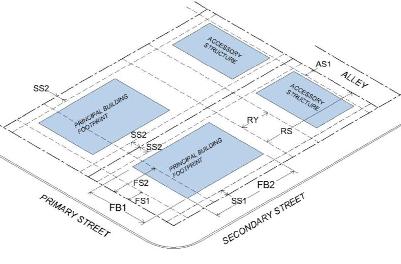
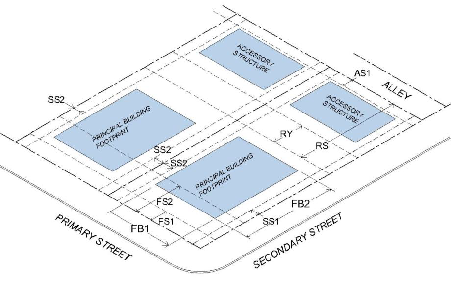
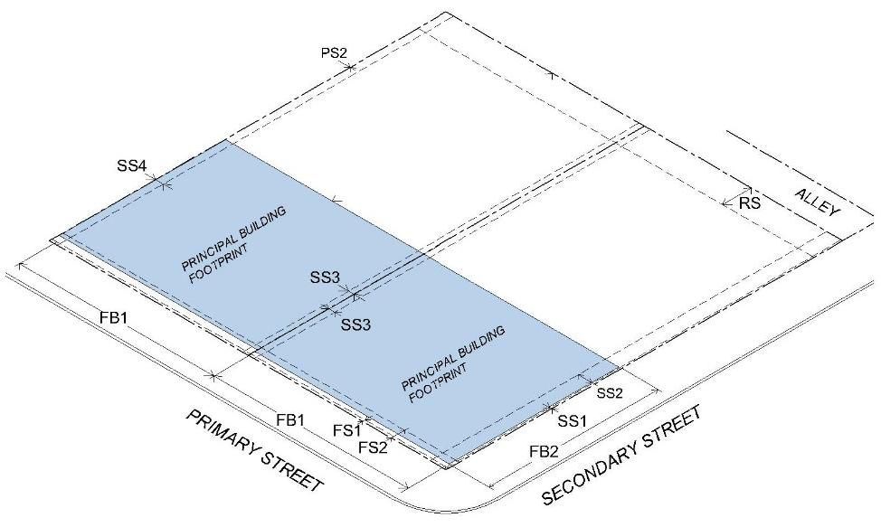 | PRINCIPAL BUILDING SETBACKS | ||
| FS1 | Front Setback (min.) | 0' | |
| FS2 | Front Setback (max.) | 10' | |
| SS1 | Side Setback (min.) (secondary street) | 0' | |
| SS2 | Side Setback (min.) (interior) | 0'* | |
| * Fire Separation Standards apply | |||
| RS | Rear Setback (min.) | 5' | |
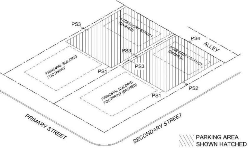
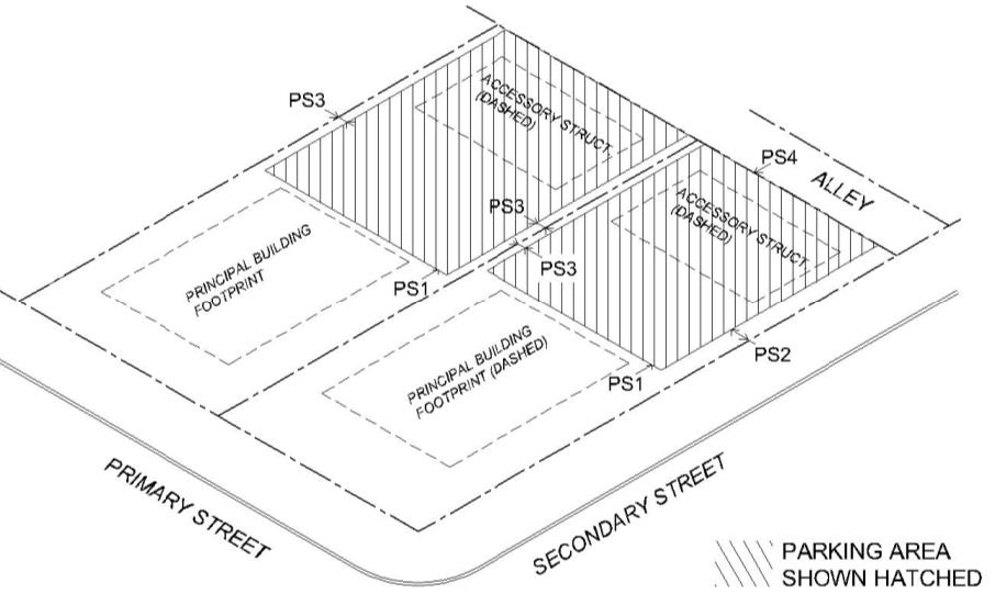
| PARKING PLACEMENT | |||
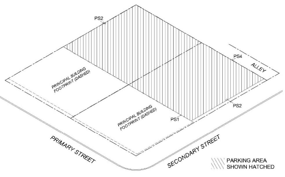 | PARKING SETBACKS | ||
| PS1 | Primary Street Setback (min.) | 40' | |
| OR behind the Principal Building on the lot | |||
| PS2 | Secondary Street Setback (min.) | 5' | |
| OR behind the front facade of the Principal Building on the lot | |||
| PS3 | Side Setback (min.) | 0' | |
| PS4 | Rear Setback (min.) | 0'** | |
| **Rear parking setback from the centerline of the alley is 15' | |||
B.
Downtown General (DT-G).
| GENERAL DESCRIPTION | |||
| The Downtown General (DT-G) is intended to accommodate a wide range of development and redevelopment within the blocks immediately surrounding the historic core of Downtown Brownsville. This district allows for a range of commercial and higher intensity residential uses that can create a vibrant downtown neighborhood. | |||
| BUILDING PLACEMENT | |||
 | PRINCIPAL BUILDING SETBACKS | ||
| FS1 | Front Setback (min.) | 0' | |
| FS2 | Front Setback (max.) | 20' | |
| SS1 | Side Setback (min.) (secondary street) | 0' | |
| SS2 | Side Setback (min.) (interior) | 0'* | |
| * Fire Separation Standards apply | |||
| RS | Rear Setback (min.) | 5' | |
| PARKING PLACEMENT | |||
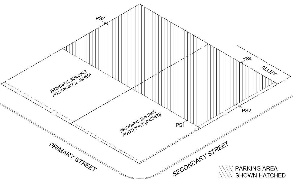 | PARKING SETBACKS | ||
| PS1 | Primary Street Setback (min.) | 40' | |
| OR behind the Principal Building on the lot | |||
| PS2 | Secondary Street Setback (min.) | 5' | |
| PS3 | Side Setback (min.) | 0' | |
| PS4 | Rear Setback (min.) | 0'** | |
| **Rear parking setback from the centerline of the alley is 15' | |||
C.
Downtown Edge (DT-E).
| GENERAL DESCRIPTION | |||
| The Downtown Edge (DT-E) is intended to accommodate a wide range of development and redevelopment within the older blocks immediately surrounding downtown as a transition between Downtown Brownsville and the adjoining historic neighborhoods. This district allows for a range of urban residential uses (single-family, duplex, triplex, and small apartments) and live-work and corner commercial uses that are compatible with the character and pattern of the existing neighborhoods. | |||
| BUILDING PLACEMENT | |||
 | PRINCIPAL BUILDING SETBACKS | ||
| FS1 | Front Setback (min.) (all building types except Corner Commercial) | 8' | |
| FS1 | Front Setback (min.) (Corner Commercial) | 0' | |
| FS2 | Front Setback (max.) | 20' | |
| SS1 | Side Setback (min.) (secondary street) (all building types except Corner Commercial) | 5' | |
| SS1 | Side Setback (min.) (secondary street) (Corner Commercial) | 0' | |
| SS2 | Side Setback (min.) (interior) | 0'* | |
| * Fire Separation Standards apply | |||
| RS | Rear Setback (min.) | 5' | |
| ACCESSORY BUILDING SETBACKS | |||
| AS1 | Alley or Rear Setback (min.) | 0'** | |
| **Setback from the centerline of the alley is 15' | |||
| AS2 | Principal Building Setback (min.) | 5' | |
| PARKING PLACEMENT | |||
 | PARKING SETBACKS | ||
| PS1 | Primary Street Setback (min.) | 50' | |
| OR behind the Principal Building on the lot | |||
| PS2 | Secondary Street Setback (min.) | 5' | |
| PS3 | Side Setback (min.) | 3' | |
| PS4 | Rear Setback (min.) | 0'** | |
| **Rear parking setback from the centerline of the alley is 15' | |||
D.
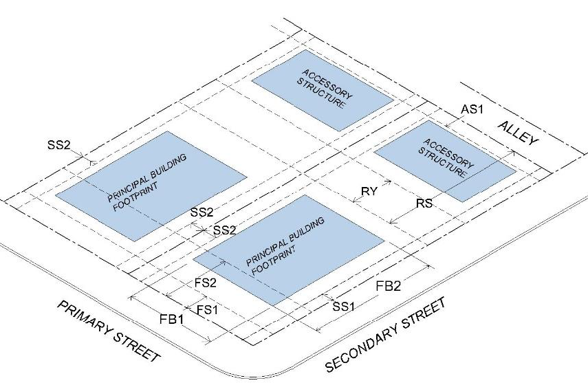
Traditional Neighborhood Corridor (TN-C).
| GENERAL DESCRIPTION | |||
| The Traditional Neighborhood Corridor (TN-C) District is intended to accommodate development and redevelopment along the older commercial corridors that connect Downtown Brownsville to the adjoining neighborhoods. These include the corridors of Elizabeth Street, Palm Boulevard, and portions of 6th and 7th Streets going north towards the Interstate. This district allows for a range of small scale neighborhood oriented commercial uses and missing middle residential uses such as live-work, townhomes and small apartments. | |||
| BUILDING PLACEMENT | |||
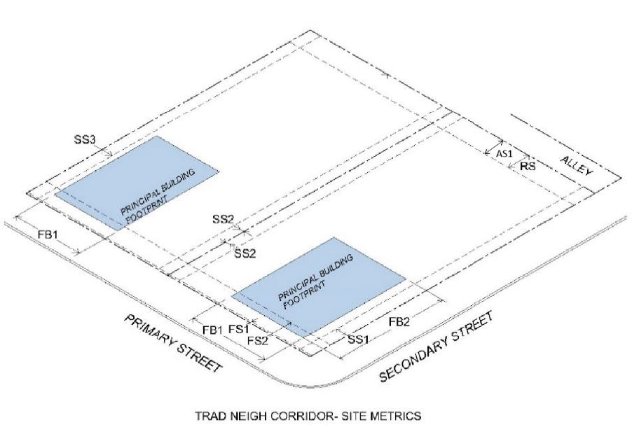 | PRINCIPAL BUILDING SETBACKS | ||
| FS1 | Front Setback (min.) | 5' | |
| FS2 | Front Setback (max.) | 20' | |
| SS1 | Side Setback (min.) (secondary street) | 5' | |
| SS2 | Side Setback (min.) (interior) | 0'* | |
| * Fire Separation Standards apply | |||
| RS | Rear Setback (min.) | 5' | |
| ACCESSORY BUILDING SETBACKS | |||
| AS1 | Alley or Rear Setback (min.) | 0'** | |
| AS2 | Principal Building Setback (min.) | 5'* | |
| * Fire Separation Standards apply | |||
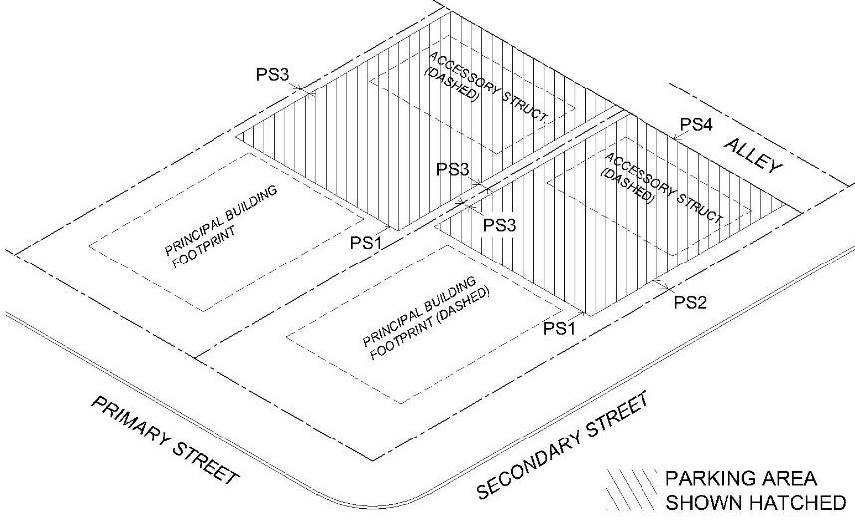
| PARKING PLACEMENT | |||
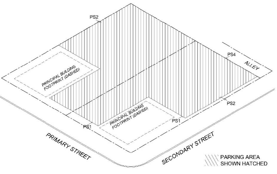 | PARKING SETBACKS | ||
| PS1 | Primary Street Setback (min.) | 40' | |
| OR 5' behind the front facade of the Principal Building on the lot | |||
| PS2 | Secondary Street Setback (min.) | 5' | |
| PS3 | Side Setback (min.) | 0' | |
| PS4 | Rear Setback (min.) | 0'** | |
| **Rear parking setback from the centerline of the alley is 15' | |||
E.
Traditional Neighborhood Mixed Use (TN-MU).
| GENERAL DESCRIPTION | |||
| The Traditional Neighborhood Mixed Use (TN-MU) District is intended to accommodate a wide range of development and redevelopment of older commercial nodes next to traditional neighborhoods of Brownsville. These areas would allow the redevelopment of these aging retail plazas and centers into true mixed use with neighborhood serving office, restaurant, retail and service uses and a range of residential building types with a walkable context. | |||
| BUILDING PLACEMENT | |||
 | PRINCIPAL BUILDING SETBACKS | ||
| FS1 | Front Setback (min.) (all building types except Corner Commercial) | 10' | |
| FS1 | Front Setback (min.) (Corner Commercial) | 5' | |
| FS2 | Front Setback (max.) | 25' | |
| SS1 | Side Setback (min.) (secondary street) (all building types except Corner Commercial) | 10' | |
| SS1 | Side Setback (min.) (secondary street) (Corner Commercial) | 5' | |
| SS2 | Side Setback (min.) (interior) | 0'* | |
| * Fire Separation Standards apply | |||
| RS | Rear Setback (min.) | 5' | |
| ACCESSORY BUILDING SETBACKS | |||
| AS1 | Alley or Rear Setback (min.) | 0'** | |
| **Setback from the centerline of the alley is 15' | |||
| AS2 | Principal Building Setback (min.) | 5' | |
| PARKING PLACEMENT | |||
 | PARKING SETBACKS | ||
| PS1 | Primary Street Setback (min.) | 40' | |
| OR 5' behind the front facade of the Principal Building on the lot | |||
| PS2 | Secondary Street Setback (min.) | 10' | |
| PS3 | Side Setback (min.) | 0' | |
| PS4 | Rear Setback (min.) | 0'** | |
| **Rear parking setback from the centerline of the alley is 15' | |||
F.
Traditional Neighborhood (TN).
| GENERAL DESCRIPTION | |||
| The Traditional Neighborhood (TN) District is intended to accommodate development and redevelopment within the older, established neighborhoods surrounding downtown Brownsville. This district allows for a range of single-family residential residential uses and corner commercial uses in keeping with the historic context of these neighborhoods. | |||
| BUILDING PLACEMENT | |||
 | PRINCIPAL BUILDING SETBACKS | ||
| FS1 | Front Setback (min.) | 10' | |
| FS2 | Front Setback (max.) | 25' | |
| SS1 | Side Setback (min.) (secondary street) | 10' | |
| SS2 | Side Setback (min.) (interior) | 5' | |
| RS | Rear Setback (min.) | 5' | |
| ACCESSORY BUILDING SETBACKS | |||
| AS1 | Alley or Rear Setback (min.) | 0'** | |
| **Setback from the centerline of the alley is 15' | |||
| AS2 | Principal Building Setback (min.) | 5' | |
| PARKING PLACEMENT | |||
 | PARKING SETBACKS | ||
| PS1 | Primary Street Setback (min.) OR behind the Principal Building on the lot | 50' | |
| PS2 | Secondary Street Setback (min.) | 10' | |
| PS3 | Side Setback (min.) | 3' | |
| PS4 | Rear Setback (min.) **Rear parking setback from the centerline of the alley is 15' | 0'** | |
4.3.4 - Special and Overlay Districts.
A.
Purpose.
1.
All overlay districts are intended to address geographic areas having special and substantial public interest.
2.
To the extent specified in this Unified Development Code, property inside the boundaries of an overlay district may be subject to provisions that are more stringent or less stringent than the provisions of an underlying base zoning classification.
B.
Historic Overlay District (O-H).
1.
The purpose of the Historic Overlay (O-H) District is to preserve areas of historical or cultural significance, including sites, structures, and landmarks. Each individual overlay will have specific standard.
2.
See 4.2.3 Historic Preservation Zoning Map Amendments.
3.
See 4.2.5 Certificate of Appropriateness and Demolition in the HP Overlay.
4.
See 4.6.11 Development in the Historic Overlay.
C.
Airport Overlay District (O-A).
1.
The purpose of the Airport Overlay District (O-A) is to ensure development near the airport is compatible with airport operations, that land uses surrounding the airport are developed according to the recommendations of the BRO Airport Master Plan, to limit the adverse impacts of airport operations on adjacent properties by accounting for those impacts in the development and use of property near the airport, and to protect the airport from incompatible encroachments.
2.
See 4.6.12 Development in the Airport Overlay.
D.
Planned Development District (PDD).
1.
The purpose of the Planned Development (PD) District is to provide land for uses and developments that promote development that is more sensitive to the natural environment, create a significantly enhanced natural setting or sense of place, or otherwise enhance the standard pattern of development in Brownsville. Development must provide a higher level of amenities to its users or residents than is usually required under the normal standards of this code. A PD may be used to permit new or innovative concepts in land use not permitted by other zoning districts in this Code or to permit development projects that existing districts cannot easily accommodate.
2.
See 4.2.6 Planned Development District.
E.
Medical Overlay District (MOD).
1.
The purpose of the Medical Overlay District (MOD) is to establish regulations that ensure development near Brownsville's healthcare and biosciences facilities is compatible with such uses in order to:
a.
Support the healthcare and biosciences industry within the City of Brownsville; and
b.
Increase the economic impact of areas containing a high concentration of healthcare and biosciences facilities.
2.
See 4.6.13 Development in the Medical Overlay.
(Ord. No. 2025-235.118, § 1 (Exh. A), 6-3-2025)