
Buckeye City Zoning Code
ARTICLE 2
- ZONING DISTRICTS
2.1. - DISTRICTS ESTABLISHED; ZONING MAP
Article 2 establishes the City's zoning districts and contains statements of purpose and district-specific regulations for each of the zoning districts. Article 3, Use Regulations,Article 4, Dimensional Standards, and Article 5, Development and Design Standards and Guidelines, identify the uses allowed within the zoning districts and the dimensional and other standards applying to development in the zoning districts, respectively.
2.1.1.
Zoning Districts Established. The following zoning districts are established:
The Zoning Administrator shall determine the compatibility of the respective zoning district to the General Plan land use designation since all uses identified in the table above are "possible," but not guaranteed. In addition to the table above, any zoning district may be considered within the Activity Center land use designation, if consistent with the applicable Specific Area Plan for that Activity Center.
2.1.2.
Zoning Map. The zoning districts are shown on the "City of Buckeye Zoning Map" (Zoning Map). The boundaries of zoning districts established in this Development Code are delineated upon the Zoning Map and adopted as part of this Development Code. In the event of uncertainty in the exact boundaries of any of the districts as shown on the Zoning Map, the rules contained in subsection 1.6.2 of this Development Code shall apply.
2.1.3.
Relationship to Overlay Districts. All lands within the City shall be designated as one of the base zoning districts listed in Sections 2.2 through 2.7. In addition, some lands may be designated as one or more of the overlay districts listed in Section 2.8. Where the property is designated as an overlay district as well as a base zoning district, the regulations governing development in the overlay district shall apply in addition to the regulations governing development in the underlying base district, except to the extent the overlay district expressly modifies the underlying base district's regulations. In the event of an express conflict between the two sets of standards, the standards for the overlay district shall control.
(Ord. No. 28-25, § 3, 10-21-2025)
2.2. - RURAL DISTRICTS
2.2.1.
General Purposes of Rural Districts. The rural districts are intended to:
A.
Provide standards for existing agricultural, ranching, and other rural uses, as well as annexed rural lands until suitable redevelopment occurs; and
B.
Provide for appropriately located areas of low-density residential development that are consistent with the General Plan, existing agricultural, ranching, and other rural uses, and standards for public health, safety, and general welfare.
2.2.2.
Agricultural (AG). The AG District is established to provide for the continued use of land for predominantly agricultural and/or ranching purposes, and to preserve undeveloped areas until they can feasibly be developed at urban standards and with adequate public safeguards of health, safety, and welfare.
2.2.3.
Single-Family Residential 43 (R1-43). The R1-43 District is established to provide for low-density residential uses with limited agricultural, animal and ranching privileges and establish a transition area between agricultural uses and more intense development. The district has a minimum lot size of 43,000 square feet.
(Ord. No. 28-25, § 3, 10-21-2025)
2.3. - RESIDENTIAL DISTRICTS
2.3.1.
General Purposes of Residential Districts. The residential zoning districts are intended to:
A.
Provide appropriately located areas for residential development that are consistent with the General Plan and standards for public health, safety, and general welfare;
B.
Allow for a variety of housing types that meet the diverse economic and social needs of current and prospective residents;
C.
Protect the scale and character of existing residential neighborhoods and community character when practical;
D.
Provide for connectivity among residential developments so that an interconnected, integrated pattern of neighborhoods is established; and
E.
Discourage any use that, because of its character or size, would create additional requirements and costs for public services that are in excess of the requirements and costs if the district were developed solely for the intended type of residential uses.
Future rezonings to the residential districts should be consistent with the City's plans for water and sanitary sewer line extensions, as well as expansion of garbage collection services.
2.3.2.
Single-Family Residential 18 (R1-18). The R1-18 District is intended to promote and encourage a suitable environment for residential development on large lots at a low rate of urban population density. Housing density in the R1-18 District shall be higher than the R1-43 District and lower than the R1-10 District. It is the intent of this district to encourage the construction of and the continued use of the land for single-family dwellings, and to prohibit commercial, office, and industrial use, or any other use that would substantially interfere with development or continuation of single-family dwellings or any use not performing a neighborhood function. The district has a minimum lot size of 18,000 square feet.
2.3.3.
Single-Family Residential 10 (R1-10). The R1-10 District is intended to promote the construction of and the continued use of the land for single-family dwellings on large lots with a greater density of land use allowed than in the R1-18 District. The district prohibits commercial and industrial use or any other use that would substantially interfere with the development or continuation of single-family dwellings in this district. The district has a minimum lot size of 10,000 square feet.
2.3.4.
Single-Family Residential 6 (R1-6). The R1-6 District is intended for single-family dwellings on medium-sized lots at a higher density than allowed in the R1-18 and R1-10 Districts. The district prohibits commercial and industrial use or any other use that would substantially interfere with the development or continuation of single-family dwellings in this district. The district has a minimum lot size of 6,000 square feet.
2.3.5.
Single-Family Residential 3 (R1-3). The R1-3 District is intended for small lot single-family dwellings at a higher density than allowed in the R1-6 District. In addition to single-family detached and attached homes, middle housing product types such as two-family homes (duplexes) and townhomes are allowed. The district prohibits commercial and industrial use or any other use that would substantially interfere with the development or continuation of single-family dwellings in this district. The district has a minimum lot size of 3,000 square feet.
2.3.6.
Residential 1 (R1-1). The R1-1 District is intended for small lot single-family dwellings at a higher density than allowed in the R1-3 District. In addition to single-family detached and attached homes, middle housing product types such as two-family homes (duplexes) and townhomes are allowed. The district prohibits commercial and industrial use or any other use that would substantially interfere with the development or continuation of single-family dwellings in this district. The district has a minimum lot size of 1,000 square feet.
2.3.7.
Multi-Family 1 (MF-1). The MF-1 District is intended to accommodate the development of multi-family units, including apartments, condominiums, and bungalow communities, in neighborhoods with medium to high residential densities. It is the intent of this district, through proper site planning and design, to provide compatibility of uses in zoning, assure privacy and individuality by adequate screening techniques, protect adjacent property values, and provide usable open space (exclusive of parking areas and streets).
2.3.8.
Multi-Family 2 (MF-2). The MF-2 District is intended to accommodate the development of multi-family units at urban densities in a mid- or high-rise configuration. This district is intended to be used along major transportation corridors and within or near business centers but is not intended to be used in the immediate proximity of single-family residential development at substantially lower densities. It is the intent of this district to require exceptional site planning and design in order to provide usable open space (exclusive of parking areas and streets) and minimize visual, privacy, and traffic-related impacts on any adjacent residential development or open space.
2.3.9.
Mobile Home/RV Park (MH). The MH District is intended to encourage the development of properly planned mobile home/RV parks and subdivisions in residential environments and to establish standards for the size, design, and quality of mobile home/RV parks.
(Ord. No. 28-25, § 3, 10-21-2025)
2.4. - MIXED-USE DISTRICTS
2.4.1.
General Purposes of Mixed-Use Districts. Mixed-Use districts define the uses of land and the siting and character of the improvements and structures to promote compatibility between residential and nonresidential uses. The districts also are intended to encourage redevelopment of underutilized parcels and infill development of vacant parcels. The Mixed-Use Districts specifically are intended to:
A.
Concentrate higher-density residential development and commercial and office employment efficiently in and around the Downtown, major employment centers, and other designated centers of community activity;
B.
Encourage mixed-use and higher-density redevelopment, conversion, and reuse of aging and underutilized areas, and increase the efficient use of available land in the City;
C.
Create compact and pedestrian-oriented environments that encourage transit use and pedestrian access;
D.
Ensure that development in mixed-use areas is of high quality and provides pedestrian scale and interest through use of varied forms, materials, details, and colors, especially at the ground floor and second story; and
E.
Ensure that office, commercial, or retail space occupies the majority of the ground-floor area of all mixed-use buildings.
2.4.2.
Neighborhood Mixed-Use (NMU). The NMU District is intended to provide for small, compact commercial/residential centers within or surrounded by residential areas, compatible in scale and character with surrounding residential uses, to serve the convenience needs of the immediately surrounding neighborhood. NMU centers are between one-half to five acres in size. Ground-floor, small-scale retail and restaurants are encouraged, with upper-story residential and office uses. Continuous commercial frontages, largely uninterrupted by driveways and parking, are encouraged.
2.4.3.
Community Mixed-Use (CMU). The CMU District is intended to provide for community-serving commercial/residential development at a higher scale than is appropriate for the NMU District. The CMU District is intended for use along selected corridors and at important nodes in the City on sites of five acres or larger. The CMU District is intended to include commercial, institutional, recreational, and service facilities needed to support surrounding neighborhoods and the community at large. Medium- to higher-density housing shall be incorporated within or located around the district. Development shall facilitate pedestrian connections between residential and nonresidential uses.
2.4.4.
Regional Mixed-Use (RMU). The RMU District is designed to accommodate the highest-intensity mixed-use development in key areas or nodes as identified in the General Plan. This district is intended to include the broadest range of uses and serve as a regional activity and employment center. The RMU District is designed for both pedestrians and automobiles, as well as alternative modes of transportation. This district is intended to include a mixture of commercial, office, and residential uses.
2.4.5.
Industrial Mixed-Use (IMU). The IMU District is designed to accommodate mixed-use industrial development in key areas or nodes as identified in the General Plan. This district is intended to serve as an employment center. The IMU District is designed for both automobile and alternative modes of transportation. This district is intended to include a mixture of industrial uses with related commercial, office, and business park uses.
2.4.6.
Downtown Commercial (DC). The DC District is intended to provide for and encourage development and redevelopment that preserves and enhances the unique character and vitality of the Downtown. Permitted uses include public uses, offices, retail, restaurants, entertainment/recreation, and services that are destination-oriented in nature. Residential uses are also permitted if not the dominant ground floor use along the area's primary main streets, Monroe Avenue and 4th Street. Design standards focus on creating a human-scaled, pedestrian-oriented, and walkable Downtown, where automobile-oriented uses, if present, will be designed to de-emphasize drive-throughs and parking from the perspective of adjacent streets. To be eligible for DC Zoning, a property must be located within the Downtown Activity Center and be designated as part of the Downtown Core on Figure 3.1 (Long-Term Future Land Use Framework Plan) of the Downtown Specific Area Plan (DSAP).
2.4.7.
Downtown Residential (DR). The DR District allows for development and redevelopment of properties within the Downtown Activity Center that are not located adjacent to the area's primary main streets, including many of the City's older residential neighborhoods. The district allows for a variety of residential uses including single-family residential, duplexes, and multi-family residential, as well as a tailored list of compatible commercial and office uses. To be eligible for DR zoning, a property must be located within the Downtown Activity Center and be designated as Downtown Residential on Figure 3.1 (Long-Term Future Land Use Framework Plan) of the DSAP.
(Ord. No. 28-25, § 3, 10-21-2025)
2.5. - OFFICE AND COMMERCIAL DISTRICTS
2.5.1.
General Purposes of Office and Commercial Districts. The office and commercial zoning districts generally are intended to:
A.
Provide appropriately located areas for retail, service, and office uses consistent with the General Plan;
B.
Strengthen the City's economic base and provide employment opportunities close to home for residents of the City and surrounding communities; and
C.
Minimize negative impact of nonresidential development on adjacent residential land uses.
2.5.2.
Professional Office (PO). The PO District is intended to provide locations for offices and supporting commercial uses. Activities located in the PO District should have traffic generation characteristics associated with an office environment; may have supporting retail or other limited commercial uses; should require limited identification by signage; and should generate virtually no noise, odor, dust, or vibration.
2.5.3.
Neighborhood Commercial (C-1). The C-1 District is intended for small, compact commercial uses within or surrounded by residential areas, compatible in scale and character with surrounding residential uses, to serve the convenience needs of the immediately surrounding neighborhood.
2.5.4.
Community Commercial (C-2). The C-2 District is intended to provide for the development of commercial corridors with community-serving uses with a three- to five-mile market area. The C-2 District is intended to provide for a full range of community-oriented retail and service commercial uses but is not intended to accommodate large-scale commercial or retail uses with a City-wide or regional market area.
2.5.5.
Regional Commercial (C-3). The C-3 District is intended primarily for uses that provide commercial goods and services to residents of the region in areas that are dependent on automobile access and exposed to heavy automobile traffic. This district is intended to accommodate large-scale commercial or retail uses with a City-wide or regional market area. For example, high-intensity regional shopping centers on large sites with multiple buildings are appropriate within the C-3 District. These commercial uses are subject to frequent view by the public and visitors to the City, and they should provide an attractive appearance with landscaping, sufficient parking, and controlled traffic movement.
2.5.6.
Business Park (BP). The BP District is intended to allow for a mixture of light industrial, office, manufacturing, and limited retail uses in a business park, industrial park, or campus setting with high-quality site and building design.
(Ord. No. 28-25, § 3, 10-21-2025)
2.6. - INDUSTRIAL DISTRICTS
2.6.1.
General Purposes of Industrial Districts. The industrial zoning districts generally are intended to:
A.
Provide appropriately located areas, consistent with the General Plan, for industrial uses;
B.
Strengthen the City's economic base and provide employment opportunities close to home for residents of the City and surrounding communities; and
C.
Minimize any negative impact of industrial development on adjacent or nearby residential land uses.
2.6.2.
Light Industrial (I-1). The I-1 District is intended to provide for light manufacturing, warehousing, processing, service, storage, wholesale, distribution operations, and research and development uses, with all operations contained within an enclosed building.
2.6.3.
Heavy Industrial (I-2). The I-2 District is intended to provide for heavy industrial development that has some, any, or all of the following: (a) potentially noxious impacts, or (b) very heavy truck traffic for supplies, storage, or shipping, or (c) outdoor storage and operations. Examples include heavy manufacturing, storage, major freight terminals, waste and salvage, large dairy operations, distribution centers, processing, and other related uses. The intent is to preserve this land especially for industry in locations with access to major streets as designated on the General Plan map, as well as locations generally accessible to railroad transportation. The district is also intended for military uses. Because of the intensive nature of the uses that may be allowed in this district, a buffer and other site design requirements may be necessary around this district to protect other zoning districts except the I-1 District.
(Ord. No. 28-25, § 3, 10-21-2025)
2.7. - PLANNED AREA DEVELOPMENT DISTRICT
2.7.1
Planned Area Development (PAD). The PAD District is established to provide an alternative to conventional development and requires approval under the procedures in Section 8.6, Planned Area Developments, of this Development Code. For the purpose of this chapter, each occurrence of the term PAD also refers to all previously approved Community Master Plans (CMPs) and PADs, including previous CMP and PAD Overlay Districts and CMP and PAD Zoning Districts.
A.
Purpose. The PAD District is intended to accomplish all of the following purposes:
1.
To allow and encourage innovative coordinated land development while maintaining appropriate limitations on the character and intensity of use, assuring compatibility with adjoining and proximate properties;
2.
To allow greater flexibility within the development to best utilize the physical features of the particular site, in exchange for greater public benefits than would otherwise be achieved through development under this Development Code;
3.
To ensure that any development impacts that occur through the use of greater flexibility are mitigated to the greatest extent feasible so as not to create adverse impacts on neighboring properties or the surrounding neighborhood;
4.
To encourage the provision and preservation of meaningful interconnected open space that can provide meaningful recreational opportunities or connect to and supplement adjacent open spaces to provide more valuable public amenities;
5.
To encourage integrated and unified design and function of the various uses comprising the PAD;
6.
To encourage a more productive use of land consistent with the public objectives and standards of accessibility, safety, infrastructure, and land use compatibility;
7.
To foster a strong sense of community based on the distinctive character of the development and a shared physical and economic environment; and
8.
To ensure that planned developments function in an integrated fashion with amenities and benefits and with enhanced design not required or available in standard subdivision development.
B.
District Conversion.
1.
Any property converted to PAD Zoning District from the Planned Community (PC) Zoning District will be able to develop according to the existing approved PAD or CMP Overlay District, so long as the entitlements have not been terminated or extinguished and unless otherwise amended with a formal application for a PAD Amendment. Any property converted to PAD Zoning District from the PC Zoning District that is unplatted will be able to develop according to the development plan within the approved PAD or CMP Overlay District and Development Agreement, to the extent the development rights, duties, and obligations have not been terminated or extinguished.
2.
Any property that is converted to PAD Zoning District from the Planned Residential (PR) Zoning District will be able to develop via an approved Site Plan or plat according to standards and uses listed in Appendices B and C unless otherwise amended with a formal PAD application. PR lots smaller than the minimum lot size when converted shall be deemed legal nonconforming.
3.
Any existing PAD or CMP Overlay District without an active Development Agreement undergoing a Major Amendment is required to rezone to PAD District. Minor Amendments to an existing PAD or CMP Overlay District, with or without an active Development Agreement, may remain as a PAD or CMP Overlay District.
(Ord. No. 28-25, § 3, 10-21-2025)
2.8. - OVERLAY DISTRICTS
2.8.1.
Apache-Rainbow Employment Overlay District (AREOD).
A.
Purpose. The Apache-Rainbow Employment Overlay District is established to enhance economic opportunities, streamline review and approval procedures, and provide an alternative to conventional industrial development standards within the overlay district. It is the intent of these provisions to provide context-sensitive design flexibility and enhance land use compatibility between industrial-employment based uses and adjacent existing and future residential neighborhoods.
B.
Boundaries. The boundaries of the AREOD are established as shown on Figure 2.8-A, generally bounded by Southern Avenue, Apache Road, the Union Pacific Railroad, and Rainbow Road.
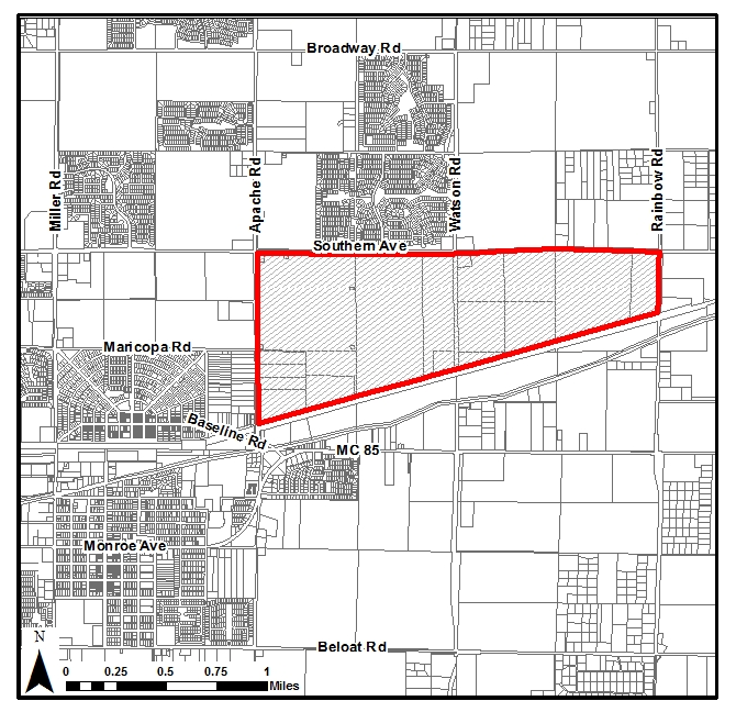
Figure 2.8-A: Apache-Rainbow Employment Overlay District
C.
General Regulations.
1.
General Applicability. Unless otherwise specifically identified in this subsection, all guidelines and standards of this Development Code shall apply to all development within the district.
2.
Building Design Standards.
a.
Architectural Character. Large-scale industrial processes often require specialized building designs which accommodate long-run assembly, manufacturing, research and other industrial methods. The standards and guidelines of subsections 5.8.2B, 5.8.3.B, 5.8.3.D, and 5.8.3.E may impact these operations and shall not apply to industrial or manufacturing uses in buildings over 50,000 square feet within the district. However, designs which incorporate these standards and guidelines are encouraged.
b.
Preferred Building Structure Wall Materials. Subsection 5.8.3.F shall not apply. The following materials are preferred for use on exterior building walls, individually or in combination:
i.
Brick;
ii.
Stone (natural or simulated);
iii.
Painted, stained, or integrally-colored concrete masonry units (CMU), split-face or ground-face;
iv.
Tilt-up concrete panels, with or without reveals;
v.
Stucco;
vi.
Exterior insulation and finish systems (EIFS);
vii.
Clear and tinted glass;
viii.
Tile;
ix.
Wood; and/or
x.
Architectural metal;
Other materials may be used provided they are of comparable quality, durability, and character, as determined by the Zoning Administrator.
c.
Alternative Wall Materials. The following materials are additional alternative allowed wall materials for buildings which exceed 50,000 square feet and contain industrial/manufacturing uses. They may be used individually or in combination with any material listed in subsection 2.8.1.C.3.b.
i.
Pre-fabricated metal panels; and/or
ii.
Corrugated or rolled metal.
3.
Landscaping.
a.
Site Perimeter Landscaping. Subsection 5.4.3.B shall not apply. A minimum landscape buffer of up to 150 feet of the required setback shall be provided along all arterial streets from the edge of the right-of-way.
i.
Under all circumstances, a 50-foot minimum landscaping buffer shall be provided adjacent to Watson Road right-of-way.
ii.
Except for the buffer adjacent to Watson Road, this buffer may be reduced to 20 feet if buildings which abut the landscape buffer are composed of the preferred wall materials listed in subsection 2.8.1.C.
iii.
If the 150-foot buffer is required, outdoor storage and parking may encroach into the site perimeter landscaping buffer 75 feet, provided that a minimum six-foot-tall architectural screen wall is located between the outdoor storage and/or parking and the adjacent right-of-way line. The materials or equipment stored as outdoor storage or parking shall not exceed the height of the screen wall.
iv.
This site perimeter landscaping shall count towards the site enhancement landscaping required by subsection 5.4.3.A.
v.
Drainage facilities may be located within the site perimeter landscaping buffer.
b.
Building Foundation Plantings. Subsection 5.4.3.D shall not apply. All development shall provide a minimum of one shrub for each eight lineal feet of building façade along all building façades that are adjacent to or facing public streets or parking areas. Four shrubs can be replaced with one tree. Plantings may be placed in-ground within 15 feet of the building façade. As an alternative, required plantings may be placed in adjacent yards to aid in screening.
c.
Entryways (Landscaping). Subsection 5.4.3.E shall not apply.
4.
Walls, Fencing and Screening. Subsection 5.4.6 shall not apply.
a.
Walls and Fences.
i.
Height. Walls and fences located between the principal structure and street-side and front property lines shall not exceed six feet in height; additional height of up to two feet may be granted for retaining walls, sites with elevated foundations, or to enhance screening of outdoor storage. Walls and fences located between the principal structure and the rear or side property line shall not exceed eight feet in height. Columns, pilasters and other narrow features are allowed to exceed the maximum wall or fence height by eight inches for no more than two feet of run. Walls utilized in industrially zoned districts may exceed eight feet if needed to better screen areas from public view as determined by the Zoning Administrator.
ii.
Articulation. Walls and fences shall be articulated to avoid continuous, unbroken expanses. Walls and fences facing an arterial or highway may not extend continuously, without articulation, for more than 200 feet, or 100 feet for fences facing any other type of public street. Walls and fences may be articulated using any combination of the following:
(1)
Changes in material or texture, including the use of view walls that allow for views into the site;
(2)
Offsets (projections or recessions of at least two feet);
(3)
Columns, pilasters or other vertical changes at regular intervals;
(4)
Landscape pockets and/or runs of landscaping along fence lines; and/or
(5)
Similar features as approved.
iii.
Wall and Fence Materials. Walls and fences shall be constructed with any combination of the following materials:
(1)
Integrally-colored, split-face, or ground-face concrete masonry units (CMU);
(2)
Concrete masonry units (CMU) that have been painted, stuccoed, or faced with another allowed material;
(3)
Stone (natural or simulated);
(4)
Brick;
(5)
Wrought-iron or other decorative metal; and/or
(6)
Chain-link fencing (industrial/manufacturing uses only that are not visible from freeways, arterial, and collector streets).
iv.
Wall and Fence Placement. Walls and fences may be placed within the public right-of-way.
b.
Screening of Refuse Collection and Mechanicals.
i.
Solid waste collection areas and ground-level mechanical equipment shall be screened from the view of a six-foot tall person standing on the property line on the far side of an adjacent public street.
ii.
Individual screening of rooftop mechanical equipment is prohibited. Best efforts shall be taken so that rooftop units are either grouped together and screened "penthouse style" or screened with a parapet wall the entire length of the building. This screening design shall be consistent with the architecture of the building, and parapet wall design shall be integral to the overall architecture of the building.
c.
Screening of Services and Impact Mitigation. Loading docks, truck parking, outdoor storage, trash collection, trash compaction, and other service functions shall be incorporated into the overall design of the building and landscaping so that the acoustic impacts of these functions are contained to the maximum extent feasible, and so that the features are fully screened and out of view from public streets. Use screening materials for solid waste collection and loading areas that are the same and of equal quality to the materials used for the primary building and landscaping.
d.
Screening of Utilities. All site utilities shall be located underground, including but not limited to electric lines less than 69kV, telephone, cable, water, and sewer systems, per applicable utility requirements and specifications. Where feasible, locate above-ground utility facilities, such as utility cabinets and meters, in areas that do not conflict with site circulation or visibility areas. Screen these facilities with dense landscaping or decorative fences and/or integrate into the building design as appropriate.
D.
General Procedures.
1.
General Applicability. Unless otherwise specifically identified in this subsection, all procedures of Article 8, Review and Approval Procedures, shall apply to all development within the district.
2.
Review Procedures and Criteria.
a.
Site Plan, Landscaping and Building Design Review Procedures. Section 8.9 shall not apply. A conceptual Site Plan, Landscape Plan, and building elevations shall be submitted for administrative review and approval by the Zoning Administrator. Site Plan, Landscape Plan, and building design approval constitutes authorization for submittal of final construction and civil improvement plans and reports.
2.8.2.
Airport Overlay District (AOD).
A.
Purpose. The Airport Overlay District (AOD) is established to enhance economic opportunities, streamline review and approval procedures, and provide aviation specific Development Standards within the overlay district.
B.
Boundaries. The boundaries of the AOD are established as shown on Figure 2.8-B, generally bounded by West Yuma Road to the north, South Palo Verde Road to the east, West Elwood Street alignment to the south, and South Bruner Road alignment to the west. Boundaries are subject to change as the airport acquires additional real property for airport expansion and development.
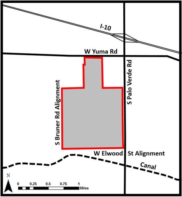
Figure 2.8-B: Airport Overlay District (AOD)
C.
General Regulations.
1.
General Applicability. Unless otherwise specifically identified in this subsection, all guidelines and standards of this Development Code shall apply to all development within the district.
2.
Building Design Standards.
a.
Architectural Character.
Aeronautical Related Uses. Aeronautical uses often require specialized building designs which accommodate hangars, offices, fueling facilities, warehouses, and other aviation-related structures that require direct or indirect access to taxiways and the runway. The standards and guidelines of Section 5.8 may impact these operations and shall not apply to buildings with aeronautical uses within the district. However, designs which incorporate these standards and guidelines are encouraged where practical in compliance with the Airport Layout Plan (ALP) as amended.
Non-aeronautical Uses. Located primarily along the frontage of Palo Verde Road, non-aeronautical uses such as restaurants, commercial offices, aviation related businesses, and retail that do not require airport access, as determined by the Aviation Director and as shown on the ALP, will follow the zoning regulations of the underlying zoning district and will be subject to the provisions of Section 5.8 where compatible with the ALP. Any future area plans that address design and development will apply to the non-aeronautical uses as described herein.
b.
Preferred Building Wall Materials for Aviation Related Uses. Subsection 5.8.3.F. shall not apply. The following materials are preferred for use on exterior building walls, individually or in combination:
i.
Brick;
ii.
Stone (natural or simulated);
iii.
Painted, stained, or integrally-colored concrete masonry units (CMU), split-face or ground-face;
iv.
Concrete walls (prefabricated, cast in place, tilt up, etc.);
v.
Smooth finish stucco or EIFS, used sparingly and accompanied by other finish materials such as brick or metal; and/or
vi.
Double paned, low E coated and/or tinted window glazing, which shall be angled downward or perpendicular to the ground plane to reduce glare.
c.
Prohibited Exterior Building Materials. The following materials shall not be used within the entire AOD, unless otherwise authorized by the Aviation Director:
i.
Wood materials on the exterior of any building, except for decorative accents;
ii.
Galvanized roofing materials due to reflectivity;
iii.
Fabric on the exterior of the building envelope;
iv.
Chrome or other highly polished reflective materials that may cause glare;
v.
Asphalt or wood shingles;
vi.
Ballasted or asphaltic roofing; and
vii.
Solar panels, unless they can be certified to pass all glare requirements as noted in Federal Register 78 FR 63726, FAA Interim Policy for Solar Energy System Projects on Federally Obligated Airports.
d.
Alternative Building Wall Materials. The following materials are allowed wall materials for aeronautical structures. They may be used individually or in combination with any material listed in Section 2.8.2.C.2.b.
i.
Pre-fabricated metal panels; and/or
ii.
Corrugated or rolled metal.
e.
Pre-engineered Buildings. Pre-engineered buildings are allowed structures within the AOD for use on aeronautical facilities (hangars) or other similar facilities within the AOD as determined by the Aviation Director.
3.
Landscaping. The requirements of Section 5.4 shall not apply to the AOD. Landscaping within the AOD is modified from standard requirements for reasons of safety and security. The following shall apply:
a.
Aeronautical Area. Landscaping is limited to plants less than 18 inches in height that do not require irrigation, pavement, or landscape rock. All proposed landscaping shall be free of materials that can be ingested by aircraft engines, known as foreign object debris (FOD).
b.
Non-Aeronautical Area. A "xeriscape" approach to landscaping shall be utilized that provides an uncluttered, clean, and orderly representation of the Southwest Desert; however, plantings shall not attract wildlife or birds.
c.
Air/Non-Aeronautical Buffer. Due to the need to provide visual surveillance from the non-aeronautical side to the aeronautical side, there shall be a 20-foot buffer on the non-aeronautical side for any proposed plantings. Trees planted outside the 20-foot boundary shall remain trimmed to seven feet clear and in no case shall the mature canopy be greater than 20 feet in diameter. Within the 20-foot buffer, all plantings are limited to 18 inches in height. See Figure 2.8-C.
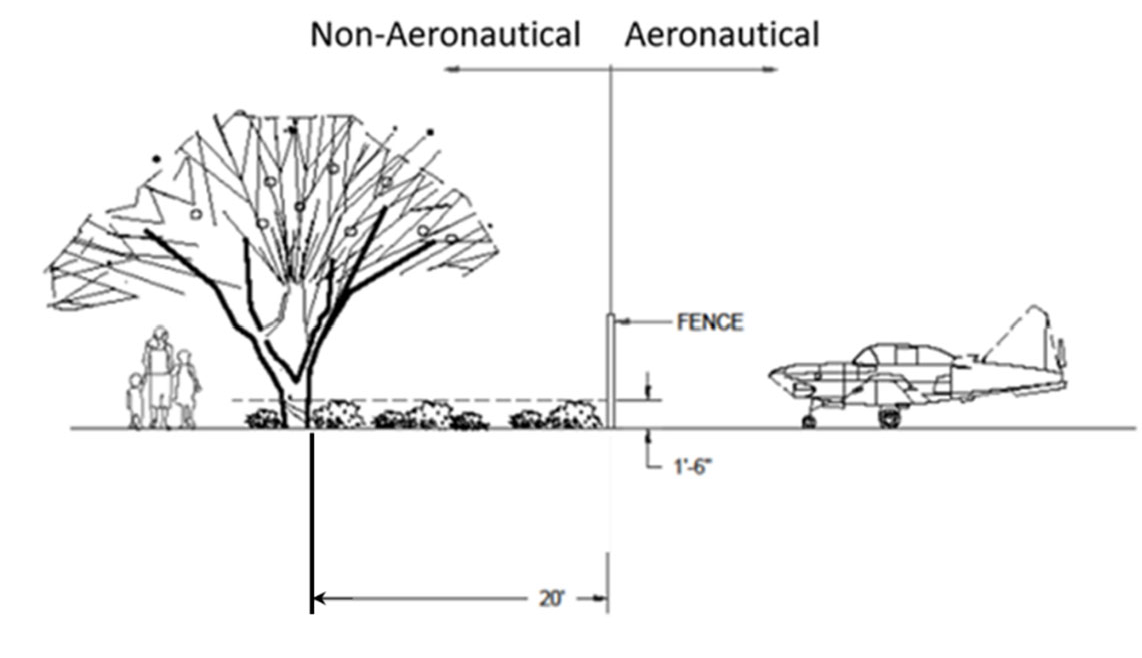
Figure 2.8-C: Landscape Buffer
4.
Walls, Fencing and Screening.
a.
Subsection 5.4.6 shall not apply to aeronautical areas as defined by the ALP.
b.
Non-Aeronautical Area Walls and Fences.
i.
Height. Walls and fences located between a structure and street-side property lines shall not exceed six feet in height. Additional height of up to two feet may be granted for retaining walls, sites with elevated foundations, security measures, or to enhance screening of outdoor storage. Walls and fences located between structures and the rear or side property line shall not exceed eight feet in height. Columns, pilasters, and other narrow features are allowed to exceed the maximum wall or fence height by eight inches for no more than two feet of run.
ii.
Articulation. Walls and fences shall be articulated to avoid continuous, unbroken expanses. Walls and fences facing an arterial or highway may not extend continuously, without articulation, for more than 200 feet, or 100 feet for walls and fences facing any other type of public street. Walls and fences may be articulated using any combination of the following:
(1)
Changes in material or texture, including the use of view walls that allow for views into the site;
(2)
Offsets (projections or recessions of at least two feet);
(3)
Columns, pilasters, or other vertical changes at regular intervals; and/or
(4)
Landscape pockets and/or runs of landscaping along wall or fence lines; or similar features as approved by staff.
iii.
Wall and Fence Materials. Walls and fences shall be constructed with any combination of the following materials:
(1)
Integrally-colored, split-face, or ground-face concrete masonry units (CMU);
(2)
Concrete masonry units (CMU) that have been painted, stuccoed, or faced with another allowed material;
(3)
Stone (natural or simulated);
(4)
Brick;
(5)
Wrought-iron or other decorative metal; and/or
(6)
Minimum six-foot tall chain-link fencing with three strand barbed wire. Where fencing is required along South Palo Verde Road due to non-aeronautical land lease development that would require access to South Palo Verde Road, subsections (1) through (5) would be required; however, the interior border separating aeronautical activity of the land leased non-aeronautical parcels may use a minimum six-foot tall chain-link fencing with three strand barbed wire, as approved by the Aviation Director.
iv.
Wall and Fence Placement. Walls and fences may not be placed within the public right-of-way.
c.
Aeronautical/Non-Aeronautical Area Requirements. Fencing that separates the aeronautical and non-aeronautical areas shall meet FAA security fencing requirements (FAA Advisory Circular 150/5370-10G, Change 8, as amended). Construction or climbable objects on the non-aeronautical side will not be closer than ten feet to any aeronautical area's perimeter fencing.
d.
Screening of Refuse Collection and Mechanicals.
i.
Solid waste collection areas and ground-level mechanical equipment shall be screened from the view. Solid waste and ground-level mechanical equipment enclosures shall be located on the non-aeronautical side of the hangar fence to allow collection and/or servicing from the vehicle access road.
ii.
Individual screening of rooftop mechanical equipment is prohibited. Best efforts shall be taken to screen rooftop equipment from the perspective of adjacent public rights-of-way so that rooftop units are either grouped together and screened "penthouse style" or screened with a parapet wall the entire length of the building. This screening design shall be consistent with the architecture of the building, and parapet wall design shall be integral to the overall architecture of the building.
e.
Screening of Services and Impact Mitigation. Outdoor storage, trash collection, trash compaction, and other service functions shall be incorporated into the overall design of the building and landscaping so that the acoustic impacts of these functions are contained to the maximum extent feasible, and so that the features are fully screened and out of view from public streets. Use screening materials for solid waste collection and loading areas that are the same and of equal quality to the materials used for the primary building and landscaping.
f.
Screening of Utilities. All site utilities shall be located underground, including but not limited to electric lines less than 69kV, telephone, cable, water, and sewer systems, per applicable utility requirements and specifications. 69kV and larger electric lines will be undergrounded when interfering with airport operations as determined by the Aviation Director. Where feasible, locate above-ground utility facilities, such as utility cabinets and meters, in areas that do not conflict with site circulation or visibility areas. Screen these facilities with dense landscaping or decorative fence and/or integrate into the building design as appropriate.
D.
General Procedures.
1.
General Applicability. Unless otherwise specifically identified in this subsection, all procedures of Article 8, Review and Approval Procedures, shall apply to all development within the district.
2.
Review Procedures and Criteria.
a.
Site Plan, Landscaping, and Building Design Review Procedures for Aeronautical Uses. Section 8.9 shall not apply. A conceptual Site Plan, Landscape Plan, and building elevations shall be submitted for administrative review and approval by the Zoning Administrator and the Aviation Director. Site Plan, Landscape Plan, and building design approval constitutes authorization for submittal of final construction and civil improvement plans and reports.
2.8.3.
Downtown Overlay District (DOD). The Downtown Overlay District (DOD) is established to preserve and enhance Downtown's unique, rural, and historic character in accordance with the DSAP. The DOD also protects the identity of a Downtown main street, developing standards and creating allowances that promote an economically viable part of the City by encouraging revitalization with new commercial and residential infill development. Downtown reflects a pedestrian and mixed-use emphasis.
A.
Downtown Boundary. The boundaries of the DOD are generally Miller Road on the west, Maricopa Road on the north, 239th Avenue (alignment) on the east, and Irwin Avenue/Beloat Road on the south, shown in Figure 2.8-D below.
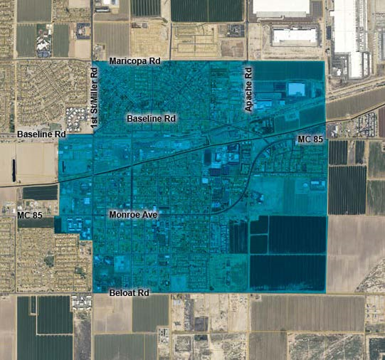
Figure 2.8-D: Downtown Overlay District (DOD)
(Ord. No. 28-25, § 3, 10-21-2025)
2.9. - OBSOLETE DISTRICTS
The zoning districts in this subsection are carried forward from prior superseded editions of this Development Code. No future rezonings may occur to any of the obsolete districts listed in this subsection. Development on property having an obsolete zoning district classification is allowed subject to the development standards in Appendix B and occupied by uses in Appendix C; compliance with the design standards listed in Article 5 is also required. The City strongly recommends that any new project that moves forward with a development proposal within an obsolete district rezone to the conversion districts shown below and in Table 2.9-1. All rezonings to suggested conversions will be deemed compatible with the General Plan.
2.9.1.
Rural Residential (RR) May Be Converted to AG District. The RR District is designed to accommodate low-density residential development in outlying areas where all public services may not be available.
2.9.2.
Planned Residential (PR) With an Approved Plat May Be Converted to PAD District. Without a Plat May Be Converted to R1-6 District. The PR District is designed to accommodate all subdivided residential developments to which public services are available.
2.9.3.
Mixed Residential (MR) May Be Converted to NMU District. The MR [District] is designed to accommodate both single- and multiple-family residential development, historic residential neighborhoods, and compatible commercial uses.
2.9.4.
Planned Community (PC) With an Approved PAD or CMP Overlay District May Be Converted to PAD District. Without Approved PAD or CMP Overlay District May Be Converted to R1-43 District. The PC District is designed to accommodate all land uses approved as part of a PAD or CMP, where specific uses, public services, densities, and design criteria have been identified and adopted.
2.9.5.
Commercial Center (CC) May Be Converted to CMU District. The CC District is designed to accommodate a variety of commerce and specialized development, including commercial uses that comprise the Central Business District of the City.
2.9.6.
General Commerce (GC) May Be Converted to IMU District. The GC District is designed to accommodate general commercial and employment uses and compatible industrial uses to which public services are available.
2.9.7.
Special Use (SU) May Be Converted to AG District Outside of the Historic Downtown. Inside the Historic Downtown May Be Converted to DR District. The SU District is designed to accommodate uses in natural hazard or floodplain areas or those under public ownership where development may not be possible because of flooding or other constraints or if development is possible, it is sponsored by the City as a public purpose.
(Ord. No. 28-25, § 3, 10-21-2025)