
Buckeye City Zoning Code
ARTICLE 5
- DEVELOPMENT AND DESIGN STANDARDS AND GUIDELINES
5.1. - GENERAL PROVISIONS
5.1.1.
General Intent. This Article includes standards and guidelines for developing property or establishing new uses of property within Buckeye, to ensure the protection of the health, welfare, safety, and quality of life for local citizens, visitors, and business owners. These provisions address the physical relationship between development and adjacent properties, public streets, neighborhoods, and the natural environment, in order to implement the General Plan vision for a more attractive, efficient, and livable community.
5.1.2.
Applicability.
A.
General Applicability. Unless exempted under subsection 5.1.2 B., Exemptions, or unless otherwise provided in this Article, this Article shall apply to the following types of development:
1.
New construction or development;
2.
Any project that involves demolition of an existing primary building and the construction of a new primary building;
3.
Any renovation, rehabilitation, restoration, or repair work that includes an addition of floor area equal to 50 percent or more of the existing floor area; or the addition of new floors (collectively "substantial renovation"). The calculation shall include attached garages, but not detached garages. For the purposes of calculation, the increase in floor area shall be aggregated over a three-year period.
4.
Any renovation, rehabilitation, restoration, or repair that alters the exterior appearance of an existing building must comply with the architectural design requirements outlined in this Section. However, unless a project meets the criteria of paragraphs 1, 2, and/or 3 above, compliance with site design, layout, parking, landscaping, and similar subsections requiring modification to portions of a site not developed with structures is not mandatory.
5.
Any conversion of an existing commercial or industrial building from a less parking intensive use to a more parking intensive use, when the amount of existing on-site parking spaces is less than the amount required by this Development Code. Conversion of an existing building to a more parking intensive use shall not require compliance with this Section if the amount of existing parking is sufficient for the new use.
6.
Any new outdoor use or expansion of an existing outdoor use.
B.
Exemptions. The following are exempt from this Article:
1.
Projects for which a complete Site Plan application has been submitted and is considered active or approved and in good standing prior to the effective date of this Development Code, provided that full Improvement Plans are submitted and active prior to the expiration of the Site Plan; and
2.
Development within an approved Planned Area Development (PAD) area is subject to the standards of Article 5, Development and Design Standards and Guidelines, except where an alternate standard (Modified Provision) is approved within a PAD. However, the application of the standards and guidelines in this Article shall not limit the uses, densities, or intensities approved in the PAD. If a new PAD is submitted for initial review for a particular property following the effective date of this Development Code, this Article shall serve as the "baseline" for the development of any development or design standards to be incorporated into the plan. All PADs are subject to vesting rights as defined in state statutes, and the City Code, and Development Agreements (if applicable).
5.1.3.
Standards and Guidelines. This Article contains both standards and guidelines.
A.
Standards are rules, principles, or measures with which compliance is mandatory unless expressly modified through the Variance or Minor Modification procedures in Sections 8.12, Variances, or 8.13, Administrative Deviations, or if a modified standard is approved through the alternative equivalent compliance (AEC) procedures outlined in Section 5.1.4. A development application may be denied for failure to meet the standards established by this Development Code. All requirements in this Article are standards unless explicitly labeled as guidelines.
B.
Guidelines are policy preferences for which no specific measures exist. Guidelines further the City's land use goals and policies. A development may not be denied solely for failure to comply with a guideline if the underlying policy preferences are addressed.
5.1.4.
Alternative Equivalent Compliance (AEC).
A.
Purpose. To encourage creative and unique design, AEC allows development to occur in a manner that meets the intent of this Article, yet through an alternative design that does not strictly adhere to the article's standards. AEC is not a general waiver of regulations. Rather, AEC authorizes a site-specific plan that will result in development of equal or better quality than the strict application of the standard.
B.
Applicability. The AEC procedure is available only for Sections 5.4 through 5.13 of this Article.
C.
Decision-Making Responsibility. Applicants shall propose AEC in writing, explaining any proposed alternatives and compliance with the criteria in subsection D below. Final approval of any proposed AEC shall be the responsibility of the decision-making body responsible for deciding upon the application. AEC may be reviewed concurrently (part of the standard review cycle) with the project or entitlement request (e.g., Site Plan, Design Review, Preliminary Plat, or Final Plat). AEC shall be approved within the approval of the project or entitlement request.
D.
Criteria. AEC may be approved if the applicant demonstrates that following criteria have been met by the proposed alternative:
1.
Achieves the intent of the subject standard to the same or better degree than the subject standard;
2.
Advances the goals and policies of the General Plan and this Development Code to the same or better degree than the subject standard;
3.
Results in benefits to the community that are equivalent to or exceed benefits associated with the subject standard; and
4.
Imposes no greater impacts on adjacent properties than would occur through compliance with the specific requirements of this Development Code.
E.
Effect of Approval. AEC shall apply only to the specific site for which it is requested and shall not establish a precedent for approval of other requests.
(Ord. No. 28-25, § 3, 10-21-2025)
5.2. - TOPOGRAPHY AND NATURAL FEATURES PRESERVATION
5.2.1.
Purpose. The purpose of this Section is to protect and enhance the natural and man-made features that contribute significantly to Buckeye's quality and character, including but not limited to the: varying topography and hillsides, washes, floodplains, wetlands, native vegetation, view corridors to the mountains, historic or cultural sites, and other significant features.
5.2.2.
Protection of Natural Features. Existing natural features and historic views of landmarks or mountainous horizons which add value and enhance the attractiveness and vitality of the community (such as native trees, watercourses, riparian areas, historic monuments, and similar irreplaceable assets) should be protected and addressed as part of development proposals. The adopted master plans and policy documents as well as the General Plan goals and policies should be implemented.
A.
Development patterns should preserve and utilize unique and rare landscape elements (such as mountains, hills, rock outcroppings, and buttes), natural topography and geologic features, wildlife corridors, sensitive habitat areas, scenic vistas, native trees, and vegetation, and prevent the disruption of natural drainage patterns.
B.
Sustainable development should be designed to respond to the region's unique environmental and urban challenges.
5.2.3.
Hillside. Hillside Development Standards apply to all land wherever the natural terrain of the proposed disturbance areas within any lot or parcel has a slope of 15 percent or greater as determined by a registered professional engineer who is licensed to practice in the State of Arizona ("Hillside Area").
A.
General Provisions for Construction in Hillside Areas. In addition to drawings, plans, specifications, and details necessary for Preliminary Plat, Site Plan, and/or Building Permit approval, the following documentary requirements and certifications shall be provided for review by the City Engineer and City Building Inspector.
1.
An existing conditions report that includes a map at an appropriate scale presenting the total lot and a 20-foot area beyond the property line.
2.
Detailed Preliminary Plat and/or Site Plan at an appropriate scale that show the following: grade and slope in percent of all disturbed areas; dimensions and calculations of all cut and fill for the building site, roads, drives, swimming pools, and the method of concealment for each fill or exposed cut; dimensions of length and height of retaining walls, fences and other attachments; the location and grade of all drainage channels, swales, drain pipes, etc.; and the amount and degree of surface disturbance, destruction, or removal of natural vegetation.
3.
Cross-sections at two or more locations perpendicular to the contours through the building site. Locations of the cross-sections shall be clearly shown on the existing conditions map. Properties impacting ridge lines shall provide additional cross-sections indicating their relation and impact on such ridge lines.
4.
An overall excavation, grading, and drainage plan prepared and certified by a registered professional engineer who is licensed to practice in the State of Arizona.
5.
Where possible and appropriate, combining the above maps into one drawing may be acceptable.
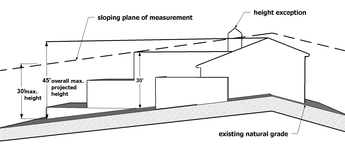
Figure 5.2-A: Hillside Height Measurement
B.
Heights and Appearances.
1.
For development within the Hillside Areas, the height of structures shall be determined by the following (depicted in Figure 5.2-A) and not by the definition of "building height" as described in Article 10, Definitions:
a.
No part of any structure shall penetrate an imaginary plane (the "sloping plane of measurement"), the height of which is 30 feet measured vertically from the highest ridge or parapet of the building to the existing natural grade directly beneath that point. Minor topographic variations may be excluded from those measurements if those areas are less than 25 feet in width.
b.
Exposed building walls measured in a vertical plane shall not exceed a height of 30 feet measured from the lowest point of the wall to the top of the wall. In addition, the overall projected height will be measured from the lowest wall improvement attached to the main structure to the highest ridge or parapet and be limited to 45 feet.
c.
Exceptions to the maximum height requirements are allowed for architectural features that are less than ten percent of the entire roof area.
2.
Materials used for exterior surfaces of all structures shall blend in color, hue, and tone with the surrounding natural setting to avoid high contrasts. The overall intent is to create a material and color palette that when utilized is deemed complementary and compatible to the desert setting.
a.
Structures, walls, roofs, and fences shall blend with the surrounding terrain, and there shall be no material or colors used which have a light reflecting value (LRV) greater than 35 percent.
b.
Mirror surfaces, or any treatment which changes ordinary glass into a mirror surface, is prohibited. Bright, untarnished copper, or other metallic surfaces shall be treated so they are non-reflective.
c.
All electrical service equipment and sub panels and all mechanical equipment including, but not limited to, air conditioning and pool equipment, solar panels, and antennas shall not be visible from the outside the property when viewed from the same or a lower elevation. Restrictions of solar panels and mechanical equipment may be modified if they are integrated into the roof design.
3.
Fences on lots within a Hillside Area, excluding retaining walls, shall be restricted to privacy fences attached to or directly screening a portion of the main residence.
C.
Disturbed Areas. Lots in Hillside Areas shall be developed to provide for the minimum amount of ground disturbance during the time of construction to prevent rockslides and falls, erosion, and seepage at final construction. Disturbed areas shall be hidden or supported by retaining walls, buildings, finished surfaces, or shall be landscaped.
1.
All buildings, structures, and roads shall, to the fullest extent practicable, utilize the natural contours of the land to minimize the disturbed area.
2.
The maximum height of any cut or fill used to establish a building site or a driveway shall not exceed 15 feet. The maximum height of any cut or fill used to establish a road or roadway shall not exceed 30 feet.
3.
The limits of construction and proposed disturbed areas shall be clearly designated on the property prior to and during construction with flags or visible roping. No disturbance outside the designated area shall take place.
4.
All surplus excavated material shall be removed from the lot.
D.
Driveways.
1.
If any portion of a driveway grade is more than 20 percent, the entire residence and all accessory buildings over 120 square feet of roof area shall be protected with an approved fire sprinkling system.
2.
Residential driveways with turning radii of less than 35 feet may be used provided all structures are protected with an approved fire sprinkling system.
3.
Any driveway cut greater than 12 feet in depth shall not have a length greater than 200 feet.
E.
Retaining Walls and Erosion Control Measures.
1.
The design of all retaining walls and erosion control measures shall be prepared by a registered professional engineer or architect who is licensed to practice in the State of Arizona.
2.
Raw spill slopes are prohibited.
3.
The slope from retaining walls shall be no more than 4:1.
4.
When multiple retaining walls are utilized, the top of the footing of the upper retaining wall will be at least one foot below the top of the lower retaining wall. The slope between the walls will terminate four inches below the top of the top of the lower retaining wall.
5.
All exposed disturbed area fill shall be contained behind retaining walls or landscaped.
6.
Retaining walls shall not exceed 20 feet in height. If additional height is needed, the wall shall be offset at a minimum of four feet or one foot per one foot of height. Privacy fences may be erected on a retaining wall so long as the total height does not exceed 20 feet.
5.2.4.
Protection of Native Plant Species within Pristine or Environmentally Sensitive Areas.
A.
Development of lands consisting of undisturbed desert, native Sonoran Desert plant species, natural washes, riparian habitat, or unique geological features shall provide an inventory survey documenting the existing vegetation and features on site. In addition to the inventory survey, a salvage plan shall be submitted detailing how the impacts to the surveyed items will be mitigated and how surveyed items will be preserved or salvaged.
B.
Development shall minimize the removal of existing healthy Sonoran Desert vegetation, particularly any tree or cacti that have reached maturity, or any cacti that are protected by local regulations or the State of Arizona, regardless of the stage of growth (refer to Appendix A, Protected Native Plants). If removal is necessary based on an analysis and recommendation by a registered landscape architect or other qualified native plant professional, healthy mature trees and healthy mature or protected cacti shall be salvaged and utilized on site. Relocation or removal of native plants shall comply with Arizona native plant law (A.R.S. § 3-901 et seq.).
C.
Natural washes and vegetation within natural washes shall be maintained in a natural state to avoid impeding drainage flows to the extent practicable for public safety and preservation of natural resources.
(Ord. No. 28-25, § 3, 10-21-2025)
5.3. - OPEN SPACE
A.
Open spaces shall be provided by all new development consistent with the most current and applicable City plans, including the City's Parks and Recreation Master Plan, the El Rio Design Guidelines and Planning Standards, the "Wildlife Corridors Best Management Practice Guide," the El Rio District Area Plan, and any other applicable Specific Area Plan or adopted design guideline.
B.
Mountain ridge lines should be protected from development to maintain the visual identity of Buckeye.
C.
Maximize land use compatibility around open space tracts to enhance community/recreational opportunities.
D.
Open spaces should be connected together to provide continuity (see Figure 5.3-A).
Figure 5.3-A: Open Space Continuity
(Ord. No. 28-25, § 3, 10-21-2025)
5.4. - LANDSCAPING
5.4.1.
Intent. The standards and guidelines of this Section are intended to:
A.
Visually unify the appearance of developments;
B.
Define major entryways, circulation (both vehicular and pedestrian), and parking patterns to help buffer less intensive adjacent uses;
C.
Integrate the native and colorful landscape character of the Sonoran Desert into the City's developments;
D.
Provide relief from the desert climate by providing shade and mitigating the heat island effect;
E.
Preserve, protect, promote, and integrate the existing desert landscape, including riparian areas, organic and inorganic materials, and associated vegetation;
F.
Preserve native vegetation, which stabilizes desert soils and is an important habitat component by providing food, cover, and nesting sites for desert wildlife species; and
G.
Preserve vegetation that contributes to the high quality of life, and unique desert lifestyle that the community of Buckeye enjoys.
5.4.2.
General Description of Landscaping Requirements.
A.
All development shall meet the requirements of Section 5.2.4, Protection of Native Plant Species within Pristine or Environmentally Sensitive Areas unless preservation and/or relocation of native plants on a development site is infeasible as determined by the Zoning Administrator.
B.
In addition, one or more of the five types of landscaping in Section 5.4.3, Landscaping Required, may be required for a development, depending on the use and zoning district of the property, adjacent properties, and the portion of the property involved. These types of landscaping are: (1) site enhancement landscaping, (2) site perimeter landscaping, (3) parking lot landscaping, (4) building foundation landscaping, and (5) entryways.
C.
Each type of required landscaping shall meet the minimum standards of Section 5.4.4, General Requirements for all Landscaping, and shall be shown on a Landscaping Plan that meets the requirements of this Development Code.
D.
No unapproved landscaping, object, structure, or sign shall be placed within a sight visibility triangle (SVT), as specified in the Engineering Design Standards, unless otherwise approved by the City Engineer (see Figure 5.4-A).
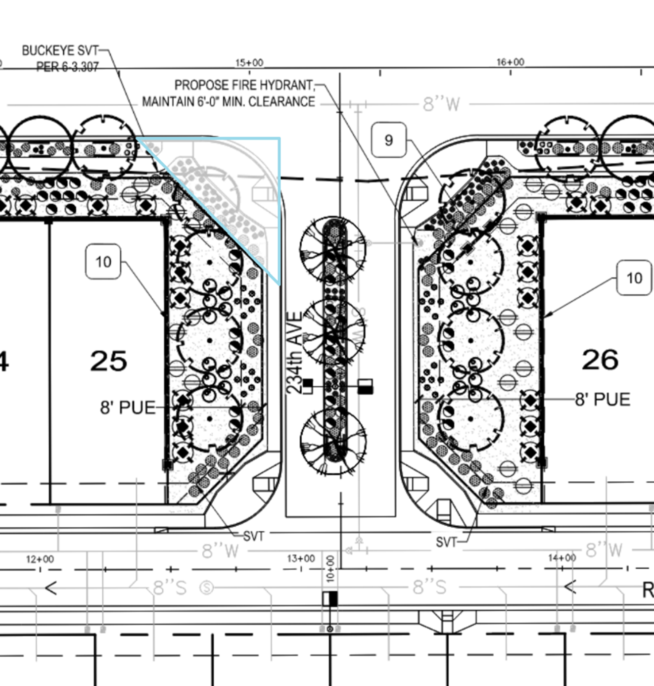
Figure 5.4-A: Unapproved Landscaping Within Sight Visibility Triangle (SVT)
5.4.3.
Landscaping Required.
A.
Site Enhancement Landscaping.
1.
All portions of new development, not comprised of building or residential lot or unit footprint, vehicular access, and required hardscape shall include planting requirements as prescribed in Table 5.4-1, Landscaping Requirements.
2.
Site enhancement minimum percentages include all buffer requirements (if applicable).
3.
A minimum percentage of the gross land area in residential zoning districts is required as landscaped area that increases based on density (du/ac) as stated below. Enclosed private yards serving one residential lot or one dwelling unit do not count towards these minimum requirements.
a.
1.0 du/ac or less - Zero percent.
b.
More than 1.0 du/ac up to 2.0 du/ac - 5 percent.
c.
More than 2.0 du/ac up to 3.0 du/ac - 15 percent.
d.
More than 3.0 du/ac up to 5.0 du/ac - 20 percent.
e.
More than 5.0 du/ac up to 10.0 du/ac - 25 percent.
f.
More than 10.0 du/ac up to 15.0 du/ac - 30 percent.
g.
More than 15.0 du/ac - 30 percent.
i.
The amount of landscaping may be reduced by up to 50 percent for developments located within 1,320 feet of a major public park or within the boundaries of a Specific Area Plan with urban residential design guidelines, as determined by the Zoning Administrator.
4.
Nonresidential zoning districts shall have a minimum percentage of the gross land area as landscaped area that is based on intensity of the use, as noted in Table 5.4-1, Landscape Requirements.
5.
A mixed-use development shall calculate residential and nonresidential minimum standards independently unless otherwise approved through the Site Plan process.
6.
Minimum planting requirements shall vary by zoning district. Tree sizes shall meet or exceed the minimum standards of Section 5.4.4.B., Minimum Plant Specifications.
B.
Site Perimeter Landscaping.
1.
Except in the Downtown, site perimeter landscaping shall be required for all development along roadways if a setback is provided and shall include planting requirements as prescribed in Table 5.4-1, Landscaping Requirements.
2.
A minimum landscape setback of 25 feet shall be provided along all arterial and higher classification streets and freeways from the edge of the right-of-way (ROW), and a minimum landscape buffer of 15 feet shall be provided along all collector and lower classification streets from the edge of the ROW. In districts where buildings are permitted to be set back less than the minimum prescribed landscape setback, those buildings may encroach into the landscape setback; however, no parking, vehicular circulation (excluding driveways providing access to the adjacent right-of-way) or walls (excluding parking screen walls) may occur within the required landscape setback. Developments utilizing a setback of zero feet shall not be required to provide site perimeter landscaping on that side. See Figure 5.4-B.
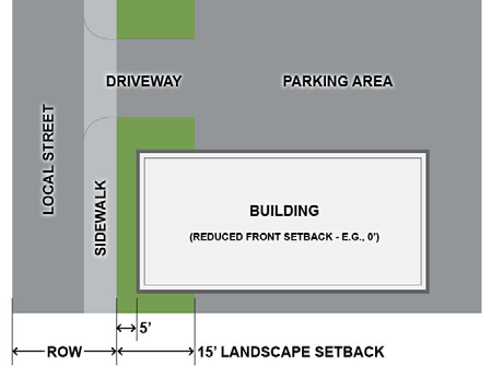
Figure 5.4-B: Relationship between Building Setback and Landscape Setback
a.
Site perimeter landscaping may not be utilized towards the interior parking lot landscaping requirement.
b.
This setback is exclusive of any ROW area as required.
c.
Trees are not permitted within public utility easement (PUE) areas, unless approved by the appropriate utility interest(s) and the City. The density of shrubs and accent plants within the PUE should increase to compensate for the lack of trees.
d.
In areas where an existing pattern of sidewalks, street trees, or other landscaping has been established, the standard may be modified through the Site Plan approval process to allow for consistency with the established pattern.
e.
Additional landscaping within the public ROW, between the back of curb and sidewalk and between the sidewalk and property line, is required at the rate of one tree and five shrubs for every 40 linear feet of frontage. Trees shall be planted 25 feet on-center. In the event trees cannot be planted 25 feet on-center due to the site visibility triangle, special easements, or other factors as determined by the Zoning Administrator, tree spacing may be greater.
f.
A five-foot reduction for the required setback depth is permitted for locations where a PUE is not required or existing.
3.
The perimeter of parking areas located within 300 feet of an adjacent public street shall be screened by one or a combination of the following methods:
a.
A masonry wall no less than three and one-half feet in height using materials compatible with the principal building, not to interfere with sight lines for vehicular movement; or
b.
A landscaped berm no less than three and one-half feet in height at a maximum slope of 4:1, including a flat top for planting, not to interfere with site lines for vehicular movement.
4.
Stormwater detention basins shall not occupy more than 50 percent of any landscaped area fronting on an arterial street if maximum basin depth exceeds three feet below grade. Where exceptional design is exhibited through contouring and landscaping, as determined by the Zoning Administrator, a greater percentage of the frontage landscaped area may be allowed.
5.
A minimum landscape buffer of 40 feet shall be provided for new industrial development, a minimum of 30 feet for new commercial development, and a minimum of 20 feet for new multi-family development located adjacent to single-family residential zoning districts and shall include planting requirements as prescribed in Table 5.4-1, Landscape Requirements for site perimeter landscaping.
a.
Excluding landscaping, perimeter walls constructed on or near property lines, and any improvements required for civil and/or safety purposes, no improvements shall be constructed within the required buffer.
b.
A minimum landscape buffer shall be provided for new mixed-use development located adjacent to single-family residential zoning districts determined through the Site Plan approval process.
c.
Within the Downtown Activity Center, the minimum buffer depth between dissimilar land uses may be reduced within zoning districts that permit a building setback less than the width prescribed within this subsection.
6.
In the event that an easement that precludes planting of plant material of any kind is located within a required landscape setback or buffer, developers shall receive credit for half of the easement width towards required landscape setback or buffer. For example, if a 25-foot landscape setback along a frontage is required, but the frontage features a 16-foot-wide easement where plant material of any kind is not permitted, half of the easement width (eight feet) will count towards the required landscape setback, necessitating the provision of an additional 17 feet of landscape area required outside of the easement.
a.
Easements that preclude planting of trees but allow for planting of shrubs and accents shall receive full credit towards required landscape setbacks and half credit, using the methodology above, towards required landscape buffers. If, at the time of construction or following landscape plan approval and permit issuance, the owner or agency with easement rights legally requires removal of plant material shown within the easement on the approved landscape plan, the developer will not be required to increase the width of the landscape setback.
7.
Section 5.10.2.B.4 establishes additional site perimeter landscape standards for industrial developments.
C.
Landscaping Inside Parking Areas.
1.
Landscape Islands.
a.
Landscape islands must be a minimum of eight feet wide and the length of the parking stall. Landscape islands must be installed between a maximum of ten parking spaces either in a single row or a double row and must also be provided at the ends of all rows. Landscape islands must include planting requirements as prescribed in Table 5.4-1, Landscaping Requirements.
Covered parking lots shall only require landscape islands at the ends of rows and are exempt from the requirement to provide islands every ten spaces.
b.
For maintenance and water conservation, turf grasses are not permitted within landscape islands.
c.
The standards in this subsection shall not apply to truck loading and service areas or truck-only parking areas located on industrial development sites.
2.
Landscape Medians.
a.
Parking lots containing 250 or more spaces shall provide medians to enhance pedestrian connectivity between parking spaces and building entrances in compliance with Section 5.6.9.F, Parking Area Layout.
b.
One tree and five other plantings shall be provided every 30 linear feet.
c.
The standards in this subsection shall not apply to truck loading and service areas or truck-only parking areas located on industrial development sites.
D.
Building Foundation Plantings. In all multi-family, commercial, mixed-use, and industrial zoning districts, new development must provide minimum landscaping as prescribed in Table 5.4-1, Landscaping Requirements, along all façades that are adjacent to public streets or parking areas, unless the building has no setback from the property line.
1.
Required plants shall be placed in-ground in a landscaped area with a minimum dimension of five feet by five feet located within 15 feet of the building façade.
2.
Alternatively, raised planters or pots may be used if located within 15 feet of the building façade. The color, material, and form of planters/pots must complement the design of the adjacent façade.
3.
Buildings taller than 30 feet must provide one tree per 25 linear feet, in addition to the standards in Table 5.4-1, Landscaping Requirements.
E.
Entryways and Major Intersections. In all zoning districts, any development that is ten acres or more in size shall incorporate prominent focal points at major entrances and arterial/arterial intersection corners. Such focal points shall be created through a minimum of three of the following:
1.
Gateway monuments;
2.
Decorative pavement treatments at driveway entrances outside of ROW;
3.
Sculpture or public art;
4.
Concentrations of vertical landscape forms; or
5.
Other features, as approved, to define entrances and intersections as visual gateways to the development.
F.
Roadway Medians. In all zoning districts, any development that fronts a public street where medians are planned shall be responsible for constructing and landscaping the median. Areas that are subject to the Buckeye Arterial Gateway Guide (BAGG) will develop in compliance with the adopted Guide.
1.
Median Construction Responsibility. The following conditions determine the responsibility for constructing and/or landscaping an adjacent median in a public street.
a.
If sufficient ROW and existing street improvements are present adjacent to the development as determined by the City Engineer, then the developer of the property shall construct, provide all necessary utilities, and landscape the full median along the frontage of the development site;
b.
If sufficient ROW and existing street improvements are not present adjacent to the development as determined by the City Engineer, then the developer of the property shall be required to pay in-lieu fee for half of the ultimate median construction, utilities, and landscaping and shall construct the otherwise required half street improvements; or
c.
If a median that is not landscaped is located within the ROW along the frontage of the development site, the developer of the development site shall be responsible for landscaping the median, including all necessary utilities and irrigation to the median.
2.
Median Landscaping. The following requirements apply to the design and construction of any median NOT identified within the adopted BAGG. Any median identified in the BAGG shall be designed in accordance with that document.
a.
Trees must be provided at a rate of one 24-inch box tree for every 35 lineal feet of median length. The species must be selected based on mature canopy spread that will be equal to or less than the width of the median.
b.
Shrubs or ground covers must be provided at a minimum rate of five shrubs or ground covers for every 35 lineal feet of median length.
c.
Decomposed granite (DG) ground cover must be half-inch screened. The color selected for the median must match the decomposed granite installed along an adjacent project frontage.
5.4.4.
General Requirements for All Landscaping.
A.
Landscape Materials List.
1.
Low-water, drought-tolerant, plants shall be used for all new landscaping. Plant materials shall be selected from the plant list of the Arizona Department of Water Resources.
2.
The male mulberry (Morus alba) and the olive tree (Olea europea) are prohibited within City limits. The fruitless version of the olive tree (Olea europea 'Swan Hill') is permitted.
3.
Sissoo trees are prohibited within City ROW and must be located a minimum of 20 feet from public sidewalks, public roads, and public structures.
B.
Minimum Plant Specifications. Landscaping mixture shall be in compliance with Section 5.4.4.A, Landscape Materials List. All shrubs shall be a minimum of five gallons, and all groundcover shall be a minimum of one gallon. All required trees shall meet the following box sizes and conform to the Arizona Nursery Association standards for tree species container size, height, width and caliper:
1.
Sixty percent of required trees shall be 24-inch box or larger.
a.
Within single-family residential developments, trees that are located more than 120 feet from an arterial street may be 15 gallons instead of 24-inch box.
2.
Thirty-five percent of required trees shall be 36-inch box or larger.
3.
Five percent of required trees shall be 48-inch box or larger. A 15-foot tall or larger saguaro can be planted instead of a 48-inch box tree.
4.
Any additional trees provided on a site beyond the minimum quantity required must be 15 gallons or larger.
C.
Maintenance. Every property owner and any tenants must keep their landscaped areas in a well-maintained, safe, clean, and attractive condition at all times in compliance with a national standard, such as the American National Standards Institute (ANSI) standards, for tree and shrub pruning and maintenance. Landscape maintenance includes, but is not limited to, the following:
1.
Landscaped areas shall be kept free of trash, litter, weeds, and other such materials or plants not a part of the landscape;
2.
All plant material shall be maintained in a healthy and growing condition and must be replaced with plant material of similar variety and size not to be smaller than the minimum required by this Development Code at the time of replacement if diseased, damaged, destroyed, or removed in perpetuity over the life of a development project;
3.
Watering on a regular basis;
4.
Maintenance of landscape lighting in working order;
5.
Maintenance of irrigation systems in working order;
6.
Cleaning and maintenance of abutting landscaped areas lying between the street curb and property line, within the public ROW unless such landscaped area is expressly designated to be maintained by a designated governmental authority; and
7.
It is the responsibility of the adjacent property owner or the property association formed by the adjacent property owner to trim trees to allow for an 18-foot-high clearance above the pavement.
D.
Irrigation.
1.
All landscaping improvements, except for drought-tolerant or low-water use plants that do not require irrigation, shall include a suitable method for irrigation. Failure to maintain landscaping shall be a cause for permit revocation or other enforcement action.
2.
An underground drip irrigation system is required for all landscaped areas (except for turf). For turf areas, a secondary non-potable water source, if available, must be used.
E.
Right-of-Way (ROW).
1.
To the maximum extent practicable, Landscaping Plans shall be coordinated with the placement of utilities to avoid conflicts with above- and below-ground utilities and overhead light fixtures, and within the City ROW to avoid obstruction issues.
2.
Any object, wall, structure, mound, or landscape (mature) over 24 inches in height is prohibited within the SVT as specified in the Engineering Design Standards.
3.
Tree canopies hanging over the sight visibility lines must be trimmed to seven feet above street surface.
4.
Boulders are prohibited within a PUE, ROW, or within six feet from the back of curb.
5.
Trees are prohibited within the SVT or sight distance line (SDL) including median trees, except that median trees may be allowed if limited to single trunk variety trees with canopies that are at least eight feet in height.
6.
Except for groundcover and accent plants that grow low to the ground, landscape planting will not be located between the fire hydrant and the curb.
7.
Deep root barriers are required for all trees located within the ROW.
F.
Phasing Landscape Installation. All landscaping within ROW and required landscape setbacks adjacent to ROW shall be installed during the initial phase of development for any master planned commercial, industrial, or mixed-use project, unless alternative phasing of street improvements is otherwise approved by the Zoning Administrator or City Engineer. This requirement applies to the full length of the boundary of the master planned project area, regardless of phasing.
(Ord. No. 28-25, § 3, 10-21-2025)
5.4.5.
Special Character Areas.
A.
Sun Valley Parkway Scenic Corridor. Recognizing the need for preservation of the natural Sonoran Desert environment, the Sun Valley Parkway, from the eastern City limits in northern Buckeye to Interstate 10 in central Buckeye, is subject to the following additional standards:
1.
All new development shall provide a supplemental landscape setback of 15 feet along Sun Valley Parkway, in addition to the minimum requirements outlined in 5.4.3.B, Site Perimeter Landscaping.
2.
Retention basins shall not be permitted within the combined 40-foot landscape setback along Sun Valley Parkway. Drainage facilities shall be limited to regional flows.
3.
No parking, vehicular circulation (excluding driveways providing access to the adjacent ROW), walls (excluding parking screen walls) or other development improvements may occur within the required landscape setback.
4.
Landscape design within the combined setback area shall preserve the natural character of the Sonoran Desert. Salvaged, preserved, and new native plants, succulents, and native seed mixes shall be prominently incorporated into the proposed design, accounting for at least 75 percent of plantings within the combined setback area. Irregular groupings of plant materials and provision of undulating berms and/or mounds should be prioritized over more formal arrangements, such as evenly spaced rows of trees or symmetrical shrub patterns.
5.
Walls and fencing adjacent to the required combined total landscape setback shall be thematic in materials and colors to complement with the natural environment.
6.
Natural and artificial turf shall not be permitted.
7.
All varieties of Palm Tree species shall not be permitted within the ROW or medians but may be utilized at main entrances of developments or as corner treatments.
B.
Cohesive Streetscape. Integration with existing built environments gives a sense of cohesion through complementary planting palettes, decorative rock, and hardscapes.
C.
All new developments shall strive to provide materials that are cohesive with established landscape designs on neighboring properties. Walls and fencing shall utilize complementary materials and colors to any existing walls on adjacent properties to create a more cohesive aesthetic.
(Ord. No. 28-25, § 3, 10-21-2025)
5.4.6.
Fences, Walls, and Screening.
A.
Purpose. The purpose of these standards is to ensure the design of fences contributes to the character of development, and to avoid long expanses of blank fences and walls that can lead to a "canyon" effect on the streetscape. This Section also ensures that fences are constructed of high-quality and durable materials.
B.
Fences and Walls.
1.
Height.
a.
Front.
i.
No fence or wall on lots used for single-family residential uses located between the principal structure and the front property line shall exceed three and one-half feet in height. A fence or wall in line with or behind the principal structure may be up to six feet in height.
ii.
A six-foot high wall between the principal structure and the front property line is allowed for multi-family, commercial and industrial developments. The fence or wall must be provided at the back of any required landscape setback. The Zoning Administrator may authorize wall heights up to ten feet if additional height is needed to screen service, loading, or outdoor storage areas from adjacent residential uses.
b.
Side and Rear.
i.
No fence or wall on lots used for single-family or multi-family residential uses located between the principal structure and the rear or side property line shall exceed six feet in height, except that additional height may be granted for retaining walls or sites with elevated foundations. If the side or rear property line is street-adjacent, the fence or wall must be provided at the back of any required landscape setback.
ii.
For commercial and industrial uses, no fence or wall located between the principal structure and the rear or side property line shall exceed eight feet in height, except that additional height may be granted for retaining walls or sites with elevated foundations. If the side or rear property line is street-adjacent, the fence or wall must be provided at the back of any required landscape setback. The Zoning Administrator may authorize wall heights up to ten feet if additional height is needed to screen service, loading, or outdoor storage areas from adjacent residential uses.
c.
Perimeter Fences and Walls. Perimeter walls enclosing platted residential subdivisions may be up to eight feet in height adjacent to arterial or higher street classifications and up to six feet in height adjacent to collector and lower street classifications. Perimeter walls must be located at the back of required landscape setbacks.
2.
Articulation.
a.
Fences and walls shall be articulated to avoid continuous and unbroken expanses. No fence facing an arterial or higher street classification may extend continuously, without articulation, for more than 200 feet, or 100 feet for fences facing any other type of public street. Fences may be articulated using any combination of the following:
i.
Changes in material or texture, including the use of view fence that allows for views into the site;
ii.
Offsets (projections or recessions);
iii.
Landscape pockets; or
iv.
Similar features as approved.
b.
All fences and walls along an arterial or higher street classification with a continuous length greater than 200 feet must be articulated with a minimum three foot offset at minimum intervals of 150 feet or every three lots, whichever is less, to provide variety and visual interest.
3.
Fence and Wall Materials.
a.
Fences and walls shall be constructed with the following materials, with fences and walls visible from public ROW requiring a combination of at least two of the listed materials:
i.
Integrally colored, split-face, or ground-face concrete masonry units (CMU);
ii.
Concrete masonry units (CMU) that have been painted, finished with stucco, or faced with another permitted material;
iii.
Stone (natural or simulated);
iv.
Brick;
v.
Wrought-iron or other decorative metal;
vi.
Wood (painted or stained), vinyl, or plastic, allowed on agricultural or single-family residential lots only, not be utilized on perimeter walls enclosing single-family residential platted subdivisions visible from streets); and/or
vii.
Other materials as approved by the Zoning Administrator.
b.
Chain link fencing is prohibited on commercial and residential development sites, except to enclose sport courts and as necessary to ensure public safety during approved construction activities on the site. Chain link fencing is permitted in industrial districts but shall not be viewable from public ROW. For the purposes of this provision, not visible shall mean starting at a point 200 feet from the nearest edge of ROW.
c.
A higher level of design detail shall be utilized for highly visible fences along major arterial roadways and interstates, including but not limited to, the incorporation of mosaic designs, relief panels, or similar public art.
d.
For single-family residential uses, the design of fences and walls must include colors, materials, and/or forms that complement and are of equal quality to the materials used for the building and/or the residential subdivision. For all other uses, the design of fences and walls must include colors, materials, and forms that are of the same and of equal quality to the materials used for the primary building.
4.
Fence and Wall Placement. No fences or walls may be placed within the public ROW.
5.
Freeway Sound Walls. Development proposed within 150 feet of an existing freeway may be required by the Arizona Department of Transportation (ADOT) to construct a sound attenuation wall. If required, the height of the sound attenuation wall permitted shall be equal to the height required by ADOT. Design of such walls shall be decorative and in context with any existing sound walls in the general vicinity.
6.
Retaining Walls.
a.
The height of retaining walls supporting either cut or fill conditions shall not exceed 12 feet in height measured vertically from the lowest point at natural grade to the highest point of the wall.
b.
Retaining walls greater than six feet in height that are visible from public ROW shall be terraced to minimize visual impacts on residents and neighboring properties by:
i.
Limiting terracing to three tiers, with each tier no greater than six feet in height; and
ii.
Providing a minimum terrace width of five feet between any two retaining walls with a maximum slope of 4:1 and planted with a minimum of four shrubs per 100 square feet of terrace area.
iii.
The Zoning Administrator may approve reduced terrace depths and alternative landscaping treatments where site constraints limit the amount of space available to accommodate the minimum width and planting densities.
C.
Screening of Services, Refuse Collection, and Utilities.
1.
Screening Required.
a.
Solid waste collection areas and mechanical equipment, including equipment located on a rooftop, shall be screened from the view of a six-foot tall person standing on the property line on the far side of an adjacent public street (see Figure 5.4-C) and from the shared property line of any residentially used or zoned properties. Individual screening of rooftop mechanical equipment is prohibited. Rooftop-mounted mechanical equipment shall either be grouped together "penthouse style" or screened with a parapet wall the entire length of the building facade. The parapet wall shall be designed as an integral element of the overall architecture of the building.
b.
To ensure the effectiveness of proposed screening as required by this subsection, the Zoning Administrator may require the submission of a line of site analysis to determine the best method of screening the following:
i.
Truck and trailer parking areas;
ii.
Loading docks and doors:
iii.
Refuse and recycling areas;
iv.
Outside storage;
v.
Roof- or ground-mounted equipment;
vi.
Utility equipment such as transformers, well sites, lift stations, etc.; and
vii.
Similar equipment or components of a building.
Figure 5.4-C: Screening of Equipment, Etc.
c.
Except in the Downtown and mixed-use districts, storage, solid waste collection, and loading areas shall be located at least 20 feet from any public street or public sidewalk, or 50 feet from a property line with a residential use. Placement of storage, solid waste collection, and loading areas shall be sited so as not to interfere with vehicular visibility or circulation.
d.
Loading docks, truck parking, outdoor storage, trash collection, trash compaction, and other service functions shall be incorporated into the overall design of the building and landscaping so that the acoustic impacts of these functions are contained to the maximum extent feasible, and so that such features are fully screened and out of view from public streets. Screening materials for solid waste collection and loading areas must be of the same and of equal quality to the materials used for the primary building and landscaping.
2.
Shopping Cart Storage. The following standards apply to any commercial development that provides shopping carts: (refer also to Chapter 10, Section 10-3-16)
a.
Long-term (overnight) shopping cart storage areas must be provided inside of the primary building or adjacent to the building and behind a decorative screening fence or wall constructed of masonry, metal, or finished wood that is consistent with the design of the adjacent building. The fence or wall shall not exceed the height of the shopping carts by more than six inches.
b.
Short-term shopping cart corrals (located within parking areas for day use and where carts are generally not left overnight) must be designed with durable materials and design features that complement the architectural character of the development or be painted to match or complement the primary building.
c.
Short-term shopping cart corrals must be located so as not to encroach upon vehicular or pedestrian circulation paths.
3.
Guidelines for Service and Refuse Areas.
a.
Cluster service and refuse areas for nearby buildings and uses.
b.
Where feasible, locate above-ground utility facilities, such as utility cabinets and meters, in areas that do not conflict with featured views, outdoor dining areas, outdoor gathering areas, or site circulation. Screen these facilities with dense landscaping or decorative fences or walls.
(Ord. No. 28-25, § 3, 10-21-2025)
5.5. - TRANSPORTATION AND CONNECTIVITY
5.5.1.
Purpose. The purpose of this Section is to support the creation of a highly connected transportation system within the City in order to provide choices for drivers, bicyclists, and pedestrians; increase effectiveness of local service delivery; promote walking and bicycling; connect neighborhoods to each other and to local destinations such as employment, schools, parks, and shopping centers; reduce vehicle miles of travel and travel times; improve air quality; reduce emergency response times; mitigate the traffic impacts of new development; and free up arterial capacity to better serve regional long-distance travel needs. These standards attempt to avoid the creation of large, isolated tracts without routes for through traffic or pedestrian and bicycle connections.
This Section is in compliance with the current Transportation Master Plan and the Bike and Pedestrian Master Plan.
5.5.2.
Traffic Impact Mitigation. Any proposed development shall account for the traffic generated by that development. Any improvements required to mitigate the impacts of traffic generated by the development will be the responsibility of the development. See Section 6-1 of the Engineering Design Standards for guidelines.
5.5.3.
Streets and Vehicular Circulation.
Note— (Refer also to Section 6-3, Engineering Design Standards.)
A.
Street Standards. All streets shall meet the standards in Article 6, Land Subdivision, and shall be consistent with the circulation element of the General Plan or approved PAD.
B.
Street Connectivity.
1.
Purpose. Street and block patterns should include a clear hierarchy of well-connected streets that distribute traffic over multiple streets and avoids traffic congestion on principal routes. Within each development, the access and circulation system should accommodate the safe, efficient, and convenient movement of vehicles, bicycles, and pedestrians through the development, and provide ample opportunities for linking adjacent neighborhoods, properties, and land uses. Local neighborhood street systems are intended to provide multiple direct connections to and between local destinations such as parks, schools, and shopping. These connections should knit separate developments together, rather than forming barriers between them.
2.
Residential Streets.
a.
Residential streets shall be laid out so that use by through-traffic will be discouraged. Traffic-calming techniques such as diverters, neck-downs, street gardens, and curvilinear alignments are encouraged to reduce speeds and cut-through traffic.
b.
Should topography or other constraints require the use of straight local streets that extend more than 660 feet without interruption, a traffic-calming device, or similar feature shall be used to slow traffic and break-up the "runway" appearance. In addition, traffic-calming devices may be required to address public safety concerns.
c.
To the maximum extent practicable, streets shall be arranged to follow the natural contours of the site.
3.
Vehicular Access to Public Streets and Adjacent Land.
a.
All development shall provide public street or pedestrian/bike connections to all existing, adjacent public streets, unless it is impractical or infeasible to do so, as determined by the Zoning Administrator.
b.
If there are no adjacent public streets, a vehicular and pedestrian connection must be provided from new subdivisions and/or Site Plans on each boundary abutting adjacent vacant land for future connections spaced at intervals not to exceed 1,320 feet for arterials, or 660 feet for other street types, or as otherwise approved.
c.
When connections to surrounding streets are proposed or required by the City, public ROW shall be dedicated and streets developed to existing paved ROW. The City may also require temporary turnarounds to be constructed for temporary culs-de-sac between development phases.
4.
Culs-de-Sac and Dead-End Streets Discouraged.
a.
Permanent culs-de-sac and dead-end streets shall generally be used when topography, the presence of natural features, and/or vehicular safety factors make a vehicular connection impractical.
b.
Design standards for culs-de-sac are located in Section 6-3 of the Engineering Design Standards.
5.
Driveways and Access.
a.
General.
i.
All driveway entrances and other openings onto streets shall be constructed so that:
(1)
Vehicles may safely enter and exit from the lot in question;
(2)
Interference with the free and convenient flow of traffic in abutting or surrounding streets is minimized; and
(3)
Joint driveways are desirable whenever possible in order to minimize the number of access points to streets and access easements.
b.
Residential. In addition to the above general requirements, all residential development shall be subject to the following:
i.
There shall be no direct driveway access (ingress or egress) from any single-family residential lots to any collector street, arterial street, or highway unless no other legal access alternative is available. Bungalow communities are exempt from this requirement.
ii.
Multi-family development sites greater than five acres shall include a minimum of two through-access ingress/egress driveways. An exception may be made where a site is landlocked by existing development or other physical constraints, or where existing natural features on the site require the use of protective measures that would otherwise make a second access drive infeasible.
iii.
For driveways serving a multi-family residential development with gates, the minimum driveway throat length is 50 feet measured from the back of the ROW to the call box to allow vehicles to stack outside the development's gate.
iv.
Excluding single-family attached products such as townhomes and similar product types where driveway parking is not intended, a driveway serving a single-family home shall not be less than 20 feet in length from the face of the garage to the near edge of the sidewalk. Parking is prohibited on driveways less than 20 feet in length from the face of the garage to the near edge of the sidewalk. Bungalow communities are exempt from this requirement and instead must provide a minimum of 20 feet of clear space within a garage.
v.
The width of a single-family residential lot's driveway must not exceed ten feet in width for one-stall garages/carports and tandem garages; 20 feet in width for two-stall garages/carports; and 30 feet in width for three or more-stall garages/carports. Driveway width is measured at right angles to the center line of the driveway at a point ten feet from the front property line. Driveway width may be increased by permissible curb return radii.
vi.
All driveways serving single-family residential lots shall be setback at least one foot from side yard property lines, except that zero lot line, attached, and similar products where multiple households share a driveway are not subject to this requirement.
vii.
The total aggregate driveway width for lots that include an RV garage in addition to a one-or two-bay garage, must not exceed 35 feet provided landscape strips, decorative pavers, grass-crete pavers, or similar materials are used to minimize the visual appearance of the parking surface in the front yard. The driveway for an RV garage must connect to the driveway to the one- or two-bay garage; a separate curb cut for the RV garage is prohibited.
viii.
Driveways for single-family residential lots shall be paved with asphalt, bituminous, brick, concrete, or other surfaces of comparable durability to minimize nuisance from dust.
c.
Residential Driveway Extensions. A "residential driveway extension" means a hard surface that extends from the driveway and which is primarily used for the parking of vehicles and not for traveling between the garage and adjacent street.
i.
A residential driveway extension shall be constructed of concrete, asphalt, pavers, or three inches of crushed rock that is compacted and contained within a permanent border. Residential driveway extensions must adhere to the following conditions:
(1)
The total width of the driveway and driveway extension shall not exceed 50 percent of the lot width. Irregular shaped lots widths are measured from the front setback line. Bungalow communities are exempt from this requirement.
d.
Nonresidential. In addition to the above general requirements, all nonresidential development shall be subject to the following:
i.
All nonresidential buildings, structures, and parking and loading areas shall be physically separated from all non-arterial or collector streets by vertical curbs and other suitable barriers and landscaping to prevent unchanneled motor vehicle access. In addition, each access way shall comply with the following:
(1)
An adequate throat length helps to keep traffic conflicts within a parking lot to an acceptable level and provides space on the driveway for incoming and outbound traffic. Throat length is measured from the curb return from the street to the next curb return or first point of conflict with internal site traffic.
(2)
For all nonresidential driveways, the minimum driveway throat length is 50 feet, unless a different length is determined through a traffic study prepared by a traffic engineer and approved by the City.
a.)
For high-volume driveways (i.e. over 400 peak hour vehicles in both directions) such as a shopping center entrance/exit, the minimum throat length must be determined through a traffic study prepared by a traffic engineer and approved by the City.
b.)
For driveways serving a nonresidential development regardless of traffic volume that includes gates, the minimum driveway throat length is 50 feet measured from the back of the ROW to allow vehicles to stack outside the development's gate.
(3)
Where feasible, the width of any access way leading to the full access of an arterial street shall be median-divided to provide separation from incoming and outgoing traffic. Medians shall be a minimum of six feet in width measured from inside curb to inside curb to accommodate tree planting and a minimum of 20 feet in length. (See Figure 5.5-A.) Construction and maintenance of such on-site medians shall be the responsibility of the property owner/developer.
Figure 5.5-A: The width of accessways from arterial streets.
6.
Visibility at Intersections. On all lots or parcels of land on which a front setback is required, no obstruction that will obscure the view of motor vehicle drivers shall be placed within the triangular area formed by the adjoining street property lines as specified in the City Engineering Manual, except that trees may be permitted within the triangular area provided that those trees are placed in the street planter strip and the limbs are pruned to at least seven feet above the grade level of the adjacent street.
5.5.4.
Pedestrian Circulation.
A.
Sidewalks Required.
1.
Sidewalks shall be installed on both sides of all arterials, collector streets, and local streets (including loop streets and culs-de-sac), and within and along the frontage of all new development or redevelopment. This requirement shall not apply to local streets in districts in which the minimum lot size is one acre or greater or in steep-slope areas where sidewalks on one side of the street may be approved to reduce excessive slope disturbance, adverse impacts on natural resources, and potential soil erosion and drainage problems. Alternative paving materials within residential developments may be approved by the Zoning Administrator.
2.
Ten-foot-wide sidewalks must be provided along all public street frontages of all public, private, and charter schools. Existing schools and schools that are located as a tenant within an existing commercial center would be exempt from this requirement.
3.
A minimum eight-foot wide internal sidewalk shall be provided from the public ROW to school buildings and school facilities. This sidewalk shall not bisect a parking lot and may be located on the edge of a parking lot.
B.
Non Single-Family Residential On-Site Pedestrian Connections.
1.
All commercial, industrial, and multi-family development shall provide a network of on-site pedestrian walkways with a minimum width of five feet to and between the following areas:
a.
Entrances to each commercial building on the site, including pad site buildings;
b.
Public sidewalks or walkways on adjacent properties that extend to the boundaries shared with the subject development;
c.
Adjacent public transit station areas, transit stops, park and ride facilities, or other transit facilities;
d.
Adjacent single-family residential or other uses such as public parks, recreational facilities, schools, places of worship, or similar community serving facilities; and
e.
Parking lots.
2.
Identify on-site pedestrian walkways and crosswalks to motorists and pedestrians through the use of one or more of the following methods: (See Figure 5.5-B.)
a.
Changing paving material, patterns, or paving color (does not include the painting of the paving material);
b.
Changing paving height;
c.
Decorative bollards;
d.
Raised median walkways with landscaped buffers; or
e.
Stamped or stained concrete.
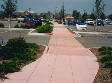
Figure 5.5-B: Examples of Pedestrian Connections
3.
Emphasize off-street pedestrian circulation areas that are adjacent to on-site parking areas, drive aisles, and driveways with special design features that establish them as areas where pedestrians are physically separated from the flow of vehicular traffic that are well shaded. Techniques shall include landscape planters with a minimum width of six feet featuring shade trees placed every 25 feet (or more frequently) and a minimum of two of the following:
a.
Pedestrian light features;
b.
Bollards;
c.
Seat walls or benches;
d.
Drinking water fountains; and
e.
Structural shade features such as canopies, trellises, etc.
4.
Guidelines.
a.
Break up sites larger than five acres into smaller units through the use of on-site pedestrian walkways, private drives, and other vehicular circulation routes. Breaking up such sites need not require any subdivision of the site or creation of a separate legal description(s).
b.
To the extent practicable, combine drainage and stormwater retention facilities between adjacent sites.
c.
Minimize access points to arterial roads through shared drives and internal connections. (See Figure 5.5-C.)
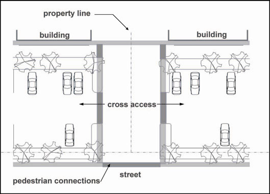
Figure 5.5-C: Shared Drives and Internal Connections
C.
Trails. Construct on-site portions of trails and multi-use paths that are identified in the Parks and Recreation Master Plan or other City-adopted trails master plan, or connect to the Maricopa County's trails system, or connect to adjacent municipalities' pedestrian and bicycle circulation systems, provided that any such improvements are directly related to the impacts of the proposed use or development and are roughly proportional in both extent and amount to the anticipated impacts of the proposed use or development.
(Ord. No. 28-25, § 3, 10-21-2025)
5.6. - OFF-STREET PARKING
5.6.1.
Purpose. The regulations of this Section are intended to ensure provision of off-street parking and loading facilities in rough proportion to the generalized parking, loading, and transportation demands of different land uses. By requiring such facilities, it is the intent of this Section to help avoid the negative impacts associated with spillover parking into adjacent neighborhoods, while at the same time avoiding the negative environmental and urban design impacts that can result from parking lots and other vehicular use areas. The provisions of this Section are also intended to help protect the public health, safety, and general welfare by:
A.
Helping avoid and mitigate traffic congestion;
B.
Encouraging multi-modal transportation options and enhanced pedestrian safety;
C.
Providing methods to help reduce stormwater runoff and the heat island effect of large paved parking areas; and
D.
Providing flexible methods of responding to the transportation and access demands of various land uses in different areas of the City.
5.6.2.
Applicability.
A.
Generally. The off-street parking and loading standards of this Section shall apply to all new parking lots and parking structures accessory to any new building constructed and to any new use established in every district. Except when specifically exempted, the requirements of this Section shall apply to all temporary parking lots and parking lots that are the principal use on a site.
B.
Expansions, Enlargements, and Changes in Use. The off-street parking and loading standards of this Section shall apply when an existing structure or use is expanded or enlarged or when a building and/or site is converted from a less parking intensive use to a more parking intensive use. Additional off-street parking and loading spaces may be required to serve the enlarged or expanded area, provided that in all cases the number of off-street parking and loading spaces provided for the entire use (pre-existing plus expansion) must equal 100 percent of the minimum ratio established in this Section and shall not exceed any maximum standards established in this Section. The change in use of a property from a more parking intensive use to a less parking intensive use, or a change from one use to a different use where both require equivalent parking, shall not require compliance with this Section.
C.
Regulation of Parking Space. The providers of required off-street parking spaces and the City may reasonably control the users thereof by means that may include, but are not limited to, restricting all parking to the users of the facility; parking lot attendants; control gates; tow-away areas; areas for exclusive use by employees, tenants or staff; areas restricted for use by customers or visitors; and imposing reasonable time limitations on users other than tenants, employees, or staff. City staff may review all methods of control and may disapprove of any restriction that adversely affects the purpose of this section. The City may enforce any approved restrictions through any of the code enforcement provisions in Article 9, Enforcement.
5.6.3.
Off-Street Parking Requirements.
A.
Schedule A. Unless otherwise expressly stated in this Development Code, off-street parking spaces shall be provided in compliance with Table 5.6-1, Off-Street Parking Schedule A. Unless otherwise approved, lots containing more than one activity must provide parking and loading in an amount equal to the total of the requirements for all activities.
B.
Schedule B. Uses that reference Schedule B in off-street parking Schedule A shall provide the minimum number of off-street parking spaces listed in Table 5.6-2.
C.
Schedule C. Uses that reference "Schedule C" in off-street parking Schedule A have widely varying parking and loading demand characteristics, making it impossible to specify a single off-street parking or loading standard. Upon receiving a development application for a use subject to Schedule C standards, the Zoning Administrator shall apply the off-street parking and loading standard specified for the listed use that is deemed most similar to the proposed use or establish minimum off-street parking requirements on the basis of a parking demand study prepared by the applicant consistent with the requirements in subsection D, below.
D.
Parking Demand Study. A parking demand study substantiates the basis for granting a specific number of spaces, which may vary from the space requirements listed in Schedule A or B. In order to evaluate a proposed project's compliance with Section 5.6, the Zoning Administrator may require submittal of a parking demand study. Any Schedule A or B use may submit a parking demand study; the approved study will determine the number of spaces required for the proposed project.
1.
Parking Reductions. In order to approve a parking demand study that reduces parking below minimum requirements listed in Schedule A or B, all of the following criteria must be met:
a.
The reduction in parking can be justified due to one of the following:
i.
A business employs less people per square foot than the accepted industry standard for that use, and is able to demonstrate this variation from the mean through a statistical comparison.
ii.
Lowered parking demand can be predicted as a result of sharing parking between intermittent uses, occurring on the same property or within a master planned development, with non-conflicting parking demands (e.g., a nightclub and a bank).
iii.
A development is designed to take advantage of adjacent public transit opportunities.
b.
The reduction in parking will not cause fewer off-street parking spaces to be provided for the proposed use than the number of such spaces necessary to accommodate all vehicles attributable to such use under the normal and reasonably foreseeable conditions of operation of such use.
c.
The reduction in parking will not increase the demand for parking spaces on the public streets in the immediate vicinity of the proposed use.
d.
The reduction in parking will not increase the demand for parking spaces upon adjacent private property in the immediate vicinity of the proposed use, unless as part of an approved joint-parking agreement.
e.
The applicant will incorporate measures intended to reduce vehicle trips to the site, including, but not limited to, the provision of spaces reserved for carpool use, the provision of weather-protected short term bike parking and the provision of showers and changing facilities in commercial buildings over 50,000 square feet in floor area.
5.6.4.
Computation of Parking and Loading Requirements.
A.
Fractions. When measurements of the number of required spaces result in a fractional number, any fraction exceeding 0.5 shall be rounded up to the next higher whole number.
B.
Multiple Uses. Lots containing more than one use shall provide parking and loading in an amount equal to the total of the requirements for all uses, except if shared parking is proposed consistent with the requirements in Section 5.6.7.A.
C.
Area Measurements. Unless otherwise specified, all square footage-based parking and loading standards shall be computed on the basis of gross floor area of the use in question. Structured parking within a building shall not be counted in such measurement.
D.
Computation of Off-Street Parking. Required off-street loading space shall not be included as off-street parking space in computation of required off-street parking space.
E.
Parking for Unlisted Uses. Parking requirements for uses not specifically listed in Table 5-6.1, Off-Street Parking Schedule A shall be determined by the Zoning Administrator based on the requirements for the closest comparable use, as well as on the particular parking demand and trip generation characteristics of the proposed use. The Zoning Administrator may alternately require the submittal of a parking demand study as described in Section 5.6.3.D.
5.6.5.
Dedicated Spaces for Alternative Energy Vehicles and Carpooling. All multi-family (including bungalow communities) or nonresidential development required to provide 20 or more off-street parking spaces in compliance with Table 5.6-1, Off-Street Parking Schedule A shall reserve a minimum of five percent of its required parking spaces per the following:
A.
The reserved spaces shall be for the exclusive use of hybrid vehicles, alternative energy vehicles, and/or carpool vehicles.
B.
Developer must install electric vehicle (EV) charging stations on 25 percent of spaces reserved in accordance with subsection A. Up to 25 percent of spaces reserved in accordance with subsection A may be for carpool vehicles. The remaining spaces shall be reserved for hybrid vehicles or shall include EV charging stations or be EV-capable (conduit installed allowing for easy future installation of EV chargers to meet increasing demand).
5.6.6.
Off-Street Loading Requirements.
A.
Spaces Required. Multi-family residential projects exceeding 50 dwelling units must provide at least one loading space.
B.
Design.
1.
Space Size. Off-street loading spaces, excluding maneuvering areas, must be at least ten feet in width and 25 feet in length unless off-street loading will involve the use of semi-tractor trailer combinations or other vehicles in excess of 25 feet in length, in which case loading spaces must be at least 12 feet in width and 65 feet in length (see Figure 5.6-A). A minimum vertical clearance of 14 feet must be maintained. The Zoning Administrator may allow an equivalent amount of loading zone or dock space to fulfill the off-street loading requirement.
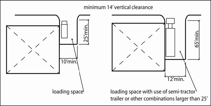
Figure 5.6-A: Off-Street Loading Spaces
2.
Surfacing and Maintenance. All surfaces within a parking area including access drives and loading areas must be paved and maintained with concrete, asphalt, or similar material of sufficient thickness and consistency to support anticipated traffic volumes and weights.
C.
Location.
1.
Off-street loading facilities required in this Section must be located on the same lot or parcel of land as the structure they are intended to serve. The required off-street loading space shall not be part of the area used to satisfy the off-street parking requirements.
2.
At no time may goods be loaded or unloaded from the ROW of a collector or arterial street.
3.
No part of any vehicle may extend into the ROW of a collector or arterial street while being loaded or unloaded.
4.
On a site adjoining an alley, a required loading space should be accessible from the alley.
5.
A required loading space must be accessible without backing a truck across a collector or arterial street property line unless the provision of turnaround space is infeasible.
6.
A loading space must not intrude into any portion of a required aisle or access dimension.
7.
An occupied loading space must not prevent access to a required parking space.
8.
To the maximum extent feasible, loading areas shall be located to the rear of a site and/or away from adjacent residential areas.
D.
Setbacks and Screening. Loading areas may not be located in a required setback and must be screened from view from the perspective of adjacent streets and adjacent residential properties.
5.6.7.
Parking Alternatives. The Zoning Administrator may approve alternatives to providing the number of off-street parking spaces required by Table 5.6-1, Off-Street Parking Schedule A in compliance with the following standards.
A.
Shared Parking. The Zoning Administrator may approve shared parking facilities for developments or uses with different operating hours or different peak business periods if the shared parking complies with all of the following standards:
1.
Location. Shared parking spaces shall not be located farther than 600 feet from the primary building entrance.
2.
Zoning Classification. All shared parking areas shall be located on a site with the same or a more intensive zoning classification than the zoning classification for the primary use(s) served by the shared parking area.
3.
Shared Parking Study. Those proposing to use shared parking as a means of satisfying off-street parking requirements shall submit a shared parking analysis that clearly demonstrates the feasibility of shared parking. The applicant shall also demonstrate that any parking reduction requested as part of the shared parking study will not result in the spillover of parking onto other properties.
4.
Agreement for Shared Parking. The parties involved in the joint use of off-street parking facilities shall submit a written agreement for such joint use, approved by the Zoning Administrator. The Zoning Administrator may impose such conditions of approval as may be necessary to ensure the adequacy of parking in areas affected by such an agreement. The agreement shall be approved as part of the Site Plan approval. Documentation of the agreement shall take place before issuance of a Building Permit for any use to be served by the shared parking area. A shared parking agreement may be revoked only if all required off-street parking spaces will be provided in compliance with the requirements of Table 5.6-1, Off-Street Parking Schedule A.
5.
Discontinued Users of a Shared Parking Agreement. If a party or use utilizing a shared parking agreement is discontinued, use of the property by another party or use will require a new shared parking study to demonstrate sufficient parking.
B.
Off-Site Parking. The Zoning Administrator may approve the location of required off-site parking spaces on a separate lot, or in the public ROW, from the lot on which the principal use is located if the off-site parking complies with all of the following standards:
1.
Location. No off-site parking space may be located more than 600 feet from an entrance to a principal use (measured along the shortest legal pedestrian route). Off-site parking spaces shall be connected to the use by acceptable pedestrian facilities, as defined in Section 5.5.4, Pedestrian Circulation. Off-site parking spaces may not be separated from the use served by a street ROW with a width of more than 80 feet, unless a grade-separated pedestrian walkway, a traffic signal, a shuttle bus, or other traffic control is provided, or other traffic control or remote parking shuttle bus service is provided.
2.
Agreement for Off-Site Parking. In the event that an off-site parking area is not under the same ownership as the principal use served, a written agreement between the record owners shall be required. An attested copy of the agreement between the owners of record shall be submitted to the City for recordation in a form acceptable to the City Attorney. Recordation of the agreement shall take place before issuance of a Building Permit or Certificate of Occupancy for any use to be served by the off-site parking area. In the event that an off-site parking agreement is terminated, all required off-street parking spaces shall be provided in compliance with the requirements of this Chapter. No use shall be continued if the parking is removed unless substitute parking facilities are provided, and the Zoning Administrator shall be notified at least 60 days prior to the termination of a lease or agreement for off-site parking.
C.
Structured Parking.
1.
Credit for Nearby Public Structured Parking. Spaces available in nearby public parking structures may be counted toward the total amount of required off-street parking.
2.
Height of Parking Structure. The height of a parking structure may not exceed the height of the principal building it is intended to serve. Where no principal building exists, the maximum height of the parking structure shall be limited to the maximum building height allowed in the zoning district in which the structure is located.
3.
General Standards.
a.
Parking structures located along a public street or public pedestrian thoroughfare shall provide for active uses (other than parking) at street level, such as retail storefronts.
b.
Internal circulation and parking levels shall be oriented so that a horizontal, rather than sloped, plane faces public streets (See Figure 5.6-B).
c.
Parking structures must be designed to incorporate a comparable level of architectural detailing and quality materials as the primary building. Where no primary building exists, a parking structure shall incorporate architectural detailing and quality materials comparable to buildings on surrounding blocks.
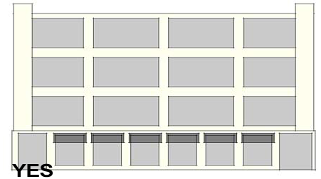
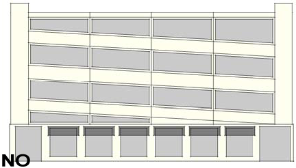
Figure 5.6-E: Parking Garage Design. A sloping approach may be used, but a horizontal plane should face public streets.
D.
Sites in Mixed-Use Districts. In the mixed-use districts, the total requirement for off-street parking facilities shall be the sum of the requirements for the various uses computed separately, subject to the modifications set forth below.
1.
All nonresidential uses within mixed-use districts shall be eligible for a 15 percent parking reduction to reflect the reduced automobile use associated with mixed-use developments.
2.
A 15 percent parking reduction for multi-family residential dwellings may be allowed if the proposed use is located within 1,320 feet of a transit stop.
3.
The total number of parking spaces required of a use or uses in a mixed-use district may be further reduced by the Zoning Administrator if the applicant provides a parking demand study in accordance with Section 5.6.3.D.
E.
On-Street Parking. On streets where on-street parking is permitted by the City, outside of the Downtown Activity Center, on-street parking spaces in the ROW along the property line, between the lot lines of the site, may be counted to satisfy the minimum off-street parking requirements. Within the Downtown Activity Center, on-street parking spaces and any parking spaces within City-owned public parking lots within 600 feet of a property may be counted to satisfy the minimum off-street parking requirements. Where such spaces are not already delineated, new developments shall provide signage, striping, and landscape islands to delineate the designated parking area.
F.
District Parking. Minimum required off-street parking spaces may be waived or reduced for properties within the boundaries of a public parking or local improvement district that provides district-wide parking facilities, based on the projected parking demand to be addressed by the district-wide facility.
5.6.8.
Dimensions of Parking Spaces.
A.
Parking Angle Dimensions. The parking configuration stated in the following table shall apply to all required off-street parking.
B.
Calculation of Parking Space Dimensions. The spatial relationships described in Table 5.6-3, Parking Angle Dimensions, shall be calculated in the manner depicted in Figure 5.6-C:
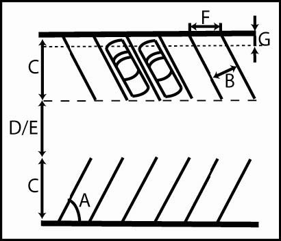
Figure 5.6-C: Spatial Relationships of Parking
5.6.9.
Parking Lot Design Standards.
A.
Surface. All parking and driveway areas and primary access to parking facilities shall be surfaced with asphalt, concrete, or other similar materials, unless otherwise approved. Pedestrian linkages shall comply with Section 5.5.4, Pedestrian Circulation.
B.
Incentive For Use of Permeable Surfaces. The number of parking spaces required for a new development stipulated in this Section may be reduced by no more than five percent if the vehicle parking spaces and circulation/driveway surfaces are constructed with pervious concrete, pervious asphalt, or similar materials such as pavers, that reduce the amount of runoff of an impervious surface, as determined by the City Engineer.
C.
Maintenance. Parking facilities, including pavement markings, shall be continually maintained in compliance with the approved site and/or subdivision plan and shall be free of litter and debris at all times.
D.
Circulation Area Design. Circulation areas shall be designed to facilitate the safe movement of vehicles without posing a danger to pedestrians or impeding the function of the parking area. Parking lots that accommodate ten or more vehicles must maintain continuous circulation patterns, with no dead-ends, and safe access to public streets (see Figure 5.6-D). On properties with unique dimensional or other constraints, the Zoning Administrator may allow dead-ends on parking lots that accommodate more than ten vehicles if an acceptable turnaround is provided.
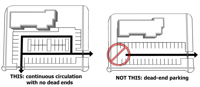
Figure 5.6-D: Example Circulation Area Design
E.
Buffering and Screening; Location of Lot.
1.
Outside Downtown, all parking areas shall be separated at least ten feet from buildings, in order to allow room for sidewalks, landscaping, and other plantings between the building and the parking area. For industrial and warehouse buildings, this separation may be eliminated in areas designed for unloading and loading of materials.
2.
Outside Downtown, to the maximum extent feasible, parking areas shall be located to the rear or side of buildings rather than in front, in order to reduce the visual impact of the parking areas. No more than one two-sided bay of nose-in parking should be placed between the building(s) and the street.
F.
Parking Area Layout. Surface parking areas shall be divided into sub-areas, each accommodating no more than 250 vehicles. Each parking sub-area shall be separated by a minimum 15-foot wide landscaped feature, which shall include pedestrian walkways and shade features. This technique shall be used to minimize the "sea of parking" between the building and the principal street.
G.
Parking Lot Landscaping. The perimeter and interior of parking lots shall be landscaped pursuant to the requirements in Section 5.4.3 C, Landscaping Inside Parking Areas.
H.
Shared Access. Parking lots shall share access drives with adjacent property with similar land uses and, when requested by the City, a cross-access easement shall be provided.
I.
Lighting and Maintenance. All parking area lighting shall comply with the City's lighting requirements and provide adequate lighting for safety if night use is intended. Refer to Section 5.11.3.K, Parking Lot and Pedestrian Lighting. Parking lots should provide adequate security and should limit visual clutter, parking lot signs, and equipment.
5.6.10.
Bicycle Parking Requirements.
A.
Applicability. Bicycle parking must be provided for all new development, parks, additions of ten percent or more of the floor area of existing buildings, and changes in land use classification. Single-family homes, duplexes, and multi-family dwellings of less than four units are exempt.
B.
Number of Required Bicycle Parking Spaces.
1.
Short-Term Bicycle Parking. If a land use or project is anticipated to generate visitor traffic, the project must provide permanently anchored bicycle racks within 100 feet of the visitor's entrance. To enhance security, visibility, and functionality, bicycle racks must be located along active frontages and be readily visible to passers-by from the street or from visitor parking areas, in a shaded or partially shaded location. The bicycle capacity of the racks must equal an amount equivalent to five percent of all required motorized vehicle parking. A minimum of one rack with capacity for two bicycles is required.
C.
Bicycle Racks. Required bicycle parking may be provided in floor, wall, or ceiling racks. Where required bicycle parking is provided with racks, the racks must meet the following requirements:
1.
Each short-term and long-term bicycle parking space must be a minimum of two feet in width and six feet in length.
2.
A minimum of two feet of clearance must be provided between bicycle parking spaces and adjacent walls, poles, landscaping, street furniture, drive aisles, and pedestrian walkways.
3.
The rack must be securely anchored.
4.
Racks must feature a design/finish complementary to the nearest building.
D.
Visibility. If required bicycle parking is not visible from the street or main building entrance, a sign must be posted at the main building entrance indicating the location of the bicycle parking.
(Ord. No. 28-25, § 3, 10-21-2025)
5.7. - RESIDENTIAL BUILDING STANDARDS AND GUIDELINES
5.7.1.
Purpose. The standards of this Section are intended to promote high-quality residential development and construction; protect property values; encourage visual variety and architectural compatibility; and promote an integrated character for Buckeye's neighborhoods. Specifically, the standards:
A.
Promote new residential developments that are distinctive, have character, and relate and connect to established neighborhoods;
B.
Provide variety and visual interest in the exterior design of residential buildings;
C.
Enhance the residential streetscape and diminish the prominence of garages and parking areas;
D.
Enhance public safety by preventing garages from obscuring main entrances or blocking views of the street from inside residences; and
E.
Improve the compatibility of attached and multi-family residential development with the residential character of surrounding neighborhoods.
5.7.2.
General Standards for All Residential Development.
A.
Mix of Housing Types.
1.
Purpose.
a.
To promote a more diverse community through the provision of a variety of housing types.
b.
To encourage developments that are not dominated by a single type of home or dwelling unit, providing for a variety of price points and densities.
c.
To encourage "neighborhood-oriented" multi-family developments that incorporate a variety of housing types, such as a combination of duplex, triplex/fourplex, live-work units, townhomes, apartments, and single-family units in a range of sizes.
2.
Standard. Single-family residential developers of 20 acres or more shall provide a minimum housing mix of at least three floor plans, with a minimum of three elevations per floor plan.
B.
Infill Residential Compatibility Standards.
1.
Applicability. These residential infill compatibility standards shall apply to development of a new residential use, or renovation of an existing residential use, either of which is not part of a planned/phased development, on a site that is adjacent to or across a street from two or more lots with existing structures. Manufactured homes which are located outside of manufactured home parks or subdivisions shall comply with the design standards within this Section.
2.
Contextual Front Building Setbacks. An applicant must use a contextual front setback when the existing front setbacks on the same block are less than that required by the underlying zoning district (refer to Article 4, Dimensional Standards). In this case, the front setback for the proposed development must equal the average of the existing front setbacks on the same and facing block faces. Only lots with similar uses to that proposed may be included in the average. Vacant lots must be included using the front setback standards of the underlying zoning district. See Figure 5.7-A below.
Figure 5.7-A: Example of Contextual Front Building Setback
3.
Appearance. New development shall be constructed to be generally compatible in appearance with other existing structures on the block that comply with this Development Code. This provision can be satisfied by constructing the proposed building so that at least three of the following features are substantially similar to the majority of other buildings on the same and facing block:
a.
Roof material;
b.
Roof overhang;
c.
Exterior building material;
d.
Shape, size, and alignment of windows and doors;
e.
Front porches or porticos; or
f.
Location and style of garage/carport.
4.
Accessory Structures. Accessory structures shall be compatible with the associated principal structure in terms of building materials and architectural style. Small accessory structures under 300 square feet in area shall not be required to utilize similar materials as the principal residence but shall be painted to match the primary color of the residence.
C.
Entryway Treatment.
1.
Entrances should be prominent and visible from the street or private drive and from parking areas.
2.
The main entry of each unit shall be emphasized by the use of at least two of the following:
a.
A porch or landing;
b.
Double doors;
c.
A roofed structure such as a portico or awning;
d.
The inclusion of side-lights (glazed openings to the side of the door) and/or transom-lights (a glazed opening above the door);
e.
A change in texture or material around the entry;
f.
Offsets or insets, bays, or similar architectural features; and/or
g.
Other architectural enhancements consistent with the proposed architectural style(s), as determined by the Zoning Administrator.
D.
Mechanical Equipment. Mechanical equipment, such as air conditioners, pool heaters, and equipment associated with solar energy systems, shall be located outside of any required front yard setback and behind the front façade. Such equipment shall be placed in a side or rear yard and, where visible from a public street, shall be screened from view with landscaping, fencing, or similar materials compatible with the residential character of the property.
E.
Single-Family Residential Pools. Pools must be located in line with or behind the principal structure on a single-family residential lot.
5.7.3.
Standards for Single-Family Detached Residential Dwellings, Duplexes, Triplexes, and Fourplexes.
A.
Purpose. This subsection is intended to promote building design that contributes to a sense of neighborhood and to the overall streetscape by carefully relating buildings, yards, and garages in relation to public streets and adjacent properties. The standards support visual variety, avoid monotony in home designs and layouts, and protect property values of both the subject property and surrounding development.
B.
Design Standards.
1.
Orientation of Dwellings to the Street. Each residence shall have at least one primary pedestrian doorway for access to the dwelling located on the elevation of the dwelling facing the front lot line of the property, and clearly visible from the street or public area adjacent to the front lot line. On corner lots, such pedestrian doorway may be located facing any adjacent street.
2.
Architectural Variety.
a.
Design Standards.
i.
No home model elevation or floor plan shall be located adjacent to or across the street from the same home model elevation or floor plan.
ii.
All home model designs shall provide a similar level of architectural detailing on all sides.
iii.
All home model elevations shall provide a minimum of three color schemes, consisting of at least three colors each.
iv.
For lots backing to collector streets, arterial streets, and parkways, home model elevations with identical roof designs shall not be located directly adjacent to one another.
b.
Tracking. It shall be the responsibility of the developer to disclose these architectural variety standards to potential home buyers. Failure on the part of the developer to disclose these requirements is not grounds for relief from these architectural variety standards as applied to any individual home.
3.
Garages.
a.
Maximum Garage Width. The maximum width of front-facing one- or two-car garages, including the garage door but excluding architectural elements on each side of the garage door, shall not exceed:
i.
Thirty percent of the façade width on homes 60 feet or larger in width;
ii.
Forty percent of the façade width on homes 45 feet in width or larger but less than 60 feet in width;
iii.
Fifty percent of the façade width on homes 36 feet in width or larger but less than 45 feet in width; and
iv.
Sixty percent of the façade width on homes less than 36 feet in width. An additional five percent of garage width is allowed if four of the following design elements are provided:
(1)
The garage is recessed at least three feet behind the porch and/or living space of the home;
(2)
The garage door design and coach light design are unique to each elevation within the residential community;
(3)
The garage door design includes windows and decorative hardware, as appropriate to the architectural style of the home;
(4)
The garage door is recessed a minimum of 12 inches from the surrounding façade; and/or
(5)
The driveway is comprised of decorative or enhanced paving.
(6)
In lieu of (1) through (5) above, the applicant may propose a higher level of design through AEC as provided for in Section 5.1.4, Alternative Equivalent Compliance (AEC).
v.
On homes that incorporate a front-facing RV garage, the maximum aggregate width of the garage doors attached to the primary residence and facing the front of the lot shall not exceed 45 percent of the overall building façade width. If the individual doors are separated by four feet, and one of the garage doors is set back at least six feet, the maximum aggregate width shall not exceed 52 percent of the façade width.
vi.
On homes that incorporate a front-facing three-car garage (excluding tandem garages), the maximum aggregate width of the garage doors attached to the primary residence and facing the front of the lot shall not exceed 50 percent of the overall building façade width.
b.
Diversity of Garage Location. In all single-family residential zoning districts except for R1-43, a diversity of garage styles is required. Diversity shall be achieved by providing a variety of the following garage locations:
i.
Alley-loaded garage;
ii.
Side-loaded garage;
iii.
Garage recessed a minimum of four feet behind the front façade of the dwelling portion of the structure;
iv.
Garage that protrudes no more than five feet in front of the dwelling portion of the structure, if accompanied by a porch that extends to the same plane or further;
v.
Garage that is recessed a minimum of two feet beneath a second-floor bay; and
vi.
Garage flush with the dwelling portion of the building.
c.
Three-Car Garage Orientation. The third bay of any three-car garage, except a side-loaded garage, shall not have the same orientation as the first two bays or shall be offset by two feet when having the same orientation.
d.
Side-Loading Garages. Side-loaded garages shall provide windows or other architectural details that continue the features of the living portion of the dwelling on the side of the garage facing the front street.
e.
RV Garages. The maximum number of homes that incorporate an RV garage within a subdivision shall not exceed 45 percent. Driveways leading to an RV garage shall include a paver driveway or stained concrete. Additionally, RV garages shall be required to continue the architecture of the principal structure and be set back a minimum of four feet from the front plane of any livable portion of the principal structure. If the RV garage is not setback from the front plane of the livable portion of the principal structure, the façade shall be articulated such that the façade is made up of at least four distinct sections, all of which must be set back or forward of the adjacent façade by at least three feet.
4.
Alleys.
a.
If a residential unit has alley access to a garage, the front setback of the living portion of the house (but not the garage) may be reduced by ten feet.
b.
If a residential unit is served by an alley, no driveways in the front yard shall be permitted. All vehicular access, including to garages, shall be from the alley.
5.
Porches. All residential units shall provide a covered rear yard patio or porch of at least 60 square feet in size. For any residential unit with alley access to a garage, this requirement may be satisfied with a covered patio or porch at least 60 square feet in size attached to the front of the home.
5.7.4.
Standards for Single-Family Attached Residential and Townhomes.
A.
Purpose. The purpose of these standards is to provide a distinctive architectural character in new single-family attached residential and townhome development that avoids featureless design and repetition of façades.
B.
Building Articulation and Architectural Variety.
1.
No more than eight units may be attached in a single row or building cluster.
2.
Buildings shall incorporate at least two distinct materials on each façade and be given architectural and visual interest through two or more of the following methods (see Figure 5.7-B):
a.
Providing a projection, recess, or reveal at least every 20 feet, with a minimum change of plane of two feet;
b.
Use of distinct features, such as a balcony or similar feature, between individual units;
c.
Use of distinct variations in roof form.
Figure 5.7-B: Examples of Building Articulation and Architectural Variety
C.
Garages.
1.
If a development includes alleys, the garages shall be accessed from the alleys, and the front setback may be reduced by ten feet.
2.
If the development does not include alleys, garages on the street-facing side of the building shall occupy no more of the front façade width than as indicated in Section 5.7.3.B.3.a.
D.
Porches. All residential units shall provide a covered front or rear yard patio, porch, or balcony of at least 60 square feet in size.
5.7.5.
Standards for Bungalow Community Development.
A.
Purpose. The purpose of these standards is to ensure that bungalow community (also known as build to rent or single family for rent) projects provide quality housing that meets the needs of current and future residents. Bungalow communities may include attached townhouses or detached individual buildings/cottages. A maximum of eight attached units are allowed before a minimum 20-foot space must be provided.
1.
Units fronting (primary entrance facing) street ROW shall landscape the front setback and enter their garage from the rear or side.
2.
A sidewalk should be provided that connects each unit and the public sidewalk.
3.
All unit designs must provide a similar level of architectural detailing on all sides. Side or rear unit elevations that face street ROW, internal roads, and/or internal parking areas must be architecturally designed at an equivalent level of detail as front elevations. Landscaping must be provided between the building and the ROW.
4.
All unit elevations must provide a minimum of three color schemes, consisting of at least three colors each. Units that match both in elevation and color scheme must not be located adjacent to each other. Consecutive units directly adjacent to a public ROW, within 50 feet of the ROW, shall not feature identical roof designs. Appropriate roof design variety may include, but is not limited to, alternating between one- and two-story units, variations in ridgelines, alternating between a hip roof or gable roof, etc.
5.
Garages must not face the ROW. Entrance to garages must be from an internal private road, alley, or driveway.
6.
If garage spaces are counted toward parking requirements, the garages must be restricted from being used for storage.
7.
Access for ingress and egress to an adjacent public ROW shall be limited to two locations unless additional access points are required by the Fire Department.
8.
Front, side, and rear perimeter setbacks must be landscaped. The setbacks are measured from the perimeter of the project and, where adjacent to streets, may not contain walled yards assigned to individual units/buildings.
9.
Solid waste trash collection must not block the accessible routes, including the public sidewalk along the ROW. Trash cans shall not be visible from off-site except for trash collection days.
10.
Community open space and landscaping must be provided for and shown on the conceptual landscape plans within the Site Plan approval. Required setbacks and walled yards assigned to individual dwelling units cannot be included in the landscaping and open space calculations.
B.
Density Bonus for Traditional Neighborhood Design.
1.
A bungalow community may be granted a density increase of up to 15 percent above the maximum density permitted in the applicable zoning district if designed to meet all of the following criteria:
a.
At least 80 percent of all residential units located along the perimeter of the site, where the site abuts a public street, shall be oriented such that the primary/front façade faces the adjacent street;
b.
A direct connection from the front door of the unit is provided to the adjacent public sidewalk;
c.
No walls or fences taller than three feet are located between the public sidewalk and street-facing front façade of any qualifying unit; and
d.
Enhanced architectural detailing shall be provided on the street-facing façade.
5.7.6.
Standards for Multi-Family Residential (Four or Fewer Stories).
A.
Purpose. The purpose of these standards is to improve the appearance of design and functionality of multi-family development, not including bungalow communities, recognizing the importance of design in the economic success of urban areas, the need to be more efficient in the use of land, and the need to ensure the adequate protection of the surrounding area. More specifically, these standards are intended to:
1.
Provide a distinctive architectural character in new multi-family residential developments that avoids featureless design, large building masses, and repetition of façades within a single development;
2.
Promote sensitive design and planning of multi-family housing units that preserves or improves the characteristics of surrounding development;
3.
Promote building design, placement, and orientation that contributes to a sense of neighborhood and community; and
4.
Improve the quality of life of residents of multi-family residential dwellings.
B.
Applicability. All development or substantial renovation of multi-family residential structures shall comply with the standards in this Section. In the case of mixed-use buildings, these standards and the standards of Section 5.8, Commercial Site and Building Standards and Guidelines shall both apply.
C.
Building and Parking Location, Layout, and Orientation.
1.
In multi-building developments, buildings are encouraged to be arranged to enclose and frame common areas. Common areas and courtyards should be convenient for a majority of units.
2.
When more than one multi-family structure is constructed, no multi-family structure shall be located within ten feet of any other multi-family structure. Buildings three stories or taller shall be separated from one another by a minimum of 30 feet.
3.
For purposes of measurement in this subsection, projections such as decks and bay windows shall not be counted.
D.
Building Mass and Articulation.
1.
Each façade greater than 50 feet in length, measured horizontally, shall incorporate wall plane projections or recesses having a depth of at least three feet and a length of at least 20 feet. Façades greater than 200 feet in length, measured horizontally, shall incorporate wall plane projections or recesses having a depth of at least six feet and a length of at least 40 feet.
2.
The façades of all multi-family buildings shall feature at least two distinct materials and be articulated through the incorporation of at least three or more of the following:
a.
Balconies (wrap-around balconies at building corners shall be counted as meeting two of the required three features);
b.
Windows that recess or project at least 18 inches from the face of the adjacent wall;
c.
Porches or covered entries to individual units and/or common lobbies with a minimum area of 50 square feet;
d.
Variations in roof forms and/or parapet height;
e.
Vertical elements that demarcate building modules;
f.
Architecturally integrated awnings over windows and doorways if not used in a repeating, predictable pattern; and/or
g.
Changes in wall plane of six feet or more.
3.
The height of each multi-family building taller than 35 feet shall be stepped down from its highest roofline at least one full story on any end of the building located within 50 feet of an adjacent area zoned or used for single-family residential.
4.
Ground floor patios shall be enclosed with solid walls constructed of durable materials such as masonry, stucco on block, or similar permanent materials. Open fencing, such as wrought iron or perforated metal paneling, shall be restricted to use on second stories and above.
5.
Exterior stairways shall be screened from public view through architectural means that are integrated into the overall massing and design of the building.
E.
Roof Form.
1.
The incorporation of a variety of roof forms is strongly encouraged. Upper-level residential floors may be incorporated into the roof form to reduce the apparent height and mass of buildings.
2.
Multi-family residential buildings shall be designed to avoid any continuous roofline longer than 50 feet. Rooflines longer than 50 feet shall include at least one vertical elevation change of at least two feet. Rooflines longer than 100 feet shall include at least two such changes.
F.
Architectural Details, Materials, and Colors.
1.
Highly reflective materials shall not be used in areas where the location of the building will create undue solar, reflective glare on surrounding properties.
2.
In multi-building complexes, individual buildings shall incorporate architectural details, color palettes, or building materials different from, but complementary to, the adjacent buildings.
3.
Permitted Wall Materials. The following materials are permitted for use on exterior building walls, individual or in combination:
a.
Brick, including realistic veneers;
b.
Stone, including realistic veneers;
c.
Stained, exposed aggregate, or integrally-colored concrete masonry units (CMU), split face or ground face;
d.
Textured tilt-up concrete panels, with or without reveals;
e.
Integrally-colored stucco;
f.
Exterior insulation and finish systems (EIFS) and fiber cement panel systems featuring concealed fasteners and incorporating reveals (allowed as an accent only on first floors; may be primary material on second stories and above);
g.
Clear and tinted glass;
h.
Tile (allowed as an accent only);
i.
Wood (allowed as an accent only);
j.
Architectural-grade metal panels featuring concealed fasteners and high-performance coatings and significant articulation, texture, or patterning, intended to provide a refined, durable finish (allowed as an accent only);
k.
Metal posts, columns, beams, or similar structural support; and/or
l.
Other materials of comparable quality, durability, and character, as determined by the Zoning Administrator.
4.
Prohibited Materials. The following materials are prohibited:
a.
Asphalt shingles; and
b.
Poor quality veneers and other engineered materials that have an unnatural appearance not reflective of the product they are attempting to simulate.
5.
Downspouts. Scuppers and exterior downspouts shall not be permitted on any building façade visible from adjacent streets or properties and must be fully concealed within the wall assembly or integrated into the architectural design of the structure, except that the Zoning Administrator may permit exterior downspouts if the downspout is designed as a deliberate architectural feature that is integral and true to the overall style of the building and serves a decorative function.
G.
Site Entrances. The prominence of entrances to a site (both vehicular and pedestrian) intended for use by residents and visitors shall be reinforced through use of decorative pavement treatments, enhanced landscaping featuring landscape lighting, and attractive and complementary signage.
H.
Building Entrances.
1.
Buildings located adjacent to public streets should feature at least one main pedestrian entry facing the adjacent street connecting to the adjacent public sidewalk by a walkway with enhanced landscaping design and shade elements.
2.
All building entrances serving more than a single unit shall be emphasized with landscaping, special paving, arbors, or similar features, and incorporate at least two of the following:
a.
A porch or landing;
b.
A roofed structure such as a portico, awning, or marquee, architecturally integrated into the building's design;
c.
The inclusion of side-lights (glazed openings to the side of the door), and transom-lights (glazed opening above the door) in the entry design; or
d.
Decorative lighting.
I.
Private Outdoor Open Space. Each unit shall be provided a minimum of 50 square feet of private outdoor open space in the form of either a patio or balcony.
J.
Accessory Elements.
1.
Storage. A multi-family project shall provide covered, enclosed, and secure storage areas for bicycles and other belongings, unless buildings are designed to include enclosed storage space large enough to store a bicycle within individual dwelling units. Storage and other accessory buildings shall be designed with materials and/or architectural elements that are related to the principal building(s).
2.
Trash Receptacles/Dumpsters.
a.
Dumpsters, trash compactors, or similar appurtenances shall be located within walled enclosures of sufficient height to screen the equipment within that are designed to complement on-site buildings.
b.
Trash enclosures shall be geographically distributed throughout a site to ensure convenient access by all residents. Any development that provides a valet service where staff, on a regular and frequent basis, collect garbage from individual units and transport it to a centralized dumpster or compactor, shall not be required to distribute multiple enclosures on a site.
c.
Dumpsters shall not be allowed in developments or sites with six or fewer dwelling units; instead, covered storage for trash receptacles shall be provided. Such covered storage shall not be located between any building and the primary adjacent street frontage.
K.
Garages.
1.
Attached or Detached Garages. Excluding any garage architecturally integrated into the design of the building where upper floor residential uses occur over ground floor garages, all garage entries and carports shall not be located between a principal multi-family building and a street frontage. Buildings with architecturally integrated garages shall be oriented so that the garage door faces away from the adjacent street. No individual unit garage shall take vehicular access directly from an external public street.
2.
Size. Garage and carport structures shall be limited to eight spaces per structure to avoid a continuous row of garages. No more than eight garage doors may appear on any multi-family building elevation containing front doors, and the plane of each garage door shall be offset at least two feet from the plane of the garage door adjacent to it.
3.
Design. Detached garages and carports shall be integrated in design with the principal building architecture and shall incorporate similar and compatible forms, scale, materials, color, and details.
4.
Parking Structures. Underground parking, structured parking, and parking within, above, or beneath the building it serves are all strongly encouraged for multi-family developments.
5.
Landscape. Where a façade includes more than one garage door, a minimum ten square foot landscape island or at least one decorative pot containing a 36-inch box tree shall be provided between individual garages. Where a landscape island or tree is not feasible, the Zoning Administrator may approve alternative design elements intended to soften the appearance of a façade with multiple garage doors.
5.7.7.
Standards for Multi-Family Residential (More Than Five Stories). All multi-family residential buildings that are five stories or greater in height shall comply with Section 5.7.6. Additional design measures may be required for buildings five stories or greater in height, to be determined during a Site Plan review.
(Ord. No. 28-25, § 3, 10-21-2025)
5.8. - COMMERCIAL SITE AND BUILDING STANDARDS AND GUIDELINES
5.8.1.
General Intent.
A.
The intent of this Section is to establish design and development standards that foster high-quality, attractive, and sustainable development that is compatible with General Plan principles and policies. The standards are intended to:
1.
Protect and enhance the character and quality of residential, commercial, and industrial areas in Buckeye;
2.
Protect and enhance the long-term market value of property within Buckeye;
3.
Enhance the human and pedestrian scale of commercial and industrial developments and ensure compatibility between residential neighborhoods and adjacent commercial and industrial uses;
4.
Mitigate negative visual impacts arising from the scale, bulk, and mass of large buildings and centers;
5.
Promote building designs and construction practices that are sustainable and adaptable to multiple uses for extended building lifecycles;
6.
Minimize negative impacts of on-site activities to adjacent uses; and
7.
Balance the community's economic and aesthetic concerns.
5.8.2.
Site Design.
A.
Purpose. The standards and guidelines of this Section are intended to:
1.
Ensure development relates to the physical characteristics of the site;
2.
Ensure building scale, orientation, and design relates to the surrounding uses and streets, and creates a cohesive visual identity and an attractive street scene;
3.
Ensure site design for efficient pedestrian, bicycle, transit, and vehicular circulation patterns, and create a high-quality pedestrian environment;
4.
Promote design environments built to human scale;
5.
Ensure delivery, trash, and loading facilities are located so as not to impede regular vehicular and pedestrian circulation and access routes; and
6.
Ensure safe and efficient access between buildings and parking areas.
B.
Building Orientation.
1.
Primary Entrance. Buildings should be placed on a site so that the principal building entrance faces the principal street or the street providing main access to the site. In cases where the principal entrance does not face the principal street, the entrance to the street and adjacent parking areas must be connected with sidewalks that meet the shading requirements of Section 5.2, Topography and Natural Features Preservation.
2.
Building Locations (Multi-Building Developments). Arrange and group buildings within developments that have three or more buildings using one or more of the following techniques (see Figure 5.8-A for examples):
a.
Frame the corner of an adjacent street intersection or entry point to the development; or
b.
On sites of 15 acres or more, frame and enclose a "main street" pedestrian and/or vehicle access corridor within the development; or
c.
Frame and enclose parking areas on at least two sides; or
d.
Frame and enclose outdoor dining and/or outdoor gathering spaces between buildings.
Figure 5.8-A: Multi-Building Development with Framed Intersection and Enclosed Parking
at Main Street and Verrado Way
3.
Guideline. Buckeye's desert setting requires careful siting of buildings in order to mitigate the summer heat. Buildings should be oriented and grouped to provide shading for outdoor spaces — for example, by locating outdoor gathering spaces on the north and east sides of buildings under shade devices such as awnings.
C.
Outdoor Gathering Spaces.
1.
Standards. Developments on sites of ten acres or larger require a minimum of two percent of the net site area to be an outdoor gathering place that:
a.
Is integrated as part of the overall design of the site and located in an area that maximizes accessibility to the greatest amount of users and helps establish or improve functional relationships and linkages within a site or between adjacent sites. Potential locations include near anchor tenants, near concentrations of restaurants, near transit stops (if applicable), as a geographically centralized site feature, or as a continuation of an adjacent natural area, trail, or riparian corridor;
b.
Incorporates decorative pavement, pedestrian scale lighting, pedestrian seating (in the form of movable tables/chairs, benches and/or seat walls), shading over 50 percent or more of the plaza area (in the form of shade trees or structural shade elements), and landscaping (in the form of raised planters, pots, tree grates, and/or in-ground planters);
c.
Incorporates well-crafted art, such as murals or sculptures, or design-forward functional art, such as benches or pots, or other features that contribute to the project's overall architectural character or design theme;
d.
Is directly accessible from sidewalks and pedestrian walkways; and
e.
Is maintained by the owners of the development, unless otherwise agreed to as part of the development approval process.
2.
Guidelines.
a.
For sites smaller than ten acres, provide outdoor gathering spaces by expanding pedestrian walkways along the front or side of the building with awnings, arcades, trees, or other types of shade structures and providing pedestrian seating under those shaded spaces.
b.
Provide outdoor dining areas within plazas and along the perimeter of open spaces, building frontages, and street frontages. Outdoor dining areas should be oriented away from off-site uses affected by noise.
3.
Credit to Open Space Standards. An outdoor gathering space required by and designed in compliance with the requirements of this Section will be credited toward any landscape and usable open space required for the development by this Development Code and the Parks and Recreation Master Plan.
D.
Drive-Through Facilities.
1.
Stacking.
a.
For restaurants with drive-through facilities, a minimum of eight stacking spaces (measuring a minimum of nine feet by 20 feet for each stacking space) must be provided, with no less than four spaces located between the street and the order box and four spaces located between the order box and the pick-up window. As determined by the City Engineer, a stacking study may be required depending on the proposed end user and the number of vehicles reasonably expected to use the drive-through facility. (See Figure 5.8-B.)
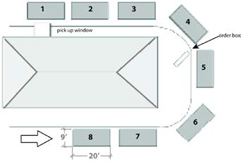
Figure 5.8-B: Stacking Spaces
b.
For drive-through uses other than a restaurant, drive-through facilities specified in Table 5.8-1, Schedule of Stacking Spaces, must comply with the following minimum stacking space standards.
2.
Stacking Study.
a.
The Zoning Administrator or City Engineer may require submittal of a drive-through stacking study signed and sealed by a professional civil engineer that substantiates the basis for requiring a specific number of drive-through stacking spaces.
b.
If required, the stacking study must, at a minimum, include the following:
i.
Description of onsite operations including:
(1)
Business hours of operation;
(2)
The method by which a customer order is placed and processed;
(3)
Peak demand hours;
(4)
The time required to serve a typical customer; and
(5)
A description of how sound from external operations will be attenuated to neighboring properties.
ii.
Description of onsite traffic activity, including:
(1)
Arrival rates of customers;
(2)
Anticipated vehicular stacking required;
(3)
An onsite circulation plan showing points of entry to the site, stacking locations and distances, and anticipated patterns of onsite circulation;
(4)
A mitigation plan describing how backup stacking will be addressed so that vehicles are not blocking internal drives or backing up onto roadways; and
(5)
An evaluation of uses within 1,200 feet of the proposed development identifying cumulative traffic impacts and mitigation efforts to ensure that vehicles are not blocking internal drives or backing up onto roadways.
iii.
Other information deemed necessary by the Zoning Administrator or City Engineer to determine whether the proposal has appropriate traffic circulation and stacking.
3.
Layout and Design.
a.
Direct access to drive-through facilities is not permitted from primary commercial center driveways and must be located a minimum of 60 feet from a primary commercial center driveway.
b.
Drive-through facilities, including drive-through aisles, speaker boxes, menu boards, and drive-through windows, must be located a minimum of 25 feet from a public ROW and a minimum of 75 feet from a residential zoning district or residential use.
c.
Each drive-through lane must have a minimum width of 12 feet and a minimum interior turning radius of 25 feet.
d.
Drive-through aisles must be clearly identified using striping, landscaping, and signage and must be designed to:
i.
Minimize conflict between pedestrians, parking, and the building entrance. Pedestrian walkways should not intersect the drive-through aisles, but where they do, they shall have a minimum of 15 feet clear visibility and be emphasized with enhanced paving. Appropriate pedestrian crossing signs must be visible from both the vehicle drive aisle and the pedestrian walkway. Vehicles in the drive-through area must not wait within the pedestrian crossing; and
ii.
Be integrated with the on-site circulation of the larger development.
e.
Drive-through facilities must orient pick-up/teller windows away from adjacent residential uses or adjacent arterial or collector streets.
f.
Drive-through lanes must be screened from the ROW and adjacent uses through the incorporation of a landscaped berm with continuous, dense landscaping with year-round foliage at least four feet in height to screen the vehicles in the queue. In cases where a berm may not be feasible because of space constraints, a decorative screen wall may be used in connection with landscaping.
g.
Drive-through facilities must incorporate an attached canopy over payment and pickup windows or teller/ATM stations. The canopy must not exceed the height of the adjacent building. All lighting fixtures in the canopy area must be fully recessed.
h.
The architecture of drive-throughs, including required canopies, must reflect the architecture of the principal building.
i.
Menu Boards.
i.
Maximum of two menu boards per drive-through lane;
ii.
Must be placed within ten feet of any drive-through lane;
iii.
Must be placed at least 30 feet from any ROW;
iv.
Maximum allowable menu board height is seven feet; and
v.
Maximum allowable menu board area is 45 square feet.
E.
Refuse Service. All commercial or industrial development shall provide one or more sites for solid waste collection. Such sites shall be:
1.
Located so as to facilitate collection and minimize any negative impact on persons occupying the development site, neighboring properties, or public ROW, including visual impact;
2.
Constructed according to specifications established by the Public Works Director to allow for collection without damage to the development site or collection vehicle;
3.
Designed so that any enclosure complements the architecture of buildings on the site, utilizing a mix of the same materials and colors used on the primary buildings, and incorporates a solid, opaque gate; and
4.
If possible, enclosures should be located and sized to be shared by multiple users.
5.8.3.
Building Design.
A.
Purpose. The standards and guidelines of this Section are intended to:
1.
Ensure that multi-building or phased commercial developments use compatible schemes of materials, colors, and architectural vocabulary to ensure consistency;
2.
Ensure building materials are durable and have low maintenance requirements in the desert environment;
3.
Ensure buildings are designed to a human scale;
4.
Ensure design that is sensitive to the desert climate;
5.
Encourage sustainable development by limiting the amount of resources necessary to construct and operate buildings and by designing buildings to be adaptable for multiple uses;
6.
Require buildings that are designed with a standardized corporate architectural style to meet a higher level of building design, thereby ensuring they are complementary to, and support the character of, the surrounding area; and
7.
Ensure architectural compatibility in keeping with Buckeye's heritage.
B.
Architectural Character.
1.
Standards.
a.
Four-Sided Design. Any building elevation visible to the general public, including from parking areas, ROW, and surrounding properties, must incorporate architectural detailing on all sides of a building consistent with the level of design and architectural detail on the front façade. Blank walls void of architectural details or other variation are prohibited on publicly visible building elevations.
b.
Exterior Trademarked Design Features. For each building with exterior trademarked architectural design features located 12 feet or more above finished grade, including trademarked roof and parapet design features, but excluding signs, a higher level of building design must be incorporated by meeting the following additional requirements:
i.
Section 5.8.3.D.1.a, Horizontal Articulation: meet four or more of the listed standards; and
ii.
Section 5.8.3.E.1.a, Primary Building Entrance: meet four or more of the listed standards.
2.
Guideline: Theming. Organize the architectural design of buildings within a commercial center, including freestanding pad buildings, around a consistent architectural theme. Precise replication is not required or desirable. Instead, use complementary materials, textures, and colors, along with repeating patterns and compatible proportions and scale, to reinforce the connections between the various buildings.
C.
Response to the Sonoran Desert Environment.
1.
Standards.
a.
Shaded sidewalks must be provided along at least 50 percent of all building façades adjacent to or facing streets, outdoor gathering spaces, or parking areas. See Figure 5.8-C.
b.
A shaded sidewalk must include at least one of the following design standards:
i.
A sidewalk at least ten feet wide made of pervious concrete with shade trees at 30-foot intervals or of standard concrete with the trees planted in grates at the same distance;
ii.
A five-foot sidewalk adjacent to a landscape strip at least ten feet wide planted with shade trees at 30-foot intervals; or
iii.
A sidewalk at least six feet wide covered with weather-protection materials (such as awnings, an arcade, trellis, or other structure).
c.
Shaded sidewalks shall constitute a minimum of 30 percent of the sidewalks within the site.
d.
Buildings must be oriented to minimize direct solar exposure on primary building façade and areas of high pedestrian activity, where feasible.
Figure 5.8-C: Examples of Shaded Sidewalks
2.
Guidelines.
a.
Sustainable Design. To the maximum extent practicable, new buildings are encouraged to incorporate one or more of the following features:
i.
Opportunities for the integration of renewable power in the design of buildings or sites;
ii.
Energy-efficient materials, including recycled materials that meet the standards of Section 5.8.3.F, Architectural Details, Materials, and Colors, in the building design;
iii.
A sustainable roof; and/or
iv.
Generally accepted sustainable design features and practices.
D.
Building Mass.
1.
Standards.
a.
Horizontal Articulation. Design buildings to reduce apparent mass by dividing façades into a series of smaller components (See Figure 5.8-D.). No individual component shall have a length of more than 60 feet. Distinguish components from one another through two or more of the following:
i.
Variations in roof form or variations in roof height of two feet or more;
ii.
Changes in wall plane of two feet or more;
iii.
Variations in the arrangement and recessing of windows;
iv.
Recognizable changes in texture, material, or surface colors;
v.
Engaged columns that project from the face of the wall by two feet or more; or
vi.
Minimum two-foot parapet return.
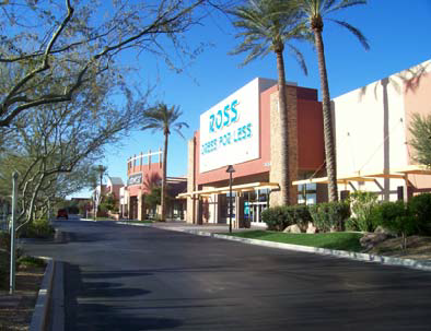
Figure 5.8-D: Examples of Horizontal Articulation
b.
Vertical Articulation. Design multi-story buildings to reduce apparent mass by including a clearly identifiable base, body, and top, with horizontal elements separating these components. The component described as the body must constitute a minimum of 50 percent of the total building height. See Figure 5.8-E.
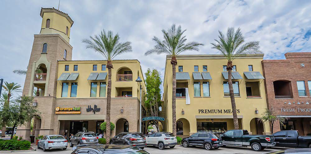
Figure 5.8-E: Example of Vertical Articulation
2.
Guidelines. Incorporate other techniques to further divide large building façades, including:
a.
In large stores, 50,000 square feet or greater, that contain separate internal functions (e.g., coffee shop, deli, florist), for each internal function, provide a minor storefront with a separate entrance.
b.
Provide multiple entrances for large uses (e.g., groceries, department stores, warehouse stores).
E.
Design for Pedestrians.
1.
Standards.
a.
Primary Building Entrance. Design visually prominent primary building entrances that provide shade for pedestrians. Unless otherwise provided in this Article, use a combination of two or more of the following techniques:
i.
Projecting or recessed entry, including a canopy, portico, archway, arcade, or similar projection that provides architectural interest and protection for pedestrians;
ii.
Prominent tower, dome, or spire;
iii.
Peaked roof (where contextually appropriate);
iv.
Outdoor features, such as seat walls, landscaping with seasonal color, or permanent landscape planters with integrated benches; or
v.
Other comparable techniques.
b.
Transparency.
i.
For all commercial buildings with 70,000 square feet or more of gross floor area, at least 15 percent of the façade facing the principal street or an internal driveway in a parking area shall consist of transparent or non-transparent glazing. For all other commercial buildings, at least 30 percent of the façade facing the principal street or driveway in a parking area shall consist of transparent or non-transparent glazing.
ii.
Glazing required in this Section should be concentrated in areas of high pedestrian activity and, to maximize energy efficiency, should be used in conjunction with the shade features required and encouraged by Section 5.8.3.C, Response to the Sonoran Desert Environment, including awnings, shaded sidewalks, deeply recessed windows, and covered porches or arcades.
iii.
Except as otherwise permitted in this Section and in Section 5.12, Signs, transparent glazing must be maintained without interior or exterior obstructions that substantially limit visibility, including, but not limited to, window signs, interior shelving, or window coverings (except window blinds) during hours of business operation. This Section shall not apply to signage, shelving, displays, or the like, set back at least three feet from the glazing surface.
c.
Pedestrian Amenities. Ground-floor façades that face public streets or other public areas (e.g., outdoor gathering spaces, parks or open space, parking areas) shall incorporate pedestrian-oriented design features along no less than 60 percent of their horizontal length. Pedestrian-oriented design features may include arcades, display windows, entryways, awnings, or other features. Shaded sidewalks required by Section 5.8.3.C, Response to the Sonoran Desert Environment, that are part of the building design may also be credited toward this standard.
F.
Architectural Details, Materials, and Colors.
1.
Standards.
a.
Permitted Wall Materials. The following materials are permitted for use on exterior building walls, individually or in combination:
i.
Brick, including realistic veneers;
ii.
Stone, including realistic veneers;
iii.
Stained, exposed aggregate, or integrally-colored concrete masonry units (CMU), split face or ground face;
iv.
Textured tilt-up concrete panels, with or without reveals;
v.
Integrally-colored stucco;
vi.
Exterior insulation and finish systems (EIFS) and fiber cement panel systems featuring concealed fasteners and incorporating reveals (allowed as an accent only on first floors; may be primary material on second stories and above);
vii.
Clear and tinted glass;
viii.
Tile (allowed as an accent only);
ix.
Wood (allowed as an accent only);
x.
Architectural-grade metal panels featuring concealed fasteners and high-performance coatings and significant articulation, texture, or patterning, intended to provide a refined, durable finish (allowed as an accent only);
xi.
Metal posts, columns, beams, or similar structural support; and/or
xii.
Other materials of comparable quality, durability, and character, as determined by the Zoning Administrator.
b.
Accent Wall Materials. A minimum of ten percent and a maximum of 25 percent of the exterior building wall facing the principal street (not including windows and doorways) shall consist of an accent material from the list in subsection (a) that is different than the remainder of the building façade material.
c.
Prohibited Wall Materials. The following materials are prohibited:
i.
Un-textured tilt-up concrete panels;
ii.
Prefabricated metal panels, excluding architectural grade metal panel systems described above; and/or
iii.
Mirrored surfaces or any treatments which change ordinary glass into a mirrored or highly reflective surface.
d.
Downspouts. Scuppers and exterior downspouts shall not be permitted on any building façade visible from adjacent streets or properties and must be fully concealed within the wall assembly or integrated into the architectural design of the structure, except that the Zoning Administrator may permit exterior downspouts if the downspout is designed as a deliberate architectural feature that is integral and true to the overall style of the building and serves a decorative function.
e.
Roof Materials. Flat roofs, standing seam metal roofs, and concrete and clay tile roofs are permitted, though peaked roofs should be avoided in areas where a contemporary aesthetic is prevalent. Asphalt shingle roofs are not permitted.
f.
Exterior Building and Roof Colors. Select materials and colors that are abundant in the Sonoran Desert environment.
i.
Reflective building materials (other than windows) and roofing materials, including materials with high gloss finishes and bright, untarnished copper, aluminum, galvanized steel, or other metallic surfaces, must be textured or have a matte or non-reflective surface treatment to reduce the reflection of sunlight.
ii.
Materials used for exterior surfaces of all structures must blend in color, hue, and tone with the surrounding natural desert setting to avoid high contrast.
iii.
Excluding shades of white, bright colors (LRV greater than 70) and contrasting colors are appropriate only for accents, such as on doors, limited trim, and window mullions. Florescent colors are prohibited, even for use as an accent.
iv.
The surface materials of walls, retaining walls, or fences must be similar to and compatible with those of the adjacent main buildings.
(Ord. No. 28-25, § 3, 10-21-2025)
5.9. - LARGE FORMAT RETAIL STANDARDS
5.9.1.
Purpose. The purpose of these standards is to ensure that large format retail development, sometimes called "big box retail," enhances the economic viability and aesthetic value of commercial properties in the City, is compatible with surrounding areas, integrates into the natural and built environment, and contributes to the unique character of the City.
5.9.2.
Applicability. The development and design standards in this Section apply to all new retail establishments with single tenant space of 50,000 gross square feet or greater. Existing large retail establishments that are 50,000 gross square feet or greater must comply with these standards if proposed renovations or improvements exceed 15 percent of the gross floor area. These design standards supplement the applicable standards in Article 5, including, but not limited to, Section 5.8, Commercial Site and Building Standards and Guidelines.
5.9.3.
Building Design.
A.
Aesthetic Character.
1.
Roofs. Roofs must have no less than two of the following features:
a.
Overhanging eaves, extending no less than five feet past the supporting walls;
b.
Where stylistically consistent with development in the immediate area, sloping roofs that do not exceed the average height of the supporting walls, with an average slope greater than or equal to one foot of vertical rise for every three feet of horizontal run and less than or equal to one foot of vertical rise for every one foot of horizontal run;
c.
Where stylistically consistent with development in the immediate area, three or more roof slope planes; and/or
d.
A specific architectural element proposed by the applicant's architect that is acceptable to the Zoning Administrator.
B.
Building Entrances. Large format retail buildings must feature a minimum of two customer entrances that are clearly defined and directly accessible from public sidewalks via onsite pedestrian walkways that feature no less than two of the following elements:
1.
Canopies or porticos;
2.
Overhangs;
3.
Recesses/projections;
4.
Arcades or galleries;
5.
Raised corniced parapets over the door;
6.
Peaked roof forms, where contextually appropriate;
7.
Arches, where contextually appropriate;
8.
Outdoor patios;
9.
Architectural details, such as tile work and moldings, which are integrated into the building structure and design;
10.
Integral planters or wing walls that incorporate landscaped areas and/or places for sitting; and/or
11.
A specific architectural element proposed by the applicant's architect that is acceptable to the Zoning Administrator.
C.
Façade Design.
1.
Building façades must include:
a.
Noticeable material changes impacting at least 70 percent of a vertical wall section when compared to a directly adjacent section for a minimum width of 30 feet, provided at the ratio of one such wall section for every 150 linear feet of façade length; and
b.
Roof height variation of three feet or more at a minimum interval of every 100 feet. Variations should be provided in an asymmetrical fashion and not repeated at a regular interval.
2.
Front- and street-facing façades of buildings, including any rear façade facing a street or freeway, must include a minimum of three of the following features:
a.
Fully shielded decorative style lighting consistent with the architectural style of the building;
b.
Roof style changes (e.g., flat to hip, or flat to shed) that match building materials, wall plane changes (i.e., articulation), or separately defined storefronts, where stylistically and contextually appropriate;
c.
Corner accents, such as a tower at least eight feet taller in height compared to other roof surfaces;
d.
Angled or recessed door entries;
e.
Awnings;
f.
Columns, posts, or other features to define separate storefronts;
g.
Structural entryway accents; and/or
h.
Where a building has a double frontage, each street-facing side must be treated as a primary building frontage.
3.
Side and rear façades must incorporate at least one of the features in subsection C.2 above.
5.9.4.
Enhanced Landscaping. Foundation landscaping shall be increased by 25 percent over standard commercial requirements to provide appropriate softening of the building's mass.
(Ord. No. 28-25, § 3, 10-21-2025)
5.10. - INDUSTRIAL SITE AND BUILDING STANDARDS AND GUIDELINES
5.10.1.
General Intent. The purpose of this Section is to establish design standards appropriate for industrial uses that are compatible with General Plan goals and policies, while promoting economic development, protecting adjacent uses, and fostering a positive image for the community.
5.10.2.
Site Design Standards.
A.
Purpose. The standards in this Section are intended to:
1.
Ensure development relates to the physical characteristics of the site and surrounding uses and streets;
2.
Ensure site design for efficient vehicular and truck circulation patterns;
3.
Ensure delivery, trash, and loading facilities are located so as not to impede regular vehicular and pedestrian circulation and access routes;
4.
Ensure safe and efficient access between buildings and parking areas; and
5.
Ensure any visual pollution, noise, light, and/or similar impacts on nearby residential uses are minimized.
B.
Site Design Standards.
1.
General Site Design.
a.
Site elements such as buildings, parking areas, driveways, sidewalks, and outdoor recreational spaces must be arranged to emphasize the aesthetically pleasing components of the site (e.g., landscaping and the superior architectural design of office building elements) and to screen less attractive elements (e.g., service facilities, loading docks, outdoor storage, equipment areas, and refuse enclosures) through the proper placement and design of buildings, screen walls, and landscaping.
b.
Dock doors and/or storage areas should not be located adjacent to any ROW or freeway/highway. After every effort has been made to locate dock doors and/or storage areas away from ROW and/or freeways/highways, and it is found not to be feasible, those dock doors and/or storage areas shall include an eight-foot high masonry wall along the entire adjacent ROW side, located at the back of the required landscape setback, designed with material and articulation consistent with Section 5.4.6, Fences, Walls, and Screening, along with trees planted 25 feet on-center, located on the outside of the wall, utilizing a variety of trees that will further screen the storage area strategically based on line-of-site from the adjacent ROW. The wall may be required to return a certain distance on one or both sides depending on the analysis of the site line details.
c.
All refuse, storage, and equipment areas placed outside of a building must be screened from adjacent public ROW and uses.
d.
Items or materials stored outside (e.g., stacks, pallets, or piles of materials) shall not be stored such that they extend above the height of the adjacent screen wall unless it can be demonstrated that the storage is not visible from adjacent ROW or properties.
2.
Parking Location and Design.
a.
Surface parking must be located to the side or to the rear of principal buildings to the greatest extent feasible unless cross-docks are an integral part of the operations of the building, in which case surface parking areas may be placed adjacent to a street.
b.
Surface parking stalls for employees and guests are encouraged to incorporate shade structures that are capable of supporting solar/photovoltaic array systems with a minimum clearance height of 12 feet. Shade structures must not encroach into the required access lanes.
c.
Applicable tree and landscaping standards are not required in the sections of the parking areas where solar array systems are placed.
3.
Open Space.
a.
An outdoor seating/break area(s) is required for every proposed building. The seating/break area(s) must be appropriately and proportionately sized based upon the number of employees anticipated within the building.
b.
Outdoor seating areas must include shade and wind protection using landscaping or screening structures. If located where visible from adjacent ROW, the shade structure design shall incorporate colors, materials, and forms that complement the primary building(s).
c.
Outdoor seating areas must be easily accessed from the lobby or interior break rooms, if provided, or placed at the corner(s) of the building.
4.
Landscaping, Screening, and Street Trees.
a.
All new industrial developments must adhere to the standards in Section 5.4 in addition to the standards provided below. In the event of a conflict, the provisions of this Section shall apply. Landscaping must be provided along the public streets and sidewalks to define the street edge, buffer pedestrians from vehicles, and provide shade over the sidewalk.
b.
Walls and fences used to provide screening of loading facilities, outdoor trash receptacles, utility equipment, etc. must be solid and designed with materials and finishes that are consistent with and complementary to the design of the primary buildings.
c.
All new trees planted for screening purposes must be planted a minimum of 30 feet on-center the full length of the area requiring screening, except as interrupted by driveways into the site. At least 80 percent of trees provided for screening purposes must be evergreen species to ensure year-round effectiveness. Landscape materials as required in compliance with Section 5.4 may complement the requirements for screening, but landscaping without a screen wall or fence does not meet the minimum screening requirement of this Section.
d.
Fences used for security purposes may consist of wrought iron, tubular steel, or similar material. The use of chain-link is prohibited except where not visible from adjacent ROW or adjacent residentially zoned or developed properties.
e.
Except where required for screening or buffering from adjacent properties or streets, landscaping is not required within walled or fenced areas of a site not accessible to the general public, such as walled loading yards associated with cross-dock warehouses, walled electrical substations, and the like, or parallel to railroad ROW.
f.
Where not required for screening, trees must be selected and planted to provide shade for walkways, outdoor seating areas, parking areas etc. and for their ability for filtering particulate matter and other pollutants from the air.
5.
Rail Service. The design of any rail crossings and any spur construction must be approved by the rail service provider. The following additional criteria should apply unless modified by the rail service provider:
a.
Road crossings at grade must be avoided wherever possible.
b.
Spur track is not permitted along any frontage between a building and a public ROW and must be confined to the side or rear yard area of the building that the rail spur serves.
c.
Rail loading areas must be screened from view from the public ROW by both landscaping with trees and a wall that matches the architecture, materials, and colors of the building that the rail spur serves.
d.
Spur tracks must not encroach onto/across any required parking stalls. Spur tracks must not encroach across drive aisles for automobile/heavy truck and/or emergency vehicle access except when it is necessary to connect the main rail line with the rail loading area.
e.
Lot divisions and building layouts for properties which adjoin existing or proposed lead and spur lines must be done in a manner to ensure full potential of future rail access and use and should not preclude rail access to other properties adjacent to such rail lines. Subdivisions which could reduce a property's ability to accommodate potential rail served developments may not be authorized.
f.
Speculative building design must include rail service features and/or related easements to ensure the potential use of available spur lines.
g.
Finished floor elevations and dock height door must be provided in all properties abutting rail lines.
h.
The above-referenced rail service development standards may be amended or deleted on a site-by-site basis during Site Plan Review. The following must be established in order to authorize any modification of a rail service standard:
i.
The installation of a lead or spur track cannot be accomplished due to physical constraints on or adjacent to the development site; and
ii.
Other existing or potential rail service properties will not be negatively affected in their ability to accommodate rail service activity as a result of modifications to the standards.
5.10.3.
Building Design Standards.
A.
Purpose. The purpose of these building design standards is to:
1.
Ensure that multi-building or phased industrial developments use compatible schemes of materials, colors, and architectural vocabulary to ensure consistency throughout the development;
2.
Ensure building materials are durable and have low maintenance requirements in the desert environment;
3.
Ensure design that is sensitive to the desert climate; and
4.
Encourage sustainable development by limiting the amount of resources necessary to construct and operate buildings and by designing buildings to be adaptable for multiple uses.
B.
Building Orientation and Placement.
1.
Buildings must be articulated and incorporate transparent elements along any side visible from a street or parking area accessible by the general public.
2.
Where feasible, equipment, electrical, and service rooms must be placed inside the building. Where this is not feasible for practical or operational reasons, the equipment must be screened to minimize its visibility from the public ROW or placed on the site where it is less visible from the ROW. Storage tanks and/or other exterior equipment that by virtue of its height may not be able to be fully screened must be painted with muted, matte, or low-sheen finishes in neutral desert tones.
C.
Architectural Character.
1.
Building Façade Articulation.
a.
Primary building entries must be readily identifiable, well-defined using projections, recesses, columns, roof structures, or other design elements, and provide shade for pedestrians. Two or more of the following techniques are required:
i.
Projecting or recessed entry, including a canopy, portico, archway, arcade, or similar projection that provides architectural interest and protection for pedestrians;
ii.
Prominent tower, dome, or spire;
iii.
Peaked roof (where contextually appropriate);
iv.
Outdoor features, such as seat walls, landscaping with seasonal color, or permanent landscape planters with integrated benches; and/or
v.
Other comparable techniques.
b.
All industrial buildings or campuses shall incorporate an architectural element that approximates the look of an office. When located at the intersection of two public streets, the element shall be located at the corner of a building nearest the intersection or centered on the elevation facing the street. Developments located mid-block shall have discretion on which (or both) corners feature the element, or the element may be centered on the elevation facing the street. The element shall have a prominent, vertical form (e.g. a tower) that extends above the roofline by at least three feet, but no more than 15 feet above the height of adjacent wall sections, incorporate significant glazing, and extend at least 15 percent of the length of the elevation facing the street. In addition, raised parapets with enhanced decorative treatment such as cornices or crenellations are permitted not to exceed eight feet above the maximum allowable height of the building.
c.
All elevations of a building's façade must include modulation and articulation of the wall plane and roof line, proportionate to the height and length of the building, and no less than three feet. Exceptions to this requirement are the wall planes at the dock areas and any elevation not visible from adjacent ROW or neighboring properties.
d.
All elevations of a building's façade visible from adjacent ROW or neighboring properties must have vertical or horizontal variations in color, texture, material, and ornamentation.
e.
No individual building component may exceed 100 feet in length. Individual components must be distinguished from one another through application of two or more of the design elements established in Section 5.8.3.D.1.a.
f.
Shade elements such as canopies, awnings, arcades, and overhangs must be provided over all ground level windows, at all pedestrian entry points, and along the front elevation, any street-facing elevation, and office portions of the building.
g.
Scuppers and exterior downspouts shall not be permitted on any building façade visible from adjacent streets or properties and must be fully concealed within the wall assembly or integrated into the architectural design of the structure, except that the Zoning Administrator may permit exterior downspouts if the downspout is designed as a deliberate architectural feature that is integral and true to the overall style of the building and serves a decorative function.
2.
Door and Window Openings.
a.
For office portions of principal buildings, window and door openings must comprise at least 60 percent of the total area of exterior walls facing a public street.
b.
These windows must be clear or translucent to improve visibility, add visual interest, and allow light into interior spaces.
c.
Industrial building façades facing public streets shall incorporate windows or other transparent glazing above a minimum height of eight feet from finished floor elevation. Such glazing shall be designed to provide natural light into the building while maintaining privacy for interior operations. A minimum of ten percent of the façade area above eight feet shall consist of transparent or translucent glazing. Glazing may be provided in the form of clerestory windows, ribbon windows, or other architecturally integrated features. Glazing shall be incorporated into articulated façade elements such as recesses, projections, banded material, or color changes, or other architectural features that provide depth and visual interest to the building elevation. Clerestory windows shall not appear as isolated or unsupported elements on blank walls.
D.
Architectural Details, Materials, and Colors.
1.
Standards.
a.
Permitted Wall Materials. The following materials are permitted for use on exterior building walls, individually or in combination:
i.
Brick, including realistic veneers;
ii.
Stone, including realistic veneers;
iii.
Stained, exposed aggregate, or integrally-colored concrete masonry units (CMU), split face or ground face;
iv.
Textured tilt-up concrete panels, with or without reveals;
v.
Integrally-colored stucco;
vi.
Exterior insulation and finish systems (EIFS) and fiber cement panel systems featuring concealed fasteners and incorporating reveals;
vii.
Clear and tinted glass;
viii.
Tile (allowed as an accent only);
ix.
Wood (allowed as an accent only);
x.
Architectural-grade metal panels featuring concealed fasteners and high-performance coatings and significant articulation, texture, or patterning, intended to provide a refined, durable finish;
xi.
Metal posts, columns, beams, or similar structural support; and/or
xii.
Other materials of comparable quality, durability, and character, as determined by the Zoning Administrator.
b.
Accent Wall Materials. A minimum of ten percent and a maximum of 25 percent of any exterior building wall facing a principal street (not including windows and doorways) shall consist of an accent material from the list in subsection (a) that is different than the remainder of the building façade material. Concrete tilt panel buildings may satisfy this requirement through provision of concrete formliners that provide a texture distinct from the bulk of the smooth panel.
c.
Prohibited Wall Materials. The following materials are prohibited:
i.
Prefabricated metal panels, excluding architectural grade metal panel systems described above, and any pre-manufactured metal building kits;
ii.
Poor quality veneers and other engineered materials that have an unnatural appearance not reflective of the product they are attempting to simulate; and
iii.
Mirrored surfaces or any treatments which change ordinary glass into a mirrored or highly reflective surface.
d.
Roof Materials. All roofs shall be flat (or appear flat), incorporating a parapet(s) of sufficient height to screen the roof deck surface from all property lines.
e.
Exterior Building and Roof Colors. Select materials and colors that are abundant in the Sonoran Desert environment.
i.
Reflective building materials (other than windows) and roofing materials, including materials with high gloss finishes and bright, untarnished copper, aluminum, galvanized steel or other metallic surfaces, must be textured or have a matte or non-reflective surface treatment to reduce the reflection of sunlight.
ii.
Materials used for exterior surfaces of all structures must blend in color, hue, and tone with the surrounding natural desert setting to avoid high contrast.
iii.
Excluding shades of white, bright colors (LRV greater than 70) and contrasting colors are appropriate only for accents, such as on doors, limited trim, and window mullions. Florescent colors are prohibited, even for use as an accent.
iv.
The surface materials of walls, retaining walls or fences must be similar to and compatible with those of the adjacent main buildings.
E.
Exterior Lighting. Building and landscape accent up-lighting must be incorporated into the lighting plan for the development site with a focus along the front and office portions of the building.
(Ord. No. 28-25, § 3, 10-21-2025)
5.11. - EXTERIOR LIGHTING
5.11.1.
Purpose. The purpose of this Section is to help assure that dark skies remain a resource to be enjoyed by the community, encourage effective lighting practices to ensure that lighting systems are designed to minimize light pollution and light trespass across property lines, reduce energy usage and related costs, minimize the potential disruption to nocturnal ecosystems, allow the installation of safe and efficient outdoor lighting, implement the General Plan, and further the public health, safety, and general welfare.
5.11.2.
Applicability.
A.
Existing Development. Any new outdoor lighting installed on a building or parcel must meet the requirements of this Section for shielding and lamp type.
B.
New Development. The requirements of this Section apply to all new and major additions to land uses, developments, subdivisions, buildings, or structures.
C.
Conformance with Applicable Codes. All outdoor lighting fixtures must be installed and maintained in conformance with the provisions of this Section and applicable Building Codes. Lighting for public and private streets shall comply with Chapter 7 of the Engineering Design Standards.
D.
Conformance after Abandonment. In the event that an outdoor lighting fixture is abandoned, the replacement fixture must comply with the provisions of this Section.
5.11.3.
General Lighting Standards.
A.
Conformance with State and Local Requirements. All lighting shall be designed to conform to the standards of the state "dark skies" requirements established in A.R.S. § 49-1101 et seq., and the requirements set forth in this Section. In areas identified as Environmentally Sensitive Land (ESL), reduced lighting standards may be required in compliance with Chapter 7 of the Engineering Design Standards.
B.
Lighting Classes.
1.
Class 1 Lighting is permitted where accurate color rendition is required to preserve the effectiveness of an activity listed below. Uses not included in the list below require an interpretation by the Zoning Administrator of the essential nature of accurate color rendition to preserve the effectiveness of the activity.
a.
Recognized Class 1 Lighting applications include:
i.
Outdoor sales areas, including service station canopies;
ii.
Primary customer building entry/exit areas (does not include service or emergency entry/exits);
iii.
Outdoor seating areas at restaurants;
iv.
Outdoor areas where assembly, repair, or similar work of an industrial nature occurs at night on a regularly scheduled basis;
v.
Outdoor recreational field/track/arena areas; and
vi.
External and internal lighting for signs, excluding neon.
2.
Class 2 Lighting is used for general illumination for utility, safety, or security purposes. Examples of Class 2 Lighting include:
a.
Pedestrian walkways, driveways, and roadways;
b.
Parking lots;
c.
Equipment yards; and
d.
Outdoor security.
3.
Class 3 Lighting is used for decorative purposes. Decorative lighting that changes colors is only permitted to change color every two minutes. Examples of Class 3 Lighting include:
a.
Architectural illumination, including uplighting not to go beyond top of roofline;
b.
Flag and monument lighting;
c.
Neon incorporated on signs; and
d.
Landscape lighting.
C.
Lamp Source and Shielding Standards. The standards provided in Table 5.11-1, Lamp Type and Shielding Standards apply:
Table 5.11-1: Lamp Type and Shielding Standards
D.
Effective Shielding. All light fixtures that are required to be fully shielded must be installed in a manner that satisfies the definition of a fully shielded fixture (i.e. directed downward).
E.
Light Trespass Standard.
1.
All light fixtures must be located, aimed, and shielded so that the direct illumination from the fixture is confined to the property boundaries of the source.
2.
Unless otherwise provided in this Section, exterior lighting must not add more than one footcandle to illumination levels at any point off-site.
3.
Any light fixture located within 50 feet of a residential zoning district or public ROW must utilize an internal or external shield, with the light fixture and shield oriented to minimize light trespass onto any adjacent property or ROW line. If an external shield is used, its surface must be painted black to minimize reflections.
F.
Light Temperature (Color). All exterior lighting must have a Correlated Color Temperature (CCT) of 3000 Kelvin (K) or less unless an applicant can demonstrate a unique, project-based need for CCTs exceeding 3000K, subject to approval by the Zoning Administrator.
G.
Time Limits for Outdoor Lighting. All Class 1 and any Class 2 lighting located within 50 feet of an adjacent single-family residential property line must be turned off by 11:00 p.m. and/or no later than 30 minutes after the business closes, whichever is later, and remain off for the remainder of the night or until the business reopens. Seasonal lighting decorations in compliance with subsection L.3 below are exempt. For outdoor recreation facilities, refer to subsection L.9 below.
H.
Sign Illumination. Standards for external and internal sign illumination are provided in Section 5.12.5.C. Lighting used for the external illumination of signs is subject to all applicable standards of this Section for Class 1 lighting.
I.
Architectural/Landscape Lighting. Architectural lighting used to illuminate a building or landscape lighting used to illuminate trees or other landscape elements is permitted subject to all applicable standards of this Section. Light fixtures used to illuminate flags, statues, or any other objects mounted on a pole, pedestal, or platform shall use a narrow cone beam of light that will not extend beyond the illuminated object.
J.
Design Consistency. The style of light standards and fixtures must be consistent with the style and character of architecture proposed on the site.
K.
Parking Lot and Pedestrian Lighting.
1.
Parking lots, sidewalks, paths, trails, and common areas/facilities, and other background spaces shall be illuminated as unobtrusively as possible while meeting the functional needs of safe circulation and protection of people and property.
2.
Parking lot light poles in commercial and industrial zoning districts are limited to 25 feet in height and are limited to 16 feet in height when placed closer than 50 feet from a residential use.
L.
Exempt Lighting. The following types of lighting are exempt from the requirements of this Section.
1.
Soffit or wall-mounted luminaires that are permanently attached to single-family residential dwellings, not to exceed the height of the eave.
2.
Public street and ROW lighting.
3.
Temporary decorative seasonal lighting, provided that individual lamps have a light output of 200 lumens or less.
4.
Temporary lighting for emergency or nighttime work and construction.
5.
Temporary lighting for theatrical, television, and performance areas or for special events authorized through a Special Event Temporary Use Permit (SETUP).
6.
Lighting for a special district, street, or building that, according to an adopted Specific Area Plan, is determined to require special lighting aesthetics as part of its physical character.
7.
Lighting required and regulated by the Federal Aviation Administration.
8.
Lights emitting infrared radiation used for remote security surveillance systems, permitted for commercial or industrial applications with the following restrictions:
a.
Fixed lights must be fully shielded; and
b.
Movable lights, such as spotlights attached to infrared sensitive cameras, must be mounted so that the lights cannot be directed higher than 20 degrees below the horizontal, measured from the center of the light beam.
9.
Lighting for outdoor recreational uses such as ball diamonds, playing fields, tennis courts, and similar uses, provided that such uses comply with the following standards:
a.
Maximum permitted light post height is 80 feet.
b.
Maximum permitted illumination at the property line is two footcandles.
c.
Exterior lighting shall be extinguished no later than 11:00 p.m. An exception may be granted by the Zoning Administrator for special events and tournament activities.
M.
Prohibited Lighting. The following types of outdoor lighting are prohibited:
1.
Search lights, flood lights, laser lights, or similar high intensity light, except as necessary for official emergency services or for meteorological data gathering purposes.
2.
Any lighting device located on the exterior of a building or on the inside of a window which is visible beyond the property boundaries of the lot or parcel with intermittent fading, flashing, blinking, rotating, or strobe light illumination. This prohibition does not apply to temporary seasonal lighting as described in subsection L.3 above, or lighting that is integrated with a security alarm system and only flashes or blinks when the alarm is activated.
3.
Lighting that results in unreasonable glare to motor vehicles on public ROW.
4.
The installation of any mercury vapor light fixtures.
(Ord. No. 28-25, § 3, 10-21-2025)
5.12. - SIGNS
5.12.1.
Purpose.
A.
This Section has been adopted to ensure that all signs within the City are compatible with the unique character and environment of the community. This Section promotes the public health, safety, and welfare through a comprehensive system of reasonable, effective, consistent, content-neutral, and nondiscriminatory sign standards and requirements.
B.
More specifically, the purpose of this Section is to:
1.
Ensure that all signs support the desired ambience and development patterns of the various districts and historic areas within the City;
2.
Balance public and private objectives by allowing adequate avenues for both commercial and noncommercial messages;
3.
Ensure pedestrian and traffic safety by promoting the free flow of traffic and the protection of pedestrians and motorists from injury and property damage caused by, or which may be fully or partially attributable to, cluttered, distracting, and/or illegible signage;
4.
Prevent property damage, personal injury, and litter caused by signs that are improperly constructed or maintained;
5.
Protect and improve property values, the local economy, and quality of life by preserving and enhancing the appearance of the streetscape;
6.
Provide clear and unambiguous sign standards that enable the fair and consistent enforcement of these sign regulations;
7.
Ensure that the constitutionally guaranteed right of free speech is protected; and
8.
Promote the health, safety, and general welfare of the citizens of the City.
5.12.2.
Applicability.
A.
This Section applies to all signs within the incorporated areas of the City regardless of their nature or location, except as specifically provided in this Section and for developments that are subject to a Comprehensive Sign Plan (CSP) existing and in effect on the effective date, in which case the time, place, and manner provisions of the CSP will apply, and unless otherwise specifically exempted in Section 5.12.2.H, Exempt Signs;
1.
Standards for permanent building mounted and freestanding signs are found in Section 5.12.6, Standards for Permanent Signs.
2.
Standards for temporary and portable signs are found in Section 5.12.6, Standards for Portable and Temporary Signs.
B.
All regulations included in this Section shall apply unless a CSP is approved by the Zoning Administrator; see Section 5.12.3.B, Comprehensive Sign Plan. Entry into agreement between the City and a developer for a CSP may supersede the requirements in this Section except for matters of public safety.
C.
The provisions of this Section shall be applied in a content-neutral manner. Noncommunicative aspects of all signs, not related to the content of the sign, must comply with the provisions of this Section. "Noncommunicative aspects" include the time, place, manner, location, size, height, illumination, spacing, and orientation of signs.
D.
Nothing in this Section shall be construed to prohibit a person from holding a sign while picketing or protesting on public property that has been determined to be a traditional or designated public forum, so long as the person holding the sign does not block ingress and egress from buildings, create a safety hazard by impeding travel on sidewalks, in bike or vehicle lanes, or on trails, or violate any other reasonable time, place, and manner restrictions adopted by the City.
E.
Substitutions and Interpretations. This Section is not intended to, and does not, restrict speech on the basis of its content, viewpoint, or message. No part of this Section shall be construed to favor commercial speech over noncommercial speech. A noncommercial message may be substituted for any commercial or noncommercial message displayed on a sign, or the content of any noncommercial message displayed on a sign may be changed to a different noncommercial message, without the need for any approval or permit, provided that the size of the sign is not altered, and the sign otherwise complies with the provisions of this Section. To the extent any provision of this Section is ambiguous, the term will be interpreted not to regulate on the basis of the content of the message. If there is any question regarding the interpretation of a provision of this Section, or its application to any specific case or situation, the Zoning Administrator shall interpret the intent of this Section.
F.
Sign Message. Any permitted sign may contain, in lieu of any other message or copy, any lawful noncommercial message, so long as the sign complies with the size, height, area, location, and other requirements of this Section.
G.
Conflicting Regulations. Exceptions to this Section may be made for signs subject to federal or state government regulations that may be in conflict with this Section.
H.
Exempt Signs. The following signs are not regulated under this Section, do not count toward the maximum total sign area for all permanent signs, and do not require a Sign Permit:
1.
Government Signs. Any sign, posting, notice or similar signs placed, installed, or required by law by a federal, state, county, or local governmental agency in fulfilling its responsibility to protect the public health, safety, and welfare, including the following:
a.
Numerals and letters identifying an address from the street to facilitate emergency response and in compliance with City requirements;
b.
Emergency and warning signs necessary to warn of dangerous and hazardous conditions and that serve to aid public safety or civil defense;
c.
Traffic signs erected and maintained by an authorized public agency;
d.
Signs required to be displayed by any applicable federal, state, or local law, regulation, or ordinance;
e.
Signs directing the public to points of interest;
f.
Signs showing the location of public facilities; and
g.
Signs identifying the location of City facilities and operations.
2.
Accessory Signs. Accessory signs subject to the following standards:
a.
Not permitted in single-family residential zoning districts;
b.
May be building mounted or freestanding;
c.
Not to exceed a total of 12 square feet in sign area and six feet in height;
d.
Sign area for accessory signs is excluded from the total allowed sign area for building mounted or freestanding signs;
e.
Maximum of two signs per building or driveway entrance, except that if the accessory sign is not readable from the public ROW, there is no limit on the number of signs; and
f.
May be non-illuminated, internally illuminated, or externally illuminated.
3.
Incidental Signs. Incidental signs not to exceed a total of three square feet in sign area in all single-family residential zoning districts and six square feet in all other zoning districts.
4.
Signs Not Readable from the Public ROW. Signs not readable from the public ROW, including:
a.
Signs or displays located entirely inside of a building, within a courtyard, open-air pedestrian space, or similar open area and not visible from the building's exterior;
b.
Signs intended to be readable from within a parking area or City park or other facilities but not readable beyond the boundaries of the lot or parcel upon which they are located or from any public ROW.
5.
Historic Plaques and Commemorative Signs. Historic plaques, memorial signs, or tablets either attached to or cut into the surface of buildings, provided that no individual sign exceeds two square feet in area.
6.
Signs During Site Construction. A total of 32 square feet of signage is allowed per site entrance during site construction activities.
I.
Severability. If any Section, sentence, clause, phrase, word, portion or provision of this Section is held invalid or unconstitutional by any court of competent jurisdiction, such decision shall not affect, impair, or invalidate any other Section, sentence, clause, phrase, word, portion, or provision of this Section which can be given effect without the invalid provision. The invalidation of the application of any Section, sentence, clause, phrase, word, portion, or provision of this Section to a particular property or structure, or any particular properties or structures, by any court of competent jurisdiction shall not affect the application of the Section, sentence, clause, phrase, word, portion or provision to any other property or structure not specifically included in the invalidation.
5.12.3.
Signs Permits and Procedures.
A.
Sign Permit. All permanent signs and temporary signs described in this Section (except as provided in subsection 5.12.7.B.1.b) require the review and approval of a Sign Permit. Refer to the Sign Permit application/process guide on file with the Director.
B.
Comprehensive Sign Plan (CSP).
1.
A CSP is required for all multi-tenant commercial, industrial, and mixed-use development illustrating a coordinated approach to site signage.
2.
PAD applications for a CSP must include a legal description and specifications regarding sign:
a.
Type;
b.
Materials;
c.
Illumination;
d.
Colors;
e.
Dimensions; and
f.
Location.
3.
A CSP may also be approved for new development where a variation from the otherwise applicable dimensional standards established in this Section is desired.
a.
Variations of up to 25 percent from the height and area standards applicable to a sign type may be approved by the Zoning Administrator.
b.
Variations of greater than 25 percent from the height and area standards applicable to a sign type may be approved by the Planning Commission.
c.
The Zoning Administrator may also approve variations from nondimensional standards established in this Section including, but not limited to, the following:
i.
A request for a sign type not specifically included in Section 5.12.6, Standards for Permanent Signs provided the sign meets the intent of the zoning district in which it is proposed;
ii.
A request for variations from the location and display restrictions established in Sections 5.12.4.A and 5.12.4.B;
iii.
The use of neon or fluorescent colors in signs outside of the Activity Centers identified in the General Plan;
iv.
Any sign that uses motion picture projection;
v.
Signs located on an illuminated wall surface; or
vi.
Requests for electronic message signs other than for assembly and governmental uses as provided in subsection 5.12.6.E.3.
5.12.4.
General Restrictions for All Signs.
A.
Location Restrictions. Signs may not be placed in the following locations or manner, except where specifically authorized in this Section:
1.
Architectural Features. Areas where a sign would cover the architectural features of a building, such as dormers, insignias, pilasters, soffits, transoms, trims, or another architectural feature.
2.
Poles, Posts, Trees, and Fences. Tacked, painted, pasted, or otherwise affixed, on fences, poles, posts, trees, ladders, or other similar elements that are visible from or within a public ROW. Permanent signs may be attached to a fence or freestanding wall only when a monument or post sign is not present in the development and must be maximum three square feet in sign area.
3.
Clearance Standards. Within the horizontal or vertical clearance standards from communications lines and energized electrical power lines prescribed by applicable standards from the utility companies.
4.
Conflict with Traffic Signs. Any location that obstructs the view of any authorized traffic sign, signal, or other traffic control device or which by reason of shape, color, or position interferes with or could be confused with any authorized traffic signal or device.
5.
Exits and Entrances. Any sign which is placed in a manner that would prevent or inhibit free ingress to or egress from any door, window, vent, or any exit way required by Building Code or Fire Department regulations.
6.
Fuel Tanks, Storage Containers, and Solid Waste Receptacles. Painted, attached or mounted on fuel tanks, storage containers and/or solid waste receptacles or their enclosures, except for a manufacturer's or installer's identification, appropriate warning signs and placards, and information required by law.
7.
Intersections and Sight Visibility. Any sign erected or maintained at or near any street intersection or within the SVT as specified in Section 6-3 of the Engineering Design Standards that will obstruct the free and clear vision of drivers and pedestrians.
8.
Obstruction of Pedestrian Ways. Any sign mounted or displayed in such a manner that impede, obstruct, or create hazards with respect to pedestrian traffic. A minimum width of four feet must be maintained on sidewalks at all times.
9.
Off-Premises. Off-premises signs, except those signs approved by a Sign Permit to be located on a legal easement for an access way through another property when such access is required for public use or as otherwise authorized in this Section.
10.
Public Utilities and Infrastructure. Any sign placed within any utility easement except with express written permission from the easement grantee, or attached to any public utility pole, structure or streetlight, tree, fence, fire hydrant, bridge, curb, sidewalk, park bench, statue, memorial, or other location on public property, except those signs approved as part of a Special Event Permit on City property or banner signs permitted by the City on light poles within the City.
11.
ROW. Signs located within the public ROW including any sign or handbill attached to a utility pole or street sign pole except those required or permitted by federal, state, or local law.
12.
Vehicles. Mounted, attached, or painted on a trailer, boat, or motor vehicle when parked, stored, or displayed conspicuously on private premises in a manner intended to attract attention of the public for the purpose of advertising or identifying the business premises. This provision excludes signs indicating the name of the owner or business that are permanently painted or wrapped on the surface of the vehicle, adhesive vinyl film affixed to the interior or exterior surface of a vehicle window, or signs magnetically attached to motor vehicles or rolling stock that are actively used in the daily conduct of the business. Vehicles must be operable and parked in a lawful or authorized manner.
B.
Display Restrictions. This subsection regulates the manner in which signs convey their messages by specifying prohibited display features that create distractions to the traveling public and create visual clutter that mar the natural and architectural aesthetics of the City. Signs with the following display features are prohibited:
1.
Devices Affected by Movement. Any sign animated by any means, including fixed aerial displays, balloon bobbers, pennants, propellers, spinners, streamers, lights, string of flags, tubes or other devices affected by movement of the air or other atmospheric or mechanical means;
2.
Exposed Light Source. Any sign with an exposed light source, except for LED strip lights incorporated into the design of the sign or neon placed on the exterior of a sign within a General Plan Activity Center or an applicable Specific Area Plan, subject to approval by the Zoning Administrator, or as allowed through approval of a CSP;
3.
Flashing Lights. Any sign or lighting device, whether on the exterior of a building or on the inside of a window which is visible beyond the boundaries of the lot or parcel, or from any public ROW, with intermittent, flashing, rotating, blinking, or strobe light illumination, including search lights;
4.
Fluorescent Colors. Any sign which uses florescent colors unless authorized though approval of a CSP;
5.
Rotating Signs and Barber Poles. Any sign in which the sign body or any portion of the sign body or any portion of the sign rotates, moves up and down, or any other type of action involving a change in position of the sign body or any portion of the sign, whether by mechanical or any other means. Barber poles no larger than three feet high and ten inches in diameter, and clocks, are excepted from this restriction; or
6.
Visible Matter and Motion Picture Projection. Any sign which emits sound, odor, smoke, laser light display, hologram lights, or other visible matter, including any sign that uses motion picture projection except as allowed through approval of a CSP.
C.
Prohibited Sign Types. The following signs are prohibited within the City:
1.
Any sign which advertises a business that is a prohibited use; no longer in existence; or a product or service no longer being sold, except landmark signs;
2.
Bandit signs;
3.
Billboards, except digital billboards as provided in subsection 5.12.6.E.4;
4.
Any signs mounted or displayed on the roof of a building; and
5.
Stuffed animals or characters used as signs.
5.12.5.
General Requirements for All Signs.
A.
Sign Message. Any permitted sign may contain, in lieu of any other message or copy, any lawful noncommercial message, so long as the sign complies with the size, height, area, location, and other requirements of this Section.
B.
Rules of Measurement.
1.
Sign Area Measurement. Sign area is measured as follows:
a.
Signs on Background Panel. Where the sign copy is mounted, affixed, or painted on a background panel or distinctively painted, textured, or constructed surface, the sign area is measured as the sum of the smallest rectangle(s) that will enclose both the sign copy and the background, as shown in Figure 5.12-A.
Figure 5.12-A: Determining Sign Area on a Background Panel
b.
Signs with Individual Letters. Where the sign has individual letters or graphics mounted against a wall, fascia, mansard, parapet, or other building surface that has not been distinctively painted, textured or constructed as a background panel, the sign area is measured as a sum of the smallest rectangle(s) that will enclose each word and each graphic in the total sign, except for the descending or ascending elements of lower-case letters, as shown in Figure 5.12-B. As an incentive to encourage the use of individual letters in a sign, sign area for individual letters or graphics will be counted as 75 percent of the area enclosing the sign copy so that a larger sign area may be permitted.
Figure 5.12-B: Determining Sign Area for Individual Letter Signs
c.
Signs on Illuminated Surfaces. Where the sign is mounted, affixed, or painted on an illuminated surface or illuminated element of a building or structure, the sign area is measured as the entire illuminated surface or illuminated element, which contains sign copy, as shown in Figure 5.12-C.
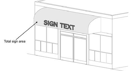
Figure 5.12-C: Determining Sign Area for Illuminated Surfaces
d.
Irregularly Shaped Signs. Sign area for irregular shaped signs is determined by dividing the sign into squares, rectangles, triangles, circles, or arcs as shown in Figure 5.12-D.
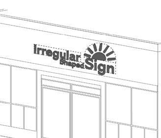
Figure 5.12-D: Determining Sign Area for Irregular Shaped Signs
e.
Multi-Face Signs. The sign area for multi-face signs, as shown in Figure 5.12-E is measured as follows:
i.
Two-Face Signs. Where the interior angle between the two sign faces is 45 degrees or less and the sign faces are less than 42 inches apart, the sign area is measured as the area of one sign face only. Where the angle between the two sign faces is greater than 45 degrees, the sign area is the sum of the areas of the two sign faces.
ii.
Three- or Four-Face Signs. The allowable sign area is measured as 50 percent of the sum of the areas of all sign faces.
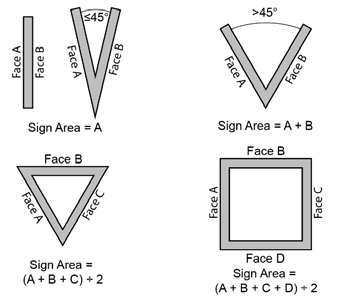
Figure 5.12-E: Determining Sign Area for Multi-Face Signs
f.
Spherical, Free-Form, or Sculptural Signs. The sign area is measured by encasing the longest portion of the sign with four dimensionally equal lines, and the shortest portion of the sign with at least two dimensionally equal lines to form a cuboid. The sign area is 50 percent of the sum of the areas between the longest four dimensionally equal lines encompassing the cuboid, as shown in Figure 5.12-F.
Figure 5.12-F: Determining Sign Area for Spherical, Free-Form, or Sculptural Signs
2.
Sign Height Measurement.
a.
Freestanding Signs. Sign height for freestanding signs is measured as the vertical distance from the highest finish grade at the base of the sign to the highest point of the sign, as shown in Figure 5.12-G, excluding decorative embellishments as permitted in Section 5.12.6.D, Specific Standards for Permanent Freestanding Signs.
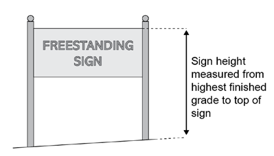
Figure 5.12-G: Determining Freestanding Sign Height
i.
Higher Than Adjacent Grade. Where the natural grade at the base of a sign is higher than the finished grade of the nearest adjacent road, sign height is measured from the base of the sign, as shown in Figure 5.12-H.
Figure 5.12-H: Determining Freestanding Sign Height; Higher Than Finished Grade
ii.
Lower Than Adjacent Grade. Where the natural grade at the base of a sign is lower than the finished grade of an adjacent road, the height of the sign is measured from the top of curb elevation, as shown in Figure 5.12-I.
Figure 5.12-I: Determining Freestanding Sign Height: Lower Than Finished Grade
b.
Building-Mounted Signs. The height of building-mounted signs is determined as the vertical distance measured from the base of the wall on which the sign is located to the top of the sign, as shown in Figure 5.12-J.
Figure 5.12-J: Determining Building-Mounted Sign Height
C.
Sign Illumination.
1.
Internal Illumination. Internally illuminated signs include cabinet signs, changeable copy signs, single- or multi-color LED signs, signs constructed with pan channel letters or reverse pan channel letters (i.e., indirect halo-illuminated letters) on an unlit or otherwise indistinguishable background on a freestanding sign or building wall, as shown in Figure 5.12-K.
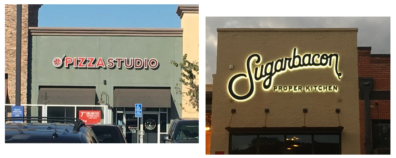
Figure 5.12-K: Internal Sign Illumination—Individual Letter Signs
a.
To minimize glare, internally illuminated signs such as cabinet signs must either be constructed with an opaque background and translucent text and symbols, or with a colored (not white, off-white, light gray, or cream) background and generally lighter text and symbols as shown in Figure 5.12-L.
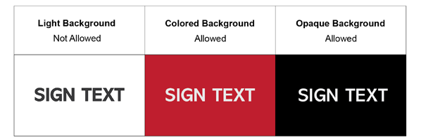
Figure 5.12-L: Internal Sign Illumination—Cabinet Signs
b.
Internally illuminated cabinet signs may be used only for nonresidential uses in the residential zoning districts and in the nonresidential and public/institutional zoning districts (Refer to Table 3.1-1: Table of Allowed Uses) provided the illumination intensity does not exceed one foot candle measured at the property line. Internally illuminated cabinet signs are not allowed in any of the mixed-use zoning districts.
2.
External Illumination.
a.
Externally illuminated signs must be illuminated only with steady, stationary, fully shielded light sources directed solely onto the sign without causing glare.
b.
The light source for externally illuminated signs must be arranged and shielded to substantially confine all direct light rays onto the sign face and away from streets and adjacent properties as illustrated in Figure 5.12-M.
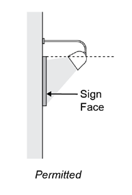
Figure 5.12-M: External Illumination for Signs
3.
Direct Illumination.
a.
Direct illumination may not be used in residential zoning districts and is limited to letters, numbers, symbols, and accents on a marquee sign.
b.
Exposed lamps must not exceed an output of 25 watts and must only have a steady light output.
4.
Neon.
a.
Exposed neon sign lighting on permanent signs is only allowed within a General Plan Activity Center or an applicable Specific Area Plan, subject to approval by the Zoning Administrator.
b.
Neon signs placed in a window are counted toward the total aggregate area for all window signs (Refer to Table 5.12-9: Standards for Window Signs).
5.
Single-Color, Two-Color, or Multi-Color LED Signs.
a.
Single-color, two-color, or multi-color LED signs are exempt from the sign area limitations for wall signs and window signs established in Table 5-12.9: Standards for Wall Signs and Table 5.12-10: Standards for Window Signs.
b.
Any individual single-color, two-color, or multi-color LED window sign must not exceed four square feet in area.
6.
Electronic Message Displays and Billboards. Refer to subsection 5.12.6.E.3, for the luminance and illumination standards for electronic message displays and refer to subsection 5.12.6.E.4, for the luminance and illumination standards for digital billboards.
D.
Sign Structure Standards.
1.
The installation of all permanent signs shall be enforced and administered by the Building Official. All signs and sign structures must be designed to comply with the provisions of this Section and the applicable provisions of the Building Code.
2.
Raceway cabinets, as illustrated in Figure 5.12-N, must only be used in building mounted signs when access to the wall behind the sign is not feasible, or when the Zoning Administrator determines that a benefit exists to preserve a historic or architectural feature of a building. In such cases, the raceway cabinet must not extend in width and height beyond the area of the sign and must match the color of the building to which it is attached. Where a raceway cabinet provides a contrast background to sign copy, the colored area is counted in the total allowable sign area allowed for the site or business.
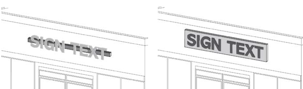
Figure 5.12-N: Raceway Cabinet
E.
Sign Maintenance.
1.
All signs shall be maintained by any property owner, lessor, lessee, manager, agent, or other person having lawful possession or control over a sign, building, structure, or parcel of land, in a condition or state of equivalent quality to which it was approved or required by the City.
2.
All signs together with their supports and appurtenances must be maintained in good structural condition, in compliance with applicable Building Codes, and in conformance with this Section.
3.
Maintenance of a sign includes annual cleaning; replacement of flickering, burned out, or broken light bulbs or fixtures; repair or replacement of any faded, peeled, cracked, or otherwise damaged or broken parts of a sign; replacement of broken or removed components of the sign; and any other activity necessary to restore the sign so that it complies with the requirements and contents of the Sign Permit issued for its installation and the provisions of this Section.
4.
The Building Official is authorized to order the repair, maintenance, or removal of any sign or sign structure that has not been maintained and is dangerous or in disrepair, or which is erected or maintained contrary to the requirements of this Section.
5.
Failure to maintain a sign constitutes a violation of this Section and will be subject to enforcement action, in which case the Building Official may order the removal of any sign that is determined to be in disrepair or dangerous.
6.
Any owner of a sign victimized by graffiti shall remove, repair, or repaint sign(s) within 30 days of the graffiti being applied.
5.12.6.
Standards for Permanent Signs.
A.
Applicability.
1.
This Section establishes the standards for permanent signs.
a.
Table 5.12-1: Allowed Sign Types by Zoning District, establishes which sign types are allowed in each zoning district. Any combination of allowed sign types may be used within a given zoning district unless specifically prohibited.
b.
Tables 5.12-1 through Table 5.12-13 as well as Section 5.12.6.E, Special Purpose Signs, provides the standards and descriptive illustrations for each of the allowed sign types.
2.
A sign type not specifically included in this Section may be allowed by the Zoning Administrator through approval of a CSP (Refer to Section 5.12.3.B, Comprehensive Sign Plan) provided the sign meets the intent of the zoning district in which it is proposed.
3.
A permanent freestanding sign is only allowed on a parcel on which a primary use or building has been established.
Table 5.12-1: Allowed Sign Types by Zoning District
B.
General Standards for Permanent Building Mounted and Freestanding Signs.
1.
The maximum total area for all building-mounted signs is established in Table 2, Maximum Dimensional Standards for Permanent Building-Mounted Signs.
2.
The maximum total area and sign height for all freestanding signs is established in Table 5.12-3, Maximum Dimensional Standards for Permanent Freestanding Signs.
3.
All permanent building-mounted and freestanding signs must comply with the corresponding sign type standards provided in this Section.
Table 5.12-2: Maximum Dimensional Standards for Permanent Building-Mounted Signs
Table 5.12-3: Maximum Dimensional Standards for Permanent Freestanding Signs
C.
Specific Standards for Permanent Building Mounted Signs. Standards for each allowed permanent building-mounted sign type are provided in the tables that follow with a supporting illustration of each sign type. All permanent building-mounted signs must comply with the standards for sign area, height, number, type, and other requirements provided in these tables. Each sign type listed in this Section must be included in the calculation of the total sign area allowed on a parcel or development site by Table 5.12-2, Maximum Dimensional Standards for Permanent Building-Mounted Signs, except as explicitly provided otherwise in Table 5.12-2.
1.
Awning Signs. Awning signs must comply with the standards provided in Table 5.12-4, Standards for Awning Signs.
Table 5.12-4: Standards for Awning Signs
Figure 5.12-O: Awning Sign
2.
Blade Signs. Blade signs, also known as vertical projecting signs, must comply with the standards provided in Table 5.12-5, Standards for Blade Signs.
Table 5.12-5: Standards for Blade Signs
Figure 5.12-P: Blade Sign
3.
Canopy Signs. Canopy signs must comply with the standards provided in Table 5.12-6, Standards for Canopy Signs.
Table 5.12-6: Standards for Canopy Signs.
Figure 5.12-Q: Canopy Sign
4.
Marquee Signs. Marquee signs must comply with the standards provided in Table 5.12-7, Standards for Marquee Signs.
Table 5.12-7: Standards for Marquee Signs.
Figure 5.12-R: Marquee Sign
5.
Service Island Canopy Signs. Service island canopy signs must comply with the standards provided in Table 5.12-8, Standards for Service Island Canopy Signs.
Table 5.12-8: Standards for Service Island Canopy Signs.
Figure 5.12-S: Service Island Canopy Sign
6.
Wall Signs. Wall signs must comply with the standards provided in Table 5.12-9, Standards for Wall Signs.
Table 5.12-9: Standards for Wall Signs.
Figure 5.12-T: Wall Signs
7.
Window Signs. Window signs must comply with the standards provided in Table 5.12-10, Standards for Window Signs.
Table 5.12-10: Standards for Window Signs.
Figure 5.12-U. Window Sign
D.
Specific Standards for Permanent Freestanding Signs. Standards for each allowed permanent freestanding sign type are provided in tables with a supporting illustration of each sign type. All permanent freestanding signs must comply with the standards for sign area, height, number, type, and other requirements provided in these tables as well as the standards established in Table 5.12-3, Maximum Dimensional Standards for Permanent Freestanding Signs. Permanent freestanding signs must be located on the same parcel as the use they advertise unless they are part of a CSP (Refer to Section 5.12.3.B, Comprehensive Sign Plan) which incorporates off-premises signage.
1.
Flags. Flags must comply with the standards provided in Table 5.12-11, Standards for Flags.
Table 5.12-11: Standards for Flags.

Figure 5.12-V. Flags
2.
Monument Signs. Monument signs must comply with the standards provided in Table 5.12-12, Standards for Monument Signs.
Table 5.12-12: Standards for Monument Signs
Figure 5.12-W: Monument Signs
3.
Post Signs. Freestanding post signs must comply with the standards provided in Table 5.12-13, Standards for Post Signs.
Table 5.12-13: Standards for Post Signs.
Figure 5.12-X: Post Sign
E.
Special Purpose Signs.
1.
Community Kiosk Signs.
a.
Sign panels on City-approved community kiosk signs may be allowed for the purpose of providing directional information to community facilities and attractions and residential developments, including mobile home parks and apartment developments.
b.
Community kiosk signs must not exceed 12 feet in height and 5.5 feet in width.
c.
Community kiosk signs must be located outside of the public ROW of a minor arterial or higher street classification. The locations are subject to the approval of the Zoning Administrator.
d.
A plan for a community kiosk sign shall be prepared showing the design and location of each kiosk sign and shall be submitted to, and approved by, the Zoning Administrator prior to the issuance of a Sign Permit.
e.
A Sign Permit for a community kiosk sign shall be effective for one year from the date of approval. An applicant must submit a community kiosk sign plan to the Zoning Administrator at least 30 days prior to the expiration of the current permit for review and re-approval.
f.
A minimum of 30 inches at the top of each community kiosk sign must be reserved for the placement of an approved City logo.
g.
A 2-foot clearance must be provided on the bottom of each community kiosk sign to the ground.
h.
Sign panels in community kiosk signs must not exceed 18 inches in height.
i.
Community kiosk signs must not be located within an SVT (Refer to subsection 5.12.4.A.7).
j.
No community kiosk sign shall be placed within 300 feet of another kiosk sign on the same side of the street.
2.
Neighborhood Kiosk Signs.
a.
Sign panels on City-approved neighborhood kiosk signs may be allowed for the purpose of providing directional information to community facilities and attractions.
b.
Neighborhood kiosk signs must not exceed six feet in height and 5.5 feet in width.
c.
Neighborhood kiosk signs shall be located outside of the public ROW of a collector or lower street classification. The locations are subject to the approval of the Zoning Administrator.
d.
A plan for a neighborhood kiosk sign shall be prepared showing the design and location of each kiosk sign and shall be submitted to and approved by the Zoning Administrator prior to issuance of a Sign Permit.
e.
A Sign Permit for a neighborhood kiosk sign shall be effective for one year from the date of approval. An applicant must submit a neighborhood sign plan to the Zoning Administrator at least 30 days prior to the expiration of the current permit for review and re-approval.
f.
A minimum of two feet at the top of each neighborhood kiosk sign must be reserved for the placement of a community logo or name.
g.
A one foot clearance must be provided on the bottom of each neighborhood kiosk to the ground.
h.
Sign panels in neighborhood kiosk signs must not exceed 12 inches in height.
i.
Neighborhood kiosk signs must not be located within an SVT (Refer to subsection 5.12.4.A.7).
j.
No neighborhood kiosk sign shall be placed within 300 feet of another kiosk sign on the same side of the street.
3.
Electronic Message Sign Displays. The following standards shall apply to all electronic message sign displays:
a.
Location. Electronic message sign displays are limited to assembly and governmental uses, unless authorized for another use though approval of a CSP (Refer to Section 5.12.3.B, Comprehensive Sign Plan).
b.
Development Standards.
i.
Must comply with the maximum height standards for freestanding signs established in Table 5.12-1, Allowed Sign Types by Zoning District.
ii.
Shall not exceed 75 percent of the overall maximum sign area established in Table 5.12-3, Maximum Dimensional Standards for Permanent Freestanding Signs.
c.
Design Standards.
i.
Luminance and Illumination.
a)
May be internally illuminated or externally illuminated with fully shielded lighting.
b)
The luminance of an electronic message display must not exceed 0.3 footcandles over ambient lighting conditions when measured at the recommended distance, based on the electronic message display's size, using the formula in subsection c.i.c) below from sunset through sunrise.
c)
The illuminance of an electronic message display shall be measured with an illuminance meter set to measure foot-candles accurate to at least two decimals. Illuminance shall be measured with the electronic message display turned off, and again with the electronic message display displaying a white image for a full color capable electronic message display, or a solid message for a single- or two-color electronic message display. All measurements shall be taken perpendicular to the face of the electronic message display at a distance determined by the following formula:
Measurement Distance = √ (Area of Electronic Message Display in sq. ft. × 100)
d)
The difference between the off and solid-message measurement must not exceed 0.3 foot-candles.
e)
All electronic message displays must be equipped with a sensor or other device that:
i)
Automatically determines the ambient illumination;
ii)
Is programmed to automatically dim according to ambient light conditions; and
iii)
Can be adjusted to comply with the 0.3 foot-candle measurements.
f)
In the event of a conflict between subsection b. and c. as described above, the most restrictive standard shall prevail.
g)
All highway-oriented electronic message display light sources shall be extinguished from 11:00 p.m. until sunrise unless the sign is for a business open 24 hours, such as a hotel or gas station.
ii.
Messaging.
a)
Electronic message displays must be programmed so that one static message or image is displayed at all times or that multiple static messages or images are displayed, provided the message or image changes no more than once every eight seconds.
b)
No video, effects of movement, intermittent or moving light or lights, blinking, animation, scrolling, flashing, or similar effects in the individual static digital message or in the transition between messages are allowed. The transition time between messages must be instantaneous.
c)
Electronic message display signs must contain a default design that will freeze the device on a single message or shut down the display if a malfunction occurs. If the ambient light meter fails, the electronic message display must immediately extinguish the display and shut down.
d)
Approval. All electronic message displays, both new and conversions from existing non-digital signs, require approval of a Sign Permit as provided in Section 5.12.3, Sign Permits and Procedures.
4.
Digital Billboards.
a.
Purpose. The purpose of this Section is to ensure the creation of an attractive visual environment that promotes a healthy local economy by establishing specific development standards for digital billboards placed adjacent to Interstate 10 (I-10), State Route 85 (SR-85), and future State Route 30 (SR-30), and to ensure that the erection and installation of digital billboards in the City does not create visual clutter or create other operational impacts on surrounding uses, by:
i.
Enabling the placement of commercial and noncommercial messages on digital billboards to effectively inform, identify, and communicate.
ii.
Directing the general public through the use of digital billboards while maintaining attractive and harmonious installation of digital billboards on a site.
iii.
Protecting and enhancing the physical appearance of the City in a lawful manner that recognizes the rights of property owners by:
a)
Encouraging the appropriate design, scale, and placement of digital billboards; and
b)
Assuring that the information displayed on a digital billboard is clearly visible, conspicuous, legible, and reasonable so that the billboard achieves the intended purpose.
iv.
Fostering public safety along public streets within the City by assuring that all signs are in safe and appropriate locations outside of the ROW.
b.
Digital billboard standards. The following standards apply to all digital billboards:
i.
Location.
a)
No more than a total of ten new digital billboard or non-digital billboard to digital billboard conversions may be approved by the City. These approvals will be on a first-come, first-served basis. No new non-digital billboards will be approved by the City;
b)
Will only be permitted in commercial and industrial zoning districts, including commercial and industrial mixed-use zoning districts, and within commercial or industrial land uses identified on an approved PAD land use plan; and
c)
Must be adjacent to I-10, SR-85, or the future ROW of SR-30. Placement of the digital billboard must be within 175 feet of the nearest highway travel lane or highway interchange travel lane and no closer than ten feet from the edge of the highway ROW.
ii.
Separation.
a)
The separation requirements established in Table 5.12-14, Separation Requirements for Digital Billboards, apply regardless of the location of the digital billboard to the City's corporate boundary.
Table 5.12-14: Separation Requirements for Digital Billboards
iii.
Development Standards.
a)
Digital billboard support structures must have a maximum height of 45 feet measured from the adjacent grade of the highway roadway to the top of the digital billboard sign. The maximum height must not exceed 65 feet measured from the base of the billboard pylon to the top of the sign.
b)
Must not exceed 672 square feet in area, excluding detailing and embellishments around the sign face, with a maximum vertical facing dimension of 14 feet and a maximum horizontal facing dimension of 48 feet.
c)
Must include no more than two faces, which are not permitted to be vertically or horizontally stacked. Digital billboards that are parallel double-sided or "V"-shaped (45-degree maximum angle) shall be considered one structure with each facing subject to the size requirements established above.
iv.
Design Standards.
a)
Luminance and Illumination.
i)
With the exception of amber alerts and emergency messages, all digital billboard light sources must be extinguished from 11:00 p.m. until sunrise.
ii)
May be internally illuminated. In no instance will external illumination be allowed.
iii)
From sunset to 11:00 p.m., the following illumination standards apply to all digital billboards:
b)
Luminance. The luminance of all digital billboards must not exceed 0.3 footcandles over ambient lighting conditions when measured at the recommended distance, based on the digital billboard's size, using the formula in subsection iv.c.i below.
c)
Illuminance.
i)
The illuminance of a digital billboard must be measured with an illuminance meter set to measure foot-candles accurate to at least two decimals. Illuminance shall be measured with the digital billboard turned off, and again with the digital billboard displaying a white image for a full color capable digital billboard, or a solid message for a single-color or multi-color digital billboard. All measurements shall be taken perpendicular to the face of the digital billboard at a distance determined by the following formula:
Measurement Distance = √ (Area of Digital Billboard in sq. ft. × 100)
ii)
The difference between the off and solid-message measurement shall not exceed 0.3 foot-candles.
iii)
Must be equipped with a sensor or other device that automatically determines the ambient illumination and programmed to automatically dim according to ambient light conditions, or that can be adjusted to comply with the 0.3 foot-candle measurements.
d)
Conflict Resolution. In the event of a conflict between subsections b) and c) above, the most restrictive standard shall prevail.
e)
Designers and installers of digital billboards must ensure that the most efficient and modern technology is utilized in order to increase operational efficiency and to reduce power consumption.
f)
Messaging.
i)
Digital billboards must be programmed so that one static message or image is displayed at all times or if multiple static messages or images are displayed, the sign changes no more than once every eight seconds.
ii)
No video, effects of movement, blinking, animation, scrolling, flashing, or similar effects in the individual static digital message or in the transition between messages are allowed. The transition time between messages must be instantaneous.
iii)
Digital billboards must contain a default design that will freeze the device on a single message or shut down if a malfunction occurs. If the ambient light meter fails, the digital billboard shall immediately shut down.
iv)
Digital billboards must not simulate or imitate a directional, warning, danger, or informational sign if it is likely, at the discretion of the City Engineer, to be mistaken for any authorized traffic signal or device or any such permitted sign, or it is intended or likely to be construed as giving warning to traffic, such as by the use of the words "stop" or "slow down."
g)
Architecture.
i)
The billboard support pylon must be clad in high-quality masonry or other durable, quality materials. The pylon shall be designed to a high architectural standard and if located within an existing development, the support pylon shall be designed to meet or exceed the architectural standards within the development.
ii)
"Buckeye," "Buckeye, AZ" or the City logo shall be integrated into the pylon design. The text/logo shall be constructed of dark-colored metal or other durable, fade-resistant material and halo illuminated.
h)
Approval. In addition to the issuance of a Sign Permit, all digital billboards require site plan approval in accordance with Section 8.9, Site Plan Review.
i)
Conversion of Existing Billboards to Digital Billboards. Existing non-digital billboards in existence prior to the adoption of the effective date are permitted to continue in use and may be eligible for conversion to a digital billboard subject to the standards outlined in this Section. If an existing non-digital billboard is converted to a digital billboard, the Arizona Department of Transportation must be notified of the conversion.
5.
Signs Placed Along Freeway frontages.
a.
Freeway-oriented identification signs are limited along freeway frontages to one identification sign per property or unified development with a maximum height of 65 feet and a maximum sign area of 250 square feet per side. A maximum sign area of 500 square feet per side is allowed for multi-tenant nonresidential developments or if included within a CSP.
b.
Two signs are allowed for properties or unified developments which are 30 acres or larger in size.
c.
A separation distance of minimum 500 feet is required between any freeway-oriented signs located on the same side of the freeway.
d.
For all freeway-oriented identification signs an ADOT permit or authorization must be obtained prior to the issuance of a Sign Permit.
F.
Downtown Sign Standards.
1.
Signage. Signs are an essential element that defines the character of a Downtown Area. They are the initial communication between a business and a customer. As such, they must be attractive, easy to read and complement the architecture of the building, while providing adequate identification of the business. The City's desire is to encourage unique and distinctive signage Downtown which may not be found or allowed in other areas.
2.
Standards and Guidelines—General. The following types of signs are allowed in the Downtown Overlay District (DOD), in compliance with the issuance of a Sign Permit and in compliance with the established standards and guidelines in this Section. Signs proposed outside of the DOD must comply with the sign standards established in this Section as applicable based on the underlying base zoning district.
a.
General. Standards for awning signs are included in Table 5.12-4, Standards for Awning Signs, except that an awning sign must not obstruct sidewalks, required accessible paths of travel, or the visibility of other signs.
i.
Encourage the use of signs that reflect the pedestrian scale of Downtown.
ii.
Signage may have the capability of being illuminated in the evening, although the source of light must be hidden or shielded from the direct view of motorists or pedestrians. However, neon and LED signs are allowed.
iii.
The letters on a sign must not occupy more than 75 percent of the sign panel area.
iv.
Building numbering is required and the location and size shall be approved by the Fire Department.
v.
Signage must not be located in any sight visibility lines (Refer to subsection 5.12.4.A.7).
vi.
Freestanding signs are not permitted, unless part of an approved CSP.
b.
Awning Signs. Standards for awning signs are included in Table 5.12-4, Standards for Awning Signs, except that an awning sign must not obstruct sidewalks, required accessible paths of travel, or the visibility of other signs.
c.
Blade Signs. Standards for blade signs are included in Table 5.12-5, Standards for Blade Signs and as provided below:
i.
Up to 12 square feet of blade signs are not included in the total allowable business sign area.
ii.
Creatively shaped and designed blade signs are encouraged.
d.
Canopy Signs. Standards for canopy signs are included in Table 5.12-6, Standards for Canopy Signs.
e.
Roof-Mounted Signs. Standards for roof-mounted signs must comply with the following standards:
i.
Only allowed on both sides of Monroe Avenue;
ii.
Maximum height of the sign above the roofline is six feet; and
iii.
A sign height greater than six feet may be approved by the Zoning Administrator taking into consideration the height of a pre-existing historic sign.
f.
Wall Signs. Standards for wall signs are included in Table 5.12-9, Standards for Wall Signs, except as provided below:
i.
Cabinet signs are prohibited. Individual pan-channel letter signs, reverse pan channel letter signs, and signs manufactured from metal, wood, etc. are allowed.
ii.
Wall signs must fit proportionally with the building massing and architectural features of the building elevation on which the sign is placed.
iii.
Wall signs facing property designated for residential use in the General Plan must not exceed six square feet in area and must not be illuminated.
g.
Window Signs. Standards for window signs are included in Table 5.12-10, Standards for Window Signs, and as provided below:
i.
Web addresses and telephone numbers are encouraged on windows.
ii.
Paint on windows is prohibited except during the promotion of temporary holiday events/sales which are limited to a maximum of 30 consecutive days with 15 days between promotions and must not be painted for more than 180 days a year.
iii.
Letter in window signs are recommended to be a minimum of six inches in height.
iv.
Window signage may cover a maximum of 25 percent of the total window area on the building.
v.
A letter color that is in high contrast from shadows created by the store display is recommended.
i.
Portable and Temporary Signs. Standards for portable and temporary signs are included in Section 5.12.7, Standards for Portable and Temporary Signs, and as provided below:
i.
Limited to one A-frame sign per business or tenant per public street frontage.
ii.
Off-Site A-Frame Signs. A-frame signs may be placed off-site if all of the following standards are met:
(a)
Written approval of the property owner of record for the property where the sign is to be located must be obtained; and
(b)
A Site Plan or illustration depicting the location of the off-site A-frame sign must be submitted and approved by the Zoning Administrator prior to the placement of the sign.
5.12.7.
Standards for Portable and Temporary Signs.
A.
Purpose. The proliferation of portable and temporary signs is a distraction to the traveling public and creates aesthetic blight and litter that threatens the public's health, safety, and welfare. In addition to the purpose provisions of Section 5.12.1, Purpose, these regulations ensure that portable and temporary signs do not create a distraction to the traveling public by eliminating the aesthetic blight and litter caused by these signs.
B.
General. Portable and temporary signs are allowed only in compliance with the provisions of this Section.
1.
Permits.
a.
Portable Signs. No permits are required to place or display portable signs, except that approval from the Public Works Director as described in Article 19-2, Encroachment Permits, is required for portable signs placed within public ROW when buildings are placed up against the property line (i.e., a zero-foot setback).
b.
Temporary Signs. A Temporary Sign Permit is required for all temporary signs (i.e., banner signs, yard sign type III signs, and balloons and inflatables) except that banner signs installed for seven days or less and yard sign type II signs are exempt from permitting requirements.
2.
Not Included in Permanent Sign Allowances. Portable and temporary signs are not counted toward the maximum total sign area established in Section 5.12.6, Standards for Permanent Signs.
3.
General Time, Place, and Manner Restrictions.
a.
Time Restrictions.
i.
Portable signs. Refer to Table 5.12-15, Standards for Portable Signs for the time restrictions for portable signs.
ii.
Temporary signs. Refer to Table 5.12-17, Standards for Temporary Signs for the time restrictions for temporary signs.
b.
Location Restrictions. Unless specifically exempted by this Section, portable and temporary signs must be placed in compliance with Section 5.12.4.A, Location Restrictions. In zoning districts with a zero-foot setback, and where portable signs are, therefore, placed in the public ROW, approval from the Public Works Director is required.
c.
Display Restrictions.
i.
Portable and temporary signs must comply with the display restrictions provided in Section 5.12.4.B, Display Restrictions.
ii.
Any form of illumination is prohibited on portable and temporary signs, as well as the use of reflective materials. Attachments including balloons, ribbons, loudspeakers, etc. are prohibited.
d.
Design and Construction. Portable and temporary signs must be of sufficient weight and durability to withstand wind gusts, storms, etc. and must be professionally crafted.
e.
Removal. All portable and temporary signs must be removed within 48 hours after the conclusion of the purpose served by the sign.
f.
Special Events and Temporary Uses. Special events and temporary uses that are approved through the issuance of a City Special Event and Temporary Use Permit (SETUP) may have alternative temporary sign standards approved as a part of the SETUP process. If no alternative temporary sign standards are approved, the standards in this Section shall apply.
4.
Additional Standards for Portable Signs.
a.
Portable signs are allowed in compliance with the provisions in Section 5.12-15, Standards for Portable Signs.
Table 5.12-15: Standards for Portable Signs
5.
Standards for Specific Portable Sign Types. Portable signs must comply with the standards provided in Table 5.12-16, Standards for Specific Portable Sign Types. Refer to A.R.S. § 16-1019 for additional regulations specific to political signs.
Table 5.12-16: Standards for Specific Portable Sign Types
| Portable Sign Type | Standards | Other Requirements | ||
|---|---|---|---|---|
| "ft" = Feet; "lf" = Linear Feet; and "sf" = Square Feet | ||||
| Portable Sign Type 1 | Height (Max.) | Width (Max.) | Area (Max.) | Other Requirements |
A-Frame or Upright Sign
 | 4 ft | 3 ft | 8 sf |
If advertising a business, only permitted during regular business hours.
Placement must allow for min. 3 ft pathway to all building entrances. Max. height and area includes riders (max. 6" tall by 24" wide) placed on top of the sign. |
Window Sign
 | — | — | See End Note 2 |
Max. Height:
Placed no higher than first story windows. Inside mounting required. Not included in the total sign area for all portable signs. |
Yard Sign Type I
 | 4 ft | 2 ft | 3 sf | Installation Requirement: Installed securely in the ground. |
Feather Banner
3
 | 12 ft | — | 16 ft |
Installation Requirement: Installed securely in the ground or has a stable weighted
base.
Must not interfere with pedestrian or vehicular traffic. |
| End Notes: 1 Other nonpermanent sign types may be allowed (e.g., fuel pump topper signs, wraps around waste receptacles, or balloon bobbers (max. height of tether or support is 3 ft) provided the aggregate sign area of these signs is max 20 sf. 2 The area of temporary and permanent window signs combined (including signs constructed of perforated vinyl or painted on the window) must not exceed 40% of the area of the window on or within which they are displayed. 3 Max. three feather banners per business. | ||||
6.
Sign Walkers. To promote pedestrian and traffic safety, sign walkers are subject to the following time, place, and manner restrictions:
a.
A Sign Permit is not required for a sign walker;
b.
Sign walkers are only allowed in the commercial and industrial zoning districts and commercial and industrial areas with PAD;
c.
Sign walkers are permitted to stand on a sidewalk provided pedestrian movement is unimpeded in conformance with applicable provisions of the Americans with Disabilities Act (ADA);
d.
Sign walkers are prohibited from standing in the median of streets, in travel lanes, landscaped areas, curb ramps at crosswalks, and unimproved ROW areas. Sign walkers may not interfere with traffic or block pedestrians or bicyclists;
e.
A business is only allowed to use a sign walker for up to ten consecutive days in any 30-day period and there must be at least a 20-day period before the commencing of another ten-day period;
f.
Sign walkers are permitted only from 8:00 a.m. to 8:00 p.m.;
g.
Sign walker signs must not exceed ten square feet in the area;
h.
Spinning, waving, throwing the sign in the air, or any other similar erratic movements intended to attract attention is prohibited; and
i.
Sign walker signs that include any of the following are prohibited:
i.
Audio devices to attract attention;
ii.
Any form of illumination, including flashing, blinking, or rotating lights; and
iii.
Animation on the sign itself.
7.
Additional Standards for Temporary Signs. Temporary signs are allowed in compliance with the provisions in Table 5.12-17, Standards for Temporary Signs.
Table 5.12-17: Standards for Temporary Signs
8.
Standards for Specific Temporary Sign Types. Temporary signs must comply with the standards provided in Table 5.12-18, Standards for Specific Temporary Sign Types.
Table 5.12-18: Standards for Specific Temporary Sign Types
| Temporary Sign Type | Standards | Other Requirements | ||
|---|---|---|---|---|
| "ft" = Feet; "lf" = Linear Feet; and "sf" = Square Feet | ||||
| Temporary Sign Type | Height (Max.) | Width (Max.) | Area (Max.) | Other Requirements |
Banner Sign
 |
Multi-story buildings: placed in the space between first and second stories
Single-story buildings: placed below top of the parapet | 6 ft | 32 sf |
Prohibited in single- family residential zoning districts except as allowed in Table
5.12-17, Standards for Temporary Signs.
Must be mounted on a building wall or between columns, posts, or stakes anchored securely into the ground. Ventilation flaps are required if the banner is not mounted on a building wall. |
Yard Sign Type II
 | 6 ft | 2 ft | 4 sf | Installation Requirement: Installed securely in the ground. |
Yard Sign Type III
 | 7 ft | 6 ft | 24 sf |
Prohibited in single-family residential zoning districts.
Installation Requirement: Installed securely in the ground. |
9.
Balloons and Inflatables.
a.
Airborne ballons are only allowed in nonresidential zoning districts subject to the following standards:
i.
Must not exceed the allowed building height for the zoning district in which the business is located. Must not occupy or infringe upon any required parking spaces.
ii.
Must be securely tethered or anchored to the ground and shall not be affixed or attached to any light poles, traffic signals, street signs, or other public safety device.
iii.
Must not be attached to the roof of the building.
b.
Inflatables are only allowed in nonresidential zoning districts subject to the following standards:
i.
Must not exceed 30 feet in height measure from the ground surface to which it is tethered.
ii.
Must be securely tethered or anchored to the ground and shall not be affixed or attached to any light poles, traffic signals, street signs, or other public safety device.
iii.
Must not interfere with pedestrian and vehicular circulation patterns as approved by the City.
iv.
Must not be attached to or placed upon the roof of the building.
10.
Temporary Model Home Complex/Active Residential Development Signs.
a.
Temporary model home complex/active residential development signs are allowed in all residential zoning districts and for residential developments in the mixed-use zoning districts subject to the standards provided in Table 5.12-19, Standards for Temporary Model Home Complex/Active Residential Development Signs in All Residential Zones.
b.
Model home signs must be included with the site plan application packet to be reviewed and approved for the model home complex.
Table 5.12-19: Standards for Temporary Model Home Complex/Active Residential Development Signs in All Residential Zoning Districts
5.12.7.
Nonconforming Signs.
A.
Purpose. This Section establishes regulations for nonconforming signs that were lawful before the adoption or amendment of this Section, but which would be prohibited, regulated, or restricted differently in compliance with the current regulations. These provisions provide for the orderly termination of nonconforming signs to promote the public health, safety, and general welfare, and to bring nonconforming signs into conformity with the goals and policies of the City's adopted General Plan. In recognition of these declarations, it is the intent of this Section to:
1.
Prevent the expansion of nonconforming signs to the maximum extent feasible;
2.
Establish criteria under which nonconforming signs may be continued or expanded; and
3.
Provide for the correction or removal of nonconforming signs in an equitable, reasonable, and timely manner.
B.
Applicability. Nonconforming signs may be maintained, expanded upon, and/or abated only in accordance with the provisions of this Section. In no event will the degree of nonconformity of any sign or type of signage on any lot be increased. Illegal signs, such as signs installed without a required Sign Permit, are not considered to be nonconforming signs.
C.
Signs Rendered Nonconforming. Any sign which becomes nonconforming subsequent to the effective date of these regulations either by reason of the annexation to the City of the territory upon which the sign is located, or the amendment of this Section to render a sign nonconforming, shall also be subject to the provisions of this Section.
D.
Modification and Maintenance.
1.
No nonconforming sign shall be altered in any manner, reconstructed, or moved without being made to comply in all respects with the provisions of this Section. Nothing in this Section shall prohibit the normal upkeep or repair of any sign; changes to the sign face or copy of an existing multi-tenant sign from one business to another with no structural or lighting modifications to the signs; nor the painting or repainting of the face of the sign, during its lawful existence.
2.
Nonconforming signs are required to be maintained in good condition in compliance with Section 5.12.5.E, Sign Maintenance. Maintenance of legal nonconforming signs shall be consistent with applicable state law. Nothing in this Section shall affect existing property or the right to its continued use for the purpose used at the time this Section takes effect, nor to make any reasonable repairs or alterations.
3.
A legal nonconforming sign that has been damaged to the extent of more than 50 percent of the appraised value of the sign structure or is temporarily or permanently removed by any means, including "an act of God," shall be removed or rebuilt, repaired, or replaced only in compliance with the provisions of this Section if an application for a Sign Permit to re-erect the sign is made within 6-months of its destruction.
E.
Signs Previously Approved. Any sign erected and installed in compliance with a Sign Permit lawfully issued by the City prior to the effective date of this ordinance shall be treated as a conforming sign. All signs determined to be conforming signs may be continued, maintained, and repaired so long as the sign is not structurally altered or expanded.
F.
Removal or Replacement of a Nonconforming Sign. Removal of a nonconforming sign, or replacement of a nonconforming sign with a conforming sign, is required except for designated landmark signs, when:
1.
A building is renovated, and the cost of the renovation is 50 percent or more of the value of the building as determined by the Building Official or the building is demolished and rebuilt; or
2.
The use of the sign and/or the property on which the sign is located has been abandoned, ceased operations, become vacant, or been unoccupied for a period of 90 consecutive days or more as long as the period of non-use is attributable at least in part to the property owner, tenant, or other person or entity in control of the use. For the purposes of this Section, rental payments or lease payments and taxes shall not be considered as a continued use. In the event this should occur, such conditions will be considered as evidence of abandonment, requiring removal of the sign by the owner of the property, his/her agent, or person having the beneficial use of the property, building or structure upon which such sign or sign structure is erected within 30 days after written notification from the Zoning Administrator. If, within the 30-day period, such sign(s) is (are) not removed, enforcement action shall be pursued.
G.
Incentive for Replacement of a Nonconforming Freestanding Sign. As an incentive for the replacement of a nonconforming freestanding sign that exceeds the maximum height and area standards established in this Section with a new sign that is in closer conformance with the area and height standards for freestanding signs of Section 5.12.6.D, Specific Standards for Permanent Freestanding Signs.
1.
A new freestanding sign may be approved and erected that is reduced in height and area by ten percent of the existing nonconforming sign, or the area and height standards for freestanding signs established in Section 5.12.6.D, Specific Standards for Permanent Freestanding Signs, whichever is larger. The replacement freestanding sign must be a type authorized in subsection 5.12.6.D.
2.
The new replacement sign must be located in the same place as the former nonconforming sign, unless it would be located in an SVT or similar location where freestanding signs are prohibited (Refer to Section 5.12.4.A.7), in which case it may be placed as close as possible to its original location and still satisfy the requirements of this Section. Any nonconforming sign modified in compliance with the provisions of this Section will still be considered a nonconforming sign until full compliance with the area and height standards of Section 5.12.6, Standards for Permanent Signs has been achieved.
H.
Abatement. Abatement of nonconforming signs must be accomplished in the following manner:
1.
Signs painted on buildings, walls, and fences must be painted over in such a manner that the sign is no longer visible. The new painting must be applied so that the sign area blends with and is compatible with the color scheme of the building.
2.
All other signs not otherwise specified by this Section must be removed or altered to cause it to conform with the provisions of this Section.
I.
Maintenance.
1.
Nonconforming signs are required to be maintained in good condition in compliance with the sign maintenance provisions of Section 5.12.5.E., Sign Maintenance of legal nonconforming signs must be consistent with applicable Arizona law. Nothing in this Section affects an existing sign or the right to its continued use for the purpose used at the time this Section takes effect, nor the right to make any reasonable repairs or alterations within the existing sign envelope.
2.
A legal nonconforming sign that has been damaged to the extent of more than 50 percent of the appraised value of the sign structure or is temporarily or permanently removed by any means, including "an act of God," must be removed or rebuilt, repaired, or replaced only in compliance with the provisions of this Section.
(Ord. No. 28-25, § 3, 10-21-2025)
5.13. - DISTRICT-SPECIFIC DEVELOPMENT STANDARDS
5.13.1.
Rural Districts.
A.
Sidewalks. Sidewalks are not required. Bridle paths, trails, and similar types of improvements are encouraged where appropriate.
B.
Lighting. Street lighting is not required. For safety reasons, lighting may be required at all major intersections. Lighting on private property shall be in compliance with Section 5.11, Exterior Lighting.
C.
Fencing. Project fencing adjacent to public streets shall be required. An open design, such as split rail fencing, is encouraged. The design of fencing shall be consistent and compatible with all other types of fencing allowed. Along any property line not adjacent to a public street, fencing is optional. Notwithstanding Section 5.4.6, Fences, Walls, and Screening, higher fencing in front setback areas may also be allowed if deemed appropriate.
D.
Natural Vegetation. All lots containing natural (undisturbed) desert vegetation are not to be graded, disturbed, or cleared beyond the identified building envelope in the initial construction of a subdivision.
E.
Drainage. Natural drainage areas outside of designated building envelopes must be preserved. Care is to be taken when establishing the building envelope to locate outside existing drainage areas. A natural drainage area is within 25 feet of where water collects or drains in the course of a storm event.
5.13.2.
Mixed-Use Districts.
A.
General Standards for NMU, CMU, and RMU Districts.
1.
Street Design and Character.
a.
Street Tree/Furniture Area. Along all frontages within these districts, a street tree/furniture zone shall be provided supplementing any required sidewalk. The zone shall feature a minimum width of six feet and shall either be continuous and located adjacent to the curb, or continuous and located adjacent to the back of sidewalk. The area shall be planted with street trees with a spacing based on the mature canopy width of the tree species selected. The area also is intended for the placement of street furniture including seating, waste receptacles, newspaper vending boxes, bicycle racks, and similar elements, and may also be utilized for infrastructure elements, such as streetlights, fire hydrants, traffic signs, bus shelters, and public utility equipment (e.g., electric transformers and water meters) in a manner that does not obstruct pedestrian access or motorist visibility, or appropriate light levels, subject to applicable requirements of this Development Code.
b.
Supplemental Zone. A supplemental zone may be provided at the option of the applicant between the street-facing façade and the required street tree/furniture area and sidewalk, to provide additional areas for outdoor dining, porches, terraces, landscape and water features, and plazas. A supplemental zone, if provided, may be a maximum of 20 feet deep and may extend up to 30 percent of the linear frontage of the development. The supplemental zone shall not provide any parking or vehicle circulation areas.
c.
Building Placement. At least 75 percent of the building façade facing a public street shall be brought up to the edge of the street tree/furniture area or sidewalk, whichever is nearer, or supplemental zone if provided.
d.
Sidewalk Entries. Sidewalk entries to buildings shall occur at a maximum of every three ground level units or 75 feet for retail/commercial frontages.
e.
Utilities. Transformers, switchgear, and related utility service equipment shall not be located above-ground in pedestrian access easements. Building service panels are to be located to the side or rear of buildings, in a location not readily visible to pedestrians, or on the inside of all buildings.
f.
Paving. Paving is intended to highlight or accentuate special areas along the ground plane while at the same time complementing the design of adjacent building and streetscape elements.
i.
Sidewalk Paving. Sidewalk paving along the mixed-use development primary streets and secondary streets shall include accents areas of pavers or stamped concrete comprising a minimum of 30 percent of the paved walkway surface. All sidewalk paving shall be installed over a subgrade consistent with the Engineering Design Standards and shall be maintained by the adjacent property owner.
2.
Pedestrian Amenities. Ground-floor façades that face public streets or other public areas (e.g., outdoor gathering spaces, parks or open space, parking areas) shall incorporate pedestrian-oriented design features along no less than 60 percent of their horizontal length. Pedestrian-oriented design features may include arcades, display windows, entryways, awnings, or other features approved by the Zoning Administrator. Shaded sidewalks required by this Development Code that are part of the building design may be credited toward this standard.
3.
Use Mix. Development on properties in the RMU, CMU, and NMU districts shall feature a relatively proportionate mix of residential and nonresidential uses, with the total floor area devoted to residential or nonresidential uses not to exceed 70 percent of the project's total floor area, unless the Zoning Administrator determines that based on existing development patterns on surrounding properties, a greater percentage of either residential or nonresidential would result in a more appropriate and/or compatible mix of uses.
4.
Ground-Floor Uses.
a.
Intent. The incorporation of commercial uses such as retail shops and restaurants at the street level is strongly desired within the mixed-use districts to promote a more active environment for pedestrians and support residential and office uses located within the same building (on upper floors) or nearby.
b.
Standards.
i.
Location. Commercial uses shall be concentrated adjacent to transit stops, major public spaces, and in other areas where a high level of pedestrian activity and visibility is desirable. If a limited portion of a structure's ground level will be devoted to commercial space, such space shall be located along those façades adjacent to or most visible from transit corridors, primary street frontages, or major pedestrian walkways.
5.
Residential Uses. Residential uses shall be incorporated within a mixed-use development to be visually and/or physically integrated with nonresidential uses. This shall be achieved by ensuring that residential uses meet at least two of the following:
a.
Residential uses are vertically located above street-level commercial uses;
b.
Residential uses are horizontally integrated into site development to provide a transition between the highest intensity uses within the center or development and the adjacent neighborhood;
c.
No internal block walls are used that separate residential and nonresidential uses from each other; and
d.
A pedestrian circulation system (i.e., sidewalks, crosswalks, trails, etc.) is provided that reduces conflict between pedestrian and vehicular movements and increases pedestrian activity between residential and nonresidential uses. Where uses are horizontally integrated, connections shall be shaded and illuminated in safe and attractive locations outside of service areas.
6.
Parking Standards for Mixed-Use Districts. The purpose of parking area requirements is to ensure that parking areas are not the dominant feature of the mixed-use development. These requirements restrict on-site surface parking (other than incidental parking in association with residential development leasing offices or head-in or parallel spaces to support retail uses) and encourage physical consistency throughout the development, including the appearance of parking garages. The following standards apply:
a.
Allowable Parking. Parking areas are encouraged to be provided in structures or below-grade, with the exception of on-street parking and minimal surface parking areas to support retail uses or stand-alone restaurants. In no instance shall a development in these districts provide more than the minimum spaces required by this Development Code in a surface lot; excess parking may be provided if desired, but that additional parking must be located in structures or below grade. On-street parking shall not be designated per individual business or occupancy but may count toward the minimum parking requirements for the entire structure along the adjacent frontage. Parallel parking, head-in parking along streets, and/or minimal surface parking is permitted subject to approval through the Site Plan process.
b.
Parking Location. Off-street parking is prohibited between any street and the corresponding street-facing façade line.
7.
Driveways. Like parking garages, driveways are not intended to dominate the streetscape of a development. These requirements are intended to promote pedestrian-oriented design that minimizes conflict with vehicular uses. Curb cuts shall be limited in compliance with the Engineering Design Standards. Requests for additional curb cuts beyond this amount will be reviewed and determined based on demonstrated need and safety considerations.
8.
Material and delivery loading areas. Material and delivery service areas, while necessary, are to be screened as completely as possible from the adjacent streets. The placement of loading or service areas shall be subject to approval as part of the Site Plan. Refer to Section 5.6, Off-Street Parking.
9.
Outdoor Gathering Areas and Pedestrian Amenities.
a.
All Site Plans five acres in size or larger shall devote a minimum of two percent of the net site area to one of the following types of outdoor gathering spaces or pedestrian amenities:
i.
A landscaped private common open space for use of the residents, employees, and visitors to the development;
ii.
A playground, patio, or plaza with outdoor seating areas, provided such feature has a minimum depth and width of ten feet and a minimum total area of 300 square feet. The area shall include pedestrian amenities to support these places as gathering areas; or
iii.
A combination of the above-listed amenities.
b.
To the maximum extent feasible, where significant natural and scenic resources exist on a site, the developer shall give priority to their preservation as an outdoor gathering area to fulfill the requirements of this subsection.
c.
Outdoor gathering areas shall be located so as to be readily accessible and useable by residents of or visitors to the development.
d.
The following shall not be counted towards the requirements of this subsection:
i.
Private yards;
ii.
Public or private streets or ROW; and
iii.
Parking areas and driveways for dwellings.
B.
Additional District-Specific Standards for the NMU District. The following district-specific standards apply to all development in the NMU District.
1.
Building Footprint. Establishment of single-tenant nonresidential buildings exceeding 5,000 square feet and multiple nonresidential tenant buildings exceeding 15,000 square feet shall require a Conditional Use Permit (CUP).
2.
No Park/Drive Zone. Parking, drive aisles, and/or drive throughs shall not be permitted between the building and front/corner yard landscape buffer on the side.
5.13.3.
Office. Any retail use may be located in the PO District only within a building that also contains permitted and related non-retail uses. Such retail uses shall be limited to 30 percent of the gross floor area of the building. No outdoor storage or merchandise display is allowed.
5.13.4.
Downtown Overlay District (DOD).
A.
Lighting. Lighting in the DOD should serve to illuminate façades, entrances, and signage and provide an adequate level of personal safety while enhancing the aesthetic appeal of the buildings. The following lighting is allowed:
1.
Standards and Guidelines.
a.
Shielded security lighting is required along service entrances and along alleys for all commercial buildings.
b.
Ornate or accent lighting that enhances the building or property is required for all elevations visible to the public.
c.
Roof-mounted signs, where provided, must be illuminated internally or with down lighting.
d.
"Shoebox" site lighting is prohibited. Site lights must be architecturally sensitive to the building architecture.
e.
Lights may not be exposed beyond the lighting array.
f.
Buildings with a zero-foot setback may have down lighting spill over the property line.
g.
Lighting must be provided under covered awnings or arcades.
h.
All lighting must be in accordance with A.R.S. § 49-1101 et seq.
B.
Building Design and Character.
1.
Building Massing and Form.
a.
Buildings must be stepped back a minimum of ten feet at the third story or higher in the following instances:
i.
Along all street frontages excluding Monroe Avenue and/or 4th Street; and
ii.
Along lot frontages that abut the Downtown Residential District.
b.
Step-backs must be measured from the front façade.
2.
Architectural Style.
a.
New buildings should be designed to complement the architectural styles found on historical buildings in Downtown (e.g., through the use of similar building forms, window proportions, materials, and other features) without trying to replicate a specific architectural style or create a false sense of history.
b.
Formula architecture typically found on chain businesses is not compatible with the character of Downtown.
3.
Additions to Historical Buildings.
a.
Additions should be designed to respect the scale, proportions, and design features found on the historical building and should not fundamentally alter the scale and character of the block when viewed from the public ROW.
b.
Additions should incorporate a similar roof pitch, form, and orientation as the principal structure.
c.
Additions should be distinguishable as new without distracting from the historical structure.
4.
Building Entrances.
a.
Primary building entrances must be clearly distinguished as required by the residential, commercial, and industrial design standards of this Development Code.
b.
Secondary building entrances are encouraged along north-south alleys designated within the DSAP as opportunities for alleyway enhancements. These include north-south alleys between 3rd Street and 4th Street and 5th Street and 6th Street (south of Monroe).
C.
Building Materials. Building materials and color should help establish a human scale and provide visual interest. The predominant color should be respectful to the architectural style of the building and compatible with buildings in the Downtown District. These materials are listed in addition to Section 5.8.3.F, Architectural Details, Materials, and Colors.
1.
General Standards and Guidelines. General materials should appear similar to those used historically.
a.
Primary Building Materials. Primary building materials shall be used for at least 60 percent but no more than 80 percent of any façade. Appropriate primary building materials include:
i.
Smooth or Santa Barbara finish stucco;
ii.
Brick;
iii.
Striated brick (raked or directional grain brick);
iv.
Adobe block;
v.
Slump block;
vi.
Integral colored concrete masonry unit (CMU), smooth, burnished, or polished finish (split face should be reserved for use as an accent material only);
vii.
Terra cotta;
viii.
Architectural cast concrete; and/or
ix.
Other materials of equivalent quality as approved by the Zoning Administrator.
b.
Secondary or Accent Materials. In combination, accent materials must be used for at least 20 but no more than 40 percent of any façade. No individual accent material may be used for more than 20 percent of any façade. Secondary or accent materials include:
i.
High-quality architectural metals including steel;
ii.
Standing seam metal, stamped metal, etc., where the metals are used creatively as opposed to part of a pre-fabricated building kit. Metals may be approved as a primary material if part of an exceptional design that furthers the goals for Downtown design, as determined by the Zoning Administrator;
iii.
EIFS;
iv.
Wood, if adequately weather treated, and simulated wood, if the product appears natural; and/or
v.
Any material from the primary material list above used, in addition to the primary material selected for the structure.
c.
Prohibited Materials.
i.
Premanufactured buildings and kits.
ii.
Poor quality veneers and other engineered materials that have an unnatural appearance not reflective of the product they are attempting to simulate.
d.
Transparency.
i.
On all properties designated Downtown Core and Mixed-Use Core as illustrated on Figure 3.1 (Long-Term Future Land Use Framework Plan) of the DSAP, building façades facing Monroe Avenue or 4th Street must consist of transparent glazing for at least 50 percent of the ground floor wall area between two and ten feet above grade, and for at least 35 percent of the wall area of upper floors. If a single-story building has a façade taller than 20 feet, the façade area above 15 feet shall consist of transparent glazing for at least 35 percent of the wall area of the portion greater than 15 feet in height.
ii.
Excluding those properties covered in item i. above, building façades facing a public street must consist of transparent glazing for at least 30 percent of the ground floor wall area between two and ten feet above grade, and for at least 20 percent of the wall area of upper floors. If a single-story building has a façade taller than 20 feet, the façade area above 15 feet shall consist of transparent glazing for at least 20 percent of the wall area of the portion greater than 15 feet in height.
2.
Building Colors.
a.
Primary colors or other brilliant colors are to be only used as an accent on the building or for signage.
b.
No more than ten percent of any commercial building façade may use primary (red, yellow or blue) or other brilliant non-earth tone paint color.
c.
No commercial building may use paint colors with a light reflective value (LRV) greater than 60, except that shades of white may be provided up to an LRV of 80.
d.
Fluorescent colors are prohibited.
e.
Murals on a building façade or any portion thereof may be permitted on a case-by-case basis if the mural does not act as a sign or portray a commercial message. Subsections (a) through (d), above, shall not apply to any approved mural.
D.
Building Orientation. All properties within the Downtown Core and Mixed-Use Core, as illustrated on Figure 3.1 (Long-Term Future Land Use Framework Plan) of the DSAP, must be designed to accommodate primary customer access from the adjacent public sidewalks. Buildings which feature a dual orientation, where customers can access the building/business from the public sidewalk as well as from on-site parking behind, are also supported.
1.
Outdoor loading, service, and refuse areas must be integrated into the building design if possible or must be located where they are not visible from public open space, public trails, public streets, or from adjacent properties, to the maximum extent possible.
E.
Landscape/Shading. Landscaping/shading treatments should be used to enhance the pedestrian experience and complement architectural features.
1.
Buildings with a zero-foot front setback have no minimum landscape requirement.
2.
Unless existing site conditions limit on-site landscaping, all property must meet the standards provided in Section 5.4.3, Landscaping Required, of this Development Code.
3.
On all properties within the Downtown Core and Mixed-Use Core, as illustrated on Figure 3.1 (Long-Term Future Land Use Framework Plan) of the DSAP, awnings, canopies and/or covered arcades are required on street-adjacent sides of a building, to extend at least 50 percent of the length of the building. For all other locations, awnings, canopies, and/or covered arcades are encouraged. An awning or covered arcade may be allowed in public ROW with an encroachment permit.
a.
Awnings and canopies must have a minimum five-foot projection from the building and a maximum of ten feet unless additional projection is required to cover the adjacent public sidewalk.
b.
Covered arcades and covered walkways must extend to the edge of sidewalk on buildings with a zero-foot setback.
F.
Screening. Screening of mechanical equipment is used to keep an area aesthetically appealing to residents and visitors of homes and businesses. Downtown has a mix of uses with no traditional suburban-style development buffering. This unique situation makes the need for screening mechanical equipment from the public view essential.
1.
Roof-Mounted Mechanical Equipment.
a.
Roof-mounted mechanical equipment must be screened by a parapet wall or similar feature that is an integral part of the building's architectural design.
b.
The parapet wall or similar feature must be sufficient to screen the mechanical equipment from all sides when viewed from the sidewalk directly across the street.
c.
Facilities for the operation of active or passive solar energy systems and other alternate energy systems are exempt from the screening requirements.
2.
Ground-Mounted Mechanical Equipment.
a.
Outdoor ground-mounted mechanical equipment (e.g., subpanels, air conditioners, heating, cooling and ventilating equipment, kitchen hoods and vents, swimming pool equipment, pumps and heaters, propane tanks), and all other mechanical equipment must be located where it is not visible from public open space, public trails, public streets (including alleyways), or from adjacent properties to the maximum extent practicable. In cases when ground-mounted mechanical equipment is visible from a public open space, public trail, public street, or adjacent property, the equipment must be screened from view by a solid wall or fence or a vegetative screen that satisfies the following criteria:
i.
The wall or fence must be of a height equal to or greater than the height of the mechanical equipment being screened and must be compatible with the architecture and landscaping of the development; or
ii.
The vegetative screen must be planted along the full length of the equipment to be screened and must be of a height equal to or greater than the height of the equipment to be screened at the time of planting.
b.
Screening of ground-mounted solar energy equipment is not required when it can be clearly demonstrated that required screening would reduce the efficiency or effectiveness of the solar energy equipment.
G.
Setbacks. Downtown is comprised of many different plats and lots. Some plats have implied setbacks, while others have recorded standards. Some commercial buildings were developed by previous or historic standards. Due to such pre-existing conditions, there is no uniform standard for commercial or residential setbacks.
1.
Commercial.
a.
On all properties within the Downtown Core and Mixed-Use Core, as illustrated on Figure 3.1 (Long-Term Future Land Use Framework Plan) of the DSAP, the maximum building setback shall be eight feet, except that restaurants and similar uses that provide integrated space for outdoor dining may be set back up to 30 feet if the outdoor dining area extends from the front face of the building to within eight feet or nearer of the street adjacent property line. In instances where a PUE is provided directly adjacent to street, the maximum building setback can be increased to 12 feet to allow for provision of landscaping by the Zoning Administrator.
b.
For all other commercial properties, the maximum building front setback is calculated using the average of the two adjacent building front setbacks.
2.
Residential. Setbacks should reflect the existing streetscape by considering the location of other buildings on the block. An appropriate setback can be determined by averaging the front façades of the buildings on a block. Unlike a more suburban setting, the primary building façades should be located parallel to the street. Refer to Figure 5.7-A, Example of Contextual Front Building Setback.
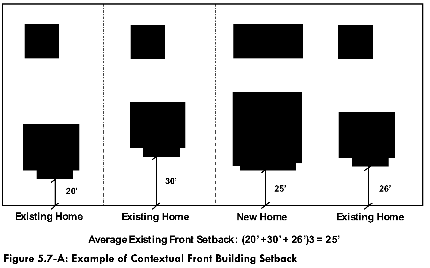
H.
Parking. Downtown does not have contemporary suburban commercial and residential development. In an area that has established uses, not every commercial building has available space for parking. What makes Downtown unique is the availability of on-street and common off-street public parking and pedestrian activity.
1.
If on-site parking is utilized, the parking shall be designed to the rear or sides of the building. Parking within a front setback area shall be prohibited. Parking to the side of any building, visible from the ROW, shall be limited to one aisle with a single row of spaces on each side.
2.
If traditional parking is not feasible, please refer to Section 5.6.7., Parking Alternatives, of this Development Code.
3.
Sole on-street parking may be utilized if the number of on-street parking spaces within 600 feet of the use meets or exceeds the minimum parking required for the use.
4.
The visual impact and presence of vehicles shall be minimized by siting parking areas to the rear or interior of the property rather than along street frontage, providing underground and structured parking, and screening parking areas from views both interior and exterior to the site.
5.
On-site loading spaces are not required.
6.
If off-site parking is provided (not including on-street or City-owned public parking lots), refer to Section 5.6.7, Parking Alternatives.
I.
Use-Specific Requirements.
1.
Child Care Facilities. Within the Downtown Core, child care facilities must be located above the ground floor nonresidential uses or at the ground floor of a building that does not front onto Monroe Avenue.
2.
Drive-Through Uses.
a.
Where permitted, any proposed/new drive-through use must be located a minimum of 1,320 feet of the nearest existing drive-through on the same side of the street, measured from nearest building wall to nearest building wall.
b.
No parcel to be developed with a drive-through use shall share a property line with a parcel developed with a single-family residence.
c.
The drive-through must be visually minimized. The design focus of any business with a drive-through must first be on accommodating pedestrians utilizing the adjacent public sidewalk. From the perspective of the adjacent street, it should not be readily apparent that the business features a drive-through component.
d.
No drive-through lane or drive aisle may be located between the building's front, street-facing façade and the public sidewalk.
e.
All drive-through menu boards, speaker boxes, or other features inherent to drive-through uses must be fully screened from adjacent streets.
3.
Dwelling, Live/Work.
a.
The residential component of the unit must be located above or behind the nonresidential areas of the structure, and the residential living space must be occupied by the owner of the nonresidential activity or the owner's employee, including that person's household.
b.
The nonresidential activity area may not exceed 50 percent of the gross floor area of the unit.
4.
Food Truck Court.
a.
Food truck courts must provide, at a minimum, permanent restroom facilities, drinking fountains, trash and recycling receptacles, shade, and seating.
b.
Recreational or entertainment activities, such as playground equipment or live music, may be provided on-site.
c.
All portions of a food truck court site used for parking (of customer vehicles or food trucks) and/or circulation must be an approved paved surface.
5.
General Retail. Free-standing retail with single-users over 10,000 square feet and group-users over 50,000 square feet require approval of a CUP.
6.
Mini-Storage and Gas Station Uses.
a.
Where permitted, any proposed/new mini-storage facility or gas station within the DOD must be separated from the nearest existing storage facility or gas station by a minimum of 2,640 feet, measured from nearest property line of the proposed use to the nearest property line of the closest existing use.
b.
The 2,640-foot separation requirement is inclusive and applies to gas stations from other gas stations, gas stations from mini-storage facilities, and mini-storage facilities from other mini-storage facilities.
c.
The required separation applies to any proposed/new gas station or mini-storage facility within the DOD from any other existing mini-storage facility or gas station, whether located within or outside of the DOD.
7.
Multi-Family Dwellings.
a.
On all properties within the Downtown Core or Mixed Use Core, as illustrated on Figure 3.1 (Long-Term Future Land Use Framework Plan) of the DSAP, multi-family residential uses (including leasing offices and ancillary resident spaces such as fitness centers), where permitted, may not occupy more than 40 percent of the linear frontage of any building façade directly adjacent to 4th Street or Monroe Avenue, if applicable.
b.
There shall be no restriction on ground floor multi-family use of any building façades not facing 4th Street or Monroe, or any limitation on use of upper floors for multi-family residential use.
8.
Outdoor Dining.
a.
Any building constructed prior to January 1, 2024, shall maintain a minimum six-foot-wide continuous sidewalk free from any seating, furnishings, or other obstructions adjacent to any street frontage.
b.
Any building constructed after January 1, 2024, shall maintain a minimum ten-foot-wide continuous sidewalk free from any seating, furnishings, or other obstructions adjacent to any street frontage.
c.
Required sidewalk width may be located within the public ROW, on private property within a dedicated sidewalk easement, or a combination of both.
J.
Conversion from Single-Family Dwelling to a Commercial Use. Downtown has residential homes that currently have commercial zoning. Home occupations are subject to Table 5.13-1 below. Adaptive reuse is encouraged and is subject to the following standards:
1.
Locate parking off-site. If parking is necessary on-site, it must be located to the rear or sides only.
2.
On-site parking should be screened from adjacent residential properties.
3.
Landscape areas in the interior of the lot as well as the street frontage shall be in conformance with Section 5.4.3, Landscaping Required.
4.
Create a pedestrian walkway or corridor from the parking area to the building entrance using a change in material.
(Ord. No. 28-25, § 3, 10-21-2025)