- LAND SUBDIVISION
6.1.1.
Intent. This Article is intended to promote the health, safety, convenience, order, prosperity, and welfare of the present and future inhabitants of the City by:
A.
Promoting well-defined, sustainable neighborhoods that enhance the City's character and are compatible with adjoining lands;
B.
Creating livable neighborhoods that foster a sense of community and reduce dependency on private vehicles;
C.
Encouraging the proper arrangement of streets in relation to existing or planned streets and ensuring streets facilitate safe, efficient, and pleasant walking, biking, and driving;
D.
Providing a variety of lot sizes and housing types in every neighborhood;
E.
Protecting sensitive natural and historic areas and the City's environmental quality;
F.
Providing protection from natural hazards and flood prone areas; and
G.
Ensuring compliance with the General Plan.
6.1.2.
Applicability.
A.
General. Unless exempted in subsection B, this Article shall apply to all subdivision of land within the City that results in the partitioning, dividing, combining, or altering of any lot, parcel, or tract of land, including subdivisions created by an exercise of the power of eminent domain by an agency of the state or the City.
B.
Exemptions. The standards of this Article shall not apply to:
1.
Creation or realignment of an easement; and
2.
Adjustment of the boundary line or the transfer of land between two adjacent property owners that does not result in the creation of any additional parcels.
C.
Approvals Required. All subdivision approvals shall be in accordance with Section 8.8, Subdivision.
6.1.3.
Safety and Public Facilities. Land to be subdivided shall be of such character that it can be used safely for building purposes without danger to health or peril from fire, flood, or other menace. Land shall not be subdivided until proper provision has been made for drainage, water, sewage, and capital improvements such as schools, parks, recreation facilities, transportation facilities, and other public improvements.
6.1.4.
Plat and Construction Plan Preparation.
A.
Registered Land Surveyor. It shall be the responsibility of the subdivider to have a land surveyor registered in the State of Arizona prepare the subdivision plat in accordance with all applicable City Codes and Engineering Design Standards.
B.
Registered Engineer. It shall be the responsibility of the subdivider to have an engineer registered in the State of Arizona prepare a complete set of engineering plans in accordance with all applicable City Codes and Engineering Design Standards for the construction of all required improvements. Engineering plans shall be in substantial conformance with the approved Preliminary Plat.
C.
City Engineer Approval. All plans and supporting engineering reports for subdivision improvements shall be reviewed and approved by the City Engineer. All improvements shall be in substantial conformance with the approved Preliminary Plat and all effective Engineering Design Standards, policies, and requirements at the time of final improvements.
6.1.5.
Limitation on Conditions.
A.
In approving subdivisions, the Zoning Administrator and City Engineer shall be authorized to impose such conditions upon the premises as may be necessary to carry out the general purpose and intent of this Development Code. Conditions imposed on a development approval shall be based upon adopted standards that are: (a) contained in this Development Code, adopted plan or other document adopted by the City, and/or (b) determined by the City Engineer to be necessary to protect public health, safety, and general welfare or for critical infrastructure linkage. Conditions imposed on a development approval shall be sufficiently specific to ensure that the condition is imposed in a consistent and rational manner. Under no circumstance shall these provisions be interpreted to waive any responsibility to the public in the enforcement of provisions contained herein, where such conditions are necessary to protect public health, safety, and general welfare.
B.
Any condition imposed on a development approval that would require the applicant to dedicate real property to the public or to pay money to the public in an amount that is determined on an individual and discretionary basis shall only be imposed if: (a) there is an essential nexus between the dedication or payment and a legitimate local government interest; and (b) the dedication or payment is roughly proportional both in nature and extent to the impact of the proposed use or development of such property.
(Ord. No. 28-25, § 3, 10-21-2025)
6.2.1.
Subdivision. "Subdivision" means improved or unimproved land or lands divided for the purpose of financing, sale, or lease, whether immediate or future, into four or more lots, tracts, or parcels of land; or, if a new street is involved, any such property that is divided into two or more lots, tracts, or parcels of land; or, any such property, the boundaries of which have been fixed by a recorded plat, which is divided into more than two parts. "Subdivision" also includes any condominium, cooperative, community apartment, townhouse or similar project containing four or more parcels, in which an undivided interest in the land is coupled with the right of exclusive occupancy of any unit located thereon, but plats of such projects need not show the buildings or the manner in which the buildings or airspace above the property shown on the plat are to be divided.
6.2.2.
Preliminary Plat. A Preliminary Plat is a preliminary map, including supporting data, that is required for a subdivision that creates more than ten lots, tracts, or parcels with or without dedications and easements. A Preliminary Plat does not establish or modify any lots, tracts, or parcels and is not recorded. A Preliminary Plat is required prior to Final Plat approval.
6.2.3.
Final Plat. A Final Plat is a subdivision that creates more than ten lots, tracts, or parcels with or without dedications and easements. A Preliminary Plat is required prior to approval of a Final Plat.
6.2.4.
Minor Subdivision. A Minor Subdivision is a subdivision that creates ten or fewer lots, tracts, or parcels with or without dedications and easements. Although a Preliminary Plat is not required for approval of a Minor Subdivision, additional information shall be submitted as determined by the City Engineer to review the project for compliance with all applicable City standards. The City Engineer may waive or reduce infrastructure standards or requirements proportional to the impact of the subdivision, except that the requirements for dust-controlled access and drainage improvements shall not be waived. A plat for a Minor Subdivision may be used to abandon a previously recorded plat.
6.2.5.
Land Split. A land split is the division of improved or unimproved land whose area is two and one-half acres or less into two or three tracts or parcels of land for the purpose of sale or lease, as defined in A.R.S. § 9-463.
6.2.6.
Map of Dedication. A Map of Dedication dedicates right-of-way to establish main roadways without subdividing adjacent property into building lots. No new or existing parcels or tracts shall be established or modified in size by a Map of Dedication.
(Ord. No. 28-25, § 3, 10-21-2025)
6.3.1.
Minimal Standards. The design standards in this Article are minimum standards. The City, at its discretion, may impose more restrictive standards when it finds that they are necessary to preserve and protect public health, safety, and welfare.
6.3.2.
Compliance with Adopted Plans and Development Code. All subdivisions shall comply with all other applicable zoning, design, and development regulations set forth in this Development Code or an approved Planned Area Development (PAD), the General Plan, and all other adopted City plans, including, but not limited to:
A.
Specific Area Plans;
B.
Transportation and transit plans; and
C.
Parks, trails, recreation, and open space plans.
6.3.3.
Suitability for Subdivision. Land subject to hazardous conditions such as floods, mud flows, rock falls, possible mine subsidence, mine shafts, shallow water table, open quarries, and polluted or non-potable water supply shall be identified and shall not be subdivided until the hazards have been mitigated or will be mitigated by the subdivision and construction plans.
6.3.4.
Streets. All public and private streets shall comply with the Engineering Design Standards, Section 5.5.3, Streets and Vehicular Circulation, and the Transportation Master Plan, and in addition shall comply with the following standards.
A.
Coordination of Streets.
1.
All new streets shall intersect with surrounding existing streets at safe and convenient locations. All street classifications shall connect with surrounding streets where necessary to allow convenient movement of traffic and reasonable access for emergency vehicles, but connections are not allowed where the effect would be to encourage the use of such streets by cut-through traffic.
2.
When connections to surrounding streets are proposed or required by the City, public right-of-way shall be dedicated, and streets developed to existing paved rights-of-way.
3.
The City may also require temporary hammerheads or turnarounds to be constructed for temporary cul-de-sacs between development phases or to provide future connection with adjoining undeveloped land.
4.
Certain proposed streets, as designated by the City, shall be extended to the subdivision boundary to provide future connection with adjoining undeveloped land. The street pattern in the subdivision shall not landlock adjacent property nor prevent access to public land.
5.
In addition to providing connections to surrounding streets, internal connections for the safe movement of vehicles, pedestrians, and bicycles shall be provided from the parcel to be subdivided to adjacent commercial projects as determined by the Zoning Administrator and, where feasible, for pedestrian and bicycle pathways to adjoining parks and open space.
6.
Whenever a parcel to be subdivided includes a street designated in the Transportation Master Plan, the street shall be platted in conformance with the Transportation Master Plan.
B.
Street Design Standards.
1.
Streets shall be related appropriately to expected use. Streets shall be designed as set forth in the Engineering Design Standards and as warranted by an approved Traffic Impact Analysis.
2.
Other suitable designs and materials may be approved for the construction of streets, curbs and sidewalks when in the opinion of the Zoning Administrator, at the recommendation of the City Engineer, such methods would be more environmentally desirable or more in keeping with the design of the development or neighborhood.
3.
Collector streets, minor arterial streets, and major arterial streets shall have a landscaped median as determined by the City.
C.
Lighting Requirements. Lighting shall comply with the requirements of Section 5.11, Exterior Lighting.
D.
Street Naming.
1.
Continuation of Existing Names. Street naming and addressing shall comply with Chapter 2 of the Engineering Design Standards. The subdivider shall indicate the street name for public streets on the Preliminary Plat by projecting existing Phoenix north-south and east-west street grid names that fall in alignment. Where no current streets are in alignment, the subdivider may propose a name based on the Maricopa Association of Governments (MAG) or City street naming policy. All names are subject to final approval by the City.
2.
Sign Posts. Street sign posts shall be placed at all street intersections by the subdivider and shall be in place when street paving is complete. Specifications for design, construction, location, and installation shall be in accordance with the Engineering Design Standards.
6.3.5.
Blocks.
A.
Block Length. Residential blocks shall not be less than 300 feet nor more than 660 feet in length. The City may approve a longer block length when necessary to accommodate natural features such as steep slopes or washes (i.e., environmentally sensitive lands, low-density residential development, or golf course communities, pedestrian linkages) or if a landscape tract serving as an open space connection with a pedestrian and/or bicycle path intersects the longer block and a maximum distance of 500 feet between the open space connection and the corner of the block is maintained. The landscape tract must be a minimum of 40 feet in width and include shade trees every 30 feet. Adjacent residential lots must provide full or partial view fencing along the landscape tract (see Figure 6.3-A).
Figure 6.3-A: Example of Block with Open Space Connection
B.
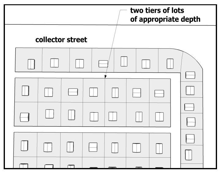
Block Arrangement. Blocks shall have sufficient width to provide for two tiers of lots of depth meeting the minimum requirements of this Development Code, except where lots back onto a collector or greater street, natural feature, or subdivision boundary, or where lots face an approved loop road or cul-de-sac (see Figure 6.3-B).
Figure 6.3-B: Example Block Arrangement
C.
Mixed-Use Zoning Districts General Standards.
1.
Block Pattern. The layout of any development site five acres in size or larger shall be designed to reinforce a pattern of individual blocks.
a.
Blocks shall be designed as an extension of the surrounding neighborhood, aligning with and connecting to adjacent streets and mirroring the scale and orientation of adjacent blocks (for residential areas within an activity center).
b.
On large sites or where block consolidation is proposed (by right-of-way abandonment), special consideration shall be given to pedestrian and vehicular circulation patterns and access to surrounding neighborhoods.
c.
New development shall establish a regular pattern of blocks to the extent feasible to avoid creating especially large blocks that limit pedestrian and vehicular circulation. See subsection 6.3.5.A for applicable block length provisions.
6.3.6.
Lots. The design and layout of lots must respond to topography, natural vegetation, soil conditions, drainage, and abrupt changes in land use, heavy street traffic or other conditions.
A.
The lot arrangement shall be such that there will be no foreseeable difficulties in obtaining a Building Permit or in providing driveway access to buildings on such lots from an approved street.
B.
Double frontage, reversed frontage, flag, or other odd-shaped lots are to be avoided.
C.
Unless otherwise determined by the City Engineer, corner lots in residential subdivisions shall be at least ten feet larger in width than other lots in the same area to provide additional buffering area, and a minimum five-foot tract shall be provided to accommodate corner lot buffering.
D.
Lots shall be so placed as to provide positive drainage away from all buildings.
E.
Lots should be so configured to face as many as possible in a north/south direction.
F.
Lot widths on cul-de-sacs shall be measured as the distance in a straight line, between the side lot lines at the points of intersection with the front setback line.
G.
Where streets terminate in a "T" intersection condition, either a landscape tract at least 40 feet in width shall be provided at the terminus, or lot lines shall be staggered and garages oriented to prevent vehicle headlights from shining into living spaces within the home, unless determined infeasible as determined by the Zoning Administrator or City Engineer (see Figure 6.3-C).
Figure 6.3-C: T-Intersection Examples
6.3.7.
Easements.
A.
The width, location, and purpose of all easements shall be provided on the Final Plat.
B.
Utility easements shall be located to the front of lots where practicable.
C.
Unless otherwise determined by the City Engineer, drainage easements shall be provided for the retention of drainage from subdivision streets. Drainage shall not be shed to adjoining right-of-way.
D.
Natural drainage easements are encouraged to protect natural vegetation and to preserve washes and streams. Easements should include 25 feet of area on either side of a natural drainage area.
E.
The private maintenance of all easements shall be provided for in the recorded covenants, conditions, and restrictions (CC&Rs) for the subdivision.
F.
To the extent allowed by easement grantees, landscaping shall be provided by the developer or designee for all easement areas. Maintenance of the easement landscaping shall be provided for in the recorded CC&Rs for the subdivision.
G.
Developers shall dedicate vehicular non-access easements in accordance with the Engineering Design Standards, where vehicular access is not appropriate for safety, legal, or design reasons.
H.
Temporary construction easements (TCEs) are to be provided as necessary.
I.
The building envelope shall not be located within any required public easements, including, but not limited to, sight visibility triangles and public utility easements.
(Ord. No. 28-25, § 3, 10-21-2025)
6.4.1.
Responsibility for Improvements.
A.
Requirements in this Section apply to all new development.
B.
The developer shall be responsible for construction of all utility systems, such as wastewater, water, electric, communications, cable, gas, irrigation, and refuse that are needed as a direct result of the development.
C.
The developer will be responsible for construction of frontage improvements, water and wastewater systems, and streets.
D.
The extent of improvements required will be in accordance with standards as contained within this Development Code and the Engineering Design Standards.
E.
If it is determined by the City Engineer that certain off-site improvements, as required in the Engineering Design Standards and this Section, do not need to be constructed at the time of development, the developer may guarantee the cost of the improvements by posting a performance bond, providing a letter of credit, in-lieu payment or other financial guarantee as determined by the City Engineer. The City Engineer is authorized to process and collect in-lieu payments and any associated in-lieu fee agreements administratively. The City Engineer will also have discretion to defer certain off-site improvements to the time of development of any proposed subdivided property, which shall be memorialized on the subdivision plat or per separate agreement.
6.4.2.
Guarantee and Warranty of Public Improvements.
A.
Financial Guarantee. The developer shall guarantee that all required improvements will be completed in a manner satisfactory to the City using one of the following methods:
1.
A performance bond, an irrevocable letter of credit, assurance of construction of subdivision improvements or other financial guarantee approved by the City Attorney prior to the issuance of the first final civil permit.
2.
The financial guarantee shall be ten percent of the cost of the labor and materials necessary to complete the off-site improvements required with the subdivision and/or project. If the amount of the assurance is based on an estimate, such estimate shall be prepared by a registered engineer, and the amount of the financial guarantee shall be increased by ten percent to account for unforeseen circumstances.
3.
The period within which required improvements must be completed shall be specified and shall not exceed two years from the date of financial guarantee approval.
B.
Inspection of Improvements. Prior to the approval of the required improvements by the City Engineer, an engineer retained by the developer shall certify to the City that all facilities and improvements to be dedicated to the City have been constructed in accordance with the requirements of this Development Code and Engineering Design Standards. The City Engineer shall also inspect all improvements to the site and certify that they comply with all specifications as set forth in the approved improvement plans. Any inspection expenses incurred by the City shall be reimbursed by the developer.
C.
Warranty of Improvements. The developer shall post a performance bond or other sufficient surety to guarantee that all defects in any public facilities or improvements that occur within two years after acceptance of the improvements by the City shall be corrected by the developer.
D.
Development Agreement. The City shall have the authority to enter into a Development Agreement with the developer to carry out the provisions contained in this Development Code.
6.4.3.
Improvement Requirements.
A.
Sewage Disposal Facilities.
1.
Refer also to City Code Chapter 16, Sewer Utilities and Use of Public Sewers, and City Code Chapter 20, Off-Site Construction Improvement Requirements for Property Development.
2.
Refer also to Chapter 4 of the Engineering Design Standards.
3.
Every principal use and every lot within a development shall be served by a sewage disposal system that is adequate to accommodate the reasonable needs of such use or development lot with all applicable health regulations.
4.
Structures shall not be occupied without an approved wastewater source that has been deemed adequate by the Maricopa County Environmental Services Department and other applicable public agencies.
5.
Developments are required to provide water, wastewater, and reclaimed facilities in a manner that is consistent with integrated and regional master plans, and facility plans where applicable.
B.
Water Supply and Distribution Systems.
1.
Refer also to City Code Chapter 17, Water Utilities, and City Code Chapter 20, Off-Site Construction Improvement Requirements for Property Development.
2.
Refer also to Chapter 3 of the Engineering Design Standards.
3.
Every principal use and every lot within a development shall be served by a water supply and distribution system that will accommodate the reasonable needs of such use or development lots and that complies with all applicable health regulations.
4.
Structures shall not be occupied without an approved water supply system that has been approved by all applicable public agencies.
5.
All subdivisions shall comply with the requirements of City Code Section 25-1-11, Assured Water Supply.
C.
Electric, Telephone, and Cable System. Every principal use and every lot within a development shall have available to it a source of electric power, telephone service, fiber optic communications, and cable service adequate to accommodate the reasonable needs of such use and every lot within such subdivision. Compliance with this requirement shall be determined as follows:
1.
Refer also to City Code Chapter 19, Streets and Sidewalks Regulations; City Code Chapter 20, Off-Site Construction Improvement Requirements for Property Development; and City Code Chapter 23, Public Works and Water Resources.
2.
If the use is not in a development and can be served by existing service via a simple connection (as opposed to a more complex distribution system, such as would be required in an apartment complex or shopping center or would require an extension of a primary line), then no further certification is required.
3.
If the use is in a development (or is a development) or is not served by existing service or a substantial internal distribution center would be necessary, or extension of a primary line would be necessary, then the utility company must review the proposed plans and certify to the City that it can provide service that is adequate to meet the needs of the proposed use or development.
D.
Underground Service Lines.
1.
Refer also to City Code Chapter 19, Streets and Sidewalks Regulations; City Code Chapter 20, Off-Site Construction Improvement Requirements for Property Development; and City Code Chapter 23, Public Works and Water Resources.
2.
All utility lines (except electric lines more than or equal to 69kV), including irrigation service lines but not including transformers or enclosures containing equipment such as switches, meters, or capacitors that are ground-mounted and constructed in developments after the effective date, shall be placed underground in accordance with the specifications and policies of the respective utility company.
3.
Whenever an unsubdivided development is constructed on a lot, then all electric power less than 69kV, telephone, and cable television lines located on the development site outside of a previously existing public street right-of-way shall be placed underground in accordance with the specifications and policies of the respective utility company.
6.4.4.
Engineering Specifications. Construction and design details for all improvements shall comply with the Engineering Design Standards.
(Ord. No. 28-25, § 3, 10-21-2025)
6.5.1.
Streets. All street rights-of-way shall be dedicated to the public.
6.5.2.
Alleys. Alleys may be utilized but must be identified as private streets for service access, off-street loading, or parking.
6.5.3.
Public Park Dedication and Fees In-Lieu. See Section 5.3, Open Space.
(Ord. No. 28-25, § 3, 10-21-2025)
- LAND SUBDIVISION
6.1.1.
Intent. This Article is intended to promote the health, safety, convenience, order, prosperity, and welfare of the present and future inhabitants of the City by:
A.
Promoting well-defined, sustainable neighborhoods that enhance the City's character and are compatible with adjoining lands;
B.
Creating livable neighborhoods that foster a sense of community and reduce dependency on private vehicles;
C.
Encouraging the proper arrangement of streets in relation to existing or planned streets and ensuring streets facilitate safe, efficient, and pleasant walking, biking, and driving;
D.
Providing a variety of lot sizes and housing types in every neighborhood;
E.
Protecting sensitive natural and historic areas and the City's environmental quality;
F.
Providing protection from natural hazards and flood prone areas; and
G.
Ensuring compliance with the General Plan.
6.1.2.
Applicability.
A.
General. Unless exempted in subsection B, this Article shall apply to all subdivision of land within the City that results in the partitioning, dividing, combining, or altering of any lot, parcel, or tract of land, including subdivisions created by an exercise of the power of eminent domain by an agency of the state or the City.
B.
Exemptions. The standards of this Article shall not apply to:
1.
Creation or realignment of an easement; and
2.
Adjustment of the boundary line or the transfer of land between two adjacent property owners that does not result in the creation of any additional parcels.
C.
Approvals Required. All subdivision approvals shall be in accordance with Section 8.8, Subdivision.
6.1.3.
Safety and Public Facilities. Land to be subdivided shall be of such character that it can be used safely for building purposes without danger to health or peril from fire, flood, or other menace. Land shall not be subdivided until proper provision has been made for drainage, water, sewage, and capital improvements such as schools, parks, recreation facilities, transportation facilities, and other public improvements.
6.1.4.
Plat and Construction Plan Preparation.
A.
Registered Land Surveyor. It shall be the responsibility of the subdivider to have a land surveyor registered in the State of Arizona prepare the subdivision plat in accordance with all applicable City Codes and Engineering Design Standards.
B.
Registered Engineer. It shall be the responsibility of the subdivider to have an engineer registered in the State of Arizona prepare a complete set of engineering plans in accordance with all applicable City Codes and Engineering Design Standards for the construction of all required improvements. Engineering plans shall be in substantial conformance with the approved Preliminary Plat.
C.
City Engineer Approval. All plans and supporting engineering reports for subdivision improvements shall be reviewed and approved by the City Engineer. All improvements shall be in substantial conformance with the approved Preliminary Plat and all effective Engineering Design Standards, policies, and requirements at the time of final improvements.
6.1.5.
Limitation on Conditions.
A.
In approving subdivisions, the Zoning Administrator and City Engineer shall be authorized to impose such conditions upon the premises as may be necessary to carry out the general purpose and intent of this Development Code. Conditions imposed on a development approval shall be based upon adopted standards that are: (a) contained in this Development Code, adopted plan or other document adopted by the City, and/or (b) determined by the City Engineer to be necessary to protect public health, safety, and general welfare or for critical infrastructure linkage. Conditions imposed on a development approval shall be sufficiently specific to ensure that the condition is imposed in a consistent and rational manner. Under no circumstance shall these provisions be interpreted to waive any responsibility to the public in the enforcement of provisions contained herein, where such conditions are necessary to protect public health, safety, and general welfare.
B.
Any condition imposed on a development approval that would require the applicant to dedicate real property to the public or to pay money to the public in an amount that is determined on an individual and discretionary basis shall only be imposed if: (a) there is an essential nexus between the dedication or payment and a legitimate local government interest; and (b) the dedication or payment is roughly proportional both in nature and extent to the impact of the proposed use or development of such property.
(Ord. No. 28-25, § 3, 10-21-2025)
6.2.1.
Subdivision. "Subdivision" means improved or unimproved land or lands divided for the purpose of financing, sale, or lease, whether immediate or future, into four or more lots, tracts, or parcels of land; or, if a new street is involved, any such property that is divided into two or more lots, tracts, or parcels of land; or, any such property, the boundaries of which have been fixed by a recorded plat, which is divided into more than two parts. "Subdivision" also includes any condominium, cooperative, community apartment, townhouse or similar project containing four or more parcels, in which an undivided interest in the land is coupled with the right of exclusive occupancy of any unit located thereon, but plats of such projects need not show the buildings or the manner in which the buildings or airspace above the property shown on the plat are to be divided.
6.2.2.
Preliminary Plat. A Preliminary Plat is a preliminary map, including supporting data, that is required for a subdivision that creates more than ten lots, tracts, or parcels with or without dedications and easements. A Preliminary Plat does not establish or modify any lots, tracts, or parcels and is not recorded. A Preliminary Plat is required prior to Final Plat approval.
6.2.3.
Final Plat. A Final Plat is a subdivision that creates more than ten lots, tracts, or parcels with or without dedications and easements. A Preliminary Plat is required prior to approval of a Final Plat.
6.2.4.
Minor Subdivision. A Minor Subdivision is a subdivision that creates ten or fewer lots, tracts, or parcels with or without dedications and easements. Although a Preliminary Plat is not required for approval of a Minor Subdivision, additional information shall be submitted as determined by the City Engineer to review the project for compliance with all applicable City standards. The City Engineer may waive or reduce infrastructure standards or requirements proportional to the impact of the subdivision, except that the requirements for dust-controlled access and drainage improvements shall not be waived. A plat for a Minor Subdivision may be used to abandon a previously recorded plat.
6.2.5.
Land Split. A land split is the division of improved or unimproved land whose area is two and one-half acres or less into two or three tracts or parcels of land for the purpose of sale or lease, as defined in A.R.S. § 9-463.
6.2.6.
Map of Dedication. A Map of Dedication dedicates right-of-way to establish main roadways without subdividing adjacent property into building lots. No new or existing parcels or tracts shall be established or modified in size by a Map of Dedication.
(Ord. No. 28-25, § 3, 10-21-2025)
6.3.1.
Minimal Standards. The design standards in this Article are minimum standards. The City, at its discretion, may impose more restrictive standards when it finds that they are necessary to preserve and protect public health, safety, and welfare.
6.3.2.
Compliance with Adopted Plans and Development Code. All subdivisions shall comply with all other applicable zoning, design, and development regulations set forth in this Development Code or an approved Planned Area Development (PAD), the General Plan, and all other adopted City plans, including, but not limited to:
A.
Specific Area Plans;
B.
Transportation and transit plans; and
C.
Parks, trails, recreation, and open space plans.
6.3.3.
Suitability for Subdivision. Land subject to hazardous conditions such as floods, mud flows, rock falls, possible mine subsidence, mine shafts, shallow water table, open quarries, and polluted or non-potable water supply shall be identified and shall not be subdivided until the hazards have been mitigated or will be mitigated by the subdivision and construction plans.
6.3.4.
Streets. All public and private streets shall comply with the Engineering Design Standards, Section 5.5.3, Streets and Vehicular Circulation, and the Transportation Master Plan, and in addition shall comply with the following standards.
A.
Coordination of Streets.
1.
All new streets shall intersect with surrounding existing streets at safe and convenient locations. All street classifications shall connect with surrounding streets where necessary to allow convenient movement of traffic and reasonable access for emergency vehicles, but connections are not allowed where the effect would be to encourage the use of such streets by cut-through traffic.
2.
When connections to surrounding streets are proposed or required by the City, public right-of-way shall be dedicated, and streets developed to existing paved rights-of-way.
3.
The City may also require temporary hammerheads or turnarounds to be constructed for temporary cul-de-sacs between development phases or to provide future connection with adjoining undeveloped land.
4.
Certain proposed streets, as designated by the City, shall be extended to the subdivision boundary to provide future connection with adjoining undeveloped land. The street pattern in the subdivision shall not landlock adjacent property nor prevent access to public land.
5.
In addition to providing connections to surrounding streets, internal connections for the safe movement of vehicles, pedestrians, and bicycles shall be provided from the parcel to be subdivided to adjacent commercial projects as determined by the Zoning Administrator and, where feasible, for pedestrian and bicycle pathways to adjoining parks and open space.
6.
Whenever a parcel to be subdivided includes a street designated in the Transportation Master Plan, the street shall be platted in conformance with the Transportation Master Plan.
B.
Street Design Standards.
1.
Streets shall be related appropriately to expected use. Streets shall be designed as set forth in the Engineering Design Standards and as warranted by an approved Traffic Impact Analysis.
2.
Other suitable designs and materials may be approved for the construction of streets, curbs and sidewalks when in the opinion of the Zoning Administrator, at the recommendation of the City Engineer, such methods would be more environmentally desirable or more in keeping with the design of the development or neighborhood.
3.
Collector streets, minor arterial streets, and major arterial streets shall have a landscaped median as determined by the City.
C.
Lighting Requirements. Lighting shall comply with the requirements of Section 5.11, Exterior Lighting.
D.
Street Naming.
1.
Continuation of Existing Names. Street naming and addressing shall comply with Chapter 2 of the Engineering Design Standards. The subdivider shall indicate the street name for public streets on the Preliminary Plat by projecting existing Phoenix north-south and east-west street grid names that fall in alignment. Where no current streets are in alignment, the subdivider may propose a name based on the Maricopa Association of Governments (MAG) or City street naming policy. All names are subject to final approval by the City.
2.
Sign Posts. Street sign posts shall be placed at all street intersections by the subdivider and shall be in place when street paving is complete. Specifications for design, construction, location, and installation shall be in accordance with the Engineering Design Standards.
6.3.5.
Blocks.
A.
Block Length. Residential blocks shall not be less than 300 feet nor more than 660 feet in length. The City may approve a longer block length when necessary to accommodate natural features such as steep slopes or washes (i.e., environmentally sensitive lands, low-density residential development, or golf course communities, pedestrian linkages) or if a landscape tract serving as an open space connection with a pedestrian and/or bicycle path intersects the longer block and a maximum distance of 500 feet between the open space connection and the corner of the block is maintained. The landscape tract must be a minimum of 40 feet in width and include shade trees every 30 feet. Adjacent residential lots must provide full or partial view fencing along the landscape tract (see Figure 6.3-A).
Figure 6.3-A: Example of Block with Open Space Connection
B.
Block Arrangement. Blocks shall have sufficient width to provide for two tiers of lots of depth meeting the minimum requirements of this Development Code, except where lots back onto a collector or greater street, natural feature, or subdivision boundary, or where lots face an approved loop road or cul-de-sac (see Figure 6.3-B).
Figure 6.3-B: Example Block Arrangement
C.
Mixed-Use Zoning Districts General Standards.
1.
Block Pattern. The layout of any development site five acres in size or larger shall be designed to reinforce a pattern of individual blocks.
a.
Blocks shall be designed as an extension of the surrounding neighborhood, aligning with and connecting to adjacent streets and mirroring the scale and orientation of adjacent blocks (for residential areas within an activity center).
b.
On large sites or where block consolidation is proposed (by right-of-way abandonment), special consideration shall be given to pedestrian and vehicular circulation patterns and access to surrounding neighborhoods.
c.
New development shall establish a regular pattern of blocks to the extent feasible to avoid creating especially large blocks that limit pedestrian and vehicular circulation. See subsection 6.3.5.A for applicable block length provisions.
6.3.6.
Lots. The design and layout of lots must respond to topography, natural vegetation, soil conditions, drainage, and abrupt changes in land use, heavy street traffic or other conditions.
A.
The lot arrangement shall be such that there will be no foreseeable difficulties in obtaining a Building Permit or in providing driveway access to buildings on such lots from an approved street.
B.
Double frontage, reversed frontage, flag, or other odd-shaped lots are to be avoided.
C.
Unless otherwise determined by the City Engineer, corner lots in residential subdivisions shall be at least ten feet larger in width than other lots in the same area to provide additional buffering area, and a minimum five-foot tract shall be provided to accommodate corner lot buffering.
D.
Lots shall be so placed as to provide positive drainage away from all buildings.
E.
Lots should be so configured to face as many as possible in a north/south direction.
F.
Lot widths on cul-de-sacs shall be measured as the distance in a straight line, between the side lot lines at the points of intersection with the front setback line.
G.
Where streets terminate in a "T" intersection condition, either a landscape tract at least 40 feet in width shall be provided at the terminus, or lot lines shall be staggered and garages oriented to prevent vehicle headlights from shining into living spaces within the home, unless determined infeasible as determined by the Zoning Administrator or City Engineer (see Figure 6.3-C).
Figure 6.3-C: T-Intersection Examples
6.3.7.
Easements.
A.
The width, location, and purpose of all easements shall be provided on the Final Plat.
B.
Utility easements shall be located to the front of lots where practicable.
C.
Unless otherwise determined by the City Engineer, drainage easements shall be provided for the retention of drainage from subdivision streets. Drainage shall not be shed to adjoining right-of-way.
D.
Natural drainage easements are encouraged to protect natural vegetation and to preserve washes and streams. Easements should include 25 feet of area on either side of a natural drainage area.
E.
The private maintenance of all easements shall be provided for in the recorded covenants, conditions, and restrictions (CC&Rs) for the subdivision.
F.
To the extent allowed by easement grantees, landscaping shall be provided by the developer or designee for all easement areas. Maintenance of the easement landscaping shall be provided for in the recorded CC&Rs for the subdivision.
G.
Developers shall dedicate vehicular non-access easements in accordance with the Engineering Design Standards, where vehicular access is not appropriate for safety, legal, or design reasons.
H.
Temporary construction easements (TCEs) are to be provided as necessary.
I.
The building envelope shall not be located within any required public easements, including, but not limited to, sight visibility triangles and public utility easements.
(Ord. No. 28-25, § 3, 10-21-2025)
6.4.1.
Responsibility for Improvements.
A.
Requirements in this Section apply to all new development.
B.
The developer shall be responsible for construction of all utility systems, such as wastewater, water, electric, communications, cable, gas, irrigation, and refuse that are needed as a direct result of the development.
C.
The developer will be responsible for construction of frontage improvements, water and wastewater systems, and streets.
D.
The extent of improvements required will be in accordance with standards as contained within this Development Code and the Engineering Design Standards.
E.
If it is determined by the City Engineer that certain off-site improvements, as required in the Engineering Design Standards and this Section, do not need to be constructed at the time of development, the developer may guarantee the cost of the improvements by posting a performance bond, providing a letter of credit, in-lieu payment or other financial guarantee as determined by the City Engineer. The City Engineer is authorized to process and collect in-lieu payments and any associated in-lieu fee agreements administratively. The City Engineer will also have discretion to defer certain off-site improvements to the time of development of any proposed subdivided property, which shall be memorialized on the subdivision plat or per separate agreement.
6.4.2.
Guarantee and Warranty of Public Improvements.
A.
Financial Guarantee. The developer shall guarantee that all required improvements will be completed in a manner satisfactory to the City using one of the following methods:
1.
A performance bond, an irrevocable letter of credit, assurance of construction of subdivision improvements or other financial guarantee approved by the City Attorney prior to the issuance of the first final civil permit.
2.
The financial guarantee shall be ten percent of the cost of the labor and materials necessary to complete the off-site improvements required with the subdivision and/or project. If the amount of the assurance is based on an estimate, such estimate shall be prepared by a registered engineer, and the amount of the financial guarantee shall be increased by ten percent to account for unforeseen circumstances.
3.
The period within which required improvements must be completed shall be specified and shall not exceed two years from the date of financial guarantee approval.
B.
Inspection of Improvements. Prior to the approval of the required improvements by the City Engineer, an engineer retained by the developer shall certify to the City that all facilities and improvements to be dedicated to the City have been constructed in accordance with the requirements of this Development Code and Engineering Design Standards. The City Engineer shall also inspect all improvements to the site and certify that they comply with all specifications as set forth in the approved improvement plans. Any inspection expenses incurred by the City shall be reimbursed by the developer.
C.
Warranty of Improvements. The developer shall post a performance bond or other sufficient surety to guarantee that all defects in any public facilities or improvements that occur within two years after acceptance of the improvements by the City shall be corrected by the developer.
D.
Development Agreement. The City shall have the authority to enter into a Development Agreement with the developer to carry out the provisions contained in this Development Code.
6.4.3.
Improvement Requirements.
A.
Sewage Disposal Facilities.
1.
Refer also to City Code Chapter 16, Sewer Utilities and Use of Public Sewers, and City Code Chapter 20, Off-Site Construction Improvement Requirements for Property Development.
2.
Refer also to Chapter 4 of the Engineering Design Standards.
3.
Every principal use and every lot within a development shall be served by a sewage disposal system that is adequate to accommodate the reasonable needs of such use or development lot with all applicable health regulations.
4.
Structures shall not be occupied without an approved wastewater source that has been deemed adequate by the Maricopa County Environmental Services Department and other applicable public agencies.
5.
Developments are required to provide water, wastewater, and reclaimed facilities in a manner that is consistent with integrated and regional master plans, and facility plans where applicable.
B.
Water Supply and Distribution Systems.
1.
Refer also to City Code Chapter 17, Water Utilities, and City Code Chapter 20, Off-Site Construction Improvement Requirements for Property Development.
2.
Refer also to Chapter 3 of the Engineering Design Standards.
3.
Every principal use and every lot within a development shall be served by a water supply and distribution system that will accommodate the reasonable needs of such use or development lots and that complies with all applicable health regulations.
4.
Structures shall not be occupied without an approved water supply system that has been approved by all applicable public agencies.
5.
All subdivisions shall comply with the requirements of City Code Section 25-1-11, Assured Water Supply.
C.
Electric, Telephone, and Cable System. Every principal use and every lot within a development shall have available to it a source of electric power, telephone service, fiber optic communications, and cable service adequate to accommodate the reasonable needs of such use and every lot within such subdivision. Compliance with this requirement shall be determined as follows:
1.
Refer also to City Code Chapter 19, Streets and Sidewalks Regulations; City Code Chapter 20, Off-Site Construction Improvement Requirements for Property Development; and City Code Chapter 23, Public Works and Water Resources.
2.
If the use is not in a development and can be served by existing service via a simple connection (as opposed to a more complex distribution system, such as would be required in an apartment complex or shopping center or would require an extension of a primary line), then no further certification is required.
3.
If the use is in a development (or is a development) or is not served by existing service or a substantial internal distribution center would be necessary, or extension of a primary line would be necessary, then the utility company must review the proposed plans and certify to the City that it can provide service that is adequate to meet the needs of the proposed use or development.
D.
Underground Service Lines.
1.
Refer also to City Code Chapter 19, Streets and Sidewalks Regulations; City Code Chapter 20, Off-Site Construction Improvement Requirements for Property Development; and City Code Chapter 23, Public Works and Water Resources.
2.
All utility lines (except electric lines more than or equal to 69kV), including irrigation service lines but not including transformers or enclosures containing equipment such as switches, meters, or capacitors that are ground-mounted and constructed in developments after the effective date, shall be placed underground in accordance with the specifications and policies of the respective utility company.
3.
Whenever an unsubdivided development is constructed on a lot, then all electric power less than 69kV, telephone, and cable television lines located on the development site outside of a previously existing public street right-of-way shall be placed underground in accordance with the specifications and policies of the respective utility company.
6.4.4.
Engineering Specifications. Construction and design details for all improvements shall comply with the Engineering Design Standards.
(Ord. No. 28-25, § 3, 10-21-2025)
6.5.1.
Streets. All street rights-of-way shall be dedicated to the public.
6.5.2.
Alleys. Alleys may be utilized but must be identified as private streets for service access, off-street loading, or parking.
6.5.3.
Public Park Dedication and Fees In-Lieu. See Section 5.3, Open Space.
(Ord. No. 28-25, § 3, 10-21-2025)