
Cary City Zoning Code
CHAPTER 6
- SUBDIVISION REGULATIONS
Sec. 14.6.1. - General provisions.
14.6.1.1. Purpose and jurisdiction.
Because each new subdivision accepted by the Village becomes a permanent addition to the community, all subdivisions planned after the adoption of this title and located within planning area, shall be in full compliance with the regulations contained in this title. These regulations are designed to provide for the orderly and harmonious development of the Village, for the coordination of streets within new subdivisions with other existing or planned streets, to secure a uniform system of utilities and services, and to promote the realization of the comprehensive plan.
14.6.1.2. Procedure.
Before subdividing any tract or parcel of land in the planning area, an owner or subdivider shall submit a preliminary plat and a final plat to Village authorities in accordance with the requirements of this title. Prior to the preparation of the preliminary plat drawings, the subdivider shall schedule a conceptual review meeting with planning staff to determine conformity to the comprehensive plan, official map, zoning title, and compliance with this title and other applicable Village ordinances. The subdivider shall make all revisions detailed by staff in the formal comments delivered after the meeting in document form.
14.6.1.3. Compliance.
No plat of subdivision shall be approved unless it is in compliance with the regulations detailed in this title and all other relevant Village of Cary ordinances.
14.6.1.4. Village engineer's services.
The cost incurred by the Village for the review of plans and specifications by the Village Engineer shall be paid by the owner or subdivider. Such costs shall be paid to the Village Clerk at the time of application for approval of a final plat. All required land improvements to be installed under the provisions of this title shall be inspected during construction by the Village Engineer or other Village employee duly appointed by the Board of Trustees. The cost of such inspection shall be paid by the owner or subdivider to the Village Clerk.
14.6.1.5. Buildings within proposed major street extensions.
No permanent building or structure shall be erected within the rights-of-way of proposed extensions or widenings of thoroughfares shown on the official map of the Village.
(Ord. No. O19-05-06, § 3, 5-21-2019)
Sec. 14.6.2. - Requirements: planning, design, and public facilities.
14.6.2.1. Public use areas.
A contiguous area of land approximating five (5) percent of the total land area of the subdivision shall be reserved for public use (in addition to streets, alleys, pedestrian ways, and utility easements) , and the subdivider shall designate on the preliminary plat and final plat that such land is reserved for public use. If such land is not acquired or arrangements made for acquisition by the Village, Park District, a school board, or other governmental body within one (1) year after the date of the recordation of the final plat, such land may thereafter be used by the subdivider for a use permitted at its location by zoning regulations or, if applicable, in accordance with more restrictive protective covenant requirements.
14.6.2.2. Division of lands without planning unlawful.
After the effective date of the ordinance codified in this title, no lot or tract of land located within the Village or within the area of jurisdiction of the Plan Commission, and which contains an area of more than 0.5 acres, shall be divided or redivided in any manner into two (2) or more lesser tracts for building site purposes, without subdividing or resubdividing and platting such tract in the manner provided by the statutes of the State and in accordance with regulations of this title.
14.6.2.3. Preliminary plat.
1)
Dimensions. The preliminary plat shall be drawn on paper, having a dimension of twenty-four (24) inches by thirty-six (36) inches, and in a manner that clear and legible prints can be made and shall show the information set forth in this chapter.
2)
Identification and description. Identification and description of the preliminary plat shall include the following:
a)
Proposed name of the subdivision, not a duplication of a name of any plat previously recorded in the Village or in the County;
b)
Location by section, town, and range, or by other approved legal description;
c)
Boundary line survey on an accompanying map which is prepared and certified by a registered surveyor, and topographic survey data on an accompanying map which indicates source of survey data;
d)
Name and address of the owner or subdivider of the proposed subdivision and designer of such subdivision;
e)
Graphic scale shall have a greater differentiation than one-inch equals one hundred (100) feet;
f)
North arrow (designated as true north);
g)
Date of preparation.
3)
Existing conditions. Existing conditions for the preliminary plat shall include the following:
a)
Boundary lines of proposed subdivision in accordance with this chapter;
b)
Total acreage of proposed subdivision;
c)
Existing zoning districts in proposed subdivision and adjacent tracts;
d)
Location, widths, and names of all existing or previously platted streets or other rights-of-way showing type of improvement (if any), railroad and utility rights-of-way, parks and other public open spaces, permanent buildings and structures, easements, and section and corporate lines within the tract and within a one hundred (100) foot radius beyond the tract;
e)
Location and size of existing sewer lines, water mains, culverts, or other underground facilities within the tract and within a 100-foot radius beyond the tract also indicating such data as locations and surface and invert grade elevations of catchbasins, manholes, and fire hydrants;
f)
Location map, drawn at a scale of not less than one (1) inch equals one thousand (1,000) feet, showing boundary lines of adjoining unsubdivided or subdivided land within an area bounded by nearest arterial streets or other natural boundaries, but not less than 0.5 miles beyond the subdivision boundaries in subdivision located beyond the Village limits, identifying type of use and ownership of surrounding land and showing alignments of existing streets;
g)
Topographic data, including existing contours at vertical intervals of not more than two (2) feet, except in unusual topographical conditions; such vertical intervals may be required to be altered as determined by the Village Engineer. Topographic data shall refer to United States Geodetic Survey or adjusted Village datum. Locations of watercourses, marshes, and other significant features. Soil boring data and seepage tests may be required at locations and depths as determined by the Village Engineer;
h)
Location of or reference to locations of existing monuments or survey markers used in preparation of survey and grade elevation of each monument and marker.
4)
Subdivision design features. Subdivision design features shall include the following:
a)
The preliminary plat shall be in substantial accordance with the comprehensive plan as amended from time to time;
b)
Layout of streets showing right-of-way widths and street names (not duplicating the name of any street before now used in the Village or its environs unless such street is an extension of or in line with an already named street in which event that name shall be used) and showing proposed through streets extended to boundaries of subdivision;
c)
Location and width of alleys, pedestrian ways, and utility and cable TV easements;
d)
Layout, total number of lots, and dimensions on the lot containing the minimum and maximum width and depth and the square footage of each lot;
e)
Minimum front and side street building setback lines indicating dimensions;
f)
The Village zoning districts proposed for the subdivision to be annexed;
g)
Areas (other than those listed in Subsections B, C and D of this section), if any, intended to be dedicated or reserved for nonresidential purposes indicating in each the approximate acreage. Such areas shall be designated by letter or number;
h)
Proposed location of sewer lines and stormwater drainage systems, and proposed method of sewage and waste disposal;
i)
If deemed necessary by the Plan Commission, proposed detailed grading plans of blocks and lots. No land will be approved for subdivision which is subject to periodic flooding or which contains inadequate drainage facilities or other topographic conditions which may increase danger to health, life or property or aggravate erosion or flood hazard unless the subdivider agrees to make improvements which will, in the opinion of the Village Engineer and Plan Commission, make such land safe for development and occupancy;
j)
All erosion and sedimentation regulations of the Village;
k)
Layout and location of wastewater treatment facilities and application field including delineation of buffer areas.
14.6.2.4. Final plat.
1)
Scale and dimensions. A final plat shall be accurately drawn at a scale of one (1) inch equals one hundred (100) feet or less, with waterproof, nonfading black ink on Mylar or good quality vellum, having a dimension of twenty-four (24) inches by thirty-six (36) inches, in a manner that clear and legible transparent or contact prints or photostatic copies can be made and show correctly on its face the information set forth in this chapter.
2)
General information. General information for the final plat shall contain the following: all information required on the preliminary plat, except that required in this chapter.
3)
Topographical and profile studies. If it is contemplated that the elevation of the land or the flow of surface water from such land will be changed as a result of any portion of such subdivision development, then there shall be submitted simultaneously with the final plat a study or studies which show topographically and by profile such proposed changes in elevation and the flow of surface water from such land. The topographical and profile studies required in this title may be prepared as a subsidiary study or studies separate from, but of the same scale and size as the subdivision plat and shall be prepared in such a manner as will permit the topographical study or studies to be used as overlays to the subdivision plat.
4)
Additional delineation. Additional delineation of the final plat shall include the following:
a)
Accurate regular and lineal dimensions for all lines, angles, and curvatures, with functions used to describe all boundaries including perimeter survey of tract, streets, alleys, easements, areas to be reserved for public use, and other important features; error of closure of boundary-line surveys shall not exceed one (1) in ten thousand (10,000) (one (1) foot for each ten thousand (10,000) feet of perimeter survey). Angular error shall not exceed plus or minus twenty (20) seconds. Lot lines to show dimensions in feet and hundredths, and when an angle occurs in any lot line between lot corners, the measurement of the angle shall be shown in degrees, minutes, and seconds. The final plat shall show accurately the location of all permanent lot markers as actually installed;
b)
An identification system for all blocks and lots using consecutive numbers for lots within a block;
c)
True angles and distances to the nearest established street lines and official monuments (not less than three (3) ), which shall be accurately described in the plat by location, size, and elevation;
d)
Municipal, township, or section lines accurately referenced to the lines of the subdivision by distances and angles;
e)
Accurate location of all monuments which shall be placed at all block corners, angle points, and at intermediate points as shall be required by the Village Engineer, and installed in such a manner that they may be located by a licensed surveyor; All USGS, State, County, Village, or other official bench marks, monuments, or triangulation stations in or adjacent to the property shall be preserved in precise position;
f)
Accurate outlines and legal descriptions of any areas to be dedicated or reserved by public use or for the exclusive use of property owners within the subdivision;
g)
Protective covenants or filed as an accompanying document.
14.6.2.5. Lot establishment standards.
Lot standards shall be as follows:
1)
In general, lots should be as rectangular in shape as is practicable.
2)
Width and area of lots shall conform with the lot width and area requirements of the underlying zoning district set forth in the zoning ordinance of the Village or that of the County in the unincorporated areas beyond the Village limits. Corner lots shall be increased in width by twenty (20) percent over the width of typical interior lots, except that corner lots shall not exceed ninety (90) feet in width. The Plan Commission may require a greater width to provide for the proper development of intersection design and traffic safety.
3)
Depth of lots shall be not less than one hundred twenty-five (125) feet for interior lots, and not less than one hundred fifteen (115) feet for corner lots, provided the width is increased to give equivalent area.
4)
Width, area, and depth of lots in a manufacturing or business subdivision shall be as approved by the Plan Commission.
5)
All lots shall abut upon a street.
6)
Side lot lines of lots shall be at right angles or radial to the street line, or substantially so.
7)
Double-frontage lots are not permitted, except where lots back upon a thoroughfare, upon a body of water in separate or undivided ownership, or as specifically approved by the Plan Commission in manufacturing and business subdivisions.
8)
Lots abutting upon a watercourse, drainage way, channel, or stream shall have an additional depth or width as required by the Plan Commission in order to provide acceptable building sites.
9)
In the subdividing of any land, the subdivider shall develop and submit to the Plan Commission for review and approval, a Landscape Preservation and Development Plan as specified in Chapter 4 of this title.
14.6.2.4. Utility standards.
1)
Repair, replacement, or maintenance of waterline, sanitary sewer line, or stormwater drainage system. The Village shall have no duty or obligation to repair, replace, or maintain any waterline, sanitary sewer line, or stormwater drainage system that is located under any building in the Village. The maintenance, repair, or replacement of lines and drains, and all associated expenses, shall be at the sole cost and expense of the owner or occupant of such building under which such lines or drains are located.
2)
Fire hydrants. Fire hydrants shall be installed at locations designated by the Village Engineer and installed in accordance with Village standards and specifications.
3)
Street grading. Street grading shall be as follows:
a)
All stumps and trees that cannot be saved, boulders, and similar items shall be removed.
b)
The full width of the right-of-way shall be graded, including the subgrade of the areas to be paved in accordance with Village standards for applicable street cross section design.
(Ord. No. O19-05-06, § 3, 5-21-2019)
Sec. 14.6.3. - Requirements: transportation and circulation.
14.6.3.1. Acceptance of streets.
In order for any plat of subdivision to be approved or annexed by the Board of Trustees, all existing or proposed streets must be accepted by the Board of Trustees through the adoption of a resolution. Before such a resolution can be adopted a certificate created by the Village Engineer must be filed with the Village Clerk, certifying all improvements required to be constructed or installed in or upon such streets in connection with the approval of the final plat, have been fully completed and the construction or installation of those improvements have been approved by the Village Engineer.
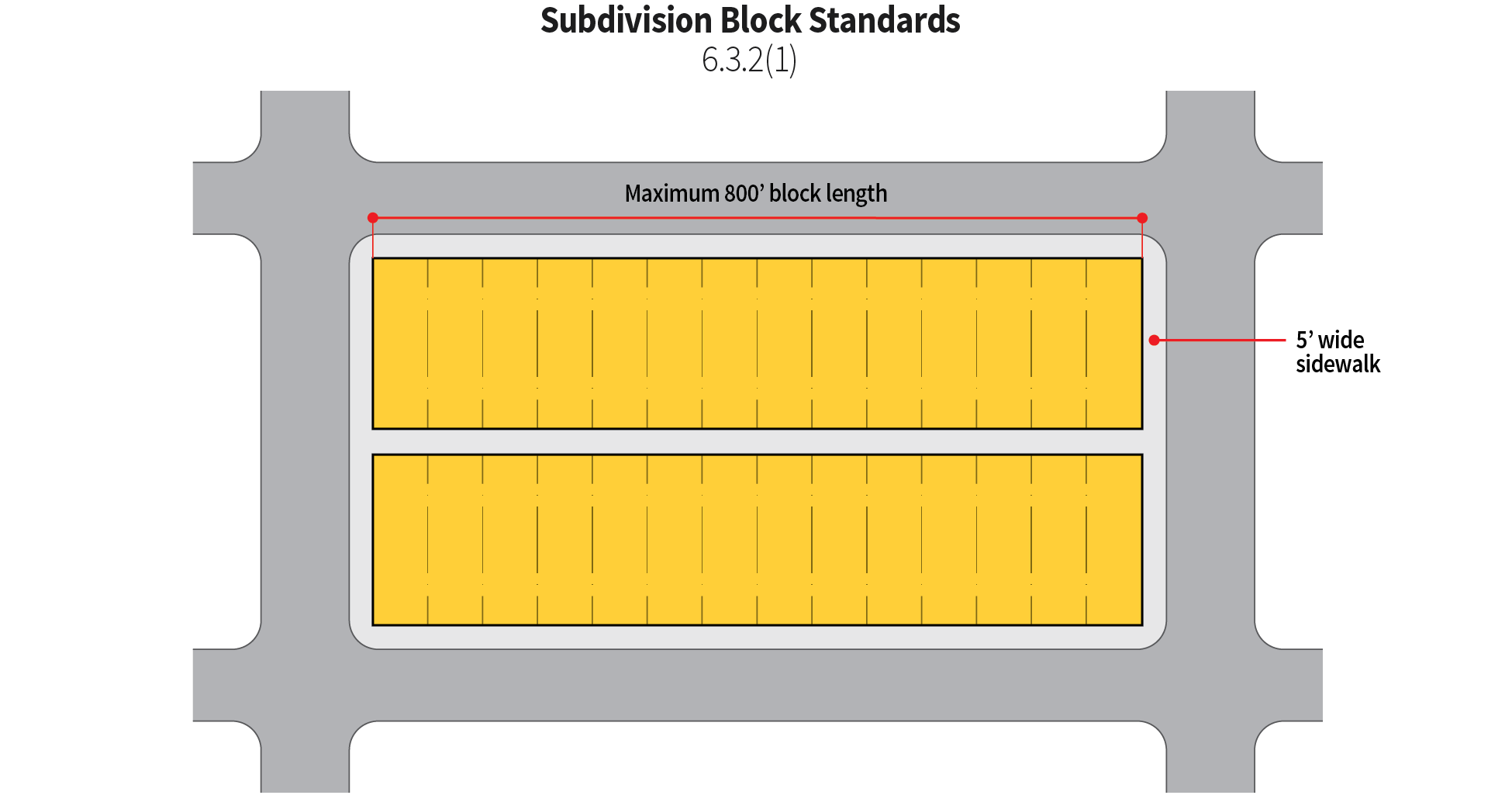
14.6.3.2. Block standards.
1)
In residential subdivisions, the maximum length of blocks shall be eight hundred (800) lineal feet. No blocks shall be less than five hundred (500) lineal feet in length unless approved by the Plan Commission. Pedestrian ways not less than five (5) feet in width shall be required in all areas within a 0.25-mile radius surrounding schools, parks, or other common destinations as determined by the Plan Commission, pedestrian ways outside of the 0.25-mile radius may be required by the Plan Commission.
2)
In manufacturing and business subdivisions, maximum length of blocks shall be as approved by the Plan Commission.
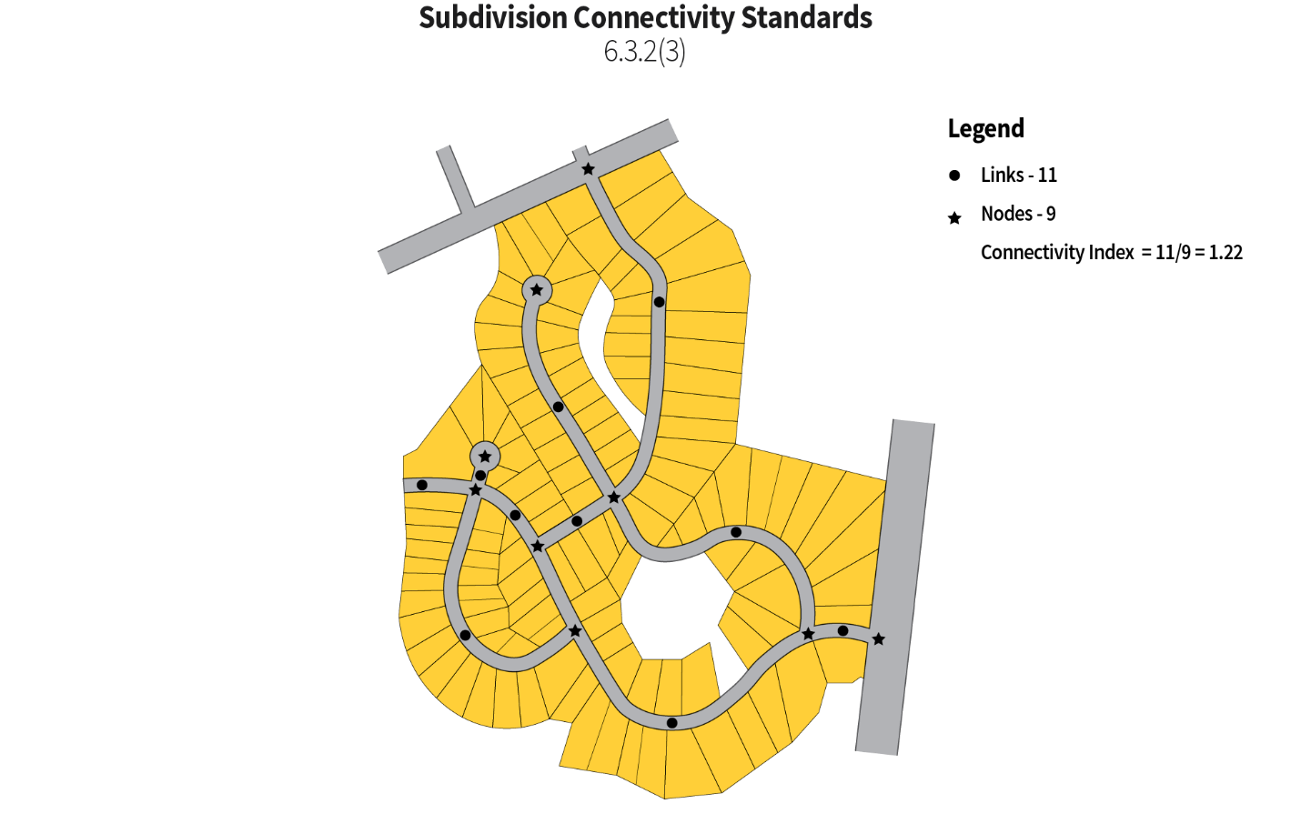
3)
The street network pattern shall be determined by topographical features, the basic street system and traffic pattern, lot depths, and areas designated for public and other nonresidential land uses but shall meet a connectivity index not less than 1.2.
4)
Where a subdivision borders upon or is traversed by a railroad right-of-way or thoroughfare, the Plan Commission may require a street (on one (1) or both sides of such right-of-way or street) approximately parallel to and at a distance removed suitable for the appropriate use of the intervening land, i.e. park purposes, deep residential lots fronting on it with a non-access strip along the rear lot lines, and off-street parking, business, or other uses as permitted by zoning ordinance regulations.
14.6.3.3. Easement standards.
1)
Village utility easements. Village utility easements shall be required in all areas, other than in the right-of-way, where water main, sanitary sewer, storm sewer, or other underground utilities to be maintained by the Village are located. Village utility easements must not be less than twenty (20) feet wide, ten (10) of which may be shown on each of two (2) adjacent lots. The following provision shall be added to the final plat for Village utility easements:
AN EXCLUSIVE EASEMENT IS HEREBY RESERVED FOR AND GRANTED TO THE VILLAGE OF CARY, ILLINOIS AND ITS RESPECTIVE SUCCESSORS AND ASSIGNS, WITHIN THE AREAS SO DESIGNATED ON THE PLAT AND MARKED VILLAGE UTILITY EASEMENT (VUE) AND UPON THE GRANTOR'S PROPERTY IMMEDIATELY ADJACENT TO THE EASEMENT AREA AS MAY BE REASONABLY REQUIRED TO CONSTRUCT, INSTALL, RECONSTRUCT, REPAIR, REMOVE, REPLACE, INSPECT, MAINTAIN AND OPERATE UNDERGROUND TRANSMISSION AND DISTRIBUTION SYSTEMS AND LINES IN, UNDER, ACROSS, ALONG AND UPON THE SURFACE OF THE VILLAGE UTILITY EASEMENT INCLUDING WITHOUT LIMITATION WATER MAINS, STORM SEWERS, SANITARY SEWERS, FORCE MAINS, ELECTRIC LINES AND ALL NECESSARY FACILITIES APPURTENANT THERETO, TOGETHER WITH THE RIGHT OF ACCESS THERETO FOR THE PERSONNEL AND EQUIPMENT NECESSARY AND REQUIRED FOR SUCH USES AND PURPOSES, AND TOGETHER WITH THE RIGHT TO INSTALL REQUIRED SERVICE CONNECTIONS UNDER THE SURFACE OF EACH LOT TO SERVE IMPROVEMENTS THEREON; TOGETHER WITH THE RIGHT TO CUT, TRIM, OR REMOVE TREES, BUSHES AND ROOTS AS MAY BE REASONABLY REQUIRED INCIDENTAL TO THE RIGHTS HEREIN GIVEN, AND THE RIGHT TO ENTER UPON THE PROPERTY FOR ALL SUCH PURPOSES. OBSTRUCTIONS SHALL NOT BE PLACED OVER GRANTEE'S FACILITIES OR IN, UPON, OR OVER THE PROPERTY WITHIN SAID EASEMENT WITHOUT PRIOR WRITTEN CONSENT OF THE GRANTEE. SAID EASEMENT MAY BE USED FOR LANDSCAPING, GARDENS, DRIVEWAYS AND PARKING EXCEPT AS OTHERWISE DESIGNATED ON THE PLAT. THE GRADES OF THE SUBDIVIDED PROPERTY APPROVED BY THE VILLAGE ENGINEER SHALL NOT BE ALTERED IN ANY MANNER BY THE INSTALLATION OF ANY OF THE FACILITIES OF SAID GRANTEE SO AS TO INTERFERE WITH THE PROPER OPERATION AND MAINTENANCE THEREOF OR WITH THE SURFACE DRAINAGE THEREON.
UNAVOIDABLE PERPENDICULAR CROSSINGS OF THE VUE BY OTHER UTILITIES SHALL BE PERMITTED BY THE VILLAGE OF CARY AND SHALL APPEAR ON ALL RECORD DRAWINGS.
2)
Public utility easements. Public utility easements shall be required in all areas used by "franchise" public utility companies such as electric, natural gas, cable television, telephone, etc. for utility distribution or transmission installations; such easements shall be located along the rear lot lines, side lot lines or front lot lines. They shall occupy not less than ten (10) feet of which five (5) feet may be shown on each of two (2) adjacent lots. Public utility easements shall not be used for drainage purposes except that they may be graded as a drainage swale. The following provision shall be added to the final plat for public utility easements:
A NON-EXCLUSIVE EASEMENT IS HEREBY RESERVED FOR AND GRANTED TO HOLDERS OF FRANCHISES GRANTED BY THE VILLAGE OF CARY, ILLINOIS AND THEIR RESPECTIVE SUCCESSORS AND ASSIGNS, WITHIN THE AREAS SO DESIGNATED ON THE PLAT AND MARKED PUBLIC UTILITY EASEMENT (PUE) TO CONSTRUCT, INSTALL, RECONSTRUCT, REPAIR, REMOVE, REPLACE, INSPECT, MAINTAIN AND OPERATE UNDERGROUND TRANSMISSION AND DISTRIBUTION SYSTEMS AND LINES IN, UNDER, ACROSS, ALONG AND UPON THE SURFACE OF THE UTILITY EASEMENT INCLUDING WITHOUT LIMITATION, GAS MAINS, TELECOMMUNICATION CABLES, ELECTRIC CABLES, CABLE TELEVISION LINES AND ALL NECESSARY FACILITIES THAT ARE APPURTENANT , TOGETHER WITH THE RIGHT OF ACCESS TO SUCH FACILTIES FOR THE PERSONNEL AND EQUIPMENT NECESSARY AND REQUIRED FOR SUCH USES AND PURPOSES, AND TOGETHER WITH THE RIGHT TO INSTALL REQUIRED SERVICE CONNECTIONS UNDER THE SURFACE OF EACH LOT TO SERVE IMPROVEMENTS THEREON; TOGETHER WITH THE RIGHT TO CUT, TRIM, OR REMOVE TREES, SHRUBS, AND ROOTS AS MAY BE REASONABLY REQUIRED INCIDENTAL TO THE RIGHTS GIVEN IN THIS TITLE, AND THE RIGHT TO ENTER UPON THE PROPERTY FOR ALL SUCH PURPOSES. OBSTRUCTIONS SHALL NOT BE PLACED OVER GRANTEES FACILITIES OR IN, UPON, OR OVER THE PROPERTY WITHIN SAID EASEMENT WITHOUT PRIOR WRITTEN CONSENT OF THE GRANTEE. SAID EASEMENT MAY BE USED FOR LANDSCAPING, GARDENS, DRIVEWAYS, AND PARKING EXCEPT AS OTHERWISE DESIGNATED ON THE PLAT. THE GRADES OF THE SUBDIVIDED PROPERTY APPROVED BY THE VILLAGE ENGINEER SHALL NOT BE ALTERED IN ANY MANNER BY THE INSTALLATION OF ANY OF THE FACILITIES OF SAID GRANTEES SO AS TO INTERFERE WITH THE PROPER OPERATION AND MAINTENANCE OF THE FACILITIES OR WITH THE SURFACE DRAINAGE OF THE EASEMENT.
3)
Utility easements. Utility easements shall be required in all areas, other than in the right-of-way, where Village utilities and the public utilities follow a common route, said easements shall be of adequate width for the purpose intended, but in no case shall it be less than twenty (20) feet. The following provision shall be added to the final plat for utility easements:
A NON-EXCLUSIVE EASEMENT IS HEREBY RESERVED FOR AND GRANTED TO THE VILLAGE OF CARY, AND HOLDERS OF FRANCHISES GRANTED BY THE VILLAGE OF CARY, ILLINOIS AND THEIR RESPECTIVE SUCCESSORS AND ASSIGNS, WITHIN THE AREAS SO DESIGNATED ON THE PLAT AND MARKED UTILITY EASEMENT (UE) TO CONSTRUCT, INSTALL, RECONSTRUCT, REPAIR, REMOVE, REPLACE, INSPECT, MAINTAIN AND OPERATE UNDERGROUND TRANSMISSION AND DISTRIBUTION SYSTEMS AND LINES IN, UNDER, ACROSS, ALONG AND UPON THE SURFACE OF THE UTILITY EASEMENT INCLUDING WITHOUT LIMITATION WATER MAINS, STORM SEWERS, SANITARY SEWERS, FORCE MAINS, GAS MAINS, TELECOMMUNICATION CABLES, ELECTRIC CABLES, CABLE TELEVISION LINES AND ALL NECESSARY FACILITIES APPURTENANT THERETO, TO-GETHER WITH THE RIGHT OF ACCESS THERETO FOR THE PERSONNEL AND EQUIPMENT NECESSARY AND REQUIRED FOR SUCH USES AND PURPOSES, AND TOGETHER WITH THE RIGHT TO INSTALL REQUIRED SERVICE CONNECTIONS UNDER THE SURFACE OF EACH LOT TO SERVE IMPROVEMENTS LOCATED IN THAT LOT; TOGETHER WITH THE RIGHT TO CUT, TRIM, OR REMOVE TREES, SHRUBS, AND ROOTS AS MAY BE REASONABLY REQUIRED INCIDENTAL TO THE RIGHTS HEREIN GIVEN, AND THE RIGHT TO ENTER UPON THE PROPERTY FOR ALL SUCH PURPOSES. OBSTRUCTIONS SHALL NOT BE PLACED OVER GRANTEES FACILITIES OR IN, UPON, OR OVER THE PROPERTY WITHIN SAID EASEMENT WITHOUT PRIOR WRITTEN CONSENT OF THE GRANTEE. SAID EASEMENT MAY BE USED FOR LANDSCAPING, GARDENS, DRIVEWAYS, AND PARKING EXCEPT AS OTHERWISE DESIGNATED ON THE PLAT. THE GRADES OF THE SUBDIVIDED PROPERTY APPROVED BY THE VILLAGE ENGINEER SHALL NOT BE ALTERED IN ANY MANNER BY THE INSTALLATION OF ANY OF THE FACILITIES OF SAID GRANTEES SO AS TO INTERFERE WITH THE PROPER OPERATION, MAINTENANCE, OR SURFACE DRAINAGE OF THE GRADE.
4)
Stormwater Management Easements. Stormwater management easements shall be required in all areas used for purposes of operating and maintaining stormwater runoff management facilities such as detention and/or retention basins and appurtenant structures and overland flood routes. The following provision shall be added to the final plat for stormwater management easements:
A STORMWATER MANAGEMENT EASEMENT IS HEREBY RESERVED FOR AND GRANTED TO THE VILLAGE OF CARY, ILLINOIS WITHIN THE AREAS DESIGNATED ON THE PLAT AS STORMWATER MANAGEMENT EASEMENTS FOR THE COLLECTION, CONVEYANCE, AND STORAGE OF STORMWATER IN AREAS TO BE MAINTAINED BY THE OWNER OF THE LOT(S) OR OUTLOT(S) ON WHICH THE FACILITIES EXIST IN ACCORDANCE WITH VILLAGE ORDINANCES AND THE APPROVED FINAL ENGINEERING PLANS. ENCROACHMENTS OF ANY KIND INCLUDING LANDSCAPING, FENCES, SHEDS, OR ACCESSORY STRUCTURES WITHIN SAID EASEMENT IS PROHIBITED UNLESS THE VILLAGE ENGINEER HAS DETERMINED SAID ENCROACHMENT WILL NOT INTERFERE WITH THE PROPER FUNCTION OF SAID FACILITIES. THE VILLAGE SHALL HAVE THE RIGHT TO ENTER WITH PERSONNEL AND EQUIPMENT UPON SAID EASEMENT AT ANY TIME FOR THE PURPOSES OF ACCESS TO AND INSPECTION OF THE STORMWATER MANAGEMENT FACILITIES LOCATED WITHIN SAID EASEMENT. IF THE OWNER FAILS TO MAINTAIN SAID FACILITIES AND, AFTER RECEIPT OF NOTICE FROM THE VILLAGE OF SAID FAILURE, THE OWNER FAILS TO MAKE REQUIRED REPAIRS IN A REASONABLE PERIOD OF TIME, THE VILLAGE MAY MAKE THE REQUIRED REPAIRS AND SEEK REIMBURSEMENT FROM THE OWNER FOR THE COSTS INCURRED BY THE VILLAGE TO MAKE THE REPAIR AND/OR FILE A LIEN ON THE PROPERTY.
5)
Drainage easements. Drainage easements shall be required in all areas where a subdivision is traversed by a water course, drainage way, channel, or stream. The drainage easement shall conform substantially with the lines of such water course and shall include further width as will be necessary for the purpose of adequately maintaining or improving the water course. Said easements shall not be used for any other purposes except that utilities may cross such easement, provided that the crossing does not alter the intended use of such easement. Said easements shall be shown on the final plat.
6)
Sight triangle restriction. On any street intersection, a clear sight triangle shall be established according to the dimensions in Table 14.6.3.3(6) below.
a)
No construction, planting, or grading shall be permitted to be erected, placed, planted, or allowed to grow within the clear sight triangle in such a manner as to impede vision.
b)
A clear view is to be maintained between a height of two and a half feet (2½) and ten (10) feet above the plane surface of this triangular area.
c)
The following provision shall be added to the final plat for sight triangle easement:
NO IMPROVEMENT SUCH AS FENCES, SIGNS, LANDSCAPING, ETC., SHALL BE INSTALLED, ERECTED, OR CONSTRUCTED WHICH MAY OBSTRUCT OR REDUCE TRAFFIC SIGHT LINES OR MAY CREATE ANY TRAFFIC HAZARD.
14.6.3.4. Pedestrian Way Standards.
The owner, developer, or subdivider shall construct public sidewalks, not less than five (5) feet in width, on both sides of every street within a 0.25-mile radius surrounding schools, parks, or other common destinations as determined by the Plan Commission. Pedestrian ways outside of the 0.25-mile radius may be required by the Plan Commission. Sidewalks shall be constructed in accordance with all design policies and construction details required by the Village Engineer.
Multiuse paths shall be required within or adjacent to a subdivision where a bicycle/multiuse path shown on the comprehensive plan runs through all or part of, or adjacent to, such subdivision. Multiuse paths shall be located on both sides of the street, shall be a minimum of ten (10) feet in width, or a width as otherwise required by the Village Engineer, and shall be designed in accordance with the latest edition of the "AASHTO Guide for the Development of Bicycle Facilities." Construction of any multiuse path shall conform to the "Standard Specifications for Road and Bridge Construction," Illinois Department of Transportation, latest edition and the engineering standards.
14.6.3.5. Streets and right-of-way standards.
1)
Street Improvements. All streets dedicated or platted after the effective date of the ordinance codified in this title shall be improved with roadway paving in accordance with the requirements listed below. A structural design of all pavements as established by the Illinois Department of Transportation will be required to substantiate the proposed construction. Actual or projected traffic counts along with sufficient soil-boring data will be required for the structural design. Not less than the minimum requirements listed below will be allowed. Twenty (20) feet of public right-of-way shall be allocated in addition to all minimum roadway widths as detailed below.
2)
Roadway pavement—Installation. Roadway pavement, including subgrade subbase, base course, surface course, curb and gutter, and other related work, shall be installed in all streets designated on the final plat, and shall be constructed, in accordance with the latest edition of the Standard Specifications for Road and Bridge Construction published by the Illinois Department of Transportation. On all new road construction other than concrete with an aggregate base course, final bituminous surfacing shall be allowed only after the base and bituminous binder course have been in place for one (1) winter season and then approved by the Village Engineer.
a)
Whenever two (2) inches of snow have fallen, the Village will place a courtesy telephone call to the subdivider's 24-hour emergency access number to remind him/her to snowplow said roads. If said roads are not completely snowplowed by the subdivider within six (6) hours from the time that the Village attempts to place said telephone call to the subdivider, and even though there was no answer to the aforesaid telephone call placed by the Village to the subdivider, the Village may, without further notice to the subdivider, snowplow said roads, after which the subdivider shall pay to the Village a sum determined by the Village fee schedule, as amended time to time, per hour for each hour, or fraction of an hour, that the Village expends in connection with the snowplowing of said subdivision roads.
b)
Pozzolanic material will not be allowed in base-course construction.
3)
Roadway pavement—Alleys. Roadway pavements in alleys shall be not less than twenty-four (24) feet wide in business or manufacturing subdivisions and shall be installed in accordance with Village standards and specifications.
4)
Roadway pavement—Curb and gutter. All new roadways shall be bordered by Portland cement designated as State Standard Curb B-6.12 concrete curb and gutter not less than nineteen (19) inches in width consisting of a twelve (12) inch gutter flag width and a six (6) inch curb width along with a one (1) inch batter on the curb face and a six (6) inch curb height. A four (4) inch high roll curb with a four (4) inch curb width and nose radius and a three (3) inch batter and gutter radius may be used for residential streets on request, if approved by the Village. The depth of the gutter shall not be less than eight (8) inches and shall be equal to the total depth of the pavement unless the total depth of pavement exceeds twelve (12) inches, in which case the curb and gutter may be constructed on partial-depth base course extending a distance of twelve (12) inches beyond the back of curb. Joint control shall be established by contraction joints formed by steel plates or saw cuts 1.5 inches in depth spaced not more than twenty-five (25) feet, by construction joints with dowel bars at the terminus of a pour and at all intersecting radii, and by expansion joints of spacing not to exceed four hundred (400) feet. For all land development projects adjacent to existing platted roadways, it will be the Village Board's decision to determine if roadway improvements (street lights, signage, curb and gutter, etc.) will be required as part of the land development project. The land improvement standards required by the Village Board will be reviewed by the Village Engineer to determine compliance with this title.
5)
Street names. Duplication of street names is prohibited. All street names shall be subject to the approval of the Village Board of Trustees and local U.S. postal authority.
6)
Street lighting system.
a)
Residential street-lighting facilities shall be provided at all street intersections, at the midpoint in all blocks, curves, and at the end of all cul-de-sacs. At all main entrances of any subdivision abutting a primary thoroughfare, the street-light shall be a 200-watt LED luminaire General Electric, or equivalent, cobra head on a Salt and Pepper, octagonal shape terrazzo pole set nineteen (19) feet above grade. At all locations in the subdivision other than at the main entrance aforesaid, the street light shall be a LED luminaire General Electric, or equivalent, coach head on a Salt and Pepper, octagonal shape imbedded, terrazzo pole set fourteen (14) feet above ground.
b)
In business districts, street-lighting facilities shall be recommended by the Plan Commission to the Village Board and shall be subject to the Village Board approval.
c)
Industrial street-lighting shall be provided at all street intersections and at a maximum spacing of three hundred (300) feet. Lights shall be a General Electric 200-watt LED, or equivalent, cobra head on a spun aluminum pole with breakaway anchors set at thirty (30) feet above ground.
d)
The subdivider shall arrange for and pay all costs relative to the installation of the street-lights including any fees by utilities providers.
e)
Upon payment of all installation costs and the approval by the Village Engineer, the subdivider shall convey and dedicate the street-lighting system to the Village free of any charge.
7)
Street intersections. At street intersections, intersecting roadway pavement edges shall be connected by a radius of not less than twenty-five (25) feet.
8)
Parkways. All parkways within a street right-of-way shall be graded and at a minimum seeded in accordance with Village standards and specifications.
14.6.3.6. Sign standards.
1)
Traffic signs, signals, and markings. Traffic signs, signals, and markings to regulate, warn, or guide traffic, conforming to the Illinois Manual on Uniform Traffic Control Devices, as amended from time to time, shall be installed by the Village, at the sole cost and expense of the subdivider, at such street locations that may be designated by the Village.
2)
Street name signs. Street name signs shall be installed at the sole expense of the subdivider prior to completion of roadway pavements and located in a manner so as to identify every street within the subdivision. They shall be of the type and installed in accordance with Village standards and specifications.
(Ord. No. O19-05-06, § 3, 5-21-2019)
Sec. 14.6.4. - Requirements: environmental and parks.
14.6.4.1. Stormwater standards.
1)
A stormwater drainage system shall be designed to service the entire subdivision and natural watershed tributary to it, in accordance with the McHenry County Stormwater Ordinance as amended from time to time.
2)
Land dedicated as retention or detention facilities or for drainage easements cannot be used to satisfy the requirement of land donated for parks and recreation purposes but can be taken out of net developable acreage.
14.6.4.2. Stormwater inlets and utility access holes.
Unless otherwise approved by the Village Engineer, utility access holes or inlet utility access holes shall be provided at all changes of direction of pipe or pipe size. Manholes and inlets shall be Type A as shown in the Highway Standards Manual of the Illinois Department of Transportation. Manhole covers shall be Neenah R-1077-A, or East Jordan 1022, or equivalent, with the word "Storm" permanently imprinted on the face of the cover. Inlet spacing shall be based on a design flow of not more than two (2) cubic feet per second per inlet, but in no case shall the curb run to the inlet exceed two hundred fifty (250) feet. Inlets in B-6.12 curb and gutter shall be provided with Type 11 frame and grate as shown in the Highway Standards Manual of the Illinois Department of Transportation. Roll-type curb inlets shall be Neenah R-3501-A, or East Jordan 7171, or equivalent.
14.6.4.3. Sustainable development.
1)
Intent. The purpose of this article is to provide flexibility to the developer who subdivides property and aggregates his or her open space in one (1) or more tracts, to provide enhanced recreational benefits to his or her development and enhanced protection of natural features, such as wetlands or wooded areas, and, in the case of architecturally integrated subdivisions, constructs buildings on the lots created in accordance with a unified plan of development.
2)
General standards—Cluster. In any subdivision of a tract consisting of ten (10) acres of land or more, the developer may create lots which deviate from the minimum lot size and lot width; except that the dimensional standards for any lot created shall not be reduced below the dimensional standards of the next most intensive district.
a)
For purpose of this section, the next most intensive district is as follows:
b)
The developer shall demonstrate that at least ten (10) percent of the tract is characterized by significant natural features deserving protection, and that for the most part those areas will be placed into open space. The word "Cluster" shall appear in the title of any plat seeking to use this style of development.
c)
For purpose of this section, the lot area of the R2A district shall be construed as being 22.5 percent less than the lot area of the R2 district and the lot width of the R2A district shall be construed as the same as the R2 district.
3)
Architecturally integrated subdivision. In any cluster subdivision, the developer may create lots and construct buildings which deviate from the minimum side and rear yard setbacks except for those lots abutting land that is not part of the subdivision. The development will comply with the standards for cluster set out in Section 14.6.4.3(2) of this title. The words "Architecturally Integrated Subdivision" shall appear in the title of any plat seeking to use this style of development.
4)
Density. The number of lots or dwelling units allowed in a cluster or architecturally integrated subdivision shall not exceed the number obtained by multiplying the net developable acreage by the density for the district as set out in the table of dimensional standards located in Chapter 2 of this title. The net developable acreage is the gross acreage less any lands in floodway, regulatory wetlands, detention or retention ponds, and street rights-of-way.
5)
Useable open space. To the extent reasonably practicable, the amount of land saved by creating lots that are smaller than the standards set forth in Chapter 2 of this title shall be set aside as passive, active, preserved, or natural open space. The amount of usable open space provided shall exceed forty (40) percent of the development. At least seventy-five (75) percent of the lots that are reduced in size shall be adjacent to the open space preserved. Any open space preserved shall be placed in a property owner's association, or shall, with the Village's consent, be dedicated to the Village or another public entity.
6)
Emergency access. Because of the flexibility allowed in this article, every architecturally integrated subdivision shall be required to demonstrate that the Village and other emergency service providers will have adequate access to each dwelling unit for purpose of police and fire protection.
7)
Architectural drawings. Where a developer proposes to use the architecturally integrated style of development to deviate from the yard requirements in this title, any preliminary plat submitted shall be accompanied by architectural drawings showing the facades and footprints of the proposed structures. These drawings may be roughly drawn at the preliminary plat stage, with the focus on window placement, orientation, and distance between buildings, and with provisions addressing privacy. These matters will be more definitively addressed in submittals accompanying the final plan. Every development will provide a minimum of five (5) different front facades.
14.6.4.4. Dedication of park land and school sites as a requirement of plat approval.
1)
Findings and determinations.
a)
Whereas, the Village has experienced a population increase due in part to the subdivision and planned unit development of vacant land within the jurisdiction of Cary; and
b)
Whereas, such population growth might result in the rapid disappearance of available land and the marked increase in land values; and
c)
Whereas, the Village has found that productive community life depends in part on the availability of recreational and park space and adequate school and fire protection facilities; and
d)
Whereas, it is found and determined that the public interest, convenience, health, welfare, and safety requires that a minimum of one (1) acre of land for each one hundred (100) persons residing within the Village be devoted to park and recreational purposes; and
e)
Whereas, it is found and determined that the public interest, convenience, health, welfare, and safety requires the establishment of school sites within the Village in accordance with the following criteria:
i.
Four hundred (400) capacity elementary schools, kindergarten through fifth grade, on fifteen (15) acres of land,
ii.
Seven hundred fifty (750) capacity junior high school, grades sixth through eighth, on thirty-five (35) acres of land,
iii.
One thousand (1,000) capacity high schools, grades ninth through twelfth, on sixty (60) acres of land; and
f)
Whereas, it is determined that the "Table of Estimated Ultimate Population," which is published by the Illinois School Consulting Service, is generally indicative of current and short-range projected trends of the number of school-age children and of adults to be generated from proposed subdivisions or planned unit developments; and
g)
Whereas, it has been found and determined that the locations of park and recreational, school sites, and provision for fire protection facilities to serve the immediate and future needs of residents and children of each new subdivision or planned unit development is just as essential to proper land development as are streets, water, sewer, and sidewalks; and
h)
Whereas, aside from the finding relating to the fair market value of improved land specified in this title, it is determined by the Village to require cash contributions substantially less than the amount which would otherwise be produced by a consideration of all of the aforesaid factors; and
i)
It has been determined, and is declared, that it is urgent that the ordinance codified in this chapter take effect immediately upon its passage and approval.
2)
Required. As a condition of approval of a final plat of subdivision, each subdivider or developer will be required to dedicate land for park and recreational purposes and land for school sites, to serve the immediate and future needs of the residents of the development, or cash contribution in lieu of actual land dedication, or a combination of both, at the option of the Village, in accordance with the criteria and formula set forth in this chapter. This required dedication shall be in addition to the five (5) percent minimum land area dedicated for public access as specified in this chapter.
14.6.4.5. Criteria for park and recreation land dedication.
1)
Requirement and population ratio. The ultimate density of a proposed development shall bear directly upon the amount of land required for dedication. The total requirement shall be one (1) acre of land per one hundred (100) of ultimate population. This requirement shall not include land required for stormwater, drainage systems, or retention/detention facilities. It is recognized that population density, age distribution, and local conditions change over the years, and the specific formula for the dedication of land, or the payment of fees in lieu of, as stated in this chapter, is subject to periodic review and amendment if necessary.
2)
Location. The official map of the Village and/or "Cary Park District Park Master Plan" shall be used as a guideline in locating park sites. Each subdivider or his or her agent shall obtain a statement in writing from the park district and submit a copy of it to the Village recommending: the exact size and location of each parcel to be used for park and recreation purposes; or the amount of cash to be paid in lieu; or a combination of land and cash to be paid in lieu; prior to consideration and approval of such park and recreational land dedication by the Village Board of Trustees.
3)
Cash contribution in lieu of land dedication. In the event the Cary Park District Board should determine that a cash contribution or a combination of land and cash contribution shall be made by the subdivider or developer in lieu of the required land dedication, the Village shall apply a formula as follows: the required land donation minus the land being dedicated divided the required donation, that fraction times the product of the total number of units multiplied by the appropriate scheduled rate as set out in this chapter, yields the cash donation.
14.6.4.6. Criteria for school site dedication.
1)
Requirement and population ratio. The ultimate number of students to be generated by a subdivision or planned unit development shall bear directly upon the amount of land required to be dedicated for school sites. The land dedication requirement shall be determined by obtaining the ratio of:
a)
estimated children to be served in each such school classification over the
b)
maximum recommended number of students to be served in each such school classification as stated in this title, and then applying such ratio to the
c)
minimum recommended number of acres for a school site of each such school classification as stated in this title. The determined amount of land dedicated shall be equal to the acres of land deemed needed to have sufficient land for school sites to serve the estimated increased children in each such school classification. This requirement shall not include land required for stormwater, drainage systems, or retention or detention facilities.
2)
Classifications and size of site. School classifications and size of school sites within the Village shall be determined in accordance with the criteria previously set forth in the recital portion of this chapter. The official map of the Village and/or the standards adopted by the impacted school district shall be used as a guideline in locating sites.
3)
Density formula.
a)
The current "Table of Estimated Ultimate Population" per dwelling unit of population density, which is published by the Illinois School Consulting Service, shall be used in calculating the amount of required dedication of acres of land and any combination of land dedication and cash contribution. For purposes of this section, the current table shall mean the most recent table of estimated ultimate tabulation per dwelling unit published by the Illinois School Consulting Service as applied simultaneously with the request for approval of the final plat of subdivision or planned unit development pursuant to the ordinances of the Village.
b)
In the event a subdivider or developer files a written objection to the "Table of Estimated Ultimate Population", he or she shall submit his or her own demographic study showing the estimated additional population to be generated from the subdivision or planned unit development and in that event final determination of the density formula to be used in such calculations shall be made by the Village Board of Trustees based upon such demographic information submitted by the subdivider or developer and from other sources which may be submitted to the Village Board of Trustees by the park district, school district, or others. It is recognized that population density, age distribution and local conditions change over the years, and the specific formula for the dedication of land, or the payment of fees in lieu of dedication, as stated in this chapter, is subject to periodic review and amendment if necessary.
14.6.4.7. Criteria for cash contribution in lieu of land dedication.
1)
Requirement and population ratio. The ultimate number of students to be generated by a subdivision or planned unit development shall bear directly upon the amount of land required to be dedicated for school sites. The land dedication requirement shall be determined by obtaining the ratio of:
a)
estimated children to be served in each such school classification over the
b)
maximum recommended number of students to be served in each such school classification as stated in this title, and then applying such ratio to the
c)
minimum recommended number of acres for a school site of each such school classification as stated in this title. The determined amount of land dedicated shall be equal to the acres of land deemed needed to have sufficient land for school sites to serve the estimated increased children in each such school classification. This requirement shall not include land required for stormwater, drainage systems, or retention or detention facilities.
2)
Required. When the available land for dedication is determined to be too small or inappropriate for park and recreational purposes or a school site, the Village shall require the subdivider or developer to pay a cash contribution in lieu of the land dedication required. Cash in lieu of the required park land contribution shall be computed as per the schedule set forth in this chapter.
3)
Fair market value. The cash contributions in lieu of land shall be based on the fair market value of the acres of land in the area improved as specified in this title, that otherwise would have been dedicated as park and recreation and school sites. The present fair market value of such improved land in the planning jurisdiction of the Village will be determined by the Director of Community Development, and such figure may be used in making any calculation in this title unless the subdivider or developer files a written objection of the determined amount. In the event of any such objection, the developer shall submit an appraisal showing the fair market value of such improved land in the area of his or her development or other evidence justifying the objection and final determination of said fair market value per acre of such improved land shall be made by the Village Board of Trustees based upon such information submitted by the subdivider or developer and from other sources which may be submitted to the Village Board of Trustees by the park district, school district, or others.
4)
Schedule. The cash contribution per each residential dwelling unit for library district, fire protection district facilities, and for park and school purposes where the Village requires solely cash in lieu of land dedication for school and park sites, shall be in accordance with the "Contribution Per Residential Units" table made available by the Director of Community Development.
5)
Time of payment—Property outside Village. Where the property in the subdivision is located outside of the Village boundaries but within its plan jurisdiction, the cash contribution required by this chapter shall be payable to the Village when application is made to the Village to approve such subdivision or planned unit development.
6)
Time of payment—Property within Village. Where the property in the subdivision is located within the Village boundaries, the cash contributions required by this chapter shall be payable to the Village either upon the sale of each lot or parcel, or at the time application is made to the Village for the issuance of a residential building permit in connection with any premises in such subdivision or planned unit development, whichever event occurs first; provided, however, that if not sooner paid, fifty (50) percent of the cash contributions shall be due and payable eighteen (18) months after the final plat approval and the remaining fifty (50) percent of such contributions shall be due and payable thirty-six (36) months after such final plat approval.
7)
Method of calculating number of bedrooms. In those situations where the cash contribution is due upon an application being made for a residential building permit, such contributions shall be calculated pursuant to the schedule set forth in this chapter based on the type of residential unit to be constructed and the number of bedrooms specified in such application.
8)
Method of calculating increased number of bedrooms—Supplementary payment. In each of those situations where the cash contribution, as detailed in this Section, is due and payable prior to the application for a residential building permit, such cash contribution shall be calculated pursuant to the above schedule and on the basis that the single-family dwellings to be subsequently constructed will contain a minimum of three (3) bedrooms, and that the apartments, townhouses, row houses and quadraplexes will contain one (1) bedroom per each allowable residential unit; provided, however, that if later an application for building permit is made showing more than the aforesaid number of bedrooms per dwelling unit, the applicant for such building permit shall then be required to pay a supplementary cash contribution to the Village to make up the difference between the amount previously paid by the developer or subdivider and the amount required for the actual number of bedrooms to be constructed in such residential dwelling unit.
9)
Notice to be placed on all final subdivision plats. The following language shall be placed as a notice on all final subdivision plats:
NOTICE
All of the property described herein and platted in lots, blocks and other parcels or units, is subject to the payment of a fee to the Village of Cary, Illinois, for park, library, school, and fire protection purposes at the time of the initial sale of any such lot, block or other parcel or unit.
10)
Use of funds. The Village shall remit the cash contributions to the affected school, library district, park, and fire protection districts on a periodic basis not less frequently than quarterly. Such cash contributions shall be held in a special fund by each of said districts and shall be disbursed by them only for such lawful purposes as may be authorized by statute or by law. No such cash contribution shall be distributed to any of the impacted governments unless they have executed an intergovernmental agreement regarding impact fees with the Village of Cary.
14.6.4.8. Land dedication and cash contribution.
There will be situations in subdivisions when a combination of land dedication and a contribution in lieu of land are both necessary. These occasions will arise when:
1)
Only a portion of the land to be developed is proposed as the location for a park or school site. That portion of the land within the subdivision falling within the park or school location shall be dedicated as a site as detailed previously in this chapter, and a cash contribution shall be required in lieu of any additional land that would have been required to be dedicated.
2)
A major part of the local park or recreational site or school site has already been acquired and only a small portion of land is needed from the development to complete the site. The remaining portions shall be required by dedication, and a cash contribution shall be required in lieu of a dedication.
(Ord. No. O19-05-06, § 3, 5-21-2019)
Sec. 14.6.5. - Application process and procedures.
14.6.5.1. Platting procedure.
14.6.5.2. Board of trustees' approval of plat of subdivision of small tracts.
When a plat of subdivision or a plat of resubdivision of a small tract of land is presented to the Board of Trustees for approval, the Board, after the consideration of recommendations about the plat made by the Plan Commission, is of the opinion that the intent and purpose of the provisions of this title are not violated by such plat, and the construction of the improvements required in this title cannot be reasonably enforced, the Board may waive the application or enforcement of the provisions of this title and approve such plat without requiring further procedure.
14.6.5.3. Variations.
The Plan Commission may recommend variations from the requirements of this title in specific cases which, in its opinion, do not adversely impact the comprehensive plan or intent of this title. Such recommendations shall be communicated to the Board of Trustees or governing County authorities in writing, substantiating the recommended variation. The Board of Trustees may approve variations from the requirements of this title, when, in its opinion, such variations will not adversely impact the comprehensive plan or the intent of this title. The Board of Trustees shall not approve variations that result in requirements less than required by the County subdivision regulations ordinance for subdivisions located in the unincorporated areas under the extraterritorial jurisdiction of this title.
14.6.5.4. Enforcement.
No plat of any subdivision shall be entitled to record in the Recorder of Deeds' office or have any validity until it shall have been approved in a manner prescribed in this title. The Director of Community Development shall be the enforcing officer of this title, and he or she may call upon any department or official of the Village to furnish him or her with such information and assistance as he or she may deem necessary for the observance or enforcement of this title, and it shall be the duty of such department or officer to furnish such information and assistance whenever required.
14.6.5.5. Certificates.
1)
Roadway access certificate. The roadway access certificate shall also be furnished simultaneously with the preliminary plat.
2)
McHenry County Health Department certificate. The McHenry County Health Department certificate shall also be furnished simultaneously with the preliminary plat.
3)
Application for final plat approval. The application for approval of the final plat shall not be deemed completed until the certificates, other than the Village Clerk, Village Treasurer and department heads certificates have been duly executed.
4)
Owner's certificate. The Director of Community Development shall make the Owner's Certificate available. It shall include provisions including but not limited to: grants or dedications for public use of land, and a non-exclusive easement for serving the subdivision and other property with electric communications, sewer, water, gas, and drainage service.
5)
Notary certificate. The Director of Community Development shall make the Notary Certificate available. It shall include provisions including but not limited to: certification for signer identity, acknowledgement of signing annexed plat.
6)
Corporate owner's certificate. The Director of Community Development shall make the Corporate Owner's Certificate available. It shall include provisions including but not limited to: certification of ownership, public use of lands, nonexclusive easement for serving the subdivision.
7)
Village Engineer's certificate. The Director of Community Development shall make the Village Engineer's Certificate available. It shall include provision including but not limited to: certification that land improvements in the plat and plans meet minimum requirements.
8)
County clerk certificate. The Director of Community Development shall make the County Clerk Certificate available. It shall include provisions including but not limited to: certification that no delinquent or unpaid taxes are associated with the property.
9)
Certificate as to special assessments. The Director of Community Development shall make the Certificate as to Special Assessments available. It shall include provisions including but not limited to: certification that no unpaid current or forfeited special assessments have been apportioned against the property.
(Ord. No. O19-05-06, § 3, 5-21-2019)