
Cheney City Zoning Code
CHAPTER 21
10 - MEASUREMENTS3
Editor's note— Ordinance No. W-55, § 2, adopted March 10, 2015, renamed chapter 21.10 from "Development Standards" to "Measurements."
21.10.010 - Purpose.
The purpose of this chapter is to set the standards for calculating measurements required in the development code.
(Ord. No. W-22, § 20, 4-22-2014)
21.10.020 - Measuring number of items required.
Rounding to whole numbers may be used to determine distance, structure height, number of trees, parking spaces (including bicycle), maximum or minimum area, density or other quantitative standards or requirements. A decimal ending with five or greater may be rounded up to the next whole number. A decimal ending with four or less may be rounded down to the next whole number.
(Ord. No. Y-21, § 6, 10-11-2022; Ord. No. W-22, § 21, 4-22-2014)
21.10.030 - Measuring distances.
A.
When any measurement technique for determining required minimum or allowed maximum dimensions, including, but not limited to, height, yards, setbacks, lot coverage, opens space, parking stall size or street width, results in a fractional number, the dimension shall be measured to the nearest inch. Any fraction less than one-half of an inch shall be disregarded and fractions of one-half-inch or larger shall be included in the measurement. Note: Where illustrations conflict with the text of this section, the text shall control.
B.
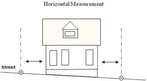
Distances are measured horizontally. When determining distances for setbacks, structure dimensions, and buffers, all distances are measured along a horizontal plane from the appropriate property line, critical area boundary, edge of building, structure, storage area, parking area or other object. These distances are not measured by following the topography of the land.
C.
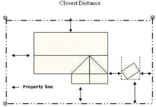
Measurements are shortest distance. Measurements should reflect the shortest applicable distance, perpendicular to the lot line.
D.
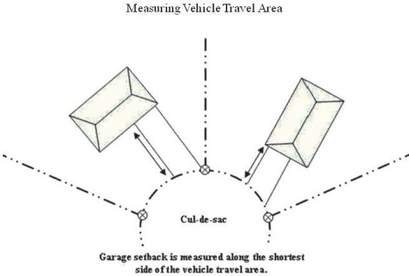
Measurements of vehicle travel areas. Minimum vehicle travel area for garage entrance setbacks is measured along the shortest side of the vehicle travel area.
E.
Measurements involving a structure. Measurements involving a structure are made to the closest wall of the structure. Chimneys, eaves, and bay windows up to ten feet in length, are not included in the measurement. Other items, such as covered porches, and entrances are included in the measurement.
F.
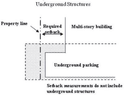
Underground structures. Structures or portions of structures that are entirely underground are not included in measuring required distances. However, this shall not be interpreted to mean that underground construction is allowed to encroach under public rights-of-way, easements or other property without a street use permit.
G.
Landscaping. Measurements of the dimensions of a landscaped area include only the area that is actually landscaped and not any other elements such as protect curbs.
(Ord. No. W-22, § 22, 4-22-2014)
21.10.040 - Measuring distances on a map.
A.
Zone boundaries. Zone boundaries that are shown crossing lots are usually based on a topographic feature or a set measurement from a property line or topographic feature, such as the top of slope or stream bank or middle of a stream. When zone boundaries are shown crossing properties with no clear indication of the basis for the line, exact distances are to be determined by scaling the distances from the official zoning map, using the center of the zoning line.
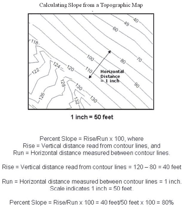
B.
Calculating slope from a topographic map.
(Ord. No. W-22, § 23, 4-22-2014)
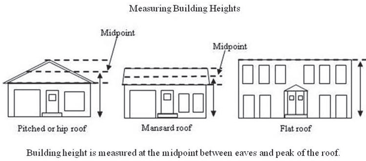
21.10.050 - Measuring height.
Height of buildings is measured from the vertical distance from the average grade to the average height of the roof peak of the building, in which case the height shall be measured from average existing grade (prior to development) to the highest point of a structure (see also WAC 173-27-030).
(Ord. No. W-22, § 24, 4-22-2014)
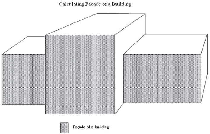
21.10.060 - Determining the area of the facade of a building.
Criteria for determining the area of the façade of a building. The area of a specific facade of a building is determined by adding the square footage of surface area of each section of wall visible from that perspective. For buildings with more than one wall along one façade, for example, rooms jutting out from the main building or a building where each floor is set back from the floor below, all of the walls are included in the total area. The total area does not include any roof area.
(Ord. No. W-22, § 25, 4-22-2014)
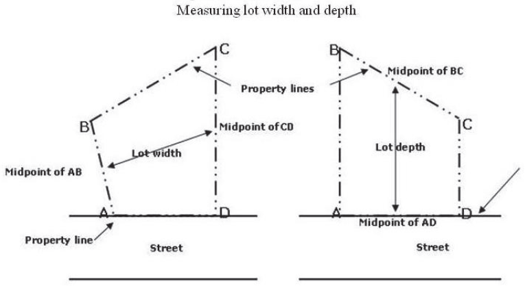
21.10.070 - Measuring lot widths and depths.
Criteria for measuring lot widths and depths. Lot widths and depths are measured from the midpoints of opposite lot lines.
(Ord. No. W-22, § 26, 4-22-2014)
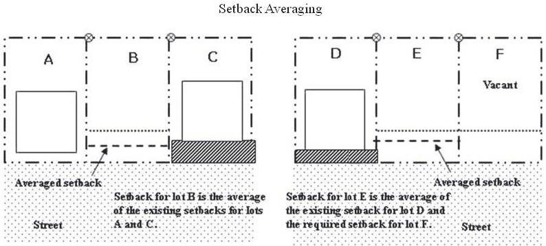
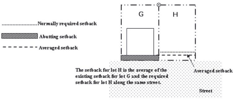
21.10.080 - Setback averaging.
Specific setback regulations. Certain regulations allow for setbacks to be averaged. In these situations the required setback may be reduced to the average of the existing setbacks of the lots that are on both sides of the site. The following rules apply in calculating the average:
(1)
Setback type consistency. The setbacks used for the calculations must be the same type of setback that is being averaged. For example, only front yard setbacks can be used to average a front yard setback;
(2)
Setbacks that abut the site. Only the setbacks on the lots that abut each side of the site and are on the same street may be used. Setbacks across the street or along a different street may not be used; and
(3)
Setbacks and lot orientation. When one abutting lot is vacant or if the lot is a corner lot, then the average is of the setback of the non-vacant lot and the required setback for the zone.
(Ord. No. W-22, § 27, 4-22-2014)
21.10.090 - Calculating density.
The following describes how net density is calculated with certain examples:
1.
Lot calculation if a street is created: Example in the R-1 Zone.
Assume a 15 percent loss when a street is created.
(Square footage of site x 0.85)/Maximum density = Maximum number of lots
(43,560 sf x 0.85)/7,000 sf = 5.28 lots or 5 lots when rounded down.
2.
Lot calculation if there is a critical area: Example in the CALR Zone.
Assume a three-acre site with a 20,000 square foot wetland and buffer.
(Square feet of the site including wetland)/Max. density = Maximum number of lots
(130,680 sf)/10,000 sf = 13.06 lots or 13 lots when rounded down.
(Ord. No. Y-21, § 7, 10-11-2022; Ord. No. W-22, § 28, 4-22-2014)
21.10.100 - Measuring tree diameter.
A.
Existing trees. Existing trees are measured at a height of four and one-half feet above the ground. Trees on slopes are measured from the ground level on the lower side of the tree. If the tree splits into multiple trunks below four and one-half feet, the trunk is measured at its most narrow point below the split.
B.
New trees. New trees are measured in caliper inch, which is the diameter of the trunk six inches above the ground for up to and including four inches caliper size and 12 inches above the ground for larger trees.
C.
Tree diameter. Tree diameter is measured by taking the circumference of the tree at the height, described in Items A and B above, and dividing the result by 3.14.
(Ord. No. W-22, § 29, 4-22-2014)