
Cherokee County Unincorporated
City Zoning Code
City Zoning Code
ARTICLE 8
- TRADITIONAL NEIGHBORHOOD DEVELOPMENT ORDINANCE3
Editor's note— Ord. No. 2006-Z-004, adopted May 2, 2006, repealed the former article 8, §§ 8.1—8.10, and enacted a new article 8 as set out herein. The former article 8 pertained to similar subject matter and derived from Ord No. 2000-17, adopted Oct. 24, 2000.
8.1 - Purpose.
8.1.1 The traditional neighborhood development ordinance serves to encourage developing as one project, tracts of land that are sufficiently large to allow a site design for a group of uses, as a mixed-use development, while maintaining compatibility with the surrounding area and creating an attractive, efficient and stable environment. It encourages a mixture of housing types, prominently sited civic or community buildings, and commercial or office/institutional workplaces to provide a balanced mix of activities and public spaces. To this end, a project must consist of more than one type of land use to be considered a traditional neighborhood development. The ordinance promotes flexibility in the application of development standards, best possible site planning and arrangement of land uses in a master development plan aimed at ensuring the conservation of the natural environment, more efficient use of land, and efficiency in the extension of streets and utilities. It is further the purpose of the traditional neighborhood development ordinance to take into account the following:
a)
Advances in technology and design, for example the use of pervious materials in the paving of parking lots, driveways, etc.
b)
Recognition and resolution of problems associated with sprawl developments, through, for example, the creation of a network of interconnecting, pedestrian oriented streets and other public spaces.
c)
A comprehensive development equal to or better than that resulting from typical lot-by-lot land use development, in which the design of the overall site permits increased freedom in the placement and uses of buildings and the location of open spaces, circulation facilities, off-street parking areas and other facilities.
d)
The conservation of sites characterized by special features of geography, topography, size or shape.
e)
The height and bulk characteristics of buildings can vary as long as the ratio of site area to buildings and openness of the project site will be in harmony with the area in which the proposed development is located.
(Ord. No. 2006-Z-004, 5-2-06)
8.2 - Findings for project approval.
8.2.1 The traditional neighborhood development ordinance is not intended for speculative purposes to enhance the value of property. As such, approval of a traditional neighborhood development project shall be on a site-specific basis, as a conditional use, based upon the submission and approval of a detailed master plan. If construction is not commenced within one year, after obtaining all the necessary permits, or pursued contrary to the approved master plan, the board of commissioners may, upon written recommendation from the director of planning and zoning and written notice to the applicant, following a hearing, revoke the approval and/or reduce the size of the approved traditional neighborhood development project to fit the scope of actual development. The board of commissioners shall approve a traditional neighborhood development project only if it finds that the proposed project will satisfy standards of this article including the following:
a)
That the proposed traditional neighborhood development project is an effective and unified treatment of development possibilities on the project site, while remaining consistent with the county's comprehensive development plan and future land use map, and making appropriate provisions for the preservation of natural features such as streams, and wetlands.
b)
That the proposed traditional neighborhood development project will be compatible (location, size, design and operating characteristics) with the area surrounding the project site, and with no greater demand on public facilities and services than other authorized uses for the land.
c)
That the statement of the proposed development schedule demonstrates a readiness to begin construction within one year, upon obtaining all necessary permits, and assures a timely completion of the proposed development.
(Ord. No. 2006-Z-004, 5-2-06)
8.3 - General standards and requirements.
8.3.1 Size of the traditional neighborhood development site. A tract of land to be developed as a traditional neighborhood development shall contain not less than 20 contiguous acres and not more than 250 acres, and be of a configuration that is conducive to a traditional neighborhood development. The simultaneous planning of larger and adjacent parcels is encouraged.
Notwithstanding the provisions noted above, a traditional neighborhood development may have land that is less than 20 acres if the board of commissioners, upon showing by the applicant, is convinced that a traditional neighborhood development is in the public interest because one or more of the following conditions exist:
a)
The property is adjacent to or across a street from property that has been developed or redeveloped under a traditional neighborhood development ordinance, and a traditional neighborhood development will contribute to the maintenance of the character, amenities, values and architectural style of the neighboring traditional neighborhood development.
8.3.2 Pedestrian shed. The basis of any traditional neighborhood development shall be the pedestrian shed. The pedestrian shed represents the physical limits most Americans will walk before choosing to drive. Traditional neighborhood development, by design, is compact, walkable, and mixed-use, and it is meant to be comfortable, safe, and ecologically sustainable. It allows a mix of uses within the neighborhood, so its residents or customers do not have to drive everywhere. A TND may be comprised of a partial or entire standard pedestrian shed (¼-mile radius) or more than one standard pedestrian shed including neighborhood edge T3, neighborhood general T4 and neighborhood center T5 as specified in Table 14-a. Larger sites shall be designed and developed as multiple pedestrian sheds, each with the individual neighborhood zone requirements as specified in Tables 1 and 14-a.
8.3.3 Ownership of land. All of the land in a traditional neighborhood development shall initially be under one ownership. Individual properties in the traditional neighborhood development may be sold after a plat has been recorded, with the properties subject to deed covenants/restrictions that ensure the continuance of the traditional neighborhood development as originally approved and developed.
8.3.4 Location. The traditional neighborhood developments shall be appropriate in the following locations:
a)
On property within the alternate use corridors;
b)
On land within the adopted future growth boundary areas of the cities of Cherokee County;
c)
In areas planned for high density residential use on the adopted interim land use policy map;
d)
On property outside of the areas listed above (subsections a)—c)), provided the following conditions exist:
i.
Subject property is served by an urban road, as identified by the Georgia Department of Transportation Functional Classification Map 2005; and
ii.
Subject property is within an area of a street density of 6.03 miles/square mile or greater, as determined by Cherokee County; and
iii.
Subject property is not currently zoned for medium to low density residential or PUD use.
8.3.5 Phasing. In the event the traditional neighborhood development project contains phases of development and construction, such phases shall be indicated and approved as part of the traditional neighborhood development master plan.
8.3.6 Buffer requirements. No buffers shall be required between uses inside of traditional neighborhood developments.
Buffers shall be required between TND and other zoning districts under the following circumstances:
a)
TND to adjacent developed commercial or residential property.
1.
Existing developed commercial or residential property adjacent to a planned TND which does not plan for connection points (either vehicular or pedestrian) within an approved neighborhood plan shall have a 30-foot buffer.
2.
Where a neighborhood plan proposes similar building type, use, and lot configuration as found on adjacent developed property, and proposes to connect said properties, a minimum buffer of ten feet shall be maintained.
b)
TND to other industrial districts.
1.
Existing industrial development shall have a 50-foot buffer.
(Ord. No. 2006-Z-004, 5-2-06; Ord. No. 2007-Z-002, 8-7-07)
8.4 - Neighborhood plans.
8.4.1 Neighborhood plans may be prepared by an owner, a developer, or by the planning office. Each neighborhood plan shall contain:
a)
Regulating plan:
i.
Proposed configuration of neighborhood zones.
ii.
Proposed street network.
iii.
Proposed civic building sites and civic spaces.
iv.
Frontage characteristics of commercial streets.
v.
Pedestrian shed circles.
b)
Illustrative plan (building scale plan):
i.
Building disposition (lots and building footprint).
ii.
Configuration (frontages and building heights).
iii.
Building function and density.
iv.
Parking standards.
c)
Community standards:
i.
Covenants for community governance.
ii.
Architectural standards.
iii.
Environmental standards.
iv.
Landscape standards.
- Including a tree plan meeting the requirements of Article 25 Tree Preservation and Replacement Ordinance.
v.
Signage.
vi.
Ambient (lighting and sound).
vii.
Visitibility.
8.4.2 Neighborhoods shall be planned according to the provisions of this Code and shall be of the neighborhood zones described herein.
8.4.3 Each neighborhood plan shall respond to the existing conditions of the site, adjacent developments, connecting thoroughfares, natural features and manmade traces.
8.4.4 Each neighborhood plan, responding to existing conditions, shall be structured as one or several pedestrian sheds.
8.4.5 Each neighborhood plan shall allocate the neighborhood zones and densities as specified in section 8.6 and Table 14.
8.4.6 Each neighborhood plan shall lay out the thoroughfare network according to the provisions of section 8.7 and Tables 10A and B.
8.4.7 Each neighborhood plan shall allocate the civic functions according to section 8.8.
8.4.8 Each neighborhood plan shall be detailed with the special requirements described in section 8.11.
8.4.9 Each neighborhood plan shall include a set of building standards prepared in accordance with the requirements of sections 8.10, 8.11 and 8.12.
TABLE 1: Neighborhood zone descriptions. This table provides description of the character of each neighborhood zone.
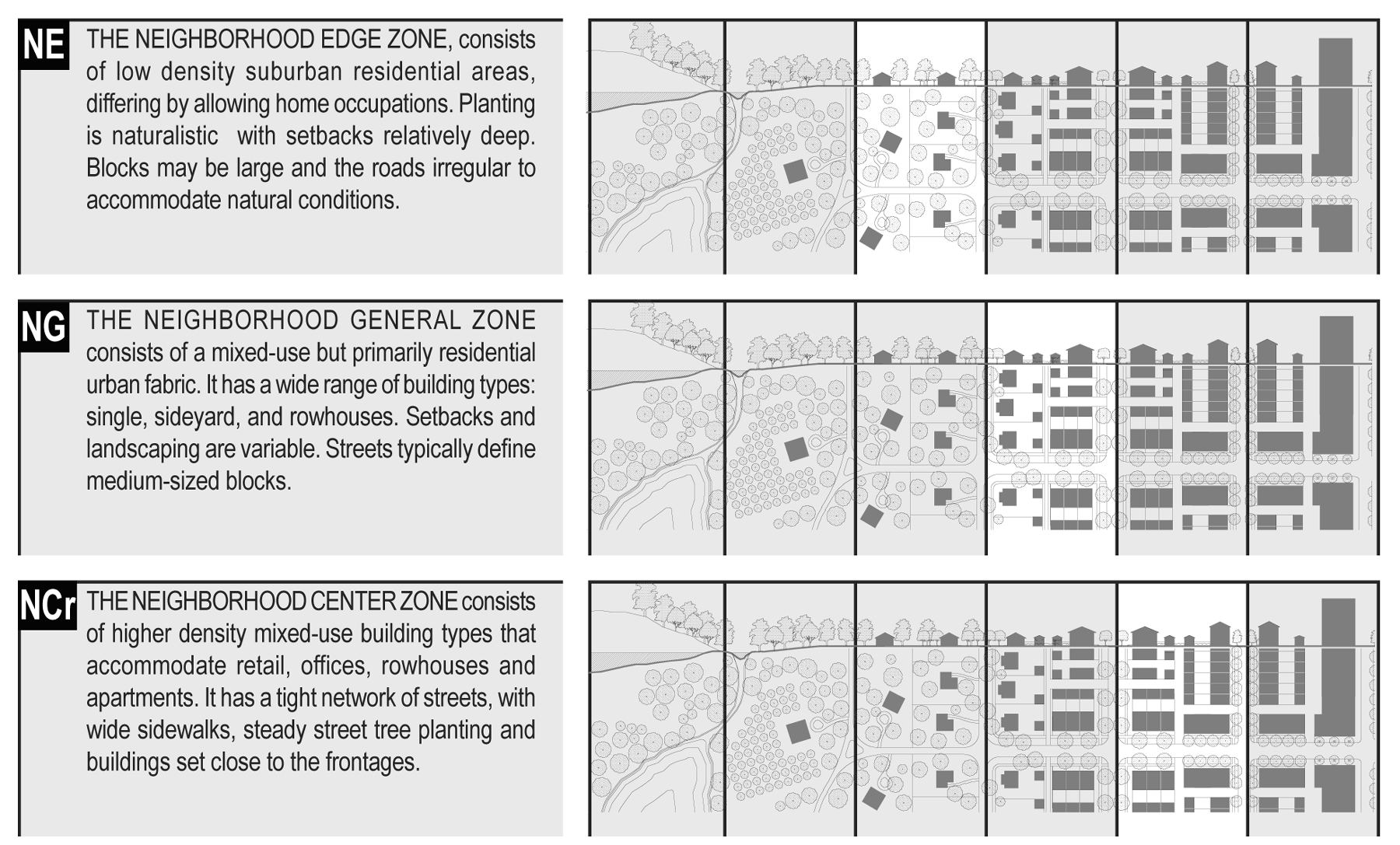
Neighborhood zone desc.
(Ord. No. 2006-Z-004, 5-2-06)
8.5 - TND planning process.
8.5.1 Neighborhood plans shall demonstrate adherence to the following standard planning protocol for TND's:
Step 1 Map existing site resources.
a)
Identify and delineate paths, roads, ponds, woods, streams, slopes and wetlands.
b)
Design the parks, squares, or greens around ponds, and wooded areas or specimen trees as much as practicable.
c)
Define natural boundaries on the site excluding arterials, utility easements, steep slopes (those exceeding 35 percent in 5,000 square feet contiguous areas) and any area of land to be preserved for its natural use.
Step 2 Locate the commercial center on thoroughfare or intersection with highest traffic.
Step 3 Structure site into pedestrian sheds.
a)
Pedestrian sheds form the basis for TND's. The size and shape of the neighborhood is determined by the pattern of the pedestrian shed.
b)
Pedestrian shed is equivalent to a five-minute walk from edge to center.
c)
One pedestrian shed should be centered upon the commercial center.
d)
Additional sheds should cover the remainder of the site with substantial overlap to prevent dilution of each center as a viable mixed use center.
e)
Can use irregular shape to represent actual walk times.
Step 4 Adjust pedestrian sheds locations on site.
a)
Centers of the pedestrian shed must coincide in with natural or manmade features on the site. Site designers should use the features in the landscape as the backbone for public spaces.
Examples:
•Cluster of specimen trees can become a green, park or square
•A hedgerow may present the opportunity to become a tree lined street or avenue
•Existing paths on site can determine the location of streets and roads.
b)
Where such natural features either do not exist or do not provide such opportunities for becoming public space, introduce a public space as the center of each pedestrian shed.
Step 5 Design street network/connect centers with thoroughfares.
a)
Subsequent to this point in the design of the TND, the natural features have been delineated and designed into the neighborhood design, the main commercial area has been determined and the pedestrian sheds have been outlined.
b)
Connect the centers with one another by "main" streets or avenues. They should be direct approaches but not necessarily straight. Using the terrain of the site to deflect and slow traffic through the neighborhood.
c)
Fill in the areas between the main streets with streets and roads into a network. Adjust the network to create a pattern of blocks. Such blocks should be smaller when in close proximity to the centers, and larger in the edges.
d)
Subdivide the blocks into lots.
Step 6 Detail other neighborhood elements.
Step 7 Reserve civic sites.
Step 8 Provide covenants and establish local governance.
(Ord. No. 2006-Z-004, 5-2-06)
8.6 - Density calculations.
8.6.1 The developable areas of the site shall be considered the net site area. The net site area shall be allocated to the various neighborhood zones according to the parameters specified in Table 14-a.
8.6.2 The overall density shall be calculated in terms of building units as specified for the area of each neighborhood zone by Table 14-b. For purposes of density calculation, the neighborhood zone areas include the thoroughfares but not land allocated to civic function.
8.6.3 The percent of the building units shown on Table 14-b shall be exchanged for other functions at the following rates:
a)
For lodging: Two bedrooms for each unit of overall density.
b)
For office or retail: 1,500 square feet for each unit of overall density.
c)
The number of units exchanged shall be approved by warrant.
8.6.4 The residential and other functions for each neighborhood zone shall be further adjusted at the building scale according to sections 8.10, 8.11 and 8.12.
(Ord. No. 2006-Z-004, 5-2-06)
8.7 - Streetscape requirements.
8.7.1
General.
a)
The thoroughfares are intended for use by vehicular and pedestrian traffic and to provide access to lots and open spaces.
b)
The thoroughfares consist of vehicular lanes and public frontages (Table 16-a). The lanes provide the traffic and parking capacity. They consist of vehicular lanes in a variety of widths for parked and for moving vehicles. The frontages contribute to the character of the neighborhood zone. They include the types of sidewalk, curbing, planter, and street tree.
c)
Thoroughfares should be designed in context with the appropriate development form and desired design speed of the neighborhood zones through which they pass. Thoroughfares that pass from one neighborhood zone to another shall adjust their public frontages accordingly or, alternatively, the neighborhood zone may follow the alignment of the thoroughfare to the depth of one lot, retaining a single public frontage throughout its trajectory.
d)
Within the neighborhood general and neighborhood center zones pedestrian comfort shall be a primary consideration of the thoroughfare. Design conflict between vehicular and pedestrian movement shall be decided in favor of the pedestrian.
8.7.2
Thoroughfares.
a)
The standards for vehicular lanes shall be as shown in Table 3, 4, and 5.
b)
The thoroughfare network shall be designed to define blocks not exceeding the size prescribed in Table 14-c. The size shall be measured as the sum of lot frontage lines.
c)
All thoroughfares shall terminate at other thoroughfares, forming a network. Internal thoroughfares shall connect wherever possible to those on adjacent sites. Cul-de-sacs shall be permitted only when warranted by natural site conditions.
d)
Lots shall front a vehicular thoroughfare, except that 20 percent of the lots within each neighborhood zone may front a pedestrian passage.
e)
Thoroughfares along a designated secondary grid (subsection 8.9.1a) may be exempted from the specified frontage requirements.
f)
A bicycle network consisting of trails, routes and lanes should be provided throughout as defined in section 8.20 Glossary and allocated in Table 14-d. A community bicycle network should be connected to existing or proposed networks wherever possible.
8.7.3
Public frontages.
a)
Public frontages shall be designed as shown in Table 5A and 5B and allocated within neighborhood zones as specified in Table 14-d.
b)
Within the public frontages, the prescribed type of street trees and street lights shall be as shown in Tables 4, 5 and 6. The spacing may be adjusted by warrant to accommodate specific site conditions.
(Ord. No. 2006-Z-004, 5-2-06)
8.8 - Civic functions.
8.8.1
General.
a)
Places for public use shall be required for each community and designated on the neighborhood plans as civic space (CS) and civic building (CB).
b)
Civic spaces are public sites permanently dedicated to open space.
c)
Civic buildings are sites dedicated for buildings generally operated by not-for-profit organizations dedicated to culture, education, government, transit and municipal parking, or for a use approved by the Cherokee County Board of Commissioners.
8.8.2
Civic space.
a)
Each pedestrian shed shall assign at least five percent of its developed area to civic space.
b)
Civic spaces shall be designed as generally described in Table 13 and approved by the board of commissioners and allocated to neighborhood zones as described in Table 14-e.
c)
Each pedestrian shed shall contain at least one main civic space. The main civic space shall be within 800 feet of the geographic center of each pedestrian shed, unless topographic conditions, pre-existing thoroughfare alignments or other circumstances warrant it.
d)
Within 800 feet of every lot in residential use, a civic space designed and equipped as a playground shall be provided, unless otherwise warranted.
e)
Each civic space shall have a minimum of 50 percent of its perimeter fronting a thoroughfare.
f)
Parks may be permitted in neighborhood general and neighborhood center zones by warrant (Table 14-e).
8.8.3
Civic buildings.
a)
The developer shall covenant to construct a meeting hall or other such community building in proximity to the main civic space of each pedestrian shed.
b)
One civic building lot may be reserved for an elementary school. Its area shall be one acre for each increment of 100 dwelling units provided by the community plan. The school site may be within any neighborhood zone.
c)
One civic building lot suitable for a childcare building should be reserved within each pedestrian shed.
d)
Civic building sites shall not occupy more than 20 percent of the area of each pedestrian shed.
e)
Civic building sites should be located within or adjacent to civic spaces, or at the axial termination of significant thoroughfares.
f)
Civic buildings shall not be subject to the standards of sections 8.10, 8.11 and 8.12. The particulars of their design shall be determined by variance.
g)
Parking for civic buildings shall be adjusted by warrant. Civic parking lots may remain unpaved if graded, compacted and landscaped, as recommended and approved by the engineering department.
(Ord. No. 2006-Z-004, 5-2-06)
8.9 - Special requirements.
8.9.1
Neighborhood plan. A neighborhood plan may designate the following special requirements:
a)
A differentiation of the thoroughfares as a primary-grid (P-Grid) and a secondary-grid (S-Grid). Buildings along the P-Grid shall be held to the highest standard of this Code in support of pedestrian activity. Buildings along the S-Grid may be more readily considered for warrants and Variances allowing automobile-oriented standards. The frontages assigned to the S-Grid shall not exceed 30 percent of the total length within a pedestrian shed.
b)
A designation for mandatory or recommended retail frontage requiring that a building provide a shopfront at sidewalk level along the entire length of the frontage. The shopfront shall be no less than 70 percent glazed in clear glass and provided with an awning overlapping the sidewalk as generally illustrated in Table 7. The first floor shall be confined to retail use through the depth of the second layer. (See Table 16-d).
c)
A designation for mandatory or recommended gallery frontage, requiring that a building provide a permanent cover over the sidewalk, either cantilevered or supported by columns. The gallery frontage may be combined with a retail frontage as shown in Table 7.
d)
A designation of coordinated streetscape frontage, requiring that the public and private frontages be coordinated as a single, coherent landscape and paving design.
e)
A designation of terminated vista location, requiring that the building be provided with architectural articulation of a type and character that responds to the location as approved by the Cherokee County Board of Commissioners.
f)
A designation for cross block passages, requiring a minimum eight-foot-wide pedestrian access be reserved between buildings.
(Ord. No. 2006-Z-004, 5-2-06)
8.10 - Specific to neighborhood edge zone.
8.10.1
Building disposition.
a)
Newly platted lots shall be dimensioned according to section 8.10.11.
b)
Buildings shall be disposed in relation to the boundaries of their lots according to section 8.10.11.
c)
One principal building at the frontage, and one outbuilding to the rear of the principal building, may be built on each lot as shown in Table 16-c.
d)
Lot coverage by building shall not exceed that shown in section 8.10.11.
e)
Facades shall be built parallel to a rectilinear principal frontage line or parallel to the tangent of a curved principal frontage line.
f)
Setbacks for principal buildings shall be as shown in Table 14-g.
g)
Rear setbacks for outbuildings shall be a minimum of 12 feet measured from the centerline of the alley or rear lane easement. In the absence of rear alley or lane, the rear setback shall be as shown in section 8.10.11.
h)
Building types shall be as shown in Table 9.
8.10.2
Building configuration.
a)
Private frontage types shall conform to and be allocated in accordance with Table 7 and section 8.10.11.
b)
Building heights shall conform to Table 8 and be as shown in section 8.10.11.
8.10.3
Building function and density.
a)
Buildings in each neighborhood zone shall conform to the functions described in Table 10 or 11 and section 8.10.11. Functions that do not conform to the requirements of Tables 10 and 11 shall require approval by warrant.
8.10.4
Parking standards.
a)
Vehicular parking shall be required and adjusted for mixed-use as shown in Tables 11 and 12.
b)
On-street parking available along the frontage lines that correspond to each lot shall be counted toward the parking requirement of the building on the lot.
c)
Parking shall be accessed by the alley or rear lane, when such are available on the neighborhood plan.
d)
Parking lots shall be masked from the frontage by a liner building or streetscreen as specified in sections 8.10, 8.11 and 8.12.
e)
Open parking areas shall be located at the second and third lot layers, as shown in Table 16-d, except that driveway aprons and drop-offs may be located at the first layer. Garages shall be located at the third layer.
f)
The required parking may be provided within one-quarter mile of the site that it serves, subject to approval by variance.
g)
For buildings on secondary grids (S-Grids), parking lots may be allowed on the frontage by warrant (see sections 8.10, 8.11 and 8.12).
8.10.5
Architectural standards.
a)
Building wall materials may be combined on each facade only horizontally, with the heavier material below the lighter material.
b)
Streetscreens should be between 3.5 and eight feet in height and constructed of a material matching the adjacent building facade. The streetscreen may be replaced by a hedge or fence by warrant. streetscreens shall have openings no larger than necessary to allow automobile and pedestrian access.
c)
All openings, including porches, galleries, arcades and windows, with the exception of storefronts, shall be square or vertical in proportion.
d)
Openings above the first story shall not exceed 50 percent of the total building wall area, with each facade being calculated independently.
e)
Doors and windows that operate as sliders are prohibited along frontages.
f)
Pitched roofs, if provided, shall be symmetrically sloped no less than 5:12, except that porches and attached sheds may be no less than 2:12.
g)
The exterior finish material on all facades shall be limited to brick, wood siding, cementitious siding and/or stucco.
h)
Flat roofs shall be enclosed by parapets a minimum of 42 inches high, or as required to conceal mechanical equipment to the satisfaction of the Cherokee County Board of Commissioners.
i)
Balconies and porches shall be made of painted wood, brick, stone or masonry construction.
j)
Fences, if provided at the first layer, shall be painted. Fences at lot lines may be of wood board or chain link.
8.10.6
Environmental standards.
a)
The landscape installed should consist primarily of native species requiring minimal irrigation, fertilization and maintenance.
b)
Impermeable surface by building should be minimized and confined to the ratio of lot coverage by building shown in Table 14-f.
c)
To the extent not inconsistent with applicable local, state or federal law, the management of storm water shall be primarily through retention and percolation on the individual lot or through swales in the public frontage, as recommended and approved by the engineering department.
8.10.7
Landscape standards.
a)
A minimum of one tree to match the species of street trees on the public frontage shall be planted within the first layer for each 30 feet of frontage line as illustrated in Table 16-d.
b)
Trees shall be of various species, naturalistically clustered, with an understory stall below for maintenance.
8.10.8
Signage standards.
a)
One address number no more than six inches measured vertically shall be attached to the building in proximity to the principal entrance or at a mailbox.
b)
One blade sign for each business may be permanently installed perpendicular to the facade. Such a sign shall not exceed a total of four square feet.
c)
There shall be no signage permitted additional to that specified in this section.
d)
Signage shall not be lit.
8.10.9
Ambient standards.
a)
Average lighting levels measured at the building frontage shall not exceed 1.0 fc (foot-candles).
b)
Streetlights shall be of a general type illustrated in Table 5.
c)
Outdoor storage shall be screened from view from any frontage by a streetscreen in conformance with sections 8.10, 8.11 and 8.12.
8.10.10
Visitibility standards.
a)
There shall be provided one zero-step entrance to each building from an accessible path at the front, side, or rear of each building.
b)
All first floor interior doors (including bathrooms) shall provide 32 inches of clear passage.
c)
There shall be a half or full bath provided on the first story of each building.
8.10.11
Neighborhood edge summary table.
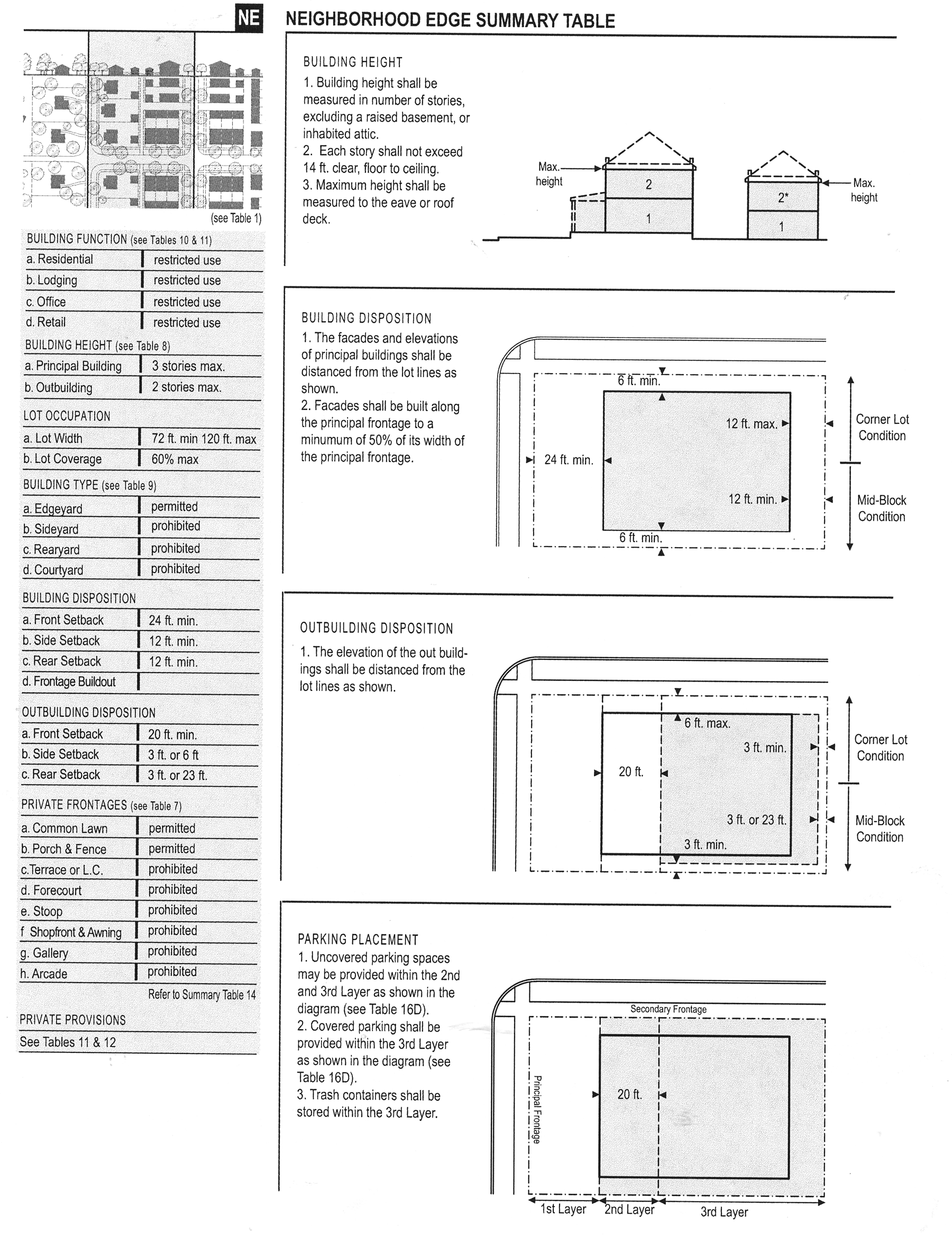
edge summary table
(Ord. No. 2006-Z-004, 5-2-06)
8.11 - Specific to neighborhood general zones.
8.11.1
Building disposition.
a)
Newly platted lots shall be dimensioned according to section 8.11.11.
b)
Buildings shall be disposed in relation to the boundaries of their lots according to section 8.11.11.
c)
One principal building at the frontage, and one outbuilding to the rear of the principal building, may be built on each lot as shown in Table 16-c.
d)
Lot coverage by building shall not exceed that shown in section 8.11.11.
e)
Facades shall be built parallel to a rectilinear principal frontage line or parallel to the tangent of a curved principal frontage line.
f)
Setbacks for principal buildings shall be as shown in Table 14-g.
g)
Rear setbacks for outbuildings shall be a minimum of 12 feet measured from the centerline of the alley or rear lane easement. In the absence of rear alley or lane, the rear setback shall be as shown in section 8.11.11.
h)
Building types shall be as shown in Table 9.
i)
A minimum residential housing mix of three types (none less than 20 percent) shall be required in the neighborhood general zone, selected from Table 9.
8.11.2
Building configuration.
a)
Private frontage types shall conform to and be allocated in accordance with Table 7 and section 8.11.11.
b)
Awnings may encroach the public sidewalk without limit. Stoops may encroach 100 percent of the depth of a setback. Open porches and awnings may encroach up to 50 percent of the depth of the setback. Balconies and bay windows may encroach up to 25 percent of the depth of the setback.
c)
Loading docks and service areas shall be permitted on frontages only by warrant.
d)
Building heights shall conform to Table 8 and be as shown in section 8.11.11.
8.11.3
Building function and density.
a)
Buildings in each neighborhood zone shall conform to the functions described in Tables 10 or 11 and section 8.11.11. Functions that do not conform to the requirements of Tables 10 or 11 shall require approval by warrant.
b)
Accessory uses of limited lodging or limited office shall be permitted within an outbuilding.
8.11.4
Parking standards.
a)
Vehicular parking shall be required as shown in Tables 11 and 12.
b)
On-street parking available along the frontage lines that correspond to each lot shall be counted toward the parking requirement of the building on the lot.
c)
Parking shall be accessed by the alley or rear lane, when such are available on the neighborhood plan.
d)
Parking lots shall be masked from the frontage by a liner building or streetscreen as specified in sections 8.10, 8.11 and 8.12.
e)
All parking areas except for driveways shall be located at the third layer as illustrated in Table 16-d. Garages shall be at the third layer.
f)
The required parking may be provided within ¼-mile of the site that it serves, subject to approval by variance.
g)
A minimum of one bicycle rack place should be provided within the public or private frontage for every ten vehicular parking spaces. This clause shall not apply to single-family detached home or townhomes.
h)
For buildings on secondary grids (S-Grids), parking lots may be allowed on the frontage by warrant (see sections 8.10, 8.11 and 8.12).
8.11.5
Architectural standards.
a)
Building wall materials may be combined on each facade only horizontally, with the heavier material below the lighter material.
b)
Streetscreens should be between 3.5 and eight feet in height and constructed of a material matching the adjacent building facade. The streetscreen may be replaced by a hedge or fence by warrant. Streetscreens shall have openings no larger than necessary to allow automobile and pedestrian access.
c)
All openings, including porches, galleries, arcades and windows, with the exception of storefronts, shall be square or vertical in proportion.
d)
Openings above the first story shall not exceed 50 percent of the total building wall area, with each facade being calculated independently.
e)
Doors and windows that operate as sliders are prohibited along frontages.
f)
Pitched roofs, if provided, shall be symmetrically sloped no less than 5:12, except that porches and attached sheds may be no less than 2:12.
g)
Flat roofs shall be enclosed by parapets a minimum of 42 inches high, or as required to conceal mechanical equipment to the satisfaction of the Cherokee County Board of Commissioners.
h)
The exterior finish material on all facades shall be limited to brick, wood siding, fiber-cement siding and/or stucco.
i)
Balconies and porches shall be made of painted wood, brick, stone, other masonry construction or metal.
j)
Fences, if provided within the first lot layer shall be painted. Fences at other layers may be of wood board or chain link.
8.11.6
Environmental standards.
a)
The species of landscape installed shall consist primarily of durable species tolerant of soil compaction.
b)
Impermeable surface shall be confined to the ratio of lot coverage by building, as shown in Table 14-f.
8.11.7
Landscape standards.
a)
A minimum of one tree to match the species of street trees on the public frontage shall be planted within the first layer for each 30 feet of frontage line as illustrated in Table 16-d.
b)
Trees of species matching the planting on the public frontage as shown in Table 4.
8.11.8
Signage standards.
a)
One address number no more than six inches measured vertically shall be attached to the building in proximity to the principal entrance or at a mailbox.
b)
One blade sign for each business may be permanently installed perpendicular to the facade. Such a sign shall not exceed a total of four square feet.
c)
There shall be no signage permitted additional to that specified in this section.
8.11.9
Ambient standards.
a)
Average lighting levels measured at the building frontage shall not exceed 2.0 fc (foot-candles).
b)
Streetlights shall be of a general type illustrated in Table 5. All streetlight fixtures shall be of full cut off design so that all light is directed down.
c)
Outdoor storage shall be screened from view from any frontage by a streetscreen in conformance with sections 8.10, 8.11 and 8.12.
8.11.10
Visitibility standards.
a)
There shall be provided one zero-step entrance to each building from an accessible path at the front, side, or rear of each building.
b)
All first floor interior doors (including bathrooms) shall provide 32 inches of clear passage.
c)
There shall be a half or full bath provided on the first habitable story of each building.
8.11.11.
Neighborhood general summary table.
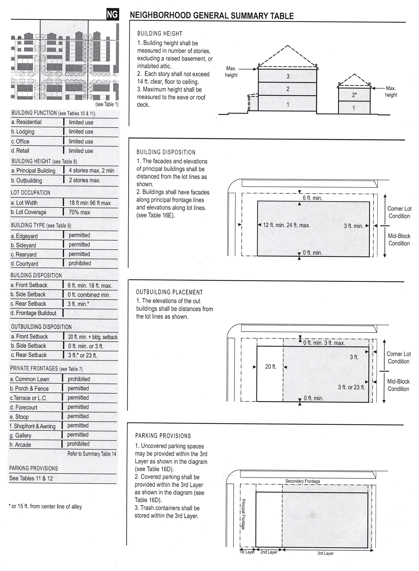
general summary
(Ord. No. 2006-Z-004, 5-2-06)
8.12 - Specific to neighborhood center zones.
8.12.1
Building disposition.
a)
Newly platted lots shall be dimensioned according to section 8.12.11.
b)
Buildings shall be disposed in relation to the boundaries of their lots according to section 8.12.11.
c)
One principal building at the frontage, and one outbuilding to the rear of the principal building, may be built on each lot as shown in Table 16-c.
d)
Lot coverage by building shall not exceed that shown in section 8.12.11.
e)
Facades shall be built parallel to the principal frontage line along a minimum of 70 percent of its length on the setback shown in section 8.12.11. In the absence of a building along the remainder of the frontage line, a streetscreen shall be built co-planar with the facade.
f)
Setbacks for principal buildings shall be as shown in Table 14-g.
g)
Rear setbacks for outbuildings shall be a minimum of 12 feet measured from the centerline of the alley or rear lane easement. In the absence of rear alley or lane, the rear setback shall be as shown in section 8.12.11.
h)
Building types shall be as shown in Table 9.
j)
Buildings shall have their principal pedestrian entrances on a frontage line.
8.12.2
Building configuration.
a)
Private frontage types shall conform to and be allocated in accordance with Table 7 and section 8.12.11.
b)
Awnings may encroach the public sidewalk without limit. Stoops may encroach 100 percent of the depth of a setback. Open porches and awnings may encroach up to 50 percent of the depth of the setback. Balconies and bay windows may encroach up to 25 percent of the depth of the setback.
c)
Loading docks and service areas shall be permitted on frontages only by warrant.
d)
Building heights shall conform to Table 8 and be as shown in section 8.12.11.
e)
A first level residential or lodging function shall be raised a minimum of two feet from average sidewalk grade.
8.12.3
Building function and density.
a)
Buildings in each neighborhood zone shall conform to the functions described in Tables 10 or 11 and section 8.12.11. Functions that do not conform to the requirements of Tables 10 or 11 shall require approval by warrant.
b)
Accessory uses of limited lodging or limited office shall be permitted within an outbuilding.
c)
First story commercial shall be permitted throughout and shall be required at mandatory shopfront frontages.
d)
Manufacturing within the first story may be permitted by variance.
8.12.4
Parking standards.
a)
Vehicular parking shall be required as shown in Tables 11 and 12.
b)
On-street parking available along the frontage lines that correspond to each lot shall be counted toward the parking requirement of the building on the lot.
c)
Parking shall be accessed by the alley or rear lane when such is available in the neighborhood plan.
d)
Parking lots shall be masked from the frontage by a liner building or streetscreen as specified in sections 8.10, 8.11 and 8.12.
e)
All parking areas shall be located at the third lot layer.
f)
The required parking may be provided within ¼-mile of the site that it serves, subject to approval by variance.
g)
The vehicular entrance of a parking lot or garage on a frontage shall be no wider than 30 feet.
h)
Pedestrian entrances to all parking lots and parking structures shall be directly from a frontage line. Only underground parking structures may be entered by pedestrians directly from a principal building.
i)
A minimum of one bicycle rack place should be provided within the public or private frontage for every ten vehicular parking spaces.
j)
For buildings on secondary grids (S-Grids), parking lots may be allowed on the frontage by warrant (see sections 8.10, 8.11 and 8.12).
8.12.5
Architectural standards.
a)
Building wall materials may be combined on each facade only horizontally, with the heavier material below the lighter material.
b)
Streetscreens should be between 3.5 and eight feet in height and constructed of a material matching the adjacent building facade. The streetscreen may be replaced by a hedge or fence by warrant. Streetscreens shall have openings no larger than necessary to allow automobile and pedestrian access.
c)
All openings, including porches, galleries, arcades and windows, with the exception of storefronts, shall be square or vertical in proportion.
d)
Openings above the first story shall not exceed 50 percent of the total building wall area, with each facade being calculated independently.
e)
The facades on retail frontages shall be detailed as storefronts and glazed with clear glass no less than 70 percent of the sidewalk-level story.
f)
Doors and windows that operate as sliders are prohibited along frontages.
g)
Buildings may have flat roofs enclosed by parapets or sloped roofs. Pitched roofs shall be symmetrically sloped no less than 5:12, except that porches and attached sheds may be no less than 2:12.
h)
Flat roofs shall be enclosed by parapets a minimum of 42 inches high, or as required to conceal mechanical equipment to the satisfaction of the Cherokee County Board of Commissioners.
i)
The exterior finish materials on all facades shall be limited to stone, brick and/or stucco.
j)
Balconies, galleries and arcades shall be made of concrete, painted wood or metal.
k)
Streetscreens shall be located coplanar with the building facade line as shown in Table 16-d.
8.12.6
Environmental standards.
a)
The landscape installed shall consist primarily of durable species tolerant of soil compaction.
b)
Impermeable surface by building shall be confined to the ratio of lot coverage as shown in Table 14-f.
c)
To the extent not inconsistent with applicable local, state or federal law, management of storm water shall be primarily off-site through regional retention or detention facilities, as recommended and approved by the engineering department. There shall be no retention or detention required on the individual lot.
8.12.7
Landscape standards.
a)
A minimum of one tree to match the species of street trees on the public frontage shall be planted within the first layer for each 30 feet of frontage line as illustrated in Table 16-d.
b)
The first layer as shown in Table 16-d shall be landscaped or paved to match the fronting public frontage as shown in Table 4A.
c)
Trees shall be a species with shade canopies that, at maturity, begin higher than the top of the second story of buildings.
8.12.8
Signage standards.
a)
One address number no more than six inches measured vertically shall be attached to the building in proximity to the principal entrance or at a mailbox.
b)
Blade signs, not to exceed six square feet for each separate business entrance, may be attached perpendicular to the facade.
c)
A single external sign band may be applied to the facade of each building, providing that such sign not exceed three feet in height by any length.
d)
Signage shall be externally lit, except that signage within the shopfront glazing may be neon lit.
8.12.9
Ambient standards.
a)
Average lighting levels measured at the building frontage shall not exceed 5.0 fc (foot-candles).
b)
Streetlights shall be of a general type illustrated in Table 5. All streetlight fixtures shall be of full cut off design so that all light is directed down.
c)
Outdoor storage shall be screened from view from any frontage by a streetscreen in conformance with sections 8.10, 8.11 and 8.12.
8.12.10
Visitability standards.
a)
There shall be provided one zero-step entrance to each building from an accessible path at the front, side, or rear of each building.
b)
All first floor interior doors (including bathrooms) shall provide 32 inches of clear passage.
c)
There shall be a half or full bath provided on the first story of each building.
8.12.11
Neighborhood center summary table.
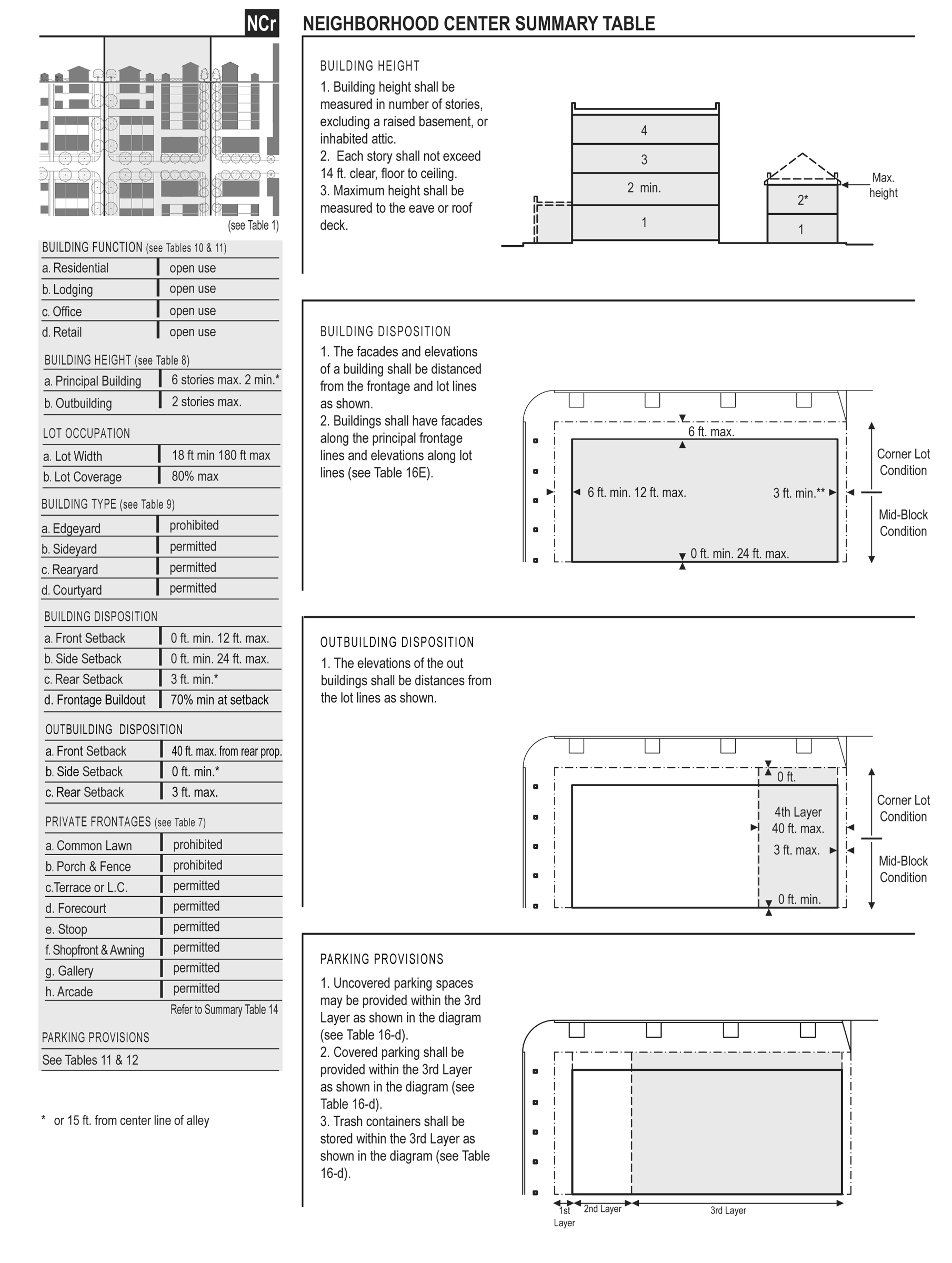
center summary
TABLE 3A: Vehicular lane dimensions. This table assigns lane widths to neighborhood zones. The design ADT (average daily traffic) is the determinant for each of these sections. The most typical assemblies are shown in Table 3B. Specific requirements for truck and transit bus routes and truck loading shall be decided by warrant.
TABLE 3B: Vehicular lane/parking assemblies. The projected design speeds determine the dimensions of the vehicular lanes and turning radii assembled to create thoroughfares.
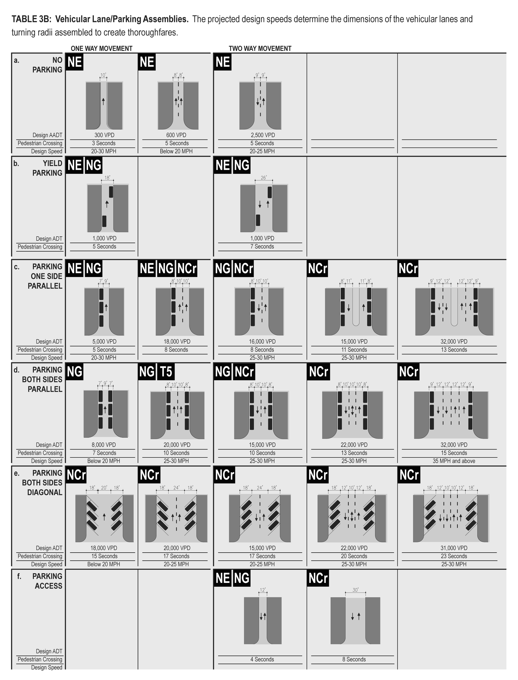
lane/parking assemb
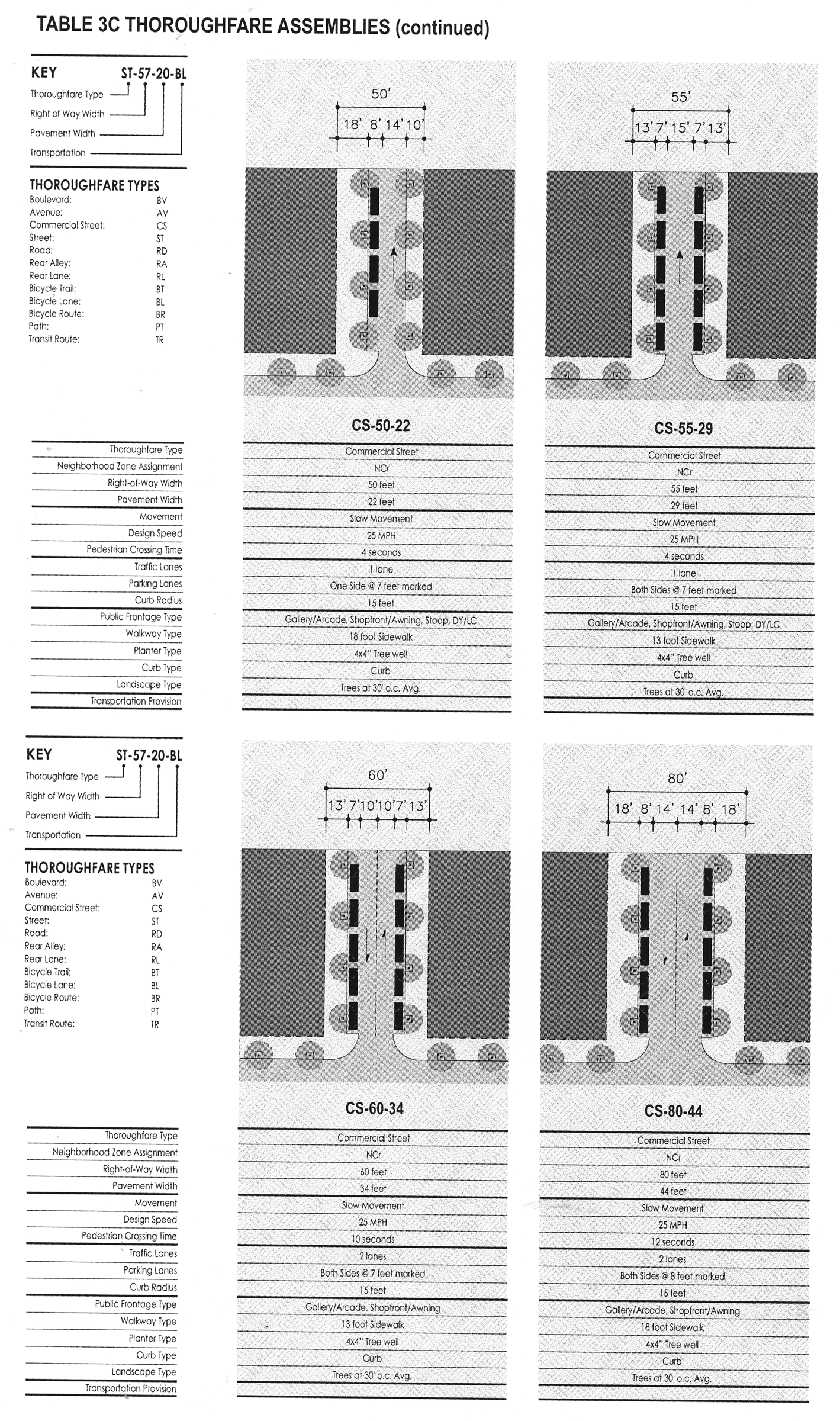
TABLE 3C: Thoroughfare assemblies. These thoroughfares are assembled from the elements that appear in Tables 3A and 3B and incorporate the public frontages of Table 4. The key gives the thoroughfare type followed by the right-of-way width, followed by the pavement width, and in some instances followed by specialized transportation capabiliity.
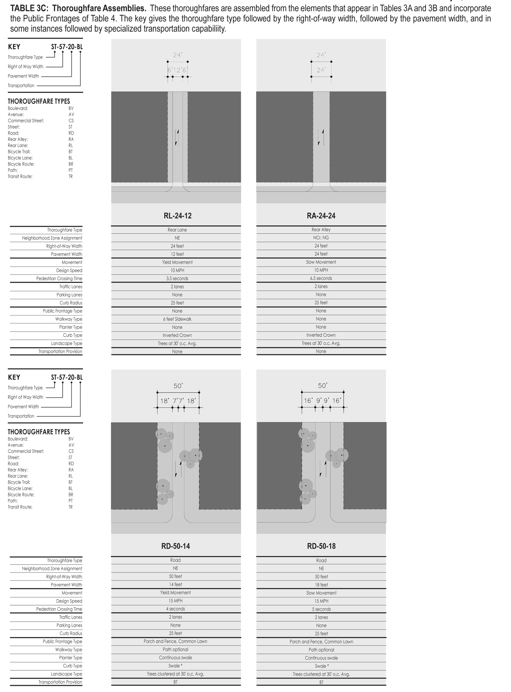
thoroughfare assemb
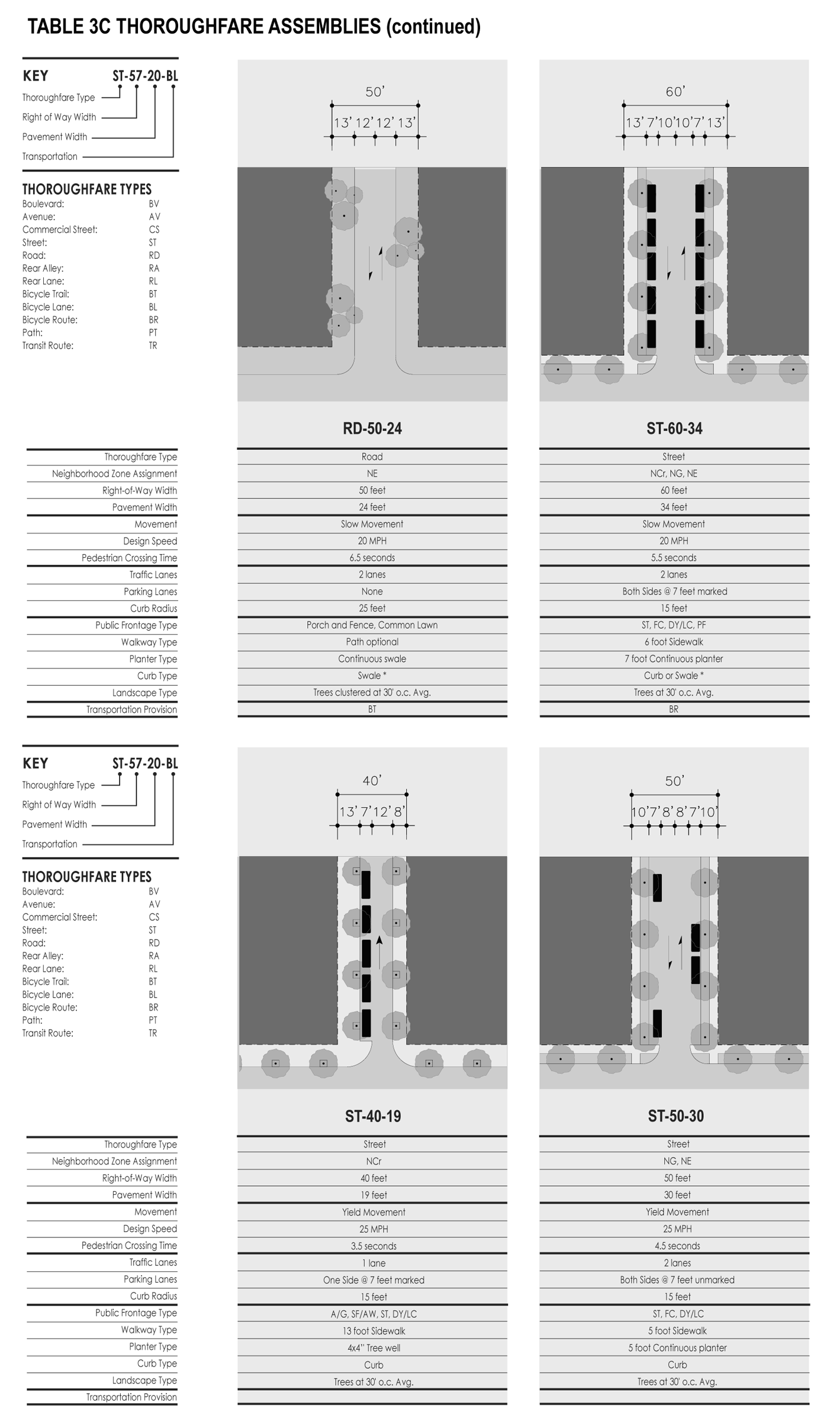
thoroughfare assemb-2
thoroughfare assemb-3
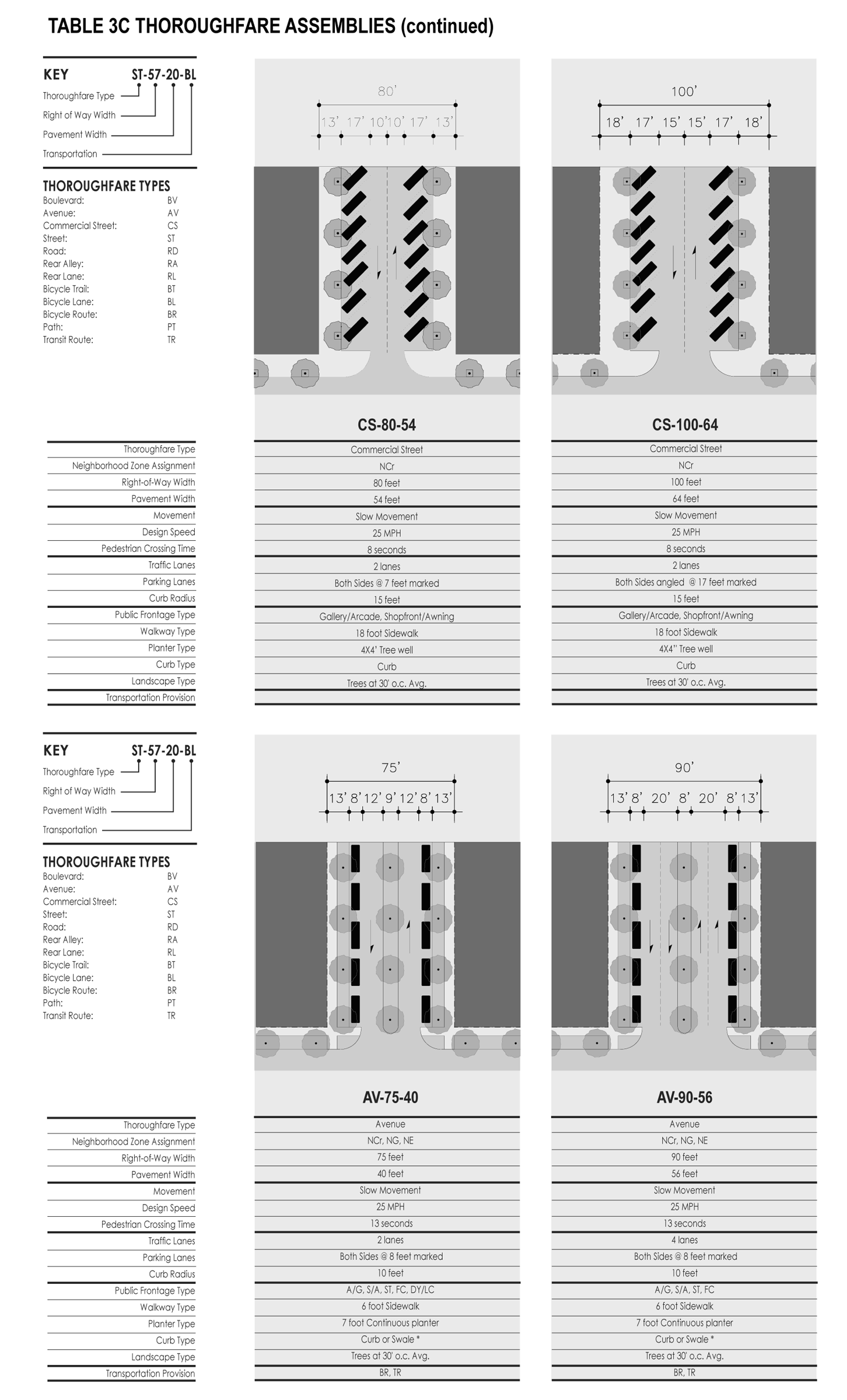
thoroughfare assemb-4
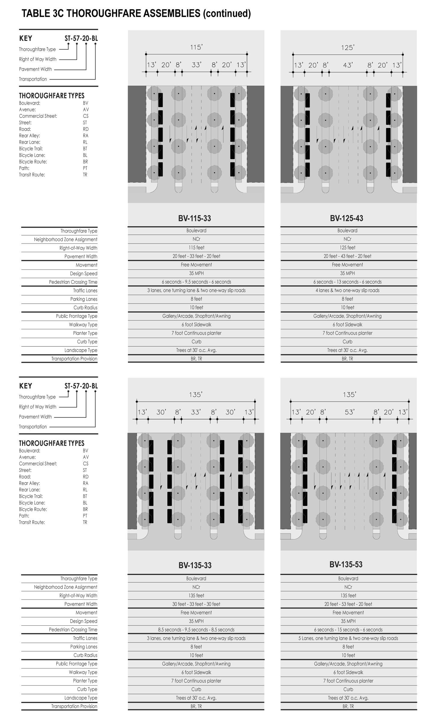
thoroughfare assemb-5
TABLE 4A: Public frontages—General The public frontage is the area between the private lot line and the edge of the vehicular lanes. Dimensions are given in Table 4B (Public frontages - specific)
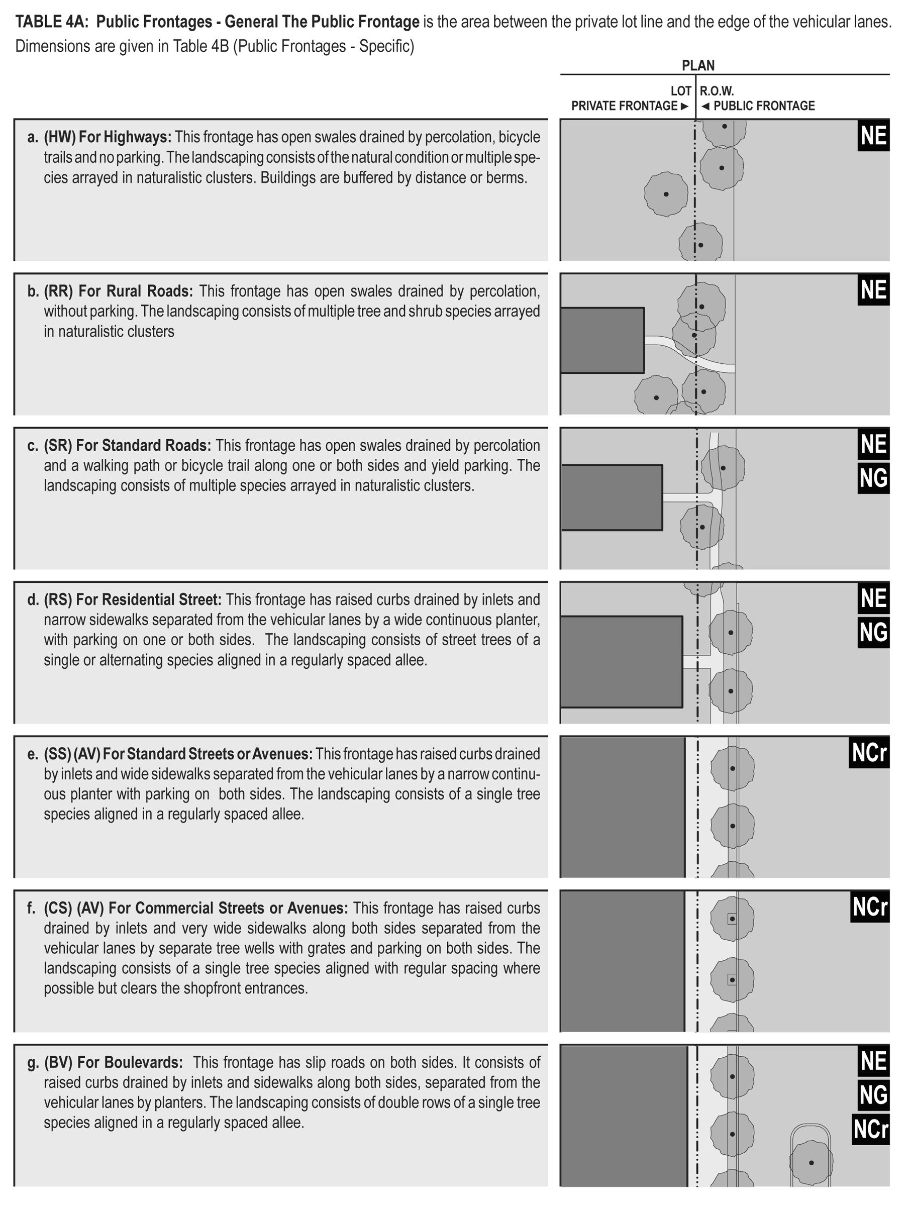
table4a
Table 4B: Public frontages—Specific. This table assembles prescriptions and dimensions for the public frontage elements—curbs, walkways and planters — relative to specific thoroughfare types within neighborhood zones. Table 4B-a assembles all of the elements for the various street types. Locally appropriate planting species should be filled in to the calibrated Code.
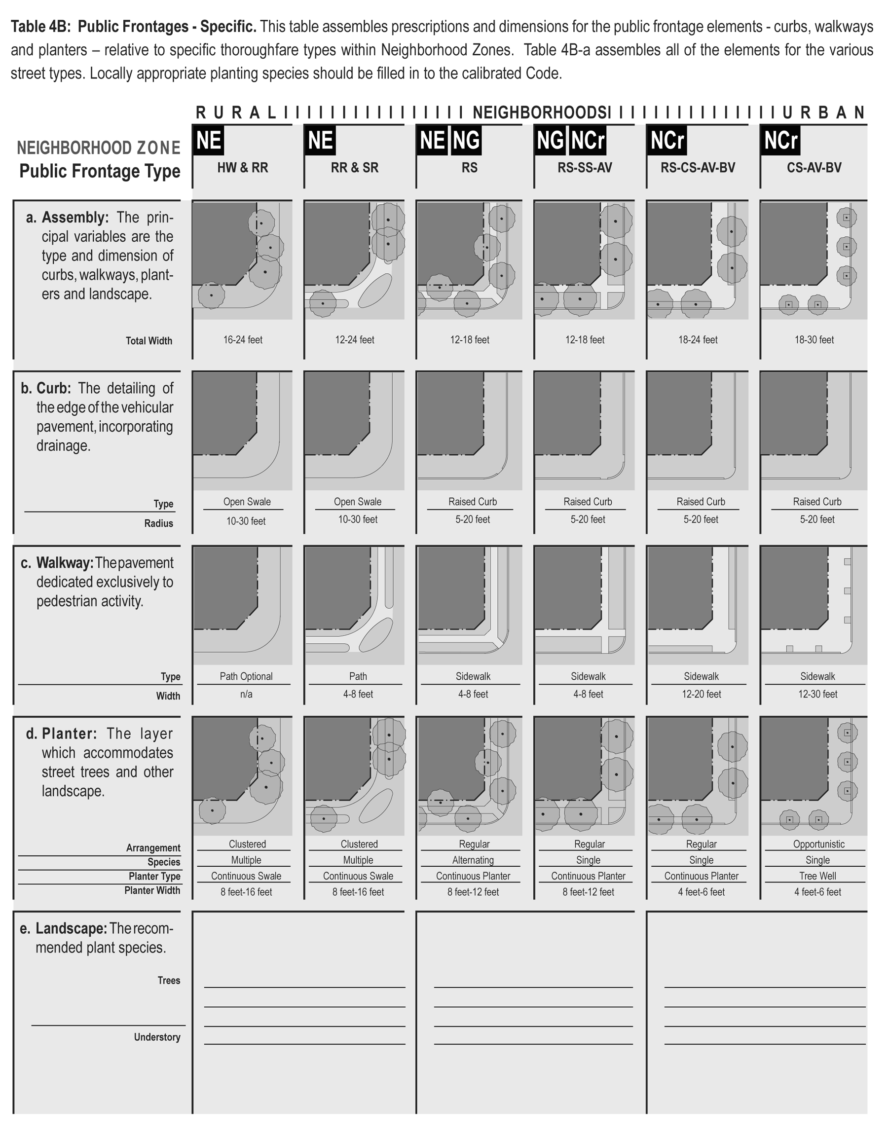
table4b
TABLE 5: Public lighting. Lighting varies in brightness and also in the character of the fixture according to the transect. The table shows four common types. A listed set of streetlights corresponding to these types would be approved by the utility company and listed on the page.
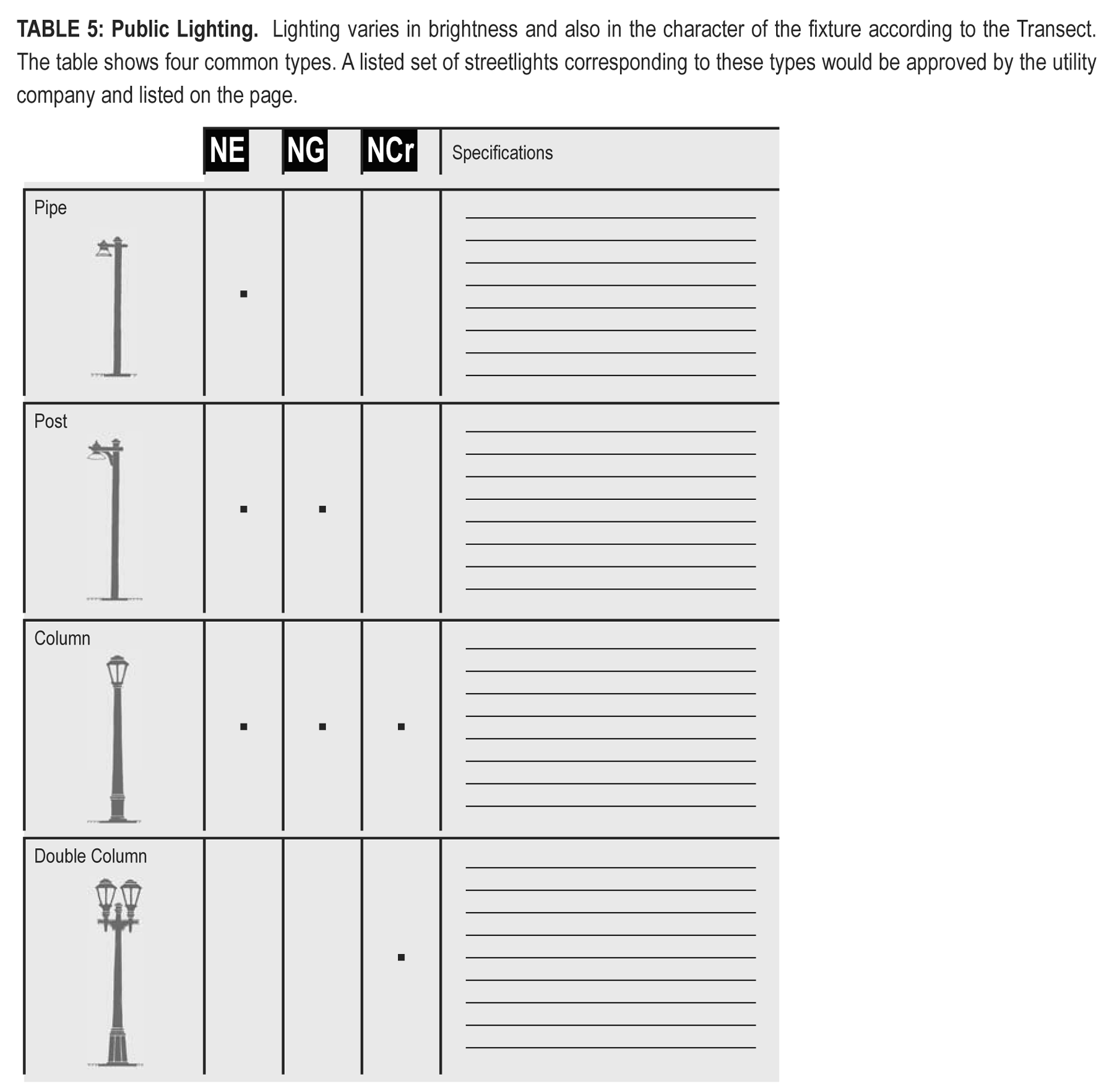
table5
TABLE 6: Public planting. This table shows six common types of street tree shapes and their appropriateness within the neighborhood zones. The Cherokee County Arborist selects species appropriate for the bioregion.
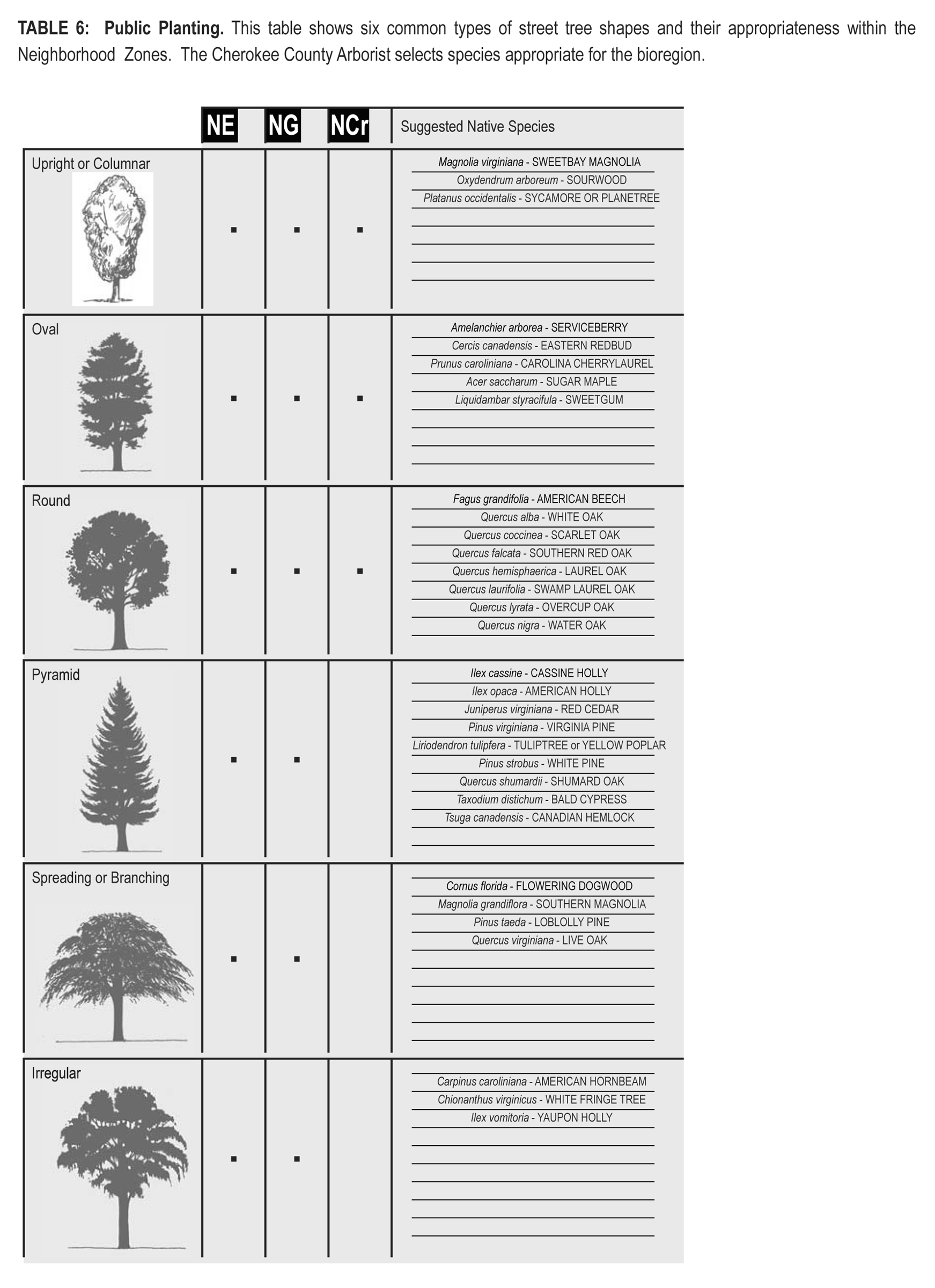
table6
TABLE 7: Private frontages. The private frontage is the area between the building and the lot lines.
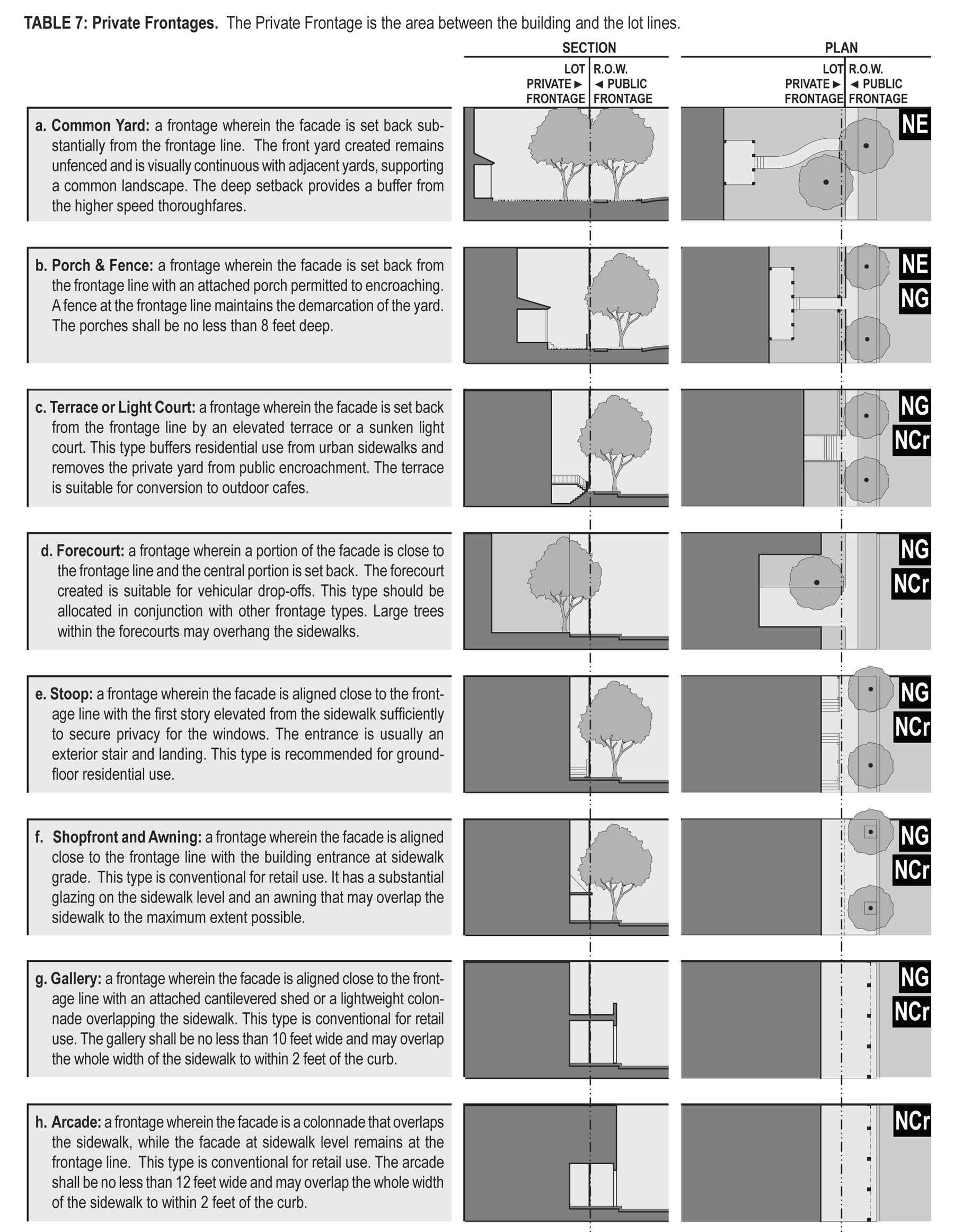
table7
TABLE 8: Building configuration. This table shows prescribed building heights for each neighborhood zone. The vertical
extent of a building is measured by number of stories, not including a raised basement
or an inhabited attic. Heights are measured from the average grade of the frontage
line to the eave of a pitched roof or to the surface of a flat roof. The term "tower"
here refers to an attached or detached addition to a building, not to an entire building.
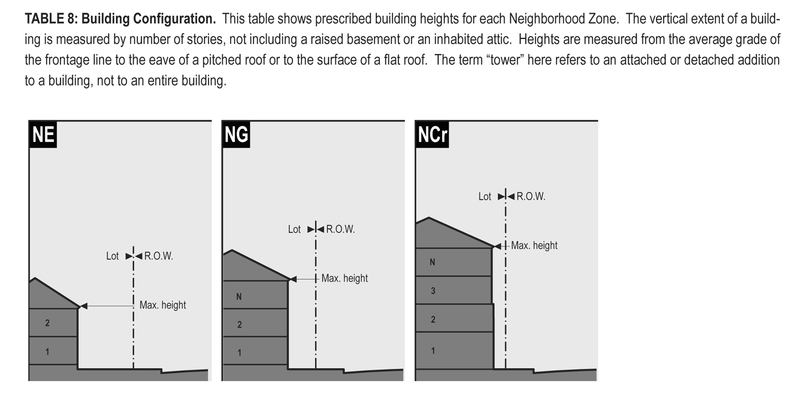
table8
TABLE 9: Building type. This table approximates the location of the structure relative to the boundaries
of each individual lot, establishing suitable basic building types for each neighborhood
zone.
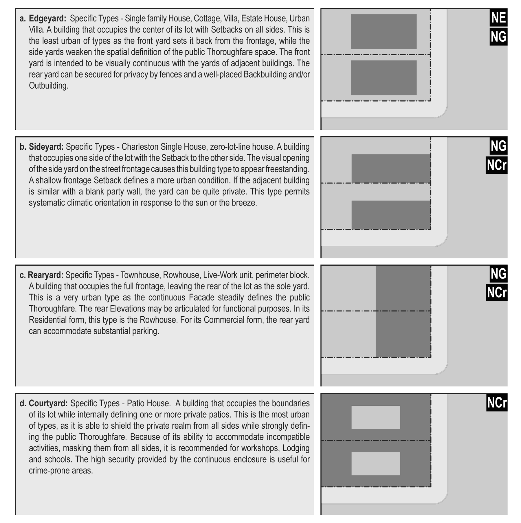
table9
TABLE 10: Specific function. This table expands the building function categories of Table 11 to delegate specific functions within neighborhood zones. Table 10 should be customized for local character and requirements.
TABLE 11: Building function—General. This table categorizes building functions within neighborhood zones. For greater precision describing the functions, see Table 10.
TABLE 12: Parking calculation. The required parking table summarizes the parking requirements of Table 11 for each
site or, conversely, the amount of building allowed on each site given the parking
available.
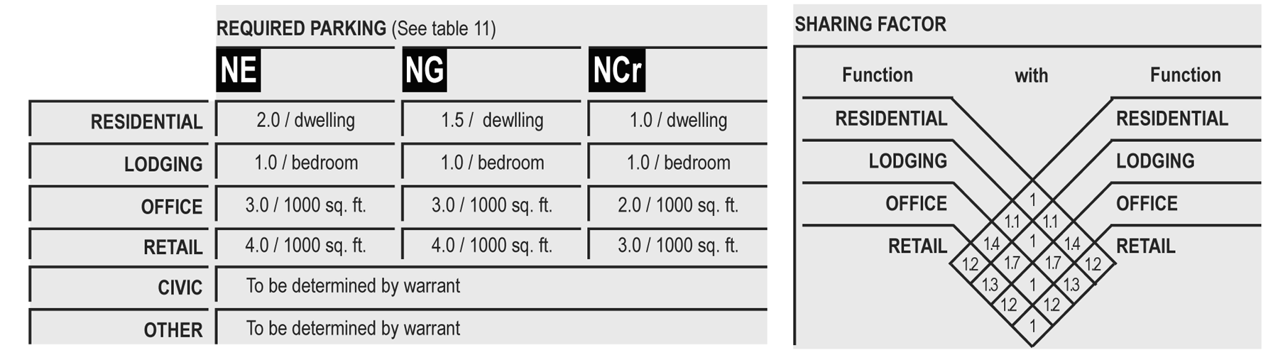
table12
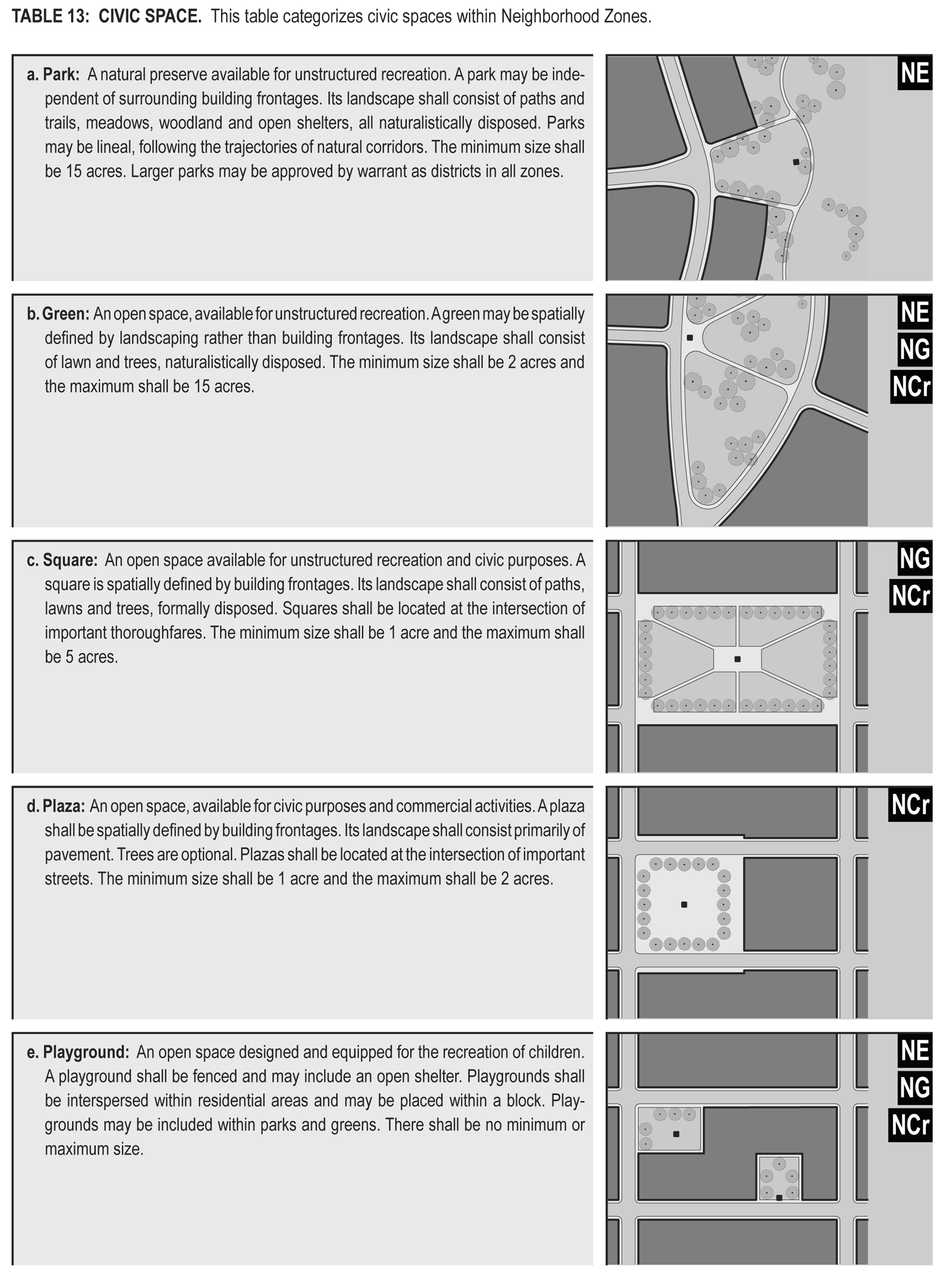
table13
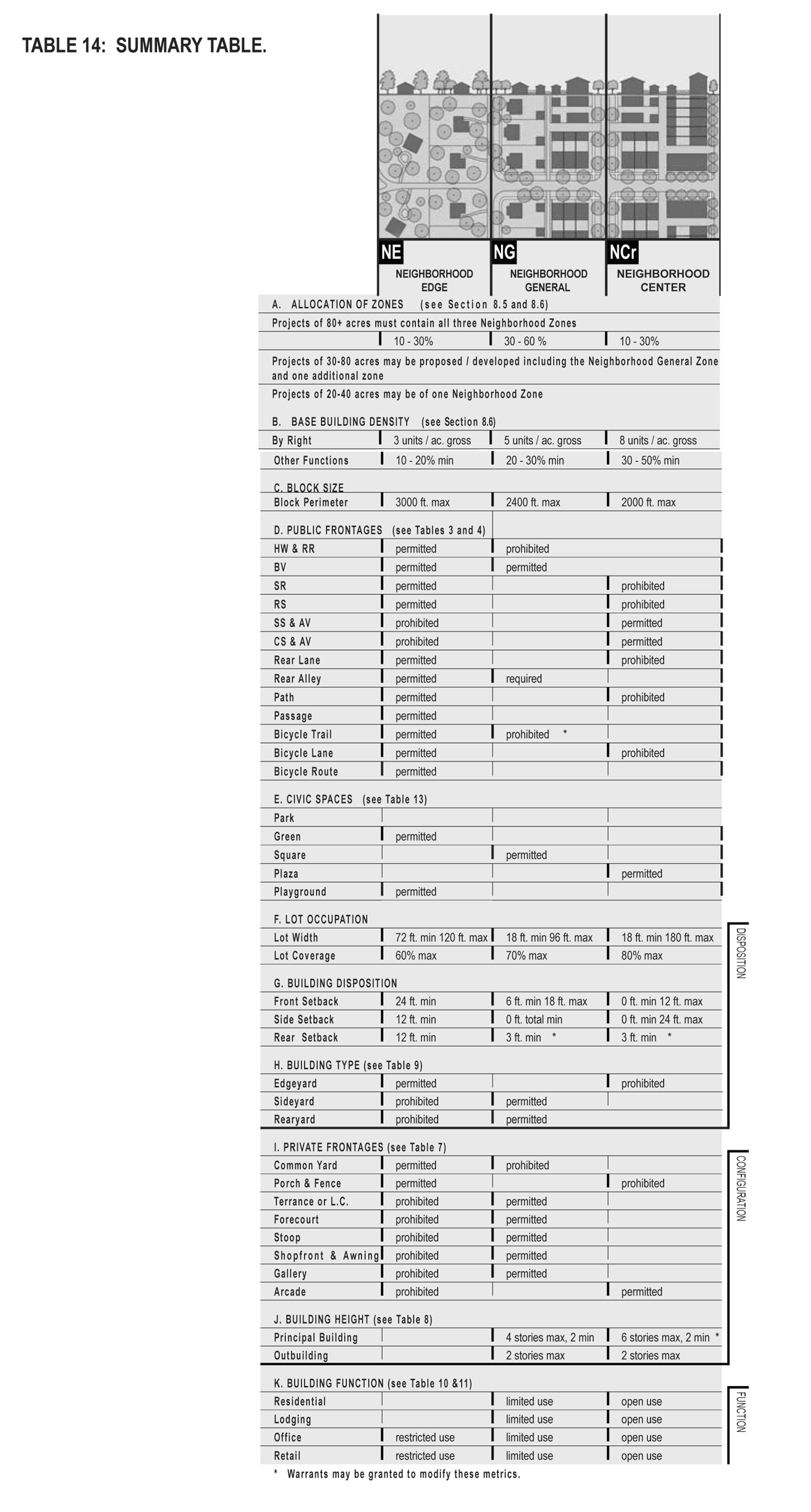
table14
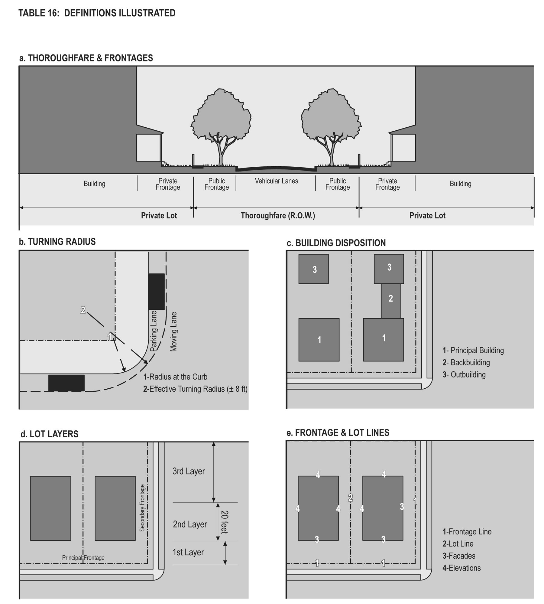
table16
(Ord. No. 2006-Z-004, 5-2-06; Ord. No. 2007-Z-002, 8-7-07)
8.13 - Pre-existing conditions.
8.13.1
Existing buildings that do not conform to the provisions of this Code may continue in use as they are until a substantial modification is requested, at which time the zoning board of appeals shall determine the provisions of this section that shall apply.
8.13.2
Existing buildings that when renovated have at any time received a certificate of occupancy shall not require upgrade to the requirements of this code and may meet the standards of the code under which they were originally permitted.
8.13.3
The modification of existing buildings is permitted by right if such changes result in greater conformance with the specifications of this section or Article 4 of the Cherokee County Zoning Ordinance.
8.13.4
Where buildings exist on adjacent lots, the planning office may require that a proposed building match one or the other of the adjacent setbacks and heights rather than the provisions of this Code.
8.13.5
Any addition to or modification of a building of value that has been designated as such by the Cherokee County Board of Commissioners or is actually or potentially eligible for inclusion on a state, local or national historic register, including without limitation, the architectural harmony (similar materials, window proportions, color range, mass/void ratio, roof type and pitch) of such addition or modification, shall be subject to approval by the Cherokee County Board of Commissioners.
8.13.6
The restoration or rehabilitation of an existing building shall not require the provision of (a) parking in addition to that existing or (b) on-site stormwater retention/detention in addition to that existing, except to the extent required by applicable local, state or federal law.
(Ord. No. 2006-Z-004, 5-2-06)
8.14 - Application submission.
8.14.1
Pre-application conference. Prior to filing a formal application for a traditional neighborhood development, the applicant shall confer with the planning and zoning staff to review the requirements of the ordinance and the proposed mix of uses and the general character of the proposed development.
An applicant seeking approval for a traditional neighborhood development shall utilize the application procedure outlined below. The applicant shall prepare and submit a written statement and a preliminary neighborhood plan as described in the section below. The information shall deal with the proposed traditional neighborhood development, and enough of the area surrounding the proposed traditional neighborhood development to demonstrate the relationship of the proposed development to adjoining existing uses.
8.14.2
Preliminary submission.
A)
Written statement. The written statement shall contain the following information:
i)
An explanation of the character of the proposed project, and the manner in which it shall be planned to take advantage of the traditional neighborhood development ordinance.
ii)
An explanation of the ownership of all the land included within the proposed traditional neighborhood development project.
iii)
An indication of the expected schedule of development.
B)
Preliminary neighborhood plan. The preliminary neighborhood plan shall be prepared and shall include that information required in section 8.4-1a and including the following information:
i)
A boundary survey with computed acreage of the tract bearing the seal of registered land surveyor.
ii)
The existing topographic character of the land at 20 feet contour interval with all slopes shown.
iii)
Location of major thoroughfares and thoroughfare types.
iv)
Existing land uses, including schools, parks, playgrounds and other public buildings and structures.
v)
Areas proposed to be conveyed, dedicated or reserved for public streets, parks, parkways, play grounds, school sites, public buildings and similar public uses.
vi)
A plan for each building site and common open space area, showing the approximate location of buildings, structures, and other improvements and indicating the open spaces around buildings and structures.
vii)
Proposed internal site planning standards such as setbacks and buffers aimed at addressing potential incompatibility between adjacent land uses and activities.
viii)
Elevation and perspective drawings of proposed typical structures.
C)
Development schedule. A development schedule indicating:
i)
The approximate date when construction of the project can be expected to begin.
ii)
The stages in which the project will be built and the approximate date when construction of each stage can be expected to begin.
iii)
The anticipated rate of development.
iv)
The approximate dates when each stage in the development will be completed.
v)
The area, location and degree of development of common open space that will be provided at each stage.
D)
Traffic and circulation plan. The applicant shall address the traffic patterns, the current and fully built out traffic volume projections of the roads that access the proposed development and determine the impact of the proposed development. In addition, the applicant shall provide the following:
•An off-street parking and loading plan.
•A circulation diagram indicating proposed movement of vehicles, goods and pedestrians within the traditional neighborhood development project to and from the adjoining thoroughfares. Any special engineering feature(s) and traffic regulation devices needed to facilitate or insure the safety of this circulation pattern shall be shown.
(Ord. No. 2006-Z-004, 5-2-06)
8.15 - Preliminary neighborhood plan review and action.
8.15.1
Public hearing. An application for a traditional neighborhood development project approval shall be subject to a site plan review and a public hearing by the planning commission.
8.15.2
Action on the proposed traditional neighborhood development project. After the review of the preliminary neighborhood plan and required public hearing, the planning commission shall submit its written recommendation for action to the board of commissioners. The board shall then approve, approve with modifications or deny the proposed traditional neighborhood development project.
(Ord. No. 2006-Z-004, 5-2-06)
8.16 - Submission of the final neighborhood plan.
8.16.1
Following the approval of a preliminary neighborhood plan, the applicant shall prepare a final development plan, wrapping up the design specifics of the preliminary plan in final form, and including the review comments of technical items by county departments. The final neighborhood plan shall be submitted to the community development director within six months following the approval of the preliminary neighborhood plan. For good cause, the community development director may extend for up to six months the period for the filing of the development plan.
8.16.2
If the community development director finds evidence of a material deviation (change of density, change of location of a roadway, a change of right-of-way of a roadway, a decrease in buffers/screening or an addition of acreage), from the approved preliminary neighborhood plan, the community development director shall advise the applicant to submit an application for amendment of the traditional neighborhood development project. An amendment shall be considered in the same manner as an original application.
(Ord. No. 2006-Z-004, 5-2-06)
8.17 - Control of the development plan after completion.
8.17.1
The final neighborhood plan shall continue to control the traditional neighborhood development project after construction is complete, and the following shall apply:
A)
After the approval of the final neighborhood plan, the use of the land and the construction, modifications or alterations of a building or structure within the traditional neighborhood development project shall be governed by the approved final neighborhood plan.
B)
After the final neighborhood plan has been approved, no change shall be made in the development contrary to the approved plan without approval of an amendment to the plan except as follows:
i)
Minor modifications of existing buildings or structures may be authorized by the community development director, if they are consistent with the purposes and intent of the final development plan and do not increase the size of a building or structure.
ii)
A building or structure that is totally or substantially destroyed may be reconstructed without the need to amend the traditional neighborhood development project, if the building is in compliance with the purpose and intent of the final neighborhood plan.
C)
An amendment to a completed traditional neighborhood development project may be approved if it is required for the continued success of the development, and if it is deemed appropriate, because of changes in conditions that have occurred since the final neighborhood plan was approved or because there have been changes in the development policy of the county, as reflected by the county's comprehensive plan or related land use regulations.
D)
No modification or amendment to a completed traditional neighborhood development project is to be considered as a waiver of covenants or conditional use permit limiting the use of land, buildings, structures and improvements within the area of the traditional neighborhood development; and all rights to enforce these covenants against any change permitted by this ordinance should be expressly reserved.
(Ord. No. 2006-Z-004, 5-2-2006)
8.18 - Variances.
8.18.1
There shall be two levels of variance: Warranted variances (warrants) and exceptional variances (exceptions).
8.18.2
Warrants permit a practice that is not consistent with a specific provision of this Code, but is justified by its intent (section 8.1) or by hardship. Warrants may be granted administratively through the director of planning and zoning.
8.18.3
Exceptions permit a practice that is not consistent with a provision nor the intent of this Code (section 8.1). Exceptions shall be granted only by the Cherokee County Zoning Board of Appeals.
8.18-4
The request for an exception shall not be subject to the entire application for public hearing, but only that portion necessary to rule on the issue under consideration. The request for an exception shall meet the public hearing notice requirements in section 18.3-3 and 18.3-5(A)(7) of the zoning ordinance.
8.18.5
Warrants and cxceptions shall be considered unique and shall not set precedent for others.
8.18.6
The following standards and requirements shall not be available for warrants or exceptions:
a.
The allocation ratios of each neighborhood zone.
b.
The maximum dimensions of traffic lanes.
c.
The required provision of alleys and rear lanes.
d.
The minimum residential densities.
e.
The permission to build ancillary apartments.
f.
The requirements of parking location.
(Ord. No. 2006-Z-004, 5-2-2006; Res. No. 2023-R-049, Exh. A, 6-20-23)
8.20 - Glossary.
Allee: A regularly spaced and aligned row of trees usually planted along a thoroughfare or pedestrian path.
Ancillary unit: An apartment not greater than 600 square feet sharing ownership and utility connections with a principal building. An ancillary unit may or may not be within an outbuilding. ancillary units do not count toward maximum density calculations (see Tables 16 and 12).
Apartment: A dwelling unit sharing a building and a lot with other dwellings and/or uses. Apartments may be for rent or for sale as condominiums.
Avenue (AV): A thoroughfare of high vehicular capacity and low speed. Avenues are short distance connectors between urban centers. Avenues may be equipped with a landscaped median. Avenues become collectors upon exiting urban areas.
Backbuilding: A single-story structure connecting a principal building to an outbuilding (see Table 16).
Bicycle lane (BL): A dedicated bicycle lane running within a moderate-speed vehicular thoroughfare, demarcated by striping.
Bicycle route (BR): A thoroughfare suitable for the shared use of bicycles and automobiles moving at low speeds.
Bicycle trail (BT): A bicycle way running independently of a high-speed vehicular thoroughfare.
Block: The aggregate of private lots, passages, rear lanes and alleys, circumscribed by thoroughfares.
Block face: The aggregate of all the building facades on one side of a block. The block face provides the context for establishing architectural harmony.
Boulevard (BV): A thoroughfare designed for high vehicular capacity and moderate speed. Boulevards are long-distance thoroughfares traversing urbanized areas. Boulevards are usually equipped with slip roads buffering sidewalks and buildings. Boulevards become arterials upon exiting urban areas.
Building configuration: The form of a building, based on its massing, private frontage, and height.
Building disposition: The placement of a building on its lot (see Tables 9 and 16).
Building function: The uses accommodated by a building and its lot. Functions are categorized as restricted, limited, or open, according to the intensity of the use (see Tables 10 and 11).
Building height: The vertical extent of a building measured in stories, not including a raised basement or a habitable attic. Height limits do not apply to masts, belfries, clock towers, chimney flues, water tanks, elevator bulkheads and similar structures. Building height shall be measured from the average grade of the enfronting thoroughfare (see Table 8).
Building type: A structure category determined by function, disposition on the lot, and configuration, including frontage and height.
By right permit: A proposal for a building or community plan that complies with this Code and may thereby be processed administratively, without public hearing (see Deviations).
Civic: The term defining organizations dedicated to arts, culture, education, recreation, government, transit, and municipal parking, or other uses deemed by the board of commissioners to be of particular public interest.
Civic building: A building designed specifically for a civic function. Civic buildings shall not be subject to the requirements of sections 8.10, 8.11, and 8.12. The particulars of their design shall be determined by variance.
Civic parking reserve: Parking structure or lot within a quarter-mile of the site that it serves. Space may be leased or bought from this reserve to satisfy parking requirements.
Civic space: An outdoor area dedicated for public use. Civic space types are defined by the combination of certain physical constants including the relationship between their intended use, their size, their landscaping and their enfronting buildings (see Table 13).
Commercial: The term collectively defining workplace, office and retail functions.
Common destination: An area of focused community activity defining the approximate center of a pedestrian shed. It may include without limitation one or more of the following: a civic space, a civic building, a commercial center, a bus stop. A common destination may act as the social center of a neighborhood. (See section 8.9 Civic function).
Context: Surroundings made up of the particular combination of elements that create specific habitat.
Corridor: A lineal geographic system incorporating transportation and/or greenway trajectories. A transportation corridor may be a lineal urban neighborhood zone.
Cottage: An edgeyard building type. A single-family dwelling, on a regular lot, often shared with an ancillary building in the rearyard.
Courtyard building: A building that occupies the boundaries of its lot while internally defining one or more private patios.
Curb: The edge of the vehicular pavement detailed as a raised curb or flush to a swale. The curb usually incorporates the drainage system (see Table 4).
Density: The number of building units within a standard measure of land area, usually given as units per acre (see section 8.7).
Design speed: Is the velocity at which a thoroughfare tends to be driven without the constraints of signage or enforcement. There are three ranges of speed: Very Low: (below 20 MPH); Low: (20-25 MPH); Moderate: (25-35 MPH); High: (above 35 MPH). Lane width is determined by desired design speed.
Developable areas: The net site area exclusive of all environmentally sensitive areas protected by federal, state or local regulation. (ie. Streams, floodways, wetlands, etc.).
Driveway: A vehicular lane within a lot, usually leading to a garage. A driveway in the first layer may be used for parking if it is no more than 18 feet wide, thereby becoming subject to the constraints of a parking lot.
Edgeyard building: A building that occupies the center of its lot with setbacks on all sides.
Elevation: An exterior wall of a building not along a frontage line. See: Facade (Table 16).
Enfront: To place an element along a frontage line, as in "porches enfront the street."
Entrance, principal: the main point of access of pedestrians into a building.
Estate house (Syn.: Country house, Villa): An edgeyard building type. A single family dwelling on a very large lot of rural character, often shared by one or more ancillary buildings.
Facade: The exterior wall of a building that is set along a frontage line (see Elevation; frontage line).
Frontage line: Those lot lines that coincide with a public frontage. Facades along frontage lines define the public realm and are therefore more regulated than the elevations that coincide with other lot lines (see Table 16).
Greenway: An open space corridor in largely natural conditions which may include trails for bicycles and pedestrians.
Home occupation: Non-retail commercial enterprises permitted in all neighborhood zones. The work quarters should be invisible from the frontage, located either within the house or in an outbuilding. Permitted activities are defined by the restricted office category (Table 11).
House (Syn.: Single): An edgeyard building type. A single-family dwelling on a large lot, often shared with an ancillary building in the rearyard.
Inside turning radius: The curved edge of a thoroughfare at an intersection, measured at the inside edge of the vehicular tracking. The smaller the turning radius, the smaller the pedestrian crossing distance and the more slowly the vehicle is forced to make the turn. (See Tables 3 and 16).
Layer: A range of depth of a lot within which certain elements are permitted (see Table 16).
Linear pedestrian shed: A pedestrian shed that is elongated along an important commercial corridor such as a main street.
Liner building: A building specifically designed to mask a parking lot or a parking garage from a frontage. A liner building, if less than 30 feet deep and two stories, may be exempt from parking requirements.
Live-work: A fee-simple dwelling unit that contains a commercial component anywhere in the unit. (Syn.: Flexhouse.) (See Work-Live.)
Lodging: Premises available for daily and weekly renting of bedrooms. The area allocated for food service shall be calculated and provided with parking according to retail use.
Lot line: The boundary that legally and geometrically demarcates a lot (see frontage line). Such lines appear graphically on community and site plans. Codes reference lot lines as the baseline for measuring setbacks (see Tables 16 and 14-g).
Lot width: The length of the principal frontage line of a lot.
Manufacturing: Premises available for the creation, assemblage and/or repair of artifacts, using table-mounted electrical machinery and including their retail sale.
Meeting hall: A building available for gatherings, including conferences. It should accommodate at least one room equivalent to a minimum of ten square feet per projected dwelling unit within the pedestrian shed in which the meeting hall is located. A meeting hall shall be completed upon the sale of 75 percent of the dwelling units. The meeting hall may be used for the marketing purposes of the development until the sale of 75 percent of the dwelling units, at which time control of its use shall be given to the homeowners association or other such group or entity established for the purpose of managing common or private property within the development.
Mixed use: Multiple functions within the same building through superimposition or adjacency, or in multiple buildings within the same area by adjacency. Mixed use is one of the principles of TND development from which many of its benefits are derived, including compactness, pedestrian activity, and parking space reduction.
Neighborhood: An urbanized area at least 20 acres that is primarily residential. A neighborhood shall be based upon a partial or entire standard pedestrian shed. The physical center of the neighborhood should be located at an important traffic intersection associated with a civic or commercial institution.
Net developable area, net site area: The developable areas of a site. The net site area shall be allocated to the various neighborhood zones according to the parameters in Table 14-a.
Office: Premises available for the transaction of general business but excluding retail, artisan and manufacturing uses.
Outbuilding: An accessory building, usually located towards the rear of the same lot as a principal building. It is sometimes connected to the principal building by a backbuilding. Outbuildings shall not exceed 600 square feet of habitable space, excluding parking areas (see Table 16).
Parking structure: A building containing two or more stories of parking. Parking structures shall have liner buildings at the first story or higher.
Passage (PS): A pedestrian connector passing between buildings, providing shortcuts through long blocks and connecting rear parking areas to frontages. Passages may be roofed over.
Path (PT): A pedestrian way traversing a park or rural area, with landscape matching the contiguous open space. Paths should connect directly with the urban sidewalk network.
Pedestrian shed: An area, approximately circular, that is centered on a common destination. A pedestrian shed is applied to determine the approximate size of a neighborhood. A standard pedestrian shed is ¼ mile radius or 1,320 feet, about the distance of a five-minute walk at a leisurely pace. It has been shown that provided with a pedestrian environment, most people will walk this distance rather than drive. The outline of the shed must be refined according to actual site conditions, particularly along thoroughfares. A long pedestrian shed is ½-mile radius or 2,640 feet. (Sometimes called a "walkshed" or "walkable catchment.") A linear pedestrian shed is elongated to follow a commercial corridor. See standard, long, or linear pedestrian shed.
Planter: The element of the public streetscape which accommodates street trees. Planters may be continuous or individual.
Primary-secondary grid: Thoroughfare designations appearing on the regulating plan. Buildings on the P-Grid are subject to all of the provisions of this Code. Buildings on the S-Grid are exempt from certain provisions, allowing for warranted open parking lots, unlined parking decks, drive-throughs and hermetic building fronts.
Principal building: The main building on a lot, usually located toward the frontage (see Table 16).
Private frontage: The privately held layer between the frontage line and the principal building facade. The structures and landscaping within the private frontage may be held to specific standards. The variables of private frontage are the depth of the setback and the combination of architectural elements such as fences, stoops, porches and galleries (see Table 7).
Public frontage: The area between the curb of the vehicular lanes and the frontage line. Elements of the public frontage include the type of curb, walk, planter, street tree and streetlight (see Table 4).
Rear alley (AL): A vehicular driveway located to the rear of lots providing access to service areas and parking, and containing utility easements. Alleys may be paved from building face to building face, with drainage by inverted crown at the center or with roll curbs at the edges.
Rear lane (LA): A vehicular driveway located to the rear of lots providing access to parking and outbuildings and containing utility easements. Rear lanes may be paved lightly to driveway standards. Its streetscape consists of gravel or landscaped edges, no raised curb and is drained by percolation.
Rearyard building: A building that occupies the full frontage line, leaving the rear of the lot as the sole yard. This is a more urban type, as the continuous facade spatially defines the public thoroughfare. For its residential function, this type yields a rowhouse. For its commercial function, the rear yard can accommodate substantial parking.
Residential: Premises available for long-term human dwelling.
Retail: Premises available for the sale of merchandise and food service.
Retail frontage line: Frontage lines designated on a community plan that require the provision of a shopfront, causing the ground level to be available for retail use.
Road (RD): A local, rural and suburban thoroughfare of low vehicular speed and capacity. Its public frontage consists of swales drained by percolation and a walking path or bicycle trail along one or both sides. The landscaping consists of multiple species composed in naturalistic clusters.
Rowhouse: A single-family dwelling that shares a party wall with another of the same type and occupies the full frontage line (Syn: Townhouse; see Rearyard Building).
Secondary grid: See primary-secondary grid.
Setback: The area of a lot measured from the lot line to a building facade or elevation. This area must be maintained clear of permanent structures with the exception of: galleries, fences, garden walls, arcades, porches, stoops, balconies, bay windows, terraces and decks (that align with the first story level) which are permitted to encroach into the setback (see sections 8.10, 8.11 and 8.12 and Table 14-g).
Shared parking: An accounting for parking spaces that are available to more than one function. The requirement is reduced by a factor, shown as a calculation. The shared parking ratio varies according to multiple functions in close proximity which are unlikely to require the spaces at the same time (see Tables 11 and 12).
Sideyard building: A building that occupies one side of the lot with a setback to the other side.
Sidewalk: The paved layer of the public frontage dedicated exclusively to pedestrian activity.
Specialized building: A building that is not subject to residential, commercial, or lodging classification.
Standard pedestrian shed: An area, approximately circular, that is centered on a common destination. A pedestrian shed is applied to determine the approximate size of a neighborhood. A standard pedestrian shed is ¼-mile radius or 1,320 feet, about the distance of a five-minute walk at a leisurely pace. It has been shown that provided with a pedestrian environment, most people will walk this distance rather than drive. The outline of the shed must be refined according to actual site conditions, particularly along thoroughfares. (Sometimes called a "walkshed" or "walkable catchment.") See pedestrian shed.
Story: A habitable level within a building of no more than 14 feet in height from finished floor to finished ceiling. Attics and raised basements are not considered stories for the purposes of determining building height.
Street (ST): A local urban thoroughfare of low speed and capacity. Its public frontage consists of raised curbs drained by inlets and sidewalks separated from the vehicular lanes by a planter and parking on both sides. The landscaping consists of regularly placed street trees.
Streetscape: The urban element that establishes the major part of the public realm. The streetscape is composed of thoroughfares (travel lanes for vehicles and bicycles, parking lanes for cars, and sidewalks or paths for pedestrians) as well as the visible private frontages (building facades and elevations, porches, yards, fences, awnings, etc.), and the amenities of the public frontages (street trees and plantings, benches, streetlights, etc.).
Streetscreen: Sometimes called streetwall. A freestanding wall built along the frontage line, or coplanar with the facade, often for the purpose of masking a parking lot from the thoroughfare. Streetscreens [should] be between 3.5 and eight feet in height and constructed of a material matching the adjacent building facade. The streetscreen may be a hedge or fence by warrant. Streetscreens shall have openings no larger than is necessary to allow automobile and pedestrian access. In addition, all streetscreens over five feet high should be 30 percent permeable or articulated to avoid blank walls.
Substantial modification: Alterations to a building that are valued at more than 50 percent of the replacement cost of the entire building, if new.
Terminated vista: A location at the axial conclusion of a thoroughfare. A building located at a terminated vista designated on a community plan is required to be designed in response to the axis.
Thoroughfare: A vehicular way incorporating moving lanes and parking lanes within a right-of-way (see Tables 3 and 16).
Townhouse: Syn. Rowhouse. (See Rearyard building.)
Transition line: A horizontal line spanning the full width of a facade, expressed by a material change or by a continuous horizontal articulation such as a cornice or a balcony.
Type: A category determined by function, disposition, and configuration, including size or extent. There are street types, civic space types, etc. (See also: Building type.)
Variance: A ruling that would permit a practice that is not consistent with either a provision or the intent of this Code (sections 8.1 and 8.2). Variances are usually granted by the board of appeals in a public hearing. See section 8.19.
Warrant: A ruling that would permit a practice that is not consistent with a specific provision of this Code, but is justified by its intent (sections 8.1 and 8.2). Warrants are usually granted administratively by the planning director. See section 8.19.
Work-live: A fee-simple mixed-use unit with a substantial commercial component that may accommodate employees and walk-in trade. Therefore the unit shall require ADA compliance for accessibility. (Syn.: Live-With.) (See Live-Work.)
(Ord. No. 2006-Z-004, 5-2-2006)