


Cherokee County Unincorporated
City Zoning Code
City Zoning Code
ARTICLE 12
- OFF-STREET PARKING REGULATIONS
11.1 - Objectives and purpose.
This article, which shall be known and may be cited as the Cherokee County Sign Ordinance, is to establish requirements for the placement, installation, and maintenance of signs in order to protect and promote the health, safety, welfare, and general well-being of the citizens of Cherokee County. The zoning regulation of the placement, construction, maintenance of buildings and structures is a valid use of the police power, including the regulation of the placement, installation, and maintenance of signs. Signs must ordinarily be considered structures, and are capable of producing many of the same nuisances as are produced by buildings. The intent of this article to regulate the size, height and number of signs in such a manner as to protect and preserve the aesthetic qualities of the county while promoting traffic safety without causing unsafe conditions.
It is not the intent of this article to apply regulation to signs based upon the message that they convey. It is not the intent of this article to foreclose important and distinct mediums of expression for political, religious or personal messages. Furthermore, it is not the intent of the county, nor any of its boards, commissions, or agents, to regulate, in any manner, the message content of signs, except to the extent of obscenity or other messages prohibited by state or federal law. Accordingly and except as described in the prior sentence, the provisions of this article shall not be construed, interpreted, or enforced so as to regulate signage based upon the content of a sign's message
The planning and land use department will only oversee the number of signs, height, size and placement of signs. Cherokee County makes no determination or permits signs in regard to on-site or off-site locations. With these objectives and purposes in mind, the intention of this article is to authorize the use of signs that are compatible with their surroundings in terms of zoning, existing land use, and architectural characteristics; are legible and compatible with the type of lawful activities to which the signs pertain in such a manner as to express the identity of the individual properties and/or of the county as a whole.
In addition, the regulation of signs within the county is necessary and in the public interest:
(1)
To protect property values within the county.
(2)
To protect the motoring public from damage or injury caused or partially attributable to distractions or obstructions from improperly designed or situated signs.
(3)
To promote the economic well-being of Cherokee County by creating a favorable physical image.
(4)
To improve the legibility and effectiveness of all permitted signs.
(5)
To allow individuals equal and fair opportunity to advertise and promote their products and services without discrimination.
(6)
To eliminate excessive signage.
(7)
To protect the right of citizens to enjoy Cherokee County's natural scenic beauty.
(8)
To encourage economic development within the county.
(9)
To regulate the construction, erection, maintenance and size of signs that may constitute a direct danger to pedestrians and property.
(10)
To preserve and promote the public health, safety and welfare in Cherokee County.
(Ord. No. 2015-O-009, Exh. A, 9-15-15; Ord. No. 2016-O-001; Exh. C, 2-2-16)
11.2 - Jurisdiction and applicability of Code requirements.
(a)
This article shall apply to all properties within the unincorporated areas of Cherokee County, Georgia. This article shall not relate to the copy or message on a sign within the unincorporated areas of Cherokee County.
(b)
All signs and other advertising structures shall be constructed and maintained in conformance with the building and electrical codes adopted by Cherokee County.
(c)
If any provisions or requirements of this article are in conflict with any other provision or requirement of this ordinance or any other applicable governmental law, ordinance, resolution, rule or other governmental regulation or any kind, the more restrictive rule or standard takes precedence.
(Ord. No. 2015-O-009, Exh. A, 9-15-15; Ord. No. 2016-O-001; Exh. C, 2-2-16)
11.3 - Appeals and variances.
(a)
Appeals.
(1)
A person whose permit application has been denied or a permittee whose permit has been revoked may appeal the decision of the planning director or his/her designee to the zoning board of appeals, pursuant to article 15 of this Code.
(2)
Appeals of the decision of the zoning board of Appeals are made to the board of commissioners pursuant to section 15.8.
(3)
Certiorari. In the event a person whose permit has been denied or revoked is dissatisfied with the decision of the board of commissioners, he/she may petition for writ of certiorari to the Superior Court of County as provided by law.
(b)
Variances. Variances other than with respect to the frequency by which the image on an electronic sign may change may be requested. All such variances shall be considered and decided by the Cherokee County Zoning Board of Appeals in accordance with officially adopted procedures and standards contained in article 15 of the Cherokee County Zoning Ordinance.
(Ord. No. 2015-O-009, Exh. A, 9-15-15; Ord. No. 2016-O-001; Exh. C, 2-2-16)
11.4 - Definitions.
Words and phrases used in this article have the meanings defined in this section. In addition, words and phrases not defined in this section, but defined in the Zoning Ordinance of the county shall be given the meanings as set forth in such ordinance.
Abandoned sign. A sign and/or sign structure without copy area for more than 30 days and/or which requires maintenance and repairs in excess of 25 percent of the replacement cost of the sign.
Advertising device. Any structure or device situated on or attached to real property that is erected or intended for the purpose of calling the attention of the public.
Air and gas filled device. Any sign using, either wholly or in part, forced air or other gas as a means of supporting its structure.
Animated illumination or effects means illumination or effects with action, moving characters or flashing lights. This may require electrical energy, but shall also include wind actuated devices. Specifically included is any motion picture or video mechanism used in conjunction with any outdoor advertising structure in such a manner as to permit or allow the images to be visible from any public right of way. This definition does not include electronic message signs as permitted within this article.
Animated sign. Any sign that all or any part thereof visibly moves or imitates movement in any fashion whatsoever. Any sign that contains or uses for illumination any lights (or lighting devices) that change color, flash or alternate, show movement or motion, or change the appearance of said sign or any part automatically, including any electronic sign which contains anything other than static messages or changes its message more often than permitted by this ordinance. This includes flashing, moving, and revolving signs.
Area of sign (copy area). The area within a continuous perimeter enclosing the limits of writing, representation, emblem, or any figure of similar character together with any frame, other material, open space, or color forming an integral part of the display or used to differentiate such sign from the background against which it is placed.
Banner. A sign hung either with or without a frame, possessing characters, letters, illustrations, or ornamentation applied to paper, plastic, or fabric of any kind.
Beacon. Any light with one or more beams directed into the atmosphere or directed at one or more points not on the same zone lot as the light source; also, any light with one or more beams that rotate or move.
Bench sign. A sign located on any part of the surface of a bench or seat placed on or adjacent to a public right-of-way.
Billboards. Freestanding signs or structures for the display of advertisements in public places or highways. All regulations relating to freestanding signs shall apply.
Building sign. Any sign attached to any part of a building other than a freestanding sign.
Canopy sign. A sign affixed to, imposed upon, or painted on any roof-like structure either permanently or temporarily extended over a sidewalk or walkway, which can be mounted flush or suspended. A flush canopy sign is one that is mounted in such a manner that a continuous plane with the canopy is formed. A hanging canopy sign is one suspended from beneath the canopy.
Copy. The wording or graphics on a sign surface in either permanent or removable form.
Development entrance sign. A sign located on either side of an intersection of the driveway, road or entryway of a residential major subdivision or a multi-family development, or a commercial/industrial development, with a county maintained road or state route.
Distance. The measurement in linear feet from the closest point of a sign to the nearest property line or to the closest point of another sign, as the case may be.
Double faced (back-to-back) sign. A sign with two parallel, or nearly parallel faces, back-to-back and located not more than 24 inches from each other.
Electronic sign. A sign whose message may be changed at intervals by computer controller, microprocessor controller or remote control, and whose message is displayed through the use of LED, LCD, plasma or other similar type of panels or screens, including devices known as commercial electronic message signs and similar devices.
Erect. To build, construct, attach, hang, place, suspend, paint or affix.
Establishment. A commercial, industrial, institutional, educational, office, business [or] financial entity.
Flag. Any fabric, banner, bunting or other flexible material containing distinctive colors, patterns, standards, words, or symbols.
Flagpole. A permanently anchored pole on which a flag is hoisted and displayed.
Flashing. A pattern of changing light illumination where the light intensity alternates suddenly during display of a message for the purpose of drawing attention to the sign. The term "flashing" excludes electronic signs operated in conformity with this ordinance.
Frame effect. A visual effect on an electronic sign which depicts movement, fading, mosaic flips, wipes, or other changing effects associated with the transition from one static message to another.
Freestanding sign. Any sign, which is physically independent from any building or other structure and is entirely supported by structures that are permanently at or below ground level. May be double faced or v-shaped as allowed by this article.
Frontage, building. The length of an outside building wall facing a street.
Frontage, street. The length of the property line of any one parcel along a street on which it borders.
Historic sign. Any animated neon sign over 30 years old, any existing barber pole or any other sign so designated by the historic preservation commission. Extensions, additions and embellishments are not considered part of a historic sign.
Human sign. A sign worn or held, moved or spun by a person or persons so as to attract attention or convey information. A human sign may also be known as human directionals, sign walkers, sign wavers, sign spinners, or sign twirlers. A human sign also includes costumes intended to attract attention or convey information.
Identification sign. A sign depicting the address where the sign is located.
Illuminated sign. A sign lighted by artificial sources on the inside of the sign or external lights directed towards the sign.
Information sign. A temporary sign erected to provide information to people passing the property in a vehicle or on foot.
Kiosk sign. A free-standing and multiple sided structure owned by the county and located in public rights-of-way.
Mansard sign. Any sign attached to or erected within 12 inches of an actual or simulated mansard of a building, with the sign face parallel to and within the limits of the building, not deemed to be a roof sign.
Monument style. A style of freestanding sign that has a solid-appearing base with no open space between the ground and the sign for the entire width of the copy area. The monument is constructed of brick, stone, stucco, or a combination thereof that is compatible with primary buildings on the site. The copy area is framed with a minimum of six inches of material consistent with remaining monument. See illustrations below.
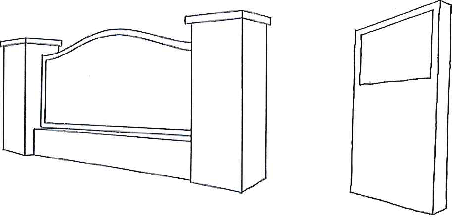
Nonconforming sign (legal). Any advertising device or sign, including billboards, which were legally erected and maintained prior to the adoption or amendment of this ordinance, but which no longer comply.
Painted wall sign. Any sign that is applied with paint or similar substance on the face of a wall.
Parcel (lot) (business lot). Any standard lot or parcel of land, the boundaries of which, have been established by a recorded legal instrument and is recognized and intended as a unit for the purpose of transfer of ownership. The said parcel being duly recorded with the clerk of Superior Court, Cherokee County.
Permanent sign. A sign permanently affixed to a building or the ground.
Person. Any association, company, corporation, firm, organization, or partnership, singular or plural, of any kind.
Portable sign. Any sign supported by its own frame or trailer, with or without wheels, that is designed to move from one place to another. Includes A-frames, mobile signs, sandwich boards and trailer signs.
Principal building. The building with the principal use of the parcel on which it is located. Parcels with multiple principal uses may have multiple principal buildings. However, storage buildings, garages, and other clearly accessory [buildings] are not considered principal buildings.
Projecting sign. Any sign affixed to and supported by a building or wall, which horizontally extends more than twelve inches beyond the surface of a building or wall.
Residential district. Includes all land zoned R-80, R-60, R-40, R-30, R-20, R-15, RD-3, RTH, RZL, RA, RM-10, RM-16, and PUD-Residential.
Roof sign. Any sign erected, constructed, and maintained upon or over the roof of any building and projecting above the roof line.
Setback. The distance from the property line to the nearest part of the applicable building, structure, or sign, measured perpendicularly to the property line.
Sidewalk, sandwich or a-frame sign. A sign which is normally in the shape of an 'A' or some variation, which is usually two-sided.
Sign. Any identification, description, illustration or device, illuminated or non-illuminated, which is visible to the general public or placard designed to advertise, identify, or convey information.
Sign face. The portion of a sign on which the copy is placed.
Sign number. For the purpose of determining the number of signs, a sign shall be construed to be a single display surface or device containing elements organized, related and composed, to form a single unit. In cases where material is displayed in a random or unconnected manner or where there is reasonable doubt as to the intended relationship of such components, each component is considered to be a single sign. A projecting sign with both sign faces being less than 42 inches apart shall be construed as a single sign.
Sign structure. Any construction used or designed to support a sign.
Snipe sign. A sign of any material that is attached in any way to a utility pole, tree, fence, rock, or any other similar object located on public or private property.
Street. Any public or private right-of-way for automobile use. This excludes alleyways, parking lots and driveways.
Street frontage. The width in linear feet of a lot or parcel where it abuts the right-of-way of any public street.
Temporary sign. A sign constructed of an impermanent material and designed or intended to be displayed for a short period of time.
Traffic control sign. A standard sign or electronic device for the purpose of directing or regulating traffic and/or pedestrians.
Under canopy sign. A sign that is suspended from the underside of a canopy (including awnings and marquees), is perpendicular to the wall surface of a building, and whose copy is not clearly visible from a public right-of-way.
Unlawful sign (illegal sign). Any sign erected without a permit when a permit for the sign was otherwise required by this ordinance or previously adopted ordinance or code. Also, a permitted sign which has not been properly erected in accordance with the permit application and approved sign permit or an otherwise lawful and permitted sign that has become hazardous or a nuisance to the public due to poor maintenance, dilapidation, or abandonment and so declared by the building official.
V-shaped sign. A structure of two signs in the shape of the letter "V" when viewed from above having their faces oriented in opposite directions at an angle not greater than 90 degrees.
Wall face. A measurement of area equal to the height of the structure from the ground to the coping or eave of the roof multiplied by the width of the wall associated with an individual business or use. The wall face is to be measured for each wall independently.
Wall sign. Any sign affixed or attached to a wall of a building in such a way that the wall becomes the supporting structure for the sign, extending no more than 12 inches beyond the wall and which displays only one sign surface.
Weekend sign. A temporary sign that may be erected and maintained for a limited time as prescribed in section 11.7 of this article.
Wind-activated device. Any sign that is designed to move when the wind or air blows around or through it.
Window sign. Any sign placed inside or upon a window, and intended to be seen from the exterior.
(Ord. No. 2015-O-009, Exh. A, 9-15-15; Ord. No. 2016-O-001; Exh. C, 2-2-16; Ord. No. 2024-O-002, Exh. A, 2-20-24)
11.5 - General provisions.
11.5-1
Permitting requirements.
(a)
Except as specifically exempted from the provisions of this article, a person or firm may not legally post, display, enlarge, erect, move or substantially change a sign without first obtaining a sign permit from the planning director or his/her designee. A change in the copy only of a sign or advertising device does not constitute a substantial change.
(b)
Permit application. Applications for sign permits shall be filed by the sign owner or his agent with the planning director or his/her designee upon forms furnished by the county. Applications shall describe and justify the following:
(1)
The type of the sign as defined in this ordinance.
(2)
The value of the sign.
(3)
The street address and zoning designation of the property where the sign is to be located and the proposed location of the sign on the property.
(4)
The square foot area per sign and the aggregate square foot area if there is more than one sign face.
(5)
The name(s) and address(es) of the owner(s) of the real property upon which the subject sign is to be located.
(6)
Written consent of the owner, or his agent, granting property upon which the subject sign is to be located.
(7)
For freestanding signs: a site plan drawn to scale, showing the proposed location of all primary and accessory ground sign(s) on subject property. The site plan includes a closed boundary survey of the property, gross acreage, the proposed sign location, street right-of-way lines, public or private easements, driveway locations and parking spaces.
(8)
For all signs: A sketch or print drawn to scale showing all dimensions with pertinent information such as wind pressure requirements and display materials in accordance with the International Building Code as adopted by Cherokee County.
(9)
Name, address, phone number and business license number of the sign contractor.
(10)
All applicants for electrical signs must obtain an electrical permit.
(11)
A written agreement to indemnify and hold the county harmless of all damages, demands or expenses of every type which may in any manner be caused by the sign or sign structure.
(c)
Fees. No permit shall be issued until the appropriate application has been filed with the planning director or his/her designee. Such application shall not be deemed complete until all of the information required by this section has been submitted and all permit fees have been paid as adopted by the board of commissioners and as amended from time to time.
(d)
The planning director or his/her designee shall grant a completed application if the proposed sign meets the requirements of this article.
(e)
The planning director or his/her designee shall provide written notice of the granting or denial of an application with 30 business days following submission of a completed application. In the event no action is taken within 30 business days, the application shall be deemed granted.
(f)
Permit Expiration. A sign permit shall become null and void if construction of the sign has not begun within a period of two months from the date of issuance and completed within six months from the date of issuance. Issuance of a sign permit shall in no way prevent the county from later declaring the sign to be nonconforming or unlawful with further review of available information, if the sign is found not to comply with the requirements of this ordinance.
11.5-2
Construction, maintenance requirements.
(a)
Erecting or placing any sign that does not conform to the requirements of this ordinance is unlawful.
(b)
All signs for which a permit is required, together with all their supports, braces, guys and anchors shall be kept in constant repair. Signs shall be kept clean, neatly painted and maintained at all times so as not to be detrimental to public health and safety.
(c)
No trash shall be allowed to accumulate in the area around a sign and all weeds shall be kept out.
11.5-3
Lighting requirements.
(a)
Lighted, neon or luminous signs giving off light resulting in glare, blinding or any other such adverse effect on traffic shall not be erected or maintained.
(b)
The light from illuminated signs shall be established in such a way that adjacent properties and roadways are not adversely affected and that no direct light is cast upon adjacent properties and roadways. Lighting shall not be directed skyward.
(c)
No illuminated signs shall be constructed or maintained within 50 feet of any residential district or dwelling, except within the TND district.
(d)
Signs with flashing, intermittent or animated illumination or effect shall be excluded from all districts except as defined under Section 11.5-5(I).
(e)
No sign shall be erected which simulates or hides from view any traffic or street sign or signal.
11.5-4
Height requirements.
The height requirements of a sign shall be computed as the distance from the base of the sign at normal grade to the highest attached component of the sign or sign structure, whichever is higher. Normal grade shall be construed to be the lower of:
(1)
Existing grade prior to construction; or
(2)
The newly established grade after construction, exclusive of any filling, berming, mounding or excavating solely for the purpose of locating the sign.
In cases in which the normal grade cannot reasonably be determined, sign height shall be computed on the assumption that the elevation of the normal grade, at the base of the sign, is equal to the elevation of the nearest point of the crown of a public road. Refer to Table 11.1 for specific height limits and requirements.
11.5-5
Additional requirements.
(a)
It shall be the responsibility of the property owner to remove, replace or repair an abandoned sign and/or sign structure within 30 days of written notification from the Planning Director or his/her designee. After which time, the county may cause the removal of the sign at the property owner's expense.
(b)
No sign shall be erected or maintained which obstructs any fire escape, any means of escape or ventilation, or which prevents free passage from one part of a roof to any other part thereof; nor shall any sign be attached in any form, shape or manner to a fire escape.
(c)
No sign shall be erected, maintained, painted, drawn or attached to any utility pole, rock, tree or any other natural feature.
(d)
It shall be unlawful to post any signs or advertisements on any building, or other property belonging to another person without the written consent of the owner thereof. Such consent shall be included with the sign permit application.
(e)
All signs shall be located on or over private property only, except those specifically permitted by this article.
(f)
All signs shall be erected in such a manner as to not interfere with or obstruct the view of any authorized traffic sign, signal or device.
(g)
All signs shall be located in such a way that they maintain horizontal and vertical clearance from all overhead utilities in accordance with International Electrical Code specification. In no case shall any sign be installed within five feet horizontally or vertically from an overhead utility line or utility guy wire.
(h)
Corner Visibility Clearance: Freestanding signs near driveways and development entrances shall be sited in accordance with safety conditions as required by the Cherokee County Engineering Department.
(i)
Electronic signs. Electronic signs may be used in accordance with the following provisions, provided that legal non-conforming freestanding signs shall not be converted to electronic signs except in accordance with the provisions of this article.
1.
The following shall apply to all electronic signs:
a.
Electronic signs shall only be used as freestanding signs and shall not be allowed as canopy, wall or awning signs as defined in this ordinance.
b.
Electronic signs shall contain static messages only, and shall not have movement nor flashing on any part of the sign structure, design, or pictorial segment of the sign, nor shall such sign have varying light intensity during the display of any single message. Transitions between messages shall not use frame effects or other methods which result in movement of a displayed image during such transition.
c.
Electronic signs must operate within brightness levels as established in this ordinance.
d.
Each sign must have a light sensing device that will adjust the brightness of the display as the natural ambient light conditions change.
e.
The owner of said electronic sign shall provide to the Development Service Director, information for a 24-hour contact able to turn off the electronic sign promptly if a malfunction occurs. If, at any time more than 50 percent of the digital display lights malfunction or are no longer working, the owner of said electronic sign shall turn off the electronic display until repairs are made.
f.
In the course of processing a complaint, the staff of Cherokee County may request a certification of the brightness (under measurement conditions) by an independent contractor (if such has not been certified within the preceding 12 months). If this investigation and certification indicates that the electronic sign exceeds the brightness levels specified in this ordinance, the owner of the sign, within 24 hours of a request by the staff of Cherokee County, shall turn off the sign until the brightness of the sign is corrected to comply with this ordinance at owner's expense.
g.
Any electronic sign whose face or structure is physically removed for whatever cause must alter the sign to comply with this ordinance.
h.
No electronic sign shall utilize, house or contain any interactive features or components, or function as an interactive sign.
i.
Electronic signs shall not be allowed in residential zones.
2.
Electronic signs located on non-residentially zoned property: Electronic signs may be utilized for and in conjunction with any sign permitted by this ordinance on non-residentially zoned property, provided that each such electronic sign shall comply with the following requirements in addition to and in conjunction with those specified in subsection (1) hereinabove:
a.
Must be located on a property/lot with at least 200 feet of public road frontage on one road (if abutting more than one public road, sign may only be erected along a road with more than 200 feet of frontage) and cannot be within 200 feet of another electronic sign that may be permitted on the same property/lot. For the purposes of measurement, mitered corners will not be included in road frontage calculations.
b.
Electronic messaging portion of sign shall not exceed 32 square feet per allowable sign area and may not have more than two electronic sign areas per sign.
c.
Each individual static message must be displayed for not less than 60 seconds.
d.
Electronic signs located on non-residentially zoned property may not operate at brightness levels of more than 0.20 foot candles above ambient light levels (at measurement conditions) as measured at a distance of 125 feet.
e.
If the electronic sign is located in the line of sight of a residentially occupied structure on a residentially zoned property, such electronic sign shall not operate at brightness levels of more than 0.1 foot candles above ambient light levels (at measurement conditions) as measured at the nearest portion of such residential structure.
3.
Notwithstanding any provisions otherwise providing for variance to the terms and limitations in the zoning ordinance, the limitation on the frequency by which the image on an electronic sign may change shall not be subject to variance other than by amendment to this section.
(Ord. No. 2015-O-009, Exh. A, 9-15-15; Ord. No. 2016-O-001; Exh. C, 2-2-16)
11.6 - Permitted signs by type and zoning district.
The following signs are allowed with a permit:
1.
Commercial and industrial lots in the OI, CP, NC, GC, LI & HI zoning districts are allowed three signs. Only one of the three can be a freestanding sign. A business within a shopping center can have a maximum of two signs. The shopping center is allowed the freestanding sign. Freestanding signs are limited to 120 square feet with a maximum height of 35 feet.
Freestanding signs on commercial or industrial lots:
a.
Freestanding signs on commercial or industrial lots must be built in the monument style.
b.
All residential uses on a commercial or industrial lot must cease prior to the erection of a commercial-size freestanding sign.
2.
Property in agriculture and residential zoning districts of three acres or greater is allowed one freestanding sign limited to 32 square feet with a maximum height of eight feet. Agricultural and residential districts of less than three acres are allowed one freestanding sign limited to four square feet with a maximum height of eight feet. The following land uses are allowed one freestanding sign limited to 32 square feet with a maximum height of eight feet:
a.
Permitted commercial establishments and institutions within agriculture (AG) district.
b.
Permitted institutions within residential zoning districts.
3.
Development entrances. Signs shall be constructed in a monument style with a maximum height of ten feet. The copy area shall be limited to a total of 64 square feet for two signs flanking the either side of the entrance or a maximum of 32 square feet per sign. In lieu of two flanking signs, one double-faced sign with a maximum of 50 square feet may be permitted. There are to be no signs on islands within a public ROW.
4.
If the parcel has two street frontages, two freestanding signs are allowed in any zoning district. Each freestanding sign must be located on a different road frontage. The freestanding signs must be separated by a minimum of 200 feet measured by a straight line drawn between the closest point of each sign.
11.6-1
Relocation or reconstruction of permitted freestanding signs.
A.
Requirements. Where a permitted freestanding sign is located on property acquired by the Georgia Department of Transportation or Cherokee County for public road purposes, or where such agency has acquired a property interest, such sign may be relocated or reconstructed provided the new location:
(a)
Is within 250 feet of the original location,
(b)
Meets all requirements for permitting a sign,
(c)
Is available to the sign owner,
(d)
Is comparable to the original location,
(e)
Is agreed upon by the owner of the sign, GDOT, if applicable, and Cherokee County, and;
(f)
Does not result in a violation of Federal or State law, or County ordinance.
B.
A relocated sign or a sign obstructed by a transportation related improvement may be adjusted in height or angle, or both, in order to restore visibility provided the height of such relocated sign shall not exceed the height of the existing sign or 35 feet, as measured from the base of the sign or the crown of the adjacent roadway, whichever is greater.
C.
A freestanding sign relocated or adjusted as provided for herein, shall be relocated or adjusted in conformity with the sign design (i.e., copy area, materials and structure) as previously existing, except for height and/or angle as provided in 11.6-1B. Alternatively, a new sign that follows current sign regulations may also be constructed. Where the sign owner desires to permit a sign not in conformity with the sign design as previously existing or current sign regulations, a variance must be obtained prior to permitting the relocated sign and/or making adjustment. The cost of seeking such variance shall be the responsibility of the sign owner.
D.
Any sign identified by Cherokee County Zoning Ordinance, Article 11 Signs and Outdoor Advertising as exempt from permitting, prohibited, illegal or any sign erected without a permit which is impacted by a transportation related improvement shall not be eligible to be relocated, adjusted in height or angle, or both.
(Ord. No. 2015-O-009, Exh. A, 9-15-15; Ord. No. 2016-O-001; Exh. C, 2-2-16; Res. No. 2021-R-004, § Exh. A, 1-19-21; Ord. No. 2024-O-002, Exh. A, 2-20-24)
11.7 - Exempt signs.
Except as otherwise provided, the following may be erected without securing a permit. Such exempt signs shall not be considered in determining the allowable number or size of signs per zoning on a lot. However, the signs must comply with all other applicable sections of this article and applicable codes and regulations.
(1)
One plaque for each establishment not to exceed two square feet in area.
(2)
One separate identification sign for each establishment when affixed to a building wall or window and limited to a maximum size of four square feet. The purpose of this sign is to identify the establishment's property number (address), suite or unit number for public safety and/or law enforcement response.
(3)
One (1) informational bulletin board affixed to a building wall. Bulletin boards may not exceed 32 square feet in area.
(4)
Traffic, directional, warning or official notices that otherwise meet the location, size and height requirements of the ordinance.
(5)
Flags.
a.
Each lot shall be allowed a maximum of three flagpoles with a maximum height of 30 feet each unless a variance is obtained pursuant to the Zoning Ordinance.
b.
A maximum of two flags shall be allowed per flagpole. In addition, the hoist side of the flag shall not exceed 20 percent of the vertical height of the flagpole.
c.
A vertical flagpole must be set back from the property boundaries a distance which is at least equal to the height of the flagpole.
d.
Flags and flagpoles shall be maintained in good repair, and to the extent applicable shall be in compliance with the building code. Flagpoles with broken halyards shall not be used and flags which are torn or frayed shall not be displayed.
(6)
Integral decorative or architectural features of buildings, except letters, trademarks, moving parts or moving lights.
(7)
A sign per entrance/exit onto the property not exceeding two square feet.
(8)
Temporary signs are subject to the following provisions:
a.
General provisions:
Zoning districts: Signs shall be allowed in all zoning districts.
Property owner permission required: Temporary signs do not require a permit or a permit fee. Such signs shall be located not closer than one foot from any publicly maintained right-of-way or easement, shall not be located in any medians and must have the permission of the property owner(s). In any instance where permission is in doubt, proof of such permission must be presented to the director of the department of planning and land use upon such request.
b.
Information signs:
1.
Number: Limited to one sign per parcel of property.
Size and height: In commercial and industrial zoning districts, the maximum area per sign face shall be 32 square feet and a maximum height of eight feet. The maximum area of the sign in all other districts shall be four square feet and the maximum height shall be eight feet. Notwithstanding the previous sentence, each parcel of three acres or greater in agriculture and residential zoning districts is allowed one freestanding sign limited to 32 square feet with a maximum height of eight feet. Such signs may be double-faced; shall not be affixed in any manner of trees, natural objects, street light poles, utility poles, other signs or other sign structures.
Time limit: All informational signs may only be erected for a total of 30 consecutive days. Date of installation shall be marked on the sign when first erected. Once a sign has been removed, another informational sign may not be erected on the same site for at least 90 days.
Other provisions: Brochures/information boxes may be allowed with a maximum of one brochure/information box per parcel of land. Banners may be used as information signs as long as all requirements of this subsection are met.
2.
Notwithstanding subsection (b)(1) above, additional information signs shall be permitted as described herein:
Number: Limited to 15 per parcel of property.
Time allowed: Shall be allowed during the period beginning 60 days preceding: 1) the date of qualification of candidates for public office or 2) the date of legislative action calling for a referendum election or ballot question (the "commencement date") until 30 days after the date of the final determination of an election to which such commencement date applies. The responsibility to remove all such signs is on the sign placer. The description of the time period during which such additional information signs may be erected and maintained shall not be construed as a limitation on the content of such signs.
Size, height and materials: Shall not exceed the sign area per face as described below for the property's zoning district and eight feet in height. Such signs may be double-faced; shall not be affixed in any manner to trees, natural objects, street light poles, utility poles, other signs or other sign structures; and shall be made of metal, plastic, laminated cardboard or some other durable and waterproof material. No sign shall be made of paper.
The following sign areas per zoning district shall apply:
a.
In commercial and industrial zoning districts: may be up to 32 square feet.
b.
In agricultural zoning district: may be up to 32 square feet.
c.
In any residential zoning district (including PUD and TND): may be up to 16 square feet.
c.
Weekend signs:
Number: Limited to one sign per parcel of property.
Size, height & materials: Weekend signs shall not exceed four square feet and three feet in height and may be double-faced. Signs shall be mounted on an independent single or double pole device. Signs shall not be affixed in any manner to trees, natural objects, street light poles, utility poles, other signs or other sign structures. Signs shall be made of metal, plastic, laminated cardboard or some other durable and waterproof material. No sign shall be made of paper.
Time allowed: Signs shall be allowed from 3:00 p.m. on Friday to 7:00 a.m. on Monday. The responsibility to remove all signs prior to 7:00 a.m. Monday is of the sign placer.
(9)
Works of art.
(10)
Historic signs. (see definition)
(11)
Signs on public transportation vehicles.
(12)
Signs painted on or otherwise attached to motor vehicles which are not conspicuously parked in proximity to a right-of-way, and obviously not parked in such a way as to advertise any business or service to motorists or pedestrians.
(13)
Temporary decorations, including lights.
(14)
One A-frame sign per establishment in the OI, CP, NC, and GC zoning districts that meets the following conditions:
a.
Placed within five feet of the front door of a building as long as ADA accessibility is maintained.
b.
Maximum of six square feet of copy area per side.
c.
Only displayed temporarily during hours when the building is open to the public.
(Ord. No. 2015-O-009, Exh. A, 9-15-15; Ord. No. 2016-O-001; Exh. C, 2-2-16; Ord. No. 2024-O-002, Exh. A, 2-20-24)
11.8 - Prohibited signs.
The following signs and advertising devices are prohibited within the unincorporated portions of Cherokee County.
(1)
Portable signs (A-frame, curb signs, mobile, sandwich type, sidewalk or trailers) that do not meet the exempt sign provisions above.
(2)
Rotating or animated signs involving motion or sound including those that flash, blink, change image, or show any form of movement, excluding electronic signs as allowed by this article, historic signs and those officially designated for public service.
(3)
Signs that resemble any official traffic control device or emergency vehicle markings, or signs that make use of the words "stop," "go," "slow," "caution," "danger," "warning" or similar words, phrases, symbols or characters which may pose a threat to the safety of the public traveling on an adjacent or nearby roadway
(4)
Roof signs.
(5)
Balloons, pennants, streamers, feather banners, air or gas filled figures, or similar attention-getting devices or other wind-activated devices, except as authorized by this ordinance.
(6)
Courtesy benches, waste containers or other forms of street furniture on which advertising is displayed.
(7)
Snipe signs.
(8)
Search lights and beacons.
(9)
Signs attached to or painted on vehicles of any type, including trailers and containers, or portable structures, which are conspicuously parked or placed in proximity to a right-of-way in such a way as to attract the attention of passing motorists or pedestrians.
(10)
Signs that emit visible smoke vapor particles or odor.
(11)
Signs in the right-of-way. It shall be unlawful for any person to install a sign in any public right-of-way except for the following:
-
Public signs, i.e., signs erected by the county or other governmental authority.
-
County owned kiosk signs.
(12)
Human signs.
The planning director or his/her designee is hereby authorized to immediately remove any illegal sign located in any public right-of-way.
(Ord. No. 2015-O-009, Exh. A, 9-15-15; Ord. No. 2016-O-001; Exh. C, 2-2-16; Ord. No. 2024-O-002, Exh. A, 2-20-24)
11.9 - Severability and amendments.
It is hereby declared to be the intention of the governing authority that the sections, paragraphs, sentences, clauses and phrases of the Sign Ordinance are severable, and if any phrase, clause, sentence, paragraph or section of this ordinance shall be declared unconstitutional or invalid by judgment or decree of any court of competent jurisdiction, the unconstitutional or invalid phrase, clause, sentence, paragraph or section shall be struck and the remaining phrases, clauses, sentences, paragraphs, and sections shall be effective as if the unconstitutional or invalid portion had not existed.
Table 11.1 District Requirements for Signs
* See Article 8 - Traditional Neighborhood Development (TND) for additional sign regulations
** See Article 16 - Overlay Districts for additional sign regulations. Temporary Information Signs are the same as commercial above.
(Ord. No. 2015-O-009, Exh. A, 9-15-15; Ord. No. 2016-O-001; Exh. C, 2-2-16)
10.1 - Intent.
This article shall apply to all properties or portions thereof located within the unincorporated areas of Cherokee County, Georgia, to the extent of the provisions contained herein. The board of commissioners hereby finds that the protection and preservation of trees, the planting of new trees and other landscape material, and the provision of buffers between dissimilar uses as part of the land development progress is a public purpose and provides for the public health and general welfare.
10.2 - Purpose.
10.2-1 The purpose of this article is to preserve and enhance the county's natural environment through tree protection and preservation, the planting of trees and other landscape material, and the provision of natural and/or planted buffers between dissimilar uses. The article is intended to further the county's policy that all development sites, where trees are most commonly removed, will achieve upon project completion a uniform standard for buffer requirements.
10.2-2 This article is also intended to further the county's policy of encouraging all individuals or firms who propose to develop land, and which are required to meet the requirements of this article, to consider the use of water-efficient landscaping principles and techniques.
10.3 - Title.
This article shall be known as "The Buffer Requirements of Cherokee County, Georgia" and may be referred to generally as "the buffer requirements."
10.4 - Definitions.
In construing the provisions hereof and the meaning of each and every word, term, phrase, or part thereof, where the context will permit, the definitions of words as contained in the adopted Zoning Ordinance of Cherokee County, supplemented by the following, shall apply:
Buffer. Land area used to visibly separate one use from another through screening and distance; to shield or block noise, light, glare, or visual or other conditions; to block physical passage to nonsimilar areas, or to reduce air pollution dust, dirt, and litter.
Clearing. The removal of vegetation from a property, whether by cutting or other means.
Construction buffer. A type of buffer which is temporary and remains in effect during the construction of a project.
Department. The Cherokee County Municipal Planning Commission (CCMPC) as established by the Cherokee County Board of Commissioners, and as operated through the actions and administration of the appointed director of said department or his/her designee.
Development regulations. The adopted regulations providing for the subdivision and development of real property within Cherokee County, Georgia, as amended from time-to-time by the Board of Commissioners of Cherokee County.
Diameter breast height (DBH). The diameter of a tree measured at a point 4½ feet above the ground.
Director. The director of the department of planning and development or his/her designee.
Grading. The placement, removal, or movement of earth by use of mechanical equipment on a property.
Land disturbance permit (LDP). Any permit other than a building permit issued by Cherokee County that authorizes clearing or grading activities on a site or portion of a site. Said permit may be clearing, clearing and grubbing, grading, or development permit as defined and authorized under the Development Regulations of Cherokee County.
Landscape strip. Land area located within the boundary of a lot and required to be set aside and used for landscaping upon which only limited encroachments are authorized.
Screening. A method of shielding or obscuring one abutting or nearby structure or use from another by opaque fencing, walls, berms, densely planted vegetation, or the like.
Shrub. A woody plant of relatively low height, as distinguished from a tree by having several stems rather than a single trunk.
Timber harvests. The felling, loading and transporting of timber products (pulpwood, etc.). The term "timber harvesting" may include both clear-cutting and selective cutting of timber.
Tree. Any self-supporting woody perennial plant, usually having a main stem or trunk and many branches, and at maturity normally attaining a trunk diameter greater than three inches at any point and a height of over ten feet.
Tree diameter. The widest cross-sectional dimension of a tree trunk measured at diameter breast height (dbh) or at a point below dbh for new trees or multitrunked species, but in no case less than six inches from the ground.
Tree thinning. Selective cutting or thinning of trees only for the clear purpose of good forestry management in order to protect said forest from disease or infestation and in no way shall be construed as clear-cutting.
Zoning buffer. A buffer required by the zoning ordinance or as a condition of zoning or variance approval for a specific property.
Zoning ordinance. The 1992 Zoning Ordinance of Cherokee County, Georgia, as amended from time-to-time by the Board of Commissioners of Cherokee County.
10.5 - Applicability.
Buffers shall be required between dissimilar districts or uses in accordance with the provisions of the zoning ordinance or as a condition of zoning or variance approval.
10.6 - Standard for permanent buffers.
10.6-1 Width of buffers. Buffers shall meet the minimum width requirements contained in this article, except as authorized to be reduced by the applicable buffer reduction process, as follows:
a.
As specified in the minimum buffer strip requirement table 10.1;
b.
As specified in a residential zoning district for a permitted nonresidential use (e.g. a church, temple, synagogue, etc.); or
c.
As required by a condition of zoning or variance approval.
10.6-2 Screening requirements.
a.
Buffers shall be natural, undisturbed, and free of encroachments except as authorized by a condition of zoning or variance approval, or as authorized herein, and shall contain the existing tree cover and vegetation as well as any supplemental plantings or replanting as may be required.
b.
Buffers shall be of such nature and density so as to screen activities, structures and uses on the property from view from the normal level of a first story window on an abutting lot and shall further provide a year-round effective visual screen.
c.
Buffers required along side property lines shall extend to a street right-of-way line unless otherwise required by the director/designee in order to observe the sight distance requirements contained in the development regulations and the zoning ordinance, or as authorized by a condition of zoning approval or variance approval.
d.
In situations where the required buffer width is partially or completely contained within an existing easement (e.g. power or natural gas transmission. etc.), the screening requirements of this article shall be met outside of the easement area.
10.6-3 Supplemental plantings.
a.
Buffers in which vegetation is nonexistent or is inadequate to meet the screening requirements of this article shall be planted with supplemental plantings so as to provide a year-round effective visual screen. A buffer/landscape plan shall be submitted to the department for approval, delineating the type, size, and location of all supplemental plantings as well as any nonvegetative screening mechanism proposed for use, in accordance with the terms of this article.
b.
Supplemental plantings and replanting shall consist of evergreen trees, shrubs, or combination thereof, native or adaptable to the region. All trees planted shall be a minimum of six feet in height at time of planting and shall be a species which will achieve a height of at least 20 feet at maturity. All shrubs planted shall be of a large growing species, shall be a minimum of three feet in height at time of planting and shall be a species which will achieve a height of at least ten feet at maturity.
c.
All supplemental plantings shall be installed to allow for proper plant growth and maintenance.
10.6-4 Nonvegetative screening.
a.
Nonvegetative materials utilized to satisfy the screening requirements of this article, in addition to the use of existing vegetation and/or supplemental plantings, may consist of walls, fences, earthen berms or any combination thereof.
b.
If walls or fences are to be utilized, their placement and installation shall be such so as to cause minimal disturbance of existing vegetation and located so as to provide an effective visual screen.
10.6-5 Disturbances or encroachments.
a.
Ditches, swales, stormwater conveyance facilities, stormwater detention ponds, sanitary sewer conveyance facilities, similar facilities, and any associated easements, shall not encroach into a buffer except that necessary access and utility crossings (e.g. stormwater or sanitary sewer pipes) may encroach into the buffer as near to perpendicular as practical.
b.
Supplemental plantings or replantings of vegetation, or authorized nonvegetative screening devices shall be authorized to encroach into a buffer provided their is minimal disturbance of any significant existing vegetation.
c.
Land disturbance is authorized in areas of a buffer that are devoid of significant vegetation provided that the final grade and replanting of vegetation meet the screening requirements contained herein.
d.
Dying, diseased or dead vegetation may be removed from a buffer provided minimal disturbance occurs. Vegetation thus removed shall be replaced where necessary to met the screening requirements contained herein.
10.6-6 Protection during land disturbing activities.
a.
During authorized land disturbing activities, buffers shall be clearly demarcated and protected prior to commencement of, and during construction.
b.
The method of demarcation and protection utilized shall be in accordance with best management practices or as required by the department.
10.6-7
Stream buffer protection.
(1)
Title. This ordinance shall be known as the "Cherokee County Stream Buffer Protection Ordinance.
(2)
Findings and purposes.
a.
Findings. Whereas, the Cherokee County Board of Commissioners find that buffers adjacent to streams provide numerous benefits including:
1.
Protecting, restoring and maintaining the chemical, physical and biological integrity of streams and their water resources.
2.
Removing pollutants delivered in urban stormwater.
3.
Reducing erosion and controlling sedimentation.
4.
Protecting and stabilizing stream banks.
5.
Providing for infiltration of stormwater runoff.
6.
Maintaining base flow of streams.
7.
Contributing organic matter that is a source of food and energy for the aquatic ecosystem.
8.
Providing tree canopy to shade streams and promote desirable aquatic habitat.
9.
Providing riparian wildlife habitat.
10.
Furnishing scenic value and recreational opportunity.
11.
Providing opportunities for the protection and restoration of greenspace.
b.
Purposes. It is the purpose of this ordinance is to protect the public health, safety, environment and general welfare; to minimize public and private losses due to erosion, siltation and water pollution; and to maintain stream water quality by provisions designed to:
1.
Create buffer zones along the streams of Cherokee County for the protection of water resources; and,
2.
Minimize land development within such buffers by establishing buffer zone requirements and by requiring authorization for any such activities.
(3)
Definitions.
Buffer means, with respect to a stream, a natural or enhanced vegetated area (established by subsection (5)a.1. below), lying adjacent to the stream.
Impervious cover means any manmade paved, hardened or structural surface regardless of material. Impervious cover includes but is not limited to rooftops, buildings, streets, roads, decks, swimming pools and any concrete or asphalt.
Land development means any land change, including but not limited to clearing, grubbing, stripping, removal of vegetation, dredging, grading, excavating, transporting and filling of land, construction, paving and any other installation of impervious cover.
Land development activity means those actions or activities which comprise, facilitate or result in land development.
Land disturbance means any land or vegetation change, including, but not limited to, clearing, grubbing, stripping, removal of vegetation, dredging, grading, excavating, transporting and filling of land, that do not involve construction, paving or any other installation of impervious cover.
Land disturbance activity means those actions or activities which comprise, facilitate or result in land disturbance.
Floodplain means any land area susceptible to flooding, which would have at least a one percent probability of flooding occurrence in any calendar year based on the basin being fully developed as shown on the current land use plan; i.e., the regulatory flood.
Parcel means any plot, lot or acreage shown as a unit on the latest county tax assessment records.
Permit means the permit issued by the Cherokee County Engineering Department required for undertaking any land development activity.
Person means any individual, partnership, firm, association, joint venture, public or private corporation, trust, estate, commission, board, public or private institution, utility, cooperative, city, county or other political subdivision of the state, any interstate body or any other legal entity.
Protection area, or stream protection area means, with respect to a stream, the combined areas of all required buffers and setbacks applicable to such stream.
Riparian means belonging or related to the bank of a river, stream, lake, pond or impoundment.
Setback means, with respect to a stream, the area established by subsection (5)a.2. extending beyond any buffer applicable to the stream.
State waters means any and all rivers, streams, creeks, branches, lakes, reservoirs, ponds, drainage systems, springs, wells and other bodies of surface or subsurface water, natural and artificial, lying within or forming a part of the boundaries of the state which are not entirely confined and retained completely upon the property of a single individual, partnership or corporation.
Stream means any stream, beginning at:
1.
The location of a spring, seep, or groundwater outflow that sustains stream flow: or
2.
The point in the stream channel with a drainage area of 25 acres or more; or
3.
Where evidence indicates the presence of a stream in a drainage area of less than 25 acres, the Cherokee County Engineering Department may require field studies to verify the existence of a stream.
Stream bank means the sloping land that contains the stream channel and the normal flows of the stream.
Stream channel means the portion of a watercourse that contains the base flow of the stream and is usually the point where the normal stream flow has wrested the vegetation.
Stream hierarchy means a body of water that flows in a cumulative series to the main body of water.
Watershed means the land area that drains into a particular stream.
(4)
Applicability. This ordinance shall apply to all land development activity on property containing a stream protection area as defined in subsection (3) of this ordinance. These requirements are in addition to, and do not replace or supersede, any other applicable buffer requirements established under state law and approval or exemption from these requirements do not constitute approval or exemption from buffer requirements established under state law or from other applicable local, state or federal regulations.
a.
Grandfather provisions. This ordinance shall not apply to the following activities:
1.
Work consisting of the repair or maintenance of any lawful use of land that is zoned and approved for such use on or before the effective date of this ordinance.
2.
Existing development and on-going land disturbance activities including but not limited to existing agriculture, silviculture, landscaping, gardening and lawn maintenance, except that new development or land disturbance activities on such properties will be subject to all applicable buffer requirements.
3.
Any land development activity that is under construction, fully approved for development, scheduled for permit approval or has been submitted for approval as of the effective date of this ordinance.
4.
Land development activity that has not been submitted for approval, but that is part of a larger master development plan, such as for an office park or other phased development that has been previously approved within two years of the effective date of this ordinance.
b.
Exemptions. The following specific activities are exempt from this ordinance. Exemption of these activities does not constitute an exemption for any other activity proposed on a property.
1.
Activities for the purpose of building one of the following:
• A stream crossing by a driveway, transportation route or utility line;
• Public water supply intake or public wastewater outfall structures;
• Intrusions necessary to provide access to a property;
• Public access facilities that must be on the water including boat ramps, docks, foot trails leading directly to the river, fishing platforms and overlooks;
• Unpaved foot trails and paths;
• Activities to restore and enhance stream bank stability, vegetation, water quality and/or aquatic habitat, so long as native vegetation and bioengineering techniques are used.
2.
Public sewer line easements paralleling the creek, except that all easements (permanent and construction) and land disturbance should be at least 25 feet from the top of the bank. This includes such impervious cover as is necessary for the operation and maintenance of the utility, including but not limited to manholes, vents and valve structures. This exemption shall not be construed as allowing the construction of roads, bike paths or other transportation routes in such easements, regardless of paving material, except for access for the uses specifically cited in subsection b.1., above.
3.
Land development activities within any public road right-of-way existing at the time this ordinance takes effect or approved under the terms of this ordinance.
4.
Within an easement of any utility existing at the time this ordinance takes effect or approved under the terms of this ordinance, land disturbance activities and such impervious cover as is necessary for the operation and maintenance of the utility, including but not limited to manholes, vents and valve structures.
5.
Emergency work necessary to preserve life or property. However, when emergency work is performed under this section, the person performing it shall report such work to the (review and permitting authority) on the next business day after commencement of the work. Within ten days thereafter, the person shall apply for a permit and perform such work within such time period as may be determined by the (review and permitting authority) to be reasonably necessary to correct any impairment such emergency work may have caused to the water conveyance capacity, stability or water quality of the protection area.
6.
Forestry and silviculture activities on land that is zoned for forestry, silvicultural or agricultural uses and are not incidental to other land development activity. If such activity results in land disturbance in the buffer that would otherwise be prohibited, then no other land disturbing activity other than normal forest management practices will be allowed on the entire property for three years after the end of the activities that intruded on the buffer.
After the effective date of this ordinance, it shall apply to new subdividing and platting activities.
Any land development activity within a buffer established hereunder or any impervious cover within a setback established hereunder is prohibited unless a variance is granted pursuant to subsection (5)b. below.
(5)
Land development requirements.
a.
Buffer and setback requirements. All land development activity subject to this ordinance shall meet the following requirements:
1.
An undisturbed natural vegetative buffer shall be maintained for 50 feet, measured horizontally, on both banks (as applicable) of all streams as measured from the top of the stream bank. The first 25 feet of this vegetative buffer is established as a state waters buffer by the Georgia Department of Natural Resources, Environmental Protection Division.
2.
An additional setback shall be maintained for 25 feet, measured horizontally, beyond the undisturbed natural vegetative buffer, in which all impervious cover shall be prohibited. Grading, filling and earthmoving shall be minimized within the setback.
3.
No septic tanks or septic tank drain fields shall be permitted within the buffer or the setback.
4.
A 150-foot undisturbed natural buffer is established along both sides of the Etowah River and the Little River, in accordance with Article 26 of the Zoning Ordinance of Cherokee County, Georgia.
b.
Variance procedures. Variances from the above buffer and setback requirements may be granted only in accordance with the following provisions:
1.
Where a parcel was platted prior to the effective date of this ordinance, and its shape, topography or other existing physical condition prevents any land development consistent with this ordinance, and the Cherokee County Engineering Department finds and determines that the requirements of this ordinance prohibit the otherwise lawful use of the property by the owner, the Cherokee County Zoning Board of Appeals may grant a variance from the buffer and setback requirements hereunder, provided such variance require adequate mitigation measures are implemented by the property owner to offset the effects of such variance.
2.
Except as provided above, the Cherokee County Zoning Board of Appeals shall grant no variance from any provision of this ordinance without first conducting a public hearing on the application for variance and authorizing the granting of the variance by an affirmative vote of the zoning board of appeals. The Cherokee County Planning and Zoning Department shall give public notice of each such public hearing in a newspaper of general circulation within Cherokee County. The Cherokee County Planning and Zoning Department shall require that the applicant post a sign giving notice of the proposed variance and the public hearing. The sign shall be of a size and posted in such a location on the property as to be clearly visible from the primary adjacent road right-of-way.
3.
Any variance to the required 25-foot state waters buffer must be made to the director of the environmental protection division of the department of natural resources.
Variances will not be considered when, following adoption of this ordinance, actions of any property owner of a given property have created conditions of a hardship on that property.
4.
At a minimum, a variance request shall include the following information:
a.
A site map that includes locations of all streams, wetlands, floodplain boundaries and other natural features, as determined by field survey;
b.
A description of the shape, size, topography, slope, soils, vegetation and other physical characteristics of the property;
c.
A detailed site plan that shows the locations of all existing and proposed structures and other impervious cover, the limits of all existing and proposed land disturbance, both inside and outside the buffer and setback. The exact area of the buffer to be affected shall be accurately and clearly indicated;
d.
Documentation of unusual hardship should the buffer be maintained;
e.
At least one alternative plan, which does not include a buffer or setback intrusion, or an explanation of why such a site plan is not possible;
f.
A calculation of the total area and length of the proposed intrusion;
g.
A stormwater management site plan, if applicable; and,
h.
Proposed mitigation, if any, for the intrusion. If no mitigation is proposed, the request must include an explanation of why none is being proposed.
5.
The following factors will be considered in determining whether to issue a variance:
a.
The shape, size, topography, slope, soils, vegetation and other physical characteristics of the property;
b.
The locations of all streams on the property, including along property boundaries;
c.
The location and extent of the proposed buffer or setback intrusion; and,
d.
Whether alternative designs are possible which require less intrusion or no intrusion;
e.
The long-term and construction water-quality impacts of the proposed variance;
f.
Whether issuance of the variance is at least as protective of natural resources and the environment.
6.
An approved variance shall allow a reduction in buffer width only to the extent necessary to provide relief from the conditions which prevented land development activities on the parcel.
(6)
Compatibility with other buffer regulations and requirements. This ordinance is not intended to interfere with, abrogate or annul any other ordinance, rule or regulation, statute or other provision of law. The requirements of this ordinance should be considered minimum requirements, and where any provision of this ordinance imposes restrictions different from those imposed by any other ordinance, rule, regulation or other provision of law, whichever provisions are more restrictive or impose higher protective standards for human health or the environment shall be considered to take precedence.
(7)
Additional information requirements for development on buffer zone properties. Any permit applications for property requiring buffers and setbacks hereunder must include the following:
a..
A site plan showing:
1.
The location of all streams on the property;
2.
Limits of required stream buffers and setbacks on the property;
3.
Buffer zone topography with contour lines at no greater than five-foot contour intervals;
4.
Delineation of forested and open areas in the buffer zone; and,
5.
Detailed plans of all proposed land development in the buffer and of all proposed impervious cover within the setback;
b.
A description of all proposed land development within the buffer and setback; and,
c.
Any other documentation that the (review and permitting authority) may reasonably deem necessary for review of the application and to insure that the buffer zone ordinance is addressed in the approval process.
All buffer and setback areas must be recorded on the final plat of the property following plan approval.
(8)
Responsibility. Neither the issuance of a development permit nor compliance with the conditions thereof, nor with the provisions of this ordinance shall relieve any person from any responsibility otherwise imposed by law for damage to persons or property; nor shall the issuance of any permit hereunder serve to impose any liability upon Cherokee County, its officers or employees, for injury or damage to persons or property.
(9)
Inspection. The Cherokee County Engineering Department may cause inspections of the work in the buffer or setback to be made periodically during the course thereof and shall make a final inspection following completion of the work. The permittee shall assist the Cherokee County Engineering Department in making such inspections. The Cherokee County Engineering Department shall have the authority to conduct such investigations as it may reasonably deem necessary to carry out its duties as prescribed in this ordinance, and for this purpose to enter at reasonable time upon any property, public or private, for the purpose of investigating and inspecting the sites of any land development activities within the protection area.
No person shall refuse entry or access to any authorized representative or agent who requests entry for purposes of inspection, and who presents appropriate credentials, nor shall any person obstruct, hamper or interfere with any such representative while in the process of carrying out official duties.
(10)
Violations, enforcement and penalties. Any action or inaction which violates the provisions of this ordinance or the requirements of an approved site plan or permit may be subject to the enforcement actions outlined in this subsection. Any such action or inaction which is continuous with respect to time is deemed to be a public nuisance and may be abated by injunctive or other equitable relief. The imposition of any of the penalties described below shall not prevent such equitable relief.
a.
Notice of violation. If the Cherokee County Engineering Department determines that an applicant or other responsible person has failed to comply with the terms and conditions of a permit, an approved site plan or the provisions of this ordinance, it shall issue a written notice of violation to such applicant or other responsible person. Where a person is engaged in activity covered by this ordinance without having first secured the appropriate permit therefor, the notice of violation shall be served on the owner or the responsible person in charge of the activity being conducted on the site.
The notice of violation shall contain:
1.
The name and address of the owner or the applicant or the responsible person;
2.
The address or other description of the site upon which the violation is occurring;
3.
A statement specifying the nature of the violation;
4.
A description of the remedial measures necessary to bring the action or inaction into compliance with the permit, the approved site plan or this ordinance and the date for the completion of such remedial action;
5.
A statement of the penalty or penalties that may be assessed against the person to whom the notice of violation is directed; and,
6.
A statement that the determination of violation may be appealed to the Cherokee County Engineering Department by filing a written notice of appeal within 30 days after the notice of violation (except that in the event the violation constitutes an immediate danger to public health or public safety, 24 hours' notice shall be sufficient).
b.
Penalties. In the event the remedial measures described in the notice of violation have not been completed by the date set forth for such completion in the notice of violation, any one or more of the following actions or penalties may be taken or assessed against the person to whom the notice of violation was directed. Before taking any of the following actions or imposing any of the following penalties, the Cherokee County Engineering Department shall first notify the applicant or other responsible person in writing of its intended action, and shall provide a reasonable opportunity, of not less than ten days (except that in the event the violation constitutes an immediate danger to public health or public safety, 24 hours' notice shall be sufficient) to cure such violation. In the event the applicant or other responsible person fails to cure such violation after such notice and cure period, the Cherokee County Engineering Department may take any one or more of the following actions or impose any one or more of the following penalties.
1.
Stop work order. The Cherokee County Engineering Department may issue a stop work order which shall be served on the applicant or other responsible person. The stop work order shall remain in effect until the applicant or other responsible person has taken the remedial measures set forth in the notice of violation or has otherwise cured the violation or violations described therein, provided the stop work order may be withdrawn or modified to enable the applicant or other responsible person to take necessary remedial measures to cure such violation or violations.
2.
Withhold certificate of occupancy. The Cherokee County Engineering Department may refuse to issue a certificate of occupancy for the building or other improvements constructed or being constructed on the site until the applicant or other responsible person has taken the remedial measures set forth in the notice of violation or has otherwise cured the violations described therein.
3.
Suspension, revocation or modification of permit. The Cherokee County Engineering Department may suspend, revoke or modify the permit authorizing the land development project. A suspended, revoked or modified permit may be reinstated after the applicant or other responsible person has taken the remedial measures set forth in the notice of violation or has otherwise cured the violations described therein, provided such permit may be reinstated (upon such conditions as the Cherokee County Engineering Department may deem necessary) to enable the applicant or other responsible person to take the necessary remedial measures to cure such violations.
4.
Civil penalties. In the event the applicant or other responsible person fails to take the remedial measures set forth in the notice of violation or otherwise fails to cure the violations described therein within ten days (or such greater period as the Cherokee County Engineering Department shall deem appropriate) (except that in the event the violation constitutes an immediate danger to public health or public safety, 24 hours' notice shall be sufficient) after the Cherokee County Engineering Department has taken one or more of the actions described above, the Cherokee County Engineering Department may impose a penalty not to exceed $2,500.00 (depending on the severity of the violation) for each day the violation remains unremedied after receipt of the notice of violation.
5.
Criminal penalties. For intentional and flagrant violations of this ordinance, the Cherokee County Marshal's Office may issue a citation to the applicant or other responsible person, requiring such person to appear in Cherokee County Magistrate Court to answer charges for such violation. Upon conviction, such person shall be punished by a fine not to exceed $2,500.00 or imprisonment for 60 days or both. Each act of violation and each day upon which any violation shall occur shall constitute a separate offense.
(11)
Administrative appeal and judicial review.
a.
Administrative appeal. Any person aggrieved by a decision or order of Cherokee County Engineering Department, may appeal in writing within 30 days after the issuance of such decision or order to the Cherokee County Board of Commissioners and shall be entitled to a hearing before the Cherokee County Board of Commissioners within 30 days of receipt of the written appeal.
b.
Judicial review. Any person aggrieved by a decision or order of Cherokee County Engineering Department, after exhausting all administrative remedies, shall have the right to appeal de novo to the Magistrate Court of Cherokee County.
(Ord. No. 98-O-12, 8-28-98; Ord. No. 2003-Z-005, 6-3-03; Ord. No. 2005-Z-003, §§ 1—11, 7-19-05)
10.7 - Standards for construction buffers.
10.7-1 Where required. Construction buffers shall only be required where specifically provided as a condition of zoning or variance approval.
10.7-2 Time constraints. Construction buffers shall only be in effect during the construction period of a project and shall terminate upon project completion. In the case of a residential subdivision, a construction buffer shall terminate upon each individual lot with the issuance of a certificate of occupancy for the principal dwelling.
10.7-3 Disturbance or encroachments.
a.
Construction buffer shall be natural, undisturbed and free of encroachments except as authorized by a condition of zoning or variance approval, or as authorized herein.
b.
The encroachments of ditches, swales, stormwater conveyance facilities, stormwater detention ponds, sediment basins, sanitary sewer conveyance facilities, similar facilities, and any associated easements, into a construction buffer shall not be authorized except that necessary access and utility crossings (e.g. stormwater or sanitary sewer pipes), and natural bottom detention ponds (sediment basins must be located outside of the construction buffer) and their appurtenant structures which require no grading and removal of trees, may encroach upon the construction buffer.
c.
If the construction buffer on a residential lot is devoid of existing trees and vegetation, and a tree survey is submitted to document this situation prior to conducting land disturbing activities (including clearing) on the lot, then the department may authorize the encroachment of a building or structure into the construction buffer for a distance not to exceed ten feet.
10.7-4 Protection during land disturbing activities.
a.
During authorized land disturbing activities construction buffers shall be clearly demarcated and protected prior to commencement of, and during construction,
b.
The method of demarcation and protection utilized shall be in accordance with best management practices or as required by the department.
10.8 - Compliance.
10.8-1 Artificial materials prohibited. All artificial plants, trees, shrubs, grass or other vegetation shall be prohibited from fulfilling the requirements of these regulations.
10.8-2 Warranty or maintenance surety. Upon final installation of new trees, shrubs or other landscape material planted to meet the requirements of this ordinance, and following acceptance by the department in accordance with the procedures set forth in the development regulations, the owner shall either provide proof of warranty or post a maintenance bond or other acceptable surety, warranting the new trees, shrubs or landscape material for a period of no less than one year.
10.8-3 Inspection.
a.
The department shall perform an inspection of the plantings and landscape materials required by these regulations prior to expiration of the one year warranty or maintenance period. The owner shall be notified of any replacements or restoration that must be made to maintain compliance with these regulations or conditions of zoning or variance approval.
b.
Required landscape material found to be dead or near death shall be replaced prior to release by the department of the warranty or maintenance surety. In no case shall replacement be delayed more than 30 days from notification, unless a performance bond is posted with the department.
10.8-4 Buffers for interior subdivision lots. When a lot within a residential subdivision fronts on a local street within the subdivision and the back yard is located along either an arterial street, a collector street or freeway street, then any and all buffer requirements shall apply to the back yard of said lot and the arterial, collector or freeway street.
(Ord. No. 03-Z-004, 6-3-03)
10.9 - Enforcement.
It shall be the responsibility of the department to enforce these regulations. The director or his/her designee shall have the authority to revoke, suspend, or void any clearing, clearing and grubbing, grading, development, or building permit, or to withhold issuance of a certificate of occupancy, and shall have the authority to suspend all work on a site or any portion thereof, where tree removal or damage occurs in violation of these regulations.
10.10 - Violation and penalty.
Any person violating the provisions of these regulations shall be guilty of violating a duly adopted ordinance of Cherokee County, and upon conviction by a court of competent jurisdiction may be punished either by a fine not to exceed $500.00, or confinement in the county jail not to exceed 60 days, or both. The court shall have the power and authority to place any person found guilty, of a violation of these regulations, on probation and to suspend or modify any fine or sentence. As a condition of said suspension, the court may require payment of restitution or impose other punishment allowed by law which may include mandatory attendance at an educational program regarding tree preservation. The owner of any property wherein a violation exists, and any builder, contractor, or agent who may have assisted in the commission of any such violation, shall be guilty of a separate offense.
10.11 - Appeals and waivers.
10.11-1 Variance from the zoning ordinance. The preservation of trees may be considered as a condition peculiar to a piece of property in support of a request for a variance from the literal application of the provisions of the zoning ordinance; under the procedures and requirements contained herein.
10.11-2 Appeals. Appeals of the interpretation of the requirements of these regulations by the director shall be filed and processed in accordance with the appeal procedures as set forth in the zoning ordinance (article 15).
10.12 - Repeal clause.
The provisions of any ordinances or resolutions or parts thereof in conflict herewith are repealed, save and except such ordinances or resolutions or parts thereof, which provide stricter standards than those provided herein.
10.13 - Severability.
Should any section, subsection, clause, or provision of this article be declared by a court of competent jurisdiction to be invalid, such decision shall not affect the validity of this article in whole or any part thereof other than the part so declared to be invalid.
10.14 - Amendment.
This article may be amended from time to time by resolution of the Board of Commissioners of Cherokee County. Such amendments shall be effective as specified in the adopting resolution.
10.15 - Effective date.
This article shall become effective upon its adoption.
Table 10.1. Minimum Buffer Width Between Abutting Districts
*See Article 8—Traditional Neighborhood Development, Section 8.3.6 Buffer requirements.
(Ord. No. 2007-Z-002, 8-7-07)
Sec. 10.16. - I-575 Technology Ridge Buffer Zone.
The I-575 Technology Ridge Buffer Zone is herein recognized as all parcels lying within 75 feet to 120 feet in a horizontal linear distance measured perpendicular from each side of the I-575 right-of-way. It is the intent that the buffer zone will not only provide a visual aesthetic value, but also serve in a capacity to improve the quality of life by filtering noise, light, and air borne pollutants. All new development activity shall incorporate the following two criteria prior to issuance of land disturbance permit. Any new additions can utilize another option under each option as long as the option incorporates elements from existing plan and provides continuity among parcels.
(1)
Corridor. The corridor for the I-575 Technology Ridge Tree Buffer Zone shall be recognized as those areas lying parallel on each side of I-575 connected by the interstate zones. Properties wholly contained within each of the buffers shall be allowed to be disturbed and replanted utilizing berms and underplantings of indigenous landscape species. County staff will conduct inspections to determine the required screening requirement. New development shall incorporate one of three tree protection buffers herein that create a sliding scale.
(a)
Seventy-five-foot minimum tree buffer requiring underplantings to block 90 percent visibility of all buildings during all seasons.
Architectural bonus: Reduction of underplanting to block 45 percent visibility of all buildings during all seasons if building facades have architectural treatments equal to the comprehensive interchange design and landscape plan of the nearest interchange zone.
Tree bonus: No percent decrease in tree density units
(b)
One hndred-foot minimum tree buffer requiring underplantings to block 75 percent visibility of all buildings during all seasons.
Architectural bonus: Reduction of underplanting to block 45 percent visibility of all buildings during all seasons if building facades have architectural treatments equal to the comprehensive interchange design and landscape plan of the nearest interchange zone.
Square footage bonus: 33 percent of total approved commercial, office and/or industrial square footage shall be permitted for residential uses.
Zoning bonus: If zoned industrial, the following commercial uses are permitted:
1.
Farmer's market.
2.
Appliance sales and repair.
3.
Bakery.
4.
Books, cards and stationary store.
5.
Florist shop.
6.
Hardware, paint and wallpaper store.
7.
Shoe repair.
8.
Vocational school.
If zoned commercial, the following industrial uses are permitted:
1. Laundry, dry cleaning plant.
2. Storage warehouse, no outside storage.
3. Bottling plant.
Tree bonus: 25 percent decrease in total overall site tree density units.
(c)
One hundred twenty-foot minimum tree buffer requiring underplantings to block 60 percent visibility of all buildings during all seasons.
Architectural bonus: Reduction of underplanting to block 45 percent visibility of all buildings during all seasons if building facades have architectural treatments equal to the comprehensive interchange design and landscape plan of the nearest interchange zone.
Square footage bonus: 60 percent of total approved commercial, office and/or industrial shall be permitted for residential uses.
Zoning bonus: If zoned industrial, the following commercial uses are permitted:
1.
Farmer's market.
2.
Appliance sales and repair.
3.
Bakery.
4.
Books, cards and stationary store.
5.
Convenience store with/without fuel pumps.
6.
Drug stores, pharmacies.
7.
Fast food restaurant, drive in.
8.
Florist shop.
9.
Furniture, home furnishing store.
10.
Garden, landscaping supplies.
11.
Gasoline service station.
12.
Hardware, paint and wallpaper store.
13.
Shoe repair.
14.
Vocational school.
15.
Theater.
16.
Recreation facilities, indoor or outdoor.
If zoned commercial, the following industrial uses are permitted:
1.
Laundry, dry cleaning plant.
2.
Storage warehouse, no outside storage.
3.
Bottling plant.
4.
Laboratory research facilities.
5.
Bottled gas, storage and distribution.
6.
Building supplies and storage, no outside storage.
7.
Equipment supplies (medical, dental, art, etc.).
8.
Ice manufacturing.
Tree bonus: 50 percent decrease in total overall site tree density units.
(2)
Interchange zones. The area within a distance of 1,000 linear feet of the crossings of a right-of-way of an Interchange shall be recognized as an interstate zone. Properties wholly contained within each of the buffer areas shall be allowed to be disturbed and replanted utilizing berms and underplantings of indigenous landscape species. County staff will conduct inspections to determine the required screening elements. New developments shall incorporate one of three tree protection buffers herein that create a sliding scale.
(a)
Seventy-five-foot minimum tree buffer requiring underplantings to block 90 percent visibility of all buildings during all seasons.
Architectural bonus: Reduction of underplanting to block 45 percent visibility of all buildings during all seasons if building facades have architectural treatments equal to the comprehensive interchange design and landscape plan of the nearest interchange zone.
Tree bonus: No percent decrease in tree density units.
(2)
One hundred-foot minimum tree buffer requiring underplantings to block 75 percent visibility of all buildings during all seasons.
Architectural bonus: Reduction of underplanting to block 45 percent visibility of all buildings during all seasons if building facades have architectural treatments equal to the comprehensive interchange design and landscape plan of the nearest interchange zone.
Square footage bonus: 33 percent of total approved commercial, office and/or industrial square footage shall be permitted for residential uses.
Zoning bonus: If zoned industrial, the following commercial uses are permitted:
1.
Farmer's market.
2.
Appliance sales and repair.
3.
Bakery.
4.
Books, cards and stationary store.
5.
Florist shop.
6.
Hardware, paint and wallpaper store.
7.
Shoe repair.
8.
Vocational school.
If zoned commercial, the following industrial uses are permitted:
1.
Laundry, dry cleaning plant.
2.
Storage warehouse, no outside storage.
3.
Bottling plant.
Tree bonus: 25 percent decrease in total overall site tree density units.
(c)
One hundred twenty-foot minimum tree buffer requiring underplantings to block 60 percent visibility of all buildings during all seasons.
Architectural bonus: Reduction of underplanting to block 45 percent visibility of all buildings during all seasons if building facades have architectural treatments equal to the comprehensive interchange design and landscape plan of the nearest interchange zone.
Square footage bonus: 60 percent of total approved commercial, office and/or industrial shall be permitted for residential uses.
Zoning bonus: If zoned industrial, the following commercial uses are permitted:
1.
Farmer's market.
2.
Appliance sales and repair.
3.
Bakery.
4.
Books, cards and stationary store.
5.
Convenience store with/without fuel pumps.
6.
Drug stores, pharmacies.
7.
Fast food restaurant, drive in.
8.
Florist shop.
9.
Furniture, home furnishing store.
10.
Garden, landscaping supplies.
11.
Gasoline service station.
12.
Hardware, paint and wallpaper store.
13.
Shoe repair.
14.
Vocational school.
15.
Theater.
16.
Recreation facilities, indoor or outdoor.
If zoned commercial, the following industrial uses are permitted:
1.
Laundry, dry cleaning plant.
2.
Storage warehouse, no outside storage.
3.
Bottling plant.
4.
Laboratory research facilities.
5.
Bottled gas, storage and distribution.
6.
Builder supplies and storage, no outside storage.
7.
Equipment supplies (medical, dental, art, etc.).
8.
Ice manufacturing.
Tree bonus: 50 percent decrease in total overall site tree density units.
(Ord. No. 99-O-24, 7-27-99)
12.1 - Off-street parking regulations by use.
Except as otherwise provided in this resolution, when any building or structure is hereafter erected or structurally altered, or any building or structure hereafter erected is converted for the uses listed in article 12.1 adequate off-street parking shall be provided as indicated in the following tables.
12.2 - Interpretation of parking requirements chart.
1.
The use regulations for each district are not affected by arrangement of uses in the chart.
2.
The parking requirements in the chart are in addition to space for storage of trucks or other vehicles used in connection with any use.
3.
The parking requirements in the chart do not limit other parking requirements contained in the district regulations.
4.
Floor area as used in the chart shall be defined in article 4.
5.
Where fractional spaces result the parking spaces required shall be construed to be the next highest whole number.
6.
Except as otherwise provided, the number of employees shall be compiled on the basis of the maximum number of persons employed on the premises at one time on an average day or average night, whichever is greater. Seasonal variations in employment may be recognized in determining an average day.
7.
The parking space requirements for a use not specifically listed in the chart shall be the same as for a listed use of similar characteristics of parking demand generation.
8.
In the case of mixed uses, or uses with different parking requirements occupying the same building or premises, or in the case of joint use of a building or premises by more than one use having the same parking requirements, the parking spaces required shall equal the sum of the requirements of the various uses computed separately.
9.
Whenever a building or use is changed or enlarged in floor area, number of employees, number of dwelling units, seating capacity or otherwise, to create a need under the requirements of this article for an increase in parking spaces of ten percent or more than those required before the change or enlargement, such additional spaces shall be provided on the basis of change or enlargement. No additional spaces shall be required for the first change or enlargement which would result in an increase of spaces of less than ten percent of those required for the first change or enlargement which would result in an increase of spaces of less than ten percent of those required before the change or enlargement, but this exception shall not apply to a series of changes or enlargements which together result in a need for an increase in parking spaces of ten percent or more.
12.3 - Joint use and off-site facilities.
1.
All parking spaces required herein shall be located on the same lot with the building or use served except that where an increase in the number of spaces is required by a change or enlargement of use or where such spaces are provided collectively or used jointly by two or more building or establishments, the required spaces may be located and maintained at a distance not to exceed 300 feet from an institutional building or other nonresidential building served.
2.
Up to 50 percent of the parking spaces required for (a) theaters, public auditoriums, bowling alleys, dance halls and night clubs, and up to 100 percent of the parking spaces required for a church auditorium, may be provided and used jointly by (b) banks, offices, retail stores, repair shops, service establishments and similar uses not normally open, used or operated during the same hours as those listed in (a), and up to 100 percent of parking spaces required for schools may be provided and used jointly by a church auditorium, provided that written agreement thereto is properly executed and recorded as specified below.
3.
In any case where the required parking spaces are not located on the same lot with the building or use served, or where such spaces are collectively or jointly provided and used, such parking space shall be established by a recorded covenant or agreement as parking spaces to be used in conjunction with the principal use and shall be reserved as such through an encumbrance on the title of the property to be designated as required parking space such encumbrance to be valid for the total period the use or uses for which the parking is needed are in existence. A certificate of recording of the covenant or agreement shall be furnished to the zoning administrator.
12.4 - Design standards.
1.
Minimum area. For the purpose of these regulations, an off-street parking space is an all-weather surfaced area not in a street or alley and having an area of not less than 200 square feet, temporary a paved driveway which affords ingress and egress for an automobile without requiring another automobile to be moved.
2.
Drainage and maintenance. Off-street parking facilities shall be drained to eliminate standing water and prevent damage to abutting property and/or public streets and alleys, and surfaced with erosion-resistant material in accordance with applicable town specifications.
Off-street parking areas shall be maintained in a clean, orderly, and dust-free condition at the expense of the owner or lessee and not used for the sale, repair, dismantling or servicing of any vehicles, equipment, materials or supplies.
3.
Separation from walkways and streets. Off-street parking spaces shall be separated from walkways, sidewalks, streets or alleys by a wall, fence, curbing or other approved protective device, or by distance so that vehicles cannot protrude over publicly owned areas.
4.
Entrances and exits. Location and design of entrances and exits shall be in accord with the applicable requirements of Cherokee County regulations and standards. All entrances and exits from or to any State of Georgia highway shall be approved by the Georgia Department of Transportation prior to construction. Landscaping, curbing or approved barriers shall be provided along lot boundaries to control entrance and exit of vehicles or pedestrians.
5.
Interior drives. Interior drives shall be of adequate width to serve the particular design arrangement of parking spaces.
6.
Marking. Parking spaces in lots of more than ten spaces shall be marked by painted lines, curbs or other means to indicate individual spaces. Signs or markers shall be used as necessary to ensure efficient traffic operation of the lot.
7.
Lighting. Adequate lighting shall be provided if off-street parking spaces are to be used at night. The lighting shall be arranged and installed to minimize glare on property in any residential district.
8.
Screening. When off-street parking areas for ten or more automobiles are located closer than 50 feet to a lot in a residential district, or to any lot upon which there is a dwelling as a permitted use under these regulations, and where such parking areas are not entirely screened visually from such lot by an intervening building or structure, there shall be provided a continuous, visual screen with a minimum height of six feet. Such screen may consist of a compact evergreen hedge or foliage screening or louvered wall or fence.
9.
Corner visibility clearance. [Reserved.]
12.5 - Off-street loading requirements by use.
1.
Except as otherwise provided in this resolution, when any building or structure is hereafter erected or structurally altered to the extent of increasing the floor area by 25 percent or more, or any building is hereafter converted, for the uses listed in table 12.2.
Table 12.2. Minimum Off-Street Loading Requirements
2.
Interpretation of the chart.
a.
The loading space requirements apply to all districts but do not limit the special requirements which may be imposed in the district regulations.
b.
Under the provisions of article 15, the board of appeals may waive or reduce the loading space requirements whenever the character of the use is such as to make unnecessary the full provisions of loading facilities, where provision is made for community loading facilities or where provision of loading space for uses which contain less than 10,000 square feet of floor area.
3.
Mixed uses in one building. Where a building is used for more than one use or for different uses, and where the floor area used for each use for which loading spaces is required is below the minimum for required loading spaces but the aggregate floor area used is greater than such minimum, then off-street loading space shall be provided as if the entire building were used for that use in the building for which the most spaces are required. In such cases, the zoning administrator or his designee may make reasonable requirements for the location of required loading spaces.
4.
Design standards.
1.
Minimum size. For the purposed of these regulations, a loading space is a space within the main building or on the same lot, providing for the standing, loading or unloading of trucks, having minimum area of 608 square feet, minimum width of 35 feet, a minimum depth of 45 feet and a vertical clearance of at least 14.5 feet.
b.
Loading space for funeral homes. Loading spaces for a funeral home may be reduced in size to 10 by 25 feet and vertical clearance reduced to eight feet for all but one space when multiple spaces are provided.
c.
Drainage and maintenance. Off-street loading facilities shall be drained to eliminate standing water and prevent damage to abutting property and/or public streets and alleys, and surfaced with erosion-resistant material in accordance with applicable town specifications. Off-street loading areas shall be maintained in a clean, orderly and dust-free condition at the expense of the owner or lessee and not used for the sale, repair, dismantling or servicing of any vehicles, equipment, materials or supplies.
d.
Entrances and exits. Location and design of entrances and exits shall be in accord with applicable requirements of town traffic regulations and standards. Where the entrance or exit of a building is designed for truck loading and unloading, such entrance or exit shall be designed to provide at least one off-street loading space.
12.6 - Parking of vehicles.
All parking of vehicles shall be in compliance with the Cherokee County Property Maintenance Ordinance.
(Ord. No. 2009-O-006, § ID, 10-20-09)