
Clarksville City Zoning Code
CHAPTER 7
LANDSCAPE, BUFFERING AND SCREENING REQUIREMENTS
7.1 - PURPOSE AND INTENT
The general purpose of this chapter is to set standards for landscaping, buffering and screening in order to lessen air pollution, to reduce noise, heat, glare and erosion, to control storm water and minimize flooding, and to enhance the aesthetic appeal and economic value of properties subject to the requirements herein. This chapter further establishes standards for the protection and replacement of trees to insure their continued presence and associated benefits; establishes standards for screening and landscaping parking areas to reduce their impact on adjacent properties and public thoroughfares, as well as to mitigate the environmental impacts of large areas of unbroken pavement; establishes standards for buffering between different zone districts or selected land uses to mitigate the results of differing activities; and sets standards for plant materials, maintenance of required plants, and standards for the screening of unsightly areas.
In their interpretation and application the provisions of this section shall be considered minimum requirements adopted for the promotion of public health, safety, morals, convenience, order, prosperity, and general welfare of the community. Where other ordinances or regulations which may exist or be adopted hereinafter, impose greater restrictions than those specified herein, compliance with such ordinances or regulations shall be mandatory.
7.2 - APPLICABILITY
The provisions of this chapter shall apply to all uses, except single-family and two-family dwellings on individual lots.
1.
New developments: No new building, structure or development shall hereafter be constructed, or parking area created, unless landscaping is provided as required by this chapter.
2.
Changes to existing buildings, structures and developments: The requirements of this chapter shall be applicable to existing buildings, structures and developments as of the effective date of the Ordinance from which this chapter derives.
A.
If an existing building's gross floor area of the ground floor is expanded by fifty percent (50%) or more, then the entire building, structure or development shall comply with the requirements of this chapter.
B.
If there is change in use of an existing building, structure or development, which requires rezoning of the property to allow the new use, then the entire building, structure, or development including parking area shall comply with the requirements of this chapter.
C.
If the number of existing parking spaces for an existing building, structure or development is expanded by twenty-five percent (25%) to forty-nine percent (49%), then the area of expansion shall comply with the requirements of this chapter.
D.
If the number of existing parking spaces for an existing building, structure or development is expanded by fifty percent (50%) or more, then the entire parking lot shall comply with the requirements of this chapter.
E.
If a new and separate building, structure or development is constructed on the same lot of record as an existing building, structure or development, only the separate and new building, structure or development must meet the requirements of this chapter.
F.
Trees and shrubs should not be planted so as to obstruct access to fire hydrants or utility transformers. Alternative designs, to include reduction of required plantings, may be considered in areas where documented public safety issues have been identified.
3.
Allowance for small lots of record. If the imposition of the buffering requirements, in conjunction with the perimeter planting requirements, would result in the elimination of an otherwise legal utilization of a lot of record upon the effective date of this chapter, then the buffer yard criteria may be modified to the extent necessary to ensure development, to include such measures as fencing, decreased planting, etc.
7.3 - DEFINITIONS
The following definitions shall apply to the regulation and control of landscaping within this chapter:
1.
Access Way: A paved area intended to provide ingress and egress of vehicular traffic from a public right-of-way to an off street parking area.
2.
Bond: Money or a form of monetary security issued to the City of Clarksville by an owner to insure that the required site work will be performed completely and correctly within a certain time frame. This bond shall be in the form of a cashier's check, letter of credit from a banking institution, certificate of deposit, or performance bond from an insurance company. The posting of a bond satisfactory to the City will be a condition for the issuance of a temporary certificate of occupancy. The bond shall be for a period of one (1) year and shall be delivered to the City Building and Codes Department.
3.
Buffer Zone: The required installation of landscaping between land uses.
4.
Buffering: The use of landscaping (other than mere grass on flat terrain), or the use of landscaping with berms, walls, or decorative fences, that at least partially obstructs the view from the street or adjoining properties of vehicular use areas, parking lots and their parked cars, loading areas, and refuse containers.
5.
Building Official: Person within the Building and Codes Department, which is determined by the City of Clarksville to have authority for enforcement of this chapter.
6.
Caliper: A standard trunk diameter measurement for nursery grown trees taken six (6) inches above the ground for up to and including four-inch caliper size, and twelve (12) inches above the ground for larger sizes.
7.
Certificate of Landscape Compliance: A document that the contractor or installer and the owner shall submit to the City of Clarksville before final inspection that certifies that the landscape plan has been substantially implemented in its entirety.
8.
Certificate of Occupancy: A document issued by the Building Official allowing the occupancy or use of a building and certifying that the structure or use has been inspected for compliance with all the applicable municipal codes and ordinances. A temporary certificate of occupancy may be issued by the Building Official allowing the occupancy or use of a building, although all required work has not been completed, if the owner posts a bond.
9.
Critical root zone (CRZ): A circular region measured outward from a tree trunk representing the essential area of the roots that must be maintained in order for the tree's survival. The critical root zone is one (1) foot of radial distance for every inch of tree DBH, with a minimum of eight (8) feet.
10.
DBH: Diameter-at-breast-height is the tree trunk diameter measured in inches at a height of four and one-half (4½) feet above the ground.
11.
Deciduous: Those plants that annually lose their foliage.
12.
Designer: Person, persons, or firms responsible for the preparation of the landscape plan.
13.
Detention Area: Area used for temporary storage and controlled release of stored storm water.
14.
Director of Planning: The Director, or acting Director, of the Clarksville-Montgomery County Regional Planning Commission and parties designated by the Director, or acting Director, of the Clarksville-Montgomery County Regional Planning Commission to act on their behalf.
15.
Drip Line: A vertical line extending from the outermost edge of the tree canopy or shrub branch to the ground.
16.
Evergreen: Those plants that retain their foliage throughout the year.
17.
Evergreen Screen: Plants that retain their foliage year round that are planted to provide a dense vegetative screen for purposes of visual mitigation between zoning districts or incompatible uses or structures.
18.
Ground Cover: A prostrate plant growing less than two (2) feet in height at maturity that is grown for ornamental purposes. Ground covers are used as an alternative to grasses. On slopes, ground covers control erosion while eliminating the maintenance of mowing.
19.
Island: In road and parking area design, a raised planting area, usually curbed, and placed to guide traffic, separate lanes, limit paving (impervious surface), preserve existing vegetation and increase aesthetic quality.
20.
Land Clearing: Operations where trees and vegetation are removed and which occur prior to construction of buildings, road right-of-way excavation, utility excavation, grubbing, and any other necessary clearing operation.
21.
Landscape Ordinance: The sections of the Zoning Ordinance, which regulate landscape design, landscaping, and landscape installation and maintenance.
22.
Landscape Plan: The preparation of graphic and written criteria, specifications, and detailed plans to arrange and modify the effects of natural features with plantings, ground and water forms, circulation, walks and other landscaping features to comply with the provisions of this chapter.
23.
Landscape Strip: An area required by this chapter which is reserved for the installation and/or maintenance of plant materials.
24.
Landscaping: The process or product of site development including grading, installation of plant materials, and seeding of turf or ground cover. Includes any combination of living plants, such as trees, shrubs, vines, ground covers or grass; natural features such as rock, stone, bark chips or shavings; and structural features, including but not limited to, fountains, reflecting pools, outdoor art work, screen walls, fences, benches.
25.
Loading Areas: An area which contains trash collection areas of dumpster type refuse containers, outdoor loading and unloading spaces, recycling bins, docks, outdoor shipping and receiving areas, outdoor bulk storage of materials or parts thereof, or outdoor repair areas of any service stations, safety equipment, inspection stations or dealers.
26.
Off Street Parking and Other Vehicular Use Area: Any area, excluding public right-of-way, used for the purpose of driving, maneuvering, parking, storing or display of motor vehicles, boats, trailers, mobile homes and recreational vehicles, including new and used automobile lots, and other parking lot uses, excluding minimum parking requirements for single family residences or duplexes.
27.
Owner: Any individual, corporation, partnership or entity, which owns property that is subject to the provisions of this chapter and any individual, corporation, partnership or entity which succeeds to such ownership. The obligations of an owner under this chapter, including perpetual maintenance in accordance with an approved landscape plan, are binding on any successor owner.
28.
Parking Lot Island: An area of ground within the boundary of any parking lot, which has curbing adjacent to all paved areas. Parking lot islands are used for traffic control and as planting areas to screen and shade parking lots to minimize the detrimental environmental impacts of large paved areas.
29.
Plant: A combination of vegetation in a designed, specific application which meets the purpose of this Ordinance. Vegetation may include: trees, shrubs, groundcovers, vines and grasses. For purposes of this chapter it does not include flowers or weeds.
30.
Planting Area: The area prepared for the purpose of accommodating the planting of plants.
31.
Planting Yard: A planting area around the perimeter of a property separating the access way and vehicular use area from adjoining property and/or public right-of-way. Its purpose is to enhance the visual appearance of the site and to provide screening of the vehicular use area and certain other activities from the public right-of-way and abutting property.
32.
Public Street: For the purpose of this chapter, any public street or dedicated roadway easement.
33.
Retention Area: Area used for storage of storm water without controlled release of stored water.
34.
Shrub, large: An upright plant growing ten (10) feet to twenty (20) feet in height at maturity planted for ornamental or screening purposes.
35.
Shrub, medium: A plant growing five (5) feet to nine (9) feet in height at maturity planted for ornamental or screening purposes.
36.
Shrub, small: A plant growing to less than five (5) feet in height at maturity planted for ornamental or screening purposes.
37.
Sight Triangle: Area at the intersection of the road right-of-way and an access point to property where driver visibility must be maintained as required in this chapter. See Section 7.13 of this chapter.
38.
Travel Lanes: That part of the roadway provided for the movement of vehicles, exclusive of shoulders and auxiliary lands.
39.
Tree Credit: A unit of measurement used in determining a site's landscape requirements when existing trees are preserved and a tree preservation plan is submitted for approval. See Section 7.10 of this Chapter.
40.
Tree, ornamental or understory: A small to medium tree, growing fifteen (15) feet to forty (40) feet at maturity often used for aesthetic purposes such as colorful flowers, interesting bark, or fall foliage. Understory trees must be used for planting under or near overhead utility lines.
41.
Tree Preservation Plan: A plan to preserve existing trees on a site for the purpose of receiving tree credits.
42.
Tree Protection Zone: The area around a tree corresponding to the drip line or ten (10) feet, whichever is greater, in all directions from the trunk.
43.
Tree, Shade or Canopy: A large tree growing to over forty (40) feet in height at maturity, usually deciduous, planted to provide canopy cover shade.
44.
Vehicular Use Areas: All areas subject to vehicular traffic including access ways, driveways, loading areas, service areas, bicycle lanes and parking stalls for all types of vehicles. This definition does not include covered parking structures or underground parking lots.
45.
Vines: A woody plant that has a spreading pattern of growth. Vines may be used on the ground, on walls and on trellises.
46.
Wash Out Area: Area where construction machinery may have concrete, or other material that may be harmful to trees, washed out or off the equipment. This area should be away from and not drain toward any existing trees.
7.4 - SUBMITTAL OF LANDSCAPE PLAN
Submittal of landscape plan. Landscape and tree preservation plans, along with support documentation meeting all specified requirements, must be submitted to the Director of Planning or his designee, reviewed and approved prior to the issuance of a building permit. A building permit may be issued prior to approval of a landscape plan if the proposed development has received site plan approval by the Regional Planning Commission, and the site plan reflects adequate provisions for compliance with the landscape ordinance, as determined by the Director of Planning or his designee.
The Director of Planning or his designee first conducts a review of the plans to determine if all basic information has been included. Should the plans be determined to be incomplete, they will be returned to the applicant along with a request for any additional information. The review for completeness will be made within seven (7) working days of the receipt of plans. When all basic information has been supplied, the Director of Planning shall have fifteen (15) days to review the plans and issue a decision approving, rejecting, or conditionally approving the plans.
If the plan is not approved by the Director of Planning it will then be reviewed by the Regional Planning Commission within the specified time frame at its next regularly scheduled meeting. Failure to submit a complete landscape plan will result in the denial of building permits until such plan is submitted, reviewed and approved.
All submitted landscape and tree preservation plans must meet current Tennessee State Laws regarding preparation and sealing of drawings and details.
1.
Landscape plan requirements. A separate landscape plan must be submitted; provided that, if the site plan is for a building of less than fifteen thousand (15,000) square feet of ground floor area (area obscured to the sky), and is on a lot of less than two (2) acres, then the landscape plan may be combined with the site plan if the scale of the site plan is not smaller than one (1) inch = thirty (30) feet. The landscape plan must not be of a lesser scale than the site plan. All items on the following checklist which are applicable shall be depicted on the landscape plan or the combined site and landscape plan.
A.
A plant schedule. The plant schedule must contain:
I.
Quantity of each plant material;
II.
Common and botanical name of plant material;
III.
Size and spacing of all proposed landscape material at time of planting;
IV.
General plant comments;
B.
Plant calculations including total linear feet of frontage and buffers;
C.
Sight triangle shown and labeled;
D.
Existing plant materials to be left in natural state (non disturbed areas only);
E.
Methods and details for protecting existing plants (tree protection zones must be designated and established in order to receive credit for required landscaping);
F.
All building setback lines, landscape strips, and buffers shown and labeled;
G.
Location and description of required landscape improvements, including perimeter landscaping, landscaping within parking lots, and buffer zones (the description shall include the size of the parking area and the actual percentage of the parking area used for landscaping);
H.
Location and description of other landscape improvements, such as earth berms, walls, fences, screens, sculptures, fountains, street furniture, lights, courtyards or paved areas, construction details for landscape improvements;
I.
Planting and installation details to ensure conformance with all required standards;
J.
Location and type of irrigation system compliance;
K.
Location of existing and proposed buildings;
L.
Layout of parking and traffic patterns;
M.
Plan drawn to scale with north arrow and any interpretative legends;
N.
Location and size of all overhead and underground utilities, existing and proposed;
O.
Location and size of all public or private easements, existing and proposed;
P.
Location of all existing and proposed ground signage; (Note: Approval of the landscaping plan shall not constitute any approval as to location that may be required under the sign ordinance.)
Q.
Connections to existing streets; and,
R.
Zoning designation of the subject property and the adjacent properties.
2.
Support documentation. Support documentation, if required, shall include but may not be limited to, copies of the grading, drainage and erosion control plans when required by and submitted to the City Street Department. Plans shall meet all requirements as specified in the City Stormwater Management Ordinance.
3.
Changes and resubmittals. A change to a previously approved landscape plan requires resubmittal and reapproval before the installation of plant materials. Such changes may occur as a result of, but are not limited to a:
A.
Reduction in the quantity of required landscape materials.
B.
Reduction in the size of plant materials (if adding larger plant materials of the same category, resubmittal and reapproval are not necessary).
C.
Change in location of plant materials (no revisions are necessary if minor field adjustments, not to exceed three (3) feet, must occur).
D.
Change in design, layout or location of design elements such as: earth berms, buffer zones, walls, fences, etc.
E.
Change in location of overhead or underground utilities.
F.
Changes to a previously approved landscape plan will not require resubmittal and reapproval before the installation of plant materials if such changes occur as a result of change in species due to lack of plant availability. However, the new plants must be of the same general category, i.e. shade tree, ornamental tree, evergreen tree, deciduous shrub, or evergreen shrub, and shall maintain the same general design characteristics, such as form, mature height, crown spread and intent, as the plants on the originally approved landscape plan.
7.5 - EXCEPTIONS AND APPEALS
1.
Submittal and approval of alternative methods of compliance. If application of these landscape requirements to a particular lot would be unreasonable or impractical, or would damage or eliminate existing vegetation, a landscape plan may be submitted with a request for approval of an alternate and equivalent means of providing landscaping. The need for alternative means of landscaping might arise from unusual site conditions, including streams, natural rock formations or topography; or for the preservation of significant landscape features or wetlands or from an unusual lot configuration or development design; or, from the presence of utility easements. The request for approval of an alternative to the landscape requirements must specify the reason for requesting the alternative and the landscape plan must demonstrate the equivalency of the proposed alternative to the requirements. The Planning Director or his designee will determine if the proposed alternative is equivalent and whether it meets the intent and purpose of the ordinance. The Regional Planning Commission may consider appeals from this decision and the decision of this body shall be final. This determination may take into account the land use classification of adjacent properties; the number of plantings, species, arrangement and coverage proposed; the location of the plantings on the lot; and the level of screening, height, spread, and canopy of the plantings at maturity.
2.
Each applicant for a variance shall have the burden of proving that compliance with the landscape requirements should be extraordinarily difficult because of one (1) or more unusual characteristics of the property. Generally such characteristic may not have been created by deliberate action of the owner or the owner's representative. Each applicant for a variance must prove that an alternative and equivalent means of landscaping is not viable. In considering a variance request, cost alone is not an extraordinary difficulty and it does not justify granting a variance.
3.
Requests for exceptions and appeals from the provisions of the Ordinance or a staff determination may only be made by the owner (or owner's representative) of the tract of land on which development is to occur requiring the landscaping.
Requests for variances must be submitted at least twenty-one (21) days prior to the next regularly scheduled meeting of the Regional Planning commission. The application must be accompanied by at least three (3) copies of the proposed alternative Landscape Plan in the same format required for the submission of all other landscape plans (Subsection 7.4.1). Said plan must include a listing of required quantities, types, and locations of landscape or buffering materials along with a similar listing of proposed reductions or alterations. Any other supporting documentation and narratives in sufficient detail to clearly justify the reason for the variance must be included with the request.
Upon receipt of all information required above the staff will notify the applicant and all property owners adjoining the proposed development by mail of the date and time of the Regional Planning Commission meeting where the appeal will be considered.
A public hearing will be held at the Regional Planning Commission meeting following regular established rules of the Commission.
The Regional Planning Commission may postpone action on any appeal request for further study for a reasonable period of time.
The decision of the Regional Planning Commission is final.
7.6 - INSTALLATION
All landscaping materials shown and listed on the approved plans shall be installed in a sound, workmanship like manner and according to accepted, good construction and planting procedures. Plants installed shall meet the standards for size, form and quality set out in the American Standard for Nursery Stock, latest edition. Any landscape material, which fails to meet the minimum requirements of this section at the time of installation, shall be removed and replaced with acceptable materials. All trees and shrubs shall be tagged according to species. Tags shall not be removed until after inspection.
7.7 - INSPECTIONS FOR CERTIFICATE OF OCCUPANCY
Site inspections for the issuance of a certificate of occupancy will occur only after the contractor or installer and the owner have submitted a landscape certificate of compliance to the Building Official or his designee. No certificate of occupancy for any development on a site subject to the landscaping requirements of this section shall be issued until all landscaping materials are in place in substantial compliance with the approved landscape plan. However, should conditions occur beyond the reasonable control of owner that would delay the installation of the landscaping, the owner may submit an installation bond or other financial instrument acceptable to the City and in an amount set by the Building Official to cover the cost of incomplete work. The amount of installation bond required shall be set by a schedule adopted by the Building Official or his designee. A permanent certificate of occupancy will be issued by the Building Official or his designee when it is verified that the plantings are correct as to their location, size, number, and species; all required planting yards, parking lot plantings, and buffer zones have been installed; the installed system meets the irrigation requirements and the site does not violate the sight triangle prohibitions.
7.8 - MAINTENANCE
The person in charge of or in control of the property whether as owner, lessee, tenant, occupant, or otherwise shall be responsible for the continued proper maintenance of all landscaping materials and shall keep them in proper, neat and orderly appearance, free from refuse and debris at all times. All required landscaping shall be watered by one of the following methods: an underground sprinkling system or a hose attachment within two hundred (200) feet of all landscaping. The use of plants which are naturally adapted to the climatic conditions of Clarksville, and which can survive drought in the opinion of the Director of Planning or his designee is recommended. Undisturbed areas of natural vegetation retained in fulfillment of the requirements of this code shall not require irrigation. All unhealthy or dead plant material shall be replaced within one (1) year, or by the next planting period, whichever comes first; while other defective landscape material shall be replaced or repaired within three (3) months. Violation of these installation and maintenance provisions shall be grounds for the Building Official or his designee to refuse a building occupancy permit, require replacement of landscape material or institute legal proceedings to enforce the provisions of this chapter.
7.9 - ADMINISTRATION AND ENFORCEMENT
1.
The Director of Planning or his designee shall be the person responsible for review and approval of landscape plans and tree preservation plans.
2.
Decisions regarding landscape plans may be the subject of an administrative appeal to the Clarksville-Montgomery County Regional Planning Commission whose decision shall be final.
3.
All further enforcement of an approved landscape plan or tree preservation plan and the continued maintenance thereof will be the responsibility of the Building Official or his designee.
7.10 - CREDIT TOWARD LANDSCAPING FOR PRESERVED TREES
1.
Credits for preserved trees are offered when a tree preservation plan is submitted and approved along with the site plan prior to commencing any grading or construction activity on a site. A tree preservation plan may be submitted as part of the landscape plan. A tree preservation plan must show that there will be no substantial disturbance in the critical root zone (CRZ). A substantial disturbance is considered compaction of soil, trenching, placing backfill in the CRZ, grading or dumping of trash, oil, paint, or other materials detrimental to plant health in close proximity of the tree(s).
2.
Only those trees that are determined to be viable and savable will receive tree credits. A tree(s) that is determined to be hazardous, diseased or severely injured will not receive tree credits. Likewise, if it is determined that a large portion of the root system of a tree(s) will be disturbed or destroyed by grading, trenching etc. then no tree credits will be granted. Only those trees that exhibit a reasonable chance of survival will receive tree credits. Should the owner of the property wish to receive credit for a tree that did not initially qualify for credit, then said owner may provide documentation regarding the particular tree's health and survivability. This documentation shall include any and all corrective measures, including long-term maintenance that would be effective toward saving the tree(s). The Planning Director or his designee will review any such additional documentation.
3.
Protective barricades or tree fence shall be placed around all trees designated in the tree preservation plan prior to the start of development activities, and shall remain in place until development activities are complete. The area within the protective barricade shall remain free of all building materials, dirt or other construction debris, vehicles and development activities. Failure to comply with this requirement will result in the denial of tree credits and the landscape plan will have to be modified to include new tree plantings.
4.
Decisions regarding tree credits may be the subject of an administrative appeal to the Regional Planning Commission whose decision shall be final.
5.
The following information shall be submitted and/or indicated on the tree preservation plan:
A.
Tree survey at the same scale as the site plan or landscape plan, showing location of each existing tree(s) to be preserved that is six (6) inches in diameter or larger;
B.
Groups of trees in close proximity (those within five (5) feet of each other) may be designated as a clump of trees, with the predominant species, estimated number and average diameter indicated. Any tree greater than twenty-four (24) inches DBH must be identified individually;
C.
Tree inventory including location, species, size and condition of each tree;
D.
Trees which are noteworthy due to size, age, historic, cultural or aesthetic value;
E.
Trees to be removed;
F.
Location and type of tree protection barrier with tree save area labeled;
G.
Existing and proposed grades;
H.
Tree protection details;
I.
Indicate staging and parking areas or wash out areas;
J.
Indicate limits of disturbance;
K.
Location of all existing utilities and proposed utilities;
L.
Location of all existing and proposed structures, improvements, rights-of-way, and easements on the property (driveways, alleys, walkways, bicycle paths, parking lots, etc.);
M.
Critical root zone;
N.
All buffers and landscape strips; and
O.
Proposed root and branch pruning, if any. See Paragraph 7.10.11.G.
6.
Existing landscape material which is proposed to be used to fulfill landscape requirements shall be shown on the required plan, and any material in satisfactory condition may be used to satisfy these requirements in whole or in part when, in the opinion of the Director of Planning or his designee, such material meets the requirements and achieves the objectives of this section. Existing healthy trees may be substituted for trees required for buffer perimeter or interior landscaping by using the following criteria: a four-inch to six-inch caliper tree may be substituted for two (2) new trees of the required minimum size; a six-inch to twelve-inch caliper tree may be substituted for four (4) new trees of the required minimum size; a twelve-inch to twenty-four-inch caliper tree may be substituted for seven (7) new trees of the required minimum size; a twenty-four-inch or greater caliper may be substituted for ten (10) new trees of the required minimum site. Tree credits for buffer yard areas will be allowed only for existing trees within the proposed buffer yard. Tree credits for perimeter screening will be allowed only for trees within proposed perimeter screening areas allowed for trees within "reasonable proximity to" proposed perimeter screening requirements.
Each tree or group of trees to be counted for tree credits must be surrounded by a minimum undisturbed planting area of the dripline, whichever is greater, or ten (10) feet, whichever is greater, in all directions from the trunk.
The minimum planting area must be delineated by a tree fence.
TABLE 7.1: TREE CREDITS
7.
Upon approval of a tree preservation plan, an owner shall receive tree credits for a tree within the surveyed portion of the property for which a site plan was submitted. An owner may include an existing tree straddling an adjacent property line in a tree preservation plan but tree credits for any such tree shall only be half of the amount otherwise applicable.
8.
Only if a preserved tree for which tree credits are given is located within a parking area may those tree credits be used to satisfy the landscaping requirements for parking lots. Tree credits may be used to satisfy the landscaping requirements for perimeter landscaping under Section 7.11.3 of this chapter only for the front, side or rear property line nearest the preserved trees; e.g. preserved trees in a fence row on a rear property line may be used to satisfy the perimeter landscaping requirement for the rear but not the front or side property lines.
9.
Should any tree designated on the tree preservation plan die or be removed at anytime after approval of the plan or issuance of a certificate of occupancy, the owner shall replace sufficient landscaping equal to the tree preservation credit within six (6) months. The owner shall notify the City in writing and submit plans to the Regional Planning Commission for approval showing the location of the tree(s) lost and the number, size, species and location of replacement tree(s). The replacement tree(s) shall be a minimum of two (2) inches in caliper for a deciduous tree, a minimum of six (6) feet in height for an evergreen tree.
10.
If it is determined that a tree proposed for credit on a development site is undesirable due to visible weakness, limited life span, susceptibility to disease, and/or overpopulation of the species, such tree shall not be eligible for credit. Such species may include, but are not limited to, Box Elder (female), Silver Maple, Bradford Pear, Hackberry, American Elm, Osage Orange (female), Cottonwood (except hybrids), Siberian Elm, Tree of Heaven, Mimosa, Gingko (female), Mulberry, Empress trees, and White Pine.
11.
Trees offered for credit are to be protected on or adjacent to a development site. The following procedures shall be followed to adequately protect the trees during construction:
A.
A protection barrier or tree fence shall be installed at a minimum of four (4) feet in height around the tree that is identified to be protected. The tree fence shall be constructed before the issuance of any permits, and shall remain intact throughout the entire period of construction.
B.
The tree fence shall be constructed of a barrier material securely fastened to a wood or metal frame properly braced by two-by-four inch minimum structural members with cross braces, or another form of substantial barrier approved by the Building Official.
C.
The tree fence shall be installed to whichever is greater, either the drip line, as measured from the trunk of the protected tree or ten (10) feet, whichever is greater, in all directions measured from the trunk. [i.e., if the radius of the drip line is twenty (20) feet, the radius of the tree fence shall be installed at a minimum distance of twenty (20) feet]. See Picture 7.1 below.
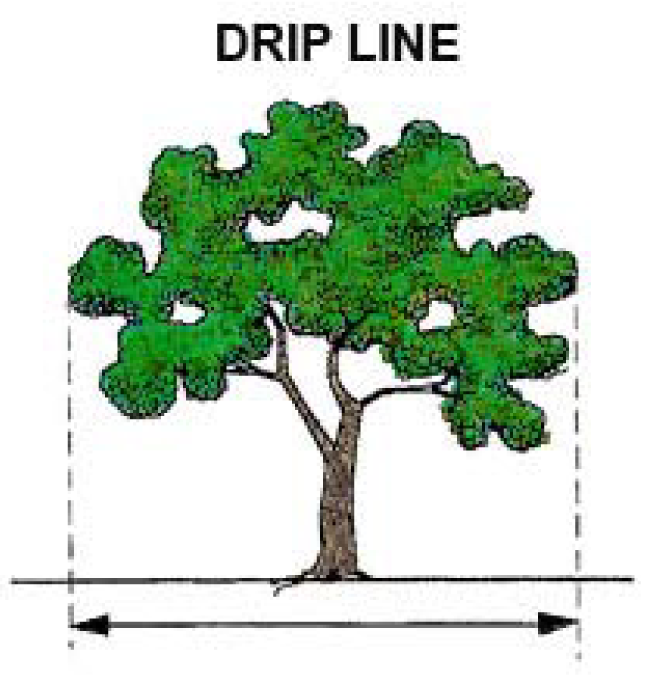
Picture 7.1
D.
Any required excavation in or around the protection zone to accommodate underground services, footings, etc. shall be indicated on the plan, and shall be excavated by hand. In addition, related root pruning shall be accomplished via ANSI (American National Standards Institute) A-300-95 standard so as to minimize impact on the general root system.
E.
The storage of building materials or stockpiling shall not be permitted within the limits of or against the protection barriers.
F.
Trees within the protection barriers must be adequately cared for throughout the construction process (i.e., they must be watered sufficiently, particularly if the tree's root system has been disturbed by excavation.) Fill shall not be placed upon the root system in such a manner as to endanger the health or life of the affected tree.
G.
Proposed root and branch pruning, where necessary, shall be noted on the tree preservation plan and shall be accomplished in accordance with standard tree pruning practices, as established by ANSI (American National Standards Institute) A-300-995 standards. Tree topping shall not be permitted.
7.11 - VEHICLE USE AREA SCREENING AND LANDSCAPING
• Purpose and Intent. The purpose of this section is to lessen the visual and environmental effects that large vehicular use areas can have on the community through the use of minimum landscaping standards. To those ends, this section establishes the minimum standards by which vehicular use areas will be screened from adjacent public streets, dedicated roadway easements or from adjacent properties. In addition, this section delineates standards for landscaping within the interiors of vehicular use areas.
• Applicability. The following requirements are cumulative, not exclusive:
A.
Perimeter vehicular use area landscaping required. The perimeter vehicular use area landscaping requirements of this section shall apply to all off-street parking facilities adjacent to a public street, dedicated roadway easement or property line which:
I.
Have five (5) or more parking spaces; or
II.
Are larger than one thousand seven hundred fifty (1,750) square feet in paved area.
B.
Interior vehicular use area landscaping required. The interior vehicular use area landscaping requirements of this section shall apply to all off-street parking facilities which:
I.
Have ten (10) or more parking spaces; or
II.
Are over three thousand five hundred (3,500) square feet in paved area.
• Perimeter screening requirements. Unless supplanted by more stringent standards in Section 7.12 of this chapter, Landscape Buffer Yard Requirements, the perimeters of vehicular use areas shall be landscaped as follows:
A.
Vehicular use areas adjacent to public streets. Vehicular use areas adjacent to public streets shall be separated from the edge of the right-of-way by a perimeter landscape strip which shall be landscaped per the standards set out in Section 7.11.3.C of this chapter. The public right-of-way and areas reserved for future rights-of-way shall not be used to satisfy the requirements of this section. Perimeter landscape strips shall be continuous and unbroken except for driveways or sidewalks required to access the parking area.
I.
Perimeter landscape strips adjacent to public streets with four (4) or more travel lanes shall be a minimum of ten (10) feet in width, unless: (a) the strip includes a permanent finished wall no less than thirty (30) inches in height; or (b) the required trees are planted in islands between the parking spaces. In such cases the perimeter landscape strip may be reduced to five (5) feet in width.
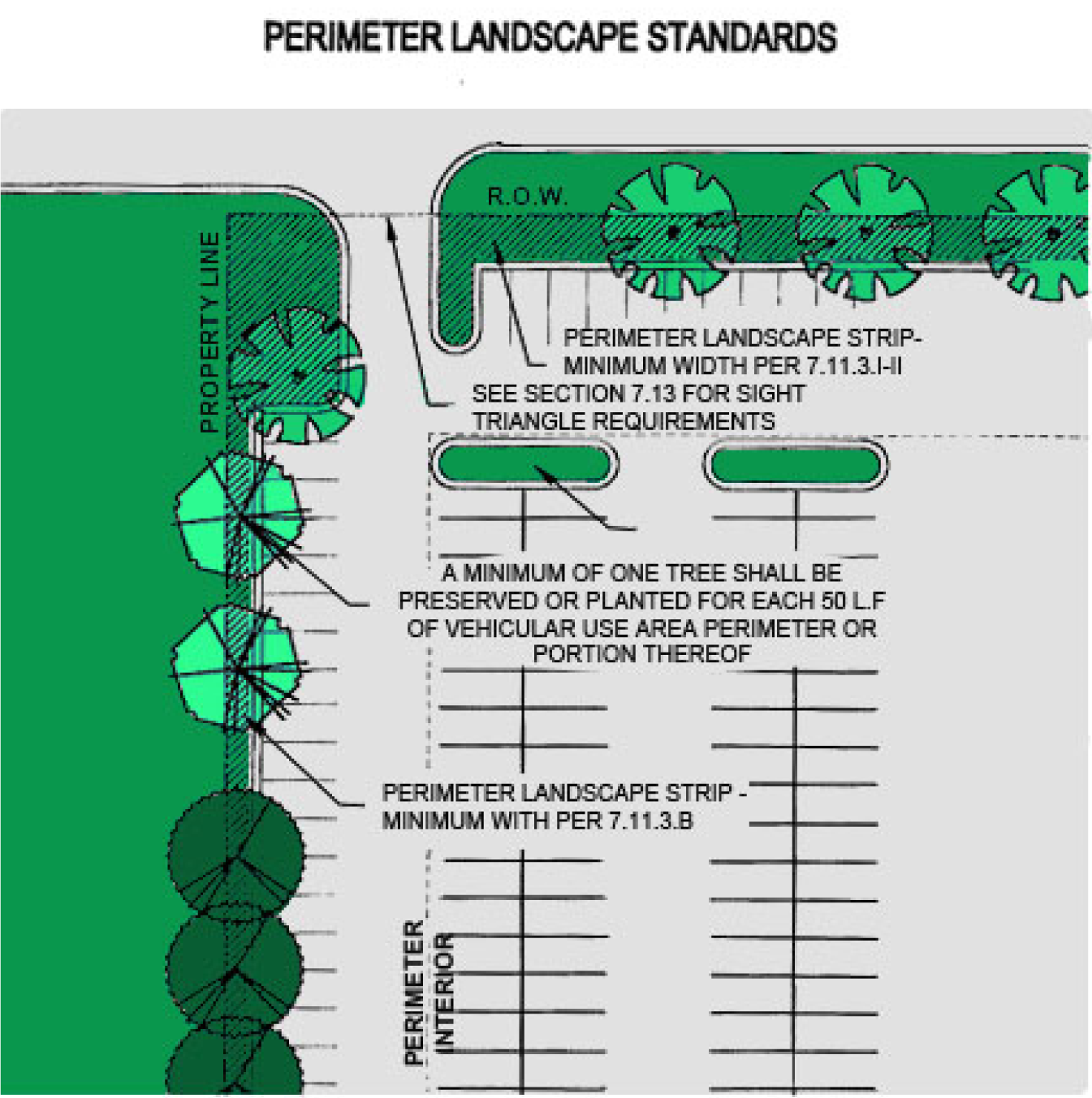
Picture 7.2
II.
Perimeter landscape strips adjacent to public streets with less than four (4) travel lanes shall be a minimum of five (5) feet in width, unless:
a.
The strip includes a permanent finished wall no less than thirty (30) inches in height; or
b.
The required trees are planted in islands between the parking spaces. In such cases and in areas where no shrubs are planted in the perimeter landscape strip, the perimeter landscape strip may be reduced to two and one-half (2½) feet in width. In all areas where shrubs are to be planted, the minimum width shall be five (5) feet.
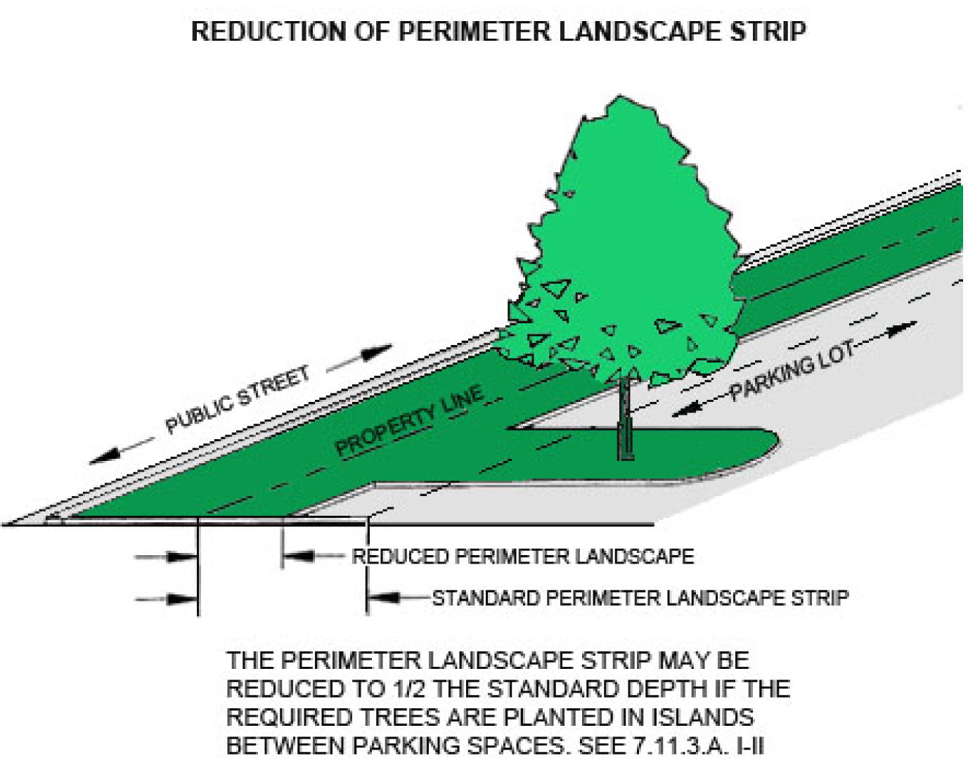
Picture 7.3
III.
Permanent landscape strips that use walls or earthen berms are desirable for the reliability of the screening effect they provide. Berms shall not have slopes steeper than 2:1 (horizontal to vertical). Berms with slopes flatter than 3:1 may be stabilized with lawn grasses, and berms with slopes in the range of 2:1 to 3:1 shall be stabilized by a continuous perennial plant groundcover which does not require mowing in order to maintain a neat appearance. The wall or combination of berm and perennial groundcover shall be a minimum of three and one-half (3½) feet in height, except where prohibited by sight triangle standards described in Section 7.13 of this chapter.
B.
Vehicular use areas adjacent to side and rear property lines. A perimeter landscape strip shall separate a driveway or vehicular use area from an adjacent side or rear property line by one of the following standards: (a) a five-foot minimum wide planting strip shall be provided if required trees are to be planted within the strip; (b) a two and one-half (2½) foot minimum planting strip shall be provided if all required trees are planted within tree islands located adjacent to the property line; or (c) two (2) adjacent properties may share equally in the establishment of an eight-foot minimum planting strip along the common property line. In instances where the common perimeter planting strip is part of a plan for shared access, each owner may count the respective area contributed toward that common planting strip toward the interior planting area requirements for the lot. All landscaping strips shall be planted to satisfy the tree requirements of this chapter. No shrubs shall be required in perimeter landscape strips for vehicular use areas adjacent to side and rear property lines but not adjacent to a public street.
C.
Landscape materials. A minimum of one (1) tree shall be preserved or planted for each fifty (50) feet of vehicular use area perimeter, or portion thereof. This does not mean trees are to be planted fifty (50) foot on center. Trees planted to meet this requirement shall measure a minimum of two (2) inches in caliper for a deciduous tree, and six (6) feet in height for an evergreen tree. The area within the perimeter landscape strip which fronts on a street right-of way shall be planted with evergreen shrubs at a standard of ten (10) shrubs per one hundred (100) linear feet of frontage, i.e., for two hundred fifty (250) linear feet of frontage, twenty-five (25) shrubs would be required. Shrubs shall be a minimum of eighteen (18) inches high at planting. No more than forty (40) percent of any one genus (trees and shrubs) may be included in any planting. The remainder of the area within all perimeter strips not occupied by required trees or evergreen shrubs shall be covered by organic or mineral mulches, other shrubs, groundcover plants or grassed lawns. Trees, shrubs and ground covers may be massed to create a more naturalistic planting. The use of concrete, asphalt or other impervious surfaces shall be prohibited.
A list of recommended and prohibited trees is available from the Regional Planning Commission. This list will periodically be updated as needed.
D.
Corner visibility. Trees and other landscaping required in the perimeter strip shall be planted and maintained to assure unobstructed corner visibility pursuant to sight triangle requirements of this section. For developments where the entire road frontage is within a sight triangle, the required perimeter landscape strip trees for this frontage shall be planted in an adjacent perimeter landscape strip; or in lieu of the frontage trees, the frontage landscape strip will be significantly enhanced with shrub and ground cover planting above and beyond the required planting.
E.
Adjacent vehicular use areas with shared access. Vehicular use areas on adjacent properties, which are designed to share a common access from the public right-of-way and a vehicular travel way along their common property line shall be exempt from the requirement for a vehicular use area perimeter landscape strip along their common property line, upon the recording of an easement agreement which provides for the mutual right of ingress and egress for both property owners.
• Interior planting requirements.
A.
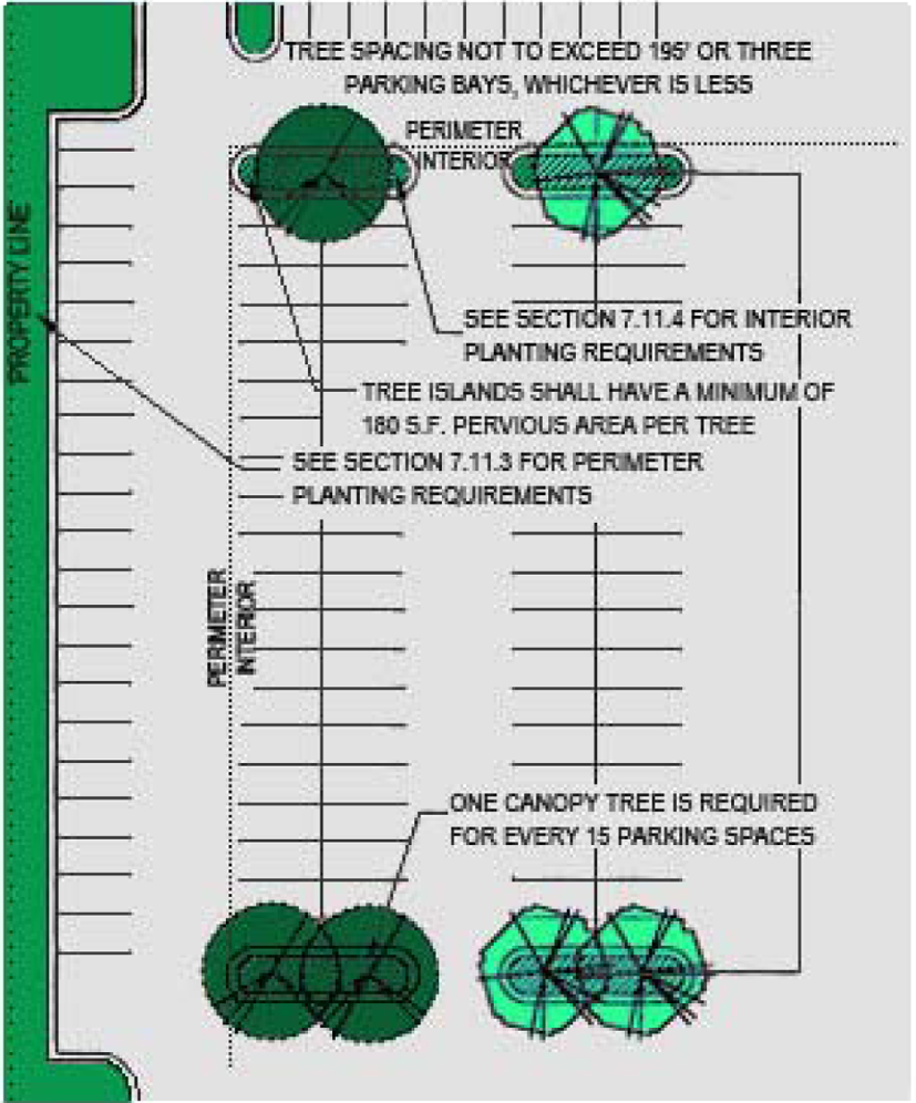
General requirements. At least five percent (5%) of the gross area of the vehicular use area shall be landscaped. But in no case shall the combined perimeter and interior landscape area requirement exceed fifteen percent (15%) of the total land area. Interior planting areas are to be located within or adjacent to the parking area as tree islands, at the end of parking bays or inside eight-foot wide or greater medians (where the median area is to be included as a part of the calculations for the interior planting area) or five-foot if concrete bumper blocks are provided. Interior planting areas shall be located so as not to impede storm-water runoff and provide shade in large expanses of paving and contribute to orderly circulation of vehicular and pedestrian traffic. The required number of parking spaces may be decreased by the number of tree islands created to meet the minimum interior planting requirement of this section. For example, the required creation of three (3) separate tree islands, if within the proposed required off-street parking area(s), would allow the minimum number of parking spaces required by Section 6.1 to be reduced by three (3) spaces.
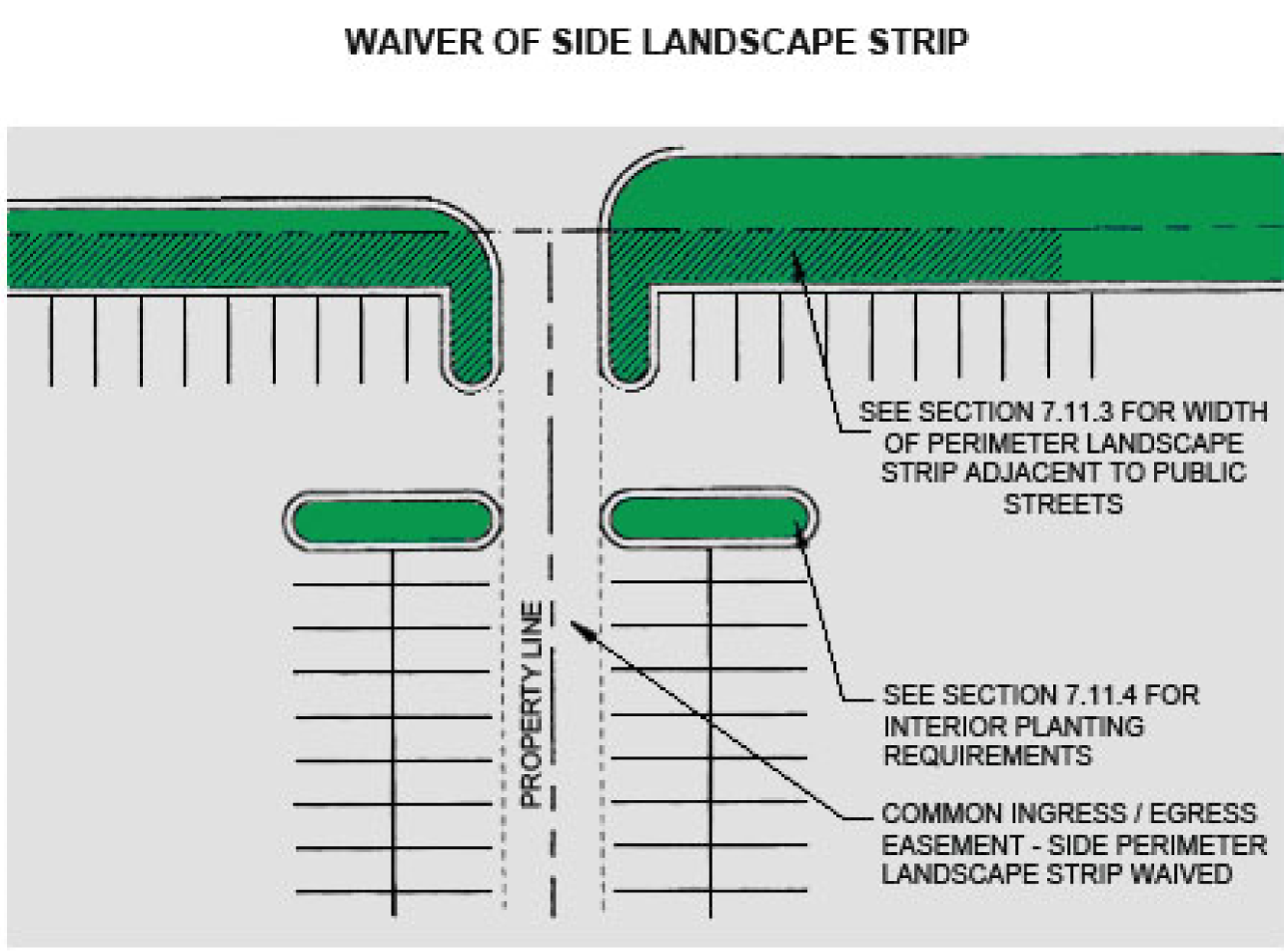
Picture 7.4
I.
Tree spacing shall not exceed a maximum of one hundred ninety-five (195) feet or three (3) parking modules, whichever is less. The maximum tree spacing shall apply in all directions.
Picture 7.5
II.
Trees shall be required at the minimum of one (1) canopy tree for every fifteen (15) parking spaces or portion thereof. All vehicular use areas located within the same block which serve one (1) or more businesses or uses of land or share unified ingress and egress may be considered as a single vehicular use area for the purpose of computing the required rate of trees, notwithstanding ownership. Required trees shall be at least six (6) feet in height for an evergreen tree and two (2) inches in caliper for a deciduous tree.
B.
Minimum size of interior planting areas.
I.
A minimum of one hundred eighty (180) square feet of pervious planting area shall be required for each new tree.
II.
The minimum planting area for existing trees shall include the undisturbed area inside the tree fence. See Section 7.10.11.
7.12 - LANDSCAPE BUFFER YARD REQUIREMENTS
1.
Purpose and Intent. The purpose of this section is to protect the value and integrity of property from the potential adverse effects of non-compatible land uses. To that end, this section requires that landscape buffer yards be provided at the boundaries of selected zoning districts. Buffers may also be required between incompatible uses within zoning districts or between districts. For example, in the MLUD or PUD Districts, commercial uses will be required to provide buffering when adjacent to residential uses. The Buffer Yard Matrix shown in this chapter shall be used as a guide in determining adequate screening. The landscape buffer yard standards of this section are also employed by other sections to accomplish special screening and buffering objectives. The width of the landscape buffer yard and the intensity of plantings required may vary depending upon the relative intensities of the abutting zone districts or the activity itself. In most cases, the property owner may choose among a number of buffer yard widths and plantings to satisfy the requirement. In some cases, minimum buffer widths may be set by the Director of Planning or his designee.
Buffering requirements may be reduced or eliminated if it is determined by the planning staff, that the proposed use would have a minimal impact on the immediate surrounding area; or if it is determined that the likelihood exists of similar development occurring within a reasonable amount of time.
2.
Landscape Buffer Yard Required for Double Frontage Lot. In cases where residential lots in zoning districts covered by this section are developed with frontage and access to a street within the subdivision and the rear of the lot is oriented toward a public right-of-way, the rear of such double frontage lots shall be screened from the public right-of-way by a landscape buffer yard according to the following standards:
TABLE 7.2: REAR LANDSCAPE BUFFER FOR DOUBLE FRONTAGE LOTS
3.
Exemptions. No landscape buffer yard shall be required in the following situations:
A.
When a zoning boundary falls along a public street or along an elevated railroad bed, navigable river, controlled access highway, or other natural topographic or man-made feature which provides adequate buffer in the opinion of the Director of Planning.
TABLE 7.3: BUFFER YARD MATRIX
4.
Determination of Landscape Buffer Yard Requirements. Generally, a landscape buffer yard shall be located at the perimeter of the building site along zoning district boundaries, or otherwise coincident with the edge of a specified facility that is to be screened, and shall not be located in any portion of a public right-of-way. On lots which have a split zoning in place, and owned by the same property owner, the required buffers may be positioned in locations other than along the zone district boundaries, as long as the intended effect is achieved. Where the building setback line and the width of landscape buffer differs, the greater of the two will prevail and take precedence. When the gross floor area of a building legally existing on the effective date of the Ordinance is expanded by fifty percent (50%) or more, that perimeter portion of the property in proximity to the area of expansion shall be brought into conformance with the landscaping buffer yards standard of this code. When incremental expansions occur over time, the total of all expansions shall be used in applying the provisions of this section. If the requirements of this section have been fully complied with on an adjoining property, additional buffer areas may not be required. The following procedure shall be followed to determine the standard of landscape buffer yard required along a zoning district boundary.
5.
Identify the zone district for the proposed site as well as for the abutting site(s).
A.
Determine the landscape buffer yard standard required on each building site boundary (or portion thereof) by referring to the buffer yard matrix.
B.
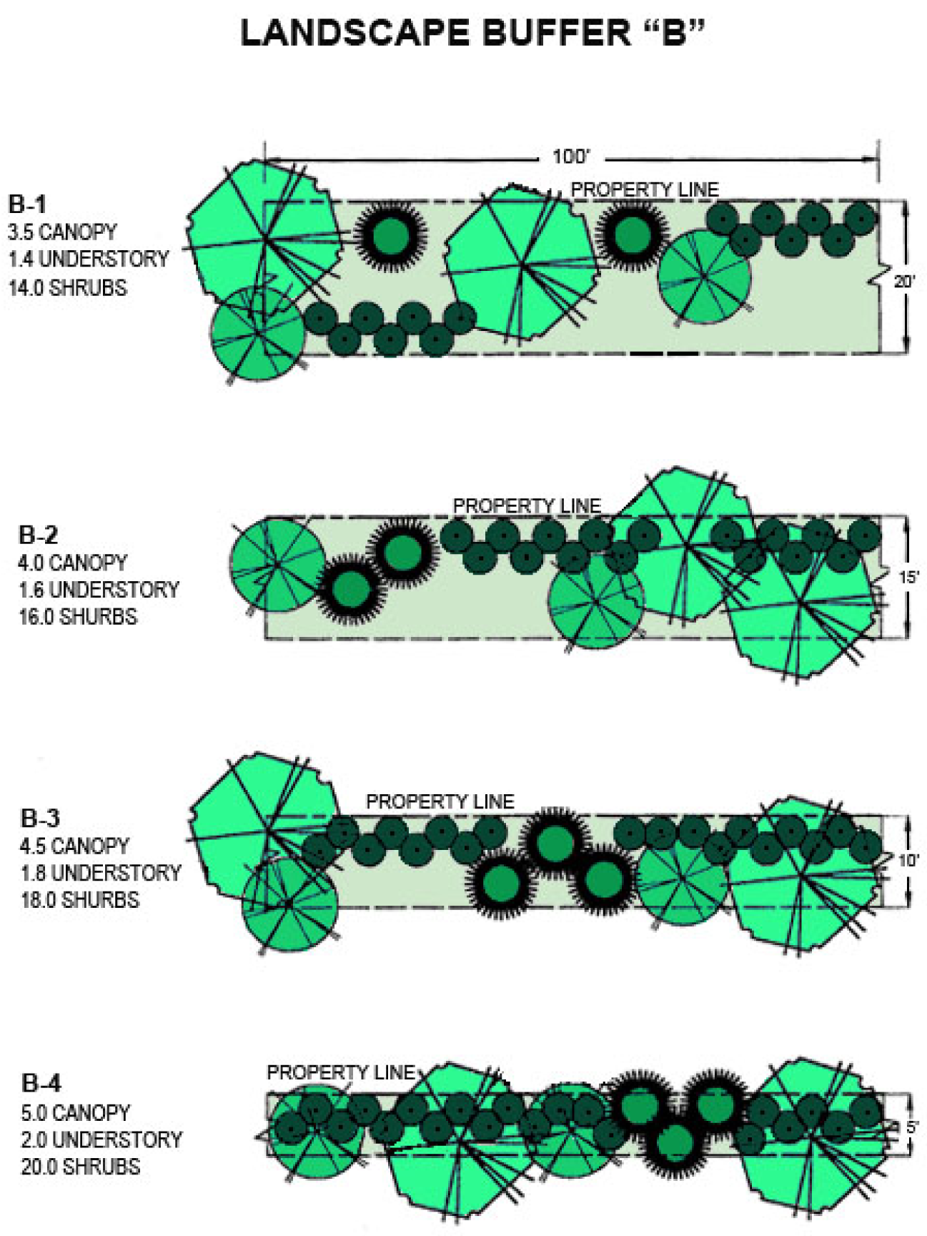
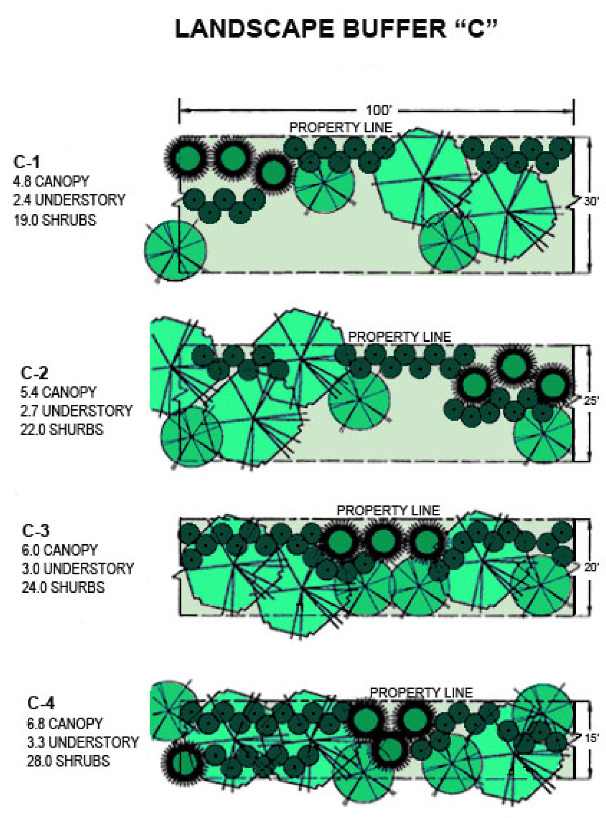
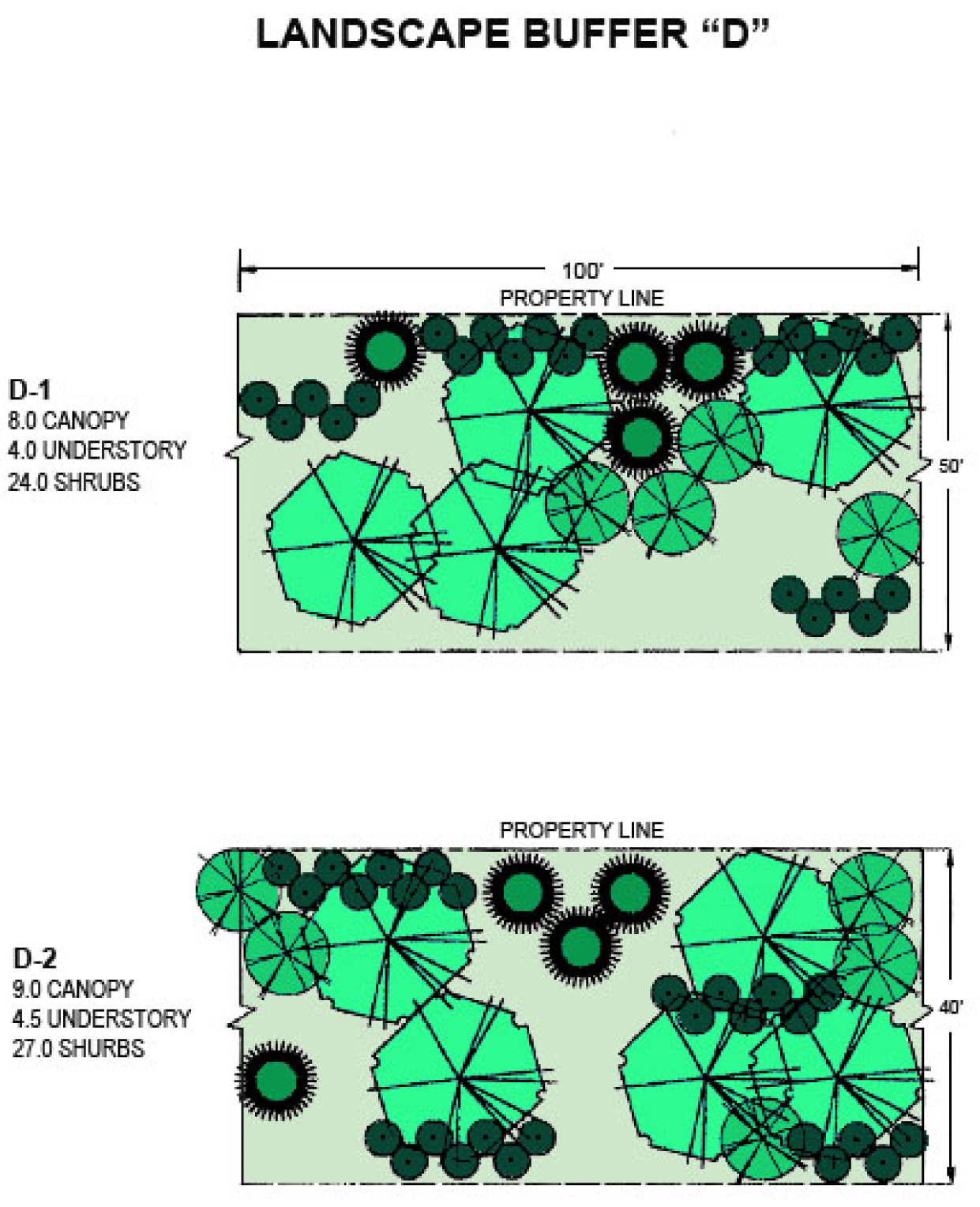
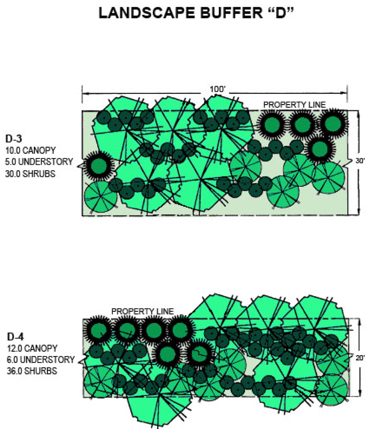
Select the desired width/screening option from those listed in the illustrations at the end of this section, landscape buffer yard standards. Any of the listed width or screening variations shall satisfy the requirement between abutting zone districts.
6.
Landscape Buffer Yard Design and Materials.
A.
Existing Native Plant Material. The use of existing plant material is strongly encouraged in landscape buffer yards. Existing natural groundcover shall be retained where possible by avoiding scraping, grading and sodding within the landscape buffer yard. Where the planting requirements of the landscape buffer yard standards require additional trees or shrubs to be installed in an existing natural area, installation shall minimize disturbances to native species.
B.
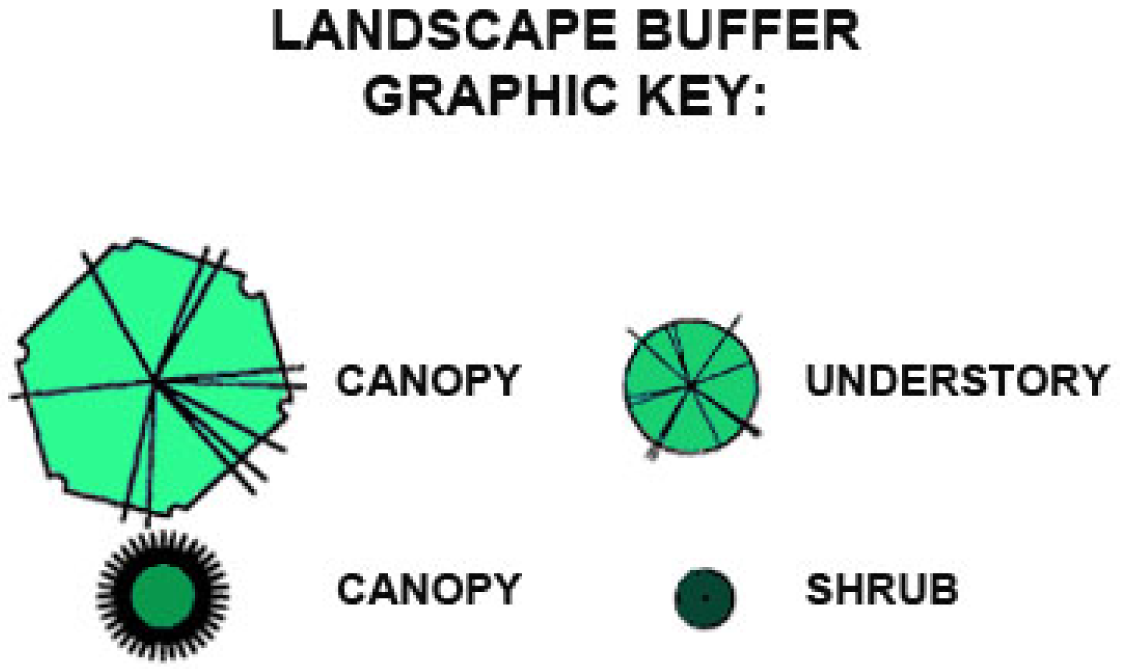
Trees. Where the planting requirements of the landscape buffer yard standards indicate that additional trees shall be installed, required trees shall be a minimum of six (6) feet in height for an evergreen tree or two (2) inches in caliper for a deciduous tree, as appropriate. No more than forty (40) percent of any one genus may be included in any planting. At least one-half (½) of the required trees shall be locally adapted natural evergreen species. Trees shall be distributed throughout the yards, so that there are no horizontal gaps between trees greater than thirty (30) feet as measured parallel to the property line except in A-1 or A-2. Required canopy trees shall have an expected mature height of forty (40) feet or greater. Required understory trees shall have an expected mature height of at least fifteen (15) feet. A list of recommended and prohibited trees is available from the Regional Planning Commission. This list will periodically be updated as needed.
C.
Shrubs. No more than forty percent (40%) of any one (1) genus may be included in any planting. At least one-half (½) of the required shrubs shall be locally adapted natural evergreen species. Evergreen shrubs planted to meet the minimum standards of this section shall be a minimum of one and one-half (1½) feet in height when planted and at least one-half (½) shall be expected to reach five (5) feet or greater in height within five (5) years of planting. Shrubs planted on berms may have a lesser mature height provided that the combined height of the berm and plantings after five (5) years is at least five (5) feet. Shrubs may be planted in staggered rows or any other pattern. Pedestrian areas and other places where surveillance for the purpose of preventing crime is a design objective may be planted with the smaller of the required shrubs. Required shrubs may be replaced with approved evergreen trees at a ratio of one (1) evergreen tree per four (4) shrubs. Evergreen trees shall be a minimum of six (6) feet in height at time of planting.
D.
Utility and Drainage Easements. Required landscape buffer yards shall not be used for utility or drainage easements unless approved by the entity controlling the easement. If such an easement exists along the perimeter of the site or if there is no alternative in locating the easement, the full landscape buffer yard shall be placed inward (toward the interior of the site) from the easement.
E.
Vehicular Use Area Landscaping. Perimeter plantings required for vehicular use area landscaping may be allowed to be counted toward satisfying landscape buffer yard requirements when the perimeter planting area coincides with the buffer yard.
F.
Compatibility of Landscaping Materials. Supplemental plantings shall be chosen to enhance the existing vegetation within the landscape buffer yard. The species used in the supplemental plantings shall be species that occur naturally in the landscape, and shall be selected for their noninvasive properties.
G.
Opaque Fences. When utilized to satisfy a screening requirement of this section, opaque fences shall be constructed of permanently affixed materials that comprise an integral part of the fence itself. The use of nonrigid plastic or fabric material shall not qualify as an opaque fence. Walls shall be constructed of natural stone, brick or other weatherproof materials arranged in a linear, serpentine, or other alignment; fences shall be constructed of wood or other weatherproof, durable materials generally used in the exterior construction of buildings. Fence posts shall be structurally stable based on the material used and shall have a maximum spacing of eight (8) feet on center. If wood is used, the posts shall be four (4) inches by four (4) inches minimum. Posts shall be set in or anchored to crowned concrete footers at least six (6) inches larger in each direction than the post it supports. The base of the footer shall be at least twenty-four (24) inches below finished grade. If wood is used for any member, it shall be softwood treated with water-borne preservative to the American Wood Preservers Institute standard LP-2 for above ground use or LP-22 for ground contact use, or all-heart redwood, or all-heart cedar. All cut surfaces of pressure treated lumber shall be waterproofed. If another material is used, it shall be weatherproofed. Slats, pickets or panels are to be placed on the outside of the fence unless the design is two-sided (e.g. shadow box). All hardware is to be galvanized or otherwise rustproofed. Wood horizontal members shall be installed bark-side up. Chain link fencing may not be used. There shall be a six-foot height restriction for walls or fences in front yards and side street side yards, and an eight-foot height restriction in side and rear yards. All walls or fences shall have a minimum opacity of eighty percent (80%). Walls and fences allowed to meet the requirements of this section shall not be used for the erection or display of any sign or other advertising device. Walls and fences shall be horizontally level as opposed to following the topography of the site where said topography is other than level. In this situation, the height restriction shall apply to a reasonable average height above the grade between step-downs.
7.
Other Uses Within Landscape Buffer Yards.
A.
Trails. Sidewalks or bike trails may occur within landscape buffer yards provided that the required effect of the yard is not compromised. In no event, however, shall the following uses be permitted in landscape buffer yards: playfields, stables, swimming pools, golf courses, tennis courts, and other recreational facilities; parking areas and other vehicular use areas; dumpsters, equipment storage and other open storage; buildings or overhangs.
B.
Subterranean stormwater retention/detention facilities which are designed in a manner so as not to interfere with the proper installation and maintenance of the yard are allowed.
C.
Buffer yards shall be continuous and unbroken except for driveways or sidewalks required to access parking areas or streets. Driveway/sidewalk penetrations shall cross the buffer yard as close to perpendicular as possible and shall not exceed twenty-five percent (25%) of the entire buffer yard, with no single penetration to exceed thirty-five (35) feet.
8.
Landscape Buffer Yard Standards.
A.
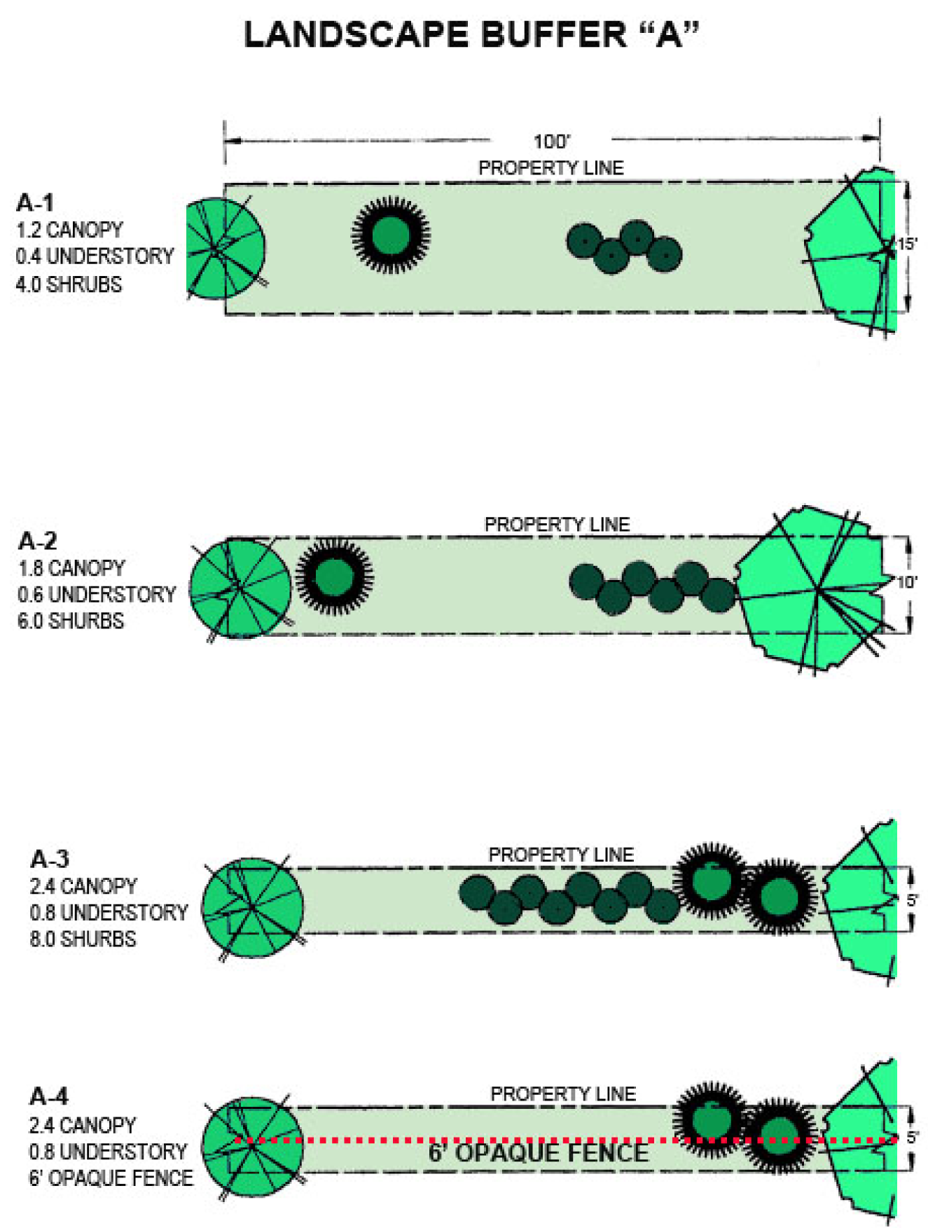
Application of Landscape Buffer Yard Standards. The specifications contained in the illustrations set out at the end of this section, shall be used to select the desired landscape buffer yard option for the building site. These yard requirements are stated in terms of minimum yard width and the density of required plant material per linear foot of yard. To determine the total number of plants required, the length of each side of property requiring a landscape buffer yard shall be divided by one hundred (100) and multiplied by the number of plants shown in the illustration.
B.
Allowable Design Variations. The landscape buffer yard is normally calculated as parallel to the property line. However, design variations, especially when used to incorporate native vegetation into the yard area, shall be considered. The edges of the landscape buffer yard may meander provided that:
I.
The total area of the yard is equal to or greater than the total area of the required landscape buffer yard; and
II.
The yard measures no less than the minimum width permitted by the applicable landscape buffer yard standard at all points along the perimeter of the property line requiring a landscape buffer yard.
C.
Fractional Requirements. When the requirements of this section result in a fractional number of plantings, any fraction less than one-half (½) may be dropped and any fraction of one-half (½) or more shall be counted as one (1) planting.
D.
Planned Unit Development Districts. Notwithstanding any other provision of this chapter to the contrary, the landscaping buffer yard requirements for a PUD originally under previous zoning shall be provided as required by this chapter or as required in the originally approved PUD, whichever is greater.
E.
Yard Exceeds Twenty Percent (20%) of Lot Area. In circumstances where the ground area required for the landscape buffer yard exceeds twenty percent (20%) of the total lot area, the width and the number of trees and shrubs within the yard may be reduced up to fifty percent (50%) provided that a solid wall or closed wooden fence at least six (6) feet in height is provided along the length of the reduced landscape buffer yard.
F.
Grading and Use of Berms. Proposals for the use of berms within a landscape buffer yard shall demonstrate superior enhancement of the buffer function compared to retention of the existing grades. Grading shall not endanger or remove existing trees which occur within a landscape buffer yard, unless the proposal clearly demonstrates an enhanced buffer. The use of earthen berms within a landscape buffer yard is encouraged when disturbance to existing vegetation can be minimized. Where berms are incorporated into the yard, the required plantings may have a lesser mature height, provided that the combined height of the berm and plantings will equal the required mature heights of plantings as set forth in this section.
G.
Waiver of Landscape Buffer Yard. Landscape buffer yard requirements may be waived by a demonstration of unusual site grade conditions which would clearly negate the effects of the required yard. The applicant shall furnish sections or profiles (drawn to scale) through the property line along the yard which is proposed for waiver. These drawings shall demonstrate the existing and proposed grades on both sides of the property line, as well as the principal structures on both properties. The sections or profiles shall show the line of sight for a pedestrian (taken at four and one-half (4½) feet above grade) from principal entrances and from the highest point on the site to be buffered. Such profiles or sections shall clearly demonstrate that the effect of the change in grade would negate the effect of a mature landscape buffer yard thirty (30) feet in height.
7.13 - LANDSCAPE RESTRICTIONS-SIGHT TRIANGLE STANDARDS
1.
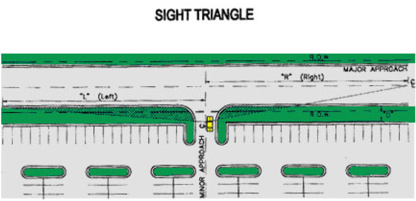
A sight triangle is that area located at the intersection of two (2) public streets or a public street and private driveway through which an unobstructed view of approaching traffic is necessary for motorists. Except as permitted in this section, no landscaping or vegetation, or fence, structure, or object shall be included in a sight triangle, nor shall any such landscaping or object be planted, erected or maintained within a sight triangle. A sight triangle shall be defined by the table and illustration below:
Picture 7.6
The distance "D" shall measure twenty (20) feet and fifteen (15) feet from the edge of the nearest travel lane for a public street and private driveway, respectively. The distance "L" shall be measured from the centerline of the minor approach to a point at the edge of the nearest travel lane. The distance "R" shall be measured from the centerline of the minor street to a point on the centerline of the major street approach.
TABLE 7.4: MINIMUM REQUIRED SIGHT DISTANCES FOR DIFFERENT POSTED SPEED LIMITS
Sight triangles shall be measured from the minor leg of the intersection of two (2) public streets where the minor approach shall be defined as that approach whose right-of-way is controlled by a stop sign and whose major approach is uncontrolled. At a signalized intersection of two (2) public streets, sight triangles shall be measured for all approaches. For an intersection of a public street and private driveway, the sight distance is only measured from the private driveway.
2.
No landscaping object or plant material, except those meeting the requirements set forth below, shall be allowed within the sight triangle at an elevation greater than three and one-half (3½) feet above the crown of pavement on the adjacent roadway.
For developments where the entire road frontage is within a sight triangle, the required perimeter landscape strip trees for this frontage will be planted in an adjacent perimeter landscape strip; or in lieu of the frontage trees, the frontage landscape strip will be significantly enhanced with shrub and ground cover planting above and beyond the required planting.
3.
Notwithstanding the table and illustration provided in this section, the Director of Planning or his designee with concurrence from the Director of Streets or his designee may recommend variances of this section to the Regional Planning Commission, which shall have the authority to grant variances upon application by the owner. Any variance for landscaping shall take into account roadway conditions as they relate to traffic control devices, alignments, geometrics, or other unique circumstances that are supported by generally accepted engineering practices or principles, or actual on site studies.
4.
No landscape plan shall be approved if the landscaping proposed for the intersection of a public street and a vehicular use area would create an unsafe obstruction in the opinion of the Director of Planning or his designee. No landscaping or vegetation, or fence, structure, or object, shall be planted, erected, or maintained by an owner at the intersection of a public street and a vehicular use area if it creates a safety hazard by obstructing the view of a motorist.
7.14 - SPECIAL SCREENING REQUIREMENTS
Screening of unsightly areas shall be accomplished as follows:
Dumpsters and other trash receptacles for all structures other than single-family or two-family residences shall be screened from public streets or properties which are zoned or policed for residential use. Receptacles shall be placed on a concrete pad and shall be enclosed by an opaque fence or wall at least six (6) feet in height. An enclosure shall have an opaque gate unless the service opening is oriented away from public streets or adjacent residential properties. The enclosure shall be built of wood, masonry or other permanent materials and evergreen plants may be used in part to meet the requirement of opacity.
Mechanical equipment, terminals, satellite dishes, etc. located at grade shall be screened from all abutting public streets and residential properties by opaque fences or evergreen screens with eighty percent (80%) opacity at maturity in five (5) years to equal or exceed the height of equipment. Screening installed around utility equipment, including pad-mounted switchgear, transformers or junction boxes shall be installed so as not to interfere with the operation or accessibility to the equipment.
The exterior service areas of commercial or industrial buildings, including loading docks and outdoor storage areas, if oriented toward a public street or residential uses, shall be screened twelve-foot deep with evergreen trees planted in two (2) rows, offset six-foot on center, six-foot high at planting; or as approved by the Director of Planning or his designee.
Other areas, natural or man-made, may be considered unsightly and also require screening from public roads and properties zoned or policed for residential uses. These areas might include, but are not limited to, detention basins.
Picture 7.7
• A minimum of fifty percent (50%) of all plants must be evergreen;
• No more than forty percent (40%) of any one (1) plant genus allowed;
• Evergreen trees shall be a minimum of six (6) feet in height at planting;
• Deciduous trees shall be a minimum of two-inch caliper at planting;
• There shall be no horizontal gaps greater than thirty (30) feet between trees except in A-1 and A-2 buffers;
• All shrubs shall be a minimum of eighteen (18) inches in height at planting;
• A minimum of fifty percent (50%) of the evergreen shrubs shall reach a minimum of five (5) feet in height within five (5) years of planting;
• Required shrubs may be replaced at a ratio of one (1) evergreen tree per four (4) shrubs.
Picture 7.8
Picture 7.9
Picture 7.10
Picture 7.11
Picture 7.12

