
Clovis City Zoning Code
CHAPTER 17
85 - MEASUREMENTS
17.85.010 - Fractions and rounding.
When calculations required under this UDO result in fractions, the results must be rounded as follows:
A.
Maximum Limits. When a regulation governs a maximum quantity or limit, any fractional result must be rounded down to the preceding whole number. For example, if a maximum limit of one dwelling unit for every five thousand square feet of lot area is applied to a twenty-three thousand square foot lot, the resulting fraction of 4.6 is rounded down to four allowed dwelling units. (Note: "minimum lot area per dwelling unit" is a measure of the maximum density of dwelling units allowed, and is therefore subject to this "maximum limits" rounding rule.)
B.
Minimum Requirements. When a regulation is expressed in terms of a minimum requirement, any fractional result of 0.5 or more must be rounded up to the next consecutive whole number. Any fractional result of less than 0.5, is rounded down. For example, if a minimum tree planting requirement of one tree for every thirty linear feet is applied to a fifty-foot long strip, the resulting fraction of 1.67 is rounded up to two required trees. On the other hand, if that same minimum tree planting requirement is applied to a forty-three-foot long strip, the resulting fraction of 1.43 is rounded down to one required tree.
(Ord. No. 2122-2019, § 3, 6-20-19).
17.85.020 - Lot area.
Lot area is measured as the total ground-level surface area contained within the property lines of a lot.
(Ord. No. 2122-2019, § 3, 6-20-19).
17.85.030 - Lot area per unit.
Lot area per unit is a measure of maximum residential density, expressed in terms of the amount of lot area required for each dwelling unit on the subject lot. To determine the number of dwelling units allowed on a lot, divide the area of the lot by the minimum lot-area-per-unit requirement, and round any fractional result down to a whole number (see 17.85.010.A). If, for example, a minimum lot-area-per-unit requirement of five thousand feet per unit is applied to a twenty-three thousand square foot lot, a maximum of four units would be allowed on that lot (4.6 rounded down to four).
(Ord. No. 2122-2019, § 3, 6-20-19).
17.85.040 - Floor area.
The floor area of a building is measured as the sum of the gross horizontal areas of all floors within the building, including basements, as measured from the exterior faces of the exterior walls or from the centerline of walls separating two buildings. The floor area of enclosed required off-street parking areas is not included in the measurement of floor area.
(Ord. No. 2122-2019, § 3, 6-20-19).
17.85.050 - Lot width.
Lot width is the horizontal distance between the side property lines of a lot, as measured at the point of the required minimum setback. If no setback is required, lot width is calculated as the average (mean) horizontal distance between the side property lines of the lot.
FIGURE 85-1: LOT WIDTH MEASUREMENT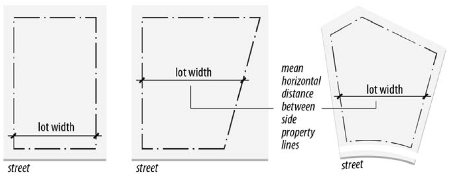
(Ord. No. 2122-2019, § 3, 6-20-19).
17.85.060 - Setbacks.
A.
Measurement. Building setbacks are measured from the referenced lot line to the nearest exterior building wall. Minimum setbacks that apply to other features (parking areas, fences, storage areas) are measured from the nearest point of the area or feature for which a setback is required. See 17.85.060.C for information on structures and building features that are allowed to occupy setback and yard areas in R zoning districts.
1.
Street setbacks are measured from the actual right-of-way line of the street (other than an alley).
2.
Side (interior) setbacks are measured from a side lot line that does not abut a street.
FIGURE 85-2: SIDE (INTERIOR)
SETBACK MEASUREMENT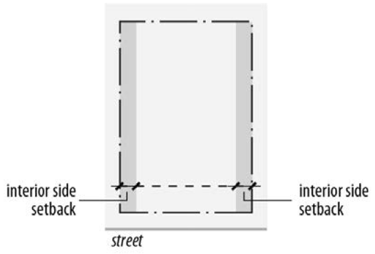
3.
Rear setbacks are measured from the rear lot line, except on double-frontage lots. On double-frontage lots, street setbacks apply from all property lines that abut streets.
FIGURE 85-3: REAR SETBACK MEASUREMENT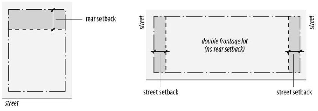
B.
Setbacks on Irregular Lots. Setbacks are measured from lot lines towards the center of the lot, as follows:
1.
Generally, setbacks are measured as set out in 17.85.060.A.
2.
When lot lines are curvilinear, setbacks must be measured parallel to the curvilinear lot line.
FIGURE 85-4: SETBACKS FROM
CURVILINEAR LOT LINES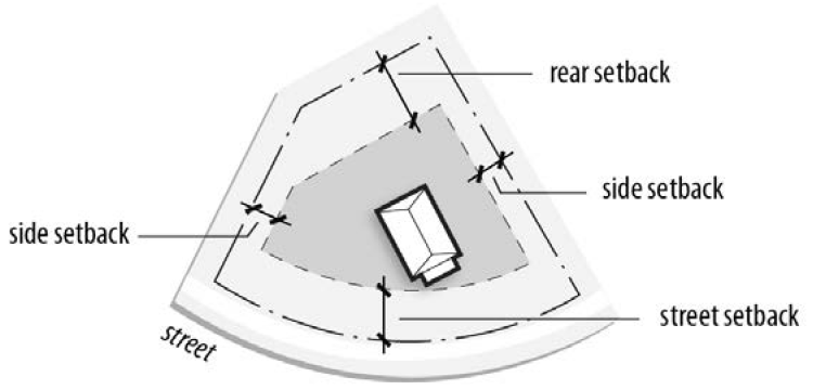
3.
When there are multiple rear lot lines, the rear setback must be measured from each of rear lot lines.
FIGURE 85-5: SETBACKS FROM
MULTIPLE REAR LOT LINES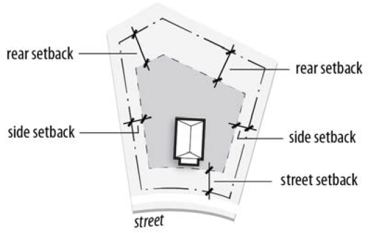
4.
When there is no rear lot line, the rear setback must be measured as a radial distance from the intersection of side lot lines at the rear of the lot.
FIGURE 85-6: REAR SETBACK MEASUREMENT
WHEN THERE IS NO REAR LOT LINE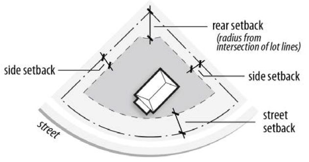
C.
Permitted Setback Obstructions in R Zoning Districts. Setbacks must be unobstructed and unoccupied from the ground to the sky except as indicated in Table 85-1:
TABLE 85-1: PERMITTED SETBACK OBSTRUCTIONS
IN R ZONING DISTRICTS
Table 85-1 Notes:
[1]
May not project more than two feet into the yard or required setback.
[2]
Allowed in Carport and Prefab Carport Overlay districts (see 17.20.020 and 17.20.030).
D.
Contextual Setbacks. When existing buildings on one or more abutting lots are closer to the street (front or street side) property line than the otherwise required setback, additions to existing buildings or construction of new buildings on the subject lot may comply with the average street yard depth that exists on the nearest two lots on either side of the subject lot instead of complying with the zoning district's minimum street setback requirement. Existing yard depths must be based on the front corners of the buildings on the lots used in the contextual setback determination that are nearest to the subject lot.
FIGURE 85-7: CONTEXTUAL SETBACKS (1)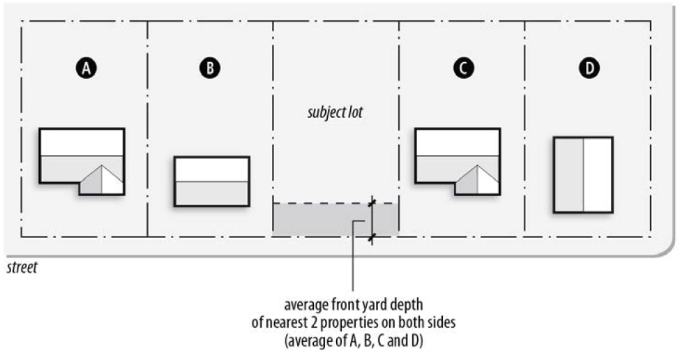
1.
If one or more of the lots required to be included in the averaging calculation is vacant, that vacant lot will be deemed to have a street yard depth equal to the minimum street setback requirement of the subject zoning district.
FIGURE 85-8: CONTEXTUAL SETBACKS (2)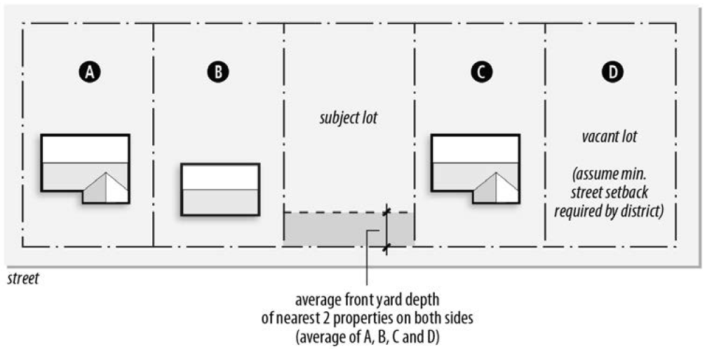
2.
Lots with frontage on a different street than the subject lot or that are separated from the subject lot by a street or alley may not be used in computing the average.
FIGURE 85-9: CONTEXTUAL SETBACKS (3)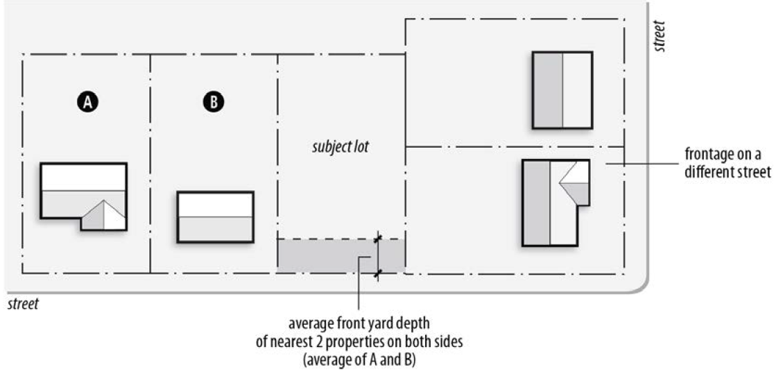
3.
When the subject lot is a corner lot, the average street yard depth will be computed on the basis of the nearest two lots with frontage on the same street as the subject lot.
FIGURE 85-10: CONTEXTUAL SETBACKS (4)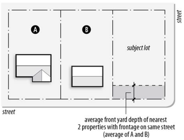
4.
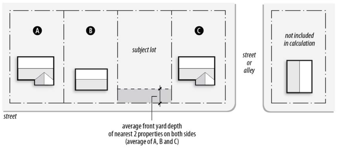
When the subject lot abuts a corner lot with frontage on the same street, the average street yard depth will be computed on the basis of the abutting corner lot and the nearest two lots with frontage on the same street as the subject lot.
FIGURE 85-11: CONTEXTUAL SETBACKS (5)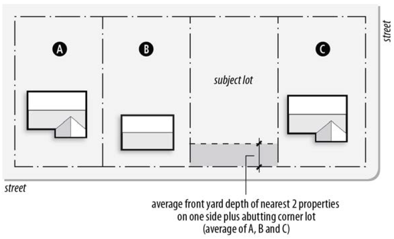
5.
These contextual setback provisions may not be used to reduce the setback of a street-facing garage door to less than twenty feet.
(Ord. No. 2122-2019, § 3, 6-20-19).
17.85.070 - Building coverage.
Building coverage is the total area of a lot covered by principal and accessory buildings. Only building areas beneath a roof are counted for purposes of measuring building coverage. A porch with a roof, for example, is counted, but an uncovered deck structure is not considered building coverage.
(Ord. No. 2122-2019, § 3, 6-20-19).
17.85.080 - Building height.
A.
Measurement.
1.
Building height is measured as the vertical distance from the lowest ground elevation along the building's exterior wall to the highest point on the subject building. For purposes of measuring height:
a.
The highest point of the building is the coping of a flat roof, the top of a mansard roof or shed roof, or the peak of the highest gable of a gambrel or hip roof. For buildings without a roof, height is measured to the highest point of the structure.
B.
Exceptions.
1.
Farm buildings and farm-related structures are not subject to building height limits.
2.
Chimneys, elevators, equipment penthouses, monitors, cooling towers and ventilators may exceed maximum building height limits, provided they are not intended for human occupancy and they do not extend more than twenty feet above the top of the principal structure to which they are attached.
3.
Belfries, clock towers, cupolas, domes, flag poles and spires may exceed maximum building height limits, provided they are not intended for human occupancy and they are not more than one hundred fifty percent taller than the applicable height limit. This one hundred fifty percent limit may be increased through the conditional use procedures of 17.65.110.
(Ord. No. 2122-2019, § 3, 6-20-19).
17.85.090 - Other height measurements.
The height of structures other than buildings is measured as vertical distance from the average finished grade at the base of the structure to the highest point of the structure. Unless otherwise expressly stated, the height of a structure may not exceed the maximum building height allowed in the subject zoning district.
(Ord. No. 2122-2019, § 3, 6-20-19).
17.85.100 - Occupancy.
For the purpose of determining compliance with standards or requirements based on building occupancy or capacity, calculations must be based on the building code.
(Ord. No. 2122-2019, § 3, 6-20-19).