
Coalinga City Zoning Code
CHAPTER 2
- BASE ZONING DISTRICTS
Sec. 9-2.101. - Purpose.
(a)
The specific purpose of the "Open Space/Conservation" and "Agriculture" Districts is to preserve agricultural and resource conservation areas while providing opportunities for rural living.
(b)
Additional purposes of each District:
(1)
Open Space/Conservation (OS). To preserve resource conservation areas for each of the following purposes:
a.
To safeguard the health, safety, and welfare of the people by limiting developments in areas where police and fire protection are not possible without excessive costs, and where protection from the following are not possible without excessive costs to the community: floodway or floodplains; fault rupture hazard areas; unstable geologic or soils conditions; hazardous materials; and wildlife corridors or habitat areas.
b.
To preserve the natural resources including, but not limited to, areas required for the preservation of plant and animal life, including habitat for fish and wildlife species (either plant or animal or both); areas required for ecologic or other scientific study purposes; areas required for the protection of water quality and water reservoirs or for the protection and enhancement of air quality or for the protection of rivers, streams, creeks, banks of rivers, banks of streams, banks of creeks or watershed lands.
c.
Residential uses are generally not allowed in the Open Space/Conservation land use designation. However, if all other economic uses are infeasible then one single-family residence may be allowed, subject to City Council approval. No commercial uses, except equestrian boarding, equestrian training and limited agricultural uses, are allowed within this designation. Passive recreational uses, including bicycle and hiking trails, are highly encouraged.
(2)
Agriculture (AG). This designation is designed for intensive agricultural and related uses. It is intended to be an exclusive district for agriculture and for those uses which are a necessary and integral part of the agricultural operation. The district is intended to protect the general welfare of the community from encroachments of nonrelated agricultural uses which by their nature would be injurious to the physical and economic well-being of the agricultural district. Development density is one home per twenty (20) gross acres.
(Ord. No. 776, § 1(Exh. A), eff. 9-5-2014)
Sec. 9-2.102. - Land use regulations.
(a)
Table 2.1 below prescribes the land use regulations for "Agriculture" and "Open Space/Conservation" Districts. The regulations for each district are established by letter designations as follows:
(1)
"Yes" designates permitted uses.
(2)
"CUP" designates use classifications that may be permitted after review and approval of a Conditional Use Permit by the Planning Commission.
(3)
"(#)" numbers in parentheses refer to specific limitations listed at the end of the table.
(4)
"No" designates uses that are not permitted.
(b)
Land use classifications are defined in Chapter 1 Article 2 "Definitions". In cases where a proposed specific land use or activity is not defined, an application shall be made to the Community Development Director, and the Planning Commission shall approve or deny the assignment of the proposed land use or activity to a classification that is substantially similar in character. Use classifications and subclassifications not listed in the table or not found to be substantially similar to the uses below are prohibited. The table also notes additional use regulations that apply to various uses. Section numbers in the right hand column refer to other sections of this title.
(Ord. No. 776, § 1(Exh. A), eff. 9-5-2014)
Sec. 9-2.103. - Development regulations.
(a)
Base development regulations. Table 2.2 prescribes the development standards for "Agriculture" and "Open Space/Conservation" Districts. Additional regulations are denoted in the right hand column. Section numbers in this column refer to other sections of this title, while individual letters refer to subsections that directly follow the table.
(Ord. No. 776, § 1(Exh. A), eff. 9-5-2014)
Sec. 9-2.201. - Purpose.
(a)
The specific purposes of the "Residential" Districts are to:
(1)
Maintain and enhance the city's neighborhoods.
(2)
Ensure the provision of services and facilities needed to accommodate planned population densities.
(3)
Provide a basis for the evaluation of development proposals for appropriate densities within the given ranges.
(4)
Implement and provide appropriate regulations for General Plan classifications of "Residential Ranchette", "Residential Estate", "Residential Single Family", "Residential Medium Density", and "Residential High Density".
(b)
Additional purposes of each "Residential" District:
(1)
Residential Ranchette (RR). To provide areas for large-lot developments with a minimum parcel size of ten (10) acres and one single-family residence per lot, with a maximum residential density of one-tenth (.10) dwelling units per acre. This designation applies to areas located north of the developed portions of the community along Highway 198/33. Equestrian-oriented developments with public linkages to trail systems are strongly encouraged in this designation.
(2)
Residential Estate (RE). To provide areas for large-lot developments containing one single-family residence per lot, with residential densities ranging from over two-tenths (.20) to two (2) dwelling units per acre. This designation applies largely to areas to the east and south of developed portions of the City and is intended to serve as a buffer between higher density urban areas and agricultural lands. Clustering development is encouraged in this land use designation to preserve natural features and/or provide community amenities (including parks and trails).
(3)
Residential Single Family (RSF). To provide areas for traditional single-family homes with a residential density ranging from over two (2) to five (5) dwelling units per acre. Development requires a full range of urban services and public improvements. Development on large parcels should be in areas with minimal environmental constraints. The use of clustering techniques is encouraged.
(4)
Residential Traditional Neighborhood (RT). To accommodate low to medium densities and more varied forms of residential development, including small-lot single-family homes and detached zero lot line developments with a maximum residential density of five (5) dwelling units per acre. This designation is intended to accommodate development in the compact residential neighborhoods in the historic central areas of the city. The designation can also be applied to newer outlying development to provide for a transition from lower-density residential neighborhoods to medium-density multi-family areas.
(5)
Residential Medium Density (RMD). To accommodate a variety of housing types, such as small-lot single-family homes, detached zero lot line developments, duplexes, townhouses, and garden apartments with a maximum residential density of fifteen (15) dwelling units per net acre. Common amenities such as pools, landscaping, tot lots, trails and open space should be included. This district provides for a transition from lower-density residential neighborhoods to higher-density multi-family development and commercial areas.
(6)
Residential High Density (RHD). This classification is intended to accommodate attached homes, two- to four-plexes, apartment buildings, and condominiums with a maximum residential density twenty (25) units per net acre. Common amenities such as pools, landscaping, tot lots, trails and open space should be included.
(Ord. No. 776, § 1(Exh. A), eff. 9-5-2014)
Sec. 9-2.202. - Land use regulations.
(a)
Table 2.3 below prescribes the land use regulations for "Residential" Districts. The regulations for each district are established by letter designations as follows:
(1)
"Yes" designates permitted uses.
(2)
"CUP" designates use classifications that are permitted after review and approval of a Conditional Use Permit by the Planning Commission.
(3)
"(#)" numbers in parentheses refer to specific limitations listed at the end of the table.
(4)
"No" designates uses that are not permitted.
(b)
Land use classifications are defined in Chapter 1, Article 2 Definitions. In cases where a proposed specific land use or activity is not defined, an application shall be made to the Community Development Department, and the Planning Commission shall approve or deny the assignment of the proposed land use or activity to a classification that is substantially similar in character. Use classifications and subclassifications not listed in the table or not found to be substantially similar to the uses below are prohibited. The table also notes additional use regulations that apply to various uses. Section numbers in the right hand column refer to other sections of this title.
(Ord. No. 776, § 1(Exh. A), eff. 9-5-2014; Ord. No. 854, § 2, eff. 8-18-2022)
Sec. 9-2.203. - Development regulations.
(a)
Base development regulations. Table 2.4 prescribes the development standards for Residential Districts. Additional regulations are denoted in the right hand column. Section numbers in this column refer to other sections of this chapter, while individual letters refer to subsections that directly follow the table.
(b)
Additional development regulations.
(1)
Reduced lot area, width, and depth. Reduced lot area, width, and depth are allowed with cluster developments in all Zoning Districts, provided the overall maximum density does not exceed the standards. Deed restrictions shall be filed on each property to ensure the overall maximum density is not exceeded through future subdivision or development.
a.
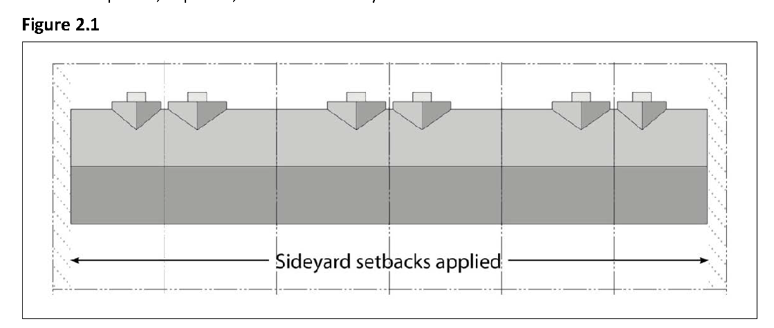
Narrow lots. For lots less than 100 feet in width, each side yard shall be a minimum of ten (10) percent of the lot width, or five (5) feet, whichever is greater.
b.
Coverage exception. Greater coverage on individual lots may be allowed with clustered development provided the overall site coverage of the entire development does not exceed the standard.
(1)
Front yards or setbacks. Where more than 60 percent of such portion of the lineal frontage of lots improved with residential buildings within any block is comprised of lots with less than the minimum front yard requirement, then the minimum front yard requirement for other residential buildings in such block may be reduced to the average of the actual front yards of all of the lots in such block with existing residential buildings, counting those which have front yards of greater depth than the minimum requirement.
(2)
Existing structures. When the existing side yard setback is less than required in this title, additions to such structures may conform to the existing setback, provided that the addition does not encroach closer to the property line than the existing structure.
(3)
Attached single-family dwellings. Required setbacks apply to the ends of rows of attached single-family dwellings (examples of attached single-family dwellings include duplexes, triplexes, and townhouses).
(4)
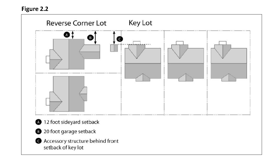
Street side yard - reversed corner lots. Reversed corner lots shall have a minimum street side yard width of twelve (12) feet or the required front yard requirement of the lot in the rear (key lot), whichever is less. The setback shall be twenty (20) feet for garages accessed from the side street. No accessory structure shall project beyond the extension of the required front yard line of the lot in the rear (key lot), unless under one hundred twenty (120) square feet and not permanently affixed to the ground. If a structure requires a building permit it is not permitted in this required setback. Structures in this setback must be behind a 6-foot solid fence as permitted under the planning and zoning code.
(5)
Increased yard for certain institutional uses. Any building erected or used for a school, government, or other institutional use mentioned elsewhere in this chapter, shall be located at least fifteen (15) feet from any Residential district, notwithstanding any lesser requirement in the district where located, provided such building shall not be required to be located more than five (5) feet from any lot line adjacent to any alley. The Planning Commission may waive this requirement for accessory buildings to provide reasonable accommodation.
(6)
Rear yards. In RMD and RHD districts, open space with a minimum dimension of ten (10) feet exclusive of setbacks, parking, driveways, or other designated use and is provided other than on the rear one-third of the lot, shall be considered as a credit against this requirement. In multiple-family projects, no vehicle parking facilities or driveways shall be permitted to occur in the required 750 square feet. This requirement may be modified with a Conditional Use Permit when the City Council finds that sufficient private open area has been provided with the overall development for the outdoor enjoyment of the development's residents.
(c)
Residential multi-family development regulations. Each multiple family residential project with two (2) or more dwelling units on a single lot shall be developed in accordance with the following standards.
(1)
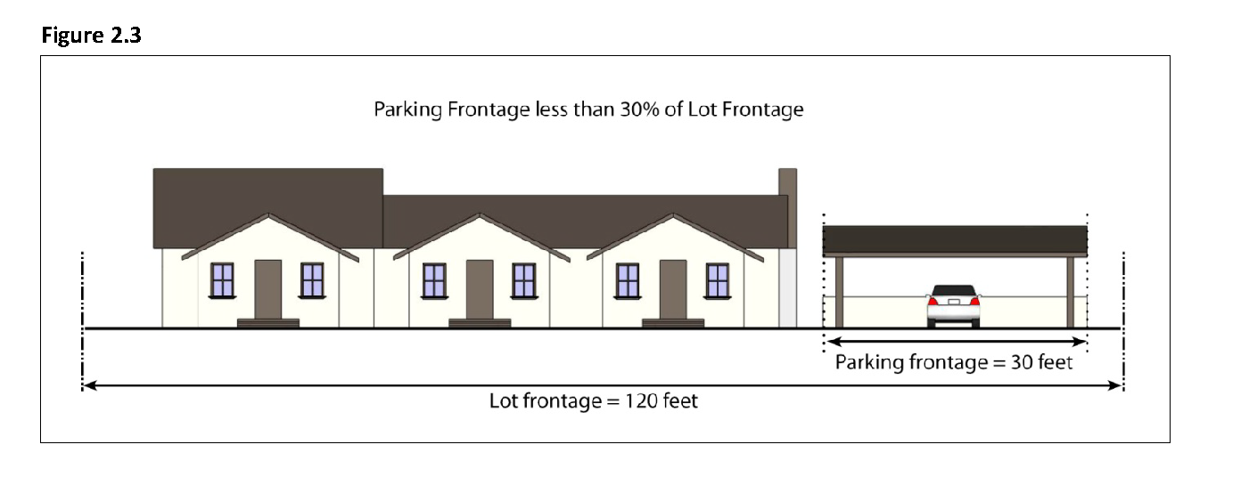
Parking and garage frontage limitation. The total frontage of parking areas visible from the street, including open parking, carports, and garages, but excluding underground parking and parking located behind buildings, shall not exceed thirty (30) percent of the lot frontage. The Community Development Director may approve a modification to this standard where existing development patterns or topographic features make it infeasible to limit parking and garage frontage to thirty (30) percent of lot frontage. Parking areas not visible from the street are not subject to this limitation.
(2)
Building entrances.
a.
Orientation. All units located along public rights-of-way must have the primary entrance facing this right-of-way. Exceptions to this requirement may be approved for projects where multiple-family housing is located on four-lane streets carrying high traffic volumes and/or streets that do not allow on-street parking. In such cases, the project may be oriented around courtyards.
b.
Projection or recess. Building entrances for multi-family buildings must have a roofed projection (such as a porch) or recess with a minimum depth of at least five (5) feet and minimum area of fifty (50) square feet. Alternative designs that create an enhanced entry feature facing the street, such as a trellis or landscaped courtyard entry, may be approved.
(3)
Architectural articulation. All multiple-family residential buildings shall include adequate design features to create visual variety and avoid a large-scale and bulky appearance. Long facades shall be broken up into smaller modules. This requirement can be met by using two (2) or more of the following methods.
a.
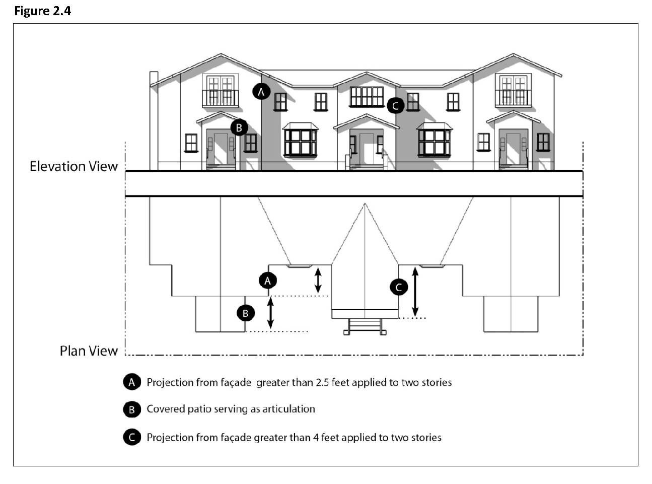
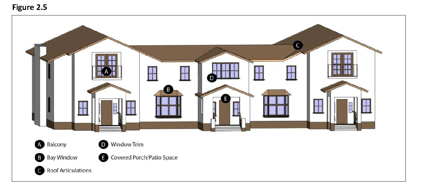
Façade articulation. All street-facing facades shall have at least one horizontal or vertical projection or recess at least four (4) feet in depth, or two (2) projections or recesses at least two and one-half (2.5) feet in depth, for every twenty-five (25) horizontal feet of wall. If located on a building with two (2) or more stories, the articulated elements must be greater than one story in height, and may be grouped rather than evenly spaced in twenty-five (25) foot modules. Building entrances and front porches and projections into required yards such as stoops, bays, overhangs, fireplaces, and trellises may count towards meeting this requirement.
b.
Variable roof form. Variable roof forms incorporated into the building design, and no more than two (2) side-by-side units may be covered by one unarticulated roof. Articulations may be accomplished by changing roof height, offsets, and direction of slope, and by introducing elements such as dormers, towers, or parapets.
c.
Façade detailing and materials. All visible building façades shall incorporate details, such as window trim, window recesses, cornices, changes in materials or other design elements, in an integrated composition. Each side of a building that is visible from a public right-of-way shall be designed with a complementary level of detailing and quality of materials.
d.
Use of balconies, bay windows, and other such projections or recesses. The building shall incorporate balconies, bay windows, entry porches or other projections and recesses in a pattern that creates architectural interest across the length of the façade.
(4)
Open space and pedestrian connections. Private and common areas shall be provided in accordance with this section. Private areas typically consist of balconies, decks, patios, and fenced yards. Common areas typically consist of landscaped areas, patios, swimming pools, barbeque areas, playgrounds, trees, bushes, groundcover, and turf. All areas not improved with buildings, parking, vehicular accessways, trash enclosures, and similar items shall be developed as common areas with the types of attributes described above.
a.
Minimum dimensions. Open space shall have the following minimum dimensions in order to count towards open space requirements:
1.
Open space located on the ground level (e.g., yards, decks, patios): ten (10) feet by ten (10) feet.
2.
Open space located above ground level (e.g., balconies): five (5) feet by five (5) feet.
b.
Usability. A surface shall be provided that allows convenient use for outdoor living and/or recreation. Such surface shall be a combination of lawn, garden, flagstone, wood planking, concrete, or other serviceable, dust-free surfacing. Slope shall not exceed ten (10) percent.
c.
Accessibility.
1.
Private open space. The space shall be accessible to only one residential unit by a doorway to a habitable room or hallway.
2.
Common open space. The space shall be accessible to all the residential units on the lot. It shall be served by any stairway or other accessway qualifying as an egress facility from a habitable room.
d.
Pedestrian connections. Pedestrian ways five (5) feet or more in width may be required:
1.
To connect all buildings on the site to one another, to on-site automobile and bicycle parking areas, and to any on-site open space areas or pedestrian amenities.
2.
Through the middle of blocks that are more than 600 feet in length;
3.
To connect cul-de-sac or dead-end streets;
4.
To provide access to playgrounds, parks, schools, shopping centers, or similar community facilities; and/or
5.
To provide access to trails or bikeways shown in the General Plan.
6.
All outdoor walkways shall be illuminated in accordance with the requirements of Section 9-4.206, Lighting and Illumination, of this title.
7.
All sidewalks shall conform to the requirements of Title 7, Chapter 2, Sidewalks, Crosswalks, Curbs, Gutters and Driveways, of the Municipal Code. Street trees shall be provided per the requirements of Title 7, Chapter 3, Trees and Shrubs, of the Municipal Code.
(5)
Minimum courtyard dimensions. Courtyards surrounded by building walls on three (3) sides shall have a minimum length and width of twenty (20) feet by twenty (20) feet.
(Ord. No. 776, § 1(Exh. A), eff. 9-5-2014; Ord. No. 862, § 2, eff. 11-2-2023)
Sec. 9-2.301. - Purpose.
(a)
The specific purposes of the "Commercial" Districts are to:
(1)
Provide for a full range of commercial uses.
(2)
Strengthen the city's economic base and provide employment opportunities for residents of the city.
(3)
Ensure the provision of services and facilities needed to accommodate planned population densities.
(4)
Identify appropriate standards for new development.
(b)
Additional purposes of each "Commercial" District:
(1)
(CG) General Commercial. To encourage areas of concentrated retail, generally located adjacent to major streets, such as Elm Avenue at Polk Street. The CG designation permits food, drug, clothing and other retail uses and services including small restaurants, laundry outlets among other services. Hotels, motels, and medical and professional offices are allowed in CG areas, subject to zoning provisions.
(2)
(CR) Retail Centers. To maintain areas for regional shopping centers located at major circulation intersections. Large format or "big box" retail and auto sales as well as travel related services, such as hotels and gas stations are allowed.
(3)
(CS) Service Commercial. To provide areas for retail and service uses that usually requires a single-purpose trip to visit one commercial establishment. Repair facilities, building materials, industrial suppliers, auto and accessory dealers, light manufacturing/ distributing, and wholesale and/or retail outlets are allowed in this designation.
(4)
(MX) Mixed-Use. To provide areas for either horizontal or vertical mixed-use development consisting of commercial, service, office, and residential uses. Commercial uses are primarily retail or office in nature. All uses allowed in the Commercial General (CG) and Commercial Service (CS) designations are generally allowed in the MX designation. The Community Development Director may determine that Mixed-Use residential/commercial development may be subject to the Planned Development Combining Designation (P-D) zoning requirements in Chapter 3, Article 5. Residential uses on a given parcel shall not exceed fifteen (15) dwelling units/gross acre.
(Ord. No. 776, § 1(Exh. A), eff. 9-5-2014)
Sec. 9-2.302. - Land use regulations.
(a)
Table 2.5 below prescribes the land use regulations for "Commercial" Districts. The regulations for each district are established by letter designations as follows:
(1)
"Yes" designates permitted uses.
(2)
"CUP" designates use classifications that are permitted after review and approval of a Conditional Use Permit by the Planning Commission.
(3)
"(#)" numbers in parentheses refer to specific limitations listed at the end of the table.
(4)
"No" designates uses that are not permitted.
(b)
Land use classifications are defined in Chapter 1, Article 2 "Definitions" of this title. In cases where a proposed specific land use or activity is not defined, an application shall be made to the Community Development Director, and the Planning Commission shall approve or deny the assignment of the proposed land use or activity to a classification that is substantially similar in character. Use classifications and subclassifications not listed in the table or not found to be substantially similar to the uses below are prohibited. The table also notes additional use regulations that apply to various uses. Section numbers in the right hand column refer to other sections of this chapter.
(Ord. No. 776, § 1(Exh. A), eff. 9-5-2014; Ord. No. 798, § 1, eff. 2-4-2017; Ord. No. 802, § 2, eff. 4-14-2018; Ord. No. 804, § 3, eff. 2-3-2018; Ord. No. 840, § 1, eff. 8-15-2020; Ord. No. 850, § 4, 5, 7, eff. 3-17-2022; Ord. No. 859, § 2, eff. 5-18-2023; Ord. No. 860, § 3, eff. 6-1-2023; Ord. No. 868, § 3, eff. 9-19-2024)
Sec. 9-2.303. - Development regulations.
(a)
Base development regulations. Table 2.6 prescribes the development standards for the Commercial Districts. Additional regulations are denoted in the right hand column. Section numbers in this column refer to other sections of this chapter, while individual letters refer to subsections that directly follow the table.
(b)
Additional development standards.
(1)
Exceptions to minimum lot size, width, and depth. An exception to the minimum lot size, width and depth may be allowed with a Conditional Use Permit if a Master Plan for the site is submitted concurrently with the subdivision application. The plan shall indicate proposed land uses, building footprints, driveways, fire lanes, parking areas, landscaped areas, buffer yards, and other site features. The City Council must find that the proposed subdivision will create lots that are adequately sized, shaped, and oriented to meet or exceed all requirements for yards, buffer yards, parking, landscaping, fire lanes, and other requirements of this title.
(2)
Transitional standards. Where a site is adjacent to a Residential district, the following standards apply:
a.
Height.
1.
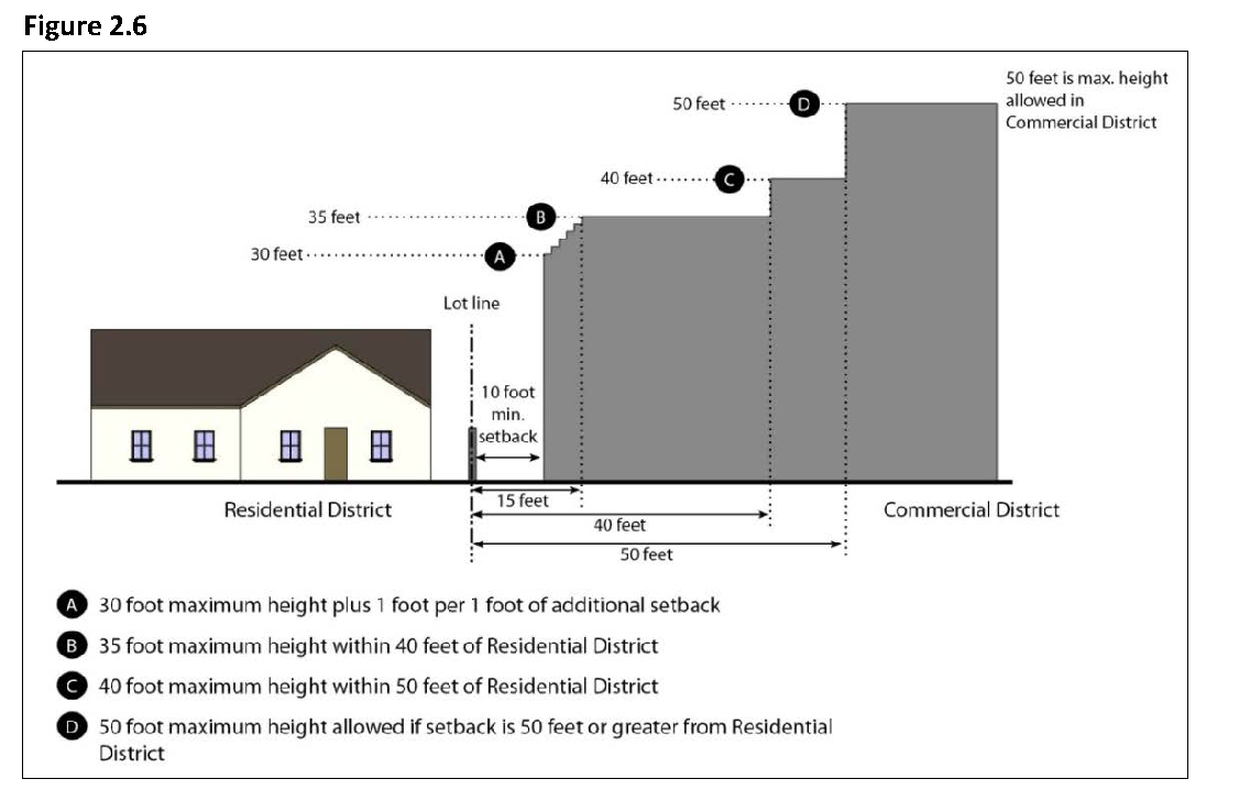
The maximum height within forty (40) feet of a Residential district boundary is thirty-five (35) feet. The maximum height within fifty (50) feet of a Residential district boundary is forty (40) feet.
2.
Buildings exceeding thirty (30) feet in height must be set back or stepped back one foot from the required interior side and rear setback lines for every foot of height above thirty (30) feet.
b.
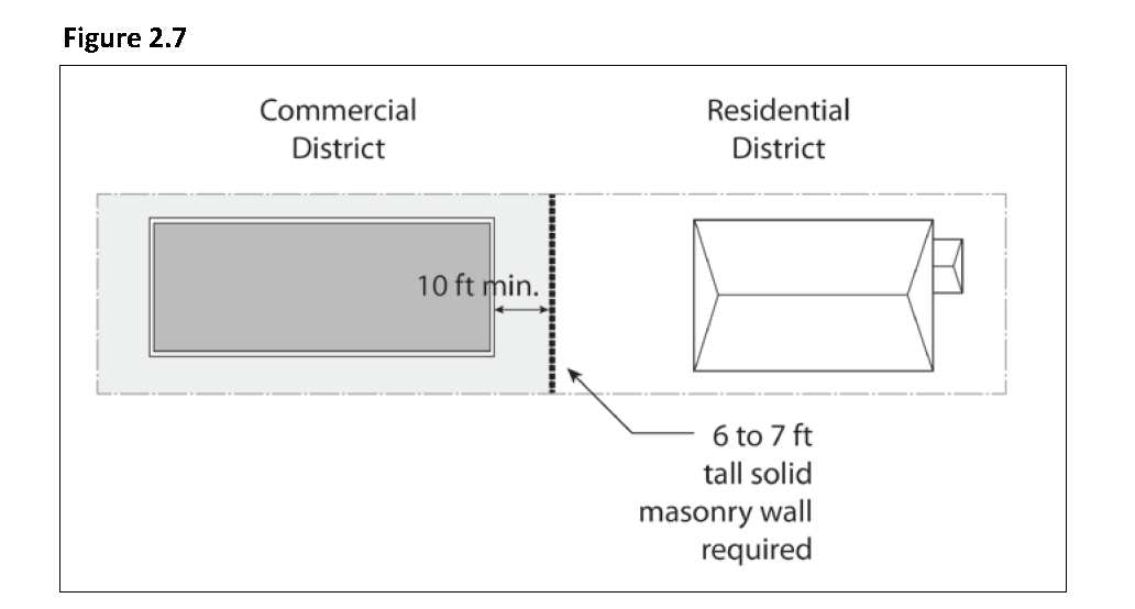
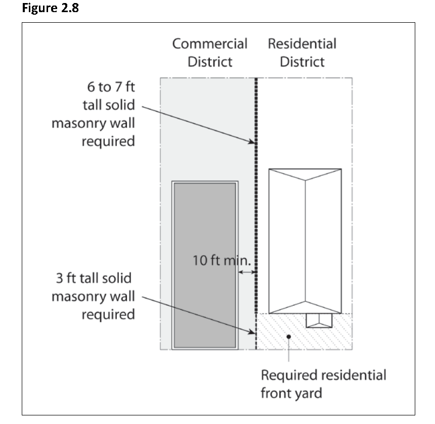
Fences and yards. Where a parcel in a commercial district is adjacent to a residential district, a solid masonry wall not less than six (6) feet nor more than seven (7) feet in height shall be erected along such property line, as follows:
1.
Where the district boundary is at a rear lot line that is not on a right-of-way line, the wall shall be on that line.
2.
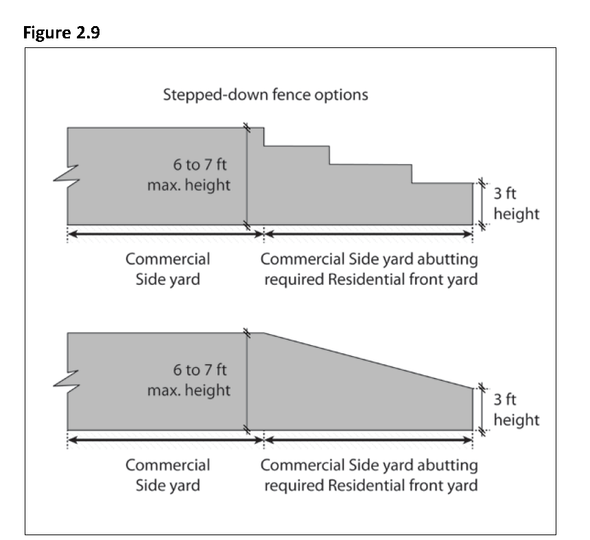
Where the district boundary is on a side lot line that is not on a right-of-way line, the required wall shall be on, or parallel with, such side lot line. Such wall shall be reduced in height to three (3) feet when next to the required front yard of the adjacent residential district.
3.
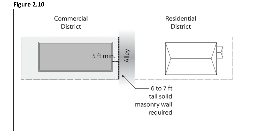
If the district boundary is an alley, the wall shall be along the length of the commercial property line against the alley. No driveway openings into the alley are allowed.
4.
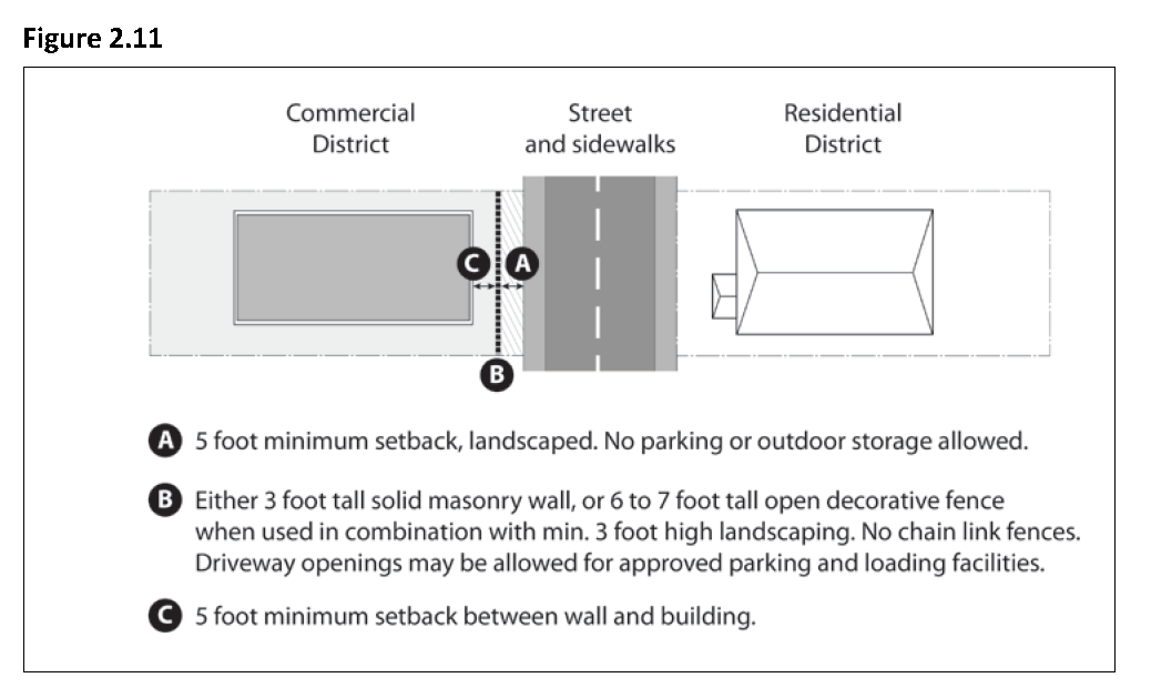
Exception: If the district boundary is a street, any wall constructed along such street in the Commercial District shall be set back from the property line a distance of five (5) feet. Such walls may include solid masonry walls of three (3) feet in height, or open decorative fences between six (6) and seven (7) feet in height provided that landscaping of minimum three (3) feet height is in place at the start of operations. Chain link fences are not allowed. The space between the wall and the property line shall be landscaped and maintained, and no parking and outdoor storage shall be allowed. Driveway openings may be allowed into the street for approved parking and loading facilities. Structures shall be set back at least an additional five (5) feet from the wall. Outdoor storage is allowed within the setback between the wall and the structure, provided that it is screened from public view.
(3)
Pedestrian access between adjacent commercial developments. If a commercial property shares a property line with another commercial property, pedestrian access shall be provided at the shared property line, to allow for increased walkability and connectivity between commercial properties.
(4)
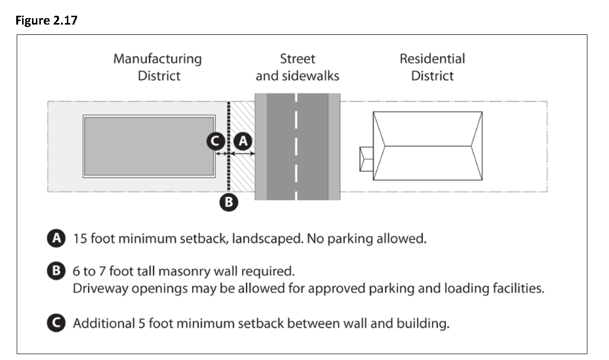
Increased yard for commercial properties adjacent to Residential Districts. If a commercial property shares a property line with a Residential district, there shall be minimum yard setback of ten (10) feet on the commercial property from the shared property line. If a commercial property is across an alley or street from a Residential district, there shall be an additional minimum yard setback of five (5) feet for any structure on the commercial property, measured from the required wall set back from the subject property line.
(5)
Increased yard for certain institutional uses. Any building erected or used for a school, government, or other institutional use mentioned elsewhere in this title, shall be located at least fifteen (15) feet from a Residential district, notwithstanding any lesser requirement in the district where located, provided such building shall not be required to be located more than five (5) feet from any lot line adjacent to any alley. The City Council may waive this requirement for accessory buildings to provide reasonable accommodation.
(6)
Downtown design guidelines. Development in commercial properties that are within the Downtown Overlay District are also subject to the Downtown Overlay District and Downtown Design Guidelines.
(7)
Pedestrian connections. Pedestrian ways five (5) feet or more in width may be required:
a.
To connect all buildings on the site to one another, to on-site automobile and bicycle parking areas, and to any on-site open space areas or pedestrian amenities.
b.
Through the middle of blocks that are more than 600 feet in length;
c.
To connect cul-de-sac or dead-end streets;
d.
To provide access to other community facilities such as shopping centers; and/or
e.
To provide access to trails or bikeways shown in the General Plan.
f.
All outdoor walkways shall be illuminated in accordance with the requirements of Section 9-4.206, Lighting and Illumination, of this title.
g.
All sidewalks shall conform to the requirements of Title 7, Chapter 2, Sidewalks, Crosswalks, Curbs, Gutters and Driveways, of the Municipal Code. Street trees shall be provided per the requirements of Title 7, Chapter 3, Trees and Shrubs, of the Municipal Code.
h.
Primary pedestrian routes and access points shall be clearly differentiated from driveways, parking aisles, and parking and loading spaces through the use of elevation changes, a different paving material, or another method. Where a required walkway is parallel and adjacent to an auto travel lane, it shall be raised or separated from the auto travel lane by a raised curb at least four (4) inches high, bollards, or other physical barrier.
(c)
Mixed-Use standards. In the Mixed-Use district, residential uses may be permitted if all of the following conditions are met:
(1)
Residential uses ancillary. Residential land uses are required to be ancillary to a primary commercial use on the subject site(s). Residential-only developments are prohibited in the Mixed-Use district.
(2)
Area of residential land uses. The combined area of all ground floor residential land uses, which includes residential buildings and residential-only parking areas, shall occupy less than fifty (50) percent of the site's total land area.
(3)
Location of residential units. Residential units are permitted at the side, rear and/or above the commercial uses.
(4)
Residential building entry and orientation requirements.
a.
Entrances to residential units shall be physically separated from the entrance to the permitted commercial uses and clearly marked with a physical feature incorporated into the building or an appropriately scaled element applied to the facade.
b.
Garages or other enclosed or covered parking facilities for use by residents shall not be significantly visible feature from the public street or from adjacent bikeways, sidewalks or other pedestrian amenities. Residential parking shall be clearly signed and reserved for the residents.
(5)
Pedestrian connections. Pedestrian ways five (5) feet or more in width may be required:
a.
To connect all buildings on the site to one another, to on-site automobile and bicycle parking areas, and to any on-site open space areas or pedestrian amenities.
b.
Through the middle of blocks that are more than 600 feet in length;
c.
To connect cul-de-sac or dead-end streets;
d.
To provide access to playgrounds, parks, schools, shopping centers, or similar community facilities; and/or
e.
To provide access to trails or bikeways shown in the General Plan.
f.
All outdoor walkways shall be illuminated in accordance with the requirements of Section 9-4.206, Lighting and Illumination, of this title.
g.
All sidewalks shall conform to the requirements of Title 7, Chapter 2, Sidewalks, Crosswalks, Curbs, Gutters and Driveways, of the Municipal Code. Street trees shall be provided per the requirements of Title 7, Chapter 3, Trees and Shrubs, of the Municipal Code.
h.
Primary pedestrian routes and access points shall be clearly differentiated from driveways, parking aisles, and parking and loading spaces through the use of elevation changes, a different paving material, or another method. Where a required walkway is parallel and adjacent to an auto travel lane, it shall be raised or separated from the auto travel lane by a raised curb at least four (4) inches high, bollards, or other physical barrier.
(6)
Usable open space. A minimum of 150 square feet of usable open space is required per residential unit and may be provided as common or private open space on balconies or patios.
(7)
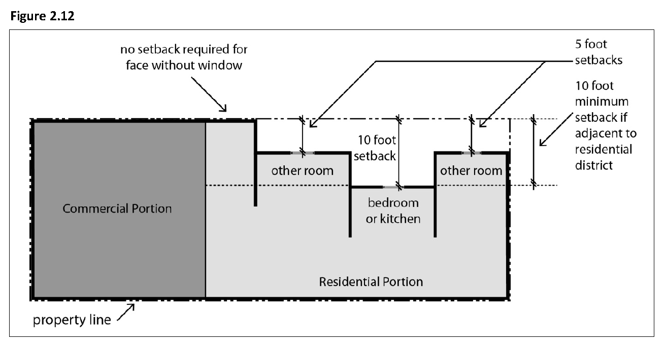
Side and rear yard setback requirements for residential units. In order to provide light and air for residential units in mixed-use buildings, the following minimum setbacks apply to the residential portion of the building(s). In any case in which an interior yard is also adjacent to a Residential district boundary, the following setbacks shall apply.
a.
Five (5) feet for any wall with windows.
b.
Ten (10) feet for any wall with bedroom or kitchen windows.
(Ord. No. 776, § 1(Exh. A), eff. 9-5-2014)
Sec. 9-2.401. - Purpose.
(a)
The specific purposes of the "Manufacturing/Business" Districts are to:
(1)
Provide for large and small-scale businesses involved in manufacturing, distribution or services.
(2)
Provide appropriate areas of the city where employment uses can locate and operate without significant conflicts with other land uses.
(3)
Strengthen the City's economic base and provide employment opportunities for residents of the City.
(4)
Ensure the provision of services and facilities needed to accommodate planned population densities.
(b)
Additional purposes of each "Manufacturing/Business" District:
(1)
MBL Light Manufacturing/Business. To provide areas for a mix of light industrial, secondary office, bulk retail, and service uses. This district allows for uses such as, warehouse, mini-storage, research and development, wholesale, bulk retail, and office space with limited customer access. This district also allows for other uses, such as commercial recreation, distribution centers, or other uses that require large, warehouse-style buildings. Small-scale retail and service uses serving local employees and visitors are permitted as secondary uses.
(2)
MBH Heavy Manufacturing/Business. To provide areas for businesses which have the potential to create adverse visual, noise, or other impacts to adjoining public and residential properties. This district allows for uses such as warehousing, manufacturing, food processing, distribution, with support commercial services and ancillary office space. No retail uses are allowed.
(Ord. No. 776, § 1(Exh. A), eff. 9-5-2014)
Sec. 9-2.402. - Land use regulations.
(a)
Table 2.7 below prescribes the land use regulations for "Commercial" Districts. The regulations for each district are established by letter designations as follows:
(1)
"Yes" designates permitted uses.
(2)
"CUP" designates use classifications that are permitted after review and approval of a Conditional Use Permit by the Planning Commission.
(3)
"(#)" numbers in parentheses refer to specific limitations listed at the end of the table.
(4)
"No" designates uses that are not permitted.
(b)
Land use classifications are defined in Chapter 1, Article 2 "Definitions" of this title. In cases where a proposed specific land use or activity is not defined, an application shall be made to the Community Development Director, and the Planning Commission shall approve or deny the assignment of the proposed land use or activity to a classification that is substantially similar in character. Use classifications and subclassifications not listed in the table or not found to be substantially similar to the uses below are prohibited. The table also notes additional use regulations that apply to various uses. Section numbers in the right hand column refer to other sections of this chapter.
(Ord. No. 776, § 1(Exh. A), eff. 9-5-2014; Ord. No. 804, § 2, eff. 2-3-2018; Ord. No. 850, § 2, 6, eff. 3-17-2022; Ord. No. 868, § 4, eff. 9-19-2024)
Sec. 9-2.403. - Development regulations.
(a)
Base development regulations. Table 2.8 below prescribes the development standards for the Manufacturing/Business Districts. Additional regulations are denoted in the right hand column. Section numbers in this column refer to other sections of this chapter, while individual letters refer to subsections that directly follow the table.
(b)
Additional development standards.
(1)
Exceptions to minimum lot size, width, and depth. An exception to the minimum lot size, width and depth may be allowed with a Conditional Use Permit if a master plan for the site is submitted concurrently with the subdivision application. The plan shall indicate proposed land uses, building footprints, driveways, fire lanes, parking areas, landscaped areas, buffer yards, and other site features. The City Council must find that the proposed subdivision will create lots that are adequately sized, shaped, and oriented to meet or exceed all requirements for yards, buffer yards, parking, landscaping, fire lanes, and other requirements of this title.
(2)
Transitional standards.
a.
Height.
1.
The maximum height within forty (40) feet of a Residential district boundary is thirty-five (35) feet. The maximum height within fifty (50) feet of a Residential district boundary is forty (40) feet.
2.
Buildings exceeding thirty-five (35) feet in height must be set back or stepped back one foot from the required interior side and rear setback lines for every foot of height above thirty-five (35) feet.
b.
Fences and yards. Where a site in a Manufacturing/Business district is adjacent to a Residential district, a solid masonry wall not less than six (6) feet nor more than seven (7) feet in height shall be erected along such property line, as follows:
1.
Where the district boundary is at a rear lot line that is not on a right-of-way line, the wall shall be on that line. No parking and loading is allowed in the rear yard. Outdoor storage may be allowed within the rear yard, provided that it is screened from public view.
2.
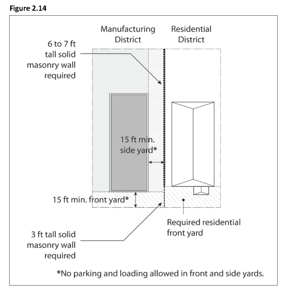
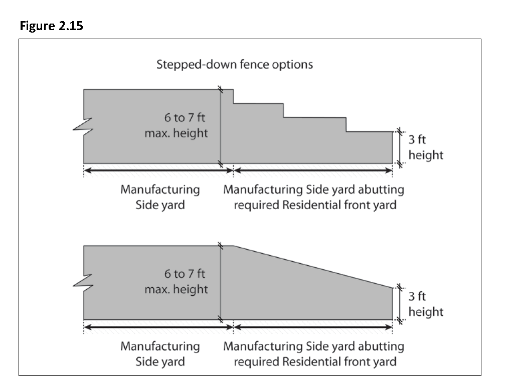
Where the district boundary is on a side lot line that is not on a right-of-way line, the required wall shall be on, or parallel with, such side lot line. Such wall shall be reduced in height to three (3) feet when next to the required front yard of the adjacent residential district. No parking and loading is allowed in the side and front yard adjacent to the Residential district. Outdoor storage may be allowed within the side yard that is adjacent to the Residential district, provided that it is screened from public view.
3.
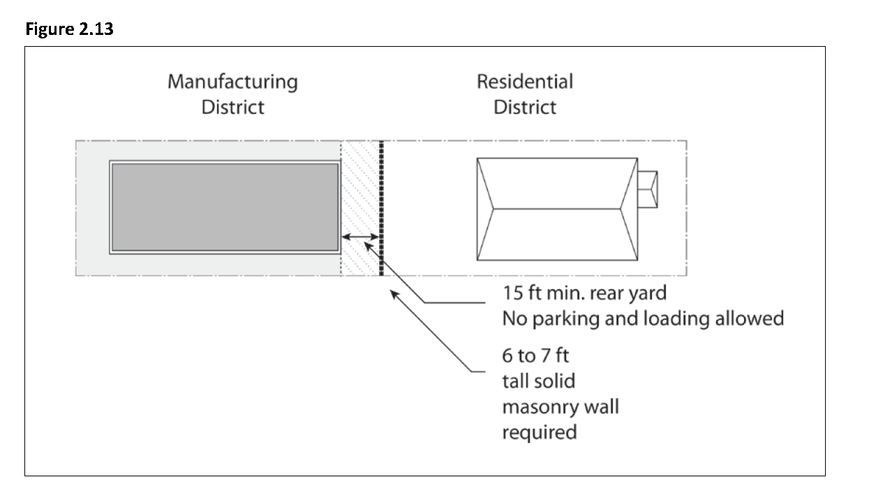
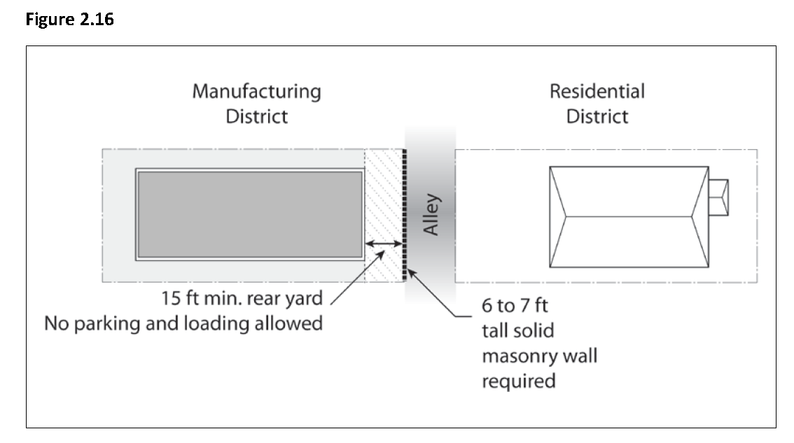
If the district boundary is an alley, the wall shall be along the length of the commercial property line against the alley. No driveway openings are allowed into the alley. A fifteen (15) foot rear yard setback is required between the building and the property line. No parking and loading is allowed in the rear yard. Outdoor storage may be allowed in the rear yard, provided that it is screened from public view.
4.
Exception: If the district boundary is a street, any wall constructed along such street shall be set back from the property line a distance of five (5) feet. Such walls may include solid masonry walls of three (3) feet in height, or open decorative fences between six (6) and seven (7) feet in height provided that landscaping of minimum three (3) feet height is in place at the start of operations. Chain link fences are not allowed. The space between the wall and the property line shall be landscaped and maintained; no parking and no outdoor storage shall be allowed. Outdoor storage may be allowed within the setback, provided that it is screened from public view. Driveway openings may be allowed into the street for approved parking and loading facilities. Structures shall be set back at least an additional five (5) feet from the wall. Outdoor storage is allowed within the setback between the wall and the structure, provided that it is screened from public view.
(3)
Increased yard for certain institutional uses. Any building erected or used for a school, government, or other institutional use mentioned elsewhere in this title, shall be located at least fifteen (15) feet from a Residential district, notwithstanding any lesser requirement in the district where located, provided such building shall not be required to be located more than five (5) feet from any lot line adjacent to any alley. The Community Development Director may waive this requirement for accessory buildings to provide reasonable accommodation.
(Ord. No. 776, § 1(Exh. A), eff. 9-5-2014)
Sec. 9-2.404. - Supplemental regulations.
(a)
Setback and screening requirements.
(1)
Setback and screening from highways. Any site in a Manufacturing/Business district that is fully or partially located within 200 feet of a state highway shall provide a landscaped area at least fifteen (15) feet deep between the highway right-of-way and any building or parking area for the length of the site frontage facing toward the highway. At least two (2) fifteen (15) gallon trees shall be provided for every twenty-five (25) feet of site frontage toward the highway.
(2)
Parking setback and screening from public right-of-way. The following requirements apply to frontages on arterial or collector streets:
a.
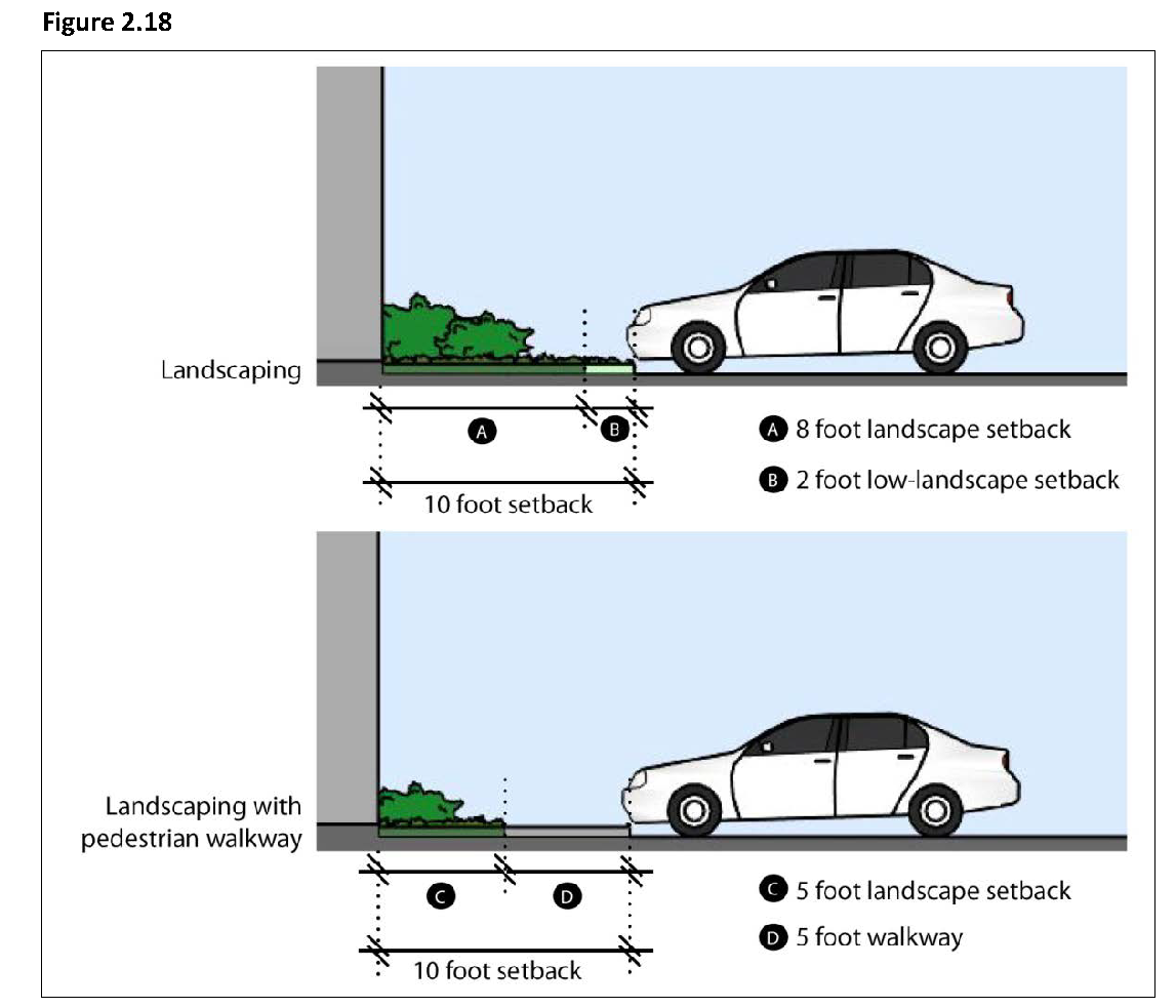
Landscaped setback of parking from right-of-way. Any parking area located between a building and right-of-way must be set back a minimum of fifteen (15) feet from the street-facing lot line, and the setback area must be landscaped. Two (2) feet of the landscaped setback shall be low growing plants to allow for vehicle overhang.
b.
Screening of parking areas. Any parking area located between a building and right-of-way, or within fifty (50) feet of and visible from a right-of-way, must be screened by a wall or berm at least two and one-half (2.5) feet high. A screening wall meeting this requirement shall be composed of brick, stone, stucco, or other quality durable material approved by the Community Development Director, and shall include a decorative cap or top finish as well as edge detail at wall ends. Plain concrete blocks are not allowed as a screening wall material unless capped and finished with stucco or other material approved by the Community Development Director.
(3)
Landscaped setback of parking from on-site buildings. In the MBL districts, parking spaces must be set back at least ten (10) feet from any building wall, and the area between parking and building must be landscaped. Two (2) feet of the landscaped setback shall be low growing plants to allow for vehicle overhang. Up to five (5) feet of this required landscape area may be occupied by a paved pedestrian walkway.
(b)
Pedestrian orientation. Pedestrian oriented design shall be provided in the MBL district according to the following standards:
(1)
Pedestrian-oriented design. The following design elements at ground floor street frontage level shall be incorporated into the design of the structure in order to provide pedestrian orientation.
(2)
Articulated facades. Buildings shall provide adequate architectural articulation and detail to avoid a bulky and "box-like" appearance. The building façade at ground floor street frontage level shall be articulated with measures such as, indentation in plane, change of materials in a complimentary manner, sensitive composition and juxtaposition of openings and solid wall and/or building frame, and projecting elements, such as awnings or marquees, to provide shade and shelter.
(3)
Entrances. All ground floor tenant spaces with at least twenty-five (25) feet of frontage facing a public or private street shall have at least one building entrance oriented to the adjacent street. Such an entrance shall open directly to the outside and shall not require a pedestrian to first pass through a garage, parking lot or loading area to gain access.
(4)
Signage. Signage shall be integrated with the design of the building and oriented and scaled to the pedestrian, where applicable.
(5)
Other pedestrian-oriented design elements. Other pedestrian-oriented design elements such as street furniture or other seating surfaces on private property and other design amenities scaled to the pedestrian such as awnings, drinking fountains, arcades, colonnades, plazas, non-commercial community bulletin boards, public or private art, and alternative paving materials may be provided in areas of pedestrian access. Compliance may also be demonstrated by pedestrian-oriented design elements that are provided off-site.
(c)
Pedestrian access. On-site pedestrian circulation and access shall be provided according to the following standards. Pedestrian ways five (5) feet or more in width may be required:
(1)
To connect all buildings on the site to one another, to on-site automobile and bicycle parking areas, and to any on-site open space areas or pedestrian amenities.
(2)
To a public sidewalk on each street frontage. Such walkway shall be the shortest practical distance between the main entry and sidewalk.
(3)
To adjoining neighborhood residential and commercial streets. These connections shall be direct, convenient, remain accessible at all times, and not be gated.
(4)
Through the middle of blocks that are more than 600 feet in length;
(5)
To connect cul-de-sac or dead-end streets;
(6)
To provide access to playgrounds, parks, schools, shopping centers, or similar community facilities; and/or
(7)
To provide access to trails or bikeways shown in the General Plan.
(8)
All outdoor walkways shall be illuminated in accordance with the requirements of Section 9-4.206, Lighting and Illumination, of this title.
(9)
All sidewalks shall conform to the requirements of Title 7, Chapter 2, Sidewalks, Crosswalks, Curbs, Gutters and Driveways, of the Municipal Code. Street trees shall be provided per the requirements of Title 7, Chapter 3, Trees and Shrubs, of the Municipal Code.
(10)
Primary pedestrian routes and access points shall be clearly differentiated from driveways, parking aisles, and parking and loading spaces through the use of elevation changes, a different paving material, or another method. Where a required walkway is parallel and adjacent to an auto travel lane, it shall be raised or separated from the auto travel lane by a raised curb at least four (4) inches high, bollards, or other physical barrier.
(d)
Driveway restrictions; location of parking.
(1)
Access. Access shall not be provided from a residential street where alternate access is available.
(2)
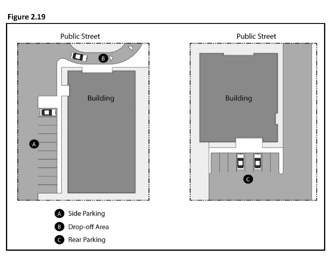
Location of parking. Parking areas shall be located at the rear of the site or at the side of the building, except for drop-off areas which may be located at the primary entry.
(Ord. No. 776, § 1(Exh. A), eff. 9-5-2014)
Sec. 9-2.501. - Purpose.
(a)
The specific purpose of the "Public Facilities" and "Recreation" Districts is to ensure the provision of services and facilities needed to accommodate planned population densities, employment intensities, and traffic regulation.
(b)
Additional purposes of each District:
(1)
Public Facilities (PF). To provide areas for needed public and institutional facilities, including, but not limited to City, County and other government agency properties including post offices, the Civic Center, public schools, public playgrounds and fire stations. Public utility right-of-ways are also included.
(2)
Recreation (REC). To provide areas for public and private recreational facilities including but not limited to public parks, golf course and equestrian centers.
(Ord. No. 776, § 1(Exh. A), eff. 9-5-2014)
Sec. 9-2.502. - Land use regulations.
(a)
Table 2.9 below prescribes the land use regulations for the "Public Facilities" and "Recreation" Districts. The regulations for each district are established by letter designations as follows:
(1)
"Yes" designates permitted uses.
(2)
"CUP" designates use classifications that are permitted after review and approval of a Conditional Use Permit by the Planning Commission.
(3)
"(#)" numbers in parentheses refer to specific limitations listed at the end of the table.
(4)
"No" designates uses that are not permitted.
(b)
Land use classifications are defined in Chapter 1, Article 2 "Definitions" of this title. In cases where a specific land use or activity is not defined, an application shall be made to the Community Development Director, and the Planning Commission shall approve or deny the assignment of the proposed land use or activity to a classification that is substantially similar in character. Use classifications and subclassifications not listed in the table or not found to be substantially similar to the uses below are prohibited. The table also notes additional use regulations that apply to various uses. Section numbers in the right hand column refer to other sections of this chapter.
(Ord. No. 776, § 1(Exh. A), eff. 9-5-2014)
Sec. 9-2.503. - Development regulations.
(a)
Base development regulations. Table 2.10 prescribes the development standards for the "Public Facilities" and "Recreation" Districts. Additional regulations are denoted in the right hand column. Section numbers in this column refer to other sections of this chapter, while individual letters refer to subsections that directly follow the table.
(b)
Additional development regulations.
(1)
Transitional standards. Where a site is adjacent to a Residential district, the following standards apply:
a.
The maximum height within forty (40) feet of a Residential district boundary is thirty-five (35) feet. The maximum height within fifty (50) feet of a Residential district boundary is forty (40) feet.
b.
Buildings exceeding thirty (30) feet in height must be set back or stepped back one foot from the required interior side and rear setback lines for every foot of height above thirty (30) feet.
(2)
Determining FAR. When determining the FAR of the PF District, medical laboratories, operating rooms, meeting rooms, conference facilities, cafeteria facilities, and recreational facilities are excluded from floor area.
(3)
Pedestrian access. On-site pedestrian circulation and access shall be provided according to the following standards. Pedestrian ways five (5) feet or more in width may be required:
a.
To connect all buildings on the site to one another, to on-site automobile and bicycle parking areas, and to any on-site open space areas or pedestrian amenities.
b.
To a public sidewalk on each street frontage. Such walkway shall be the shortest practical distance between the main entry and sidewalk.
c.
To adjoining neighborhood residential and commercial streets. These connections shall be direct, convenient, remain accessible at all times, and not be gated.
d.
Through the middle of blocks that are more than 600 feet in length;
e.
To connect cul-de-sac or dead-end streets;
f.
To provide access to playgrounds, parks, schools, shopping centers, or similar community facilities; and/or
g.
To provide access to trails or bikeways shown in the General Plan.
h.
All outdoor walkways shall be illuminated in accordance with the requirements of Section 9-4.206, Lighting and Illumination, of this title.
i.
All sidewalks shall conform to the requirements of Title 7, Chapter 2, Sidewalks, Crosswalks, Curbs, Gutters and Driveways, of the Municipal Code. Street trees shall be provided per the requirements of Title 7, Chapter 3, Trees and Shrubs, of the Municipal Code.
j.
Primary pedestrian routes and access points shall be clearly differentiated from driveways, parking aisles, and parking and loading spaces through the use of elevation changes, a different paving material, or another method. Where a required walkway is parallel and adjacent to an auto travel lane, it shall be raised or separated from the auto travel lane by a raised curb at least four (4) inches high, bollards, or other physical barrier.
(Ord. No. 776, § 1(Exh. A), eff. 9-5-2014)