
Coalinga City Zoning Code
CHAPTER 3
- SPECIAL DISTRICTS AND OVERLAYS
Sec. 9-3.101. - Purpose.
(a)
The specific purposes of the Downtown Overlay District is to:
(1)
Maintain a thriving historic Downtown that is the symbolic and functional center of the City's business, professional, governmental and social activities, that provides for the needs of residents and tourists.
(2)
Actively encourage expanded commercial and retail shopping opportunities and employment generating uses in the Downtown area.
(3)
Enhance the City's historic Downtown Core by creating an efficient, attractive, and pedestrian-oriented area that reflects the City's historic character, while providing a diverse mix of uses.
(4)
Concentrate business services and public buildings and spaces in a functional and efficient manner, creating an attractive center for retail services and social activities.
(5)
Include specific development parameters to express and maintain the unique characteristics of the Downtown.
(Ord. No. 776, § 1(Exh. A), eff. 9-5-2014)
Sec. 9-3.102. - Applicability.
(a)
District boundaries. The boundaries of the Downtown Overlay District are prescribed as follows:
(1)
Western boundary: From the intersection of Sunset Street and Van Ness Street to the intersection of Sunset Street and West Polk Street;
(2)
Northern boundary: From the intersection of Van Ness Street and Sunset Street to the intersection of Van Ness Street and East Forest Avenue;
(3)
Eastern boundary: From the intersection on Van Ness Street and East Forest Ave, continuing south down East Forest Street and through First Street, West Glenn Avenue, and North Hayes Avenue until the intersection of North Hayes Avenue and East Polk Street;
(4)
Southern boundary: From the intersection of East Polk Street and North Hayes Avenue to the intersection of West Polk Street and Sunset Avenue.
(b)
Projects subject to these requirements. Proposed projects within the Downtown Overlay District that are subject to the provisions of this article include:
(1)
Modifications to and additions of fifty (50) percent or more of existing building square footage;
(2)
Alterations to twenty-five (25) percent or more of the surface area of any existing building face or exterior facade; and
(3)
Other modifications, alterations, additions, or remodels determined to be applicable by the Community Development Director.
(c)
Signage.
(1)
All proposed signage projects in the Downtown Overlay District are subject to the provisions of Chapter 4, Article 5, Signs.
(Ord. No. 776, § 1(Exh. A), eff. 9-5-2014)
Sec. 9-3.103. - Regulations.
(a)
Design guidelines. All development shall comply with the Downtown Design Guidelines adopted by City Council Resolution Number 3221. In the event of a conflict between this article and the Downtown Design Guidelines, the provisions of this article shall apply.
(b)
Street preservation. Existing streets in Downtown Overlay District shall be preserved. Public rights-of-way shall not be eliminated or abandoned unless substantial public benefits are provided such as a new plaza or park.
(c)
Parking. Parking shall be provided and maintained according to the general standards of Chapter 4, Article 3, Off-Street Parking and Loading, as well as the standards of this section.
(1)
Parking location. Parking lots may not be located between the street and the building; they must be located behind the building. In the case of corner lots, parking lots must be accessed from the minor road and must be screened from the street with a minimum ten-foot landscape setback.
(2)
On-street parking. For properties within the Downtown Overlay District, on-street parking directly adjacent to the property may be counted towards required on-site parking as outlined in Chapter 4, Article 3, Off Street Parking and Loading.
(3)
Parking lot access.
a.
Access to parking lots should be provided from both a street and an alley where possible.
b.
Lots shall be designed to prohibit the backing of vehicles into public streets.
c.
Commercial parking lot access shall not be provided from a residential street where alternate access is available.
d.
Wherever possible, parking entrances shall share curb cuts in order to minimize the overall number of curb cuts.
(4)
Parking lot screening.
a.
Parking lots shall be screened from adjacent streets by a ten-foot landscape easement containing any of the following:
1.
Landscaping, primarily trees and shrubs.
2.
A combination of shrubs and berms, not to exceed a three-to-one (3:1) slope.
3.
Low, decorative wall not to exceed thirty (30) inches in height, or twenty-four (24) inches high when combined with landscaping, for the purposes of reducing glare from vehicle headlights.
4.
Screening shall not block views between thirty (30) inches in height above sidewalk grade and six (6) feet above the sidewalk for security purposes.
(5)
Parking lot walkways and curbs.
a.
Walkways in or adjacent to the parking lots shall be elevated a minimum of 4 inches and a maximum of six (6) inches above the parking lot grade, unless an alternate drainage scheme has been approved by the City Engineer.
b.
Planting areas shall be protected by six (6) inches curbs.
c.
Where walkways must be at grade (such as to accommodate ADA path of travel) the walkway must be differentiated from the paving of the parking lot by contrasting pavement such as pavers or stamped, colored concrete, or by painted stripes.
(6)
Residential parking.
a.
Garages or other enclosed or covered parking facilities for use by residents shall not be a significant visible feature from the public street or from adjacent bikeways, sidewalks or other pedestrian amenities.
b.
Residential parking shall be clearly signed and reserved for the residents.
(d)
Open Space - Residential Uses. Private and common open space areas shall be provided in multi-family developments in accordance with this section. Private areas typically consist of balconies, decks, patios, and fenced yards. Common areas typically consist of landscaped areas, patios, swimming pools, barbeque areas, playgrounds, trees, bushes, groundcover, and turf.
(1)
Minimum dimensions. Open space shall have the following minimum dimensions in order to count towards open space requirements:
a.
Open space located on the ground level (e.g., common areas, decks, patios): ten (10') feet.
b.
Open space located above ground level (e.g., balconies): five (5) feet.
(2)
Usability. A surface shall be provided that allows convenient use for outdoor living and/or recreation. Such surface shall be a combination of lawn, garden, flagstone, wood planking, concrete, or other serviceable, dust-free surfacing. Slope shall not exceed ten (10) percent.
(3)
Accessibility.
a.
Private Open Space. The space shall be accessible to only one residential unit by a doorway to a habitable room or hallway.
b.
Common Open Space. The space shall be accessible to all the residential units on the lot.
(4)
Existing buildings. If the project involves the renovation of an existing building and it is not feasible to provide outdoor open space, open space shall be provided in interior common areas such as a community or fitness room.
(5)
Open Space - Commercial Uses. Commercial developments on lots greater than fifteen thousand (15,000) square feet shall provide a plaza or outdoor dining area, which provides public seating and is accessible from the public sidewalk.
a.
Minimum size: Three-hundred (300) square feet for lots between 15,000 and 30,000 square feet in size; 600 square feet for lots 30,000 square feet in size or larger.
b.
Minimum dimensions: Twelve (12') feet.
c.
Parking lot buffering. The required public area shall be separated from any parking area with a minimum five-foot wide landscaped buffer area and screened with a decorative wall two and one-half (2.5) to three and one-half (3.5) feet high.
(e)
Pedestrian connections.
(1)
When new development or remodeling introduces pedestrian use of alleyways, and space allows, shaded walkways shall be provided to form visual and functional connections between businesses or between businesses and the downtown streets.
(2)
Shade structures do not need to provide solid shade, but should clearly define the route between developments and should separate pedestrians from parking lots and alleys.
(f)
Building projections.
(1)
Front porches and building entrances. Front porches and building entrance structures may encroach up to ten (10) feet into front and side yards facing the street for up to forty (40) percent of the lot frontage.
(2)
Architectural projections. Bay windows, balconies, and other architectural features such as chimneys may project into required yards up to three (3) feet.
(3)
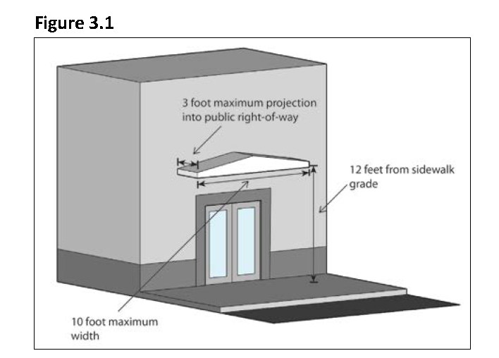
Building projections into the public right-of-way. Building projections may encroach into the public right-of-way up to three (3) feet for the purpose of providing shade over the sidewalk, provided they are no closer than twelve (12) feet from sidewalk grade. The maximum width of any projection is ten (10) feet.
(4)
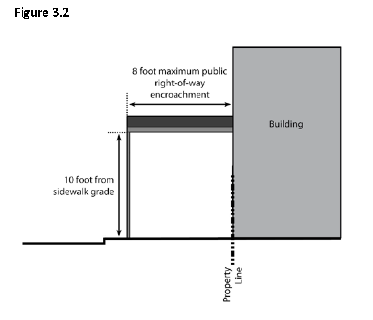
Awnings and overhangs. Awnings, overhangs, and pedestrian shade structures, may encroach into the public right-of-way up to eight (8) feet for the purpose of providing shade over the sidewalk, provided they are at least ten (10) feet above sidewalk grade. Awnings and canopies shall comply with the Downtown Design Guidelines adopted by resolution.
(g)
Building design.
(1)
Commercial building design.
a.
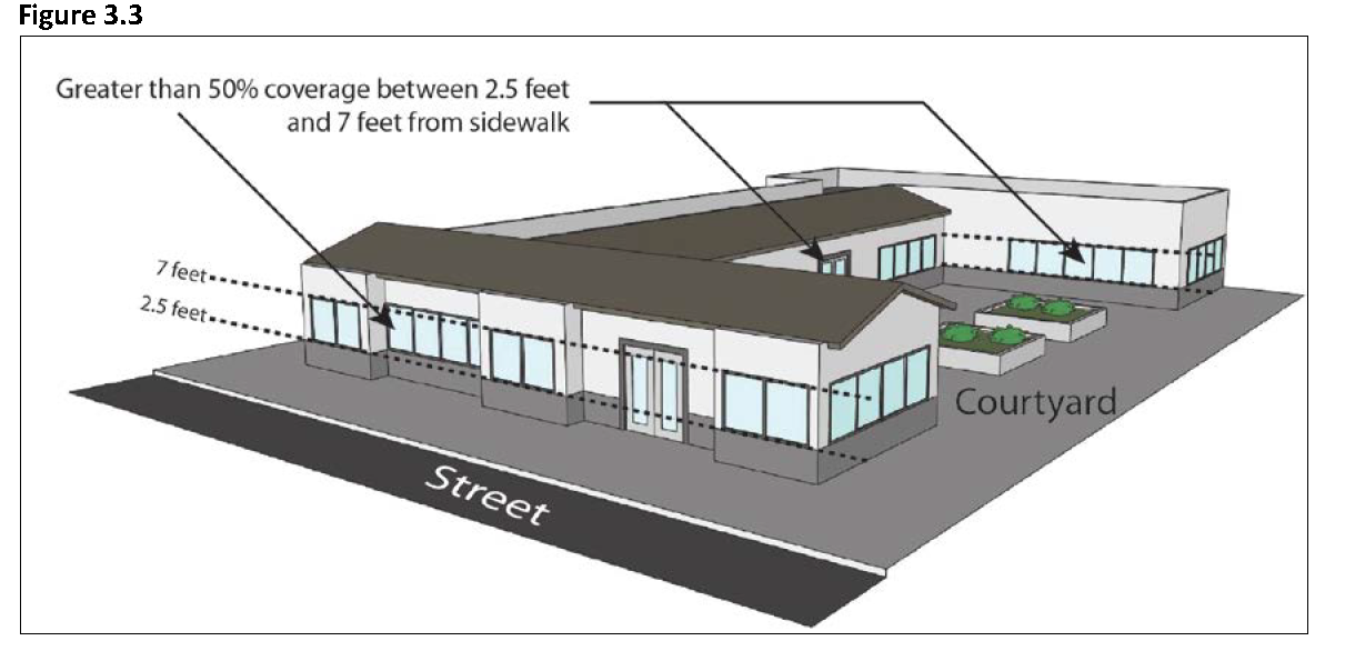
Ground floor windows. Facades facing streets, plazas, and courtyards shall be lined with windows. Where blank walls are necessary, they shall be on side or interior facades not facing streets. Exterior walls facing an adjacent public street, or facing onto a park, plaza, or other public outdoor space shall include windows, doors, or other openings for at least fifty (50) percent of the building wall area located between two and one-half (2.5) and seven (7) feet above the elevation of the sidewalk.
b.
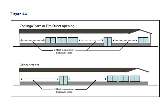
Limits on blank walls. No wall shall run in a continuous plane for more than twenty (20) feet without an opening on Coalinga Plaza or Elm Street, and for more than thirty (30) feet on other streets. Openings fulfilling this requirement shall have transparent glazing and provide views into work areas, display areas, sales areas, lobbies, or similar active spaces, or into window displays that are at least three (3) feet deep.
c.
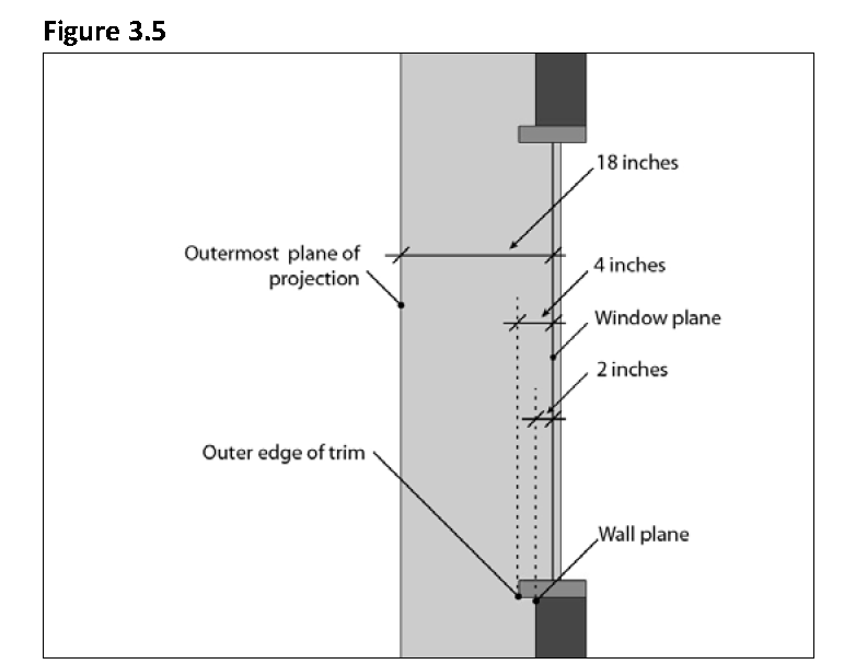
Wall plane articulation. Windows, doors, columns, and other features shall be recessed or project forward from the wall plane, such that there is a minimum two-inch recess of the window plane from the wall plane, a minimum four-inch projection from the window plane and outer edge of trim, and a total of at least eighteen (18) inches from the window plane to the outermost plane of any projection such as a wall, column, or other articulation feature.
d.
Building articulation. Commercial building facades shall include building projections or recesses, doorway and window trim, and other details that provide architectural articulation and design interest.
e.
Building entrances.
1.
Buildings shall be oriented to face public streets.
2.
Building frontages shall be generally parallel to streets, and the primary building entrances shall be located on a public street.
3.
Building entrances shall be emphasized with special architectural and landscape treatments.
4.
Rear entry doors, door frames, door hardware, signs and lighting fixtures shall match types utilized on the front façade and/or that are appropriate to the parent building's historic period.
5.
In mixed-use developments, entrances to residential units shall be physically separated from the entrance to the permitted commercial use and clearly marked with a physical feature such as a recess or projection incorporated into the building or appropriately scaled element applied to the façade.
(2)
Residential building design.
a.
Residential architectural articulation. All multiple-family residential buildings and mixed-use buildings that include residential uses shall include adequate design features to create visual variety and avoid a large-scale and bulky appearance. Long facades shall be broken up into smaller modules.
b.
Residential building façade and entrances. The following standards apply to residential buildings and mixed-use projects that include residential uses.
1.
Orientation. All units located along public rights-of-way shall have the primary entrance facing this right-of-way. Exceptions to this requirement shall only be approved for projects where multiple-family housing is located on four (4) lane streets carrying high traffic volumes and/or streets that do not allow on-street parking. In such cases, the project shall be oriented around courtyards.
2.
Street-facing Facades. Street-facing facades of residential buildings shall be designed as front facades and shall include stoops, porches, recessed windows, and bay windows or balconies.
3.
Projection or recess. Building entrances shall have a roofed projection (such as a porch) or recess with a minimum depth of at least five (5) feet and minimum area of fifty (50) square feet. Alternative designs that create a welcoming entry feature facing the street, such as a trellis or landscaped courtyard entry, may be approved.
4.
Entrances. Provide at least one building entrance for every 100 feet of street frontage.
(h)
Mechanical equipment. Mechanical equipment, including rooftop mechanical equipment, shall be screened from view to the height of the equipment, and the screening shall be designed as an integral component of the architectural design. The property owner shall be responsible for the maintenance of such screening.
(i)
Utilities screening. Utility meters and related equipment shall be located only on the side or rear façade of buildings and shall be integrated into the building architecture through painting or other means.
(j)
Building security. Components of building security shall be integrated into the building's design and be effective but not obtrusive in accordance with the following standards:
(1)
Security doors shall not encroach into the public right-of-way, in either an opened or closed position.
(2)
Lighting shall be provided at all entryways to the building and in any alcoves or other features of the building, to allow visual surveillance of the building and its public areas.
(3)
Where security grills are required or otherwise provided, they shall be painted to match the trim colors of the building. Unobtrusive roll-down grilles with thin vertical and horizontal elements are preferred; opaque rolling doors and accordion fold grates are discouraged.
(4)
Grilles, security doors, and other security devices designed for nighttime security shall not be readily visible to the public during business hours or when they are in an open position.
(Ord. No. 776, § 1(Exh. A), eff. 9-5-2014)
Sec. 9-3.201. - Purpose.
The specific purpose of the Flood Hazard Overlay is to set appropriate development standards to protect the community from the risks to life, property, community and the environment associated with construction in the areas identified as 100-year flood zones by the Federal Emergency Management Agency (FEMA) in the City of Coalinga.
(Ord. No. 776, § 1(Exh. A), eff. 9-5-2014)
Sec. 9-3.202. - Preference for passive uses in Flood Hazard Overlay.
(a)
Lands in the Flood Hazard Overlay should remain predominantly free of structures. Consistent with the Land Use Element of the General Plan, development in the Flood Hazard Overlay should be limited to multi-use trails and passive recreational uses.
(1)
The multi-use trails designation applies to walking, biking and equestrian trails.
(2)
Passive recreational uses include open space and recreation activities requiring minimal development and construction, and with minimal impact on the environment. Examples include wildlife observation, canoeing, hiking, and biking.
(b)
As identified in the 1990 Management Plan for Warthan Creek and Los Gatos Creek referenced in the Open Space and Conservation Element of the General Plan, lands in the Flood Hazard Overlay should be primarily preserved and used as conservation areas and wildlife corridors.
(Ord. No. 776, § 1(Exh. A), eff. 9-5-2014)
Sec. 9-3.203. - Development regulations in Flood Hazard Overlay.
(a)
A limited amount of development may be allowed in the Flood Hazard Overlay, subject to the requirements of the Chapter 8, Floodplain Management, of this title.
(b)
The review of proposed development in the Flood Hazard Overlay should pay specific attention to the prevention of flooding toward properties, roads, and public facilities adjacent to the flood zone.
(Ord. No. 776, § 1(Exh. A), eff. 9-5-2014)
Sec. 9-3.301. - Purpose.
(a)
The purpose of the Gateway Overlay District is to identify gateways to the City by signaling and easing the transition between the City and the County, and creating a positive first impression of the City.
(b)
The Gateway Overlay District sets forth design and development standards for public right-of-ways and properties in the Gateway Overlay areas, in order to create harmonious and aesthetically pleasing gateways. Gateways shall reflect and reinforce Coalinga's history and community character.
(c)
The design and development standards below are intended to:
(1)
Create a sense of place that is consistent with the rural and small-town character of Coalinga;
(2)
Facilitate a welcoming entrance by providing vehicle, bicycle and pedestrian access;
(3)
Create an inviting streetscape that guides visitors into the City of Coalinga, through attractive landscaping and greater attention to building design; and
(4)
Require the provision of aesthetically pleasing public and private signage.
(Ord. No. 776, § 1(Exh. A), eff. 9-5-2014)
Sec. 9-3.302. - Applicability.
(a)
The standards and guidelines detailed in this section apply to the following areas of the City identified as part of the Gateway Overlay in the General Plan:
(1)
The "Urban Gateway" to the South of the City, characterized by its proximity to the Downtown Overlay and developed lands:
a.
From the intersection of West Elm Avenue (Highway 198) and West Lucille Avenue to the intersection of West Elm Avenue (Highway 198) and Polk Street, approximately half a mile in length.
(2)
The "Northern Gateway" characterized by Open Space/Conservation and agricultural land along Highway 198/33:
a.
Between the intersection of Highway 198/ 33 and West Gale Avenue to the end of the West Hills Community College property, approximately one mile in length.
(3)
The "Eastern Gateways" in the Sphere of Influence of the City, characterized by open space and planned low density residential uses:
a.
On Phelps Avenue, between the intersection of Phelps Avenue and South Calavaras Avenue alongside the airport and proposed residential area to the approximate western boundary of the airport property, approximately one mile in length.
b.
On West Jayne Avenue, from the intersection of West Jayne Avenue and South Alpine Avenue to approximately 2,000 feet east of South San Joaquin Avenue, approximately one and half a mile in length.
c.
The following standards apply to all Gateway Overlay areas unless otherwise specified.
(Ord. No. 776, § 1(Exh. A), eff. 9-5-2014)
Sec. 9-3.303. - Project approval.
Approvals for proposed projects within the Gateway Overlay District may include specific conditions of approval, to ensure that the goals of the Gateway Overlay District are met.
(Ord. No. 776, § 1(Exh. A), eff. 9-5-2014)
Sec. 9-3.304. - General development standards.
(a)
The requirements and development standards of the Gateway Overlay shall supplement and supersede the regulations of the underlying Zoning District and take precedence in the case of conflict. For all aspects not addressed by this section, the regulations of the underlying Zoning District shall remain in effect.
(b)
Signage.
(1)
All signage proposed in the Gateway Overlay shall be reviewed by the Planning Commission.
(2)
Monument signs indicating entrance to and exit from the City:
a.
The City may install an entrance monument sign with the City name, seal or motto, or all of the above, at the corner of the property in the Gateway Overlay that will be first seen by visitors entering the City.
b.
On the opposite side of the road, the City may install a separate exit monument sign indicating to motorists and pedestrians that they are exiting the City.
c.
The entrance and exit monument signs shall be illuminated at night. Public art or landscaping may accompany the monument signs to increase their visibility and aesthetic value. Colors, materials and landscaping that are representative of or appropriate to the City of Coalinga shall be used in conjunction with the monument signs.
d.
No object, plants, trees or other signs shall be allowed to obstruct the text or graphic content of entrance or exit monument signs.
(3)
All other public and private signage in the Gateway Overlay shall follow the standards prescribed in Chapter 4, Article 5, Signs. No signage shall be allowed within ten (10) feet of the City entrance or exit monument signs. All signage within twenty (20) feet of a monument sign must not be larger than the entrance or exit monument signs.
(c)
Pedestrian and bicycle access.
(1)
Any installed bicycle lanes and pedestrian sidewalks within the Gateway Overlays shall be continuous throughout the Gateway Overlay, and extend at minimum to the nearest roadway intersection.
(2)
Installed bicycle lanes shall be at minimum "Class 2 bikeways", visually separated from traffic lanes using Caltrans striping standards. It is highly recommended to paint the bikeways a different color from the asphalt pavement for increased visibility. In specific areas with narrower right-of-ways and reduced maximum speeds, "Class 3 bicycle routes" may be installed per Caltrans standards. In such cases, roadside signs shall be installed urging motorists to share the road with cyclists.
(d)
Parking.
(1)
Parking should not be allowed in the right-of-way.
(2)
Public and private parking on lots alongside the roadway is permitted. Screening shall be located between the parking and the sidewalk or right-of-way. The screening can either be a fence or a landscape buffer. The landscape buffer should be between two (2) and four (4) feet tall and consist of local plants.
(e)
Street trees and landscaping.
(1)
Street trees shall be planted on both sides of the street to provide shade, define and embellish the streetscape, and provide screening for parking, utilities and service areas.
(2)
Any proposed landscaping and street trees should be selected with the goal to frame and preserve views of the hills, fields and open space, which are unique to Coalinga.
(3)
Eight (8) to ten (10) feet of space should generally be allowed between each tree. Spacing between trees may be adapted to accommodate fire hydrants, utility vaults, property entrances, and other infrastructure elements. The placement of street trees shall not interfere with traffic sight visibility. Structured soil (an engineered soil) for tree plantings is encouraged wherever possible to encourage healthy growth and prevent tree root damage to sidewalks and pavement.
(4)
Existing planting shall be maintained or upgraded in all public areas wherever possible. The use of native and drought-resistant tree and plant species, and seasonal color is highly encouraged. Please refer to the Community Development Department for a list of recommended trees and plants.
(f)
Walls and fences.
(1)
Open or solid fences or walls proposed along the edge of properties should utilize wood, stone or brick, or other local colors and materials, to define the edge of the road.
(2)
All proposed fences and walls shall be consistent with the requirements of Section 9-4.203, Fences and Freestanding Walls, and any other requirements of the property's Zoning Districts.
(g)
Street lighting.
(1)
Street lighting is encouraged to illuminate the right-of-way and sidewalks at night, at minimum between sunset and midnight, and between 5:00 a.m. and sunrise.
(2)
Bulbs used for street lamps shall be energy efficient.
(3)
Street lamps should not point or shine light towards the sky. Any lamp hoods should be downcast.
(4)
The design of the street lamps shall be consistent or compatible across all Gateway Overlay areas, and be representative of the City of Coalinga. The Planning Commission shall determine the design and corresponding height for street lamps in each Gateway Overlay area.
(h)
Screening of utilities.
(1)
Utilities and public infrastructure should be undergrounded, or screened with trees, landscaping, or public art.
(2)
Visibility and sight distances at driveways and street intersections should be preserved per the requirements of Section 9-4.214, Visibility at Driveways and Intersections.
(i)
Buildings.
(1)
There shall be no minimum setback of buildings from the property line that fronts the street in the Gateway Overlay. The maximum setback from the property line shall be as prescribed in the underlying Zoning District, if any. Main entrances and pedestrian connections from these buildings to the street in the Gateway Overlay are highly encouraged.
(j)
Public art.
(1)
The installation of permanent public art is encouraged in the Gateway Overlay areas. The Planning Commission shall review all proposed public art. The approval of public art requires the finding that the artwork meets the design criteria in Section 9-3.305 of this article.
(k)
Sidewalks.
(1)
Urban Gateway.
a.
A secured sidewalk, separated from the roadway by a curb, shall be installed on both sides of the street. Street trees should be planted between the sidewalk and the roadway and/or between the sidewalk and the property lines.
b.
Sidewalks should be a minimum of four (4) feet wide.
(2)
Northern Gateway.
a.
The installation of sidewalks is encouraged along both sides of the roadway, in tandem with future development. Existing pedestrian walkways should be improved in the interim with stones, plants and landscaping to define its edges.
(3)
Eastern Gateways.
a.
Wherever residential developments are proposed along the right-of-way, the construction of a sidewalk with landscaping and street trees is required.
(l)
Buildings and structures.
(1)
Building facades visible from the public right-of-way shall be regularly maintained to ensure a well-kept appearance. Landscape buffers are required alongside new developments to enhance aesthetics, provide screening, protection from noise and wind, and to preserve the "rural character" of the gateway.
(2)
All setbacks should conform to the requirements of the respective Zoning Districts. If a general trend for a front setback from the street has been established, future development shall be compatible with the established trend, even if it is more limiting than Zoning requirements.
(3)
Residential developments shall be visually enhanced and partially screened from the public right-of-way with landscape buffers and fences. Ranchettes, farm houses, agricultural sheds, barns and other rural buildings are not subject to this requirement.
(4)
Urban Gateway and Northern Gateway.
a.
The façades of buildings in the Urban Gateway and Northern Gateway, that are visible from the public right-of-way, shall be designed to assist the creation of a sense of place that is consistent with the rural and small-town character of Coalinga.
(Ord. No. 776, § 1(Exh. A), eff. 9-5-2014)
Sec. 9-3.305. - Design criteria.
(a)
To approve a Site Plan Review Application for any development in the Gateway Overlay zone, the following criteria shall be met:
(1)
The proposed development creates a sense of place that is consistent with the rural and small-town character of Coalinga;
(2)
The proposed development facilitates a welcoming entrance by providing vehicle, bicycle and pedestrian access;
(3)
The proposed development facilitates the creation of an inviting streetscape that guides visitors into the City of Coalinga, through attractive landscaping and greater attention to building design;
(4)
The proposed development has provided aesthetically pleasing public and private signage;
(5)
The proposed project screens any visible mechanical and electrical equipment and utilities per the provisions of Section 9-4.209, Screening, and Section 9-4.213, Underground Utilities.
(Ord. No. 776, § 1(Exh. A), eff. 9-5-2014)
Sec. 9-3.401. - Purpose.
(a)
The specific purposes of the Master Plan Overlay District is to:
(1)
Ensure the orderly planning for the development of large, unsubdivided areas of the City, consistent with its General Plan;
(2)
Maintain an environmental equilibrium consistent with existing vegetation, soils, geology, topography, and drainage patterns;
(3)
Avoid premature or inappropriate development that would result in incompatible uses or create public service demands exceeding the capacity of existing or planned facilities;
(4)
Encourage sensitive site planning and design; and
(5)
Ensure the provision of utilities, parks, roadways and other public facilities.
Sec. 9-3.402. - Applicability and zoning map designator.
The Master Plan Overlay District (-MP) may be combined with an underlying Zoning District and may be applied to an area of at least twenty (20) acres or more. Each Master Plan Overlay District shall be shown on the Zoning Map by adding an "-MP" designator to the underlying Zoning District designation. A Master Plan is required for all development within the Master Plan Overlay District.
(Ord. No. 776, § 1(Exh. A), eff. 9-5-2014)
Sec. 9-3.403. - Land use regulations.
(a)
The land use regulations of the Master Plan Overlay District shall be those of the underlying Zoning District, together with any other overlay district with which the Master Plan Overlay District is combined with, unless modified by a Master Plan.
(b)
All land use regulations shall be consistent with the General Plan Land Use designations established for land within the Master Plan Overlay District area.
(c)
No new uses or conditional uses may be approved unless a Master Plan is first approved.
(Ord. No. 776, § 1(Exh. A), eff. 9-5-2014)
Sec. 9-3.404. - Development regulations.
(a)
The Planning Commission may recommend and the City Council may approve lots smaller than those required by the underlying Zoning District, but shall not approve residential types or densities that deviate from those permitted by the General Plan and underlying Zoning District. Density bonus provisions shall apply.
(b)
All development regulations of the Master Plan Overlay District shall be those of the underlying Zoning District, together with any other overlay district with which the Master Plan Overlay District is combined with, unless modified by a Master Plan.
(c)
Notwithstanding clause (2) above, the provisions of any Airport Master Plan Area and Floor Hazard Overlay shall take precedence over the provisions of any other Overlay District and underlying Zoning District.
(Ord. No. 776, § 1(Exh. A), eff. 9-5-2014)
Sec. 9-3.405. - Initiation.
(a)
The application for a Master Plan may be initiated by the City Council, Planning Commission, or petition of a qualified applicant or group of applicants, as described in Section 9-6.903, Initiation of Amendments.
(b)
If the property is not under a single ownership, all owners shall join the application, and a map showing the extent of ownership shall be submitted with the application.
(Ord. No. 776, § 1(Exh. A), eff. 9-5-2014)
Sec. 9-3.406. - Required plans and materials.
(a)
Each Master Plan for a specific area of land must include a land use and circulation system concept that is consistent with the goals and policies of the General Plan, compatible with the environment, and capable of being served by existing and planned public facilities and utilities.
(b)
The following plans and materials must be submitted. The Community Development Director or his or her designee may require the submission of additional items considered necessary:
(1)
A map showing proposed Master Plan boundaries and the relationship of the area to uses and structures within a 300-foot radius of the plan area boundaries;
(2)
A map of the Master Plan area showing sufficient topographical data to indicate clearly the character of the terrain, and the type, location, and condition of mature trees and other natural vegetation;
(3)
A site plan indicating the existing and proposed uses, gross floor area, lot coverage, height, parking and density, and a circulation plan;
(4)
Architectural plans indicating exterior elevations, floor plans, colors, material of buildings and structures;
(5)
Preliminary development schedule indicating sequence and timing of development;
(6)
A fiscal impact analysis shall be conducted for proposed Master Plans. The fiscal impact analysis must:
a.
Estimate the population generated by the development, including any new residents, school-age children, and employees;
b.
Analyze the resulting public service costs required to serve this population, including the provision of water, sewer connections, roads, schools, and emergency services;
c.
Project the tax and other local revenues generated by the Master Plan;
d.
Compare development-induced costs to projected revenues, and address any shortfall.
(7)
Guidelines for the physical development of the property, including illustrations of proposed architectural, urban design, and landscape concepts;
(8)
On slopes over ten (10) percent, single-line sections showing the relationship of the building to the topography; and
(9)
All flood zone designations for the property.
(Ord. No. 776, § 1(Exh. A), eff. 9-5-2014)
Sec. 9-3.407. - Approval of a master plan.
(a)
The application for the approval of a Master Plan is processed as a Zoning Map Amendment per Section 9-6.904, Application of Property Owner.
(b)
In addition to findings required by Section 9-6.904, Application of Property Owner, the Planning Commission and the City Council shall find that the proposed Master Plan:
(1)
Conforms to the General Plan;
(2)
Generally complies with the land use and development regulations of the underlying Zoning District and does not significantly alter the regulations; and
(3)
Can be adequately, reasonably and conveniently served by public services, utilities and public facilities.
(4)
Based on the fiscal impact analysis, will bring substantial tax and revenue benefits to the City of Coalinga that outweigh the public service costs required to serve the Master Plan area.
(c)
Adopted Master Plans shall be indicated on the zoning map by adding a number to the "-MP" designator based on order of adoption, and reference to the Ordinance approving the plan.
(Ord. No. 776, § 1(Exh. A), eff. 9-5-2014)
Sec. 9-3.408. - Amendments to an adopted master plan.
(a)
Procedures for an amendment to an adopted Master Plan shall be initiated in the same manner as an application for a zoning map amendment prescribed by Section 9-6.903, Initiation of Amendments.
(b)
Substantial amendments to an Adopted Master Plan may trigger the requirement for a revised fiscal impact analysis.
(Ord. No. 776, § 1(Exh. A), eff. 9-5-2014)
Sec. 9-3.409. - Expiration and renewal.
(a)
Expiration. A Master Plan shall become void two (2) years following the date of approval, unless actions specified in the conditions of approval have been taken or unless the original approval was for a stated period longer than two years. An approved Master Plan may specify adherence to a development staging or phasing program.
(b)
Renewal. An approved Master Plan may be renewed for a period approved by the City Council after a duly noticed public hearing, as described in Section 9-6.908, Public Hearing by City Council. Application for renewal shall be made in writing between thirty (30) and ninety (90) days prior to the lapse of the original approval.
(Ord. No. 776, § 1(Exh. A), eff. 9-5-2014)
Sec. 9-3.410. - Site plan review.
Site plans for a project within an approved Master Plan area shall only be accepted for review if they are consistent with the approved Master Plan, and with all other applicable requirements of this title.
(Ord. No. 776, § 1(Exh. A), eff. 9-5-2014)
Sec. 9-3.501. - Purpose.
(a)
The Planned Development District encourages new developments to be consistent with smart growth objectives and implement integrated planning for land use, infrastructure, and the environment. These smart growth objectives are in line with the General Plan goals and policies, and the twelve (12) Smart Growth Principles of the San Joaquin Valley Blueprint.
(b)
The objectives of Planned Developments (PDs) are to:
(1)
Enhance and preserve the City of Coalinga's rural and small-town character, as described in the General Plan;
(2)
Protect the character of existing neighborhoods in proximity to Planned Developments;
(3)
Plan new development in a way that is compatible and connected with the City's existing development patterns;
(4)
Create clear community standards to avoid the proliferation of multiple areas with special zoning allowances;
(5)
Plan and cluster development in a way that avoids adverse impacts on natural resources and agricultural land, and conserve energy;
(6)
Provide opportunities for a diversity of housing types, and promote affordable housing in appropriate locations;
(7)
Create compact, village-scale mixed-use development as designated within the Master Plan Overlay areas in the General Plan land use map; and
(8)
Encourage creative design and layout of development, and efficient use of land.
(Ord. No. 776, § 1(Exh. A), eff. 9-5-2014)
Sec. 9-3.502. - Applicability.
(a)
The Planned Development District applies to:
(1)
All projects and major subdivisions of twenty (20) acres or more.
(2)
All parcels and subdivisions within an approved Master Plan, in the Master Plan Overlay District.
(Ord. No. 776, § 1(Exh. A), eff. 9-5-2014)
Sec. 9-3.503. - General standards.
(a)
Planned Developments shall be compatible with the traditional development and circulation patterns in the City of Coalinga, and be connected to the rest of the City.
(b)
Open spaces and amenities:
(1)
Planned Developments are required to set aside twenty (20) percent of land area as usable open spaces for residents in proportion to the size of the subdivision, or preserve natural open space compatible with the new residential uses (wetlands, forest, flood zones, light agricultural uses such as small orchards). Usable open spaces include:
a.
Public or semi-public parks with amenities,
b.
Open spaces where community activities could take place,
c.
Trails connecting the neighborhood with adjacent uses, for activities such as biking, walking, and jogging.
(2)
Support connectivity by designing the road network and pedestrian connections so as to connect and include the neighborhood in the wider City grid, according to the provisions of Section 9-4.305(a)(4), Pedestrian Connections.
(3)
Encourage biking and walking in the community by building continuous and connected sidewalks and bike paths.
(4)
Provide a variety of lot and home sizes.
(5)
Utilize parking reductions, shared parking and on-street parking standards where feasible for the development.
(c)
Where identified in the General Plan Land Use Map, include commercial and retail uses that serve the needs of the residents, at a scale appropriate for the City of Coalinga.
(d)
The design of Planned Developments should be compatible with the traditional architecture and rural character of Coalinga.
(Ord. No. 776, § 1(Exh. A), eff. 9-5-2014)
Sec. 9-3.504. - Design guidelines.
(a)
Site planning.
(1)
New subdivisions shall be planned as an extension of the community's pattern of streets, parks, lots and blocks. Infill housing shall be of similar scale, orientation and design as the existing structures.
(2)
Buildings shall be oriented so that outdoor space will visually connect between properties and extend a sense of open space, while maintaining a sense of privacy.
(3)
Private Open Space such as patios, gardens, recreation courts and play areas shall be placed in a manner to maximize use of sun and shade patterns, natural drainage and existing trees and vegetation.
(4)
Proposed buildings' plan shall preserve existing trees to the extent possible. Properties are encouraged to use native, drought-resistant species in their landscaping and buffering.
(b)
General building form.
(1)
The building's architectural style, visual bulk, massiveness, height, width and length shall be compatible with the neighborhood and harmonize with the existing residential structures of neighboring properties.
(2)
The building's mass, roof form and projecting elements shall be designed so as to minimize the visual impact of the building on the neighborhood. Rooflines shall be designed in ways that minimize interference with views from neighboring properties.
(3)
Open space and landscape areas should visually blend with adjacent properties and be consistent with the neighborhood and sensitive to the rural character of the City.
(4)
Architecture within a residential area shall reflect a common vocabulary of forms, details and materials, while creating a pleasing variety of homes.
(c)
Sustainability.
(1)
Installation of Solar Panels on buildings' roofs is encouraged, provided that it respects the proportion and shape of the roof, as well as the harmony of the building.
(2)
Principles of passive design should be considered when building new homes, such as orienting the building to benefit from sunlight and solar heat in winter while being protected from direct sunlight in summer, and use air and vegetation for natural cooling.
(d)
Streets and parking.
(1)
Streets shall be pedestrian-friendly with sidewalks, street trees and other amenities. Cul-de-sacs shall be minimized and width of street decreased inside residential neighborhood.
(2)
On-street parking shall be limited. New subdivisions shall consider alternative parking solutions including tandem parking, shared driveways, single car garages, using alleys as off-street parking, and other methods reducing the visual presence and areas reserved for cars on the street. Large parking lot areas shall be located in courts not visible from the street.
(Ord. No. 776, § 1(Exh. A), eff. 9-5-2014)
Sec. 9-3.505. - Application requirements.
(a)
Applications for Planned Development must include the following:
(1)
A brief summary of the project and how it meets the requirements set forth in this article and follows the principles of Smart Growth;
(2)
A statement describing all proposed changes and modifications to the zoning requirements applicable to the district in which the project is located;
(3)
A statement describing any land set aside as conversation area or usable open space stating:
a.
Its size,
b.
Location,
c.
Current use,
d.
Future use,
e.
Management and Protection Plan,
f.
Ownership.
(4)
A site plan indicating the existing and proposed uses, gross floor area, lot coverage, height, parking and density, and a circulation plan;
(5)
Architectural plans indicating exterior elevations, floor plans, colors, material of buildings and structures.
(6)
Phasing plan and development schedule, including the construction schedule, and anticipated date of completion. Upon approval of the Planned Development, the phasing plan and development schedule shall become a part of the Planned Development and shall be adhered to by the property owner(s) of the PD, and any successors in interest.
(7)
A fiscal impact analysis shall be conducted for Planned Developments, unless a fiscal impact analysis has already been conducted for an approved Master Plan, which the Planned Development is part of. The fiscal impact analysis must:
a.
Estimate the population generated by the development, including any new residents, school-age children, and employees;
b.
Analyze the resulting public service costs required to serve this population, including the provision of water, sewer connections, roads, schools, and emergency services;
c.
Project the tax and other local revenues generated by the Master Plan;
d.
Compare development-induced costs to projected revenues, and address any shortfall.
(8)
The Community Development Director or his or her designee may require the submission of additional items considered necessary.
(Ord. No. 776, § 1(Exh. A), eff. 9-5-2014)
Sec. 9-3.506. - Review process and findings for approval.
(a)
Applications for Planned Developments may be reviewed simultaneously with applications for Subdivisions.
(b)
For the Planned Development to be approved, the Planning Commission and the City Council shall find that:
(1)
The proposed Planned Development conforms to the General Plan;
(2)
The proposed Planned Development complies with the requirements and follows the principles of Smart Growth described in this chapter;
(3)
All documents required for the application have been completed and submitted to the City.
(4)
Based on the fiscal impact analysis, the proposed Planned Development will bring substantial tax and revenue benefits to the City of Coalinga that outweigh the public service costs required to serve the Master Plan area.
(Ord. No. 776, § 1(Exh. A), eff. 9-5-2014)
Sec. 9-3.507. - Amendments to an adopted planned development.
Procedures for an amendment to an adopted Planned Development shall be initiated in the same manner as an application for a Zoning Map Amendment prescribed by Section 9-6.904, Application by Property Owner.
(Ord. No. 776, § 1(Exh. A), eff. 9-5-2014)
Sec. 9-3.508. - Expiration and renewal.
(a)
Expiration. A Planned Development shall become void two (2) years following the date of approval, unless actions specified in the conditions of approval have been taken or unless the original approval was for a stated period longer than two (2) years. An approved Planned Development may specify adherence to a development staging or phasing program.
(b)
Renewal. An approved Planned Development may be renewed for a period approved by the City Council after a duly noticed public hearing. Application for renewal shall be made in writing between thirty (30) and ninety (90) days prior to the lapse of the original approval.
(Ord. No. 776, § 1(Exh. A), eff. 9-5-2014)
Sec. 9-3.601. - Purpose.
(a)
The specific purpose of the Resource Extraction Overlay District is to:
(1)
Recognize the historic and economic importance of the resource extraction industry and ensure that resources that have been historically extracted in the region can continue be utilized without having to compete with incompatible uses;
(2)
Clearly indicate the areas of the City designated for resource extraction operations, businesses and industries;
(3)
Discourage the introduction of residential uses and other incompatible uses in this area, due to existing environmental and infrastructural constraints;
(4)
Preserve a safe and healthy environment for the community by requiring adequate protection measures and controlling uses within the Resource Extraction Overlay District.
(Ord. No. 776, § 1(Exh. A), eff. 9-5-2014)
Sec. 9-3.602. - Applicability.
(a)
Boundaries. The Resource Extraction Overlay District is divided into northern and southern sections. The locations and boundaries of these areas are described as follows:
(1)
The boundaries of the larger northern area of the Resource Extraction Overlay District are as follows:
a.
Western boundary: Beginning South from the intersection of West Gale Avenue and West Tractor Avenue, follows West Tractor Avenue until its terminus and continuing south along South Monterey Avenue until just south of its intersection with Cambridge Avenue;
b.
Northern boundary: East from the intersection of West Gale Avenue and West Tractor Avenue. Continues into the Coalinga city limits;
c.
Eastern boundary: From the eastern point of the northern boundary, the boundary crosses through the northwestern-most parcel within the sphere of influence. Follows the boundaries of the parcel containing the old Coalinga Municipal Airport along the northern and eastern edges of this parcel until its southern-most point;
d.
Southern boundary: Approximate to the southern boundary of the old Coalinga Municipal Airport and City limits until connection with the western boundary near the intersection of South Monterey Avenue and Cambridge Avenue;
(2)
The boundaries and location of the smaller southern portion of the Resource Extraction Overlay District is within the boundaries of a parcel, located south of West Lucille Avenue and west of West Elm Avenue. This section of the Resource Extraction Overlay bounded to the north, south, and west by the sphere of influence.
(Ord. No. 776, § 1(Exh. A), eff. 9-5-2014)
Sec. 9-3.603. - Permitted uses.
(a)
The following uses shall occur in the Resource Extraction Overlay District and are not permitted elsewhere in the City:
(1)
Traditional extraction activities related to the extraction of fossil fuels such as oil and coal, and aggregate products such as sand, gravel, and other metals and minerals.
(2)
Drilling, production, handling, processing, storage, extraction and removal of oil, gas and other hydrocarbons, including the necessary compressors and other structures and buildings in connection with such operations.
(3)
Mining, production, handling, processing, storage, extraction and removal of rock, aggregate, precious metals, sand and other similar materials, including but not limited to structures and buildings in connection with the operation.
(4)
New and proposed modifications to structures and equipment associated with the above uses.
(b)
All proposed projects require approval per the provisions of Chapter 6, Code Administration, of this title, as well as a development permit approved by the State, consistent with all requirements of the Surface Mining and Reclamation Act (SMARA) of 1975, Cal. Public Resources Code §2710, et seq. regulations, and the applicable level of environmental review, depending on project scope.
(Ord. No. 776, § 1(Exh. A), eff. 9-5-2014)
Sec. 9-3.604. - Prohibited uses.
No development is permitted in the Resource Extraction Overlay District, except for industrial uses compatible with resource extraction activities listed in Section C, Permitted Uses, of this article.
(Ord. No. 776, § 1(Exh. A), eff. 9-5-2014)
Sec. 9-3.605. - General requirements.
(a)
All permitted uses shall follow the statutes set by the Surface Mining and Reclamation Act of 1975 (SMARA) and associated regulations. The statutes are referenced and listed as follows:
(1)
Surface Mining and Reclamation Act of 1975 (SMARA), Cal. Public Resources Code, Division 2, Chapter 9, Section 2710 et seq;
(2)
Annual Reporting Requirements and Reporting Fee, Cal. Public Resources Code, Division 2, Chapter 2, Section 2207;
(3)
Site Inspections Conducted by the Department of Conservation, Cal. Public Resources Code, Division 2, Chapter 2, Section 2208;
(4)
Purchase and Use of Mined Materials by State and Local Agencies, Cal. Public Contract Code, Division 2, Part 2, Chapter 2, Sections 10295.5 and 20676;
(5)
Liability Limitations for Remediation/Reclamation of Abandoned Mines.
(b)
All mining activity shall abide by the Surface Mining and Reclamation Act (SMARA) Regulations, referenced in the California Code of Regulations, Title 14, Division 2, Chapter 8, Subchapter 1. Articles of the SMARA Regulations are as follows:
(1)
Article 1. Surface Mining and Reclamation Practice;
(2)
Article 2. Areas Designated to be of Regional Significance;
(3)
Article 4. Designation Appeal Procedures;
(4)
Article 5. Reclamation Plan Appeals;
(5)
Article 6. Mineral Resource Management Policies;
(6)
Article 7. Financial Assurances Appeal Procedures;
(7)
Article 8. Fee Schedule;
(8)
Article 9. Reclamation Standards;
(9)
Article 11. Financial Assurance Mechanisms;
(10)
Article 11.5. Forfeiture of Financial Assurance;
(11)
Article 12. Administrative Penalty Petition Procedures;
(12)
Article 13. Selection of Professional Service Firms;
(13)
Article 14. Appeals of Orders to Comply with the Surface Mining and Reclamation Act of 1975;
(14)
Article 15. Vested Rights Determination.
(Ord. No. 776, § 1(Exh. A), eff. 9-5-2014)