
Coral Gables City Zoning Code
ARTICLE 4
URBAN DESIGN AND PUBLIC IMPROVEMENTS STANDARDS
Section 4-101. Purpose and applicability.
The purpose of this Article is to provide standards of subdivision design that provide for and encourage:
- Development of sound and economically viable communities, and the creation of healthy living environments.
- Efficient, adequate, and economic supply of utilities and services to land developments.
- Prevention of traffic hazards and the provisions of safe and convenient pedestrian and vehicular traffic circulation in land developments.
- Provision of public open spaces in land developments for recreational and educational purposes.
This Article shall apply to any application for the subdivision of land, in conjunction with applicable regulations in Article 6, Landscape, and as reviewed and approved pursuant to Article14 Process of these regulations.
Section 4-102. Minimum requirements conflicts.
Minimum platting requirements for the City are controlled by the Miami-Dade County Code of Ordinances. In the event of a conflict between provisions and the Miami-Dade County Code, the Miami-Dade County requirements shall control.
Section 4-103. Bulkhead line.
Whenever land adjacent to Biscayne Bay or other open bodies of water is subdivided, the final plat shall show the bulkhead line established by Miami-Dade County, as recorded on sheet numbers 6, 7, 8 and 9, of plat book 74, page 3 of the Public Records of Miami-Dade County and approved by the City Commission under Ordinance Number 1403 which is on file in the office of the City Clerk.
Section 4-104. Street design.
- Conformity. The arrangement, character, extent, width, grade and location of all streets shall be considered in their relation to:
- Existing and planned streets.
- Topographical conditions.
- Public convenience.
- Pedestrian, bicycle and vehicular safety.
- The proposed use of the land to be served by such street.
- Relation to adjoining street system. The arrangement of streets in new subdivisions shall make provision for the continuation of the existing streets in adjoining areas.
- Street projection. Where adjoining areas are not subdivided, the arrangement of streets in new subdivisions shall make provision for the proper projection of streets.
- Street carried to property line. When a new subdivision adjoins unsubdivided land susceptible of being subdivided, then the new streets shall be carried to the boundaries of the tract proposed to be subdivided.
- Dead-end street or cul-de-sac. Dead-end streets or cul-de-sacs, designed to be so permanently, shall not be longer than six hundred (600) feet, unless approved by the City Commission, and shall be provided at the closed end with a turnaround having an outside roadway diameter of at least eighty-four (84) feet, and a street property line diameter of at least one hundred (100) feet. If a dead-end street is of a temporary nature, a similar turn-around shall be provided and provision made for future extension of the street into adjoining properties.
- Marginal access streets. Where a subdivision abuts or contains an existing arterial street, marginal access streets may be required, or other such treatment as may be necessary for adequate protection of residential properties, and to afford separation of through and local traffic.
- Minor streets. Minor streets shall be so laid out that their use by through traffic will be discouraged.
- Minimum street widths. Street right-of-way widths shall not be less than as follows:
| Street Type | Width |
| Arterial | 100 feet |
| Collector | 75 feet |
| Minor | 60 feet however, the width shall be 70 feet for all industrial areas |
| Marginal Access | 50 feet, however the width shall be 70 feet in industrial areas |
| Alleys | 20 feet |
I. Railroads or limited access highways abutting subdivision. Where a subdivision borders on or contains a railroad right-of-way or limited access highway right-of-way, a street approximately parallel to and on each side of such right-of-way may be required, at a distance suitable for the appropriate use of the intervening land for park purposes in residential districts or for commercial or for industrial purposes in appropriate districts. Such distances shall be determined with due regard for the requirements of approach grade and future grade separation in accordance with uniform standards prescribed by the manual of public works construction.
J. Street width in commercial areas. Where a proposed commercial use abuts a right-of-way, the width of the right-of-way shall be increased on each side to ensure the free flow of through traffic without interference by parked or parking vehicles, and to provide safe parking spaces for such use.
K. Intersections and curb radius. Street intersections shall have a curb radius as specified in 4-206 Streetscape Standards, measured at the curb line when the said intersection occurs at right angles. If an intersection occurs at an angle other than a right angle, it shall be rounded with a curve of a radius acceptable to the public works director. In MF and MX districts, the City may permit a smaller radius, typically fifteen (15) feet, with comparable cut-offs or chords.
L. Subdivision into tracts larger than ordinary building lots. Where a tract is subdivided into larger parcels than ordinary building lots, such parcels shall be arranged so as to allow the opening of future streets and logical further re-subdivision.
M. Street grades. No street grade shall be less than twenty-five-hundredths (.025%) percent.
N. Half streets. Half streets shall be prohibited except where essential to the reasonable development of the subdivision in conformity with other requirements of these regulations, and where the City finds it will be practical to require the dedication of the other half when adjoining property is subdivided. Whenever a half street is adjacent to a tract to be subdivided, the other half of the street shall be platted within such tracts.
O. Street names and numbers. Names of new streets shall not duplicate existing or platted street names unless they are extensions. House numbers shall be assigned in accordance with the house numbering system now in effect in the City.
P. Street jogs prohibited. Street jogs with centerline offsets of less than one hundred twenty-five (125) feet shall be prohibited unless because of unusual conditions the plat division determines that a lesser centerline offset is justified.
Q. Reverse curves. A tangent of at least one hundred (100) feet long shall be introduced between reversed curves on arterial and collector streets.
R. Street intersections. Streets shall be laid out so as to intersect as nearly as possible at right angles.
S. Property lines at street intersections. In single-family residential areas, property lines at street intersections shall be rounded with a radius of twenty-five (25) feet. In MF and MX districts, property lines may intersect without rounding, as determined by the Public Works Director.
T. Sight distance and safe turning movement. When connecting street lines deflect from each other at any one (1) point by more than ten (10) degrees, they shall be connected by a curve with a radius adequate to ensure a sight distance and safe turning movement in accordance with the Uniform Standards set forth in the City’s Manual of Public Works Construction.
Section 4-105. Alleys.
- Where required. Alleys shall be required in all commercial and industrial districts. Alleys are not required in residential districts.
- Waiver of requirement. The Public Works Director may waive the requirement for alleys in commercial and industrial districts where other definite and assured provisions are made for service access. Examples of such provisions for service access include areas designated for off-street loading and unloading and the continued availability of adequate parking and access for the uses proposed.
- Width of alley. The right-of-way width of an alley shall be not less than twenty (20) feet, and shall provide adequate turning areas at changes in angles.
- Dead-end alleys. Dead-end alleys are prohibited.
Section 4-106. Vacation of streets and alleys.
Property owner(s) may request the vacation and/or abandonment of a public right-of-way subject to the criteria and procedure in Article 14 Process.
Section 4-107 Easements.
- Easement provision. The City may, as a condition of approval, require that suitable areas for easements be set aside, dedicated and improved for the installation of public utilities and purposes which include water, gas, telephone, internet, electronic power, sewer, drainage, public access, ingress, egress, open space, recreation and other public purposes which may be deemed necessary by the City Commission. [formerly 4-201.M(2)]
Easements shall provided for the installation of underground utilities or relocating existing facilities in conformance with the respective utility company's rules and regulations. In subdivisions of less than twenty-one (21) lots the directors of the Public Works and Planning Departments may waive the requirements for underground installations if the service to the adjacent area is overhead and it does not appear that further development will occur. [formerly 5-1511]
- Easements dimensions.Easements with a minimum right-of-way width of six (6) feet shall be provided on each side of all rear lot lines and along certain side lot lines where necessary for installation and maintenance of utilities. [formerly 5-1506.A]
- Drainage easements. Where a subdivision is bordered by or traversed by a watercourse, drainage way, channel, or stream, there shall be provided a minimum twelve (12) foot storm water easement at intervals to provide storm drainage to the waterway in accordance with the storm drainage plan proposed for the subdivision. [formerly 5-1506.B]
Section 4-108. Encroachments into rights-of-way.
Any encroachments, construction, and penetration into the rights-of-way shall be subject to the following:
The property owners shall be responsible for all maintenance of all encroachments and property of all surrounding public rights-of-way, including the following: landscaping (hard and softscape), benches, trash receptacles, irrigation, kiosks, plazas, open spaces, recreational facilities, private streets, and other public realm features, subject to all the provisions for which the development was approved as may be amended. And the property owners shall be responsible for liability insurance, local taxes, and the maintenance of the encroachment and the property.
Section 4-109.Blocks.
Block length and width or acreage within bounding roads shall accommodate the size of lot required in the area by these regulations and to provide for convenient access, circulation control and safety of pedestrians, bicycles, and vehicles. In single-family residential areas, block length shall not exceed one thousand three hundred (1,000) feet, , unless a greater length is requested by the subdivider and is deemed advisable because of unusual conditions by the City. In blocks nine hundred (900) feet in length or over, pedestrian passages not less than ten (10) feet wide may be required to provide circulation or access to school, playground, shopping center, transportation, and other community facilities. In all other zoning districts block length shall not exceed five hundred (500) feet and pedestrian passages shall be provided if the block exceeds four hundred (400) feet.
Section 4-110. Public sites and open spaces.
Where a proposed park, playground, school or other public use shown in a master plan is located in whole or in part within a subdivision, the subdivision shall dedicate or reserve adequate space for such purpose in such area within the subdivision.
Section 4-111. Lots - General.
- Dimensions. Lot dimensions and area shall not be less than the requirements of these regulations.
- Location. All lots shall abut by their full frontage on a publicly dedicated street or a street that has received the legal status as such.
- Lot lines. Side lot lines shall be substantially at right angles to straight street lines or radial to curved street lines.
- Corner lots. Corner lots for residential use, unless otherwise approved by the board, shall have extra width to permit appropriate building setback from both streets.
- Uninhabitable lots. Lots subject to flooding and lots deemed to be uninhabitable shall not be platted for residential occupancy, nor for such other uses as may increase danger to health, life or property or aggravate the flood hazard, but such land within the plat shall be set aside for such uses as shall not be endangered by periodic or occasional inundation or shall not produce unsatisfactory living conditions.
- Lot remnants. All remnants of lots below the minimum size left over after subdividing a larger tract must be added to the adjacent lots, rather than allowed to remain as unusable parcels.
- Means of access. Each lot shall be provided access, by means of a public street, with satisfactory access to an existing public street or in the case of units within a townhouse site, or planned developments; each lot shall be provided perpetual right of access by a private street or roadway to an existing public street.
- Double frontage lots. Double frontage or through lots shall be avoided except where essential to provide separation from residential development from traffic arteries or to overcome specific disadvantages of topography or orientation A decorative masonry wall, or in the discretion of the City, a combination of a fence and landscaping that provides a satisfactory buffer may be required along the rear property line, across which there shall be no right of vehicular access. This portion of the block line shall be shown as a limited access line on the final plat.
Section 4-112. Lots – Dimensions
- SFR and MF Districts. Except as may be provided hereinafter to the contrary, in connection with replats, subdivisions, specific regulations and specifically described lots or parcels of land, all buildings or structures located in SFR or MF Districts shall be constructed or erected upon a building site containing at least one (1) platted lot and such building site shall have a minimum street frontage of fifty (50) feet.
- Residential Estates. No replat or subdivision for a Residential Estate shall be approved where the building sites have an area of less than one and one-half (1½) acres, a minimum width of two-hundred (200) feet and a minimum lot depth of two hundred and fifty (250) feet.
- Replats and subdivisions south of the Coral Gables waterway and east of Old Cutler Road. The following minimum size building sites shall be required for all replats and subdivisions for all lands lying south of the Coral Gables Waterway and east of Old Cutler Road, excluding the area within the plats of Coral Bay Sections B, C and D.
- One (1) acre building sites, one (1) tier deep, with a minimum street frontage on Old Cutler Road of one-hundred fifty (150) feet and maximum street frontage on Old Cutler Road of two hundred eight (208) feet on the east side of Old Cutler Road from Casuarina Concourse, as shown on Plat Book 60 at Page 37 of the Public Records of Miami-Dade County, Florida, to the intersection of Old Cutler Road and Red Road, as shown on Plat Book 57 at Page 97 of the Public Records of Miami-Dade County, Florida, and on the east side of Red Road from the intersection of Old Cutler Road and Red Road, as shown on Plat Book 57 at Page 97 of the Pubic Records of Miami-Dade County, Florida, to Avenue Campamento, as shown on Plat Book 57 at Page 97 of the Public Record of Miami-Dade County, Florida.
- Corner lots not abutting upon a waterway:
- Minimum street frontage of one hundred fifteen (115) feet.
- Minimum depth of one hundred twenty-five (125) feet.
- Inside lots not abutting upon a waterway:
- Minimum street frontage of one hundred (100) feet.
- Minimum depth of one hundred twenty-five (125) feet.
- Corner lots abutting upon a waterway:
- Minimum street frontage of one hundred fifteen (115) feet.
- Minimum depth of one hundred forty-five (145) feet.
- Inside lots abutting upon a waterway:
- Minimum street frontage of one hundred (100) feet.
- Minimum depth of one hundred forty-five (145) feet.
- MX Districts. No replat or subdivision in Commercial, MX Districts shall be approved where the building sites have a street frontage of less than twenty-five (25) feet and a depth of less than one-hundred (100) feet.
Section 4-113. Subdivision procedures
- Clearing, Filling and Excavation. Before any land may be cleared of trees and other growth, excavated, filled and/or graded, such land shall have been platted or replatted into lots, blocks or parcels for building development in the manner prescribed by Article14 Process, and the owner thereof or owner’s contractor shall have applied for and obtained a permit for such work from the Development Services Department.
- Subdivision construction standards. Properly qualified and licensed contractors shall pay for and obtain proper permits from the Public Works Department for all construction and improvement work within the subdivision. Should any work within the subdivision be performed not in conformity with any provisions of this Article or any other Ordinances of the City, the City Manager shall immediately give notice by certified mail to the subdivider and any contractors performing work in that area that all permits are suspended, and that all improvements, construction, development and other work within the subdivision shall cease within twenty-four (24) hours of receipt of notice. The subdivider and contractor shall in such case further be subject to penalties as set forth in Article 7 of these regulations.
- Subdivision improvements or bond required. Before consideration of a final plat of a subdivision, the City Commission must be satisfied that all improvements required by Section 5-1510 are to be constructed. The Director of Public Works shall prepare an estimated cost of all required improvements. The estimated costs shall be based on the actual computed cost of improvements plus ten (10) percent. In lieu of the completion of the improvements, a bond executed by a surety company qualified to transact business in the state, shall be furnished by the subdivider in an amount equal to the estimated cost of the construction plus ten (10) percent of such improvements, including engineering supervision, testing and miscellaneous charges. The surety will be subject to the condition that the improvements will be completed within twelve (12) months after approval of the final plat, and in the event they are not completed, the City shall proceed with the work and hold the owner and the bonding company jointly responsible for the costs thereof. If the bond proves insufficient to complete the improvements covered, the City shall have the right to finish all work by creating a special assessment district, and assess the amount of the additional funds required equally against all divisions of land within the subdivision. As an alternative, the subdivider may deposit a certified or cashier's check with the City Clerk payable to the City in lieu of the surety bond.
- Subdivision certificate of insurance and indemnification of City. The subdivider shall hold the City harmless against any liability or damage which may occur during construction of any improvements in, about or upon any land or water dedicated for public use as shown upon the final plat. In addition to saving the City harmless as herein provided, the subdivider shall provide the city with a certificate of insurance naming the city as an additional insured in an amount specified by the City. Nothing herein contained shall be construed to relieve the subdivider from any negligence on its part on account of any such improvements or damage to other persons or property of others.
Section 4-201. Purpose and applicability.
All property owner(s) that desire to develop MF or MX properties shall be required to fund, install, and maintain all public realm improvements required herein on private property as well as those required from the property boundary to the centerline of all contiguous public rights-of-way. A property owner may also provide public realm improvements up to the property line on the far side of rights-of-way abutting his/her property. These improvements as identified in the City’s Public Works Manual may include the following: landscaping; paving; signage; street furniture; public right-of-way improvements; and undergrounding of all utilities.
Any other abutting property owner who subsequently develops property abutting an improved public realm area pursuant to these provisions shall reimburse the property owner who funded the improvements the pro rata share attributable to his property based on street or alley frontage along with the amount of interest permitted by this provision. Per annum simple interest as established and authorized by Section 687.01, Florida Statutes will accrue from the date of full payment for all improvements.
Property owners who develop property abutting already improved public realm areas shall restore the public realm areas to the condition that existed prior to the commencement of construction before Certificate of Occupancy is issued. The costs of such restoration shall not affect the total amount of reimbursement which another abutting property owner may be entitled to under this section.
Section 4-202. Administration of improvements.
Prior to issuance of a building permit for construction, the property owner(s) shall provide surety monies equating to one hundred (100%) percent of the costs for completion of all improvements. The monies shall be deposited and accounted for in a “Project” reserve within a City fund appropriate to the type of construction, e.g., General Capital Improvement, stormwater, sanitary sewer funds, or other similar fund. The pro rata share of each property owner’s contribution to the fund shall be based on its street frontage measured in linear feet or other means of equitable distribution. Per annum simple interest as established and authorized by Section 687.01, Florida Statutes will accrue from the date of full payment for all improvements. The City shall also collect an administrative fee as authorized by Florida Statutes for the administration and implementation of the Fund. Invoices submitted by the developer to the City in connection with the public realm improvements shall be paid by the City from the Fund. The City’s Public Works Department shall monitor construction and disperse the monies from the Fund based upon completion of work and in compliance with the Public Works Manual.
Section 4-203. Underground utility provision and easements.
Underground utilities shall be installed pursuant to an Underground Facilities Master Plan which will be prepared by the Public Works Department in cooperation with the Planning and Zoning Division. The necessary support facilities for the installation of all underground utility facilities, including utility vaults and transformers shall be located on private property. The property owner shall provide easements to all applicable utility companies for the installation and maintenance of underground utilities.
Property owners may receive a floor area credit equivalent to the amount of space occupied by the necessary utility facility, as determined by the site plan review process.
Section 4-204. Alternative funding for utilities.
A Special Taxing District or Special Assessment District may be created pursuant to Florida Statutes to fund the installation and maintenance of underground utilities and all public realm improvements.
Section 4-205. Streetscape standards.
- Streetscape required. The developer of all new buildings shall be responsible for the improvement of the area between the front set back and edge of pavement as an urban or suburban streetscape. If the parcel of land proposed for development is designated zoned MF2, MF3, MF4, or MX1, MX2, or MX3, then an urban streetscape shall be required. If the parcel of land proposed for development is designated SFR or MF1, then a suburban streetscape shall be required. Any improvements constructed within the public right-of-way shall be dedicated to and maintained by the City.
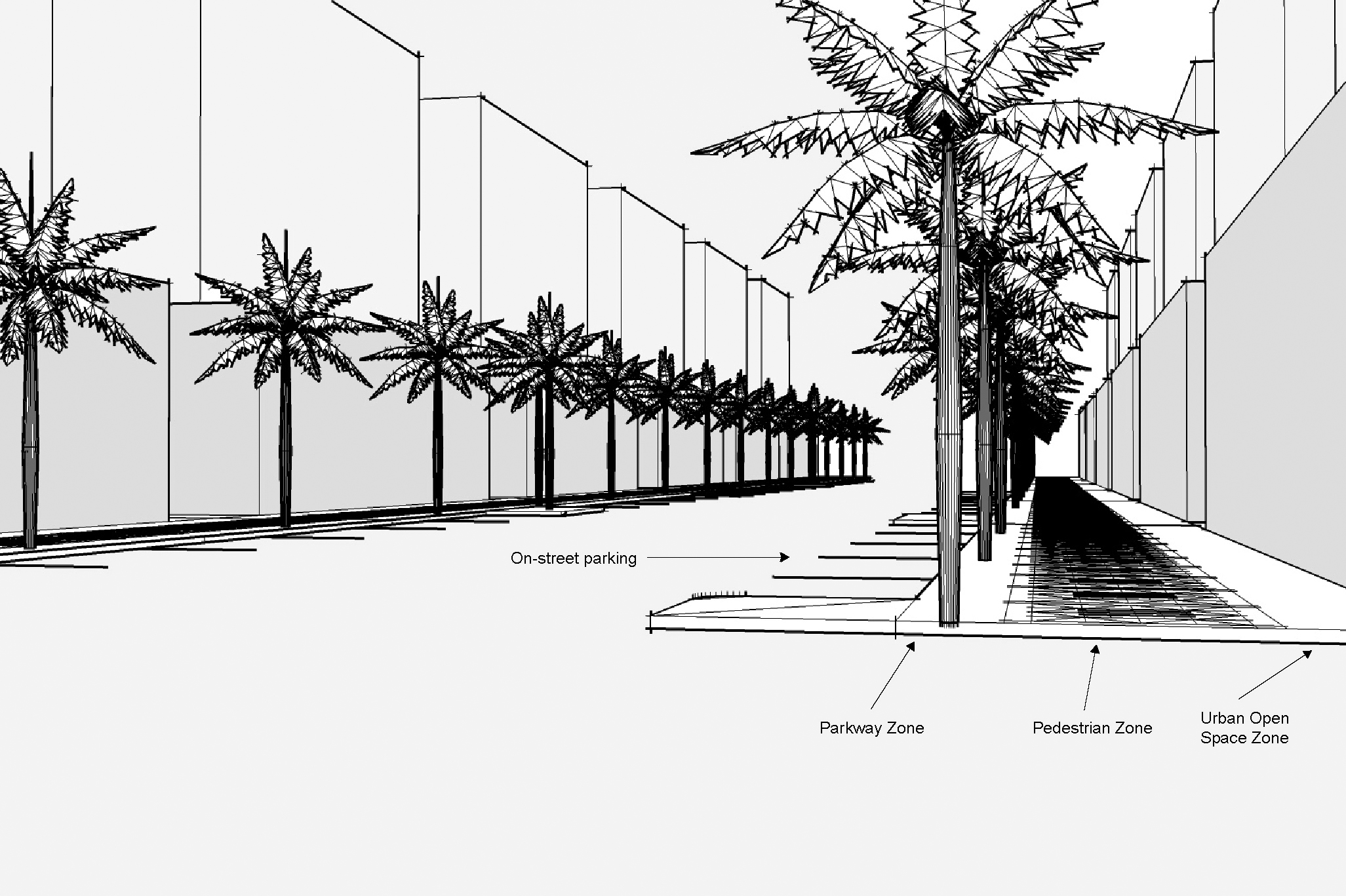
- Required urban streetscape elements. The required urban streetscape shall be comprised of four (4)to six (6) elements, as determined by the Planning Director. If the placement of streetscape elements results in removal of existing on-street parking, the Directors of Public Works Landscape Division and Public Works may reduce the required elements to provide for the preservation of the existing on-street parking.
- On-street parking.
- Bicycle zone as per the City’s Bicycle and Pedestrian Master Plan.
- A parkway of at least five (5) feet in width.
- A pedestrian zone of at least eight (8) feet in width except that the zone width may be reduced to six (6) feet where the existing sidewalks adjacent to the parcel proposed for development are five (5) feet or less.
- An urban open space zone located between the building and the pedestrian zone, except where a zero setback is required.
- Curb radius of fifteen (15) feet or less.
- Required suburban streetscape elements. The required suburban streetscape shall be comprised of two (2) to three (3) elements, as determined by the Planning Director. If the placement of streetscape elements results in removal of existing on-street parking, the Directors of Public Service and Public Works may reduce the required elements to provide for the preservation of the existing on-street parking.
- A parkway of at least five (5) feet in width.
- A pedestrian zone of at least five (5) feet in width.
- Curb radius of twenty-five (25) feet or less.
- Urban Streetscape on-street parking requirements.
- On-street parking must be provided on both sides of the street on all streets, unless encroachments for arcades/loggias are requested. Evaluation as to the amount of on-street parking provided shall be on a case-by-case basis.
- On-street parking is encouraged on alleys.
- Parallel parking spaces shall be provided within the public right-of-way with dimensions of seven (7) feet by twenty (20) feet. Parallel parking spaces shall be separated with “landscape bulb outs” or pedestrian crosswalks so that no more than six (6) spaces shall be contiguous to one another.
- If the placement of the spaces results in removal of existing on-street over story trees, the Directors of Public Service and Public Works may reduce the on-street parking requirement to provide for the preservation of the existing over story trees.
- Removal of on-street parking shall be subject to compensation to the City pursuant to the provisions of Chapter 74 of the City Code.
- Parkway requirements.
- At least twenty-five (25%) percent of the parkway shall be landscaped with groundcover, flower planters or tree grates.
- Street trees shall be located in the parkway on thirty (30) foot centers, a minimum height of fifteen (15) feet at time of planting, and of a species designated in the City’s Public Works Manual.
- Portions of the parkway which are not landscaped shall be improved with pavers.
- Planters shall not be located in those portions of the parkway which are contiguous to on-street parking spaces.
- Pavers shall be Coral Gables beige with neutral borders and internal patterns.
- The pedestrian zone shall be free of obstacles such as street furniture landscaping, light fixtures, trash receptacles, planter boxes, other similar temporary or permanent structures, fire hydrants, and other above ground utility equipment. Traffic signage shall be exempt from this requirement.
- Urban open space zone. The urban open space zone shall be improved with:
- Landscape, hardscape or a mix of landscape and hardscape material.
- Water features, fountains, planters, street lighting and street furniture.
- Entrance features including steps may be located within the zone.
- If the urban open space zone is located on private property, the zone may be enclosed with ornamental fencing not to exceed five (5) feet in height. No more than thirty-five (35%) percent of the fencing shall be solid and the fencing shall have gates to allow access to the pedestrian zone of the streetscape.
- Include one (1) tree of at least fourteen (14) feet in overall height per nine hundred (900) square feet of required open space area.
- Pedestrian Zone. Sidewalks and pedestrian pathways shall connect to one another to form a continuous pedestrian network from parking garage entrances, parking areas, primary and secondary pedestrian entrances, or similar uses and structures.
- Wherever possible sidewalks and pedestrian pathways shall be separated from vehicular traffic.
- At street intersections and pedestrian crossings, sidewalks shall be ramped to accommodate handicapped access.
- Bicycle Zone. Bicycle lanes shall connect to one another to form a continuous bicycle network as per the City’s Bicycle and Pedestrian Master Plan, and wherever possible shall be separated from vehicular traffic.
- Building facades. Building facades abutting the required streetscape shall be animated by operable doors, windows, and shutters, planters, columns, relief elements, and other architectural details to give character to the street. All windows shall be recessed at least four (4) inches.
Section 4-206. Mandatory Setbacks and Build-to-Lines on Certain Streets.
- Mandatory Setbacks on Certain Streets. To maintain and enhance safe pedestrian travel along major thoroughfares, the following mandatory setbacks shall apply:
- Douglas Road and LeJeune Road: Ten (10) feet.
- US-1: Twenty (20) feet, except an arcade may encroach into the mandatory setback a maximum of ten (10) feet.
Developments that include sidewalks in the right-of-way and land in the mandatory setback shall coordinate design for pedestrian use, safety, and aesthetic quality, as determined by the Development Review Official (DRO) or as determined by applicable review process.
B. Build-to Lines on Certain Streets. To enhance the shopping experience of retail-priority streets, a build-to-line shall apply to all buildings on Miracle Mile, Giralda Plaza, and Ponce de Leon Boulevard from Minorca Avenue to University Drive.