Cottonwood Heights City Zoning Code
19.51 Planned
Development District
19.51.010 Purpose
This chapter sets forth standards for development, redevelopment, and changes in land use and zoning designation of property located within the overlay areas designated as “Planned Development District” (“PDD”) on Map in section 19.51.100 that is part of this chapter, as determined by the city. Although such properties are entitled to consideration by the city for rezoning to a planned development zone (a “PD zone”) pursuant to this chapter, inclusion of a property within a PDD does not of itself rezone such property as a PD zone. Instead, until such time, if any, as rezoning of a property located in a PDD to a PD zone is accomplished as provided in this chapter, the zoning designation of such property immediately prior to its inclusion in such PDD shall continue, subject to any subsequent rezoning of such property to another zone available elsewhere in this title. Consequently, inclusion of a property within a PDD provides only the opportunity for rezoning to a PD zone, while preserving (until any future rezoning under this chapter) both the current zoning designation of such property as well as the right to seek another zoning designation for such property that is not a PD zone.
19.51.020 Goals And Objectives
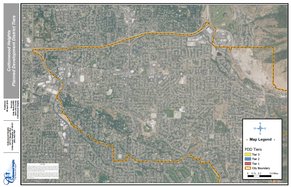
- Creation of the PDD and the possibility of a future PD zone designation are provided to encourage mixed use development or redevelopment of properties in the vicinity of the Wasatch Boulevard gravel pit (see Tier 1-Red on Map 19.51); intersection nodes along Fort Union Boulevard at 1300 East and Union Park Avenue, along Highland Drive and 2300 East, and the Old Mill site on Wasatch Boulevard (see Tier 2-Blue on Map 19.51); and certain areas along Fort Union Boulevard and Union Park Avenue (see Tier 3-Yellow on Map 19.51).
- Development within the PDD should be designed to:
- Promote employment and activity centers such as shopping, entertainment, cultural arts, recreational and community centers, health care facilities, and public transit;
- Provide for a range of employment uses at appropriate intensities and locations, support the integration of living and working uses, and support public transit services;
- Promoting more efficient use of land and public services, potentially allowing more concentrated projects in appropriate circumstances;
- Promote layout, design and construction of development that is sensitive to the natural land form and environmental conditions of the immediate and surrounding area and promote preservation of property with unique features, such as property having historical significance;
- Ensure the adequacy of public facilities to accommodate population growth;
- Encourage quality and variety in building and landscape design to create a vibrant pedestrian environment;
- Encourage the planned development of parcels sufficiently large to permit comprehensive site planning and building design by using master planning as a tool to achieve the goals of the general plan, project harmony, design consistency and the purposes of this chapter;
- Encourage opportunities for public transit services that promote multimodal connections at local and regional levels;
- Encourage a mixture of uses, including complementary high density multi-family residential and loft units, retail service, office, lodging, entertainment and cultural uses, and create a vibrant pedestrian/transit oriented environment to promote pedestrian activity;
- Ensure that provision is made for public and private open space;
- Encourage creative approaches to the use of land through variation in siting of buildings and the appropriate mixing of several land uses, activities and dwelling types, including a variety of housing types;
- Achieve economic development goals concentrated in specific areas of the city by allowing higher intensity and higher quality developments that warrant greater financial investments which, in turn, provide an enhanced economic base for the city;
- Preserve the health, safety and welfare of the public; and
- Implement the purposes and intent of this chapter, this title and the city’s general plan, as determined by the city.
- Such goals/purposes are to be ensured through the preparation and submission of comprehensive development plans showing innovative site layout, design character and integration with the surroundings of the proposed site.
- Development within the PDD should be designed to:
- Rezoning of a specific site to an individually designed PD zone should more appropriately address the unique physical and locational attributes of the subject property. Uses and development standards shall be established by a unique PD zone ordinance (a “PDZ ordinance") adopted for a specific property by legislative action of the city council following planning commission recommendation. Each PDZ ordinance is to be designed according to a detailed plan submitted by the applicant and approved by the city council (following planning commission recommendation), whether with or without amendments or modifications, as part of the PDZ ordinance.
- Growth through use of PD zones generally should occur in a phased and organized manner to avoid costly, premature extension of basic infrastructure and to maintain the integrity of the current and projected general plan. Application for rezoning to a PD zone will be considered where the city concludes that a proposal meets the objectives and criteria set forth in this section, and where the merit of the mix of uses, architectural design, public amenities (serving both the project and city) and pedestrian-oriented spaces combine to meet the collective vision of the planning commission and city council, creating a clearly superior development project than would otherwise be possible through the strict application of zoning district regulations available outside this chapter.
- The city council may approve, as a legislative action following recommendation by the planning commission, a request to rezone a site in a PDD to a PD zone if the city determines that the development achieves the following objectives:
- An integrated mixed-use development containing two or more uses that include a pedestrian orientation as defined in Section 19.51.060(D)(1) in its design and functionality;
- Consistency with the city’s general plan ensuring a compatible and functional relationship to the area and along the major corridors;
- Site features, uses, public amenities and aesthetic characteristics that encourage public pedestrian activity, multi-modal transportation connection points, vitality, convenience and safety in and around the development;
- The plan coherently provides both a physical and functional integration of the site components to each other, to other properties in the PDD and to the balance of the city, including design features that will assure an appropriate transition of uses, building heights, architectural massing and spatial relationships respecting nearby areas; and
- The site is fully served by public streets, municipal services and public utilities of adequate capacity; provided, however, that where infrastructure capacity is judged by the city to be inadequate:
- The city may accept the applicant’s agreement in such form as the city may require under this code ensuring that suitable improvements will be installed in a timely manner; and
- No building permit shall be issued until the city’s approval and acceptance of such an agreement.
19.51.030 Uses
- There are no conditional uses in a PD zone.
- Any use allowed by this title shall be permitted in a PD zone only if such use is specified permitted in the PDZ ordinance creating such PD zone. No uses that are not specifically permitted in the PDZ ordinance creating a PD zone shall be allowed in that PD zone.
- Unless specified in the PDZ ordinance, all buildings and uses shall comply with all city development requirements. The size, location, appearance, and method of operation shall be specified to the extent necessary to ensure compliance with the requirements of this title.
19.51.040 Development Plan
- Development in a PD zone is permitted only in accordance with a development plan (a “PDZ plan”) prepared and submitted by the applicant and approved by the city council, with or without amendments and modifications, as part of the PDZ ordinance for that site following recommendation by the planning commission.
- The applicant shall file its proposed PDZ plan with its application on a city-approved form for creation and adoption of a PD zone for a site located in a PDD. A PDZ plan shall include:
- The location of the proposed development;
- The names of and contact information for the applicant(s) and the owner(s) of the property(ies);
- A written narrative and graphic exhibits explaining and showing the nature and character of the planned development, including:
- The proposed project’s consistency with the city’s general plan and any master plans for covering part or all of the proposed site;
- A statement of how the goals, objectives and specific criteria of this chapter will be satisfied;
- Disclosure of any easements or leases necessary for the proposed project and how their long term continuity will be assured;
- The total acreage of the planned development, broken down into the acreage of any phases or sub-parcels;
- The specific land uses to be permitted in the proposed PD zone and the general location and amount of land proposed for each permitted land use, such as single family residential, multi-family residential, institutional, office, commercial, industrial, common open space/recreation, street use, etc.;
- The scale/intensity of each use, expressed in numbers (i.e., number of residential units, residential density, square footage of retail-commercial, square footage of office uses, etc.) and the acreage allotted to each use. For example, a table of proposed land uses including:
- Proposed maximum and average residential densities for each residential use;
- The maximum total acreage of each residential use, including below market/affordable dwelling units, if applicable;
- The maximum allowable number of each type of residential unit requested, including affordable dwelling units, if applicable; and
- The maximum proposed building/lot coverage for each non-residential use;
- Conceptual lot lines and all dimensional and lot standards for each land use type designated;
- An open space/landscaping plan including the location and composition of all screening, buffering materials, trees and other vegetation;
- An analysis of the traffic impact of the project on existing and proposed streets, current and projected traffic counts on surrounding roads and streets, etc.;
- A traffic circulation plan (vehicular, bicycle and pedestrian) showing project circulation patterns; internal streets, roads and alleys; connections to city and regional transit; interior pedestrian trail connections; and a description of the vehicular transportation circulation system within the project and connecting to larger circulation networks in the city and the region;
- A description of facilities for public transportation, pedestrians, bicycles and other alternatives to private vehicles;
- Preliminary plans for parking, including parking structures, stall counts and location;
- A preliminary development schedule and any proposed phasing plans, including areas to be included in each phase and the location of all open space areas and affordable dwelling units to be included in each phase;
- Tabulations of approximate acreage allotted to public open space, common private open space, and non-common private open space, including a statement of intended uses of open space and public facilities, including a rationale for scale and location;
- A lighting plan showing location, lighting types, foot candle measurements, etc.
- Illustrative architectural elevations for each type of residential and nonresidential unit, including:
- Character sketches of proposed buildings or building types, typical exteriors and architectural elevations, etc. as appropriate to convey an accurate visual imagery of the proposed project; and
- How the scale, massing and design of new buildings compliment and positively contribute to the setting of any buildings within or adjacent to the project and create a pleasing visual relationship with them;
- A preliminary utilities master plan, including the locations of any existing or proposed utility easements; the general location, size and capacity of all existing and proposed utility lines; and an analysis of the development’s projected ten-year water usage and how water efficient materials may be used in the project;
- An infrastructure plan, including a narrative of the proposed project’s impacts on public facilities and public infrastructure;
- A plan detailing any sensitive lands, natural hazards, historic buildings/sites, unique geological features, etc., and how the project’s impact on such areas will be mitigated;
- If the application is to amend the PDZ ordinance for an existing PD zone and the proposed amendment would affect less area than that entire PD zone, the PDZ plan also shall include a map showing the entire existing PD zone and identifying any area to be added to or deleted from that zone, or the area to which the amended PDZ plan would apply;
- If the proposed PD zone includes a large area (generally over 20 acres) and development of at least 80% of the PD zone is not expected to occur within the following two years, then the city may require the PDZ plan to include additional land use planning as specified by the city’s community development director or designee (the “director”); and
- Such other information as the director deems necessary or appropriate to determine whether the application complies with the standards established in this chapter, which additional information typically will be designated by the director in the pre-application phase.
- The PDZ plan also shall include a draft PDZ ordinance to be considered by the planning commission, including all applicable text, tables, drawings, schematics and the like complying with the formatting and usage conventions of this code, as determined by the director in consultation with the city attorney. The draft PDZ ordinance shall include development requirements for the proposed PD zone such as permitted uses, densities, lot areas, lot widths and depths, building heights, building elevations, lot coverage, floor area ratio, parking, access, screening, landscaping, accessory buildings, signs, lighting, management associations, and other requirements as the director, the planning commission and/or the city council may deem appropriate during their review of the application.
19.51.050 Development Requirements
- Development requirements for each PD zone shall be set forth in the PDZ ordinance creating such PD zone and shall include, without limitation, the standards listed in the following documents:
- This title;
- Title 12 (Subdivisions) of this code;
- APWA standards; and
- Such other standards as the city council may deem appropriate following recommendation by the planning commission.
- A PDZ ordinance also shall include:
- A schematic map showing:
- Proposed land use designations;
- Streets and parking lots, including parking structures and details;
- Public open space and other public facilities, and landscaping; and
- Structures, natural features or other site amenities to be preserved.
- Maps indicating the following transportation circulation systems within the project and connecting to larger circulation networks in the city and region:
- Vehicular, including public transit;
- Bicycles; and
- Pedestrians.
- A preliminary development schedule and phasing diagram showing each phase of the development;
- A schematic map showing:
- The PDZ ordinance may expressly delegate some, or all, of the future decisions on the development plans to the director, subject to the requirements of this chapter and the PDZ ordinance.
19.51.060 Site Development Regulations
- Base Regulations. The following table, designated “Table 1: Site Development Regulations – Planned Development Districts” (“Table 1”), sets forth the base site development regulations for the PDD, which are in addition to any further development regulations set forth in the PDZ ordinance for a property. Letter designations in the “Additional Regulations” column of Table 1 refer to the additional regulations that follow Table 1 in this section. The intent of these regulations is to promote vertical and horizontal mixed use development in a pedestrian–oriented environment.
Table 1: Site Development Regulations – Planned Development DistrictsStandards Tier 1 Tier 2 Tier 3 Additional Regulations Area Requirement (in contiguous acres) 10 3 1* (B)(1) Lot Coverage No Min. or Max. 65% 65% (B)(2) Building Height Minimum Bldg. Height (ft.) 25' No Minimum No Minimum Maximum Bldg. Height (ft.) Varies from 50’-300’ from Wasatch Blvd. elevation 50' 35'* (B)(3) Min Bldg. Setback (ft.) (B)(4) Front 0 0 0 Side (Street) 0 0 0 Side (Residential) 50’ from adjacent residential properties outside project area Same as adjacent residential zone Same as adjacent
residential zoneSide (Nonresidential) 0 0 0 Rear (Residential) 50’ from adjacent residential properties outside project area Same as adjacent residential zone Same as adjacent
residential zoneRear (Nonresidential) 0 0 0 Storefronts & Access Yes Yes Yes (B)(5) Building Transparency Yes Yes Yes (B)(6) Open Space 25%* gross lot area 15% gross lot area 15% gross lot area (B)(7) Landscape (B)(8) Off-Street Parking and Loading The development plan may require the provision of a minimum number of on-site parking and loading spaces. (B)(9) Parking setback Pedestrian Circulation Yes Yes Yes (B)(10) Signage Master sign program required (B)(11) Below Market Rate (BMR) Housing 10% of total residential for projects with 50 or more units 10% of total residential for projects with 25 or more units 10% of total residential
for projects with 25 or
more units(B)(12) Exterior Lighting Standards Yes Yes Yes (B)(13) Residential Density - Dwelling Units/Acre Based on IBC/IRC Occupancy 35 dwelling units/acre 20 dwelling units/acre - Additional regulations.
- Area requirement. An application for a PD zone may be submitted and approved only for a site containing the specified minimum acreage; provided, however, that the area requirement in Tier 3 may be reduced on a case-by-case basis if approved by the city council following recommendation by the planning commission.
- Lot coverage.
- The following areas are to be included for the purpose of computing lot coverage:
- All buildings, including dwellings; and
- All accessory structures, including sheds, garages, pool structures, carports, decks, roof overhangs exceeding 20”, platform walkways and similar structures; and
- For those properties also within the Sensitive Lands Overlay Zone, lot coverage shall be limited to 30%, including all structures and impervious surfaces.
- The following areas are to be excluded for the purpose of computing lot coverage:
- Existing grade level walkways and driveways; and
- Retaining walls and fences.
- The following areas are to be included for the purpose of computing lot coverage:
- Maximum building height.
- The maximum building height in any Tier 1 PD zone will be determined by the setback of the building from the public right of way for Wasatch Boulevard, and will be the height measurement in feet for that setback shown in the following table: *Measured from the average grade elevation of Wasatch Boulevard.
Setback from Wasatch Blvd. Building Height (ft.) 0 to 20’ No Building 20’ to 50’ 60’ Height* 50’ to 100’ 100’ Height* 100’ to 250’ 120’ Height* 250’ to 500’ 150’ Height* 500’ and more 300’ Height* - The maximum building height in any Tier 2 PD zone is 50 feet if the first two stories (beginning at the street level) are commercial and/or office uses. The maximum building height is reduced to 35 feet for any building that either does not have commercial/office uses on the first two stories or is located within 50 feet of a single-family zoning district.
- The maximum building height in any Tier 3 PD zone is 35 feet if the first story (at street level) is a commercial and/or office use. The maximum building height is reduced to 30 feet for any building that is located within 50 feet of a single-family zoning district. Notwithstanding the foregoing, however, the building height in a Tier 3 PD zone may exceed 35 feet, to a maximum of 50 feet, if so specified in the PDZ ordinance, so long as the proposed building will contain commercial/office uses on the first two stories, is adjacent to a more intensive development, and is not located within 50 feet of a single-family zoning district.
- Building height shall not exceed the corresponding building height for each tier in the table measured from the grade plane as defined in the city’s building code (the “building code”). Parapet walls, rooftop penthouses, landscaping and vegetative amenities and other similar architectural features may extend above the maximum building height provided they contribute to the overall architectural character of the building as determined by the city’s architectural review commission (“ARC”) and contain only mechanical or other apparatus necessary for the operation of the building.
- The maximum building height in any Tier 1 PD zone will be determined by the setback of the building from the public right of way for Wasatch Boulevard, and will be the height measurement in feet for that setback shown in the following table:
- Setbacks.
- Setbacks from the public right of way shall be determined by the site plan approved as part of the PDZ ordinance for a site. Typically, setbacks shall be measured from one foot behind the public sidewalk or, if no sidewalk exists, one foot behind the top of curb. Other setbacks shall be measured from the property line of the adjoining tract. There shall be no setbacks for buildings from internal lot lines within the PDD unless required by the building code or Table 1.
- Fifty percent (50%) of ground floor building facades shall be located at the setback line when the building fronts on an arterial or collector street. If authorized in the PDZ ordinance, permanent shade structures such as canopies and arcades may encroach up to ten feet within the setback area when abutting an arterial or collector street, so long as a vertical clearance of at least ten feet above finished grade is maintained.
- Outdoor dining areas adjacent to public streets shall provide a minimum of six feet of unobstructed pedestrian circulation, or such greater distance as may be specified in the PDZ ordinance.
- Building street facades above the street level may not encroach into the setback area more than ten feet.
- Storefronts and access (retail and commercial areas). A minimum of 50% of the height and width of the ground floor frontage of principal buildings shall consist of windows, window displays, doors, or a combination thereof. In Tier 1 areas, this requirement will be defined in the approved site plan and project design guidelines manual.
- Transparency (retail and commercial areas).
- On the ground floor, view windows, window displays, or doors shall be provided between two and eight feet above grade adjacent to the principal building frontage.
- A minimum of 25% of a building’s upper floor (above the ground floor) elevations along streets shall have view windows with non-reflective glass.
- In Tier 1 areas, the transparency requirements shall be defined in the approved site plan and project design guidelines manual.
- Open space. Open space shall be provided in the form of natural areas meriting preservation, landscaping, pedestrian plazas, atriums and other significant spaces open to the public. Vehicular circulation and parking areas shall not qualify as open space but are required to meet parking and landscaping requirements. At least 75% of required open space must be ground level in Tier 1 areas.
- Landscaping. Prior to the use or occupancy of any premises in a PD zone, the following landscaping requirements must be met:
- Provide a total landscaped area equal to at least 25% of the gross land area in that PD zone. The landscaped area may be provided at the ground level or on upper level balconies, decks or roofs (such as with permanently affixed planter boxes), or any combination thereof. At least 60% of the landscaped area shall be vegetated.
- Provide a ground level landscaped area equal to at least 15% of the gross land area in that PD zone.
- For landscaped areas designed as buffers, setbacks or visual backdrops, 40% of the area shall be vegetated with a combination of groundcover, vines, shrubs, and trees. These areas must be at least eight feet wide.
- For large paved pedestrian spaces such as courtyards or plazas, a 12-foot tall/two inch caliper conifer, or a 15-gallon/eight-foot tall deciduous tree, shall be required for every 200 square feet of paved area. A 50% reduction in the number of trees may be permitted if at least 25% of the ground plane is vegetated with potted plants, vines, shrubs, or groundcover.
- Parking.
- The minimum off-street parking requirement shall be specified in a parking plan approved as part of the PDZ ordinance using the standards of Chapter 19.80 (Off-Street Parking Requirements) of this code as a guide.
- The potential for shared use of on-site parking shall constitute an additional standard for possible reduction of required parking, subject to the standards of Section 19.80.110 of this code and a compelling demonstration that there will be adequate parking available for all uses.
- In Tier 1 areas, twenty-five percent of all required parking shall be structured parking. 50% of all required parking shall be integrated within buildings behind active uses or appropriately screened from sensitive views from any public street, residential property or public pedestrian way.
- Parking setback shall be determined by the site plan approved by the PDZ ordinance.
- Street level, surface parking shall be located behind or adjacent to buildings or screened by a minimum ten foot tall landscaped berm.
- Minimum parking lot setbacks are as follows:
- Wasatch Boulevard lot lines: 20 feet or as specified in the PDZ ordinance.
- Fort Union Boulevard lot lines: 30 feet.
- Highland Drive lot lines: 30 feet.
- Abutting land used for single family residential: 20 feet.
- All other property lines: 8 feet.
- Where a nonresidential use in a proposed PD zone cannot provide all the required parking spaces on-site, off-site parking may be approved as part of the PDZ ordinance subject to revocation of such approval if the use of the site materially changes and further subject to the following additional requirements:
- The off-site parking spaces shall be located within 600 feet of the use;
- The off-site parking spaces shall be improved to the standards set forth in this code; and
- The applicant shall provide recorded, legally effective and perpetual cross-easements for parking or evidence provided of adequate public parking.
- Pedestrian Circulation. Each PD zone shall comply with the following pedestrian circulation regulations:
- Sidewalks and pedestrian walkways shall be provided in accordance with a submitted pedestrian circulation plan approved as part of the PDZ ordinance.
- Minimum requirements for public sidewalks in a PD zone include:
- Continuous sidewalks with a minimum width of six feet shall be located along both sides of collector and arterial public streets and both sides of internal private street(s). Sidewalks along Fort Union Boulevard and Wasatch Blvd shall have a minimum width of eight feet.
- Sidewalk(s) along the private street(s) shall be located within a public pedestrian easement to be shown on the final plat granting access to the public.
- Minimum requirements for private pedestrian walkways in a PD zone include:
- Hard surfaced with a minimum width of five feet or such greater width as may be required by this section;
- Readily visible and free of encroachment by parked vehicles;
- Paved with concrete or other masonry products differentiated from the driveway and parking areas through the use of color, texture, or materials;
- Predominantly shaded with deciduous shade trees spaced at one per 30 linear feet of walkway or building canopies; and
- Lighted with pedestrian-scaled fixtures.
- A pedestrian walkway shall connect a building entrance to the private or public street sidewalk.
- If parking is located between the street and the building, at least one walkway shall be provided to and through its associated parking area to connect a building entrance to a public street sidewalk.
- In order to create a safe pedestrian environment, multifamily residential buildings shall be placed and sited so that all required internal sidewalks are in view of at least one unit’s living area windows.
- Internal sidewalks parallel and adjacent to a street or drive aisle shall be raised or separated from the street or drive aisle by a raised curb, landscaping or other physical barrier. If a raised internal sidewalk is used, the ends of the raised portions must be equipped with curb ramps.
- When adjacent to perpendicular, head-in, or diagonal parking, a pedestrian walk must be increased in width to a minimum of seven feet when parking is located on one side, and a minimum of nine feet when parking is located on both sides.
- Minimum requirements for public plazas include:
- Publicly-accessible plazas shall be located as shown on the approved site plan.
- Each plaza shall include a decorative paving pattern.
- Each plaza of up to 500 square feet in area shall include at least two benches, two shade trees and four bicycle parking spaces. An additional two benches, two shade trees and four bicycle parking spaces shall be provided for each additional increment of 500 square feet of plaza area, prorated for additional area of less than 500 square feet.
- Signage.
- A master sign program shall be submitted as part of the application for a PD zone that details each type, material, color and location of each requested sign.
- Permitted signage shall be as specified in the PDZ ordinance, provided that OPEDS (as defined in Chapter 19.82) are not permitted. All permitted signs shall comply with all city development requirements in Chapter 19.82 (Signs). The size, location, appearance, and method of operation of signage in a PD zone may be specified in the PDZ ordinance to the extent necessary to ensure compliance with the purpose of this chapter.
- Below Market Rate (BMR) housing requirement.
- All PD zone ordinances shall require the development to include below market rate housing units ("BMR units"). The minimum number of BMR units in a project shall be based on the project's tier (see Table 1, above) and the requirements of this subsection (B)(12). The required BMR units shall be affordable to households whose total income is at or below (i) 50% of the city's area median income ("AMI"), and/or (ii) 50% to 80% AMI. For applications proposing BMR housing that is affordable to households whose total income is at or below 50% AMI, at least 10% of the residential units in the project shall be BMR units that are affordable to households in that income category. For applications proposing BMR housing that is affordable to households whose total income is between 50% AMI and 80% AMI, at least 15% of the residential units in the project shall be BMR units that are affordable to households whose total income is between 50% AMI and 80% AMI. Applications proposing a mix of the two AMI housing groups listed above shall require between 10% and 15% BMR units, as determined by the city council to meet the intent of this subsection on a "blended" approach.
- The draft PDZ ordinance shall include appropriate language to ensure proper administration of, and guaranteeing ongoing compliance with, this subsection, including a requirement to record the final PDZ ordinance against legal title to the project in the official records of Salt Lake County in a recording priority that is reasonably agreed to by the project applicant and the city to assure ongoing constructive notice of, inter alia, the BMR requirements of this subsection.
- Lighting Standards.
- Lighting shall be regulated by Chapter 19.77 - Lighting.
- Existing development.
- Continued use of existing, legally non-conforming improvements, including buildings, landscaping, parking and other uses, may be authorized by a PDZ ordinance to facilitate the fullest attainment of the objectives of this chapter.
- The area of the original lot supporting such non-conforming uses shall not be included in any calculations within the PD zone. Existing, legally non-conforming improvements or lots may be modified in connection with the PD zone development to achieve superior design, but shall not be expanded or extended. Any such modification shall not be deemed to render the improvements or lots more non-conforming.
- Site design criteria. All development in a PD zone also shall satisfy the following site design criteria by providing a combination of the following:
- Pedestrian oriented interface. A pedestrian oriented interface, which is defined as uses of buildings and/or design features that encourage pedestrian interaction at the street level. These include, without limitation, retail and commercial shops; space designed to be adaptable to retail uses; service businesses; establishments dealing directly with the general public; visually interesting features such as public art or building lobbies; display cases; accessible plazas; or similar landscaped open spaces and pedestrian promenades/walkways for public use and congregation.
- Site plan promotes transit oriented development. Improvements that promote available transit-oriented development features, including pedestrian-friendly design, improvements at transportation nodes, and other similar features likely to promote public transit.
- Environmentally sustainable design checklist. As part of the application, an environmentally sustainable design checklist shall be submitted that demonstrates the intent to design and build the proposed project in an environmentally sustainable manner. All projects in a PD zone should provide elements that comply with environmental design standards established by the Green Building Council or similar, and may incorporate xeriscaping, utilize native plants and drought-resistant vegetation, etc. Related documentation and requirements may be incorporated as part of the city’s approval process in the PDZ ordinance or otherwise.
19.51.070 Application And Review Procedures
- Overview. The process for granting, modifying, amending, or revising a PD zone or any of the development conditions, development plans, permitted uses or other matters covered by a PDZ ordinance shall be the same as for any zoning district set forth in this title, except as modified by this chapter. As part of the application and approval process, the city may require written reports from each affected public or quasi-public entity, including the school district, utilities providers, special districts and other public and quasi-public officers and entities as deemed necessary or appropriate by the city.
- Specific procedures.
- Pre-application conference. Before submitting a PDZ plan, the applicant shall confer with the director to discuss the proposal and the applicable development review and approval procedures.
- Concept plan. A concept plan shall be required for any proposed PD zone containing 50 or more dwelling units and/or five or more acres of non-residential development. The concept plan shall show all proposed streets, alleys, drives, buildings, parking areas, landscaped areas, screening, uses of building and land, building heights, topography, and other features of the proposed development. A concept plan shall be construed to be an illustration of the development concepts only and not an exact representation of the specific development proposed.
- PD zone applicants shall present any required concept plan to the planning commission in a work session at least once before submitting a formal application. Such presentation shall be for discussion and informal feedback purposes only, and no action shall be taken concerning the concept plan at the work session.
- The director or planning commission may require applicants for PD zone which are not required to submit a concept plan under (B)(2)(a), above, to nonetheless present the proposed development to the planning commission in a work session prior to submitting a formal application.
- Community Workshop. After the pre-application conference and presentation of any concept plan, the applicant shall hold at least two community workshops whose purpose is to ensure early citizen participation, in an informal forum, in conjunction with the development application and to provide an applicant with the opportunity to understand and try to mitigate any anticipated impacts of the proposed development on the surrounding community. A community workshop is not intended to produce complete consensus on all applications, but to encourage applicants to be good neighbors and to allow citizen input at the early stages of a proposed development. The city will provide mailing address label for the developer to use to notify surrounding residents, and will require the developer to certify that such mailing timely occurred. City’s planning staff shall be informed of the time and place of each such workshop, and shall be invited to attend. An accurate summary of citizen comments received at the workshops shall be provided to the city within five business days after each meeting.
- Draft PDZ plan submittal. After the required pre-application conference and prior to submitting a formal application, the applicant shall submit one electronic copy and at least two paper copies of a draft of the requested PDZ plan for staff review, accompanied by the same number of copies of a PDZ checklist (available through the director) completed for the project. The director then will cause the draft PDZ plan to be reviewed to determine its compliance with this chapter and all other applicable laws, rules and regulations. Comments will then be conveyed to the applicant so that the applicant may make any desired modifications to the draft PDZ plan.
- PD zone application. The applicant may submit an application for a PD zone following completion of the procedural steps described Subsections (B)(1)-(4) of this section.
- No application for a PD zone shall be accepted as complete unless it includes the following:
- One completed PD zone application signed by the current property owner(s) and by any third-party developer;
- One digital copy and three paper copies of the applicant’s final version of the PDZ plan, including all text, charts, tables, exhibits and graphics;
- The fee required by the city’s consolidated fee schedule;
- One legible copy of the approved and recorded plat showing the current property lines of the parcel(s) to be included in the PD zone;
- One copy of the current, recorded deed covering the affected property;
- A current title report covering the affected property issued by a Utah-licensed title insurance company showing vesting and all recorded easements and other matters affecting the property;
- An ALTA survey covering the affected property;
- Documentation of the required community workshops held regarding the proposed PDZ plan application;
- A current aerial of the site overlaid with the proposed plan;
- An analysis of the impact of the proposed development on existing public facilities and services such as streets, water, sewer, etc. as well as complete information concerning any proposed future improvements to these facilities and services to be made as part of the planned development;
- A traffic study that meets the requirements of this chapter for the proposed PD zone development or development phases;
- A development schedule with a generalized phasing schedule, if appropriate. Among other things, the phasing schedule shall include the number of dwelling units, total acreage of each residential use, the total gross floor area of each non-residential use, the percentage and acreage of common open space to be included in each phase, and the percentage, number and acreage of any required BMR units to be included in each phase;
- A statement of how any common open space/recreation areas will be owned and managed;
- A statement of how all roads, alleys, walkways and parking areas will be owned and maintained;
- Letters of coordination from all public, quasi-public and private entities and agencies from which the applicant must either (A) obtain permits, or (B) obtain services and/or facilities;
- A statement that the proposed PD zone development is feasible based on the results of a competent market study;
- A statement of agreement to proceed with proposed development in accordance with the provisions of PD zone application and PDZ plan, this title, applicable provisions of the city’s general plan, and such other requirements as may be included in the final PDZ ordinance; and
- Any other information that the director, the planning commission and/or the city council then, or thereafter, determines is reasonably necessary to make an informed decision as to whether the application complies with the standards of this chapter.
- All land use, concept, and detail plans shall be accurately drawn to an appropriate legible scale and shall include title, north arrow, date drawn, and necessary references to accurately locate the property. Copies in sufficient quantity and at an appropriate size for review purposed shall be submitted by the owner, applicant, or their representative.
- No application for a PD zone shall be accepted as complete unless it includes the following:
- Department review and report. Once an application is deemed complete by the director, the application will be scheduled for a public hearing before the planning commission, which may occur before or after discussion and analysis of the application by the planning commission in one or more public meetings. The director shall cause his staff to prepare a report reviewing the PD zone application, which shall be provided to the planning commission, the applicant, and any other interested parties.
- Public notice. Public notice of the public hearing and other meetings where the PD zone application is considered by the planning commission, the city council or any other public body of the city shall be provided as required by Utah state law and this title.
- Planning commission review and recommendation. The planning commission shall review the proposed PD zone application and proposed PDZ ordinance and, following the public hearing and such modifications to the PDZ ordinance as the planning commission may deem appropriate, recommend that the city council either approve, approve with modifications, or deny the proposed PDZ ordinance and related zoning map amendment based, inter alia, on the following criteria:
- Whether the application is complete and complies with all applicable statutes, ordinances and codes, and the city’s general plan;
- Whether the proposed rezoning would materially, adversely impact the provision of public facilities and services;
- Whether the proposed rezoning would materially, adversely impact the provision of public transportation and transit services;
- Whether the subject land is suitable for the intended use;
- Whether the city and other public and quasi-public entities and agencies will be able to timely provide necessary public services, utilities, facilities and programs to serve the proposed development;
- Whether the proposed development would create unacceptable traffic congestion or burden the existing road network;
- Whether the PDZ plan provides for unified development control under a unified plan; and
- Whether the proposed development will contain requisite utility infrastructure in terms of quantity, dependability and quality as determined by the utility providers.
- City council review and decision. After receiving the recommendation of the planning commission, the city council may seek additional public comment on the application. The city council shall take action in a public meeting to adopt or reject the PDZ ordinance and zoning map amendment either as proposed by the planning commission or after making any revisions that the city council considers appropriate. Any approval by the city council of the PDZ ordinance (and the PDZ plan incorporated by the PDZ ordinance) may impose completion deadlines for the proposed development and/or any development phases.
19.51.080 Reversionary Clause
All PDZ ordinances shall incorporate or be deemed to incorporate, and shall be subject to, the following reversionary clause:
If a building permit is not issued for the principal improvements to be constructed on the subject property, as shown on the PDZ plan approved by this ordinance, within three years after the effective date of this ordinance, this ordinance shall be deemed retroactively repealed and the property located in the PD zone created by this ordinance shall revert back to its zoning designation in effect immediately prior to the passage of this ordinance (or the equivalent of such zoning designation that is in existence on the date of such reversion). An applicant may request an extension for additional one year provided that (A) the extension is applied for prior to the third anniversary of the effective date of the PDZ ordinance; and (B) the director determines that good cause exists for the granting of such requested extension.
19.51.090 Severability
If any provision of this chapter or its application to any person or circumstance is held invalid, the invalidity of that provision or application does not affect other provisions or applications of this chapter that can be given effect without the invalid provision or application, and to this end the provisions of this chapter are severable.
19.51.100 Planned Development District Areas And Tiers Map
Click here to view larger image in PDF format.