
Crowley City Zoning Code
ARTICLE 3
- ZONING DISTRICTS
106.45 - GENERAL TO ALL ZONING DISTRICTS & ZONING MAP
A.
ZONING DISTRICTS ESTABLISHED
(1)
This article establishes all the zoning districts within the City of Crowley, Texas. This Article 3 and Article 5: Use Standards identify the dimensional standards established and uses allowed within the districts.
(2)
The following Table 106.45-1 provides a summary of the zoning districts established.
B.
ZONING DISTRICT MAP
(1)
Boundaries. The boundaries of the zoning districts are delineated on the zoning district map of the city, which is incorporated in and made a part of this chapter for all purposes.
(2)
Adoption. Original, official, and identical copies of the zoning district map are hereby adopted and shall be identified by the signature of the mayor, attested by the city secretary, and bearing the seal of the city under the following words: "This is to certify that this is the official zoning map of the City of Crowley, Texas," together with the date of adoption. The zoning district map shall be filed and maintained as follows:
a.
One copy shall be filed with the city secretary and retained as the original record and shall not be changed in any manner. A second reproducible copy shall be filed with the city secretary and shall be the official zoning district map. This map shall be maintained by posting on the map all changes and subsequent amendments after their enactment for the use of the Planning and Zoning Commission and City Council.
b.
One copy shall be filed with the administrative official and shall be maintained by posting on the map all changes and subsequent amendments.
c.
Reproductions for information purposes may, from time to time, be made of the official zoning district map.
C.
ZONING DISTRICT BOUNDARIES. Where uncertainty exists as to the boundaries of districts as shown on the official zoning map, the following rules shall apply:
(1)
Centerlines. Boundaries indicated as approximately following the centerlines of streets, highways, or alleys shall be construed to follow such centerlines.
(2)
Lot Lines. Boundaries indicated as approximately following platted lot lines, or tract or survey lines for unplatted property, shall be construed as following such lot or tract lines.
(3)
City Limits. Boundaries indicated as approximately following city limits shall be construed as following city limits.
(4)
Railroads. Boundaries indicated as following railroad lines shall be construed to be midway between the main tracks.
(5)
Waterways. Boundaries indicated as approximately following streams, drainage courses, creeks, canals, lakes, or other bodies of water shall be construed to follow such centerlines.
(6)
Extensions of Features. Boundaries indicated as parallel to, or extensions of features indicated in subsections (1) through (5) of this section shall be so construed. Distances not specifically indicated on the official zoning map shall be determined by the scale of the map.
(7)
Vacated Public Way. Whenever any street, alley, or other public way is vacated by official action of the City Council, the zoning district line adjoining each side of the street, alley, or other public way shall be automatically extended to the centerline of the vacated street, alley, or way, and all areas so involved shall be subject to regulations of the extended districts.
(8)
Variations of Physical Features and Official Zoning Map. Where physical or cultural features existing on the ground vary with those shown on the official zoning map or when there arises a question as to how or whether a parcel of property is zoned and such question cannot be resolved by the application of subsections A through G of this section, the property shall be considered as classified in the AG Agricultural District, in the same manner as provided for newly annexed territory, and the issuance of a building permit and the determination of zoning shall be in accordance with the provisions provided in Section 106.45.E, Annexed Territory.
D.
GENERAL TO ALL ZONES
(1)
Double frontage lots: Where lots have double frontage, running through from one street to another, a required front yard shall be provided on both streets unless otherwise established by plat or by ordinance, in which case only one required front yard need be provided.
(2)
Thoroughfares: Front yard requirements in all districts adjacent to an existing or proposed major thoroughfare or secondary thoroughfare street, as designated in the city's adopted Master Thoroughfare Plan, shall be measured from such existing or proposed major thoroughfare or secondary thoroughfare street future right-of-way (ROW) line.
(3)
Two or more zoning districts: Where the frontage on one side of the street between two intersecting streets is divided by two or more zoning districts, the front yard shall comply with the requirements of the most restrictive district for the entire frontage from one intersecting street to the other. This standard shall not apply in the Downtown District.
(4)
Established building line (or front setback line): Building lines established by plat shall be for informational purposes only. Building lines or setback lines shall be established by zoning district standards only.
(5)
Measurement of Yards: All yards shall be measured from the property line to the face of the building closest to and along that property line. Encroachments into the yard may be allowed as established in the district standards.
E.
ANNEXED TERRITORY
(1)
Classification of Newly Annexed Territory. All territory which is hereafter annexed to the city shall automatically have an AG Agricultural District classification. The procedure for establishing zoning on annexed territory shall conform to the procedure established by state law for the adoption of original zoning regulations.
(2)
Alternative Zoning of Newly Annexed Territory. The City Council, upon recommendation from the Planning and Zoning Commission or request by petitioners for annexation, may approve alternative zoning classifications in an area being considered for annexation. The City Council and Planning and Zoning Commission may hold public hearings on annexation and zoning simultaneously and may approve the zoning of a newly annexed area at the time of annexation.
(3)
Construction in Newly Annexed Territory. No person shall erect, construct, or proceed or continue with the erection or construction of any building or structure, add to any building or structure, or cause the same to be done in any newly-annexed territory without first applying for and obtaining a building permit or certificate of occupancy from the building official. No permit for construction of a building or use of land shall be issued by the building official other than a permit which will allow the construction of a building permitted in the AG Agricultural District unless other zoning has been approved per previous subsections (Section 106.45.E (2) above).
106.46 - RESIDENTIAL DISTRICT REGULATIONS
A.
PURPOSE AND INTENT:
(1)
Provide appropriate locations for residential development that are consistent with the City of Crowley Future Land Use Plan and Comprehensive Plan.
(2)
Ensure adequate light, air, and privacy for all dwelling units.
(3)
Appropriately address multi-modal transportation access and ensure adequate availability of public services and utilities including pedestrian circulation through the provision of sidewalks, and provision of bicycle facilities according to the requirements of any adopted plans and policies.
(4)
Allow for a mix and range of housing types that meet the diverse needs of residents, either in one zoning district or different zoning districts.
(5)
Protect residential development from the encroachment of uses that are incompatible with a residential use.
(6)
Allow complementary uses such as parks, open space, public schools, religious assemblies, minor public or private utilities, accessory buildings, and certain temporary uses in all residential zoning districts.
B.
AG AGRICULTURAL DISTRICT
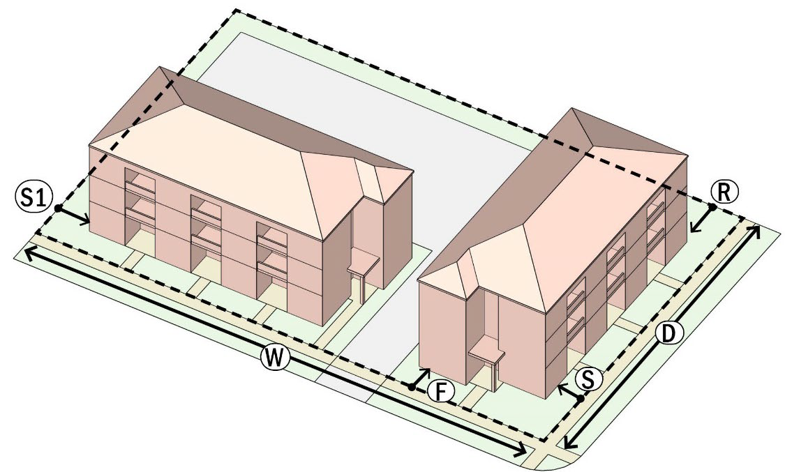
| ILLUSTRATION | ||
 | ||
| PURPOSE | ||
| The Agricultural (AG) District is intended to accommodate agricultural uses on large acreage. This district can also accommodate single-family detached residential uses and accessory buildings. It may be used as a holding zoning when property is first annexed into the city. The district provisions allow compatible agricultural uses that are in keeping with the rural character of these neighborhoods. | ||
| LOT SIZE AND DENSITY | ||
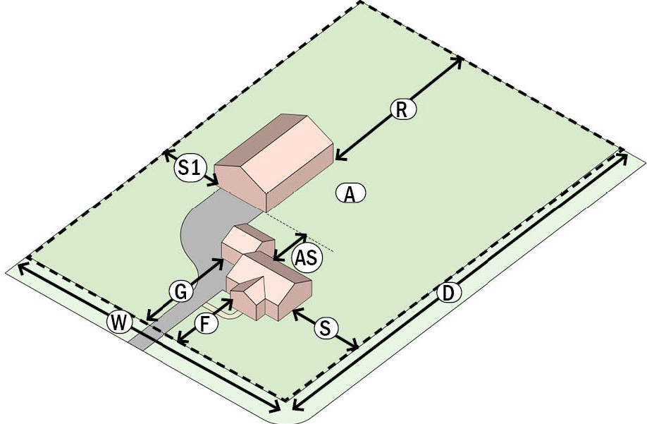
| LOT AREA (MIN.) | A | 60,000 sq. ft. |
| LOT WIDTH (MIN.) | W | 150 feet |
| LOT DEPTH (MIN.) | D | 200 feet |
| NET DENSITY (MAX.) | 0.7 DU/Acre | |
| LOT COVERAGE (MAX.) | 45% (Including all accessory buildings on the lot but excluding pools and spas) | |
| PRIMARY BUILDING SETBACKS (MIN.) | ||
| FRONT (PRIMARY STREET) | F |
40' along Arterial and Collector streets
30' along all other streets |
| FRONT (SECONDARY STREET) (CORNER LOT) | S |
40' along Arterial streets
30' along all other streets |
| SIDE PROPERTY LINE | S1 | 10' |
| REAR PROPERTY LINE | R | 20' |
| REAR OR SIDE (ALLEY) | R | 10' |
| ACCESSORY BUILDING SETBACKS (MIN.) | ||
| SETBACK FROM PRIMARY BUILDING | AS | 5' |
| SETBACK FROM ANY OTHER ACCESSORY BUILDING | 5' (Shall meet any fire separation standards based on the construction type and use) | |
| SIDE PROPERTY LINE | 5' | |
| REAR PROPERTY LINE | 5' | |
| REAR OR SIDE (ALLEY) | 5' | |
| ENCROACHMENTS INTO YARDS | ||
| GENERAL | All required yards shall be open to the sky with the exception of the following encroachments allowed. | |
| FRONT YARD ENCROACHMENT | Porches, stoops, and porte-cocheres may encroach into the front yard to a maximum of six feet (6') or 50% of the front yard, whichever is less | |
| All OTHER YARD ENCROACHMENTS |
Encroachments shall not be over any utility or drainage easements.
Encroachments (including pools and spas) shall be no closer than 5' to any side or rear property lines. Encroachments shall include fire escapes, ornamental features, roof eaves, terraces, balconies, etc. | |
| PARKING PLACEMENT AND ACCESS | ||
| PARKING PLACEMENT | G |
Residential garages (attached or detached) with driveway access from the Primary Street
shall be setback a minimum of 10 feet from the front façade of the building.
Surface parking spaces shall NOT be located within any front yards or lawn areas. Exception to the above may be made in the case of porte-cocheres and driveways located in the front setback area. Unenclosed carports in the side or rear yards shall be permitted as long as the minimum setbacks are met. |
| BUILDING HEIGHT AND MASS | ||
| PRIMARY BUILDING (MAX.) | 35' | |
| ACCESSORY BUILDING (MAX.) | 35' (silos, barns, and similar structures used for agricultural purposes are exempt from this limitation) | |
| DWELLING SIZE (MIN.) | 1,600 sq. ft. | |
| ADDITIONAL REQUIREMENTS WITHIN THE ZONING DISTRICT | ||
| Article 5. Use Standards
Article 6. Building Design Standards Article 7. Parking and Transportation Article 8. Landscaping, Screening, and Open Space | ||
C.
R-1 SINGLE FAMILY RESIDENTIAL DISTRICT
| ILLUSTRATION | ||
 | ||
| PURPOSE | ||
| The R-1 Single Family Residential District is intended to accommodate the development and conservation of single-family dwellings in large-lot suburban environments. The district shall also accommodate associated Accessory Buildings. The district provisions allow for transitions to adjoining agricultural uses that are in keeping with the rural character of these neighborhoods. | ||
| LOT SIZE AND DENSITY | ||
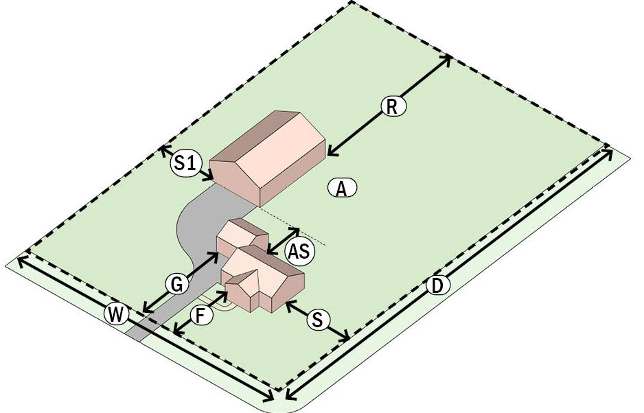
| LOT AREA (MIN.) | A | 20,000 sq. ft. |
| LOT WIDTH (MIN.) | W | 100 feet |
| LOT DEPTH (MIN.) | D | 200 feet |
| NET DENSITY (MAX.) | 2 DU/Acre | |
| LOT COVERAGE (MAX.) | 45% (Including all accessory buildings on the lot but excluding pools and spas) | |
| PRIMARY BUILDING SETBACKS (MIN.) | ||
| FRONT (PRIMARY STREET) | F |
30' along Arterial and Collector streets
20' along all other streets |
| FRONT (SECONDARY STREET) (CORNER LOT) | S |
30' along Arterial streets
20' along all other streets |
| SIDE PROPERTY LINE | S1 | 10' |
| REAR PROPERTY LINE | R | 20' |
| REAR OR SIDE (ALLEY) | R | 10' |
| ACCESSORY BUILDING SETBACKS (MIN.) | ||
| SETBACK FROM PRIMARY BUILDING | AS | 5' |
| SETBACK FROM ANY OTHER ACCESSORY BUILDING | 5' (Shall meet any fire separation standards based on the construction type and use) | |
| SIDE PROPERTY LINE | 5' | |
| REAR PROPERTY LINE | 5' | |
| REAR OR SIDE (ALLEY) | 5' | |
| ENCROACHMENTS INTO YARDS | ||
| GENERAL | All required yards shall be open to the sky with the exception of the following encroachments allowed. | |
| FRONT YARD ENCROACHMENT | Porches, stoops, and porte-cocheres may encroach into the front yard to a maximum of six feet (6') or 50% of the front yard, whichever is less | |
| All OTHER YARD ENCROACHMENTS |
Encroachments shall not be over any utility or drainage easements.
Encroachments (including pools and spas) shall be no closer than 5' to any side or rear property lines. Encroachments shall include fire escapes, ornamental features, roof eaves, terraces, balconies, etc. | |
| PARKING PLACEMENT AND ACCESS | ||
| PARKING PLACEMENT | G |
Residential garages (attached or detached) with driveway access from the Primary Street
shall be set back a minimum of 10 feet from the front façade of the building.
Surface parking spaces shall NOT be located within any front yards or lawn areas. Exception to the above may be made in the case of porte-cocheres and driveways located in the front setback area. Unenclosed carports in the side or rear yards shall be permitted as long as the minimum setbacks are met. |
| BUILDING HEIGHT AND MASS | ||
| PRIMARY BUILDING (MAX.) | 35' | |
| ACCESSORY BUILDING (MAX.) | 35' (silos, barns, and similar structures used for agricultural purposes are exempt from this limitation) | |
| DWELLING SIZE (MIN.) | 1,800 sq. ft. | |
| ADDITIONAL REQUIREMENTS WITHIN THE ZONING REGULATIONS | ||
| Article 5. Use Standards
Article 6. Building Design Standards Article 7. Parking and Transportation Article 8. Landscaping, Screening, and Open Space | ||
D.
R-2 SINGLE FAMILY RESIDENTIAL DISTRICT
| ILLUSTRATION | ||
 | ||
| PURPOSE | ||
| The R-2 Single-Family Residential District is intended to accommodate suburban style large-lot (8,400 sq. ft.) single-family detached residential uses and accessory units and buildings. The district provisions discourage any use that would substantially interfere with the quiet residential nature of the district. | ||
| LOT SIZE AND DENSITY | ||
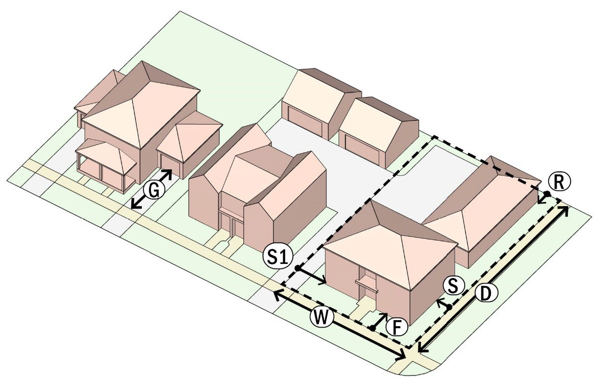
| LOT AREA (MIN.) | A | 8,400 sq. ft. |
| LOT WIDTH (MIN.) | W | 70 feet |
| LOT DEPTH (MIN.) | D | 120 feet |
| NET DENSITY (MAX.) | 5 DU/Acre | |
| LOT COVERAGE (MAX.) | 50% (Including all accessory buildings on the lot but excluding pools and spas) | |
| PRIMARY BUILDING SETBACKS (MIN.) | ||
| FRONT (PRIMARY STREET) | F | 25' |
| FRONT (SECONDARY STREET) (CORNER LOT) | S | 15' |
| SIDE PROPERTY LINE | S1 | 10' |
| REAR PROPERTY LINE | R | 10' |
| REAR OR SIDE (ALLEY) | R | 5' |
| ACCESSORY BUILDING SETBACKS (MIN.) | ||
| SETBACK FROM PRIMARY BUILDING | AS | 5' |
| SETBACK FROM ANY OTHER ACCESSORY BUILDING | 5' (Shall meet any fire separation standards based on the construction type and use) | |
| SIDE PROPERTY LINE | 5' | |
| REAR PROPERTY LINE | 5' | |
| REAR OR SIDE (ALLEY) | 5' | |
| ENCROACHMENTS INTO YARDS | ||
| GENERAL | All required yards shall be open to the sky with the exception of the following encroachments allowed. | |
| FRONT YARD ENCROACHMENT | Porches, stoops, and porte-cocheres may encroach into the front yard to a maximum of six feet (6') or 50% of the front yard, whichever is less | |
| All OTHER YARD ENCROACHMENTS |
Encroachments shall not be over any utility or drainage easements.
Encroachments (including pools and spas) shall be no closer than 5' to any side or rear property lines. Encroachments shall include fire escapes, ornamental features, roof eaves, terraces, balconies, etc. | |
| PARKING PLACEMENT AND ACCESS | ||
| PARKING PLACEMENT | G |
Residential garages (attached or detached) with driveway access from the Primary Street
shall be setback a minimum of 10 feet from the front façade of the building.
Surface parking spaces shall NOT be located within any front yards or lawn areas. Unenclosed carports in the side or rear yards shall be permitted as long as the minimum setbacks are met. |
| BUILDING HEIGHT AND MASS | ||
| PRIMARY BUILDING (MAX.) | 35' | |
| ACCESSORY BUILDING (MAX.) | 35' | |
| DWELLING SIZE (MIN.) | 1,600 sq. ft. | |
| ADDITIONAL REQUIREMENTS WITHIN THE ZONING REGULATIONS | ||
| Article 5. Use Standards
Article 6. Building Design Standards Article 7. Parking and Transportation Article 8. Landscaping, Screening, and Open Space | ||
E.
R-3 SINGLE FAMILY RESIDENTIAL DISTRICT
| ILLUSTRATION | ||
 | ||
| PURPOSE | ||
| The R-3 Single-Family Residential District is intended to accommodate mid-sized lots (7,200 sq. ft.) with single-family detached residential uses and accessory buildings. The district provisions discourage any use that would substantially interfere with the development of single-family detached dwellings. | ||
| LOT SIZE AND DENSITY | ||
| LOT AREA (MIN.) | A | 7,200 sq. ft. |
| LOT WIDTH (MIN.) | W | 60 feet |
| LOT DEPTH (MIN.) | D | 100 feet |
| NET DENSITY(MAX.) | 6 DU/Acre | |
| LOT COVERAGE (MAX.) | 50% (Including all accessory buildings on the lot but excluding pools and spas) | |
| PRIMARY BUILDING SETBACKS (MIN.) | ||
| FRONT (PRIMARY STREET) | F | 25' |
| FRONT (SECONDARY STREET) (CORNER LOT) | S | 15' |
| SIDE PROPERTY LINE | S1 | 7.5' |
| REAR PROPERTY LINE | R | 10' |
| REAR OR SIDE (ALLEY) | R | 5' |
| ACCESSORY BUILDING SETBACKS (MIN.) | ||
| SETBACK FROM PRIMARY BUILDING | AS | 5' |
| SETBACK FROM ANY OTHER ACCESSORY BUILDING | 5' (Shall meet any fire separation standards based on the construction type and use) | |
| SIDE PROPERTY LINE | 5' | |
| REAR PROPERTY LINE | 5' | |
| REAR OR SIDE (ALLEY) | 5' | |
| ENCROACHMENTS INTO YARDS | ||
| GENERAL | All required yards shall be open to the sky with the exception of the following encroachments allowed. | |
| FRONT YARD ENCROACHMENT | Porches, stoops, and porte-cocheres may encroach into the front yard to a maximum of six feet (6') or 50% of the front yard, whichever is less | |
| All OTHER YARD ENCROACHMENTS |
Encroachments shall not be over any utility or drainage easements.
Encroachments (including pools and spas) shall be no closer than 5' to any side or rear property lines. Encroachments shall include fire escapes, ornamental features, roof eaves, terraces, balconies, etc. | |
| PARKING PLACEMENT AND ACCESS | ||
| PARKING PLACEMENT | G |
Residential garages (attached or detached) with driveway access from the Primary Street
shall be setback a minimum of 10 feet from the front façade of the building.
Surface parking spaces shall NOT be located within any front yards or lawn areas. Unenclosed carports in the side or rear yards shall be permitted as long as the minimum setbacks are met. |
| BUILDING HEIGHT AND MASS | ||
| PRIMARY BUILDING (MAX.) | 35' | |
| ACCESSORY BUILDING (MAX.) | 35' | |
| DWELLING SIZE (MIN.) | 1,400 sq. ft. | |
| ADDITIONAL REQUIREMENTS WITHIN THE ZONING REGULATIONS | ||
| Article 5. Use Standards
Article 6. Building Design Standards Article 7. Parking and Transportation Article 8. Landscaping, Screening, and Open Space | ||
F.
R-4 SINGLE FAMILY RESIDENTIAL DISTRICT
| ILLUSTRATION | ||
 | ||
| PURPOSE | ||
| The R-4 Single-Family Residential District is intended to accommodate smaller lots (6,000 sq. ft.) with single-family detached residential uses and Accessory Buildings. Homes in this district may also be designed as zero lot-line houses. The district provisions discourage any use that would substantially interfere with the development of single-family detached dwellings. This district is intended to mainly recognize the existence of small lot conventional single-family development that already exists in the city. | ||
| LOT SIZE AND DENSITY | ||
| LOT AREA (MIN.) | A | 6,000 sq. ft. |
| LOT WIDTH (MIN.) | W | 60 feet |
| LOT DEPTH (MIN.) | D | 100 feet |
| NET DENSITY (DU/AC) (MAX.) | 7 DU/Acre | |
| LOT COVERAGE (MAX.) | 60% (Including all accessory buildings on the lot but excluding pools and spas) | |
| PRIMARY BUILDING SETBACKS (MIN.) | ||
| FRONT (PRIMARY STREET) | F | 25' |
| FRONT (SECONDARY STREET) (CORNER LOT) | S | 15' |
| SIDE PROPERTY LINE | S1 | 5' |
| REAR PROPERTY LINE | R | 10' |
| REAR OR SIDE (ALLEY) | R | 5' |
| ACCESSORY BUILDING SETBACKS (MIN.) | ||
| SETBACK FROM PRIMARY BUILDING | AS | 5' |
| SETBACK FROM ANY OTHER ACCESSORY BUILDING | 5' (Shall meet any fire separation standards based on the construction type and use) | |
| SIDE PROPERTY LINE | 5' | |
| REAR PROPERTY LINE | 5' | |
| REAR OR SIDE (ALLEY) | 5' | |
| ENCROACHMENTS INTO YARDS | ||
| GENERAL | All required yards shall be open to the sky with the exception of the following encroachments allowed. | |
| FRONT YARD ENCROACHMENT | Porches, stoops, and porte-cocheres may encroach into the front yard to a maximum of six feet (6') or 50% of the front yard, whichever is less | |
| All OTHER YARD ENCROACHMENTS |
Encroachments shall not be over any utility or drainage easements.
Encroachments (including pools and spas) shall be no closer than 5' to any side or rear property lines. Encroachments shall include fire escapes, ornamental features, roof eaves, terraces, balconies, etc. | |
| PARKING PLACEMENT AND ACCESS | ||
| PARKING PLACEMENT | G |
Residential garages (attached or detached) with driveway access from the Primary Street
shall be setback a minimum of 10 feet from the front façade of the building.
Surface parking spaces shall NOT be located within any front yards or lawn areas. Unenclosed carports in the side or rear yards shall be permitted as long as the minimum setbacks are met. |
| BUILDING HEIGHT AND MASS | ||
| PRIMARY BUILDING (MAX.) | 35' | |
| ACCESSORY BUILDING (MAX.) | 35' | |
| DWELLING SIZE (MIN.) | 1,200 sq. ft. | |
| ADDITIONAL REQUIREMENTS WITHIN THE ZONING REGULATIONS | ||
| Article 5. Use Standards
Article 6. Building Design Standards Article 7. Parking and Transportation Article 8. Landscaping, Screening, and Open Space | ||
G.
MR MIXED RESIDENTIAL DISTRICT
| ILLUSTRATION | ||
 | ||
| PURPOSE | ||
| The Mixed Residential (MR) District is established and intended to encourage a range of missing middle residential types from small lot single-family detached to townhomes to triplexes and quadplexes to meet the diverse needs of city residents. Maximum residential density is limited to 18 units per gross acre. | ||
| LOT SIZE AND DENSITY | ||
| LOT AREA (MIN.) | A |
3,000 sq. ft. for detached residential
2,000 sq. ft. for attached residential |
| LOT WIDTH (MIN.) | W |
35 feet for detached residential
25 feet for attached residential |
| LOT DEPTH (MIN.) | D | 70 feet |
| NET DENSITY (DU/AC) (MAX.) | 18 DU/Acre | |
| LOT COVERAGE (MAX.) | 70% (Including all accessory buildings on the lot but excluding pools and spas) | |
| PRIMARY BUILDING SETBACKS (MIN.) | ||
| FRONT (PRIMARY STREET) | F | 10' |
| FRONT (SECONDARY STREET) (CORNER LOT) | S | 10' |
| SIDE PROPERTY LINE | S1 |
0' (Fire separation standards apply) for attached residential
10' for zero lot line residential 5' for all other detached residential |
| REAR PROPERTY LINE | R | 5' |
| REAR OR SIDE (ALLEY) | R | 5' |
| ACCESSORY BUILDING SETBACKS (MIN.) | ||
| SETBACK FROM PRIMARY BUILDING | AS | 5' |
| SIDE PROPERTY LINE | 0' (Fire separation standards apply) | |
| REAR PROPERTY LINE | 5' | |
| REAR OR SIDE (ALLEY) | 5' | |
| ENCROACHMENTS INTO YARDS | ||
| GENERAL | All required yards shall be open to the sky with the exception of the following encroachments allowed. | |
| FRONT YARD ENCROACHMENT | Porches, stoops, and porte-cocheres may encroach into the front yard to a maximum of six feet (6') or 50% of the front yard, whichever is less | |
| All OTHER YARD ENCROACHMENTS |
Encroachments shall not be over any utility or drainage easements.
Encroachments (including pools and spas) shall be no closer than 5' to any side or rear property lines. Encroachments shall include fire escapes, ornamental features, roof eaves, terraces, balconies, etc. | |
| PARKING PLACEMENT AND ACCESS | ||
| PARKING PLACEMENT | G |
Lots over 40' in width:
• Surface parking spaces in the front setback area shall be limited to driveways or porte-cocheres only. • Residential garages with driveway access from the Primary Street shall be setback a minimum of 10 feet from the front façade of the building. Lots less than 40' in width shall provide garage and/or off-street parking access from alleys. Unenclosed carports in the side or rear yards shall be permitted as long as the minimum setbacks are met. |
| BUILDING HEIGHT AND MASS | ||
| PRIMARY BUILDING (MAX.) | 35' | |
| ACCESSORY BUILDING (MAX.) | 35' | |
| DWELLING SIZE |
1,000 sq. ft. (AVG.)
700 sq. ft. (MIN.) | |
| ADDITIONAL REQUIREMENTS WITHIN THE ZONING REGULATIONS | ||
| Article 5. Use Standards
Article 6. Building Design Standards Article 7. Parking and Transportation Article 8. Landscaping, Screening, and Open Space | ||
H.
MF MULTIFAMILY DISTRICT
| ILLUSTRATION | ||
 | ||
| PURPOSE | ||
| The purpose of the Multifamily (MF) Residential District is to provide for compatible land, buildings, and uses primarily oriented to high density multifamily residential purposes, open space uses, and associated uses. The MF district is intended to serve as a transitional element between lower density and more intense nonresidential land uses, and is most appropriately located near the intersections of major thoroughfares. Apartment buildings and condominiums are the principal elements of the MF district. | ||
| LOT SIZE AND DENSITY | ||
| LOT AREA (MIN.) | A | 20,000 sq. ft. |
| LOT WIDTH (MIN.) | W | 100 feet |
| LOT DEPTH (MIN.) | D | 200 feet |
| NET DENSITY (DU/AC) (MAX.) | 18 DU/Acre | |
| LOT COVERAGE (MAX.) | 70% (Including all accessory buildings on the lot but excluding pools and spas) | |
| OPEN SPACE % (MIN.) | 10% (of the gross site area) | |
| PRIMARY BUILDING SETBACKS (MIN.) | ||
| FRONT (PRIMARY STREET) | F | 20' |
| FRONT (SECONDARY STREET) (CORNER LOT) | S | 20' |
| INTERNAL BUILDING SETBACKS |
0' (Fire separation standards apply) for TH, Duplex, Triplex
10' | |
| SIDE PROPERTY LINE | S1 | 10' |
| REAR PROPERTY LINE | R |
5'
20' adjacent to any Single-Family district (AG, R-1, R-2, R-3, and R-4 Districts) |
| REAR OR SIDE (ALLEY) | R | 5' |
| ENCROACHMENTS INTO YARDS | ||
| GENERAL | All required yards shall be open to the sky with the exception of the following encroachments allowed. | |
| FRONT YARD ENCROACHMENT | Porches, stoops, and porte-cocheres may encroach into the front yard to a maximum of six feet (6') or 50% of the front yard, whichever is less | |
| All OTHER YARD ENCROACHMENTS |
Encroachments shall not be over any utility or drainage easements.
Encroachments (including pools and spas) shall be no closer than 5' to any side or rear property lines. Encroachments shall include fire escapes, ornamental features, roof eaves, terraces, balconies, etc. | |
| PARKING PLACEMENT AND ACCESS | ||
| PARKING PLACEMENT | G | Off-street parking spaces shall NOT be located in the front setback area along any street frontage unless the frontage is along an Arterial or a Collector street, in which case no more than one parking aisle with two head-in rows shall be permitted. |
| BUILDING HEIGHT AND MASS | ||
| PRIMARY BUILDING HEIGHT (MAX.) | 35' | |
| DWELLING SIZE |
1,000 sq. ft. (AVG.)
700 sq. ft. (MIN.) | |
| ADDITIONAL REQUIREMENTS WITHIN THE ZONING REGULATIONS | ||
| Article 5. Use Standards
Article 6. Building Design Standards Article 7. Parking and Transportation Article 8. Landscaping, Screening, and Open Space | ||
I.
MH MANUFACTURED HOME
( Ord. No. 03-2023-482 , § 1, 3-16-2023)
106.47 - NON-RESIDENTIAL ZONING DISTRICTS
A.
PURPOSE AND INTENT:
(1)
Accommodate a range and different scales of nonresidential uses including office, retail, service, civic/public, and industrial/employment uses needed by Crowley residents, work force, and visitors.
(2)
Encourage site planning, land use planning, and architectural design that create interesting and attractive environments.
(3)
Maintain and enhance the city's economic base and provide a range of shopping, entertainment, and employment opportunities for the residents and visitors of Crowley.
(4)
Minimize potential negative impacts of commercial development on adjacent residential neighborhoods.
(5)
Help ensure that the appearance and operational impacts of commercial developments do not adversely affect the character of the areas in which they are located.
B.
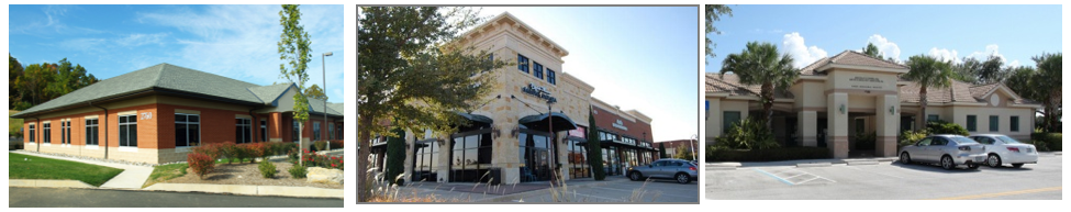
OC OFFICE COMMERCIAL DISTRICT
| ILLUSTRATIVE IMAGES | |
 | |
| PURPOSE | |
| The Office Commercial (OC) District is intended to provide for the development of a range of office, employment, medical office, professional service, neighborhood-serving commercial, and business support uses including garden-style offices near or adjacent to residential neighborhoods. This district is appropriate along arterial and collector roadways where residential uses may not be appropriate. Landscaping along the major street frontage, adequate street access, and parking capacity should be available to serve the office uses. | |
| SETBACKS | |
| PRIMARY STREET (MIN.) |
20' along an FM 1187 and Crowley Road.
10' along all other streets |
| SECONDARY STREET (MIN.) | 10' |
| SIDE/REAR (MIN.) |
10' (shall also need to meet any fire separation standards required based on the construction
type)
20' adjacent to any Single-Family district (AG, R-1, R-2, R-3, and R-4 Districts) |
| MINIMUM LOT REQUIREMENTS | 10,000 sq. ft. |
| LOT COVERAGE (MAX.) | 75% (Including all accessory buildings on the lot) |
| ENCROACHMENTS INTO YARDS | |
| GENERAL | All required yards shall be open to the sky with the exception of the following encroachments allowed. |
| FRONT YARD ENCROACHMENT | Patios, awnings, and porte-cocheres may encroach into the front yard to a maximum of six feet (6') or 50% of the front yard, whichever is less |
| All OTHER YARD ENCROACHMENTS |
Encroachments shall not be over any utility or drainage easements.
Encroachments (including pools and spas) shall be no closer than 5' to any side or rear property lines. Encroachments shall include fire escapes, ornamental features, roof eaves, terraces, balconies, etc. |
| PARKING PLACEMENT AND ACCESS | |
| PARKING PLACEMENT | No more than 50% of the provided parking shall be placed between the building and the Primary Street. |
| BUILDING HEIGHT | |
| PRIMARY BUILDING (MAX.) | 35' |
| ADDITIONAL REQUIREMENTS WITHIN THE ZONING REGULATIONS | |
| Article 5. Use Standards
Article 6. Building Design Standards Article 7. Parking and Transportation Article 8. Landscaping, Screening, and Open Space | |
C.
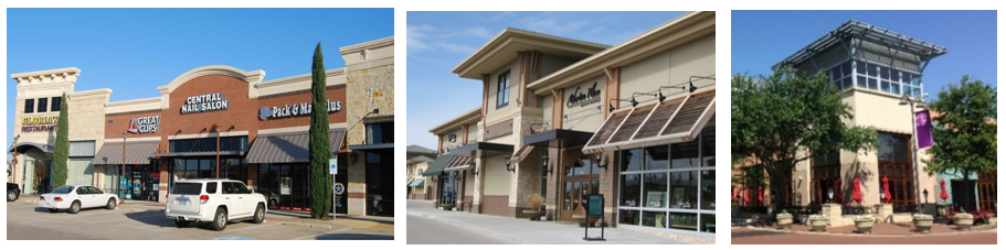
GC GENERAL COMMERCIAL DISTRICT
| ILLUSTRATIVE IMAGES | |
 | |
| PURPOSE | |
| The General Commercial (GC) District is intended primarily to provide sites for larger scale and larger format community and regional retail shopping centers, including stores selling items such as home furnishings, apparel, electronics, etc.; restaurants, entertainment, and commercial recreation; and business, personal, and financial services. These uses are subject to frequent view by the public given their location along major regional arterials and highways, and they should provide an attractive appearance with landscaping, well-designed and appropriately located parking, and controlled traffic movement. Traffic generated by the uses may include high volumes of vehicle traffic and trucks and commercial vehicles, as appropriate, for sites adjacent to regional roadways. Although surface parking along the roadway is permitted, strip-type development along the entire highway or arterial frontage is strongly discouraged. | |
| SETBACKS | |
| PRIMARY STREET (MIN.) |
20' along FM 1187 and Crowley Road.
10' along all other streets |
| SECONDARY STREET (MIN.) | 10' |
| SIDE/REAR (MIN.) |
5' (shall also need to meet any fire separation standards required based on the construction
type)
30' adjacent to any Single-Family district (AG, R-1, R-2, R-3, and R-4 Districts) |
| MINIMUM LOT REQUIREMENTS | 20,000 sq. ft. |
| LOT COVERAGE (MAX.) | 75% (Including all accessory buildings on the lot) |
| ENCROACHMENTS INTO YARDS | |
| GENERAL | All required yards shall be open to the sky with the exception of the following encroachments allowed. |
| FRONT YARD ENCROACHMENT | Patios, awnings, and porte-cocheres may encroach into the front yard to a maximum of six feet (6') or 50% of the front yard, whichever is less |
| All OTHER YARD ENCROACHMENTS |
Encroachments shall not be over any utility or drainage easements.
Encroachments (including pools and spas) shall be no closer than 5' to any side or rear property lines. Encroachments shall include fire escapes, ornamental features, roof eaves, terraces, balconies, etc. |
| PARKING PLACEMENT AND ACCESS | |
| PARKING PLACEMENT | No more than 60% of the provided parking shall be placed between the building and the Primary Street. |
| BUILDING HEIGHT | |
| PRIMARY BUILDING (MAX.) | 70' |
| ADDITIONAL REQUIREMENTS WITHIN THE ZONING REGULATIONS | |
| Article 5. Use Standards
Article 6. Building Design Standards Article 7. Parking and Transportation Article 8. Landscaping, Screening, and Open Space | |
D.
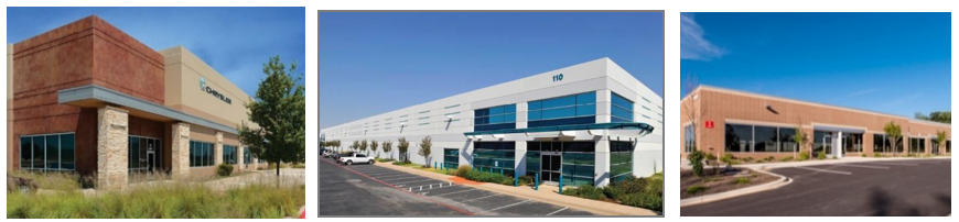
I INDUSTRIAL DISTRICT
| ILLUSTRATIVE IMAGES | |
 | |
| PURPOSE | |
| The Industrial (I) District is intended to provide for the development of a range of office, employment, professional service, flex-office, high-tech manufacturing and assembly, warehousing, logistics, and other indoor light industrial uses and business support uses in a master planned office, business park, or corporate campus context. The district shall apply to larger parcels that may accommodate a range of office and support uses including lodging and retail uses. Uses permitted in this district are intended to serve community and regional needs. This district is intended to be located with good regional roadway access away from low- and medium-density residential development. Landscaping along the arterial roadways, adequate street access, and parking capacity should be available to serve the uses. | |
| SETBACKS | |
| PRIMARY STREET |
20' along FM 1187 and Crowley Road.
10' along all other streets |
| SECONDARY STREET | 10' |
| SIDE/REAR | 10' |
| MINIMUM LOT REQUIREMENTS | 20,000 sq. ft. |
| LOT COVERAGE (MAX.) | 75% (Including all accessory buildings on the lot) |
| ENCROACHMENTS INTO YARDS | |
| GENERAL | All required yards shall be open to the sky with the exception of the following encroachments allowed. |
| FRONT YARD ENCROACHMENT | Patios, awnings, and porte-cocheres may encroach into the front yard to a maximum of six feet (6') or 50% of the front yard, whichever is less |
| All OTHER YARD ENCROACHMENTS |
Encroachments shall not be over any utility or drainage easements.
Encroachments (including pools and spas) shall be no closer than 5' to any side or rear property lines. Encroachments shall include fire escapes, ornamental features, roof eaves, terraces, balconies, etc. |
| PARKING PLACEMENT AND ACCESS | |
| PARKING PLACEMENT | No more than 60% of the provided parking shall be placed between the building and the Primary Street. |
| LOADING DOCKS OR BAYS |
Loading docks or bays shall not have direct frontage along an Arterial Street.
However, driveway access to loading zones may be from Arterial roadways. If loading docks or bays are along any other building facades, they shall be screened from view of any public street by a wing wall or other opaque screen at least 8' in height. |
| BUILDING HEIGHT | |
| PRIMARY BUILDING (MAX.) | 70' |
| ADDITIONAL REQUIREMENTS WITHIN THE ZONING REGULATIONS | |
| Article 5. Use Standards
Article 6. Building Design Standards Article 7. Parking and Transportation Article 8. Landscaping, Screening, and Open Space | |
E.
CP CIVIC-PUBLIC DISTRICT
| ILLUSTRATIVE IMAGES | |
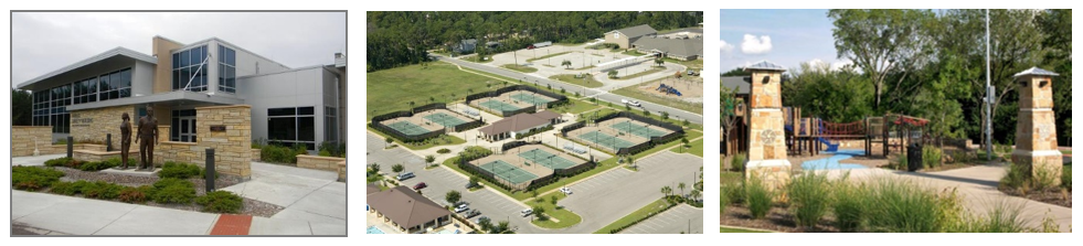 | |
| PURPOSE | |
|
The Civic-Public (CP) District is intended to provide for a range of park, public,
and institutional sites and buildings. These include city, county, and other government
offices and facilities, parks, schools, and other public facilities.. Depending on
the type of facility, site design and standards need to address access, transitions,
and integration into the neighborhood. Civic and public buildings should occupy prominent
sites within a neighborhood, such as at the end of a terminated vista or a center
of a block or public plaza.
Public parks and open space should be integrated with the neighborhood and provide for a variety of open space types, including generally equal acreages of active and passive spaces. | |
| SETBACKS | |
| PRIMARY STREET (MIN.) | 10' |
| SECONDARY STREET (MIN.) | 10' |
| SIDE/REAR (MIN.) | 5' |
| MINIMUM LOT REQUIREMENTS | 5,000 sq. ft. |
| LOT COVERAGE (MAX.) | 60% (Including all accessory buildings on the lot) |
| BUILDING HEIGHT | |
| PRIMARY BUILDING (MAX.) | 45'; buildings taller than 45' may be approved with an SUP. |
| ADDITIONAL REQUIREMENTS WITHIN THE ZONING REGULATIONS | |
| Article 5. Use Standards
Article 6. Building Design Standards Article 7, Parking and Transportation Article 8. Landscaping, Screening, and Open Space | |