
Dania Beach City Zoning Code
SUB PART 1
COMMUNITY REDEVELOPMENT AREA CRA FORM-BASED ZONING DISTRICTS
ARTICLE 305. - SUSTAINABLE BUILDING REQUIREMENTS[3]
Editor's note—Ord. No. 2024-021, § 2, adopted March 12, 2024, repealed the former Art. 305, §§ 305-1—305-70, and enacted a new Art. 305 as set out herein. The former Art. 305 pertained to incentives and derived from Ord. No. 2010-20, § 2(Exh. A), 9-14-10; Ord. No. 2012-015, § 5, 8-14-12; Ord. No. 2014-011, § 3, 9-23-14; Ord. No. 2016-007, § 8, 3-22-16; Ord. No. 2016-021, § 4, 10-10-16.
ARTICLE 308. - SIGNAGE REGULATIONS
(A)
All signage regulations for the CRA form-based districts are located in article 505.
(B)
Design standards for signs are located in article 525.
(Ord. No. 2010-20, § 2(Exh. A), 9-14-10)
Sec. 300-10. - The CRA includes six (6) form-based districts.
The Community Redevelopment Area (CRA) is divided into several zoning districts. Six (6) of those districts are form-based districts that are unique to the CRA. Except for section 301-20(B), which is applicable to all properties located within the Regional Activity Center (RAC) Future Land Use designation as identified in the city's Comprehensive Plan, Article 300 shall not apply to the Planned Mixed-Use Development District (PMUD) established pursuant to article 340, subpart 5 of part 3 of this chapter or the Planned Small Lot Mixed-Use Development District (PMUD-SL) established pursuant to article 350, subpart 6 of part 3 of this chapter. Each form-based zoning district has a set of regulations that apply to it, called "district development standards" in article 303. The district standards include:
(A)
A generalized list of permitted uses. The detailed list of permitted, special exception and prohibited uses is in article 302, discussed further in section 300-20, below.
(B)
Building placement and height standards, discussed further in section 300-30, below.
(C)
The types of buildings that can be constructed. There are eight (8) "types" of buildings based upon the building's function and character, discussed further in section 300-40, below.
(D)
The types of ground story configurations that are allowed along street frontages, called "frontage types", which are discussed further in section 300-50, below.
(Ord. No. 2010-20, § 2(Exh. A), 9-14-10; Ord. No. 2015-022, § 6, 10-13-15; Ord. No. 2019-015, § 6, 10-7-19; Ord. No. 2022-001, § 1, 2-8-22)
Sec. 300-20. - How to determine permitted uses.
(A)
The district standards in article 303 for each district contain a simplified list of permitted uses. The purpose of the simplified list is to give the reader a quick reference guide to the general types of permitted uses and special exception uses in each district. For a detailed list of permitted uses, consult article 302.
(B)
Having more than one (1) type of use on a lot (mixed use) is encouraged in many districts. Section 302-40 determines which types of use can be mixed within a lot or within a building, and any conditions for doing so. Section 302-10, the list of permitted, special exception and prohibited uses, is organized by use type to correspond to the use types listed in section 302-40 and again in the generalized permitted uses lists in the district regulations of article 303.
(C)
Within many of the zoning districts, some uses may be permitted on lots fronting primary streets, but not along secondary streets, and vice versa.
(Ord. No. 2010-20, § 2(Exh. A), 9-14-10)
Sec. 300-30. - How to determine the buildable area of a lot, allowable density and building height.
(A)
The district standards in article 303 for each district include a map showing maximum allowable height within the district. Permitted height varies within some districts based upon location. Article 304 has the rules for interpreting the maps.
(B)
See additional regulations found in section 301-20(B) for maximum intensity/density limits permitted within the CRA and Comprehensive Plan.
(C)
The district standards in article 303 for each district specify build-to-lines, setbacks, minimum open space, and where parking facilities can be sited. Mandatory build-to-lines in lieu of minimum setbacks are one of the aspects that make these regulations form-based.
(D)
No variances as to the height restrictions or density shall be authorized.
(E)
Utilizing of the four thousand (4,000) RAC units from the Comprehensive Plan must be in accordance with the allocation designated by use [single-family or multi-family], unless the city commission, after notice pursuant to section 610.20, of the Land Development Regulations, holds a public hearing, to authorize a reallocation of the RAC units, by a four-fifths (⅘) vote of the city commission.
(F)
Of the fifteen (15) percent RAC units approved in 2024 in the city's Comprehensive Plan, which are to be designated for affordable housing, the entire fifteen (15) percent of RAC units shall be used for low or very low income housing purposes (eighty (80) percent AMI or lower).
(Ord. No. 2010-20, § 2(Exh. A), 9-14-10; Ord. No. 2022-001, § 1, 2-8-22; Ord. No. 2024-021, § 2, 3-12-24)
Sec. 300-40. - How to determine the allowable kinds of buildings; an explanation of building types.
Buildings are classified into eight (8) types based upon their characteristics. For example, a row house building type is different than a mansion apartment building because mansion apartment buildings are designed to look like large single-family detached dwellings, and rowhouses cannot be mistaken for a detached single-family dwelling. Regulation of building types is one of the aspects that makes these regulations form-based. Certain building types may be permitted on primary streets but not secondary streets, and vice versa, within a district.
(Ord. No. 2010-20, § 2(Exh. A), 9-14-10)
Sec. 300-50. - How to determine the allowable kinds of building fronts; an explanation of frontage types.
(A)
Where to find. Every district allows certain frontage types in the district standards of article 303. The frontage types correspond to the allowable building types. The details of each frontage type are provided in article 311. Regulation of building frontages is one of the aspects that makes these regulations form-based. Certain frontage types may be permitted on primary streets but not secondary streets, and vice versa, within a district.
Example. Every building has a front side with one (1) or more entrances. The front of a retail building, for example, usually has a lot of window area for the display of merchandise, and the entrance to the storefronts is immediately next to the sidewalk, and at the same grade (elevation) as the sidewalk. If the potential customer had to climb a stair to get to the store, he or she wouldn't be able to see inside the display windows, and might not want to expend the effort needed to climb the stairs. Therefore, the "shopfront" type of frontage would require the characteristics of façade design, entrance location and configuration, and setback from the sidewalk that are necessary for retail to be successful.
Example. An apartment building, on the other hand, needs to afford some privacy to its ground-story residents, so it is set back a little further from the sidewalk, perhaps with some landscaping or private yards abutting the sidewalk, and the entrance is above grade to reinforce the transition from the public sidewalk to private property and allow ground story windows to be above eye level at the sidewalk. The entrance to the building or ground-story units may even be off a private courtyard. Therefore, "stoop", "dooryard" or "courtyard" frontage types would be appropriate for multiple-family buildings based on the characteristics of façade design, entrance location and configuration (i.e. elevated above the sidewalk or situated behind a small private yard), and setback from the sidewalk which is necessary for quality urban living conditions.
(Ord. No. 2010-20, § 2(Exh. A), 9-14-10)
Sec. 300-60. - Other development regulations.
(A)
Article 305 contains sustainable building requirements.
(B)
Article 306 contains parking and loading standards.
(C)
Article 307 contains landscaping standards.
(D)
Article 308 contains signage standards.
(E)
Article 309 contains general regulations that address fences, screening, required improvements, and more.
(F)
Article 312 includes standards for open space design.
(G)
Article 525 contains architecture and urban design standards.
(Ord. No. 2010-20, § 2(Exh. A), 9-14-10; Ord. No. 2024-021, § 2, 3-12-24)
Sec. 300-70. - Commonly used abbreviations.
(Ord. No. 2010-20, § 2(Exh. A), 9-14-10; Ord. No. 2025-016, § 9, 8-26-25)
Sec. 300-80. - Intent.
The Community Redevelopment Area (CRA) encompasses predominantly single-family and two-family residential neighborhoods, a downtown commercial district, two (2) commercial corridors, and industrial acreage. The CRA redevelopment plan identifies the redevelopment path that is needed for the CRA. Industrial development and redevelopment is in large measure going to be a function of infrastructure improvements and other capital projects, while redevelopment of the remainder of the CRA is largely going to be a function of urban development standards that will not only assist in the redevelopment of the area, but will shape the form it takes consistent with the CRA redevelopment plan objectives.
The following are the specific objectives of the urban form standards:
(A)
Encourage and facilitate redevelopment through:
(1)
Clearly identifying how any given property can and should be developed;
(2)
Providing developers with certainty and predictability in the development review process through clear and certain direction as to the desired development outcome;
(3)
Allowing a wide range of land uses to accommodate real estate market cycles;
(4)
Providing flexibility in the permitted uses of land while not precluding reuse for the primary intended uses, nor precluding infill of urban intensity. Examples include allowing several uses within a building that is designed to ultimately house a research and product development use, or future ground floor retail that may not be supported by current market conditions;
(5)
Allowing maximum build-out of commercial and mixed-use properties by eliminating or minimizing building setbacks and on-lot open space requirements;
(6)
Establishing development standards that are most appropriate to the small lots, urban block patterns, alleys and narrow streets within parts of the CRA;
(7)
Flexible parking facility siting alternatives.
(B)
Long-term planning.
(1)
Whenever a site is developed at a relatively low intensity relative to the maximum permitted intensity, the site and improvements thereon should be designed and constructed to enable buildout of the site at the maximum allowable intensity at some future time without the need for substantial demolition. Known as "beginning with the end in mind," this approach may, for example, involve designing and constructing buildings to accommodate vertical expansion and designing surface parking lots to eventually accommodate a parking structure.
(C)
Transit-oriented development.
(1)
Allow mixing of land uses within a building or property.
(2)
Allow vertical development; allow structured parking.
(3)
Park once and walk to multiple destinations within the CRA; centralized parking, shared parking, on-street parking, internal trip capture, and modal split parking reductions.
(D)
Build a vibrant community within a community.
(1)
Activate the sidewalks by building close to the street with parking facilities behind buildings, and by controlling the interface between building and sidewalk.
(2)
Maintain, and enhance when possible, the stability and property values of residential neighborhoods through compatible transitions to nonresidential properties, and through building form standards that bring new or expanded dwellings closer to the street with a renewed emphasis on the front yard.
(3)
Encourage development that minimizes its impact on natural resources.
(4)
Encourage development that provides urban amenities and pedestrian conveniences for the enjoyment of the general public and contribute to place making.
(5)
Bring buildings to the roadway, ensure proper proportioning and require continuous building façades to "enclose" designated streets in order to help create a lively and visually appealing environment that invites people to live, locate businesses, and spend time shopping, dining and interacting with others.
(6)
Foster a safe pedestrian environment by increasing the opportunity for day and night activity on the public sidewalks and by ensuring "eyes on the street" through mixing of uses, fenestration and access standards.
(7)
Reinforce the interconnectivity of the urban components of buildings, streets, sidewalks, open spaces, transit facilities, and parking facilities.
(8)
Encourage visual interest by ensuring the building and visual landscapes are accented rather than their parking facilities.
(9)
Require the location of on-site parking facilities in the rear yard, accessed when possible through rear alleys or side streets.
(Ord. No. 2010-20, § 2(Exh. A), 9-14-10; Ord. No. 2024-021, § 2, 3-12-24)
Sec. 301-10. - Short title.
The provisions of part 3, subpart 1 of the Land Development Code shall be referred to as the "Community Redevelopment Area form-based districts", or "CRA form-based districts".
(Ord. No. 2010-20, § 2(Exh. A), 9-14-10)
Sec. 301-20. - Applicability.
(A)
Conflict with other regulations. The CRA form-based district regulations shall specifically prevail over all other regulations of this code in the case of conflict.
(B)
Regional Activity Center limitations. All development within the CRA form-based districts is subject to the overall, "pooled" intensity limits established in the Future Land Use Element of the Comprehensive Plan for the underlying Regional Activity Center (RAC) land use category. The intensity limits include the total number of residential units and total area of nonresidential development that can be constructed within the more than one thousand three hundred (1,300) acres encompassed by the RAC. Development in the CRA form-based districts is also subject to the restrictions and requirements placed on the allocation of such intensities set forth in the RAC provisions of the Comprehensive Plan, including but not limited to, allowable dwelling unit types and dwelling unit affordability criteria. Therefore, the RAC provisions in the Future Land Use Element of the Comprehensive Plan and the remaining available development intensities in the RAC, tracked by the community development department, should be consulted to ensure the consistency of any development proposal with the Future Land Use Element.
(C)
Vesting for certain dwelling units. Development utilizing the initial pool of seven thousand eight hundred eighteen (7,818) dwelling units established with the adoption of the RAC in 2010 shall be vested under the regulations of this Subpart as they existed in Supplement No. 154 of the Dania Beach Code of Ordinances, dated November 30, 2022, published by CivicPlus. Previous code versions can be viewed online through the CivicPlus' "municode" website, which are organized by supplement number, and at the city clerk's office.
(D)
Procedure when RAC units near depletion. When the number of available dwelling units assigned to the RAC land use designation falls below fifteen (15) percent of the total number of approved units, the following additional information must be provided:
(1)
The applicant shall enter into a developer's agreement prior to a public hearing stating the developer will not request utilization of any of the Governor's Executive Order extensions, thereby returning any unused RAC units upon expiration of the term of the developer's agreement, which authorization period shall not exceed thirty (30) months.
(2)
The applicant must provide a project proforma, illustrating project financing exists for development of the proposed project prior to public hearing.
(3)
The applicant must provide a tax benefit/cost analysis of the project illustrating projected property tax increase once the project is completed, as well as anticipated municipal expenditures, such as for police, fire, water/sewer services, etc.
(4)
The applicant must identify how the project approval and construction will benefit the community, such as through installation of bicycle rental stations, participation in a free trolley/shuttle service, etc.
(5)
Any project in which the city has partnered with another person or entity utilizing Florida Housing Finance Corporation funds shall be exempt from subparagraphs (1)—(4) above.
(E)
Graphic vs. text conflicts. In the event of a conflict between text and any illustration or graphic, the text shall prevail.
(F)
Map conflicts. In the event of a conflict between district boundary maps and the official zoning map, the official zoning map shall prevail.
(Ord. No. 2010-20, § 2(Exh. A), 9-14-10; Ord. No. 2022-001, § 1, 2-8-22; Ord. No. 2024-021, § 2, 3-12-24)
Sec. 301-30. - Nonconformities.
Nonconformities shall be governed by article 710 except as provided in this section.
(A)
Nonconforming characteristics of use. Nonconforming characteristics of use not addressed in article 710, including, but not limited to, location of parking facilities, access to parking facilities, design and architecture, and other requirements unique to the CRA form-based districts shall be subject to the same rules, thresholds and conditions for compliance as nonconforming buildings and structures.
(B)
Nonconforming buildings and structures.
(1)
Modifications. Modification to the shell or interior of nonconforming buildings or structures is permitted without triggering compliance of said building or structure with these regulations.
(2)
Expansion. The expansion of a nonconforming building or structure is permitted as long as the cumulative square footage of such expansion within any five-year period does not exceed twenty-five (25) percent of the gross floor area of a building as it existed upon the effective date of these regulations. In the event that the cumulative five-year threshold is met, compliance with these regulations shall be required if the city determines that substantial compliance with these regulations can be achieved without compromising the intended use of the expansion and logistics of the building and site layout.
(C)
Nonconforming single-family dwellings. Nonconforming single-family dwellings existing on the effective date of this subpart and their accessory structures may remain in perpetuity and may be repaired, rebuilt and expanded regardless of nonconformity with the provisions of this article. Once a single-family dwelling is replaced with another use, no single-family dwelling can be reestablished on the lot.
(Ord. No. 2010-20, § 2(Exh. A), 9-14-10; Ord. No. 2024-021, § 2, 3-12-24)
Sec. 301-40. - Site plan procedures.
Applications for site plans shall be governed by the requirements of article 635.
(Ord. No. 2010-20, § 2(Exh. A), 9-14-10; Ord. No. 2024-021, § 2, 3-12-24)
Sec. 301-50. - Variations in design; procedure for review of design variations.
(A)
Intent and purpose. The CC, SFED-MU, EDBB-MU and NBHD-MU districts emphasize urban design principles in order to effect attractive and functional mixed-use urban redevelopment that is unique to the City of Dania Beach's urban center, corridors and neighborhoods within the CRA. In order to accomplish this, the four above-referenced districts have specific, prescribed development standards rather than minimums and maximums, to define the urban form of future development. It is the intent of this section to provide a mechanism for evaluating and granting requests for variation from the standards and requirements of these regulations that can occasionally be expected for the following reasons:
(1)
To acknowledge the variation in conditions that exist, and the difficulty of accounting for them in a design-specific regulation.
(2)
To facilitate design interpretations and alternatives that work as well as the prescribed standard.
(B)
Applicability. The city is authorized to approve design variations within the CC, SFED-MU, EDBB-MU and NBHD-MU districts that are consistent with the intent of this section, using the procedure and criteria of this section in lieu of the variance process of article 625. Design-based variations shift the focus of review from hardship to design and logistics issues. Design variations are not authorized for varying the following code requirements, which are not specific to the regulations of this subpart:
(1)
Design variations are not authorized for varying the following code requirements, which are not specific to the regulations of this subpart:
(a)
Maximum density;
(b)
Maximum impervious area;
(c)
Maximum lot coverage;
(d)
Minimum open space;
(e)
Parking and loading;
(f)
Signage.
(C)
Procedure.
(1)
Design variations associated with site plan and site plan modifications shall be considered as part of such site plan or modification applications.
(2)
Submittal requirements shall be established administratively.
(3)
The request for design variation shall be evaluated based upon the criteria set forth in this section, and the procedures for processing site plans in sections 635-70 (Site plans) and 635-80 (Site plan modifications).
(D)
Standard of review for design variations. The planning and zoning board or city commission, as applicable, shall use the following criteria when evaluating requests for design variation:
(1)
Whether the request is for a reasonable accommodation of design flexibility that results in overall superior development and design consistent with the intent and principles of this subpart that govern the standard for which variation is requested; or
(2)
Whether the variation is appropriate to accommodate site conditions not anticipated in these regulations, or to reconcile conflicting requirements, provided the request is generally consistent with the intent and principles of this subpart that govern the standard for which variation is requested.
(E)
Variance procedure. Variance requests shall be processed pursuant to article 625.
(Ord. No. 2010-20, § 2(Exh. A), 9-14-10; Ord. No. 2016-013, § 3, 7-26-16; Ord. No. 2024-021, § 2, 3-12-24)
Sec. 302-10. - Permitted, special exception and prohibited uses.
|
Legend:
P = Permitted SE = Special Exception use (#) = Permitted subject to the restriction in section 302-20 having the same number that is within the parentheses | Districts | |||||||||
|---|---|---|---|---|---|---|---|---|---|---|
City Center
| EDBB-MU | SFED-MU |
GTWY-MU
|
GTWY-MU-II
|
NBHD-MU
|
NBHD-RES
| ||||
| - Not permitted | Principal Street Frontage | |||||||||
| Abbreviations: EDBB = East Dania Beach Boulevard SFED = South Federal Highway |
EDBB
|
Other streets
|
S. Fed. Hwy
Sheridan St. |
Other Streets
| ||||||
| MIXED USE [subject to section 302-40] | ||||||||||
| Mixed residential and commercial use | P | P | P | P | P | P | P | P | NP | |
| OPEN SPACE [subject to article 312] | ||||||||||
| Accessory uses | P | P | P | P | P | P | P | P | P | |
| Parks | P | P | P | P | P | P | P | P | P | |
| Plazas | P | P | NP | P | NP | P | P | P | NP | |
| Pocket parks | P | P | P | P | P | P | P | P | NP | |
| Tot lots | P | P | P | P | P | P | P | P | P | |
| Urban agricultural gardens | SE | NP | SE | NP | SE | NP | NP | NP | SE | |
| RESIDENTIAL | ||||||||||
| Accessory uses | P | P | P | P | P | P | P | P | P | |
| Apartments, ground story | (2) | NP | (2) | (2) | (2) | (2) | (2) | (2) | (2) | |
| Apartments, upper story | P | P | P | P | P | P | P | P | (2) | |
| Community residential home—type 1; up to 6 residents (see section 725-30 for definition) (subject to section 105-170) | NP | NP | NP | NP | NP | NP | NP | NP | P | |
| Community residential home—type 2; 7—14 residents (see section 725-30 for definition) (subject to section 105-170) | (3) | NP | (3) | (3) | (3) | (3) | (3) | NP | NP | |
| Home-based assembly [subject to section 105-100] | P | P | P | P | P | P | P | P | P | |
| Home occupations [subject to section 105-80] | P | P | P | P | P | P | P | P | P | |
| Multiple-family residential | (2) | NP | (2) | (2) | (2) | (2) | (2) | (2) | (2) | |
| Single-family detached residential | NP (12) |
NP
(12) |
NP
(12) |
NP
(12) |
NP
(12) |
NP
(12) |
NP
(12) |
NP
(12) | P | |
| Two-family (duplex) residential | NP | NP | NP | NP | NP | NP | NP | NP | (1) | |
| MIXED-USE COMMERCIAL (uses that are compatible with residential uses on adjoining stories) | ||||||||||
| Accessory uses | P | P | P | P | P | P | P | P | P | |
| Art galleries, bookstore | P | P | NP | P | NP | P | P | P | NP | |
| Bank and financial institutions | P | P | NP | P | NP | P | P | P | NP | |
| Bakeries, delicatessens, coffee shops | P | P | P | P | P | P | P | P | NP | |
| Convenience food store | (8) | (8) | NP | (8) | (8, 20) | (8) | (8) | (8) | NP | |
| Copy, printing shop | P | P | NP | P | NP | P | P | P | NP | |
| Day care center (pre-K) | P | P | P | P | P | P | P | P | NP | |
| Drive-through service [subject to section 110-190] | NP | (4) | SE | (4) | NP | P | NP | NP | NP | |
| Dry cleaning establishments, excluding self-service laundries, for direct service to customers | P | P | NP | P | NP | P | P | P | NP | |
| General office use, including business, sales, professional, real estate, insurance, travel agent, information technology | P | P | P | P | P | P | P | P | NP | |
| General repair shop | P | P | SE | P | (20) | P | P | P | NP | |
| Large retail establishment | P | P | NP | P | NP | P | P | NP | NP | |
| Medical offices, excluding pain management clinics | P | P | P | P | P | P | P | P | NP | |
| Personal service establishments | P | P | P | P | P | P | P | P | NP | |
| Pet shops (excluding cats, dogs, birds) and pet supplies | P | P | NP | NP | NP | P | P | P | NP | |
| Restaurant, free standing drive-through [subject to section 110-190] | NP | P | NP | P | NP | P | NP | NP | NP | |
| Restaurant, fast food in an existing building [subject to section 110-190] | P | P | NP | P | NP | P | P | P | NP | |
| Restaurant, fast food in a new multi-tenant or attached building (not free standing) [subject to section 110-190] | P | P | NP | P | NP | P | P | P | NP | |
| Restaurant; outdoor dining accessory to a restaurant, bar, ice cream shop, bakery, delicatessen or coffee shop | (5) | (5) | NP | (5) | (5, 20) | (5) | (5) | (5) | NP | |
| Retail sales | (7) | (7) | (7) | (7) | (20) | (7) | (7) | (7) | NP | |
| Retail sales of baked goods, confectionaries, delicatessen | P | P | P | P | (20) | P | P | P | NP | |
| Self-service or coin operated laundry [subject to section 110-190] | NP | NP | NP | NP | NP | NP | NP | SE | NP | |
| Studios for individual instruction or tenant workspace for art, music, drama, martial arts | P | P | P | P | P | P | P | P | NP | |
| LODGING | ||||||||||
| Accessory uses | P | P | P | P | P | P | P | P | P | |
| Boarding house | NP | NP | NP | NP | NP | NP | NP | NP | NP | |
| Hotel, extended-stay hotel, condominium-hotel, or timeshare containing at least 75 rooms or keys | P (9) | P (9) | NP |
SE
(9) | (20) | P | P | NP | NP | |
| Motels | NP | NP | NP | NP | NP | NP | NP | NP | NP | |
| CIVIC AND INSTITUTIONAL | ||||||||||
| Academic schools | NP | NP | SE | SE | SE | SE | SE | NP | NP | |
| Accessory uses | P | P | P | P | P | P | P | P | P | |
| Auditoriums and convention halls | (6) | (6) | NP | (6) |
SE
(6) | (6) | (6) | NP | NP | |
| Charitable clubs, lodges, civic or fraternal organizations, excluding social service providers |
SE
(6) |
SE
(6) |
SE
(6) |
SE
(6) |
SE
(6) |
SE
(6) |
SE
(6) | NP | NP | |
| City of Dania Beach municipal uses (police, fire, administration, parks, public parking, etc.), private open space | P | P | P | P | P | P | P | P | P | |
| Colleges, specialty schools, excluding student housing | P | P | SE | P | SE | P | SE | NP | NP | |
| Community garden/urban farm [subject to section 105-230] | NP | NP | NP | NP | NP | NP | NP | NP | P | |
| Marine schools, including on-campus student housing | SE | SE | NP | SE | SE | SE | SE | NP | NP | |
| Museums, libraries | P | P | P | P | P | P | P | P | NP | |
| Place of worship | (6) | (6) | (6) | (6) | (6) | (6) | (6) | NP | NP | |
| Recreation center, athletic facility with spectator seating | (6) | (6) | (6) | (6) | (6) | (6) | (6) | NP | NP | |
| Residential care facility (subject to section 105-170) | NP | NP | SE | NP | SE | SE | SE | NP | NP | |
| Residential care facility, adult (subject to section 105-170) | NP | NP | SE | NP | SE | SE | SE | NP | NP | |
| GENERAL COMMERCIAL (uses that may not be compatible directly under a residential story) | ||||||||||
| Accessory uses | P | P | P | P | P | P | P | P | P | |
| Athletic and health clubs, fitness studios | P | P | P | P | (20) | P | P | P | NP | |
| Auto parts sales, retail only (no bays) | NP | P | NP | P | NP | P | P | P | NP | |
| Catering establishment [*subject to section 302-20(22)] | NP | NP | NP | NP | NP | NP | NP | P* | NP | |
| Community garden/urban farm [subject to section 105-230] | P | P | P | P | P | P | P | P | P | |
| Exhibit/Event space | SE | NP | NP | SE | NP | NP | NP | NP | NP | |
| Farmer's market [subject to section 105-240] | P | NP | NP | NP | NP | NP | NP | NP | P | |
| Group instruction in art, music, drama, martial arts, aerobics, crafts | P | P | P | P | P | P | P | P | NP | |
| Indoor play center providing primarily physical and imaginative non-electronic recreational opportunities for primarily preschool and elementary aged children, and which may also offer accessory retail sales, food and beverage sales [*subject to section 302-20(22)] | NP | NP | NP | P | NP | NP | NP | P* | NP | |
| Massage therapy services as accessory to a full service personal service establishment only [subject to section 110-280] | A | A | A | A | A | A | A | A | NP | |
| Merchandise rental or leasing stores | NP | SE | NP | SE | NP | SE | SE | SE | NP | |
| Microbrewery or winery, with tasting room (required) [subject to section 110-50] | P | SE | SE | SE | SE | SE | SE | SE | NP | |
| Office, other | P | P | P | P | P | P | P | P | NP | |
| Outdoor produce sales (fresh fruit, vegetable, plant and flower retail sales), accessory to a retail use that primarily sells uncooked | (10) | (10) | NP | (10) | (20) | (10) | (10) | (10) | NP | |
| food, or beverages or both. [subject to section 110-190] | ||||||||||
| TRANSPORTATION-RELATED | ||||||||||
| Private or public parking structure as a principal use | P | SE | SE | SE | SE | SE | SE | NP | NP | |
| Private or public surface parking lot as a principal use | P | P | P | P | P | P | P | P | NP | |
| Transit station | P | NP | NP | NP | NP | NP | NP | P | NP | |
| ENTERTAINMENT | ||||||||||
| Accessory uses | P | P | P | P | P | P | P | P | P | |
| Arcade or amusement center | SE | SE | NP | SE | NP | SE | SE | SE | NP | |
| Bar [subject to section 110-50] | P | P | NP | P | NP | P | P | SE | NP | |
| Bingo hall |
SE
(6) |
SE
(6) | NP | NP | P (20) (6) |
SE
(6) |
SE
(6) | NP | NP | |
| Live entertainment accessory to a full-service restaurant, coffee house or similar establishment | P | P | NP | P | (20) | P | P | SE | NP | |
| Nightclub [Alcoholic beverage establishments are subject to section 110-50] | SE | SE | NP | SE | NP | SE | SE | SE | NP | |
| Movie theater |
SE
(6) |
SE
(6) | NP |
SE
(6) | NP |
SE
(6) |
SE
(6) | NP | NP | |
| Pari-mutuel facility | NP | P (11) | NP | NP | NP | NP | NP | NP | NP | |
| RESTRICTED COMMERCIAL | ||||||||||
| Accessory uses | P | P | P | P | P | P | P | P | P | |
| Auction house for fine arts and antiques | P | P | NP | P | NP | P | P | NP | NP | |
| Automobile sales showroom, marine equipment sales showroom | SE | SE | NP | SE | NP | NP | NP | NP | NP | |
| Bail Bonds [subject to section 110-310] | P | NP | NP | NP | NP | NP | NP | NP | NP | |
| Bail bondsman | NP | NP | NP | NP | NP | NP | NP | NP | NP | |
| Car wash (principal use) | NP | NP | NP | SE | NP | NP | NP | NP | NP | |
| Charity or thrift shop | NP | NP | NP | NP | NP | NP | NP | NP | NP | |
| Check-cashing stores, pawn shops, gun shops, flea markets | NP | NP | NP | NP | NP | NP | NP | NP | NP | |
| Drug or alcohol rehabilitation facility, treatment center, or clinic (inpatient or outpatient) | NP | NP | NP | NP | NP | NP | NP | NP | NP | |
| Fortune tellers, palmists, clairvoyants or astrologists [subject to section 110-190 and chapter 12.5] | P | P | NP | P | NP | P | P | P | NP | |
| Funeral homes, mortuaries | NP | NP | P | P | P | NP | NP | NP | NP | |
| Liquor stores, package stores [subject to section 110-50] | NP | NP | NP | NP | NP | NP | NP | NP | NP | |
| Liquor, package stores accessory to grocery retail use of at least 27,500 square feet [subject to section 110-50] | A | A | NP | A | NP | A | A | NP | NP | |
| Mobile vendor | NP | NP | NP | NP | NP | NP | NP | NP | NP | |
| Mobile food vendor [subject to section 110-320] | P | P | P | P | P | P | P | NP | NP | |
| Outdoor display of new materials and equipment | NP | NP | NP | NP | NP | NP | NP | NP | NP | |
| Penal, correctional, reentry facility, or halfway house for adult or juvenile offenders | NP | NP | NP | NP | NP | NP | NP | NP | NP | |
| RESTRICTED COMMERCIAL | ||||||||||
| Pet shops and pet supplies, including dogs, cats or birds | (21) | (21) | (21) | (21) | (21) | (21) | (21) | (21) | NP | |
| Resale boutique and consignment shop for profit | NP | P | P | P | P (20) | P | P | P | NP | |
| Retail motor fuel pumps, car washes, accessory to any other use | (13) | NP | NP | (13) | NP | NP | NP | NP | NP | |
| Sales, storage, or display of lumber or building materials | NP | NP | NP | NP | NP | NP | NP | NP | NP | |
| Social service providers and agencies | SE | NP | NP | SE | NP | NP | NP | NP | NP | |
| Tattoo, body art, or body piercing [subject to section 110-190] | SE | NP | NP | NP | NP | NP | NP | NP | NP | |
| Temporary employment agency, day labor office | NP | NP | NP | NP | NP | NP | NP | NP | NP | |
| Temporary parking lots [subject to conditions of use listed in section 302-20(17)] | (17) | NP | NP | NP | NP | NP | NP | NP | NP | |
| Temporary uses [subject to article 675] | P | P | P | P | P | P | P | P | NP | |
| Veterinary clinic, indoor-only kennel | (21) | (21) | (21) | (21) | (21) | (21) | (21) | (21) | NP | |
| INDUSTRIAL, OTHER | ||||||||||
| Accessory uses | P | P | P | P | P | P | P | P | P | |
| Assembly and light fabrication of goods and materials | SE | NP | NP | NP | NP | NP | NP | SE | NP | |
| Assembly, repair, and fabrication of premanufactured art objects, apparel, jewelry, and home furnishings accessory to a principal retail use | (15) | (15) | NP | (15) | NP | NP | NP | (15) | NP | |
| Cabinet or furniture shop [subject to section 110-250] | NP | NP | NP | NP | NP | NP | NP | P | NP | |
| Contractor shop [subject to section 110-270] | NP | NP | NP | NP | NP | NP | NP | P | NP | |
| Food processing or warehouse facility | NP | NP | NP | NP | NP | NP | NP | NP | NP | |
| Outdoor storage | NP | NP | NP | NP | NP | NP | NP | NP | NP | |
| Sign fabrication and sign printing shops [subject to section 110-250] | NP | NP | NP |
SE
(16) | NP |
SE
(16) |
SE
(16) | P | NP | |
| Storage [subject to section 110-260] | NP | NP | NP | NP | NP | NP | NP | P | NP | |
| Vehicle (including RVs and watercraft) assembly, repair, paint and body shops, auto glass shops; storage, warehousing, sales, display, leasing, and rental | NP | NP | NP | NP | NP | NP | NP | NP | NP | |
| Vinyl sign fabrication and sign printing shops (excluding metal fabrication sand blasting and spray painting processes) [*subject to section 302-20(22)] | NP | NP | NP | SE | NP | SE | SE | P* | NP | |
| Warehouse (including selfstorage warehouse), industrial, or manufacturing use | NP | NP | NP | NP | NP | NP | NP | NP | NP | |
| Warehousing with up to twenty (20) percent ancillary office space [*subject to section 302-20(22)] | NP | NP | NP | NP | NP | NP | NP | P* | NP | |
| Welding, sheet metal, tool and die, furniture or cabinet manufacturing | NP | NP | NP | NP | NP | NP | NP | NP | NP | |
| Wholesale: Combined office-showroom-warehouse facility with up to twenty percent (20%) ancillary office space [*subject to section 302-20(22)] | NP | NP | NP | NP | NP | NP | NP | P* | NP | |
| Wholesale sales | NP | NP | NP | NP | NP | NP | NP | NP | NP | |
(Ord. No. 2010-20, § 2(Exh. A), 9-14-10; Ord. No. 2012-00, § 8, 5-8-12; Ord. No. 2012-015, § 4, 8-14-12; Ord. No. 2013-004, § 7, 6-25-13; Ord. No. 2013-007, § 4, 8-13-13; Ord. No. 2014-004, § 6, 5-27-14; Ord. No. 2015-002, § 6, 1-13-15; Ord. No. 2015-009, § 5, 4-28-15; Ord. No. 2015-024, § 9, 10-27-15; Ord. No. 2016-007, § 7, 3-22-16; Ord. No. 2017-005, § 5, 2-28-17; Ord. No. 2017-010, § 3, 4-25-17; Ord. No. 2019-023, § 3, 12-10-19; Ord. No. 2019-026, § 4, 12-10-19; Ord. No. 2021-018, § 2, 8-24-21; Ord. No. 2023-006, § 8, 4-25-23; Ord. No. 2025-016, § 10, 8-26-25)
Sec. 302-15. - Use not specifically listed.
Uses not specifically listed as a permitted use or special exception use in the table provided in section 302-10, but which the community development director determines are similar to a listed permitted or special exception use in character and impact on adjacent properties, and are not defined or listed within this Land Development Code, under any other zoning district, shall be permitted in accordance with the requirements for such similar use.
(Ord. No. 2010-20, § 2(Exh. A), 9-14-10)
Sec. 302-20. - Conditions of use.
(A)
The following are the conditions of use that correspond to the numbers in the schedule of permitted, special exception and prohibited uses contained in section 302-10.
(1)
Two-family (duplex) dwellings may be constructed only on vacant lots that satisfy the minimum lot size criteria of eight thousand (8,000) square feet and minimum width requirement of eighty (80) feet, or are under common ownership with an adjoining vacant lot that, if combined, could satisfy the minimum lot criteria for a duplex dwelling. Any such lot occupied by a single-family dwelling cannot be converted or redeveloped for two-family dwelling use.
(2)
Multiple-family dwellings.
(a)
City Center District. Apartments on ground story are permitted only on secondary streets, and primary streets outside of the city center core.
(b)
Neighborhood Residential district. Multiple-family dwellings are permitted only on lots that were zoned RM, RM-1, RM-2, or RM-3 immediately prior to the adoption of this code, which is reflected on the new zoning map with an asterisk (NBHD-RES*). Permitted building types for multiple-family dwellings are limited to mansion apartment house, apartment building, and rowhouse with porch, balcony over porch, stoop and dooryard frontage types. Maximum permitted height is three (3) stories for rowhouses, three (3) stories for apartment houses and five (5) stories for apartment buildings.
(c)
All districts. In all districts where ground story apartments are permitted, they must be part of an apartment building of at least two (2) stories.
(3)
Community residential homes, type 2 are subject to the restrictions on first-floor residential use, where applicable (see "Multiple-family dwelling units on ground story" in permitted uses table).
(4)
Drive-through service, including vehicular stacking lanes, are prohibited except in the rear yard, and shall not be permitted within one hundred (100) feet of a Neighborhood Residential District, provided that no drive-through window or stacking lane shall be visible from any street. There shall be a minimum distance separation of five hundred (500) feet between lots with drive-through facilities on the same side of any street.
(5)
Outdoor dining shall be permitted upon a finding by the community development director that the outdoor furnishings are consistent with the CRA design guidelines, comply with fire department access requirements, and do not interfere with public pedestrian access.
(6)
Uses that qualify as places of assembly are permitted subject to a minimum distance separation of one thousand five hundred (1,500) feet, measured from property line to property line, between any two (2) assembly uses. Section 700-140 provides more detailed information as to how minimum distance separation is measured.
(7)
Retail use includes the retail sale of groceries and unprepared food products, gifts, drug and sundry items, wine, appliances, carpet and floor coverings, home furnishings, office supplies, sporting goods, electronics, photographic equipment, musical instruments, jewelry, art, crafts, apparel, hardware, paint, wallpaper, floor coverings, lighting, flowers, toys and hobby items, antiques, and includes caterers.
(8)
Convenience stores, subject to:
(a)
Minimum one thousand (1,000) feet of separation from an existing convenience store;
(b)
Location within a building containing a minimum of three thousand five hundred (3,500) square feet with at least one (1) other tenant with at least one thousand (1,000) square feet of other commercial, retail, or office uses;
(c)
Location within a freestanding building or on a shopping center out-parcel is prohibited;
(d)
Redevelopment of an existing retail fuel station that will include a convenience store shall be restricted to locations that comprise no more than one (1) acre of land that complies with section 302-20(A)(13);
(e)
Redevelopment of an existing retail fuel station that will include a convenience store must be located at an intersection with annual average daily traffic (AADT) counts that exceed fifty thousand (50,000) trips confirmed by a licensed traffic engineer and shall have no more than six (6) fuel pumps (twelve (12) fueling positions).
(9)
Hotels, subject to:
(a)
City commission allocation of LAC or RAC rooms/units;
(b)
Guestroom access shall be via interior corridors;
(c)
HVAC units shall not be visible from the exterior of the building;
(d)
Parking, service or loading areas shall not be located within twenty-five (25) feet of a residential zoning district unless separated by a street, canal, or rail line, or located entirely within an enclosed building;
(e)
Overnight commercial vehicle parking is prohibited.
(10)
Outdoor produce sales, subject to the following conditions:
(a)
Applicant shall submit a plan showing the size and location of display and sale area;
(b)
Display and sale area shall be set back twenty-five (25) feet from any lot line abutting a public street, shall not occupy more than two (2) parking spaces, shall not be located within a driveway or drive aisle, shall not exceed a total area of two hundred (200) square feet and shall be maintained in a neat and orderly condition;
(c)
Such uses shall be separated by at least one thousand (1,000) feet from any other such use.
(11)
A pari-mutuel facility which was permitted by the State of Florida pursuant to F.S. chapter 550, and which was in existence on June 23, 1981. Any language in this article to the contrary notwithstanding, the exclusive procedure for review of and the criteria which shall be used to evaluate and grant all city approvals which are required to construct a capital improvement to a pari-mutuel facility shall be those provided in F.S. § 550.155(2).
(12)
Nonconforming single-family dwellings are addressed in section 301-30.
(13)
Motor fuel pumps. Retail motor fuel pumps only on lots with vested rights to such use, subject to section 110-90 (motor fuel pumps and minor automobile repair establishments).
(14)
Reserved.
(15)
Assembly, repair, and fabrication of premanufactured art objects, apparel, jewelry, and indoor home furnishings accessory to a principal retail use, subject to the following:
(a)
Activity shall be accessory and incidental to a permitted retail use and shall be conducted within a completely enclosed building;
(b)
Activity shall not exceed two thousand (2,000) square feet in floor area;
(c)
Activity shall not be visible from any street;
(d)
Conditions (b) and (c) may be waived by the city commission upon a finding that the proposed activity does not produce objectionable noise, fumes, or odors impacting adjacent commercial and residential uses.
(16)
Sign shops within a fully enclosed building (excluding metal fabrication, sand blasting and spray painting processes).
(17)
Temporary parking lots may be permitted within the City Center zoning district for a period of no more than twenty-four (24) months, with a one-year renewal possible by approval of the community development director, in accordance with the following requirements of this subsection.
(a)
Temporary parking lots shall be permitted in the following circumstances:
1.
To supplement required parking for new and existing businesses on existing developed properties where minimum required off-street parking is provided on-site.
2.
To provide a temporary method for satisfaction of the minimum off-street parking requirements for existing nonconforming developments, pending the approval and construction of a permanent parking lot to serve such developments.
3.
As public parking, open to the general public.
(b)
Application requirements for temporary parking lots shall be as follows:
1.
Prior to the issuance of the temporary parking permit, the applicant shall submit a site plan which includes proposed grade elevations, landscaping and other information which addresses the regular maintenance of the parking surface and irrigation of the landscaped areas.
2.
The temporary parking plan shall identify the layout of parking spaces, aisles, all points of vehicular ingress and egress, and landscape areas.
3.
The parking lot surface shall be brought to grade with a dust-free surface of one of the following materials over soil which has been compacted to ninety-five (95) percent maximum:
a.
A minimum of four (4) inches of crushed limerock or shellrock coated with a prime coat per "FDOT Standard Specifications for Road and Bridge Construction", latest edition;
b.
A minimum of four (4) inches of pearock, gravel or river rock; or
c.
A minimum of six (6) inches of mulch.
4.
If the lot is not operated on a one hundred (100) percent valet basis, wheel stops shall be provided as a means to indicate individual spaces. The size of the parking spaces, maneuvering areas and aisle widths shall be subject to the standards of article 265.
5.
Driveway aprons between the property line and edge of street pavement shall be constructed of asphalt or concrete.
6.
The parking lot perimeter shall be buffered with a minimum five (5) feet wide landscape buffer. Landscape materials must be xeriscaped or irrigated.
7.
If the parking lot will be utilized at night, the applicant shall contract with FPL to install supplementary lighting on adjacent power poles where possible. The applicant may, as an option, provide alternative on-site lighting for the parking lot.
8.
Existing trees of four (4) inches or greater diameter at four and one-half (4½) feet above the ground shall not be removed from the site.
(c)
The city engineer shall review the grading plan for the temporary parking lot, and shall notify the community development director as to whether the plan meets all applicable grading requirements. Upon receipt of all required information pursuant to this subsection, the community development director shall review the application, and upon assurance that all applicable regulations and requirements are satisfied, the community development director shall issue an administrative permit for the temporary parking lot for a period of time which shall not exceed twenty-four (24) months.
(d)
The temporary parking lot shall be monitored for compliance with the approved plan. Should the code compliance department find that the operation of a temporary parking lot is not in compliance with this subsection or if the lot has an adverse effect on surrounding properties, and the applicant is unable or unwilling to rectify such noncompliance or adverse effects (such as, but not limited to excessive run-off, dust or light spillage), the permit shall be subject to revocation by the community development director.
(e)
Within thirty (30) days of expiration of a temporary parking lot permit, all rock or gravel surfaces shall either be removed or covered with top soil. The site shall then be sodded or landscaped as determined acceptable by the community development director.
(18)
Reserved.
(19)
Reserved.
(20)
Permitted only on parcels with lot frontage on U.S. 1, and lots with frontage on Dixie Highway within the SFED-MU District.
(21)
All uses with this restriction shall be located in a freestanding building not containing other uses other than restricted, entertainment or industrial uses, provided that pet supply stores that do not house or display dogs or exotic birds (parrots, parakeets and other vocal varieties) are not subject to this requirement.
(22)
All uses within this restriction shall only be permitted within the NBHD-MU District on those properties which are located south of Stirling Road, east of Phippen Road, north of West Dixie Highway, and west of the FEC railroad tracks.
(Ord. No. 2010-20, § 2(Exh. A), 9-14-10; Ord. No. 2011-007, § 11, 2-22-11; Ord. No. 2013-004, § 7, 6-25-13; Ord. No. 2014-012, § 5, 9-23-14; Ord. No. 2016-013, § 4, 7-26-16; Ord. No. 2017-010, § 3, 4-25-17; Ord. No. 2017-011, § 2, 4-25-17)
Sec. 302-30. - Other use regulations.
Additional use regulations are located in articles 100, 105 and 110.
(Ord. No. 2010-20, § 2(Exh. A), 9-14-10)
Sec. 302-40. - Mixing of uses.
(A)
Mixing of uses within a lot is permitted in all mixed-use districts (CC, SFED-MU, EDBB-MU, GTWY-MU, GTWY-MU-II, NBHD-MU) subject to this section. This section identifies the use groups that can be incorporated into the same building or lot with residential use in all mixed-use districts. Note that nonresidential and institutional uses cannot be located above a residential use. Permitted and special exception uses are classified into eight (8) use categories, listed below in loose order of highest to lowest compatibility with residential uses:
(1)
Residential;
(2)
Lodging;
(3)
Mixed-use commercial (given its name because it is appropriate for mixing with residential);
(4)
Civic, institutional;
(5)
General commercial;
(6)
Entertainment;
(7)
Transportation;
(8)
Industrial.
(B)
The following schedule shows the compatibility of each category of use with residential use, ranging from those uses allowed within the same building, but a different story as residential use (vertical mixed-use), to those uses that are not permitted to be on an adjacent lot to residential use. Mixing of uses not otherwise permitted in this subsection may be permitted by special exception.
(1)
Requires a minimum of two (2) intervening stories between any story with an entertainment use and any story with a residential use, as well functionally appropriate separation of the uses, which may include but is not limited to extra-thick concrete floors, soundproofing on ceilings, walls and sound-containing openings, operational standards and time limits, or other proven technique acceptable to the city.
(2)
Horizontal mixing via separate buildings is permitted, subject to compatible integration of buildings. Compatible integration shall ensure, at a minimum, that residential uses are not facing, proximate to or accessed through nonresidential loading areas, and that all buildings within the development share some design elements or otherwise have compatible architectural style. Building setbacks and landscape buffers for mixed-use developments where the residential use is located in separate building(s) from the nonresidential use(s) but integrated into the overall development, shall be determined based upon the design of the proposed development as reflected in a master plan or site plan, as appropriate.
(3)
Intervening story must be used for any nonresidential use that is permitted to be vertically mixed directly below a residential story.
(Ord. No. 2010-20, § 2(Exh. A), 9-14-10; Ord. No. 2025-016, § 11, 8-26-25)
Sec. 303-10. - Applicability.
Each district has its own set of development standards in this article, many of which are used in varying combinations to control the form that buildings take and their placement and relationship relative to the street. All provisions of this article are requirements. All standards for which there is a BTL or minimum or maximum shall read as "required BTL", "minimum required" (or requirement per context), and "maximum permitted".
(Ord. No. 2010-20, § 2(Exh. A), 9-14-10; Ord. No. 2025-016, § 11, 8-26-25)
Sec. 303-20. - Abbreviations used in this article.
(Ord. No. 2010-20, § 2(Exh. A), 9-14-10)
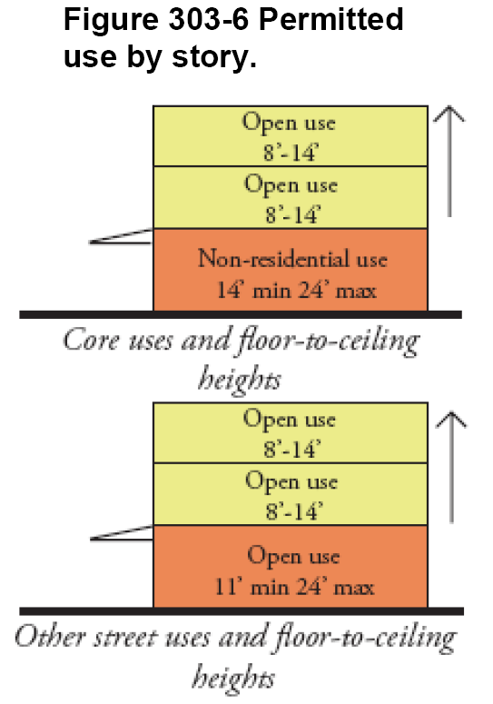
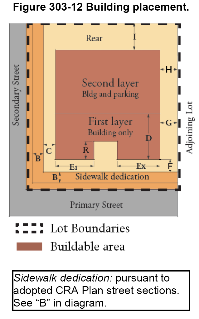
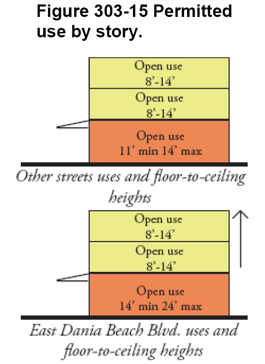
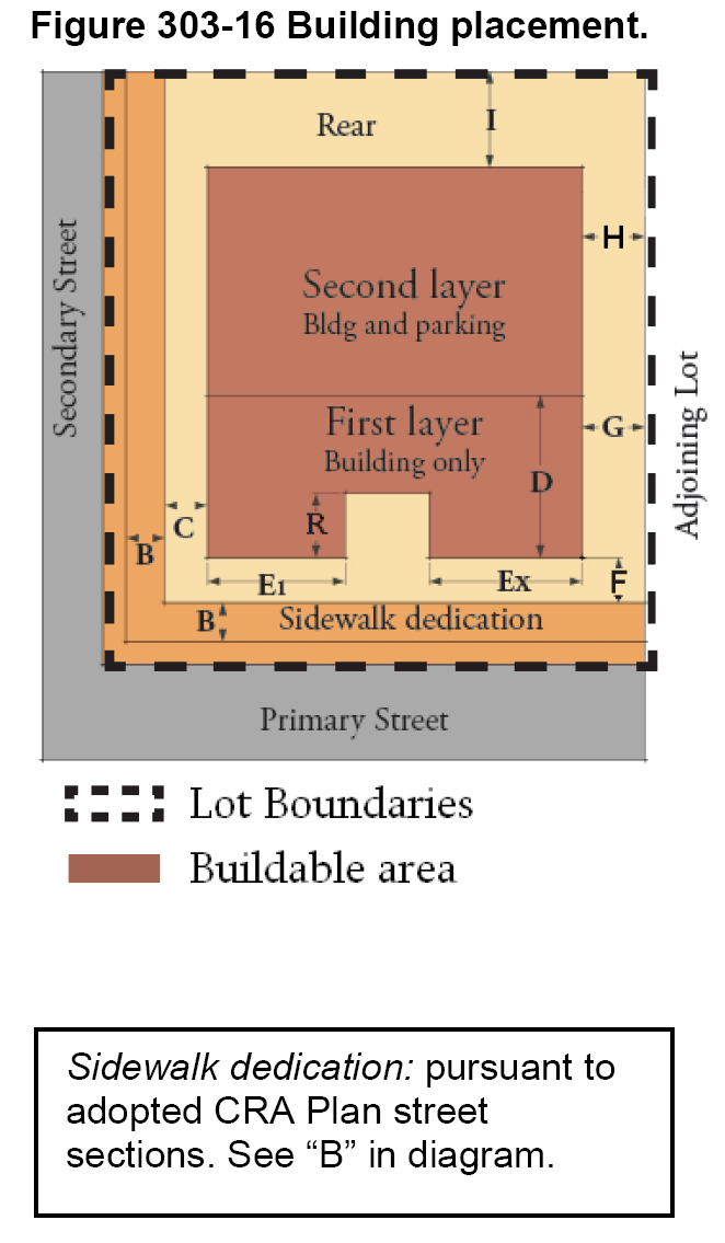
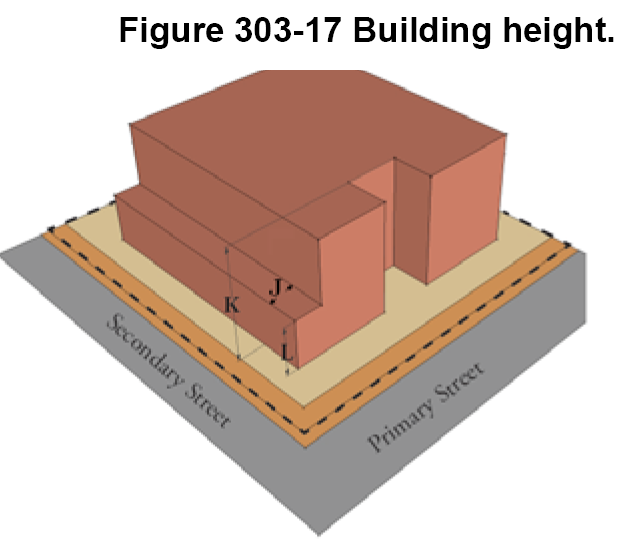
Sec. 303-30. - Illustrated development standard definitions; interpretation.
(A)
Building and parking placement.
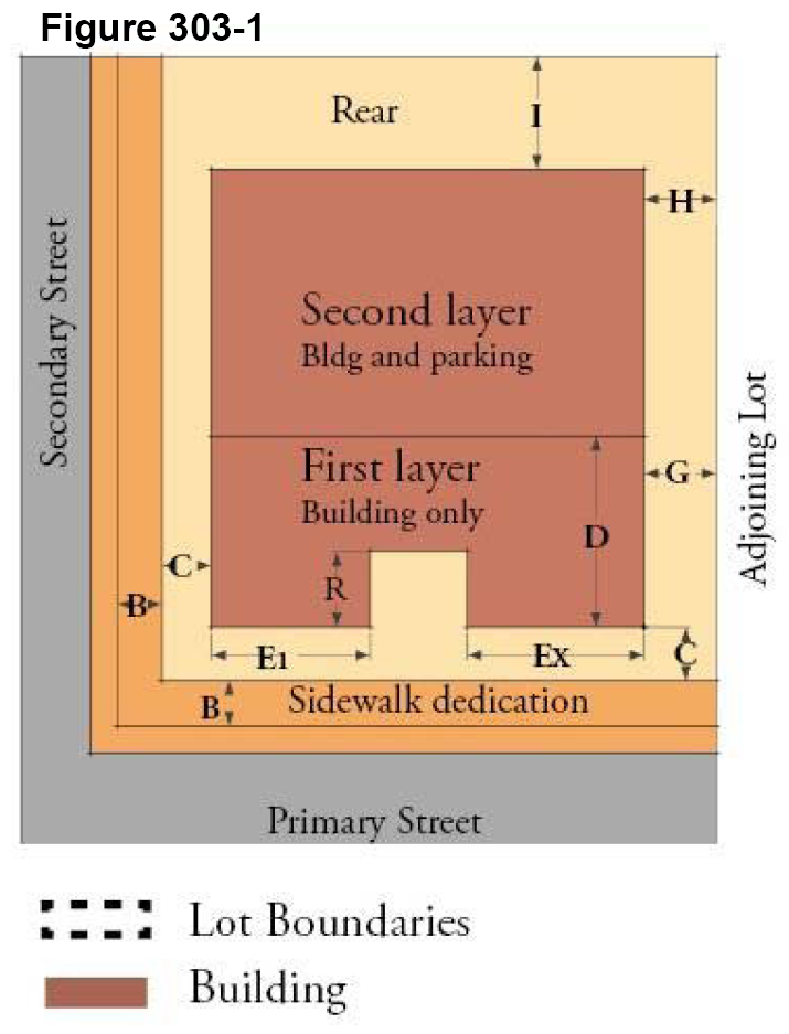
(1)
"B" in diagram. Sidewalk dedication: when existing right-of-way is insufficient for wide sidewalks, on-street parking, or both, as specified on the street sections approved by the city commission in the CRA redevelopment plan, a dedication is required pursuant to section 309-10.
(2)
"C" in diagram. Build-to-line (BTL) or setback: the regulations require either a BTL, a paired min. and max. setback, or a min. setback for all buildings.
A BTL is an exact building setback line parallel to the block face, upon which the entire building façade of at least the lowest three (3) stories must be built, except as provided for jogs in the façade (see "E1, Ex"), and allowable encroachments such as arcades and stoops.
(3)
Primary and secondary street standards, as shown in Figure 303-1 and Table 303-1. A primary street shall always be considered the front street. In the case of two (2) primary streets, both must be treated as the front street. Primary street standards govern all buildings with primary street frontage, regardless of any corner side frontage on a secondary street. Secondary street standards govern buildings that front only upon one or more secondary streets.
(4)
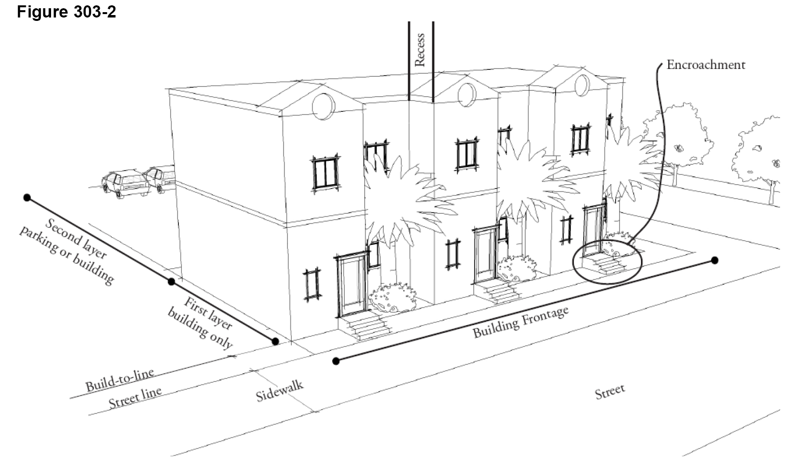
"D" in diagram. Layers: the buildable area of each lot (portions of the lot not required for setbacks and yards) is divided into a first layer and second layer demarcated by imaginary lines for the purpose of regulating which of the following activities can occur in each: building, surface parking or structured parking. The first layer is comprised of the front twenty (20) to thirty (30) feet of a lot (varies by zone), measured from the BTL, and is the part of the lot that the building must occupy when a BTL is established. The second layer is located to the rear of the first layer, and generally represents the area where parking, building or both can occur. See also Figure 303-2.
(5)
Shown in Figure 303-2. Street line is the back edge of the right-of-way, after any required dedications. In this illustration, the street line is the back edge of the sidewalk. This represents the transition from public realm to private property.
(B)
Building frontage. Regulates the undulation of street-facing building façades.
(1)
"E1" and Ex" in diagram. Min. building frontage requirement: regulates how much of the building façade must be built on the BTL and how much (by default) can be built behind the BTL. The building frontage requirement applies only to the first layer (see "D" in Figure 303-1), and is expressed as a percentage of lot width that has to be built on the BTL. Example: a building frontage requirement of fifty (50) percent on a lot that is one hundred (100) feet wide means that at least fifty (50) feet of the building façade must be placed on the BTL. This standard also works in tandem with the side setback (or BTL) requirement (see "G" in figure 303-1) and corner street setback (or BTL) requirement. In the example above, if there is a first layer side yard requirement of zero (0) to ten (10) feet, then the first layer of the building must be at least eighty (80) feet long (one hundred (100) feet of lot width less two (2) ten-foot side yards), with at least fifty (50) feet built at the BTL.
(2)
"R" in diagram. Max. building recess describes the maximum distance that any part of a building can be placed behind the BTL or max. setback line (see Figure 303-1). This standard does not apply to courtyard and forecourt types. Usually, a limited portion of the façade may be built behind the BTL, but no further than the maximum recess dimension. In the illustration, the building has three (3) entrances built at the BTL, and three (3) jogs in the building façade that allow landscaping between the building and sidewalk. In Figure 303-2, approximately fifty (50) percent (one-half) of the building façade is recessed from the BTL. The distance at which the building jogs backward from the BTL is called the recess.
(3)
"G" in diagram. Interior side BTL or setback: In most districts, there are different side building placement standards for the first layer and second layers. Since the first layer contains the building frontage on the street, it is important to control how far from the side lot line the building can be set back, if at all. Minimizing side yards helps to maintain the "building street wall" in the mixed-use districts, and the continuity of building frontage along the street maintains pedestrian interest and minimizes gaps that could present opportunities for criminals. Within the second layer, there is often just a minimum setback.
(4)
Shown in Figure 303-2, Encroachment is any part of the building structure that extends forward of the BTL, but remains behind the street line unless an encroachment is specifically authorized to extend forward of the street line, such as for awnings, galleries and arcades. In Figure 303-2, the stoops at the building entrances are permitted encroachments. Although the term is used in the frontage type regulations and not the district standards, it is illustrated here.
(C)
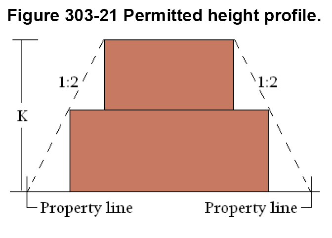
Upper story setbacks.
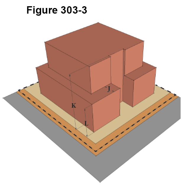
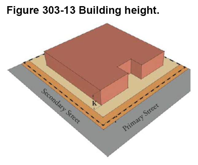
(1)
"L" in diagram. Maximum height before additional setback required for upper stories: Refers to the lower portion of a building that is not subject to an additional setback requirement for upper stories.
(2)
"J" in diagram. Upper-level building setback: Refers to the vertical plane modulation of a building and is the minimum required perpendicular distance that a building wall and elements must be recessed from the BTL or minimum setback line, as applicable.
(D)
Height regulations.
(1)
"K" in diagram. Maximum allowable height: Is established within each district for all buildings. Maximum height in transitional areas may be limited by article 304.
(E)
Other terms used.
(1)
Building frontage type. A combination of a building's ground story street frontage characteristics including entrance configuration, fenestration and required or permitted encroachments forward of a minimum setback or build-to-line used. Several combinations of such characteristics have been classified as building frontage types, which serve to define and facilitate the intended ground story building function/uses through the degree of differentiation and privacy made between the public sidewalk and private property. Building frontages are regulated in tables such as shown in Figure 303-4.
Figure 303-4
P - Primary street frontage; lots without frontage on a primary street can be used only for parking or a neighborhood residential district permitted use, building type and frontage.
(2)
Building types are described in detail in article 310. Every type of building also has one (1) or more allowable frontage types, which determines how the building entry is configured, as well as fenestration requirements and allowable encroachments over the public sidewalk. Building frontage types are described in detail in article 311. Building types are regulated in tables such as shown in Figure 303-4.
(3)
Floor area ratio (F.A.R.) means the gross floor area of all buildings on a lot expressed in square feet, divided by the net lot area expressed in square feet.
(4)
Pervious landscaped lot area offset program.
(a)
The city establishes a pervious landscaped area offset program to be used for purchasing and improving public open space within the CC, EDBB-MU, SFED-MU and NBHD-MU zoning districts for the purpose of mitigating deficiencies in required pervious landscaped area. A developer may contribute a fee in lieu of providing pervious landscaped pervious lot area on site as required by this article. The amount of an in-lieu payment shall be based on the average cost of land acquisition and preparation within the applicable zoning district per square foot of required pervious landscaped lot area, and shall be determined and established by the city commission by resolution, and updated periodically. Funds contributed through payments in-lieu of providing pervious landscaped lot area shall be placed in a dedicated city fund to be utilized for acquisition and improvement of pervious landscaped open space for public park use and stormwater management within these zoning districts.
(b)
The pervious open space requirement may be met collectively by two (2) or more development sites, subject to the execution of a restrictive covenant or other instrument deemed acceptable by the city attorney, with the city as a party thereto, that guarantees that open space will be maintained in perpetuity.
(F)
Generalized permitted uses.
(1)
Generalized permitted uses may vary between primary and secondary street frontages. The table below (Figure 303-5) provides a sample of generalized permitted uses. The table is generalized because many of the uses listed in the table are categories of use, rather than specific uses. For example, general commercial uses are shown as being permitted in this table. This does not mean that all general commercial uses are permitted in this district, but that at least one (1) general commercial use is either permitted or a special exception use within the district. The user must consult article 302 for the full list of permitted and special exception uses. Additionally, permitted uses for the ground story may be different than for upper stories (see Figure 303-5).
Figure 303-5. Example of generalized permitted uses by street and by story.
(Ord. No. 2010-20, § 2(Exh. A), 9-14-10; Ord. No. 2024-021, § 2, 3-12-24)
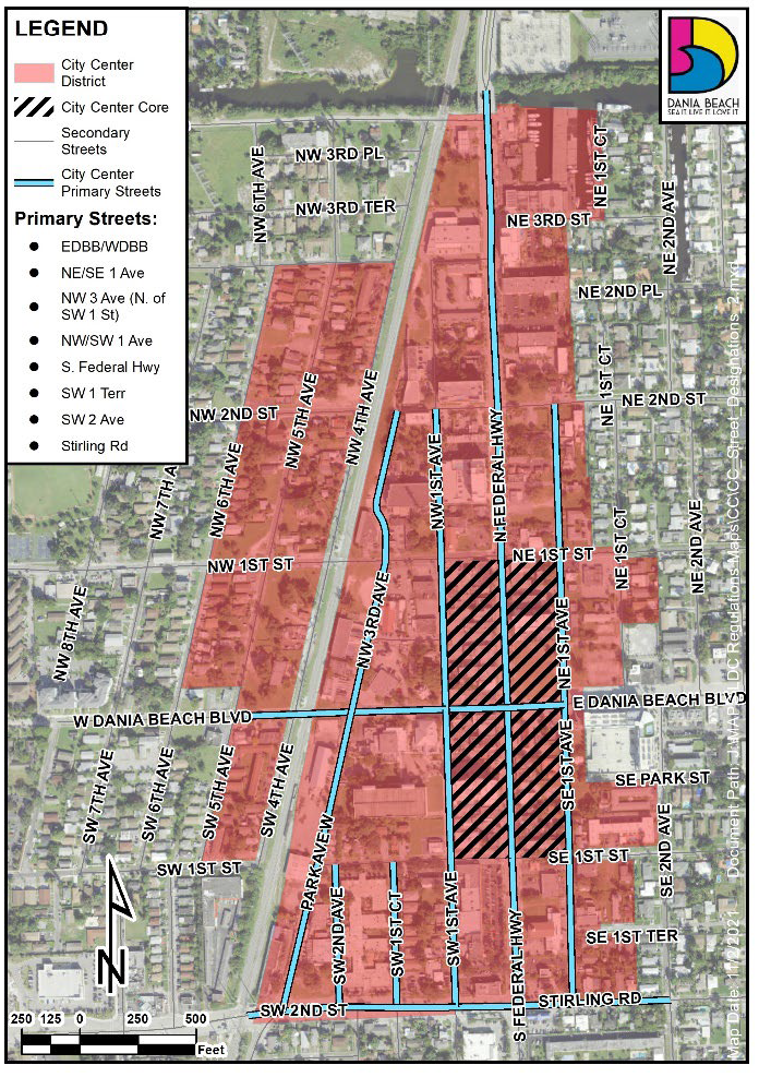
Sec. 303-40. - City Center (CC) District.
(A)
Intent and purpose. To establish a mixed-use downtown with transit supportive densities and intensities where citizens can work, live, and shop in the economic, governmental, entertainment and cultural focal point of Dania Beach. This district is designed to encourage accessible, active, pedestrian-oriented areas within walking distance of a prospective transit station on the FEC railway.
(B)
Density. Maximum fifty (50) du/ac.
(C)
Reserved.
(D)
Generalized permitted uses (see article 302 for specific uses and conditions of use).
(E)
City center core. Located between NE and NW 1st Avenues and between SE/SW 1st and NE/NW 1st Streets (see cross-hatching on map). The core is the planned retail, government and downtown of Dania Beach. Mixed-use buildings with ground-floor retail, entertainment, and/or office uses are required in the core.
(F)
Minimum required pervious, landscaped lot area. Ten (10) percent. Section 303-30(E)(4) provides for payment-in-lieu.
(G)
Sustainable building requirements. See article 305.
(H)
Parking and loading. See article 306. Parking is permitted only in the second layer.
(I)
Landscaping. See article 307.
(J)
Signage. See article 308.
(K)
Additional development standards. See article 309.
(L)
Architectural and design standards. See article 525.
(M)
Building placement standards.
(N)
Building frontage standards.
(O)
Allowable building types, frontage types (see articles 310 and 311 for details) and minimum lot dimensions.
(P)
Height: "K", district maximum is seven (7) stories and varies by location (see height map and article 304), with a minimum two (2) habitable stories required in the CC District core. The maximum allowable height in this district is based upon proximity to adjacent residential zoning districts. Allowable height increases at a rate of one (1) foot per one (1) foot of horizontal distance from an adjacent residential zoning district boundary. Therefore, allowable height within one (1) portion of a property might be different than that permitted on another portion. Buildings must be designed accordingly. The allowable height of buildings just outside of the district boundary is shown for information purposes.
(Q)
Upper story setback standards.
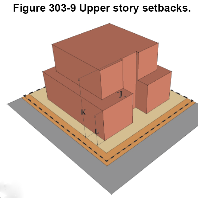
Figure 303-10 Maximum Permitted Height Map.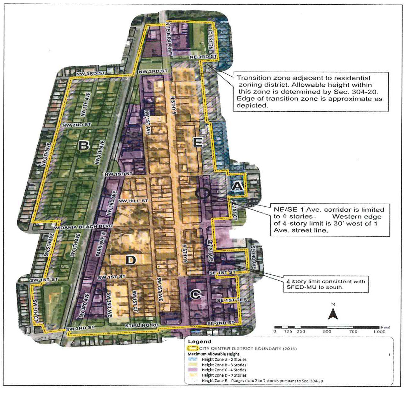
(Ord. No. 2010-020, § 2(Exh. A), 9-14-10; Ord. No. 2011-024, § 11, 8-9-11; Ord. No. 2012-008, § 9, 5-8-12; Ord. No. 2016-004, § 7, 3-22-16; Ord. No. 2016-007, § 8, 3-22-16; Ord. No. 2016-013, § 5, 7-26-16; Ord. No. 2022-004, § 1, 1-11-22; Ord. No. 2024-021, § 2, 3-12-24)
Sec. 303-50. - NBHD-MU, neighborhood mixed-use district.
(A)
Intent and purpose. May be applied along existing and planned collector streets that border neighborhoods and along portions of some arterial roadways where neighborhood-scale commercial and multiple-family residential uses are desirable, as follows: West Dania Beach Boulevard, Stirling Road, Phippen Waiters Road, West Dixie Highway and Sheridan Street. Each such street is a primary street for the purposes of this section. The development pattern associated with this district is linear, typically one lot deep along a thoroughfare. Rear yards are required in order to accommodate parking and loading, and provide separation from the residential neighborhoods typically bordering the rear lot lines.
(B)
Density. Maximum 18 du/ac.
(C)
Reserved.
(D)
Generalized permitted uses (see article 302 for specific uses and conditions of use).
✓ - Permitted use
* - Restricted to buildings with
secondary street frontages only
(E)
Building placement standards.
(F)
Frontage standards.
(G)
Height.
(H)
Allowable building types, frontage types (see articles 310 and 311 for details) and minimum lot dimensions.
;sz=8q; P - Primary street frontage
S - Secondary street frontage, subject to conditions of use for NBHD-RES District
(I)
Pervious landscaped lot area. Minimum fifteen (15) percent. Subsection 303-30(E)(4) provides for payment-in-lieu.
(J)
Sustainable building requirements. See article 305.
(K)
Parking and loading. See article 306. Parking is permitted only in the second layer.
(L)
Landscaping. See article 307.
(M)
Signage. See article 308.
(N)
Additional development standards. See article 309.
(O)
Architectural and design standards. See article 525.
(Ord. No. 2010-20, § 2(Exh. A), 9-14-10; Ord. No. 2024-021, § 2, 3-12-24)
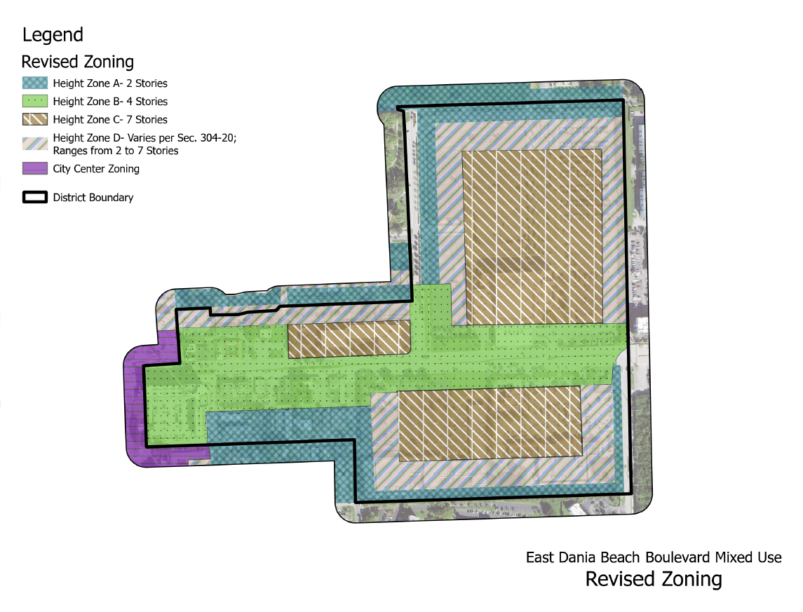
Sec. 303-60. - EDBB-MU, East Dania Beach Boulevard Mixed-Use District.
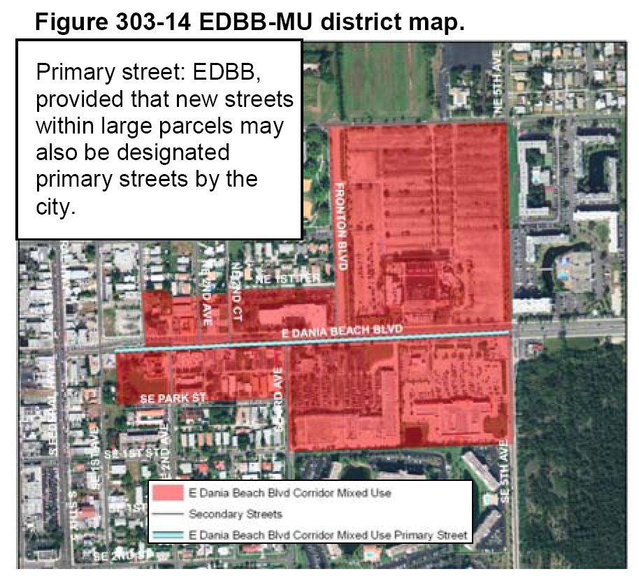
(A)
Intent and purpose. Redevelopment to place a greater emphasis on pedestrian activity and transit supportive development. This will be accomplished by building close to the street, relocating parking facilities behind buildings, and mixing residential and commercial uses at medium to high intensities.
(B)
Density. Thirty-five (35) du/ac.
(C)
Reserved.
(D)
Pervious landscaped lot area. For lots five (5) acres and smaller, minimum ten (10) percent. For lots over five (5) acres, minimum twenty (20) percent. Subsection 303-30(E)(4) provides for payment-in-lieu.
(E)
Sustainable building requirements. See article 305.
(F)
Parking and loading. See article 306. Parking is permitted only in the second layer.
(G)
Landscaping. See article 307.
(H)
Signage. See article 308.
(I)
Additional development standards. See article 309.
(J)
Architectural and design standards. See article 525.
(K)
Generalized permitted uses (see article 302 for specific uses and conditions of use).
✓ - Permitted use
* - Only select uses permitted
** - See section 302-40
(L)
Building placement standards.
(M)
Building frontage standards.
P - Primary street frontage.
S - Secondary street frontage.
(O)
Height. Maximum height, "K", is seven (7) stories. The maximum allowable height in this district is based upon proximity to adjacent residential zoning districts, and a fixed height limit of four (4) stories within one hundred (100) feet from the EDBB. Allowable height increases at a rate of one (1) foot per one (1) foot of horizontal distance from an adjacent residential zoning district boundary. Therefore, allowable height within one (1) portion of a property might be different than that permitted on another portion. Buildings must be designed accordingly. The allowable height of buildings shown outside the district boundary on the height map is for informational purposes.
(Ord. No. 2010-20, § 2(Exh. A), 9-14-10; Ord. No. 2024-021, § 2, 3-12-24; Ord. No. 2025-013, § 3, 6-10-25)
Sec. 303-70. - GTWY-MU, Beach Gateway Mixed-Use District.
(A)
Intent and purpose. To capitalize on the proximity of conservation areas, waterways and the beach, by preserving additional land, thus enhancing the area's assets, by differentiating this district from the more urban EDBB mixed-use district, and by allowing appropriate building height to allow for reduction in footprint and developed land area. This will be accomplished by allowing relatively tall buildings built relatively close to the street, while providing greater setback and landscaping between the building and street than in the East Dania Beach Boulevard mixed-use district.
Figure 303-19 GTWY-MU district map.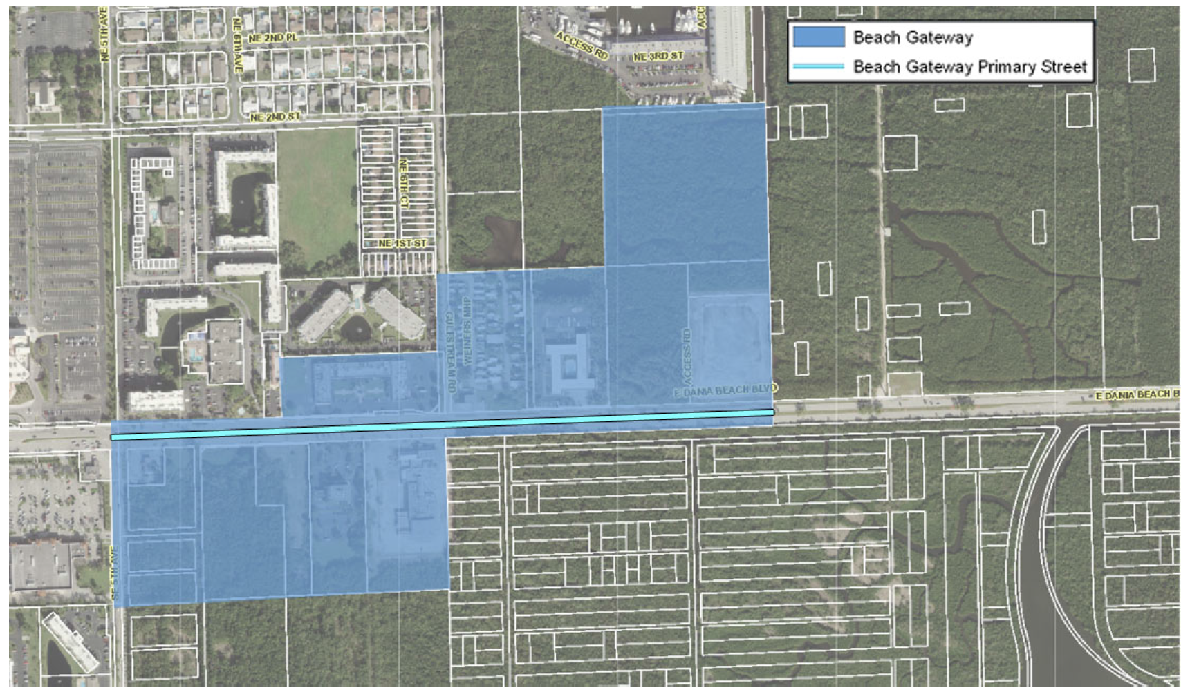
(B)
Density: Maximum 50 du/ac.
(C)
Reserved.
(D)
Generalized permitted uses (see article 302 for specific uses and conditions of use):
✓ - Permitted use
(E)
Pervious landscaped lot area. Twenty-five (25) percent.
(F)
Sustainable building requirements. See article 305.
(G)
Parking. See article 306. Structured parking is not permitted in the first layer.
(H)
Landscaping. See article 307.
(I)
Signage. See article 308.
(J)
Additional development standards. See article 309.
(K)
Architectural and design standards. See article 525.
(L)
Building placement standards.
(M)
Building frontage standards.
(N)
Allowable building and frontage types. Building form is not regulated through building or frontage types in this district.
(O)
Minimum lot width. One hundred (100) feet.
(P)
Minimum lot depth. One hundred (100) feet.
(Q)
Maximum building height. Two (2) feet for each one (1) foot of horizontal distance from street lines and property lines, not to exceed seven (7) stories. The maximum allowable height in this district is based upon proximity to adjacent residential zoning districts and district streets. Therefore, allowable height within one (1) portion of a property might be different than that permitted on another portion. Buildings must be designed accordingly. The allowable height of buildings just outside of the district boundary is shown on the height map for information purposes.
Figure 303-22 GTWY-MU district height map.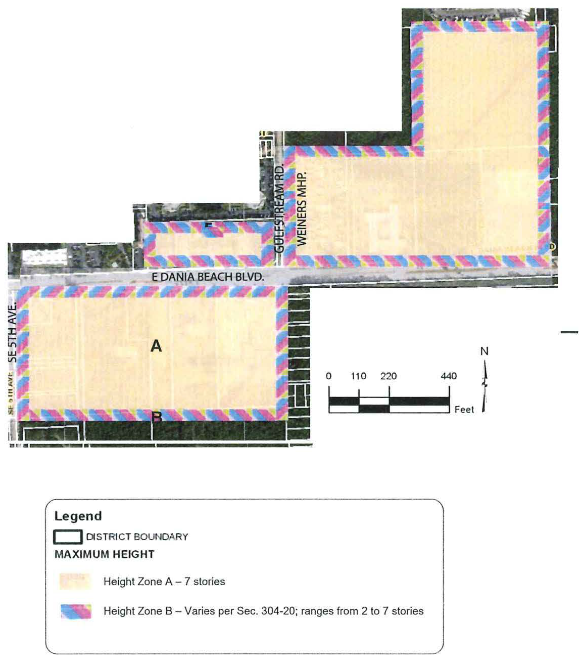
(Ord. No. 2010-20, § 2(Exh. A), 9-14-10; Ord. No. 2014-011, § 2, 9-23-14; Ord. No. 2019-001, § 4, 2-26-19; Ord. No. 2024-021, § 2, 3-12-24; Ord. No. 2026-004, § 7, 1-13-26)
Sec. 303-75. - GTWY-MU-II, Beach Gateway Mixed-Use II District.
(A)
Intent and purpose. To capitalize on the proximity of conservation areas, waterways and the beach, by preserving additional land, thus enhancing the area's assets, by differentiating this district from the GTWY-MU Mixed-Use District, and by allowing appropriate building height to allow for reduction in footprint and developed land area. This will be accomplished by allowing relatively tall buildings built relatively close to the street, while providing greater setback and landscaping between the building and street than in the East Dania Beach Boulevard Mixed-Use District.
(1)
Eligibility. Only parcels that are zoned Beach Gateway Mixed-Use shall be eligible for rezoning to the Beach Gateway Mixed-Use-II District.
(B)
Density: Max. 85 du/ac.
(C)
Reserved.
(D)
Generalized permitted uses (see article 302 for specific uses and conditions of use):
✓—Permitted use
(E)
Pervious landscaped lot area. Twenty-five (25) percent.
(F)
Sustainable building requirements. See article 305.
(G)
Parking. See article 306. Structured parking is not permitted in the first layer.
(H)
Landscaping. See article 307.
(I)
Signage. See article 308.
(J)
Additional development standards. See article 309.
(K)
Architectural and design standards. See article 525.
(L)
Building placement standards.
(M)
Building frontage standards.
Figure 303-22-2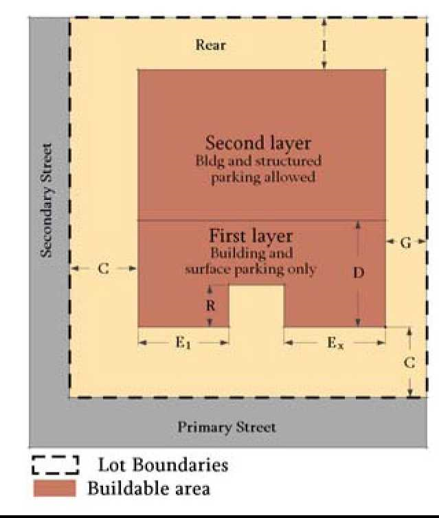
(N)
Allowable building and frontage types. Building form is not regulated through building or frontage types in this district.
(O)
Minimum lot width. One hundred (100) feet.
(P)
Minimum lot depth. One hundred (100) feet.
Figure 303-22-3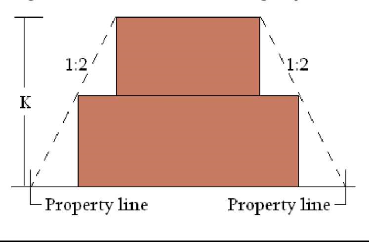
(Q)
Maximum building height. Two (2) feet for each one-foot of horizontal distance from street lines and property lines, not to exceed eight (8) stories. The maximum allowable height in this district is based upon proximity to adjacent residential zoning districts and district streets. Therefore, allowable height within one (1) portion of a property might be different than that permitted on another portion. Buildings must be designed accordingly. The allowable height of buildings just outside of the district boundary is shown on the height map for information purposes.
(R)
Required amenities. The following amenities are required.
• Sustainable building practices.
• Payment in lieu of public parking.
• Provide public parks.
(1)
Sustainable building practices; voluntary green building/development program.
(a)
Overview. The CRA green building/development program is a voluntary program that developers may choose to participate in, to comply with subsection (R) Required Amenities
(b)
Green building; green building practices. Green building practices refers to building and building site design, materials and construction techniques that minimize demand for nonrenewable material and energy resources, water consumption, and minimize the generation of waste products, pollution, and stormwater runoff. Green building practices are generally consistent with the techniques used to achieve certification of construction and development through third-party green building and development certification programs including the U.S. Green Building Council Leadership in Energy and Environmental Design (LEED), the Florida Green Building Coalition, and Florida Green Lodging.
(c)
Rating organizations. This program awards credits based on selected third-party green building/development certification programs, including, but not limited to, the Florida Green Building Coalition, Florida Green Lodging, and U.S. Green Building Council Leadership in Energy and Environmental Design (LEED).
(d)
Approval of established third-party standards. Applicants seeking to participate in the voluntary green building/development program are required to schedule a preliminary development application meeting with the community development director. At the preliminary development application meeting, the applicant shall identify the third-party green building/development standards proposed to be incorporated in the project design and implementation and provide a copy of the standards to city staff the community development director for review. If the standards of a third-party certification program other than those listed in [subsection] (b) are proposed, the city staff [and] the community development director will review the standards of the rating organization certification program intended to be used by the applicant and notify the applicant if the proposed program and standards are accepted or rejected for the voluntary green building/development program.
(e)
Review process and certification options. Applicants seeking to participate in the voluntary green building/development program must choose to:
1.
Formally apply for third-party certification with a selected third-party green building/development rating organization approved by the community development director, which includes meeting all the submittal, application and fee requirements for the selected third-party certification; or
2.
As an alternative to formal application for third-party certification the applicant may participate in the city's cost-recovery green building/development review process. The community development director shall review and verify the third-party green building/development standards proposed to be incorporated in the project design and implementation. The applicant shall document compliance with all of the third-party certification criteria to the satisfaction of the community development director.
(f)
Minimum submittal requirements for applying for voluntary green building or development program. Site development plan submittal requirements to participate in the voluntary green building/development program shall include the following:
1.
Documentation that the applicant has participated in the preliminary development application meeting and has received approval from the community development director to utilize the third-party green building/development standards used in the site development plan submittal.
2.
Written statement identifying the review option selected by the applicant (demonstration of formal third-party certification of the project, or community development director verification of project compliance with third-party green building/development standards through cost-recovery based review).
3.
A completed residential green development/building checklist, with a narrative explanation of how the green building measure is being incorporated.
4.
The city shall require that the proposal exceed the number of points necessary under this section by a margin to be established administratively for each third-party certification program. The intent is to ensure certification as best possible in the event that a given green measure fails to qualify after construction is completed.
5.
A notarized affidavit from the project architect demonstrating that the approved green building measures have been incorporated into the project plans.
6.
Project site and engineering plans that clearly detail all green building measures.
7.
A notarized affidavit certifying that a green building expert professional certified or accredited by a third-party green building and development rating organization deemed acceptable by the community development director is a part of the development team and shall remain part of the project team throughout its duration (i.e., from the design stage through final building inspection/issuance of certificate of occupancy).
(g)
Performance bond. Participants in the voluntary green building program, prior to issuance of a certificate of occupancy, shall post a performance bond, letter of credit or other form of surety approved by the city attorney.
1.
The amount of the required performance bond, letter of credit or other approved form of surety shall be calculated as follows for projects seeking the incentive bonus for meeting third-party certification requirements:
a.
Four (4) percent of the total cost of construction for a development of less than one hundred thousand (100,000) square feet of building area.
b.
Three (3) percent of the total cost of construction for a development of up to two hundred thousand (200,000) square feet of building.
c.
Two (2) percent of the total cost of construction for any building greater than two hundred thousand (200,000) square feet.
2.
In the event the completed development does not achieve the third-party certification or the required number of points, a portion of the surety shall be forfeited in an amount equal to the percentage of the required third-party point total not earned. However, if the development does not qualify for at least ninety (90) percent of the number of points, the entire bond amount shall be forfeited.
3.
The city may call on the performance bond if:
a.
If the community development director determines that the development does not qualify for the credits within one (1) year of the city issuance of the certificate of occupancy for the building. Funds that become available to the city from the forfeiture of all or part of the surety shall be placed in the sustainable development fund established by the city, which shall be used to fund sustainable and energy-efficient city-initiated capital projects including, but not limited to, water-efficient landscaping, open space acquisition and improvements, traffic calming, public transportation-related improvements, pollution mitigation, sustainability improvements to public facilities, or similar improvements as deemed appropriate by the city commission.
(2)
Provide payment in lieu of public parking, consistent with section 265-92.
(3)
Contribution for public parks.
(a)
The public park contribution shall be calculated pursuant to section (3)(b) below, which shall be applied to the city's park fund for park land acquisition or park improvements. The full public park payment shall be paid if this amenity is selected. A development containing a minimum of twenty-five (25) dwelling units is required to provide this amenity.
(b)
The public park payment shall be equal in value to fifty cents ($0.50) per square foot of estimated residential gross floor area.
(c)
For purposes of this section, residential gross floor area shall be defined as the sum of the habitable horizontal area of all residential floors of all stories of a residential building or structure under a roof, and including, interior amenity areas, clubhouses, lobby areas however excluding private garages, maintenance areas, utility areas, operational areas, storage closets, electrical and mechanical facilities, balconies, stairwells, elevators, basements and subbasements, covered parking, loading areas, and parking structures.
(d)
The contributions referenced in this section are calculated in 2024 dollars and shall be adjusted by the consumer price index on an annual basis.
(e)
Payment of the public park fees shall be made prior to issuance of a building permit.
(S)
Stormwater. For any development utilizing the GTWY-MU-II, Beach Gateway Mixed-Use II District, the following additional standards shall be applicable.
(1)
Developments must retain all stormwater from a three-year, 24-hour event.
(2)
Stormwater retention/detention areas.
(a)
Stormwater retention/detention areas shall be designed to maximize the perimeter dimension, where feasible.
(b)
Stormwater retention/detention areas shall be planted throughout with native herbaceous facultative plants, with the following exceptions:
1.
In areas that are designated and actively used for play and/or picnic areas, overflow parking, or sports shall be planted with grasses which are very drought tolerant, as well as tolerant to wet soils.
2.
In areas where the minimum required stormwater retention capacity would be adversely affected.
(c)
The minimum required number of native herbaceous facultative plants shall be one (1) plant per square foot of retention/detention area, including the slope. Minimum required herbaceous plant container size shall be one and one-half (1.5) inches, commonly, referred to as a liner. Sprigging, seeding, plugging, hydro-mulching or sodding with native herbaceous facultative plants grown from local seed sources may be used in lieu of liners. Herbaceous plants shall be planted in such a manner as to present a finished appearance and reasonably complete coverage within one (1) year after planting.
(d)
Native facultative trees or shrubs may be used in lieu of native herbaceous facultative plants, provided that the minimum required stormwater retention capacity is not adversely affected.
(Ord. No. 2025-016, § 2, 8-26-25)
Sec. 303-80. - SFED-MU, South Federal Highway Corridor Mixed-Use District.
Figure 303-23 SFED-MU District Map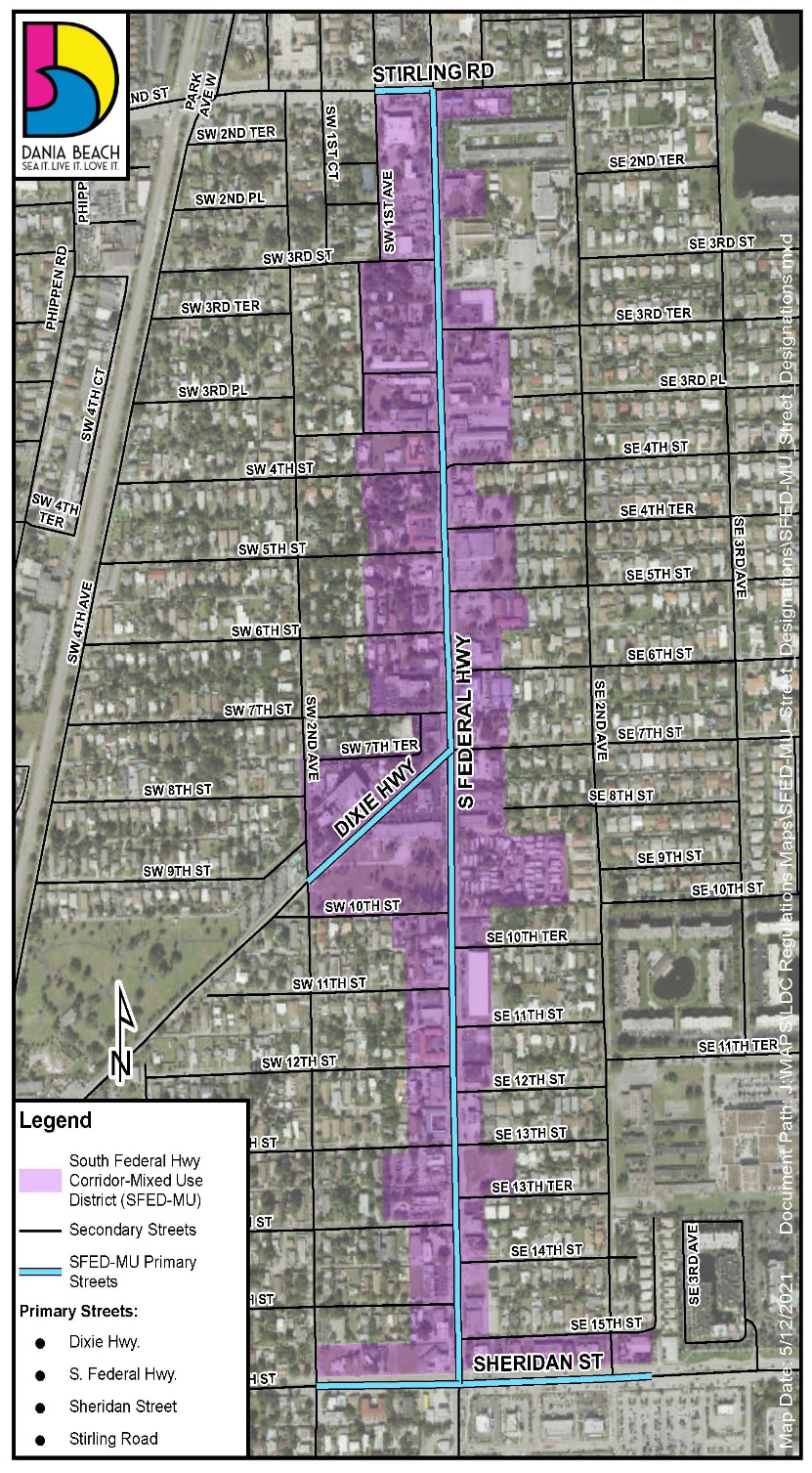
(A)
Intent and purpose. Redevelop the corridor with emphasis on the pedestrian and street life consistent with TOD principals. This will be accomplished by building close to the street, relocating parking facilities behind buildings, and mixing residential and commercial uses at medium intensities, designed to create interest and investment in the immediate neighborhood.
(B)
Density. Maximum twenty-five (25) du/ac.
(C)
Reserved.
(D)
Pervious landscaped lot area. Minimum fifteen (15) percent. Subsection 303-30(E)(4) provides for payment-in-lieu.
(E)
Sustainable building requirements. See article 305.
(F)
Parking and loading. See article 306. Parking is permitted only in the second layer. Parking structures shall be set back from any secondary street by a minimum of thirty (30) feet, which setback may be occupied by a liner building.
(G)
Landscaping. See article 307.
(H)
Signage. See article 308.
(I)
Additional development standards. See article 309.
(J)
Architectural and design standards. See article 525.
(K)
Generalized permitted uses (see article 302 for specific uses and conditions of use).
✓ - Permitted use.
* - Restrictions apply.
e - See Section 301-30.
(L)
Building placement standards.
(M)
Building frontage standards.
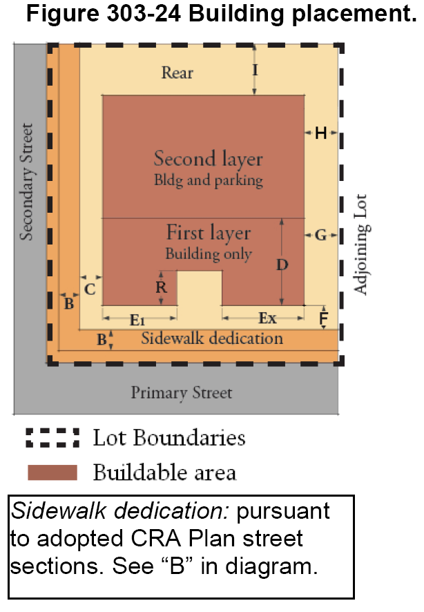
(N)
Allowable building and frontage types (see articles 310 and 311 for details) and minimum lot dimensions.
P - Primary street frontage.
S - Secondary street frontage.
A - For through-lot frontages on SW 7th and 10th streets, and SW 1st and 2nd avenues, a landscape buffer pursuant to section 275-110 is required unless the street frontage is built-out with mansion or rowhouse building types. Mansions are subject to the development standards of the NBHD-RES district.
(O)
Reserved.
(P)
Height. Maximum height, "K", in district is four (4) stories. The maximum allowable height in this district is based upon proximity to adjacent residential zoning districts. Allowable height increases at a rate of one (1) foot per one (1) foot of horizontal distance from an adjacent residential zoning district boundary. Therefore, allowable height within one (1) portion of a property might be different than that permitted on another portion. Buildings must be designed accordingly. The allowable height of buildings just outside of the district boundary is shown on the height map for information purposes.
(Q)
Development of property for commercial use must front Federal Highway or Sheridan Street, or must be assembled with properties that front Federal Highway or Sheridan Street.
(Ord. No. 2010-20, § 2(Exh. A), 9-14-10; Ord. No. 2019-001, § 4, 2-26-19; Ord. No. 2021-018, § 2, 8-24-21; Ord. No. 2024-021, § 2, 3-12-24)
Sec. 303-90. - NBHD-RES, Neighborhood Residential District.
(A)
Intent and purpose. To maintain the overall single-family character of the neighborhoods by restricting establishment of new two-family dwellings and requiring designs that are compatible with single-family dwellings.
(B)
Generalized permitted uses (see article 302 for specific uses and conditions of use).
✓ - Permitted use.
* - Restricted pursuant to section 302-20.
(C)
Building placement standards.
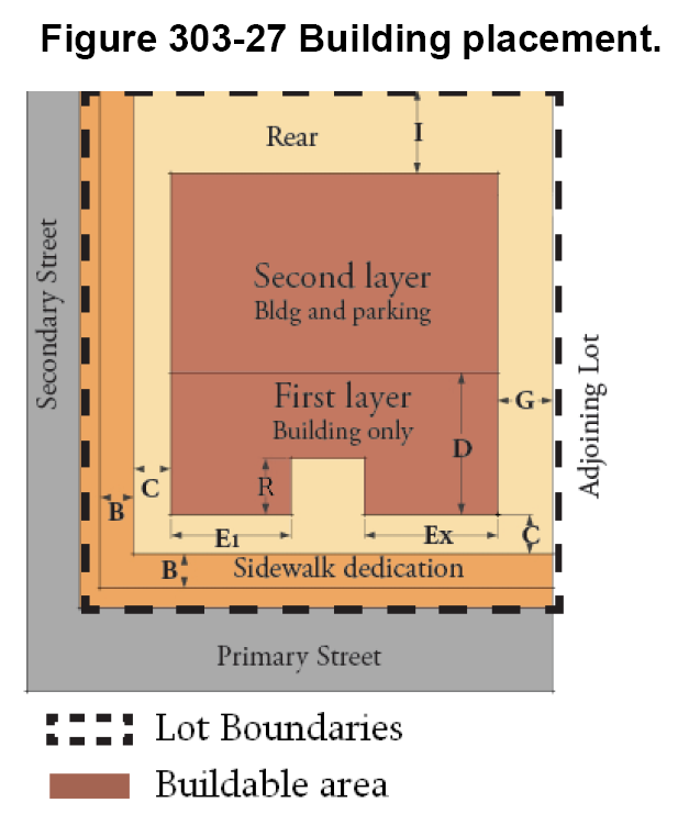
* The fifteen-foot BTL applies along any street within a block where more than fifty (50) percent of either the number of lots or total lot frontage on either or both sides is undeveloped, or contain any combination of: buildings that are set back twenty (20) feet or less from the street line; two-family dwellings; multiple-family dwellings; or nonconforming uses. If the 15-foot BTL does not apply, a new building can be placed a minimum of 15′ from the street line.
(D)
Building frontage standards.
(E)
Height. Maximum of two (2) stories and twenty-five (25) feet except as provided in section 302-20(A)(2)(b). See "K" in diagram.
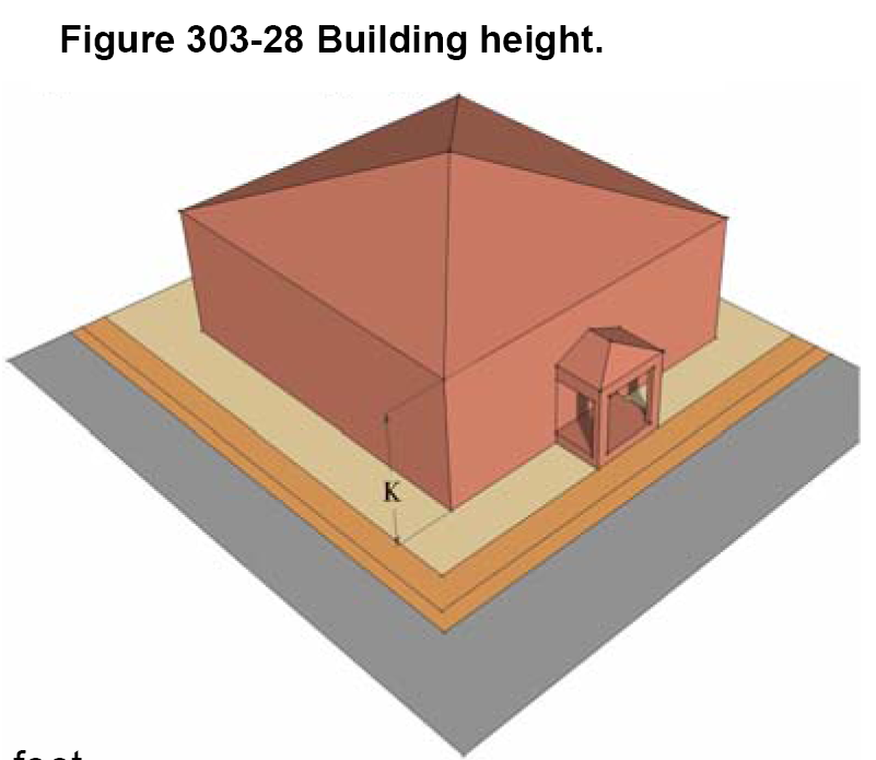
(F)
Allowable building and frontage types (see articles 310 and 311 for details) and required lot dimensions.
✓ Permitted frontage type
* Restricted pursuant to section 302-20
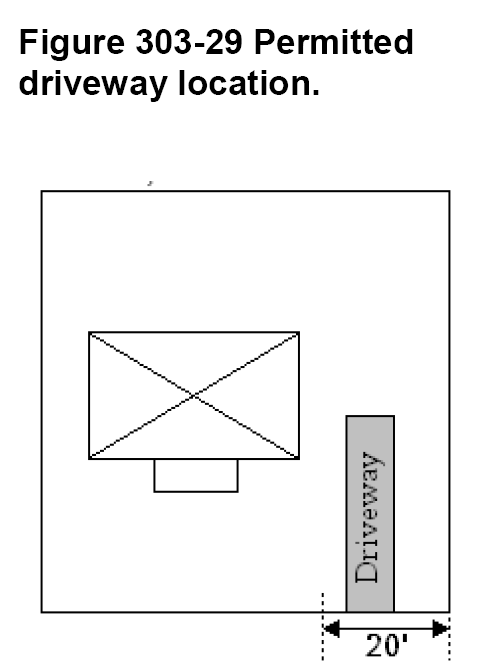
(G)
Pervious open space. Min. thirty-seven (37) percent.
(H)
Parking.
(1)
Parking spaces and driveways for dwellings built to the fifteen-foot BTL requirement in subsection (C) must be built to the requirements below:
a.
Parking spaces and driveways are not permitted in the front yard except within twenty (20) feet of one (1) interior side lot line (see Figure 303.70).
b.
Only one (1) driveway within the front yard is permitted as shown.
c.
An opaque fence or opaque landscape buffer is required along a side lot line adjacent to a driveway.
d.
If the property does not have alley access, a garage may be provided with access from the primary or secondary street.
(2)
Parking spaces and driveways for dwelling units with twenty-foot setback or greater may be built as identified below:
a.
Parking spaces and driveway may be located in the front yard if the minimum required dimensions are provided.
b.
A garage may be located at the front of the residential structure provided building setbacks are met.
c.
A circular driveway may be installed in the front yard provided a minimum of three-foot setback is provided between the edge of driveway and interior side property line on each side. Each curb opening must be a minimum of ten (10) feet. The minimum radius measured from the property line is five (5) feet.
(I)
Sustainable building requirement. See article 305.
(J)
Landscaping. See article 307.
(K)
Signage. See article 308.
(L)
Additional development standards. See article 309.
(M)
Architectural and design standards. See article 530.
(Ord. No. 2010-20, § 2(Exh. A), 9-14-10; Ord. No. 2013-007, § 5, 8-13-13; Ord. No. 2015-009, § 6, 4-28-15; Ord. No. 2016-013, § 5, 7-26-16; Ord. No. 2024-021, § 2, 3-12-24)
Sec. 303-100. - Marine district.
(A)
Intent and purpose. The purpose of the Marine district is to further the goals of the CRA Redevelopment Plan, and to encourage expansion of the marine industry by permitting marine uses which are primarily conducted within a building and which have limited impact outside the building. Some marine uses are permitted to be located outside of a completely enclosed building, subject to conditions or special exception approval. This district is also intended to permit some marine-related commercial uses, as either a permitted use or a special exception use.
(B)
Permitted uses (see article 110 for specific uses and conditions of use).
(C)
Building placement standards.
* The first ten (10) feet adjacent to any street or public thoroughfare line shall be landscaped and shall not contain parking
** The first five (5) feet adjacent to any lot line shall be landscaped and shall not contain parking.
(D)
Height: Maximum of three (3) stories.
(E)
Percentage of lot coverage: No more than seventy (70) percent of total lot area shall be covered by buildings or structures.
(F)
Sustainable building requirements. See article 305.
(G)
Parking and loading. See article 306.
(H)
Landscaping. See article 307.
(I)
Signage. See article 308.
(J)
Additional development standards. See article 309.
(K)
Architectural and design standards. See article 525.
(Ord. No. 2011-007, § 13, 2-22-11; Ord. No. 2024-021, § 2, 3-12-24)
Sec. 304-10. - Generally.
(A)
[Maximum building height.] Maximum building height is determined by the maximum height map and textual standards for each district. The height map for each district shows the maximum building height in stories.
(B)
Allowable heights. The allowable height in each district is determined by:
(1)
Maximum permitted district height;
(2)
Maximum permitted height along a given street or street segment, as applicable;
(3)
Transitional height standards adjacent to residential zoning districts.
(C)
Transitional height zones. The maps showing maximum permitted height throughout each zoning district include transitional height zones in those portions of mixed-use districts where the allowable height varies with distance from single-family residential neighborhoods and the Florida East Coast Railroad (FEC) right-of-way. Transitional height zones are established to transition building height adjacent to neighborhood residential district boundaries and the FEC railroad right-of-way. Height within a transitional height zone is based upon a formula of allowable height per distance from the adjacent neighborhood or FEC right-of-way feature. The transitional height zone is also applied to each development site within the GTWY-MU District and GTWY-MU-II District because allowable building height varies based upon the distance of a building, or portion of a building, from property lines.
(D)
Exceptions. The following structures may exceed the height of a building or structure by the lesser of twenty-five (25) percent or fifteen (15) feet:
(1)
Rooftop structures for the housing of solar panels, elevators, stairways, tanks, skylights, ventilating fans, air conditioning or similar equipment required to operate and maintain the building.
(2)
Radio, television and telecommunication antennae, whether freestanding or roof-mounted.
(E)
Additional exceptions. The following structures may exceed the height of a building or structure by not more than twenty-five (25) percent:
(1)
Cupolas, steeples, chimneys and other decorative rooftop projections, provided that the aggregate coverage of all such structures does not exceed twenty-five (25) percent of the total roof area.
(F)
Exception for ham radio antennas. Ham radio antennas may exceed the height of building or structure by forty (40) percent, not to exceed one hundred fifty (150) feet.
(Ord. No. 2010-20, § 2(Exh. A), 9-14-10; Ord. No. 2024-021, § 2, 3-12-24; Ord. No. 2025-016, § 12, 8-26-25)
Sec. 304-20. - Rules of height transition from residential zoning districts.
(A)
When a lot line or alley forms a boundary between a residential zoning district and a mixed-use zoning district, the minimum setback from said lot line or alley line shall be as follows for the lot in the nonresidential or mixed-use district:
(1)
Fifteen (15) feet measured from an interior side lot line of a lot within a residential zoning district, as illustrated in Figure 304-1.
(2)
Twenty-five (25) feet measured from a rear lot line of a lot within a residential zoning district, as illustrated in Figure 304-2.
(B)
The maximum allowable building height on the lot within the mixed-use district shall be the lesser of two (2) stories or twenty-five (25) feet at the minimum setback line, and shall increase at a constant rate of one (1) foot for each one (1) foot of distance from the minimum setback line, as illustrated in Figure 304-2.
Figure 304-1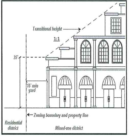
Figure 304-2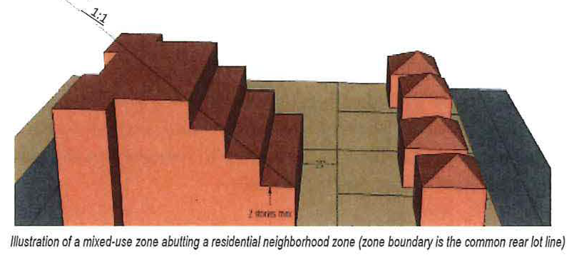
(C)
Where a street centerline forms the boundary between a residential zoning district and a mixed-use zoning district, the following standards shall apply to any lot within the mixed-use zoning district that abuts the boundary street, as illustrated in Figure 304-3.
(1)
The build-to-line along the boundary street shall be fifteen (15) feet.
(2)
One (1) of the following building types must be constructed: Mansion apartment building or rowhouse building.
(3)
The height of the building shall be exactly two (2) stories not to exceed twenty-five (25) feet for the first fifty (50) feet measured from the BTL. Mansion apartment or rowhouse buildings may be used as liner buildings or as freestanding buildings on the lots abutting the boundary street.
(4)
At fifty (50) feet measured perpendicular to the BTL, three (3) stories or thirty-five (35) feet of building height is permitted, and permitted height shall increase by one (1) foot for each additional one (1) foot of horizontal distance measured perpendicular from the BTL.
(Ord. No. 2010-20, § 2(Exh. A), 9-14-10; Ord. No. 2024-021, § 2, 3-12-24)
Sec. 304-30. - Reserved.
Editor's note— Ord. No. 2024-021, § 2, adopted March 12, 2024, repealed § 304-30, which pertained to rules of height transition adjacent to FEC Railroad Corridor and derived from Ord. No. 2010-20, § 2(Exh. A), 9-14-10.
Sec. 305-10. - Applicability.
All city buildings greater than fifty thousand (50,000) square feet in enclosed floor area shall comply with the requirements of this article.
(Ord. No. 2024-021, § 2, 3-12-24)
Sec. 305-20. - Green Building; Green Building Practices.
Green Building Practices refers to building and building site design, materials and construction techniques that minimize demand for nonrenewable material and energy resources, water consumption, and minimize the generation of waste products, pollution, and stormwater runoff. Green Building Practices are generally consistent with the techniques used to achieve certification of construction and development through the Green Building and Development Certification Programs of the U.S. Green Building Council Leadership in Energy and Environmental Design (LEED) and the Florida Green Building Coalition.
(Ord. No. 2024-021, § 2, 3-12-24)
Sec. 305-30. - Third party certification required.
(A)
The city shall formally apply for third-party certification with the selected third-party Green Building/Development Rating Organization, which includes meeting all the submittal, application and fee requirements for the selected third-party certification.
(B)
Projects subject to this article must achieve at least a gold-level certification.
(Ord. No. 2024-021, § 2, 3-12-24)
Sec. 306-10. - Off-street parking requirements.
Article 265, "Off-Street Parking Regulations" establishes the off-street parking and loading requirements for the CRA form-based districts. This article supplements article 265 and shall prevail in case of conflict.
(A)
Access hierarchy for the CRA form-based districts for rear yard parking.
(1)
Vehicular access to off-street parking and loading facilities shall be from a rear alley or its equivalent via cross-access parking aisles or driveways between properties.
(2)
In the absence of an alley or its equivalent rear yard access, access shall be provided from a corner (secondary) side street.
(3)
In the absence of the ability to provide access as prescribed in [subsection] (1) or (2), access shall be provided from a shared driveway through the primary street frontage. The driveway may run along an interior side lot line to connect the rear yard parking facility to a street.
(4)
In the event that none of the options above is possible, a driveway serving a single lot may run along an interior side lot line or internal to a lot to connect the rear yard parking facility to a street.
(5)
For properties with more than four hundred (400) linear feet of street frontage, access may be provided from the street front of the property.
(B)
[Connection to access aisle, driveway.] All off-street parking spaces shall connect directly to an access aisle or driveway without requiring another automobile to be moved or otherwise requiring access over or through any other parking space, except as provided in section 265-120 for valet/attendant parking, and within the CRA form-based districts, as follows:
(1)
Tandem parking shall be no more than two (2) spaces deep.
(2)
Tandem spaces are permitted only for two (2) or more bedroom residential units.
(3)
Both tandem spaces shall be reserved for the same dwelling unit.
(4)
Tandem spaces cannot be designated as guest parking or count towards meeting guest parking requirements.
(C)
Parking lot connectivity in the CRA form-based districts. All surface parking lots in rear yards shall be designed for connection to existing or future parking lots on abutting properties on the same side of the block, and on both sides of the block if there is no alley. This shall require recordation of a cross-access and cross-parking easement which shall be reviewed and approved by the city attorney. In the case of an abutting lot where the connection cannot yet be made, or where the building occupies the rear portion of the lot and prevents the siting of parking facilities, the developer shall design the rear yard parking facilities in such a way that parking spaces can be eliminated or reconfigured in the event the abutting building is demolished or reconfigured. The city may waive this provisions when it is unlikely that an abutting property will accommodate future rear yard parking (example: when the adjoining property was recently redeveloped and occupies its entire lot).
(Ord. No. 2010-20, § 2(Exh. A), 9-14-10; Ord. No. 2016-021, § 5, 10-10-16)
Sec. 306-20. - On-street parking requirements.
Within the City Center District, each development or redevelopment project is required to dedicate, construct and provide on-street parking along the property frontage on adjacent city streets in conformance with the street cross-sections identified in the approved CRA redevelopment plan. The method of compliance with the on-street parking requirements shall be determined in accordance with subsection 309-10(C) "Construction of on-street parking, sidewalks and street furniture required", and payment in-lieu of construction of street improvements, if required, shall be made pursuant to subsection 309-10(D) "Payment in-lieu of construction." On-street parking abutting a lot shall count toward satisfying the total parking requirement for the lot pursuant to section 265-50, "Off-street parking required; on-street parking credit". The on-street parking space shall be for public use and shall not be reserved for private use unless otherwise approved by the city commission.
(Ord. No. 2010-20, § 2(Exh. A), 9-14-10)
Sec. 306-30. - Loading requirements.
(A)
Article 270 establishes the loading space requirements for the CRA form-based districts.
(B)
No loading space or outdoor storage shall be permitted within fifty (50) feet of a neighborhood residential district boundary, nor shall any loading space face a neighborhood residential district boundary.
(C)
Loading areas shall be screened so as not to be visible from streets and residential zoning districts.
(D)
Off-street loading zones should be designed so as to minimize the disruption of the streetscape. A gated interior court as shown below, allows a two (2) axle truck to back in to a narrow loading space from the street.
(Ord. No. 2010-20, § 2(Exh. A), 9-14-10)
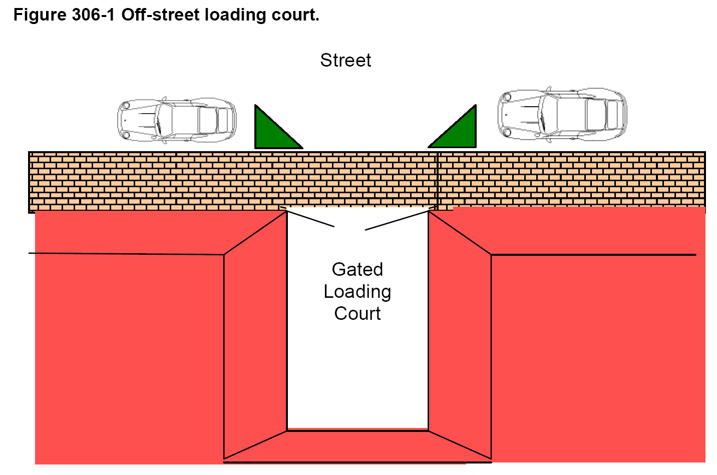
Sec. 306-40. - Parking facility setback.
Surface and structured parking facilities shall be set back a minimum of five (5) feet from all corner side streets and all alleys. The setback shall be landscaped pursuant to article 530.
(Ord. No. 2010-20, § 2(Exh. A), 9-14-10)
Sec. 306-50. - Structured parking.
(A)
Parking structures are not permitted within the first layer of any lot, unless the city commission finds that a lot is of insufficient dimension to accommodate a parking structure and one or more liner frontages for the full height of the parking structure. Upon such finding, the city commission may waive the liner requirement along one or more street frontages, provided an architectural and perimeter landscaping solution pursuant to article 530 is provided to disguise and beautify the parking structure façade. Still, the city strongly encourages lining at least the ground story street frontage (less vehicular ingress and egress opening) with inhabitable space that has sufficient depth and floor-to-ceiling clearance for the permitted uses.
(B)
Parking structure geometrics are regulated in section 265-140.
(Ord. No. 2010-20, § 2(Exh. A), 9-14-10)
Sec. 307-10. - On-site landscaping requirements.
Article 275, "Landscaping requirements" establishes the site landscaping requirements for the CRA form-based districts.
VUA = vehicle use area (parking, driveway, loading)
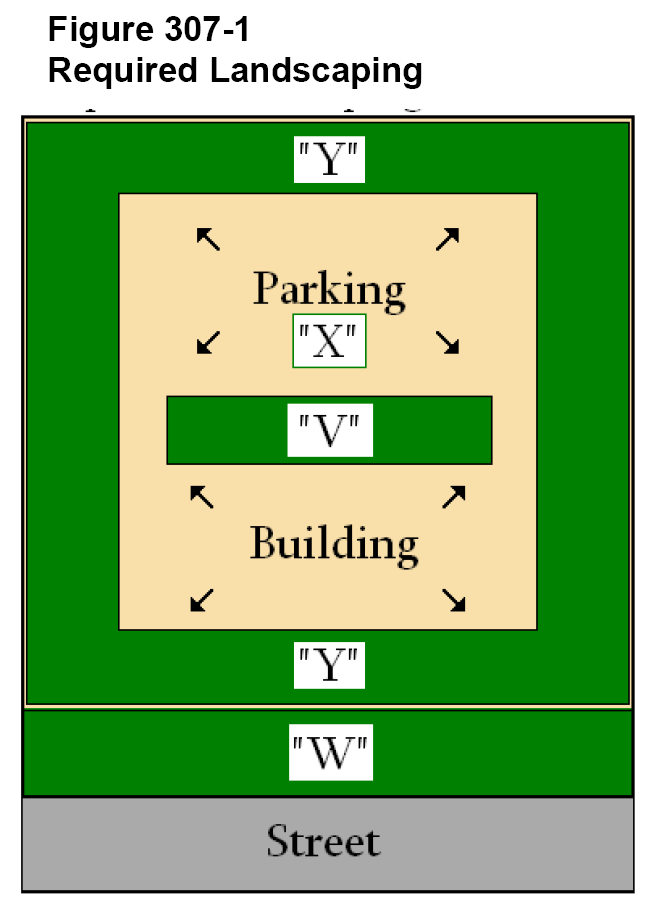
(Ord. No. 2010-20, § 2(Exh. A), 9-14-10; Ord. No. 2025-016, § 13, 8-26-25)
Sec. 307-20. - Street landscaping and hardscaping.
(A)
[Street trees.] Whenever a building is constructed, reconstructed or expanded, the owner of the lot is required to install street trees of the species, and at the spacing intervals, required by resolution of the city commission for the particular street. In the absence of a resolution passed by the city commission to this effect, the default requirement shall be live oak trees, spaced thirty (30) feet on center within the NBHD-RES district, Royal palms on trafficways spaced twenty (20) feet on center, and Sabal palms spaced fifteen (15) feet on center along all other streets.
(B)
[Planting requirements.] Street trees shall be planted as shown in the street sections approved by the city commission in the CRA redevelopment plan, and in the absence of an approved section for any street with swales, the trees shall be planted a minimum six (6) feet from street edge of pavement, and a minimum three (3) feet from the edge of sidewalk. In the absence of an approved section for any street with curb and gutter, the trees shall be planted three (3) feet from the face of the curb within grated tree wells a minimum sixteen (16) square feet in area built into the sidewalk.If the existing swale is less that nine (9) feet wide, an administrative variance may be requested as delineated in article 620 of the LDC.
(C)
Streetscape elements. Streetscape elements such as benches and lighting shall be provided based on the street sections and streetscape specifications approved by the city commission in the CRA redevelopment plan.
(Ord. No. 2010-20, § 2(Exh. A), 9-14-10; Ord. No. 2025-007, § 4, 4-8-25)
Sec. 307-30. - Screening requirements; treatment of dumpsters, loading areas and mechanical equipment.
(A)
Landscaping pursuant to section 275-170 is required to screen dumpsters and mechanical equipment.
(B)
Dumpsters, dumpster enclosures and loading zones shall not be located within twenty (20) feet of any street line or BTL.
(C)
Dumpsters and their enclosures, and loading zones, shall be screened from view at the street frontage by a building or screenwall six (6) feet in height with a planter at the street-facing base of the screenwall, provided that the city may require additional screening if necessary to obscure same from street view.
(D)
Utility boxes and machinery, including, but not limited to, backflow devices, electric meters, air conditioning units, and transformer boxes, shall not be visible from public rights-of-way, parks and other public spaces.
(E)
Mechanical equipment is not permitted along any street frontage or in any street-side yard.
(F)
In instances where rooftops are used for parking, a perimeter treatment (i.e. landscape, trellis, etc.) shall be incorporated to shield and shade the parking area from adjacent structures.
(G)
Street walls shall be used to shield vehicular use areas and unbuilt lot frontage from sidewalks within mixed-use districts. Street walls are freestanding walls built along a street frontage at the build-to-line or minimum setback line, as applicable, usually for the purpose of masking a parking lot from the street.
(1)
Street walls shall be solid and opaque below three (3) feet in height, and at least thirty-five (35) percent open screening above three (3) feet (ex: iron or aluminum) consistent with crime prevention through environmental design (CPTED) principles, and constructed and painted to match the adjacent building façade.
(2)
Living walls may be utilized, where the wall is partially covered with a vine, provided the opacity limitation above three (3) feet is not exceeded.
(3)
Street walls shall be placed three (3) to five (5) feet from the back edge of the sidewalk, and a planting strip shall be placed in between the sidewalk and wall.
(Ord. No. 2010-20, § 2(Exh. A), 9-14-10)
Sec. 307-40. - Treatment of vacant lots.
The following requirements are applicable to vacant nonresidential lots within the community redevelopment area located along principal arterials as defined in section 510-20:
(A)
Site restoration. Within thirty (30) days of completion or abandonment of any land clearing (including, but not limited to, clearing of any demolished buildings, structures or both), excavation, land-filling or any combination of the foregoing operations, all vacant lands remaining after such operation shall be prepared with ground cover, mulch, landscaping, or turf. All asphalt, rock and non natural materials shall be removed and the area, if necessary, refilled with clean soil prior to any planting or installation of any of the materials listed above. The property shall be maintained and the lot kept free of trash and debris.
(B)
Securing vacant lot. The vacant lot must be secured by a perimeter fence. Fence material must consist of vinyl coated chain link, metal picket, or polyvinyl chloride (PVC). In lieu of vinyl coated chain link, a chain link fence may be wrapped in a screening material displaying pictures of landscaping that would be allowed under subsection (A). Graphics must be reviewed and approved pursuant to section 505-30(f).
(C)
Active building permits. The requirements of this section shall not apply if a building permit has been issued and is active for the property.
(Ord. No. 2012-008, § 10, 5-8-12)
Sec. 309-10. - Complete street improvements.
(A)
Intent.
(1)
Public pedestrian circulation is one of the most important aspects of a successful redevelopment area. This article is intended to ensure that optimal public pedestrian corridors are provided along all roadways to assure unobstructed, safe and convenient pedestrian access to and between adjacent buildings.
(2)
On-street parking is a necessary component of a complete urban street, as it increases pedestrian safety and comfort by buffering pedestrians from street traffic and effectively reducing vehicle speed. On-street parking also reduces the need for off-street parking, which is a significant cost factor for urban redevelopment.
(B)
Dedication required. A sidewalk and landscaping easement or special purpose right-of-way, as determined by the city, shall be dedicated for the area between the property line abutting each street and the planned street line in order to complete the public sidewalk. The dedication shall be required for property with at least two hundred (200) feet of street frontage or four (4) contiguous platted lots, whichever is less, prior to the issuance of any building permit for work cumulatively valued in excess of twenty-five thousand dollars ($25,000.00) within any calendar using either the current RS Means or Marshall & Swift construction cost data publications. Along Federal Highway, in lieu of this requirement, right-of-way dedications are required in the amount necessary to complete the 46-foot half-section on each side of the centerline pursuant to the Broward County Trafficways Plan. The conceptual section for U.S. 1 will provide for the desired sidewalk width within the right-of-way required by the Broward County Trafficways Plan.
(C)
Construction of on-street parking, sidewalks and street furniture required. Prior to the issuance of a building permit for any construction of a new principal building, or expansion to the gross floor area of an existing principal building exceeding the lesser of two thousand five hundred (2,500) square feet or thirty-three (33) percent of the existing gross floor area of the building, the developer shall be required to comply with this section through one or more of the following methods:
(1)
Construct the sidewalk and on-street parking, and provide and install street furniture (including, but not limited to, benches, transit shelters, street lights, waste bins, and bike racks or lockers) for the street frontage abutting the property line of the development site; or
(2)
Provide for construction of these street improvements through private agreement with one (1) or more adjacent developers along the abutting right-of-way, by which one (1) or more developers construct and install the street improvements along the right-of-way and are reimbursed by the adjacent developers in proportion to their respective shares of right-of-way abutting each developer's parcel; or
(3)
Make payment in lieu of the construction of the improvements pursuant to subsection (D), at the city's option. For each development which is required to comply with this section, the community development director, in coordination with the public services director, shall review the proposed development plan and location, and determine whether the developer shall be recommended to comply with this section through construction of the required street improvements or through payment to the city in lieu of construction in accordance with subsection (D) below.
(D)
Payment in lieu of construction for complete street improvements. The amount of the required payment to the payment-in-lieu program for complete street improvements shall be determined by the average cost to the city for the construction and provision of required improvements on an average cost basis for each foot of the street frontage of each lot. The average total cost shall be determined by the public services director in coordination with the community development director and the director of finance based upon the total cost of all improvements for a typical block face, divided by the number of linear feet of the typical block face. The costs shall include actual costs and fees for design, legal and engineering services, actual construction and hardware, inspection, finance, and planning. The in-lieu fee payment amount based on these average total costs shall be established administratively by the public services director in coordination with the community development director and the director of finance. For new construction or expansion to the gross floor area of an existing principal building exceeding the lesser of two thousand five hundred (2,500) square feet or thirty-three (33) percent of the existing gross floor area of the building, payment in lieu of construction of street improvements, if used to comply with this section, shall be due prior to the issuance of a building permit for vertical construction of or expansion to a principal building or structure on the lot, provided that the property owner may execute an agreement with the city that requires payment prior to the initial certificate of occupancy. This agreement shall require the property owner to provide for surety in the event of default in a form and amount approved by the city attorney.
(1)
Annual evaluation. The amount determined to be the total average cost for improvements to a typical block face in subsection (D) shall be evaluated yearly by the public services director based upon the construction cost index (CCI) or the consumer price index (CPI). If determined to be necessary, the in-lieu fee payment amount shall be amended administratively by the public services director in coordination with the community development director and the director of finance.
(2)
Deposit of payment-in-lieu program funds. Funds generated through the complete street improvements in-lieu fee program shall be deposited in an account or accounts specifically established by the city to provide the required improvements within the applicable district of the street improvement payment-in-lieu districts. The public services director shall maintain a map which includes a listing of the complete street improvements payment-in-lieu districts and geographic locations of such districts, for the purposes of the administration of this section.
(3)
Use of payment-in-lieu program funds. The fees collected through the complete street improvements payment-in-lieu fund shall be used only for the construction and improvement activities established pursuant to subsection (D) within the applicable payment-in-lieu of construction district, or to reimburse capital costs or advances, or related financing costs, for such complete street construction and improvement activities undertaken, or being undertaken, by the city within the applicable payment-in-lieu of construction district.
(Ord. No. 2010-20, § 2(Exh. A), 9-14-10; Ord. No. 2012-025, § 5, 10-9-12; Ord. No. 2013-007, § 6, 8-13-2013; Ord. No. 2025-010, § 5, 5-27-25)
Sec. 309-20. - Paseos.
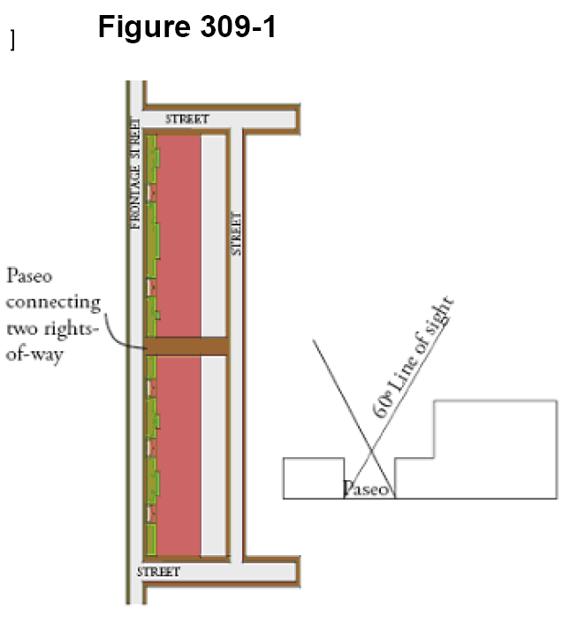
(A)
Paseo defined. A paseo is a covered or uncovered pedestrian passageway substantially at sidewalk grade that is unenclosed at both ends, located in between buildings or as an integrated feature within the façade of a building that provides access from one (1) street to another street, an alley, or an interior block plaza or parking area.
(B)
Paseos encouraged.
(1)
Section 305-30 authorizes height, density and impervious area bonuses for providing a paseo pursuant to this subsection.
(2)
Blocks bordering primary streets within the city center and neighborhood mixed-use districts that exceed seven hundred (700) feet in length should provide a minimum ten-foot-wide pedestrian paseo for continuous pedestrian connectivity.
(3)
The pedestrian paseo should extend the depth of a block to connect two (2) rights-of-way when a block is rectangular and has parallel street boundaries, or in other cases may connect the public sidewalk with rear yard parking facilities. Paseos should be provided approximately mid-block and may be sited along an interior side property line or interior to a lot if the paseo bifurcates the buildings on the lot.
(C)
Designs standards.
(1)
Paseos cannot be enclosed, but may have "open roofing," which may include individual umbrellas or overhead awnings/architectural fabric that let air and light pass into the paseo, while providing partial shade and reasonable shelter from rain.
(2)
Paseos may be gated at either end after business hours.
(3)
Building wall heights framing a paseo shall maintain a minimum sixty-degree clear sight line from the bottom of each wall framing the paseo, as illustrated in Figure 309-1.
(4)
Building façades lining the paseo shall continue the frontage type adjacent to the paseo.
(5)
Paseos shall not be more than thirty (30) feet nor less than ten (10) feet wide.
(6)
No vehicular access, loading or parking is permitted. Emergency access drives will be considered through paseos upon review of integration into paseo design.
(7)
Entries to the paseo business and storefronts shall be designed and lighted so they are safe and visible to paseo guests, avoiding hiding places.
(Ord. No. 2010-20, § 2(Exh. A), 9-14-10)
Sec. 309-30. - Vacation of alleys intersecting South Federal Highway for parcel aggregation.
Vacation of alleys intersecting South Federal Highway is encouraged in order to improve traffic flow and safety conditions, and unify properties under common ownership with U.S. 1 frontage that are separated by alleys. Should the city commission approve an alley vacation, only the portion of the alley separating the U.S. 1 frontage properties should be vacated, and a new alley parallel to U.S. 1 should be dedicated at the back of the frontage properties between which the alley was vacated. See Figure 309-2 for illustration.
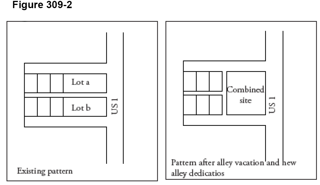
(Ord. No. 2010-20, § 2(Exh. A), 9-14-10)
Sec. 309-40. - Fences, walls and hedges.
Fences are useful for separating uses, defining transitions from the public sidewalk to private property, guiding pedestrians to entrances, and screening unsightly views. Fences shall be subject to the provisions of article 235 except as follows:
(A)
Chain-link fences are prohibited in the front yard. Vinyl coated chain link fences are permitted along rear and interior side property lines.
(B)
Decorative fencing is permitted in all districts and is the only type of fencing permitted in any front yard. Decorative fencing shall not exceed four (4) feet in height, unless otherwise provided. Approved decorative fencing materials are wooden shadowbox, decorative aluminum, steel, iron, PVC, and solid masonry walls with paint over stucco.
(C)
Barb or razor wire fencing shall be prohibited.
(D)
Wood fences shall be constructed of cedar or other heavy timber that will not create a run-down appearance after sustained exposure to the elements. Caps shall be part of the fence design to protect the end grain of the slats.
(E)
Whenever possible, fences should be combined with other elements such as plant material.
(F)
Fences shall generally be considered an extension of the adjacent structure or architectural elements, and the materials and colors should be compatible.
(G)
Walls or fences shall be used to screen pedestrian routes and spaces from service, utility, or sanitation areas, and shall include a three-foot wide landscape strip to soften the appearance. This landscape strip shall include shrubs or groundcover in compliance with the landscaping requirements of the code, and shall be properly maintained.
(Ord. No. 2010-20, § 2(Exh. A), 9-14-10; Ord. No. 2015-009, § 7, 4-28-15; Ord. No. 2016-013, § 6, 7-26-16)
Sec. 309-50. - Setback from alleys.
All buildings and structures shall be set back a minimum of five (5) feet from any alley.
(Ord. No. 2010-20, § 2(Exh. A), 9-14-10)
Sec. 309-60. - Additional development standards.
Part 2 of this code contains additional development standards that may apply to the CRA form-based districts.
(Ord. No. 2010-20, § 2(Exh. A), 9-14-10)
Sec. 309-70. - Subdivision and development of large parcels.
(A)
Any lot or combination of abutting lots under unified control that have a land area exceeding five (5) acres as of the date of adoption of this section shall not be subdivided, and no site plan shall be approved unless the site plan and subdivision conform to this section. This means that boundary plats are not permitted, and that plats and site plans that encompass less than the entire lot or combination of lots under unified control must be accompanied by a conceptual master site plan for the entire land area that demonstrates how the property will be subdivided into streets and blocks in conformance with this section.
(B)
The lot shall be subdivided into developable blocks with perimeter dimensions between one thousand two hundred (1,200) and one thousand eight hundred (1,800) linear feet.
(C)
Every block shall be bound by public or private streets that shall be designated as primary or secondary for purposes of applying district regulations.
(D)
Interior streets shall connect to perpendicular primary streets bordering the site.
(E)
Streets shall be designed with on-street parking on both sides, travel lanes not exceeding eleven (11) feet in width, and sidewalks a minimum of twelve (12) feet in width.
(F)
All such streets shall be comparable in terms of amenities and improvements with one of the street sections approved by the city commission in the CRA redevelopment plan for the NW 1st Avenue in the City Center District core.
(G)
At least one (1) focal public open space shall be provided with a minimum area equivalent to two and one-half (2.5) percent of the total net land area of the development. The city commission may approve multiple, smaller open spaces if it finds that the design of the smaller open spaces are appropriate to the overall design of the development and the urban fabric adjacent to the development site.
(Ord. No. 2010-20, § 2(Exh. A), 9-14-10)
Sec. 310-10. - Residential building types.
(A)
Single-family detached dwelling. A detached dwelling unit located upon its own lot, having usable front, side and rear yards. This building type has the greatest setback from the street of all residential types, and the greatest overall combined yard area. This type is appropriate in established neighborhoods predominated by single-family detached dwellings and two-family dwellings. A porch frontage or balcony over porch frontage is optional.
(B)
Two-family (duplex) dwelling. A dwelling containing two (2) dwelling units that may be attached vertically or horizontally. A porch frontage or balcony over porch frontage is optional. See section 525-40 for design standards applicable to two-family dwellings.
(C)
Mansion apartment house. Three (3) or more apartments within a dwelling designed to appear like a large single-family detached dwelling with usable front, side and rear yards. The apartment units may be arranged vertically, horizontally, or both. Parking is permitted in the rear yard and one side yard. Side yards must be fenced. See section 525-40 for design standards applicable to mansion apartment houses.
(D)
Rowhouse dwelling. A dwelling containing three (3) or more dwelling units built close to the street line, and attached side-to-side with each unit spanning the front yard to rear yard. All units must front a public street. Ground-floor units must access the street frontage through a porch, dooryard or stoop frontage. When designed with party walls and one (1) unit from ground to roof, townhouse units may be owned in fee simple with the land upon which situated. Stacked townhouses or stacked flats take on the same form as townhouse buildings, except that upper-floor units are accessed from internal foyers connecting to stairwells. Maximum height is five (5) stories. Parking is in the rear. Side yards must be fenced or garden/street wall used unless the yard is used for driveway access to the rear yard.
(E)
Apartment building. A dwelling located at, or close to, the street line, containing four (4) or more apartment units. This type is also used for hotels without commercial uses. Numerous configurations are possible, using double loaded corridors or lobbies on each floor, off of which units are accessed, or courtyard frontages where units are accessed directly from the courtyard. Apartment buildings must have a minimum two (2) stories and can take the form of high-rise towers. Dooryard, stoop, or balcony over porch frontages must be used. Apartment buildings under five (5) stories in height must provide individual access to each ground-floor unit fronting the street. Apartment buildings five (5) stories and higher may provide a central lobby entrance instead, using a permitted frontage type. The upper stories of an apartment building may be the same as those for a commercial/mixed-use building. Parking shall be in the rear, and may include structured parking. Interior side yards must be fenced or street wall used pursuant to section 307-30 unless the yard is used for driveway access to the rear yard.
(Ord. No. 2010-20, § 2(Exh. A), 9-14-10; Ord. No. 2014-012, § 6, 9-23-14; Ord. No. 2025-010, § 6, 5-27-25)
Sec. 310-20. - Nonresidential and mixed-use building types.
(A)
Commercial/mixed-use building. A building located at or close to the street line, with ground floor devoted to commercial use, and upper floors devoted to commercial, lodging, or residential use, provided that commercial use floors shall not be located above residential use floors. Interior side yards must be fenced or a garden/street wall used unless the yard is used for driveway access to the rear yard. The shopfront or modified shopfront are the permitted frontage types, provided that modified shopfronts are not permitted within the City Center core.
(B)
Live/work building. A building containing the primary places of work for occupants of attached dwelling units. Live/work buildings are located at or close to the street line, characterized by ground floor work units each connected to a dwelling unit located behind the work unit on the ground floor, above the work unit on an upper floor, or both. Work spaces may extend to upper floors. Additional work units and residential units may be located on upper floors, provided that work units and dwelling units are each stacked, such that no residential unit shares a floor or ceiling with a work space other than the one to which it is connected. Permitted frontage types are shopfront and modified shopfront. Interior side yard requires a garden/street wall unless the yard is used for driveway access to the rear yard.
(C)
Civic building. A building containing public governmental or civic uses such as governmental centers, schools, museums, convention centers, performing arts centers, or places of worship. Civic buildings represent physical symbols of the city's social, cultural, educational, and governmental activities. The physical composition of civic buildings should result in distinction from common buildings used for dwelling and business. The building should be situated prominently on its site, many times set back from the street with public open space. Therefore, new civic buildings and alterations to existing civic buildings require city commission approval of the building design, orientation and placement upon the lot. Accordingly, the city commission may waive the following requirements of the CRA form-based zoning regulations to the extent that the proposed site plan furthers the intent of this subsection:
(1)
District site development standards;
(2)
Architectural design standards;
(3)
Frontage type standards.
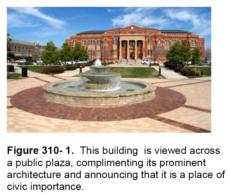
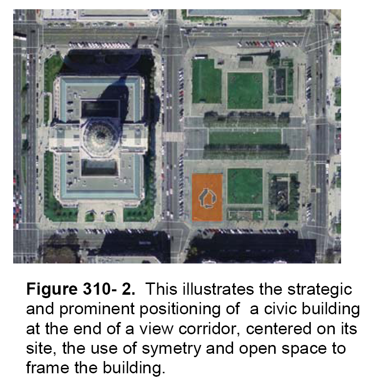
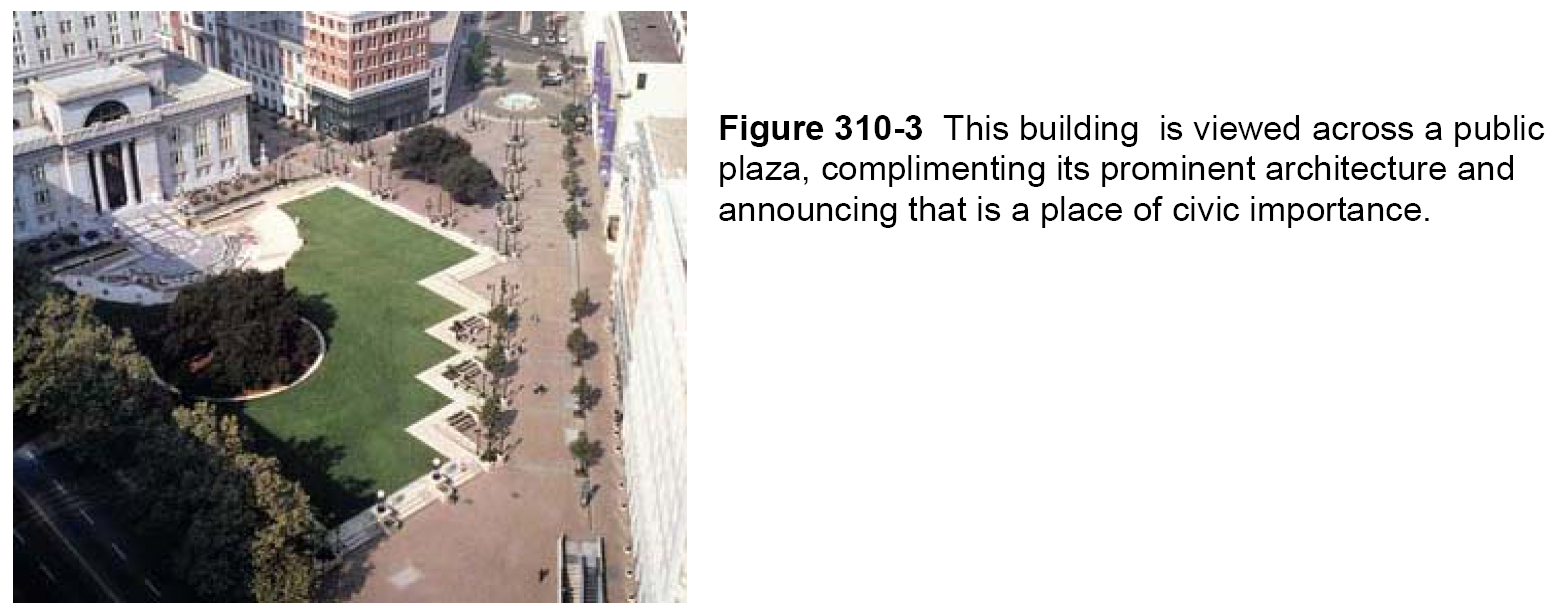
(Ord. No. 2010-20, § 2(Exh. A), 9-14-10)
Sec. 311-10. - Generally.
(A)
The front of every building must face a street. The rear of a building, loading zones, overhead doors and service entries are prohibited on street-facing façades.
(B)
Buildings shall provide a permitted frontage type along the street frontage. All principal buildings shall have a principal entrance opening to a public sidewalk along a street, public plaza, or private courtyard that opens to the street, consistent with a permitted frontage type. The principal entrance shall not open onto a parking lot. Furthermore, all buildings must provide entrances to individual ground-story shopfronts or dwelling units along the public sidewalk, plaza or courtyard unless otherwise provided in the building type regulations.
(C)
Corner lots that have frontage on two (2) streets are required to have entrances only on the principal street frontage. Streets designated as primary streets in the district regulations shall always be the principal street frontage. Corner lots at the intersection of two (2) primary streets shall either treat both streets as primary frontages or shall treat the street with the longest frontage along the block face as the primary frontage.
(D)
Building façades shall be built parallel to the street line, or parallel to the tangent of a curved principal frontage line. This provision is not intended to limit or preclude alcoves or variations in the plane of the street-front façade, nor the provision of plazas.
(E)
Secondary corner streets within all districts other than the neighborhood residential district shall be treated as follows:
(1)
The building shall be built to the BTL of both streets within thirty (30) feet of the corner unless the corner is a dedicated public plaza.
(2)
Fenestration and architectural detailing shall be provided to the greatest extent possible along the secondary street pursuant to the applicable frontage type and design standards. Any portion of the secondary street frontage not built to the BTL shall provide a minimum five-foot-wide planting strip placed at the back edge of the sidewalk, and a street wall shall be built at the back edge of the planting strip pursuant to the design standards of this article.
(F)
All stories above the ground story shall provide between thirty (30) and sixty (60) percent fenestration.
(Ord. No. 2010-20, § 2(Exh. A), 9-14-10)
Sec. 311-20. - Frontage type definitions and standards.
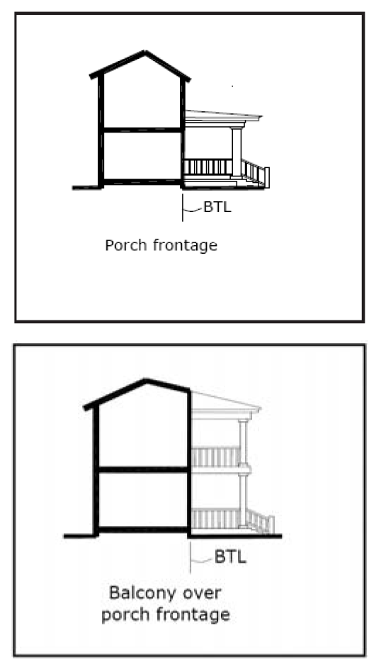
(A)
Porch frontage. A covered entry and outdoor room used in conjunction with front yards, that may extend forward of the building façade as a yard encroachment. A low fence may be used at the edge of the sidewalk in combination with a porch when the porch is set back from the sidewalk. Alternatively, a retaining wall may be used to raise the front lawn with steps leading through the retaining wall connecting the sidewalk with porch, provided that adequate on-site stormwater retention is provided.
(B)
Balcony over porch frontage. A frontage where the second-floor balcony or terrace extends completely above the first-floor porch and forms its roof. This pattern may be repeated up to and including a fourth floor.
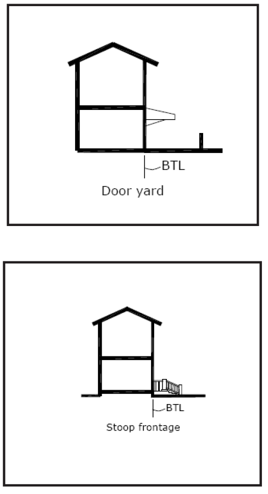
(C)
Dooryard frontage. A shallow yard open to the sky, separates the sidewalk and building façade. The yard may be at grade and separated from the sidewalk by a low decorative translucent fence of four (4) feet maximum height, or a terrace elevated above the sidewalk that may also utilize a low decorative translucent fence. Residential dooryards can be open for the use of the dwelling occupants, but should be landscaped for greatest privacy. A terrace is suitable for an outdoor café as the eyes of diners are at the same level as passersby on the sidewalk.
(D)
Stoop frontage. An exterior stair and landing at a building entrance that extends forward of the BTL as an encroachment, located close to the street line and elevated above the sidewalk, securing privacy for the windows and front rooms, and demarcating a vertical transition from public to private realms. This type is suitable for ground-floor residential use, and may be interspersed with the shopfront frontage type. The street setback for a stoop frontage shall be the depth of the stoop, in which case the stoop shall not encroach further than six (6) feet forward of the BTL. Upper-story balconies may extend up to four (4) feet forward of the BTL. A variety of stoop designs are possible.
(1)
Stoops must correspond directly to the building entry(ies);
(2)
Stoops may be covered by an awning or shed-type roof extending up to five (5) feet forward of the building façade for the width of the stoop.
(E)
Shop frontage and modified shop frontage. A frontage in which a highly fenestrated façade is placed at or near the street line and the entrance is at sidewalk grade.
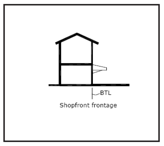
(1)
The shopfront type is conventional for retail use, and requires a minimum of seventy (70) percent translucent glazing on the ground floor. The modified shop frontage requires between thirty (30) and seventy (70) percent translucent glazing on the ground floor. The modified shopfront is ideal for groundstory office use and live/work units. Modified shopfronts are not permitted within the core of the City Center District, and shall not be utilized for buildings intended to house retail uses.
(2)
Shopfront store entrances should be recessed, not flush, with the edge of the building façade, to provide shelter for persons entering and exiting, to articulate the façade, and to provide maximum window display area at the entrance (the recess allows the angling the shop windows at a forty-five-degree angle from the façade to the entry). Modified shopfront entries should not be recessed.
(3)
Street frontage façades shall have entryways at reasonable intervals, typically no more than fifty (50) feet apart. Ground level façades that face the street shall be designed with entrances, windows, display windows, or other display devices.
(4)
Shopfronts and modified shopfronts must be combined with one (1) of the following elements:
(a)
Gallery roofs (attached cantilevered shed or lightweight colonnade) are required to overlap the sidewalk to within three (3) feet of the curb face. The gallery roof may form a balcony for an upper floor. This pattern may be repeated for up to four (4) stories.
(b)
Awnings, which may be constructed of flexible or rigid materials, shall project from the building façade a minimum of seven (7) feet forward of the façade, and may extend over the sidewalk to within one (1) foot of the street tree planting trench or grates. Awnings shall extend along a minimum of eighty (80) percent of the building frontage, excluding recesses from the BTL for forecourts and courtyard frontages. Balconies on upper stories shall not project forward of the BTL with shopfront/awning frontage.
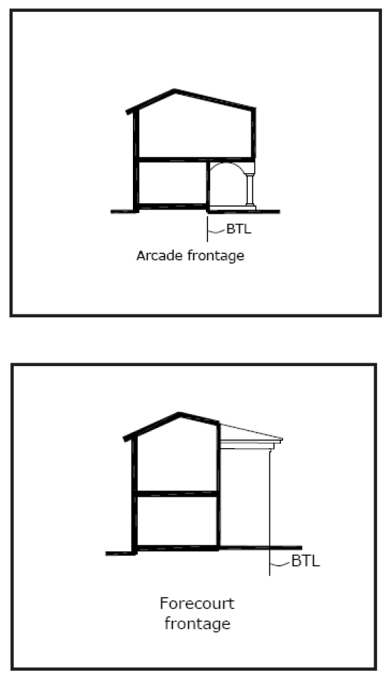
(c)
Arcades are colonnades supporting habitable space above, that extend a minimum ten (10) feet forward of the ground story façade at all points, and overlap the sidewalk. The arcade may extend to within three (3) feet of the curb face (provided there is no conflict with street trees and street light poles), or may be set back further provided there is a minimum ten (10) feet between the curb face and colonnades. The ground floor façade shall be located at the BTL, or behind the BTL if permitted by the applicable district regulations. Upper stories of the building may be built over the arcade.
(F)
Forecourt frontage. This frontage type is permitted as a supplemental frontage for commercial/mixed-use and live-work buildings. This frontage type features a façade that is built to the BTL but with the central portion being recessed and uncovered. This type must be used in conjunction with other frontage types. A forecourt may be used sparingly in conjunction with a shopfront, gallery or arcade frontage, and is suitable for gardens, outdoor dining, or in some cases, vehicular dropoff. A fence or wall at the BTL, not exceeding four (4) feet in height with a pedestrian opening, may be provided to define the space of the court. A variety of forecourt designs are possible with the following standards:
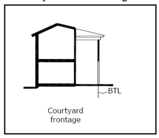
(G)
Courtyard frontage. This frontage type is permitted as a supplemental frontage for commercial/mixed-use, live-work and apartment buildings. Courtyard buildings are actually building types as much as they are frontage types, but are treated as frontage types because they can be combined with multiple building types. Courtyards are frontage and building type combination in which the building substantially occupies the boundaries of its lot, and the building frontage opens up into an internal yard provided in the form of a courtyard.
(1)
The courtyard entrance may be fully open to the street or may be accessed through a wide opening in the façade over which upper stories extend. The courtyard may be defined by a single building or multiple buildings on the lot that are arranged so as to enclose the courtyard on three (3) or four (4) sides, or may enclose the courtyard at least two (2) sides, forming a linear courtyard that extends between parallel block faces or between a street to a parking facility, much like a wider and more functional version of a paseo. A linear courtyard frontage is useful in linking two parallel streets, such as Federal Highway and East or West 1st Avenues, and may be used in lieu of a paseo. Most typically, courtyards are enclosed on three (3) sides by a single building that is roughly "U" shaped.
(2)
In a commercial block, this type should be used sparingly in conjunction with other frontage types, with the sum total of actual courtyard openings along a block limited to twenty (20) percent of the block face. A courtyard is suitable for gardens, outdoor dining, or in some cases, a vehicular drive. A fence or wall at the street line not exceeding four (4) feet in height with a pedestrian opening may be provided to define the space of the court.
(3)
The courtyard width must be at least fifteen (15) feet and not more than fifty (50) feet, and the courtyard opening to the street must not comprise more than fifty (50) percent of the building width at the BTL (or in the case of a linear courtyard, the combined width of buildings on each side of the courtyard).
(4)
Courtyards must be designed with a balance between paving and landscaping, such that the paved area should comprise no more than fifty (50) percent of the courtyard.
(5)
All ground-floor dwelling units or nonresidential suites fronting the courtyard shall have primary access from the courtyard. Upper-level units may also have access from the courtyard via exterior stairways. Use of double loaded corridors is discouraged, in favor of having all units/suites fronting either the street, courtyard or both with external direct access to each unit or suite.
(6)
The courtyard frontage in combination with an apartment building requires a minimum setback of ten (10) feet from any interior lot line wherever windows will face such property lines. A minimum five-foot-wide landscape buffer shall be provided along such lot lines to create privacy.
(7)
The street BTL for courtyard frontages shall be the same BTL required for shopfront, porch or stoop frontages used in combination with the courtyard.
(8)
Nonresidential courtyards shall be accessible to the public for at least the time of normal business hours.
(9)
Required street frontages shall be continued throughout the courtyard, with entries to the courtyard, business and storefronts within the courtyard designed and lighted so they are safe and visible to courtyard guest, avoiding hiding places.
(10)
Courtyards should provide at least one (1) sitting place for each one hundred (100) square feet of courtyard in addition to any permitted outdoor dining provided.
(11)
Courtyards should have adequate mix of sun vs. shaded area; no more than fifty (50) percent of the courtyard should be covered with a roof.
(12)
No vehicular access, loading, or parking is permitted.
(13)
At least ten (10) percent of the courtyard surface shall be landscaped. Shade trees and gardens are encouraged.
(Ord. No. 2010-20, § 2(Exh. A), 9-14-10; Ord. No. 2025-010, § 7, 5-27-25)
Sec. 312-10. - Generally.
The following areas shall qualify as open space to satisfy minimum open space requirements and qualify for open space incentives: landscaped areas; plazas; courtyards; pocket parks; and paseos. All such areas must comply with the standards of this article and the urban design standards of article 525 in order to satisfy open space requirements and qualify for incentive bonuses pertaining to provision of open space.
(Ord. No. 2010-20, § 2(Exh. A), 9-14-10)
Sec. 312-20. - Plazas.
(A)
Definition. Plazas are pedestrian-friendly open spaces that extend the public realm from the street or sidewalk to the main entry of an adjacent building. Plazas are designed to facilitate public gatherings and congregations. Plazas are usually provided in front of a multistory building, which incorporate urban design elements such as special pavers, public art, architectural elements and water features.
(B)
Size. Plazas shall be a minimum of two thousand, five hundred (2,500) square feet in area.
(C)
Location. Plazas and civic open spaces shall generally be located along major thoroughfares and intersections and shall not interfere with vehicular traffic, pedestrian flow or building activities. Plazas are encouraged in the CC, EDBB-MU, NBHD-MU, and SFED-MU districts to facilitate public gatherings and public congregation.
(D)
Access. Plazas should abut public areas and be physically and visually accessible from the public sidewalks. Security fences, walls, and entry gates should not block the sidewalk edge of the plaza or views into the plaza. The plaza shall be accessible to the public for at least the time of normal business hours. Vehicular access, loading, or parking within the plaza is prohibited. Emergency access drives will be considered through plaza upon review of integration into plaza design.
(E)
CPTED design. Adjacent development should be designed with crime prevention through environmental design (CPTED) principles, including natural surveillance considerations, furthered through building orientation and access to the park, and fenestration, in order to encourage use and ensure security. There should be no potential hiding places. Special features, and medium size vegetation shall be implemented with this in mind. Adequate security lighting shall be provided to aid in natural surveillance and crime deterrence.
(F)
Building walls. Ground-level façades facing a plaza shall avoid blank walls that are devoid of generous glazing and entrances.
(G)
Rooftop plazas. Rooftops can be used for open space, including sun decks, pool decks, tennis courts, gardens, and outdoor cafes/restaurants. Rooftop open space does not qualify [as] open space credit, although it may qualify for credit as a green building practice.
(H)
Water features. A water feature or public art is required for the open space incentive bonus. The use of water, in a variety of forms adds aesthetic value to the area and a sense of respite. Water features help to mask inhospitable noise, direct attention, cool the microclimate of a space and create a positive image of the area. They can be freestanding features or attached to a building wall. The visual aesthetic shall be carefully considered when designing water features. A variety of water feature effects are encouraged, such as the use of bubblers, sprays, falls, and mists. Lighting should accompany water features to add visual interest during nighttime hours and additional security. All water features must conform to local codes and regulations, and shall not have exposed mechanical or electrical equipment.
(I)
Public art. Public art, as defined in section 725-30, is encouraged adjacent to public sidewalks and in open spaces to create identity and to celebrate the local art community in Dania Beach. The inclusion of public art or water feature is required for the open space incentive bonus. Any public art shall be free of sharp edges or obstructive elements that might cause physical harm. Public art shall be permitted within public pedestrian corridors or sidewalks upon the approval of the public services director and approval of necessary encroachment license and maintenance agreement in a form acceptable to the city attorney.
(J)
Special paving. Special paving is an important element within an urban setting. It defines space along the ground plane and contributes to a place's unique sense of identity. Special paving shall be incorporated into plazas and other open spaces. Paving materials shall reflect the intensity of expected pedestrian traffic, aid in circulation routes and create identifiable ground plane associations. There are a variety of materials, colors and shapes available for special paving. Careful consideration should be made in the selection of the materials, colors and shapes for special paved areas, especially in area dedicated for public use.
(K)
Shading. Plazas should have adequate mix of sun vs. shaded area. No more than forty (40) percent of the plaza shall be covered with a roof. At least ten (10) percent of the plaza's surface shall be landscaped to provide heat relief.
(L)
Seating. Plazas shall provide at least one (1) sitting place for each two hundred (200) square feet of plaza in addition to any permitted outdoor dining provided.
(Ord. No. 2010-20, § 2(Exh. A), 9-14-10)
Sec. 312-30. - Pocket parks.
(A)
Definition. A small, mostly passive, urban park that offers shaded seating and can include water features, art or a small playground, and can offer relief from the urban hardscape. Pocket parks may be utilized as an urban agricultural garden pursuant to sections 302-10 and 312-50. They can also serve as tot-lots for adjacent residences.
(B)
Size. Pocket parks range in size from at least two thousand five hundred (2,500) square feet to approximately one-quarter (¼) acre.
(C)
Location. Pocket parks should abut streets and be physically and visually accessible from the public sidewalks.
(D)
CPTED design. Adjacent development should be designed with crime prevention through environmental design (CPTED) principles, including natural surveillance considerations, furthered through building orientation and access to the park, and fenestration, in order to encourage pocket park use and ensure security. There should be no potential hiding places. Special features and medium-size vegetation shall be implemented with this in mind. Adequate security lighting shall also be provided to aid in natural surveillance and crime deterrence.
(E)
Access. The pocket parks shall be accessible to the public for at least the time of normal business hours. A pocket park shall be exclusive of any vehicular access, loading and parking areas.
(F)
Seating. Pocket parks shall provide at least one (1) sitting place (i.e. seat for one (1) person) for each two hundred (200) square feet.
(G)
Shade. An even mix of sun and shade coverage is encouraged.
(H)
[Playground equipment.] Plastic playground equipment is discouraged.
(I)
Amenities. The park shall provide a water feature, public art, or playground equipment for incentive credit.
(Ord. No. 2010-20, § 2(Exh. A), 9-14-10)
Sec. 312-40. - Courtyards.
See courtyard frontage type under building frontage type standards.
(Ord. No. 2010-20, § 2(Exh. A), 9-14-10)
Sec. 312-50. - Urban agricultural garden.
Urban agricultural gardens are plots of land gardened by a group of people. Such gardens include small gardens where people grow vegetables, as well as tiny street beautification planters on urban street corners. For all their diversity, however, most community gardens share at least four (4) elements in common: land (or a place to grow something); plantings; gardeners; and some sort of organizing arrangements. Land for a community garden can be publicly or privately held. One (1) strong tradition in community gardening in urban areas is cleaning up abandoned vacant lots and turning them into productive gardens. Alternatively, community gardens can be seen as a health or recreational amenity and included in public parks, similar to ball fields or playgrounds.
(Ord. No. 2010-20, § 2(Exh. A), 9-14-10)