
Dearborn Heights City Zoning Code
ARTICLE VIII
SPECIAL DEVELOPMENT PROVISIONS
Sec. 36-301. - Sidewalks.
(a)
General requirements.
(1)
Sidewalks required. To provide for a continuous network of sidewalks and pedestrian paths; ensure safe and convenient pedestrian and non-motorized travel; and improve barrier-free access to sites in the city, it shall be the policy of the city to require installation, extension, or modification of public sidewalks and sidewalk connectors to primary building entrances to serve uses and developments subject to site plan approval, condominium site plan approval, or planned unit development approval.
(2)
Signage. The planning commission may require installation of signage for the purposes of safety where it is necessary to separate vehicular traffic from pedestrian and bicycle traffic, or where it is necessary to alert vehicular traffic of the presence of the sidewalks.
(3)
Maintenance. The owner of the property which fronts on the sidewalk shall be responsible for maintenance of the sidewalk, including patching cracked or deteriorated pavement, snow removal, and removal of glass and other debris. The property owner shall be liable for damages in the event that a person is injured while using a sidewalk that said property owner has not properly maintained.
(4)
Permits. It shall be the responsibility of the owner or developer to secure any required permits from the city to allow sidewalk construction in the road right-of-way.
(b)
Standards. Installation, extension, or modification of public sidewalks and sidewalk connectors shall be subject to the following:
(1)
Location and width. Required sidewalks shall be five (5) feet in width and shall be located one (1) foot off the property line in the road right-of-way.
a.
Where the planned right-of-way is greater in width than the existing right-of-way, the sidewalk shall be located one (1) foot inside the planned right-of-way.
b.
The planning commission may modify this requirement in consideration of the location of utilities, existing landscaping, or other site improvements.
(2)
Design standards. Sidewalks shall be constructed of concrete in accordance with established engineering standards for the city and shall be subject to city engineer inspection and approval.
(3)
Alignment with adjacent sidewalks. Sidewalks shall be aligned horizontally and vertically with existing sidewalks on adjacent properties. The planning commission may modify this requirement if existing adjacent sidewalks are not constructed in conformance with the standards set forth herein.
(Ord. No. H-07-01, § 8.101, 7-24-07)
Sec. 36-302. - Streets, roads, and other means of access.
(a)
Intent. Unimpeded, safe access to parcels of land throughout the city is necessary to provide adequate police and fire protection, ambulance services, and other public services, and to otherwise promote and protect the health, safety, and welfare of the public. Accordingly, minimum standards and specifications are required for private roads to assure safe and quick access to private property, and to permit the eventual upgrading and dedication of such access rights-of-way to the Roads Division of the Wayne County Department of Public Services or other appropriate municipal corporation if public dedication is deemed necessary or desirable. The standards and specifications set forth herein are determined to be the minimum standards and specifications necessary to meet the above stated intentions.
(b)
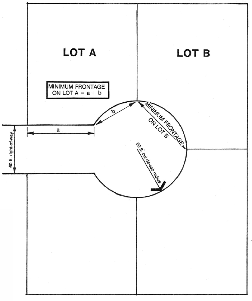
Public access required. The front lot line of all lots shall abut onto a publicly dedicated road right-of-way or onto an approved private road or drive which complies with the requirements set forth herein. The required frontage on an approved road right-of-way or easement shall be equal to or greater than the minimum lot width for the district in which the lot is located, as specified in article V; except that the minimum frontage of lots that abut the turnaround at the end of a cul-de-sac shall be equal to or greater than fifty (50) percent of the minimum lot width. On lots located on a curve, frontage shall be measured along a straight line between the two (2) points where the side lot lines intersect the curved right-of-way line (see drawing). Frontage on a "T" turnaround shall not be counted toward the minimum road frontage requirements. No person shall construct, alter, or extend a private road unless in compliance with these requirements.
(c)
General requirements. Roads and driveways shall comply with the pavement width and curb and gutter requirements set forth in this section. Roads and driveways shall comply with all applicable city engineering standards and ordinances, as well as the current requirements of Wayne County.
(1)
Pavement required. All roads and driveways shall be paved.
(2)
Curb and gutter required. All roads shall be installed with six-inch high concrete curb and gutter, except for driveways to individual units and circulation routes through parking lots.
(d)
Standards by road or driveway type.
1 A residential collector street collects and distributes traffic between lower-order residential streets and higher-order streets or major activity centers. A residential collector street typically carries between one thousand (1,000) and three thousand (3,000) vehicles per day.
2 The entrance road extends from the edge of the public road to the edge of any parking lot, intersection, tee, or similar terminus within the development.
(e)
Access across residential district land. No land which is located in a residential district shall be used for a driveway, walkway, or access purposes to any land which is located in a nonresidential district, unless such access is by way of a public road.
(f)
Private roads or streets. Lots or building sites may be created with frontage on private roads (in subdivision or condominium projects) or streets provided that such lots or building sites conform to all requirements of the district in which the land is located.
(g)
Service roads. If the planning commission determines that proposed or anticipated development will result in an excessive number of entrance or exit drives onto a public road, thereby creating potentially hazardous traffic conditions and diminishing the carrying capacity of the road, the commission may permit or require construction of service roads across abutting parcels and generally parallel to the arterial street to allow traffic to circulate from one parcel to another without re-entering the public road. The front edge of any such secondary access drive shall be located no closer to the road than the future right-of-way line. Such secondary access drive shall conform to the minimum specifications for roads as set forth in this article.
(h)
Performance guarantee. To assure completion of a service road in conformance with the requirements set forth herein, the building official may require the applicant or owner to provide a performance guarantee, in accordance with section 36-341.
(Ord. No. H-07-01, § 8.102, 7-24-07)
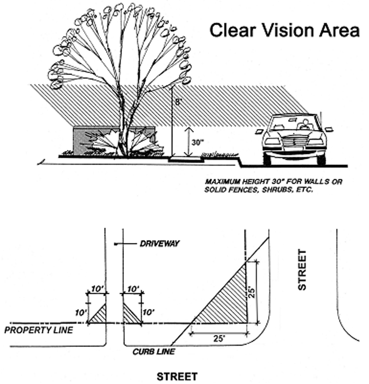
Sec. 36-303. - Clear vision areas.
(a)
No fence, wall, structure, or planting shall be erected, established, or maintained on any lot which will obstruct the view of drivers in vehicles approaching an intersection of two (2) roads or the intersection of a road and a driveway. Fences, walls, structures, or plantings located in the triangular area described below shall not be permitted to obstruct cross-visibility between a height of thirty (30) inches and eight (8) feet above the lowest point of the intersecting road(s).
(1)
Trees shall be permitted in the triangular area provided that limbs and foliage are trimmed so that they do not extend into the cross-visibility area or otherwise create a traffic hazard.
(2)
Landscaping, except required grass or ground cover, shall not be located closer than three feet from the edge of any driveway or road pavement within the triangular area.
(b)
The unobstructed triangular clear vision area is described as follows (see illustration below):
(1)
The area formed at the corner intersection of two (2) public right-of-way lines, the two (2) sides of the triangular area being twenty-five (25) feet in length measured along abutting public rights-of-way lines, and third side being a line connecting these two (2) sides, or
(2)
The area formed at the corner intersection of a public right-of-way and a driveway, the two (2) sides of the triangular area being ten (10) feet in length measured along the right-of-way line and edge of the driveway, and the third side being a line connecting these two (2) sides.
(Ord. No. H-07-01, § 8.103, 7-24-07)
Sec. 36-311. - Water supply and sewers.
Connection required to public utilities. All principal buildings shall be connected to publicly owned and operated water and sanitary sewer service systems at the time of construction or expansion.
(Ord. No. H-07-01, § 8.201, 7-24-07)
Sec. 36-316. - Wetlands and bodies of water.
Setback from regulated wetlands and watercourses. An undisturbed open space setback of not less than fifty (50) feet shall be maintained from the edge of any stream, pond, lake, or other body of water. An undisturbed open space setback of not less than twenty-five (25) feet shall be maintained from the edge of any wetland or open drain. Such setbacks shall be measured from the top of the bank or other defined edge, and shall not be subject to topography.
(1)
Trails, boardwalks, observation platforms, or similar passive recreational improvements may be provided within the required setback, subject to approval from the Michigan Department of Environmental Quality (MDEQ).
(2)
Detention basins and similar storm water management facilities may be constructed within the required setback, provided that appropriate replacement plantings are provided and maintained, subject to the approval from the Michigan Department of Environmental Quality (MDEQ).
(Ord. No. H-07-01, § 8.301, 7-24-07)
Sec. 36-317. - Flood hazard area overlay zone.
(a)
Purpose. It is the purpose of this section to significantly reduce hazards to persons and damage to property as a result of flood conditions in the city, and to comply with the provisions and requirements of the National Flood Insurance Program, as constituted in accordance with the National Flood Insurance Act of 1968, as amended, and subsequent enactments, and the rules and regulations promulgated in furtherance of this program by the Federal Emergency Management Agency, as published in the Federal Register, Vol. 41, No. 207, Tuesday, October 26, 1976, and re-designated as 44 CFR 31177, May 31, 1979.
(b)
Objectives. The objectives of this section include:
(1)
The protection of human life, health, and property from the dangerous and damaging effects of flood conditions;
(2)
The minimization of public expenditures for flood control projects, rescue and relief efforts in the aftermath of flooding, repair of flood damaged public facilities and utilities, and the redevelopment of flood damaged homes, neighborhoods and commercial and industrial areas;
(3)
The prevention of private and public economic loss and social disruption as a result of flood conditions;
(4)
The maintenance of stable development patterns not subject to the blighting influence of flood damage;
(5)
To ensure that the public has access to information indicating the location of land areas subject to periodic flooding; and
(6)
To preserve the ability of floodplains to carry and discharge a base flood.
(c)
Delineation of flood hazard area overlay zone. The flood hazard area overlay zone shall overlay existing zoning districts delineated on the official zoning map of the city. The boundaries of the flood hazard area overlay zone shall coincide with the boundaries of the areas indicated as within the limits of the 100-year flood area as currently defined by the Federal Emergency Management Agency (FEMA).
(1)
Compliance required. In addition to other requirements of this section applicable to development in the underlying zoning districts, compliance with the requirements of this section shall be necessary for all development occurring within the flood hazard area overlay zone.
(2)
Disputes. Where there are disputes as to the location of a flood hazard area overlay zone boundary, the zoning board of appeals shall resolve the dispute in accordance with the provisions of this chapter.
(3)
Conflicts with other ordinances. Conflicts between the requirements of this section, other requirements of this chapter, or any other ordinance shall be resolved in favor of this section, except where the conflicting requirement is more stringent and would further the objectives of this section to a greater extent than the requirements of this section. In such cases, the more stringent requirement shall be applied.
(d)
Use and principal structure regulations. Within the flood hazard area overlay zone, no land shall be used except for one (1) or more of the following uses:
(1)
Parks, picnic areas, playgrounds, playfields, athletic fields, golf courses, other outdoor recreational uses, nature paths, and trails.
(2)
Wildlife preserves.
(3)
Fishing in compliance with current laws and regulations.
(4)
Historic sites and structures.
(5)
Landscaping, screening, and required open space or lot area for structural uses that are landward of the overlay zone.
(e)
Accessory buildings, structures, and uses.
(1)
Consistency. Any accessory use in a flood hazard area overlay zone shall be used in a manner consistent with the requirements of accessory buildings, structures, and uses in the underlying district, in addition to the requirements below.
(2)
Permitted uses. Within the flood hazard area overlay zone, no building, structure, or use shall be permitted except for one (1) or more of the following, in accordance with provisions of this section:
a.
Off-street parking, streets, roads, and bridges.
b.
Outdoor play equipment.
c.
Sheds and garages.
d.
Boathouses, boat hoists, utility lines, and pump houses.
e.
Bleachers.
f.
Riverbank protection structures.
g.
Signs.
h.
Fences.
i.
Gazebos.
j.
Similar outdoor equipment and appurtenances.
(3)
Supplemental requirements. In all cases, the following requirements shall be met:
a.
The building or structure shall not cause an increase in water surface elevation, obstruct flow, or reduce the impoundment capacity of the floodplain.
b.
All equipment, buildings, and structures shall be anchored so as to prevent flotation and lateral movement.
c.
Compliance with these requirements shall be certified by a registered engineer.
(f)
Filling and dumping. Dredging and filling and/or dumping or backfilling with any material in any manner is prohibited, unless, through compensating excavation and shaping of the floodplain, the flow and impoundment capacity of the floodplain will be maintained or improved, and unless all applicable federal, state, and city regulations are met, including, but not limited to, approvals pursuant to Act 245 of the Public Acts of 1929, as amended by Act 167 of the Public Acts of 1968; Act 347 of the Public Acts of 1972, as amended; Act 346 of the Public Acts of 1972, as amended; and Act 203 of the Public Acts of 1979, as amended.
(g)
General standards for flood hazard reduction.
(1)
Permit required. No building or structure shall be erected, converted, or substantially improved or placed, and no land filled or building or structure used in a flood hazard area overlay zone unless a building permit, or a variance from the zoning board of appeals, is obtained, which approval shall not be granted until a permit from the Michigan Department of Environmental Quality under authority of Act 245 of the Public Acts of 1929, as amended by Act 167 of the Public Acts of 1968, has been obtained.
(2)
Public utility location. All public utilities and facilities shall be designed, constructed, and located to minimize or eliminate flood damage.
(3)
Site plan review. Site plans shall be reviewed in accordance with article XIV, division 2, Site plan review, to determine compliance with the standards of this chapter.
(4)
Land division. Land shall not be divided in a manner creating parcels or lots which cannot be used in conformance with the requirements of this chapter.
(5)
Alteration or relocation of watercourses. The flood-carrying capacity of any altered or relocated watercourse not subject to state or federal regulations designed to ensure flood-carrying capacity shall be maintained.
(6)
Data sources. Available flood hazard data from federal, state, or other sources shall be reasonably utilized in meeting the standards of this section. Data furnished by the Federal Insurance Administration shall take precedence over data from other sources.
(h)
Disclaimer of liability.
(1)
The degree of flood protection required by this section is considered reasonable for regulatory purposes and is based upon engineering and scientific methods of study. Approval of the use of land under this section shall not be considered a guarantee or warranty of safety from flood damage.
(2)
This section does not imply that areas outside the flood hazard area overlay zone will be free from flood damage. This section does not create liability on the part of the city or any officer or employee thereof for any flood damage that results from reliance on this section or any administrative decision lawfully made hereunder.
(i)
Floodplain management administrative duties.
(1)
Responsibilities. With regard to the National Flood Insurance Program, and the regulation of development within the flood hazard area overlay zone as prescribed in this section, the duties of the building official and/or the community and economic development director shall include, but are not limited to:
a.
Notice of proposed alteration or relocation of watercourses. Notification to adjacent communities and the Michigan Department of Environmental Quality of the proposed alteration or relocation of any watercourse, and the submission of such notifications to the Federal Insurance Administration.
b.
Record of variances. Recording of written notification to all applicants to whom variances are granted in a flood hazard area overlay zone indicating the terms of the variance, the potential increased danger to life and property, and that the cost of flood insurance will increase commensurate with the increased flood risk. A record of all variance notifications and variance actions shall be maintained, together with the justification for each variance.
(2)
Records and maps. All records and maps pertaining to the National Flood Insurance Program shall be maintained in the office of the building official and/or the community and economic development director and shall be open for public inspection.
(3)
Best available data. It shall be the responsibility of the building official and/or the community and economic development director to obtain and utilize the best available flood hazard data for purposes of administering this section in the absence of data from the Federal Insurance Administration.
(j)
Flood hazard area overlay zone mapping disputes.
(1)
Hearing by zoning board of appeals. Where disputes arise as to the location of the flood hazard area boundary or the limits of the floodway, the zoning board of appeals shall resolve the dispute and establish the boundary location. In all cases, the decision of the zoning board of appeals shall be based upon the most current floodplain studies issued by the Federal Insurance Administration. Where Federal Insurance Administration information is not available, the best available floodplain information should be utilized.
(2)
Grounds for boundary revision. Where a dispute involves an allegation that the boundary is incorrect as mapped and Federal Insurance Administration floodplain studies are being questioned, the zoning board of appeals shall modify the boundary of the flood hazard area or the floodway only upon receipt of an official letter of map amendment issued by the Federal Insurance Administration.
(3)
Evidence permitted. All parties to a map dispute may submit technical evidence to the zoning board of appeals.
(k)
Flood hazard area overlay zone variances.
(1)
Standards. Variances from the provisions of this section shall only be granted by the zoning board of appeals upon a determination of compliance with the general standards for variances contained in this section and each of the following specific standards:
a.
A showing of good and sufficient cause;
b.
A determination that failure to grant the variance would result in exceptional hardship to the applicant; and
c.
A determination that the granting of a variance will not result in a harmful increase in flood heights, additional threats to public safety or extraordinary public expense, or create nuisances, cause fraud on or victimization of the public, or conflict with existing laws or ordinances.
(2)
Minimum for relief. The variance granted shall be the minimum necessary, considering the flood hazard, to afford relief to the applicant.
(3)
Conditions. The zoning board of appeals may attach conditions to the granting of a variance to ensure compliance with the standards contained in this section.
(4)
Historic properties. Variances may be granted for the reconstruction, rehabilitation, or restoration of structures listed on the National Register of Historic Places or the Michigan Register of Historic Sites, or any other state register of historic places without regard to the requirements of this section governing variances in flood hazard areas.
(Ord. No. H-07-01, § 8.302, 7-24-07)
Sec. 36-326. - General requirements.
(a)
Purpose.
(1)
The purpose of this section is to regulate projects that divide real property under a contractual arrangement known as a condominium. New and conversion condominium projects shall conform to the requirements of this chapter, all other applicable city regulations, and the Condominium Act (P.A. 59 of 1978, as amended). Each condominium project shall be reviewed in a manner consistent with equivalent projects within the zoning district.
(2)
Pursuant to the authority conferred by the Condominium Act (P.A. 59 of 1978, as amended), condominium subdivision plans shall be regulated by this chapter as site condominiums, and shall be considered equivalent to a platted subdivision for the purposes of enforcing the city's site development standards. It is the intent of this section to ensure that:
(3)
Review of condominium subdivision (site condominium) plans be accomplished, aside from procedural differences, with the objective and intent of achieving the same results as if the site were to be developed under the Land Division Act (P.A. 288 of 1967, as amended), except that nothing in this article shall be construed to require a site condominium development to obtain plat approval.
(4)
Condominium subdivisions are developed in compliance with all applicable standards of this chapter and the Land Division Act (P.A. 288 of 1967, as amended), except that the review procedures of this article and chapter shall apply.
(b)
Condominium unit requirements. The following regulations shall apply to all condominium units:
(1)
Types of permitted condominium units. The following types of condominium units shall be permitted under this article, subject to conformance with the use and zoning district standards of this chapter:
a.
Site condominiums. A site condominium project is one that is designed to function in a manner similar to, or as an alternative to a platted subdivision, and as such, shall be subject to the following:
1.
Each site condominium lot shall be considered the equivalent of a platted lot of record as defined in the Land Division Act (P.A. 288 of 1967, as amended), and shall comply with the minimum floor space, height of building, lot size, density, and all other requirements set forth in article V (Schedule of Regulations) for the zoning district in which the project shall be located.
2.
Site condominium projects shall comply with the applicable design standards which have been developed for this type of development in the city, as described in article III of chapter 29 Subdivision regulations in the Code of Ordinances for the City of Dearborn Heights, the city's engineering design specifications, and other applicable ordinances and regulations, including requirements for roads, streets, blocks, lots, utilities, and storm drainage. These requirements and specifications are hereby incorporated and are made a part of this chapter by reference.
b.
Detached condominiums. A detached condominium project is one that is designed to function in a manner similar to, or as an alternative to a platted subdivision, and as such, shall be subject to the following:.
1.
Each detached condominium unit shall comply with the minimum floor space, height of building, lot size, density, and all other requirements set forth in article V (Schedule of Regulations) for the zoning district in which the project shall be located, and shall be considered the equivalent of a platted lot of record as defined in the Land Division Act (P.A. 288 of 1967, as amended).
2.
Detached condominium projects shall comply with the applicable design standards which have been developed for this type of development in the city, as described in article III of chapter 29, Subdivision regulations in the Code of Ordinances for the City of Dearborn Heights, the city's engineering design specifications, and other applicable ordinances and regulations, including requirements for roads, streets, blocks, lots, utilities, and storm drainage. These requirements and specifications are hereby incorporated and are made a part of this chapter by reference.
c.
Attached residential or multiple-family residential units.
1.
Condominium buildings and units created by the construction of multiple or attached residential units containing individually owned condominium units, or by conversion of existing multiple-family or attached units or an existing building into residential condominium units shall comply with the minimum floor space, height of building, lot size, density, and all other requirements set forth in article V, (Schedule of Regulations) for the zoning district in which the project shall be located.
2.
In addition, attached residential or multiple-family residential units projects shall comply with the applicable design standards which have been developed for this type of development in the city, as described in article III of chapter 29, Subdivision Regulations in the Code of Ordinances for the City of Dearborn Heights, the city's engineering design specifications, and other applicable ordinances and regulations, including requirements for roads, streets, blocks, lots, utilities, and storm drainage. These requirements and specifications are hereby incorporated and are made a part of this chapter by reference.
d.
Nonresidential condominium units.
1.
A nonresidential condominium project consisting of either new building construction or the conversion of an existing building into individual condominium units shall conform to all requirements of this chapter for the zoning district in which it shall be located.
2.
In addition, nonresidential condominium projects shall comply with the applicable design standards which have been developed for this type of development in the city, and other applicable ordinances and regulations, including requirements for roads, streets, blocks, lots, utilities, and storm drainage. These requirements and specifications are hereby incorporated and are made a part of this chapter by reference.
(Ord. No. H-07-01, § 8.401, 7-24-07)
Sec. 36-327. - Condominium review requirements.
An application for a condominium project shall be submitted and reviewed in accordance with the provisions for site plan review in section 36-494 (Application procedure) and section 36-497 (Plan review procedure and authorization), in addition to the following:
(1)
Conceptual plan review. An applicant may file a written request for conceptual review of a conceptual condominium site plan by the planning commission, prior to submission of a condominium site plan for final review, in accordance with subsection 36-497(b). For condominium subdivision (site condominium) developments, conceptual condominium site plan review shall be considered the equivalent of an initial plat investigation, as specified in the Land Division Act (P.A. 288 of 1967, as amended).
(2)
Condominium site plan review.
a.
Upon determination that the site plans substantially complies with city ordinances and regulations, the site plans for a condominium project shall be placed the next available planning commission agenda. All required revisions must be completed prior to the site plan being placed on the planning commission agenda for review.
b.
The planning commission shall approve, approve with conditions or deny the request for approval of the condominium documents, in accordance with subsection 36-497(e) (Authorization).
c.
If the condominium plans are approved subject to conditions, the applicant shall submit four copies of the revised plans, indicating compliance with the conditions of approval, to the building department. Distribution of the revised condominium plans shall be in accordance with subsection 36-494(b).
Upon subsequent review and verification that all conditions of approval have been met, the planning consultant shall stamp all four copies of the plans "APPROVED," in accordance with subsection 36-497(f) (Recording of site plan action).
d.
For site condominium developments, condominium site plan review shall be considered the equivalent of a tentative preliminary plat review, as specified in the Land Division Act (P.A. 288 of 1967, as amended).
(3)
Condominium document review. The term "condominium documents" shall include the condominium subdivision plan (Exhibit B drawing), master deed and bylaws. Condominium documents shall be subject to the following:
a.
Condominium documents may be submitted for review with the final site plan application or the condominium documents may be submitted for review after final site plan approval and engineering approval, subject to the requirements in subsection 36-338(b)(3).
b.
Prior to the recording of the condominium documents for an approved condominium site plan, the planning commission shall review said documents to determine compliance with the approved condominium site plan and in compliance with subsection 36-497(e), Authorization, and the Condominium Act (P.A. 59 of 1978, as amended).
c.
No installation or construction of any improvements or land balancing or grading shall be made or begun until the final condominium documents have been approved. No removal of trees and/or other vegetation shall be started at this time except for minor clearing required for surveying and staking purposes.
(4)
Modifications to an approved condominium site plan. A condominium site plan approved in accordance with this chapter, but not recorded, may be subsequently modified subject to the requirements of subsection 14.209.I (Modifications to approved plans).
(5)
Modifications to a recorded condominium plan.
a.
The relocation of boundaries or any other change in the dimensions of a condominium unit or site condominium lot shall be considered an amendment to the condominium documents and condominium site plan. Relocation of condominium lot boundaries, as permitted in Section 48 of the Condominium Act (P.A. 59 of 1978, as amended), shall comply with the requirements of article V (Schedule of Regulations), and shall be subject to the review procedures specified in article XIV, division 2 (Site plan review).
b.
Any property remaining after the formation of a new unit lot by the relocation of an existing condominium lot boundary, as permitted by Section 49 of the Condominium Act (P.A. 59 of 1978, as amended) shall comply with the requirements of article V (Schedule of Regulations) or shall be placed into common areas within the project.
c.
All other modifications to a recorded condominium plan shall be subject to the requirements of subsection 14.209.I (Modifications to approved plans) and as set forth above in subsection 8.502.C (Condominium review requirements).
(6)
Condominium construction plans. Detailed engineering or construction plans shall be reviewed in accordance with the provisions in subsection 14.209.A (Detailed engineering (Construction) plan review). For site condominium developments, condominium construction plan review shall be considered the equivalent of a final plat review, as specified in the Land Division Act (P.A. 288 of 1967, as amended).
(7)
Monuments. All condominium subdivision (site condominium) projects shall be clearly marked with monuments as follows:
a.
Required. Monuments shall be placed in the ground according to the following requirements, but it is not intended or required that monuments be placed within the traveled portion of a street to mark angles in the boundary of the condominium project if the angle points can be readily re-established by reference to monuments along the sidelines of the streets.
b.
Construction. Monuments shall be made of solid iron or steel bars at least one-half (½) inch in diameter and thirty-six (36) inches long and completely encased in concrete at least four (4) inches in diameter.
c.
Location. Monuments shall be located in the ground at all angles in the boundaries of the condominium project; at the intersection lines of streets and at the intersection of the lines of streets with the boundaries of the condominium project; at all points of curvature, points of tangency, points of compound curvature, points of reverse curvature, and angle points in the side lines of streets and alleys; at all angles of an intermediate traverse line; and at the intersection of all limited common elements and all common elements.
1.
Reference. If the required location of a monument is inaccessible or locating a monument would be impractical, it is sufficient to place a reference monument nearby, with the precise location clearly indicated on the plans and referenced to the true point.
2.
Steel rods. If a monument point is required to be on a bedrock outcropping, a steel rod, at least one-half (½) inch in diameter shall be drilled and grouted into solid rock to a depth of at least eight (8) inches.
d.
Set at grade. All required monuments should be placed flush with the surrounding grade where practicable.
e.
Condominium unit corners. Each site condominium unit corner shall be identified by monuments in the field consisting of iron or steel bars or iron pipes at least eighteen (18) inches long and one-half (½) inch in diameter, or other markers approved by the city's engineering consultant. Each condominium lot must be able to be defined by reference to appropriate condominium unit monuments.
f.
Timing. The building official, upon recommendation of the city's engineering consultant, may waive the placing of any required monuments and markers for a reasonable time period on the condition that the proprietor deposits with the city clerk a performance guarantee in an amount sufficient for the installation of all required monuments and markers, per section 36-7 (Fees and performance guarantees). Cost estimates for completing such improvements shall be made or verified by the city's engineering consultant.
The period shall not exceed three hundred sixty-five (365) days after the date of condominium construction plan approval. The performance guarantee shall be returned to the proprietor upon receipt of a certificate by a licensed surveyor that the monuments and markers have been placed as required within the time specified. Failure to complete within the time period will lead to a forfeiture of the performance guarantee and the completion of the placement under the direction of the city's engineering consultant.
(Ord. No. H-07-01, § 8.402, 7-24-07)
Sec. 36-328. - Plan information requirements.
An application for a condominium project shall be submitted and reviewed in accordance with the provisions for site plan review in section 36-494 (Application procedure), in addition to the following:
(1)
Conceptual site plan information. The following information shall be included with a conceptual condominium site plan:
a.
The name, address, and telephone and fax numbers for the applicant(s).
b.
The name, address, and telephone and fax numbers of the professional person(s) responsible for preparing the subdivision design, for the design of public improvements, and for surveys.
c.
The name, address, and telephone and fax numbers of the legal owner(s) or agent(s) of the property, including a description of the nature of each entity's interest (e.g. fee owner, option holder, lessee or land contract vendee).
d.
The applicant's interest in the property.
e.
Legal description of the property along with a vicinity map showing the general relationship of the proposed subdivision to the surrounding area.
f.
The total acreage of the proposed condominium site, with the acreage for street rights-of-way, regulated wetlands, steep slopes, easements that cannot be included in residential lots, or other existing or proposed features that would prevent construction of a building or use of the site for residential purposes factor out resulting in the net acreage of the site.
g.
The number of condominium units to be developed on the subject parcel, and density computation on a unit per acre basis.
h.
The proposed approximate layout of streets, blocks, and lots.
i.
The location of existing streets adjacent to the development, with details for the location and design of interior streets and access drives, and proposed connections to abutting streets.
j.
Site drainage showing topography and flow directions, including computations of flows into storm sewers or retention or detention areas.
k.
Existing conditions and characteristics of the site and adjacent land, including:
1.
Specific locations and dimensions of wetland areas, wetland buffers, floodplain, and significant natural features such as tree stands, unusual slopes, streams, and water drainage areas. The gross land area of all wetland areas and proposed open space dedications shall be provided;
2.
The approximate location and intended future use of existing structures on the site, if any;
3.
Existing land use on surrounding properties;
4.
Location of existing easements on the site.
m.
The vehicular and pedestrian circulation system planned for the proposed development;
n.
The approximate location, dimensions, and area of all parcels of land proposed to be set aside for park or playground use or other public use, or for the use of property owners in the proposed subdivision.
(2)
Final site plan requirements. The following information shall be included with a condominium site plan:
a.
Site plan information. All information required for a site plan review, as specified in section 36-495 (Required site plan information).
b.
Condominium documents. The following information shall accompany all condominium documents submitted for review:
1.
An application for condominium document review must be submitted to the building department in accordance with the provisions of subsection 36-494(a), as applicable, at the time of final plan review or within one (1) year after the date of approval of the condominium site plan by the planning commission, or such approval shall be deemed null and void, unless an extension subject to the requirements of subsection 36-499(4), is granted.
2.
Upon submission of all required application materials (Condominium subdivision plan (exhibit B drawing), master deed and bylaws), the building department shall distribute such materials to the city attorney and planning and engineering consultant's according to subsection 36-494(b). to verify compliance with the approved condominium site plan and to ensure compliance with Condominium Act, P.A. 59 of 1978, as amended.
3.
Outside agency permits or approvals. The applicant shall be responsible for obtaining all necessary permits or approvals from applicable outside agencies, prior to construction plan approval.
(Ord. No. H-07-01, § 8.403, 7-24-07)
Sec. 36-336. - Wireless communications facilities.
(a)
Purpose and goals. The purpose of this section is to establish general guidelines for the citing of wireless communication facilities within the city. The goals of this section are to:
(1)
Protect residential areas, community facilities, and historic sites from potential adverse impacts of towers and antennas;
(2)
Encourage the location of towers in nonresidential areas;
(3)
Minimize the total number of towers throughout the community;
(4)
Strongly encourage colocation as a primary option instead of construction of new single-use towers;
(5)
Minimize the adverse visual impact of towers and antennas through careful design, citing, landscape screening, and innovative camouflaging techniques;
(6)
Enhance the ability of the providers of telecommunication services to provide such services to the community quickly, effectively, and efficiently;
(7)
Promote the public health, safety, and welfare;
(8)
Prevent potential damage to adjacent properties from tower failure through engineering and proper citing of tower structures; and
(9)
Promote the timely removal of wireless communication facilities upon the discontinuance of use.
(b)
Definitions. As used in this section, the following terms shall have the meanings set forth below:
* Alternative tower structure means man-made trees, clock towers, bell steeples, light poles, and similar alternative-design mounting structures that camouflage or conceal the presence of antennas or towers.
* Antenna means any exterior transmitting or receiving device mounted on a tower, building, or structure and used in communications that radiate or capture electromagnetic waves, digital signals, analog signals, radio frequencies (excluding radar signals), wireless telecommunications signals, or other communication signals. Not included in this definition and not subject to regulation under this section are governmental facilities subject to state or federal law or regulations which preempt municipal regulatory authority.
* Back-haul network means the lines that connect a provider's towers/cell sites to one or more cellular telephone switching offices and/or long distance providers, or the public switched telephone network.
* Colocation means the location by two or more wireless communication providers of antennas on a common structure, tower, or building, with the purpose of reducing the overall number of towers required to support antennas within the city.
* Height means, when referring to a tower or other structure, the distance measured from the finished grade of the parcel to the highest point on the tower or other structure, including the base pad and any antenna.
* Pre-existing towers and pre-existing antennas mean any tower or antenna for which a building permit or special use permit has been properly issued prior to the effective date of this section, including permitted towers or antennas that have not yet been constructed so long as such approval is current and not expired.
* Tower means any structure or support thereto that is designed and constructed primarily for the purpose of supporting one (1) or more antennas for telephone, radio, or similar communication purposes, including self supporting lattice towers, guyed towers, or monopole towers. The term includes radio and television transmission towers, microwave towers, common-carrier towers, cellular telephone towers, alternative tower structures, and the like. Not included in this definition and not subject to regulation under this section are governmental facilities subject to state or federal law or regulations that preempt municipal regulatory authority.
* Wireless communication facility means any antenna or tower as defined in this section.
(c)
Required materials for application. The following information shall be provided with any application for approval of a wireless communication facility:
(1)
Site plan and special land use review. A site plan in accordance with article XIV, division 2 shall be submitted, showing the location, size, screening and design of all buildings, outdoor equipment, and structures. In addition, the special land use approval procedures and standards in article XIV, division 3 shall be followed.
(2)
Landscape plan. A detailed landscaping plan shall be submitted illustrating the number, species, location, and size at the time of planting of all proposed trees and shrubs. The purpose of landscaping is to provide screening and aesthetic enhancement for the structure base, accessory buildings and enclosure.
(3)
Structural specifications. Structural specifications for the support structure and foundation shall be submitted for review. The structural specifications shall state the number of various types of antennas capable of being supported on the structure. A soils report prepared by a geotechnical engineer licensed in the State of Michigan shall also be submitted confirming that the soils on the site will support the structure. Structural plans shall be subject to review and approval by the city engineer.
(4)
Security. The application shall include a description of security to be posted immediately upon issuance of a building permit for the facility to ensure removal of the facility when it has been abandoned or is no longer needed, as previously noted. The amount of security shall be determined by the city engineer. In this regard, the security shall, at the election of the applicant, be in the form of: (1) cash; (2) surety bond; (3) letter of credit; or, (4) an agreement in a form approved by the city attorney and recordable at the office of the register of deeds, establishing a promise of the applicant and owner of the property to remove the facility in a timely manner as required herein, with the further provision that the applicant and owner shall be responsible for the payment of any costs and attorney's fees incurred by the city in securing removal.
(5)
Service area coverage documentation. The application shall include a map showing existing and known proposed wireless communication facilities in the city and in areas surrounding communities, which are relevant in terms of potential colocation or in demonstrating the need for the proposed facility. If such information is on file with the community, the applicant shall be required only to update as needed. Any such information which is a trade secret and/or other confidential commercial information which, if released would result in commercial disadvantage to the applicant, may be submitted with a request for confidentiality in connection with the development of governmental policy {MCL 15.243(l)(g)}. This chapter shall serve as the promise to maintain confidentiality to the extent permitted by law. The request for confidentiality must be prominently stated in order to bring it to the attention of the city.
(6)
Contact person. The application shall include the name, address and phone number of the person to contact for engineering, maintenance and other notice purposes. This information shall be continuously updated during all times the facility is on the premises.
(7)
Insurance certificate. The applicant shall submit a valid certificate of insurance, to be renewed annually, listing the city as the certificate holder and naming the city, its past, present and future elected officials, representatives, employees, boards, commissions and agents as additional named insured. The certificate shall also state that if any of the described policies are to be canceled before the expiration date thereof, the issuing company will mail thirty (30) days' written notice to the city as certificate holder. The city may require the applicant to supply a one thousand dollars ($1,000.00) cash bond to the city, which shall be used to reimburse administrative expenses in the event the certificate is allowed to lapse.
(d)
Review procedures. In order to establish consistent procedures that ensure full compliance with the standards of this section, and to ensure that the review and required information is in direct proportion to the scale of the project being proposed, the following procedures shall apply to the construction, installation, replacement, co-location, alteration or enlargement of all wireless communication facilities within the city:
(1)
Type of review required. Wireless communication facilities shall be reviewed in accordance with the following table:
(2)
Exempt facilities. Activities listed as exempt from review shall be permitted by right, subject to the applicable standards of this section.
(3)
Facilities subject to administrative review. Activities listed as subject to administrative review shall be subject to review and approval in accordance with the applicable standards of this section and the review procedures specified in subsection 36-497(e), Authorization.
(4)
Facilities subject to planning commission approval. Activities listed as subject to planning commission review shall be subject to review and approval in accordance with the applicable standards of this section and the review procedures specified in subsection 36-497(e), Authorization.
(e)
Conditions and standards for wireless communication towers. All applications for wireless communication facilities shall be reviewed in accordance with the standards in this chapter that apply generally to site plan review and special land use review, and subject to the following standards and conditions. If approved, such facilities shall be constructed and maintained in accordance with such standards and conditions and any additional conditions imposed by the planning commission.
(1)
Public health and safety. Facilities and/or support structures shall not be detrimental to the public health, safety and welfare.
(2)
Harmony with surroundings. Facilities shall be located and designed to be harmonious with the surrounding areas.
(3)
Compliance with federal, state and local standards. Wireless communication facilities shall comply with applicable federal and state standards, including requirements promulgated by the Federal Aviation Administration (FAA), Federal Communication Commission (FCC), and Michigan Aeronautics Commission. Wireless communication support structures shall comply with all applicable building codes.
(4)
Location.
a.
Wireless communication towers shall be permitted per section 36-93, Table of permitted uses by district. In all other districts, towers in existence on the effective date of this chapter shall be permitted to remain, but may not be reactivated or replaced upon abandonment or removal.
b.
A tower may be located on a lot containing other principal uses. A tower may be located within an area smaller than the minimum lot size of the zoning district provided the overall lot complies with the applicable minimum lot size for the existing principal use or is a legal nonconforming lot.
(5)
Maximum height. Applicants shall demonstrate a justification for the proposed height of the structures and an evaluation of alternative designs that might result in lower heights. The maximum height of a new or modified support structure and antenna shall be the minimum height demonstrated to be necessary for reasonable communication by the applicant (and by other entities to colocate on the structure), but shall not exceed one hundred fifty (150) feet. Higher towers may be permitted, however, if necessary to achieve colocation. The buildings, cabinets, and other accessory structures shall not exceed the maximum height for accessory structures in the zoning district in which the facility is located.
(6)
Minimum setbacks.
a.
The setback of a new or modified support structure from any residential-zoned district or existing or proposed right-of-way or other publicly traveled road shall be no less than the total height of the structure and attachments thereto.
b.
Where the proposed new or modified support structure abuts a parcel of land zoned for a use other than residential, the support structure shall comply with the required setbacks for principal buildings specified in the schedule of regulations for the zoning district in which the facility is located.
c.
Buildings and facilities accessory to the wireless communication facility (other than the support structure) shall comply with the required setbacks for principal buildings specified in the schedule of regulations for the zoning district in which the facility is located.
(7)
Access. Unobstructed permanent access to the support structure shall be provided for operation, maintenance, repair and inspection purposes, which may be provided through or over an easement. The permitted type of surfacing, dimensions and location of such access route shall be subject to approval by the planning commission, based on evaluation of the location of adjacent roads, layout of buildings and equipment on the site, utilities needed to service the facility, proximity to residential districts, disturbance to the natural landscape, and the type of vehicles and equipment that will visit the site.
(8)
Division of property. The division of property for the purpose of locating a wireless communication facility shall be permitted only if all zoning requirements, including lot size and lot width requirements, are met.
(9)
Equipment enclosure. If an equipment enclosure is proposed as a building or ground-mounted structure, it shall comply with the required setbacks and other requirements specified for principal buildings in the schedule of regulations for the zoning district in which the facility is located. If an equipment enclosure is proposed as a roof appliance on a building, it shall be designed, constructed and maintained to be architecturally compatible with the principal building.
(10)
Design objectives. The support structure and all accessory buildings shall be designed to minimize distraction, reduce visibility, maximize aesthetic appearance, and ensure compatibility with surroundings. Accordingly, support structures shall be white and shall not have lights unless required otherwise by the Federal Aviation Administration (FAA). Equipment buildings shall have a brick exterior. No signs or logos visible from off-site shall be permitted on a support structure.
(11)
Fencing. Wireless communication facilities shall be enclosed by an open weave, green vinyl-coated, chain link fence having a maximum height of six (6) feet. Barbed wire is not permitted.
(12)
Structural integrity. Wireless communication facilities and support structures shall be constructed and maintained in structurally sound condition, using the best available technology, to minimize any threat to public safety.
(13)
Maintenance. A plan for the long term, continuous maintenance of the facility shall be submitted prior to the issuance of a building permit. The plan shall identify who will be responsible for maintenance, and shall include a method of notifying the city if maintenance responsibilities change.
(14)
Screening. The fenced site shall be completely screened on all sides by evergreen screening consisting of upright arborvitae ("Nigra," "Techny," or "Emerald") planted no farther than three and one-half (3½) feet apart. The plants shall be at least six (6) feet in height at the time of planting. Other evergreen trees or shrubs may be permitted, provided that the planning commission finds that the substitute plant material will provide a complete screen around the facility.
(15)
Removal. A condition of every approval of a wireless communication facility shall be adequate provision for removal of all or part of the facility by users and owners upon the occurrence of one (1) or more of the following events:
a.
When the facility has not been used for one hundred eighty (180) days or more. For purposes of this section, the removal of antennas or other equipment from the facility, or the cessation of operations (transmission and/or reception of radio signals) shall be considered as the beginning of a period of nonuse.
b.
Six (6) months after new technology is available at reasonable cost, as determined by the planning commission, which permits the operation of the communication system without the requirement of the support structure.
1.
The situations in which removal of a facility is required, as set forth in subsection (1) above, may be applied and limited to portions of a facility.
2.
Upon the occurrence of one or more of the events requiring removal, the property owner or persons who had used the facility shall immediately apply for any required demolition or removal permits, and immediately proceed with and complete the demolition, removal, and site restoration.
3.
If the required removal of a facility or a portion thereof has not been lawfully completed within sixty (60) days of the applicable deadline, and after at least thirty (30) days' written notice, the city may remove or secure the removal of the facility or required portions thereof, with its actual cost and reasonable administrative charge to be drawn or collected and/or enforced from or under the security posted at the time application was made for establishing the facility.
(16)
Tower address. Each wireless communication tower shall be designated with a specific and unique mailing address.
(f)
Standards for antennas located on structures. The following shall apply to antennas located on principal or accessory structures, in addition to the provisions of subsection (e), as applicable:
(1)
Antenna attachment. The antenna and support structure shall be permanently secured to the structure, and shall not exceed the structure height by more than ten (10) feet.
(2)
Aesthetics. Any antenna and any supporting electrical and mechanical equipment installed on a structure other than a tower must be of a neutral color that is identical to, or closely compatible with, the color of the supporting structure so as to make the antenna and related equipment as visually unobtrusive as possible.
(g)
Standards for amateur radio antennas. The following shall apply to all amateur radio antennas, in addition to the provisions of subsection (e), as applicable:
(1)
One (1) antenna per lot. A maximum of one such antenna shall be permitted per zoning lot, with a minimum setback from all lot boundaries equal to one hundred (100) percent of its height. The lot must be of sufficient size to accommodate the required setback area.
(2)
Location. Such antennas shall be accessory to a principal building on the same lot, and shall be located in the rear yard area.
(h)
Standards for satellite dish antennas. The following shall apply to all satellite dish antennas, in addition to the provisions of subsection (e), as applicable:
(1)
One antenna per lot. A maximum of one (1) such antenna shall be permitted per zoning lot, with a minimum setback from all lot boundaries equal to one hundred fifty (150) percent of the height of the antenna and support structure. The lot must be of sufficient size to accommodate the required setback area.
(2)
Maximum size. No satellite dish antenna larger than ten (10) feet in diameter shall be permitted in any zoning district. The maximum height of the antenna shall be the maximum height permitted in the zoning district wherein located.
(3)
Location. Such antennas shall be accessory to a principal building on the same lot, and shall be permanently installed on the principal building or located in the rear yard area such that the antenna is not visible from any street right-of-way.
(4)
Screening. Ground-mounted satellite dish antennas shall be screened as much as possible from the view of adjacent properties through the use of landscaping and/or fencing.
(5)
Nonconforming installations. Satellite dish antennas in existence on the effective date of this chapter and not in compliance with the provisions of this section shall be deemed to be nonconforming and shall not be moved or relocated without securing a permit for installation as provided by this section.
(i)
Existing towers and antennas. Wireless communication facilities for which building permits have been issued prior to the effective date of this chapter shall be allowed to continue, provided that such facilities are continuously operated and maintained in accordance with subsection (e), above and all approved plans, permits, and conditions of approval.
(Ord. No. H-07-01, § 8.501, 7-24-07)
Sec. 36-341. - Performance standards.
No activity, operation or use of land, buildings, or equipment shall be permitted if such activity, operation, or use produces an environmental impact or irritant to sensory perception which exceeds the standards set forth in this section.
(1)
Intent and scope of application.
a.
Intent. The purpose of this section is to establish controls on the impacts generated by permitted uses so as to prevent an unreasonable negative impact that might interfere with another person's use of his or her property, or that might cause harm to the public health, safety, and welfare.
b.
Scope of application. After the effective date of this chapter, no structure or tract of land shall hereafter be used or occupied, and no structure, or part thereof, shall be erected, altered, reconstructed, or moved, except in conformity with all applicable performance standards set forth in this article. No site plan shall be approved unless evidence is presented to indicate conformity with the requirements of this section.
c.
Submission of additional data. Nothing in this section shall preclude the applicant or other interested party from submitting additional data or evidence related to a specific case. In consideration of such data or evidence, the planning commission may waive or modify the regulations set forth in this section, provided that the planning commission finds that no harm to the public health, safety and welfare will result and that the intent of this chapter will be upheld.
(2)
Noise.
a.
Definitions. The terms used in this section shall have the meaning ascribed to them as follows. Terms used in this section but not defined below or in article II shall have the meaning ascribed to them by the American National Standards Institute (ANSI) or its successor body.
A-weighted sound level: The sound pressure level in decibels as measured on a sound level meter using the A-weighing network. The level so read may be designated dB(A).
Day-night average sound level: The twenty-four-hour energy average of the A-weighted sound pressure level, with the levels during the period of 10:00 p.m. to 7:00 a.m. the following day increased by ten (10) dB(A) before averaging.
Emergency: Any occurrence or set of circumstances involving actual or imminent physical trauma or property damage which demands immediate attention.
Impulsive sound: Sound of short duration, usually less than one (1) second, with an abrupt onset and rapid decay. Examples of sources of impulsive sound include explosions, drop forge impacts, and discharge of firearms.
Noise: Any sound which annoys or disturbs humans or which causes or tends to cause an adverse psychological or physiological effect on humans.
Noise disturbance: Any sound which (a) endangers or injures the safety or health of humans or animals, or (b) annoys or disturbs a reasonable person of normal sensitivities, or (c) endangers or injures personal or real property. For the purposes of this chapter, a noise disturbance shall be further defined as any sound which exceeds the limits set forth in Table A, following, or other standards set forth in this section.
Noise sensitive zone: An area which contains noise-sensitive activities, such as but not limited to, operations of schools, libraries, churches, hospitals, and nursing homes.
Pure tone: Any sound which can be distinctly heard as a single pitch or a set of single pitches.
Sound: An oscillation in pressure, particle displacement, particle velocity or other physical parameter, in a medium with internal forces that causes compression and rarefaction of that medium.
Sound level: The weighted sound pressure level obtained by the use of a sound level meter and frequency weighing network (for the purposes of this chapter an A-weighted network), as specified by the American National Standards Institute.
Vibration: An oscillatory motion of solid bodies of deterministic or random nature described by displacement, velocity, or acceleration with respect to a given reference point.
Noise disturbances prohibited: No person shall unreasonably make, continue, or cause to be made or continued, any noise disturbance. Examples of noise disturbances include but are not limited to:
1.
Sounds which exceed limits in Table A. Any sound which exceeds the limits set forth in Table A, following, shall be deemed a noise disturbance.
2.
Loading and unloading. Loading and unloading, opening, closing, or other handling of boxes, crates, containers, building materials, garbage cans, or similar objects shall be prohibited between the hours of 8:00 p.m. and 7:00 a.m. in such a manner as to cause a noise disturbance across a residential district boundary or within a noise sensitive zone.
3.
Construction. Operation of any tools or equipment used in construction, drilling, or demolition work shall be prohibited between the hours of 6:00 p.m. and 7:00 a.m. on weekdays or any time on Sundays or holidays, such that the sound therefore creates a noise disturbance across a residential district boundary or within a noise sensitive zone, except for emergency work of public service utilities.
4.
Vibration. Operating of any device that creates vibration which is above the vibration perception threshold of an individual at or beyond the property of the source shall be prohibited. For the purposes of this section, "vibration perception threshold" means the minimum ground or structure-borne vibrational motion necessary to cause a normal person to be aware of the vibration by such direct means as, but not limited to, sensation by touch or visual observation of moving objects.
5.
Noise sensitive zones. Creating of any sound within any noise sensitive zone so as to disrupt the activities normally conducted within the zone shall be prohibited, even if the average A-weighted sound level is lower than the values shown in Table A, provided that conspicuous signs are displayed indicating the presence of the zone.
(i)
Exceptions: Emergency exceptions. The provisions in this section shall not apply to (a) the emission of sound for the purpose of alerting persons to existence of an emergency, or (b) the emission of sound in the performance of emergency work.
(ii)
Additional exceptions. The provisions in this section shall not apply to the following activities, provided that such activities are conducted in a legally accepted manner:
* Snow plowing, street sweeping, and other public works activities.
* Agricultural uses.
* Church bells, chimes, and carillons.
* Lawn care and house maintenance that occurs between 8:00 am and 9:00 pm.
* Licensed vehicles being operated on a road or street.
* Trains and aircraft when on the ground.
b.
Variances.
1.
An application for a variance from the provisions in this section may be submitted to the zoning board of appeals.
2.
The owner or operator of equipment on the property shall submit a statement regarding the effects of sound from the equipment on the overall sound level in the area. The statement shall include a study of the background sound levels, predicted level on sound at the boundary line due to the proposed operation, and justification for the variance.
3.
Upon review of the request for a variance, the zoning board of appeals may grant a variance where strict adherence to the permitted sound level would create unnecessary hardship and only if the variance will not create a threat to the health, safety, and welfare of the public. The zoning board of appeals may impose conditions of operation when granting a variance.
c.
Maximum permitted sound levels by receiving zoning district. Sound emitted by any source is considered a noise disturbance when its average A-weighted sound level exceeds the limit set forth for the receiving zoning district in Table A, when measured at or within the property boundary of the receiving district.
Notes:
1.
Correction for tonal sounds. For any source of sound which emits a pure tone sound, the maximum sound level limits in Table A shall be reduced by five (5) dB(A) where the receiving district is residential or commercial-noise sensitive.
2.
Correction for impulsive or impact-type sounds. For any source of sound which emits an atypical impulsive or impact-type sound, the maximum sound level limits in Table A shall be reduced by five (5) dB(A) where the receiving district is residential or commercial-noise sensitive.
3.
Planned development. Where the receiving district is a planned development district, the applicable standard in Table A shall be based on the types of uses within the planned development.
4.
Permitted land use. No new or substantially modified structure shall be approved for construction unless the owner or developer of such land demonstrates that the completed structure and the activities associated with and on the same property as the structure will not generate a noise disturbance as set forth in this section at the time of initial full-scale operation of such activities.
(3)
Dust, soot, dirt, fly ash and products of wind erosion.
a.
Dust, smoke, soot, dirt, fly ash, and products of wind erosion shall be subject to the regulations established in conjunction with the Air Pollution Act, Michigan Public Act 348 of 1965, as amended, or other applicable state or federal regulations. No person, firm or corporation shall operate or maintain any process for any purpose, or furnace or combustion device for the burning of coal or other natural or synthetic fuels, unless such processes or devices use or are equipped with recognized and approved equipment, methods, or technology to reduce the quantity of gas-borne or airborne solids or fumes emitted into the open air.
b.
The drifting of air-borne matter beyond the lot line, including wind-blown dust, particles or debris from open stock piles, shall be prohibited. Emission of particulate matter from materials, products, or surfaces subject to wind erosion shall be controlled by paving, oiling, wetting, covering, landscaping, fencing, or other means.
(4)
Odor. Offensive, noxious, or foul odors shall not be allowed to escape into the atmosphere in concentrations which are offensive, which produce a public nuisance or hazard on adjoining property, or which could be detrimental to human, plant, or animal life.
(5)
Glare and heat. Any operation or activity which produces glare shall be conducted so that direct and indirect illumination from the source of light does not exceed one-half (½) of one (1) footcandle when measured at any point along the property line of the site on which the operation is located. Any operation, which produces intense glare or heat, shall be conducted within an enclosure so as to completely obscure and shield such operation from direct view from any point along the lot lines. If heat is a result of an industrial operation, it shall be so insulated as to not raise the temperature at any property line at any time.
(6)
Fire and safety hazards.
a.
General requirements. The storage and handling of flammable liquids, liquefied petroleum gases, and explosives shall comply with all applicable state, county and local regulations, including the state Fire Prevention Act, Michigan Public Act 207 of 1941, as amended.
b.
Storage tanks.
1.
All storage tanks for flammable liquid materials above ground shall be located at least one hundred and fifty (150) feet from all property lines, and shall be completely surrounded by earth embankments, dikes, or another type of approved retaining wall capable of containing the total capacity of all tanks so enclosed. These provisions shall not apply to approved tanks which hold propane or other fuel used for heating a dwelling or other building on the site.
2.
Below-ground bulk storage tanks which contain flammable material shall be located no closer to the property line than the distance to the bottom of the buried tank, measured at the point of greatest depth. All underground tanks shall be registered with the Michigan Department of Natural Resources, in accordance with Michigan Public Act 165 of 1985, as amended.
c.
Detonable materials.
1.
The storage, utilization, or manufacture of detonable materials shall be permitted subject to approval by the fire chief with the following restrictions:
2.
Detonable materials covered by these requirements include, but are not necessarily limited to the following:
(i)
All primary explosives such as lead azide, lead styphnate, fulminates, and tetracene.
(ii)
All high explosives such as TNT, RDX, HMX, PETN, and picric acid.
(iii)
Propellants and components thereof such as dry nitrocellulose, black powder, boron hydrides, and hydrazine and its derivatives.
(iv)
Pyrotechnics and fireworks such as magnesium powder, potassium chlorate, and potassium nitrate.
(v)
Blasting explosives such as dynamite and nitroglycerine.
(vi)
Unstable organic compounds such as acetylides, tetrazoles, and ozonides.
(vii)
Strong unstable oxidizing agents such as perchloric acid, perchlorates, and hydrogen peroxide in concentrations greater than thirty-five (35) percent.
(viii)
Nuclear fuels, fissionable materials and products, and reactor elements such as Uranium 235 and Plutonium 239.
(7)
Sewage wastes and water pollution. Sewage disposal (including septic systems) and water pollution shall be subject to the standards and regulations established by federal, state, county and local regulatory agencies, including the Michigan Department of Health, the Michigan Department of Natural Resources, Michigan Department of Environmental Quality, the Wayne County Health Department, and the U. S. Environmental Protection Agency.
(8)
Gases. The escape of or emission of any gas which is injurious or destructive to life or property, or which is explosive, is prohibited. Gaseous emissions shall be subject to regulations established in conjunction with the Air Pollution Act, Michigan Public Act 348 of 1965, as amended, the federal Clean Air Act of 1963, as amended, and any other applicable state or federal regulations. Accordingly, gaseous emissions measured at the property line at ground level shall not exceed the levels indicated in the following table, which is based on the National Ambient Air Quality Standards, unless a higher standard is imposed by a federal, state, county or local regulatory agency which has jurisdiction:
(9)
Electromagnetic radiation and radio transmission. Electronic equipment required in an industrial, commercial, or other operation shall be designed and used in accordance with applicable rules and regulations established by the Federal Communications Commission (FCC). The operation of such equipment shall not interfere with the use of radio, television, or other electronic equipment on surrounding or nearby property.
(10)
Radioactive materials. Radioactive materials, wastes and emissions, including electromagnetic radiation such as from an x-ray machine, shall not exceed levels established by federal agencies which have jurisdiction. No operation shall be permitted that causes any individual outside of the lot lines to be exposed to any radiation exceeding the lowest concentration permitted for the general population by federal and state laws and regulations currently in effect.
(11)
Procedures of determining compliance. In the event that the city receives complaints or otherwise acquires evidence of possible violation of any of the performance standards set forth in this section, the following procedures shall be used to investigate, and if necessary, resolve the violation:
a.
Official investigation.
1.
Upon receipt of evidence of possible violation, the building official shall make a determination whether there is reasonable cause to suspect the operation is indeed in violation of the performance standards. The building official may initiate an official investigation in order to make such a determination.
2.
Upon initiation of an official investigation, the building official is empowered to require the owner or operator of the facility in question to submit data and evidence deemed necessary to make an objective determination regarding the possible violation. Failure of the owner or operator to supply requested data shall constitute grounds for taking legal action to terminate the use and/or deny or cancel any permits required for continued use of the land. Data which may be required includes, but is not limited to the following:
(i)
Plans of the existing or proposed facilities, including buildings and equipment.
(ii)
A description of the existing or proposed machinery, processes, and products.
(iii)
Specifications for the mechanisms and techniques used or proposed to be used to control emissions regulated under the provisions of this section.
(iv)
Measurement of the amount or rate of emissions of the material purported to be in isolation.
b.
Method and cost of determination.
1.
The building official or his designee shall take measurements and complete investigation necessary to make an objective determination concerning the purported violation. Where required, measurements and investigation can be accurately made by the building official or his designee using equipment and personnel normally available to the city without extraordinary expense, such measurements and investigation shall be completed before notice of violation is issued. If necessary, skilled personnel and specialized equipment or instruments shall be secured in order to make the required determination.
2.
If the alleged violation is found to exist in fact, the costs of making such determination shall be charged against those responsible, in addition to such other penalties as may be appropriate. If it is determined that no substantive violation exists, then the costs of this determination shall be paid by the city.
c.
Appropriate remedies. If, after appropriate investigation, the building official or his designee determines that a violation does exist, the building official shall take or cause to be taken lawful action as provided by this chapter to eliminate such violation. The owners or operators of the facility deemed responsible shall be given written notice of the violation. The building official shall take appropriate action in accordance with the owner or operator's response to the notice of violation. Appropriate action includes the following:
1.
Correction of violation within time limit. If the alleged violation is corrected within the specified time limit, even if there is no reply to the notice, the building official shall note "violation corrected" on the city's copy of the notice, and the notice shall be retained on file. If necessary, the building official may take other action as may be warranted by the circumstances of the case, pursuant to the regulations in this and other ordinances.
2.
Violation not corrected and no reply from owner or operator. If there is no reply from the owner or operator within the specified time limits (thus establishing admission of violation, as provided in subsection (11)a), and the alleged violation is not corrected in accordance with the regulations set forth in this article, then the building official shall take such action as may be warranted to correct the violation.
3.
Reply requesting extension of time. If a reply is received within the specified time limit indicating that an alleged violation will be corrected in accordance with the regulations set forth in the zoning ordinance, but that more time is required than was granted by the original notice, the building official may grant an extension if:
(i)
The building official deems that such extension is warranted because of the circumstances in the case, and
(ii)
The building official determines that such extension will not cause imminent peril to life, health, or property.
4.
Reply requesting technical determination.
(i)
If a reply is received within the specified time limit requesting further review and technical analysis even though the alleged violations continue, then the building official may call in properly qualified experts to complete such analysis and confirm or refute the initial determination of violation.
(ii)
If expert findings indicate that violations of the performance standards do exist in fact, the costs incurred in making such a determination shall be paid by the persons responsible for the violations, in addition to such other penalties as may be appropriate under the terms of this chapter. Such costs shall be billed to those owners or operators of the subject use who are deemed responsible for the violation. If the bill is not paid within thirty (30) days, the city shall take whatever appropriate action is necessary to recover such costs, or alternately, the cost shall be charged against the property where the violation occurred. If no substantial violation is found, cost of determination shall be paid by the city.
d.
Continued violation. If, after the conclusion of the time period granted for compliance, the building official finds that the violation still exists, any permits previously issued shall be void and the city shall initiate appropriate legal action, including possibly pursuit of remedies in circuit court.
e.
Appeals. Action taken by the building official pursuant to the procedures outlined in this section may be appealed to the zoning board of appeals within thirty (30) days following said action. In the absence of such appeal, the building official's determination shall be final.
(Ord. No. H-07-01, § 8.601, 7-24-07)
Sec. 36-342. - Industrial activity statement.
(a)
Purpose. In order to plan for and accommodate new industries in Dearborn Heights, an industrial activity statement shall be provided in conjunction with site plan review for all proposed industrial operations. An industrial activity statement is also required for a new industry prior to re-occupying an existing building, even if a formal site plan review is not required. Responses shall be submitted on company letterhead, signed and dated by the chief executive of the proposed Dearborn Heights facility.
(b)
Contents. An industrial activity statement shall include the following information:
(1)
Business name.
(2)
Business mailing address.
(3)
Business phone number, fax number, and emergency phone number.
(4)
If a subsidiary, the name and address of the parent company.
(5)
The names and titles of individuals involved in management of the business in Dearborn Heights.
(6)
A detailed description of the business to be located in Dearborn Heights, including, at minimum, the following information (this information, including the levels of emissions and discharges specified, will become a part of the approved site plan, and may be used by the city to monitor compliance with the approved site plan):
a.
The types of industrial processes to be used.
b.
The products to be created.
c.
Identification of chemicals, hazardous substances, flammable or combustible liquids, pesticides, fertilizers, and oil products to be used, stored, or produced.
d.
Description of the type and maximum level of any air contaminants or air emissions to be produced by the industrial processes, and description of the measures to be taken to protect air quality.
e.
Description of the type and maximum amount of wastewater to be produced, and description of the measures to be taken to prevent discharge of pollutants into or onto the ground.
f.
Description of the type and level of noise to be created by the industrial processes, and description of any noise abatement measures to be taken.
(7)
If the business is relocating from another municipality, the addresses of previous location(s).
(8)
The expected daily hours of operation.
(9)
The days of the week when expected to be in operation.
(10)
Number of employees expected at the Dearborn Heights facility.
(11)
Indication whether the business has been cited within the past five (5) years, in any form or manner, by any governmental authority for violation of any laws and regulations, including environmental laws and regulations, and indication whether the business had any permits revoked because of noncompliance with governmental regulations, with detailed explanation.
(12)
Indication whether, in the past five (5) years, any employees sustained on-the-job disabling injuries or injuries necessitating recovery lasting more than two (2) weeks, or whether any employees have been killed on the job, with detailed explanation.
(13)
Indication whether there are any special fire protection devices or measures required by this business, with detailed explanation.
(14)
Indication whether there are any special waste treatment procedures or measures required by this business, with detailed explanation.
(c)
Statement of accuracy and authority. In the letter containing the above information, the following statement shall be inserted prior to the signature by the chief executive officer of the Dearborn Heights facility:
"I hereby swear or affirm that I have sufficient knowledge concerning the proposed business to provide the information provided herein and that this information is true and accurate. I further swear or affirm that I have the authority to sign this document on behalf of the applicant."
"I acknowledge that the information contained in this document is required under the Dearborn Heights Zoning Ordinance and shall become a part of our site plan review application. I acknowledge that any omission or material misrepresentation as to the information contained herein shall be cause for denial of the application, and if the omission or material misrepresentation is discovered subsequent to site plan approval, for revocation of that site plan approval. I acknowledge that any operations of the business that are inconsistent with or in conflict with the information presented herein shall constitute a violation of the Zoning Ordinance and shall be subject to the penalties and corrective action specified in the Zoning Ordinance."
(Ord. No. H-07-01, § 8.602, 7-24-07)