
Florence County Unincorporated
City Zoning Code
City Zoning Code
ARTICLE X
- DEFINITIONS
Sec. 30-311.- Definitions.
Words not defined herein shall have the meanings stated in the South Carolina Building Code, South Carolina Plumbing Code, South Carolina Gas Code, South Carolina Mechanical Code, National Electrical Code or South Carolina Fire Code. Words not defined in the South Carolina Codes shall have the meanings in Webster's Ninth New Collegiate Dictionary, as revised.
Words in the present tense include the future tense. Words used in the singular include the plural, and words used in the plural include the singular.
The word "shall" is always mandatory.
The word "may" is permissive.
The word "lot" includes the word "plot" or "parcel."
The word "person" includes a firm, association, organization, partnership, trust company, or corporation, as well as an individual.
The word "used" or "occupied" as applied to any land or building shall be construed to imply that said land or building is in actual use or occupancy and shall be construed to include the words "intended," "arranged," or "designed to be used or occupied."
The word "map" or "zoning map" shall mean the Official Zoning Maps of Florence County.
The term "planning commission" refers to the Florence County Planning Commission as established by the Florence County Code of Ordinances, as amended.
The term "council" refers to the legally elected governing body of Florence County.
The term "council of jurisdiction" refers to the council with legal authority to act within a political jurisdiction.
The term "board of zoning appeals" refers to the Florence County Board of Zoning Appeals as established by the Florence County Code of Ordinances.
Other words and terms defined herein are as follows:
Abutting. Sharing a common border; physically touching.
Accessory structure (appurtenant structure). Structures that are located on the same parcel of property as the principal structure and the use of which is incidental to the use of the principal structure. Accessory structures should constitute a minimal investment, may not be used for human habitation, and be designed to have minimal flood damage potential. Examples of accessory structures are detached garages, carports, storage sheds, pole barns, and hay sheds.
Addition (to an existing building). An extension or increase in the floor area or height of a building or structure. Additions to existing buildings shall comply with the requirements for new construction regardless as to whether the addition is a substantial improvement or not. Where a firewall or load-bearing wall is provided between the addition and the existing building, only the addition(s) shall be considered a separate building and must comply with the standards of the ordinance at time of construction.
Agricultural structure. A structure used solely for agricultural purposes in which the use is exclusively in connection with the production, harvesting, storage, drying, or raising of agricultural commodities, including the raising of livestock. Agricultural structures are not exempt from the provisions of this chapter.
Airport elevation. The established elevation of the highest point on the usable landing area.
Airport hazard. Any structure, tree, or use of land which obstructs the airspace required for, or is otherwise hazardous to the flight of aircraft in landing or taking off at the airport.
Airport reference point. The point established as the appropriate geographic center of the airport landing areas and so designated.
Appeal. A request for a review of the local administrator's interpretation of any provision of this chapter.
Area of shallow flooding. A designated AO or VO zone shown on flood insurance rate maps (FIRM) with base flood depths of one to three feet, where a clearly defined channel does not exist, where the path of flooding is unpredictable and indeterminate, and where velocity flow may be evident.
Area of special flood hazard. The land in the floodplain subject to a one percent or greater chance of flooding in any given year.
Base flood. The flood having a one percent chance of being equaled or exceeded in any given year.
Basement. Any enclosed area of a building that is below grade on all sides.
Bed and breakfast inn. Any owner-occupied dwelling or portion thereof offering rooms and meals at breakfast to transient lodgers in return for compensation.
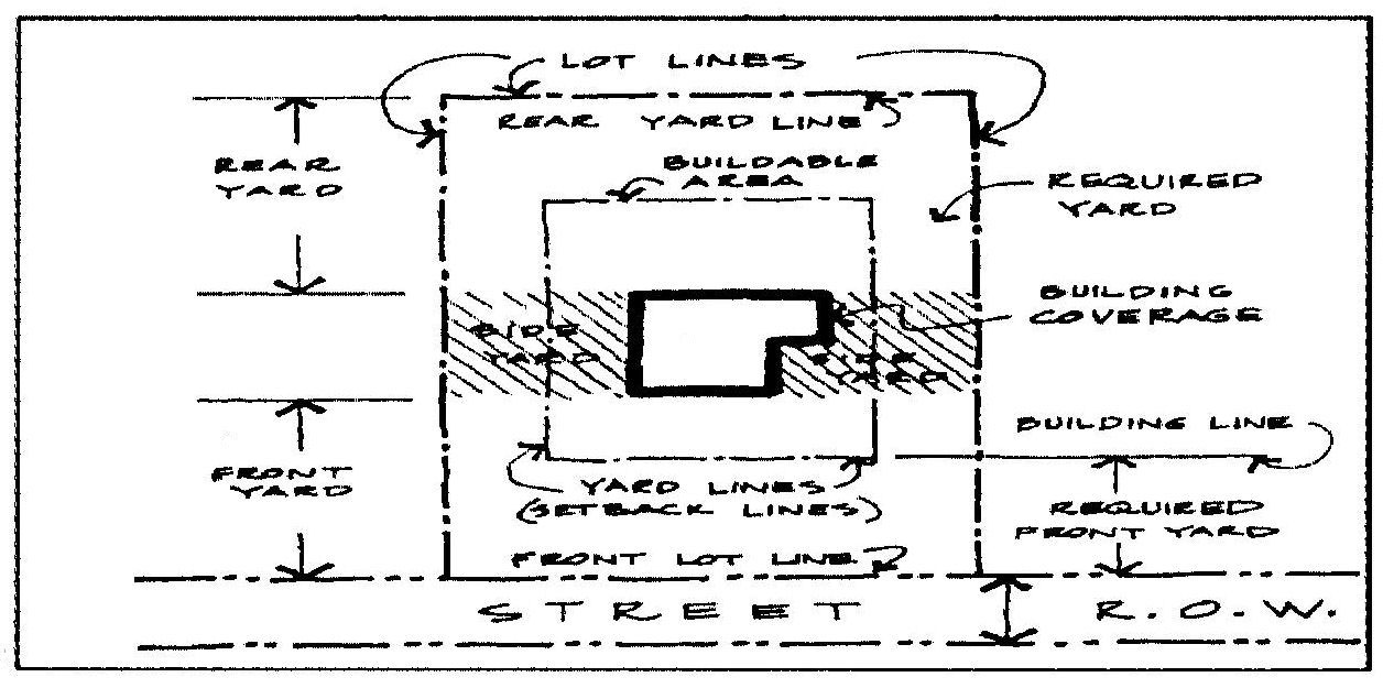
Buildable area. That portion of any lot which may be used or built upon in accordance with the regulations governing the zoning district within which the lot is located when the front, side and rear yard, open space, and applicable buffer area requirements have been met.
Building, accessory. A subordinate structure on the same lot as the principal or main building or use occupied or devoted to a use incidental to the principal use. Included in this definition are private garages, storage sheds, workshops, animal shelters, pool houses, etc., when detached from the principal buildings, and carports attached to the principal building when at least 75 percent open or unenclosed. A structure which is accessory in nature may be considered to be attached and part of the primary structure when such construction is in accordance with one of the following methods.
(1)
Twenty percent of the subordinate structure's abutting side must be in direct contact with the wall of the primary structure. (See illustration Method A.)
(2)
Subordinate structures not in direct contact with the primary structure shall be attached by structures which are enclosed not less than 75 percent, such as sun rooms. The width of the adjoining attachment shall be equal to, or greater than, the horizontal distance between the primary and subordinate structure. (See illustration Method B.)
Building, alteration. Any act or process that changes one or more of the exterior architectural features of a structure, including, but not limited to, the erection, construction, reconstruction, or removal of any structure.
Building, principal. A building in which is conducted, or in which is intended to be conducted, the main or principal use of the lot on which it is located.
Build-to zone. The area of a lot where a building facade must be placed.
Canopy tree. A deciduous tree that forms the top layer of vegetation in a forest. Examples of such trees include oaks, hickories, maples, poplars, and others.
Certificate of occupancy. A document allowing the occupancy or use of a building or certifying that the structure or use has been constructed or will be used in compliance with all applicable provisions of this chapter and the building code.
Certificate of zoning compliance. A document certifying that a proposed use meets all requirements of this chapter.
Child day care services. Where permitted as an accessory use, a home in which care is given by a family member and no others during the day only for one and not more than six children, including the day care parents' own children.
Club, private. An organization catering exclusively to members and their guests including buildings and grounds with commercial activities serving the membership only.
Cluster development. A development design technique that concentrates buildings in specific areas on the site to allow the remaining land to be used for recreation, common open space, and preservation of environmentally sensitive features.
Color, fluorescent. Highly reflective color or colors with pigments that serve to intensify brightness. Colors which are considered exceptionally bright, reflective, neon, and/or luminescent. These include bright yellow, bright orange, bright pink, and bright green.
Community garden. Community gardens are collaborative projects on shared open spaces where participants share in the maintenance and products of the garden, including healthful and affordable fresh fruits and vegetables.

Conditional use. A use of land or structure which is permitted in a district under conditions specified in the Zoning Ordinance.
Condominium. A unit in a multi-unit structure owned by an individual who has use of all common areas associated with that structure.
Corridor roadway. The principal road of an established corridor overlay district.
Cottage court. A group of small-scale detached dwellings arranged around a shared court visible from the road.
Photo: missingmiddlehousing.com
Critical development. Development that is critical to the community's public health and safety, is essential to the orderly functioning of a community, store or produce highly volatile, toxic or water-reactive materials, or house occupants that may be insufficiently mobile to avoid loss of life or injury. Examples of critical development include jails, hospitals, schools, fire stations, nursing homes, wastewater treatment facilities, water plants, and gas/oil/propane storage facilities.
Day care services. Day care services shall mean and include any home, center, agency, or place, however styled, where children, elderly, and other persons not related to the operator are received for custodial care, apart from their parents, whether for compensation, reward, or otherwise during part or all of the day or any number of successive days.
Density. The number of dwelling units per acre of land developed or used for residential purposes. Density requirements in this chapter are expressed in dwelling units per gross acre; that is, per acre of land devoted to residential use is based on the total land area within a development tract or subdivision, excluding nothing.
Developer. An individual, partnership, or corporation (or agent therefore) that undertakes the activities covered by these regulations.
Development. Any manmade change to improved or unimproved real estate, including, but not limited to, buildings or other structures, mining, dredging, filling, grading, paving, excavation, drilling operations, or storage of equipment or materials.
DHEC. South Carolina Department of Health and Environmental Control.
Domestic animal shelter. A pen, shelter, or structure where no more than three dogs or small domestic animals, not to include horses, cows, goats, swine including potbellied pigs, sheep, ponies, grazing animals, and fowl of any kind, are boarded and kept.
Drainage. The removal of surface water or groundwater from land by drains, grading, or other means.
Driveway. A paved or unpaved area used for ingress and egress of vehicles, and allowing access from a street to a building or other structure or facility.
Dwelling. A building or portion of a building arranged or designed exclusively for human habitation.
Dwelling, apartment. (See "Dwelling, multi-family").
Dwelling, detached. A single dwelling unit, surrounded by open space or yards and which is not attached to any other dwelling by any means.
Dwelling, duplex. A building containing two dwelling units.
Dwelling, group occupied. A dwelling unit occupied by five or more individuals unrelated by blood, marriage, adoption, or guardianship living together as a single housekeeping unit.
Dwelling, mobile home. A single-family dwelling that is wholly, or in substantial part, fabricated in an off-site manufacturing facility for installation or assembly at the building site, designed to be a permanent residence, and built prior to the enactment of the Federal Manufactured Housing Construction and Safety Standards, June 15, 1976.
Dwelling, multi-family. A building containing five or more dwelling units.
Dwelling, patio house. A single-family detached or semi-detached dwelling unit. It is built on a small lot generally enclosed by walls which provide privacy. The term is synonymous with zero lot line dwellings.
Dwelling, quadraplex. A building containing four dwelling units.
Dwelling, residential designed manufactured home. A single-family dwelling built according to the Federal Manufactured Housing Construction and Safety Standards (Title 24, Code of Federal Regulations [CFR], Part 3280) HUD Code, which:
(1)
Has a minimum width over 25 feet (multiple-section);
(2)
Has a minimum of 1,100 square feet of enclosed living area;
(3)
Has a minimum 2.0:12 roof pitch; and has a type of shingle commonly used in standard residential construction;
(4)
Is covered with an exterior material customarily used on site built homes, including vinyl or aluminum lap siding, wood, masonite, or other materials similar to the exterior siding commonly used in standard residential construction;
(5)
Has an entry landing that conforms to the minimum requirement of the current edition of the South Carolina State Residential Building Code.
Dwelling, single-family. A building containing one dwelling unit.
Dwelling, standard designed manufactured home. A single-family dwelling unit built according to the Federal Manufactured Housing Construction and Safety Standards (24 CFR 3280) HUD Code, which does not meet the definition of a "residential designed manufactured home."
Dwelling, townhouse. A series of attached single-family dwelling units on separate lots which may or may not have a common roof and are separated from each other by common vertical walls.
Dwelling, triplex. A single building containing three dwelling units.
Dwelling unit. A single unit providing complete, independent living facilities for one or more persons including permanent provisions for living, sleeping, eating, cooking, and sanitation.
Dwelling, zero lot line. A zero lot line dwelling is a single-family detached unit which instead of being centered on a lot, is placed against at least one of the side lot lines. The term is synonymous with patio homes.
Easement. A right-of-way granted to another party for specific limited use.
Elevated building. A non-basement building constructed to have the lowest floor elevated above the ground level by means, solid foundation perimeter walls, pilings, columns, (post and piers), shear walls, parallel to the flow of water.
Evergreen tree. A coniferous or deciduous tree that remains green throughout the year.
Executive Order 11988 (Floodplain Management). Issued by President Carter in 1977, this order requires that no federally assisted activities be conducted in or have the potential to affect identified special flood hazard areas, unless there is no practicable alternative.
Existing construction. For the purposes of determining rates, structures for which the start of construction commenced before September 2, 1982.
Existing manufactured home park or manufactured home subdivision. A manufactured home park or subdivision for which the construction of facilities for servicing the lots on which the manufactured homes are to be affixed (including, at a minimum, the installation of utilities, the construction of streets, and either final site grading or the pouring of concrete pads) was completed before May 1, 1979.
Expansion to an existing manufactured home park or subdivision. The preparation of additional sites by the construction of facilities for servicing the lots on which the manufactured homes are to be affixed (including the installation of utilities, the construction of streets, and either final site grading or the pouring of concrete slabs).
Family. One or more persons related by blood, marriage, adoption, or guardianship, and not more than four persons not so related, except that mentally and physically handicapped persons for whom care is provided on a 24-hour basis shall be construed to be a family, in accord with the provisions of S.C. Code 1976, § 6-7-830.
Federal Manufactured Home Construction and Safety Standards. Regulations promulgated by the Department of Housing and Urban Development (HUD) governing the design and construction, strength and durability, transportability, fire resistance, energy efficiency, and quality of manufactured housing. These standards also set performance requirements for heating, plumbing, air conditions, thermal, and electrical systems.
Flood. A general and temporary condition of partial or complete inundation of normally dry land areas from the overflow of inland or tidal waters, or the unusual and rapid accumulation of runoff of surface waters from any source.
Flood hazard boundary map (FHBM). An official map of a community issued by the Federal Emergency Management Agency, where the boundaries of the areas of special flood hazard are defined as zone A.
Flood insurance rate map (FIRM). An official map of a community on which the Federal Emergency Management Agency has delineated both the areas of special flood hazard and the risk premium zones applicable to the community.
Flood insurance study. An official study provided by the Federal Emergency Management Agency. The report contains flood profiles, as well as the flood boundary floodway map and the water surface elevation of the base flood.
Floodproofing. Any combination of structural and non-structural additions, changes, or adjustments to structures which reduce or eliminate flood damage to real estate or improved real property, water and sanitary facilities, structures and their contents.
Flood-resistant material. Any building material capable of withstanding direct and prolonged contact (minimum 72 hours) with floodwaters without sustaining damage which requires more than low-cost cosmetic repair. Any material that is water-soluble or is not resistant to alkali or acid in water, including normal adhesives for above-grade use, is not flood-resistant. Pressure-treated lumber or naturally decay-resistant lumbers are acceptable flooring materials. Sheet-type flooring coverings that restrict evaporation from below and materials that are impervious, but dimensionally unstable are not acceptable. Materials that absorb or retain water excessively after submergence are not flood-resistant. Please refer to Technical Bulletin 2, Flood Damage-Resistant Materials Requirements, dated 8/08, and available from the Federal Emergency Management Agency. Class 4 and 5 materials, referenced therein, are acceptable flood-resistant materials.
Floodway. The channel of a river or other watercourse and the adjacent land area that must be reserved in order to discharge the base flood without cumulatively increasing the water surface elevation more than one foot.
Floor. The top surface of an enclosed area in a building (including basement), i.e. top of slab in concrete slab construction or top of wood flooring in wood frame construction. The term does not include floor of a garage used solely for parking vehicles.
Floor area ratio. An intensity measure of land use derived at by dividing the total floor area of a building by the total site area.
Freeboard. A factor of safety usually expressed in feet above a flood level for purposes of floodplain management. "Freeboard" tends to compensate for the many unknown factors that could contribute to flood heights greater than the height calculated for a selected size flood and floodway conditions, such as wave action, bridge openings, and the hydrological effect of urbanization of the watershed.
Functionally dependent use. A use which cannot perform its intended purpose unless it is located or carried out in close proximity to water. The term includes only docking facilities, port facilities that are necessary for the loading and unloading of cargo or passengers, and ship building and ship repair facilities, but does not include long-term storage or related manufacturing facilities.
Garage, private. (As defined by the Standard Building Code.)
Garage, public. (As defined by the Standard Building Code.)
Gross floor area (GFA). The sum of the floor area for each of a building's stories measured from the exterior limits of the faces of the structure, including basement floor area. It does not include unenclosed porches or any floor space in an accessory building or in the principal building which is designed for parking of motor vehicles.
Habitable dwelling. A dwelling meeting the minimum habitability requirements of this chapter, and other applicable regulations.
Hazard to air navigation. An obstruction determined to have a substantial adverse effect on the safe and efficient utilization of the navigable airspace.
Height. The vertical distance of a structure or vegetation.
Highest adjacent grade. The highest natural elevation of the ground surface, prior to construction, next to the proposed walls of the structure.
Historic structure. Any structure that is:
(1)
Listed individually in the National Register of Historic Places (a listing maintained by the U.S. Department of the Interior (DOI)) or preliminarily determined by the Secretary of the Interior as meeting the requirements for individual listing on the National Register;
(2)
Certified or preliminarily determined by the Secretary of the Interior as contributing to the historical significance of a registered historic district or a district preliminarily determined by the Secretary to qualify as a registered historic district;
(3)
Individually listed on a state inventory of historic places;
(4)
Individually listed on a local inventory of historic places in communities with historic preservation programs that have been certified:
a.
By an approved state program as determined by the Secretary of Interior; or
b.
Directly by the Secretary of Interior in states without approved programs.
Some structures or districts listed on the state or local inventories may not be "historic" as cited above, but have been included on the inventories because it was believed that the structures or districts have the potential for meeting the "historic" structure criteria of the DOI. In order for these structures to meet NFIP historic structure criteria, it must be demonstrated and evidenced that the South Carolina Department of Archives and History has individually determined that the structure or district meets DOI historic structure criteria.
Home occupation. Any occupation within a dwelling, including a hobby and clearly incidental thereto, carried on by a member or members of the family residing on the premises.
Impervious surface. Impervious surfaces are those that do not absorb water. All buildings, paved parking areas, driveways, roads, sidewalks, and any areas in concrete or asphalt shall be considered impervious surfaces within this definition. In addition, other areas determined by the zoning administrator to be impervious within the meaning of this definition also will be classed as impervious surfaces.
Impervious surface ratio. The impervious surface ratio is a measure of the intensity of land use. It is determined by dividing the total area of all impervious surfaces within the site by the total site area.

Impervious Surface
Improvement. Any manmade immovable item which becomes part of, placed upon, or is affixed to real estate.
Increased cost of compliance (ICC). Applies to all new and renewed flood insurance policies effective on and after June 1, 1997. The NFIP shall enable the purchase of insurance to cover the cost of compliance with land use and control measures established under Section 1361. It provides coverage for the payment of a claim to help pay for the cost to comply with state or community floodplain management laws or ordinances after a flood event in which a building has been declared substantially or repetitively damaged.
Instrument runway. A runway equipped or to be equipped with a precision electronic navigation aid or landing aid or other air navigation facilities suitable to permit the landing of aircraft by an instrument approach under restricted visibility conditions.
Junk or salvage. Any materials consisting of waste, discarded or salvage matter which is bought, sold, exchanged, stored, baled, packed or disassembled for profit, trade or hire, and shall include any vehicle damaged so as not to comply with state or federal safety regulations, incapable of self-propulsion or partially dismantled if retained on the premises for more than 72 hours whether for repair or not. The term "junk" shall also mean, but not be limited to, old or scrap copper, brass, aluminum, rope, rags, paper, trash, tire carcasses, rubber debris, old vehicle parts, non-working major appliances, and other old ferrous or non-ferrous material.
Junk or salvage yard. Any premises where salvage or junk as defined herein are found and have been permitted to remain with the consent of the owner, lessee, or person(s) responsible for maintenance of such premises.
Larger than utility runway. A runway that is constructed for and intended to be used by propeller driven aircraft of greater than 12,500 pounds maximum gross weight and jet powered aircraft.
Limited storage. An area used for storage and intended to be limited to incidental items that can withstand exposure to the elements and have low flood damage potential. Such an area must be of flood-resistant or breakaway material, void of utilities except for essential lighting and cannot be temperature controlled. If the area is located below the base flood elevation in an A, AE and A1—A30 zone, it must meet the requirements of section 30-62[(b)](4) of this chapter.
Lot. A piece of land considered as a unit whose boundaries are established by a recorded deed and, where existing, a recorded plat. The terms "lot," "lot of record," "property" or "tract," whenever used in this chapter are interchangeable. In addition, a lot is not considered a separate piece of land until the property is legally separated from the parent parcel or tract by means of a recorded deed and is given a separate tax parcel number, as assigned by the Florence County Tax Assessor's Office.
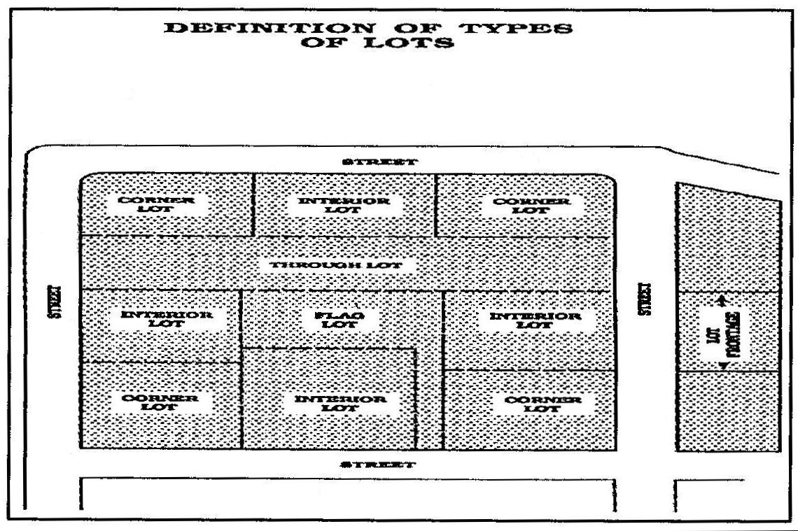
Types of Lots
Lot area. The area contained within the boundary line of a lot.
Lot, corner. A lot located at the intersection of two or more streets.
Lot depth. The horizontal distance between front and rear lot lines.
Lot, interior. A lot, other than a corner lot, which has frontage on only one street other than an alley.
Lot line. A line bounding a lot which divides one lot from another or from a street or any other public or private space.
Lot of record. A lot, the boundaries of which are filed as legal record.
Lot, through or double frontage. A lot which has frontage on more than one street.
Lot width. The horizontal distance between the side lines of a lot measured at right angles to its depth along a straight line parallel to the front lot line at the minimum required building setback line. Lot width requirements found in section 30-80.5(c) must be measured as an average of the distance between side property lines.
Lowest adjacent grade (LAG). An elevation of the lowest ground surface that touches any deck support, exterior walls of a building or proposed building walls.
Lowest floor. The lowest floor of the lowest enclosed area (including basement). Any unfinished or flood-resistant enclosure, usable solely for parking of vehicles, building access, or storage in an area other than a basement area is not considered a building's lowest floor provided that such an enclosure is not built so as to render the structure in violation of other provisions of this chapter.
Manufactured home. A structure, transportable in one or more sections, which is built on a permanent chassis and designed to be used with or without a permanent foundation when connected to the required utilities. The term "manufactured home" does not include a "recreational vehicle."
Manufactured home park or manufactured home subdivision. A lot or a parcel (or contiguous parcels) of land divided into two or more manufactured home lots for rent or sale that include improvements and utilities for the long-term parking of three or more manufactured homes which may include services and facilities for the residents.
Manufactured home park space. A plot or ground within a manufactured home park designed for the accommodation of one unit.
Mean sea level. For the purpose of this chapter, the National Geodetic Vertical Datum (NGVD) of 1929, North American Vertical Datum (NAVD) of 1988, or other datum, to which the base flood elevations shown on a community's flood insurance rate maps (FIRM) are shown.
Minimum required setback line. The line where the required yard and buildable area meet. More specifically:
Front yard setback line: The line where the front yard and buildable area of a lot meet.
Rear yard setback line: The line where the rear yard and buildable area of a lot meet.
Side yard setback line: The line where the side yard and buildable area of a lot meet.
Mining. As used in this chapter, "Mining" means the breaking of the surface soil in order to facilitate or accomplish the extraction or removal of minerals, ores, or other solid matter; any activity or process constituting all or part of a process for the extraction or removal of minerals, ores, and other solid matter from its original location; and the preparation, washing, cleaning, or other treatment of minerals, ores, or other solid matter so as to make them suitable for commercial, industrial, or construction use; but shall not include those aspects of deep mining not having significant effect on the surface, and shall not include excavation or grading when conducted solely in aid of onsite farming or construction. (S.C. Code 1976, tit. 48, ch. 21, art. II)
Mini-warehouse. A building or group of buildings in a controlled-access and fenced compound that contains individual, compartmentalized and controlled-access stalls or lockers for the dead storage of customer's goods or wares.
Mixed occupancy. Any building that is used for two or more occupancies classified by different occupancy use groups.
Modular building unit or modular structure. Any building of closed construction, regardless of type of construction or occupancy classification, other than a mobile or manufactured home, constructed off-site in accordance with the applicable codes, and transported to the point of use for installation or erection. When meeting the requirements of the Modular Building's Construction Act (S.C. Code 1976, § 23-43-10), said building unit or structure may be located in any zoning district.
National Geodetic Vertical Datum (NGVD). As corrected in 1929, elevation reference points set by National Geodetic Survey based on mean sea level.
New construction. Structure for which the start of construction commenced on or after May 1, 1979. The term also includes any subsequent improvements to such structure.
New manufactured home park or manufactured home subdivision. A manufactured home park or subdivision for which the construction of facilities for servicing the lots on which the manufactured homes are to be affixed (including at a minimum, the installation of utilities, the construction of streets, and either final site grading or the pouring of concrete slabs) is completed on or after May 1, 1979.
Nonconformity. Any lot of record, use, building, structure or vegetation in existence prior to the effective date of this chapter, but which fails, by reason of such adoption, revision or amendment, to conform to the present requirements of the chapter.
Nonresidential use. A principal use of land for other than residential purposes, i.e. commercial, industrial, institutional.
North American Vertical Datum (NAVD). Vertical control, as corrected in 1988, used as the reference datum on flood insurance rate maps.
Nudity or state of nudity. Means:
(1)
The appearance of human bare buttocks, anus, male genitals, female genitals, or the areola or nipple of the female breast; or
(2)
A state of dress which fails to opaquely and fully cover a human buttocks, anus, male genitals, female genitals, pubic region, or areola or nipple of the female breast.
Open space development. Residential developments that concentrate homes and buildings in specific areas on the site in order to allow the remaining land to be undisturbed and used for recreation, open space, wildlife corridors, and preservation of environmentally sensitive features.
Open space ratio. A measure of the intensity of land use. It is arrived at by dividing the total amount of open space within the site by the total site area.
Parcel. A land area bounded by property lines that is recognized as such by the county assessor's office.
Park. A public facility open for recreation, with commercial activities for recreational uses only, open space and public gardens.
Park, neighborhood. A park which serves the population of a neighborhood, is approximately one to two acres, and may include playground apparatus, community garden, space for active recreational purposes, or areas for passive use. The site should be public and accessible.
Precision instrument runway. A runway with an instrument approach procedure utilizing an instrument landing system (ILS) or a precision approach radar (PAR).
Premises. A lot, plot, or parcel of land including the buildings or structures thereon, under control by the same owner or operator together with all adjacent land.
Recreational vehicle. A vehicle which is:
(1)
Built on a single chassis;
(2)
400 square feet or less when measured at the largest horizontal projection;
(3)
Designed to be self-propelled or permanently towable by a light duty truck; and
(4)
Designed primarily not for use as a permanent dwelling, but as temporary living quarters for recreational, camping, travel, or seasonal use.
Redevelopment. The act of clearing, rehabilitating, modifying, reconstructing, or reusing an area or structure that includes, but is not limited to, any change to use, structures, streets, parking, access, utilities, parks, recreational areas, and open spaces significant enough to potentially impact adjacent uses, transportation and recreation networks, or community character.
Regulatory floodway. The channel of a river or other watercourse and the adjacent land area that must be reserved in order to discharge the base flood without cumulatively increasing the water surface elevation more than one foot.
Repetitive loss. A building covered by a contract for flood insurance that has incurred flood-related damages on two occasions during a ten-year period ending on the date of the event for which a second claim is made, in which the cost of repairing the flood damage, on the average, equaled or exceeded 25 percent of the market value of the building at the time of each such flood event.
Riparian buffer. An area of trees, shrubs, and other vegetation that borders an existing watercourse, wetland, or other water body (including open stormwater conveyances), for the purpose of reducing contamination from surface water runoff.
Runway. A defined area on an airport prepared for landing and takeoff of aircraft along its length.
Section 1316 of the National Flood insurance Act of 1968. The act provides that no new flood insurance shall be provided for any property found by the Federal Emergency Management Agency to have been declared by a state or local authority to be in violation of state or local ordinances.
Sexually oriented business. For purposes of this chapter, sexually oriented business operations shall mean and include the following:
Adult arcade means any place to which the public is permitted or invited wherein coin-operated or slug-operated or electronically, electrically, or mechanically controlled still or motion picture machines, projectors, or other image-producing devices are maintained to show images to five or fewer persons per machine at any one time, and where the images so displayed are distinguished or characterized by the depicting or describing of "specified sexual activities" or "specified anatomical areas."
Adult bookstore or adult video store means a commercial establishment which, as one of its principal business purposes, offers for sale or rental for any form of consideration any one or more of the following:
(1)
Books, magazines, periodicals or other printed matter, or photographs, films, motion pictures, video cassettes or video reproductions, slides or other visual representations which depict or describe "specified sexual activities" or "specified anatomical areas"; or
(2)
Instruments, devices, or paraphernalia which are designed for use in connection with "specified sexual activities." A commercial establishment may have other principal business purposes that do not involve the offering for sale or rental of material depicting or describing "specified sexual activities" or "specified anatomical areas" and still be categorized as an adult bookstore or adult video store. Such other business purposes will not serve to exempt such commercial establishment from being categorized as an adult bookstore or adult video store so long as: one of its principal business purposes is the offering for sale or rental for consideration the specified materials which depict or describe "specified sexual activities" or "specified anatomical areas."
Adult cabaret means a nightclub, bar, restaurant or similar commercial establishment which regularly features:
(1)
Persons who appear in a state of nudity; or
(2)
Live performances which are characterized by the exposure of "specified anatomical areas" or by "specified sexual activities"; or
(3)
Films, motion pictures, videocassettes, slides, or other photographic reproductions which are characterized by the description of "specified sexual activities" or "specified anatomical areas."
Adult motel means a hotel, motel or similar commercial establishment which:
(1)
Offers accommodations to the public for any form of consideration; provides patrons with closed-circuit television transmissions, films, motion pictures, video cassettes, slides, or other photographic reproductions which are characterized by the depiction or description of "specified sexual activities" or "specified anatomical areas"; and has a sign visible from the public right-of-way which advertises the availability of this adult-type of photographic reproductions; or
(2)
Offers a sleeping room for rent for a period of time that is less than ten hours; or
(3)
Allows a tenant or occupant of a sleeping room to sublet the room for a period of time that is less than ten hours.
Adult motion picture theater means a commercial establishment where, for any form of consideration, films, motion pictures, video cassettes, slides or similar photographic reproductions are regularly shown which are characterized by the depiction or description of "specified sexual activities" or "specified anatomical areas."
Adult theater means a theater, concert hall, auditorium or similar commercial establishment which regularly features persons who appear in a state of nudity or live performances which are characterized by the exposure of "specified anatomical areas" or by "specified sexual activities."
Escort agency means a person or business association who furnishes, offers to furnish or advertises to furnish escorts as one of its primary business purposes for a fee, tip, or other consideration.
Massage parlor means any place where, for any form of consideration or gratuity, massage, alcohol rub, administration of fomentation, electric or magnetic treatments, or any other treatment manipulation of the human body which occurs as a part of or in connection with "specified sexual activities," or where any person providing such treatment, manipulation, or service related thereto, exposes his or her "specified anatomical areas." The definition of sexually oriented businesses shall not include the practice of massage in any licensed hospital, nor by a licensed hospital, nor by a licensed physician surgeon, massage therapist, chiropractor or osteopath, nor by any nurse or technician working under the supervision of a licensed physician, surgeon chiropractor or osteopath, nor by trainers for any amateur, semiprofessional, or professional athlete or athletic team or school athletic program.
Nude model studio means any place where a person who appears in a state of nudity or displays "specified anatomical areas" to be observed, sketched, drawn, painted, sculptured, photographed, or similarly depicted by other persons who pay money or any form of consideration.
Sexual encounter center means a business or commercial enterprise that, as one of its primary business purposes, offers for any form of consideration:
(1)
Physical contact in the form of wrestling or tumbling between persons of the opposite sex; or
(2)
Activities between male and female persons and/or persons of the same sex when one or more of the persons is in a state of nudity or seminude.
Screening. The act of concealing a use or area from public view, through the use of intense landscaping, opaque fencing or walls, and building placement. Other forms of screening that are not listed, may be used if the zoning administrator determines they meet the intent of the ordinance.
Sign. Any object, device, display or structure, or part thereof, situated outdoors or indoors, which is used to advertise, identify, display, direct or attract attention to an object, person, institution, organization, business, product, service, event or location by any means, including words, letters, figures, design, symbols, fixtures, colors, illumination or projected images.
Sign, abandoned or obsolete. A sign which identifies, describes, directs attention to, or gives directions for locating any business or establishment no longer in operation, or advertises any product no longer marketed or any sign structure lacking sign faces for a period of 120 continuous days or more. Sign structures and boxes with faces that are blank or which advertise the availability of a property (for sale, for lease etc.) on vacant properties are not considered abandoned.
Sign, animated. Any sign that uses movement or change of lighting to depict action or creates a special effect or scene.
Sign, awning, canopy or marquee. A sign that is mounted or painted on or attached to an awning, canopy or marquee.
Sign, bench. A sign located on any part of the surface of a bench or seat placed on or adjacent to a public right-of-way.
Sign, building. Any sign attached to any part of a building.
Sign, changeable copy. A sign or portion thereof with characters, letters or illustrations that can be changed or rearranged without altering the face or the surface of the sign. A sign on which the message changes more than eight times per day shall be considered an animated sign and not a changeable copy sign for purposes of this chapter. A sign on which the only copy that changes is an electronic or mechanical indication of time or temperature shall be considered a "time and temperature" portion of a sign and not a changeable copy sign for purposes of this chapter.
Sign, dangerous. A sign which is insecure or otherwise structurally unsound, has defective parts in the support, guys, and or anchors, or which is unable to meet the minimum safety requirements of the building code adopted by Florence County and any other applicable state codes or regulations.
Sign, dilapidated. A sign which has not been properly maintained, to include painting, lettering, replacement of broken faces or parts, repairing of electrical wiring and or lighting which is defective.
Sign, directional. A sign, generally informational, that has a purpose secondary to the use of the zone lot on which it is located, such as "no parking," "entrance," "loading only," "telephone," and other similar directives. No sign with a commercial message legible from a position off the zone lot on which the sign is located shall be considered directional.
Sign face. The area or display surface used for the message.
Sign, freestanding. Any nonmovable sign not affixed to a building.
Sign, identification. A sign giving the nature, logo, trademark, or other identifying symbol; address; or any combination of the name, symbol, and address of a building, business, development, or establishment on the premises where it is located.
Sign, illegal. Permanent signs installed not in compliance with this chapter or without a permit or which the permit has been revoked or expired shall be removed within 30 days of the attempted delivery of a certified letter from the Florence County Planning Department requiring removal.
Sign, incidental. A sign, generally informational, that has a purpose secondary to the use of the zone lot on which it is located, such as "no parking," "entrance," "loading only," "telephone," and other similar directives. No sign with a commercial message legible from a position off the zone lot on which the sign is located shall be considered incidental.
Sign, off-premises. A sign which directs attention to a business, commodity, service, or entertainment conducted, sold, or offered at a location other than the premises on which the sign is located.
Sign, permanent. A sign attached to a building, structure or the ground in some manner and made of materials intended for more than short-term use.
Sign, political. A temporary sign announcing or supporting political candidates or issues in connection with any national, state or local election.
Sign, portable. Sign or signs which are capable of being moved from one location to another for the purpose of advertisement or announcement for business or other purposes. The term "portable sign" includes, but is not limited to, signs mounted on trailers and signs mounted on frames placed on the surface of any lot which are not permanently attached to the ground.
Sign, projecting. A sign that is wholly or partly dependent upon a building for support and which projects more than 12 inches from such building.
Sign, real estate. Sign or signs indicating that a property or any portion thereof is available for inspection, sale, lease, rent, or directing people to a property, but not including temporary subdivision signs.
Sign, roof. A sign that is mounted on the roof of a building or which is wholly dependent upon a building for support and which projects above the point of a building with a flat roof, the ridge line of a building with a gambrel, gable, or hip roof or the deck line of a building with a mansard roof. Signs mounted on the sloping section of a roof or the gable end of a roof shall be classified as a wall sign.
Sign, roof integral. A sign whose structure is integrated into the structure of the roof, and is an integral part thereof.
Sign, temporary. A sign that is used only for a short period of time and is not permanently mounted.
Sign, wall. Any sign attached to and within six inches of a wall, painted on the wall surface, or erected and confined within the limits of an outside wall of any building or structure, which is supported by such wall or building, and which displays only one sign surface.
Sign, window. A sign that is applied or attached to the exterior or interior of a window or located in such manner within a building that it can be seen from the exterior of the structure through a window.
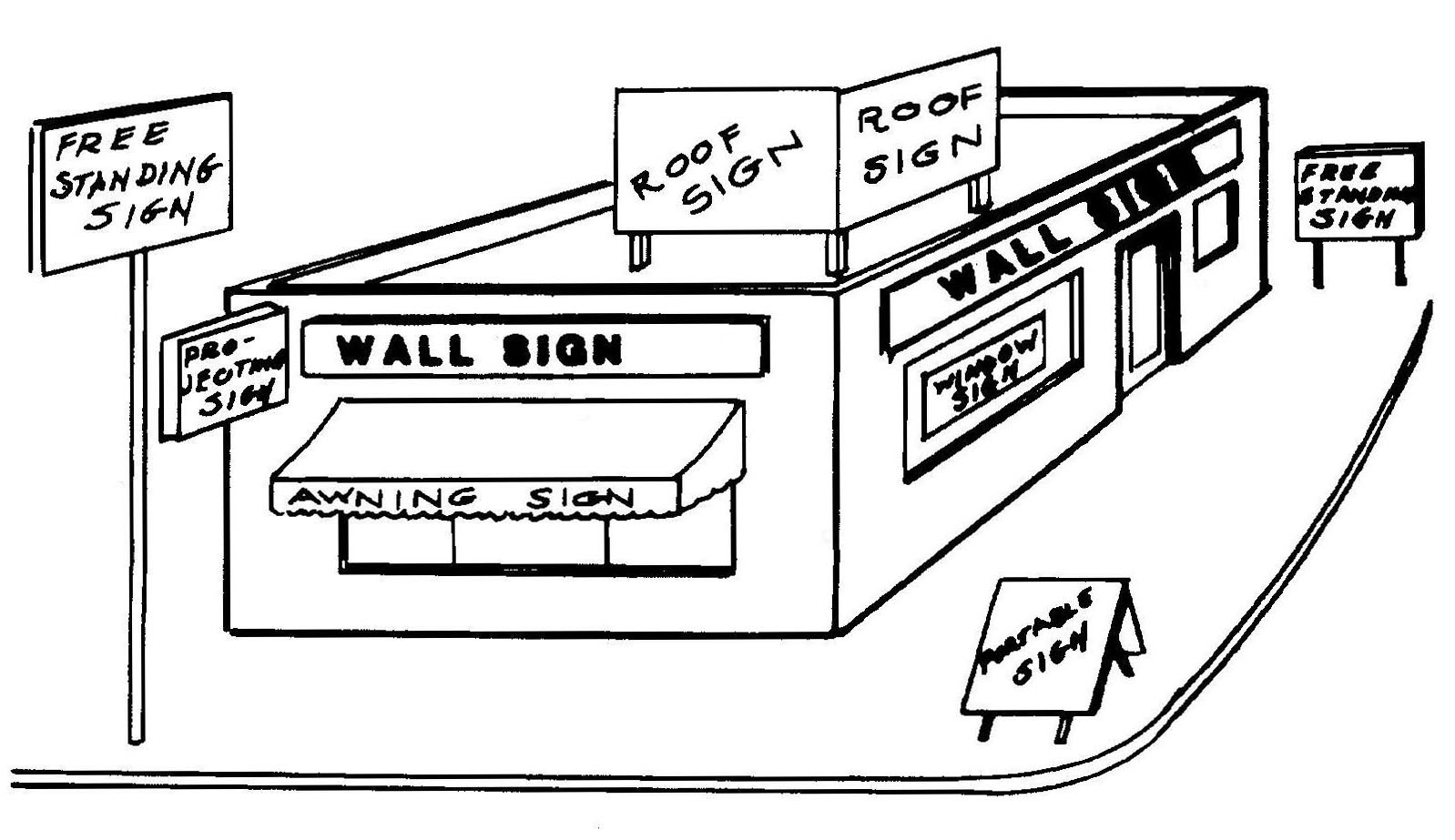
Sign Types
Single-family detached. A dwelling designed and constructed as a freestanding building that houses one primary dwelling. Such term may include a single-family dwelling that also contains one secondary, or accessory, dwelling unit as regulated by this chapter.
Solar energy systems. For the purposes of this chapter the following words, terms, and phrases, used in this article, shall have the ascribed meanings to them unless stated otherwise:
Building-integrated solar system. An active solar system incorporated into the principal and/or accessory building/structure(s) as an architectural component. Architectural designs include, but are not limited to, roof material, windows, parking facilities, awnings, section of wall, and etcetera.
Ground-mounted. Freestanding pole and tower used to support renewable energy systems (RES).
Height. The vertical distance measured from ground to the foremost tip/end of a roof or the ground-mounted solar/wind apparatus.
Integrated energy systems. Flexible energy techniques used through solar building/integration, and roof and ground-mounted solar systems to produce on-site energy. Integrated energy systems serve as accessory structures on properties with principal structure (i.e. home or business).
Renewable energy system. Energy generated through solar technology for residential, commercial, and industrial uses, and geographical areas in partnership with utility companies.
Roof-mounted. RES affixed to a roof utilizing solar panels to produce energy.
Solar collector. A solar device absorbs and accumulates solar rays for use as a source of energy. The device may be roof-mounted as an accessory use or ground-mounted.
Solar energy. Radiant energy received from the sun collected in the form of heat or light by a solar collector to produce energy.
Solar energy system (SES). The components and subsystems required to convert solar energy into electric or thermal energy suitable for use. The area of the system includes all the land inside the perimeter of the system, which extends to any fencing. The term applies, but is not limited to, solar photovoltaic (PV) systems, solar thermal systems, and solar hot water systems. A system fits into one of three system types: Level 1 SES, Level 2 SES, and Level 3 SES.
Level 1 Solar Energy System. Level 1 SESs include the following:
(1)
Any roof-mounted system on any code-compliant structure.
(2)
Any ground-mounted system on an area of up to 50 percent of the footprint of the primary structure on the parcel but no more than one acre.
(3)
Any system covering permanent parking lot and other hardscape areas.
(4)
Any building integrated solar (i.e., shingle, hanging solar, canopy, etc.).
Level 2 Solar Energy System. Level 2 SESs are ground mounted commercial-scale systems not included in Level 1 that meet the area restriction listed below:
(1)
RU-1/RU-2: SES ≤1/2 acres
(2)
R-1: SES ≤1/2 acre
(3)
R-2/R-3: SES ≤1/2 acre
(4)
R-4/R-5 ≤1/2 acre
(5)
B-1/B-2: SES ≤10 acres
(6)
B-3: SES ≤10 acres
(7)
B-4: SES ≤10 acres
(8)
B-5/B-6: SES >10 acres
Level 3 Solar Energy System. Level 3 SESs are utility-scale systems that do not satisfy the parameters for a Level 1 or Level 2 solar energy system.
Solar farm. A series of ground mounted solar collectors placed in an area for generating photovoltaic (PV) power as a commercial enterprise. The minimum size for a solar farm is five acres.
Thermal energy. Solar technology converted into heat energy.
South Carolina Manufactured Housing Board. Authorized by state statute to regulate the construction, repair, modification, installation, tie-down, hook-up, and sale of manufactured homes in South Carolina, which board has adopted for regulation of manufactured homes the Federal Manufactured Housing Construction and Safety Standards, promulgated by HUD, and contained in the board's Manufactured Housing Regulations, May 26, 1990.
Special flood hazard area. See "area of special flood hazard."
Specified anatomical areas. The male genitals in a state of sexual arousal and/or the vulva or more intimate parts of the female genitals.
Specified sexual activities. Means and includes any of the following:
(1)
The fondling or other erotic touching of human genitals, pubic region, buttocks, anus or female breasts;
(2)
Sex acts, normal or perverted, actual or simulated, including intercourse, oral copulation or sodomy;
(3)
Masturbation, actual or simulated; or
(4)
Excretory functions as part of or in connection with any of the activities set forth in (1) through (3) above.
Start of construction. For other than new construction or substantial improvements under the Coastal Barrier Resources Act (P.L. 97-348), includes substantial improvement, and means the date the building permit was issued, provided the actual start of construction, repair, reconstruction, rehabilitation, addition, or improvement was within 180 days of the permit date. The actual start means the first placement of permanent construction of a structure (including a manufactured home) on a site, such as the pouring of slabs or footings, installation of piles, construction of columns, or any work beyond the stage of excavation or the placement of a manufactured home on a foundation. Permanent construction does not include land preparation, such as clearing, grading, and filling; nor does it include the installation of streets and/or walkways; nor does it include excavation for footings, piers or foundations, or the erection of temporary forms; nor does it include the installation on the property of accessory buildings, such as garages or sheds not occupied as dwelling units or not part of the main structure. For a substantial improvement, the actual start of construction means the first alteration of any wall, ceiling, floor, or other structural part of the building, whether or not that alteration affects the external dimensions of the building.
Street. Any thoroughfare (drive, avenue, boulevard) or space more than 18 feet in right-of-way width which has been dedicated, deeded or designated for vehicular traffic, public or private.
Street, major. Includes all state primary and federal aid highways and streets that serve to circulate traffic, having signals at important intersections, and stop signs on side streets and/or having controlled access and channelized intersections.
Street, minor. A street designed principally to collect traffic from subdivisions and provide access to abutting property.
Street, private. A street not dedicated for public use or maintenance.
Structure. A walled and roofed building, a manufactured home, including a gas or liquid storage tank that is principally above ground. Or as defined by the Standard Building Code.
Structural alteration. Any change in the supporting members of a building, such as the bearing walls, beams, or girders, or any change in the dimension or configuration of the roof or exterior walls.
Substantial damage. Damage of any origin sustained by a structure whereby the cost of restoring the structure to its before damaged condition would equal or exceed 50 percent of the market value of the structure before the damage occurred. Such repairs may be undertaken successively and their costs counted cumulatively. Please refer to the definition of "substantial improvement."
Substantial improvement. Any repair, reconstruction, rehabilitation, addition, or other improvement of a structure, the cost of which equals or exceeds 50 percent of the market value of the structure before the start of construction of the improvement. This term includes structures which have incurred substantial damage, regardless of the actual repair work performed. The term does not, however, include either: (1) any project of improvement to a structure to correct existing violations of state or local health, sanitary, or safety code specifications which have been identified by the local code enforcement official and which are the minimum necessary to assure safe living conditions (does not include Americans with Disabilities Act compliance standards); or (2) any alteration of a historic structure, provided that the alteration will not preclude the structure's continued designation as a historic structure. Permits shall be cumulative for a period of five years. If the improvement project is conducted in phases, the total of all costs associated with each phase, beginning with the issuance of the first permit, shall be utilized to determine whether "substantial improvement" will occur.
Substantially improved existing manufactured home park or subdivision. Where the repair, reconstruction, rehabilitation or improvement of the streets, utilities and pads equals or exceeds 50 percent of the value of the streets, utilities and pads before the repair, reconstruction, or improvement commenced.
Townhouse. A series of attached single-family dwelling units on separate lots which may or may not have a common roof and are separated from each other by common vertical walls.
Travel trailer or recreational vehicle. A structure that is:
(1)
Intended to be transported over the streets and highways (either as a motor vehicle or attached to or hauled by a motor vehicle); and
(2)
Designed for temporary use as sleeping quarters, but that does not satisfy one or more of the definitional criteria of a mobile or manufactured home or modular unit.
Understory tree. A small deciduous tree that forms the layer of vegetation under the canopy trees in a forest. Examples of such trees include dogwoods, sourwoods, fruit trees and others.
Use. The purpose or activity for which land or any building thereon is designed, arranged or intended, or for which it is occupied or maintained.
Use, accessory. See "building, accessory."
Use, principal. The primary purpose for which land is used.
Utility runway. A runway that is constructed for and intended to be used by propeller driven aircraft of 12,500 pounds maximum gross weight and less.
Variance. A modification of the area regulations of this chapter, granted by the board of zoning appeals, where such modification will not be contrary to the public interest, and where, owing to conditions peculiar to the property, a literal enforcement of the ordinance would result in unnecessary and undue hardship, and where such modification will not authorize a principal or accessory use of the property which is not permitted within the zoning district in which the property is located.
Vegetation. Any object of natural growth.
Violation. The failure of a structure or other development to be fully compliant with these regulations.
Visual runway. A runway intended solely for the operation of aircraft using visual approach procedures.
Wetlands. Areas of 0.25 acre or more where standing water is retained for a portion of the year and unique vegetation has adapted to the area. Jurisdictional wetlands are those over which the U.S. Corps of Engineers has permitting jurisdiction.
Yard. An open space that lies between the principal or accessory building or buildings and the nearest lot line. Such yard is unoccupied and unobstructed from the ground upward except as may be specifically provided by this chapter.
Yard, front. A yard extending the full width of the front of a lot between the front (street) right-of-way line or property line and the front building line.
Yard, rear. A yard extending the full width of the lot in the area between the rear lot line and the rear building line.
Yard, required. That part of a yard between a lot line and the minimum required building setback line, within which no structure shall be located except as provided by this chapter.
Yard, side. A yard extending the full length of the lot in the area between the side lot line and a side building line.
Zoning district. A specifically delineated area or district within which regulations and requirements govern the use, placement, spacing and size of land and buildings.
(Ord. No. 33-2006/07, art. 10, 6-7-07; Ord. No. 39-2006/07, § 1(G), 8-16-07; Ord. No. 17-2007/08, § 3, 2-21-08; Ord. No. 08-2008/09, § 1, 11-20-08; Ord. No. 31-2008/09, § 4, 9-17-09; Ord. No. 04-2009/10, § 4, 9-17-09; Ord. No. 25-2009/10, § 4, 2-18-10; Ord. No. 09-2010/11, § 4, 12-9-10; Ord. No. 16-2011/12, § 1, 2-16-12; Ord. No. 06-2014/15, § 1, 11-20-14; Ord. No. 34-2015/16, § 1, 8-18-16; Ord. No. 09-2016/17, § 1, 4-20-17; Ord. No. 17-2016/17, § 1, 6-15-17; Ord. No. 08-2017/18, § 1, 11-16-17; Ord. No. 15-2019/20, § 1, 2-20-20; Ord. No. 21-2023/24, § 1, 1-18-24; Ord. No. 77-2023/24, § 1, 8-15-24; Ord. No. 19-2024/25, § 1, 9-19-24)