
Florence County Unincorporated
City Zoning Code
City Zoning Code
ARTICLE II
ZONING DISTRICT REGULATIONS
DIVISION 3. - OPEN SPACE DEVELOPMENT DISTRICTS (CLUSTER DEVELOPMENTS)
This division applies only to open space development districts (cluster developments).
DIVISION 4. - FH FLOOD HAZARD DISTRICT[2]
Flood hazard districts include (1) floodplains, (2) areas of shallow flooding, (3) areas of special flood hazard, and (4) floodways. The development of these areas, where shown on flood hazard boundary maps, issued by the Federal Emergency Management Agency (FEMA) for Florence County, may not occur where alternative locations exist due to the inherent hazards and risks involved. Before a building permit is issued, the applicant shall demonstrate on the plan submitted with the zoning compliance application that new structures cannot be located out of the floodplain and that encroachments onto the floodplain are minimized. Where there is no alternative to a location in a flood hazard district, proposed development shall be regulated by the following.
Editor's note— Ord. No. 06-2014/15, § 1, adopted Nov. 20, 2014, amended in entirety Art. II, Div. 4, effectively repealing former §§ 30-61—30-63 and enacting new §§ 30-61—30-64 as set out herein. The former Div. 4 pertained to similar subject matter and derived from Ord. No. 33-2006/07, §§ 2.7-1—2.7-3, adopted June 7, 2007; and Ord. No. 08-2008/09, § 1, adopted Nov. 20, 2008.
DIVISION 8. - TOWNHOUSE AND MIXED-USE DISTRICTS[3]
Editor's note— Div. 8, adopted by Ord. No. 21-2023/24 on Jan. 18, 2024, included images captioned as Figures 14—19. At the editor's discretion, said images have been renumbered as Figures 17—22 herein, subsequent to the adoption of Ord. No. 77-2023/24 on Aug. 15, 2024, which added and renumbered figures in Div. 7.
Sec. 30-26. - Establishment of regulations.
The uses permitted in the several zoning districts established by article I, the off-street parking requirements, and the dimensional requirements of each are set forth herein. The requirements for uses in residential, business, and rural districts are presented on tables.
Section 30-28 (Table I) sets forth use and off-street parking requirements for the five residential districts. Section 30-29 (Table II) establishes use and off-street parking requirements for business and rural districts. Section 30-30 (Table III) sets forth lot area, yard, setback, height, density, floor area, and impervious surface requirements for all residential, business, and rural districts. Article II, division 2 establishes regulations for the planned development district. Article II, division 3 prescribes regulations for development in open space development districts (cluster developments). Article II division 4 prescribes regulations for development in the flood hazard district. Article II, division 5 establishes regulations for the airport compatibility district. Article II, division 6 establishes requirements for riparian buffers. Article II, division 7 establishes regulations for the corridor overlay district. Article II, division 8 establishes regulations for townhouse and mixed-use districts. Section 30.8.1 (Table XI) sets forth use and off-street parking requirements for the five mixed-use districts and the townhouse district. Section 30-80.5 sets forth lot area, yard, setback, height, density, floor area, and impervious surface requirements for townhouse and mixed-use districts.
(Ord. No. 33-2006/07, § 2.1, 6-7-07; Ord. No. 21-2023/24, § 1, 1-18-24)
Sec. 30-27. - Application of regulations.
The North American Industry Classification System, 2022, is the basis for determining the use of property permitted by the various zoning districts. Where uncertainty exists relative to a given use not specifically listed by the tables, the NAICS Manual should be consulted. In general, all uses listed by a given NAICS number and category shall be construed as being permitted in the assigned zoning district, unless separately listed.
Uses not listed in the NAICS Manual are identified by the letters "NA" (Not Applicable) in the NAICS Column.
Where the letter "P" is shown, the use to which it refers is permitted as a use by right in the indicated district, provided it complies fully with all applicable development standards of this chapter.
Where the letter "C" is shown, the use to which it refers is conditionally permitted in the indicated district, subject to requirements for uses set out in article III.
Where the letter "N" is shown, the use to which it refers is not permitted in the indicated district.
Where a given use or NAICS reference is not listed by either Table I or II, said use shall not be permitted.
A section number reference following a use category means the use must meet the additional conditions and requirements of the referenced section.
To aid in the use of the tables they are arranged by NAICS Sectors, followed by the uses and codes included in the respective sector:
Sector 11: Agriculture, Forestry, Fishing and Hunting
Sector 21: Mining
Sector 22: Utilities
Sector 23: Construction
Sector 31-33: Manufacturing
Sector 42: Wholesale Trade
Sector 44-45: Retail Trade
Sector 48-49: Transportation and Warehousing
Sector 51: Information
Sector 52: Finance and Insurance
Sector 53: Real Estate and Rental and Leasing
Sector 54: Professional, Scientific, and Technical Services
Sector 55: Management of Companies and Enterprises
Sector 56: Administrative and Support and Waste Management and Remediation Services
Sector 61: Educational Services
Sector 62: Health Care and Social Assistance
Sector 71: Arts, Entertainment, and Recreation
Sector 72: Accommodation and Food Services
Sector 81: Other Services (except Public Administration)
Sector 92: Public Administration
Uses and NAICS code references are displayed within the appropriate sector in numerical order, beginning with Sector 11 (Agricultural, Forestry, Fishing and Hunting) and running through Sector 92 (Public Administration).
(Ord. No. 33-2006/07, § 2.2, 6-7-07; Ord. No. 50-2023/24, § 1, 4-18-24)
Sec. 30-28. - Table I: Schedule of permitted and conditional uses and off-street parking requirements for residential districts.
(1) Permitted uses in areas previously zoned (prior to effective date of this ordinance) RG-2 in Florence County.
(2) Any new use which includes outside sales of new or used household goods and other material goods and products which are akin to yard sales and flea markets for more than any two consecutive days within a 30-day period must obtain a certificate of zoning compliance. The board of zoning appeals shall hear and deliberate such requests. The goods and products of such uses, whether permitted or allowed, must not be stored outside of the site's primary or secondary structure during non-business hours.
(Ord. No. 33-2006/07, § 2.3, 6-7-07; Ord. No. 09-2008/09, § 1, 11-20-08; Ord. No. 10-2009/10, § 2, 11-19-09; Ord. No. 17-2011/12, § 2, 1-19-12; Ord. No. 18-2014/15, § 1, 3-19-15; Ord. No. 09-2016/17, § 1, 4-20-17; Ord. No. 30-2020/21, § 1, 6-15-21; Ord. No. 50-2023/24, § 1, 4-18-24)
Sec. 30-29. - Table II: Schedule of permitted and conditional uses and off-street parking requirements for business and rural districts.
Notes:
(1) Off street parking is not required in the B-4 district.
(2) Any new use which includes outside sales of new or used household goods and other material goods and products which are akin to yard sales and flea markets for more than any two consecutive days within a 30-day period must obtain a certificate of zoning compliance. The board of zoning appeals shall hear and deliberate such requests. The goods and products of such uses, whether permitted or allowed, must not be stored outside of the site's primary or secondary structure during non-business hours.
(Ord. No. 33-2006/07, § 2.4, 6-7-07; Ord. No. 04-2007/08, § 1, 9-13-07; Ord. No. 09-2008/09, § 1, 11-20-08; Ord. No. 29-2008/09, § 1, 6-4-09; Ord. No. 04-2009/10, § 2, 9-17-09; Ord. No. 13-2015/16, § 2, 11-19-15; Ord. No. 22-2015/16, § 1, 2-18-16; Ord. No. 09-2016/17, § 1, 4-20-17; Ord. No. 16-2016/17, § 1, 6-15-17; Ord. No. 12-2018/19, § 1, 12-13-18; Ord. No. 30-2020/21, § 1, 6-15-21; Ord. No. 02-2022/23, § 1, 9-15-22; Ord. No. 26-2023/24, § 1, 3-21-24; Ord. No. 49-2023/24, § 1, 4-18-24; Ord. No. 50-2023/24, § 1, 4-18-24; Ord. No. 57-2023/24, § 1, 5-16-24)
Sec. 30-30. - Table III: Zoning setbacks.
Notes to Table III:
(a) Lot area is expressed in square feet.
(b) Measurement from front property line.
(c) Measurement from average elevation of finished grade of the front of the structure.
(d) Total floor measured as a percent of total lot area.
(e) There is no maximum: provided side and rear setbacks shall increase by one foot for each two feet in height over 35 feet for buildings outside of the B-4 district; further provided that approval of buildings over 35 feet shall be based on fire ladder capabilities as determined by the fire department with jurisdiction.
The following side and rear yard setbacks shall be observed in the commercial zoning districts when nonresidential development is proposed adjacent to a residential zoning district.
(f) 20 feet.
(g) 20 feet.
(h) 30 feet.
(i) 100 feet.
(j) The minimum front yard setback shall be 20 feet if parking is established either in the side or rear of the property.
NA — Not Applicable
(Ord. No. 33-2006/07, § 2.5, 6-7-07; Ord. No. 26-2008/09, § 1, 6-4-09; Ord. No. 27-2008/09, § 1, 6-4-09; Ord. No. 10-2009/10, § 3, 11-19-09; Ord. No. 13-2015/16, §§ 2, 3, 11-19-15; Ord. No. 18-2020/21, § 1, 4-15-21)
Sec. 30-40. - Definitions.
Amenities: Features that are intentionally designed to benefit the occupants of the PD and hold little to no benefit to the surrounding community. Amenities are provided to improve the quality of life for a variety of ages and lifestyles. Amenities may include, but are not limited to, clubhouses, gyms, swimming pools, sports facilities (both indoor and outdoor), improved surface walking/jogging/equestrian/biking trails (not including street sidewalks), enclosed dog parks, picnic areas and shelters, group facilities, and equipped playgrounds.
Buildable acreage: The portion of a tract or parcel of land which can be developed, not including existing platted rights-of-way and utility easements, natural water bodies (streams/lakes), and wetlands under the jurisdiction of the U.S. Army Corps of Engineers unless such wetlands are to be filled upon issuance of a "fill" permit. Wetland buffers may be included as developable acreage, but may not be encroached upon unless specified by a permit and approved development plan.
Commercial use: A use that is intended to serve the surrounding community at large and not limited to occupants of the PD. A commercial use shall be readily accessible to the users located outside of the PD and offer a benefit to the community as a whole. Commercial uses within a PD are those improvements which provide service to and enhance the quality of life for the general public.
Common open space: An open space area intended for the use or enjoyment of the occupants of the PD that highlights and compliments the natural character of the land and are passive in nature.
Density/use: The density and uses allowed within a PD shall be as established within the written narrative provided along with the sketch plan submittal. The narrative shall include a statement detailing the differences in land uses between the current use(s) and the proposed zoning. The PD narrative shall include a table summarizing the proposed gross and net densities of the proposed PD. A breakdown of buildable acreage versus gross acreage shall be provided with a minimum of 20 percent from the overall project area to be subtracted for the provision of infrastructure and drainage.
For the purposes of determining gross and net densities, the formula below shall be used:
Gross density = the total number of dwelling units ÷ the total project acreage
Net density = the total number of dwelling units ÷ the net (buildable) acreage
Planned development district: For the purposes of this section, planned development districts (PD) may be defined as a development project comprised of housing of different types and densities and of compatible commercial uses, or shopping centers, office parks, and mixed-use developments. A planned development district is established by rezoning prior to development and is characterized by a unified site design for a mixed-use development.
Recreational open space: An improved open space area that is intended to encourage active participation by the occupants of the PD.
(1)
Active recreational open space: An open space that is developed and improved to create opportunities for recreational activity. Amenities as defined in this section may qualify as active recreation open space.
(2)
Passive recreational space: A space which is developed as part of a required design element that results in an opportunity for recreational/physical activity.
(Ord. No. 02-2023/24, § 1, 9-21-23; Ord. No. 19-2023/24, § 1, 1-18-24)
Sec. 30-41. - Establishment of PD.
A PD shall be established on the official zoning map by the same procedure as for amendments generally (article IX) and in accord with the requirements of this section.
Additionally, each PD shall be identified by a prefix and number indicating the particular district, as for example "PD - 98 - 1" (Zone - Year - Number), together with whatever other identification appears appropriate.
(Ord. No. 33-2006/07, § 2.6-1, 6-7-07)
Sec. 30-42. - Permitted uses in PD.
Any combination of uses meeting the objectives of this section may be established in a PD upon review and approved amendatory action by Florence County Council. Once approved, the proposed uses and no others shall be permitted. Said uses shall be identified and listed on the basis of classification, i.e., retail, office, wholesale, residential multi-family, residential single-family detached, manufacturing, etc. The list may also include specific uses that are not allowed. The list of approved uses shall be binding on the applicant and any successor in title, so long as the PD zoning applies to the land, unless otherwise amended by ordinance.
(Ord. No. 33-2006/07, § 2.6-2, 6-7-07; Ord. No. 19-2023/24, § 1, 1-18-24)
Sec. 30-43. - Development standards.
(a)
Unless specifically addressed in the section, applicable land development and subdivision standards of the Florence County Code of Ordinances chapter 28.6 shall apply.
(b)
Minimum area required. Minimum area requirements for establishing a PD shall be five acres.
(c)
Density. The proposed PD shall not have a negative impact on its surrounding uses and on existing and proposed support facilities, i.e., transportation, water and sewerage systems, recreation facilities, etc. through the thoughtful design of residential density, setbacks, impervious surface ratios, floor area ratios, and building heights.
(d)
Overall site design. Overall site design shall be harmonious in terms of landscaping, enclosure of principal and accessory uses, size of structures, street patterns, and use relationships. Residential building types must vary with one design style (height, and size, and facades, and setbacks) not to exceed 80 percent of the total residential structures throughout the project. For PDs where the primary emphasis is residential, not less than five percent of the buildable area of the PD shall be reserved for commercial uses; not more than five acres shall be required.
(e)
Parking and loading. Off-street parking and loading spaces for each PD shall comply with the requirements of sections 30-28 and 30-29, as applicable for the various uses proposed for the PD, and the requirements of article VI.
(f)
Streets and street improvements. Private streets may be permitted in a PD provided such streets meet the design and construction standards promulgated for public streets; further provided that an acceptable maintenance plan be submitted along with the sketch plan for consideration of approval.
(g)
Signage. Signage shall be in harmony and scale with and reflective of the proposed PD and the surrounding uses. A signage plan shall be included along with the sketch plan. The plan shall include: street and traffic signs, signs for the variety of commercial uses, and entrance/subdivision signage.
(h)
Bufferyards.
(1)
Perimeter buffer. Perimeter buffers shall comply with section 30-121, bufferyard illustration C. Buffer areas shall be held in common property of the development and not included within individual platted lots. Building encroachments shall be prohibited within such buffers; however, stormwater features, bicycle, pedestrian, and equestrian trails, landscape features, and development entrance rights-of-way may be permitted within such buffers.
The following standards shall apply to specific permitted encroachments within the PD's perimeter buffer:
a.
Recreational and common open space features that are located within the PD buffer may be counted toward meeting open space requirements established in section 30-43(i), provided that:
i.
The amount of credit given for the active amenity feature located within the buffer is calculated based on the feature's size as determined by its width and linear feet.
b.
Stormwater features located within the PD buffer are permitted provided that:
i.
Applicable maintenance easements are established on the recorded plat to ensure access to the feature.
ii.
The required maintenance easement of the storm water feature does not encroach within more than half of the required buffer's depth. Where the buffer depth is reduced, the required plantings may be reduced by the same factor.
(2)
Interior buffers. The various uses within the interior boundaries of the PD shall include buffers in accordance with section 30-121.
(i)
Open space. PDs shall include dedicated acreage for open space in accordance with the formula established in subsection (a), below. Open space shall include a combination of common and recreational (active or passive) elements as indicated in subsection (b) below, so long as a minimum of 25 percent of the recreational elements provided are made up of active features.
(1)
Open space shall designed to provide maximum benefit to the PD's occupants through its central location, when possible.
(2)
Open space features along the exterior boundary of the PD shall not exceed more than 20 percent of the open space requirements.
(3)
Open space areas that will not be developed/improved due to the burden of flood zones and wetlands, may be included in the required common open space but shall not exceed 33 percent of the required common open space.
a.
Open space calculation formulas. To calculate the required open space involves the use of two formulas; the formula for the recreational open space and the formula for the common open space. The results obtained from the two formulas are then added together to determine the total required open space.
i.
Recreational PD open space:
A 1 = D × 2.3 × 0.01
Where:
A 1 = the required upland open space area;
D = the number of dwelling units in the PD;
Average household density = 2.3 persons; and the
Number of acres required per person = 0.01 acres per person.
ii.
Common PD open space:
A 1 = D × 2.3 × 0.01 / 2
Where:
A 1 = the required common open space area;
D = Number of dwelling units in a PD;
Average household density = 2.3 persons; and the
Number of acres required per person = 0.01 acres per person.
b.
Acceptable common and recreational open space features.
i.
Common open space uses include, but are not limited to:
1.
Natural open water bodies and/or water bodies of at least three acres in size capable of supporting aquatic life (generally with a depth of at least four and one-half feet that can serve for recreational uses.
2.
Natural areas of undisturbed vegetation with maintenance limited to removal of litter, dead trees, plant material and brush.
3.
Areas of cultural significance such as locally or nationally listed historic and archeological sites (including structures).
A developer proposing to use lakes or stormwater ponds to meet the common space requirements must provide certification to the planning commission that such lake or stormwater pond has been designated to be perpetually filled and capable of supporting aquatic life (generally a minimum perpetual water depth of four and one-half feet from the bottom storage or outlet elevation is required).
ii.
Recreational open space uses for both active and passive are those as defined in this section.
(4)
Land burdened with easements may be used provided that the easements do not interfere with the use of the land for open space and recreational purposes and if future development does occur, then alternate space shall be provided.
(Ord. No. 33-2006/07, § 2.6-3, 6-7-07; Ord. No. 19-2023/24, § 1, 1-18-24)
Sec. 30-44. - Sketch plan requirements.
A sketch plan showing the proposed development shall be a prerequisite to the approval of a PD. A digital copy of the sketch plan must be provided to planning commission staff along with at least one hard copy printed on paper measuring 24" × 36". The sketch plan shall adhere to the requirements of this section and section 28.6-47 of the Florence County Code of Ordinances. The sketch plan shall show all areas intended for open space with their acreage and intended access points. Additionally, a conceptual layout of the equipment or features that will be located in such areas shall be provided as either an attachment to the PD application or on the conceptual plan.
The submittal shall include a written narrative. The narrative shall include the densities as defined in this section. The narrative shall explain the intended use of any open space and provide detail as to how such spaces will be accessible, integrated to the overall development, and maintained. A single statement indicating that open space will be provided is not acceptable. The narrative shall describe in detail how the proposed PD adheres to all requirements of this Code.
(Ord. No. 33-2006/07, § 2.6-4, 6-7-07; Ord. No. 19-2023/24, § 1, 1-18-24)
Sec. 30-45. - Financial guarantees.
Where improvements, "common" amenities that are included in the calculated open space requirements, and infrastructure are proposed, such improvements shall be installed in accord with a development schedule to be approved as part of the PD plan.
Where proposed or required improvements have not been completed by the applicant/developer prior to the scheduled target date or within the phase under construction and certified by the zoning administrator, the applicant/developer may provide financial guarantees to ensure the proper installation of such required improvements prior to the development of the next phase of the PD. The nature and duration of the guarantees shall be structured to achieve this goal without adding unnecessary costs to the developer. All financial guarantees shall comply with section 28.6-98 of the Florence County Code of Ordinances.
(Ord. No. 33-2006/07, § 2.6-5, 6-7-07; Ord. No. 19-2023/24, § 1, 1-18-24)
Sec. 30-46. - Action by planning commission and council.
Action by the planning commission and Florence County Council may be to approve the plan and application to establish a PD, to include specific modifications to the plan, or to deny the application to rezone or establish a PD. If the plan and/or rezoning are approved, the applicant shall be allowed to proceed in accord with the approved PD plan as supplemented or modified in a particular case, and shall conform to any time or priority limitations established for initiating and/or completing the development in whole, or in specified stages. If the application is denied, the applicant shall be so notified.
(Ord. No. 33-2006/07, § 2.6-6, 6-7-07; Ord. No. 19-2023/24, § 1, 1-18-24)
Sec. 30-47. - Administrative action.
After a PD plan has been approved, building and sign permits shall be issued in accord with the approved plan as a whole or in stages, or portions thereof, as approved. Said permits shall be issued in the same manner as for building and sign permits generally.
(Ord. No. 33-2006/07, § 2.6-7, 6-7-07)
Sec. 30-48. - Changes in approved PD plans.
(a)
Except as provided in this section, approved PD plans shall be binding on the owner and any successor in title.
(b)
Amendments to a planned development district may be authorized by ordinance of Florence County Council after recommendation from the planning commission. These amendments constitute Zoning Ordinance amendments and must follow prescribed procedures for the amendments. The adopted plan may include a method for minor modifications to the sketch plan or development provisions.
(c)
Minor changes in approved PD sketch plan may be approved by the zoning administrator on application by the applicant, upon making a finding that such changes are:
(1)
In accord with all applicable regulations in effect at the time of the creation of the PD district; or
(2)
In accord with all applicable regulations currently in effect.
(3)
Changes less than ten percent from the original requirements.
(d)
In reaching a decision as to whether the change will require planning commission approval, the zoning administrator shall use the following criteria:
(1)
Any increase in intensity or use shall constitute a modification requiring planning commission approval. An increase in intensity of use shall be considered to be an increase in usable floor area, an increase in the number of dwelling or lodging units, or an increase in the amount of outside land area devoted to sales, displays, or demonstrations.
(2)
Any change in parking areas resulting in an increase or reduction in the number of spaces approved shall constitute a change requiring planning commission approval.
(3)
Structural alterations significantly affecting the basic size, form, style, and location of a building, as shown on the approved plan, shall be considered a change requiring planning commission approval.
(4)
Any reduction in the amount of open space or buffer area, or any change in the location or characteristics of open space, shall constitute a change requiring planning commission approval.
(5)
Any change in use from one use group to another shall constitute a change requiring planning commission approval.
(6)
Any change in pedestrian or vehicular access or circulation.
(7)
Any change or variation of phasing of development must be approved by the planning commission. Where improvements and/or "common" amenities or infrastructure are not completed, the next phase may be approved provided proper development plans have been approved and financial guarantees are provided in accordance with section 30-45.
(Ord. No. 33-2006/07, § 2.6-8, 6-7-07; Ord. No. 27-2008/09, § 2, 6-4-09; Ord. No. 19-2023/24, § 1, 1-18-24)
Sec. 30-51. - Definition.
For the purposes of this division, open space development districts (cluster developments) may be defined as residential developments that concentrate homes and buildings in specific areas on the site in order to allow the remaining land to be undisturbed and used for recreation, open space, wildlife corridors, and preservation of environmentally sensitive features.
(Ord. No. 39-2006/07, § 1(C), 8-16-07)
Sec. 30-52. - Establishment of an open space development district.
Similar to planned development districts, open space development districts shall be established on the official zoning map by the same procedure as for amendments (article IX) and in accordance with the requirements of this division.
Additionally, each open space development district shall be identified by a prefix and number indicating the particular district, as for example "OSDD - 98 - 1" (Zone - Year - Number), together with whatever other identification appears appropriate.
(Ord. No. 39-2006/07, § 1(C), 8-16-07)
Sec. 30-53. - Permitted uses in open space development districts.
All land use within an open space development district must be either residential or undisturbed area and as specified in the open space development district ordinance.
(Ord. No. 39-2006/07, § 1(C), 8-16-07)
Sec. 30-54. - Development standards for open space development districts.
The following development standards are intended to be incentives for the use of open space development districts:
(1)
Areas allowed. Open space development districts are eligible for approval in areas the comprehensive plan designates residential.
(2)
Minimum total area required. Minimum area requirements for establishing an open space development district shall be five acres.
(3)
Minimum undisturbed area. At least 50 percent of the total development district shall be left undisturbed. Such undisturbed areas are to be perpetually kept as open space by conservation easement, dedication to the appropriate governmental jurisdiction, or other acceptable legal means. At least 75 percent of the open space shall be contiguous, with no portion less than 100 feet wide. Reasonable effort must be made to locate green space adjacent to green space in an adjoining property so that wildlife corridors may be preserved.
(4)
Minimum lot size. The minimum lot size shall be 4,000 square feet.
(5)
Minimum setbacks. The minimum front and rear yard setbacks shall be 15 feet. The minimum side yard setbacks shall be five feet.
(6)
Total number of lots (dwelling units) allowed. Total number of residential lots allowed is determined by subtracting the area of the streets, rights-of-way, shares areas, and other unbuildable areas from the parent parcel, and then dividing the remaining available land by the minimum lot size.
(7)
Overall site design. Irregular lot shapes and shared driveways are allowed.
(Ord. No. 39-2006/07, § 1(C), 8-16-07)
Sec. 30-55. - Additional requirements for open space development districts.
The site plan requirements, financial guarantee requirements, required action by planning commission and council, administration action requirements, and procedures for changes to approved plans shall be the same as that required for planned development districts (article II, division 2).
(Ord. No. 39-2006/07, § 1, 8-16-07)
Sec. 30-61. - General development standards.
(a)
Development permit. Application for a development permit shall be made to the local administrator on forms furnished by him or her prior to any development activities. The development permit may include, but not be limited to, plans in duplicate drawn to scale showing: the nature, location, dimensions, and elevations of the area in question; existing or proposed structures; and the location of fill materials, storage areas, and drainage facilities. Specifically, the following information is required:
(1)
A plot plan that shows the 100-year floodplain contour, or a statement that the entire lot is within the floodplain, must be provided by the development permit applicant when the lot is within or appears to be within the floodplain as mapped by the Federal Emergency Management Agency or the floodplain identified pursuant to either the duties and responsibilities of the local administrators of subsection (c) of this section or the standards for subdivision proposals of section 30-62(b)(13) and the standards for streams without estimated base flood elevations and/or floodways of section 30-62(c). The plot plan must be prepared by or under the direct supervision of a registered land surveyor or professional engineer and certified by the same. The plot plan must show the floodway, if any, as identified by the Federal Emergency Management Agency or the floodway identified pursuant to either the duties or responsibilities of the local administrators of subsection (c) of this section or the standards for subdivision proposals of section 30-62(b)(13) in conjunction with the standards for streams without estimated base flood elevations and/or floodways of 30-62(c).
(2)
Where base flood elevation data is provided. Where base flood elevation data is provided as set forth in section 30-4 or the duties and responsibilities of the local administrators of subsection (c) of this section, the application for a development permit within the flood hazard area shall show:
a.
The elevation (in relation to mean sea level) of the lowest floor of all new and substantially improved structures; and
b.
If the structure will be floodproofed in accordance with the nonresidential construction requirements of section 30-62(b)(2), the elevation (in relation to mean sea level) to which the structure will be floodproofed.
(3)
Where base flood elevation data is not provided. If no base flood elevation data is provided, as set forth in section 30-4 or the duties and responsibilities of the local administrators of subsection (c)(11) of this section, then the provisions in the standards for streams without estimated base flood elevations and/or floodways of section 30-62(c) must be met.
(4)
Alteration of watercourse. Where any watercourse will be altered or relocated as a result of proposed development, the application for a development permit shall include: a description of the extent of watercourse alteration or relocation; an engineering report on the effects of the proposed project on the flood-carrying capacity of the watercourse and the effects to properties located both upstream and downstream; and a map showing the location of the proposed watercourse alteration or relocation.
(b)
Certifications.
(1)
Floodproofing certification. When a structure is floodproofed, the applicant shall provide certification from a registered, professional engineer or architect that the nonresidential, floodproofed structure meets the floodproofing criteria in the nonresidential construction requirements of section 30-62(b)(2).
(2)
Certification prior to construction. A lowest floor elevation or floodproofing certification is required before the issuance of construction permits. When an application for work is received it shall be the duty of the permit applicant to submit to the local administrator a certification of the elevation of the lowest proposed floor, or floodproofed elevation, whichever is applicable in relation to mean sea level. Said certification shall be prepared by or under the direct supervision of a registered land surveyor or professional engineer and certified by the same. Any work done prior to submission of the certification shall be at the permit holder's risk. The local administrator shall review the floor elevation survey data submitted. The permit holder, immediately and prior to further progressive work being permitted to proceed, shall correct deficiencies detected by such review. Failure to submit the survey or failure to make said corrections required hereby may be cause to issue a stop work order for the project.
(3)
As-built certification. Upon completion of the development a registered professional engineer, land surveyor or architect, in accordance with South Carolina law, shall certify according to the requirements of subsections (b)(1) and (2) of this section that the development is built in accordance with the submitted plans and previous pre-development certifications.
(c)
Duties and responsibilities of the local administrator. Duties of the local administrator shall include, but not be limited to:
(1)
Permit review. Review all development permits to assure that development in flood hazard areas are reasonably safe from flooding and are designed and constructed with methods, practices and materials that minimize flood damage in accordance with this division.
(2)
Requirement of federal and/or state permits. Review proposed development to assure that all necessary permits have been received from those governmental agencies from which approval is required by federal or state law, including section 404 of the Federal Water Pollution Control Act Amendments of 1972, 33 U.S.C. 1334.
(3)
Watercourse alterations.
a.
Notify adjacent communities and the South Carolina Department of Natural Resources, Land, Water and Conservation Division, state coordinator for the National Flood Insurance Program, prior to any alteration or relocation of a watercourse, and submit evidence of such notification to the Federal Emergency Management Agency.
b.
In addition to the notifications required with watercourse alterations per subsection (c)(3)a. of this section, written reports of maintenance records must be maintained to show that maintenance has been provided within the altered or relocated portion of said watercourse so that the flood-carrying capacity is not diminished. This maintenance must consist of a comprehensive program of periodic inspections, and routine channel clearing and dredging, or other related functions. The assurance shall consist of a description of maintenance activities, frequency of performance, and the local official responsible for maintenance performance. Records shall be kept on file for FEMA inspection.
c.
If the proposed project will impact the configuration of the watercourse, floodway, or base flood elevation for which a detailed flood insurance study has been developed, the applicant shall apply for and must receive approval for a conditional letter of map revision with the Federal Emergency Management Agency prior to the start of actual construction.
d.
Within 60 days of completion of an alteration of a watercourse, the applicant shall submit as-built certification, by a registered professional engineer, to the Federal Emergency Management Agency.
(4)
Floodway encroachments. Prevent encroachments within floodways unless the certification and flood hazard reduction provisions of section 30-62(b)(5) are met.
(5)
Development proposals. Require development proposals for proposed developments prior to signing off on and CLOMRs or LOMRs.
(6)
Adjoining floodplains. Cooperate with neighboring communities with respect to the management of adjoining floodplains and/or flood-related erosion areas in order to prevent aggravation of existing hazards.
(7)
Notifying adjacent communities. Notify adjacent communities prior to permitting substantial commercial developments and large subdivisions to be undertaken in areas of special flood hazard and/or flood-related erosion hazards.
(8)
Certification requirements.
a.
Obtain and review actual elevation (in relation to mean sea level) of the lowest floor of all new or substantially improved structures, in accordance with subsections (b)(2) and (3) of this section.
b.
Obtain the actual elevation (in relation to mean sea level) to which the new or substantially improved structures have been floodproofed, in accordance with the floodproofing certification outlined in subsection (b)(1) of this section.
c.
When floodproofing is utilized for a nonresidential structure, obtain certifications from a registered professional engineer or architect in accordance with the nonresidential construction requirements outlined in section 30-62(b)(2).
(9)
Map interpretation. Where interpretation is needed as to the exact location of boundaries of the areas of special flood hazard (for example, where there appears to be a conflict between a mapped boundary and actual field conditions), make the necessary interpretation. The person contesting the location of the boundary shall be given a reasonable opportunity to appeal the interpretation as provided in this article.
(10)
Prevailing authority. Where a map boundary showing an area of special flood hazard and field elevations disagree, the base flood elevations for flood protection elevations (as found on an elevation profile, floodway data table, etc.) shall prevail. The correct information should be submitted to FEMA as per the map maintenance activity requirements outlined in section 30-62(b)(7)b.
(11)
Use of best available data. When base flood elevation data or floodway data has not been provided in accordance with section 30-4, obtain, review, and reasonably utilize best available base flood elevation data and floodway data available from a federal, state, or other sources, including data developed pursuant to the standards for subdivision proposals outlined in section 30-62(b)(13), in order to administer the provisions of this division. Data from preliminary, draft, and final flood insurance studies constitutes best available data from a federal, state, or other source. Data must be developed using hydraulic models meeting the minimum requirement of NFIP approved model. If an appeal is pending on the study in accordance with 44 CFR 67.5 and 67.6, the data does not have to be used.
(12)
Special flood hazard area/topographic boundaries conflict. When the exact location of boundaries of the areas special flood hazards conflict with the current, natural topography information at the site the property owner may apply and be approved for a letter of map amendment (LOMA) by FEMA. The local administrator in the permit file will maintain a copy of the letter of map amendment issued from FEMA.
(13)
On-site inspections. Make on-site inspections of projects in accordance with the administrative procedures outlined in subsection (d) of this section.
(14)
Administrative notices. Serve notices of violations, issue stop work orders, revoke permits and take corrective actions in accordance with the administrative procedures in subsection (d)(4) of this section.
(15)
Records maintenance. Maintain all records pertaining to the administration of this division and make these records available for public inspection.
(16)
Annexations and detachments. Notify the South Carolina Department of Natural Resources Land, Water and Conservation Division, within six months, of any annexations or detachments that include special flood hazard areas. The community must incorporate applicable maps from surrounding jurisdictions into this division within 90 days of date of the annexation.
(17)
Federally funded development. The President issued Executive Order 11988, Floodplain Management, May 1977. E.O. 11988 directs federal agencies to assert a leadership role in reducing flood losses and losses to environmental values served by floodplains. Evidence of compliance with the executive order must be submitted as part of the permit review process.
(18)
Substantial damage determination. Perform an assessment of damage from any origin to the structure using FEMA's residential substantial damage estimator (RSDE) software to determine if the damage equals or exceeds 50 percent of the market value of the structure before the damage occurred.
(19)
Substantial improvement determinations. Perform an assessment of permit applications for improvements or repairs to be made to a building or structure which cost equals or exceeds 50 percent of the market value of the structure before the improvement or repair is started. Cost of work counted for determining if and when substantial improvement to a structure occurs shall be cumulative for a period of five years. If the improvement project is conducted in phases, the total of all cost associated with each phase, beginning with the issuance of the first permit, shall be utilized to determine whether "substantial improvement" will occur.
(20)
Methods of market value determination. The market values shall be determined by one of the following methods:
a.
The current assessed building value as determined by the county assessor's office or the value of an appraisal performed by a licensed appraiser at the expense of the owner.
b.
One or more certified appraisals from a registered professional licensed appraiser in accordance with the laws of South Carolina. The appraisal shall indicate actual replacement value of the building or structure in its pre-improvement condition, less depreciation for functionality and obsolescence and site improvements. The Marshall & Swift Residential Cost Handbook shall be used to determine costs for buildings or structures.
c.
Real estate purchase contract within six months prior to the date of the application for a permit.
(d)
Administrative procedures.
(1)
Inspections of work in progress. As the work pursuant to a permit progresses, the local administrator shall make as many inspections of the work as may be necessary to ensure that the work is being done according to the provisions of the local ordinance and the terms of the permit. In exercising this power, the administrator has a right, upon presentation of proper credentials, to enter on any premises within the territorial jurisdiction at any reasonable hour for the purposes of inspection or other enforcement action.
(2)
Stop work orders. Whenever a building or part thereof is being constructed, reconstructed, altered, or repaired in violation of this division, the administrator may order the work to be immediately stopped. The stop work order shall be in writing and directed to the person doing the work. The stop work order shall state the specific work to be stopped, the specific reasons for the stoppage, and the conditions under which the work may be resumed. Violation of a stop work order constitutes a misdemeanor.
(3)
Revocation of permits. The local administrator may revoke and require the return of the development permit by notifying the permit holder in writing, stating the reason for the revocation. Permits shall be revoked for any substantial departure from the approved application, plans, or specifications; for refusal or failure to comply with the requirements of state or local laws; or for false statements or misrepresentations made in securing the permit. Any permit mistakenly issued in violation of an applicable state or local law may also be revoked.
(4)
Periodic inspections. The local administrator and each member of his inspections department shall have a right, upon presentation of proper credentials, to enter on any premises within the territorial jurisdiction of the department at any reasonable hour for the purposes of inspection or other enforcement action.
(5)
Violations to be corrected. When the local administrator finds violations of applicable state and local laws, it shall be his duty to notify the owner or occupant of the building of the violation. The owner or occupant shall immediately remedy each of the violations of law on the property he owns.
(6)
Actions in event of failure to take corrective action. If the owner of a building or property shall fail to take prompt corrective action, the administrator shall give him written notice, by certified or registered mail to his last known address or by personal service, that:
a.
The building or property is in violation of the flood damage prevention ordinance;
b.
A hearing will be held before the local administrator at a designated place and time, not later than ten days after the date of the notice, at which time the owner shall be entitled to be heard in person or by counsel and to present arguments and evidence pertaining to the matter; and
c.
Following the hearing, the local administrator may issue such order to alter, vacate, or demolish the building; or to remove fill as appears appropriate.
(7)
Order to take corrective action. If, upon a hearing held pursuant to the notice prescribed above, the administrator shall find that the building or development is in violation of the flood damage prevention ordinance, he shall make an order in writing to the owner, requiring the owner to remedy the violation within such period, not less than 60 days, the administrator may prescribe; provided that where the administrator finds that there is imminent danger to life or other property, he may order that corrective action be taken in such lesser period as may be feasible.
(8)
Appeal. Any owner who has received an order to take corrective action may appeal from the order to the local elected governing body by giving notice of appeal in writing to the administrator and the clerk within ten days following issuance of the final order. In the absence of an appeal, the order of the administrator shall be final. The local governing body shall hear an appeal within a reasonable time and may affirm, modify and affirm, or revoke the order.
(9)
Failure to comply with order. If the owner of a building or property fails to comply with an order to take corrective action from which no appeal has been taken, or fails to comply with an order of the governing body following an appeal, he shall be guilty of a misdemeanor and shall be punished in the discretion of the court.
(10)
Denial of flood insurance under the NFIP: If a structure is declared in violation of this division and the violation is not remedied then the local administrator shall notify the Federal Emergency Management Agency to initiate a Section 1316 of the National Flood insurance Act of 1968 action against the structure upon the finding that the violator refuses to bring the violation into compliance with the ordinance. Once a violation has been remedied, the local administrator shall notify FEMA of the remedy and ask that the Section 1316 be rescinded.
(11)
The following documents are incorporated by reference and may be used by the local administrator to provide further guidance and interpretation of this division as found on FEMA's website at www.fema.gov:
a.
All FEMA technical bulletins.
b.
All FEMA floodplain management bulletins.
c.
FEMA 348, Protecting Building Utilities from Flood Damage.
(Ord. No. 06-2014/15, § 1, 11-20-14; Ord. No. 17-2016/17, § 1, 6-15-17; Ord. No. 16-2018/19, § 1, 6-20-19)
Sec. 30-62. - Specific development standards.
(a)
General standards. Development may not occur in the floodplain where alternative locations exist due to the inherent hazards and risks involved. Before a permit is issued, the applicant shall demonstrate that new structures cannot be located out of the floodplain and that encroachments onto the floodplain are minimized. In all areas of special flood hazard, the following provisions are required:
(1)
Anchoring. All new construction and substantial improvements shall be anchored to prevent flotation, collapse, or lateral movement of the structure.
(2)
Flood-resistant materials and equipment. All new construction and substantial improvements shall be constructed with flood-resistant materials and utility equipment resistant to flood damage.
(3)
Minimize flood damage. All new construction and substantial improvements shall be constructed by methods and practices that minimize flood damages.
(4)
Critical development. [All new construction and substantial improvements] shall be elevated to the 500-year flood elevation or be elevated to the highest known historical flood elevation (where records are available). whichever is greater. If no data exists establishing the 500-year flood elevation or the highest known historical flood elevation, the applicant shall provide a hydrologic and hydraulic engineering analysis that generates 500-year flood elevation data.
(5)
Utilities. Electrical, ventilation, plumbing, heating and air conditioning equipment (including ductwork) and other service facilities shall be designed and/or located so as to prevent water from entering or accumulating within the components during conditions of the base flood plus one foot. This requirement does not preclude the installation of outdoor faucets for shower heads, sinks, hoses, etc., as long as cut-off devices and backflow devices are installed to prevent contamination to the service components and thereby minimize any flood damages to the building.
(6)
Water supply systems. All new and replacement water supply systems shall be designed to minimize or eliminate infiltration of floodwaters into the system.
(7)
Sanitary sewage systems. New and replacement sanitary sewage systems shall be designed to minimize or eliminate infiltration of floodwaters into the systems and discharges from the systems into floodwaters. On-site waste disposal systems shall be located and constructed to avoid impairment to them or contamination from them during flooding.
(8)
Gas or liquid storage tanks. All gas or liquid storage tanks, either located above ground or buried, shall be anchored to prevent flotation or lateral movement resulting from hydrodynamic and hydrostatic loads.
(9)
Alteration, repair, reconstruction, or improvements. Any alteration, repair, reconstruction, or improvement to a structure that is in compliance with the provisions of this division shall meet the requirements of "new construction" as contained in this division. This includes post-FIRM development and structures.
(10)
Nonconforming buildings or uses. Nonconforming buildings or uses may not be enlarged, replaced, or rebuilt unless such enlargement or reconstruction is accomplished in conformance with the provisions of this division. Provided, however, nothing in this division shall prevent the repair, reconstruction, or replacement of an existing building or structure located totally or partially within the floodway, provided that the bulk of the building or structure below base flood elevation in the floodway is not increased and provided that such repair, reconstruction, or replacement meets all of the other requirements of this division.
(11)
American with Disabilities Act (ADA). A building must meet the specific standards for floodplain construction outlined in subsection (b) of this section, as well as any applicable ADA requirements. The ADA is not justification for issuing a variance or otherwise waiving these requirements. Also, the cost of improvements required to meet the ADA provisions shall be included in the costs of the improvements for calculating substantial improvement.
(b)
Specific standards. In all areas of special flood hazard (zones A, AE) where base flood elevation data has been provided, as set forth in section 30-4 or outlined in the duties and responsibilities of the local administrator (section 30-61(c)), the following provisions are required:
(1)
Residential construction. New construction and substantial improvement of any residential structure (including manufactured homes) shall have the lowest floor elevated no lower than one foot above the base flood elevation. No basements are permitted. Should solid foundation perimeter walls be used to elevate a structure, openings sufficient to facilitate the unimpeded movements of floodwaters shall be provided in accordance with the elevated buildings requirements in subsection (b)(4) of this section.
(2)
Nonresidential construction. New construction and substantial improvement of any commercial, industrial, or nonresidential structure (including manufactured homes) shall have the lowest floor elevated no lower than one foot above the level of the base flood elevation. Should solid foundation perimeter walls be used to elevate a structure, openings sufficient to facilitate the unimpeded movements of floodwaters shall be provided in accordance with the elevated buildings requirements in subsection (b)(4) of this section. No basements are permitted. Structures located in A-zones may be floodproofed in lieu of elevation provided that all areas of the structure below the required elevation are watertight with walls substantially impermeable to the passage of water, using structural components having the capability of resisting hydrostatic and hydrodynamic loads and the effect of buoyancy. A registered, professional engineer or architect shall certify that the standards of this subsection are satisfied. Such certifications shall be provided to the official as set forth in the floodproofing certification requirements in section 30-61(a)(2)a. A variance may be considered for wet floodproofing agricultural structures in accordance with the criteria outlined in section 30-63(e) of this division. Agricultural structures not meeting the criteria of section 30-63(e) must meet the nonresidential construction standards and all other applicable provisions of this division. Structures that are floodproofed are required to have an approved maintenance plan with an annual exercise. The local administrator must approve the maintenance plan and notification of the annual exercise shall be provided to it.
(3)
Manufactured homes.
a.
Manufactured homes that are placed or substantially improved on sites outside a manufactured home park or subdivision, in a new manufactured home park or subdivision, in an expansion to an existing manufactured home park or subdivision, or in an existing manufactured home park or subdivision on which a manufactured home has incurred "substantial damage" as the result of a flood, must be elevated on a permanent foundation such that the lowest floor of the manufactured home is elevated no lower than one foot above the base flood elevation and be securely anchored to an adequately anchored foundation system to resist flotation, collapse, and lateral movement.
b.
Manufactured homes shall be anchored to prevent flotation, collapse, or lateral movement. For the purpose of this requirement, manufactured homes must be anchored to resist flotation, collapse, or lateral movement in accordance with S.C. Code 1976, § 40-29-10, the South Carolina Manufactured Housing Board Regulations, as amended. Additionally, when the elevation requirement would be met by an elevation of the chassis at least 36 inches or less above the grade at the sight, reinforced piers or other foundation elements of at least equivalent strength shall support the chassis. When the elevation of the chassis is above 36 inches in height, an engineering certification is required.
c.
An evacuation plan must be developed for evacuation of all residents of all new, substantially improved or substantially damaged manufactured home parks or subdivisions located within floodprone areas. This plan shall be filed with and approved by the local administrator and the Florence County Emergency Management Department.
(4)
Elevated buildings. New construction and substantial improvements of elevated buildings that include fully enclosed areas that are usable solely for the parking of vehicles, building access, or limited storage in an area other than a basement, and which are subject to flooding shall be designed to preclude finished space and be designed to automatically equalize hydrostatic flood forces on exterior walls by allowing for the entry and exit of floodwaters.
a.
[Design criteria.] Designs for complying with this requirement must either be certified by a professional engineer or architect and meet the following minimum criteria:
1.
Provide a minimum of two openings on different walls having a total net area of not less than one square inch for every square foot of enclosed area subject to flooding.
2.
The bottom of each opening must be no more than one foot above the higher of the interior or exterior grade immediately under the opening.
3.
Only the portions of openings that are below the base flood elevation (BFE) can be counted towards the required net open area.
4.
Openings may be equipped with screens, louvers, valves, or other coverings or devices provided they permit the automatic flow of floodwaters in both directions.
5.
Fill placed around foundation walls must be graded so that the grade inside the enclosed area is equal to or higher than the adjacent grade outside the building on at least one side of the building.
b.
Hazardous velocities. Hydrodynamic pressure must be considered in the design of any foundation system where velocity waters or the potential for debris flow exists. If flood velocities are excessive (greater than five feet per second), foundation systems other than solid foundations walls should be considered so that obstructions to damaging flood flows are minimized.
c.
Enclosures below lowest floor.
1.
Access to the enclosed area shall be the minimum necessary to allow for parking of vehicles (garage door) or limited storage of maintenance equipment used in connection with the premises (standard exterior door) or entry to the living area (stairway or elevator).
2.
The interior portion of such enclosed area shall not be partitioned or finished into separate rooms, except to enclose a single storage area and must be void of utilities except for essential lighting as required, and cannot be temperature controlled.
3.
One wet location switch and/or outlet connected to a ground fault interrupt breaker may be installed below the required lowest floor elevation specified in the specific standards outlined in subsections (b)(1), (2) and (3) of this section.
4.
All construction materials below the required lowest floor elevation specified in the specific standards outlined in subsections (b)(1), (2) and (3) of this section should be of flood-resistant materials.
d.
Agreement. A non-conversion agreement is required for all new or substantially improved residential construction with enclosed areas below the base flood elevation. The non-conversion agreement must be registered with the Florence County Clerk of Court, and a recorded copy must be submitted to the building official prior to the issuance of construction permits.
(5)
Floodways. Located within areas of special flood hazard established in section 30-4 are areas designated as floodways. The floodway is an extremely hazardous area due to the velocity of floodwaters that carry debris and potential projectiles and has erosion potential. The following provisions shall apply within such areas:
a.
No encroachments, including fill, new construction, substantial improvements, additions, and other developments shall be permitted unless it has been demonstrated through hydrologic and hydraulic analyses performed in accordance with standard engineering practice that the proposed encroachment would not result in any increase in the flood levels during the occurrence of the base flood. Such certification and technical data shall be presented to the local administrator.
b.
If subsection (b)(5)a. of this section is satisfied, all new construction and substantial improvements shall comply with all applicable flood hazard reduction provisions of this section.
c.
Stream crossings for any purpose (i.e. timber harvesting operations), shall comply with all applicable flood hazard reduction provisions of this section.
d.
No manufactured homes shall be permitted, except in an existing manufactured home park or subdivision. A replacement manufactured home may be placed on a lot in an existing manufactured home park or subdivision provided the anchoring and the elevation standards of subsection (b)(3) of this section and the encroachment standards of subsection (b)(5)a. of this section are met.
e.
Permissible uses within floodways may include: general farming, pasture, outdoor plant nurseries, horticulture, forestry, wildlife sanctuary, game farm, and other similar agricultural, wildlife, and related uses. Also, lawns, gardens, play areas, picnic grounds, and hiking and horseback riding trails are acceptable uses, provided that they do not employ structures or fill. Substantial development of a permissible use may require a no-impact certification. The uses listed in this subsection are permissible only if and to the extent that they do not cause any increase in base flood elevations or changes to the floodway configuration.
(6)
Recreational vehicles.
a.
A recreational vehicle is ready for highway use if it is:
1.
On wheels or jacking system;
2.
Attached to the site only by quick-disconnect type utilities and security devices; and
3.
Has no permanently attached additions.
b.
Recreational vehicles placed on sites shall:
1.
Be on-site for fewer than 180 consecutive days; and
2.
Be fully licensed and ready for highway use;
or meet the development permit and certification requirements of section 30-61(c).
(7)
Map maintenance activities. The National Flood Insurance Program requires flood data to be reviewed and approved by FEMA. This ensures that flood maps, studies and other data identified in section 30-4 accurately represent flooding conditions so appropriate floodplain management criteria are based on current data, the following map maintenance activities are identified:
a.
Requirement to submit new technical data.
1.
For all development proposals that impact floodway delineations or base flood elevations, the community shall ensure that technical or scientific data reflecting such changes be submitted to FEMA as soon as practicable, but no later than six months of the date such information becomes available. These development proposals include, but are not limited to:
i.
Floodway encroachments that increase or decrease base flood elevations or alter floodway boundaries;
ii.
Fill sites to be used for the placement of proposed structures where the applicant desires to remove the site from the special flood hazard area;
iii.
Alteration of watercourses that result in a relocation or elimination of the special flood hazard area, including the placement of culverts; and
iv.
Subdivision or large scale development proposals requiring the establishment of base flood elevations in accordance with subsection(b)(13) of this section.
2.
It is the responsibility of the applicant to have technical data, required in accordance with subsection(b)(7) of this section, prepared in a format required for a conditional letter of map revision or letter of map revision, and submitted to FEMA. Submittal and processing fees for these map revisions shall also be the responsibility of the applicant.
3.
The floodplain administrator shall require a conditional letter of map revision prior to the issuance of a floodplain development permit for:
i.
Proposed floodway encroachments that increase the base flood elevation; and
ii.
Proposed development which increases the base flood elevation by more than one foot in areas where FEMA has provided base flood elevations but no floodway.
4.
Floodplain development permits issued by the Floodplain Administrator shall be conditioned upon the applicant obtaining a letter of map revision from FEMA for any development proposal subject to subsection(b)(7) of this section.
b.
Right to submit new technical data. The floodplain administrator may request changes to any of the information shown on an effective map that does not impact floodplain or floodway delineations or base flood elevations, such as labeling or planimetric details. Such a submission shall include appropriate supporting documentation made in writing by the local jurisdiction and may be submitted at any time.
(8)
Accessory structures.
a.
A detached accessory structure or garage, the cost of which is greater than $3,000.00, must comply with the requirements as outlined in FEMA's Technical Bulletin 7-93 Wet Floodproofing Requirements or be elevated in accordance with subsections (b)(1) and (4) of this section or dry floodproofed in accordance with subsection (b)(2) of this section.
b.
When accessory structures of $3,000.00 or less are to be placed in the floodplain, the following additional criteria shall be met:
1.
Accessory structures shall not be used for human habitation (including work, sleeping, living, cooking or restroom areas);
2.
Accessory structures shall be designed to have low flood damage potential;
3.
Accessory structures shall be constructed and placed on the building site so as to offer the minimum resistance to the flow of floodwaters;
4.
Accessory structures shall be firmly anchored to prevent flotation, collapse or lateral movement of the structure;
5.
Service facilities such as electrical and heating equipment shall be installed in accordance with subsection (a)(5) of this section; and
6.
Openings to relieve hydrostatic pressure during a flood shall be provided below base flood elevation in conformance with subsection (b)(4)a. of this section.
(9)
Swimming pool utility equipment rooms. If the building cannot be built at or above the BFE because of functionality of the equipment, then a structure to house the utilities for the pool may be built below the BFE with the following provisions:
a.
Meet the requirements for accessory structures in subsection (b)(8) of this section.
b.
The utilities must be anchored to prevent flotation and shall be designed to prevent water from entering or accumulating within the components during conditions of the base flood.
c.
A variance may be granted to allow wet floodproofing of the structure.
(10)
Elevators.
a.
Install a float switch system or another system that provides the same level of safety is necessary for all elevators where there is a potential for the elevator cab to descend below the BFE during a flood per FEMA's Technical Bulletin 4-93, Elevator Installation for Buildings Located in Special Flood Hazard Areas.
b.
All equipment that may have to be installed below the BFE such as counter weight roller guides, compensation cable and pulleys, and oil buffers for traction elevators and the jack assembly for a hydraulic elevator must be constructed using flood-resistant materials where possible per FEMA's Technical Bulletin 4-93, Elevator Installation for Buildings Located in Special Flood Hazard Areas.
(11)
Fill. An applicant shall demonstrate that fill is the only alternative to raising the building to meet the residential and nonresidential construction requirements of subsection (b)(1) or (2) of this section, and that the amount of fill used will not affect the flood storage capacity or adversely affect adjacent properties. The following provisions shall apply to all fill placed in the special flood hazard area:
a.
Fill may not be placed in the floodway unless it is in accordance with the requirements in subsection (b)(5)a. of this section.
b.
Fill may not be placed in tidal or non-tidal wetlands without the required state and federal permits.
c.
Fill must consist of soil and rock materials only. A registered, professional geotechnical engineer may use dredged material as fill only upon certification of suitability. Landfills, rubble fills, dumps, and sanitary fills are not permitted in the floodplain.
d.
Fill used to support structures must comply with ASTM Standard D-698, and its suitability to support structures certified by a registered, professional engineer.
e.
Fill slopes shall be no greater than two horizontal to one vertical. Flatter slopes may be required where velocities may result in erosion.
f.
The use of fill shall not increase flooding or cause drainage problems on neighboring properties.
g.
Will meet the requirements of FEMA Technical Bulletin 10-01, Ensuring That Structures Built On Fill In Or Near Special Flood Hazard Areas Are Reasonably Safe From Flooding.
(12)
Standards for Subdivision Proposals.
a.
All subdivision proposals and other proposed new development shall be consistent with the need to minimize flood damage and are subject to all applicable standards in these regulations.
b.
All subdivision proposals and other proposed new development shall have public utilities and facilities such as sewer, gas, electrical, and water systems located and constructed to minimize flood damage.
c.
All subdivision proposals and other proposed new development shall have adequate drainage provided to reduce exposure to flood damage.
d.
The applicant shall meet the requirement to submit technical data to FEMA in subsection (b)(7) of this section when a hydrologic and hydraulic analysis is completed that generates base flood elevations.
(c)
Standards for streams without established base flood elevations and floodways. Located within the areas of special flood hazard (zones A and AE) established in section 30-4 are small streams where no base flood data has been provided or where no floodways have been identified. The following provisions apply within such areas:
(1)
In all areas of special flood hazard where base flood elevation data are not available, the applicant shall provide a hydrologic and hydraulic engineering analysis that generates base flood elevations for all subdivision proposals and other proposed developments containing at least 50 lots or five acres, whichever is less.
(2)
No encroachments, including fill, new construction, substantial improvements or new development shall be permitted within 100 feet of the stream bank unless certification with supporting technical data by a registered, professional engineer is provided demonstrating that such encroachments shall not result in any increase in flood levels during the occurrence of the base flood discharge.
(3)
If subsection (c)(1) of this section is satisfied and base flood elevation data is available from other sources, all new construction and substantial improvements within such areas shall comply with all applicable flood hazard ordinance provisions of this section and shall be elevated or floodproofed in accordance with elevations established in accordance with section 30-61(c)(11).
(4)
Data from preliminary, draft, and final flood insurance studies constitutes best available data. Refer to FEMA Floodplain Management Technical Bulletin 1-98, Use of Flood Insurance Study (FIS) Data as Available Data. If an appeal is pending on the study in accordance with 44 CFR 67.5 and 67.6, the data does not have to be used.
(5)
When base flood elevation data is not available from a federal, state, or other source, one of the following methods may be used by a licensed surveyor or engineer to determine a BFE. For further information regarding the methods for determining BFEs listed below, refer to FEMA's manual Managing Floodplain Development in Approximate Zone A Areas.
a.
Contour interpolation.
1.
Superimpose approximate zone A boundaries onto a topographic map and estimate a BFE.
2.
Add one-half of the contour interval of the topographic map that is used to the BFE.
b.
Data extrapolation. A BFE can be determined if a site within 500 feet upstream of a reach of a stream reach for which a 100-year profile has been computed by detailed methods, and the floodplain and channel bottom slope characteristics are relatively similar to the downstream reaches.
c.
Hydrologic and hydraulic calculations. Perform hydrologic and hydraulic calculations to determine BFEs using FEMA approved methods and software.
(d)
Standards for streams with established base flood elevations but without floodways. Along rivers and streams where base flood elevation (BFE) data is provided but no floodway is identified for a special flood hazard area on the FIRM or in the FIS:
(1)
No encroachments, including fill, new construction, substantial improvements, or other development, shall be permitted unless certification with supporting technical data by a registered, professional engineer is provided demonstrating that the cumulative effect of the proposed development, when combined with all other existing and anticipated development, will not increase the water surface elevation of the base flood more than one foot at any point within the community.
(Ord. No. 06-2014/15, § 1, 11-20-14; Ord. No. 16-2018/19, § 1, 6-20-19)
Sec. 30-63. - Variance procedures for floodplain development.
(a)
Establishment of appeal board. The construction board of adjustment and appeals as established by Florence County shall hear and decide requests for variances from the requirements of Division 4 Flood Hazard District of the Florence County Zoning Ordinance.
(b)
Right to appeal. Any person aggrieved by the decision of the appeal board or any taxpayer may appeal such decision to the court.
(c)
Historic structures. Variances may be issued for the repair or rehabilitation of historic structures upon the determination that the proposed repair or rehabilitation will not preclude the structure's continued designation as a historic structure and the variance is the minimum necessary to preserve the historic character and design of the structure.
(d)
Functionally dependent uses. Variances may be issued for development necessary for the conduct of a functionally dependent use, provided the criteria of this article are met, no reasonable alternative exist, and the development is protected by methods that minimize flood damage and create no additional threat to public safety.
(e)
Agricultural structures. Variances may be issued to wet floodproof an agricultural structure in accordance with Technical Bulletin 7-93, Wet Floodproofing Requirements for Structures Located in Special Flood Hazard Areas in accordance with the National Flood Insurance Program, document number FIA-TB-7, dated 12/93, and available from the Federal Emergency Management Agency. In order to minimize flood damages during the base flood and the threat to public health and safety, the structure must meet all of the conditions and considerations of subsection (i) of this section, and the following standards:
(1)
Use of the structure must be limited to agricultural purposes as listed below:
a.
Pole frame buildings with open or closed sides used exclusively for the storage of farm machinery and equipment.
b.
Steel grain bins and steel frame corncribs.
c.
General purpose barns for the temporary feeding of livestock that are open on at least one side.
d.
For livestock confinement buildings, poultry houses, dairy operations, and similar livestock operations, variances may not be issued for structures that were substantially damaged. New construction or substantial improvement of such structures must meet the elevation requirements of section 30-62(b)(2) of this division.
(2)
The agricultural structure must be built or rebuilt, in the case of an existing building that is substantially damaged, with flood-resistant materials for the exterior and interior building components and elements below the base flood elevation.
(3)
The agricultural structure must be adequately anchored to prevent flotation, collapse, or lateral movement. All of the structure's components must be capable of resisting specific flood-related forces, including hydrostatic, buoyancy, hydrodynamic, and debris impact forces. Where flood velocities exceed five feet per second, fast-flowing floodwaters can exert considerable pressure on the building's enclosure walls or foundation walls.
(4)
The agricultural structure must meet the venting requirement of section 30-62(b)(4) of this division.
(5)
Any mechanical, electrical, or other utility equipment must be located above the base flood elevation (BFE), plus any required freeboard, or be contained within a watertight, floodproofed enclosure that is capable of resisting damage during flood conditions in accordance with section 30-62(a)(5) of this division.
(6)
The agricultural structure must comply with the floodway encroachment provisions of section 30-62(b)(5) of this division.
(7)
Major equipment, machinery, or other contents must be protected. Such protection may include protective watertight floodproofed areas within the building, the use of equipment hoists for readily elevating contents, permanently elevating contents on pedestals or shelves above the base flood elevation, or determining that property owners can safely remove contents without risk to lives and that the contents will be located to a specified site out of the floodplain.
(f)
Considerations. In passing upon such applications, the appeal board shall consider all technical evaluations, all relevant factors, all standards specified in other sections of this division, and:
(1)
The danger that materials may be swept onto other lands to the injury of others;
(2)
The danger to life and property due to flooding or erosion damage, and the safety of access to the property in times of flood for ordinary and emergency vehicles;
(3)
The susceptibility of the proposed facility and its contents to flood damage and the effect of such damage on the individual owner;
(4)
The importance of the services provided by the proposed facility to the community;
(5)
The necessity to the facility of a waterfront location, where applicable;
(6)
The availability of alternative locations, not subject to flooding or erosion damage, for the proposed use;
(7)
The compatibility of the proposed use with existing and anticipated development, and the relationship of the proposed use to the comprehensive plan and floodplain management program for that area;
(8)
The expected heights, velocity, duration, rate of rise, and sediment transport of the floodwaters and the effects of wave action, if applicable, expected at the site;
(9)
The costs of providing governmental services during and after flood conditions, including maintenance and repair of public utilities and facilities such as sewer, gas, electrical and water systems, and streets and bridges; and
(10)
Agricultural structures must be located in wide, expansive floodplain areas, where no other alternative location for the agricultural structure exists. The applicant must demonstrate that the entire farm acreage, consisting of a contiguous parcel of land on which the structure is to be located, must be in the special flood hazard area and no other alternative locations for the structure are available.
(g)
Findings. Findings listed above shall be submitted to the appeal board, in writing, and included in the application for a variance. Additionally, comments from the Department of Natural Resources, Land, Water and Conservation Division, state coordinator's office, must be taken into account and included in the permit file.
(h)
Floodways. Variances shall not be issued within any designated floodway if any increase in flood levels during the base flood discharge would result unless a CLOMR is obtained prior to issuance of the variance. In order to ensure the project is built in compliance with the CLOMR for which the variance is granted, the applicant must provide a bond for 100 percent of the cost to perform the development.
(i)
Conditions. Upon consideration of the factors listed above and the purposes of this division, the appeal board may attach such conditions to the granting of variances as it deems necessary to further the purposes of this division. The following conditions shall apply to all variances:
(1)
Variances may not be issued when the variance will make the structure in violation of other federal, state, or local laws, regulations, or ordinances.
(2)
Variances shall only be issued upon a determination that the variance is the minimum necessary, considering the flood hazard, to afford relief.
(3)
Variances shall only be issued upon a showing of good and sufficient cause, a determination that failure to grant the variance would result in exceptional hardship, and a determination that the granting of a variance will not result in increased flood heights, additional threats to public safety, extraordinary public expense, create nuisance, cause fraud on or victimization of the public, or conflict with existing local laws or ordinances.
(4)
Any applicant to whom a variance is granted shall be given written notice specifying the difference between the base flood elevation and the elevation to which the structure is to be built and a written statement that the cost of flood insurance will be commensurate with the increased risk resulting from the reduced lowest floor elevation. Such notification shall be maintained with a record of all variance actions.
(5)
The local administrator shall maintain the records of all appeal actions and report any variances to the Federal Emergency Management Agency upon request.
(6)
Variances shall not be issued for unpermitted development or other development that is not in compliance with the provisions of this division. Violations must be corrected in accordance with section 30-61(d)(5) of this division.
(Ord. No. 06-2014/15, § 1, 11-20-14)
Sec. 30-64. - Warning and disclaimer of liability.
The degree of flood protection required by this division is considered reasonable for regulatory purposes and is based on scientific and engineering consideration. Larger floods can and will occur on rare occasions. Flood heights may be increased by manmade or natural causes. This division does not imply that land outside the areas of special flood hazard or uses permitted within such areas will be free from flooding or flood damages. This division shall not create liability on the part of Florence County or employee thereof for any flood damages that result from reliance on this chapter or any administrative decision lawfully made hereunder.
(Ord. No. 06-2014/15, § 1, 11-20-14)
Sec. 30-66. - Boundaries.
The boundaries of an airport district shall be determined by application of the following zones or sub-districts, as applicable, to an existing or proposed airport or heliport.
Approach zones: Approach zones include all land which lies directly under an imaginary approach surface longitudinally centered on the extended centerline at each end of a runway. The inner edge of an approach surface is at the same width and elevation as, and coincides with, the end of the primary surface, unless otherwise specified.
The dimensions of an approach zone shall be determined on the basis of the following:
(1)
Approach zone determination for visual approach utility runway. The approach zone shall expand outward from the primary surface uniformly to a width of 1,250 feet at a horizontal distance of 5,000 feet from the primary surface.
(2)
Approach zone determination for nonprecision instrument utility runway. The inner edge of the zone shall have an established width of 500 feet, and shall expand outward from the primary surface a width of 2,000 feet at a horizontal distance 5,000 feet from the primary surface.
(3)
Approach zone determination for runway instrument utility visual approach runway. The approach zone shall extend outward from the primary surface uniformly to a width of 1,500 feet at a horizontal distance of 5,000 feet from the primary surface.
(4)
Approach zone determination for runway larger than a utility runway with a visibility minimum greater than three-fourth mile nonprecision instrument approach. The approach zone shall expand outward from the primary surface uniformly to a width of 3,500 feet at a horizontal distance of 10,000 feet from the primary surface.
(5)
Approach zone determination for runway larger than a utility runway with a visibility minimum as low as three-fourth mile nonprecision instrument approach. The inner edge of the zone shall have an established width of 1,000 feet, and shall expand outward from the primary surface uniformly to a width of 4,000 feet at a horizontal distance of 10,000 feet from the primary surface.
(6)
Approach zone determination for precision instrument runway. The inner edge of the zone shall have an established width of 1,000 feet and shall expand outward from the primary surface uniformly to a width of 16,000 feet at a horizontal distance of 50,000 feet from the primary surface.
(7)
Approach zone determination for heliport. The approach zone shall expand outward from the primary surface uniformly to a width of 500 feet at a horizontal distance of 4,000 feet from the primary surface.
Transitional zones: Transitional zones are the areas beneath the transitional surfaces. The dimensions of a transitional zone shall be determined on the basis of the following:
(1)
Transitional zone determination for airports. Refer to section 30-73, "height restrictions for transitional zones."
(2)
Transitional zone determination for heliports. These zones extend outward from the sides of the primary surface and the heliport approach zone a horizontal distance of 250 feet from the primary surface centerline and the heliport approach zone centerline.
Horizontal zones: The horizontal zone is established by swinging arcs of 5,000 feet radii for utility and visual runways and 10,000 feet radii for all other runways, from the center of each end of the primary surface of each runway and connecting the adjacent arcs by drawing lines tangent to those arcs. The horizontal zone does not include the approach or the transitional zones.
Conical zones: The conical zone is established as the area that commences at the periphery of the horizontal zone and extends outward there from a horizontal distance of 4,000 feet.
The boundaries of such zones shall be clearly drawn on county tax maps, showing all properties to be included in the airport compatibility district and applicable zone designations.
(Ord. No. 33-2006/07, § 2.8-1, 6-7-07)
Sec. 30-67. - Permitted-prohibited uses.
The AC district is an "overlay" zone. As such, permitted uses are determined by the "underlying" or primary district. However, these regulations are intended to temper and modify the use and development standards of the primary district to the extent necessary to achieve the stated purpose of this district, section 30-2. To that end, primary district regulations are hereby amended to prohibit the following:
In all airport zones: Any use which would:
(1)
Create electrical interference with navigational signals or radio communication between the airport and aircraft;
(2)
Diminish the ability of pilots to distinguish between airport lights and other lights;
(3)
Result in glare in the eyes of pilots using the airport;
(4)
Impair visibility in the vicinity of the airport;
(5)
Create bird strike hazards, or otherwise in any way endanger or interfere with the landing, takeoff, or maneuvering of aircraft intending to use the airport.
In primary approach and transitional zones only:
(1)
Single-family residential dwellings, including mobile or manufactured dwellings in excess of two units per acre;
(2)
Multi-family dwellings, cluster housing projects, mobile home parks, and group housing;
(3)
Transient lodging, motels and hotels;
(4)
Hospitals, sanatoriums, and nursing homes;
(5)
Schools and day care centers; and
(6)
Churches, theaters, auditoriums, and similar places of assembly.
(Ord. No. 33-2006/07, § 2.8-2, 6-7-07)
Sec. 30-68. - Height restrictions.
Except as otherwise provided in this chapter, no structure shall be erected, altered, or maintained, and no tree shall be allowed to grow in any zone created by this chapter to a height in excess of the applicable height limits herein established for such zone, as follows:
Approach zones: Height limitations for approach zones shall be determined for the various runways by calculating a slope ratio (measured in feet outward and upward) from the end of and at the same elevation as the primary surface extending along the extended runway centerline to a prescribed horizontal distance, as follows:
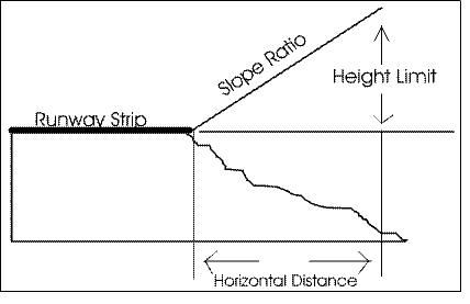
Slope Ratio
Airport transitional zone: Height limits for an airport transitional zone shall be determined by measuring outward and upward at a 7:1 slope from the sides of and at the same elevation as the approach surface, and extending to the point of intersection with a horizontal surface or conical surface.
Heliport transitional zone: Height limits for a heliport transitional zone shall be determined by measuring outward and upward at a 2:1 slope from the sides of and at the same elevation as the approach surface and extending a distance of 250 feet measured horizontally from and at 90 degree angles to the heliport approach zone centerline.
Horizontal zone: Height limits in the Horizontal Zone are established at 150 feet above airport elevation.
Conical zone: Height limits in the conical zone are established by measuring from the periphery of the horizontal zone and at 150 feet above elevation outward and upward at a 20:1 slope to a height of 350 feet above airport elevation.
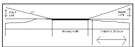
Height Limit
(Ord. No. 33-2006/07, § 2.8-3, 6-7-07)
Sec. 30-69. - Noise restrictions.
Noise restrictions shall apply within the approach zone of a precision instrument runway only. Private airports and all runways designed for other than precision instrument landings shall be exempt from the provisions of this section.
Where permitted within the approach zone of an airport district, residential dwellings and portions of buildings where the public will be received, shall be structurally designed and constructed to achieve an outdoor to indoor peak noise level reduction (NLR) of at least 30 db (decibels). All other permitted uses and structures shall be exempt from this section.
Normal construction can be expected to provide an NLR of 20 db, thus the actual required reduction is only 10 db. Lowering the NLR shall be achieved through incorporation into the design and construction of all proposed uses, sound insulation materials and methods for improving acoustic insulation performance.
A description of such methods and materials shall accompany all building applications for uses affected by this section, and shall be subject to approval by the building official prior to the issuance of a building permit.
(Ord. No. 33-2006/07, § 2.8-4, 6-7-07)
Sec. 30-70. - Lighting regulations.
No permitted use, subdivision, or project in an airport district shall have outdoor lighting or illumination arranged and/or operated in such a manner as to be misleading or pose a danger to aircraft operations.
(Ord. No. 33-2006/07, § 2.8-5, 6-7-07)
Sec. 30-71. - Regulations applicable to existing structures.
The owner of any existing structure or vegetation that is currently penetrating any referenced surface within an established airport district shall permit the installation, operation, and maintenance thereon of whatever markers and lights deemed necessary by the Federal Aviation Administration, or the South Carolina Aeronautics Commission to indicate to the operators of aircraft in the vicinity of an airport the presence of an airport obstruction. These markers and lights shall be installed, operated, and maintained at the expense of the airport operator.
However, the regulations prescribed in this section shall not be construed to require the removal, lowering, or other change or alteration of any existing structure or tree not conforming to the regulations as of the effective date of this chapter, or otherwise interfere with the continuance of an existing use. Nothing contained herein shall require any change in the construction, alteration, or intended use of any structure, the construction or alternation of which was begun prior to the effective date of this chapter, and is diligently prosecuted.
(Ord. No. 33-2006/07, § 2.8-6, 6-7-07)
Sec. 30-72. - Variances.
Any person desiring to erect or increase the height or size of any structure not in accordance with the regulations prescribed in this section may apply for a variance from such regulations to the zoning board of appeals, in accord with the provisions of article IX. The application for a variance shall be accompanied by a determination from the Federal Aviation Administration as to the effect of the proposal on the operation of air navigation facilities and the safe, efficient use of navigable airspace.
Additionally, no application for a variance to the requirements of this chapter may be considered by the board unless a copy of the application has been furnished to the airport operator for advice as to the aeronautical effects of the variance. If the airport operator does not respond to the application within 15 days after receipt, the board may act on its own to grant or deny the application for a variance.
Any permit or variance granted, if such action is deemed advisable to effectuate the purpose of this chapter and be reasonable in the circumstances, may be so conditioned as to require the owner of the structure in question to install, operate, and maintain at the owner's expense, such markings and lights as may be deemed necessary by the Federal Aviation Administration, the South Carolina Aeronautics Commission, and the airport operator.
(Ord. No. 33-2006/07, § 2.8-7, 6-7-07)
Sec. 30-76. - Definition and purpose.
A riparian buffer is an area of trees, shrubs, and other vegetation that borders an existing watercourse, wetland, or other water body (including open stormwater conveyances), for the purpose of reducing contamination from surface water runoff. Riparian buffers apply in all zoning districts, and must be maintained in the areas established below.
(Ord. No. 39-2006/07, § 1, 8-16-07)
Sec. 30-77. - Boundaries and specifications.
(a)
Riparian buffer requirements do not apply to wet ponds used as structural BMPs. However, ponds which intersect the stream channel shall have riparian buffer requirements.
(b)
The riparian buffer requirements associated with each type of water body are provided below:
(1)
Level I water bodies: Black Creek, Jeffries Creek, Middle Swamp, Lynches River, Sparrow Swamp, Lake Swamp, Alligator Branch, Beaverdam Creek, Polk Swamp, Middle Branch and Pye Branch.
A buffer must be maintained within the floodway, and 20 feet outside of the floodway, as delineated on the flood insurance rate map (FIRM), dated December 16, 2004. Developments, improvements, or other activities that disturb the land or degrade water quality are not allowed. Exceptions may be granted for water access (e.g., boardwalks, docks, etc.) or allowed by staff when disturbance is necessary to facilitate drainage in unusual circumstances.
The riparian buffers for level I water bodies are divided into the following zones:
Zone 1: A riparian buffer of at least 20 feet is required on each (outer) side of the floodway. This 20-foot outer offset area should consist of forest, small trees/shrubs, grassed area, walking paths, and other passive recreational uses.
Zone 2: A riparian buffer of at least 20 feet is also required on each (inner) side of the floodway, if available. Clear-cutting is not allowed within the 20-foot inner offset area. It should consist of naturally landscaped areas including canopy trees and small trees/shrubs.
Zone 3: All remaining areas within the established floodway shall be left undisturbed in perpetuity.
(2)
Level II water bodies: Natural creek or drainage feature with permanent flow.
A buffer of at least 30 feet on each side is required, measured from the edge of bank. Developments, improvements, or other activities that disturb the land or degrade water quality are not allowed. Exceptions may be granted for water access (e.g., boardwalks, docks, etc.) or allowed by staff when disturbance is necessary to facilitate drainage in unusual circumstances. The riparian buffers for level II water bodies are divided into the following zones:
Zone 1: The outer 20 feet should consist of forest, small trees/shrubs, grassed area, walking paths, and other passive recreational uses.
Zone 2: The inner 10 feet shall not be clear-cut and shall be left undisturbed in perpetuity.
(3)
Level III water bodies: (Other tributaries, outfalls, and open drainage conveyances).
A buffer of at least ten feet is required on each side, measured from the top edge of existing bank. Developments, improvements, or other activities that disturb the land or degrade water quality are not allowed. This buffer may consist of forested area, small trees/shrubs, or grasses. Exceptions may be granted by staff when disturbance is necessary to facilitate drainage in unusual circumstances.
(Ord. No. 39-2006/07, § 1, 8-16-07)
Sec. 30-78. - Permitted and prohibited uses.
Riparian buffers may count towards buffer yard and open space requirements located elsewhere in this chapter.
(Ord. No. 39-2006/07, § 1, 8-16-07)
Sec. 30-79.1. - Effect of corridor overlay zoning; relationship to plans and policies.
(a)
Effect. The corridor overlay zoning district regulations of this division apply in addition to underlying (base) zoning district regulations to impose specific development regulations for properties within the corridor district. Wherever the regulations of this division and other regulations contained within chapter 30 conflict, the regulations of this division shall control.
(b)
Relationship to plans and policies. In addition to all other stated purposes, individually and collectively the corridor overlay zoning district is intended to advance the purposes of the comprehensive plan, corridor plans, landscape/streetscape plans and strategies, and similar policies adopted by the county.
(Ord. No. 21-2023/24, § 1, 1-18-24; Ord. No. 77-2023/24, § 1, 8-15-24)
Sec. 30-79.2. - Uses.
(a)
Uses permitted. Unless prohibited as listed in this division, all uses permitted within the underlying district are permitted in the corridor overlay in the same manner and with the same restrictions provided they meet all the requirements of this division and any additional conditions as listed.
(b)
Additional conditions. The following additional conditions must be met for the listed uses.
(1)
Communication towers and antennas. Towers and freestanding antennas are prohibited within 100 feet of the corridor roadway unless the bottom 35 feet of such tower or antenna is screened from view by buildings located on the site.
(2)
Exterior sales and displays. All exterior sales and displays must be at or behind the front building line and must be screened from public view and adjacent neighbors. Exterior sales and displays with approved screening shall not be limited in size, but must comply with all other applicable zoning standards. Except: All automobiles (passenger cars), commercial vehicles, campers, RVs, boats, farm equipment, and construction equipment are exempt from location and screening requirements given the following conditions are met:
a.
No displays are allowed in the buffer areas.
b.
New automobile sales located in front of the building line must be assembled in parallel rows (singular or head-to-head) with no less than 18-foot drive lanes in between the rows. Parking requirements of section 30-79.7(c) shall still apply.
c.
Display areas for all other new permissible uses shall be allowed in the front of the building line parking area. When the display area is not designed for automobile parking the following formula shall be used to determine the area allowed for display: (Building Square Footage / Off Street Parking Requirements) × 345.6 = Allowable Square Footage of Display Area.
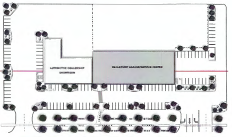
Figure 1. Example layout of automotive dealership inventory display area/parking area
layout.
(c)
Uses prohibited. The following uses are expressly prohibited within the corridor.
(1)
Storage and stockpiling of sand, gravel, or other aggregates.
(2)
Unscreened outdoor storage.
(3)
Sexually oriented businesses.
(4)
Unscreened vehicular storage not associated with vehicle sales including, but not limited to, automobiles, trucks, construction equipment, boats, and RVs.
(5)
Above-ground fuel storage intended for retail or wholesale.
(6)
Outdoor shooting and target ranges for firearms, archery, and similar activities.
(7)
Warehousing and storage facilities.
(8)
Manufactured home and storage building sales lots.
(9)
Outside storage or sales of playground equipment.
(Ord. No. 21-2023/24, § 1, 1-18-24; Ord. No. 77-2023/24, § 1, 8-15-24)
Sec. 30-79.3. - Building and structure design.
(a)
Materials. Unfinished concrete block masonry and plain corrugated/sheet metal (sinewave) shall be prohibited on all exterior building faces. B-deck, box rib, and similar decorative styles of corrugated sheet metal are acceptable except that such facing shall be for accent only in residential and mixed-use districts.

Figure 2. Finished concrete block is acceptable.

Figure 3. Unfinished block is not acceptable.

Figure 4. Decorative styles of sheet metal, such as box rib, are acceptable.
![]()
Figure 5. Plain corrugated metal (sinewave) is not acceptable.
Photos: corrugated-metals.com
(b)
Color.
(1)
All colors used on buildings and structures must be subtle, neutral, or earth tone or otherwise relate to appropriate historic building colors found within the county. Luminescent, sparkling, reflective, fluorescent, and intense colors are prohibited.
(2)
Color schemes should be simple and coordinated over an entire building to establish a sense of overall composition.
(3)
Metals must be brushed finish or painted in muted tones to minimize glare. Gutters and downspouts must be of a color that matches or complements the color scheme of the structure.
(4)
The colors used on structures within a development site must be coordinated and similar or complementary to each other.
(c)
Orientation. All buildings fronting the corridor roadway shall be oriented so that the primary building facade faces that roadway.
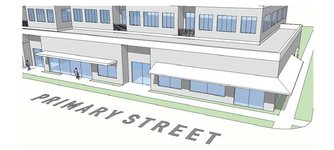
Figure 6. Primary building facades shall face the roadway.
(1)
Buildings within concentrated developments such as a residential or commercial subdivisions or retail/business centers may be exempt from facing the corridor roadway given the following criteria are met:
a.
The development is accessed from a side-street or all properties share a common ingress/egress drive.
b.
Ground or wall mounted utility, mechanical and other support systems (such as garbage dumpsters and mail kiosk) shall be adequately screened so that they are not visible from the corridor.
c.
In commercial developments, not less than two primary buildings shall be perpendicular to each other and face inwards towards shared common parking and open activity spaces.
d.
In addition to the requirements of section 30-79.5, additional buffering shall be applied in concentrated developments where the building's rear or side faces the corridor roadway and side streets, and those roadway facing facades do not have the appearance of a main entrance. This buffer shall be required around the perimeter of the development in the affected area and shall comply with the five-foot requirement of bufferyard A as defined in section 30-121. In the event that section 30-121 requires a more stringent buffer based on the proposed use than the one required by this section, the more stringent requirement shall be met. In all cases, the bufferyard shall not be less than 15 feet wide and shall be located not more than 35 feet from the wall of the building. Planning staff may approve an additional ten-foot separation when necessary for utility and delivery point parking.
e.
Interior buffers shall be required between dissimilar uses within the development.
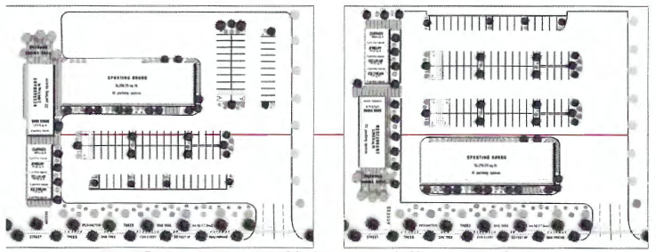
Figure 7. Two examples of a commercial development primary building layout/shared
parking area design.
(d)
Access. All buildings fronting the primary public roadway shall be designed with a minimum of one pedestrian access point facing that roadway.
(e)
Front stoops and porches. Front stoops and porches shall have a minimum depth of six feet. Stoops and porches may encroach into a front setback a maximum of six feet but shall not be less than five feet from any property line and must meet the floodplain requirements.
(f)
Fuel dispensing station. Fuel dispensing stations and related canopies must occur in the side yard, at or behind the building line.
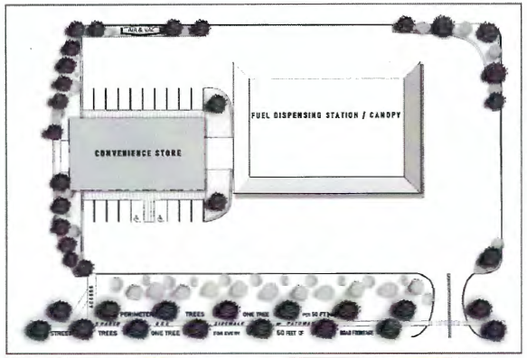
Figure 8. Example of fuel dispensing station/canopy/parking area layout.
(g)
Fences. With the exception of what is required for buffering, all opaque fences should be at or behind the primary building line.
(h)
Accessory buildings. Accessory buildings and storage units shall be located at or behind the primary building line. In concentrated developments such structures shall not be located between the principle buildings and the corridor.
(Ord. No. 21-2023/24, § 1, 1-18-24; Ord. No. 77-2023/24, § 1, 8-15-24)
Sec. 30-79.4. - Mechanical and utility equipment.
(a)
Location of mechanical equipment. Mechanical equipment shall be located on the side, rear, or roof of buildings fronting the corridor roadway. Rooftop equipment shall be screened from view from the roadway.
(b)
Distributed energy equipment. Equipment related to onsite energy generation is permitted only as an attached, integral element of a building or screened by or within a decorative structure. Freestanding equipment and large-scale energy generation is not permitted.
(c)
Utility lines. All utility lines such as electric, water, sewer, stormwater, fiber, telephone, and cable providing onsite services shall be located underground.
(Ord. No. 21-2023/24, § 1, 1-18-24; Ord. No. 77-2023/24, § 1, 8-15-24)
Sec. 30-79.5. - Landscape design.
(a)
Perimeter parking lot landscaping. Landscaped areas shall be provided to provide visual and climatic relief from broad expanses of pavement and to define logical areas for pedestrian and vehicular circulation.
(1)
A landscape buffer shall be provided between adjacent street right-of-way and parking lot with a minimum of six feet in width and one canopy tree at a maximum of 50-foot spacing.
(2)
Canopy trees shall be a minimum size of three-inch caliper.
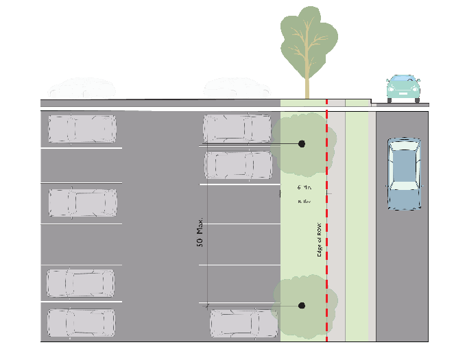
Figure 9. Perimeter parking lot landscaping.
(b)
Interior parking lot landscaping.
(1)
Landscaping within parking areas shall be equal to a minimum of ten percent of the total paved parking area.
(2)
Each landscaped area shall be a minimum of 100 square feet.
(3)
Within the interior, landscape islands shall be provided for any open vehicular use area containing ten or more parking spaces. As an alternative, landscaped six feet wide center medians located between all linear rows of parking facing head-to-head may be provided with one canopy tree located every 50 linear feet of median.
a.
The landscape islands shall be a minimum of six feet wide and include one canopy tree. Canopy trees should be of a species that will not be hindered by or cause significant damage to adjacent concrete, curbing and or asphalt.
(4)
A landscaped island (singular or head-to-head) shall be required at the ends of each row of parking spaces.
(5)
One canopy tree shall be required for each 200 square feet of required landscaping and at least one canopy tree per landscaped area.
(6)
Canopy trees shall be a minimum size of three-inch caliper.
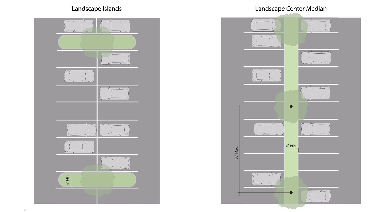
Figure 10. Interior parking lot landscaping.
(c)
Street trees. Street trees shall be provided to enhance the appearance and viability of the community.
(1)
Trees shall be provided within a landscaped buffer area between the back of curb or edge of pavement of the corridor roadway and sidewalk or shared-use pathway. The landscaped buffer area shall be not less than five feet in width. Where a five-foot landscaped buffer area is not possible, applicant may work with staff to determine a feasible alternative.
(2)
Trees shall be at a minimum of one canopy tree for each 50 feet of road frontage, planted on-center.
(3)
These canopy trees are to be a minimum of 14 feet in height, shall be a minimum of three-inch caliper, and with a minimum six-foot clear trunk, at planting.
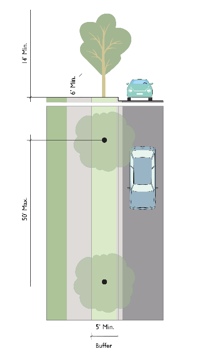
Figure 11. Street trees.
(Ord. No. 21-2023/24, § 1, 1-18-24; Ord. No. 77-2023/24, § 1, 8-15-24)
Sec. 30-79.6. - Lighting design.
(a)
Trespass and glare. All lighting shall be from a concealed source as viewed from a public roadway and oriented to prevent light trespass and glare.
(b)
Impact on residential parcels. Lighting adjacent to an offsite residential area shall be directed away from residences and residentially zoned lots.
(Ord. No. 21-2023/24, § 1, 1-18-24; Ord. No. 77-2023/24, § 1, 8-15-24)
Sec. 30-79.7. - Parking and loading design.
(a)
Number of parking spaces. Requirements for the minimum number of parking spaces shall comply with the base zoning district.
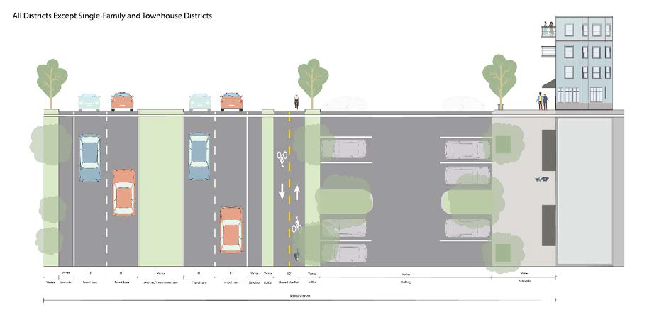
Figure 12. Single row of parking along corridor frontage.
(b)
Location of parking spaces. Parking shall be distributed on not less than two sides of the building's exterior. Parking that fronts the main building's front entrance (in front of the building line) shall not exceed 60 percent of the required parking total or 300 parking spaces, whichever is less. The remainder may be placed on the side, behind the main building's front building line or at the rear of the building. However, no parking shall occur between the side or rear of a building and the corridor roadway. All parking must occur in approved parking spaces.
(c)
On-street parking. On-street parking is allowed and encouraged along all local roads except that certain sections of roadway may be required by the zoning administrator to be marked as no parking to ensure public safety. Curb bulb-outs shall be provided at intersections to cap rows of on-street parking.
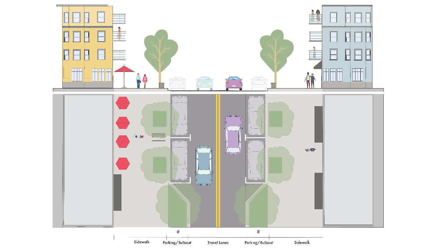
Figure 13. On-street parking with bulb-outs.
(d)
Shared parking. Shared parking between multiple uses on a site and between development sites within 500 feet of one another is encouraged. Any off-site parking to be used shall require the recording of a perpetual easement prior to occupancy in the office of the clerk of court of Florence County, the form and substance of which must be approved by the zoning administrator.
(e)
Loading area location. Loading areas shall be in approved loading areas and screened from the corridor roadway.
(f)
Surface parking materials. Unless otherwise permitted in this section, parking spaces, drives and aisles shall be constructed of either concrete, asphalt, or concrete pavers, of permeable or impermeable construction. Base material and pavement structure must be suitable for the traffic anticipated to utilize the facility, including emergency vehicles, garbage trucks, and delivery trucks.
(Ord. No. 21-2023/24, § 1, 1-18-24; Ord. No. 77-2023/24, § 1, 8-15-24; Ord. No. 34-2024/25, § 1, 10-17-24)
Sec. 30-79.8. - Motorized and non-motorized cross access and driveway connections.
(a)
Cross-access facilities. New commercial developments and substantial improvements to existing commercial developments shall provide for pedestrian and automobile access connection between adjacent commercial properties.
(b)
Onsite connections. Pedestrian and bicycle access is required between offsite planned or existing non-motorized facilities (e.g., sidewalks, multi-use paths, greenways) and onsite building entrances.
(c)
Offsite facility construction. Where offsite non-motorized facilities are proposed within the corridor by approved plans, or the development site abuts an existing facility, each development must construct or extend such facilities along the length of their site consistent with the adopted plan and construction detail.
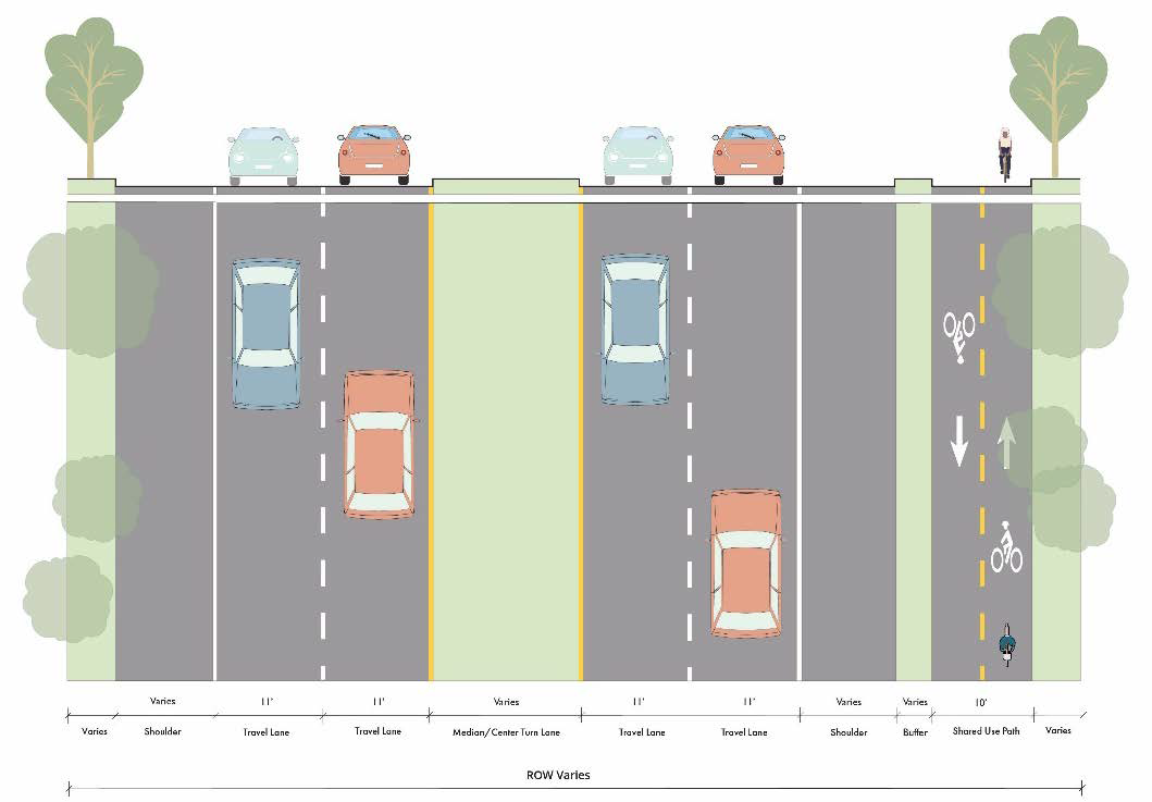
Figure 14. Where non-motorized facilities, such as side paths, are planned with the
corridor, each development must construct such facilities.
(d)
Safe access. Walkways and bikeways must be designed, located, and signed in a way that ensures safe access across the development site and all ANSI 117.1 access requirements are met.
(Ord. No. 21-2023/24, § 1, 1-18-24; Ord. No. 77-2023/24, § 1, 8-15-24)
Sec. 30-79.9. - Curb cut restrictions.
(a)
Number restricted.
(1)
New development. All parcels in a corridor overlay are allowed one curb cut per 250 feet of road frontage, except for single-family detached residentially zoned parcels and parcels containing single-family detached residential uses on local roads which shall be permitted one access regardless of frontage length.
(2)
Redevelopment of existing lots. Where curb cuts for existing parcels do not meet the standard specified in this section, redevelopment of such parcels shall include a plan for curb cut consolidation and relocation consistent with this section.
(b)
Plan required. As a condition of application approval for a rezoning or for a zoning permit to allow a use other than construction on a single-family residential lot without alternate access, a suitable access management plan must be submitted demonstrating that the 250-foot driveway separation requirement can be met. The following techniques may be employed to achieve this result, but the burden of accomplishing the desired effect remains with the applicant:
(1)
Aggregation of parcels.
(2)
Construction of a parallel frontage road or drive.
(3)
Shared access.
(c)
Shared access. Shared access (driveway) is encouraged. To approve a plan for shared access, a legally binding and recorded shared access agreement must be submitted to the zoning administrator prior to permit approval. Recording shall be with the Clerk of Court of Florence County.
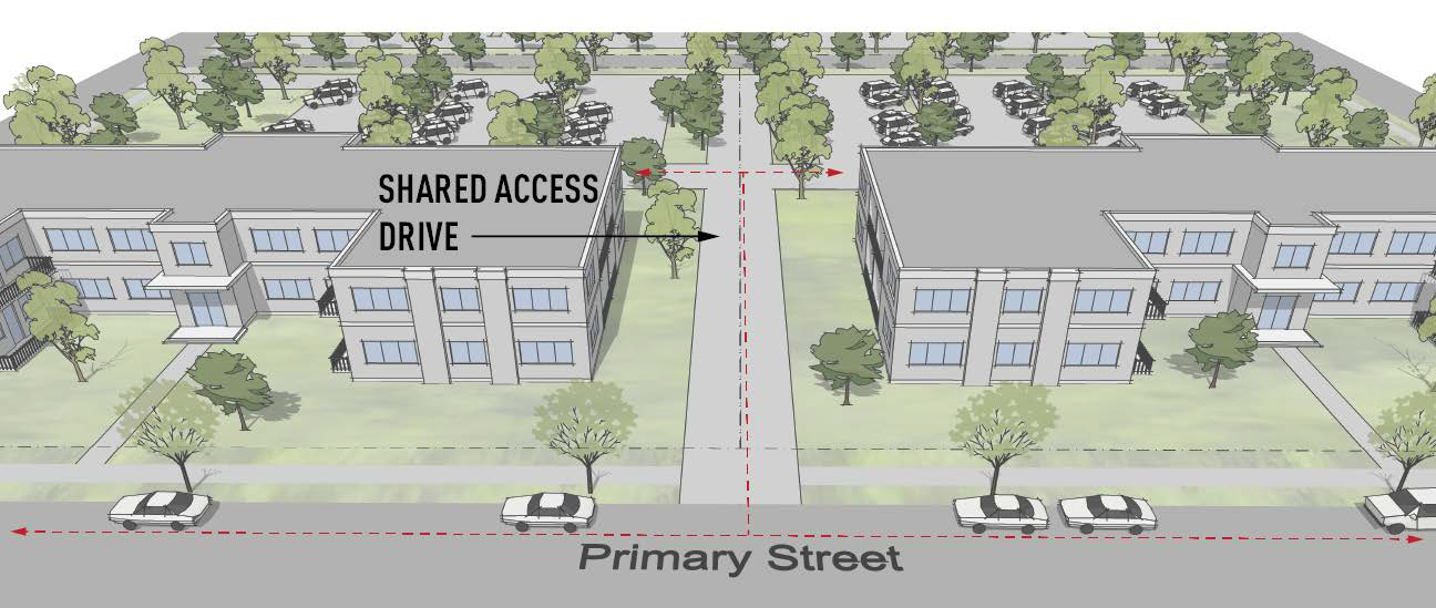
Figure 15. Shared access drive.
(d)
New roads. New roads shall meet all applicable standards of Florence County's development standards in addition to the following standards.
(1)
Stub outs required. New roads shall be stubbed out to adjacent parcels for future continuation. Adequate turn-around space meeting the county's road requirements shall be incorporated into the end of each stub that is longer than 150 feet.
(2)
Alley access encouraged. Alley access for new residential and mixed-use subdivisions is encouraged.
(e)
Waiver. The applicant may receive a waiver of the curb cut distance requirement from the zoning board of appeals (BZA) if:
(1)
Florence County determines that items (1) and (2) listed in subsection (b) above are impracticable, and
(2)
The applicant demonstrates to the satisfaction of the BZA that:
a.
The applicant tried in good faith to obtain a shared access agreement without success, or
b.
The nature of the zoning, use, or development pattern on adjoining lots is incompatible with the proposed use of the subject property. For example, it would be incompatible for a residential use to share access with a commercial or industrial use unless it is part of a mixed-use development project.
(f)
Distance from intersection. The minimum distance from a street intersection for a new residential or commercial use curb cut shall be 200 feet on arterial roads, 75 feet on collector roads, and 50 feet on local roads, measured from the edge of the intersecting roadway to the edge of the driveway radius. These minimum spacing requirements will be increased if a right-turn deceleration lane is required and shall equal the length of the turn lane and taper plus an additional distance of 50 feet.
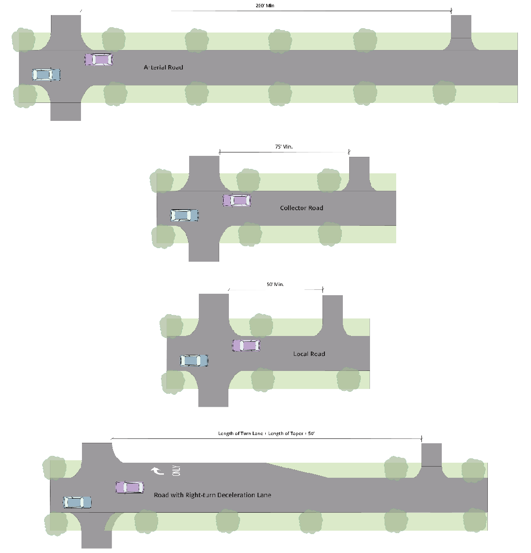
Figure 16. Minimum distances between an intersection and curb cut.
(g)
Road classification and access. Residential parcels with frontage along two or more roads shall obtain access from the road with the lowest functional classification. The zoning administrator may require or prohibit secondary access via an adjacent street on corner lots being developed for mixed-use, multifamily, or non-residential purposes depending on anticipated impacts and road capacity.
(Ord. No. 21-2023/24, § 1, 1-18-24; Ord. No. 77-2023/24, § 1, 8-15-24)
Sec. 30-79.10. - Sign restrictions.
(a)
Applicability. The following restrictions shall apply to all signs located on private property visible from a public roadway and non-motorized facilities.
(b)
Freestanding signs.
(1)
Only monument signs are permitted.
(2)
A maximum of one sign shall be permitted per road frontage per development site.
(3)
Signs shall not exceed 50 square feet per sign face.
(4)
A maximum of two sign faces are permitted per sign structure.
(5)
Signs, including the structure on which they are located, shall not exceed ten feet in height.
(6)
Signs shall be set back a minimum often feet from the edge of right-of-way.
(7)
Only internal illumination of sign faces and structures is permitted.
(8)
Signs shall be designed and located so they do not interfere with the safe movement of motorized and non-motorized traffic.
Any other standard as listed in article V not covered by this subsection shall be applicable to freestanding signs.
(c)
Wall signs. The maximum building coverage of wall signs for non-residential and mixed-use buildings shall be limited to one square foot of signage per linear foot of non-residential building frontage up to a maximum of 100 square feet. All other requirements for wall signs as well as requirements for signage in residential districts shall meet the standards for signs as listed in article V.
(d)
Prohibited signs. The following sign types and sign elements shall be prohibited:
(1)
Flashing, blinking, strobing, spinning.
(2)
Audible components.
(3)
Portable signs.
(4)
Billboards.
(Ord. No. 21-2023/24, § 1, 1-18-24; Ord. No. 77-2023/24, § 1, 8-15-24)
Sec. 30-80.1. - Effect of townhouse and mixed-use districts; relationship to plans and policies.
(a)
Effect. Townhouse and mixed-use zoning district regulations as established in this division apply in addition to all other general zoning district regulations. Wherever the regulations of this division and other regulations contained within chapter 30 conflict, the regulations of this division shall control.
(b)
Relationship to plans and policies. In addition to all other stated purposes, individually and collectively townhouse and mixed-use zoning districts are intended to advance the purposes of the comprehensive plan, corridor plans, and similar policies adopted by the county.
(Ord. No. 21-2023/24, § 1, 1-18-24)
Sec. 30-80.2. - Uses permitted.
(a)
In general. The following schedule of permitted and conditional uses indicates uses that are permitted within the districts. Signs are permitted as primary and accessory uses provided they meet all the requirements of this division and, unless in conflict with this division, the requirements of article V.
(b)
Table interpretation. A "P" indicates the use is permitted in the indicated district, provided it complies fully with all applicable development standards of this chapter. A "C" indicates the use is conditional and must meet additional conditions as outlined in this division. An "SE" indicates the use is a special exception subject to additional use conditions outlined in this division as well as general conditions and procedural requirements as detailed in article IX of this chapter. Where the letter "N" is shown, the use to which it refers is not permitted in the indicated district. Where a given use or NAICS reference is not listed in this table, said use shall not be permitted.
(c)
Table XI: Schedule of Permitted and Conditional Uses and Off-Street Parking Requirements.
(Ord. No. 21-2023/24, § 1, 1-18-24; Ord. No. 49-2023/24, § 1, 4-18-224; Ord. No. 50-2023/24, § 1, 4-18-24; Ord. No. 57-2023/24, § 1, 5-16-24; Ord. No. 34-2024/25, § 1, 10-17-24; Ord. No. 54-2024/25, § 1, 12-12-24)
Sec. 30-80.3. - Uses prohibited.
The following uses are prohibited within the mixed-use and townhouse districts, excluding FO/LI district:
(a)
Storage and stockpiling of sand, gravel, or other aggregates.
(b)
Unscreened outdoor storage.
(c)
Sexually oriented businesses.
(d)
Unscreened vehicular storage not associated with vehicle sales including, but not limited to, automobiles, trucks, construction equipment, boats, and RVs.
(e)
Above-ground fuel storage intended for retail or wholesale.
(f)
Outdoor shooting and target ranges for firearms, archery, and similar activities.
(g)
Warehousing and storage facilities except for storage that is customary to a residential use.
(Ord. No. 21-2023/24, § 1, 1-18-24; Ord. No. 58-2023/24, § 1, 5-16-24)
Sec. 30-80.4. - Conditional use regulations.
The regulations contained within this section are intended to accomplish the same purposes as stated in article III. Where a conditional use is listed within this division, and such use is regulated by article III, the use shall meet the requirements of that division except for conditions expressly covered below and dimensional standards covered in this division.
(a)
Automotive parking lots and garages.
(1)
Parking lots and garages may not be located along a public street unless designed with street-facing street-level residential, retail, or office space. This restriction does not apply to parking garages associated with single-family, duplex, triplex, quadraplex, or townhouses developments.
(2)
Parking garages associated with single-family, duplex, triplex, quadraplex, or townhouse developments must be located no closer to a public street than the front building line of the primary dwelling structure.
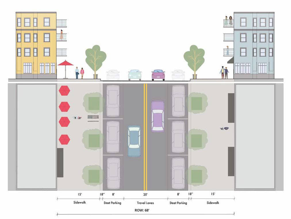
Figure 17. Mixed-use on-street parking on primary streets.
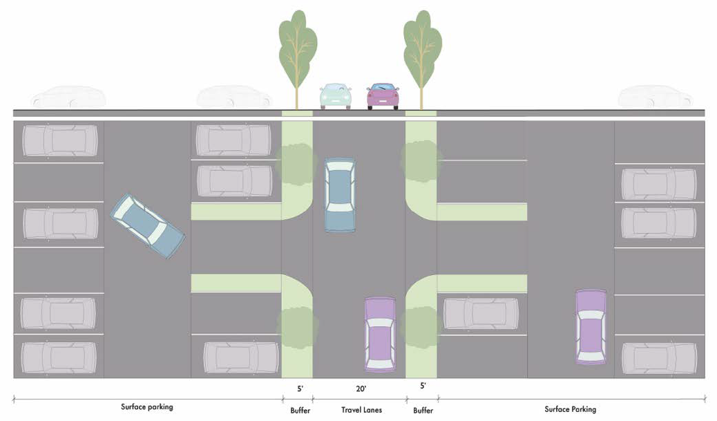
Figure 18. Mixed-use/multifamily parking lots on secondary streets.
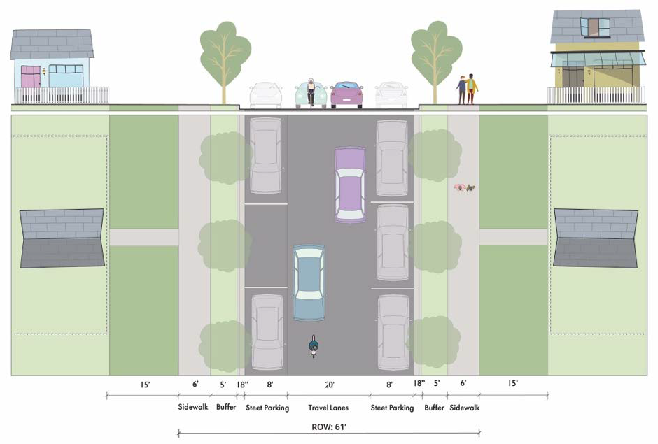
Figure 19. Single-family residential on-street parking.
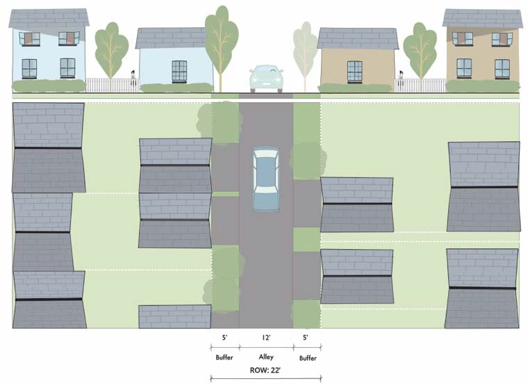
Figure 20. Single-family residential alleyway.
(b)
Residential uses. All residential conditional uses shall comply with the following requirements as noted.
(1)
In mixed-residential, mixed-use, and townhouse districts and on infill lots in existing residential neighborhoods, new multi-dwelling-unit residential buildings shall be designed to mimic single-family detached residential buildings to the maximum extent practicable with regards to building design, roof pitch, driveway and garage design and location, porches, and sidewalks.
(2)
Site designs shall create a sense of "neighborhood" and shall meet all the following requirements.
a.
Buildings shall be sited with front entrances and porches oriented toward streets, drives, and plazas, rather than parking lots.
b.
An internal vehicular circulation system for private streets, when included, shall be reflective of a single-family residential street system.
c.
Walkways shall connect all buildings with parking areas, play areas, clubhouses, and existing public sidewalks and multi-use paths adjacent to the development site.
d.
Plazas, clubhouses, pools, and recreational facilities shall be centrally located, when provided.
(c)
Museums, historical sites, and similar institutions. Museums, interpretive centers, and similar institutions located apart from a historic building that is the primary subject of such institution shall not be permitted in a residential district.
(d)
Transit and ground passenger transportation. This use shall be limited to public transit stops and private transportation services within residential districts.
(e)
Support activities for transportation. This use shall not include motor vehicle towing and stockyards.
(f)
Nursing and residential care facilities.
(1)
Driveway access to accessory structures shall be through the main entrance to the facility.
(2)
No single building shall be greater than 40,000 square feet if located within 500 feet, as measured in any direction from the nearest point, to a lot line of an adjacent residentially zoned lot.
(g)
Energy substations. Substations shall not be placed along road frontages.
(h)
Automotive fuel stations.
(1)
Fuel stations must locate pumps to the side or rear of buildings.
(2)
Fuel stations in the MMF, TH, and FO/LI are limited to electric vehicle charging as an accessory use.
(i)
Flea markets.
(1)
Flea markets must be designed to visually integrate buildings and outdoor spaces.
(2)
Indoor and outdoor sales are permitted; however, outdoor vending must be clearly delineated and separated from parking areas.
(3)
Areas for food trucks must be visually and functionally integrated into outdoor vending areas and shall not be located or operated in a manner that interferes with the safe movement of motorized and non-motorized vehicles and pedestrians.
(4)
All outdoor spaces shall be adequately lighted for nighttime use.
(5)
Paved walkways are required between buildings and outdoor vending spaces.
(6)
All exterior property and premises shall be maintained in a clean, safe, and sanitary condition.
(7)
Parking areas must be paved and marked.
(8)
At least one common area shall be provided with facilities for sitting/resting, eating, and social interaction. If located outdoors, shade structures, trees, or a combination of both shall be provided.
(9)
Goods and products must not be stored outside of the site's primary or secondary structure during non-business hours.
(10)
In addition to meeting all of the above requirements, flea markets must be granted a special exception by the board of zoning appeals prior to a certificate of zoning compliance being issued.

(j)
Manufacturing uses. The intent of this use group is to accommodate light industrial uses and maker spaces (i.e., arts and crafts that commonly involve a manufacturing component) suitable for a mixed industrial and office context. All uses identified as manufacturing uses in this division are permitted only if all the following conditions are met. Individual uses may contain a manufacturing and retail component.
(1)
All uses are located wholly within a building.
(2)
Uses have little, if any, impacts beyond the shared walls of the building in which they are located or beyond the property line where walls are not shared. This includes light, noise, vibration, odor, heat, dust, and similar impacts.
(Ord. No. 21-2023/24, § 1, 1-18-24)
Sec. 30-80.5. - Dimensional standards.
(a)
Building placement. All buildings shall meet the requirements noted below.
* At least 80 percent of the building's front wall must meet the maximum build-to line. The remaining 20 percent may be located further from the right-of-way if it is dedicated to covered dining or courtyard entrances or another use approved by the planning commission. Minor offsets and similar features that add interest and articulation but do not disrupt the overall building plane are permitted.
** Build-to zones and setbacks apply only to the exterior property boundary of the townhouse complex and not each individual townhouse.
*** At or behind the front building line.
**** The maximum setback limit may be exceeded only to allow for required buffers and parking allowances as defined in section 30-79.5, section 30-79.3(c)(1)d, section 30-80.6(B)(2), and section 30-121.
(b)
Building characteristics. All buildings shall meet the requirements noted below and additional standards as specified in this chapter except that buildings created solely for the purposes of housing a public utility substation or public water or sewer lift station shall be exempt from these requirements provided the use of the lot is restricted by deed to such purpose and acceptable access is provided (deeded or easement). The specifications on how to measure these characteristics shall be the same as noted in division 1.
* There is no maximum: provided side and rear setbacks are increased by one foot for each two feet in height over 35 feet and buildings are no taller than fire ladder capabilities as determined by the fire department with jurisdiction.
(c)
Lot characteristics. All lots shall meet the requirements noted below and additional standards as specified in this chapter except that lots created solely for the purposes of a public utility substation, public water or sewer lift station, or telecommunications tower shall be exempt from these requirements provided the use of the lot is restricted by deed to such purpose. The specifications on how to measure these characteristics shall be the same as noted in division 1.
* For the first dwelling. One thousand additional square feet per dwelling unit is required.
** Townhouse development sites will contain more than one townhouse lot. Minimum lot width shall only apply to the overall townhouse development site and not each individual lot.
*** Development sites may contain more than one parcel. All parcels within the development will be aggregated for this calculation. For example, a development site, regardless of the number of lots, that is 200 feet wide will require a minimum depth of 150 feet.
**** Minimum percentage is based on gross acreage of the development site.
(Ord. No. 21-2023/24, § 1, 1-18-24; Ord. No. 59-2023/24, § 1, 5-16-24; Ord. No. 20-2024/25, § 1, 9-19-24)
_;
Sec. 30-80.6. - Additional regulations applicable to all townhouse and mixed-use districts.
(a)
Building design.
(1)
Materials. Unfinished concrete masonry and corrugated/sheet metal shall be prohibited on all exterior building faces.
(2)
Orientation. All buildings shall be oriented so that the primary building facade faces the primary roadway or a road intersection except for cottage court developments where houses face an internal courtyard.
(3)
Grouping. Individual buildings on a development site in the MMF, MU, CMU, and FO/LI districts shall be arranged to create clusters or groups whenever practicable.
(4)
Entrances. All buildings shall be designed with a minimum of one pedestrian access point that faces the primary roadway.
(5)
Front stoops and porches. Front stoops and porches shall have a minimum depth of six feet. Stoops and porches may encroach into a front setback a maximum of six feet but shall not be less than five feet from any property line and must meet the floodplain requirements.
(b)
Parking.
(1)
Number. Uses shall be required to meet the parking standards as listed in section 30-80.2(c) Table XI.
(2)
Location. No more than one aisle of parking (two rows maximum) shall be permitted between a building and the roadway right-of-way except for the MR and TH districts. In the MR and TH districts, individual garages may not be closer than 20 feet from a road right-of-way. To preserve sidewalk continuity, alley-accessed parking is recommended for all TH development and MR lots less than 60 feet in width.
(3)
On-street parking. On-street parking is allowed along all local roads except that certain sections of roadway may be required by the zoning administrator to be marked as no parking to ensure public safety. Curb bulb-outs shall be provided at intersections to cap rows of on-street parking.
(4)
Shared parking. Shared parking between uses is encouraged.
(5)
Loading area location. Loading areas shall be screened from the corridor roadway.
(6)
Surface parking materials. Parking spaces, drives and aisles shall be constructed of either concrete, asphalt, or concrete pavers, of permeable or impermeable construction. Base material and pavement structure must be suitable for the traffic anticipated to utilize the facility, including emergency vehicles, garbage trucks, and delivery trucks.
(7)
Bicycle parking. Bicycle parking shall be provided for all districts except MR and TH at the ratio of one bicycle space per 20 car spaces provided, with a minimum of two spaces and a maximum of ten spaces per facility. All spaces shall be covered or provided indoors except spaces for commercial uses, which may be uncovered.
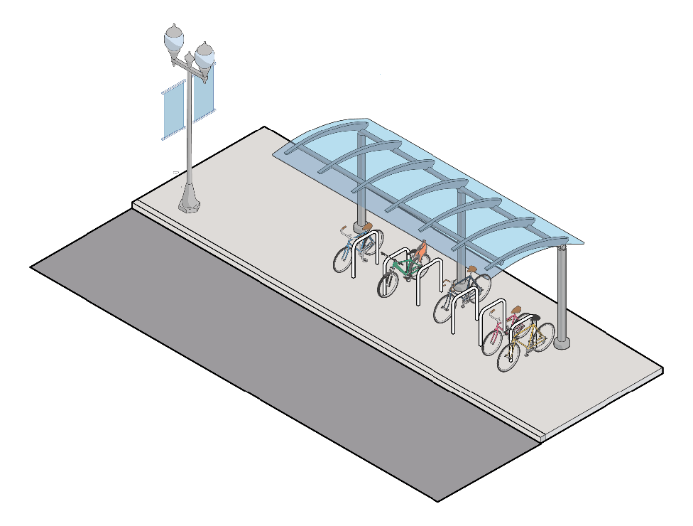
Figure 21. Bicycle parking.
(c)
Motorized and non-motorized cross access and driveway connections.
(1)
Cross-access facilities. Where cross-access facilities exist for vehicular or non-vehicular travel on adjacent lots, development sites must connect to such facilities. But on adjacent lots, development sites shall be designed to accommodate both vehicular and non-vehicular connections in the future. Site plans shall clearly indicate and mark the type and location of future access points.
(2)
Onsite connections. Pedestrian and bicycle access is required between offsite planned or existing non-motorized facilities (e.g., sidewalks, multi-use paths, greenways) and onsite building entrances.
(3)
Offsite facility construction. Where offsite non-motorized facilities are proposed by approved plans, or the development site abuts an existing facility, each development must construct or extend such facilities along the length of their site consistent with the adopted plan and construction detail.
(4)
Safe access. Walkways and bikeways must be designed, located, and signed in a way that ensures safe access across the development site, and all ANSI 117.1 access requirements are met.
(d)
Block length. Blocks shall not be less than 200 feet in length nor more than 600 feet.
(e)
Curb cut restrictions.
(1)
Number restricted.
a.
New development. All parcels are allowed one curb cut per 250 feet of road frontage, except for single-family detached residentially zoned parcels and parcels containing single-family detached residential uses which shall be permitted one access regardless of frontage length.
b.
Redevelopment of existing lots. Where curb cuts for existing parcels do not meet the standards specified in this section, redevelopment of such parcels shall include a plan for curb cut consolidation and relocation consistent with this section to the maximum extent practicable.
(2)
Width restricted.
a.
All single-family detached, duplex, triplex, quadraplex, and townhouse uses shall be limited to driveway widths of 20 feet or less.
b.
All other uses shall be limited to 24 feet unless the zoning administrator determines that traffic type (e.g., tractor-trailer trucks and heavy equipment) or need for multiple exit lanes require a greater width.
(3)
Plan required. As a condition of application approval for a rezoning for or for a zoning permit to allow a use other than construction on a single-family residential lot without alternate access, a suitable access management plan must be submitted demonstrating that the 250-foot driveway separation requirement can be met. The following techniques may be employed to achieve this result, but the burden of accomplishing the desired effect remains with the applicant:
a.
Aggregation of parcels.
b.
Construction of a parallel frontage road.
c.
Shared access.
(4)
Shared access. Shared access (driveway) is encouraged. To approve a plan for shared access, a legally binding and recorded shared access agreement must be submitted to the zoning administrator prior to permit approval.
(5)
New roads. New roads created within the corridor shall meet county road standards.
(6)
Stub outs required. New roads shall be stubbed out to adjacent parcels for future continuation. Adequate turn-around space meeting the county's road requirements shall be incorporated into the end of each stub that is longer than 150 feet.
(7)
Alley access encouraged. Alley access for new residential and mixed-use subdivisions is encouraged.
(8)
Waiver. The applicant may receive a waiver of the curb cut distance requirement from the zoning board of appeals (BZA) if:
a.
Florence County determines that items (1) and (2) listed in subsection (b) above are impracticable, and
b.
The applicant demonstrates to the satisfaction of the BZA that:
i.
The applicant tried in good faith to obtain a shared access agreement without success, or
ii.
The nature of the zoning, use, or development pattern on adjoining lots is incompatible with the proposed use of the subject property. For example, it would be incompatible for a residential use to share access with a commercial or industrial use unless it is part of a mixed-use development project.
(9)
Distance from intersection. The minimum distance from a street intersection for a new residential or commercial use curb cut shall be 200 feet on arterial roads, 75 feet on collector roads, and 50 feet on local roads, measured from the edge of the intersecting roadway to the edge of the driveway radius. These minimum spacing requirements will be increased if a right-turn deceleration lane is required and shall equal the length of the turn lane and taper plus an additional distance of 50 feet.
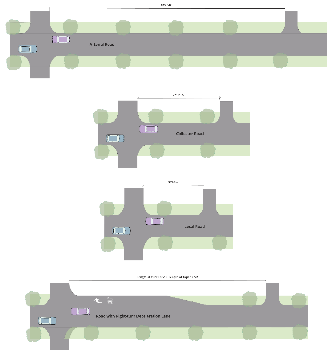
Figure 22. Minimum distances between an intersection and curb cut.
(10)
Road classification and access. Residential parcels with frontage along two or more roads shall obtain access from the road with the lowest functional classification. The county may require or prohibit secondary access via an adjacent street on corner lots being developed for mixed-use, multifamily, or non-residential purposes depending on anticipated impacts and road capacity.
(f)
Screening and location of service and support areas and mechanical equipment.
(1)
Screening of rooftop equipment. All equipment located on the roof of a mixed-use or non-residential building shall be screened by parapet walls or decorative features acceptable to the zoning administrator.
(2)
Location and screening of other mechanical equipment. Ground-mounted mechanical equipment and equipment that is mounted to the side of a structure shall be located on the side or rear of buildings. Equipment shall be screened from view from public roads and adjacent properties.
(3)
Utility lines. All utility lines such as electric, water, sewer, stormwater, fiber, telephone, and cable providing onsite services shall be located underground.
(g)
Stormwater detention, retention, and conveyances.
(1)
Curb and gutter required; exception. New roads and parking areas shall be designed to discharge stormwater into a curb and gutter system except that onsite bioretention areas, swales, rain gardens and similar low impact development techniques can be used to decrease discharge rates and allow for infiltration. Any net discharge from such treatment areas shall be directed to a curb and gutter system.
(2)
Detention/retention design. A stormwater detention or retention facility must be designed as a site amenity and, where possible, integrated into usable park space open to the public or a property owners association (POA). The applicant will be required to prove that a legally constituted POA has accepted ownership and maintenance responsibility prior to release of a certificate of occupancy.
(h)
Lighting design.
(1)
Trespass and glare. All lighting shall be from a concealed source as viewed from a public roadway and oriented to prevent light trespass and glare.
(2)
Impact on residential parcels. Lighting adjacent to an offsite residential area shall be directed away from residences and residentially zoned lots.
(i)
Sign restrictions.
(1)
Applicability. The following restrictions shall apply to all signs located on private property visible from a public roadway and non-motorized facilities.
(2)
Freestanding signs.
a.
A maximum of one sign shall be permitted per road frontage.
b.
Signs shall not exceed 50 square feet per sign face.
c.
A maximum of two sign faces are permitted per sign structure.
d.
Signs, including the structure on which they are located, shall not exceed 15 feet in height.
e.
Signs shall be set back a minimum of ten feet from the edge of right-of-way.
f.
Only internal illumination of sign faces and structures is permitted.
g.
Signs shall be designed and located so they do not interfere with the safe movement of motorized and non-motorized traffic.
h.
Any other standard as listed in article V not covered by this subsection shall be applicable to freestanding signs.
(3)
Wall signs. The maximum building coverage of wall signs for non-residential and mixed-use buildings shall be limited to one square foot of signage per linear foot of non-residential building frontage up to a maximum of 100 square feet. All other requirements for wall signs as well as requirements for signage in residential districts shall meet the standards for signs as listed in article V.
(4)
Prohibited signs. The following sign types and sign elements shall be prohibited:
a.
Flashing, blinking, strobing, spinning.
b.
Audible components.
c.
Portable signs.
d.
Billboards.
(Ord. No. 21-2023/24, § 1, 1-18-24; Ord. No. 34-2024/25, § 1, 10-17-24)
Sec. 30-80.7. - Regulations specific to the MR single-family residential district.
(a)
Signs. Signs in the MR district are subject to the same restrictions and allowances as specified in this chapter for residential districts.
(Ord. No. 21-2023/24, § 1, 1-18-24)
Sec. 30-80.8. - Regulations specific to the MMF mixed-multi-family residential district.
(a)
Signs. Signs in the MMF district are subject to the same restrictions and allowances as specified in this chapter for residential districts.
(Ord. No. 21-2023/24, § 1, 1-18-24)
Sec. 30-80.9. - Regulations specific to the TH townhouse residential district.
(a)
Signs. Signs in the TH district are subject to the same restrictions and allowances as specified in this chapter for residential districts.
(Ord. No. 21-2023/24, § 1, 1-18-24)
Sec. 30-80.10. - Regulations specific to the MU mixed-use district.
(a)
Signs. Signs in the MU district are subject to the same restrictions and allowances as specified in this chapter for the B-4 district.
(b)
Location of residential units. Other than townhouses, all residential units shall be located on the upper floors of mixed-use buildings.
(Ord. No. 21-2023/24, § 1, 1-18-24)
Sec. 30-80.11. - Regulations specific to the CMU commercial mixed-use district.
(a)
Signs. Signs in the CMU district are subject to the same restrictions and allowances as specified in this chapter for the B-4 district.
(b)
Location of residential units. All residential units shall be located on the upper floors of mixed-use buildings.
(Ord. No. 21-2023/24, § 1, 1-18-24)
Sec. 30-80.12. - Regulations specific to the FO/R flex office/retail district.
(a)
Signs. Signs in the FO/R district are subject to the same restrictions and allowances as specified in this chapter for the B-5 district.
(Ord. No. 21-2023/24, § 1, 1-18-24)