
Fontana On Geneva Lake
City Zoning Code
City Zoning Code
ARTICLE I
- INTRODUCTION AND DEFINITIONS
Sec. 18-1.- Title.
This chapter shall be known, cited, and referred to as the Village of Fontana-On-Geneva Lake Zoning Ordinance, except where as referred to herein, where it shall be known as "this chapter."
(Ord. No. 090412-02, § 1, 9-4-2012)
Sec. 18-2. - Authority.
This chapter is enacted pursuant to the authority granted by statutes of the State of Wisconsin. Specific statutory references are provided within the body of this chapter solely as a means of assisting the reader. Such references are not to be considered as all inclusive and shall in no manner be construed so as to limit the application or interpretation of this chapter.
(Ord. No. 090412-02, § 1, 9-4-2012)
State Law reference— Wis. Stats. §§ 62.23(7), 62.231, 87.30.
Sec. 18-3. - Purpose.
(a)
The overall purpose of this chapter is to implement the Village of Fontana Comprehensive Plan to the extent possible under zoning, as authorized by Wisconsin Statutes.
(b)
This chapter is designed to control and lessen congestion; and promote the safety and efficiency of the streets and highways; secure safety from fire, flooding, panic, and other dangers; provide adequate light, air, sanitation, and drainage; protect groundwater resources; prevent overcrowding of land; avoid undue population concentration; facilitate the adequate provision of public facilities and utilities; facilitate the use of solar devices and other innovative development techniques; stabilize and protect property values; preserve and protect burial sites; advance the appropriate use of land; conserve and restore natural resources and habitats; and preserve and promote the beauty of the community.
(c)
Specifically, this chapter is adopted for the purposes of protecting the health, safety, morals, comfort, convenience, and general welfare of the public and to preserve the character and protect the shores and waters of Geneva Lake. Additional purposes of this chapter are specified throughout this chapter.
(Ord. No. 090412-02, § 1, 9-4-2012)
Sec. 18-4. - Intent.
(a)
In consonance with the basic purpose stated in section 18-3, and to implement the same, this chapter is intended to provide a regulatory framework for land use within the village, which will aid in achieving a harmonious and compatible relationship between various land uses that is consistent with the rights of property ownership, the general public welfare, and the established goals for community development and character. To this intent, this chapter is designed to relate realistically to those physical, economic and environmental factors which would significantly influence the appropriate development and use of land and to provide maximum flexibility, adaptability, and responsiveness to changing physical and economic conditions and societal concerns.
(b)
The regulations of this chapter are designed to utilize performance standards wherever possible to evaluate the actual impact of uses or activities upon the community rather than to rely solely on preset and fixed formulae. Recognizing the unique character of the village resulting from its topography, its location on the shores of Geneva Lake, and its development as a predominantly residential, lake-oriented community, these regulations are also specifically designed to preserve this character, to protect the waters of Geneva Lake, and to effectively harmonize the rights and concerns of village residents with those of the general public attracted by the resort and recreational facilities on the lake.
(c)
In addition, the floodplain and the shoreland-wetland zoning regulations further the objectives of local, county, state and federal governments as set forth in detail articles VIII and IX of this chapter.
(Ord. No. 090412-02, § 1, 9-4-2012)
Sec. 18-5. - Separability and nonliability.
It is hereby declared to be the intention of the Village of Fontana Board of Trustees that the provisions of this chapter are separable in accordance with the following:
(1)
If any court of competent jurisdiction shall adjudge any provision of this chapter to be invalid, such judgment shall not affect any other provisions of this chapter not specifically included in said judgment.
(2)
If any court of competent jurisdiction shall adjudge invalid the application of any portion of this chapter to a particular property, water, building, or structure, such judgment shall not affect the application of said provision to any other property, water, building, or structure not specifically included in said judgment.
(3)
If any requirement or limitation attached to an authorization given under this chapter is found invalid, it shall be presumed that the authorization would not have been granted without the requirement or limitation and, therefore, said authorization shall also be invalid.
(4)
The village does not guarantee, warrant, or represent that only those areas designated as floodplain will be subject to periodic inundation and hereby asserts that there is no liability on the part of the village, its officers, employees, agents, or representatives for any flood damages, sanitation problems or structural damages.
(Ord. No. 090412-02, § 1, 9-4-2012)
Sec. 18-6. - Abrogation.
It is not intended that this chapter abrogate or interfere with any constitutionally protected vested right. It is also not intended that this chapter abrogate, repeal, annul, impair, or interfere with any existing easements, covenants, deed restrictions, agreements, rules, regulations, or permits previously adopted or issued pursuant to law; however, wherever this chapter imposes greater restrictions, the provisions of this chapter shall govern.
(Ord. No. 090412-02, § 1, 9-4-2012)
Sec. 18-7. - Rules of interpretation.
(a)
In their interpretation and application, the provisions of this chapter shall be held to be the minimum requirements for the promotion of the public health, safety, morals and welfare, and shall be liberally construed in favor of the village and shall not be construed to be a limitation or repeal of any other power now possessed by the Village of Fontana.
(b)
Where property is affected by the regulations imposed by any provision of this chapter and by other governmental regulations, the regulations which are more restrictive or which impose higher standards or requirements shall prevail. Regardless of any other provision of this chapter, no land shall be developed or used, and no structure erected or maintained, in violation of any state or federal regulations. Where there are conflicts between or among regulations within this chapter, the regulations which are more restrictive or which impose higher standards or requirements shall prevail. In all instances, where there are conflicts between the text of this chapter and any illustration, table or figure of this chapter, the text shall prevail.
(c)
No structure, land, water or air shall hereafter be used and no structure or part thereof shall hereafter be located, erected, moved, reconstructed, extended, enlarged, converted, or structurally altered without a building permit, except structures not requiring a building permit (e.g., swing set, clothesline, etc.), and without full compliance with the provisions of this chapter and all other applicable local, county and state regulations.
(d)
Nothing herein contained shall require any changes in plans, construction, size, or designated use of any building or part thereof for which a building permit has been issued before the effective date of this chapter, and the construction of which shall have been started within one year from the date of such permit.
(e)
Except as provided in this chapter, under provisions for nonconforming uses, nonconforming sites, substandard lots, and nonconforming structures and buildings (see article VI), no building, structure, development, or premises shall be hereinafter used or occupied, and no applicable permit granted, that does not conform to the requirements of this chapter. In cases of mixed-occupancy or mixed-use, the regulations for each land use shall apply to the portion of the structure or land so occupied or so used.
(f)
Except for outlots authorized under the village land division regulations to contain permanently protected green space area, no yard or other open space area shall be considered as providing a yard or open space for a building or structure on any other lot.
(g)
Articles VIII and IX of this chapter are comprised of the State of Wisconsin's Model Floodplain and Shoreland-Wetland Ordinances, and therefore, contain definitions which are specific to those respective articles and may be inconsistent with definitions found in section 18-13. Definitions provided in section 18-13 shall apply to this entire chapter except articles VIII and IX, and the definitions in articles VIII and IX shall only apply to those respective articles.
(Ord. No. 090412-02, § 1, 9-4-2012)
Sec. 18-8. - Jurisdiction.
Articles I through XV of this chapter are applicable to all territory located within the corporate limits of the Village of Fontana-on-Geneva Lake, hereinafter referred to as the Village of Fontana. Article XVI is applicable to all land within the village's extraterritorial zoning (ETZ) jurisdiction.
(Ord. No. 090412-02, § 1, 9-4-2012)
Sec. 18-9. - Re-enactment and repeal.
(a)
This chapter, in part, carries forward by re-enactment some of the provisions of the regulations governing zoning and related matters previously known collectively as the "zoning ordinance," chapter 18 of the Municipal Code for the Village of Fontana, adopted prior to the effective date of this chapter. It is not the intention of this chapter to repeal, but rather to re-enact and continue in force such existing provisions so that all rights and liabilities that have accrued thereunder are preserved and may be enforced, unless explicitly surrendered by specific provisions of this chapter or altered by the official zoning map.
(b)
All provisions of the predecessor zoning ordinance which are not re-enacted herein are hereby repealed.
(c)
The adoption of this chapter shall not adversely affect the village's right to prosecute any violation of the predecessor zoning ordinance, provided the violation occurred while that chapter was in effect.
(Ord. No. 090412-02, § 1, 9-4-2012)
Sec. 18-10. - Effective date.
This chapter shall become effective upon passage and posting according to law, following the date of repeal and re-enactment of the official zoning map. All plans approved under previous zoning regulations shall be valid and may be used to obtain permits for a period of not more than one year after the effective date of this chapter, except where subject to developer agreement provisions.
(Ord. No. 090412-02, § 1, 9-4-2012)
Sec. 18-11. - Word usage.
The interpretation of this chapter shall abide by the provisions and rules of this section, except where the context clearly requires otherwise, or where the result would clearly be inconsistent with the apparent intent of this chapter. If there is any conflict or ambiguity between the text of this chapter and any illustration, table, or figure, the text shall control.
(1)
Words used or defined in one tense or form shall include other tenses and derivative forms.
(2)
Words in the singular number shall include the plural number, and words in the plural number shall include the single number.
(3)
The masculine gender shall include the feminine, and vice versa.
(4)
The words "shall," "must," and "will" are mandatory.
(5)
The words "may," "can," and "might" are permissive.
(6)
The word "person" includes individuals, firms, corporations, partnerships, associations, trusts, and any other legal entity.
(7)
The words "village," "Fontana," or "Village of Fontana" shall mean the Village of Fontana-on-Geneva Lake, Wisconsin.
(8)
The word "county" shall mean the County of Walworth, Wisconsin.
(9)
The word "state" shall mean the State of Wisconsin.
(10)
The words "plan commission" shall mean the Village of Fontana Plan Commission.
(11)
The words "village board" shall refer to the Village of Fontana Board of Trustees.
(Ord. No. 090412-02, § 1, 9-4-2012)
Sec. 18-12. - Abbreviations.
The following abbreviations in this chapter are intended to have the following meanings:
(Ord. No. 090412-02, § 1, 9-4-2012; Ord. No. 071017-03, § 1, 7-10-2017)
Sec. 18-13. - Definitions.
The following words, terms and phrases, wherever they occur in this chapter, shall have the meaning ascribed to them by this section; provided, however, that those definitions set forth in section 18-549, herein, shall exclusively control with regard to any conflicting definitions between sections 18-13 and 18-549:
Abutting: Having a common border with, or being separated from, such common border by an alley or easement.
Access: A means of providing vehicular or nonvehicular egress from or ingress to a property, highway or private roadway.
Access, direct: A condition of immediate physical connection resulting from a highway, alley or private road abutting a property.
Accessory dwelling unit: See subsection 18-64(f).
Accessory structure or use: A detached or attached subordinate structure or a use which is clearly incidental to, and customarily found in connection with, the principle structure or use to which it is related and which is located on the same lot as that of the principle structure or use.
Acre: Forty-three thousand five hundred sixty square feet.
Active outdoor recreation (land use): See subsection 18-57(a).
Addition: Any walled and roofed expansion to the perimeter and/or height of a building in which the addition is connected by a common load bearing wall. Any walled and roofed addition which is connected by a fire wall or is separated by independent perimeter load bearing walls is new construction.
Adult-oriented land use (land use): See subsection 18-56(q).
Advertising sign (off-premises sign): A sign which directs attention to a business, commodity, service, or entertainment conducted, sold, or offered elsewhere than upon the premises where the sign is displayed. Advertising signs include billboards.
Agricultural services (land use): See subsection 18-63(g).
Airport (land use): See subsection 18-61(d).
Alley: A public or private right-of-way usually of reduced width as compared to a street, primarily intended to provide a secondary means of access to the side or rear of an abutting property fronting upon another street right-of-way and not for the use of through traffic.
Animal unit: A measure which represents a common denominator for the purpose of defining a husbandry or intensive agricultural land use. The animal unit measure relates to the maximum carrying capacity of one acre of land and is related to the amount of feed various species consume, and the amount of waste they produce. The following figure indicates the number of common farm species which comprise a single animal unit:
Apartment (land use): See subsection 18-55(g).
Appeal: A means for obtaining review of a decision, determination, order, or failure to act pursuant to the terms of this chapter as expressly authorized by the provisions of section 18-256.
Approved: Means approved by the local or state authority having such administrative authority.
Arterial street: See Street, arterial.
Artisan studio (land use): See subsection 18-56(c).
Auxiliary sign: A sign which provides special information such as price, hours of operation, or warning and which does not include brand names or information regarding product lines or services. It may contain a business logo if the logo is less than one square foot in area. Examples of such signs include "no trespassing" signs and signs which list prices of gasoline, up to one price listing sign per type of fuel, which must be displayed on a single structure.
Awning: A shelter projecting from and supported by the exterior wall of a building, constructed of nonrigid materials on a supporting framework.
Awning sign: A temporary hood or cover projecting from the wall of the building. An awning may be retracted, folded or collapsed against the face of a supporting structure.
Banner: A temporary sign made of flexible materials and supported along one or more sides or at two or more corners by staples, tape, wires, rope, string, or other materials.
Bed and breakfast establishment (land use): See subsection 18-56(i).
Bedroom: A room in a residence marketed, designed, or otherwise likely to function primarily for sleeping.
Blighting influence: A condition having an adverse effect on the surrounding properties. An adverse effect on the surrounding properties is created when the property owner fails to comply with any of the requirements listed herein.
Boarding house (land use): See subsection 18-56(k).
Boat: A watercraft at least 16 feet in length with a registered Wisconsin Department of Natural Resources Boat Certificate of Title (94100-193). Boats do not include personal watercraft.
Bufferyard: Any permitted combination of distance, vegetation, fencing, and berming which results in a reduction of visual and other interaction with an adjoining property (see article XI).
Building: A structure having a roof and is intended for the shelter, housing, or enclosure of persons, animals, or chattels.
Building, accessory: A building which is subordinate to and serves a principal structure or a principal use; is subordinate in area, extent, and purpose to the principal structure or use served; is located on the same lot as the principal structure or use served except as otherwise expressly authorized by provisions of this chapter; and is customarily incidental to the principal structure or use. Any portion of a principal building devoted or intended to be devoted to an accessory use is not an accessory building.
Building code: The State of Wisconsin Uniform Dwelling Code (UDC) used for building, plumbing and electrical requirements.
Building coverage: The percentage of a lot covered by principal and accessory buildings, including all structures with a roof.
Building envelope: The space remaining on a lot within which a building may be permitted after the minimum open-space requirements (coverage, yards, parking, setbacks, etc.) have been met.
Building footprint: That portion of a lot area that is covered or proposed to be covered by the foundations, including garages, carports, of the first floor area and floor areas of the floors above the first which extend beyond first floors (cantilevered sections), of a building or structure or proposed building structure. "Footprint" shall be measured from the exterior faces of all walls, including all cantilevered sections. Cantilevered sections shall not encroach into setback or offset areas. Eaves shall be allowed to encroach into setback and offset areas no more than 18 inches in an effort to encourage their installation and use.
Building front: The exterior wall of a building that faces the front lot line of the lot.
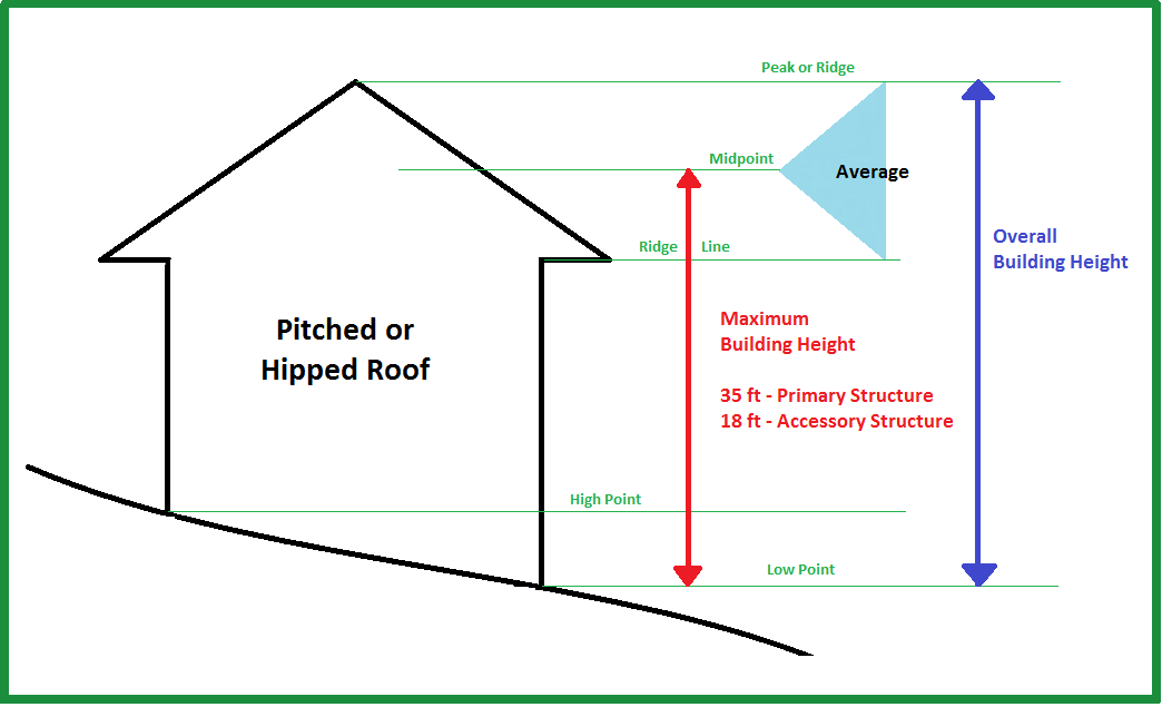
Building height: The vertical distance from the lowest point of that portion of a lot covered by the building as measured around the entire perimeter of the foundation to the highest point of the cornice of a flat roof or to the midpoint of the tallest gable on a pitched shed or hip roof (see graphic following).
Building inspector: The designated building inspector of the village or his or her authorized representatives.
Building, principal: The building on a lot in which is conducted the principal use as permitted on such lot by the regulations of the district in which it is located.
Building size: The total gross floor area of a building.
Bulk (of a building): The combination of building height, size and location on a lot.
Business sign (on-premises sign): A sign which directs attention to a business, commodity, service, or entertainment conducted, sold, offered or manufactured upon the premises where the sign is located.
Caliper: A measurement of the size of a tree equal to the diameter of its trunk measurement six to 12 feet above grade.
Campground: See subsection 18-57(a).
Candlepower: The amount of light that will illuminate a surface one-foot distant from a light source to an intensity of one foot candle. The maximum (peak) candlepower is the largest amount of candlepower emitted by any lamp, light source or luminary.
Canopy (building): A rigid multi-sided structure covered with fabric, metal, or other material and supported by a building.
Canopy (freestanding): A rigid multi-sided structure covered with fabric, metal, or other material and supported by columns or posts embedded in the ground.
Canopy sign: A sign located on a canopy, which is a shelter, attached to or connected with a building and extending into a setback or over the public sidewalk.
Canopy tree: Any mature, deciduous tree with branches that form a high foliage crown (canopy) which filters the sun, unifies the area, and provides a dominant feature. These trees are often referred to as shade trees.
Caretaker's residence: A dwelling located on a non-residential personal storage facility property occupied by the person who primarily oversees the personal storage facility property 24 hours a day, and his or her family.
Cellar: That portion of the building having more than one-half of the floor-to-ceiling height below the average grade of the adjoining ground.
Changeable copy sign: A sign with characters, letters, or illustrations that can be changed or rearranged manually or electronically without altering the face or surface of the sign. All changeable copy signs shall require a conditional use permit.
Clean: Free from dirt, impurities, and/or extraneous matters that could cause the spread of disease.
Climax tree: A tree that would occupy the uppermost canopy of a forest in a natural ecological situation (e.g., hickory, oak, maple, etc).
Commercial animal boarding (land use): See subsection 18-56(m).
Commercial indoor lodging (land use): See subsection 18-56(j).
Communication tower (land use): See subsection 18-59(e).
Community garden (land use): See subsection 18-63(h).
Community information sign: A permanent sign which may have changeable copy and that is limited to the display of information of interest to the general community regarding scheduled public events and public activities.
Community living arrangement (land use): See subsections 18-58(e), 18-58(f), and 18-58(g).
Community way-finding sign: Off-premises directional signage to restaurants, hotels and other tourism-related businesses.
Company cafeteria (land use): See subsection 18-64(m).
Company on-site recreation (land use): See subsection 18-64(n).
Composting (land use): See subsection 18-62(b).
Comprehensive plan: The Comprehensive Plan of the Village of Fontana, Wisconsin, and as subsequently amended.
Crown: The upper mass or head of a tree created by its branches and leaves.
Cultivation (land use): See subsection 18-63(a).
DBH: The diameter at breast height, which, for the purposes of this chapter, shall be measured at 4½ feet above grade on trees of four inches in diameter or greater.
Debris: See Garbage.
Dedication: The transfer of property interest from private to public ownership for a public purpose. The transfer may be of fee simple interest or of a less than fee simple interest, including an easement.
Density: A term used to describe the number of dwelling units per acre.
Destroy (tree): To kill or damage irreparably, which shall be deemed to include, but not be limited to, damage inflicted to the root system by machinery, storage of materials and soil compaction, change of natural grade above or below the root system or around the trunk; damage inflicted on the tree permitting fungus, pests or other infestation; excessive pruning or thinning leading to a failure to thrive; paving over the root system with any impervious materials within such proximity as to be fatally harmful to the tree; or application of any toxic substance.
Developer: The legal or beneficial owner(s) of a lot or parcel of any land proposed for inclusion in a development.
Dilapidated: Means the building is no longer structurally suitable for its current use.
Directional sign (off-premises): A sign which indicates only the name, direction, and/or distance of a governmental facility. This definition does not pertain to off-premises advertising signs.
Directional sign (on-premises): A sign which indicates only the name, logo (if under one square foot), and/or direction of a pedestrian or traffic facility, or a particular building within a complex of structures on the property on which said facility or building is located.
Distribution center (land use): See subsection 18-61(b).
Drainageway: A natural channel having a bed, sides or banks, and usually discharges itself into some other stream or body of water. The term "drainageway" is typically associated with a determination as to whether the channel carries a natural water flow year-round (a "perennial drainageway) or whether the channel carries a natural flow of water for only part of the year (an intermittent drainageway). Intermittent drainageways and perennial drainageways are identified on the United States Geological Survey (USGS) Quadrangle Maps or on maps produced by the Wisconsin Department of Natural Resources (WisDNR). Some drainageways are mapped as navigable streams by the WisDNR, other are mapped as non-navigable streams.
Drip line: A limiting line established by a series of perpendicular drop points marking the maximum radius of the crown of an existing tree, but not less than eight feet from the tree trunk, whichever is greater.
Duplex (land use): See subsection 18-55(d).
Dwelling: A building or one or more portions thereof, containing one or more dwelling units, but not including habitations provided in nonresidential uses such as lodging uses and campgrounds.
Dwelling, attached: A dwelling joined to another dwelling at one or more sides by a shared wall or walls.
Dwelling, detached: A dwelling entirely surrounded by open space on the same lot.
Dwelling unit: A room or group of rooms providing or intended to provide permanent living quarters for not more than one family.
Easement: Written authorization, recorded in the register of deeds office, from a landowner authorizing another party to use any designated part of the land owner's property for a specified purpose.
Eave: That portion of the roof line extending beyond the building wall, a canopy attachment on a wall, or the lowest horizontal line on any roof. Eaves may not extend any further than 18 inches into any setback.
Electronic message board sign: A sign with a fixed or changing display/message composed of a series of lights that may be changed through electronic means. A time and/or temperature sign which does not display any other changeable message shall be considered an electronic message board.
Essential services: Facilities that are owned or maintained by public utility companies or public agencies; located in public ways or in easements provided for the purpose, or on a customer's premises and not requiring a private right-of-way; reasonably necessary for the furnishing of adequate water, sewer, gas, electric, communication, or similar services to adjacent customers; and not including any cross-country line on towers.
Existing residential (land use): See subsection 18-55(l).
Expanded home occupation (land use): See subsection 18-64(b).
Exterior communications device (land use): See subsection 18-64(s).
Exterior lighting: An outdoor artificial illuminating device, whether permanent or portable, used for illumination or advertisement, including general lighting fixtures, searchlights, spotlights and floodlights, whether for architectural lighting, parking lot lighting, landscape lighting, signage, or other purposes.
Extermination: The control and elimination of insects or rodents by eliminating their harborage places; by removing or making inaccessible materials that may serve as their food; by poisoning, spraying, fumigating, trapping, or by any other recognized and legal pest elimination methods and materials as approved under the guidelines of the U.S. Environmental Protection Agency and the Wisconsin Department of Public Health, or conducted by a Wisconsin-certified pest control technician.
Extraction (land use): See subsection 18-62(a).
Extraterritorial area: The area outside of the village limits in which the Village of Fontana may exercise extraterritorial powers of planning, land division, and/or zoning review.
Facade: The entire building front including the parapet.
Family: An individual, or two or more persons, each related by blood, marriage, or adoption or guardianship, living together as a single housekeeping unit; or a group of not more than four persons not so related, maintaining a common household in which bathrooms, kitchen facilities, and living quarters are shared.
Family day care home (land use): See subsection 18-64(c).
Farm building: Any building, other than a dwelling unit, used for storing agricultural equipment or farm produce or products, having livestock or poultry, or processing dairy products.
Farm residence (land use): See subsection 18-64(g).
Farmer's market (land use): See subsection 18-65(h).
Flag: Any fabric or other flexible material attached to or designed to be flown from a flagpole or similar device.
Flag, commercial: A flag or pennant displaying the name, insignia, emblem, logo of a business, or the term "Open."
Flag, noncommercial: A flag displaying the name, insignia, emblem, or logo of any nation, state, municipality, sports team, or other noncommercial organization, or a nautical-themed, historical, patriotic, military, religious, decorative, seasonal, holiday, or other similar noncommercial flag.
Flashing sign: A sign that changes its message/appearance more than once every 60 seconds.
Foot candle: A unit of illumination produced on a surface, all points of which are one foot from a uniform point source of one candle.
Franchise: A type of retail sales establishment, restaurant, tavern, bar, or take-out food establishment which is under common ownership or control or is a franchise, and is one of 14 or more other businesses or establishments world-wide maintaining three or more of the following features:
(1)
Standardized menu or standardized array of merchandise with 50 percent or more of in-stock merchandise from a single distributor bearing uniform markings.
(2)
Trademark or service mark, defined as a word, phrase, symbol or design, or a combination or words, phrases, symbols of designs that identifies and distinguishes the source of the goods from one party from those of others, on products or as part of store design.
(3)
Standardized color scheme used throughout the interior or exterior of the establishment.
(4)
Standardized uniform including but not limited to, aprons, pants, shirts, smocks or dresses, hat and pins (other than name tags).
Freestanding sign: A self-supporting sign resting on or supported by means of poles, standards, or any other type of base on the ground. This type of sign includes monument signs.
Freight terminal (land use): See subsection 18-61(c).
Garage or estate sale (land use): See subsection 18-65(g).
Garage (residential): A detached accessory building or portion of the principal building, including a carport, which is used primarily for storing passenger vehicles, trailers, or one truck of a rated capacity not in excess of 10,000 pounds. Garages do not include temporary enclosures.
Garbage: The waste resulting from the handling, preparation, cooking, serving and non-consumption of food. Broken concrete, bricks, blocks, or mineral matter; bottles, porcelain, and other glass or crockery, boxes, lumber (new or used), posts, sticks or other wood; paper, rags (to include old clothing or discarded clothing), cardboard, excelsior, rubber, plastic, wire, tin and metal items, discarded furniture, household goods or appliances, inoperable lawn mowers, vehicles or other equipment, tar paper, residues, or other materials which constitute health, fire or safety hazards. Scrap metal, metal alloy, synthetic, or organic material or waste, or any junked, ruined, dismantled or wrecked motor vehicle or machinery, or any part thereof, whether salvageable or not. Non-containerized waste which, if not deposited in a litter receptacle, tends to create a danger to public health, safety and welfare, or impairs the environment of the people of the village. Litter includes, but is not limited to, garbage, trash, refuse, debris, grass clippings, other lawn or garden waste, newspapers, magazines, glass, metal, plastic, paper, motor vehicle parts, or other nauseous and/or offensive matter. All putrescible and non-putrescible solids including ashes and dead animals. Waste materials, including but not limited to, combustible and noncombustible materials such as yard clippings, cardboard, plastic containers, paper, rags, cartons, boxes, wood, rubber, leather, cans, metals, mineral matter, glass, crockery, and other similar materials.
Gate show: An event generally held at a resort hotel (see subsection 18-56(r)) wherein non-overnight guests of the resort hotel are permitted to attend.
Glare: The brightness of a light source which causes eye discomfort.
Grade, established: The elevation of the finished street at the centerline or curb as fixed by the engineer or by such authority as shall be designated by law to determine such elevation.
Gross density: The result of dividing the number of dwelling units located on a site by the gross site area.
Gross floor area (GFA): The total floor area on all levels of a building.
Gross site area (GSA): The total area of a single lot or the sum of multiple lots.
Ground floor: As defined by the Uniform Dwelling Code, ground floor is the level of a dwelling, below the first floor, located on a site with a sloping or multi-level grade and which has a portion of its floor line at grade.
Group day care center (land use): See subsection 18-56(l).
Group development: See section 18-167.
Group sign: A sign displaying the collective name of a group of uses such as the title of a shopping center, office park, or industrial park and its tenants.
Habitable room: A room or enclosed floor space used or intended to be used for living, sleeping, cooking or eating purposes, excluding bathrooms, water closet compartments, laundries, furnace room, pantries, kitchenettes, utility rooms, foyers, communicating corridors, stairways, closets, storage spaces, workshops and the like.
Heating device: All furnaces, water heaters, fireplaces, unit heaters, domestic incinerators, cooking and heating stoves and ranges, and other similar devices.
Heavy industrial (land use): See subsection 18-59(b).
Height: See Building height.
Home occupation (land use): See subsection 18-64(a).
Husbandry (land use): See subsection 18-63(b).
Identification sign: A sign indicating the name and/or address of the project, property owner, tenant and/or manager of the property, address, name and phone number of the property manager.
Illuminated sign: A sign that is artificially lighted internally.
Impervious surface: A surface that has been compacted or covered with a layer of material so that is it resistant to infiltration by water. It includes all surfaces such as compacted sand, aggregate clay, gravel, pavers (other than permeable surface per subsection 18-172(8)) and pavement, as well as most conventionally surfaced streets, roofs, sidewalks, driveways, parking lots, or parking spaces, and other similar structures, including appurtenances and protrusions, such as, but not limited to, eaves, decks, balconies, stairways, porches and bay windows; all either at grade level or above.
Impervious surface ratio: A measure of the intensity of land use, determined by dividing the total of all impervious surfaces on a site by the gross site area.
Incidental indoor sales (land use): See subsection 18-64(p).
Incidental light industrial (land use): See subsection 18-64(q).
Incidental outdoor display (land use): See subsection 18-64(o).
Incidental recreational equipment storage (land use): See subsection 18-64(w).
Indoor entertainment (land use): See subsection 18-56(f).
Indoor food production (land use): See subsection 18-59(d).
Indoor institutional (land use): See subsection 18-58(a).
Indoor maintenance service (land use): See subsection 18-56(n).
Indoor sales or service (land use): See subsection 18-56(d).
Indoor storage and wholesaling (land use): See subsection 18-60(a).
Infestation: The presence within or around a dwelling of any rodents and/or insects.
In-home suite (land use): See subsection 18-64(e).
Institutional residential (land use): See subsection 18-58(d).
Intensity: A term used to describe the amount of gross floor area (GFA) or landscaped area on a lot or site compared to the gross site area (GSA) of the lot or site.
Intensive agricultural (land use): See subsection 18-63(f).
Intensive outdoor recreation (land use): See subsection 18-57(d).
Intermediate day care home (land use): See subsection 18-64(d).
Internally illuminated sign: Any sign illuminated by an enclosed light source, or where the source of illumination comes through an open, translucent, or semi-translucent part of the sign.
In-vehicle sales or service (land use): See subsection 18-56(h).
Junk: See Garbage.
Lake-related recreation (land use): See subsection 18-57(e).
Land use: The type of development and/or activity occurring on a piece of property.
Landmark tree: Any tree so designated by the park commission or the tree board for its natural beauty, majestic stature, historical significance, location, memorial designation or other qualities deemed appropriate.
Landscape surface area ratio (LSR): The percentage of the gross site area which is preserved as landscaped surface area.
Landscaped surface area (LSA): The area of a site which is planted and continually maintained in vegetation, including grasses, flowers, herbs, garden plants, native or introduced groundcovers, shrubs, bushes, and trees. Landscaped surface area shall not include areas of the site which are covered in impervious surfaces, such as: concrete, asphalt, crushed limestone, gravel, paver stones or blocks, or similar pavement; swimming or decorative pools; or all structures, including appurtenances and protrusions such as eaves, decks, balconies, stairways, porches and bay windows.
Large development: See section 18-167.
Large solar energy system (land use): See subsection 18-59(f).
Large wind energy system (land use): See subsection 18-59(g).
Light industrial (land use): See subsection 18-59(a).
Litter: See Garbage.
Lot: A parcel of contiguous land, with described boundaries and abutting a public street or other officially approved means of access but exclusive of any land lying in public or private street rights-of-way or easements, public streams, or public waterbodies. Where a public right-of-way, public stream, or public waterbody divides a single described parcel into two or more parts, such severed parts shall be considered separate individual lots, except that such severed parcels do not individually meet the lot size regulations of this chapter and have been described as a single lot of record in order to permit building development, they shall continue to be treated as a single lot for regulatory purposes under this chapter.
Lot area: The area of land within the boundaries of the described lot exclusive of public streams or public waterbodies or land provided for private or public streets as defined herein.
Lot, corner: A lot abutting two or more streets at their intersection provided that the corner of such intersection shall have an angle of 135 degrees or less, measured on the lot side.
Lot frontage: Lot width measured at the street lot line. When a lot has more than one street lot line, lot width shall be measured, and the minimum lot width required by this chapter shall be provided at each such line.
Lot, interior: A lot other than a corner lot.
Lot line: A lot line is the property line (including the vertical plane established by the line and the ground) bounding a lot except that where any portion of a lot extends into the public right-of-way or a proposed public right-of-way, the line of such public right-of-way shall be the lot line for applying this chapter.
Lot line, front: A lot line which abuts a public or private street right-of-way. In the case of a lot which has two of more street frontages, the lot line along the street from which the house is addressed shall be the front lot line (see also Lot line, street side).
Lot line, rear: In the case of rectangular or most trapezoidal shaped lots, that lot line which is parallel to and most distant from the front lot line of the lot. In the case of an irregular, triangular, or gore-shaped lot, a line 20 feet in length, entirely within the lot, parallel to and at the maximum possible distance from the front line shall be considered to be the rear lot line. In the case of lots which have frontage on more than one road or street, the rear lot line shall be selected by the property owner.
Lot line, side: Any boundary of a lot which is not a front lot line, a street side lot line, or a rear lot line.
Lot of record: A platted lot or lot described in a certified survey map or in a metes and bounds description which has been approved by the village or by Walworth County, and has been recorded in the office of the register of deeds.
Lot, through: A lot which has a pair of opposite lot lines abutting two substantially parallel streets (one or more of which may be a portion of a cul-de-sac). Except for through lots which abut an arterial or nonresidential collector street, through lots shall be prohibited under the provisions of this chapter.
Lot width: The distance between the side lot lines of a lot, measured parallel to the front lot line at the rear front yard setback.
Low profile monument sign: A form of a monument sign that also is a freestanding sign detached from a building. This sign has a two-pylon support structure and the area under the sign face is above the ground.
Lowest floor: The lowest enclosed floor of a building, including the basement. Any unfinished or flood-resistant enclosure, usable solely for parking vehicles, building access or storage, in an area other than a basement area, is not considered a building's lowest floor; provided that such enclosed area is not built so as to render the structure in violation of the applicable non-elevation design requirements of this chapter.
Market garden (land use): See subsection 18-63(i).
Marquee sign: A type of projecting, on-building sign sheltering the entrance and/or entrance approaches of a theater, auditorium, fairground, museum or other similar use, which advertises present and scheduled events.
Maximum height: The maximum height of the highest portion of any structure (see Building height).
Menu board sign: A sign with no more than two faces that are adjoined at the top and displayed at an angle, which is not permanently anchored or secured, for the purpose of promoting daily and/or temporary messages, which is only displayed during open business hours and removed daily. Usually with a chalkboard or dry erase sign face surface.
Migrant employee housing (land use): See subsection 18-64(h).
Minimum lot area: The minimum lot size permitted within the specified zoning district.
Minimum setback: The narrowest distance permitted from a street, side, or rear property line to a structure.
Minor structures: Structures not requiring a building permit (e.g., swing set, clothesline, etc.).
Mixed-use: Some combination of residential, commercial, industrial, office, institutional, and/or other land uses within a district or development.
Mixed-use dwelling (land use): See subsection 18-55(k).
Mobile home (land use): See subsection 18-55(h).
Mobile home park (land use): See subsection 18-55(j).
Mobile home subdivision (land use): See subsection 18-55(i).
Mobile sign: A sign mounted on a frame or chassis designed to be easily relocated, including vehicles and/or trailers whose principal commercial use is for signage.
Monument sign: A freestanding sign that is detached from a building and has a support structure that is a solid appearing base constructed of permanent material.
Multiple dwelling: Any dwelling containing more than two dwelling units.
Multiplex (land use): See subsection 18-55(f).
Municipal water supply: The municipal water supply of the Village of Fontana.
Natural channel: Includes watercourses and drainageways. A natural channel does not become an artificial body by dredging or enlarging the original streambed or by damming the stream to create a flowage.
Navigable water: A surface water feature mapped or determined by on-site investigation by the Wisconsin Department of Natural Resources (WisDNR) as navigable. Navigable water means Lake Superior, Lake Michigan, all natural waters within Wisconsin and all streams, ponds, sloughs, flowages and other waters within the territorial limits of the state, including the Wisconsin portion of the boundary waters, which are navigable under the laws of the state.
Net developable area (NDA): The area of a site which may be disturbed by development activity. Net developable area is the result of subtracting resource protection area (RPA) from the gross site area (GSA).
Nonconforming building or structure: Any building or other structure which lawfully existed under ordinances or regulations preceding the effective date of this chapter, including nonconforming buildings or structures under previous regulations, but which would not conform to this chapter if the building or structure were to be erected under the provisions of this chapter.
Nonconforming development: Any development site in which a principal use has been established prior to the effective date of this chapter and in which one or more site or building design standards such as landscaped surface ratios, minimum landscape area (such as width of foundation planting, paved area islands, and street frontage landscaped areas), bufferyards, minimum parking, and lighting have not been met or cannot be met.
Nonconforming use: An active and actual use of land, buildings, or structures which lawfully existed prior to the enactment of this chapter, which has continued as the same use to the present, and which does not comply with all the applicable regulations of this chapter.
Noxious matter or materials: Material capable of causing injury to living organisms by chemical reaction, or is capable of causing detrimental effects on the physical or economic well-being of individuals.
Occupant: Any individual, living, sleeping, cooking, or eating in a dwelling unit or a rooming unit of which the individual does not have legal title to the dwelling unit; except that in dwelling units a guest shall not be considered an occupant.
Office (land use): See subsection 18-56(a).
Official map: The map adopted and designated by the village as being the "official map" pursuant to Wis. Stats. § 66.23(6), which shows current and proposed municipal improvement sites and rights-of-way.
Official zoning map: The map adopted and designated by the village as being the "Official Zoning Map."
Off-site parking (land use): See subsection 18-61(e).
On-site: Located on the lot in question, except in the context of on-site detention, when the term means within the boundaries of the development site as a whole.
On-site agricultural retail (land use): See subsection 18-63(c).
On-site parking (land use): See subsection 18-64(l).
Opacity: The degree to which vision is blocked by bufferyard. Opacity is the proportion of a bufferyard's vertical plane which obstructs views into an adjoining property.
Open for business sign: A temporary sign that conveys a new business is open message.
Open sign: A sign depicting the word "open" which includes no other logos, pictures or words.
Operator: A representative, caretaker, business owner occupying the space, who is in an approved position of using and controlling a property.
Outdoor boat display and sales: See subsection 18-56(t).
Outdoor display (land use): See subsection 18-56(e).
Outdoor entertainment (land use): See subsection 18-56(g).
Outdoor institutional (land use): See subsection 18-58(b).
Outdoor maintenance service (land use): See subsection 18-56(o).
Outdoor storage and wholesaling (land use): See subsection 18-60(b).
Overlay zoning district: A zoning district which imposes uniform restrictions on all properties within its area which are in addition to the restrictions specific to the standard zoning districts.
Owner: The person, persons, or entity having the right of legal title to a lot or parcel of land.
Parapet: The extension of a false front or wall above the roofline.
Parcel: The area within the boundary lines of a lot.
Passive outdoor recreation (land use): See subsection 18-57(b).
Pennant: A temporary sign composed of light-weight, flexible material (e.g., plastic, fabric or other material), whether or not containing a message of any kind, and which may taper to a point. Pennants are suspended from a rope, wire, ribbon or string, or other material, usually in a series.
Performance standard: Criterion established to control and limit the impacts generated by, or inherent in, uses of land or buildings.
Person: Means and includes any individual, firm, corporation, association, partnership, cooperative or governmental agency.
Personal or professional service (land use): See subsection 18-56(b).
Personal greeting and congratulatory sign: A temporary sign that is limited to a noncommercial, personal greeting or message used to announce, congratulate, or greet members of a family or work staff.
Personal storage facility (land use): See subsection 18-60(c).
Planned development: A planned development is a designed grouping of varied and compatible land uses, such as housing, recreation, commercial, and industrial parks, all within one contained development or subdivision.
Plumbing: Means and includes all of the following supplied facilities and equipment: water pipes, waste pipes, water closets, sinks, lavatories, bathtubs, shower baths, catch basins, drains, vents and any other similar supplied fixtures, and the installation thereof, together with all connections to water or sewer lines.
Porch: A covered platform, usually having a separate roof, at an entrance to a dwelling, or an open or enclosed gallery or room, which is not heated or cooled, that is attached to the outside of a building.
Portable storage container: A portable, weather-resistant storage container designed and used for the temporary storage or shipment of materials, household goods, wares or merchandise.
Premises: A platted lot, plot, parcel of real estate, land, or part thereof, either occupied or unoccupied by any dwelling or non-dwelling structure and includes any such building accessory structure or other structure thereon.
Primary floor area (PFA): The floor area of a building which, for purposes of determining required parking spaces, shall include only that area devoted to customer service, sales area, or actual operational area and which specifically shall not include storage, warehouse, utility, hallways, or other accessory use not generating parking demand.
Principal building: See Building, principal.
Principal use: Any and all of the primary uses of a property treated as a use permitted by right or as a conditional use (rather than as an accessory use or a temporary use).
Privacy: The existence of conditions which will permit an individual or individuals to carry out an activity commenced without interruption or interference, either by sight or sound by unwanted individuals.
Production greenhouse (land use): See subsection 18-59(c).
Projecting sign: An on-premises attached sign end-mounted or otherwise attached to an exterior wall of a building which projects from the wall to which it is attached.
Properly connected: Connected in accordance with all applicable codes and ordinances of this village as from time to time enforced; provided, however, that the application of this definition shall not require the alteration or replacement of any connection in good working order and not constitute a hazard to life or health.
Public improvement: Any improvement, facility, or service, together with customary improvements and appurtenances thereto, necessary to provide for public needs, such as: streets, roads, alleys, or pedestrian walks or paths; storm sewers; flood control improvements; water supply and distribution facilities; sanitary sewage disposal and treatment; and public utility and energy services.
Public services and utilities (land use): See subsection 18-58(c).
Pylon sign: A type of freestanding sign whose bottom edge is located more than one foot above a ground-mounted pedestal or whose top edge is located more than six feet high (see Monument sign).
Pyramiding: The act of obtaining, providing, conveying or permitting riparian rights or uses to benefit non-riparian land, including land development which includes an expansion, conveyance, assignment or contract whereby riparian rights may be utilized by non-riparian lands. Publicly owned land and public access points shall not fall within this definition.
Railroad right-of-way: A strip of land with tracks and auxiliary facilities for track operation, but not including freight depots or stations, loading platforms, train sheds, warehouses, car or locomotive shops, or car yards.
Recorded lot: See Lot of record.
Recycling and waste disposal (land use): See subsection 18-62(c).
Refuse: See Garbage.
Residential garage or shed (land use): See subsection 18-64(i).
Residential kennel or stable (land use): See subsection 18-64(k).
Residential recreational facility (land use): See subsection 18-64(j).
Resort hotel (land use): See subsection 18-56(r).
Resource protection area (RPA): The area of a site which may not be disturbed by development activity and which must also be reserved as permanently protected green space.
Restrictive, more (less): A regulation imposed by this chapter is more (less) restrictive than another if it prohibits or limits development to a greater (lesser) extent or by means of more (less) detailed specifications.
Retaining wall: A structure constructed of manmade or natural materials for the purpose of retaining soil, controlling erosion or preventing the down-slope movement of soil.
Rodent harborage: Any conditions or place where rodents can live, nest or seek shelter.
Rodent-proofing: A form of construction that will prevent the ingress or egress of rodents to or from a given space or building, or from gaining access to food, water, or harborage, consisting of the closing and keeping closed of every opening in foundations, basements, cellars, exterior and interior walls, ground or first floors, roofs, sidewalk gratings, sidewalk openings, and other places that may be reached and entered by rodents, by the use of materials impervious to rodent gnawing and other methods as set forth in the United States Public Health Service Publication: "Control of Domestic Rats and Mice," Pratt, Bjornson and Letting, July, 1977, HEW Publication #(CDC)77-8 141; and "Rat-Borne Disease Control Through Rat Stoppage," Scott and Borom, USPHS Reprint 1976.
Rubbish: See Garbage.
Safety: The condition of being reasonably free from danger and hazards which may cause accidents or disease.
Salvage or junkyard (land use): See subsection 18-62(d).
Sanitary: The promotion of hygiene which creates an environment which facilitates the prevention of diseases.
Selective cutting (land use): See subsection 18-63(d).
Septic system (land use): See subsection 18-64(t).
Setback: The shortest distance between the exterior of a building or structure and the nearest point on the referenced lot line (see Minimum setback).
Shielded: A fixture that is shielded in such a manner that light rays emitted by the fixture, either directly from the lamp or indirectly from the fixture, are projected at least 15 degrees below a horizontal plane running through the lowest point on the fixture where light is emitted.
Shoreland: Lands lying within the following distances from the ordinary high-water mark of navigable waters:
(1)
One thousand feet from a lake, pond or flowage.
(2)
Three hundred feet from a river, stream, or to a landward side of the floodplain, whichever distance is greater.
(3)
Shorelands shall not include those lands adjacent to farm drainage ditches where such lands are not adjacent to a navigable water; those parts of such drainage ditches adjacent to such lands were not navigable water before ditching or had no previous stream history; and such lands are maintained in nonstructural agricultural use.
Shoreyard or shore yard: A type of front, rear, or side yard extending the full width of the ordinary high water mark of any navigable water to the depth required in the setback regulations of the lakes, streams and other water bodies overlay zoning district or base zoning district in which such lot is located.
Shore yard setback: The minimum distance between the ordinary high-water mark and the surface of the closest exterior wall for both principal and accessory structures.
Shoreline: The elevation of the spillway crest on the Geneva Lake Dam, which is at the elevation of 864.3 feet mean sea level datum.
Sign: A sign is any object, device, display, structure, or part thereof, situated outdoors or within a window and in view of the general public, which is used to advertise, identify, display, direct or attract attention to an object, person, institution, organization, business, product, service, event, or location by any means, including words, letters, figures, logos, symbols, fixtures, or projected images. Signs do not include the flag or emblem of any nation, organization of nations, state, city, religious, fraternal, or civic organization; merchandise and pictures or models of products or services incorporated in a window display; works of art which in no way identify a product; or scoreboards located on athletic fields. Building colors and outline lighting which do not convey a logo or message specific to the use (as determined by the zoning administrator) are not considered signs.
Single-family (land use): See subsection 18-55(a).
Small solar energy system (land use): See subsection 18-64(u).
Small wind energy system (land use): See subsection 18-64(v).
Solid fence: Any fence which cannot be seen through. Such fences include basket-weave fences, stockade fences, plank fences, and similar fences.
Standard zoning districts: Zoning districts which primarily regulate the use of land and intensity or density of such use.
Steep slope: Steep slopes are areas which contain a gradient of 12 percent or greater.
Stormwater facilities (land use): See subsection 18-64(r).
Story: That portion of a building included between the surface of any floor and the surface of the floor next above; or if there is no floor above, the space between the floor and the ceiling next above. Neither a basement, nor a cellar shall be counted as a story.
Street: Unless specifically designated otherwise by the village, any public or private way that is dedicated or permanently open to pedestrian and vehicular use.
Street, arterial: Street which provides primary access to and through an area.
Street, collector: Street which disperses traffic throughout an area.
Street frontage: The distance along the street from one side property line to the other.
Street, neighborhood: Street which provides access to individual properties.
Substandard lot: A lot that lawfully existed prior to the effective date of this chapter, but that does not meet the dimensional (e.g., minimum lot size, width, setbacks, etc.) requirements of the zoning district in which it is located under the current provisions of this chapter.
Supplied: Paid for, furnished by, provided by, or under the control of the owner, operator or agent.
Swale: A linear depression in land running downhill or having a marked change in contour direction in which sheet runoff would collect and form a temporary watercourse.
Temporary business sign: Any temporary sign used to announce an event or promotion such as a "Grand Opening," "Now Open for Business," "Welcome Members," or "Holiday Sale."
Temporary construction storage (land use): See subsection 18-65(e).
Temporary farm or product sales (land use): See subsection 18-65(a).
Temporary outdoor assembly (land use): See subsection 18-65(c).
Temporary outdoor sales (land use): See subsection 18-65(b).
Temporary relocatable building (land use): See subsection 18-65(f).
Temporary sign: A sign or advertising display (including festoons, pennants, banners, pinwheels, and similar devices) intended to be displayed for a certain period of time. Included in the definition of "temporary signs" are retailers' signs temporarily displayed for the purpose of informing the public of a "sale" or special offer. If a sign display area is permanent but the message displayed is subject to periodic changes, that sign shall not be considered as temporary. A mobile or portable sign shall not be considered a temporary sign or used for such a purpose.
Temporary storage container (land use): See subsection 18-65(d).
Temporary use: A land use which is present on a property for a limited and specified period of time.
Topping: The specific reduction in the overall size of a tree and/or the cutting back of branches or limbs to such a degree so as to remove the normal canopy and disfigure the tree.
Tourist rooming house (land use): See subsection 18-64(x).
Townhouse (land use): See subsection 18-55(e).
Transit center or park and ride (land use): See subsection 18-61(a).
Tree: Any woody plant with a main stem or multiple stems with branches protruding above the root flare.
Tree canopy: The upper and outermost points of a tree created by the tree's crown.
Tree diameter: The diameter of a tree measured at a point on the tree four feet above grade. See "DBH."
Tree island: In parking lot design, built-up structures, usually curbed, placed at the end of parking rows to be used for landscaping and also for guiding traffic, signing and lighting.
Twin house (land use): See subsection 18-55(c).
Two-flat (land use): See subsection 18-55(b).
Use: The purpose or activity for which land or any building thereon is designed, arranged or intended, or for which it is occupied or maintained.
Vacation rental home (land use): See subsection 18-56(s).
Variance: Permission to depart from the literal requirements of this chapter, granted pursuant to section 18-273.
Vehicle sales (land use): See subsection 18-56(p).
Village staff: The persons authorized and charged by the village with the administration of certain sections of the ordinance from which this chapter derives. Village staff includes the village administrator, village clerk, director of public works, building inspector, village attorney, village engineer, and village planner.
Wall sign: A type of on-building sign mounted parallel to a building facade or other vertical building surface. Signs painted on, or affixed to, the exterior of a window are considered and shall count as a type of wall sign.
Watercourse: Also known as a "stream", which usually flows in a particular direction, though it need not flow continually and may sometimes be dry. The watercourse must flow in a definite natural channel, having a bed, sides or banks, and usually discharges itself into some other stream or body of water. The term "Watercourse" is typically associated with a determination as to whether the channel is navigable for all or part of a year (a "navigable watercourse or stream") or whether the channel is non-navigable for all of the year (a "non-navigable watercourse or stream"). Watercourses and streams are identified as "navigable" and "non-navigable" on maps produced by the Wisconsin Department of Natural Resources (WisDNR).
Well field: A piece of land used primarily for the purpose of locating wells to supply a municipal water system.
Window sign: A sign that is located on or inside a window of a building and designed to be viewed through the window.
Woodland: Areas of trees whose combined canopies cover a minimum of 80 percent of an area of one acre or more, as shown on U.S.G.S. "7.5 Minute Topographic Maps" for the Village of Fontana and its environs.
Yard: Required open space on a lot, which is unoccupied and unobstructed by a structure from its lowest ground level to the sky, except as expressly permitted in this chapter. A yard shall extend along a lot line and at right angles to such lot line to a depth or width specified in the setback regulations for the district in which such lot is located.
Yard, front: A yard extending along the full width of the front lot line between side lot lines and extending from the abutting front street right-of-way line to a depth required in the setback regulations for the district in which such lot is located.
Yard, rear: A yard extending along the full width of the rear lot between the side lot lines and extending toward the front lot line for a depth as specified in the setback regulations for the district in which such lot is located.
Yard, side: A yard extending along the side lot line between the front and rear yards, having a width as specified in the setback regulations for the district in which such lot is located.
Zero lot line structure: A structure that is built on the property line, such as a twin house, townhouse, or downtown unit.
Zoning administrator: The person authorized and charged by the village with the administration of this chapter.
(Ord. No. 090412-02, § 1, 9-4-2012; Ord. No. 11-11-13-04, § II, 11-11-2013; Ord. No. 02-02-15-02, § 1, 2-2-2015; Ord. No. 11-23-15-03, § 1, 11-23-2015; Ord. No. 030617-01, § 1, 3-6-2017; Ord. No. 071017-03, § 2, 7-10-2017; Ord. No. 061118-02, § 1, 6-11-2018; Ord. No. 030519-01, § 1, 3-5-2019; Ord. No. 050119-01, § 1, 5-1-2019; Ord. No. 110419-02, § 1, 11-4-2019; Ord. No. 12-09-19-02, § 1, 12-9-2019; Ord. No. 070620-03, §§ 2, 3, 7-6-2020; Ord. No. 100421-02, § 2, 10-4-2021; Ord. No. 110121-02, § 2, 11-1-2021; Ord. No. 120621-03, §§ 7, 8, 12-6-2021)