
Fort Oglethorpe City Zoning Code
CHAPTER 4
- LOT AND BUILDING STANDARDS
Sec. 1.1. - Scope.
This article addresses general requirements pertaining to the size of lots and the placement of buildings and structures on a lot.
(Ord. No. 2021-10, § 1, 6-28-2021)
Sec. 1.2. - Definitions.
The definitions of certain terms referenced in this chapter are set forth in chapter 10, Interpretation and Definitions.
(Ord. No. 2021-10, § 1, 6-28-2021)
Sec. 1.3. - Lots; general regulations.
(a)
Lot may not be reduced in size below minimum requirements. No parcel of land, even though it may consist of one or more adjacent lots of record, shall be reduced in size so that lot width or depth, front, side, or rear yard, inner or outer courts, lot area per unit, or other requirements of this code are not maintained. This section shall not apply when a portion of a lot is acquired for public use.
(b)
Lot size.
(1)
All lots shall conform to the area requirements set forth in the zoning districts in which they are located. See Table 4-A in this chapter.
(2)
Residential corner lots shall have adequate width to permit appropriate building setbacks from and orientation to both abutting streets.
(c)
Building lines. A building line, meeting the front, rear and side yard setback requirements of the zoning district in which the parcel of land is located, shall be established on all lots.
(d)
Double frontage lots.
(1)
Double frontage lots should be avoided, except where essential to provide separation of residential development from traffic arteries or to overcome specific disadvantages of topography and orientation.
(2)
When allowed, a strip of land at least ten feet in width, and across which there shall be no right of access, shall be provided along the lot or line of lots abutting such traffic artery.
(3)
See also section 1.8(b) below for setback requirements pertaining to double frontage lots.
(e)
Lots must abut public street. No building, dwelling or structure shall be erected on a lot or portion of a lot which does not abut a public road or a road that is to be dedicated to the public, with the exception that in some circumstances private roads may be allowed in accordance with the requirements of chapter 7, Infrastructure Improvements of this development code.
(Ord. No. 2021-10, § 1, 6-28-2021)
Sec. 1.4. - Buildings to be located on lots.
Every building hereafter erected or structurally altered shall be located on a lot of record, and in no case shall there be more than one principal building and the customary accessory buildings on one lot or parcel of land.
(Ord. No. 2021-10, § 1, 6-28-2021)
Sec. 1.5. - Locations of accessory structures on residential lots.
(a)
Accessory buildings; attached.
(1)
Where an accessory building is attached to the principal building, a substantial part of one wall of the accessory building must be an integral part of the main building or such accessory building must be attached to the principal building in a substantial manner by a roof, such as a breezeway or roofed passage.
(2)
Such attached accessory building shall comply in all respects with the requirements applicable to the principal building.
(b)
Accessory buildings; detached.
(1)
No detached accessory building shall be located on the front yard of a lot.
(2)
A detached accessory building shall not be constructed closer than three feet to the side and rear lot lines.
(3)
A detached accessory building shall not exceed 12 feet in height, nor occupy more than 35 percent of a required rear yard.
(c)
Other accessory structures; fences, walls and hedges.
(1)
In any residential district, no fence or structure shall be maintained within 25 feet of any corner street intersection, nor beyond the front building line.
(2)
No fence, wall, structure, or hedge, or other continuous planting shall be erected, placed or maintained on any lot line or within any front, rear or side yard not more than eight feet in height, measured from the natural contour of the ground adjoining lots or the particular lot (whichever is lower), except as follows:
a.
Where a residential lot abuts a business or industrial lot upon which a business is located; or
b.
Where peculiar circumstances warrant approval as a hardship variance by the planning advisory board, with the exception that the building, planning and zoning director may approve variances from maximum fence height requirements in accordance with the requirements in chapter 9, Appeals.
(Ord. No. 2021-10, § 1, 6-28-2021)
Sec. 1.6. - Site distance at intersections.
In all zoning districts, no fence, wall, hedge, or shrub planting which obstructs the site lines at elevations between two and 12 feet above the roadways shall be placed on any corner lot within the triangular area formed by the street property lines and a line connecting them at points 25 feet from the intersection of the street lines, or in the case of a rounded property corner, from the intersection of the street property lines.
(Ord. No. 2021-10, § 1, 6-28-2021)
Sec. 1.7. - Building height restrictions.
(a)
General application.
(1)
No building or structure shall hereafter be erected, constructed, or altered so as to exceed the height limits specified in this development code and set out for the zoning district in which it is located.
(2)
Building height shall be measured as described in the definition for "building, height of" in chapter 10 of this code.
(b)
Exceptions.
(1)
The building height restrictions imposed on buildings and structures by this code for each zoning district shall not apply to the following buildings or structures:
a.
Churches, schools, hospitals, sanitariums, and other public buildings and public utility structures. There shall be no restriction on the height of such buildings or structures, provided on the front, side, and rear yards required in the district in which such building is to be located shall be increased an additional one foot for each ten feet that the building exceeds the maximum height permitted in the zoning district;
b.
Barns, silos, grain elevators, other farm structures, belfries, cupolas, domes, monuments, water towers, transmission towers, wireless telecommunication facilities, windmills, chimneys, smokestacks, flagpoles, radio towers, masts, and aerials; and
c.
Where located on building roofs, bulkheads, water tanks, scenery lofts, and similar structures, provided that such structures shall not cover more than 25 percent of the total roof area of the building.
(2)
None of these exceptions to height limits shall apply to signs, which shall be subject to all height limitations of the zoning district in which they are located and other applicable requirements as listed in chapter 5, Sign Regulations.
(Ord. No. 2021-10, § 1, 6-28-2021)
Sec. 1.8. - Yards, minimum setbacks.
(a)
General requirements.
(1)
Where setback lines have been established on streets, roads or highways, the front yard of all lots and the side yards of corner lots shall be measured from such setback lines.
(2)
The minimum yards and other open spaces required by this development code for each building shall not be considered as a yard or open space for any other building.
(3)
Front, side and rear yards shall be as defined in chapter 10 of this code.
(b)
Double-frontage lots (or "through lots"). On double frontage lots, the required front yard shall be provided on each street.
(c)
Corner lots.
(1)
The applicant or developer will be required to designate one of the street frontages as the front and will build the principal building facing the front.
(2)
The yard opposite the designated front must there meet the required rear yard setback.
(3)
The interior side yard would meet the required side yard setback.
(4)
The exterior side yard shall be at least 50 percent of the depth of the front yard of the lot to the rear of the corner lot and facing the intersecting street.
(5)
In established neighborhoods, building placement on corner lots shall maintain a consistent pattern of development.
(d)
Projections into required yards. The minimum yards and other open spaces required by this development code shall not be encroached upon, with the following exceptions:
(1)
Every part of a required yard shall be open from its lowest point to the sky, unobstructed, except for the ordinary projections of sills, belt courses, cornices, buttresses, ornamental features, chimneys and eaves, but none of these projections shall project into a minimum side yard more than 24 inches.
(2)
Open or enclosed fire escapes, fireproof outside stairways and balconies may project into a minimum yard or court not more than three and one-half feet. Ordinary projections of chimneys and flues shall be allowed.
(Ord. No. 2021-10, § 1, 6-28-2021)
Sec. 2.1. - Consolidated requirements for lots and principal buildings.
(a)
Requirements for the city's zoning districts relating to the minimum area, width and frontage, the maximum height of a building, minimum setbacks for front, side and rear yards, and other dimensional requirements as they relate to a principal building are included in Table 4-A below.
(b)
Some requirements specific to certain zoning districts are not found in Table 4-A but are presented in this article below.
(c)
No building shall be moved, erected, reconstructed or structurally altered, nor shall any building or land be used which does not comply with all the district regulations specified by this article for the district in which the building or land is located in addition to other applicable provisions in this code.
Table 4-A: Area Requirements for Lots and Principal Buildings
Notes:
1 Areas served by approved community water supply and wastewater treatment system.
2 Areas not served by an approved community wastewater treatment system.
3 Zero lot line (ZLL) developments shall be allowed for residential developments meeting the building site requirements and density requirements of the R-5 district, with one side a zero lot line and the other side yard at least ten feet.
4 See also section 2.3, Specific requirements for R-5 zoning district.
5 In addition to the requirements for the C-N district listed in this section, the following shall also apply: a building shall not exceed 4,000 square feet in size.
(Ord. No. 2021-10, § 1, 6-28-2021)
Sec. 2.2. - Specific requirements for R-4 zoning district.
(a)
Applicability. In addition to requirements for manufactured homes in chapter 3, Restrictions on Particular Uses and other applicable regulations in this development code, the following requirements in this section shall apply in the R-4 zoning district.
(b)
Manufactured home subdivisions.
(1)
Manufactured home site area requirements. Every principal building shall be located on a lot or parcel of land having an area of not less than 6,000 square feet, provided that the R-4 district is served by an approved community public water supply and wastewater treatment system.
(2)
Front yard (setback from front property line). There shall be a front yard of not less than 25 feet in depth measured from the street right-of-way line (property line to the wall of any principal building).
(3)
Rear yard. There shall be a rear yard of not less than ten feet measured from the rear lot line to the wall of any principal building.
(4)
Side yard. There shall be a side yard on each side of any dwelling of at least ten feet.
(c)
Manufactured home parks.
(1)
General requirements. The following general requirements shall apply to the construction or remodeling of all manufactured home parks within the corporate limits of Fort Oglethorpe:
a.
Minimum area. A manufactured home park shall have as a minimum size of four acres and shall front upon a public highway or public street.
b.
Minimum number of spaces. A manufactured home park shall have as a minimum ten spaces prepared with all utilities in place prior to its approval for occupancy.
c.
Length of residential occupancy. No space within a manufactured home park, except as provided below, shall be rented for residential use of a manufactured home except for periods of 30 days or more.
(2)
Design. The design of a manufactured home park shall conform to the following design requirements:
a.
Density. A maximum of eight manufactured home stands per acre, excluding streets, is allowed.
b.
Setback. The manufactured home parks shall be designed so that manufacturers and their accessory structures shall be a minimum distance of 15 feet from adjoining property lines, 20 feet from internal park streets and at least 30 feet from any publicly dedicated street. Manufactured home stands shall be designed so as to provide a distance of at least 20 feet between manufactured homes.
c.
Access. The manufactured home park shall front upon at least one publicly dedicated street for a minimum width of 50 feet. Each manufactured home site and its parking area shall have direct access to the internal street system of the park.
d.
Streets. Streets within a manufacturing home park shall be privately owned, privately constructed, and privately maintained. Such private streets shall be well drained and provided with a hard-surfaced treatment with a minimum surface of ten feet for one-way streets and 20 feet for two-way streets.
e.
Parking. Each manufactured home shall be provided with a minimum of two off-street parking spaces which are side by side. Parking on interior streets within a park is hereby prohibited. The required front yard may be used for the minimum parking; however, required side and rear yards may not be utilized for the minimum parking.
f.
Open space. A minimum 30 percent of gross acreage shall be set aside as open space and shall provide recreational areas within said open space. Open space shall not include required front, side or rear yards.
g.
Utilities.
1.
Sewage. The manufactured home park shall be provided with an approved sewage collection and treatment system.
2.
Water. An adequate potable water supply meeting state department of public health requirements shall be provided by the park operator. If a public water system is available at the park site, water service shall be connected to the system.
3.
Easements. Publicly dedicated easements of proper size for their intended purpose shall be provided within the park if individual manufactured home stands and accessory park uses are to be serviced by a public system.
4.
Utility placement. All water, sewer or gas lines shall be buried a minimum of eight inches below the finished ground surface of the pad area and 24 inches in depth below the finished ground surface of any street right-of-way and shall be provided with adequate valve systems to allow the cutoff utility service to a manufactured home stand at the manufactured home stand and at the entrance of the utility service from the stand to the trunk line of the utility system. If overhead service lines are provided within the park, such lines shall be a minimum of 25 feet above the grade of interior streets and so placed that no wires extend over a manufactured home stand.
(3)
Improvements required for manufactured home stands. Each manufactured home stand shall meet the following minimum requirements:
a.
Interior street access. Each stand shall be provided with access frontage of at least 40 feet.
b.
Garbage cans. Private service with dumpsters shall be required.
c.
Electric power supply. The electric power supply will be in accordance with local code requirements.
d.
Stand identification. A property and street number designation or other appropriate numbering device properly identifying each manufactured home stand shall be placed at the interior side lot line at a point ten to 15 feet from the interior road system of the park. Such device shall be a minimum of six inches in height.
(d)
See also the manufactured homes section in chapter 3, Restrictions on Particular Uses of this development code.
(Ord. No. 2021-10, § 1, 6-28-2021)
Sec. 2.3. - Specific requirements for R-5 zoning district.
In addition to applicable regulations in Table 4-A and this development code, the following requirements shall apply in the R-5 zoning district:
(a)
Maximum density, townhome development.
(1)
Up to 7.5 dwelling units per acre are allowed.
(2)
Between 7.5 and 12 dwelling units per acre are allowed upon approval by city council as a special exception. In addition to the review criteria for special exceptions as set forth in this Code, approval of a townhome development at this density shall be based on:
a.
Consistency with the intent of the R-5 district, as described in chapter 2 of this Code.
b.
Submittal of a master plan for the property, including enhanced recreational facilities (parks, playgrounds and/or dedicated open space), landscape plan and drainage plan.
(b)
See also chapter 3, section 1.17, Multifamily dwellings and two-family dwellings.
(Ord. No. 2021-10, § 1, 6-28-2021)
Sec. 2.4. - Specific requirements for PM mixed use zoning district.
In addition to applicable regulations in this development code, the following requirements shall apply in the PM zoning district;
(a)
Determining if an area is suitable for inclusion within a PM district. The factors contained under the intent statement for the PM mixed use district section in chapter 2 of this development code, as well as data submitted with the development plan of the applicant for a planned development, must be thoroughly considered by the planning advisory board and the mayor and city council when determining in which zoning district an area of land is to be placed. This will ensure that rational comprehensive planning principles encourage the development and preservation of land use patterns that provide healthful and safe living conditions for the residents of Fort Oglethorpe.
(b)
Allowed uses. Allowed uses in the PM zoning district shall be as shown in the approved development plan.
(c)
Plan review and approval procedures.
(1)
Pre-application conference. Prior to filing a formal application for a PM zoning district, the applicant is encouraged to confer with the director of building, planning and zoning and the planning commission in order to review the general character of the plan (on the basis of tentative land use sketch, if available), and to obtain information on development standards and ordinances affecting the proposed project.
(2)
Submission of application for PM district approval.
a.
The applicant must file a petition with the building, planning and zoning director for approval of the proposed PM zoning district. This application must be supported by a development plan and a written summary of intent. The relationship between the proposed development and the surrounding area, both existing and proposed, must be shown. The following information must be presented with the application:
1.
A general location map.
2.
Existing topographic conditions, including contour intervals of no more than five feet based on field surveys or photogrammetric methods.
3.
The existing and proposed land uses and the approximate location of all buildings and structures.
4.
The approximate location of existing and proposed streets.
5.
The approximate location of all existing and proposed utilities, including a preliminary utility and drainage plan.
6.
The present zoning pattern in the area.
7.
A legal description of the subject property.
8.
The location and use of existing and proposed public, semipublic, and community facilities such as schools, parks, and open areas on the site. This includes areas proposed to be dedicated or reserved for community or public use.
9.
Perspective drawings of representative building types; however, this is not required for single-family detached dwellings.
b.
If a proposed development creates special problems or involves unusual circumstances, additional information may be required in order to properly evaluate the proposal as follows:
1.
An off-street parking and loading plan.
2.
An economic feasibility report or market analysis.
3.
A traffic study of the area, and a circulation plan within the proposed development as well as to and from existing streets adjacent to the site.
(3)
The written summary of intent submitted with the development plan must include the following information:
a.
A statement of the present ownership of all land within the proposed development.
b.
An explanation of the character of the proposed development; this includes a summary of acres, number and types of dwelling units, and gross density by type of land use.
c.
A general statement of the proposed development schedule.
d.
Agreements, provisions, and covenants which govern the use, maintenance and protection of the development and any common or open areas.
(d)
Review and approval of PM zoning district application.
(1)
An application for approval of a PM zoning district is treated as an application for rezoning, following the procedures in chapter 8 of this code. This is because PM districts are created only upon request of a developer, whose application materials demonstrate a firm commitment to construction of a well-designed PM district.
(2)
The power to approve a zoning map amendment creating a PM district rests with city council. City council may approve, disapprove, or conditionally approve the development plan.
(3)
If the development plan is approved as submitted, the official zoning map will be changed to indicate the PM zoning district. If the plan is approved with modifications, the applicant must file with the director of building, planning and zoning the following:
a.
Written notice of consent to the modifications.
b.
A properly revised development plan.
(4)
The official zoning map will then be changed. The site plan and supporting information of any approved plan will be properly identified and permanently filed with the department of building, planning and zoning.
(5)
No building permits will be issued until the development plan has been approved by city council.
(e)
Issuance of building permits. The director of building, planning and zoning will issue building permits for building and structure in the area covered by the approved development plan if the proposed buildings and structures are in conformity with the approved development plan, the development schedule, and all other applicable regulations.
(f)
Revision of development plan after approval of plan.
(1)
Minor extensions, alterations, or modifications of existing buildings or structure may be allowed after review and approval by the director of building, planning and zoning; such changes must be consistent with the purpose and intent of the development plan. A request for a revision of the development plan must be supported by a written statement indicating the nature of the revision and the reasons it is considered necessary or desirable to revise the development.
(2)
Any major or substantial change in the approved development plan which affects the intent and character of the development, the density of land use patterns, the location or dimensions of streets, or singular substantial changes must be reviewed and approved by city council after receipt of recommendations from the planning advisory board. A request for a revision of the development plan must be supported by a written statement indicating the nature of the revision and the reasons it is considered necessary or desirable to revise the development.
(g)
Approval of PM district revoked if construction not begun. Construction of the planned development must begin within one year of the approval of the PM zoning district. If no construction has begun by then, or if the applicant fails to maintain the approved development schedule, approval of the development plan will lapse. At its discretion and for good cause, the city council may extend the period for beginning construction of any phase of the project for one additional year. If approval of the development plan lapses under this provision, the subject PM district will be removed from the official zoning map, and the zoning districts and regulations which were in effect prior to the approval of the development plan will be reinstated.
(h)
Development standards for PM districts. In addition to applicable development standards contained in this chapter, the following standards are required within PM districts:
(1)
Development plan. The approved development plan must be carried out.
(2)
Density requirements. Density requirements or dwelling units (du) per acre shall be determined by the planning advisory board and recommended to the city council for approval. The intent of density requirements for mixed use development is to allow higher densities along heavy traffic areas and roadways adjacent to more intense uses such as commercial or industrial development. The lesser density development requirements would be more compatible adjacent to single-family or other residential development. Dwelling units per acre allowed:
a.
Five dwelling units per acre.
b.
Seven and one-half dwelling units per acre.
c.
Ten dwelling units per acre.
d.
Twelve dwelling units per acre.
(3)
Deviation from required densities.
a.
The city council may allow higher net or gross residential densities, as well as a higher density of a particular residential use, as long as the applicant can show that such a higher density will not be detrimental to the surrounding neighborhood.
b.
The city council will consider a deviation from the specified maximum density only upon a favorable recommendation from the planning advisory board.
(4)
Dimensional and bulk regulations.
a.
The location of all proposed buildings and structures must be shown on the approved development plan; minimum lot sizes, setback lines, lot coverages, and floor areas shown on the development plan must be adhered to.
b.
The proposed location and arrangement of structures must not be detrimental to existing or proposed adjacent dwellings or to the development of a neighborhood.
(5)
Perimeter requirements. City council, upon recommendation of the planning advisory board, may impose the following requirements to protect the privacy of existing adjoining uses:
a.
Structures or buildings located at the perimeter of the PM district must be set back a distance of 30 to 50 feet from the boundary of the PM district.
b.
Mixed-use development shall have a minimum 30 percent of gross acreage set aside as open space and shall provide recreational areas within said open space.
(6)
Control of area after completion. After completion of a planned development, the use of land and the construction, modification, or alteration of any buildings or structures within the PM district must conform to the approved development plan. If community needs are found to be changing in the future and a revision of the approved development plan is thought to be needed, procedures outlined in the revision of the development plan after approval of plan must be followed.
(7)
Sight distance. In order to ensure maintenance of adequate sight distances at intersections, no fence, wall, shrubbery, or other obstruction to vision between the heights of three feet and 15 feet above the ground is permitted within 20 feet of the intersection of the right-of-way of streets or of streets and railroads.
(8)
Open space not to be encroached upon. No open space may be encroached upon or reduced in any manner except in conformity with the yard, setback, off-street parking spaces, and other such required development standards contained in this development code. Shrubbery, driveways, retaining walls, fences, curbs, and buffers are not considered to be encroachments of yards. Required open space areas must be permanently maintained as open space in accordance with the requirements of this code.
(9)
Landlocked lots. Landlocked lots are not eligible for placement within a PM zoning district.
(10)
Signs. See chapter 5 of this development code.
(11)
Exterior cladding and other requirements for multifamily (apartments and townhomes) and two-family dwellings. See chapter 3 of this development code, section 1.17, Multifamily dwellings and two-family dwellings.
(12)
Development standards shown in approved development plan. Other development standards shown in an approved development plan apply only to the development shown on the specific development plan. Such development standards must be maintained.
(13)
Design standards for all PM zoning district developments.
a.
General. Condition of soil, groundwater level, drainage, and ground slope must not create hazards to the property, or to the health or safety of residents. The site must not be exposed to objectionable smoke, noise, odors, or other adverse conditions; and no part subject to flooding or erosion can be used for any purpose that would expose people or property to danger.
b.
Soil and ground cover. Exposed ground surfaces throughout the development must be protected with a vegetative growth that prevents soil erosion, standing puddles, and dust. If this is not possible, such areas may be covered with a solid material such as stone or may be paved.
c.
Site drainage. The ground surfaces throughout the development must be equipped to drain all surface water in a safe, efficient manner, either through grading or installation of drains.
d.
Required buffer. A buffer is required along all lot lines of the development. This is in addition to common open space.
(Ord. No. 2021-10, § 1, 6-28-2021)
Sec. 3.1. - Buffer requirements.
(a)
Intent.
(1)
To provide transition between incompatible land uses and to protect the integrity of less intensive uses from more intensive uses, buffering and screening will be required.
(2)
The buffer provides transition between the incompatible uses by requiring a landscape yard of a minimum specified depth along the shared property line.
(3)
The purpose of screening is to provide a year-round visual obstruction.
(b)
Procedure. Refer to Table 4-B below to determine any screening requirements for the proposed development.
(1)
First, identify the type of zoning for the proposed development (in the left-hand column of the table) and each adjoining property (along the top of the table).
(2)
Find where the zoning of the proposed development and each adjoining property intersect on the table. If a buffer is required, a capital letter will indicate the type of buffer to be applied. A description of each buffer type is provided in Table 4-B below.
(3)
When classifying a zoning district for, it the proposed use within a zoning district is also listed as an allowed use within a less-intensive zoning district, the corresponding class for the less-intensive zoning district may be applied. For example, a proposed commercial use within an industrial zoning district may be classified as a commercial zoning district for the purpose of using the table.
(4)
City council may increase the minimum buffer width requirements given in this article as a condition of rezoning, as a condition of a special exception approval, or as a condition to granting a variance.
(c)
Required buffers table.
Table 4-B: Required Buffers
(Ord. No. 2021-10, § 1, 6-28-2021)
Sec. 3.2. - Buffer types.
The following descriptions correspond with the buffer types shown on Table 4-B and describe minimum required buffer widths and screening.
(a)
Buffer type A. Provide a 30-feet deep (as measured towards the interior of the property) landscape yard along the shared property line planted with:
(1)
Evergreen trees spaced a maximum of ten feet on center or two staggered rows (spaced a maximum of seven feet apart) of shrubs spaced a maximum of eight feet on-center; and two rows of shade trees spaced a maximum of 35 feet on-center.
(2)
All plantings shall meet the installation and planting size requirements specified in the plant installation specifications section in article 5 of this chapter.
(b)
Buffer type B. Provide a 20-foot deep (as measured towards the interior of the property) landscape yard along the shared property line planted with:
(1)
Evergreen trees spaced a maximum of ten feet on-center or two staggered rows (spaced a maximum of seven feet apart) of shrubs spaced a maximum of eight feet on-center, and one row of shade trees spaced a maximum of 35 feet on-center.
(2)
All plantings shall meet the installation and planting size requirements specified in the plant installation specifications section in article 5.
(c)
Buffer type C. Provide a ten-foot deep (as measured towards the interior of the property) landscape yard along the shared property line planted with:
(1)
Evergreen trees spaced a maximum of ten feet on center or two staggered rows (spaced a maximum of seven feet apart) of shrubs spaced a maximum of eight feet on-center.
(2)
All plantings shall meet the installation and planting size requirements specified in the plant installation specifications section in article 5 of this chapter, below.
(d)
Location of stormwater management facilities in buffer areas. Stormwater management facilities may be located in the required buffer subject to the following conditions:
(1)
No rip-rap, crushed stone, concrete or other impervious materials are exposed to view; and
(2)
Trees and other living organic materials can be planted along the stormwater management facility.
(Ord. No. 2021-10, § 1, 6-28-2021)
Sec. 3.3. - Parking lot screening.
See article 5 of this chapter.
(Ord. No. 2021-10, § 1, 6-28-2021)
Sec. 3.4. - Screening of dumpsters.
See chapter 3 of this development code under the "restrictions on accessory uses and structures" section.
(Ord. No. 2021-10, § 1, 6-28-2021)
Sec. 4.1. - Applicability.
The requirements of this article shall apply to:
(a)
All new public and/or private development; and
(b)
Existing public and/or private developments, when expansion in gross floor area (GFA) or parking spaces will trigger landscaping requirements based on the scope of work proposed as established below.
(1)
Where a building expansion increases GFA at least ten percent but no more than 25 percent, the applicant can choose to either comply with the street yard or parking lot landscaping requirements for the entire property.
(2)
Where a building expansion increases GFA more than 25 percent but no more than 50 percent:
a.
The entire property shall comply with the street yard requirements;
b.
50 percent of the existing parking lot and all of any expanded portions of the parking lot shall comply with the parking lot landscaping requirements; and
c.
The entire property shall comply with the screening requirements.
(3)
Where a building expansion increases GFA more than 50 percent, the entire property shall comply with all of the provisions of this article.
(4)
Where is a parking lot expansion of at least ten spaces increases the total number of parking spaces by no more than 25 percent, the expanded portion of the parking lot shall comply with the parking lot landscaping provisions.
(5)
Where a parking lot expansion of at least ten percent spaces increases the total number of parking spaces more than 25 percent but no more than 50 percent, the entire expanded parking lot portion and 50 percent of the existing parking lot shall comply with the parking lot landscaping provisions.
(6)
Where a parking lot expansion of at least ten spaces increases the total number of parking spaces more than 25 percent but no more than 50 percent, the entire property including the expanded parking lot portion lot shall comply with the parking lot landscaping provisions.
(Ord. No. 2021-10, § 1, 6-28-2021)
Sec. 4.2. - Exemptions.
Single-family detached, two-family (duplex), and three-family (tri-plex) residential structures on their own lot are exempt from landscaping requirements. All other residential, commercial, public and/or private facilities are required to comply with the provisions of this article.
(Ord. No. 2021-10, § 1, 6-28-2021)
Sec. 4.3. - Landscape plan submittal.
Proposed developments subject to the provisions of this article shall file for a land disturbing permit and submit a landscape development site plan. This plan may be incorporated into a parking/paving plan, provided the scale is not less than one inch equals 40 feet. The following elements shall be shown on the landscape site plan:
(a)
Zoning of site and adjoining properties;
(b)
Existing and proposed contours at five feet intervals or less;
(c)
Boundary lines and lot dimensions;
(d)
Date, graphic scale, north arrow, titles and name of owner, and the phone number of the person or firm responsible for the landscape plan;
(e)
Location of all proposed structures and storage areas;
(f)
Drainage features and 100-year floodplain, if applicable;
(g)
Parking lot layout including parking stalls, bays, and driving lanes;
(h)
Existing and proposed utility lines, and easements;
(i)
All paved surfaces and curbs;
(j)
Existing trees or natural areas to be retained; and
(k)
The location of all required landscaped areas (street yard, landscaped peninsulas, landscaped islands, and screening buffers.)
(Ord. No. 2021-10, § 1, 6-28-2021)
Sec. 4.4. - Plant installation plan.
(a)
Prior to receiving a certificate of occupancy, a plant installation plan shall be submitted and approved containing the following information:
(1)
Location, installation size, quantity, and scientific and common names of landscaping to be installed; and
(2)
The spacing between trees and shrubs used for screening.
(b)
The applicant has the option of submitting both the landscape plan and plant installation plan at the same time.
(Ord. No. 2021-10, § 1, 6-28-2021)
Sec. 4.5. - Street yard requirements.
(a)
Intent. The intent of this section is to add quality and definition to the street by planting trees within a landscaped area along the edges of the right-of-way.
(b)
Dimensions.
(1)
Except for points of access, a street yard shall be provided where the proposed development site adjoins the public street right-of-way, unopened streets and opened or unopened alleys being specifically exempt from this requirement.
(2)
The street yard shall have a minimum depth of six feet as measured from the edge of the public right-of-way towards the interior of the property.
(3)
The yard shall consist of sod grass or other natural living ground cover material.
(4)
No impervious surfaces are permitted in the street yard area.
(5)
Where street yards are adjacent to a paved parking lot, allowance will be granted for vehicular overhangs to extend across the street yard, provided a suitable curb or wheel stop is provided outside and adjacent to the yard to prevent actual vehicular trespass.
(c)
Plantings.
(1)
Trees shall be planted within the street yard at a minimum ratio of one tree per 25 linear feet of total right-of-way frontage. Trees do not have to be evenly spaced in 25 feet increments. Fractions of trees shall be rounded up to the nearest whole number.
(2)
The minimum spacing between trees is 15 feet measured trunk to trunk. The maximum spacing is 40 feet measured trunk to trunk.
(3)
The trees referred to in this section shall have a minimum expected maturity height of at least 20 feet and a minimum expected canopy spread of ten feet (see plant installation specifications section: Class II shade trees).
(4)
Unless otherwise noted, larger-species trees can be used in street yards as an acceptable substitute for class II shade trees (see plant installation specifications section: Class I shade trees).
(d)
Existing woodlands. Existing woodlands along the street right-of-way frontage can be substituted for the street yard requirements subject to the following:
(1)
Existing woodlands to be set aside shall have a minimum depth of 20 feet as measured from the public street right-of-way;
(2)
The number of woodland trees (not including prohibited trees) having a minimum caliper of six inches shall equal or exceed the minimum street tree planting ratio of one tree per 25 linear feet;
(3)
No impervious surfaces are permitted within the protected woodlands area except for approved access points to the site; and
(4)
No cutting/filling activities or storage of materials/equipment are permitted within the protected woodlands.
(Ord. No. 2021-10, § 1, 6-28-2021)
Sec. 4.6. - Exemptions/special situations.
(a)
Where overhead power and communications lines encroach into the street yard, class I shade trees cannot be planted or substituted for class II shade trees (see plant installations specifications section: Class I shade trees). Stormwater management facilities may be located within the street yard subject to the following conditions:
(1)
No rip-rap, crushed stone, concrete, or other pervious materials are exposed to view; and
(2)
Trees and other living organic materials can be planted along the stormwater management facility.
(b)
No trees shall be located within the traffic safety sight triangle as defined by city regulations or other regulations as defined by the owner of the right-of-way, whichever traffic safety sight triangle is larger.
(Ord. No. 2021-10, § 1, 6-28-2021)
Sec. 4.7. - Plant installation specifications.
(a)
Intent. All landscaping material shall be installed in a professional manner, and according to accepted planting procedures specified in an arboricultural specifications manual available from a certified arborist.
(b)
Class I shade trees. Class I shade trees are used to meet the canopy tree planting requirements specified in the street yard requirements of this article and the parking lot landscaping requirements of article 4.
(1)
All class I shade trees shall be installed at a minimum caliper of two inches as measured from two and one-half feet above grade level.
(2)
Class I shade trees shall also have a minimum expected maturity height of at least 35 feet and a minimum canopy spread of 20 feet.
(3)
Evergreen trees can be treated as class I shade trees provided they meet the minimum maturity height and canopy spread criteria.
(4)
Recommend species are as follows:
Table 4-C: Recommended Class I Shade Tree Species
(c)
Class II shade trees. Class II shade trees are intended to be used where understory trees area appropriate and for planting under overhead power lines where they encroach into the property.
(1)
All class II shade trees shall be installed at a minimum caliper of one and one-half inches as measured at two and one-half feet above grade level from the base of the tree.
(2)
Class II trees shall have a maximum expected maturity height of 20 feet and a minimum canopy spread of ten feet.
(3)
Recommended species of class II shade trees are as follows:
Table 4-D: Recommended Species of Class II Shade Trees
(d)
Screening trees.
(1)
Screening trees are used to meet the tree planting requirements required for screening.
(2)
All screening trees shall be installed at a minimum height of five to six feet and have a minimum expected mature spread of eight feet.
(3)
Recommended species of screening trees are as follows:
Table 4-E: Recommended Species of Screening Trees
(e)
Screening shrubs.
(1)
All screening shrubs shall be installed at a minimum size of three gallons and have an expected maturity height of at least eight feet and a mature spread of at least five feet.
(2)
Recommended species of screening shrubs are as follows:
Table 4-F: Recommended Species of Screening Shrubs
(f)
Prohibited plants. The following plants are prohibited from being used to meet these requirements due to problems with hardiness, maintenance, and nuisance:
(Ord. No. 2021-10, § 1, 6-28-2021)
Sec. 4.8. - Utility easement policy.
Any tree or shrub used to meet the requirements of this article shall not be located within existing or proposed utility easements.
(Ord. No. 2021-10, § 1, 6-28-2021)
Sec. 4.9. - Maintenance.
The property owner shall be responsible for the maintenance of all landscaping provided. All landscaped areas must present a healthy, neat and orderly appearance and shall be kept free from refuse and weeds. Any dead or diseased plant material shall be replaced by the property owner with new plantings that meet the requirements of this article.
(Ord. No. 2021-10, § 1, 6-28-2021)
Sec. 4.10. - Tree and vegetation maintenance.
(a)
No person, other than the owner of a publicly owned property or a utility franchisee of that owner of publicly owned property, shall trim or remove trees from publicly owned property within the city. This prohibition shall not apply to dead trees, diseased trees that cannot be effectively treated or which, by virtue of the type of disease, are likely to infect other trees if not removed, or trees which constitute a hazard to life or property.
(b)
All trees shall be presumed to be healthy unless a certified arborist has issued a report stating that the tree is dead, diseased and cannot be effectively treated, or diseased and likely to infect other trees if not removed.
(c)
The director of building, planning and zoning may make a determination that a tree constitutes a hazard to life or property and shall make such determination in writing, specifying the reasoning behind the finding.
(d)
Alternatively, trees may be trimmed or removed from publicly owned property to improve the visibility of any sign by anyone other than the owner of the publicly owned property or a state utility franchisee if all of the following conditions are met:
(1)
The trimming or removal of the tree is expressly authorized by the owner of publicly owned property. In the case of the city, this may only be done via a vote of the quorum of the city council;
(2)
The trimming or removal of the tree is in accordance with the provisions of this article;
(3)
Prior to the applicant seeking permission from the city the applicant must have obtained all valid permits required to remove the trees and vegetation, including, but not limited to, applicable vegetation permits and land disturbance permits.
(Ord. No. 2021-10, § 1, 6-28-2021)
Sec. 4.11. - Certificate of occupancy/bonding.
(a)
If the landscaping has not been installed and inspected for proper installation prior to receiving a certificate of occupancy, a certificate of occupancy may be granted provided the following conditions are met.
(1)
Property owner posts a performance bond or irrevocable letter of credit or a certified check or cash with the city finance director;
(2)
The amount of the surety shall be based on material and installation costs of the uninstalled landscape material, including a 20 percent contingency cost, as shown on the submitted landscape plan; and
(3)
The costs of the landscaping shall be certified by a landscape architect licensed in the State of Georgia.
(b)
After receiving the certificate of occupancy, the remaining landscape material shall be installed within three months. The bond or letter of credit shall be called if the required landscaping has not been installed by the end of the three-month period and the funds applied to complete the landscaping work.
(Ord. No. 2021-10, § 1, 6-28-2021)
Sec. 5.1. - Applicability.
At the time of erection of any principal building or structure, or at any time any principal building or structure is enlarged or increased in capacity by adding dwelling units, guestrooms, floor space or seats, there shall be provided minimum off-street parking space with adequate means in ingress and egress from a public street or alley by an automobile of standard size, in accordance with this article. There shall also be provided off-street loading, where applicable and in accordance with this article.
(Ord. No. 2021-10, § 1, 6-28-2021)
Sec. 5.2. - General requirements for off-street parking.
(a)
Parking spaces for all dwellings shall be located on the same lot with the dwelling.
(b)
Areas reserved for off-street parking or loading shall not be reduced in area or changed to any other use unless the allowed use which it serves is discontinued or modified, or unless a reduction in areas is approved in accordance with variance procedures in chapter 9 of this code.
(c)
Lighting facilities shall be so arranged that light is reflected away from adjacent properties.
(d)
Signs and planting strips shall be arranged so that they do not obstruct visibility for drivers or pedestrians.
(Ord. No. 2021-10, § 1, 6-28-2021)
Sec. 5.3. - Construction and maintenance.
All off-street parking, loading, and service areas shall be constructed of concrete or asphalt. All such areas shall be at all times maintained at the expense of the owners thereof, in a clean, orderly, and dust-free condition.
(Ord. No. 2021-10, § 1, 6-28-2021)
Sec. 5.4. - Separation from walkways, sidewalks and streets.
All off-street parking, loading, and service areas shall be separated from walkways, sidewalks, and streets by curbing or other suitable protective device. Curbing and other protection devices must be set back a minimum of three feet to prevent vehicle overhang.
(Ord. No. 2021-10, § 1, 6-28-2021)
Sec. 5.5. - Parking area design.
(a)
Parking spaces. Off-street parking spaces shall have a minimum width of nine feet and length of 18 feet.
(b)
Interior driveways.
(1)
There shall be provided adequate interior driveways to connect each parking space with a public right-of-way.
(2)
Interior driveways shall be at least 24 feet wide where used with 90 degree angle parking, at least 18 feet wide where used with 60 degree angle parking, at least 13 feet wide where used with 45 degree parking, and at least 12 feet wide where used with parallel parking, or where there is no parking, interior driveways shall be at least 10 feet wide for one-way traffic movement and at least 20 feet wide for two-way traffic movement.
(Ord. No. 2021-10, § 1, 6-28-2021)
Sec. 5.6. - Pavement markings and signs.
(a)
Each off-street parking space shall be clearly marked, and pavement directional arrows or signs shall be provided in each travelway, wherever necessary.
(b)
Markers, directional arrows and signs shall be properly maintained so as to ensure their maximum efficiency.
(c)
No sign, whether permanent or temporary, shall be placed within the public right-of-way.
(Ord. No. 2021-10, § 1, 6-28-2021)
Sec. 5.7. - Location of required off-street parking spaces on other property.
(a)
If the required automobile off-street parking spaces cannot reasonably be provided on the same lot on which the principal use is located, such spaces may be provided on other off-street property lying not more than 400 feet from the main entrance to the principal use.
(b)
In this situation, the applicant shall submit with his application for a building permit or a certificate of occupancy an instrument duly executed and acknowledged, that accepts as a condition for the issuance of a building permit or a certificate of occupancy the permanent availability of such off-street parking spaces to serve the principal use.
(Ord. No. 2021-10, § 1, 6-28-2021)
Sec. 5.8. - Shared parking.
The parking spaces provided for separate uses may be combined in one parking lot, but the required spaces assigned to each use may not be assigned to another use, except as follows:
(a)
Shared parking between day and night users. One-half of the off-street parking spaces required by a use whose peak attendance will be at night may be shared with a use that will be closed at night or on Sunday.
(b)
Mixed-use developments.
(1)
Parking spaces may be shared by more than one use if the building, planning and zoning director finds that the total number of spaces will be adequate at the peak hours of the uses they serve.
(2)
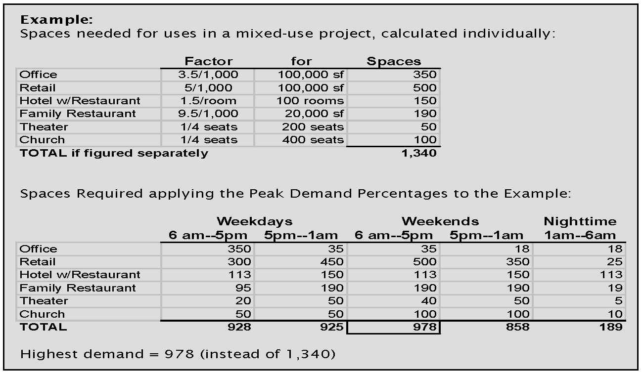
The ratios the table below may be used in determining the time of day and the day of the week at which the maximum number of spaces will be needed by the uses served by the shared parking facility.
Table 4-H: Percentage of Required Parking Spaces by Time Period
By way of example, the following illustrates shared parking calculations for a particular mixed-use development:
(c)
Availability of shared spaces. Parking spaces that are proposed to be shared among two or more uses must be clearly available to each use and not appear in any way to be serving a particular use, either through signage dedicating the spaces or through design techniques that would tend to orient use of the spaces to a particular business or building.
(d)
Recordation of shared parking agreement. Shared parking arrangements must be committed to writing in an instrument acceptable to the building, planning and zoning director, and approved by the owners of each of the affected properties or uses. The instrument must be approved by the building, planning and zoning director and shall be recorded with the clerk of the superior court, and a copy of the recorded document must be supplied to the building, planning and zoning director. The document must be written to survive future changes in ownership in perpetuity, unless the agreement is dissolved with approval by the city council.
(Ord. No. 2021-10, § 1, 6-28-2021)
Sec. 5.9. - Parking lot landscaping.
In addition to any landscaping required in article 5 of this chapter, there shall be a minimum amount of landscaping within the interior of a parking lot over ten spaces for a non-residential use designed as follows:
(a)
Planter islands shall be a minimum of 250 square feet and shall be located at the terminus of each parking row and no further apart than every ten spaces.
(b)
All planter islands must be designed with at least 60 percent coverage in shrubs and no more than 40 percent coverage in ground cover and landscaping materials. The planter island area shall include at a minimum one shade tree (see recommended tree species lists in article 5 of this chapter). No plant materials, with the exception of trees, shall exceed three feet in height. Turfgrass shall not be allowed in the planter islands.
(c)
Planter islands and landscape strips are usually defined by a barrier curb to prevent vehicular encroachment. Wheel stops or breaks in the barrier curb shall be provided in order to allow for drainage into areas designed to accommodate the stormwater discharge directed to them.
(d)
Planter islands and strips shall be designed to prevent compaction. This may be accomplished by planting a dense shrub cover or by elevating the planting area a minimum of one foot above the curb.
(e)
Parking lots with more than 100 spaces but less than 375 spaces shall provide planting strips with a minimum width of five feet and shall run continuously between all planter islands. These strips shall be planted with one tree for every 15 feet of the planter strip, taking into consideration the species and height at maturity.
(Ord. No. 2021-10, § 1, 6-28-2021)
Sec. 5.10. - Parking lot screening.
(a)
Along lot lines of a parking area which abut a residential zoning district, a dense planting of trees and shrubs shall be established on a strip of land not less than eight feet in width adjacent to the districts, and such planting shall not be less than six feet in height and a substantial bumper rail of wood, metal, or concrete shall be installed on the inside of the planting strip except where topography or other conditions would make the bumper rail unnecessary.
(Ord. No. 2021-10, § 1, 6-28-2021)
Sec. 5.11. - Number of off-street parking spaces required.
See the table below for the required minimum number of off-street parking spaces by land use type.
Table 4-I: Required Off-Street Parking Spaces
(Ord. No. 2021-10, § 1, 6-28-2021)
Sec. 5.12. - Off-street loading requirements.
(a)
On the same premises with every building, structure or part thereof, erected and occupied for manufacturing, storage, warehouse, truck freight terminal, goods display, department store, wholesale store, market, hotel, hospital, mortuary, laundry, dry cleaning or other uses similarly involving the receipt or distribution of vehicles, materials, or merchandise, there shall be provided and maintained on the lot of adequate space for standing, loading and unloading services in order to avoid undue interference with public use of the streets and alleys.
(b)
Off-street loading spaces shall be:
(1)
Provided as appropriate to the functions and scope of operation of individual or groups of buildings and uses;
(2)
Designed and constructed so that all maneuvering to park and unpark is within the property lines of the premises; and
(3)
Shall be provided so as not to interfere with the free, normal movement of vehicles and pedestrian on public rights-of-way.
(c)
Each off-street loading and unloading space, unless otherwise adequately provided for, shall be an area 12 feet by 50 feet, with 15-foot height clearance, and shall be provided according to the following table:
Table 4-J: Required Off-Street Loading Spaces
(Ord. No. 2021-10, § 1, 6-28-2021)
Sec. 5.13. - Storage and parking in residential zoning districts.
(a)
Commercial vehicles and trailers of all types, including travel, boat, camping and hauling, shall not be parked or stored on any lot occupied by a dwelling or any lot in any residential zoning district except in accordance with the following requirements:
(1)
No more than one commercial vehicle per dwelling shall be allowed, and in no case shall a commercial vehicle used for hauling explosives, gasoline, or liquefied petroleum products be allowed.
(2)
A commercial vehicle shall be of a size no greater than 10,000 pounds gross vehicle weight.
(3)
Recreational vehicles, travel trailers, hauling trailers, boats or boat trailers shall be allowed if parked or stored behind the front yard building line.
(4)
A recreational vehicle or travel trailer shall not be occupied either temporarily or permanently while it is parked or stored in any area except an RV park authorized under this development code.
(5)
No overnight parking is allowed in the street right-of-way.
(6)
Commercial vehicles and tractor trailer combinations, tractors or trailers shall not be placed or stored in residentially zoned districts that would limit access or safety on public streets.
(b)
It shall be prohibited use in all residentially zoned districts to park or store wrecked or junked vehicles, power driven construction equipment, used lumber or metal, or any other miscellaneous scrap or salvageable material in quantity.
(c)
The requirements of section 90-101, On-street parking in residential areas in the City Code of Ordinances shall also apply.
(Ord. No. 2021-10, § 1, 6-28-2021)