
Fort Oglethorpe City Zoning Code
CHAPTER 8
- PROCEDURES AND PERMITS
Sec. 1.1. - Planning advisory board.
(a)
Established.
(1)
Pursuant to the city's home rule powers granted in the Ga. Const. art. IX, § II, ¶ 1(a) and ¶ 4, the city council establishes the planning advisory board, for the purpose of advising the city council regarding planned growth and development of the city through a comprehensive and continuous planning program to accomplish a coordinated and harmonious development of the city, which will, in accordance with existing and future needs, best promote public health, safety, morals, order, convenience, prosperity and the general welfare, as well as efficiency and economy in the process of development.
(2)
The planning advisory board shall be governed by the provisions of this article.
(b)
Membership. The planning advisory board shall consist of seven members. Members shall be residents of the city, business owners in the city, and individuals who have demonstrated special interest, experience or education in history, architecture or the preservation of historic resources and shall be appointed by the city council. The terms of the members shall be for four years. Any vacancy in membership shall be filled for the unexpired term by the city council, which shall also have the authority to remove any city-appointed member for cause, on written charges, after a public hearing. All members shall serve without compensation but may be reimbursed for actual expenses incurred in connection with their official duties. The mayor and city council shall not serve on the planning advisory council and shall not serve in any advisory or quasi-advisory role.
(c)
Organization, rules, staff, and finances.
(1)
The planning advisory board shall elect its chairman from among its members. The term of the chairman shall be one year with eligibility for reelection. The chairman shall be a voting member of the board.
(2)
The city's building official shall serve as secretary to the planning advisory board, shall provide for public notice of any public hearing of the board, shall draft an agenda for each meeting subject to board adoption at the meeting, and shall record and keep the minutes of board meetings. The city's building official shall post timely notice of any cancellation or change of venue of a scheduled meeting at the direction of the chairperson of the board.
(3)
The planning advisory board may adopt rules of procedure consistent with the procedures established for its official duties under this chapter.
(4)
The planning advisory board shall meet at the time and place established on an annual schedule by the planning advisory board, except that any official meeting may be cancelled by the chairperson of the board if there is no official business to be considered. All meetings of the planning advisory board at which official action is taken shall be open to the public, and all records of the planning advisory board shall be public records.
(5)
The expenditures of the planning advisory board, exclusive of gifts, shall be within the amounts appropriated by the city council.
(Ord. No. 2021-10, § 1, 6-28-2021; Ord. No. 2023-18, 7-24-2023)
Sec. 1.2. - Powers and duties.
The planning advisory board shall have the following powers and duties:
(a)
To review applications and make findings and recommendations for rezoning requests, special exceptions, and historic preservation certificate of appropriateness requests as set forth in this development code and chapter 50, Historic Preservation Code.
(b)
To review proposals and make findings and recommendations for code amendments in accordance with the review standards herein.
(c)
To make recommendations to city council on variance requests and appeals referred to it by the building official in accordance with the provisions, procedures and review standards contained in chapter 9, Appeals and the provisions, procedures, and review standards of chapter 50, Historic Preservation Code.
(d)
To carry out such other duties, responsibilities or activities as may be directed or requested by the city council.
(Ord. No. 2021-10, § 1, 6-28-2021; Ord. No. 2023-18, 7-24-2023)
Sec. 1.3. - Decisions by the planning advisory board.
A final decision by the planning and advisory board shall require at least four members that must concur. Each official action shall contain a statement of the grounds and findings forming the basis for said decision, and the text of the motion and record of members' votes shall be incorporated in the minutes of the planning advisory board.
(Ord. No. 2021-10, § 1, 6-28-2021; Ord. No. 2023-18, 7-24-2023)
Sec. 2.1. - Outline of steps required for amendment to this code.
Amendments to the text of this development code or the adoption of a new unified development code may be initiated only by the City Council of Fort Oglethorpe.
(a)
Amendment to this development code. In the case of developing an initial development code (zoning map and text), or updating or amending an existing unified development code, the City of Fort Oglethorpe Planning Advisory Board and the City Council will, where appropriate, utilize any new or existing land use studies, land use plans or other relevant documents as a resource for code development or code amendment. The Fort Oglethorpe City Council and the Fort Oglethorpe Planning Advisory Board will each hold at least one public hearing on any new development code or any proposed amendment to the current development code.
(b)
Public hearing. Upon the completion of a preliminary development code document(s) by the planning advisory board and after this document has been presented to and reviewed by the city council, public hearings will be scheduled by both the planning advisory board and the city council, respectively. The official public hearings will be held in accordance with section 4.3 of this chapter.
(c)
Required notices. Notices of public hearings shall be published in a newspaper of general circulation within the territorial boundaries of the city. The public notice shall state the time, place and purpose of the hearing.
(Ord. No. 2021-10, § 1, 6-28-2021)
Sec. 2.2. - Standards to guide review and approval.
Standards to guide the review and approval of an amendment to this development code, and upon which findings of fact as appropriate shall be based, giving due weight or priority to those factors particularly relevant to the circumstances of the amendment, are as follows:
(a)
The extent to which a change in the economy, land use or development opportunities of the area has occurred;
(b)
The extent to which the proposed amendment is in compliance with the goals and policies of the comprehensive plan;
(c)
The extent to which the proposed amendment would require changes in the provision of public facilities and services;
(d)
The extent to which the proposed amendment would adversely or positively impact the public health, safety, and welfare;
(e)
The extent to which additional land area needs to be made available or developed for a specific type of use; and
(f)
The extent to which area demographics or projections are not occurring as anticipated.
(Ord. No. 2021-10, § 1, 6-28-2021)
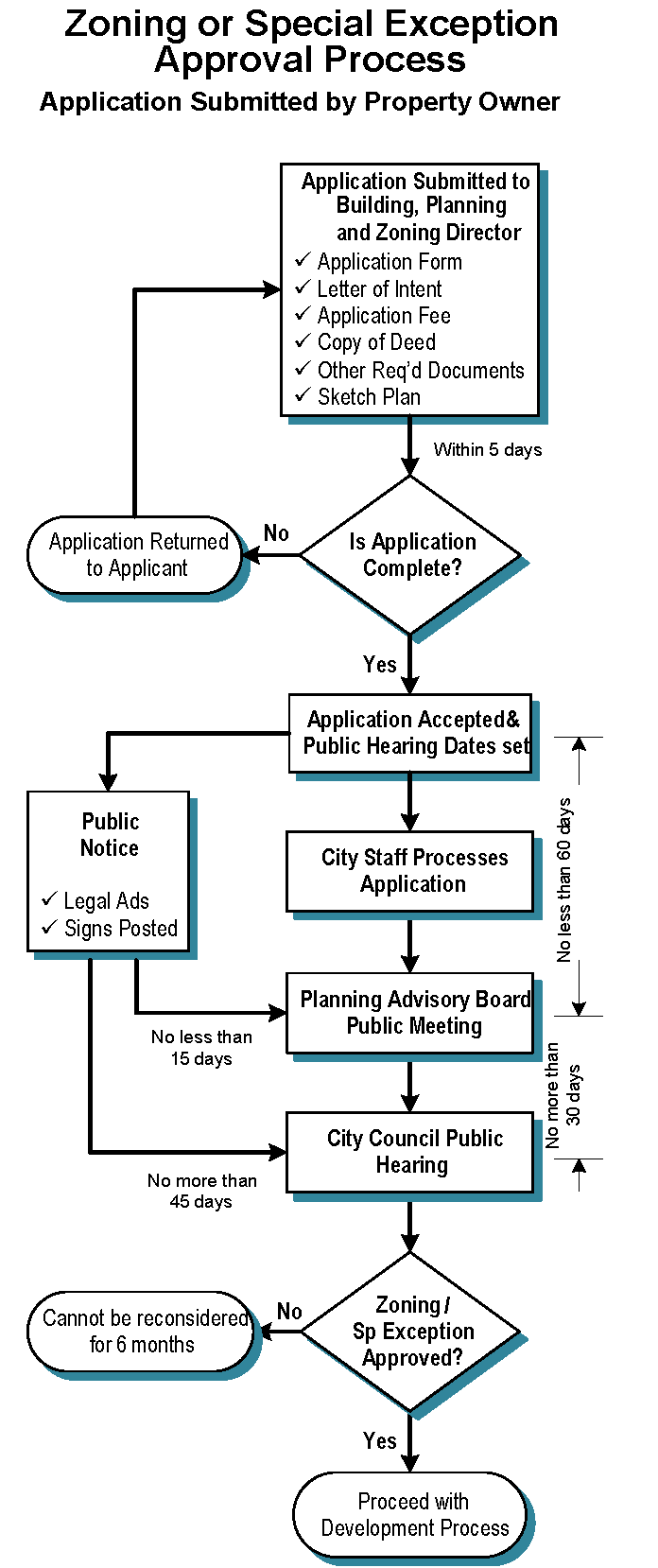
Sec. 3.1. - Outline of steps required for rezonings and special exceptions.
An application to rezone a property may be initiated at the request of the owner of the property or by the city council of Fort Oglethorpe. Requests for a special exception to the provisions regulating districts may be similarly initiated by the owner of the property or by the city council. In general, all private applications for changes in zoning districts (rezonings) and special exceptions shall follow the following steps in order to secure approval or denial.
(a)
Any petition for a zoning change or special exception by a property owner must be filed in the form of a written application with the director of building, planning and zoning and fees paid at that time.
(b)
The director of building, planning and zoning will inform the applicant of the public hearing dates at which his/her application will be considered.
(c)
The director of building, planning and zoning will advertise the public hearing(s) and provide notification to affected parties by the posting of a notice on the subject property.
(d)
Consideration of the proposed zoning change shall be carried out as referenced in section 3.2, Zoning policies and procedures.
(Ord. No. 2021-10, § 1, 6-28-2021)
Sec. 3.2. - Zoning policies and procedures.
Policies and procedures are herein established to provide guidelines for the following zoning activities:
(a)
The proposed adoption of an application or other proposal which rezones property from one zoning classification to another;
(b)
The proposed approval of a special exception authorized for consideration within a zoning district;
(c)
The procedural requirements for zoning amendments sponsored by the City of Fort Oglethorpe;
(d)
The procedural requirements for zoning amendments sponsored by an owner of property; and
(e)
The annexation of property by the City of Fort Oglethorpe.
(Ord. No. 2021-10, § 1, 6-28-2021)
Sec. 3.3. - Standards for review of a proposed rezoning or special exception.
(a)
Review of proposed rezonings. All changes to any existing zoning classification of any property or a portion of any property must be reviewed by both the Fort Oglethorpe Planning Advisory Board and the city council. For any such proposed zoning change, the city council shall have the planning advisory board prepare an evaluation of each such proposed rezoning considering each of the following factors, upon which findings of fact shall be based.
(1)
The existing land uses and zoning classification of nearby property;
(2)
The suitability of the subject property for the zoned purposes;
(3)
The extent to which the property values of the subject property are diminished by the particular zoning restrictions;
(4)
The extent to which the destruction of property values of the subject property promotes the health, safety, morals or general welfare of the public;
(5)
The relative gain to the public as compared to the hardship imposed upon the individual property owner;
(6)
Whether the subject property has a reasonable economic use as currently zoned;
(7)
The length of time the property has been vacant as zoned considered in the context of land development in the area in the vicinity of the property;
(8)
Whether the proposed zoning will be a use that is suitable in view of the use and development of adjacent and nearby property;
(9)
Whether the proposed zoning will adversely affect the existing use or usability of adjacent or nearby property;
(10)
Whether the zoning proposal is in conformity with the policies and intent of the land use plan;
(11)
Whether the zoning proposal will result in a use which will or could cause an excessive or burdensome use of existing streets, transportation facilities, utilities or schools; and
(12)
Whether there are other existing or changing conditions affecting the use and development of the property which give supporting grounds for either approval or disapproval of the zoning proposal.
(b)
Review of proposed special exceptions. Consideration of a request for a special exception shall be evaluated using the following criteria, upon which findings of fact shall be based:
(1)
Will be consistent with the comprehensive plan for the physical development of the district, including any master plan or portion thereof adopted by the city council.
(2)
Will be in harmony with the general character of the neighborhood considering population density, design, scale and bulk of any proposed new structures, intensity and character of activity, traffic and parking conditions;
(3)
Will not be detrimental to the use, peaceful enjoyment, economic value, or development of surrounding properties or the general neighborhood and will cause no objectionable noise, vibrations, fumes, odors, dust, glare, or physical activity;
(4)
Will not adversely affect the health, safety, security, morals, or general welfare of residents, visitors, or workers in the area; and
(5)
Will be served by adequate public services and facilities including schools, police and fire protection, water, sanitary sewers, public roads, storm drainage, and other public improvements.
(Ord. No. 2021-10, § 1, 6-28-2021)
Sec. 3.4. - Procedures for city initiated zoning activities.
(a)
The city council may initiate a proposed rezoning or special exception affecting one or more properties by voice vote of a majority of a quorum present at a regularly scheduled meeting.
(b)
Public hearings.
(1)
The public hearing held by the planning advisory board and by the city council shall be given public notice and held in accordance with article 4, Public Hearing Procedures.
(2)
The public hearings will be convened at the advertised time and place and will be presided over by the appropriate officials.
(c)
Recommendation of the planning advisory board.
(1)
The planning advisory board shall have no less than 15 days from the date of the public notice of its meeting to hear, review and make its recommendation to the city council on any proposed rezoning or special exception.
(2)
The planning advisory board's recommendation shall provide evaluation of each of the factors set forth in chapter 8, section 3.3(a) for rezonings or chapter 8, section 3.3(b) for special exceptions, as applicable. In making its recommendation, the planning advisory board shall adopt findings of facts with regard to such factors that are applicable.
(3)
Following the planning advisory board's public meeting, as secretary to the board, the director of building, planning and zoning shall prepare and submit the planning advisory board's recommendations to the city council prior to the city council's public hearing.
(4)
If no report is submitted within 30 days, the planning advisory board shall be deemed to have recommended the favorable adoption of the proposed zoning amendment or special exception.
(d)
Consideration by city council. The city council at its official public hearing will review the evaluations and recommendations from the planning advisory board and may choose to adopt or reject or modify the planning advisory board's recommendations and/or findings of facts, or the business may be tabled for additional study to the next regular council meeting.
(Ord. No. 2021-10, § 1, 6-28-2021)
Sec. 3.5. - Procedures for rezoning request by citizens/property owner.
(a)
Application.
(1)
An application for a rezoning or special exception must be filed with the director of building, planning and zoning at city hall on a prescribed form.
(2)
Fees shall be paid at the time of application.
(3)
The application form must be filed by the owner of the property or the owner's designated representative.
(4)
Within five working days of receipt of the application, the director of building, planning and zoning will determine if the application is complete. Incomplete applications will be returned to the applicant.
(b)
Information to be submitted along with an application for a rezoning or special exception. The following information must be provided along with the completed application form:
(1)
Letter of intent stating the reasons for the rezoning or special exception request, a description of the proposal, and addressing each of the standards under section 3.3, Standards for review of a proposed rezoning or special exception, as applicable.
(2)
Payment of fees as set forth in the schedule of fees adopted by the city council.
(3)
Copy of the deed (with legal description) as proof of ownership.
(4)
If the applicant is not the owner of the property, provide a notarized property owner's authorization for the applicant to act on behalf of the owner on the request (accompanied by an executed certificate of corporate resolution if the owner is a corporation).
(5)
Political contribution disclosure if required under the requirements of O.C.G.A. § 36-67A-3 of the Georgia Conflict in Interest in Zoning Actions Law.
(6)
Such plans and other documents required under the following chapter 8, section 3.5(c).
(c)
Plans and other documents showing proposed use required.
(1)
An application for a rezoning or special exception proposing a multi-family residential use or a nonresidential use, or which would result in the subdivision of land, shall be accompanied by a sketch plan at an approximate scale and such other plans, elevations or additional information as the director of building, planning and zoning may require, showing the proposed development.
(2)
Upon the receipt of a rezoning or special exception application, no building or other permits shall be granted except for uses or structures that conform essentially with the sketch plan and other documents submitted with the application for the rezoning or special exception.
(d)
Sketch plan standards. All applications for a rezoning or special exception shall be accompanied by a sketch plan of the proposed subdivision or development site prepared and stamped by a registered land surveyor, engineer, architect or landscape architect containing the following information:
(1)
The sketch plan shall be clearly and legibly drawn at a scale of not less than 100 feet to one inch on a sheet size not to exceed 24 inches by 36 inches. The building, planning and zoning director may approve other sheet sizes as deemed appropriate.
(2)
The sketch plan shall be drawn on a boundary survey of the property, showing bearings and distances of all property boundary lines, land lot and district lines, known survey monuments, north arrow and scale, surveyor's name and registration number, and date of survey.
(3)
The following information shall be depicted on the sketch plan.
a.
Project name.
b.
Project owner and address (both local and permanent addresses if different) and telephone and fax number(s).
c.
Name and address of person or company preparing the sketch plan.
d.
Vicinity map.
e.
Proposed use of property.
f.
Total acreage.
g.
Total number of lots and minimum lot sizes (if applicable).
h.
Size, location, and names of adjoining existing streets or access drives and proposed rights-of-ways and roadways.
i.
Proposed method of sewerage disposal (express as a note).
j.
General development data (in tabular form) for multi-family or nonresidential site developments, such as number of residential units, gross square feet of nonresidential buildings, number of parking spaces, etc.
k.
General development data (in tabular form) for single-family developments, such as minimum lot size, floor area of homes, and all relevant conditions of zoning.
l.
Any other data requested by the director of building, planning and zoning necessary for an understanding and evaluation of the project.
(4)
The sketch plan shall show the following physical characteristics as appropriate to the proposed development to an approximate (not engineering) level of accuracy:
a.
Location of ingress and egress points, internal roadways and parking areas.
b.
Location of 100-year floodplain, lakes, ponds and other watercourses.
c.
Dumpster location(s).
d.
Proposed landscaping and tree-save areas.
e.
Building heights.
f.
The approximate location and arrangement of existing buildings, parking areas and other improvements that are proposed to remain.
g.
For multi-family and nonresidential developments, the approximate location and arrangement of proposed buildings, parking areas and other improvements including stormwater detention areas and all proposed buffers.
h.
Location of existing and proposed sidewalks.
i.
Existing zoning of the property and adjoining properties.
(e)
Public hearing dates.
(1)
The director of building, planning and zoning will inform the applicant of the public hearing dates.
a.
The date scheduled for the planning advisory board meeting shall be no less than 60 days following acceptance of the complete application by the director of building, planning and zoning.
b.
The date scheduled for the city council public hearing shall be no more than 30 days following the planning advisory board's meeting at which the application is considered.
(2)
Although the Fort Oglethorpe Planning Advisory Board will convene a public meeting (following the procedures for a public hearing) on each proposal to consider its recommendations, the official public hearing will be held by the city council to consider approval or denial of the application.
(3)
Public notice of each hearing and the procedures to be followed are presented in article 4, Public Hearing Procedures.
(f)
Recommendation of the planning advisory board.
(1)
All meetings of the planning advisory board shall be held at such time as the planning advisory board may establish. All meetings of the planning advisory board shall be open to the public.
(2)
The planning advisory board shall have no less than 15 days from the date of the public notice of its meeting to hear, review and make its recommendation to the city council on any proposed rezoning or special exception.
(3)
The planning advisory board's recommendation shall provide evaluation of each of the factors set forth in chapter 8, section 3.3(a) for rezonings or chapter 8, section 3.3(b) for special exceptions, as applicable. In making its recommendation, the planning advisory board shall adopt findings of facts with regard to such factors that are applicable.
(4)
Following the planning advisory board's public meeting, as secretary to the board, the director of building, planning and zoning shall prepare and submit the planning advisory board's recommendations to the city council prior to the city council's public hearing.
(5)
If no report is submitted within 30 days, the planning advisory board shall be deemed to have recommended the favorable adoption of the proposed zoning amendment or special exception.
(g)
Consideration by city council. The city council at its official public hearing will review the evaluations and recommendations from the planning advisory board and may choose to adopt or reject or modify the planning advisory board's recommendations and findings of facts, or the business may be tabled for additional study to the next regular council meeting.
(Ord. No. 2021-10, § 1, 6-28-2021)
Sec. 3.6. - Annexations.
(a)
All land proposed to be annexed to the corporate limits of the City of Fort Oglethorpe shall be considered in strict accordance to the Annexation of Territory Law of the State of Georgia (O.C.G.A. § 36-36-1 et seq.) including the planning and zoning requirements and procedures therein, depending on the method of annexation that the city pursues.
(b)
In addition, the city will follow the annexation procedures and provisions of the Zoning Procedures Law (O.C.G.A. § 36-66-4(d)) to the extent applicable.
(c)
The required zoning hearing will be held prior to annexation but the zoning of the property will not be approved prior to the effective date of completion of the annexation.
(Ord. No. 2021-10, § 1, 6-28-2021)
Sec. 3.7. - Special public hearing; drug dependence treatment facilities.
The following requirements are adopted as required by the Georgia Zoning Procedures Law (O.C.G.A. § 36-66-4(f)):
(a)
When a proposed rezoning or special exception application relates to or will allow the location or relocation of a halfway house, drug rehabilitation center, or other facility for treatment of drug dependency, a special public hearing shall be held on the proposed request. Such special public hearing shall be held at least six months and not more than nine months prior to the date of final action on the application by the city council. The hearing required by this subsection shall be in addition to the public hearings required for a rezoning or special exception.
(b)
Notice of special public hearing.
(1)
The city shall give notice of such special public hearing by providing notice of the hearing in the same manner as required for public hearings under article 4, Public Hearing Procedures.
(2)
Both the posted notice and the published notice shall include a prominent statement that the proposed rezoning or special exception application relates to or will allow the location or relocation of a halfway house, drug rehabilitation center, or other facility for treatment of drug dependency.
(3)
The published notice shall be at least six column inches in size and shall not be located in the classified advertising section of the newspaper.
(Ord. No. 2021-10, § 1, 6-28-2021)
Sec. 3.8. - Administrative assistance.
The director of building, planning and zoning shall provide such technical, administrative, and clerical assistance and office space as is required by the planning advisory board to carry out its function under the provisions of these regulations.
(Ord. No. 2021-10, § 1, 6-28-2021)
Sec. 3.9. - Fees.
All applicants for a rezoning, a special exception, a home occupation license, or other required inspections, within a district, shall be accompanied by a fee payable to the city to defray expenses incidental to the processing of such applications. A listing of all applicable scheduled fees is available in the director of building, planning and zoning's office of city hall.
(Ord. No. 2021-10, § 1, 6-28-2021)
Sec. 4.1. - Public notice.
(a)
Published notice—Amendments. For an amendment to the text of this development code, notice shall be given as required under section 2.1(c).
(b)
Public notice—Rezonings and special exceptions. For an application for the rezoning of a property or granting of a special exception, the following shall apply:
(1)
Notice in newspaper.
a.
At least 15 days but no more than 45 days prior to a public hearing required by this chapter, notice shall be published in a newspaper of general circulation within the city. The notice shall state the time, place and purpose of the city council hearing and the same for the planning advisory board meeting that will precede the council hearing. The notice shall also include the location of the property, the present zoning classification of the property, and the nature of the requested action.
(2)
Posting of signs.
a.
In addition to the newspaper notice, a sign or signs shall be placed by the director of building, planning and zoning in a conspicuous location on the property frontage in such manner as to be legible from the public road. On lots with more than one road frontage, a sign will be placed facing each public road. If the property has no road frontage, the sign shall be placed on each road at a location where access will be gained to the property.
b.
The sign(s) must be in place no less than 15 days prior to the date of the public hearing and shall state the date, time and place for the public hearing and shall include the present zoning classification of the property and the nature of the proposed action (requested zoning classification or type of special exception).
(3)
Sufficiency of public notice. Where published notice is given in accordance with this section and a sign has been posted in accordance with this section, no further notice to interested parties or adjacent or nearby property owners is required.
(c)
Appearance of a person at a public hearing shall constitute a waiver of any claims by such person based upon improper publication of notice or posting on the property by such person.
(Ord. No. 2021-10, § 1, 6-28-2021)
Sec. 4.2. - Withdrawal.
Any appellant wishing to withdraw an application prior to final action on the application shall file a written request for withdrawal with the director of building, planning and zoning.
(a)
The withdrawal request must be in writing and signed by the owner, the applicant or the owner's authorized agent.
(b)
If the request for withdrawal is received prior to the publication of notice for the public hearing as required under section 4.1(a) Published notice—Amendments, the application shall be withdrawn administratively by the director of building, planning and zoning.
(c)
If a request for withdrawal of the application is received after notice has been published (or irretrievably set for publication) for the scheduled public hearing, the appeal may be withdrawn at the public hearing with the consent of those conducting the public hearing and removed from further consideration.
(Ord. No. 2021-10, § 1, 6-28-2021)
Sec. 4.3. - Conducting a public hearing.
(a)
Procedures. All public hearings held by the planning advisory board and the city council for amendments under article 2, Adoption or Amendment of Development Code or for applications submitted under article 3, Zoning Procedures shall be held in accordance with the procedures of this section.
(b)
Opening hearings.
(1)
The public hearing shall be convened at the scheduled time and place by the chair of the planning advisory board or the mayor, or their designee as applicable, who shall act as the presiding official.
a.
The presiding official may administer oaths and compel the attendance of witnesses by subpoena.
b.
The presiding official shall conduct the public hearing informally, as strict adherence to the rules of evidence is not required.
c.
All parties participating in the public hearing shall introduce only relevant evidence.
d.
All parties participating shall have the right to present witnesses and to cross-examine witnesses.
(2)
The presiding official shall open the public hearing by stating the matter being considered at the hearing. At this time, the presiding official may summarize the public hearing procedures.
(3)
No person in attendance is to speak unless first formally recognized by the presiding official. Upon rising to speak each person recognized is to state their name and home address.
a.
The presiding official may encourage reasonable limits on the number of persons who may speak for or against a proposal, on the time allowed for each speaker, and on the total time allowed for presentation of the application.
b.
Such reasonable time limitations, however, shall not deny any member of the general public to speak at the public hearing.
c.
No less than ten minutes is to be provided for all of those speaking in support of an application and no less than ten minutes is to be provided for all of those speaking against, unless such proponents or opponents take less time than the minimum allowed.
d.
Altogether, the total amount of time afforded the proponents of the application and the opponents, including rebuttal and cross-examination, shall be equal. Neither side, however, is required to use the total time available.
(c)
Background and recommendations. The director of building, planning and zoning shall submit the assembled record of the application. The director of building, planning and zoning shall provide such information or explanation as appropriate to the circumstances of the application.
(d)
Proponents of the application.
(1)
Persons who support the application will be asked to comment first. The applicant or their designated agent may, upon recognition and upon statement of name, address and relationship to the matter, present and explain the application. The applicant may appear in person or may be represented by an agent or counsel.
(2)
The applicant or the applicant's representative shall be required to attend the public hearing unless written notice of hardship is received prior to the hearing. Failure of the applicant or the applicant's representative to attend the public hearing, except in cases of hardship, may be due cause for the tabling of the application; provided, however, that final action by the board must be taken within 60 days of final advertising.
(3)
The applicant shall have the burden of proof, which shall include the presentation of evidence and the burden of persuasion of each factor necessary to receive the approval of the request.
(4)
After completion of the presentation of the applicant, other persons who support the request will be asked to comment and will be allowed to speak in support of the request upon recognition and upon identification of the person's name, address, and relationship to the matter.
(e)
Persons opposing the application. Persons who oppose the application will next be asked to comment. Each interested person, after being recognized, and providing their name, address and relationship to the matter, shall be afforded an opportunity to speak.
(f)
Rebuttal. The applicant shall have an opportunity for rebuttal concerning the request. Rebuttal must be limited to points or issues raised by opponents to the application at the hearing.
(g)
Cross-examination. Upon the request of any participant in the public hearing speaking in favor of or opposing the application, the presiding official shall allow such participant to ask a question or questions of any other participant. The question or questions shall be posed through the presiding official, who may determine the relevancy of the question or questions to the subject of the public hearing. Relevant questions shall be addressed by the participant to whom the question or questions are directed.
(h)
Discussion. All public comments having been heard, the members of the planning advisory board or the city council, as applicable, may discuss the matter among themselves. During this discussion period, the members may call on the director of building, planning and zoning, any proponent or opponent, or other persons in attendance to clarify points made previously, to answer questions or to provide additional information. Such persons may respond upon recognition.
(i)
Delay, rescheduling or continuation of hearing. A public hearing on an application may be delayed, rescheduled or continued to another time and date, provided the announcement of the new time, place and date is given at the time and place of the advertised hearing, which announcement shall constitute public notice for the delayed, rescheduled or continued hearing.
(j)
Transcription.
(1)
All proceedings of the planning advisory board or the city council, as applicable, shall be recorded on tape or other media. The recording of the proceedings shall be retained until any further appeals on a request have been exhausted.
(2)
The appellant or any person in opposition to the request, at their expense, is allowed to have the public hearing transcribed by a court reporter.
(Ord. No. 2021-10, § 1, 6-28-2021)
Sec. 4.4. - Decisions.
(a)
Findings of fact.
(1)
Following the public hearing, the planning advisory board and the city council, as applicable shall adopt findings of fact supporting their decision and may adopt any additional report it deems appropriate.
(2)
In order to approve an application, the planning advisory board and the city council, as applicable, shall further make a finding that the reasons set forth in the application justify the granting of the application and that approval would be the minimum needed to make possible the reasonable use of the land, building or structure.
(3)
In preparing its findings of fact, the planning advisory board and the city council, as applicable, must consider the standards for approval set forth under section 2.2, for a rezoning, or under chapter 8, section 3.3(b) for a special exception, as applicable.
(b)
Decision.
(1)
The planning advisory board shall take action to hear, review and make its recommendation to the city council in accordance with chapter 8, section 3.5(f) above.
(2)
City council shall take action to approve, approve with conditions or deny an application by majority vote no later than their next regularly scheduled meeting at which a quorum is present and the relevant official public hearing is held. If no decision obtains a majority vote, the application shall be considered denied unless the appellant agrees to a tabling of the application to the city council's next regularly scheduled meeting.
(3)
If an application for approval of a rezoning or special exception on a property is denied by the city council, an application for the same or any other rezoning or special exception on said property may not be accepted until the expiration of six months from the date of action by the city council on the original application.
(Ord. No. 2021-10, § 1, 6-28-2021)
Sec. 4.5. - Conditional approval of rezoning or special exception.
In approving the rezoning of a property or a special exception for a property, the city council may impose conditions of approval that it deems necessary in order to make the requested action acceptable and consistent with the purposes of this development code and of the zoning district(s) involved, to ameliorate negative issues identified through evaluation of the standards governing consideration of a rezoning or special exception, or to further the goals and objectives of any city adopted plan.
(a)
Types of conditions. Such conditions of approval may consist of any or all of the following:
(1)
Restrictions as to what land uses or activities shall be allowed;
(2)
Dedication of required rights-of-way to the city where insufficient amounts or none exist;
(3)
Setback requirements from any lot line;
(4)
Specified or prohibited locations for buildings, parking, loading, or storage areas or other land uses;
(5)
Driveway curb cut restrictions;
(6)
Maximum building heights or other dimensions;
(7)
Special drainage or erosion provisions;
(8)
Landscaping or planted area which may include the location, type and maintenance of plant materials;
(9)
Fences, walls, berms, or other landscaping or buffering provisions or protective measures;
(10)
Preservation of existing trees or planting of new trees or other vegetation;
(11)
Special measures to alleviate undesirable views, light, glare, noise, dust or odor;
(12)
Permitted hours of operation;
(13)
Architectural style or materials;
(14)
A requirement that the owner or developer must build or use the property according to a sketch plan of the property as adopted or modified by the conditions of approval;
(15)
A limitation on exterior modifications of existing buildings; or
(16)
Any other requirement that the city council may deem appropriate and necessary as a condition of rezoning approval in furtherance of the public health, safety or welfare.
(b)
Such conditions of approval.
(1)
Shall only be valid if they are included in the motion approving the rezoning;
(2)
Shall be in effect as long as the zoning or special exception is in effect;
(3)
Shall be required of the property owner and all subsequent owners as a condition of their use of the property;
(4)
Shall be interpreted and continuously enforced by the director of building, planning and zoning in the same manner as any other provision of this development code; and
(5)
Project approval of a preliminary plat or site plan, a development permit or a building permit shall not be issued for a conditionally approved property until the director of building, planning and zoning determines that such plans or permits are in compliance with all applicable conditions of approval.
(c)
Change in conditions of conditional zoning approval. Any application that proposes a change in the conditions of approval previously established by the city council through action on a rezoning shall be considered a new application and therefore subject to all procedures and provisions of this chapter regarding the approval of a rezoning.
(Ord. No. 2021-10, § 1, 6-28-2021)
Sec. 5.1. - Types of approvals covered.
The provisions of this section apply to any type of official city action requested by a private party related to a development project, such as a rezoning or special exception approval, hardship variance approval, approval of a subdivision plat, issuance of a land disturbance permit or building permit, or hook-up to a public utility.
(Ord. No. 2021-10, § 1, 6-28-2021)
Sec. 5.2. - Thresholds for regional review.
(a)
Any development project for which any city action is requested that meets or exceeds any of the development thresholds adopted by the Georgia Department of Community Affairs (DCA) or, if applicable, alternative development thresholds adopted by the Northwest Georgia Regional Commission shall be considered as qualified for review as a development of regional impact (DRI).
(b)
If a proposed development will be located in more than one jurisdiction and, in total, the proposed development meets or exceeds a DRI threshold; the local government in which the greatest acreage of the project is to be located is responsible for submitting the project to the regional commission as a potential DRI.
(Ord. No. 2021-10, § 1, 6-28-2021)
Sec. 5.3. - Application process.
The application process shall follow the process established by and described in the Rules of Georgia Department of Community Affairs, Chapter 110-12-3, Developments of Regional Impact.
(Ord. No. 2021-10, § 1, 6-28-2021)
Sec. 5.4. - Local government action.
The city may proceed with its development review process during the DRI process but shall take final official action regarding a project only after the regional commission completes the DRI process.
(Ord. No. 2021-10, § 1, 6-28-2021)
Sec. 6.1. - Sign permit applications.
(a)
Applications for permits shall be made upon forms provided by the city and shall contain or have attached thereto the following information:
(1)
The name, address and telephone number of the applicant;
(2)
The tax parcel ID and physical address of the building, structure or lot to which or upon which the sign is to be attached or erected;
(3)
Two accurate drawings showing the position of the sign in relation to nearby buildings or structures, including other signs, driveways, parking areas, and any other limiting site features;
(4)
One accurate drawing to scale of the plans, specifications and method of construction and attachment of the building or ground. The drawing shall specifically include the size of the sign face area, overall height and width of the sign structure, sign installation and its relation to existing rights-of-way and all driveways, a sight distance diagram, and any devices or landscaping around the base of the sign. For all signs over 35 square feet in sign area, the drawing shall be an engineered structural drawing designed to the International Building Code;
(5)
Name, address, telephone number and business license number of the number of the person erecting the sign;
(6)
Written consent of the owner of the lot to which or upon which the sign is to be erected with respect to freestanding signs and written consent of the owner of the lot and tenant of the improved space upon which a wall sign is to be erected;
(7)
The location and size of all other permanently installed freestanding signs on the lot upon which the sign is to be erected;
(8)
The distance in feet to the nearest existing freestanding sign;
(9)
The distance in feet from the location of the proposed sign to the nearest residentially zoned lot;
(10)
The distance in feet from the location of the proposed sign to the edge of the nearest registered historic district, such distance to be measured as the crow flies from the site of the proposed installation to the nearest border of the historic district;
(11)
The size of the lot upon which the sign is to be erected and the length of the street frontage for the street to which the sign is oriented;
(12)
If the sign is to be lighted, an application for electrical permit meeting all standards of the city's electrical code;
(13)
Such other information as the city shall require to show full compliance with this and other ordinances of the city;
(14)
All applications for sign permits must be signed by the owner of the property upon which the sign is to be erected.
(b)
Use of foreign languages.
(1)
For any sign for which a sign permit is required that uses words in a language other than English, the English translation of the sign shall be provided on the sign permit application.
(2)
Nothing herein shall be construed to prohibit the use of foreign words or characters on a sign as long as they do not contain obscene language or advertise an illegal activity.
(c)
No review of the specific content of any proposed sign shall be made or required.
(Ord. No. 2021-10, § 1, 6-28-2021)
Sec. 6.2. - Time for consideration.
The city shall process all sign permit applications within 30 business days of the director of building, planning and zoning's actual receipt of a fully completed application and such sign permit fee as may be established from time to time by vote of the city council.
(a)
The director of building, planning and zoning shall give notice to the applicant/owner of the decision of the city by hand delivery or by mailing a copy of the notice to the address of the applicant/proposed permittee on the permit application on or before the 30th business day after the department's receipt of the application.
(b)
If mailed, notice shall be deemed to have been given upon the date of mailing in conformity with this section.
(c)
If the city fails to respond in writing within the 30-day period, the permit shall be deemed to have been granted.
(d)
If the director of building, planning and zoning finds that conditions or stipulations are required to make the sign legally acceptable, the permit shall only be approved subject to the applicant's written agreement to such conditions.
(Ord. No. 2021-10, § 1, 6-28-2021)
Sec. 6.3. - Denial and revocation.
(a)
Procedure.
(1)
The city shall deny permits to applicants who submit applications for signs that do not comply with the provisions of this chapter, or which fail to comply with applicable building codes (including, but not limited to, any wind or hurricane resistance requirements) or other applicable local, state, or federal laws; or any applicants who submit incomplete applications or applications containing any false material statements.
(2)
Violations of any provisions of this chapter will be grounds for terminating a permit granted by the city for the erection of a sign.
(3)
Should it be determined that a sign permit was issued pursuant to an incomplete application or an application containing a false material statement, or that a permit has been erroneously issued in violation of this chapter, or that a sign has been erected contrary to the terms of the permit, the director of building, planning and zoning shall revoke the permit.
(4)
Should the city deny a permit application, the reasons for denial shall be stated in the notice provided for in chapter 8, section 6.2(a), above.
(5)
Any application denied and later re-submitted shall be deemed to have been submitted on the resubmittal date, instead of on the initial submission date.
(6)
No permit shall be revoked or denied except for due cause which is defined as any of the following:
a.
Violation of the provision of this chapter, development code or any other city ordinance or any state or federal law;
b.
Erroneous issuance of a permit which should not have been issued under the terms of this chapter;
c.
Erecting or building a sign which does not conform to the information contained in the application;
d.
Failure to maintain the sign as required by this chapter; or
e.
Submission of an incomplete application or an application containing false material statements.
(b)
Director of building, planning and zoning. An individual whose permit application has been denied or whose permit has been revoked may appeal the decision to the planning advisory board in accordance with the procedures and requirements of chapter 9, Appeals of this code.
(Ord. No. 2021-10, § 1, 6-28-2021)
Sec. 6.4. - Permit expiration.
A sign permit shall become null and void if the sign for which the permit was issued has not been completed and installed within six months after the date of issuance. No refunds will be made for permits that so expired due to a failure to erect a permitted sign. If a person desires to erect a sign after the permit is expired, a new application will be required and will be subject to the regulations in effect at the time of the new application. A new application fee will be required.
(Ord. No. 2021-10, § 1, 6-28-2021)
Sec. 6.5. - Fees.
The cost of a sign permit shall be established from time to time by vote of the city council and shall be payable in addition to any building permit or historic preservation certificate of appropriateness fees required. Differing fees for different categories of signs may be so established. A written list of applicable fees shall be maintained in the department of building, planning and zoning. The city council may set such fees by resolution of the city council.
(Ord. No. 2021-10, § 1, 6-28-2021)
Sec. 6.6. - Issuance of permits for temporary signs.
(a)
Temporary sign permits; when required.
(1)
The director of building, planning and zoning is hereby authorized to issue a sign permit for any temporary sign provided all requirements of this article are met. A temporary sign permit must be issued by the director of building, planning and zoning before a sign may be erected or attached to, suspended from, or supported on a building or structure except for temporary signs that are exempt from permitting under (b) below.
(2)
Any temporary sign using electrical wiring and connection shall require a sign permit and an electrical permit, both of which must be issued simultaneously.
(b)
Temporary signs exempt from permitting. The following signs may be erected or placed without securing a temporary sign permit or payment of a fee, provided that each is located and maintained in accordance with the provisions of the sign regulations (chapter 5) and all other applicable codes and regulations:
(1)
Temporary signs associated with the offering of a property or premises for sale or rent; the construction of a building, subdivision or development project; or the rehabilitation, remodeling or renovation of a building shall be allowed on any property, provided that:
a.
The number of such signs shall be limited to the number allowed;
b.
The signs do not exceed the maximum sizes allowed or 32 square feet, whichever is the smaller; and
c.
These signs shall be removed upon the termination of the pertinent temporary event.
(2)
Temporary signs associated with a yard sale.
(3)
Temporary signs associated with an election, political campaign, referendum or ballot proposition put to the voters as part of city, county, state or federal governance.
(4)
Small temporary signs allowed as miscellaneous freestanding signs.
(Ord. No. 2021-10, § 1, 6-28-2021)
Sec. 6.7. - Master sign plans.
(a)
Master sign plans may be submitted by a property owner or their authorized representative for pre-approval of permits for permanent signs. The master sign plan must comply with the requirements of this section.
(b)
Master sign lans shall illustrate all proposed signs in sufficient detail so as to provide knowledgeable review and design specificity. Master sign plans shall show, describe or illustrate all signs proposed to be located on a lot or within a development (and the buildings and structures related thereto) for which sign permits will be required.
(c)
Master sign plan applications must include:
(1)
Information. All of the information required for a sign permit application under section 6.1, Sign permit applications shall be submitted with an application for master sign plan approval, but including all signs proposed on the plan individually and collectively.
(2)
Specifications. An accurate drawing to scale of the plans, specifications and method of construction and attachment of the sign or signs to the building or ground. The drawing shall specifically include the size of the sign structure(s) and sign face area(s), overall height of the sign(s), a site distance diagram, and any protective devices around the base of the sign(s). For any sign for which a building permit is required, the drawing shall be an engineered structural drawing designed to all building code requirements.
(3)
Design. The master sign plan shall include such drawings and specifications as may be required to clearly illustrate the design elements of the sign or signs, including the construction materials, size, letter style and color of all elements of the sign(s), including the sign structure, the sign face, and background surfaces. The plan shall also show landscaping details meeting the requirements of this article, including the extent of the designated landscaping area, the location of specific landscape materials, and the botanical and common name of plants by location on the plan.
(d)
Signs that are otherwise exempt from permitting need not be shown on the master sign plan.
(e)
Approval.
(1)
A master sign plan depicting signs that conform to all requirements of chapter 5 of this code may be approved administratively by the director of building, planning and zoning.
(2)
If approval is denied by the director of building, planning and zoning, the applicant may appeal to the city council for approval of the master sign plan.
(3)
A master sign plan depicting signs that exceed or modify one or more requirements of chapter 5 of this code may only be approved by the city council. Following review of a complete application by the director of building, planning and zoning, the plan will be placed on the agenda of the next available city council meeting.
(4)
Upon approval, the master sign plan shall supersede any conflicting restrictions and regulations of this code for the property to which it pertains, and shall not be adversely affected by any subsequent amendments to this code.
(f)
Recordation of approved master sign plan.
(1)
The master sign plan as approved must be recorded by the owner in the office of the clerk of superior court and a copy of the approved master sign plan, as recorded, must be filed with the director of building, planning and zoning prior to issuance of a sign permit for any part of the development or premises.
(2)
The recorded master sign plan must be included in any sale, lease or other transfer of right of occupancy affecting any part of the development or premises to which the master sign plan applies.
(3)
All tenants of the property or development, whether an owner, lessee, subtenant, purchaser or other occupant, must comply with the approved master sign plan.
(Ord. No. 2021-10, § 1, 6-28-2021)
Sec. 7.1. - General procedures.
(a)
Two-step process.
(1)
The procedure for review and approval of the subdivision plat consists of two separate steps.
a.
The initial step is the preparation and submission to the director of building, planning and zoning of a preliminary plat of the proposed subdivision.
b.
The second step is the preparation and submission to the director of building, planning and zoning of a final plat, together with required certificates. This final plat becomes the instrument to be recorded in the office of the clerk of the county superior court, when approved and signed by the director of building, planning and zoning. All final plats must be stamped and in recordable form under the laws of the state.
(b)
Exceptions.
(1)
The following subdivisions are exempt from the requirements of this article in accordance with the provisions of this section:
a.
Plats which are developed solely with frontage on an existing road, which contain ten lots or fewer, and in which no public improvements (such as new streets, stormwater drainage facilities or public utilities) are to be made.
b.
The combination or recombination of portions of previously platted lots where the total number of lots is not increased and the resultant lots comply with this development code and with all ordinances and resolutions of the city.
(2)
Plats for exempted subdivisions shall be prepared in accordance with the applicable requirements for final subdivision plats under section 7.3, Requirements for plats to be submitted and section 7.6, Final plat approval.
(3)
The stormwater carrying capacity of the road, whether in an existing ditch or gutter, shall not be compromised. If the stormwater characteristics of the existing road are inadequate to accommodate the new lots, the public works director may require improvement of the roadway ditch and associated drainage structures as appropriate.
(4)
Approval of final plat by the director of building, planning and zoning will authorize recordation of the plat with the clerk of the superior court.
(5)
Prior to recordation of the final plat, no lots may be sold, and building permits and driveway permits on the lots may not be obtained.
(6)
Land subdivided under the provisions of this section 7.1(b) may not be re-subdivided under the provisions of this section 7.1(b). Any further subdivision of a lot or tract created by approval of a plat under this section 7.1(b) must be accomplished following all procedures for subdivision plat approval that follow in this article.
(Ord. No. 2021-10, § 1, 6-28-2021)
Sec. 7.2. - Preapplication.
The subdivider is encouraged to consult early and informally with the director of building, planning and zoning to obtain advice and assistance before he or she begins to prepare the preliminary plat. This will enable the subdivider to become familiar with the city thoroughfare plan and other official plans which might affect the area.
(Ord. No. 2021-10, § 1, 6-28-2021)
Sec. 7.3. - Requirements for plats to be submitted.
Requirements for plats to be submitted are as follows:
(Ord. No. 2021-10, § 1, 6-28-2021)
Sec. 7.4. - Preliminary plat approval.
(a)
Prior to making any street improvements or installing any utilities or selling any lots, the subdivider shall submit the complete subdivision plan for preliminary approval, although he may plan to construct only a portion of it initially.
(b)
The application for preliminary plat approval, including four prints of complete subdivision plans and a digital PDF copy, shall be submitted to the director of building, planning and zoning.
(c)
The director [of] building, planning and zoning shall inspect the property to be divided and the proposed location of any roads or streets in such subdivision. The director of building, planning and zoning may transmit prints of the preliminary plat to each utility service, health department, fire department and any other agency for review and recommendations in relation to specific service problems. A print of the preliminary plat may also be transmitted to the Northwest Georgia Regional Commission for its review and recommendations.
(d)
The preliminary plat of the subdivision at a scale of not more than one inch equals 100 feet shall show the following:
(1)
Name and location of the subdivision;
(2)
The name and address of the owner and person to be notified of official actions;
(3)
North point, graphic scale and date; north point shall be identified as magnetic, true or grid north;
(4)
Topography at contour intervals shown by the U.S.G.S. topographic maps used by the;
(5)
The location of all existing and proposed street or roads within the subdivision and adjacent to it;
(6)
The width and purpose of any existing and proposed rights-of-way and easements in such subdivision;
(7)
The total amount of acreage to be subdivided and the amount of acreage contained in each tract or lot in such subdivision;
(8)
Any portion of the land in the subdivision subject to periodic inundation by storm drainage, overflow or ponding shall be clearly shown and identified on the plat; and
(9)
The names of all streets, roads and alleys, and other rights-of-way.
(e)
Within 30 working days after the submission of the preliminary plat, the director of building, planning and zoning shall complete the review the plat and indicate its approval, disapproval or approval, subject to any required modifications unless the applicant waives this requirement and consents to the extension of such period. If the plat is disapproved or is approved subject to modifications, the reasons for such disapproval or the required modifications shall be indicated in writing on two copies of the plat.
(f)
One copy of the preliminary plat shall be retained in the director of building, planning and zoning's files, and one copy shall be returned to the subdivider at the time of approval or disapproval, signed by the director of building, planning and zoning along with any required changes or, modifications endorsed thereon. Failure of the director of building, planning and zoning to consider any preliminary plat within these 30 working days, or such period as extended, shall be considered as approval of such plat, as submitted.
(g)
Approval of the preliminary plat by the director of building, planning and zoning shall not constitute acceptance of the final plat, except when the final plat is completed during the specified time in substantial accordance with the layout shown on the preliminary plat.
(h)
Approval of the preliminary plat shall lapse unless a final plat, of all or part of the area shown on the preliminary plat, in substantial conformance therewith, is submitted within 12 months from the date of such approval, unless an extension of time is specifically applied for by the subdivider and expressly granted by the director of building, planning and zoning.
(Ord. No. 2021-10, § 1, 6-28-2021)
Sec. 7.5. - Construction of improvements; surety for completion of improvements
After the preliminary plat has been approved, the subdivider shall elect one of the following courses of action:
(a)
Construct all improvements required including, but not limited to, all streets and roads as shown on the preliminary plat, in accordance with the specifications required by chapter 7 of this development code. Upon completion of all construction, obtain certification from the office of building, planning and zoning that all roads and streets have been constructed in accordance with the requirements of this development code; or
(b)
Provide surety for the completion of such improvements as shown on the final plat submitted for approval. The subdivider shall deposit cash, deliver a certified check, or post a performance surety bond or irrevocable letter of credit with the city in an amount sufficient to ensure the completion of all required improvements by the subdivider as well as all other surety requirements of this section below. The bond shall be held by the City of Fort Oglethorpe Finance Director.
(1)
Requirements of surety. To ensure the construction and installation of required improvements, the subdivider shall deliver to the director of building, planning and development a certified check, performance surety bond or irrevocable letter of credit, or cash in such aggregate amount as is required by the director of building, planning and zoning to be the total cost of the construction and installation of all public improvements which are the responsibility of the subdivider. Aggregate amount is determined as: $200.00 per liner foot for roads and $400.00 per linear foot for roads and utilities.
(2)
Conditions of surety. The surety posted shall provide to the city and provide that the subdivider, his heirs or successors and assigns, and their agents and servants, will comply with all applicable terms, conditions, provisions and requirements of this chapter and any other applicable requirements of this development code; will faithfully perform and complete the work of constructing and installing such facilities or improvements in accordance with this development code; and that the subdivider shall be responsible to the city for any unnecessary expense incurred through the failure of the subdivider, his heirs, successors and assigns, or their agents or servants, to complete the work of such construction in an acceptable manner, and from any damages growing out of negligence in performing or failing to perform such construction and installation. Before acceptance, any surety shall be approved by the city. If a bond is offered, it shall be executed by a surety or guaranty company qualified to transact business in the state.
(3)
Duration and release. Bonds and/or other surety or cancellation of any bond shall be posted pursuant to this chapter. Acceptances shall be in writing accurately identifying the improvements covered. Facilities shall not be accepted unless they conform to the applicable city specifications and requirements of chapter 7 and this code.
(4)
Default. If the construction or installation of any improvements or facilities for which a bond or other surety is posted is not completed within 90 days after substantial completion of any buildings or structures which such improvements or facilities are designed to serve, or within one year after the date of recording of the final plat, whichever is sooner, or if such construction or installation is not in accordance with applicable standards, the city may proceed to construct, install or modify such improvements or facilities in accordance with the applicable specifications and requirements, using the proceeds from such surety deposits to pay for such work. Such work may be done under contract or by city personnel. To the extent that any portion of a cash deposit is not required or used, such excess cash shall be repaid to the person making the deposit.
(5)
Certification of receipt of surety for required improvements. The following form shall be printed directly on the final plat as follows, where a preliminary plat is not used:
"I hereby certify that a cash bond, performance surety bond, letter of irrevocable credit or certified check in the amount of ___________ has been received to ensure completion of all required improvements in the subdivision plat attached hereto in the event of default by the developer."
(Ord. No. 2021-10, § 1, 6-28-2021)
Sec. 7.6. - Final plat approval.
(a)
Final plat approval shall be obtained by the subdivider as the preliminary plat or portions of it are constructed or included in the posted surety. The final plat shall conform substantially to the preliminary plat as approved; and if submitted in portions, each portion shall conform to all requirements of these standards.
(b)
The subdivider shall submit seven paper copies of the proposed final plat and a digital PDF to the building, planning and zoning department.
(c)
The final plat shall contain all of the information which as required on the preliminary plat except the topographic contour lines shown on the preliminary plat and shall be drawn in compliance with all the appropriate laws of the state which govern the recordation of subdivision plats.
(d)
The following certification shall be presented along with the final plat:
(1)
Certification by a registered state land surveyor (seal affixed) of the accuracy of the survey and plat and the placement of all required monuments.
(2)
Certification by the director of building, planning and zoning that the subdivider has complied with one of the following alternatives:
a.
Constructed all roads, streets and other required improvements delineated in chapter 7 in accordance with the specifications and requirements of the city; or
b.
Deposited cash or certified check, or posted a surety bond or irrevocable letter of credit with the director of building, planning and zoning director of building, planning and zoning in an amount sufficient to ensure completion of all required improvements.
(3)
Certification by the subdivider showing that the applicant is the legal owner of the land, and that he formally dedicates all streets, roads and rights-of-way for public use.
(4)
State department of transportation certification of approval must be included for the proposed project if the project abuts any state or federal right-of-way.
(5)
Certification by the subdivider that all lands considered for development do not fall within the 100-year floodplain. If any part of the development falls within a floodplain or floodprone area, then the certification shall state that the following requirements shall apply:
a.
The director of building, planning and zoning has established that:
1.
The nature of the land use (i.e., recreational areas) would not lend itself to damage by water inundation to an appreciable extent;
2.
The area will be filled or improved in such a manner to prevent such periodic inundation; or
3.
Minimum floor elevations are required to prevent damage to buildings and structures.
b.
The director of building, planning and zoning will require whatever additional engineering information he or she deems necessary to make a decision on any area of questionable drainage. Lakes, ponds and similar areas will be accepted for maintenance only if sufficient land is dedicated as a public recreation area, or if such area constitutes a necessary part of the drainage control system. Such park land will be subject to approval by the city council.
(e)
When the plat has been approved by the director of building, planning and zoning, the following actions are required:
(1)
One copy with the approval of the director of building, planning and zoning certified therein shall be returned to the subdivider to be used for filing with the clerk of the court as the official plat of record.
(2)
Within ten working days from the date of final approval, the subdivider shall record the final plat in the office of the clerk of court.
(3)
One copy containing all required certifications shall be retained by the director of building, planning and zoning, and one copy of the original tracing shall be given to the subdivider for his records.
(4)
The director of building, planning and zoning must consider a final plat within 30 working days after the submission of the final plat. Failure of the director of building, planning and zoning to act on a final plat submission within these 30 working days shall be considered as approval of such submission. If the plat is disapproved, grounds for such disapproval shall be stated in writing by the director of building, planning and zoning and shall be stated in writing on two copies of the plat.
(5)
One copy of the plat shall be retained in the director of building, planning and zoning's office, and one copy shall be returned to the subdivider at the time of the disapproval.
(f)
Approval of a final plat by the director of building, planning and zoning shall not constitute automatic acceptance by the public of the dedication of any street or other public way or ground. However, after approval of the final plat and the construction of streets shown thereon, the director of building, planning and zoning public works director may recommend to the city council that it accepts these streets as public roads and take over their perpetual maintenance. After obtaining this approval, if the subdivider requests that the city council accept these streets as public streets, then the city council shall accept these streets as public roads and take over their perpetual maintenance.
(Ord. No. 2021-10, § 1, 6-28-2021)
Sec. 8.1. - Clearing permit, clearing and grubbing permit, and grading permit.
The following permits covering portions of the land development process may be issued in accordance with the requirements of this development code:
(a)
Clearing permit.
(1)
A permit limited to clearing only with no grubbing or other land disturbance (as defined in the Georgia Soil Erosion, Sedimentation and Pollution Control Act) may be issued upon identification of the property, the limits of the area to be cleared and the type of activities to be undertaken, and approval of a tree protection/replacement plan as may be required by this development code. All clearing activities are to be consistent with the provisions of this development code, the soil erosion, sedimentation and pollution control provisions of this development code, and any conditions of zoning.
(2)
A clearing permit shall expire unless clearing activities are commenced within 60 consecutive calendar days of issuance of the permit or if activities lapse and are abandoned for a period exceeding 30 consecutive calendar days.
(3)
A clearing permit shall not be construed as approval of, or authorization to, construct any improvements, buildings, or other structures on the property.
(b)
Clearing and grubbing permit.
(1)
A clearing and grubbing permit may be approved based on approval of a concept plan and tree protection/replacement plan (if required) for the development. Appropriate soil erosion and sedimentation controls and tree protection measures shall be placed and maintained as required.
(2)
A permit for clearing and grubbing shall expire unless activities are commenced within 60 days of issuance of the permit or if activities lapse and the project is abandoned for a period exceeding 14 calendar days.
(3)
A clearing and grubbing permit shall be limited to the removal of vegetation and stumps and the placement of required tree protection measures and soil erosion and sedimentation facilities, and may authorize the removal of existing structures on the property at the option of the developer. No grading or construction activities may be started under a clearing and grubbing permit. The approval of a clearing and grubbing permit shall not imply the approval of or authorization to construct any improvements, buildings, or other structures on the property.
(c)
Grading permit.
(1)
A grading permit, which may include clearing and grubbing, may be issued in accordance with the following:
a.
A development permit approved for a multi-family residential or a nonresidential project, as provided in this article, below.
b.
A preliminary subdivision plat approved under section 7.4, Preliminary plat approval above.
(2)
A grading permit may also be issued for earth borrow or storage, where no development or construction is proposed or imminent, based on approval of a grading plan, soil erosion and sediment control plan, and hydrology study, consistent with the zoning category of the site.
(3)
A grading permit shall expire unless activities are commenced within 60 consecutive calendar days of issuance of the permit or if activities lapse and the project is abandoned for a period exceeding 30 consecutive calendar days. Any site for which the grading permit expires shall immediately be stabilized to prevent erosion.
(4)
A grading permit shall be limited in its authorization to land grading activities along with associated tree protection, clearing and grubbing, and demolition activities, and may authorize the construction of storm drainage improvements and soil erosion and sedimentation facilities as allowed by the permit.
(Ord. No. 2021-10, § 1, 6-28-2021)
Sec. 8.2. - Development permit.
(a)
Development activities authorized. A development permit must first be issued to authorize all activities associated with the land development process, including grading; for the construction of such improvements as streets, surface parking areas and drives, sewer systems, stormwater drainage facilities, sidewalks, etc.; or for the construction of multi-family or nonresidential buildings and related structures and improvements in a multi-family or nonresidential project.
(b)
Development permit approval. A development permit (which may include grading, clearing, and grubbing) shall be issued at the developer's request and based on an approved preliminary subdivision plat for a single-family or two-family residential subdivision or a site plan for a multi-family or nonresidential project, along with approval of all other development plans and documents required to be submitted under this chapter. All plans approved for a development permit shall expire after six months if no permit is issued within said time period.
(c)
Expiration of development permits. A development permit shall expire 12 consecutive calendar months after issuance unless development activity as authorized by the permit are commenced within said 12-month period or if such authorized activities lapse and the project is abandoned for a period exceeding 60 consecutive calendar days. The director of building, planning and zoning may approve one extension not exceeding three consecutive calendar months within which time development activity must commence or the permit shall expire. Said extension shall be applied for within the first 12 consecutive calendar months after the permit's issuance.
(d)
Lapse in construction activity. For the purposes of this development code, a lapse in or suspension of development activity as authorized by a development permit, as a direct result of action or inaction on the part of the City of Fort Oglethorpe completely beyond the control of the developer, shall not be considered as a lapse in activity causing the development permit to expire. The 12 months within which development activity must begin shall exclude any such time period during which the activity is prohibited or has been caused to lapse by said city action or inaction.
(e)
Expiration of approved development plans.
(1)
If construction activity has not commenced within the permit period and the development permit expires, the director of building, planning and zoning shall require new site plans to be submitted for the project. The new plans must comply with any changes or amendments to these regulations or other ordinances as adopted by the city.
(2)
Where development plans have been approved by the director of building, planning and zoning, and no development permit has been issued, new plans shall be submitted after 12 months if a development permit has not been issued and construction has not commenced on the project.
(Ord. No. 2021-10, § 1, 6-28-2021)
Sec. 8.3. - Stormwater management permit.
See chapter 6, Natural Resource Protection of this UDC.
(Ord. No. 2021-10, § 1, 6-28-2021)
Sec. 8.4. - Environmental approval: Wetlands and groundwater recharge areas.
For any property containing a wetlands or significant groundwater recharge areas, a site plan meeting the requirements established in chapter 6 of this UDC shall be included along with the stormwater plan in an application for a development permit.
(Ord. No. 2021-10, § 1, 6-28-2021)
Sec. 9.1. - Building permit applications.
(a)
An application for a building permit shall be submitted using the form(s) provided by the director of building, planning and zoning and accompanied by payment of all applicable fees.
(b)
Digital drawing files, if required, shall be submitted in Adobe PDF file format.
(Ord. No. 2021-10, § 1, 6-28-2021)
Sec. 9.2. - Environmental health department: On-site sewage disposal.
For any structure for which on-site sewage disposal will be provided, a permit issued by the environmental health department shall be required prior to issuance of a building permit. Said permit may first require approval by the environmental health department of a plan showing the location of the sewage disposal system and other site improvements, in accordance with their regulations.
(Ord. No. 2021-10, § 1, 6-28-2021)
Sec. 9.3. - Single-family and duplex residences.
(a)
A building permit for a single or two-family residence may be issued after the recording of a final plat or after the lot upon which the building is to be located has otherwise become a buildable lot of record.
(Ord. No. 2021-10, § 1, 6-28-2021)
Sec. 9.4. - Swimming pools.
(a)
Issuance of a building permit for a swimming pool as an accessory use to a single or two-family residence, whether to be issued at the same time as, or subsequent to, the permitting for construction of the dwelling, shall first require approval of a swimming pool location plan.
(b)
The plan shall show the proposed location of the swimming pool and enclosing fence relative to the residence, the property boundaries, setback lines, septic tank and septic tank drain field (if any), and any easements on the site. The location of such swimming pool shall comply with all requirements of the applicable zoning district and the International Swimming Pool and Spa Code as adopted by the city.
(c)
A certificate of occupancy shall not be issued until conformance to the approved swimming pool location plan has been field verified by the department.
(Ord. No. 2021-10, § 1, 6-28-2021)
Sec. 9.5. - Multi-family and nonresidential structures.
(a)
Issuance of a building permit for any principal building other than a single-family detached or duplex residence (and associated accessory structures) shall first require issuance of a development permit for the building site, and the building permit shall be consistent with said development permit. (See section 8.2, Development permit, above.)
(b)
Building plans must be reviewed and approved by the director of building, planning and zoning prior to permitting for all multi-family and nonresidential structures and associated accessory structures.
(c)
Building plan approval shall expire after one year, after which re-review and approval shall be required prior to issuance of a building permit for the building or additional buildings.
(Ord. No. 2021-10, § 1, 6-28-2021)
Sec. 9.6. - Issuance on buildable lots of record; exceptions.
Building permits shall only be issued on buildable lots of record, as defined in this code, except under special circumstances limited to and as specifically described in this section, below.
(a)
In a single-family detached and duplex residential subdivision, building permits for no more than two model home buildings, on specific lots may be issued by the director of building, planning and zoning on the basis of an approved preliminary plat after the approval by the Catoosa County Health Department, and subject to all limitations or requirements as may be established by the director of building, planning and zoning. No certificate of occupancy shall be issued for the completed model home(s) until the final plat encompassing the model home building lots has been approved and recorded.
(b)
In fee-simple townhouse subdivisions, a building permit may be issued on a buildable lot of record established for each building (containing any number of townhouse dwelling units) through recording of a final plat following completion of all required public improvements. Upon completion of the buildings, the final plat shall be re-recorded to establish individual lots for the townhouse units, based on their actual locations, prior to issuance of a certificates of occupancy.
(Ord. No. 2021-10, § 1, 6-28-2021)
Sec. 9.7. - Approval period.
No order of the director of building, planning and zoning permitting the erection or alteration of a building shall be valid for a period longer than six months unless such use is established within such period; provided, however, that where such use permitted is dependent upon the erection or alteration of a building, such order shall continue in force and effect if a building permit for said erection or alteration is obtained within such period, and such erection or alteration is started and proceeds to completion in accordance with such permit.
(Ord. No. 2021-10, § 1, 6-28-2021)
Sec. 10.1. - Application of this article.
(a)
This article applies to any requirements determined by the city to be necessary for approval of plans, permits, or applications for the issuance of building permits under this code, referred to as "regulatory requirements" in this article.
(b)
This article shall not apply to hospitals, ambulatory health care centers, nursing homes, jails, penal institutions, airports, buildings or structures that impact national or state homeland security, or any building defined as a high-rise building in the State Minimum Standards Code; provided, however, that interior tenant build-out projects within high-rise buildings are not exempt from this section.
(c)
Nothing in this article shall apply to inspections for compliance with a state or local fire safety standard or erosion control standard.
(Ord. No. 2021-10, § 1, 6-28-2021)
Sec. 10.2. - Procedures.
(a)
No later than five business days after receipt of any application related to regulatory requirements, the director of building, planning and zoning shall either:
(1)
Approve the application and issue the requested permit; or
(2)
Notify the applicant as to whether the submitted documents meet the requirements of a complete application.
(b)
Except as otherwise provided in this article, time spent by the city determining whether an application is complete shall count toward the total 30 days for plan review or inspection.
(1)
If the director of building, planning and zoning determines that the application is not complete, the applicant shall be provided written notice identifying the items that are not complete.
(2)
The 30-day time period is tolled when the application is rejected as incomplete. If within 30 days after the city has provided notice that the application is incomplete the applicant submits revisions to address the identified deficiencies, the director of building, planning and zoning shall have an additional five business days to review the application for completeness.
(c)
Upon notification to the applicant that a complete application has been accepted, the city shall also notify the applicant as to whether the personnel employed or contracted by the city will be able to provide regulatory action within 30 days for plan review or provide inspection services within two business days of receiving a valid written request for inspection.
(d)
If the city determines that the personnel employed by the city cannot provide regulatory action or inspection services within the time frames required under paragraph (b) of this section, the applicant shall have the option of retaining, at its own expense, a private professional provider to provide the required plan review or inspection in accordance with the provisions of this article. If the applicant elects to utilize the services of a private professional provider, the regulatory fees associated with such regulatory action shall be reduced by 50 percent and such reduced amount shall be paid to the city in accordance with the city's policies.
(e)
If the city determines that the personnel employed by the city can provide regulatory action or inspection services within the time frames required under paragraph (b) of this section, a convenience fee not to exceed the full amount of the regulatory fees associated with such regulatory action shall be paid to the city in accordance with the city's policies. Upon payment in full of the convenience fees associated with the complete application, the applicant may nevertheless choose to retain, at its own expense, a private professional provider to provide the required plan review or inspection, subject to the requirements set forth in this article.
(f)
If the city states its intent to complete the required plan review within the time prescribed by paragraph (b) of this section, or any extension thereof mutually agreed to by the applicant and the city, and the city fails to complete such plan review in the time prescribed by paragraph (b) of this section, or any extension thereof mutually agreed to by the applicant and the governing authority, the local governing authority shall issue the applicant a project initiation permit.
(1)
The local governing authority shall be allowed to limit the scope of a project initiation permit and limit the areas of the site to which the project initiation permit may apply but shall permit the applicant to begin work on the project, provided that portion of the initial phase of work is compliant with applicable codes, laws, and rules.
(2)
If the plans submitted for permitting are denied for any deficiency, the time frames and process for resubmittal shall be governed by subparagraphs (1) through (3) of paragraph (b) of section 10.4 below.
(3)
Any delay in the processing of an application that is attributable to a cause outside the control of the city or through fault of the applicant shall not count toward days for the purposes of this article.
(g)
Any plan review or inspection conducted by a private professional provider shall be no less extensive than plan reviews or inspections conducted by city personnel.
(h)
The person, firm, or corporation retaining a private professional provider to conduct a plan review or an inspection shall be required to pay to the city the same regulatory fees which are required by either paragraph (c) or (d) of this section, as applicable.
(Ord. No. 2021-10, § 1, 6-28-2021)
Sec. 10.3. - Private professional providers.
(a)
A private professional provider performing plan reviews under this article shall review plans to determine compliance with all applicable regulatory requirements. Upon determining that the plans reviewed comply with the applicable regulatory requirements, such private professional provider shall prepare an affidavit or affidavits on a form adopted by the department of community affairs certifying under oath that the following is true and correct to the best of such private professional provider's knowledge and belief and in accordance with the applicable professional standard of care:
(1)
The plans were reviewed by the affiant who is duly authorized to perform plan review pursuant to this section and who holds the appropriate license or certifications and insurance coverage stipulated in this section;
(2)
The plans comply with all applicable regulatory requirements; and
(3)
The plans submitted for plan review are in conformity with plans previously submitted to obtain governmental approvals required in the plan submittal process and do not make a change to the project reviewed for such approvals.
(b)
All private professional providers providing plan review or inspection services pursuant to this article shall secure and maintain insurance coverage for professional liability (errors and omissions) insurance.
(1)
The limits of such insurance shall be not less than $1,000,000.00 per claim and $1,000,000.00 in aggregate coverage for any project with a construction cost of $5,000,000.00 or less and $2,000,000.00 per claim and $2,000,000.00 in aggregate coverage for any project with a construction cost of more than $5,000,000.00.
(2)
Such insurance may be a practice policy or project-specific coverage. If the insurance is a practice policy, it shall contain prior acts coverage for the private professional provider. If the insurance is project-specific, it shall continue in effect for two years following the issuance of the certificate of final completion for the project.
(3)
The director of building, planning and zoning or the city council may establish, for private professional providers working within the city, a system of registration listing the private professional providers within their stated areas of competency. The permit applicant shall verify compliance with the insurance requirements of this paragraph.
(c)
The private professional provider shall be empowered to perform any plan review or inspection required by the city, including, but not limited to, inspections for footings, foundations, concrete slabs, framing, electrical, plumbing, heating ventilation and air conditioning (HVAC), or any and all other inspections necessary or required to determine compliance with all regulatory requirements and for the issuance of a building permit or certificate of occupancy by the city, provided that the plan review or inspection is within the scope of such private professional provider's area of competency.
(d)
Nothing in this article shall authorize any private professional provider to issue a certificate of occupancy. Only the director of building, planning and zoning shall be authorized by the city council to issue a certificate of occupancy.
(Ord. No. 2021-10, § 1, 6-28-2021)
Sec. 10.4. - Procedures for permit issuance.
(a)
The permit applicant shall submit a copy of the private professional provider's plan review report to the city within five days of its completion. Such plan review report shall include at a minimum all of the following:
(1)
The affidavit of the private professional provider required under section 10.3(a);
(2)
The applicable fees; and
(3)
Any documents required by the local official and any other documents necessary to determine that the permit applicant has secured all other governmental approvals required by law.
(b)
No more than 30 days after receipt of both a permit application and the affidavit from the private professional provider required pursuant to this section, the director of building, planning and zoning shall issue the requested permit or provide written notice to the permit applicant identifying the specific plan features that do not comply with the applicable regulatory requirements, as well as the specific code chapters and sections of such regulatory requirements. If the director of building, planning and zoning does not provide a written notice of the plan deficiencies within the prescribed 30-day period, the permit application shall be deemed approved as a matter of law and the permit shall be issued by the local director of building, planning and zoning on the next business day.
(1)
If the director of building, planning and zoning provides a written notice of plan deficiencies to the permit applicant within the prescribed 30-day period, the 30-day period shall be tolled pending resolution of the matter. To resolve the plan deficiencies, the permit applicant may elect to dispute the deficiencies pursuant to this subsection or to submit revisions to correct the deficiencies.
(2)
If the permit applicant submits revisions to address the plan deficiencies previously identified, the director of building, planning and zoning shall have the remainder of the tolled 30 day period plus an additional five business days to issue the requested permit or to provide a second written notice to the permit applicant stating which of the previously identified plan features remain in noncompliance with the applicable codes regulatory requirements, with specific reference to the relevant code chapters and sections of such regulatory requirements.
a.
If the director of building, planning and zoning does not provide the second written notice within the prescribed time period, the permit shall be issued by the director of building, planning and zoning on the next business day.
b.
In the event that the revisions required to address the plan deficiencies, or any additional revisions submitted by the applicant require that new governmental approvals be obtained, the applicant shall be required to obtain such approvals before a new plan report can be submitted.
(3)
If the director of building, planning and zoning provides a second written notice of plan deficiencies to the permit applicant within the prescribed time period, the permit applicant may elect to dispute the deficiencies pursuant to this subsection or to submit additional revisions to correct the deficiencies. For all revisions submitted after the first revision, the director of building, planning and zoning shall have an additional five business days to issue the requested permit or to provide a written notice to the permit applicant stating which of the previously identified plan features remain in noncompliance with the applicable regulatory requirements, with specific reference to the relevant code chapters and sections.
(c)
Upon submission by the private professional provider of a copy of his or her inspection report to the city, the city shall be required to accept the inspection of the private professional provider without the necessity of further inspection or approval by the inspectors or other personnel employed by the city unless the director of building, planning and zoning has notified the private professional provider, within two business days after the submission of the inspection report, that it finds the report incomplete or the inspection inadequate and has provided the private professional provider with a written description of the deficiencies and specific code regulatory requirements that have not been adequately addressed.
(Ord. No. 2021-10, § 1, 6-28-2021)
Sec. 10.5. - Prequalification of private professional providers.
(a)
The city may provide for the prequalification of private professional providers who may perform plan reviews or inspections pursuant to this article.
(1)
No ordinance implementing prequalification shall become effective until notice of the city's intent to require prequalification and the specific requirements for prequalification have been advertised in the newspaper in which the sheriff's advertisements for that locality are published, and by any other methods the city ordinarily utilizes for notification of engineering, architecture, or construction related solicitations.
(2)
The ordinance implementing prequalification shall provide for evaluation of the qualifications of a private professional provider only on the basis of the private professional provider's expertise with respect to the objectives of this section, as demonstrated by the private professional provider's experience, education, and training.
(3)
Such ordinance may require a private professional provider to hold additional certifications, provided that such certifications are required by ordinance for plan review personnel currently directly employed by the city.
(b)
Nothing in this section shall be construed to limit any public or private right of action designed to provide protection, rights, or remedies for consumers.
(Ord. No. 2021-10, § 1, 6-28-2021)
Sec. 10.6. - Enforcement.
(a)
If the director of building, planning and zoning determines that the building construction or plans do not comply with the applicable regulatory requirements, the official may deny the permit or request for a certificate of occupancy, as appropriate, or may issue a stop-work order for the project or any portion thereof as provided by law, after giving notice to the owner, the architect of record, the engineer of record, or the contractor of record and by posting a copy of the order on the site of the project and opportunity to remedy the violation within the time limits set forth in the notice, if the official determines noncompliance with regulatory requirements, provided that:
(1)
The director of building, planning and zoning shall be available to meet with the private professional provider within two business days to resolve any dispute after issuing a stop-work order or providing notice to the applicant denying a permit or request for a certificate of occupancy or certificate of completion; and
(2)
If the director of building, planning and zoning and the private professional provider are unable to resolve the dispute or meet within the time required by this section, the matter shall be referred to the city council, which shall consider the matter not later than its next scheduled meeting.
(b)
Nothing in this article shall limit the authority of the director of building, planning and zoning to issue a stop-work order for a building project or any portion of such project, which may go into effect immediately, after giving notice and opportunity to remedy the violation, if the official determines that a condition on the building site constitutes an immediate threat to public safety and welfare. A stop-work order issued for reasons of immediate threat to public safety and welfare shall be appealable to the city council.
(Ord. No. 2021-10, § 1, 6-28-2021)
Sec. 10.7. - City immunity.
The city, the director of building, planning and zoning, and local building code enforcement personnel and agents of the city shall be immune from liability to any person or party for any action or inaction by an owner of a building or by a private professional provider or its duly authorized representative in connection with plan review and inspection services by private professional providers as provided in this article.
(Ord. No. 2021-10, § 1, 6-28-2021)
Sec. 10.8. - Disciplinary guidelines for private professional providers.
When performing building code plan reviews or inspection services, a private professional provider is subject to the disciplinary guidelines of the applicable professional licensing board with jurisdiction over such private professional provider's license or certification under state law, as applicable.
(a)
Any complaint processing, investigation, and discipline that arise out of a private professional provider's performance of plan reviews or inspection services shall be conducted by the applicable professional licensing board.
(b)
Notwithstanding any disciplinary rules of the applicable professional licensing board with jurisdiction over such private professional provider's license or certification under state law, the director of building, planning and zoning may decline to accept plan reviews or inspection services submitted by any private professional provider who has submitted multiple reports which required revisions due to negligence, noncompliance, or deficiencies.
(Ord. No. 2021-10, § 1, 6-28-2021)
Sec. 10.9. - Exemption.
To the extent that a provision of this article conflicts with requirements of federal laws or regulations or impairs the city's receipt of federal funds, such provision shall not apply.
(Ord. No. 2021-10, § 1, 6-28-2021)
Sec. 11.1. - Coordination with and application of related codes.
(a)
The planning, design and construction of new buildings, structures, facilities or premises shall be in conformance with the International Building Code, the International Fire Code, the National Electrical Code and all other codes adopted by the city council under section 18-51 of its Municipal Code of Ordinances. However, where operations, contents, processes or conditions are not covered by such codes, the applicable provisions of this article shall apply.
(b)
Any alterations, additions or changes required in existing buildings, structures, facilities or premises because of a change in use, occupancy, exit design or other reason shall be made in compliance with the codes noted in subsection (a) of this section.
(c)
The director of building, planning and zoning shall coordinate with the Catoosa County Fire Marshal on the review of plans for new construction and/or renovations or alterations of existing buildings so as to ascertain compliance with the codes and standards under their respective jurisdictions.
(Ord. No. 2021-10, § 1, 6-28-2021)
Sec. 11.2. - Alternate materials and methods.
(a)
New construction. The and the director of building, planning and zoning and Catoosa County Fire Marshal shall have the authority to jointly consider and approve a modification of any of the applicable codes for new construction with regard to matters relating to fire protection and safety to life in event of fire or related emergencies where the proposed design fire protection system, building use, or construction method involved is unusual or where such involves an unusual hazard, condition or hardship, and the provisions of the codes and standards in force do not clearly or adequately deal with the proposed design, protection system application or design, building use, or construction method, in their judgment.
(b)
Alternate materials. It is the intent of this section to allow the use of designs, systems, methods or devices of equivalent or superior quality, strength, fire resistance, effectiveness, durability and safety to those prescribed by the applicable codes and standards, provided technical documentation, data, or other information or material acceptable to the director of building, planning and zoning and Catoosa County Fire Marshal is submitted for review and such demonstrates to their satisfaction the equivalency of the design, system, method or device for the intended use. Any modification or alternate safeguard jointly approved by the director of building, planning and zoning and Catoosa County Fire Marshal shall not afford a condition less safe to life and, where appropriate, property, than in their judgment would be provided with compliance with the provisions of applicable codes.