
Fridley City Zoning Code
CHAPTER 610
Zoning Districts
610.01 Establishment Of Districts
1. For the purpose of this Title, the following zoning districts are hereby established within the City of Fridley:
(a) Residential Districts
(1) R-1 Traditional Single-Unit Residential District
(2) R-2 Two-Unit Residential District
(3) R-3 Attached Residential District
(4) R-4 Manufactured Home Park District
(5) R-H Hyde Park Neighborhood District
(b) Non-Residential Districts
(1) B-1 Local Business District
(2) B-2 Regional Business District
(3) M-1 Light Industrial District
(4) M-2 Heavy Industrial District
(5) M-3 Heavy Industrial District, Outdoor Intensive
(6) M-O Heavy Industrial District, Onaway Addition
(7) P Public Facilities District
(c) Special Districts
(1) S-2 Redevelopment District
(d) Overlay Districts
(1) O-1 Floodplain Management Overlay District
(2) O-2 Critical Areas District
(3) O-3 Telecommunications Towers and Facilities District
(4) O-4 Pre-1955 Residential Lots
(5) O-5 Shoreland Overlay District
(6) O-6 Transit Oriented Development
Adopted by Ord. 1431 on 6/18/2025
610.02 Official Zoning Map
1. The location and boundaries of the districts established by this Chapter are hereby shown upon the City of Fridley Official Zoning Map, also known as the “Zoning Map,” as adopted on December 29, 1955, and amended up to the date of adoption of this Title.
2. Said map and all notations, references and other information shown thereon, shall be as much a part of this Title as if the matters and information set forth by said map were all fully described herein.
Adopted by Ord. 1431 on 6/18/2025
610.03 District Boundaries
1. The district boundaries shall be determined by measurement from and as shown on the Zoning Map, and in case of any questions as to the interpretation of such boundary lines, the Community Development Director shall interpret the map according to the reasonable intent of this Chapter.
2. Where uncertainty exists as to the boundaries of districts as shown on the Zoning Map, the following rules apply:
(a) Boundaries indicated as approximately following the centerlines of streets, highways or alleys are construed to follow such centerlines.
(b) Boundaries indicated as approximately following platted lot lines are construed to follow such lot lines.
(c) Boundaries indicated as approximately following city boundaries shall be construed as following city boundaries.
(d) Boundaries indicated as following shorelines shall be construed to follow such shorelines and, in the event of change in the shoreline, shall be construed as moving with the actual shoreline. Boundaries indicated as approximately following the centerline of streams, rivers, canals, lakes or other bodies of water shall be construed to follow such centerlines.
(e) Boundaries indicated as parallel to or extensions of features indicated in the preceding are so construed. Distances not specifically indicated on the Zoning Map shall be to the scale of the map.
Adopted by Ord. 1431 on 6/18/2025
610.04 General Provisions For All Zoning Districts
1. Every lot, in order to be built on, must have at least one lot line which:
(a) Abuts for at least 25 feet along a street; or
(b) Is along a permanent, unobstructed easement of access to the lot from a public street as approved by the City.
2. Access across the right-of-way is restricted to driveways and sidewalks.
3. Exceptions to Height Requirements:
(a) The building height limits for principal buildings established herein for districts do not apply to belfries, cupolas, domes, spires, monuments, airway beacons, radio towers, windmills, flagpoles, chimneys, flues, bulkheads, elevators, water tanks, poles, towers and other structures for essential services, nor to similar structures or necessary mechanical appurtenances extending above the roof of any building and not occupying more than 25% of the area of such roof.
4. Required Setbacks and Open Space:
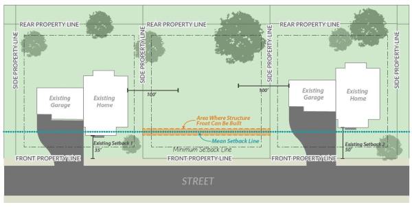
(a) Where the front setback of existing buildings is greater than the minimum front setback required and said existing buildings are within 100 feet on either side of a structure to be erected, then the setback for the new structure may be six feet more or less of this mean depth of the adjacent structures, but it must not be less than the required front setback. In the case where one of the adjacent properties is vacant, the assumed setback will be the minimum front setback requirement of the zoning district that applies to the property (see Figure 1).
Figure 1
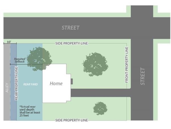
(b) In computing the depth of a rear setback for any principal building where the rear line of the lot adjoins an alley, one half of the width of the alley may be included in the calculation, provided that the actual rear yard depth on the lot will not be less than 25 feet in any district. (See Figure 2).
Figure 2
5. The following are not be considered an encroachment on setback requirements:
(a) Basement egress window wells required to meet fire or building code requirements.
(b) Chimneys, flues, ornamental architectural features, eaves, bays, gutters and other similar projections are permitted on the primary structure provided that they do not extend within three feet of the lot line.
(c) Canopies and steps to building entrances may extend no more than 10 feet into any required front yard.
(d) Unenclosed porches, decks, canopies and steps to building entrances may extend no more than 10 feet into any required rear setback and a maximum of three feet into any required side setback, provided they do not extend nearer than five feet to any lot line.
(e) On existing structures, enclosed entryways may extend no more than five feet into the required setbacks provided they are only one story in height and do not exceed 50 square feet.
(f) Essential services, utility electric power transmission lines and communication transmission lines are exempt from the setback and distance requirements of this Chapter.
6. Required distance between proposed and protected uses.
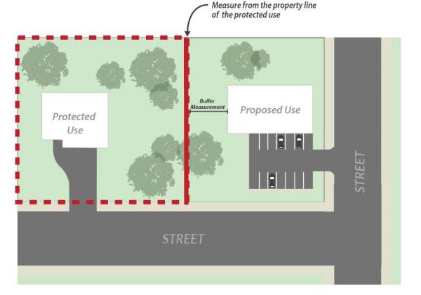
(a) The required distance between uses is computed by direct measurement in a straight line from the nearest legal parcel line of the land used for the protected uses (e.g., residential uses; schools) to the nearest external portion of the building in which the proposed use (e.g., automotive uses; cannabis uses) is to be located (see Figure 3).
Figure 3
7. Vision Safety Zone
(a) A fence or similar barrier must not impede vehicular vision or cause a hazardous condition to exist.
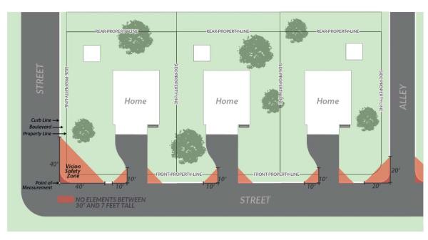
(b) Plantings or structures are not allowed to impede vision between a height of 30 inches and seven feet above the curb line in the Vision Safety Zone, which extends at the intersection:
(1) 40 feet from the corner of the curb;
(2) 20 feet from the corner of an alley; and
(3) 10 feet from the corner of a driveway. (See Figure 4).
Figure 4
8. Adequate area must be designed for snow storage such that clear visibility must be afforded from the property to any public street.
9. Provisions for active transportation must be provided on those parcels abutting streets designated for trails or sidewalks in the currently approved version of the City’s Active Transportation Plan.
(a) At a minimum, the City will require the designation of an easement. The City will determine the required width of easements and elevations for grades at the time a building is constructed on the property.
(b) At its discretion, the City may require the construction of a pedestrian or bicycle path as part of new construction, additions and parking lot improvements.
(c) If not constructed immediately, any landscaping or irrigation systems installed in the easement must be removed and replaced at the property owner’s expense when the trail or sidewalk is installed in the future.
10. Outdoor storage
(a) Outdoor storage of materials, equipment and vehicles is prohibited as a principal use in all districts unless otherwise approved through a conditional use permit, following the procedures in the Procedures Chapter, or listed as an exemption by this section. Accessory outdoor storage must adhere to the standards in the Accessory Use-Specific Standards Chapter.
(b) The following is exempt from the outdoor storage requirements and are only permitted as an accessory use to one- or two-unit dwellings:
(1) Split and neatly stacked firewood in the side or rear yard.
(2) Private outdoor recreational equipment currently being used or intended for use upon the premises.
(3) Landscaping materials and machinery currently being used or intended for use on a current project upon the premises.
(4) Boats, non-motorized camping trailers, and empty utility trailers in the side or rear yard. Boats, non-motorized camping trailers and empty utility trailers stored in the front yard are required to be located on a hard surface driveway and must be set back at least 15 feet from the back of the street curb.
Adopted by Ord. 1431 on 6/18/2025
610.05 Nonconforming Uses And Structures
1. The provisions of this Chapter pertain to all lawful nonconforming lots, uses or structures as applicable and specifically to the performance standards outlined in the established districts.
2. Any nonconformity, lawfully existing at the time of the adoption of an additional control under this Chapter, may be continued, including through repair, replacement, restoration, maintenance or improvement, but not including expansion. All nonconformities must eventually be brought into conformity, if any of the following situations apply:
(a) The nonconformity or occupancy is discontinued for a period of more than one year.
(b) Any nonconforming use is destroyed by fire or other peril to the extent of greater than 50% of its estimated market value, as indicated in the records of the assessor at the time of damage, and no building permit has been applied for within 180 days of when the property is damaged. In this case, the City may impose reasonable conditions upon a building permit in order to mitigate any newly created impact on adjacent property or water body.
(c) When a nonconforming structure in the shoreland or floodplain districts is destroyed, additional provisions may apply, as described in the Shoreland Overlay District Chapter and Floodplain Management Overlay District Chapter. The continuance of nonconforming uses must not prevent or interfere with action that may be taken to abate any nuisance in any manner provided by law.
3. Any structure or any portion of a structure which is situated unlawfully within a public street or alley or other public way or thoroughfare, is hereby declared to be a nonconforming use, whether or not its use is otherwise in conformity with the regulations of the district in which said structure is located. Any such structure is permitted only under the authorization of an Encroachment Agreement between the City and the Property Owner.
4. The burden is on the landowner to establish that their property qualifies for legal nonconforming rights.
5. The City may grant an administrative nonconforming expansion permit as described in the Procedures Chapter.
Adopted by Ord. 1431 on 6/18/2025

