
Fridley City Zoning Code
CHAPTER 614
Overlay Zoning Districts
614.04 O-3 Telecommunications Towers And Wireless Facilities Overlay District
1. Definitions
Antenna Support Structure. Any building or other structure other than a telecommunications tower which can be used for location of wireless facilities. Applicant. Any person that applies for a permit for a telecommunications tower or wireless facilities, automatic meter reading devices or small wireless facilities. Application. The process by which a person submits a request to develop, construct, build, modify or erect a telecommunications tower or wireless facilities upon land within the City, develop, construct, build, modify or erect an automatic meter reading system within the City; or develop, construct, build, modify or erect small wireless facilities within the public right-of-way. Application includes all written documentation, verbal statements and representations, in whatever form or forum, made by an applicant to the City concerning such a request. Approved Site. A site which has been approved by the City Council as an eligible location for placement of a telecommunications tower or wireless facilities. City means the City of Fridley, Minnesota. Collocate or Collocation. To install, mount, maintain, modify, operate or replace a small wireless facility on, under, within or adjacent to an existing wireless support structure that is owned privately or by a local government. Electrical Engineer. An electrical engineer licensed by the State of Minnesota. Existing Site. A telecommunications tower or antenna support structure installed or erected prior to December 18, 1997, and which is not located on an approved site. Local Government Unit. A county, home rule charter or statutory city, town or the Metropolitan Council. Owner. Any person with fee simple title to any approved site, existing site, site approved by special use permit or wireless facility. Pad Mount Device. A device which is designed for collecting, storing, processing, filtering and forwarding utility meter data within the public safety and utility bandwidth licensed by Federal Communications Commission, including any antenna attached to such device like the automatic meter reading device, but, which is installed on its own pedestal and not on an existing public utility structure. Person. Any natural person, firm, partnership, association, corporation, company or other legal entity, private or public, whether for profit or not for profit. Satellite Earth Station Antenna. All equipment necessary for processing of traffic received from terrestrial distributions prior to transmission via satellite and of traffic received from the satellite prior to transfer of channels of communication to terrestrial distribution systems. Small Wireless Facility. A wireless facility that meets both of the following qualifications; or
(a) Each antenna is located inside an enclosure of no more than six cubic feet in volume or, in the case of an antenna that has exposed elements, the antenna and all its exposed elements could fit within an enclosure of no more than six cubic feet; and (b) All other wireless equipment associated with the small wireless facility, excluding electric meters, concealment elements, telecommunications demarcation boxes, batter backup power systems, grounding equipment, power transfer switches, cutoff switches, cable, conduit, vertical cable runs for the connection of power and other services, and any equipment concealed from public view within or behind an existing structure or concealment, is in aggregate no more than 28 cubic feet in volume; or (c) A micro wireless facility.
State. The State of Minnesota. Structural Engineer. A structural engineer licensed by the State of Minnesota. Tower, telecommunications. A self-supporting monopole structure constructed from grade which supports wireless facilities. The term “telecommunications tower” shall not include amateur radio operator’s equipment as licensed by the FCC. Lattice or guyed structures are prohibited. Toll. To stop the running of a relevant time period, such as a review period. Utility Pole. A pole that is used in whole or in part to facilitate telecommunications or electric service. Wireless Facility. Equipment at a fixed location that enables the provision of wireless services between user equipment and a wireless service network, including:
(a) Cables, wires, lines, wave guides, antennas and any other equipment associated with wireless service; (b) A radio transceiver, antenna, coaxial or fiber-optic cable, regular and backup power supplies, and comparable equipment, regardless of technological configuration; or (c) A small wireless facility. The term “wireless facilities” shall not include: (a) Any satellite earth station antenna two meters in diameter or less which is located in an area zoned industrial or commercial; (b) Any satellite earth station reception antenna one meter or less in diameter, regardless of zoning category; (c) Automatic meter reading systems; (d) Small wireless facilities; (e) Wireless support structures; (f) Wireless backhaul facilities; and (g) Coaxial or fiber-optic cables between utility poles or wireless support structures or that are not otherwise immediately adjacent to or directly associated with a specific antenna. Wireless Service. Any service using licensed or unlicensed wireless spectrum, including the use of Wi-Fi, whether at a fixed location or by means of a mobile device, that is provided using wireless facilities. Wireless service does not include services regulated under Title VI of the Communications Act of 1934, as amended, including a cable service under 47 U.SC. § 522 (6).
Wireless Support Structure. A new or existing structure in a public right-of-way designed to support or capable of supporting small wireless facilities, as reasonably determined by a local government unit. 2. Purpose and Intent
(a) The general purpose of this Section is to create an overlay district to regulate the placement, construction and modification of telecommunications towers and wireless facilities.
(b) Specifically, the purpose of this Section is:
(1) To ensure that telecommunications towers and wireless facilities are compatible with surrounding land uses;
(2) To minimize adverse visual impact of telecommunications towers and wireless facilities through careful design, siting, landscaping and innovative camouflaging techniques;
(3) To promote and encourage shared use/collection of telecommunications towers and existing antenna support structures as a primary option rather than construction of additional single-use towers in order to minimize the adverse visual impact of telecommunications towers and wireless facilities;
(4) To avoid potential damage to property caused by telecommunications towers and wireless facilities by ensuring that such structures are soundly and carefully designed, constructed, modified, maintained, located and removed when no longer used or determined to be structurally unsound;
(5) To facilitate the provision of telecommunications towers and wireless facility services to the residents and businesses of the City in a streamlined, orderly, and efficient fashion;
(6) To encourage the location of telecommunications towers in industrial and business districts, rather than residential areas;
(7) To enhance the ability of providers of telecommunication services to provide such services to the community quickly, effectively, and efficiently; and
(8) To identify specific sites within the City where telecommunications towers and wireless facilities may be located;
3. District Boundaries for Overlay District
(a) The O-3, Telecommunications Towers and Facilities District, is created and shall apply to all land within the City subject to the provisions and use requirements contained in this Section.
4. Uses Permitted
(a) All principal and accessory uses allowed in each underlying primary zoning district are permitted in the telecommunications towers and wireless facilities district, except that no telecommunications towers shall be constructed, and no wireless facilities shall be placed, on telecommunications towers or antenna support structures except as provided for in this Chapter.
(b) The construction of telecommunications towers and the installation, operation and maintenance of wireless facilities shall be permitted uses in the approved sites identified on Appendix A to this Ordinance, subject to the provisions of this Chapter.
(c) Conditional Uses
(1) The construction of telecommunications towers and the installation, operation and maintenance of wireless facilities shall be a conditional use in Zoning districts M-1, M-2, and M-3, and any abutting railroad rights-of-way.
(2) The construction of telecommunications towers and the installation, operation, and maintenance of wireless facilities shall be a conditional use in the Critical Area Overlay District and subject to jurisdiction of the Critical Area Chapter.
5. Nonconforming Uses
(a) Existing sites shall be considered a legal nonconforming use, unless otherwise provided for in this Chapter.
(b) Installation of additional wireless facilities beyond those in existence on December 18, 1997, on existing sites is prohibited. Failure to comply with this provision will be considered a violation of this Chapter and subject to the penalties described herein.
(c) Routine maintenance of wireless facilities on existing sites is permitted, except that any wireless facilities installed on existing sites may not increase in size, height, weight or otherwise result in an increase in the intensity of the nonconforming use.
(d) If any wireless facilities on an existing site are abandoned for a period of one year, such existing site shall lose its legal nonconforming status and shall be considered an illegal nonconforming use. The abandoned wireless facilities shall not be re-established on the site, and must be removed within 12 months of the cessation of operations. If not removed, the City may remove the facility and assess the costs of removal against the Owner(s), according to the procedures established in the Procedures Chapter.
6. Priority for Use
(a) Priority for use of the installation, maintenance and operation of telecommunications towers and wireless facilities will be given to the following entitles in descending order:
(1) City of Fridley.
(2) Public safety agencies, including law enforcement, fire and ambulance services, which are not part of the City of Fridley and private entities with a public safety agreement with the City of Fridley.
(3) Other governmental agencies, for uses which are not related to public safety.
(4) Entities providing licensed commercial wireless facility services including cellular, public and personal communication services (PCS), and similar services that are marketed to the general public.
7. Installation Requirements on Water Towers and in City
(a) Installation of wireless facilities on water towers will be permitted when the City is fully satisfied that the following requirements are met:
(1) The wireless facility will not increase the risks of contamination to the City’s water supply.
(2) There is sufficient room on the structure or on the grounds to accommodate the wireless facility.
(3) The presence of the wireless facility will not increase the water tower or reservoir maintenance costs to the City.
(4) The presence of the wireless facility will not be harmful to the health of workers maintaining the water tower or reservoir.
(5) All state and federal regulations pertaining to non-ionizing radiation and other health hazards has been satisfied.
8. Building Permit Required
(a) A building permit is required for installation of any telecommunications towers and wireless facilities.
(b) The completed installation, including all associated buildings, shall comply with all applicable building codes including but not limited to the most currently adopted version of the N.F.P.A. 70 National Electrical Code, TIA/EIA 222 Structural Standards for steel antenna towers, and others as may be determined by the Building Official.
9. Setbacks
(a) The telecommunications towers and wireless facilities shall be located in rear or side yard areas and shall be setback at least 10 feet from side or rear lot lines.
10. Use Standards
(a) Telecommunications Tower Height
(1) Telecommunications towers are exempt from the maximum height restrictions of the underlying zoning districts where they are located.
(2) Telecommunications tower height shall be measured from the average adjoining grade to the highest point of construction of any telecommunications tower or wireless facilities.
(3) Telecommunications towers shall be permitted to a height of 125 feet.
(4) An additional 25 feet of telecommunications tower height shall be permitted for a total height of 150 feet, if all of the following criteria are met:
((a)) The telecommunications tower exists within a lineal dimension of 250 feet of any one of the following structures that exceed the height of 150 feet. These structures include:
((1)) Buildings;
((2)) Power lines; and
((3)) Train/rail yard fixtures such as light fixtures.
((b)) Telecommunications towers must meet or exceed any local, state or federal regulations relative to tower fall distance.
((c)) All permits required to replace or expand an existing telecommunications tower must be reviewed and approved by the City prior to replacement or expansion.
(b) Co-Location
(1) Telecommunications towers shall be designed to support more than two wireless facilities. Support structures shall be designed to support more than one small wireless facility.
(c) Stealth Design and Exterior Finishes
(1) All approved sites, telecommunications towers and wireless facilities shall be designed to blend into the surrounding environment.
(2) Monopoles with antenna arrays shall be finished so as to be compatible with other buildings or structures in the area, and shall be finished with a non-corrosive material.
(3) Wireless facilities placed on water towers shall be finished with a non-corrosive material to match the color of the water tower.
(d) Illumination
(1) Telecommunications towers shall not be artificially illuminated except as required by the Federal Aviation Administration (“FAA”).
(e) Special Landscape Requirements
(1) All sites shall include appropriate landscaping as required herein and shall comply with all landscaping requirements of the underlying zoning district.
(2) At minimum, all ground equipment shall be fully screened from public rights-of-way or residential property by existing structures, a brick decorative wall, or a solid 100% opaque vegetative enclosure, six feet in height at the time of planting.
(3) Accessory above-ground equipment must utilize existing buildings or structures, if possible. If no existing structures are available, the owner of the wireless facility must construct such a structure.
(f) Security
(1) All telecommunications towers must be reasonably posted and secured to protect against trespass. Chain link fences may be used to protect telecommunications towers and wireless facilities. Barbed or razor wire is prohibited. All facilities shall be designed to discourage unauthorized climbing on the structure.
(g) Signs
(1) Signs no larger than four square feet in size and attached to a structure are the only permitted signage associated with the telecommunications towers and wireless facilities.
(2) An exception to the above restriction shall be made for applicable warning and equipment information signage required by the manufacturer or by federal, state or local regulations.
(h) Maintenance
(1) Ordinary and reasonable care of telecommunications towers and wireless facilities shall be employed at all times.
(2) All telecommunications towers and wireless facilities shall at all times be kept and maintained in good condition, order and repair so that the same shall not menace or endanger the life or property of any person.
(3) Owners shall install and maintain telecommunications towers and wireless facilities in compliance with the requirements of the National Electric Safety Code and all FCC, State and local regulations, and in such manner that will not interfere with the use of other property.
(4) All maintenance or construction on telecommunications towers and wireless facilities shall be performed by qualified maintenance and construction personnel.
(5) All owners of wireless facilities shall maintain compliance with current radio frequency emission standards of the FCC.
(6) In order to provide information to its citizens, copies of all FCC information concerning wireless facilities shall be made available to the City and updated annually.
(7) In the event the use of a telecommunications tower, a public utility structure or a wireless facility is discontinued by the owner of the wireless facility, or in the event an owner files notice to the FCC of its interest to cease operating, the owner shall provide written notice to the City of its intent to discontinue use and the date when the use shall be discontinued.
11. Application for Placement of Towers or Wireless Facilities on Approved Sites in the City
(a) All persons seeking to install, operate and maintain telecommunications towers and wireless facilities on sites in the City must file a telecommunication site permit application with the City which shall include:
(1) The names, address and telephone number of the Applicant; and
(2) Written, technical evidence from a qualified and licensed structural engineer that the proposed telecommunications tower or antenna support structure is capable of supporting the equipment necessary to install, operate and maintain the proposed antenna.
((a)) The engineer shall also certify the capability of the telecommunications tower to provide adequate structural support considering existing or other proposed antenna installations.
((b)) The engineer shall also assess and state the design safety margin of the entire antenna support system. The engineer shall state that within the limits of engineering certainty, if the structure would fall or collapse for any reason or due to any event, the structure will be completely contained within the area identified; and
(3) If proposed on a City-owned site, a completed application form for lease approval as provided by the City; and
(4) A report from a qualified and licensed professional engineer which described the height and design of the proposed wireless facility including a cross-section and elevation; and
(5) A scalable site plan drawn at an engineering scale showing the location of the wireless facility in relation to surrounding structures; and
(6) If located on a water tower, a written report addressing the requirements contained herein for water towers; and
(7) Foundation, cross-section and building plans for installation of the telecommunications tower or the wireless facility; and
(8) An application fee as required by the Fees Chapter of the Code; and
(9) The application shall also contain an affirmative statement indicating that the applicant agrees to comply with the provisions in this Section regarding abandonment; and
(10) No new or existing wireless facility service shall interfere with public safety communications. Before the introduction of new service or before implementing any change in existing service, all wireless facility service providers shall notify the City at least 10 calendar days in advance of such changes and allow the City to monitor interference levels during the testing process; and
(11) An application for a building permit to the City pursuant to the Building Code Chapter of the Code; and
(12) A statement as to whether the proposed development of an approved site is capable of being developed to support more than two operating wireless facilities comparable to the others in weight, size and surface area; and
(13) Written, technical evidence from an independent consulting engineer licensed to practice geological engineering in the State of Minnesota confirming that the soil at the location of the telecommunication tower and wireless facility is capable of supporting the proposed antenna arrays, equipment and personnel performing typical work functions; and
(14) A landscaping plan showing location of materials, height at planting, types of materials and installation practices.
(b) All persons seeking to install, operate and maintain telecommunications towers and wireless facilities in M-1, M-2, M-3 Zoning Districts as a conditional use permit shall submit the information required in this section, except a lease and building permit are not required at time of application.
12. Application Process
(a) If a telecommunications towers and wireless facilities is approved by a conditional use permit, the applicant must also apply for and receive a building permit.
13. Fees
(a) The applicant shall pay the fees listed in the Fees Chapter of the Code for processing a request to install, operate and maintain a tower, public utility structure, pad mount device or a wireless facility in the City.
(b) If deemed as necessary due to the nature of the application, the applicant shall also be required to reimburse the City for the City’s cost to retain a consultant to review the requested application.
14. Certifications and Inspections
(a) All telecommunications towers and wireless facilities shall be periodically reviewed by the City to be structurally sound and in conformance with the requirements of the City Code, this Chapter, any conditions of approval placed on a conditional use permit and all other construction standards set forth by the City Code and federal, state and local law.
(b) Existing sites may be inspected for compliance with this Section at any time if the City believes there are questions regarding compliance with the City Code, this Section, any conditions of approval placed on a conditional use permit, all other construction standards set forth in the City Code and all other federal, state and local laws.
(c) The City and its agents shall have authority to enter onto any approved site, existing site, or site approved by conditional use permit between the inspections and certifications required above, to inspect the site for the purpose of determining whether the sites comply with the State Building and Electrical Codes, the National Electric Safety Code and all other construction standards provided by the City Code and federal and State law.
(d) The City reserves the right to conduct such inspections at any time, upon reasonable notice to the owner(s).
(e) All expenses related to such inspections by the City shall be borne by the site owner(s).
15. Abandonment
(a) If any site for which approval to install, maintain and operate a telecommunications tower, public utility structure or wireless facility has been granted by the City shall cease to be used for a period of 365 consecutive days, the City shall notify the wireless facility operator and the owner of the property that said site or system has been deemed abandoned.
(b) Upon a finding of abandonment by the City, the telecommunications tower, public utility structure or wireless facility must be removed or an annual user fee shall be paid to the City.
(c) If it is determined that the abandoned telecommunications tower, public utility structure or wireless facility cannot be removed in a reasonable time period by the owner or operator, the City shall assess all costs related to the removal to the owner(s) or operator(s), according to the procedures established in the Abatement of Exterior Public Nuisances Chapter of the Code.
16. No Recourse
(a) No Recourse against the City. Every permit issued to an applicant for construction, installation, maintenance or operation of a telecommunications tower or wireless facility shall provide that, without limiting such immunities as the City of other persons may have under applicable law, an applicant/permit holder shall have no monetary recourse whatsoever against the City of its elected officials, boards, commissions, agents, employees or volunteers for any loss, costs, expense or damage arising out of any provision or requirements of this Chapter or because of the enforcement or lack of enforcement of this Chapter or the City’s exercise of its authority pursuant to this Chapter, a permit, a lease, or other applicable law, unless the same shall be caused by criminal acts or by willful gross negligence. Nothing herein shall be construed as a waiver of sovereign immunity.
17. Violation
(a) Any person who shall violate any of the provisions of this Chapter shall be guilty of a misdemeanor and subject to the provisions of the Penalties Chapter of the Code.
Adopted by Ord. 1431 on 6/18/2025
614.05 O-4 Pre-1955 Residential Lots Overlay District
1. Purpose
(a) The purpose of this special zoning district is to:
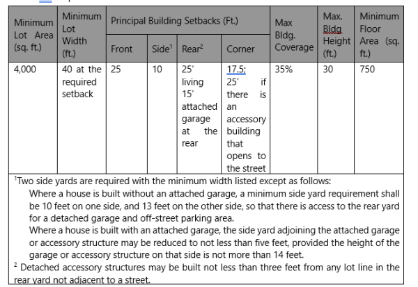
(1) Change the present "legal, nonconforming use" status of the residential dwellings located in this district on lots over 4,000 square feet in size to a "conforming use" status.
(2) Re-establish and maintain the residential character of Fridley’s neighborhoods.
(3) Protect the property rights of all present landowners, while promoting reinvestment and infill development in Fridley neighborhoods.
(4) Establish a zoning mechanism for the City that will encourage residential investment and development on those lots created and recorded at Anoka County prior to December 29, 1955.
2. District Boundaries
(a) This Section and zoning district shall be referred to as the "Pre-1955 Lots" in short form.
(b) The extent of this zoning overlay district shall only be comprised of those residentially zoned lots split, platted, or otherwise created and recorded at Anoka County prior to December 29, 1955. The O-4 district includes lots meeting all criteria set forth in this Chapter, located in the following Plats created and recorded prior to December 29, 1955: Adams Street Addition; Auditor’s Subdivisions #22, #23, #25, #39, #59, #77, #78, #79, #88, #89, #92, #94, #94 Sublot 10, #108, #129, #153, and #155; Berlin Addition; Brookview Addition; Brookview 2nd Addition; Camp Howard and Hush’s 1st Addition to Fridley Park; Carlson’s Summit Manor North Addition; Carlson’s Summit Manor South Addition; Central Avenue Addition; Central View Manor; Christie Addition; City View; Clover Leaf Addition; Clover Leaf 2nd Addition; Dennis Addition; Donnay’s Lakeview Manor; Elwell’s Riverside Heights; Elwell’s Riverside Heights Plat 2; Florence Park Addition to Fridley; Fridley Park; Hamilton’s Addition to Mechanicsville; Hayes River Lots; Hillcrest Addition; Horizon Heights; Irvington Addition to Fridley Park; Lowell Addition to Fridley Park; Lucia Lane Addition; Lund Addition; Meloland Gardens; Moore Lake Addition; Moore Lake Highlands & Additions 1-4; Moore Lake Hills; Moore Lake Park Addition; Moore Lake Park 2nd Addition; Murdix Park; Niemann Addition; Norwood Addition to Fridley Park; Oak Creek Addition; Oak Creek Addition Plat 2; Oak Grove Addition to Fridley Park; Oakhill Addition; Onaway; Osborne Manor; Ostmans 1st Addition; Ostmans 2nd Addition; Parkview Manor; Plymouth; Rearrangement of Blocks 13, 14, 15 Plymouth; Rearrangement of Lots 1,2,3, Blk 1 and Lots 1,2,3, Blk 4 Rice Creek Terrace Plat 2; Rees Addition to Fridley Park; Revised Auditor’s Subdivisions #10, #23, #77, #103; Rice Creek Terrace Plats 1-4; Riverview Heights; Sandhurst Addition; Second Revised Auditors Subdivision #21; Scherer Addition; Shaffer’s Subdivsion #1; Shorewood; Springbrook Park; Spring Lake Park Lakeside; Spring Valley; Subdivsion of Lot 10, Auditor’s Subdivision #94; Sylvan Hills; Sylvan Hills Plat 2 & 3; Vineland Addition to Fridley Park; and any unplatted lots created, prior to December 29, 1955, as recorded at Anoka County. Any lot combinations or divisions of Parcel Identification Numbers done on or after January 1, 2001 makes the property ineligible for inclusion in this overlay district.
3. Applicability
(a) This section applies only to lots that are under the minimum lot size requirement of 9,000 square feet for all one-unit detached dwellings.
4. Uses Permitted
(a) Principal Uses.
(1) One unit detached dwellings.
(b) Accessory Uses.
(1) All garages whether attached to, tucked under or detached from the principal dwelling is considered to be an accessory structure and shall not exceed 100% of the first-floor area of the dwelling unit or a maximum of 1,000 square feet.
(2) All permitted accessory uses authorized by the underlying base zoning district of this overlay district, including substandard lots, may be applied, when meeting all requirements for the applicable accessory use in Chapter 621.
(3) All accessory uses shall meet the following performance standards:
((a)) Only one accessory structure in excess of 240 square feet is allowed per site. One additional accessory structure is allowed provided it does not exceed 240 square feet. Total accessory structure size shall be limited to a 500 square feet per property.
((b)) Any accessory structure in excess of the above requirements (square footage or number of buildings) requires a conditional use permit in accordance to the procedures in the Procedures Chapter.
((c)) All accessory structures must be permanently attached to a foundation or held in place with approved tie-downs and may not be used for home occupations.
(c) Existing Uses.
(1) Existing one unit detached dwellings that do not conform to the conditions of this Chapter will be allowed to continue as a permitted use.
(2) Alterations and additions are permitted to improve the structure, provided they meet the required setbacks as stated in this Chapter.
(d) Any uses not listed indicates that the land use is prohibited. In the event a proposed use is not listed, the Community Development Director shall make a determination if the use is consistent by type, intensity, physical characteristics, style, size and purpose with any use listed in the Principal or Accessory Use tables for the respective zoning district.
5. Lot Requirements and Setbacks
6. O-4 District Standards
(e) All uses in this district shall conform to the applicable development and performance standards found in this Title.
(f) Parking Requirements.
(1) All applicable off-street parking requirements in accordance with the Off-Street Parking Chapter must be met.
(2) At least two off street parking stalls shall be provided for each dwelling unit.
(3) A garage shall satisfy the minimum off-street parking space requirements.
Adopted by Ord. 1431 on 6/18/2025
614.06 O-5 Shoreland Overlay District
1. Purpose and Intent
(a) The unregulated use of shorelands in the city affects the public health, safety and general welfare not only by contributing to pollution of public waters, but also by impairing the local tax base. Therefore, it is in the best interests of the public health, safety and welfare to provide for the wise use and development of shorelands of public waters. (b) Statutory authorization. These shoreland regulations are adopted pursuant to the authorization and policies contained in M.S. Chapter 103F, Minnesota Regulations, Parts 6120.2500 through 6120.3900, and the planning and zoning enabling legislation in M.S. Chapter 462. (c) Jurisdiction. The provisions of this Code shall apply to shorelands of the public water bodies as classified in this Chapter except for those properties that are also under the jurisdiction of the Critical Area Chapter for which only the Critical Area Chapter will apply. A body of water created by a private user where there was no previous shoreland may, at the discretion of the governing body, be exempt from this Code. (d) Compliance. The use of any shoreland of public waters; the size and shape of lots; the use, size, type and location of structures on lots; the grading and filling of any shoreland area; and the cutting of shoreland vegetation shall be in full compliance with the terms of this Code and other applicable regulations. (e) District application. The shoreland overlay district shall be superimposed (overlaid) upon all the zoning districts as identified in Chapter Zoning and Subdivision of this Code as existing or amended by the text and map of this Code. The regulations and requirements imposed by the shoreland overlay district shall be in addition to those established by the base zoning district which jointly apply. Under joint application of the districts, the more restrictive requirements shall apply. (f) Exemption. A structure or use which was lawful before adoption of this Chapter, but which is not in conformity with the provisions of the shoreland overlay district, may be continued subject to this Chapter.
2. District Boundaries
(a) The boundaries of the shoreland permit overlay district within the City consists of the first tier of riparian lots abutting a protected lake or tributary identified in this Chapter. The specific boundaries of the shoreland permit overlay district are shown on the official Fridley Shoreland Overlay District Map in the Fridley City Code. (b) Properties that are also within the jurisdiction of the Critical Area Chapter, shall remain mapped as part of the Shoreland Overlay District; however, only the provisions of the Critical Area Chapter shall apply.
3. Definitions For the purpose of this Chapter certain terms and words are hereby defined: Words used in the present tense shall include the future; words in the singular include the plural, and the plural the singular; the word “building” shall include the word “structure”; and the word “lot” shall include the word “plot”; and the word “shall” is mandatory and not directory; and the word “including” shall mean “including, but not limited to”. For the purpose of this district the following definitions shall apply:
(a) Accessory Structure or Facility. Any building or improvement subordinate to a principal use which, because of the nature of its use, can reasonably be located at or greater than normal structure setbacks. (b) Bluff. A topographic feature such as a hill, cliff, or embankment having the following characteristics:
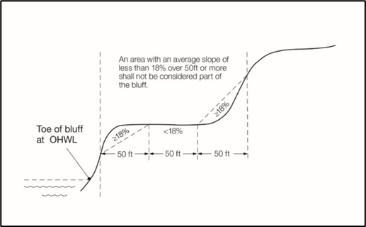
(1) Part or all of the feature is located in a shoreland area; (2) The slope must drain toward the waterbody; (3) The slope rises at least 25 feet above the ordinary high water level; and (4) The grade of the slope from the toe of the bluff to a point 25 feet or more above the ordinary high water level averages 30% or greater (see Figure 1), except that an area with an average slope of less than 18% over a distance of at least 50 feet shall not be considered part of the bluff (see Figure 2).
Figure 1. Illustration of Bluff
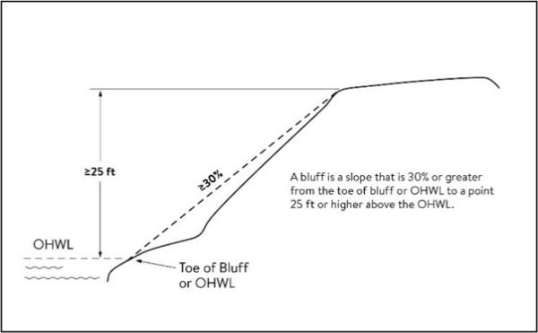
Figure 2. Exception to Bluff
(c) Bluff impact zone. A bluff and land located within 20 feet of the top of a bluff. See Figure 3.
Figure 3. Bluff Impact Zone and Top of Bluff
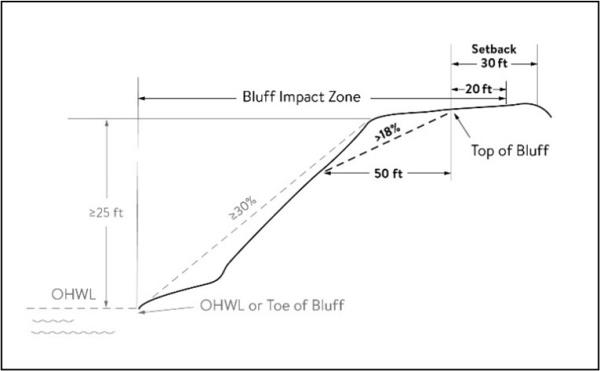
(d) Bluff, Toe of. The lower point of a 50-foot segment with an average slope exceeding 18% or the ordinary high water level, whichever is higher. (e) Bluff, Top of. For the purposes of measuring setbacks, bluff impact zone, and administering vegetation management standards, the higher point of a 50-foot segment with an average slope exceeding 18%. See Figure 3. (f) Commission. The City of Fridley Planning Commission. (g) Commissioner. The Commissioner of the Department of Natural Resources of the State of Minnesota. (h) Council. The Fridley City Council. (i) Critical Area. The area known as the Mississippi River Corridor Critical Area designated by the Governor in the Executive Order No. 130. (j) Development. The making of any material change in the use or appearance of any structure or land including reconstruction; alteration of the size of any structure; alteration of the land; alteration of a shore or bank of a river, stream, lake or pond; a commencement of drilling (except to obtain soil samples); mining or excavation; demolition of a structure; clearing of land as an adjunct to construction; deposit of refuse, solid or liquid waste, or fill on a parcel of land; the dividing of land into two (2) or more parcels. (k) Impervious Surface. A constructed hard surface that either prevents or retards the entry of water into the soil, and causes water to run off the surface in greater quantities and at an increased rate of flow than existed prior to development. Examples include rooftops, sidewalks, patios, driveways, parking lots, storage areas, and concrete, asphalt, or gravel roads. (l) Intensive vegetation clearing. The complete removal of trees or shrubs in a contiguous patch, strip, row, or block. (m) Lot Coverage. The amount of impervious surface on a lot. (n) Ordinary High Water Level. M.S. § 103G.005, subd. 14 defines ordinary high water level as the boundary of waterbasins, watercourses, public waters, and public waters wetlands, and:
((a)) the ordinary high water level is an elevation delineating the highest water level that has been maintained for a sufficient period of time to leave evidence upon the landscape, commonly the point where the natural vegetation changes from predominantly aquatic to predominantly terrestrial; ((b)) for watercourses, the ordinary high water level is the elevation of the top of the bank of the channel; and ((c)) for reservoirs and flowages, the ordinary high water level is the operating elevation of the normal summer pool.
(o) Shoreland.
Shoreland means land located within the following distances from the ordinary high water elevation of public waters:
((a)) land within 1,000 feet from the normal high watermark of a lake, pond, or flowage; and ((b)) land within 300 feet of a river or stream or the landward side of a floodplain delineated by ordinance on the river or stream, whichever is greater.
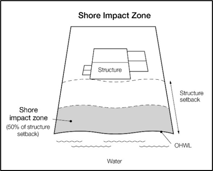
(o) Shore Impact Zone. Land located between the ordinary high water level of a public water and a line parallel to it at a setback of 50% of the structure setback (see Figure 4).
(p) Steep Slopes. Lands having average slopes over 12%, as measured over horizontal distances of 50 feet or more, which are not bluffs. (r) Structure. Any building or appurtenance, including decks, except aerial or underground utility lines, such as sewer, electric, telephone, telegraph, gas lines, towers, poles, and other supporting facilities.
4. Shoreland classification system
(a) Public waters. The public waters of Fridley have been classified below consistent with the criteria found in Minnesota Regulations, Part 6120.3300, and the DNR Protected Waters Inventory Map for Anoka County, Minnesota. (b) Official map. The shoreland permit district for the waterbodies listed below shall be shown on the Fridley Zoning Map.
(1) Lakes Recreational Development Lakes Protected Waters Inventory I.D. # Moore Lake 2-75P Spring Lake 2-71P General Development Lakes Protected Waters Inventory I.D. # Locke Lake 2 - 77P Harris Pond 2-684W Farr Lake 2-78P Natural Environment Lakes Protected Waters Inventory I.D. # Public Water in Springbrook Park 2-688P (2) Rivers and streams Rivers From To Mississippi River Sec 3, T30N, R24W Sec 34, T30N, R24W Tributary Streams Rice Creek Springbrook Creek
5. Administration
(a) Building permit required. A permit is required for the construction of buildings or building additions (and including such related activities as construction of decks and signs), and those grading and filling activities not exempted by this Code that occur within the shoreland district. Application for a building permit shall be filed with the zoning administrator or any staff persons designated by the city manager on an official application form of the city, accompanied by a fee as set forth in the Fees Chapter of the Code. Where required by law, the building permit application shall be forwarded to the applicable watershed district for review and comment. The application shall include the necessary information so that the zoning administrator can determine the site's suitability for the intended use. (b) Variance. Variances may only be granted in accordance with the Zoning and Subdivision Chapter of this Code. A variance may not circumvent the general purposes and intent of this Code. No variance may be granted that would allow any use that is prohibited in the underlying zoning district in which the subject property is located. (c) Notifications to the Department of Natural Resources.
(1) Public hearings. Copies of all notices of any public hearings to consider variances, amendments, or special uses under local shoreland management controls must be sent to the commissioner or the commissioner's designated representative and postmarked at least ten days before the hearings. Notices of hearings to consider proposed subdivisions/plats must include copies of the subdivision/plat. (2) Approval. A copy of approved amendments and subdivisions/plats, and final decisions granting variances or special uses under local shoreland management controls must be sent by the City to the commissioner or the commissioner's designated representative and postmarked within ten days of final action.
6. Land use district descriptions Allowed land uses within the shoreland district shall be determined by the underlying zoning district, as listed within Chapter Zoning and Subdivsion. 7. Lot area and width standards Lot area and width standards for residential development shall be regulated per the underlying zoning district in Chapter Zoning and Subdivision. 8. Placement, design, and height of structures
(a) Placement of structures on lots. When more than one setback applies to a site, structures and facilities must be located to meet all setbacks. Where structures exist on the adjoining lots on both sides of a proposed building site, structure setbacks may be altered without a variance to conform to the adjoining setbacks from the ordinary high water level, provided the proposed building site is not located in a shore impact zone or in a bluff impact zone. Structures shall be located as follows:
(1) Required setbacks. All required rear yard, side yard and front yard setbacks shall be met per the underlying zoning district. (2) Ordinary high water level setback. Structure setbacks (in feet) from the ordinary high water level. Classes of Public Waters Structure Setbacks General Development Lake 50 feet Natural Environment Lake 150 feet Recreational Development Lake 75 feet River 100 feet Tributary Stream 50 feet
(3) Required bluff setback. The following setback shall be applied, regardless of the classification of the water body: Classes of Land Structure Setback Top of Bluff 40 feet (4) Bluff impact zones. Structures and accessory facilities, except stairways and landings, must not be placed within bluff impact zones. (5) Height of structures. Maximum allowable height for all structures shall be regulated per underlying zoning district in Chapter Zoning and Subdivision.
(b) Shoreland alterations. Alterations of vegetation and topography will be regulated to prevent erosion into public waters, fix nutrients, preserve shoreland aesthetics, preserve historic values, prevent bank slumping, and protect fish and wildlife habitat.
(1) Vegetation alteration. Removal or alteration of vegetation is allowed subject to the following standards:
((a)) Intensive vegetation clearing within the shore and bluff impact zones and on steep slopes is not allowed. ((b)) In shore and bluff impact zones and on steep slopes, limited clearing of trees and shrubs and cutting, pruning, and trimming of trees is allowed to provide a view to the water from the principal dwelling site and to accommodate the placement of stairways and landings, picnic areas, access paths, beach and watercraft access areas, and permitted water-oriented accessory structures or facilities provided that:
((i)) The screening of structures, vehicles, or other facilities as viewed from the water, assuming summer, leaf-on conditions, is not substantially reduced. ((ii)) Along rivers, existing shading of water surfaces is preserved. ((iii)) The above provisions are not applicable to the removal of trees, limbs, or branches that are dead, diseased, or pose safety hazards and the removal of plants deemed noxious under the Minnesota Noxious Weed Law.
(2) Building permit. Grading and filling and excavations necessary for the construction of structures and driveways under validly issued building permits for these facilities do not require the issuance of a separate shoreland grading and filling permit. (3) Land alteration permit. Notwithstanding (2) above, a land alteration permit will be required for:
((a)) The movement of more than ten cubic yards of material on steep slopes or within shore or bluff impact zones. ((b)) The movement of more than 50 cubic yards of material outside of steep slopes and shore and bluff impact zones.
(4) Conditions. The following considerations and conditions must be adhered to during the issuance of building permits, land alteration permits, special use permits, variances and subdivision approvals:
((a)) Grading or filling in any type 2-8 wetland must be evaluated to determine how extensively the proposed activity would affect the following functional qualities of the wetland (This evaluation shall also include a determination of whether the wetland alteration being proposed requires permits, reviews, or approvals by other local, state, or federal agencies such as a watershed district, the Minnesota Department of Natural Resources, or the United States Army Corps of Engineers):
((i)) Sediment and pollutant trapping and retention. ((ii)) Storage of surface runoff to prevent or reduce flood damage. ((iii)) Fish and wildlife habitat. ((iv)) Recreational use. ((v)) Shoreline or bank stabilization. ((vi)) Noteworthiness, including special qualities such as historic significance, critical habitat for endangered plants and animals, or others.
((b)) Alterations must be designed and conducted in a manner that ensures only the smallest amount of bare ground is exposed for the shortest time possible. ((c)) Mulches or similar materials must be used, where necessary, for temporary bare soil coverage, and a permanent vegetation cover must be established as soon as possible. ((d)) Methods to minimize soil erosion and to trap sediments before they reach any surface water feature must be used. ((e)) Altered areas must be stabilized to acceptable erosion control standards consistent with the field office technical guides of the local soil and water conservation districts and the United States Soil Conservation Service. ((f)) Fill or excavated material must not be placed in a manner that creates an unstable slope. ((g)) Plans to place fill or excavated material on steep slopes must be reviewed by qualified professionals for continued slope stability and must create finished slopes of less than 3:1 slope. ((h)) Fill or excavated material must not be placed in bluff impact zones. ((i)) Any alterations below the ordinary high water level of public waters must first be authorized by the commissioner under M.S. § 103G.245. ((j)) Alterations of topography must only be allowed if they are accessory to permitted or special uses and do not adversely affect adjacent or nearby properties. ((k)) Placement of natural rock rip rap, including associated grading of the shoreline and placement of a filter blanket, is permitted if the finished slope does not exceed three feet horizontal to one foot vertical, the landward extent of the rip rap is within ten feet of the ordinary high water level, and the height of the rip rap above the ordinary high water level does not exceed three feet. Must be done in accordance with other State and Federal regulations. A permit from the DNR is required.
(5) Connections to public waters. Excavations where the intended purpose is connection to a public water, such as boat slips, canals, lagoons, and harbors, must be controlled by local shoreland controls. Permission for excavations may be given only after written authorization has been obtained from the Minnesota Department of Natural Resources approving the proposed connection to public waters.
(c) Stormwater management. The following general and specific standards shall apply:
(1) General standards.
((a)) When possible, existing natural drainage-ways, wetlands, and vegetated soil surfaces must be used to convey, store, filter, and retain stormwater runoff before discharge to public waters. ((b)) Development must be planned and conducted in a manner that will minimize the extent of disturbed areas, runoff velocities, erosion potential, and reduce and delay runoff velocities, erosion potential, and reduce and delay runoff volumes. Disturbed areas must be stabilized and protected as soon as possible and facilities or methods used to retain sediment on the site. ((c)) When development density, topographic features, and soil and vegetation conditions are not sufficient to adequately handle stormwater runoff using natural features and vegetation, various types of constructed facilities such as diversions, settling basins, skimming devices, dikes, waterways, and ponds may be used. Preference must be given to designs using surface drainage, vegetation, and infiltration rather than buried pipes and manmade materials and facilities.
(2) Specific standards.
((a)) Impervious surface lot coverage shall not exceed 35% of the lot area, except as a variance, which shall comply with the following standards:
((i)) All structures, additions or expansions shall meet setback and other requirements of this Code. ((ii)) The lot shall be served with municipal sewer and water. ((iii)) The lot shall provide for the collection and treatment of stormwater in compliance with the Erosion Control and Stormwater Management Chapter of the Code if determined that the site improvements will result in increased runoff directly entering a public water. All development plans shall require review and approval by the city engineer and the underlying watershed district. ((iv)) Measures to be taken from the treatment of stormwater runoff and/or prevention of stormwater from directly entering a public water. The measures may include, but not be limited to the following:
(A) Appurtenances as sedimentation basins debris basins, desilting basins, or silt traps. (B) Installation of debris guards and microsilt basins on storm sewer inlets. (C) Use where practical, oil skimming devices or sump catch basins. (D) Direct drainage away from the lake and into pervious, grassed, yards through site grading, use of gutters and down spouts. (E) Construction sidewalks of partially pervious raised materials such as decking which has natural earth or other pervious material beneath or between the planking. (F) Use grading and construction techniques which encourage rapid infiltration, e.g., sand and gravel under impervious materials with adjacent infiltration swales graded to lead into them. (G) Install berms, water bars, or terraces which temporarily detain water before dispersing it into pervious area.
((b)) When constructed facilities are used for stormwater management, documentation must be provided by a qualified individual that they are designed and installed consistent with the field office technical guide of the local soil and water conservation districts. ((c)) New constructed stormwater outfall to public waters must provide for filtering or settling of suspended solids and skimming or surface debris before discharge.
(3) Nonconformities. All legally established nonconformities as of the date of this section may continue, but they will be managed according to this Chapter of Code with the following exceptions:
((a)) Decks are allowed as a conforming use provided all of the following criteria and standards are met:
((i)). The principle structure existed on the date the structure setbacks were established. ((ii)). No other reasonable location for a deck exists. ((iii)). The deck encroachment toward the ordinary high water level maintains a minimum setback in accordance with applicable code sections and a maximum encroachment of 10 feet into the Bluff Impact Zone or Shore Impact Zone. ((iv)). The deck is framed construction, and is not roofed or screened.
9. Public Nuisance - Penalty
(a) Any person who violates any provisions of this district or fails to comply with any of its terms or requirements shall be guilty of a misdemeanor punishable by a fine of not more than $500 or imprisoned for not more than 90 days, or both, and in addition shall pay all costs of prosecution and expenses involved in the case. Each day such violation continues shall be considered a separate offense. (b) Every obstruction or use placed or maintained in the Preservation District in violation of this Chapter is hereby declared to be a public nuisance and creation thereof may be enjoined and the maintenance thereof abated by appropriate judicial action. (c) Nothing herein contained shall prevent the City from taking such other lawful action as is necessary to prevent, remedy or remove any violation.
Adopted by Ord. 1431 on 6/18/2025
614.07 O-6 Transit Oriented Overlay District
1. Definitions
Mixed Use Structure. A building or development that contains two or more different uses such as residential, commercial, industrial or public facilities. Primary Street. The street adjoining the property which has the highest traffic counts. Redevelopment. When all of the existing structures on a site are removed to ready the site for new construction. 2. Background and Authority
(a) The City of Fridley finds that Transit Oriented Development benefits the general health and welfare of the inhabitants of Fridley by fulfilling existing housing, transportation and employment needs. Therefore, the City of Fridley implements this overlay district which designates a portion of the City as a Transit Oriented Development District (“TOD” District) in an effort to support all modes of transportation. This overlay district is adopted per authority granted by the City of Fridley in M.S. 462.
3. Purpose
(a) The purpose of this overlay zoning district is to:
(1) Implement code requirements that will encourage dense, mixed use, pedestrian-friendly development within a one-half mile of the Northstar Commuter Rail Station in Fridley.
(2) Create multi-modal connections to the Fridley Northstar Commuter Rail Station that allow for safe access to the station no matter what means of transportation someone uses.
(3) Create a neighborhood identity with the Northstar Commuter Rail Station that promotes the use of mass transit, human interactions, safety and livability.
(4) Reduce automobile dependency by locating a variety of land uses within a half mile of the Northstar Commuter Rail Station.
(5) Provide life cycle housing for people of different income levels and housing space needs within one half mile of the Northstar Commuter Rail Station.
4. District Boundary
(a) The TOD Overlay District consists of those areas designated on the Northstar TOD District map, which is Appendix A to this Chapter and is on file with the City Clerk and dated March 22, 2018.
5. Uses Permitted
(a) Permitted uses in the O-6 TOD Overlay District are those uses which are acceptable in the underlying zoning district as noted in the Principal and Accessory Use Tables or in the Northstar TOD TIF District Master Plan if the parcel being developed is included in the Northstar TOD TIF District as approved by the City.
(1) Any uses not listed indicates that the land use is prohibited. In the event a proposed use is not listed in the use tables, the Community Development Director may allow the use after making a determination that the use is consistent by type, intensity, physical characteristics, style, size and purpose with a permitted listed use.
(b) Mixed use structures do not require a conditional use permit as underlying zoning requirements may require.
6. Process for TOD Plan Approval
(a) Plans for each individual project or combination of projects in the TOD District must be submitted upon payment of any required fee as provided in the Fees Chapter of the Code.
(b) One unit detached dwelling development projects located within the R-H, Hyde Park Zoning District are exempt from following the TOD design standards and the plan review process.
7. Design Criteria
(a) All new development or redevelopment TOD proposals requiring a building permit after the effective date of this Chapter must meet the following design criteria standards designed to enhance the pedestrian scale and safety of the development.
(b) In situations where an existing building is being partially expanded, the new standards will only apply to the new addition.
(c) Landscaping and streetscape design features shall be specified in a project’s Master Plan to match the models shown in Appendix B of this code section.
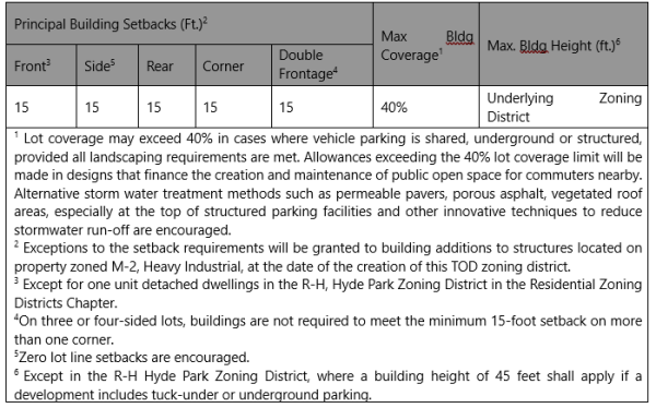
(d) Site and Lot Requirements
(e) Building Design Standards
(1) Exterior Building Materials
((a)) All non-residential buildings shall follow the applicable architectural standards in the Architectural Standards Chapter of the Code, including the additional standards listed herein this section.
((b)) The following exterior materials are specifically prohibited in the TOD district: Plain or painted concrete block; sheet metal panels; reflective glass; aluminum; vinyl; fiberglass; asphalt; or fiberboard siding.
((c)) Parking structures shall be constructed with building materials that are architecturally compatible with the adjoining structure(s).
((d)) No blank walls shall be permitted to face the public street, sidewalk or other public spaces, such as plazas.
((e)) Elements such as windows, doors, columns, changes in material and similar details should be used to add visual interest.
((f)) Buildings shall be designed with a base, middle and top, created by variations in detailing, color and material.
((1)) Articulated tops shall be considered in the design of all new buildings. This articulation may consist of pitched roofs, dormers, gable ends or cornice detailing.
((2)) The base of the building shall include human scale elements, such as doors, windows, projections, awnings, canopies and ornamentation.
(2) Entrance Orientation
((a)) Primary building entrances on all new buildings shall be oriented to the primary abutting public street.
((b)) Additional secondary entrances may be oriented to a secondary street or parking area.
((c)) Entries shall be clearly visible and identifiable from the street, and delineated with elements such as roof overhangs, recessed entries, landscaping or similar design features.
(3) Façade Articulation
((a)) Building widths of 40 feet or less are encouraged.
((b)) New buildings of more than 40 feet in width shall be divided into smaller increments, between 20 and 40 feet in width, through articulation of the façade. This can be achieved through combinations of the following architectural design techniques and others that may meet the intent of this section (see Figure 1):
Figure 1
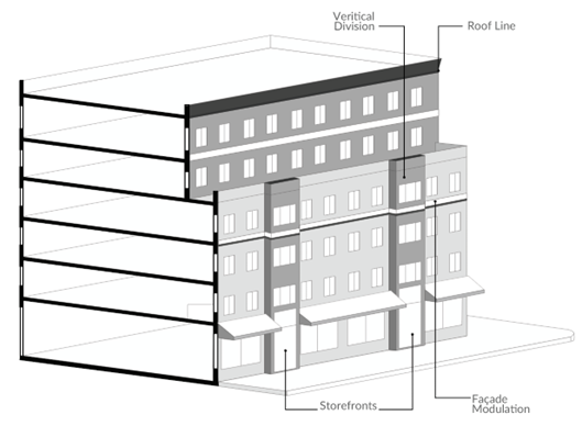
((1)) Façade Modulation – Stepping back or extending forward a portion of the façade.
((2)) Vertical Division – Using different textures or materials, provided materials are drawn from a common palette.
((3)) Storefronts – Division of building face into distinct storefronts with separate entrances and display windows.
((4)) Roof Lines – Varied roof lines with alternating dormers, stepped roofs, gables or other roof elements to reinforce the modulation or articulation interval.
((5)) Articulation Interval – Placement of arcades, awnings, window bays, arched windows or balconies at intervals equal to the articulation interval.
(4) Door and Window Openings
((a)) In new commercial, mixed-use and civic buildings, window and door openings shall comprise at least 50% of the length of the main floor of the primary street façade. Window openings shall be located at a pedestrian sight level.
((1)) Windows shall be designed with openings that create a strong rhythm of light and shadow.
((2)) Glass on windows and doors on the primary street façade shall be clear or slightly tinted, allowing views into and out of the building interior or, as an alternative, used as display windows enclosed by walls inside the building.
((3)) Where security needs warrant it, spandrel glass may be used in the primary street façade windows subject to City approval in the plan review process.
((4)) Window shape, size and patterns shall emphasize the intended organization of the façade and the definition of the building.
(5) Loading Docks
((a)) Outside loading docks shall be located in the rear or side yard and be screened from view from any public right-of-way.
((b)) The space needed for the loading dock must be adequate to handle the loading and unloading needs of the building without obstructing the public right-of-way.
(6) Refuse/Recycling Storage
((a)) Multi-tenant buildings shall share a common refuse/recycling storage area. Refuse/recycling collection areas must be screened from view form any public right-of-way and are encouraged to be enclosed inside a building.
8. Landscaping Requirements
(a) Scope
(1) A landscaping plan shall be submitted according to the requirements of the Landscaping Chapter.
(2) Mixed use projects must have a unified landscaping scheme.
(3) The landscaping requirements in this Chapter will only apply to new construction projects or projects where existing buildings are expanded to the reduced 15-foot setback.
(b) Plant Materials Substitutions
(1) The landscaping requirements in the underlying zoning district shall apply to properties in the TOD Overlay District with some exceptions:
((a)) TOD landscape plans for redevelopment of property located in the underlying Hyde Park zoning district must follow the landscape requirements for the zoning district that most closely represents the use proposed.
((b)) In the TOD Overlay District, one ornamental tree will count as one overstory deciduous tree. In addition, ornamental trees may exceed 50% of the required trees.
((c)) Due to the amount of hardscape needed for pedestrian walkways, if the level of open space for planting restricts the ability to provide adequate growth space for tree roots, perennial planting beds and permanent planters may be substituted for over-story trees at a rate of 36 square feet of plant area per tree substitution.
((d)) Decorative walkway light poles meeting the design specified in the Fridley Northstar TOD TIF District Master Plan as shown in Appendix B may be substituted at a ratio of one light pole for two trees if the site design warrants additional walkway lighting.
((e)) Street-side sculptures, public art, permanent or movable planters, light pole banners, clock towers, arbors, seating benches or similar ornamentation may be considered as substitution to meet landscaping requirements.
(2) If it is not feasible to meet the landscaping requirements of the underlying zoning district with the allowed substitutions above, the City may approve a monetary payment per fees established in the Fees Chapter of the Code into the TOD Capital Project Fund for the purpose of funding streetscape amenities within the street rights of ways within the TOD overlay district.
(c) Water
(1) Drip irrigation systems are encouraged to reduce water consumption and to prevent wet walkways. Examples of alternative storm water treatments are permeable pavers, porous asphalt, vegetative roof areas, rain gardens, infiltration basins, tree trenches, green walls, grass swales, filter strips, cisterns, underground detention/retention, or other innovative techniques used to reduce storm water runoff.
9. Streetscape Requirements
(a) Sidewalks and Pedestrian Connections
(1) Sidewalks of a minimum six-foot width must be provided on all street frontages.
(2) All streetscape and sidewalk design detail will need to be approved by the City as part of a development’s TOD master plan in compliance with the design criteria in the Northstar TOD TIF District Master Plan, along public right of ways adjacent to the proposed development.
(3) Scored concrete, colored concrete, permeable and concrete pavers are suggested pavement options for sidewalks.
(4) Paved connections to building entrances, crosswalks, and adjacent bus stops must also be incorporated into any site design.
(5) A colorized pavement pattern connecting the sidewalk on each side of the driveway shall be incorporated into driveways, warning drivers of the sidewalk connection on each side of the driveway. Such connection shall be accessible in accordance with ADA standards.
(b) Lighting
(1) A lighting plan and fixture specification schedule shall be included in the documents submitted to the City for approval.
(2) Street and pathway lighting types, styles and colors shall be provided according to the specifications in Appendix B and coordinated with the overall design of City-installed lighting in the TOD District.
(3) Pedestrian-oriented lighting is required on all streets, trails, sidewalks and public gathering places within the TOD District.
(4) Energy efficiency is encouraged in all aspects of a project’s Master Plan.
(c) Site Furnishings
(1) Decorative fencing, railings, walls, bike racks, benches, waste receptacles and dumpster enclosures that are incorporated into landscape designs shall match features designated in the Northstar TOD TIF District Master Plan or similar design approved by the City.
(2) Public transit benches located in the Northstar TOD District shall also meet the TOD design criteria.
10. Maintenance
(a) In addition to the maintenance requirements of the underlying zoning district, property owners in the TOD district are required to maintain the landscape and streetscape abutting their property. This includes the removal of debris and snow on trails and walkways and at bus stops and the irrigation of planters on their own private property and those in the public right-of-way adjoining the property. Further details of the maintenance requirements shall be addressed in a development agreement approved by the City.
Adopted by Ord. 1431 on 6/18/2025
1431
614.03.01 Purpose
The Mississippi River Corridor Critical Area (MRCCA) Chapter is adopted pursuant to the authorization and policies contained in M.S. Chapter 116G, Minnesota Rules Parts 6106.0010 - 6106.0180, and the planning and zoning enabling legislation in M.S. Chapters 462 and 473. The Legislature of Minnesota has delegated responsibility to local governments of the state to regulate the subdivision, use and development of designated critical areas and thus preserve and enhance the quality of important historic, cultural, aesthetic values, and natural systems and provide for the wise use of these areas.
Adopted by Ord. 1431 on 6/18/2025
614.03.02 General Provisions
1. Jurisdiction. The provisions of this Chapter apply to land within the O-2 District, which is land within the river corridor boundary as described in the State Register, volume 43, pages 508 to 519 and shown on the City zoning map. 2. Severability. If any section, clause, provision, or portion of this Chapter is judged unconstitutional or invalid by a court of competent jurisdiction, the remainder of this Chapter shall not be affected thereby. 3. Abrogation and Greater Restrictions. It is not intended by this Chapter to repeal, abrogate, or impair any existing easements, covenants, or deed restrictions. However, where this Chapter imposes greater restrictions, the provisions of this Chapter shall prevail. All other Chapters inconsistent with this Chapter are hereby repealed to the extent of the inconsistency only. 4. Underlying Zoning. Use and standards of underlying zoning apply except where standards of this overlay district are more restrictive. 5. Enforcement. The City is responsible for the administration and enforcement of this Chapter. Any violation of its provisions or failure to comply with any of its requirements including violations of conditions and safeguards established in connection with grants of variances or conditional uses constitutes a misdemeanor and is punishable as defined by law. Violations of this Chapter can occur regardless of whether or not a permit is required for a regulated activity listed in Section 614.03.04.01.
Adopted by Ord. 1431 on 6/18/2025
614.03.03 Definitions
Unless specifically defined below, words or phrases used in this Chapter shall be interpreted to give them the same meaning they have in common usage and to give this Chapter its most reasonable application. For the purpose of this Chapter, the words “must” and “shall” are mandatory and not permissive. All distances, unless otherwise specified, are measured horizontally. Access path: An area designated to provide ingress and egress to public waters. Adjacent: Having a boundary that physically touches or adjoins. Agricultural use: A use having the meaning given under M.S. § 40A.02. Alternative design: Subdivision design methods such as conservation design, transfer of development density, or similar zoning and site design techniques that protect open space and natural areas. Biological and ecological functions: The functions of vegetation in stabilizing soils and slopes, retaining and filtering runoff, providing habitat, and recharging groundwater.
Bluff:
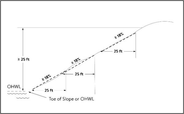
1. A slope that rises at least 25 feet where the grade of the slope averages 18% or greater, measured over any horizontal distance of 25 feet, from the toe of the slope to the top of the slope. Where the slope begins below the ordinary high water level, the ordinary high water level is the toe of the slope. See Figure 1; or
Figure 1. Bluff
2. A natural escarpment or cliff with a slope that rises at least ten feet above the ordinary high water level or toe of the slope, whichever is applicable, to the top of the slope, with a slope of 75 degrees or greater. See Figure 2.
Figure 2. Natural Escarpment Bluff and Bluff Impact Zone
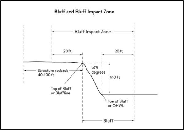
Bluff impact zone (BIZ): A bluff and land located within 20 feet of the bluff. See Figure 2 for natural escarpment or cliff example and Figure 3 for more common bluff example.
Figure 3. Bluff Impact Zone, Bluffline, Toe of bluff, and Top of Bluff
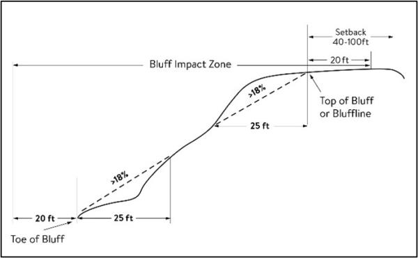
Bluffline: A line delineating the top of the bluff. More than one bluffline may be encountered proceeding landward from the river. See Figure 2 for natural escarpment or cliff example and Figure 3 for more common bluff example. Bluff, Toe of: A line along the bottom of a bluff, requiring field verification, such that the slope above the line exceeds 18% and the slope below the line is 18% or less, measured over a horizontal distance of 25 feet. See Figures 2 for natural escarpment or cliff example and Figure 3 for more common bluff example. Bluff, Top of: A line along the top of a bluff, requiring field verification, such that the slope below the line exceeds 18% and the slope above the line is 18% or less, measured over a horizontal distance of 25 feet. See Figures 2 for natural escarpment or cliff example and Figure 3 for more common bluff example. Buildable area: The area upon which structures may be placed on a lot or parcel of land and excludes areas needed to meet requirements for setback, rights-of-way, bluff impact zones, historic properties, wetlands, designated floodways, land below the ordinary high water level of public waters, and other unbuildable areas. Building: A structure with two or more outside rigid walls and a fully secured roof and affixed to a permanent site. Commissioner: The Commissioner of the Minnesota Department of Natural Resources. Conservation design: A pattern of subdivision that is characterized by grouping lots within a portion of a parcel, where the remaining portion of the parcel is permanently protected as open space. Conventional subdivision: A pattern of subdivision that is characterized by lots that are spread regularly throughout a parcel in a lot and block design.
Deck: A horizontal, unenclosed, aboveground level structure open to the sky, with or without attached railings, seats, trellises, or other features, attached or functionally related to a principal use or site. Developer: Having the meaning given under M.S. § 116G.03. Development: Having the meaning given under M.S. § 116G.03. Discretionary action: An action under this Chapter related to land use that requires a public hearing by local ordinance or statute, such as preliminary plats, final subdivision plats, planned unit developments, conditional use permits, interim use permits, variances, appeals, and rezonings. Dock: Having the meaning given under Minnesota Rules Chapter 6115. Electric power facilities: Equipment and associated facilities for generating electric power or devices for converting wind energy to electrical energy as identified and defined under M.S. § 216E. Essential services: Underground or overhead gas, electrical, communications, steam, sanitary sewer, or water distribution, treatment, collection, supply, or disposal systems, including storm water. Essential services include poles, wires, mains, drains, pipes, conduits, cables, fire alarm boxes, traffic signals, hydrants, navigational structures, aviation safety facilities, lift stations, stormwater management facilities, or other similar equipment and accessories in conjunction with the systems. Essential services do not include buildings, treatment works as defined in M.S. § 115.01, electric power facilities or transmission services. Floodplain: Having the meaning given the meaning given under Minnesota Rules Chapter 6120. Fully reconstructs: The reconstruction of an existing impervious surface that involves site grading and subsurface excavation so that soil is exposed. Mill and overlay and other resurfacing activities are not considered fully reconstructed. Hard-surface trail: A trail surfaced in crushed aggregate, asphalt, or other hard surface, for public use, as determined by local, regional, or state agency plans. Historic property: An archaeological site, standing structure, site, district, or other property that is:
1. Listed in the National Register of Historic Places or the State Register of Historic Places or locally designated as a historic site under M.S. Chapter 471; 2. Determined to meet the criteria for eligibility to the National Register of Historic Places or the State Register of Historic Places as determined by the Director of the Minnesota Historical Society; or
3. An unplatted cemetery that falls under the provisions of M.S. Chapter 307, in consultation with the Office of the State Archaeologist.
Impervious surface: A constructed hard surface that either prevents or retards the entry of water into the soil and causes water to run off the surface in greater quantities and at an increased rate of flow than prior to development. Examples include rooftops, decks, sidewalks, patios, parking lots, storage areas, and driveways, including those with concrete, asphalt, or gravel surfaces. Intensive vegetation clearing: The removal of all or a majority of the trees or shrubs in a contiguous patch, strip, row, or block. Interim use: A use having the meaning given under M.S. Chapters 394 and 462. Land alteration: An activity that exposes the soil or changes the topography, drainage, or cross section of the land, excluding gardening or similar minor soil disturbances. Also referred to as “grading”. Lift: A tram or other accessible means to get up and down steep slopes. Lot width: The shortest distance between lot lines measured at both the ordinary high water level and at the required structure setback from the ordinary high water level. See Figure 4.
Figure 4. Lot Width
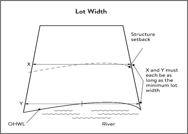
Marina: Having the meaning given under Minnesota Rules Chapter 6115. Mississippi Flyway: A major North American bird migration corridor that encompasses all MRCCA districts. Mooring Facility: Having the meaning given under Minnesota Rules part 6115.0170. Native plant community: A plant community identified by the Minnesota Biological Survey or biological survey issued or adopted by a local, state, or federal agency. Natural-surface trail: A trail composed of native soil and rock or compacted granular stone, primarily intended for hiking, equestrian, or mountain bike use, as determined by local, regional, or state agency plans. Natural vegetation: Any combination of ground cover, understory, and tree canopy that, while it may have been altered by human activity, continues to stabilize soils, retain and filter runoff, provide habitat, and recharge groundwater. Nonmetallic mining: Construction, reconstruction, repair, relocation, expansion, or removal of any facility for the extraction, stockpiling, storage, disposal, or reclamation of nonmetallic minerals such a stone, sand, and gravel. Nonmetallic mining does not include ancillary facilities such as access roads, bridges, culverts, and water level control structures. For purposes of this subpart, “facility” includes all mine pits, quarries, stockpiles, basins, processing structures and equipment, and any structures that drain or divert public waters to allow mining. Off-premise advertising signs: Those signs that direct attention to a product, service, business, or entertainment venue that is not exclusively related to the premises where the sign is located. Ordinary high water level (OHWL): Having the meaning given under M.S. § 103G.005. Parcel: Having the meaning given under M.S. § 116G.03. Patio: A constructed hard surface located at ground level with no railings and open to the sky. Picnic shelter: A roofed structure open on all sides, accessory to a recreational use. Planned Unit Development: A method of land development that merges zoning and subdivision controls, allowing developers to plan and develop a large area as a single entity, characterized by a unified site design, a mix of structure types and land uses, and phasing of development over a number of years. Planned unit development includes any conversion of existing structures and land uses that utilize this method of development. Plat: Having the meaning given under M.S. § 505 and 515B. Primary conservation areas (PCAs): Key resources and features, including shore impact zones, bluff impact zones, floodplains, wetlands, gorges, areas of confluence with tributaries, natural drainage routes, unstable soils and bedrock, native plant communities, cultural and historic properties, and significant existing vegetative stands, tree canopies, and other resources identified in local government plans. Private facilities: Private roads, driveways, and parking areas, private water access and viewing structures, decks and patios in setback areas, and private signs. Public facilities: Public utilities, public transportation facilities, and public recreational facilities. Public recreation facilities: Recreational facilities provided by the state or a local government and dedicated to public use, including parks, scenic overlooks, observation platforms, trails, docks, fishing piers, picnic shelters, water access ramps, and other similar water-oriented public facilities used for recreation. Public river corridor views (PRCVs): Views toward the river from public parkland, historic properties, and public overlooks, as well as views toward bluffs from the ordinary high water level of the opposite shore, as seen during the summer months and documented in the MRCCA Chapter of the comprehensive plan. Public transportation facilities: All transportation facilities provided by federal, state, or local government and dedicated to public use, such as roadways, transit facilities, railroads, and bikeways. Public utilities: Electric power facilities, essential services, and transmission services. Public waters: Having the meaning given under M.S. § 103G.005. Readily visible: Land and development that are easily seen from the ordinary high water level of the opposite shore during summer months. Resource agency: A federal, state, regional, or local agency that engages in environmental, natural, or cultural resource protection or restoration activities, including planning, implementation, and monitoring. Retaining wall: A vertical or nearly vertical structures constructed of mortar and rubble masonry, rock, or stone, vertical timber pilings, horizontal timber planks with piling supports, sheet pilings, poured concrete, concrete blocks, or other durable materials that in combination exceed four vertical feet. Rock riprap: Natural coarse rock placed or constructed to armor shorelines, streambeds, bridge abutments, pilings and other shoreline structures against scour, or water or ice erosion. River corridor boundary: The boundary approved and adopted by the Metropolitan Council under M.S. § 116G.06, as approved and adopted by the legislature in M.S. § 116G.15, and as legally described in the State Register, volume 43, pages 508 to 518.
River-dependent use: The use of land for commercial, industrial, or utility purposes, where access to and use of a public water feature is an integral part of the normal conduct of business and where the use is dependent on shoreline facilities. Selective vegetation removal: The removal of isolated individual trees or shrubs that are not in a contiguous patch, strip, row, or block and that does not substantially reduce the tree canopy or understory cover. Setback: A separation distance measured horizontally. Shore impact zone (SIZ): Land located between the ordinary high water level of public waters and a line parallel to it at a setback of 50% of the required structure setback or, for agricultural use, 50 feet landward of the ordinary high water level. See Figure 5.
Figure 5. Shore Impact Zone
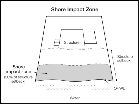
Shoreline facilities: Facilities that require a location adjoining public waters for ingress and egress, loading and unloading, and public water intake and outflow, such as watercraft lifts, marinas, short-term watercraft mooring facilities for patrons, and water access ramps. Structures that would be enhanced by a shoreline location, but do not require a location adjoining public waters as part of their function, are not shoreline facilities, such as restaurants, bait shops, and boat dealerships. Sign: See definition in the Signs Chapter. Steep slope: Any slope steeper than 15% (15 feet of rise for every 100 feet horizontal run). Storm water management facilities: Facilities for the collection, conveyance, treatment, or disposal of storm water. Structure: A building, sign, or appurtenance thereto, except for aerial or underground utility lines, such as sewer, electric, telephone, or gas lines, and utility line towers, poles, and other supporting appurtenances. Subsurface sewage treatment system. Having the meaning given under Minnesota Rules Part 7080.1100. Transmission services: Electrical power lines, cables, pipelines, or conduits that are:
1. Used to transport power between two points, as identified and defined under M.S. § 216E.01, Subd. 4; or 2. For mains or pipelines for gas, liquids, or solids in suspension, used to transport gas, liquids, or solids in suspension between two points; and 3. Telecommunication or electric lines, cables, pipelines, or conduits.
Treeline: The more or less continuous line formed by the tops of trees in a wooded area when viewed from a particular point. The treeline is determined during all seasons as if under full foliage. Variance: “Variance” means the same as that defined in 44 CFR § 59.1 and M.S. § 462.357, Subd. 6(2). Water access ramp: A boat ramp, carry-down site, boarding dock, and approach road, or other access that allows launching and removal of a boat, canoe, or other watercraft with or without a vehicle and trailer. Water-oriented accessory structure: A small building or other improvement, except stairways, fences, docks, and retaining walls, that, because of the relationship of its use to public waters, needs to be located closer to public waters than the normal structure setback. Examples include gazebos, screen houses, fish houses, pump houses, and detached decks and patios. Water quality impact zone: Land within the shore impact zone or within 50 feet of the OHWL of the river, whichever is greater, and land within 50 feet of a public water, wetland, or natural drainage route. Wetland: Having the meaning given under M.S. § 103G.005.
Adopted by Ord. 1431 on 6/18/2025
614.03.04 Administration
1. Permits. A permit is required for the construction of buildings, building additions, and structures (including construction of decks and signs), vegetation removal consistent with Section 614.03.11 and land alteration consistent with Section 614.03.12. 2. Variances. Variances to the requirements under this Chapter may only be granted in accordance with M.S. § 462.357 and must consider the potential impacts on primary conservation areas, public river corridor views, birds and other wildlife using the Mississippi Flyway through habitat loss, collision threats or light pollution, and other resources identified in the MRCCA plan. In reviewing the variance application, the following shall be considered:
(a) Impacts to the resources listed above. If negative impacts are found, require conditions to mitigate the impacts that are related to and proportional to the impacts consistent with Section 614.03.04.04; and (b) Make written findings that the variance is consistent with the purpose of this Chapter as follows:
(1) The extent, location and intensity of the variance will be in substantial compliance with the MRCCA Plan; and
(2) The variance is consistent with the character and management purpose of the MRCCA district in which it is located.
3. Conditional and interim use permits. All conditional and interim uses, required under this Chapter, must comply with M.S. § 462.3595 and must consider the potential impacts on primary conservation areas, public river corridor views, birds and other wildlife using the Mississippi Flyway through habitat loss, collision threats or light pollution, public access, and other resources identified in the MRCCA plan. In reviewing the application, the following shall be considered:
(a) Impacts to the resources listed above. If negative impacts are found, require conditions to mitigate the impacts that are related to and proportional to the impacts consistent with Section 614.03.04.04; and (b) Make written findings that the conditional or interim use permit is consistent with the purpose of this Chapter as follows:
(1) The extent, location and intensity of the conditional or interim use permit will be in substantial compliance with the MRCCA Plan; and
(2) The conditional or interim use permit is consistent with the character and management purpose of the MRCCA district in which it is located.
4. Mitigation of impacts. Negative impacts to primary conservation areas, public river corridor views, and other resources identified in the MRCCA Plan occurring due to variances, conditional use permits, or interim use permits must be mitigated for in a way that is related to and proportional to the impacts. Mitigation may include:
(a) Restoration of vegetation; (b) Implementation of animal habitat support as outlined in the most recent version of the Minnesota B3 Guidelines; (c) Increasing and/or improving habitat for pollinators, birds, and other wildlife using native trees, shrubs, and vegetation; (d) Expansion of public access; (e) Preservation of existing vegetation; (f) Storm water runoff management; (g) Reducing impervious surface; (h) Increasing structure setbacks; (i) Wetland and drainage route restoration and/or preservation; (j) Limiting the height of structures; (k) Modifying structure design to limit visual impacts on public river corridor views; and (l) Other conservation measures.
5. Application materials. Applications for permits and discretionary actions required under this Chapter must submit the following information unless the Community Development Director or their designee determines that the information is not needed.
(a) A detailed project description; and (b) Scaled maps and plans, dimensional renderings, maintenance agreements, and other materials that identify and describe:
(1) Primary conservation areas; (2) Public river corridor views; (3) Buildable area; (4) Proposed size, alignment, height, and intended use of any structure to be erected or located on the site; (5) A delineation of the location and amounts of excavated soils to be stored on the site during construction; (6) Existing and proposed topography and drainage patterns; (7) Proposed storm water and erosion and sediment control practices; (8) Existing and proposed vegetation to be removed and established; (9) Ordinary high water level, blufflines, and all required setbacks; (10) Existing and proposed impervious surfaces as well as surfacing to be used; and (11) Any other information pertinent to the particular project which in the opinion of the City or applicant is necessary or helpful for the review of the project.
6. Nonconformities
(a) All legally established nonconformities as of the date of adoption of this Chapter may continue consistent with M.S. § 462.357, Subd. 1e. (b) Site alterations and expansion of site alterations that were legally made prior to the effective date of this ordinance are conforming. Site alterations include vegetation, erosion control, storm water control measures, and other nonstructural site improvements. (c) Legally nonconforming principal structures that do not meet the setback requirements of Section 614.03.07.03 may be expanded laterally provided that:
(1) The expansion does not extend into the shore or bluff impact zone or further into the required setback than the building line of the existing principal structure (See Figure 6); and (2) The expanded structure’s scale and bulk is consistent with that of the original structure and existing surrounding development.
Figure 6. Expansion of Nonconforming Structure
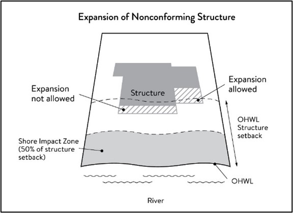
7. Notifications
(a) Amendments to this Chapter and to the MRCCA plan must be submitted to the Commissioner of the Department of Natural Resources (DNR) as provided in Minnesota Rules Part 6106.0070, Subp. 3, Items B – I. (b) Notice of public hearings for discretionary actions, including conditional and interim use permits, variances, appeals, rezonings, preliminary plats, final subdivision plats, and PUDs, must be sent to the following entities at least 10 days prior to the hearing:
(1) The Commissioner of the DNR in a format prescribed by the DNR; (2) National Park Service; and (3) Where building heights exceed the height limits specified in Section 614.03.07.01 as part of the conditional use or variance process, adjoining local governments within the MRCCA, including those with overlapping jurisdiction and those across the river.
(c) Notice of final decisions for actions in Section 614.03.04.07.B, including findings of fact, must be sent to the Commissioner of the DNR, the National Park Service, and adjoining local governments within the MRCCA within ten (10) days of the final decision. (d) Requests to amend district boundaries must follow the provisions in Minnesota Rules Part 6106.0100, Subp. 9, Item C.
8. Accommodating disabilities. Reasonable accommodations for ramps or other facilities to provide persons with disabilities access to the persons’ property, as required by the federal Americans with Disabilities Act and the federal Fair Housing Act and as provided by Minnesota Rules Chapter 1341, must:
(a) Comply with Sections 614.03.07-614.03.14; or (b) If Sections 614.03.07-614.03.14 cannot be complied with, ramps or other facilities are allowed with a Reasonable Accommodation License provided:
(1) The license terminates on either a specific date or upon occurrence of a particular event related to the person requiring accommodation; and (2) Upon expiration of the permit, the ramp or other facilities must be removed.
Adopted by Ord. 1431 on 6/18/2025
614.03.05 MRCCA Districts
1. District description and management purpose. The MRCCA within Fridley is divided into the following MRCCA districts:
(a) Rural and Open Space (ROS) The Rural and Open Space District is characterized by rural and low-density development patterns and land uses and includes land that is riparian or visible from the river, as well as large, undeveloped tracts of high ecological and scenic value, floodplain, and undeveloped islands. Many primary conservation areas exist in the district. The Rural and Open Space District must be managed to sustain and restore the rural and natural character of the corridor and to protect and enhance habitat, parks and open space, public river corridor views, and scenic, natural, and historic areas. (b) River Neighborhood (RN) The River Neighborhood District is characterized by primarily residential neighborhoods that are riparian or readily visible from the river or that abut riparian parkland. The district includes parks and open space, limited commercial development, marinas, and related land uses. The River Neighborhood District must be managed to maintain the character of the river corridor within the context of existing residential and related neighborhood development, and to protect and enhance habitat, parks and open space, public river corridor views, and scenic, natural, and historic areas. Minimizing erosion and the flow of untreated storm water into the river and enhancing habitat and shoreline vegetation are priorities in the district. (c) Separated from River (SR) The Separated from River District is characterized by its physical and visual distance from the Mississippi River. The district includes land separated from the river by distance, topography, development, or a transportation corridor. The land in this district is not readily visible from the Mississippi River. The Separated from River district provides flexibility in managing development without negatively affecting the key resources and features of the river corridor. Minimizing negative impacts to primary conservation areas and minimizing erosion and flow of untreated storm water into the Mississippi River are priorities in the district. The SR district must be managed in a manner that allows continued growth and redevelopment in historic downtowns and more intensive redevelopment in limited areas at river crossings to accommodate compact walkable development patterns and connections to the river. Minimizing erosion and the flow of untreated storm water into the river, providing public access to and public views of the river, and restoring natural vegetation in riparian areas and tree canopy are priorities in the district.
2. Urban Mixed (UM) The Urban Mixed District includes large areas of highly urbanized mixed use that are a part of the urban fabric of the river corridor, including institutional, commercial, industrial, and residential areas and parks and open space. The Urban Mixed District must be managed in a manner that allows for future growth and potential transition of intensely developed areas that does not negatively affect public river corridor views and that protects bluffs and floodplains. Restoring and enhancing bluff and shoreline habitat, minimizing erosion and flow of untreated storm water into the river, and providing public access to and public views of the river are priorities in the district. 3. MRCCA district map The locations and boundaries of the MRCCA districts established by this Chapter are shown on the Critical Area Overlay District Map, which is incorporated herein by reference. The district boundary lines are intended to follow the centerlines of rivers and streams, highways, streets, lot lines, and municipal boundaries, unless a boundary line is otherwise indicated on the map. Where district boundaries cross unsubdivided property, the district boundary line is determined by use of dimensions or the scale appearing on the map.
Adopted by Ord. 1431 on 6/18/2025
614.03.06 Special Land Use Provisions
1. Uses excluded. The following uses are excluded from the MRCCA:
(a) Any use that is excluded within the underlying zoning district; (b) Any barge fleeting or barge loading; (c) Any solid waste storage use or treatment facilities; (d) Any mining or extraction uses other than the soil preparation or peat removal necessary for construction; (e) The construction of new subsurface sewage treatment systems; (f) Agricultural use unless perennial ground cover is provided within at least 50 feet of the ordinary high water level and within the bluff impact zone; and (g) Tree harvesting and biomass harvesting within woodlands, and associated reforestation, unless it is conducted consistent with recommended practices in Conserving Wooded Areas in Developing Communities: Best Management Practices in Minnesota.
2. River-dependent uses. River-dependent uses must comply with the following design standards:
(a) Structures and parking areas, except shoreline facilities and private roads and conveyances serving river-dependent uses as provided in Section 614.03.14, must meet the dimensional and performance standards in this Chapter, must be designed so that they are not readily visible, and must be screened by establishing and maintaining natural vegetation; (b) Shoreline facilities must comply with Minnesota Rules Chapter 6115 and must: (1) Minimize the shoreline area affected in so far as feasible; and (2) Minimize the surface area of land occupied in relation to the number of watercrafts to be served; (c) Dredging and placement of dredged material are subject to existing federal and state permit requirements and agreements.
3. Wireless communication towers
(a) Wireless communication towers that existed in the MRCCA prior to the adoption of this Chapter are considered legally nonconforming. (b) A new wireless communication towers or the physical modification of an existing wireless communication tower that results in an increase in the intensity of the nonconforming use requires a conditional use permit and is subject to the following design standards:
(1) The applicant must demonstrate that functional coverage cannot be provided through co-location, a tower at a lower height, or a tower at a location outside of the MRCCA; (2) Freestanding towers must not be located in a bluff or shore impact zone; (3) Placement of the tower must minimize impacts on public river corridor views; and (4) Comply with the general design standards in Section 614.03.09.01.
Adopted by Ord. 1431 on 6/18/2025
614.03.07 Structure Height, Placement, And Lot Size
1. Structure height. Structures and facilities must comply with the following standards or the underlying development standard, whichever is lesser, unless identified as exempt in Section 614.03.14. Height is measured on the side of the structure facing the Mississippi River:
(a) River and Open Space District: 35 feet. (b) River Neighborhood District: 35 feet. (c) Separated from River District: Height is determined by underlying development standard, provided the allowed height is consistent with that of the mature treeline, where present, and existing surrounding development, as viewed from the OWHL of the opposite shore. (d) Urban Mixed District: 65 feet, provided tiering of structures away from the Mississippi River and from blufflines is given priority, with lower structure heights closer to the river and blufflines, and that structure design and placement minimize interference with public river corridor views. Structures over 65 feet are allowed as a conditional use according to Section 614.03.07.02.
2. In addition to the variance or conditional use requirements of Section 614.03.04.04, criteria for considering whether to grant a variance or conditional use permit for structures exceeding the height limits must include:
(a) Assessment of the visual impact of the proposed structure on public river corridor views, including views from other communities; (b) Identification and application of techniques to minimize the perceived bulk of the proposed structure, such as:
(1) Placing the long axis of the building perpendicular to the river; (2) Stepping back of portions of the facade; (3) Lowering the roof pitch or use of a flat roof; (4) Using building materials or mitigation techniques that will blend in with the natural surrounds; (5) Implementation of animal habitat support as outlined in the most recent version of the Minnesota B3 Guidelines; (6) Narrowing the profile of upper floors of the building; (7) Increasing the setbacks of the building from the Mississippi River or blufflines; or (8) Opportunities for creation or enhancement of public river corridor views.
3. Structure and impervious surface placement.
(a) Structures and impervious surface must not be placed in the shore or bluff impact zones unless identified as an exemption in Section 614.03.14. (b) Structures, impervious surfaces, and facilities must comply with the following OHWL setback provisions unless identified as exempt in Section 614.03.14:
(1) Rural and Open Space District: 200 feet from the Mississippi River. (2) River Neighborhood District: 100 feet from the Mississippi River. (3) Urban Mixed District: 50 feet from the Mississippi River. (4) Rice Creek and Springbrook Creek: 50 feet.
(c) Structures, impervious surfaces, and facilities must comply with the following bluffline setback provisions unless identified as exempt in Section 614.03.14:
(1) Rural and Open Space District: 100 feet. (2) River Neighborhood District: 40 feet. (3) Separated from River District: 40 feet. (4) Urban Mixed District: 40 feet.
(e) Impervious surface lot coverage must not exceed 35% on any lot within the Shoreland Overlay District except as a variance which shall comply with the following standards:
(1) All structures, additions or expansions shall meet setback and other requirements of this Code; (2) The lot shall be served with municipal sewer and water; (3) The lot shall provide for the collection and treatment of stormwater in compliance with Stormwater Management and Erosion Control Chapter of the Code; and (4) Measures shall be taken for the treatment of stormwater runoff and/or prevention of stormwater from directly entering a public water.
4. Lot size and buildable area.
(a) The width of lots abutting the Mississippi River in the ROS District must be at least 200 feet, unless alternative design methods are used that provide greater protection of the riparian area. (b) All new lots must have adequate buildable area to comply with the setback requirements of Sections Section 614.03.07.01 and Section 614.03.07.03 so as to not require variances to use the lots for their intended purpose.
Adopted by Ord. 1431 on 6/18/2025
614.03.08 Performance Standards For Private Facilities
1. General design standards. All private facilities must be developed in accordance with the vegetation management and land alteration requirements in Sections 614.03.11 and 614.03.12. 2. Private roads, driveways, and parking areas. Except as provided in Section 614.03.14, private roads, driveways and parking areas must:
(a) Be designed to take advantage of natural vegetation and topography so that they are not readily visible from the river; (b) Comply with structure and impervious surface setback requirements according to Section 614.03.07.03; and (c) Not be placed within the bluff impact zone or shore impact zone, unless exempt under Section 614.03.14 and designed consistent with Section 614.03.09.01.
3. Private water access and viewing facilities.
(a) Private access paths must be no more than:
(1) Eight feet wide, if placed within the shore impact zone; and (2) Four feet wide, if placed within the bluff impact zone.
(b) Private water access ramps must:
(1) Comply with Minnesota Rules Parts 6115.0210 and 6280.0250; and (2) Be designed and constructed consistent with the applicable standards in the most current version of the Design Handbook for Recreational Boating and Fishing Facilities.
(c) Design and construction of private stairways, lifts, and landings located above the OHWL are subject to the following standards:
(1) Stairways and lifts must not exceed four feet in width on residential lots. Wider stairways may be approved for commercial properties and residential facilities held in common; (2) Landings for stairways and lifts on residential lots must not exceed 32 square feet in area. Landings larger than 32 square feet area may be approved for commercial properties and residential facilities held in common; (3) Canopies or roofs are prohibited on stairways, lifts, or landings; (4) Stairways, lifts, and landings must be located in the least visible portion of the lot whenever practical; and (5) Ramps, lifts, mobility paths, or other facilities for persons with physical disabilities are allowed for achieving access to shore areas according to Section 614.03.08.3.C 1-4, and as provided under Section 614.03.04.08.
(d) One water-oriented accessory structure is allowed for each riparian lot or parcel less than 300 feet in width at the ordinary high water level, with one additional water-oriented accessory structure allowed for each additional 300 feet of shoreline on the same lot or parcel. Water-oriented accessory structures are prohibited in the bluff impact zone and must:
(1) Not exceed 12 feet in height; (2) Not exceed 120 square feet in area; and (3) Be placed a minimum of 10 feet from the ordinary high water level.
3. Decks and patios in setback areas. Decks and at-grade patios may encroach into the required setbacks from the ordinary high water level and blufflines without a variance, when consistent with Sections 614.03.11 and 614.03.12, provided that:
(a) The encroachment of the deck or patio into the required setback area does not exceed 15% of the required structure setback; (b) The area of the deck or patio that extends into the required setback area occupies no more than 25% of the total area between the required setback and the 15% using the formula: Required setback depth (feet) x 0.15 x lot width at setback (feet) x 0.25 = maximum total area. (c) The deck or patio does not extend into the bluff impact zone. See Figure 7.
Figure 7. Deck and Patio Encroachment
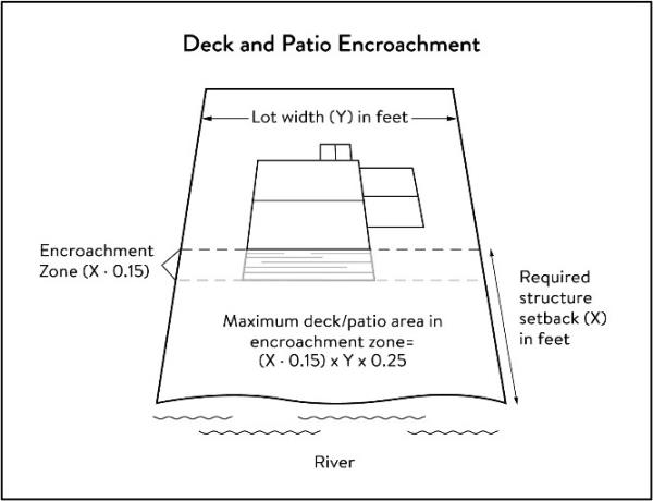
4. Off-Premise and Directional Signs
(a) Off-premise advertising signs must:
(1) Meet required structure height and placement standards in Sections 614.03.07.01 and 614.03.07.03. (2) Not be readily visible from the river
(b) Directional signs for patrons arriving at a business by watercraft must comply with the following standards:
(1) They must be consistent with M.S. § 86B.115. (2) Only convey the location and name of the establishment and the general types of goods and services available, if located in a shore impact zone. (3) Be no greater than ten feet in height and 32 square feet in surface area; and (4) If illuminated, the lighting must be shielded and directed downward to prevent illumination out across the river or to the sky.
5. Lighting. Within the Shore Impact Zone:
(a) Lighting shall be fully shielded and directed away from the river. (b) Uplighting is prohibited.
6. Line of Sight. The development of new, or the expansion of existing structures, shall be placed so that the development is consistent with the preservation of the view of the river corridor from other properties on both sides of the river and by the public. The walling off of views of the river corridor from other properties and public right-of-ways shall be prohibited.
Adopted by Ord. 1431 on 6/18/2025
614.03.09 Performance Standards For Public Facilities
1. General design standards. All public facilities must be designed and constructed to:
(a) Minimize visibility of the facility from the river to the extent consistent with the purpose of the facility; (b) Comply with the structure placement and height standards in Section 614.03.07, except as provided in Section 614.03.14; (c) Be consistent with the vegetation management standards in Section 614.03.11 and the land alteration and storm water management standards in Section 614.03.12, including use of practices identified in Best Practices for Meeting DNR General Public Waters Work Permit GP 2004-0001, where applicable; and (d) Avoid primary conservation areas, unless no alternative exists. If no alternative exists, then disturbance to primary conservation areas must be avoided to the greatest extent practicable, and design and construction must minimize impacts. (e) Where feasible, minimize disturbance of spawning and nesting times by scheduling construction at times when local fish and wildlife are not spawning or nesting in areas where this activity is known to occur.
2. Right-of-way maintenance standards. Right-of-way maintenance must comply with the following standards:
(a) Vegetation currently in a natural state must be maintained to the extent feasible; (b) Where vegetation in a natural state has been removed, native plants must be planted and maintained on the right-of-way; and (c) Chemical control of vegetation must be avoided when practicable, but when chemical control is necessary, chemicals used must be in accordance with the regulations and other requirements of all state and federal agencies with authority over the chemical’s use.
3. Crossings of public water or public land. Crossings of public waters or land controlled by the commissioner are subject to approval by the commissioner according to M.S. § 84.415 and 103G.245. 4. Public utilities. Public utilities must comply with the following standards:
(a) High-voltage transmission lines, wind energy conversion systems greater than five megawatts, and pipelines are regulated according to M.S. Chapter 216E, 216F, and 216G respectively; (b) Primary consideration shall be given to underground placement of facilities in order to minimize aesthetic, environmental and public safety aspects. When considering overhead placement, the developer must show the reasoning that makes underground placement unfeasible; (c) If underground placement is unfeasible, visibility of the facility from the river must be minimized as much as practicable; and (d) The appearance of structures must be as compatible as practicable with the surrounding area in a natural state with regard to height and width, materials used, and color.
5. Public transportation facilities. Public transportation facilities shall comply with structure placement and height standards in Section 614.03.07 except as provided in Section 614.03.14. Where such facilities intersect or abut two or more MRCCA districts, the least restrictive standards apply. Public transportation facilities must be designed and constructed to give priority to:
(a) Providing scenic overlooks for motorists, bicyclists, and pedestrians; (b) Providing safe pedestrian crossings and facilities along the river corridor; (c) Providing access to the riverfront in public ownership; and (d) Allowing for use of the land between the river and the transportation facility. 6. Public recreational facilities. Public recreational facilities must comply with the following standards: (a) Buildings and parking associated with public recreational facilities must comply with the structure placement and height standards in Section 614.03.07, except as provided in Section 614.03.14; (b) Roads and driveways associated with public recreational facilities must not be placed in the bluff or shore impact zones unless no other placement alternative exists. If no alternative exists, then design and construction must minimize impacts to shoreline vegetation, erodible soils and slopes, and other sensitive resources; (c) Trails, access paths, and viewing areas associated with public recreational facilities and providing access to or views of the Mississippi River are allowed within the bluff and shore impact zones if design, construction, and maintenance methods are consistent with the best management practice guidelines in Trail Planning, Design, and Development Guidelines:
(1) Hard-surface trails are not allowed on the face of bluffs with a slope exceeding 30%. Natural surface trails are allowed, provided they do not exceed eight feet in width. (2) Trails, paths, and viewing areas must be designed and constructed to minimize:
((a)) Visibility from the river; ((b)) Visual impacts on public river corridor views; and ((c)) Disturbance to and fragmentation of primary conservation areas.
(d) Public water access facilities must comply with the following requirements:
(1) Watercraft access ramps must comply with Minnesota Rules Chapters 6115.0210 and 6280.0250; and (2) Facilities must be designed and constructed consistent with the standards in the most recent version of the Minnesota DNR’s Design Handbook for Recreational Boating and Fishing Facilities.
(e) Public signs and kiosks for interpretive or directional purposes are allowed in the bluff or shore impact zones, provided they are placed and constructed to minimize disturbance to these areas and avoid visual impacts on public river corridor views; and (f) Public stairways, lifts, and landings must be designed as provided in Section 614.03.08.03.C.
Adopted by Ord. 1431 on 6/18/2025
614.03.10 Public Access
1. Public river access to and along the river shall be provided for any new development that is adjacent to or part of a city plan including public access. 2. Public river access shall be provided to the riverfront of developments on publicly owned and publicly controlled riverfront property where feasible.
Adopted by Ord. 1431 on 6/18/2025
614.03.11 Vegetation Management
1. Applicability. This section applies to:
(a) Shore impact zones; (b) Areas within 50 feet of a wetland or natural drainage route; (c) Bluff impact zones; (d) Areas of native plant communities; and (e) Significant existing vegetative stands identified in the MRCCA plan
2. General performance standards for vegetation management. The general performance standards for vegetation management are as follows:
(a) Development must be sited to minimize removal of or disturbance to natural vegetation; (b) Soil, slope stability, and hydrologic conditions are suitable for the proposed work as determined by the Community Development Director or their designee (c) Clearing is the minimum necessary and designed to blend with the natural terrain and minimize visual impacts to public river corridor views; (d) Vegetation removal activities must be conducted so as to expose the smallest practical area of soil to erosion for the least possible time; and (e) Grading must be conducted in a manner that preserves the root zone aeration and stability of existing trees and provides an adequate watering area equal to at least one-half of each tree crown. If this is not possible, a replacement tree must be provided in conformance with Section 614.03.11.07.
3. Activities allowed without a permit:
(a) Maintenance of existing lawns, landscaping, and gardens; (b) Removal of vegetation in emergency situations as determined by the Community Development Director or their designee; (c) Right-of-way maintenance for public facilities meeting the standards Section 614.03.09.02 (d) Agricultural and forestry activities meeting the standards of Sections 614.03.06.01.F and 614.03.06.01.G; (f) Selective vegetation removal provided that vegetative cover as viewed from the river remains consistent with the management purpose of the MRCCA district and trees are replaced in conformance with Section 614.03.11.06.
4. Activities allowed with a permit. Only the following intensive vegetation clearing activities are allowed with a permit, all other forms of intensive vegetation clearing are prohibited:
(a) Clearing of vegetation that is dead, diseased, dying, or hazardous; (b) Clearing to prevent the spread of diseases or insect pests; (c) Clearing to remove invasive non-native species; (d) Clearing for habitat restoration and erosion control management activities consistent with an approved plan; (e) The minimum necessary for development that is allowed with a building permit or as an exemption under Section 614.03.14.
5. Vegetation restoration plan. Development of a vegetation restoration plan and reestablishment of natural vegetation is required in the following circumstances:
(a) For any vegetation removed with a permit under Section 614.03.11.04; (b) Upon failure to comply with any provisions in this Section; or (c) As part of the planning process for subdivisions as provided in Section 614.03.13.
6. Vegetation Restoration Plan Performance Standards. The vegetation restoration plan must satisfy the application submittal requirements in Section 614.03.04.05, and:
(a) Vegetation must be restored in one or more of the following restoration priority areas:
(1) Stabilization of erodible soils including with soils showing signs of erosion, especially on or near the top and bottom of steep slopes and bluffs; (2) Restoration or enhancement of shoreline vegetation including shoreline areas within 25 feet of the water with no natural vegetation, degraded vegetation, or planted with turf grass; (3) Revegetation of bluffs or steep slopes visible from the river; and (4) Other approved priority opportunity area, including priorities identified in the MRCCA plan, if none of the above exist.
(b) Include vegetation that provides suitable habitat and effective soil stability, runoff retention, and infiltration capability. Vegetation species, composition, density, and diversity must be guided by nearby patches of native plant communities and by Native Vegetation Establishment and Enhancement Guidelines; (c) Any highly erodible soils disturbed during removal and/or restoration must be stabilized with deep-rooted vegetation with a high stem density; (d) Vegetation removed must be restored with natural vegetation to the greatest extent practicable. The area (square feet) of the restored vegetation should be similar to that removed to the greatest extent practicable; (e) For restoration of removed native plant communities, restored vegetation must also provide biological and ecological function equivalent to the removed native plant communities; (f) Be prepared by a qualified individual except for:
(1) Vegetation plans required in response to Section 614.03.11.04.D which must be prepared by a professional ecologist, landscape architect, or person with demonstrable experience and knowledge related to vegetation management as accepted and approved by the City; and
(g) Include a maintenance plan that includes management provisions for controlling invasive species and replacement of plant loss for three years.
7. Tree Removal and Replacement
(a) Except for tree removal conducted in accordance 614.03 with an approved vegetation restoration plan, any trees over four inches diameter at breast height that are removed shall be restored with an equal number of trees to that which existed before cutting by September 30 of the subsequent year. If insufficient space is available for tree replanting as determined by the City, a monetary fee may be provided in lieu of tree replanting.
Adopted by Ord. 1431 on 6/18/2025
614.03.12 Land Alteration And Stormwater Management
1. Land alteration
(a) Within the bluff impact zone, land alteration is prohibited, except for the following, which are allowed with a permit:
(1) Erosion control consistent with a plan approved by the Community Development Director or their designee; (2) The minimum necessary that is allowed as an exception under Section 614.03.14; and (3) Repair and maintenance of existing buildings and facilities.
(b) Within the water quality impact zone, land alteration that involves more than ten cubic yards of material or affects an area greater than 1,000 square feet requires a permit.
2. Rock riprap, retaining walls, and other erosion control structures
(a) Construction, repair, or replacement of rock riprap, retaining walls, and other erosion control structures located at or below the OHWL must comply with Minnesota Rules Part 6115.0215, Subp. 4, item E, and 6115.0216, Subp. 2. Work must not proceed until necessary approvals by the Commissioner, the US Army Corps of Engineers as necessary, and any other required permits are obtained. See Figure 8.
Figure 8. Riprap Guidelines
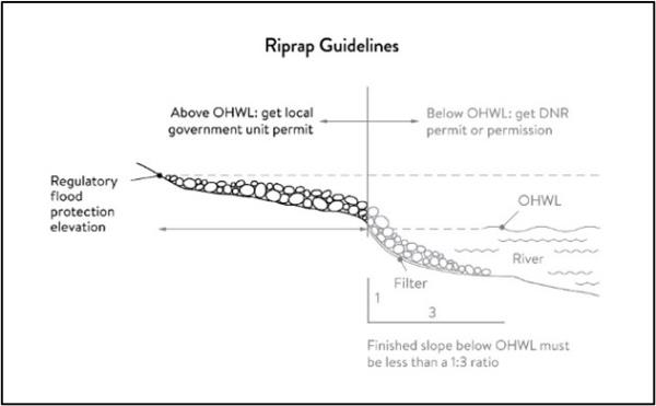
(b) Construction or replacement of rock riprap, retaining walls, and other erosion control structures within the bluff impact zone and the water quality impact zone are allowed with a permit consistent with provisions of Section 614.03.12.5 provided that:
(1) If the project includes work at or below the OHWL, the commissioner has already approved or permitted the project; (2) The structures are used only to correct an established erosion problem as determined by the City Engineer or their designee; (3) The size and extent of the structures are the minimum necessary to correct the erosion problem and are not larger than the following, unless a professional engineer determines that a larger structure is needed to correct the erosion problem:
((a)) Retaining walls must not exceed four feet in height; ((b)) Retaining walls must be placed a minimum horizontal distance of twenty feet apart; and ((c)) Riprap must not exceed the height of the regulatory flood protection elevation.
(c) Repair of existing rock riprap, retaining walls, and other erosion control structures above the OHWL does not require a permit provided it does not involve any land alteration.
3. Storm water management.
(a) In the bluff impact zone, storm water management facilities are prohibited, except by permit if:
(1) There are no alternatives for storm water treatment outside the bluff impact zone on the subject site; (2) The site generating runoff is designed so that the amount of runoff reaching the bluff impact zone is reduced to the greatest extent practicable; (3) The construction and operation of the facility does not affect slope stability on the subject property or adjacent properties; and (4) Mitigation based on the best available engineering and geological practices is required and applied to eliminate or minimize the risk of slope failure.
(b) In the water quality impact zone, development that creates new impervious surface, as allowed by exemption in Section 614.03.14, or fully reconstructs existing impervious surface of more than 10,000 square feet requires a permit. Multipurpose trails and sidewalks are exempt if there is down gradient vegetation or a filter strip that is at least five feet wide. (c) In all other areas, storm water runoff must be directed away from the bluff impact zones or unstable areas.
4. Development on steep slopes. Construction of structures, impervious surfaces, land alteration, vegetation removal, or other construction activities are allowed on steep slopes if:
(a) The development can be accomplished without increasing erosion or storm water runoff; (b) The soil types and geology are suitable for the proposed development; and (c) Vegetation is managed according to the requirements of Section 614.03.11.
5. Conditions of land alteration permit approval within the Critical Area
(a) Temporary and permanent erosion and sediment control measures retain sediment onsite consistent with best management practices in the Minnesota Stormwater Manual; (b) Natural site topography, soil, and vegetation conditions are used to control runoff and reduce erosion and sedimentation; (c) Construction activity is phased when possible; (d) All erosion and sediment controls are installed before starting any land alteration; (e) Erosion and sediment controls are maintained during construction to ensure effective operation; (f) The proposed work is consistent with the vegetation standards in Section 614.03.11; and (g) Best management practices for protecting and enhancing ecological and water resources identified in Best Practices for Meeting DNR General Public Waters Work Permit GP 2004-0001.
6. Compliance with other plans and programs. All land alteration must:
(a) Be consistent with M.S. Chapter 103B, and local water management plans completed under Minnesota Rules Chapter 8410; (b) Meet or exceed the wetland protection standards under Minnesota Rules Chapter 8420; (c) Comply with the Floodplain Management Overlay District Chapter; and, (d) Comply with the Stormwater Management and Erosion Control Chapter.
Adopted by Ord. 1431 on 6/18/2025
614.03.13 Subdivisions
1. The design standards in this Section apply to subdivisions, planned unit developments and master- planned development and redevelopment of land involving ten or more acres for contiguous parcels that abut the Mississippi River and 20 or more acres for all other parcels within the MRCCA, including smaller individual sites within these developments that are part of a common plan of development that may be constructed at different times. 2. The following activities are exempt from the requirements of this Section:
(a) Minor subdivisions consisting of three or fewer lots; (b) Minor boundary line corrections; (c) Resolutions of encroachments; (d) Additions to existing lots of record; (e) Placement of essential services; and (f) Activities involving river-dependent commercial and industrial uses.
3. Project information listed in Section 614.03.04.05 must be submitted for all proposed developments. 4. Design standards.
(a) Primary conservation areas, where they exist, must be set aside and designated as protected open space in quantities meeting the following as a percentage of total parcel area:
(1) CA-ROS District: 50%; (2) CA-RN District: 20%; (3) CA-UM: 10%; and (4) CA-SR District: 10% if the parcel includes native plant communities or provides feasible connections to a park or trail system, otherwise no requirement.
(b) If the primary conservation areas exceed the amounts specified in Section 614.03.13.04, then protection of native plant communities and natural vegetation in riparian areas shall be prioritized. (c) If primary conservation areas exist but do not have natural vegetation (identified as restoration priorities in the MRCCA Plan), then a vegetation assessment must be completed to evaluate the unvegetated primary conservation areas and determine whether vegetation restoration is needed. If restoration is needed, vegetation must be restored according to Section 614.03.11.04. (d) If primary conservation areas do not exist on the parcel and portions of the parcel have been identified in the MRCCA plan as a restoration area, vegetation must be restored in the identified areas according to Section 614.03.11.04, and the area must be set aside and designated as protected open space. (e) Storm water treatment areas or other green infrastructure may be used to meet the protected open space requirements if the vegetation provides biological and ecological functions. (f) Land dedicated under the Subdivision Chapter for public river access, parks, or other open space or public facilities may be counted toward the protected open space requirement. (g) Protected open space areas must connect open space, natural areas, and recreational areas, where present on adjacent parcels, as much as possible to form an interconnected network.
5. Permanent protection of designated open space
(a) Designated open space areas must be protected through one or more of the following methods:
(1) Public acquisition by a government entity for conservation purposes; (2) A permanent conservation easement, as provided in M.S. Chapter 84C; (3) A deed restriction; or (4) Other arrangements that achieve an equivalent degree of protection.
(b) Permanent protection methods must ensure the long-term management of vegetation to meet its biological and ecological functions, prohibit structures, and prohibit land alteration, except as needed to provide public recreational facilities and access to the river.
6. Alternative design standards. Applicants are encouraged to propose alternative design methods that achieve better protection or restoration of primary conservation areas. Methods may include protection and restoration of continuous vegetation, preventing the fragmentation of vegetation, concentration of density in exchange for higher levels of open space protection, or other zoning and site design techniques.
Adopted by Ord. 1431 on 6/18/2025
614.03.14 Exemptions
1. Applicability
(a) Uses and activities not specifically exempted must comply with this Chapter. Uses and activities exempted under shore impact zone and bluff impact zone must comply with the vegetation management and land alteration standards in Sections 614.03.11 and 614.03.12. (b) Uses and activities in this Section are categorized as:
(1) Exempt – E. This means that the use or activity is allowed; (2) Exempt if no alternative - (E). This means that the use or activity is allowed only if no alternatives exist; and (3) Not exempt - N. This means that a use or activity is not exempt and must meet the standards of this Chapter.
2. Use and activity exemptions classification.
(a) General uses and activities.
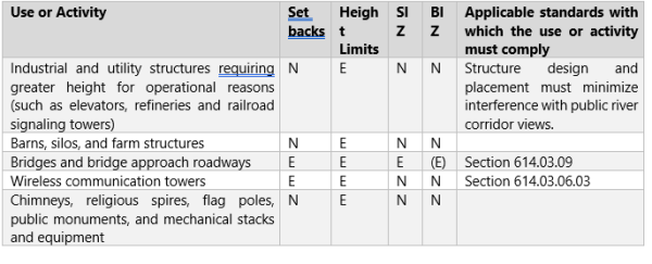
 (b) Public utilities.
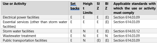
(c) Public recreationonal facilities
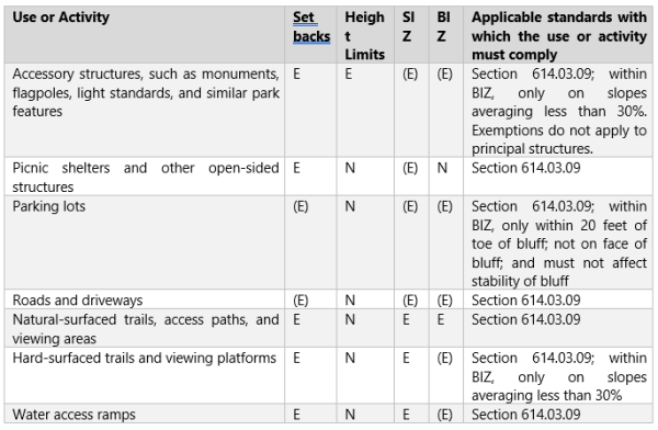

(d) River-dependent uses.
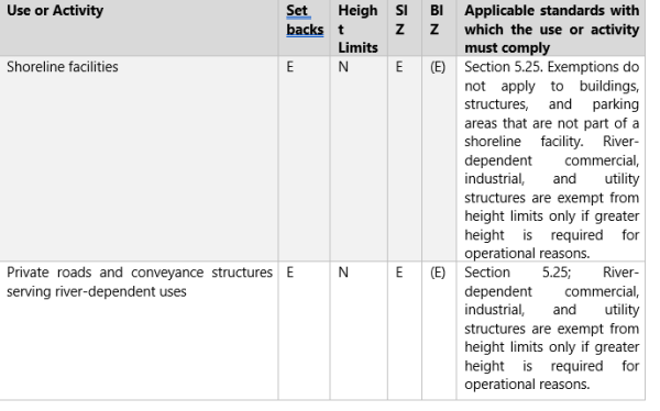
(e) Private residential and commercial water access and use facilities
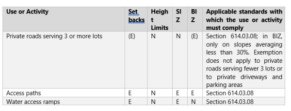
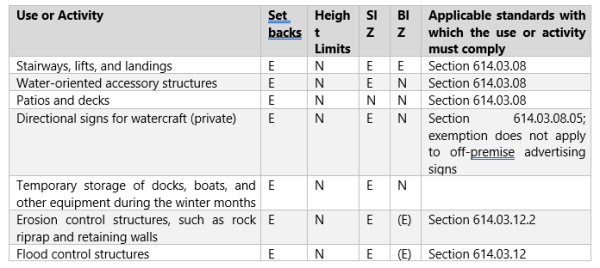
Adopted by Ord. 1431 on 6/18/2025
614.02.02 Definitions
Accessory Structure: a structure, as defined in this ordinance, that is on the same parcel of property as, and is incidental to, the principal structure or use; an accessory structure specifically excludes structures used for human habitation. Base Flood: the flood having a one-percent chance of being equaled or exceeded in any given year. “Base flood” is synonymous with the term “regional flood” used in Minnesota Rules, part 6120.5000. Base Flood Elevation (BFE): the elevation of the base flood, regional flood, or one-percent annual chance flood. The term “base flood elevation” is used in the flood insurance study.
Basement. Any area of a structure, including crawl spaces, having its floor subgrade (below ground level) on all sides, regardless of the depth of excavation below ground level. Building: see Structure. Channel: a natural or artificial depression of perceptible extent, with definite bed and banks to confine and conduct flowing water either continuously or periodically. Conditional Use: a land use or development that would not be appropriate generally, but may be allowed with appropriate restrictions upon a finding that certain conditions as detailed in the zoning ordinance exist, the use or development conforms to the comprehensive land use plan of the community, and the use is compatible with the existing neighborhood. Critical Facilities: buildings and structures that contain essential facilities and services necessary for emergency response and recovery, or that pose a substantial risk to the public in the event of failure, disruption of function, or damage by flooding. Specifically, this includes facilities identified as Flood Design Class 4 in ASCE 24-14, Flood Resistant Design and Construction, as amended. Examples include health care facilities, facilities required for emergency response, power generating stations, communications towers, or electrical substations. Development: any man-made change to improved or unimproved real estate, including, but not limited to buildings or other structures, mining, dredging, filling, grading, paving, excavation or drilling operations, or storage of equipment or materials. Equal Degree of Encroachment: a method of determining the location of floodway boundaries so that floodplain lands on both sides of a stream are capable of conveying a proportionate share of flood flows. FEMA: Federal Emergency Management Agency. Flood: a temporary rise in the stream flow or water surface elevation from any source that results in the inundation of normally dry land areas. Flood Fringe: the portion of the one-percent annual chance floodplain located outside of the floodway. Flood Insurance Rate Map (FIRM): an official map on which the Federal Insurance Administrator has delineated both the special flood hazard areas and the risk premium zones applicable to the community. A FIRM that has been made available digitally is called a Digital Flood Insurance Rate Map (DFIRM). Flood Insurance Study (FIS): the study referenced in Section 3.2, which is an examination, evaluation and determination of flood hazards, and if appropriate, corresponding surface elevations, or an examination, evaluation, and determination of mudslide (i.e. mudflow) and/or flood-related erosion hazards. Floodplain: the beds, channel and the areas adjoining a wetland, lake or watercourse, or other source which have been or hereafter may be inundated by the base flood. Floodproofing: a combination of structural and non-structural additions, changes, or adjustments to properties and structures subject to flooding, primarily for the reduction or elimination of flood damages. Floodway: the bed of a wetland or lake and the channel of a watercourse and those portions of the adjoining floodplain which must be reserved to carry or store the base flood discharge without cumulatively increasing the water surface elevation more than one-half foot. General Floodplain: those floodplains designated on the Flood Insurance Rate Maps referenced in Section 3.2, but that do not have a delineated floodway. Light Duty Truck: any motor vehicle that has all three of the following:
(a) 8,500 pounds Gross Vehicle Weight Rating or less; (b) vehicle curb weight of 6,000 pounds or less; and (c) basic vehicle frontal area less than 45 square feet.
Lowest Floor: the lowest floor of the lowest enclosed area (including basement). An unfinished or flood resistant enclosure, used solely for parking of vehicles, building access, or storage in an area other than a basement area, is not considered a building’s lowest floor; provided, that such enclosure is not built so as to render the structure in violation of the applicable non-elevation design requirements of 44 CFR § 60.3. Manufactured Home: a structure, transportable in one or more sections, which is built on a permanent chassis and is designed for use with or without a permanent foundation when attached to the required utilities. The term “manufactured home” does not include the term “recreational vehicle.” New Construction: structures for which the start of construction commenced on or after the effective date of an adopted floodplain management regulation and includes any subsequent improvements to such structures. Principal Structure: the main building or other structure on a lot that is utilized for the property’s principal use. Reach: a hydraulic engineering term to describe a longitudinal segment of a stream or river influenced by a natural or man-made obstruction. In an urban area, the segment of a stream or river between two consecutive bridge crossings would most typically constitute a reach. Recreational Vehicle: a vehicle that is built on a single chassis, is 400 square feet or less when measured at the largest horizontal projection, is designed to be self-propelled or permanently towable by a light duty truck, and is designed primarily not for use as a permanent dwelling but as temporary living quarters for recreational, camping, travel, or seasonal use. Those vehicles not meeting this definition shall be considered a structure for the purposes of this ordinance. For the purposes of this ordinance, the term recreational vehicle is synonymous with the term “travel trailer/travel vehicle.” Regulatory Flood Protection Elevation (RFPE): an elevation that is two feet above the elevation of the base flood. Special flood hazard area (SFHA): an area having special flood, mudslide (i.e., mudflow), or flood-related erosion hazards, and shown on an FHBM or FIRM as Zone A, AO, A1-30, AE, AR, AR/A1-30, AR/AE, AR/AO, AR/AH, AR/A, A99, AH, VO, V1-30, VE, V, M, or E. Stage Increase: any increase in the water surface elevation during the one-percent annual chance flood caused by encroachments on the floodplain. Start of Construction: includes substantial improvement, and means the date the permit was issued, provided the actual start of construction, repair, reconstruction, rehabilitation, addition placement, or other improvement was within 180 days of the permit date. The actual start means either the first placement of permanent construction of a structure on a site, such as the pouring of slab or footings, the installation of piles, the construction of columns, or any work beyond the stage of excavation; or the placement of a manufactured home on a foundation. Permanent construction does not include land preparation, such as clearing, grading and filling; nor does it include the installation of streets and/or walkways; nor does it include excavation for a basement, footings, piers, foundations, or the erection of temporary forms; nor does it include the installation on the property of accessory buildings, such as garages or sheds not occupied as dwelling units or not part of the main structure. For a substantial improvement, the actual start of construction means the first alteration of any wall, ceiling, floor, or other structural part of a building, whether or not that alteration affects the external dimensions of the building. Structure: a roofed building, including a gas or liquid storage tank, that is principally above ground, as well as a manufactured home. Recreational vehicles not considered travel ready, as detailed in Section 10, shall also be considered a structure for the purposes of this ordinance. Subdivision: land that has been divided for the purpose of sale, rent, or lease, including planned unit developments. Substantial Damage: damage of any origin sustained by a structure where the cost of restoring the structure to its before damaged condition would equal or exceed 50% of the market value of the structure before the damage occurred. Substantial Improvement: within any 365-day period, any reconstruction, rehabilitation, addition, or other improvement of a structure, the cost of which equals or exceeds 50% of the market value of the structure before the “start of construction” of the improvement. This term includes structures that have incurred “substantial damage,” regardless of the actual repair work performed. The term does not, however, include either:
(a) Any project for improvement of a structure to correct existing violations of state or local health, sanitary, or safety code specifications which have been identified by the local code enforcement official and which are the minimum necessary to assure safe living conditions; or (b) Any alteration of a “historic structure,” provided that the alteration will not preclude the structure’s continued designation as a “historic structure.” For the purpose of this ordinance, “historic structure” is defined in 44 CFR § 59.1.
Variance: the same as that defined in 44 CFR § 59.1 and M.S. § 462.357, Subd. 6(2). Violation: the failure of a structure or other development to be fully compliant with the community's flood plain management regulations. A structure or other development without the elevation certificate, other certifications, or other evidence of compliance required in this ordinance is presumed to be in violation of until such time as that documentation is provided. Watercourse: a channel in which a flow of water occurs either continuously or intermittently in a definitive direction. The term applies to either natural or artificially constructed channels.
Adopted by Ord. 1431 on 6/18/2025
614.02.03 Jurisdiction And Districts
1. Lands to Which Ordinance Applies. This ordinance applies to all lands within the jurisdiction of the City of Fridley within the boundaries of the Floodway, Flood Fringe and General Floodplain Districts.
(a) The Floodway, Flood Fringe or General Floodplain Districts are overlay districts. The standards imposed in the overlay districts are in addition to any other requirements. In case of a conflict, the more restrictive standards will apply.
(b) Where a conflict exists between the floodplain limits illustrated on the official floodplain maps and actual field conditions (as illustrated in Figure 1), the Base Flood Elevation (BFE) shall be the governing factor in locating the outer boundaries of the one-percent annual chance floodplain. Figure 1: The mapped floodplain may not always align with on-the-ground contour elevations.
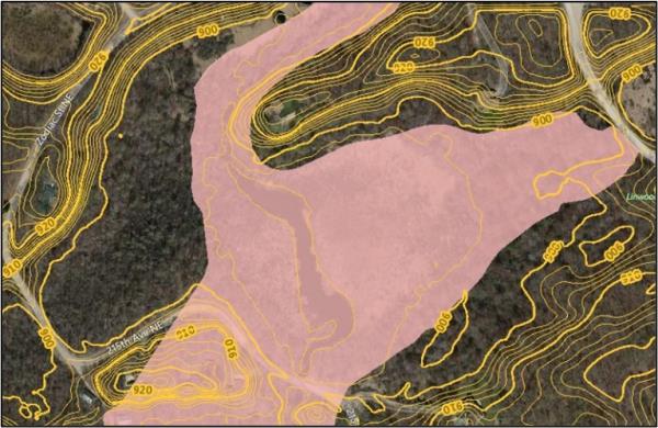
(c) Persons contesting the location of the district boundaries will be given a reasonable opportunity to present their case to the Planning Commission and to submit technical evidence.
2. Incorporation of Maps by Reference. The following maps together with all attached material are hereby adopted by reference and declared to be a part of the official zoning map and this ordinance. The attached material includes the Flood Insurance Study for Anoka County, Minnesota, and Incorporated Areas, dated December 16, 2015, and the Flood Insurance Rate Map panels enumerated below, dated December 16, 2015, all prepared by the Federal Emergency Management Agency. These materials are on file in the Planning Division of the City Office.
27003C0381E 27003C0392E 27003C0382E 27003C0401E 27003C0383E 27003C0403E 27003C0384E 27003C0411E 27003C0391E
Approved Letters of Map Change (LOMC) existing at the adoption of this ordinance are also herein incorporated by reference. 3. Districts
(a) Floodway District. Those areas within Zone AE delineated within floodway areas as shown on the Flood Insurance Rate Maps referenced in Section 3.2. (b) Flood Fringe District. Those areas within Zone AE located outside of the delineated floodway, as shown on the Flood Insurance Rate Maps referenced in Section 3.2. (c) General Floodplain District. Those areas within Zone A and AE that do not have a floodway delineated as shown on the Flood Insurance Rate Maps referenced in Section 3.2.
4. Annexations. The Flood Insurance Rate Map panels referenced in Section 3.2 may include floodplain areas that lie outside of the corporate boundaries of the City of Fridley at the time of adoption of this ordinance. If any of these floodplain land areas are annexed into the City of Fridley after the date of adoption of this ordinance, the newly annexed floodplain lands will be subject to the provisions of this ordinance immediately upon the date of annexation. Annexations into panels not referenced in Section 3.2 require ordinance amendment in accordance with Section 14.0. 5. Municipal Boundary Adjustments & Townships. The Flood Insurance Rate Map panels referenced in Section 3.2 apply countywide. If at any point any lands come under the jurisdiction of another local government, the following shall apply:
(a) City adjustments of corporate boundaries, including but not limited to annexations and detachments, shall shift floodplain administrative authority of all affected lands immediately upon the date of the boundary adjustment occurring. Cities retain jurisdiction for all incorporated lands, and the County retains jurisdiction under this ordinance on all unincorporated lands
Adopted by Ord. 1431 on 6/18/2025
614.02.04 Requirements For All Floodplain Districts
1. Permit Required. A permit must be obtained from the Community Development Director or their designee to verify compliance with all applicable standards outlined in this ordinance prior to the following uses or activities:
(a) The erection, addition, modification, rehabilitation, repair, or alteration of any building, structure, or portion thereof. Normal maintenance requires a permit to determine if such work, either separately or in conjunction with other planned work, constitutes a substantial improvement, as specified in Section 12.2. (b) The construction of a fence, pool, deck, or placement of anything that may cause a potential obstruction. (c) The change or expansion of a nonconforming use. (d) The repair of a structure that has been damaged by flood, fire, tornado, or any other source.
(e) The placement of fill, excavation, utilities, or other service facilities.
(f) The storage of materials or equipment, in conformance with Section 4.2.B. (g) Relocation or alteration of a watercourse (including stabilization projects or the construction of new or replacement dams, culverts and bridges). A local permit is not required if a public waters work permit has been obtained from the Department of Natural Resources, unless a significant area above the ordinary high water level is also to be disturbed. (h) Any other type of “development,” as defined in Section 2.0 of this ordinance.
2. Minimum Development Standards
(a) All development must:
(1) Be designed (or modified) and adequately anchored to prevent flotation, collapse, or lateral movement resulting from hydrodynamic and hydrostatic loads, including the effects of buoyancy; (2) Be constructed with materials and equipment resistant to flood damage; (3) Be constructed by methods and practices that minimize flood damage; (4) Be constructed with heating, ventilation, duct work, and air conditioning equipment and other service facilities elevated at least up to the Regulatory Flood Protection Elevation (RFPE). Water, sewage, electrical, and other utility lines below the RFPE shall be constructed so as to prevent water from entering or accumulating within them during conditions of flooding; (5) Be reasonably safe from flooding and consistent with the need to minimize flood damage; (6) Be assured to provide adequate drainage to reduce exposure to flood hazards; (7) Not be detrimental to uses in adjoining areas; and (8) Not adversely affect the efficiency or restrict the flood carrying capacity of the channel and adjoining floodplain of any tributary watercourse or drainage system. (9) Ensure that any fill or other materials are protected from erosion, discharge, and sediment entering surface waters by the use of vegetative cover or other methods as soon as possible.
(b) Materials that, in time of flooding, are buoyant, flammable, explosive, or could be injurious to human, animal, or plant life shall be stored at or above the Regulatory Flood Protection Elevation (RFPE), floodproofed, or protected by other measures as approved by the Community Development Director or their designee. Storage of materials likely to cause pollution of the waters, such as sewage; sand; rock; wrecked and discarded equipment; dredged spoil; municipal, agricultural or industrial waste; and other wastes as further defined in M.S. § 115.01, are prohibited unless adequate safeguards approved by the Minnesota Pollution Control Agency are provided. For projects not requiring approvals by the Minnesota Pollution Control Agency, adequate safeguards must be approved by the Community Development Director or their designee prior to issuance of a permit. (c) Critical facilities shall be located so that the lowest floor is not less than two feet above the Base Flood Elevation (BFE), or the 0.2% annual chance flood elevation, whichever is higher.
Adopted by Ord. 1431 on 6/18/2025
614.02.05 Floodway District
1. Permitted Uses in Floodway. Development allowed in the floodway district is limited to that which has low flood damage potential and will not obstruct flood flows, increase velocities, or increase the water surface elevations of the one-percent annual chance flood. The following uses and activities may be allowed with a permit, subject to the standards in Section 5.2:
(a) Agricultural uses, recreational uses, parking lots, loading areas, airport landing strips, water control structures, navigational facilities, as well as public open space uses. (b) Roads, driveways, railroads, trails, bridges, and culverts. (c) Public utility facilities and water-oriented industries which must be in or adjacent to watercourses. (d) Grading, filling, land alterations, and shoreline stabilization projects. (e) No structures, as defined in Section 2.0, are allowed in the Floodway District, except structures accessory to the uses detailed in Sections 5.1.A and 5.3. (f) Residential lawns, landscaping, parking, and play areas.
2. Standards for Permitted Uses in Floodway. In addition to the applicable standards detailed in Section 4.0:
(a) The applicant must demonstrate that the development will not result in any of the following during the one-percent annual chance flood: cause a stage increase of 0.00 feet or greater, obstruct flood flows, or increase velocities. This shall be demonstrated through hydrologic and hydraulic analysis performed by a professional engineer, or using other standard engineering practices (e.g. projects that restore the site to the previous cross-sectional area). This is commonly documented through a “no-rise certification.” (b) Any development that would result in a stage increases greater than 0.00 feet may only be allowed with a permit if the applicant has applied for and received approval for a Conditional Letter of Map Revision (CLOMR) in accordance with 44 CFR § 65.12. Map revisions must follow the procedures in Sections 11 and 14.0. (c) Any development resulting in decreases to the water surface elevation of the base flood identified in the Flood Insurance Study requires a Letter of Map Revision (LOMR) following the procedures in Sections 11 and 14.0. (d) Any development in the beds of public waters that will change the course, current or cross section is required to obtain a public waters work permit in accordance with M.S. § 103G.245 or a utility crossing license in accordance with M.S. § 84.415, from the Department of Natural Resources, or demonstrate that no permit is required, before applying for a local permit. (e) Any facility used by employees or the general public must be designed with a flood warning system acceptable to the Community Development Director or their designee that provides adequate time for evacuation, or be designed to ensure that within the area inundated during the base flood event, the depth (in feet) multiplied by the velocity (in feet per second) is less than four. (f) Fill and other land alteration activities must offer minimal obstruction to the flow of flood waters.
3. Conditional Uses in Floodway. The following uses and activities may be permitted as conditional uses, subject to the standards detailed in this Chapter:
(a) Commercial extractive uses, storage and stockpiling yards.
4. Standards for Conditional Uses in Floodway. In addition to the applicable standards detailed in this Chapter.
(a) Extractive uses and storage of materials require the completion of a site development and restoration plan, to be approved by the City of Fridley.
Adopted by Ord. 1431 on 6/18/2025
614.02.06 Flood Fringe District
1. Permitted Uses in Flood Fringe. Any uses or activities allowed in any applicable underlying zoning districts may be allowed with a permit, subject to the standards set forth in this Chapter. 2. Standards for Permitted Uses in Flood Fringe. In addition to the applicable standards detailed in this Chapter;
(a) Residential Structures.
(1) Elevation on Fill. Structures erected, constructed, reconstructed, altered, or moved on fill within the Flood Fringe District shall be placed so that the lowest floor, as defined in Section 2.0 of this ordinance, is elevated at or above the Regulatory Flood Protection Elevation (RFPE). The finished fill elevation shall be at or above the elevation associated with the base flood plus two feet. Fill must extend at the same elevation at least 15 feet beyond the outside limits of the structure. Elevations must be certified by a registered professional engineer, land surveyor or other qualified person designated by the Community Development Director or their designee. Elevation methods alternative to these fill standards are subject to a Conditional Use Permit, as provided below.
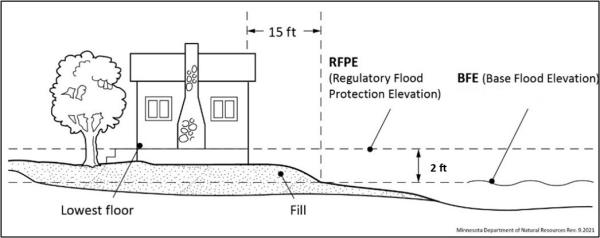
(b) Nonresidential Structures. Nonresidential structures must meet one of the following construction methods:
(1) Elevation on Fill. Structures may be elevated on fill, meeting the standards of this Chapter. Fill for nonresidential structures is not required to be extended 15 feet beyond the outside limits of the structure. (2) Alternative Elevation Methods. Structures may be elevated using methods alternative to the fill standards in this Chapter. Such methods include the use of blocks, pilings (Figure 3), filled stem walls (Figure 4), or internally-flooded enclosed areas (Figure 5) such as crawl spaces, attached garages, or tuck under garages.
Figure 3: Blocks or pilings. Figure 4: Filled stem walls. Figure 5: Internally flooded enclosed area.
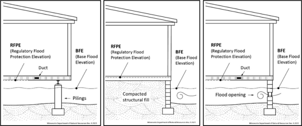
(3) Designs accommodating for internally-flooded enclosed areas must be certified by a registered professional engineer or architect, or meet or exceed the standards detailed in FEMA Technical Bulletin 1, as amended, as well as the following standards:
((a)) The lowest floor, as defined in in this Chapter, shall be elevated at or above the Regulatory Flood Protection Elevation (RFPE). ((b)) The floor of the enclosed area must be at or above the exterior grade on at least one side of the structure. ((c)) To allow for the equalization of hydrostatic pressure, there shall be a minimum of two openings below the base flood elevation on at least two sides of the structure. The bottom of all openings shall be no higher than one foot above grade. The openings shall have a minimum net area of not less than one square inch for every square foot of enclosed area subject to flooding, have a net area of not less than one square inch for every square foot of enclosed area subject to flooding, and shall allow automatic entry and exit of floodwaters without human intervention. ((d)) Internally flooded enclosed areas shall only be used for the parking of vehicles, building access, or storage. Bathrooms and toilet rooms shall not be allowed. Such areas shall be subject to a deed-restricted non-conversion agreement as well as periodic inspections with the issuance of any permit.
(4) Dry Floodproofing. Structures having watertight enclosed basements or spaces below the Regulatory Flood Protection Elevation (RFPE) must meet the following standards:
((a)) Walls must be substantially impermeable to the passage of water, with structural components having the capacity of resisting hydrostatic and hydrodynamic loads and effects of buoyancy, at least up to the Regulatory Flood Protection Elevation (RFPE); ((b)) Must meet the standards of FEMA Technical Bulletin 3, as amended; and ((c)) A registered professional engineer or architect shall be required to certify that the design and methods of construction meet the standards detailed in this Section.
(5)Accessory Structures. All accessory structures must meet the following standards:
((a)) Structures shall not be designed or used for human habitation. ((b)) Structures will have a low flood damage potential. ((c)) Structures shall constitute a minimal investment not to exceed 576 square feet in size, one-story in height, and shall only be used for parking and storage, except as provided under Section 6.2C.5. Structures not meeting the standards of Sections 6.2C.1-3 must be designed and constructed in accordance with floodplain management requirements based on whether the structure is residential or nonresidential. Residential structures must meet the requirements of Section 6.2.A, and nonresidential structures must meet the requirements of Section 6.2.B.
(6) Structures with two or more rigid walls, must meet one of the following construction methods:
((a)) Wet Floodproofing. Structures may be floodproofed in a way to accommodate internal flooding. To allow for the equalization of hydrostatic pressure, there shall be a minimum of two openings on at least two sides of the structure and the bottom of all openings shall be no higher than one foot above grade. The openings shall have a minimum net area of not less than one square inch for every square foot of enclosed area subject to flooding, and shall allow automatic entry and exit of floodwaters without human intervention. Utilities must be elevated above the RFPE and any utility lines below the RFPE shall be constructed so as to prevent floodwaters from entering or accumulating within them. Portions of structures below the RFPE must be constructed of flood damage-resistant materials. Wet floodproofed structures must be anchored to resist flotation, collapse, and lateral movement. ((b)) Elevation on Fill. Structures may be elevated on fill, meeting the standards in Section 6.2.A.1 of this ordinance. Fill is not required to be extended 15 feet beyond the outside limits of the structure. ((c)) Alternative Elevation Methods. Structures may have their lowest floor elevated above the Regulatory Flood Protection Elevation (RFPE) through methods alternative to the fill standards in Section 6.2.C.4.B, and must meet the standards in Section 6.2.B.2 of this ordinance. ((d)) Dry Floodproofing. Structures may be dry-floodproofed, or watertight, meeting the standards in Section 6.2.B.3 of this ordinance.
(7) Structures with fewer than two rigid walls, such as carports, gazebos, and picnic pavilions, meeting the standards in Section 4.2 of this ordinance may be located at an elevation below the Regulatory Flood Protection Elevation, exceed 576 square feet in size, and include uses as provided under Section 6.1.
(c) All new principal structures must provide vehicular access no lower than two feet below the Base Flood Elevation (BFE), unless a flood warning/emergency evacuation plan has been approved by the City of Fridley. (d) Accessory uses such as yards and parking lots may be at an elevation lower than the Regulatory Flood Protection Elevation. However, any facilities used by employees or the general public must be designed with a flood warning system acceptable to the Community Development Director or their designee that provides adequate time for evacuation or be designed to ensure that within the area inundated during the base flood event, the depth (in feet) multiplied by the velocity (in feet per second) is less than four. (e) Manufactured homes and recreational vehicles must meet the standards of Section 10 of this ordinance.
3. Conditional Uses in Flood Fringe. The following uses and activities may be permitted as conditional uses, subject to the standards in Sections 6.4:
(a) Alternative Elevation Methods – Residential Structures. Residential structures with their lowest floor elevated above the Regulatory Flood Protection Elevation (RFPE) using methods alternative to the fill requirements in Section 6.2.A. (b) The cumulative placement of more than 1,000 cubic yards of fill when the fill is not being used to elevate a structure in accordance with Section 6.2.A-C of this ordinance.
4. Standards for Conditional Uses in Flood Fringe. In addition to the applicable standards detailed in Sections 4.0, 6.2 and 11.2:
(a) All residential structures with lowest floors elevated through alternative elevation methods must meet the standards in Section 6.2.B.2 of this ordinance. (b) The placement of more than 1,000 cubic yards of fill or other similar material on a parcel (other than for the purpose of elevating a structure to the regulatory flood protection elevation) must comply with an approved erosion/sedimentation control plan and:
(1) The plan must clearly specify methods to be used to stabilize the fill on site for a flood event at a minimum of the regional (1% chance) flood event. (2) The plan must be prepared and certified by a registered professional engineer or other qualified individual acceptable to the City. (3) The plan may incorporate alternative procedures for removal of the material from the floodplain if adequate flood warning time exists.
Adopted by Ord. 1431 on 6/18/2025
614.02.07 General Floodplain District
1. Permitted Uses in General Floodplain District
(a) Until the floodway is delineated, allowable uses will be restricted to those listed in the Floodway District, Section 5.0 (b) All other uses are subject to a floodway/flood fringe determination as provided in Section 7.4, in addition to the standards provided in Sections 7.2 and 7.3. Permitted uses shall be determined as follows: If the development is determined to be in the Floodway District, Section 5.0 applies. If the development is determined to be in the Flood Fringe District, Section 6.0 applies.
2. Determining Flood Elevations
(a) All development requires a determination of the Base Flood Elevation (BFE). Exceptions to this requirement include projects that restore the site to the previous cross-sectional area, such as shore stabilization or culvert replacement projects. Base Flood Elevations (BFE) may be found using best available data from any Federal, State, or other source (including MNDNR’s Lake & Flood Elevations Online (LFEO) Viewer).
3. Encroachment Analysis
(a) Encroachments due to development may not allow stage increases more than one-half (0.5) foot at any point, unless through a map revision following the procedures in Sections 11.1.E and 14.0. This evaluation must include the cumulative effects of previous encroachments, and must be documented with hydrologic and hydraulic analysis performed by a professional engineer, or using other standard engineering practices. A lesser water surface elevation increase than one-half (0.5) foot is required if, due to the water surface level increase, increased flood damages would potentially result. (b) Alterations or changes that result in stage decreases are allowed and encouraged.
4. Standards for the Analysis of Floodway Boundaries
(a) Requirements for Detailed Studies. Any development, as requested by the, Community Development Director or their designee shall be subject to a detailed study to determine the limits of the Floodway District. This determination must be consistent with the minimum standards for hydrologic and hydraulic mapping standards and techniques, as detailed in Minnesota Rules, part 6120.5600, Subp. 4 and FEMA Guidelines and Standards for Flood Risk Analysis and Mapping, as revised. Additionally:
(1) A regulatory floodway necessary to carry the discharge of the one-percent annual chance flood must be selected without increasing the water surface elevation more than one-half (0.5) foot at any point. This determination should include the cumulative effects of previous encroachments. A lesser water surface elevation increase than one-half (0.5) foot is required if, due to the water surface level increase, increased flood damages would potentially result; and (2) An equal degree of encroachment on both sides of the stream within the reach must be assumed in computing floodway boundaries, unless topography, existing development patterns, and comprehensive land use plans justify a modified approach, as approved by the Department of Natural Resources.
(b) Other Acceptable Methods. For areas where a detailed study is not available or required:
(1) Development prohibited in floodways (e.g. most buildings) requires a floodway/flood fringe determination to verify the development is within the flood fringe. This determination must be done by a professional engineer or utilize other accepted engineering practices. The Department of Natural Resources may also provide technical assistance and must approve any alternative methods used to determine floodway boundaries. (2) For areas where the floodway has not been determined in and along lakes, wetlands, and other basins, the following methodology may be used as an alternative to 7.4.B.1 above, provided these areas are not affected by velocities and the lot is able to accommodate a building site above the Regulatory Flood Protection Elevation (RFPE):
((a)) All areas that are at or below the ordinary high water level, as defined in M.S. § 103G.005, Subd. 14, will be considered floodway, and all areas below the Base Flood Elevation (BFE) but above the ordinary high water level will be considered flood fringe, provided that within 25 feet of the ordinary high water level, or within the Shore Impact Zone as identified in the community’s Shoreland ordinance, whichever distance is greater, land alterations shall be restricted to:
((1))The minimum required to accommodate beach areas, access areas, and accessory structures as permitted, not to exceed a volume greater than 10 cubic yards; projects involving volumes exceeding 10 cubic yards require floodway/flood fringe determination in accordance with the procedures in Section 7.4.B.1; and ((2))The minimum required to accommodate shoreline stabilization projects to correct an identified erosion problem as verified by a qualified resource agency or the Community Development Director or their designee.
Adopted by Ord. 1431 on 6/18/2025
614.02.08 Subdivision Standards
1. Subdivisions. All subdivided land must meet the following requirements. Manufactured home parks and recreational vehicle parks or campgrounds are considered subdivisions under this ordinance.
(a) All lots within floodplain districts must be suitable for a building site outside of the Floodway District. (b) Subdivision of lands within the floodplain districts may not be approved if the cost of providing governmental services would impose an unreasonable economic burden on the City of Fridley. (c) All subdivisions must have vehicular access both to the subdivision and to the individual building sites no lower than two feet below the Regulatory Flood Protection Elevation (RFPE), unless a flood warning/emergency evacuation plan has been approved by the City of Fridley. (d) The Floodway and Flood Fringe District boundaries, the Regulatory Flood Protection Elevation (RFPE) and the required elevation of all access roads must be clearly identified on all required subdivision drawings and platting documents.
Adopted by Ord. 1431 on 6/18/2025
614.02.09 Public And Private Utilities, Service Facilities Roads, Bridges, And Railroads
1. Public Transportation Facilities. Railroad tracks, roads, and bridges must be elevated to the Regulatory Flood Protection Elevation (RFPE) where such facilities are essential to the orderly functioning of the area, or where failure or interruption would result in danger to public health or safety. Minor or auxiliary roads or railroads may be constructed at a lower elevation where failure or interruption of transportation services would not endanger the public health or safety. All public transportation facilities should be designed to minimize increases in flood elevations. 2. Public Utilities. All utilities such as gas, electrical, sewer, and water supply systems to be located in the floodplain must be elevated and/or floodproofed to the Regulatory Flood Protection Elevation (RFPE), be located and constructed to minimize or eliminate flood damage, and be designed to eliminate infiltration of flood waters into the systems and discharges from the systems into flood waters. All public utilities should be designed to minimize increases in flood elevations. New solid waste management facilities, as defined in Minnesota Rules, part 7035.0300, are prohibited in the one-percent annual chance floodplain. Water supply systems are subject to the provisions in Minnesota Rules, part 4725.4350. 3. Private On-Site Water Supply, Individual Sewage Treatment Systems, and other Service Facilities. Private facilities shall be subject to applicable provisions detailed in Section 9.2. In addition, new or replacement on-site sewage treatment systems are to be located to avoid impairment to them or contamination from them during times of flooding, shall not be located in a designated floodway, and are subject to the provisions in Minnesota Rules, parts 7080.2270.
Adopted by Ord. 1431 on 6/18/2025
614.02.10 Manufactured Homes And Recreational Vehicles
1. Manufactured Homes. Manufactured homes and manufactured home parks are subject to applicable standards for each floodplain district. In addition:
(a) New and replacement manufactured homes must be placed and elevated in compliance with Section 6.0 of this ordinance and must be securely anchored to a system that resists flotation, collapse and lateral movement. Methods of anchoring may include, but are not limited to, use of over-the-top or frame ties to ground anchors. (b) New manufactured home parks and expansions to existing manufactured home parks must meet the appropriate standards for subdivisions in Section 8.0 of this ordinance.
2. Recreational Vehicles. New recreational vehicle parks or campgrounds and expansions to existing recreational vehicle parks or campgrounds are prohibited in any floodplain district. Recreational vehicles placed in existing recreational vehicle parks, campgrounds or lots of record in the floodplain must either:
(a) Meet the requirements for manufactured homes in Section 10.1, or (b) Be travel ready, meeting the following criteria:
(1) The vehicle must be fully licensed. (2) The vehicle must be ready for highway use, meaning on wheels or the internal jacking system, attached to the site only by quick disconnect type utilities. (3) No permanent structural type additions may be attached to the vehicle. (4) Accessory structures may be permitted in the Flood Fringe District, provided they do not hinder the removal of the vehicle should flooding occur, and meet the standards outlined in Section 4.0 and Section 6.2.C.
Adopted by Ord. 1431 on 6/18/2025
614.02.12 Nonconformities
1. Continuance of Nonconformities. A use, structure, or occupancy of land which was lawful before the passage or amendment of this ordinance, but which is not in conformity with the provisions of this ordinance, may be continued subject to the following conditions:
(a) Within the floodway and general floodplain districts (when a site has been determined to be located in the floodway following the procedures in Section 7.3, or when the floodway has not been delineated), any expansion or enlargement of uses or structures is prohibited. (b) Within all districts, any addition, modification, rehabilitation, repair, or alteration shall be in conformance with the provisions of this ordinance, shall not increase the flood damage potential or increase the degree of obstruction to flood flows, and where applicable, must be protected to the Regulatory Flood Protection Elevation (RFPE). (c) If any nonconforming structure is determined to be substantially damaged or substantially improved based on the procedures in Section 12.2, it may not be reconstructed except in conformity with the provisions of this ordinance. Any structures located outside the one-percent annual chance floodplain are exempt from this provision. (d) If any nonconforming use, or any use of a nonconforming structure, is discontinued for more than one year, any future use of the premises must conform to this ordinance.
2. Substantial Improvement and Substantial Damage Determinations. Prior to issuing any permits for additions, modifications, rehabilitations, repairs, alterations, or maintenance to nonconforming structures, the Community Development Director or their designee is required to determine if such work constitutes substantial improvement or repair of a substantially damaged structure. A determination must be made in accordance with the following procedures:
(a) Estimate the market value of the structure. In the case of repairs, the market value of the structure shall be the market value before the damage occurred and before any restoration or repairs are made. (b) Estimate the cost of the project. The property owner shall accommodate for inspection, and furnish other documentation needed by the Community Development Director or their designee to evaluate costs.
(1) Improvement costs shall be comprised of the market rate of all materials and labor, as well as the costs of all ordinary maintenance and upkeep carried out over the past one year. (2) Costs to repair damages shall be comprised of the market rate of all materials and labor required to restore a building to its pre-damaged condition regardless of the work proposed, as well as associated improvement costs if structure is being restored beyond its pre-damaged condition.
(c) Compare the cost of the improvement, repairs, or combination thereof to the estimated market value of the structure, and determine whether the proposed work constitutes substantial improvement or repair of a substantially damaged structure, as defined in Section 2.0 of this ordinance. (d) Based on this determination, the Community Development Director or their designee shall prepare a determination letter and notify the property owner accordingly. Structures determined to be substantially damaged or substantially improved may not be reconstructed except in conformity with the provisions of this ordinance.
Adopted by Ord. 1431 on 6/18/2025
614.02.13 Violations And Penalties
14.02.13 Violations and Penalties 1. Uses in Violation of the Ordinance. Every structure, fill, deposit, or other use placed or maintained in the floodplain in violation of this ordinance shall be considered a public nuisance. 2. Civil Remedies. The creation of a public nuisance may be enjoined and the maintenance of a public nuisance under this ordinance may be abated by an action brought by the City of Fridley or the Department of Natural Resources. 3. Enforcement. Violations of the provisions of this ordinance constitutes a misdemeanor and is punishable as defined by law. The Community Development Director or their designee may utilize the full array of enforcement actions available to it including but not limited to prosecution and fines, injunctions, after-the-fact permits, orders for corrective measures or a request to the National Flood Insurance Program for denial of flood insurance. The City of Fridley must act in good faith to enforce these official controls and to correct ordinance violations to the extent possible so as not to jeopardize its eligibility in the National Flood Insurance Program.
Adopted by Ord. 1431 on 6/18/2025
614.02.14 Amendments
1. Ordinance Amendments. Any revisions to the floodplain maps by the Federal Emergency Management Agency or annexations of new map panels require an ordinance amendment to update the map references in Section 3.2 of this ordinance. 2. Required Approval. All amendments to this ordinance must be submitted to the Department of Natural Resources for review and approval prior to adoption, for compliance with state and federal rules and requirements. The floodplain ordinance shall not be considered valid until approved.
Adopted by Ord. 1431 on 6/18/2025

