
Frisco City Zoning Code
ARTICLE III
- ZONING DISTRICTS
§ 180-3.1. - Establishment of Districts; Zoning Map.
180-3.1.1.
The Town of Frisco is hereby divided into the following zoning districts and areas:
A.
RS Residential Single-Household District (one to four dwelling units per developable acre).
B.
RN Residential Traditional Neighborhood District.
C.
RL Residential Low Density District (one to eight dwelling units per developable acre).
D.
RM Residential Medium Density District (one to 12 dwelling units per developable acre).
E.
RH Residential High Density District (one to 16 dwelling units per developable acre).
F.
GW Gateway District.
G.
CO Commercial Oriented District.
H.
LI Light Industrial District.
I.
CC Central Core District.
J.
MU Mixed-Use District.
K.
OS Open Space District.
L.
PR Parks and Recreation District.
M.
PF Public Facilities District.
N.
HO Historic Overlay District.
O.
PUD Planned Unit Development Overlay District.
180-3.1.2.
These established zoning districts are shown, located, defined, and bounded on the map entitled the "Zoning District Map of the Town of Frisco." This map, together with explanatory matter thereon and all amendments made under this Chapter, is hereby incorporated in and made part of this Chapter. The Zoning District Map is on file in the office of the Community Development Department.
(Ord. No. 17-04, 6-27-17)
§ 180-3.2. - Zoning District Boundaries.
Unless otherwise provided, zoning district boundaries shall be on municipal corporate lines, lot lines, natural boundary lines or on the center lines of highways, streets, alleys, railroad rights-of-way or extensions of such center lines. In cases where such lines are not evident, the zoning district boundaries shall be determined by the "Zoning District Map of the Town of Frisco."
(Ord. No. 17-04, 6-27-17)
§ 180-3.3. - Residential Single-Household (RS) District.
180-3.3.1.
Purpose. To promote single-household and accessory dwellings, allowing for large areas of open space; to accommodate low density residential development; and to minimize development impacts on environmentally sensitive lands, with a minimum of allowable density.
180-3.3.2.
District standards.
A.
Dimensions. See Figure 3-A and Sections 180-3.16 and 180-3.17.
B.
Development Standards. All residential development is subject to the Residential Development Standards in Section 180-6.22.
Figure 3-A: Illustration of RS Distrcit Dimenstional Standards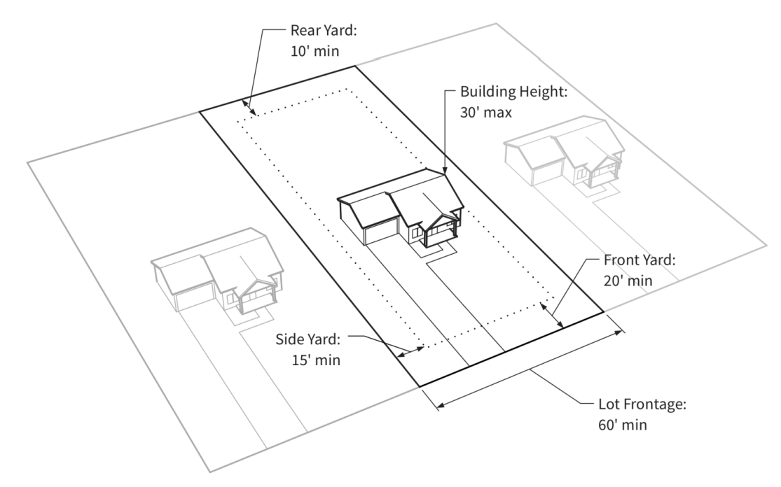
(Ord. No. 17-04, 6-27-17)
§ 180-3.4. - Residential Traditional Neighborhood (RN) District.
180-3.4.1.
Purpose. To promote community residential development that provides a traditional layout, cohesive and eclectic identity, is sustainable and livable, respects existing residential neighborhoods, and promotes the natural environment. Also to promote development that is linked with contiguous common areas and pedestrianoriented connections to existing recreational trail networks.
180-3.4.2.
District standards.
A.
Dimensions. See Figure 3-B and Sections 180-3.16 and 180-3.17.
B.
Development Standards.
1.
Parking.
a.
Per principal dwelling unit: A minimum of two spaces per unit with up to three bedrooms. One additional parking space is required per each additional bedroom over three bedrooms.
b.
Per accessory unit: One parking space per unit. This space shall not be stacked with any primary unit spaces.
2.
All residential development is subject to the Residential Development Standards in Section 180-6.22.
Figure 3-B: Illustration of RN District Dimensional Standards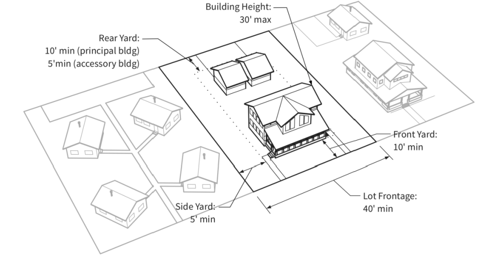
(Ord. No. 17-04, 6-27-17; Ord. No. 23-09, § 5, 3-28-23)
§ 180-3.5. - Residential Low Density (RL) District.
180-3.5.1.
Purpose. To promote detached single-household, duplex, and townhouse structures in neighborhoods and community residential areas that are well-sited, and to help preserve neighborhood character, natural amenities, and scenic views.
180-3.5.2.
District Standards.
A.
Dimensions. See:
1.
Figure 3-C and Sections 180-3.16 and 180-3.17.
2.
Criteria for development of three or more principal units on a single lot or project site:
a.
All buildings and structures greater than 20 feet in height must be separated by a minimum of 12 feet, as measured from the edge of the closest wall plane.
b.
Any third level must not exceed 60 percent of the Gross Floor Area (GFA) of the story below it.
c.
Each principal dwelling unit must be located in a detached building or duplex structure. Accessory dwelling units are permitted within the same building and in conjunction with a principal dwelling unit.
B.
Development Standards.
1.
All residential development is subject to the Residential Development Standards in Section 180-6.22.
2.
All nonresidential development is subject to the non-residential development standards in Section 180-6.21.
Figure 3-C: Illustration of RL District Dimensional Standards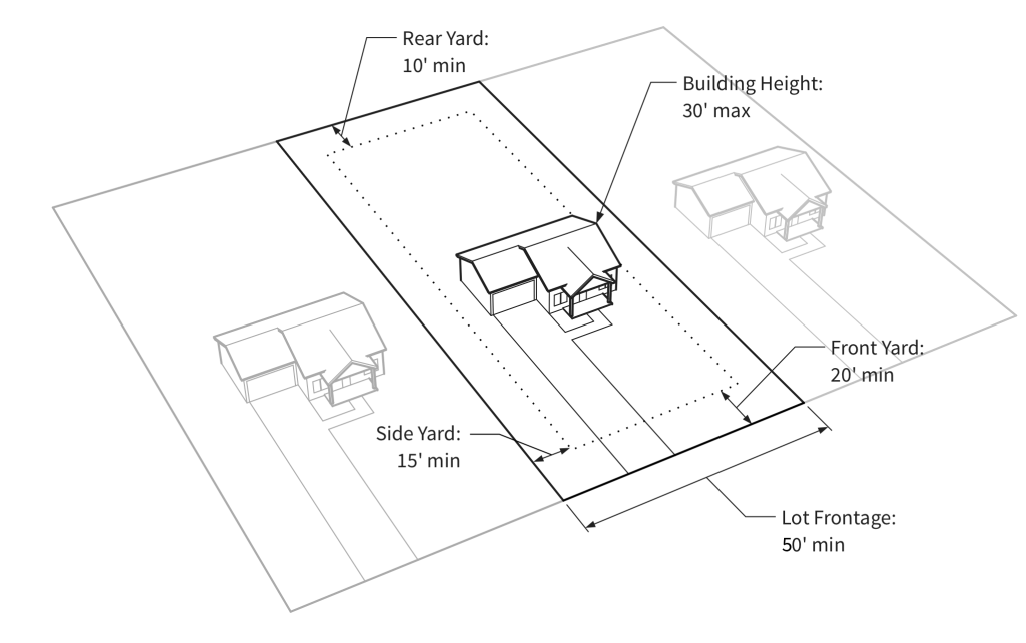
(Ord. No. 17-04, 6-27-17)
§ 180-3.6. - Residential Medium Density (RM) District.
180-3.6.1.
Purpose. To allow for the development of residential areas that are a mixture of single-household detached dwellings, duplexes, and multi-unit dwellings, to promote the clustering of medium density residential units so as to preserve open space and scenic views, and to encourage a broad mix of housing types.
180-3.6.2.
District Standards.
A.
Dimensions. See Figure 3-D and Sections 180-3.16 and 180-3.17.
B.
Development Standards.
1.
All residential development is subject to the Residential Development Standards in Section 180-6.22.
2.
All nonresidential development is subject to the Non-Residential Development Standards in Section 180-6.21.
Figure 3-D: Illustration of RM District Dimensional Standards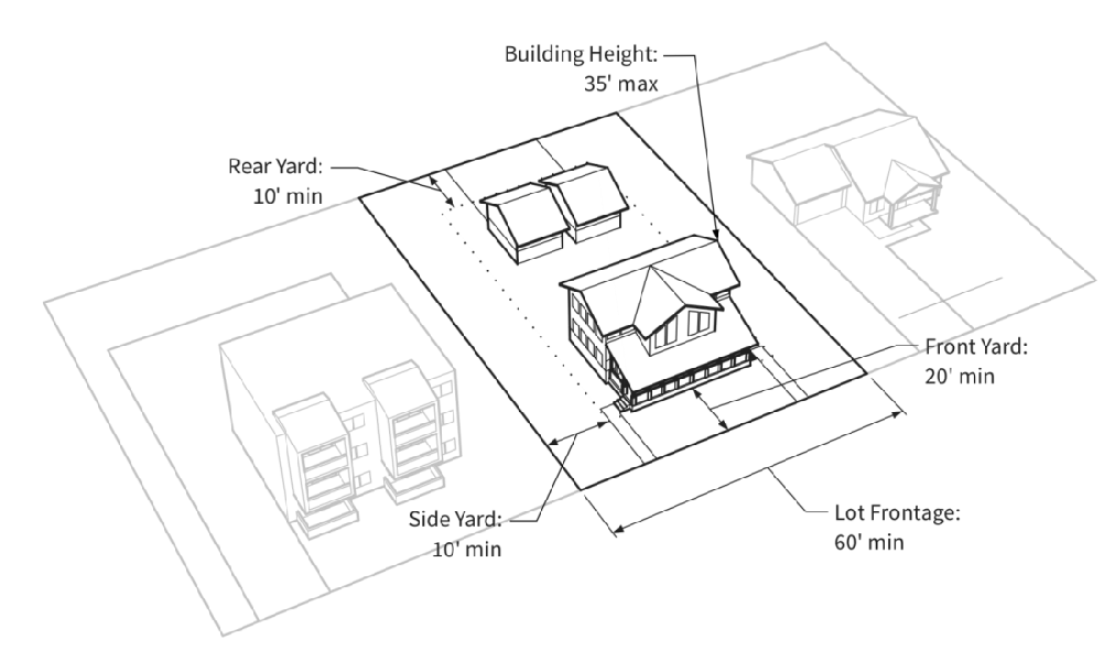
(Ord. No. 17-04, 6-27-17)
§ 180-3.7. - Residential High Density (RH) District.
180-3.7.1.
Purpose. To allow for high density residential development that is in close proximity to commercial activity, and to provide for a broad mix in the housing type and cost for all residents.
180-3.7.2.
District Standards.
A.
Dimensions. See Figure 3-E and Sections 180-3.16 and 180-3.17.
B.
Development Standards.
1.
All residential development is subject to the Residential Development Standards in Section 180-6.22.
2.
All nonresidential development is subject to the Nonresidential Development Standards in Section 180-6.21.
Figure 3-E: Illustration of RH District Dimensional Standards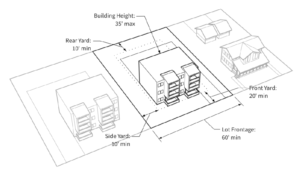
(Ord. No. 17-04, 6-27-17)
§ 180-3.8. - Gateway (GW) District.
180-3.8.1.
Purpose. To allow for the development of different types of visitor accommodations, commercial, and serviceoriented facilities in close proximity to Highway 9 and the Interstate 70 interchange area, to provide connections to mass transit and multi-modal transportation systems, and to allow for residential uses as a conditional use.
180-3.8.2.
District Standards.
A.
Dimensions. See Figure 3-F and Sections 180-3.16 and 180-3.17.
B.
Development Standards.
1.
All residential development is subject to the Residential Development Standards in Section 180-6.22.
2.
All nonresidential development is subject to the Nonresidential Development Standards in Section 180-6.21.
Figure 3-F: Illustration of GW District Dimensional Standards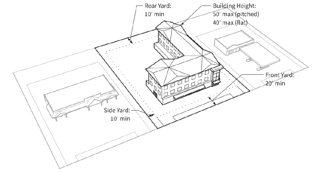
(Ord. No. 17-04, 6-27-17; Ord. No. 23-09, § 6, 3-28-23)
§ 180-3.9. - Commercial Oriented (CO) District.
180-3.9.1.
Purpose. To promote the development of regionally serving shopping areas, restaurants, and service facilities that are convenient to Highway 9 and Interstate 70, to enhance connections to mass transit and multi-modal transportation, and to allow for intensive commercial development.
180-3.9.2.
District standards.
A.
Dimensions. See Figure 3-G and Section 180-3.16.
B.
Development Standards. All nonresidential development is subject to the Nonresidential Development Standards in Section 180-6.21.
Figure 3-G: Illustration of CO District Dimensional Standards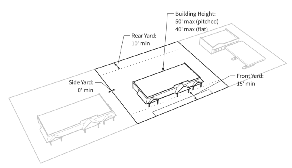
(Ord. No. 17-04, 6-27-17)
§ 180-3.10. - Light Industrial (LI) District.
180-3.10.1.
Purpose. To promote the development of professional trade, industrial, general services, storage, and contractor services in Frisco, and to allow for other associated uses complementary to contractor trades and light manufacturing.
180-3.10.2.
District standards.
A.
Dimensions. See Figure 3-H and Section 180-3.16.
B.
Development Standards. All nonresidential development is subject to the Nonresidential Development Standards in Section 180-6.21.
Figure 3-H: Illustration of LI District Dimensional Standards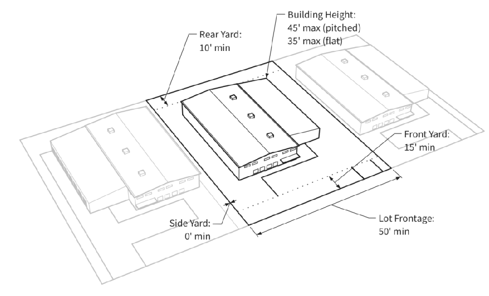
(Ord. No. 17-04, 6-27-17)
§ 180-3.11. - Central Core (CC) District.
180-3.11.1.
Purpose. To promote the development of Frisco's Main Street commercial district for retail, restaurant, service, commercial, visitor accommodation, recreational, institutional and residential uses, and to enhance the visual character, scale and vitality of the central core.
180-3.11.2.
District standards.
A.
Dimensions. See Figures 3-I through 3-L and Sections 180-3.16 and 180-3.17.
B.
Development Standards.
1.
For properties with frontage along Main Street, on-site parking shall be located at the rear of the property.
2.
All residential development is subject to the Residential Development Standards in Section 180-6.22.
3.
All nonresidential development is subject to the Nonresidential Development Standards in Section 180-6.21.
Figure 3-I: Illustration of CC District Dimenstional Standards fro Properties on Main
Street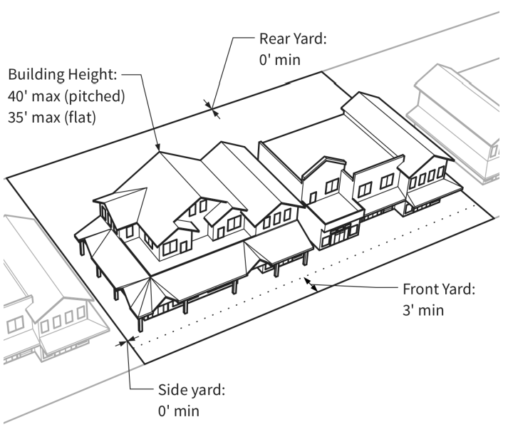
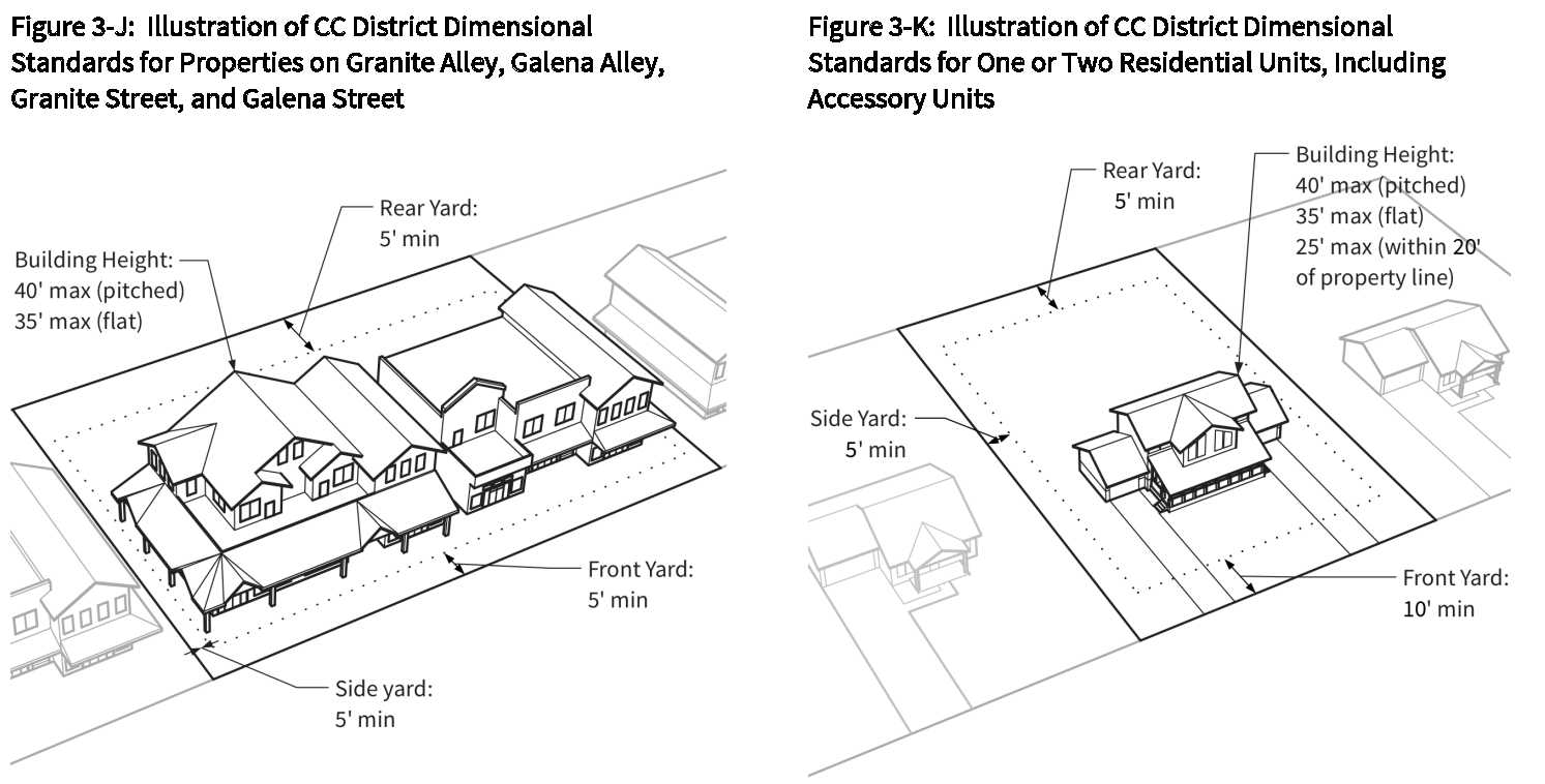
Figure 3-L: Illustration of Stepback Requirement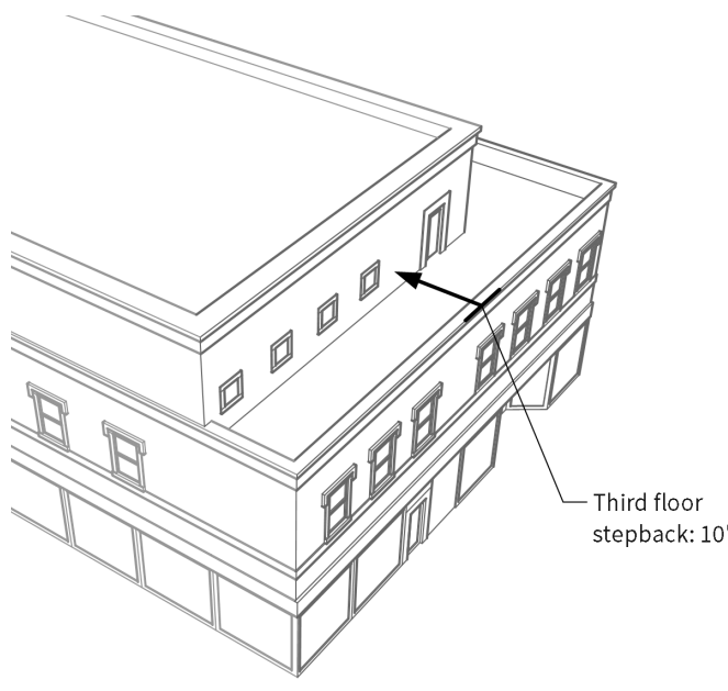
(Ord. No. 17-04, 6-27-17; Ord. No. 19-04, 4-9-19)
§ 180-3.12. - Mixed-Use (MU) District.
180-3.12.1.
Purpose. To increase the efficiency of land use, the number of residents and the diversity of commercial activities in those transition areas between the core commercial districts and residential districts, and to emphasize and encourage pedestrian and bicycle circulation.
180-3.12.2.
District standards.
A.
Dimensions. See Figure 3-M and Sections 180-3.16 and 180-3.17.
B.
Development Standards.
1.
For properties with frontage on Main Street, on-site parking shall not be located along the part of the property abutting Main Street.
2.
All residential development is subject to the Residential Development Standards in Section 180-6.22.
3.
All nonresidential development is subject to the Nonresidential Development Standards in Section 180-6.21.
Figure 3-M: Illustration of MU District Dimensional Standards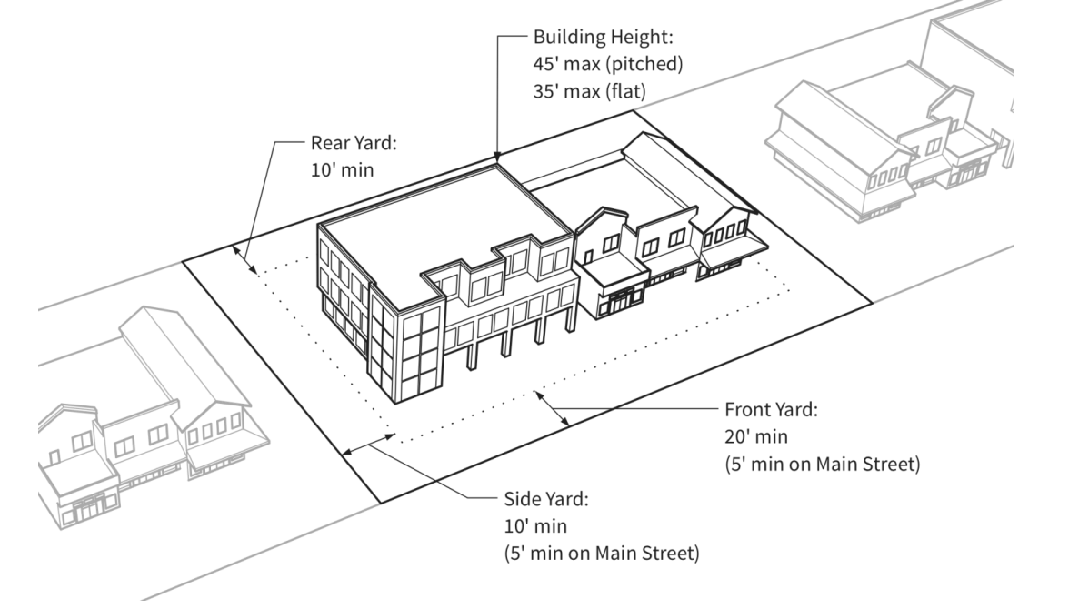
(Ord. No. 17-04, 6-27-17)
§ 180-3.13. - Open Space (OS) District.
180-3.13.1.
Purpose.
A.
To allow for and to encourage the preservation of land in its natural character for public or private use or enjoyment. This District is intended to preserve significant natural flora and fauna, buffer areas between developments, view corridors, and environmentally sensitive lands.
B.
The District shall be reserved for land dedicated to or owned by the Town, a land conservation trust, or private ownership with appropriate easements or restriction upon consent of its owner.
180-3.13.2.
Compatible Uses Not Requiring Site Disturbance. Uses that do not require site disturbance and that are compatible with the natural state of the land, including, but not limited to:
A.
Archaeological sites.
B.
Buffers between neighborhoods and communities.
C.
Historical and cultural lands.
D.
Lands of aesthetic or passive recreational value.
E.
Passive recreational access points.
F.
Scenic areas or vistas.
G.
Non-motorized trails and trail connections.
H.
Environmentally sensitive lands.
I.
Natural flora and fauna.
180-3.13.3.
Compatible Uses Requiring Minimal Site Disturbance. Uses that may require some site disturbance and that will be compatible, or will result in compatibility with the natural state of the land, including, but not limited to:
A.
Any use necessary to establish or create a permitted use.
B.
Any use necessary to clean up and/or rehabilitate land to its natural state.
C.
Uses necessary for conservation of natural resources and the environment, such as for soil, water, vegetation and wildlife, including, but not limited to:
1.
Flood control activities as permitted.
2.
Erosion control activities as permitted.
3.
Wetland mitigation activities as permitted.
D.
Vehicular bridges, roads and parking areas provided such facilities only serve as access to the area (or adjacent open space areas and U.S. Forest Service lands).
E.
Pedestrian trail bridges or other similar improvements necessary for non-motorized use.
F.
Kiosks and signs to provide information about the area's natural environment and the permitted uses within the area, in accordance with Section 180-6.19, Sign Regulations.
(Ord. No. 17-04, 6-27-17)
§ 180-3.14. - Parks and Recreation (PR) District.
180-3.14.1.
Purpose. To allow for land uses that offer a variety of active and passive recreational pursuits.
180-3.14.2.
District Standards. See Table 3-3 and Sections 180-3.16 and 180-3.17.
(Ord. No. 17-04, 6-27-17)
§ 180-3.15. - Public Facilities (PF) District.
180-3.15.1.
Purpose. To provide land that is used for, and to encourage the development of, public facilities. Generally, the use is for a governmental or non-profit entity or agency, a utility service, or a use that services a public function.
180-3.15.2.
District Standards. See Figure 3-N and Sections 180-3.16 and 180-3.17.
Figure 3-N: Illustration of PF District Dimensional Standards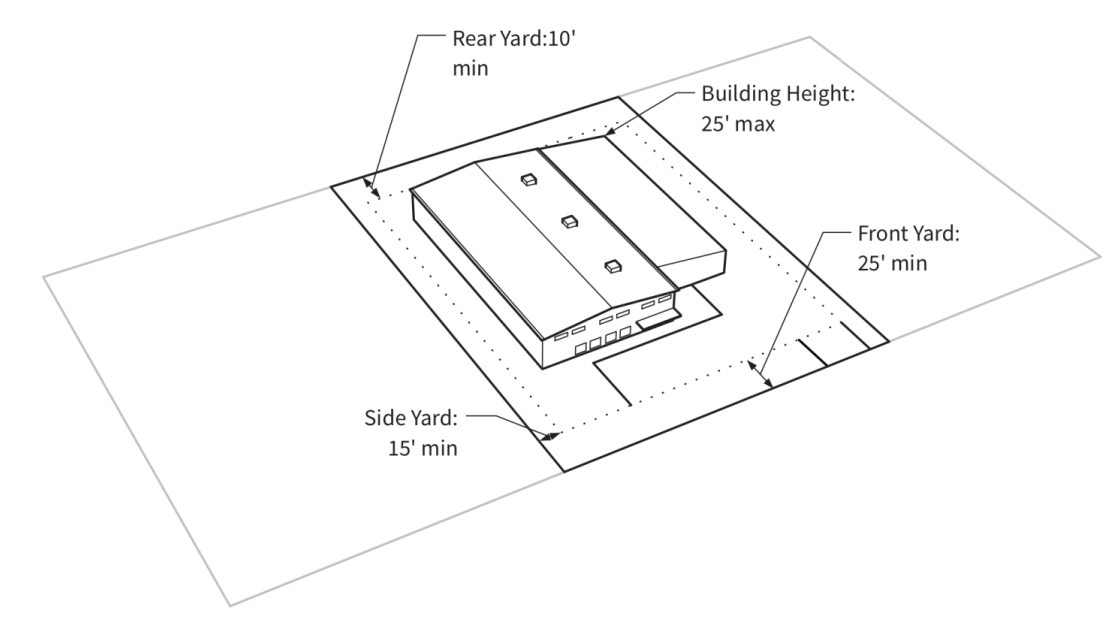
(Ord. No. 17-04, 6-27-17)
§ 180-3.16. - Summary Tables of Dimensional Standards.
180-3.16.1.
Dimensional Table: Residential.
180-3.16.2.
Dimensional Table: Commercial/Mixed-Use.
180-3.16.3.
Dimensional Table: Other.
(Ord. No. 17-04, 6-27-17)
§ 180-3.17. - Additional dimensional standards and exceptions.
180-3.17.1.
Lot Coverage.
A.
Additional Lot Coverage. In the RL, RM, RH, GW, and MU Districts, if additional lot coverage incentives are utilized, in no instance shall the aggregate lot coverage allowed be more than an additional 12 percent of the lot area.
1.
Accessory Dwelling Unit Exceptions.
a.
In the RL and RM Districts, when a deed-restricted accessory dwelling unit meeting the Town's requirements is constructed, the lot coverage requirements shall be increased such that lot coverage shall not exceed 55 percent of the total lot area.
b.
In the RH District, when a deed-restricted accessory dwelling unit meeting the Town's requirements is constructed, the lot coverage requirements shall be increased such that lot coverage shall not exceed 60 percent of the total lot area.
c.
In the GW District, when a deed-restricted accessory dwelling unit meeting the Town's requirements is constructed, the lot coverage requirements shall be increased such that lot coverage shall not exceed 65 percent of the total lot area.
2.
Building Height Exceptions.
a.
In the GW District, a five-percentage point increase in lot coverage is permitted for every five feet below the maximum height the building(s) is constructed.
b.
In the MU District, lower building height exceptions are as follows:
i.
A one percentage point increase in the maximum allowable lot coverage shall be permitted for buildings constructed from 41 feet to 42 feet in height.
ii.
A two percentage point increase in the maximum allowable lot coverage shall be permitted for building constructed from 39 feet to 40.99 feet in height.
iii.
A three percentage point increase in the maximum allowable lot coverage shall be permitted for buildings constructed from 37 feet to 38.99 feet in height.
iv.
A four percentage point increase in the maximum allowable lot coverage shall be permitted for buildings constructed from 35 feet to 36.99 feet in height.
v.
If multiple buildings of varying building heights are constructed on a single parcel, the Community Development Department shall assess this lot coverage incentive in a proportional amount based on the floor area of each building proposed. In no instance shall this lot coverage incentive result in an increase in more than five percentage points per lot.
B.
Driveway Exceptions. In the RL, RM, and RH Districts, driveways, up to a maximum of 12 feet in width, shall not count towards lot coverage when accessing only rear loaded garages or parking areas.
180-3.17.2.
Lot frontage.
A.
In the RS, RL, RN, RM, and RH Districts, a lot on the bulbous end of a cul-de-sac may have a minimum of 30 feet lot frontage.
Figure 3-O: Lot Frontage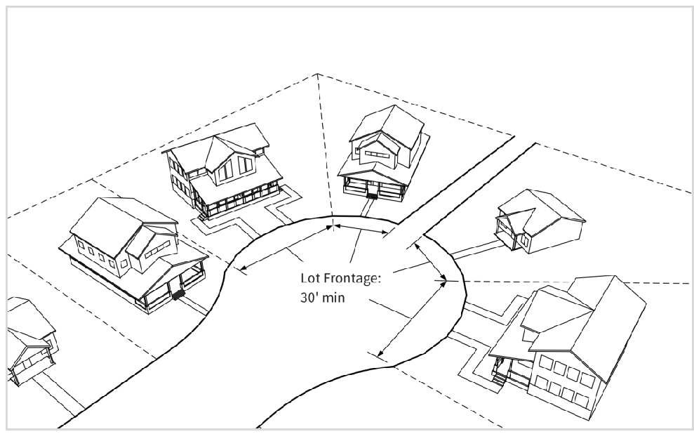
B.
In the RN District, lots with frontage on a street or park or open space area and that have alley/driveway vehicular access may have minimum lot frontages of 30 feet for single-household dwelling units, and 20 feet for individual duplex units.
180-3.17.3.
Maximum Density.
A.
Exceptions to the maximum density requirements may be permitted subject to the affordable housing standards in Section 180-5.5.
180-3.17.4.
Floor Area Ratio. In the RN District, for purposes of calculating floor area ratio (FAR), the total floor area of buildings includes all habitable space and garage space, except as provided below. The following items are exempt from the calculation of total floor area for purposes of the FAR calculation:
A.
Accessory units and accessory buildings (e.g., sheds) and/or carriage houses.
B.
Non-habitable under ground floor space (e.g., crawl spaces).
C.
Attached and detached garages up to 400 square feet.
180-3.17.5.
Setbacks.
A.
Front Yard Setbacks. In the RN District, the minimum front yard setback is measured to the building primary frontage. The front yard setback may be reduced to six feet for covered porches located on the ground floor and uncovered second floor decks.
Figure 3-P: Front Porch Setback Exception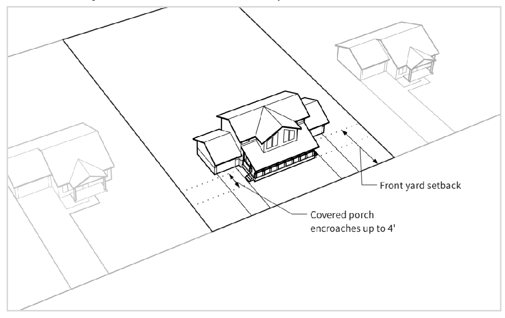
B.
Side Yard Setbacks.
1.
In the RN District. When an accessory building, including garages, is located adjacent to a public right-of-way, eaves up to one foot in depth may encroach into the side yard setback.
2.
GW District Roof Eave Exception. Upon approval from Planning Commission, and if it adds to the aesthetic character of the structure and meets the intent of the GW District, roof eaves two feet and greater are permitted to encroach up to five feet into the side and/or rear setbacks.
180-3.17.6.
Duplex resubdivision exception. In the RL, RM, and RH Districts, a duplex dwelling on a lot that meets the requirements set forth in Sections 180-3.16 and 180-3.17 above may be resubdivided, provided that the resulting two lots and the building meet the following minimum requirements:
A.
Minimum lot area: 5,250 square feet.
B.
Minimum lot frontage: 30 feet.
C.
Setback requirements.
1.
Front yard: RL, RM, and RH Districts: 20 feet.
2.
Side yard:
a.
RL District: 15 feet.
b.
RM and RH Districts: Ten feet.
c.
All-party wall: 0 feet.
3.
Rear yard: RL, RM, and RH Districts: 10 feet.
D.
The party wall in all such duplex dwellings shall run along and upon the lot line common to the resulting two lots.
180-3.17.7.
Building Height.
A.
In the PR District, upon Planning Commission approval, a maximum height of up to 35 feet may be permitted when necessary to accommodate for special recreation specific needs and when the following criteria are met:
1.
That substantial architectural relief is provided to alleviate the feeling of mass.
2.
That the additional height allowance provides a recreational amenity that is unique and desired in Frisco, and is supported in the Master Plan.
B.
In the PF District, the Planning Commission may allow a maximum of 35 feet for schools or other public buildings when necessary to accommodate special public, utility, or institutional needs.
180-3.17.8.
Ceiling Height.
A.
In the Central Core District.
1.
For properties located between Main Street and Galena Alley and for properties located between Main Street and Granite Alley, the ground floor ceiling height for all uses shall be a minimum of ten feet in height.
2.
For properties located between Galena Street and Galena Alley and for properties located between Granite Street and Granite Alley, the ground floor ceiling height for nonresidential uses shall be a minimum of ten feet in height.
B.
In the Mixed-Use District. For properties located along Main Street, the ground floor ceiling height for all uses shall be a minimum of ten feet in height.
180-3.17.9.
Open space. In the RN District, required open space may include areas maintained in a natural or undisturbed state, areas for active recreation, as well as plazas, pathways, sidewalks, landscaping, gardens, water features, fountains, or other similar areas that provide visual relief from the mass of buildings. Open space shall not include space used for driveways, parking areas, dumpster enclosures, or decks, patios and balconies above grade. The list of exclusions herein is not intended to be exhaustive and any item not mentioned may be determined by the Planning Commission and/or Town Council on a case by case basis.
180-3.17.10.
Driveways. In all zoning districts, driveways shall comply with Chapter 155, Minimum Street Design and Access Criteria.
180-3.17.11.
Stepbacks. In the CC District, the following encroachments into a required stepback are permitted:
A.
Roof overhangs, limited to two feet in depth; and
B.
Railings, limited to the minimum height required by Chapter 65, Town of Frisco Building Construction and Housing Standards.
(Ord. No. 17-04, 6-27-17; Ord. No. 19-04, 4-9-19)