
Gainesville City Zoning Code
ARTICLE VI
DEVELOPMENT STANDARDS
Sec. 30-6.1. - Purpose.
This division is intended to implement the Comprehensive Plan, as required by F.S. § 163.3202, by ensuring that development approved by the city shall not result in a reduction of service below the level of service (LOS) standards adopted in the Comprehensive Plan.
Sec. 30-6.2. - Implementation of Comprehensive Plan.
A.
To implement the provisions of the Comprehensive Plan, the city establishes:
1.
A concurrency management system that enables the city to determine whether it is adhering to the adopted LOS standards and its five-year schedule of capital improvements;
2.
A regulatory program that ensures each public facility is available to serve development concurrent with the impacts of development; and
3.
A transportation mobility program (TMP) as an alternative to transportation concurrency. The TMP is an alternative mobility funding system that is not mobility fee-based.
B.
Annual report on facility capacity. On an annual basis, the city shall issue a facility capacity report indicating the facility capacity status for each public facility having an adopted LOS standard. The extent of the remaining capacity available for each fiscal year shall be made available to the general public within 30 calendar days of the start of each fiscal year. Gainesville Regional Utilities shall be responsible for determining the water supply and water and wastewater facility capacity status to be included in the facility capacity report, as determined in accordance with Gainesville Regional Utilities' water/wastewater capacity policy.
1.
Nothing herein shall preclude amendments to the annual report if deemed necessary to update or correct: Errors in preparation; the impact of issued development orders or permits, monitoring by the city indicates an unacceptable degradation to an adopted LOS standard; or changes in the status of capital improvement projects of the state or any local government that changes the underlying assumption of the annual report.
2.
An amended annual report shall not divest rights acquired prior to the amended report, except where a divestiture of such rights is determined by the city commission to be essential to the health, safety or welfare of the general public and otherwise in accordance with law.
C.
Annual capital improvements element update. As provided in the Comprehensive Plan, the capital improvements element shall be updated annually during the budget review process. The annual report on facility capacity, prepared in conjunction with the budget review process, shall include a forecast of the capacity of existing and planned capital improvements identified in the five-year schedule of capital improvements. The forecast shall be based on the most recently updated schedule of capital improvements for each public facility. The city shall also annually revise relevant population projections, update public facility inventories, update unit costs, and update revenue forecasts in cooperation with the office of management and budget, the finance department and Gainesville Regional Utilities (GRU). The findings of the city shall be fully considered in preparing any proposed amendments to the Capital Improvements Element, any proposed amendments to the city annual budget for public facilities, any proposed amendments to GRU's annual budget for public facilities, and the review of and issuance of development orders during the next year.
D.
Recommendations on amendments to the capital improvements element, city annual budget and GRU annual budget. Based upon the city report described above, the city manager and general manager of utilities shall annually propose to the city commission any amendments to the capital improvements element, the city's annual budget and the GRU annual budget for capital improvements made necessary by circumstances described in the report.
Sec. 30-6.3. - Level of service standards.
The following level of service (LOS) standards shall be used to implement the concurrency management system and the transportation mobility program:
A.
Transportation mobility.
1.
Roadway LOS:
a.
The LOS for all roadways in city limits shall be LOS E, except for I-75 and roadways operating as backlogged or constrained.
b.
The LOS for I-75 segments that fall within city limits shall be maintained at LOS D to the extent feasible, recognizing that I-75 serves land areas and traffic outside city limits.
c.
The city shall attempt to maintain the 2012 operating LOS on all backlogged and constrained roadways in city limits.
2.
Transit LOS:
a.
The city shall strive to provide fixed-route transit service within one-fourth mile of 80 percent of all medium and high density residential areas identified on the future land use map, and within the RTS service area.
b.
The city shall strive to provide peak hour frequencies of 20 minutes or less within one-fourth mile of all high density residential and UMU-1 and UMU-2 land use areas in city limits.
c.
The city shall strive to provide and maintain fixed-route transit service to all existing transit hubs and transit-supportive areas (as mapped in the Transportation Mobility Element Map Series) with peak hour frequencies of 30 minutes or less.
d.
The city shall strive to operate 80 percent of fixed-route transit routes for at least 14 hours per day.
3.
Pedestrian LOS:
a.
The city shall install at least one linear mile of sidewalk annually to retrofit existing areas without sidewalks.
b.
Sidewalk construction shall be required for all new development.
c.
New streets shall be designed and constructed to include sidewalks.
4.
Bicycle and trail LOS:
a.
The city shall add an average of at least one mile of bicycle facilities annually, including multi-modal trails.
b.
New streets shall be designed and constructed to include bicycle facilities.
B.
Stormwater management.
1.
The LOS standard for all stormwater management facilities shall be the 100-year critical duration storm. The LOS standard for water quality treatment shall be treatment of first one inch of runoff; and compliance with the stormwater management facility design and performance standards established by the applicable water management district to ensure that the receiving water quality standards of Chapter 62-302, Florida Administrative Code are met and to ensure that receiving surface waters maintain their classifications as established in Chapter 62-302 Florida Administrative Code.
2.
These standards shall apply to all new development and redevelopment. Any exemptions, exceptions or thresholds in the Florida Administrative Code citations are not applicable.
C.
Potable water/wastewater and water supply.
1.
Potable water.
a.
Maximum day (peak) design flow: Two hundred gallons per capita per day.
b.
Storage capacity: One-half of peak day volume in gallons.
c.
Pressure: The system shall be designed for a minimum pressure of 40 psig under forecasted peak hourly demands to assure 20 psig under extreme and unforeseen conditions.
2.
Wastewater.
a.
Average day standard: One hundred six gallons daily flow per capita.
3.
Water supply. Average daily flow of 147 gallons per capita per day.
D.
Recreation.
1.
Level of service standards for parks.
1 Park standards are in acres per 1,000 people.
2 Existing LOS is based on 2011 city population estimate and available facilities.
E.
Public schools facilities. The uniform, district-wide LOS standards for elementary, middle and high schools shall be 100 percent of program capacity as annually adjusted by the school board. This LOS standard shall apply to all school concurrency services areas (SCSAs) (within Gainesville's city limits) as adopted in the interlocal agreement. For combination schools, the school board shall separately determine the capacity of each school to accommodate elementary, middle and high school students, and shall apply the LOS standard prescribed above for elementary, middle and high school levels respectively.
F.
Solid waste. The following LOS standard for disposal and collection capacity shall be established: 0.655 tons of solid waste per capita per year disposed (3.6 pounds of solid waste per capita per day disposed).
(Ord. No. 170831, § 6, 4-5-18)
Sec. 30-6.4. - Level of service review.
A.
Generally. It is the policy of the city that no development order may be issued unless adequate public facilities are available to serve the project, at adopted LOS standards. The applicant shall provide information to show compliance with the adopted LOS standards and meeting concurrency requirements. In order to ensure that adequate public facilities are available concurrent with the impacts of development on each public facility, the following procedures govern the issuance of development orders.
B.
Exemptions. Developments that are issued a certificate of concurrency exemption as further provided in this chapter are exempt from the concurrency requirements of this chapter. In addition, the following types of development fall below the threshold for any concurrency review and are deemed automatically exempt:
1.
Single-family dwellings (including expansions and remodeling) on lots of record that existed on or before June 10, 1992.
2.
Building permits for two-family dwellings (including expansions and remodeling) that: 1) are on lots of record that existed on or before June 10, 1992; or 2) previously have met the concurrency requirements of this chapter.
3.
Concept review of a development as specified in article III of this chapter.
4.
Zoning verification letters with no associated change of use as specified in article III of this chapter.
5.
Lot splits.
6.
Changes to a new use allowed under the applicable zoning district that do not involve adding any new square footage or impervious surface.
C.
Mandatory certification of preliminary development orders. Prior to the final approval of a preliminary development order, as defined in this chapter, the owner/developer of a project shall obtain either a certificate of concurrency exemption, a certificate of preliminary concurrency or a certificate of conditional concurrency reservation. Renewals of approvals for preliminary development orders shall consider the implications for concurrency management.
D.
Mandatory certification of final development orders. Prior to the approval of a final development order, as defined in this chapter, the owner/developer of a project shall demonstrate that a valid and unexpired certificate of concurrency exemption, certificate of final concurrency or certificate of conditional concurrency reservation exists for the project. A project under consideration for a final development order that has a valid and unexpired certificate of preliminary concurrency and that has not been amended in a fashion to change densities or intensities of use shall be automatically granted a certificate of final concurrency. Renewals of approvals for final development orders shall consider the implications for concurrency management.
E.
Succession. As long as the original certificate of concurrency exemption, certificate of preliminary concurrency, certificate of final concurrency or certificate of conditional concurrency reservation remains valid and unexpired, it shall serve all subsequent development permits for that specific project.
F.
Optional review of projects. Any person may submit an application for a concurrency determination at any time. A concurrency determination reserves no capacity and is in no way binding on the city. Applications for a concurrency determination shall contain sufficient data on the project to prepare a concurrency determination.
G.
Credit for redevelopment, reuse or demolition of existing structure. If an applicant proposes to redevelop, reuse or demolish a building or part of a building as part of the redevelopment of a property and desires to receive public facility impact credits for that portion of the property being redeveloped, reused or demolished in accordance with this section, application shall be made and approved prior to such action. Construction shall commence within the timeframe established in the final development order to obtain the benefits of the credit. The applicant shall provide sufficient information about the previous use of the structure(s) so that credits can be calculated. Credits are not transferable to any other site. In the case of reuse or redevelopment of a building, full credit shall be provided for the existing square footage of the building even if a change of use occurs. However, any additional square footage added to the building or development shall be subject to concurrency and TMP review.
H.
Applications.
1.
Submission of application. Applications for a concurrency determination, certificate of concurrency exemption, certificate of preliminary concurrency, certificate of final concurrency and certificate of conditional concurrency reservation shall be on file in the city. Fees for each type of application are set forth in appendix A (schedule of fees, rates and charges). The application shall consist of such information as needed by the city to determine concurrency status.
2.
Limitation of approval. A concurrency determination, certificate of concurrency exemption, certificate of preliminary concurrency, certificate of final concurrency and a certificate of conditional concurrency reservation shall apply only to the specific land uses, densities and intensities based on information provided in the application, and, where applicable, the preliminary and final development orders. All applicants, to the extent required by the city, shall submit such applications for entire projects, rather than portions of projects, except in cases of phased developments.
3.
Issuance of certification. After concurrency review has been completed, the city manager or designee shall either approve or deny the application. If denied, the denial shall be in writing and shall include the reasons for denial. If a certificate of conditional concurrency reservation is approved, the approval shall require the payment of the relevant reservation fee or a bond equal to the amount of the reservation fee for reserving capacity, as specified in the executed development agreement. This fee shall be paid within ten working days of the issuance of the certificate of concurrency reservation or the certificate shall be cancelled. In either case, the final development order shall not be issued until the capacity reservation fee is paid. Public facility capacity shall be granted on a first-come, first-served basis, determined as of the date and time a certificate of preliminary concurrency, certificate of final concurrency or certificate of conditional concurrency reservation is issued.
4.
Expiration and effect. A certificate of concurrency exemption shall be valid for one year. A certificate of preliminary concurrency and certificate of final concurrency shall be valid for the time period that the appropriate development order is valid and unexpired. If either a preliminary or final development order does not have an expiration date, the certificate of preliminary concurrency or certificate of final concurrency shall expire in one year. A certificate of conditional concurrency reservation shall be valid for the time period reserved in the certificate. A new application for a certificate of preliminary or final concurrency shall be submitted if the project does not continue in good faith. A new fee will be assessed for the resubmittal of an application for a certificate of preliminary or final concurrency.
(Ord. No. 200722, § 10, 4-21-22)
Sec. 30-6.5. - Standards of review.
The following standards shall be used in review:
A.
Potable water, solid waste, stormwater management, water supply, wastewater and recreation. Prior to approval of a building permit or its functional equivalent, the city shall consult with Gainesville Regional Utilities to determine whether adequate water supplies to serve the new development will be available no later than the anticipated date of issuance by the city of a certificate of occupancy or its functional equivalent. Concurrency requirements for potable water, solid waste, stormwater management, water supply, wastewater and recreation shall be met by one of the following standards:
1.
A final development order is issued subject to the condition that the necessary facilities and services will be in place and available to serve the development no later than the issuance of a certificate of occupancy or its functional equivalent; or
2.
The necessary facilities and services are guaranteed in an enforceable development agreement that is secured by a completion bond or other acceptable form of security subject to review and approval as to form and legality by the city attorney. The agreement shall guarantee that the necessary facilities and services will be in place and available to serve the development no later than the issuance of a certificate of occupancy or its functional equivalent.
B.
Public schools facilities. The concurrency requirements for public school facilities shall be met if:
1.
Adequate school facilities (elementary, middle, and high school) are in place or will be under actual construction within three years after the issuance of a final development order or its functional equivalent;
2.
Adequate school facilities are available in an adjacent school concurrency service area (SCSA) or will be in place or under actual construction in an adjacent SCSA within three years after the issuance of a final development order or its functional equivalent; or
3.
The developer executes a legally binding commitment to provide mitigation proportionate to the demand for public school facilities to be created by actual development of the property, including, but not limited to, the options described in F.S. § 163.3180(6)(h)2.a.
C.
Project phasing. In determining the availability of public facilities, an applicant may propose and the city may approve proposed projects in stages or phases so that public facilities needed for each phase shall be available in accordance with the standards set forth in this section.
Sec. 30-6.6. - Design standards.
A.
Lots and blocks.
1.
Generally. Lots and blocks must be designed according to acceptable practice for the type of development and use contemplated so as to: be in keeping with the topography and other site conditions; provide adequate traffic and utility access and circulation; provide acceptable use of space; and provide privacy, adequate drainage, and protection of property.
2.
Lot frontage. Each lot in a subdivision must front for the entire required minimum lot width on a public street or an approved private street. Where there is no minimum lot width requirement, each lot must abut a public street or approved private street for a width equivalent to the maximum driveway width required in the Design Manual, plus any required turning radii area. Notwithstanding the above, the length of street frontage may be modified during subdivision review by the public works and planning departments, based on the need to achieve the most efficient lot layout, access to and from the subdivision, operational needs of service vehicles, vehicular circulation and the health, welfare and safety of the public.
3.
Connectivity. The subdivision must create vehicular and pedestrian access to serve the subdivision and improve gridded connectivity by connecting to surrounding existing streets and by including new streets within the subdivision. Street intersections must occur at least every 1,000 feet. Additionally, subdivisions containing 20 lots or more must provide a minimum of two access points to the extent feasible. Modifications to this requirement may be granted by the applicable reviewing authority where the construction of a street is limited by existing conditions, including:
a.
Access management standards;
b.
Regulated environmental features; or
c.
Public facilities, including stormwater facilities, parks, or schools.
Alternatively, where the applicable reviewing authority determines that it is not possible to construct the streets that would be required to meet the block perimeter standard, the block perimeter must be completed with the provision of pedestrian and bicycle paths or multi-use paths. The required streets or paths must be constructed at the expense of the owner/subdivider according to the appropriate city standards as determined through the subdivision review process, but may be sited and configured in a manner so that the streets provide the most appropriate access to the subdivision and connectivity to the surrounding street network. Where a street or path is planned to provide a future connection to a street or path beyond the extent of the subdivision, the owner/subdivider shall provide for the connection of the street by stubbing out the road improvements as close as practicable to the boundary of the subdivision.
4.
Dimensions. The size, width, depth, shape and orientation of lots shall be appropriate for the subdivision and for the type of development and use contemplated. Lot dimensions and street abutment requirements shall not be less than the minimum standards established in article IV. Lots in areas shown on the future land use map as single-family or residential planned use district for single-family detached units shall front on a local street, whenever the lots abut a local street.
a.
For development sites of five acres or less, located in an area shown on the future land use map as single-family or residential planned use district, the following standards shall apply:
i.
The lot size and dimensions shall be generally consistent with abutting/adjacent lots.
ii.
The minimum lot width of new parcels shall be no less than 75 percent of the average width of adjacent lots, but shall not be required to be greater than 150 feet and may not be less than the minimum required in article IV. Each lot shall meet this minimum requirement at the front setback line (as opposed to the minimum front yard setback) and the rear property line.
iii.
The minimum lot width requirement shall not apply if a 35-foot natural or planted buffer is created as a perimeter buffer around the new development. The perimeter buffer may include stormwater facilities and shall be approved by the city commission during design plat review.
b.
The city commission may waive any of the standards listed in subsection a. above for any single lot that is greater than or equal to 1.5 times the required lot size of the zoning district in which the property is located.
5.
Side lot lines. Side lot lines shall be, as nearly as practical, at right angles to straight street lines and radial to curved street lines. No lot shall be divided by a municipal boundary.
6.
Double-frontage lots. Double-frontage and reverse-frontage lots shall be discouraged except where essential to provide separation of residential development from traffic arterials and collectors or to overcome specific disadvantages of topography and orientation. A landscape buffer screen in accordance with the requirements of article III, division 7, across which there shall be no right of vehicular access, shall be provided on lots abutting the traffic arterial.
B.
Streets layout and type.
1.
The arrangement, character, extent, width, grade and location of all streets shall conform to the Comprehensive Plan, particularly any neighborhood elements, now in existence or as may hereafter be adopted, and shall be considered in their relation to existing and planned streets, to topographical conditions, to the provision of wide tree lawns and tree planting to yield shaded streets, to public convenience and safety, and in their appropriate relation to the proposed uses of the land to be served by such streets.
2.
When an appropriate street network is not shown in the Comprehensive Plan now in existence or as may be hereafter adopted, the arrangement of streets in a subdivision shall provide for the continuation or appropriate projection of existing collector or arterial streets in surrounding areas unless topographic, traffic volume or other conditions make continuance or conformance to existing streets impractical or undesirable.
3.
Each street on the plat shall be designated as one of the following types, based upon the projected traffic count for the street:
D.
Traffic count data.
1.
The number of annual average trips per day may be obtained from the city traffic engineer.
2.
Trip generation rates shall be calculated by a professional engineer using trip generation rates established by the Institute of Transportation Engineers according to accepted engineering practices approved by the city traffic engineer.
E.
Subdivisions on arterial streets. Where a subdivision abuts or contains an existing or proposed arterial street, the provision by the subdivider of marginal access streets, reverse-frontage lots with planting screen contained in a nonaccess reservation along the rear property lines, deep lots with rear service alleys, or such other treatment as may be necessary for adequate protection of residential properties and to afford separation of through traffic from local traffic may be required. No lot in any area shown on the land use plan for single-family use or single-family residential PUD at less than eight units per acre shall front on an arterial street.
F.
Design specifications. Intersection design, intersection sight distance, minimum street design, and cul-de-sac minimum lengths and turnaround diameters shall be designed in accordance with this article and the Design Manual.
G.
Street access to abutting property. When designated on the official roadway map or determined by the city commission to be needed for proper traffic circulation, access to abutting property shall be provided through the use of a street stub. If such a street stub terminates more than 100 feet from an intersection, it shall be provided with a temporary turnaround that would allow vehicular traffic to turn around safely without having to leave the pavement. Specifications for optional temporary turnarounds are contained in the Design Manual. The developer of the abutting area shall pay the cost of restoring the street to its permanent cross section and extending the street at such time as the abutting area is developed.
H.
Dedication of right-of-way.
1.
Where a proposed subdivision abuts or includes a future transportation corridor alignment or existing transportation corridor that is scheduled for construction shown in the City of Gainesville Comprehensive Plan or the Florida Department of Transportation 5-Year Transportation Plan or the Alachua County 5-Year Work Program, rights-of-way as needed according to the proposed road type shall be dedicated on each side of the proposed alignment for use as a transportation and utility corridor.
2.
Where a proposed subdivision or lot split abuts a public right-of-way that does not conform to the provisions of this chapter, as further specified in the Design Manual, the owner(s) may be required to dedicate to the city, at no cost to the city, one-half of the right-of-way width necessary to meet minimum design requirements for street rights-of-way, as specified in this article. If the proposed subdivision abuts both sides of a substandard street, one-half of the right-of-way width necessary to meet those minimum design requirements may be required from each side. The dedication of this right-of-way or any easements necessary shall be accomplished by a separate document. The subdivider shall provide the city with legal descriptions of all easements or rights-of-way to be dedicated, and the city shall prepare and record the necessary documents as part of the approval process.
I.
Alleys. When provided in any district, alleys shall have a minimum right-of-way width of 20 feet.
J.
Bridges. Bridges shall be constructed in accordance with the Design Manual.
K.
Sidewalks and bikeways.
1.
Where provided, sidewalks and bikeways shall be designed as an integral part of the total on-site and off-site circulation system, including integration or linkage with designated greenways, and shall be located within the street right-of-way or within rear lot easements or common open areas.
2.
The installation of sidewalks shall be the responsibility of the subdivider and the sidewalks shall be installed prior to the acceptance of the improvements by the city. The subdivider may elect to postpone installation of sidewalks until such time as building permits are issued for 60% of the subdivision lots, up to a maximum of five years. However, security for the construction of such sidewalks, in the amount of 150 percent of the estimated costs of construction, shall be provided by one of the methods described in article III, division 7. In subdivisions, sidewalks along streets fronting common areas such as stormwater basins, entrance streets, or open space shall be installed within 12 months of final plat approval (acceptance of improvements by the city), and are not eligible for the above-described postponement provisions.
3.
The city manager or designee may waive the requirement of installing a streetside sidewalk or modify the sidewalk width requirement to save a heritage tree or a regulated tree deemed by the city manager or designee to have special value to the urban forest. Instead, the sidewalk right-of-way is allowed to be re-aligned or a short narrowing of the sidewalk width is allowed. The city manager or designee can approve either a sidewalk less than five feet wide for a distance less than 15 feet, or may require the dedication of additional right-of-way or easement so that the sidewalk can avoid the tree.
4.
Where a previously dedicated street forms a boundary of a subdivision, and where adequate right-of-way for the installation of a required sidewalk does not exist, the subdivider shall dedicate proper sidewalk areas upon the side of the street abutting the lands subdivided and construct the required facilities.
5.
Sidewalk construction in accordance with this chapter shall be required for each individual lot in a subdivision created after September 11, 2000, prior to being issued a certificate of occupancy.
L.
Costs of street improvements.
1.
It shall be the responsibility of the subdivider to install all local and minor collector streets located within a subdivision. When a major collector or a major or minor arterial street is located within a subdivision, the subdivider shall be required to construct the street, but shall only be required to pay a portion of the construction cost, which portion shall be determined by the ratio that the estimated average daily traffic on the street generated by the subdivision lands at full development bears to the total estimated average daily traffic for the street based on full development of its entire service area. The city shall pay the remaining portion of the street construction costs, but the total dollar liability of the city shall be limited to its proportion of the estimated construction costs prepared by the subdivider and approved by the city commission prior to construction. At its option, the city commission may waive the requirement for construction of the major local collector or major or minor arterial and any associated bikeways or sidewalks, in which case the subdivider's only obligation shall be the dedication of the required right-of-way. Also at its option, when the subdivider's portion of the cost of the major local collector or major or minor arterial exceeds 50 percent, the city commission may permit the construction of a half street by the subdivider.
2.
When the average daily trips of a subdivision impact an existing minor or major arterial or major local collector street, it shall be the responsibility of the subdivider to make improvements as necessary to serve the proposed development while maintaining the operating conditions of the affected roadway. These improvements can include, but are not limited to, installation of additional lanes, signalization, associated stormwater management improvements, and the installation of associated bikeway, sidewalk and transit improvements. The city commission may determine the proportional cost of programmed improvements to be allocated to the subdivider.
M.
Flood hazards. A subdivision plat shall not be approved unless all land intended for use as building sites can be used safely for building purposes, without danger from flood or other inundation. All subdivisions, or portions thereof, located within a flood channel or floodplain shall meet the requirements of article VIII.
N.
Erosion and sediment control measures. The city may require the subdivider to use grading techniques, subdivision design, landscaping, sedimentation basins, special vegetation cover and other measures to reduce erosion and sediment. The subdivider shall comply with the requirements of the Design Manual concerning erosion and sediment control measures.
O.
Stormwater management required. A complete stormwater management system, in conformance with this chapter and the Design Manual, shall be provided in all areas of the subdivision for handling stormwater runoff within or across the subdivision lands.
P.
Stormwater management facilities.
1.
Easements for maintenance access shall be granted to the city along drainage basins and along all storm sewers. In some circumstances, additional easements may be required by the city manager or designee for maintenance access only.
2.
The design of stormwater facilities shall consider the ease of maintenance over the life of the facility.
3.
Any appurtenances placed in the right-of-way or within any publicly dedicated drainage basin, such as fountains, landscaping, lighting features, and signs, shall be the sole responsibility of the homeowners association and shall only be installed with express written approval of the city manager or designee. A maintenance agreement shall be required prior to acceptance of the facility by the city.
4.
Trees selected from the Gainesville tree list that are identified as appropriate for stormwater basins shall be planted to meet the requirements identified in section 30-8.6.
Q.
Stormwater management easements. Easements, rights-of-way, and stormwater management facilities meeting all requirements of article III, division 7, shall be required upon recommendation of the director of public works.
R.
Utilities required.
1.
Sanitary sewer. The subdivider shall provide sanitary sewer services to each lot within the subdivision. All sewer lines serving lots within the subdivision shall be installed by the subdivider prior to the paving of the street and should be designed to operate on a gravity flow basis unless otherwise approved by the utility department.
2.
Water supply. The subdivider shall install a system of water mains as approved by the utility department and connect the system to the public water supply. The installation of the mains and connection to each lot shall occur prior to paving of the street.
3.
Water and sewer systems.
a.
New central water and sewer systems where required shall be designed by an engineer in accordance with the regulations of the utilities department, the state department of environmental protection and the county health department, and with standards established in this chapter. Central water and sewer systems shall be designed and constructed for an economic life of not less than 20 years, and the water system shall be designed in accordance with the fire protection requirements provided in chapter 10 of the Code of Ordinances.
b.
Fire hydrants shall be connected to mains no less than six inches in diameter; however, the utilities department may require larger diameter mains for long lines that are not connected to other mains at intervals close enough for proper mutual support.
c.
Sufficient storage or emergency plumbing facilities shall be provided to such an extent that the minimum fire flows will be maintained.
S.
Underground utilities. Provisions shall be made for utility lines of all kinds, including but not limited to those of franchised utilities, electric power and light, telephone, cable services, water, sewer and gas, to be constructed and installed beneath the surface of the ground within residential and non-residential subdivisions, unless the city commission determines that soil, topographical or other compelling conditions make such construction unreasonable or impractical. The subsurface mounting of incidental appurtenances, including but not limited to transformer boxes or pedestal-mounted boxes for the provision of utilities, electric meters, back flow preventers and fire hydrants shall not be required.
T.
Utilities easements. When they are necessary to serve the subdivision, utilities easements shall be provided, with a minimum width of 20 feet, located along lot lines. The location of the utility easements shall not interfere with the required space devoted to street trees and tree lawns. Additional width may be required for sewer or stormwater management easements. Side lot line easements may be decreased to ten feet in width when serving a single electric, cable TV, gas or telephone utility. Rear lot line easements shall be discouraged, unless they are provided along an alley.
U.
Greenway dedication. Where a proposed subdivision contains a designated greenway, the appropriate review board shall determine if there is a rough proportionality between the projected impact of the development on traffic and recreational needs and the nature and amount of property in the development encompassing the greenway. If the board finds the necessary proportionality, a right-of-way or public trail easement shall be dedicated to the city for use as a greenway corridor. The dedication shall correspond with the entire length of the designated greenway corridor as it passes through the subject property, and be of sufficient width to comply with design standards as specified in section 30-8.42, pertaining to greenway districts. Such a dedicated corridor may be established for joint use as both a greenway and for required utility or stormwater management facility dedications when such dedications are compatible with the greenway use. In making its determination, the board shall consider the following:
1.
Assessed value of the property to be dedicated and proportion to value of entire property;
2.
Square footage of property to be dedicated and proportion to area of entire property;
3.
Other legal and reasonable uses of property to be dedicated;
4.
Impact to otherwise legal and reasonable plans being considered for development of entire property that would be caused by dedication of the property;
5.
Estimated increase in transportation demand caused by the development, and estimated amount of automobile trips that would be avoided by having dedication in place; and
6.
Estimated increase in recreation demands caused by the development.
V.
Screening walls and landscaping. Screening separating residential lots from abutting FDOT functionally classified arterial streets and from streets designated by the city commission as arterial streets based on their physical design, moderately long trip length, and existing or anticipated traffic characteristics shall be required in the form of low-maintenance walls, dense plant material or planted earth mounds. Such a screen shall be at least six feet in height and shall be completely in place before required improvements for the subdivision are accepted for maintenance. The responsibility for maintenance of the wall, plant material and earthen mounds shall be conveyed to the neighborhood association established for the maintenance of common property within the subdivision or the subdivider may provide a financial mechanism for such purpose, subject to the approval of the city attorney.
W.
Subdivision entrance islands or medians. Landscaped islands or medians may be permitted within the right-of-way at all subdivision entrances. These areas shall be landscaped with materials from the Gainesville Tree List. In addition, the landscaped area shall be provided with an irrigation system or a readily available water supply within 100 feet. Maintenance of subdivision entrance identification and landscaping shall be in accordance with article III, division 7.
X.
Permanent development identification signs and structures. Permanent development identification signs and structures for subdivisions may be located in the public right-of-way provided there is compliance with article IX and with the following restrictions:
1.
Maintenance agreement. A maintenance agreement between the city and the subdivision or neighborhood organization or the developer placing the sign in the public right-of-way is required. The agreement shall provide that the subdivision or neighborhood organization or developer, including its successor or assign, is responsible for maintaining the sign and the public right-of-way where the sign is located.
2.
Permitted signs and structures with indemnification agreement. If the subdivision or neighborhood organization or the developer enters into an agreement that is acceptable to the city attorney indemnifying the city from any liability, the city may permit structures such as walls, permanent planters, or one single- or double-sided street graphic containing a maximum of 32 square feet of sign area per side, to be placed at the entrance(s) and located in the city's right-of-way.
3.
Permitted signs with no indemnification agreement. If the subdivision or neighborhood organization or the developer does not or is unable or unwilling to enter into an indemnification agreement with the city that is acceptable to the city attorney, the city will permit an identification sign on the right-of-way at the entrance(s) to the subdivision pursuant to the conditions in article IX and the following additional conditions:
a.
One double-sided sign no taller than four feet in height from the ground may be placed in an entrance median. If made of wood, the sign may be no wider than six inches in width, and, if made of masonry, may be one course thick (unreinforced) and no wider than 12 inches, including letters.
b.
Alternatively, two single-faced signs equal in size may be placed within the right-of-way on each side of an entranceway. Unless mounted on a wall, each face of the subdivision sign shall be no taller than four feet from the ground.
c.
The sign(s), whether located in a median strip or along the side of the entrance street, shall be located at least four feet behind the face of the median curb.
d.
Location and materials of the signs shall meet the requirements of article IX.
Y.
Fire hydrants. Fire hydrants shall be required in all subdivisions as per plans approved and accepted by Gainesville Regional Utilities and the city fire department.
(Ord. No. 200722, § 11, 4-21-22; Ord. No. 211359, § 8, 10-17-22 Ord. No. 2023-169, § 8, 6-1-23)
Sec. 30-6.7. - Cluster subdivisions.
A.
Purpose and intent. The purpose of this section is to establish a process by which environmentally sensitive land and infill sites may be developed for residential purposes without strict adherence to the dimensional requirements of the zoning code of the city. The intent is to encourage better site planning than would normally occur by conventional subdivision procedures. Specifically, the objectives are to better preserve valuable open spaces, environmentally sensitive areas, existing tree cover; to provide for infill development where appropriate; to provide for better utilization of land; to provide for zero lot line development; to promote efficiency through design; and to provide for design flexibility to meet changing market conditions. Such development will be accomplished without an overall increase in density otherwise permitted in the zoning district in which the development is located as determined by the minimum lot size.
B.
Permitted districts; minimum size. A cluster subdivision may be permitted in any zoning district in which single-family dwellings are allowed as a permitted use and where the parcel to be subdivided has an area of five acres or more.
C.
Approval procedure; design standards; name.
1.
Cluster developments shall be approved in accordance with the procedures established for plats. Further, cluster subdivisions involving attached housing in zoning districts that allow such housing types shall also secure development plan approval in accordance with article III.
2.
Design standards for improvements shall be in accordance with the provisions and regulations of this chapter.
3.
The name of a subdivision approved pursuant to this article shall be followed by the words "cluster subdivision," which shall become and be made a part of its official name.
4.
Application for cluster subdivision will be classified as either environmental or infill based on the following criteria:
a.
Environmental. Development site contains regulated surface waters and wetlands or regulated natural and archaeological resources, or it is within a planning parcel that includes regulated natural and archaeological resources.
b.
Infill. Cluster subdivision provides for infill development where appropriate, better use of land, zero lot line development, and/or promotes efficiency through design.
D.
Dwelling types permitted. Except in the SF zoning districts, all types of attached and detached single-family residential dwellings may be permitted in a cluster subdivision. In the SF districts only single-family detached dwellings will be permitted in a cluster subdivision. Within cluster subdivisions, a variety of lot sizes and architectural typologies shall be encouraged.
E.
Modification of street, yard, and lot requirements. Modifications to the lot area, lot width and depth, minimum yard setback, street width and layout requirements of the applicable zone may be permitted if shown on the design plat and such plat is approved by the city commission. No cluster subdivision of 50 acres or less in the SF district shall have lot sizes reduced by more than 25 percent of that required by the district regulations. Each cluster subdivision may use zero lot line, regular lots or a combination of the two. However, each lot in a cluster subdivision that directly abuts developed property not in a cluster subdivision shall not have the following, unless the subdivision provides a 35-foot buffer around the entire subdivision:
1.
An abutting side or rear yard that is less than that required for the abutting property; or
2.
A lot width that is less than 75 percent of the minimum lot width required in the zoning district for the abutting property.
F.
Number of dwelling units permitted. The total number of dwellings permitted in a cluster subdivision shall not exceed the number of dwelling units that would have been otherwise permitted by the density standards in the zoning district in which it is located. In the SF, RMF-5, and RC districts, the permitted number of dwelling units may be calculated by dividing the total land area of the cluster subdivision by the minimum lot size required for the applicable zoning district. The number of dwelling units shall not exceed the density allowed by the zoning district.
G.
Cluster open space requirement.
1.
Each cluster subdivision that reduces lot sizes below the minimum area required by the zoning district in which it is located shall provide cluster open space to be preserved and maintained for its scenic value, for recreational or conservation purposes and other related uses. This space shall be clearly indicated on the plat by the use of the words "cluster open space." The minimum amount of land to be designated as cluster open space shall be equivalent to 75 percent of the total amount of area by which each lot was reduced below the minimum lot size required in the zoning district plus any required wetland, creeks and associated buffer acreage in which the subdivision is located. Cluster open space is not required unless lot sizes are reduced below the minimum area required in a zoning district.
2.
Land area devoted to public or private vehicular streets and sidewalks, rights-of-way, and drainage structures shall not be included towards meeting cluster open space requirements, except when such land is being jointly used for a greenway corridor as specified by section 30-6.6. For the purposes of this section "drainage structures" shall be defined as culverts, storm drains and stormwater retention or detention ponds. Fifty (50) percent of drainage facilities (unfenced) that use existing topography, have side slopes that are stabilized by plantings, provide a recreational or aesthetic amenity, provide environmental quality and ecological value, and use native plants to create an aquatic or a temporary aquatic type of ecosystem to the development, may be included towards meeting cluster open space requirements. Unless otherwise restricted, cluster open space may contain accessory structures and improvements necessary for the educational, cultural, recreational or social enjoyment of the residents or citizens plus any necessary utility services. The appropriateness of accessory structures will be reviewed and considered in terms of their enhancement of the cluster open space, the purposes as provided in subsection A. of this section, and the criteria as provided in subsection I. below. Accessory structures may be approved during the design plat review process, or during the development plan review process subject to the provisions of this section and the provisions of article III. Accessory structures are prohibited within wetlands, creeks, lakes and associated buffers.
3.
Environmentally significant features such as but not limited to, creeks, creek setback buffers, wetland, wetland setback buffers, flood channels, floodplain areas, major tree groupings and individual trees of significant size shall be designated as cluster open space. Notwithstanding any contrary language contained in section 30-8.19 or other city regulations, all wetlands mitigation for a cluster subdivision shall be done on site.
4.
The cluster subdivision shall strive to protect healthy heritage trees. The restrictive covenants for the cluster subdivision shall require that homes and other improvements are designed to protect the trees.
H.
Ownership of cluster open space.
1.
Public ownership. Cluster open space may be conveyed to the city unless the city commission finds that the size, location, nature and type of development, or fiscal impact (i.e., the cost and maintenance of development or open space) would make public use undesirable or unnecessary. Such conveyance shall be by statutory warranty deed free and clear of all liens and encumbrances, and shall take place on or before the recordation of the subdivision plat. In some instances, the city commission may authorize the conveyance of the cluster open space by a conservation easement as provided in F.S. § 704.06, when the nature and character of the cluster open space are suitable for such easement. Where the cluster subdivision encompasses lands designated for greenways or other forms of public ownership or access under the recreation; conservation, open space and groundwater recharge; and stormwater management elements of the Comprehensive Plan, the city may require dedication of such areas to the city as specified by section 30-6.6.
2.
Private ownership. Where open space is not dedicated to the city or public use, it shall be protected by legal arrangements satisfactory to the city attorney sufficient to assure its maintenance and preservation for the purpose(s) intended. Covenants or other legal agreements shall specify, at a minimum, the ownership of the cluster open space, method of maintenance, maintenance of taxes and insurance, compulsory membership and assessment provisions; guarantees that any homeowners' association formed to own and maintain cluster open space will not be dissolved without the consent of the city; and any other provisions deemed necessary by the city attorney to meet the requirements of this section.
I.
Criteria for review of cluster subdivisions. A cluster subdivision shall provide for better use of land and for a total environment, which is improved over that which could be achieved under standard regulations. The applicant shall present evidence that the proposed cluster subdivision uses the land better than a standard subdivision. If the city commission finds that a subdivision will be improved by the reasonable modification of the location, design or configuration of open space, building lots, streets and parking areas, the subdivision will be modified or denied. The following criteria shall guide the city in review of the proposed subdivision and in making any modifications thereof:
1.
Individual lots, buildings, streets and parking areas shall be designed and situated to minimize alteration of the natural site features and topography. A minimum of 50 percent of all heritage trees shall be protected.
2.
Individual lots, buildings and other structures shall be arranged and situated to relate to surrounding properties and to improve the view from, and the view of, buildings, lots and structures.
3.
Individual lots, buildings, streets and parking areas, and any accessory structures and improvements located in the cluster open space, shall be situated to avoid the adverse effects of shadows, noise and traffic on the residents of the site and to minimize the area devoted to motor vehicles.
4.
Cluster open space shall include any irreplaceable natural features located on the tract such as, but not limited to, stream beds and adjacent banks, wetlands, flood channels, floodplain areas, major tree groupings and individual trees of significant size.
5.
The usability of cluster open space intended for recreation or public use shall be determined by the size, shape, topographic and location requirements of the particular purpose proposed for the open space. Further, such space intended for recreation or public use shall be easily accessible to trail users including the elderly and handicapped, be integrated to form unbroken trail linkages between uses within the subdivision, and take advantage of opportunities to establish off-site linkages to nearby land uses, bikeways, sidewalks and greenways.
6.
To the extent practical, lands designated for greenways or other forms of public ownership or access in the conservation, open space or recreation element shall be included as cluster open space and dedicated as specified by section 30-6.6.
7.
Diversity and originality in lot layout and individual building design shall be encouraged to achieve the best possible relationship between the development and the land. Garage doors if forward facing shall be set back at least 20 feet from the back of sidewalk and shall not be forward of the front facade of the building. Sidewalks shall be included on both sides of the street internal to the cluster subdivision.
8.
To the extent practical, cluster open space shall contain regulated surface waters and wetlands, and set-asides of regulated natural and archaeological resources.
9.
When lots abut wetlands or buffer areas, the property owner shall provide a ten-foot building construction setback from those areas for a construction work area, so that wetlands and buffer areas are not disturbed during any construction process.
(Ord. No. 2024-263, § 13, 10-3-24)
Sec. 30-6.8. - General lot and building requirements.
The following lot and building requirements shall apply in all zoning districts:
A.
Frontage on right-of-way.
1.
Minimum property frontage. No building or structure, except as hereinafter provided, shall be erected on a lot or parcel of land which does not physically abut a public street, private street, or approved private street for the required minimum lot width of the district where the same is located. The city manager or designee may designate a private street as an "approved private street" provided it meets one of the following standards:
a.
A perpetual ingress/egress easement recorded in the public records of Alachua County that provides legal access to the lot or parcel of land from a dedicated road or right-of-way and which is deemed capable of carrying public safety vehicles; or
b.
Property owned jointly or in common by all property owners fronting the private street as shown in the public records of Alachua County that connects to a dedicated road or right-of-way and which is deemed capable of carrying public safety vehicles.
For the purposes of this section, two classes of approved private streets shall be designated by the city manager or designee:
a.
Existing private streets that were constructed prior to September 26, 1994; and
b.
New private streets that are approved for construction after September 26, 1994.
The city manager or designee shall have the authority to approve or disapprove, for the purposes of erection of buildings or structures, private streets that existed prior to September 26, 1994. All private streets approved for construction after September 26, 1994 shall meet the construction standards for public streets as shown in the Engineering Design and Construction Manual, except in the PD district. In PD districts, the geometric construction standards may be varied as set forth in the planned development ordinance. For the purposes of minor subdivision and lot splits, the approved private street shall also meet the requirements in article III, division 7.
In zoning districts with no minimum lot width requirement, the lot or parcel of land shall abut a public or approved private street for the maximum driveway width dimension requirement provided in the Design Manual plus any required turning radii area.
Notwithstanding any provision of this section to the contrary, a single-family dwelling, if it is an allowable use in the district, may be erected on a lot or parcel of land that abuts at least one public or approved private street for at least 25 feet, provided that the minimum lot width for the district in which it is located is met at the required front yard setback line. Provided, further, that any single-family dwelling existing on a lot that does not conform to the provisions of this subsection may be modified, enlarged or extended, and/or an accessory building or structure may be added to a single-family dwelling, provided that such modification, enlargement, extension or addition complies with all the other requirements of the district in which the lot is located.
B.
Minimum setbacks. Every required minimum front yard setback line will be established by a line parallel to the centerline of the street right-of-way, measured from the street right-of-way line or as described by specific zoning districts. In cases where zoning districts have alternative requirements for establishing or measuring setbacks, those specific requirements will supersede this section.
C.
Overhanging and protruding projections.
1.
Within the DT district, porches or balconies (the "projection") that are supported by columns or posts may project over the public right-of-way line provided all of the following conditions are met:
a.
The projection is not enclosed with any walls or screens and is not heated or cooled.
b.
There shall be a curbed sidewalk that is at least ten feet wide in front of the portion of the building where the porch or balcony is to be placed.
c.
The projection (except for the supporting pole or column) maintains a clear height above the sidewalk of at least nine feet.
d.
The projection does not encroach upon the vision triangle as provided in the Design Manual.
e.
No portion of the projection or the supporting column or post may be located within four feet, measured horizontally, of the curb.
f.
The horizontal distance between the building façade and the supporting column or post must be at least four feet.
g.
An unobstructed pedestrian path that is at least five feet wide and meets all Americans with Disabilities Act (ADA) requirements shall be maintained along the length of the sidewalk in front of the subject property.
h.
The projection has received the written approval of the city. At a minimum, this includes review by planning, public works, fire rescue, building inspections, and Gainesville Regional Utilities (GRU). The city may impose additional setbacks, conditions, or restrictions as are deemed necessary by the city.
i.
If the governmental entity that owns the public right-of-way is not the city, then the written permission of the governmental entity that owns the public right-of-way is required.
j.
If the public right-of-way belongs to the city, the property owner shall enter into a license agreement with the city indemnifying and holding harmless the city, its officers, agents, and employees, from any property damage, including loss, and any personal injury, including death, caused in any way by the projection of the porch or balcony over the right-of-way, and containing such other provisions as deemed necessary by the city to protect the interests of the city.
2.
Every part of a required yard shall be open and unobstructed from its lowest point to the sky, except for the customary projection of sills, belt courses, cornices, open exit stairs, ornamental features and eaves; provided, however, that none of the above projections shall extend into a required yard more than 36 inches; and further provided that none of the above projections shall extend over any public right-of-way, except in the MU-1, MU-2, BUS, and transect zoning districts. Enclosed exit stairs, outside stairways, balconies, chimneys, flues or other projections shall not extend into any required yard.
3.
Within the MU-1, MU-2, BUS, and transect zoning districts, structural or ornamental features may project up to six inches over the public right-of-way line. Additionally, bay windows, cantilevered porches, balconies or exit stairs (the "projection") may project up to three feet over the public right-of-way line, provided all of the following conditions are met:
a.
The projection maintains a clear height of nine feet above the sidewalk or ground level of the right-of-way. No component of the projection, including the support, may extend below this clear height.
b.
The projection does not encroach upon the vision triangle as provided in the Design Manual.
c.
The projection is at least four feet from an imaginary line drawn perpendicular to the face of the nearest curb.
d.
The projection has received the written approval of the city.
e.
If the governmental entity that owns the public right-of-way is not the city, the projection has received the written approval of the governmental entity that owns the public right-of-way.
4.
In any nonresidential zoning district, marquees, canopies, or awnings may extend out ⅔ of the way between the face of a building and the curb, provided all of the following conditions are met:
a.
There shall be a sidewalk in front of a portion of the building where the marquee, canopy or awning is to be placed.
b.
The outside edge of the marquee, canopy or awning shall be at least two feet from an imaginary line drawn perpendicular to the curb.
c.
The marquee, canopy or awning shall maintain a clear height above the sidewalk of at least nine feet. No support for the marquee, canopy or awning may extend below this clear height.
d.
The person requesting the marquee, canopy or awning shall receive written approval from both the city as regards and Gainesville Regional Utilities as regards the site plan.
e.
The person requesting the marquee, canopy or awning shall receive written approval from the city traffic engineer and public works department, or, if the right-of-way is not city-owned from the government entity with jurisdiction over the right-of-way.
f.
The marquee, canopy or awning shall not encroach into the vision triangle as provided by the Engineering Design and Construction Manual.
g.
The property owner shall be responsible for removing the marquee, canopy or awning at the property owner's expense upon notice that a road or right-of-way project requires it to be removed. If the property owner does not remove it, the governmental agency with jurisdiction over the right-of-way shall remove it and bill the property owner for the cost of removal.
h.
If the right-of-way belongs to the city, the property owner shall enter into a license agreement with the city indemnifying and holding harmless the city, its officers, agents, and employees, from any property damage, including loss, and any personal injury, including death, caused in any way by the projection of the marquee, canopy or awning over the right-of-way, and containing such other provisions as deemed necessary by the city attorney to protect the interests of the city. The license agreement shall be for a period of one year, and shall be renewable from year-to-year provided the marquee, canopy or awning is maintained in good condition and meets the standards set forth in this section.
D.
Exceptions to height limits. Place of religious assembly spires, chimneys, water towers, transmitter towers, smoke stacks, flagpoles, monuments, television antennas and similar structures and their necessary mechanical appurtenances may, where permitted, be erected above the height limits established in this chapter; however, the heights of these structures or appurtenances thereto shall not exceed the height limitations prescribed by the airport zoning ordinance in article IV, division 5.
(Ord. No. 2022-707, § 1, 5-4-23)
Sec. 30-6.9. - Fences and walls.
A.
Generally.
1.
The requirements of this section are minimum requirements and shall not be construed to supersede any fence or wall requirements in the Code of Ordinances or in state law, such as specific requirements for fencing around swimming pools.
2.
All fences and walls shall be constructed of uniform, durable, weather resistant materials of professional grade. Fences constructed of wood shall be treated to resist wood-destroying organisms. Fences constructed of metal, except galvanized metal, shall have a colored finish coat and be treated to resist rust and corrosion.
3.
Fences and wall shall be constructed in a safe, sturdy, workmanship-like manner.
B.
Fences.
1.
Fences located within a required yard setback, or within five feet of the front property line in districts requiring no minimum front yard, shall not exceed eight feet in height.
2.
Fences located outside the required setback may be constructed to the actual height of the principal building on the lot or to the maximum permitted height for accessory structures for the zoning district in which the lot is located, whichever is lesser.
3.
Horizontal and vertical support posts shall be placed facing the inside of the fenced area, except where the fence is designed such that both sides are finished with alternating vertical fence supports.
4.
Fences that are constructed, in whole or in part, of razor wire or barbed wire or similar materials are prohibited in all residential zoning districts.
5.
Chain link, razor wire, barbed wire and wire mesh fences are not allowed within any of the transect zones, except within side or rear yards within U1.
C.
Walls.
1.
The construction of a wall requires a building permit and is subject to the applicable codes and review procedures of the building department.
2.
Garden walls that are built along street frontages shall be limited to three feet in height for purposes of security and visibility. Fences and decorative pillars may extend up to five additional feet above the wall, provided that at least 50 percent of the area above three feet is open.
3.
Retaining walls. Nothing in this chapter shall be construed to prohibit or prevent the construction of a retaining wall on any property, provided that such retaining wall does not adversely affect the natural flow of surface water or create any other adverse effect upon adjacent or adjoining properties. However, any application for a retaining wall shall be subject to the approval of the building official before the issuance of a building permit. The building official shall approve applications for retaining walls which are in conformance with this section.
Sec. 30-6.10. - Mechanical equipment.
For purposes of this section, mechanical equipment is defined as a heating, ventilation, or air conditioning unit placed outside of a building in addition to any utility-related equipment such as backflow preventers, pumps, transformers and similar equipment required to be installed on a development site. Mechanical equipment shall be located to minimize noise and visual impacts to adjacent property in a residential zoning district or a planned development district with predominately residential uses.
A.
Mechanical equipment shall be screened and sound attenuation shall be provided when adjacent to any property in a residential zoning district or a planned development district with predominately residential uses.
B.
Mechanical equipment shall not be located between the building and the street unless the utility company determines this to be the only feasible location.
C.
Screening, by wall, fence or vegetative matter, shall exceed the height of the equipment if the equipment is visible from the street or adjacent properties. Certain equipment, including rain barrels or cisterns, shall not require screening provided they are designed to blend with the building and are constructed with the same materials and colors.
D.
Roof-top mechanical equipment shall be enclosed by parapets or screen walls of the minimum height necessary to conceal it from the street and adjacent properties.
E.
Chiller plants and similar large-scale utility structures shall provide a six-foot high wall to hide the structure from the public street and adjacent properties. A six-foot wide landscaping strip planted with shrubs and trees shall be provided along the wall.
Sec. 30-6.11. - Solid waste disposal facilities.
A.
Solid waste disposal facilities, including solid waste, recycling, and yard trash containers, shall be located to the side or rear of the building and shall be concealed from view from the public street by a masonry wall or opaque fence with a minimum height of six feet. The enclosing wall or fence shall be finished or painted with the same material as is used on the building and shall be fitted with an opaque sliding or hinged door and working latch.
B.
On corner or double-frontage lots, disposal facilities shall be accessed from the secondary frontage.
Sec. 30-6.12. - Outdoor lighting.
A.
Purpose. To provide regulations for outdoor lighting that will:
1.
Protect and promote the public health, safety, and welfare;
2.
Promote safety and security in vehicular use and pedestrian use areas;
3.
Protect adjacent properties, the environment and wildlife and the night sky from adverse lighting impacts such as light pollution, light trespass, glare, excessive lighting, and offensive light sources;
4.
Promote energy and resource efficient lighting;
5.
Encourage the use of crime prevention through environmental design (CPTED) fundamentals in the design of lighting installations; and
6.
Promote the safety and security of pedestrians and motorists, especially at intersections, street crossings, and mid-block crossings.
B.
Applicability. All outdoor lighting uses within the city, including but not limited to multifamily residential, nonresidential, public and private recreational and institutional uses, architectural, and landscape lighting.
C.
Exemptions.
1.
Properties with a single-family or two-family dwelling.
2.
Lighting for public rights-of-way, public streets, and approved private streets that are specifically regulated by separate ordinances or other state or federal regulations.
3.
Lighting necessary for emergency equipment and work conducted in the interests of law enforcement, fire rescue, storm debris clean-up or other similar public safety efforts.
4.
Lighting for construction, renovation, or repair of roads and utilities.
5.
Temporary general construction lighting, which shall be regulated in accordance with building construction standards and shall be valid during the active period of a building permit.
6.
Sign lighting as regulated in this Land Development Code.
7.
Lighting required by federal or state laws or regulations.
8.
Luminaires with fully shielded light sources, provided the total output of the fixture does not exceed 1,800 lumens.
9.
Luminaires with diffuse lensing, provided the total output of the fixture does not exceed 900 lumens.
10.
Point source, or other types of unshielded fixtures, provided the total output of the fixture does not exceed 600 lumens.
11.
Low-voltage landscape lighting, provided the lighting is shielded in such a way as to eliminate glare and light trespass.
D.
General requirements.
1.
Luminaire design and operation.
a.
Fixture placement, distribution, wattage, orientation, and mounting height shall maximize the efficient and effective use of light output, and minimize light trespass, light pollution and glare, including the projection of light skyward or beyond the primary object being illuminated. Fixtures using directional optics and located adjacent to property boundaries shall be oriented in such a way as to minimize glare onto adjacent properties.
b.
Lighting of horizontal surfaces shall be fully shielded full-cutoff fixtures and shall be aimed downwards.
c.
Lighting of non-horizontal surfaces shall be designed, installed and aimed so as not to project light output beyond the object being illuminated, skyward, onto a public roadway, or onto adjacent uses.
d.
Luminaires shall consist of the most energy efficient light sources.
e.
The maximum mounting height of area lighting shall not exceed 30 feet when located within 75 feet of a single-family use or single-family zoning district.
f.
Sites shall not exceed an average vertical illuminance of 0.5 footcandles at a height of five feet above the mounting height of the highest luminaire. This requirement shall be provided at a parallel horizontal over the area where surface level data are provided.
g.
Controls shall be provided that automatically extinguish all outdoor lighting when sufficient daylight is available. Automatic lighting controls are not required for the interior of parking structures.
h.
A property owner/representative may and is encouraged to reduce any required level of lighting output by up to 50 percent of the otherwise required value after the site closes or is no longer in use for the night. Uniformity ratios shall meet the otherwise required values.
i.
The placement of light poles in landscape islands is discouraged. Separate islands should be created for the placement of light poles. Poles may be placed within the perimeter and interior landscape strips in locations that avoid conflicts with existing and required trees. Notwithstanding the above, where special designs, tree separation, pole arm extensions and reduced pole heights are feasible, a pole may be placed within a landscape island after review and approval by the appropriate reviewing body.
j.
Except in emergencies by police, fire, utilities, medical personnel, aircraft warning lights or for meteorological data gathering purposes, the use of exposed light sources, search lights, flood lights, lasers, lighting or lights that pulse, flash, rotate or simulate motion is prohibited. No exceptions or variances shall be permitted.
2.
Light trespass standards.
a.
Unless otherwise provided in this section, lighting shall have illuminances, uniformities and glare control in accordance with the published standards of the Illuminating Engineering Society of North America (IESNA).
b.
Light trespass measured line-of-site at the property line of the receiving property shall not exceed the following levels:
i.
1.0 footcandles for non-residential and multi-family sites.
ii.
0.5 footcandles for residential sites.
iii.
0.4 footcandles for nature parks.
iv.
5.0 footcandles for public and private streets.
1)
Alleys. This standard shall be decreased to 2.0 footcandles where an alley of 20 feet or less separates a receiving property that has a single-family use or zoning.
2)
Automobile dealers. This standard shall be increased to 10 footcandles for public streets abutting automobile dealers along Main Street north of NW 16 th Avenue and along NW 39 th Avenue between NE 2 nd Street and NE 10 th Street, provided that portion of the receiving public street is at least 500 feet from any property with single-family use or zoning. Light trespass at private streets shall meet the above requirements.
E.
Specific illumination requirements. In addition to the general requirements applicable to all outdoor lighting uses, the following requirements for specific outdoor lighting uses or areas shall apply. If provisions in this subsection conflict with any of the general requirements, the provisions in this subsection shall prevail.
1.
Recreational lighting. Lighting for outdoor recreational uses (including mounting heights above 30 feet, where appropriate) may be designed in accordance with the published standards of the Illuminating Engineering Society of North America (IESNA).
2.
Nature parks. Buildings shall not be externally illuminated on any vertical faces fronting a nature park.
3.
City parks. The following requirements shall apply within city parks listed in section 18-18 of the Code of Ordinances:
a.
Nature parks, centers, and conservation areas listed in section 18-18(b) are exempt from minimum horizontal illuminance and average horizontal illuminance requirements specified in section 30-6.12(E).
b.
Nature parks, centers, and conservation areas must comply with applicable requirements of this section specifying average uniformity ratios and maximum uniformity ratios.
c.
The city manager or designee may apply the exemptions of this subsection to development plans for city parks listed in sections 18-18(a) or (c) if such application will maximize the general public health, safety, and welfare.
4.
Building entrances, exteriors and site security. Lighting shall be provided for the general security of areas, including building entrances, stairways, ramps, main walkways, dumpsters, other site accessory structures, pedestrian entrance/exit points, and vehicular use areas.
a.
Lighting levels at building entrances/exits and around buildings shall not exceed an average horizontal illuminance of 5.0 footcandles at ground level, a uniformity ratio of 6:1 and a maximum uniformity ratio of 10:1.
b.
Lighting levels on pedestrian walkways and at pedestrian entrances/exits of vehicular use areas of multi-family developments shall maintain a minimum horizontal illuminance of 1.0 footcandles at ground level.
c.
Pedestrian walkways greater than 30 feet from the edge of a building or vehicular use area shall maintain a minimum horizontal illuminance of 0.2 footcandles at ground level.
d.
There shall be a minimum horizontal illuminance of 1.0 footcandles at ground level within five feet of dumpsters, site accessory structures and areas that are of the type known to be prone to illicit behavior or victimization.
e.
Unimproved areas of a site may be so defined and excluded from the lighting plan.
5.
Pedestrian areas.
a.
Lighting levels for pedestrian areas in transect zones U1 to U3 and any residential development must maintain an average horizontal illuminance of 1.0 footcandles at ground level, an average uniformity ratio of 6:1 or less.
b.
Lighting levels for pedestrian areas in transect zones U4 and DT and any mixed-use or non-residential development must maintain an average horizontal illuminance of 2.0 footcandles at ground level, an average uniformity ratio of 4:1 or less, and a maximum uniformity ratio of 10:1 or less.
6.
Alley lighting.
a.
Alley lighting in residential developments must maintain an average horizontal illuminance of 1.0 footcandles at ground level, and an average uniformity ratio of 6:1 or less.
b.
Alley lighting in mixed-use and non-residential developments must maintain an average horizontal illuminance of 2.0 footcandles at ground level and an average uniformity ratio of 6:1 or less and a maximum uniformity ratio of 10:1 or less.
7.
Roadways.
a.
Lighting levels for roadways in transect zones U1 to U3 and any residential development must maintain an average horizontal illuminance of 0.4 footcandles at ground level, and an average uniformity ratio of 6:1 or less.
b.
Lighting levels for roadways in transect zones U4 to DT and any mixed-use or non-residential development must maintain an average horizontal illuminance of 1.2 footcandles at ground level, and an average uniformity ratio of 3:1 or less.
8.
Vehicular use areas.
a.
Lighting shall be uniform throughout the parking lot, with no dark patches or pockets, for safety and identification of features.
b.
Lighting shall maintain a minimum horizontal illuminance of 0.5 footcandles at ground level and shall not exceed an average horizontal illuminance of 2.5 footcandles, a uniformity ratio of 5:1, and a maximum uniformity ratio of 15:1. An applicant may elect to use the building entrance and outdoor lighting standards on portions of vehicular use areas within 30 feet of a building.
9.
Parking structures.
a.
Applicability. These standards for parking structures shall apply to any multilevel parking structure and any floor of a building, including but not limited to the first floor and/or basement level, used for parking or storage of vehicles. However, when either the top floor of a building used for parking or storage of vehicles or the top floor of a multilevel parking structure is uncovered and open to the sky, said floor shall be regulated in accordance with the standards for parking lots but shall have luminaires that do not exceed a height of 15 feet. Where covered parking areas are restricted in depth to one vehicle length, lighting shall be provided in accordance with the building entrances, exteriors and site security provisions above.
b.
Luminaires shall be full-cutoff, semi-cutoff and/or refractor high intensity discharge (HID) or LED fixtures. The exact type, configuration and placement of luminaires shall be designed to prevent glare, cavern effect and to facilitate vertical illumination of the floor so that drivers are able to discern objects within the facility. Luminaires used in driving lanes shall not emit greater than 50 percent of the light output above an angle of 38 degrees on driver approach and 75 degrees on driver retreat.
c.
Lighting intensities for all floors, ramps, entrance/exit areas, and stairways shall be as listed in Table 1.
Figure 1—Transverse Lighting Coverage.
Transverse Coverage and Cutoff based on 8-foot Mounting Height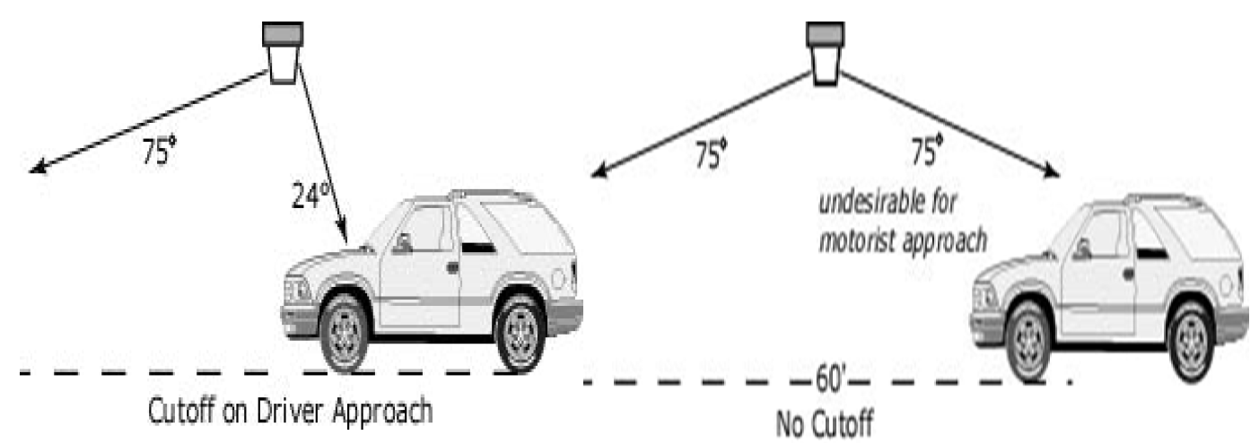
Table 1:
10.
Vehicular use areas canopy lighting.
a.
Luminaires mounted on or under canopies shall be full-cutoff fixtures or recessed so that the lens cover is flush with the bottom surface (ceiling) of the canopy, as demonstrated in Figure 2. Lighting may also be shielded by fixtures or the edge of the canopy so that light is restrained to 85° or less from vertical as shown in Figure 2. Luminaires shall not result in glare and shall meet light trespass standards applicable to adjacent properties.
b.
Lighting within six feet of the canopy shall maintain a minimum horizontal illuminance of 2.0 footcandles at ground level and shall not exceed an average horizontal illuminance of 10 footcandles, a uniformity ratio of 5:1, and a maximum uniformity ratio of 10:1.
c.
Indirect lighting where light is aimed upward at the underside of the canopy and reflected back down from the underside of the canopy may be used when luminaires are shielded so that all direct illumination is focused exclusively on the underside of the canopy and when the average vertical illuminance does not exceed 0.5 footcandles at five feet above the canopy level.
d.
Luminaires shall not be mounted on the top or sides (fascias) of the canopy when not part of a permitted sign. The sides (fascias) of the canopy shall not be illuminated in a manner other than that prescribed under the sign code.
Figure 2—Canopy Lighting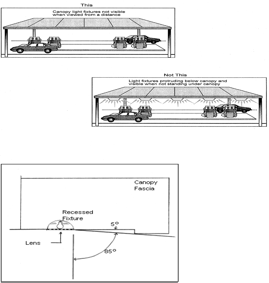
11.
Gasoline and other fuel dispensing uses.
a.
In addition to the requirements listed above for vehicular use area canopy lighting, lighting shall not exceed an average horizontal illuminance of 20 footcandles at ground level under the canopy and within an area of six feet from the edge of the canopy. Lighting shall not exceed a uniformity ratio of 5:1 and a maximum uniformity ratio of 10:1.
12.
Vehicle and automobile dealerships along Main Street north of NW 16thAvenue and along NW 39thAvenue between NE 2ndStreet and NE 10thStreet; when more than 500 feet from residential.
a.
Lighting shall not exceed an average horizontal illuminance of 50 footcandles at ground level.
F.
Lighting plan submission and review. Lighting plans demonstrating compliance with the requirements of this section must be submitted to the applicable reviewing authority for review and approval for development plan review, a building permit, or special use permit applications. Lighting plans must be certified by signature and seal of a registered architect, engineer, or lighting professional holding a current lighting certification (LC) from the National Council on Qualifications for the Lighting Profession (NCQLP) as providing illumination in accordance with the applicable standards of this section and must include the following information:
1.
A layout of all existing and proposed luminaires with location, designation, mounting height and orientation.
2.
A schedule of all fixtures that includes the following information:
a.
Fixture designation.
b.
Fixture distribution information for area lighting fixtures, such as IESNA Type III, Type IV, or Type V.
c.
Mounting height.
d.
Light source type and wattage.
3.
An illustration showing lighting levels (illuminance in footcandles) for each source of light. Separate calculations shall be performed for each area of the site, such as parking lots, building entry areas, and light trespass on receiving property boundaries. The boundary of each area shall be clearly indicated and the area shall be labeled. The calculations shall be performed on a grid at a maximum of every ten feet.
4.
A table of photometric calculations indicating, at a minimum, the following values for each area:
a.
Average, maximum and minimum illuminance.
b.
Average and maximum uniformity ratios.
c.
The ordinance section applicable to the area.
5.
Landscaping information demonstrating that the site lighting and existing and proposed landscaping have been coordinated to minimize conflict between vegetation and intended light distribution, both initially and at vegetation maturity.
6.
Topographic variations on site and any significant change in grade or elevation of the surrounding sites.
7.
A brief written narrative describing the proposed luminaires, mounting heights, control devices and schemes, applicable calculation zones, and a summary of the adjacent properties. This may be provided as notations on the lighting plan or in a separate attachment on the preparer's letterhead.
8.
Manufacturer specification sheets, cut-sheets, or other manufacturer-provided information for all existing and proposed luminaires. Photometric reports generated from manufacturer-provided IES data, where available. All components of lighting systems, including fixtures, brackets, poles, conduits, wiring, and connectors, installed within public rights-of-way must conform to the materials and installation standards of the city's utilities department (Gainesville Regional Utilities).
9.
For parking structures, the lighting plan shall include the following additional information:
a.
Minimum horizontal and vertical lighting intensities for each floor, floor ramps, entrance areas and stairways. Data may be requested for certain daylight periods.
b.
Uniformity ratios and maximum uniformity ratios for each floor, floor ramps, entrance areas and stairways. Data may be requested for certain daylight periods.
c.
The cutoff angles on driver approach and retreat.
G.
Variances. During approval of a development plan or building permit, the appropriate reviewing authority may approve a variance for one or more of the requirements of this section. The appropriate reviewing authority may approve a variance only when the applicant demonstrates, in addition to meeting all of the review criteria for a variance in article III, that the applicant is using an alternate methodology, technique, or approach that is consistent with IESNA standards and that meets the intent and purpose of the lighting ordinance. At the expense of the applicant, the appropriate reviewing authority may request an independent review by a registered architect, engineer, or lighting professional holding a current lighting certification (LC) from the National Council on Qualifications for the Lighting Profession (NCQLP).
H.
Nonconforming luminaires and lighting.
1.
A legally nonconforming luminaire or lighting installation shall be made to conform with the requirements of this section when any of the following situations applies:
a.
Minor corrective action, such as re-aiming or shielding, can achieve conformity with the applicable requirements of this section;
b.
Fifty percent or more of the existing luminaires on a property are replaced;
c.
The number of existing luminaires on a property is increased by 50 percent or more;
d.
The city manager or designee deems the nonconforming luminaire or lighting installation a safety hazard; or
e.
A development is expanded or remodeled at a cost that exceeds 50 percent of the assessed value of the site or structures as determined by the Alachua County Property Appraiser. Assessed valuation shall be determined by reference to the official property tax assessment rolls of the year of the expansion and/or remodel.
2.
A development that becomes nonconforming with this section due to a change in operational hours from daytime only to include nighttime operation shall be required to comply with these regulations within 90 calendar days of the effective date of the change.
3.
To prevent safety hazards, nonconforming luminaires and temporary luminaires that direct light towards streets or parking lots and that cause disability glare shall be either shielded or re-directed within 90 calendar days of notification by the city.
(Ord. No. 200722, § 12, 4-21-22; Ord. No. 2022-566, § 2, 1-5-23; Ord. No. 2023-527, § 1, 9-21-23; Ord. No. 2024-410, § 1, 12-5-24)
Sec. 30-6.13. - Design and maintenance.
A.
Prohibitions.
1.
No person shall change, or allow to be changed, the contour, topography, use or vegetation cover of land unless the stormwater runoff and sedimentation generated thereby are controlled in accordance with this article, except as follows:
a.
Property in actual agricultural use, excluding silviculture.
b.
Accessory home gardening and customary routine landscape maintenance.
c.
Removal of individual trees in accordance with the landscape and tree management sections of this article.
2.
No person shall discharge or alter the discharge of stormwater runoff or sedimentation from development activity into creeks, watercourses or water bodies without the consent of the applicable governmental authority.
B.
Design and maintenance standards for stormwater facilities.
1.
Design standards. Stormwater management facilities shall be designed and constructed in accordance with this article and the Design Manual.
a.
General standards.
i.
All drainage facilities shall provide a positive outfall to existing watercourses, water bodies, wetlands or storm sewer systems unless it can be proven that it is a closed system.
ii.
The property owner is fully responsible for compliance with all rules, regulations and requirements of the county, the applicable water management district, the state department of environmental protection, the U.S. Army Corps of Engineers, and the United States Environmental Protection Agency.
iii.
All basins designed to be dry shall drain completely within 72 hours of the storm event. Designs providing for longer drainage periods require approval by the city manager or designee.
iv.
All development shall provide on-site stormwater quality treatment for the first one inch of stormwater runoff, except as provided in subsection e. of this section. Infill residential development within improved residential areas or subdivisions existing prior to November 18, 1991, shall ensure that its post-development runoff will not contribute pollutants that will cause the runoff from the entire improved area or subdivision to degrade receiving water bodies and their water quality.
v.
All development shall have on-site stormwater quantity control designed for the 100-year critical duration storm, except as provided otherwise in this section. A detention system shall be provided that will permit a controlled outlet to receiving watercourses. The system shall be designed so that the peak flow of stormwater off of the site, assuming full development, shall not exceed the natural flow from the lands prior to the subdivision or any development, based on the 100-year critical duration storm.
vi.
The type, intensity and structural design of any development proposed for a site shall be appropriate to the existing natural topographic characteristics of the site, while recognizing that minimal grade changes are essential to site development. Avoid disturbing steep slopes. Use terracing and diversions when disturbance of slopes is unavoidable. Slopes created by fill for other than landscape or buffering purposes shall be not steeper than three to one and shall be stabilized by vegetation or other approved methods. Excessive erosion of any cut or fill slope shall require remediation by the property owner.
vii.
Drainage facilities designed within a closed system shall be evaluated on a site-specific basis with the minimum design criteria being the 100-year critical duration storm event.
viii.
All stormwater basins shall be landscaped in such a manner as to promote safety and to integrate the basin with the overall design of the site.
ix.
The contour of retention and detention basins should promote aesthetically pleasing site design and increased wildlife habitat.
x.
The Design Manual shall include guidelines for the design and operation of facilities that discourage the breeding of mosquitoes.
xi.
The design of retention and detention basins shall promote joint uses for habitat, open space, passive recreation, and the establishment and integration of trails.
xii.
Stormwater management facilities shall be designed to minimize the need for maintenance in accordance with the Design Manual.
b.
Erosion and sedimentation control. The city may require the developer to limit clearing and grubbing outside the proposed developed area to the site, control erosion and sedimentation during and after construction, stabilize cleared areas, limit stockpiles, protect stormwater inlets during construction, control construction access routes, remove temporary control systems after construction, and limit the placement of gutters and drains. Wherever construction vehicle access routes intersect paved public roads, provisions shall be made to minimize the transport of sediment (mud), concrete and other construction materials onto the paved surface (through runoff or vehicle tracking). Materials reaching the paved surface shall be removed from the paved surface at the end of each day. Removal shall be by shoveling or sweeping, and the materials shall be transported to a sediment-controlled disposal area.
c.
Hogtown Creek Basin.
i.
Within the Hogtown Creek Basin, systems shall be designed to retain any increase in volume of runoff over the predevelopment volume for a 72-hour period.
ii.
The state Department of Transportation, Standards for Road and Bridge Construction, latest edition, and the state Department of Transportation, Roadway and Traffic Design Standards for Design, Construction, Maintenance and Utility Operations for Streets and Highways on State Maintained Systems, latest edition, shall be applied where standards are not specifically addressed in this chapter or in the Design Manual.
d.
Master stormwater basins. The requirements for stormwater quantity and quality as listed above may be satisfied by a master stormwater plan serving several properties. An easement shall be provided between participating landowners. The easement shall be recorded in the public records of the county and submitted to the city prior to the issuance of any development permit. Any development proposed for consideration using an existing or planned master stormwater basin shall provide the calculations and documentation necessary to establish the right to use the facility and that the contribution of stormwater runoff of the proposed development will be within the design parameters of the master basin. A maintenance agreement among all the property owners that conforms to the provisions of this section shall be executed subject to the approval of the city attorney as to form and legality and recorded in the public records of the county.
e.
Off-site stormwater management facilities. A development may use an off-site stormwater management facility to meet the applicable stormwater quality or quantity standards required by the Design Manual.
f.
Redevelopment of vehicular use area or building. For the purposes of this section, redevelopment is any demolition or reconstruction of the vehicular use area (excluding resurfacing and restriping) or building. Any proposal for a site on which the proposed redevelopment of building(s) or vehicular use area involves the demolition and reconstruction of more than 80 percent of the area devoted to existing building and vehicular use area shall be considered new development, and shall be required to meet the standards for new development. This determination shall be made by the city manager or designee. All redevelopment of a particular lot or site governed by a final development order shall be cumulative from June 10, 1992. Redevelopment shall conform to the following standards with regard to required facilities:
i.
Less than 4,000 square feet. Any redevelopment of existing impervious surfaces of a site of less than 4,000 square feet shall only require the continued maintenance of existing facilities, including natural areas that provide storage. No additional stormwater management shall be required, except that all development shall be in compliance with all state and water management district requirements.
ii.
4,000 square feet or more. Any redevelopment of existing impervious surface of 4,000 square feet or more shall be designed to accommodate stormwater quality treatment for the first one-half inch of runoff from the proposed improvements in the disturbed area. The city manager or designee may allow the design engineer to retain the first one-half inch of runoff from an area of equal size as the disturbed area provided that it can be proven that there would be greater water quality benefits to the receiving surface water of equal size. Stormwater management facilities, including natural areas that provide storage, shall continue to be provided. All development shall be in compliance with all state and water management district requirements.
g.
Subdivision of property. A complete stormwater system in conformance with the flood control provisions of this article shall be provided for all areas of the subdivision for managing stormwater runoff and providing water quality treatment within or across subdivision lands. Soil borings shall be taken to establish soil type and percolation rate. The Design Manual shall provide guidelines for determining the appropriate number and location of soil borings. Full development shall be assumed for selection of proper runoff coefficients. The system shall be designed, in accordance with the Design Manual, to accomplish the following results:
i.
Closed conduits. A system of closed conduits (except where open ditches are specifically permitted by the city commission) shall be provided to collect and channel stormwater in such a fashion as to permit the unimpeded use of public roads during a rainstorm of the maximum intensity predicted for the city area at ten-year intervals.
ii.
Flood routing. A route for stormwater runoff shall also be provided that will function, when the system designed to handle the ten-year, 24-hour storm has reached its capacity, so as to prevent flooding (water over the curb level) and ensure access for emergency vehicles during a ten-year, 24-hour storm event.
iii.
Detention/retention system. A detention/retention system shall be provided that will permit a controlled outlet to receiving watercourses. The system shall be designed so that the peak flow of stormwater from the subdivided lands, assuming full development, shall not exceed the natural flow from the lands prior to the subdivision and any associated development based on the 100-year critical duration storm.
iv.
Roadside swales. Roadside swales may be provided in lieu of curb and gutter as long as all the specific requirements of this article and the Design Manual can be met.
v.
Open drainageways. Open drainageways (ditches) shall not be permitted in or within 100 feet of any residential district or any land in actual use or zoned for use as a school, unless it can be established to the satisfaction of the city commission that the open drainageway will appear and function as a natural watercourse and will not require significant maintenance. Any permitted open drainageway shall be designed so as to present no unreasonable hazard to life, the health of the public and nearby property residents and so as to be protected against scour and erosion.
C.
Acceptance of facilities. Acceptance of facilities for dedication to the public shall be in accordance with the conditions and procedures pertaining to subdivision review.
D.
Intergovernmental coordination. Copies of all water management district, state department of transportation, state department of environmental protection, and county permits and permits of any other applicable agency with jurisdiction shall be required prior to commencement of any development.
E.
Inspections.
1.
The engineer of record shall file as-built plans with the public works department upon completion of any improvements for which changes have been approved during the construction process.
2.
The city shall periodically inspect stormwater control facilities and shall inspect upon complaint to determine that such facilities are operating and being maintained as designed.
Sec. 30-6.14. - Centralized water and wastewater facilities.
All property within the city shall be subject to the following requirements. These requirements do not lessen or exempt compliance with any other section of the Code of Ordinances where the regulations may be more stringent.
A.
Exemptions. The following exemptions to the requirements for mandatory hookup to the centralized water and wastewater systems shall apply, unless more stringent code requirements apply:
1.
Development on lots in platted subdivisions and other legal lots of record that existed as of June 10, 1992, shall be exempt, unless there are existing distribution or collection facilities in the right-of-way or easements abutting the property.
2.
Developments that provide temporary package wastewater plants shall be exempt, but only to the extent provided for in section 30-6.15.
B.
Centralized water systems. Developments that require potable water shall connect to the city's centralized potable water system when equivalent residential densities are greater than two units per acre. Equivalent residential density shall be calculated using peak daily demand as estimated for level of service purposes as indicated in article VI, division 1.
C.
Centralized wastewater systems. Developments that require wastewater treatment shall connect to the city's centralized wastewater treatment system when equivalent residential densities are greater than two units per acre. Equivalent residential density shall be calculated using peak daily demand as estimated for level of service purposes as indicated in article VI, division 1.
D.
Septic tanks or on-site disposal systems for nonresidential development. Any nonresidential development proposing the use of a septic tank or on-site disposal system shall demonstrate that toxic, hazardous or industrial waste will not be disposed of in the septic tank or on-site disposal system.
Sec. 30-6.15. - Package wastewater plants.
If there are no existing wastewater collection facilities, a development may install a new, temporary package wastewater plant for the treatment of wastewater, provided the plant meets all of the following criteria:
A.
All relevant state and federal standards for package wastewater plants shall be met.
B.
The development shall connect to the central wastewater treatment facilities within five years after central wastewater facilities become available to the development.
C.
The developer of such temporary package treatment plant shall enter into a legally binding agreement that dedicates and assigns responsibility for the proper maintenance and operation of the plant to an appropriate agency of local government, and which provides adequate compensation by the developer to the local government for the proper operation and maintenance of the plant.
D.
The package plant shall be approved by the appropriate government agency assigned plant operation and maintenance as meeting standards for design, operation and maintenance.
Sec. 30-6.16. - Industrial pretreatment plants.
The city shall allow industrial pretreatment plants for the processing of industrial wastewater. Such industrial pretreatment plants shall be in conformance with the requirements of section 27-182.
Sec. 30-6.17. - Streets.
A.
Public and private streets. The design standards for streets are contained in the Design Manual or standards from other agencies as referenced in the manual.
B.
Private approved streets. Each private approved street in a minor subdivision shall meet the following requirements:
1.
An approved private street shall be paved to a minimum width of 12 feet wide for one-directional traffic flow and 18 feet wide for two-directional traffic flow. Alternatively, a determination shall be made by the city public works department, the city fire rescue department, and city solid waste department that the approved private street is adequate to support service vehicles as necessary to provide municipal services.
2.
The structure and sub-base of the approved private street shall meet the standards set forth in the Design Manual.
3.
Each approved private street shall be connected directly to a public street or to another approved private street that connects directly to the major public road network. The method and type of connection shall be subject to approval by the public works department in accordance with the standards set forth in the Design Manual. The private street serving the subdivision shall have a maximum length of 1,000 feet (measured by traversing the length of the approved private street from its farthest extent to the nearest public street). When the private street reaches 1,000 feet in length, the subdivision shall include one of the following, as determined by the city fire rescue department: 1) appropriate emergency connection to the nearest public road, if such a connection can be made on property within the minor subdivision, or 2) a turnaround sized to accommodate fire and rescue vehicles.
4.
The owners of each approved private street shall provide necessary easements to the city for the purpose of providing municipal services. Alternatively, if the city finds the street serves a valid public purpose, the owners may gratuitously dedicate an approved private street for purposes of public right-of-way.
5.
Lots created on an approved private street shall be designed to minimize the number of curb cuts onto the street. Shared driveway access shall be required of adjoining lots, except where an odd number of lots are created, in which case, one lot, as determined by the public works department, may be allowed to have a separate driveway.
6.
Approved private streets shall provide a sidewalk having a minimum width of five feet. The sidewalk shall be provided on one side of the street in accordance with standards of the Design Manual. Where five feet of pavement is not possible due to a natural or permanent man-made obstruction, the pavement width may be decreased to a minimum of three feet as necessary to avoid the obstruction. If paving is not possible due to natural conditions, a minimum three-foot wide stabilized pedestrian trail shall be constructed.
7.
All proposed minor subdivisions shall meet the level of service standards in the Comprehensive Plan. Proof of meeting these standards shall exist in the form of a certificate of concurrency exemption, certificate of preliminary concurrency or certificate of conditional concurrency reservation. The approval of a nonresidential minor subdivision in no way reserves capacity for the purposes of concurrency.
C.
Culs-de-sac or dead-end streets. Culs-de-sac shall not exceed 250 feet, except where alternative emergency service access is available. Where emergency service access is available, dead-end streets or cul-de-sacs shall not extend beyond 1,000 feet. Pedestrian connections shall be provided to these streets in order to shorten walking distances.
Sec. 30-6.18. - Sidewalks and shared-use bicycle paths.
A.
Intent. The intent of this section is to enable pedestrian activity throughout the city, especially as a means to promote pedestrian and transit trips, pedestrian safety and accessibility. Sidewalks are required in conjunction with development orders in every zoning district. This shall apply on any parcel or lot where a roadway is existing adjacent to the proposed development or where there is a reasonable likelihood of mass transit service or a pedestrian need for sidewalks. Sidewalk(s) are required on both sides of all public and private streets, except as otherwise provided in this section.
B.
Schools. Public and private schools shall meet the design guidelines of Safe Routes to School. Sidewalks and bikeways adjacent to the site shall be extended to appropriate walkways around buildings and bicycle storage areas.
C.
Sidewalks are required on both sides of all streets at least five feet in width, except as otherwise provided in this section. Whenever a sidewalk intersects with a curbed street, ramps shall be installed to facilitate access to the sidewalks by wheelchairs.
1.
A shared-use bicycle path shall be provided in a subdivision wherever designated on the officially adopted trail network plan for the city. Also, subdivisions containing a proposed trail network corridor shall provide a shared-use bicycle path and sidewalk system that integrates or links the subdivision with the trail network.
D.
Responsibility for construction. The installation of sidewalks is the responsibility of the developer/owner and the sidewalks shall be installed prior to the issuance of a certificate of occupancy by the city. For a phased development, sidewalk(s) shall be completed to serve any area for which a certificate of occupancy or any temporary occupancy is required. The developer/owner shall only be responsible for the sidewalk on the same side of the street(s) on which the approved plan is adjacent, except as specifically modified in this section.
E.
Design standard. Sidewalk(s) and ramp(s) shall be constructed in accordance with the Design Manual.
F.
Payment in lieu of sidewalk construction for single-family/duplex dwelling infill development. The appropriate reviewing authority may allow an owner/developer to make payment into a designated sidewalk fund in lieu of constructing required sidewalks for infill development of single-family or duplex dwelling(s).
1.
Payment in lieu of sidewalk construction is allowable only when the appropriate reviewing authority determines that sidewalk construction is not practical or feasible based on one or more of the following criteria:
a.
Construction would result in an isolated sidewalk segment disconnected from the existing or proposed sidewalk system;
b.
Construction would result in significant negative environmental impacts to resources including heritage trees, wetlands, or required buffers;
c.
Construction would require extensive alterations to existing drainage systems or extensive soil removal or fill; or
d.
Construction would require extensive removal or relocation of utilities or other significant physical obstructions.
2.
Payments under this subsection must be: 1) calculated based on market cost pursuant to the current FDOT Historical Item Average Cost Report - Statewide 12-Month Moving Average; and 2) collected, administered, and used as part of the city's Transportation Mobility Program Area (TMPA) for the applicable TMPA zone of the subject property, and must be used for sidewalk infrastructure nearest to the subject property to the extent practical or feasible.
3.
Payments should be used to improve sidewalk infrastructure in the following order of priority: 1) within the neighborhood from which the fee originates; 2) on the perimeter of the neighborhood from which the fee originates; and 3) within neighborhoods with activity centers that are proximate to the neighborhood from which the fee originates.
G.
Dedication. In conjunction with the owner/developer's installation of any required sidewalk(s) along a street, the sidewalk shall be constructed within existing right-of-way or, if insufficient space exists within the right-of-way, the sidewalk area shall be dedicated to public use in a form acceptable to the city attorney.
H.
Modifications. The appropriate reviewing authority may approve modifications from the terms of this section as follows:
1.
The appropriate reviewing authority shall require the petitioner to provide information in the form of reports, maps, diagrams, and similar material to support their request for modification.
2.
The appropriate reviewing authority may determine the appropriate location or termination of sidewalks, or determine that a portion of a sidewalk may be narrowed to the minimum extent necessary to meet the requirements of this section.
3.
The applicant shall demonstrate that conditions and circumstances, which do not result from the actions of the developer, warrant modification of the sidewalk requirements. In reaching its decision, the appropriate reviewing authority shall consider the following:
a.
Protection of heritage trees; and
b.
Excessive slope or other topographic or geological features.
(Ord. No. 170831, § 7, 4-5-18; Ord. No. 2022-680, § 1, 4-20-23)
Sec. 30-6.19. - Access management.
A.
Access to residentially zoned properties.
1.
No residentially zoned land shall be used for driveway, walkway or access purposes to any land that is non-residentially zoned or that is used for any purpose not permitted in a residential district or that is shown on the future land use map of the Comprehensive Plan for solely non-residential use, except for ingress and egress to a use that was existing on October 26, 1981, on land that does not abut a public street.
2.
Entrances to dwelling units in the RMF-5, RMF-6, RMF-7, RMF-8 districts shall be 15 feet or greater from any access road or driveway.
3.
Minor improvements, such as ramps and landings, that are intended to provide access for a handicapped resident shall be permitted by right within the required yard of any existing single-family dwelling, two-family dwelling and three-family dwelling.
B.
Access to non-residential uses.
1.
Where a parcel of property used for nonresidential use in any business, office, industrial or mixed-use district abuts more than one street, access from either street to such property shall be permitted only if no property in any SF or RC residential district or shown for single-family residential use on the future land use map of the Comprehensive Plan lies immediately across such street from such office-zoned property; provided, however, access may be permitted from any major collector or arterial as shown on the official roadway map; and provided, further, that one point of access shall be permitted in any case, notwithstanding other provisions of this subsection.
2.
Access to shopping centers shall be in accordance with the provisions of this article, chapter 23 of the Code of Ordinances, and the Design Manual. Areas used by motor vehicles shall be physically separated from public streets by landscaped buffer areas.
C.
Bicycle, greenway and pedestrian access. Provisions shall be made to safely incorporate travel ways for bicycle and pedestrian usage into development and redevelopment projects extending to adjacent properties. Where bikeways, greenways or sidewalks are presently adjoining the property, provisions shall be made to safely link the internal bicycle and pedestrian system with adjoining facilities. During development plan review, the appropriate reviewing authority shall also review the relationship of the mixed-use development to adjoining properties and may require appropriate access for bicycles or pedestrians at locations where vehicular access is prohibited.
(Ord. No. 170831, § 8, 4-5-18; Ord. No. 2024-263, § 14, 10-3-24)
Sec. 30-6.20. - Driveways.
All driveways constructed or removed within the city limits shall be constructed or removed as provided for in this section and chapter 23 of the Code of Ordinances.
A.
Unauthorized construction, curb-cutting declared unlawful. It shall be unlawful for any person to construct, cut, break-out or remove any curb along a street or alley except as authorized by the provisions of this article.
B.
Permit.
1.
Required. No person shall remove, alter or construct any curb, driveway, gutter or pavement or perform any other improvement on any public street or designated street right-of-way without obtaining a permit authorizing the activity from the appropriate governmental entity (the state department of transportation for roads on the state highway system, the county for roads under county maintenance, or the city for all other roads).
2.
Fees. Fees for city permits shall be according to the schedule set out in appendix A and shall be paid to the city by the person to whom the permit is issued at the time it is issued.
3.
Posting at site. The driveway permit shall be posted at the construction site.
C.
Submission of plans; information required.
1.
No driveway permit shall be issued except in compliance with this chapter. In the event that the proposed construction does not require development review under this chapter, then a copy of the plans showing the location and dimensions of all proposed improvements shall be filed with the public works department and the traffic engineering department. Plans are not required for single-family zoned property or single-family uses. All applications for driveway permits shall include information as to whether the driveway will connect to a road on the state highway system or is on a county-maintained street.
2.
Additional plans shall be submitted to the state department of transportation or the county for driveways connecting on the state highway system or county-maintained streets. All plans submitted for driveways on the state highway system shall meet state department of transportation submittal requirements including those in Chapters 14-96 and 14-97, Florida Administrative Code as amended from time to time. All plans submitted for driveways connecting on county-maintained streets shall meet the county's submittal requirements.
3.
Information required on plans submitted shall include:
a.
A complete plot plan showing all proposed buildings and parking layouts, including north arrow and date.
b.
Existing and proposed driveway locations and widths.
c.
Street pavement types and widths and right-of-way widths.
d.
Proposed location of off-street loading and unloading facilities, interior parking arrangements, and traffic circulating patterns.
e.
Retaining walls, drainage, utility poles, trees and other physical features that affect the driveway location.
f.
Driveways on adjacent properties and/or on opposite side of the street.
g.
The state road number, county road number or local road name, the existence and location of any existing and/or proposed public or private roads (proposed public roads as shown in the state department of transportation five-year transportation improvement plan or the city or the county five-year capital improvement plans) abutting or entering the property, and the horizontal and vertical curvature of the roads.
h.
Any additional information required by the state department of transportation or the county for roads under their permitting authority.
D.
Design considerations.
1.
State department of transportation design and construction standards shall be met for driveways on the state highway system.
2.
County design and construction standards shall be met for driveways under county road maintenance.
3.
In addition to state department of transportation or state county design standards, all city requirements shall be met unless they are superseded by state department of transportation or county standards. The city design standards and all other city requirements shall be met for all city-maintained streets or alleys.
4.
The choice of the proper location for access facilities (driveways) shall involve consideration of the amount of conflict that can be expected both within the parking area and on the abutting streets. One primary concept that shall be followed is to reduce the number of connections to a practical minimum, thus providing fewer locations where conflicts may occur. The city manager or designee may require stub outs to adjacent properties for future cross-access.
5.
The area to which the driveway provides access shall be of sufficient size to allow all necessary functions for loading, unloading and parking maneuvers to be carried out on private property and completely off the street right-of-way.
6.
Driveways shall be constructed to conform to the existing paved street grade or grade approved by city engineer for nonpaved streets.
7.
Parking areas shall be so designed and marked as to provide for orderly and safe movement and storage of vehicles:
a.
Back-out parking onto a public street and/or highway shall not be permitted unless in the opinion of the city manager or designee the parking does not present any unexpected hazard to roadway users with respect to roadway design considerations (e.g. visibility, road width, maintenance of utilities, traffic control devices).
b.
The minimum distance from the street right-of-way line at any ingress or egress driveway to any interior service drive or parking space with direct access to the driveway shall be 20 feet.
c.
The minimum distance from the street right-of-way line on any major ingress or egress driveway to any interior service drive or parking space having direct access to such driveway shall be 100 feet. A major driveway is defined as the main ingress or egress point to a public street or highway from a site of a major development such as a shopping center, multiple-family development, industrial park, etc.
d.
Six-inch standard curb or similar barrier shall be installed along the driveway from the street right-of-way line to the first interior service drive or to and including the first interior parking space described in subsections b. and c. above. Material other than concrete or asphalt curb may be used if approved by the city engineer and chief code enforcement officer or building official.
8.
Driveways shall be laid out to intersect the street as nearly as possible at right angles (ninety (90) degrees) and no driveway shall intersect any street at less than seventy-five (75) degrees, unless no other access is possible and the alternate access design is approved by the city traffic engineer. Driveways at or near street intersections or driveways from other sites that cannot be aligned shall be offset no less than one hundred fifty (150) feet from each other. In order for a driveway to be offset less than one hundred fifty (150) feet the applicant shall demonstrate to the satisfaction of the city traffic engineer that extraordinary need and/or circumstances exist such as insufficient frontage width or existing natural features which preclude driveway installation.
9.
Driveways serving major developments, as defined in this chapter, shall not be located closer than 300 feet from the intersection of arterial and/or collector streets. The petitioner shall demonstrate hardship to the city traffic engineer or the city traffic engineer shall determine that special engineering design considerations exist for driveways serving major developments to be located closer than 300 feet to the intersection of arterial and/or collector streets.
E.
Specifications generally; costs for city-maintained roadways.
1.
The public works department shall prepare, maintain and update a Design Manual that provides design and construction specifications for driveways, curb cuts, curbs and other pavement on city-maintained roadways and rights-of-way.
2.
All driveways shall be hard-surfaced in conformance with the applicable standards and specifications.
3.
Driveways shall cross the sidewalk area at the sidewalk grade established by the city engineer.
4.
Driveways shall be constructed as nearly to a right angle to the street or roadway as possible.
5.
Where special pedestrian and vehicular hazards may be encountered, driveways may be restricted to a one-way operation. Proper signs giving notice to the restricted use of driveways shall be erected and maintained by the person having control over the driveways. Failure to erect such signs and failure to use such driveways in accordance with the proper signs shall be a violation of this article.
6.
All costs of any change proposed in any physical improvements originally installed by the city and all costs of the installation of any driveway or necessary signing shall be borne by the property owner.
7.
All costs and responsibilities for maintenance and/or repair of any driveway or related signing shall be borne by the property owner.
F.
Number and location of driveways. In order to maximize traffic safety and highway capacity, provide reasonable ingress and egress to property, and adhere to the concepts of access management as stated in Florida Statutes and regulated by the state department of transportation, the number and location of driveways shall be regulated as follows:
1.
One driveway shall be permitted for ingress and egress to a lot, except:
a.
Where joint-use driveways, shared-access or cross-access drives are approved by the development review board or city plan board under development plan review in accordance with this chapter; or
b.
Where property zoned and in use for a detached single-family dwelling or two-family dwelling abuts a local street.
2.
Two driveways shall be permitted for ingress to and egress from a lot provided:
a.
All other requirements of this article are met;
b.
The minimum distance between the two driveways equals or exceeds 20 feet as measured from inside edge to inside edge of the driveways at the property line; and
c.
The applicant demonstrates to the city traffic engineer sufficient need, such as delivery of emergency services, one-way driveway, physical features unique to the site, and/or loading/unloading requirements, to justify two driveways.
3.
More than two driveways shall be permitted for ingress and egress to a lot provided:
a.
All other requirements of this article are met and exceptional circumstances exist that cannot be mitigated, in the judgment of the city traffic engineer, unless more than two driveways are provided; or
b.
Where the lot meets the following three thresholds:
i.
The lot exceeds ten acres in total land area;
ii.
The lot has more than 1,000 automobile parking spaces; and
iii.
Whenever more than two driveways are permitted, the minimum distance between driveways meets or exceeds 300 feet as measured from centerline to centerline of the driveways at the property line.
4.
The number and location of driveways on the state highway system are regulated by the state under Chapters 14-96 and 14-97, Florida Administrative Code, as amended from time to time.
5.
If development on any city street impacts the operation of any road on the state highway system, the regulations set forth in Chapters 14-96 and 14-97, Florida Administrative Code, as amended from time to time shall apply.
G.
Driveway types.
1.
All driveways on the state highway system or on county-maintained streets shall meet the relevant requirements of the appropriate governmental entity.
2.
All driveways on city-maintained roadways shall be the standard ramp-type driveway construction except that street-type entrances may be permitted from major thoroughfares into the major entrances of planned shopping centers, large industrial developments, apartment complexes and drive-in theaters that have parking areas for 300 or more vehicles.
H.
Width of driveways having access to city-maintained roadways.
1.
Ramp-type driveways.
a.
The width of a ramp-type driveway shall be within the minimum and maximum limits as specified below:
b.
All driveway widths shall be measured at the street right-of-way line.
c.
For single-family residential driveways, the width of the curb opening shall not be less than 16 feet measured from the outside edge to outside edge of the curb transition (T).
d.
For all other ramp-type driveways the width of curb opening shall not exceed the driveway width by more than three feet on each side.
2.
Street-type driveways. The width of street type driveways shall be within the minimum and maximum limits as specified below:
I.
Prohibited locations; installation of curb stops.
1.
No driveway shall be constructed in the radius return of an intersection.
2.
No driveway shall be constructed nearer than 25 feet from the intersection of street right-of-way lines.
3.
All driveways shall be constructed with a minimum setback distance of five feet from any interior property line, and with a two-foot minimum offset from the property line at the roadway connection. These offsets may be reduced for single-family residences at the recommendation of the city traffic engineer.
4.
To prevent vehicle overhang on private property in the vicinity of the driveway, parking areas and loading areas, a six-inch raised curb and/or parking stops shall be constructed a minimum distance of three feet inside the street right-of-way line or property line.
5.
No driveway shall be permitted to include any municipal facility such as traffic signal standards, catchbasins, fire hydrants, utility poles, fire alarm supports or other similar type structures.
6.
To prevent parked vehicles from intruding or overhanging landscaped areas, sidewalks or critical drainage retention areas, the city engineer or city traffic engineer may require the construction of a six-inch raised curb and/or similar barrier to protect such areas.
J.
Work to be performed by bonded contractors; requirements of bond. All work of removing any curb and building of any driveway shall be done by a licensed contractor having in force a current contractor's bond in an amount equal to or greater than three times the estimated cost of the proposed work. This bond shall be for a period of three years and shall be renewed each year at the time the contractor obtains his/her business tax receipt.
K.
Type of construction for driveways on city-maintained roadways.
1.
All nonresidential driveways shall be constructed of six-inch thick concrete with steel reinforced matting from the edge of the curb or pavement to at least the property line. The driveway shall extend a sufficient distance from the pavement so that the rise of the drive will be at least six inches above the level of the gutter or pavement with the minimum distance being the property line.
2.
Residential driveways shall be concrete as specified above or may be of type III asphalt, one and one-half inches thick, depending on the existing stormwater facilities, subject to review by the public works department.
3.
Exceptions to the concrete requirement for nonresidential driveways may be made at the discretion of the public works department.
L.
Minimum thickness of concrete; specifications for concrete. All driveways shall be constructed in accordance with the Design Manual.
M.
Alteration of existing driveways; unnecessary driveways.
1.
Existing driveways shall not be relocated, altered or reconstructed without a permit approving the relocation, alteration or reconstruction, and the driveways shall be subject to the provisions of this article.
2.
When the use of any driveway is changed, making any portion or all of a driveway unnecessary, the owner of the abutting property shall, at his/her expense, replace all necessary curbs, gutters, sidewalks and grass areas in accordance with the Design Manual.
N.
Review and approval. All driveways hereafter constructed in the city on street rights-of-way shall be reviewed and approved by the appropriate city department prior to the issuance of any building permit for the erection, construction, reconstruction or change in the use of the building, structure or land. This provision shall not apply to single-family residential zoned property or for single-family uses.