
Glenwood Springs City Zoning Code
ARTICLE 070
020 - ZONING DISTRICTS
070.020.010 - General Provisions.
(a)
Zoning Districts Established. Table 020.1 lists the zoning districts established by the City's adoption of the Official Zoning Map.
(b)
Official Zoning Map.
(1)
Incorporation of Map.
a.
The location and boundaries of the zoning districts established by this Code are shown on the official "Zoning District Map of the City of Glenwood Springs" ("Official Zoning Map") which is incorporated into this Code.
b.
The zoning district map shall be identified by signature of the Mayor, shall be attested by the City Clerk, and shall bear the seal of the City and the date of adoption.
c.
The zoning district map shall be located in the office of the Director.
(2)
Zoning District Boundaries.
a.
Except where otherwise necessary, zoning district boundaries shall follow the City's corporate limits, section lines, lot lines, right-of-way lines, or extensions of such lines.
b.
Where a zoning district boundary divides a lot or parcel, the location of such boundary, unless indicated by dimension, shall be determined by the scale of the zoning district map by the Director.
c.
Where a zoning district boundary coincides with a right-of-way line and that right-of-way line is abandoned, the zoning district boundary shall then follow the centerline of the former right-of-way.
d.
Land that is not part of a public railroad or utility right-of-way and that is not indicated as being in any zoning district shall be considered to be included in the most restrictive adjacent zoning district even when such zoning district is separated from the land in question by a public railroad or utility right-of-way.
(3)
Boundary Clarification. In the event that a zoning district boundary is unclear or disputed, the Director shall determine the location of the boundary. Such determination is subject to an appeal to the City Council pursuant to Subsection 070.060.070(c), Appeal of Administrative Decision.
(4)
Amendments to the Map. Amendments to the boundary of any zoning district shall require a rezoning pursuant to Subsection 070.060.040(a), Rezoning, and shall promptly be entered on the zoning district map. A list of rezoning ordinances with number and date shall be kept on file in the office of the Director.
(c)
Organization of the Zoning Districts in this Article.
(1)
Base Zoning Districts.
a.
Sections 070.020.030 through 070.020.170 follow a common structure for describing the purpose and intent for each base zoning district, the applicable dimensional standards, and any district-specific standards.
b.
Each base zoning district includes an illustration demonstrating the dimensional requirements for that district. The illustrations are not intended to represent a specific location, but rather reflect the general character of the district.
c.
Each base zoning district includes a table of dimensional standards summarizing the most pertinent dimensional standards applicable to each district. The labels in the table correspond to the applicable illustration. These tables are illustrative only and do not identify all standards that may apply to a particular development.
d.
Each base zoning district also contains a table cross-referencing other applicable key standards such as uses allowed in the district and the general and specific standards applicable to all development. These tables are illustrative only and do not identify all standards that may apply to a particular development.
(2)
Planned Unit Development. The Planned Unit Development District in Section 070.020.190 describes the applicable standards for that district. Establishment of a Planned Unit Development follows the procedures in Subsection 070.060.040(b), Rezoning to PUD.
(Ord. No. 19-2018, § 2(Exh. A), 8-2-2018; Ord. No. 9-2023, § 2, 10-26-2023)
070.020.020 - Summary of Dimensional Standards.
(a)
Residential Districts.
(b)
Mixed-Use and Commercial Districts.
(c)
Other Nonresidential Districts.
(Ord. No. 19-2018, § 2(Exh. A), 8-2-2018; Ord. No. 3-2021, § 2(Exh. A), 5-20-2021; Ord. No. 15-2023, § 2(Exh. A), 10-5-2023; Ord. No. 13-2024, § 2(Exh. B), 7-18-2024)
070.020.030 - Rural Residential (RR) District.
(a)
Purpose. The RR district is intended to accommodate very low-density, large-lot single-family residential uses with some limited agricultural uses. The district is intended to provide a transition between surrounding rural lands in the County on large parcels of land and more urbanized areas.
Figure 020-1: RR District Dimensional Standards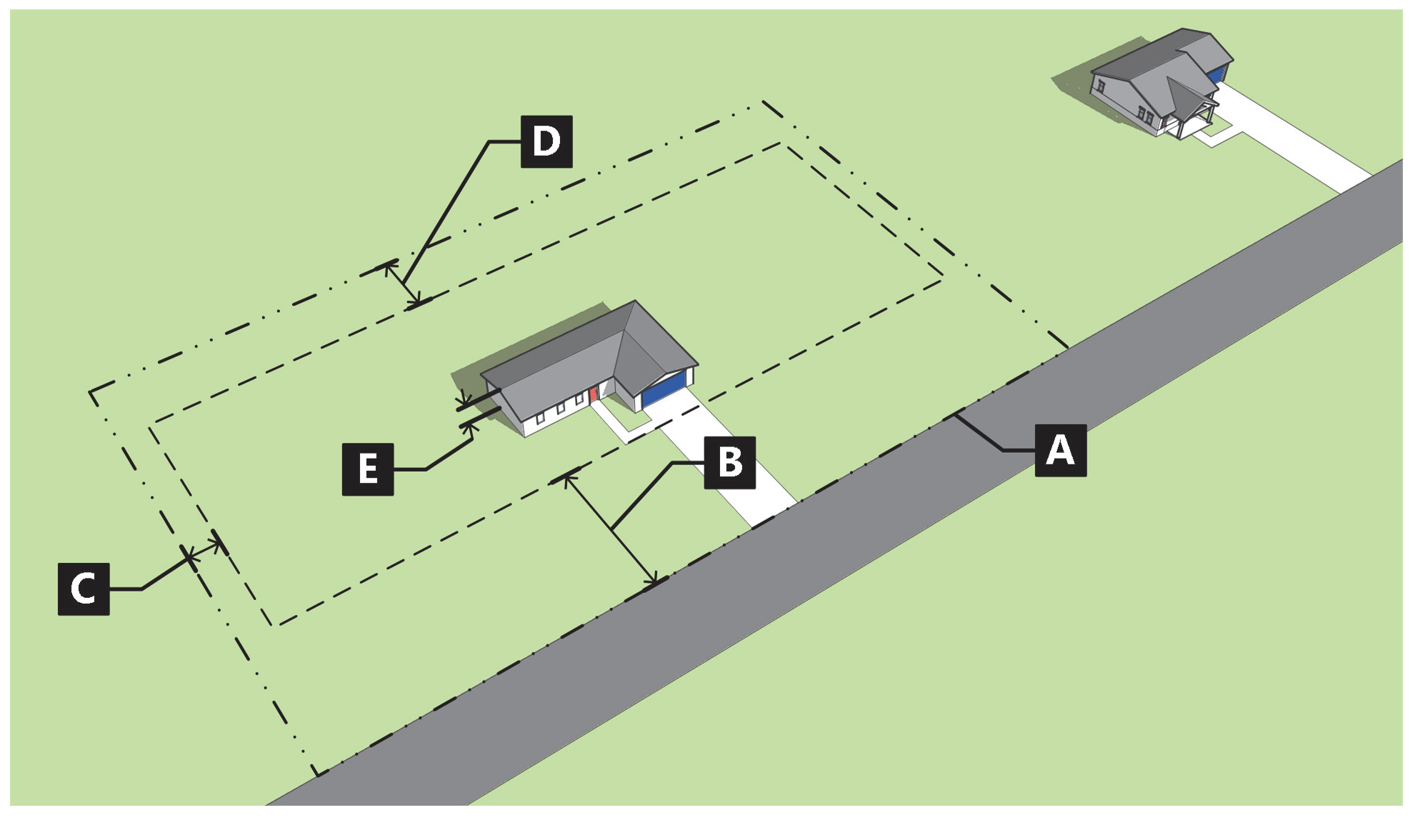
(b)
Standards.
(Ord. No. 19-2018, § 2(Exh. A), 8-2-2018; Ord. No. 9-2023, § 2, 10-26-2023)
070.020.040 - Residential Low-Density (RL) District.
(a)
Purpose. The RL district is intended to accommodate low-density, primarily single-family residential uses. The RL district can be used as a transitional district between large-lot rural development and medium-density residential neighborhoods.
Figure 020-2: RL District Dimensional Standards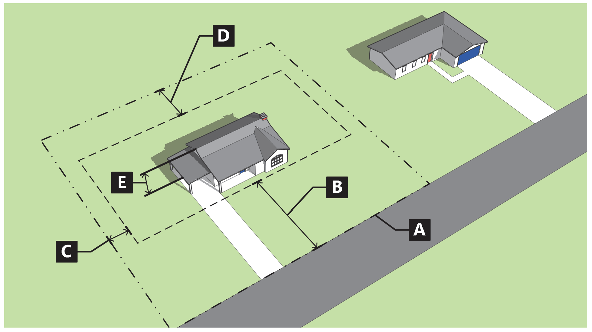
(b)
Standards.
(Ord. No. 19-2018, § 2(Exh. A), 8-2-2018; Ord. No. 9-2023, § 2, 10-26-2023)
070.020.050 - Residential Medium-Density (RM1) District.
(a)
Purpose. The RM1 district is intended to accommodate medium-density, primarily single-family uses on smaller- to medium-sized lots. The RM1 district is intended to transition from low-density single-family residential districts to multifamily development districts.
Figure 020-3: RM1 District Dimensional Standards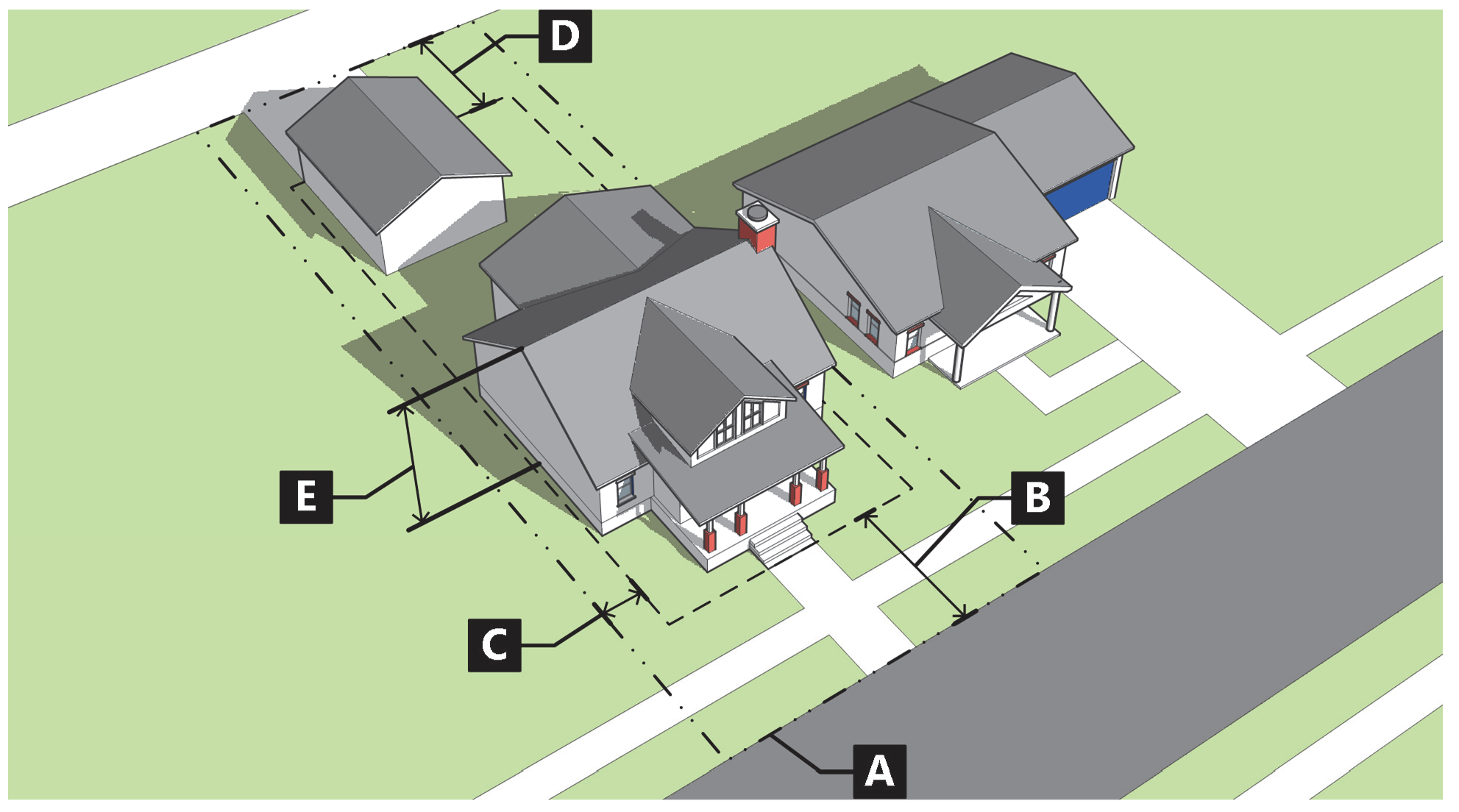
(b)
Standards.
(Ord. No. 19-2018, § 2(Exh. A), 8-2-2018; Ord. No. 9-2023, § 2, 10-26-2023)
070.020.060 - Residential Multifamily Limited (RM2) District.
(a)
Purpose. The RM2 district is intended to accommodate medium-density single-family and limited multifamily residential uses. The RM2 district allows for a more diverse housing stock, including smaller multifamily uses such as two-family dwellings and townhomes, and can provide a transition between single-family districts and high-density residential districts.
Figure 020-4: RM2 District Dimensional Standards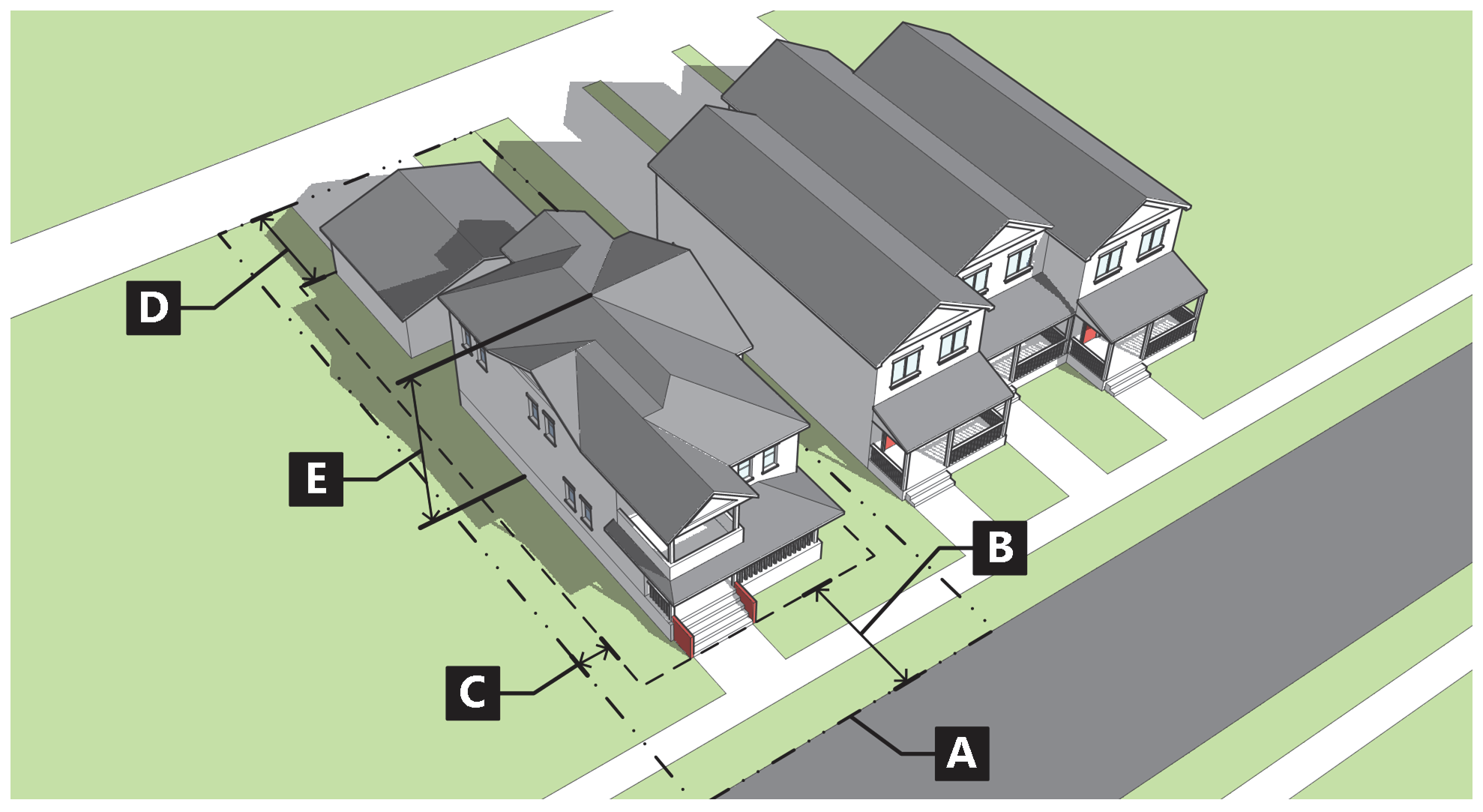
(b)
Standards.
(Ord. No. 19-2018, § 2(Exh. A), 8-2-2018; Ord. No. 9-2023, § 2, 10-26-2023; Ord. No. 13-2024, § 2(Exh. B), 7-18-2024)
070.020.070 - Residential High-Density District (RH) District.
(a)
Purpose. The RH district is intended to accommodate various housing types ranging from single-family detached on small lots to multifamily dwellings. The RH district is intended to transition between established neighborhoods and more intense commercial or other nonresidential districts.
Figure 020-5: RH District Dimensional Standards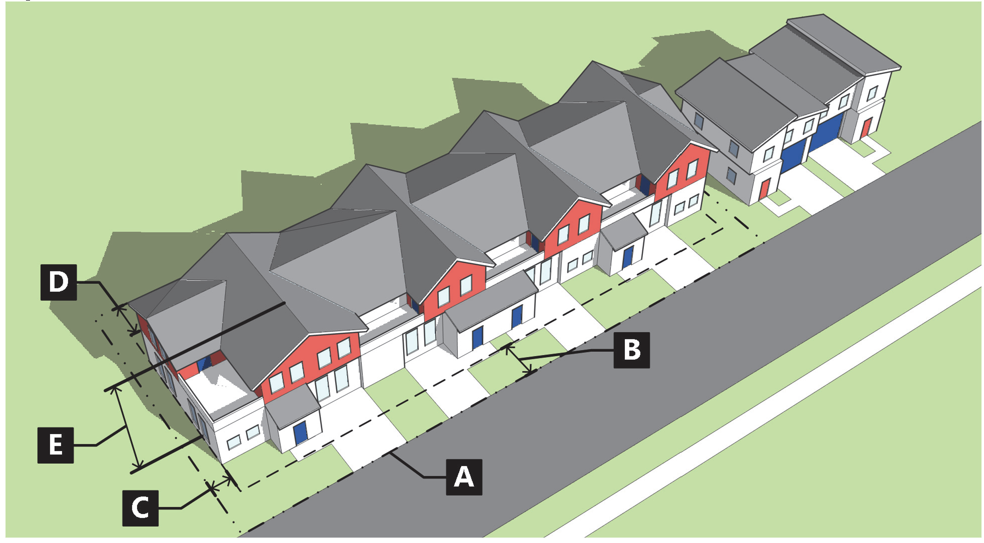
(b)
Standards.
(Ord. No. 19-2018, § 2(Exh. A), 8-2-2018; Ord. No. 9-2023, § 2, 10-26-2023; Ord. No. 13-2024, § 2(Exh. B), 7-18-2024)
070.020.080 - Residential Transitional (RT) District.
(a)
Purpose. The RT district is intended to provide for transitional areas consisting of primarily residential uses at varied densities, with limited commercial uses that are compatible with surrounding neighborhoods. The RT district is intended to serve as a transitional buffer between residential and nonresidential zoning districts.
Figure 020-6: RT District Dimensional Standards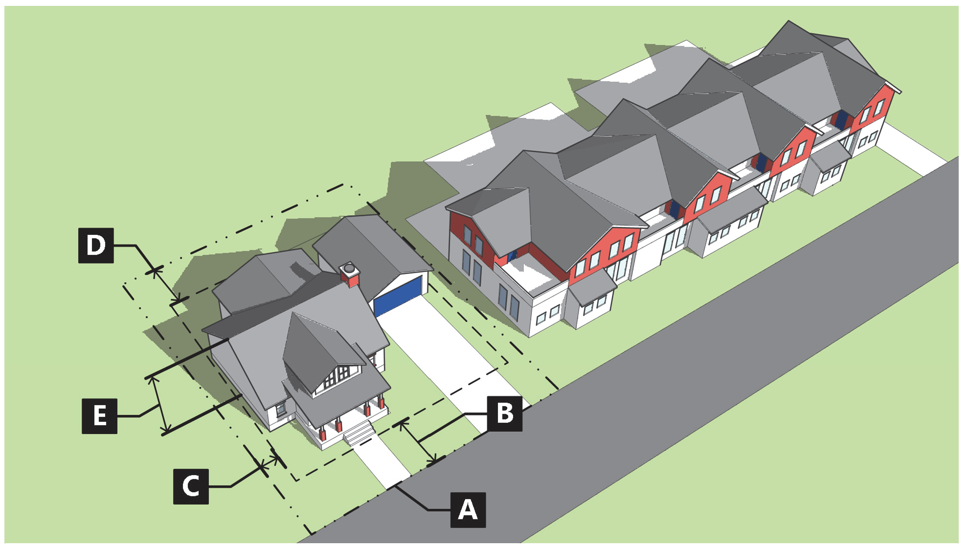
(b)
Standards.
(Ord. No. 19-2018, § 2(Exh. A), 8-2-2018; Ord. No. 9-2023, § 2, 10-26-2023; Ord. No. 13-2024, § 2(Exh. B), 7-18-2024)
070.020.090 - Mixed-Use Corridor (M1) District.
(a)
Purpose. The M1 district is intended to accommodate mixed-use development with walkable and active streetscapes on Glenwood's primary roadways. The mix of uses in the M1 district is intended to accommodate lighter-intensity commercial districts with limited auto-oriented uses compatible with surrounding residential neighborhoods. The M1 district is also intended to offer a diverse mix of housing opportunities at varying densities.
Figure 020-7: M1 District Dimensional Standards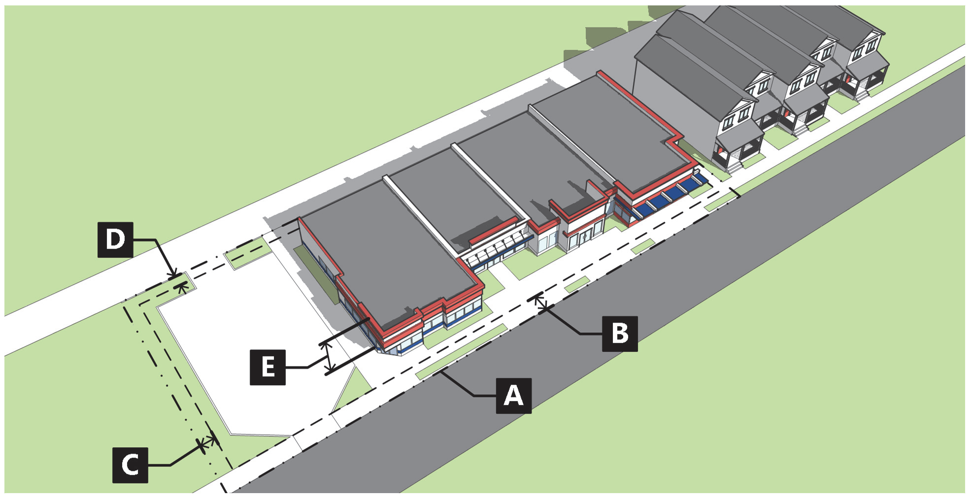
(b)
Standards.
(Ord. No. 19-2018, § 2(Exh. A), 8-2-2018; Ord. No. 9-2023, § 2, 10-26-2023)
070.020.100 - Mixed-Use Core (M2) District.
(a)
Purpose. The M2 district is intended to accommodate walkable and active development within Glenwood's core commercial areas, including but not limited to central downtown. The M2 district includes the most recognizable and prominent areas of Glenwood Springs and therefore places an emphasis on high-quality building and site design, as well as the surrounding streetscape. The M2 district is intended to allow for a mix of residential and nonresidential uses while ensuring compatibility with surrounding established neighborhoods.
Figure 020-8: M2 District Dimensional Standards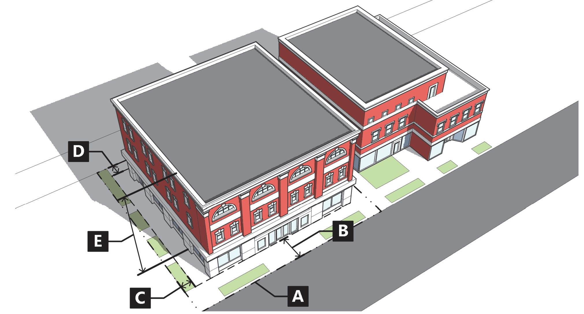
(b)
Standards.
(Ord. No. 19-2018, § 2(Exh. A), 8-2-2018; Ord. No. 9-2023, § 2, 10-26-2023)
070.020.110 - Mixed-Use Regional (M3) District.
(a)
Purpose. The M3 district is intended to accommodate large-scale mixed-use development and redevelopment with an emphasis on walkability and active ground-floor uses. The M3 district allows for regional-scale employment, retail, and medium- to high-density residential opportunities with a focus on high-quality building and site design and a clear street organization for easy access for multi-modal movement.
Figure 020-9: M3 District Dimensional Standards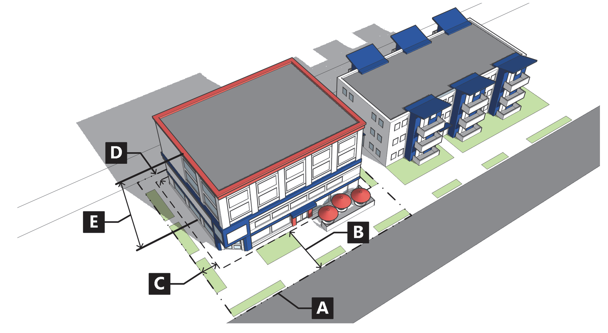
(b)
Standards.
(Ord. No. 19-2018, § 2(Exh. A), 8-2-2018; Ord. No. 9-2023, § 2, 10-26-2023)
070.020.120 - Commercial (CO) District.
(a)
Purpose. The CO district is intended to accommodate general commercial uses with some limited residential uses. The CO district provides a transition between mixed-use and/or residential districts and more intense industrial districts, and allows some typically auto-oriented or major corridor uses.
Figure 020-10: CO District Dimensional Standards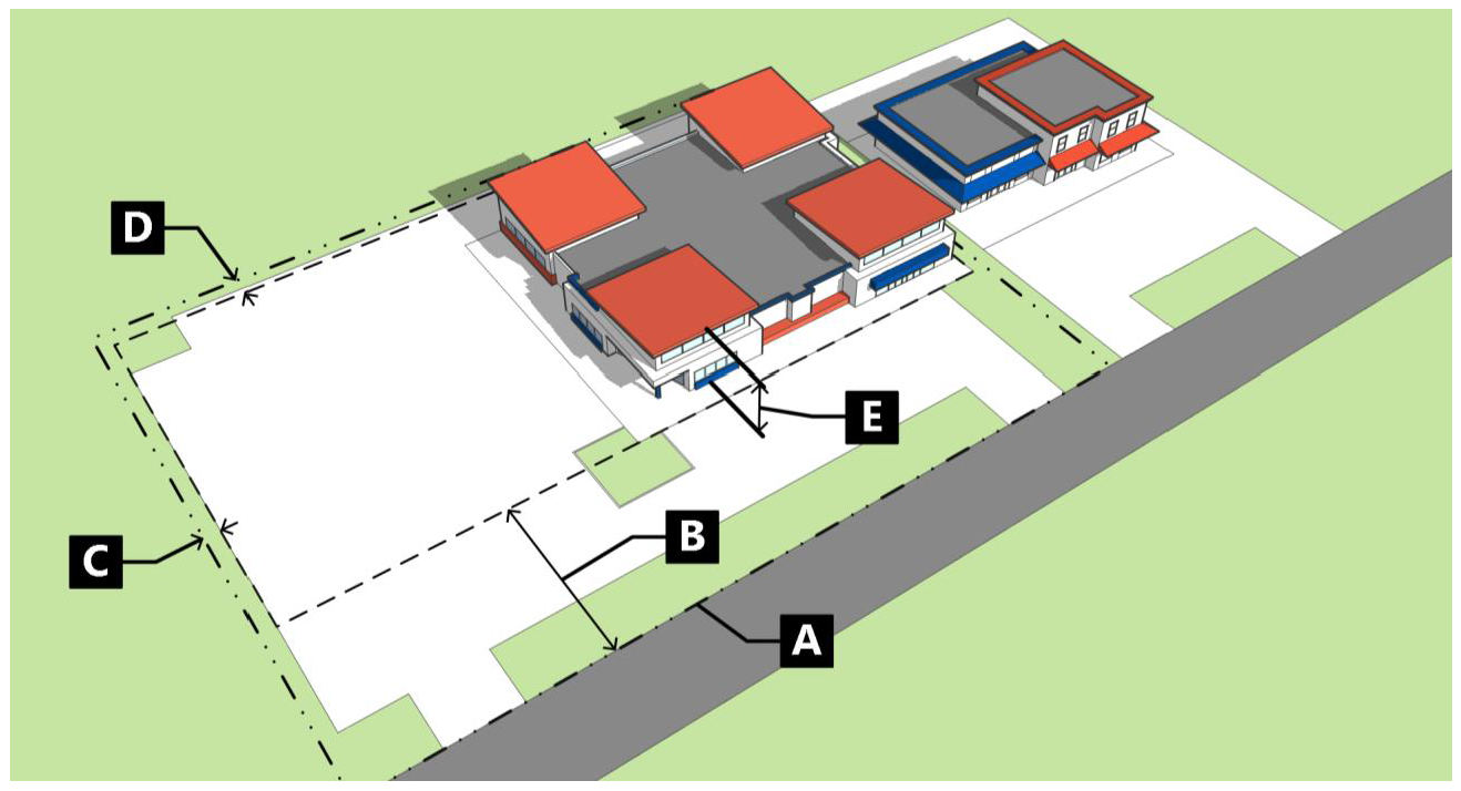
(b)
Standards.
(Ord. No. 19-2018, § 2(Exh. A), 8-2-2018; Ord. No. 9-2023, § 2, 10-26-2023)
070.020.130 - Resort (RE) District.
(a)
Purpose. The RE district is intended to accommodate high-intensity commercial development with flexibility in terms of allowable uses and dimensional standards to accommodate for primary and accessory resort development uses. The RE district is intended to apply to properties that are relatively isolated from adjacent properties due to physical and/or natural features.
Figure 020-11: RE District Dimensional Standards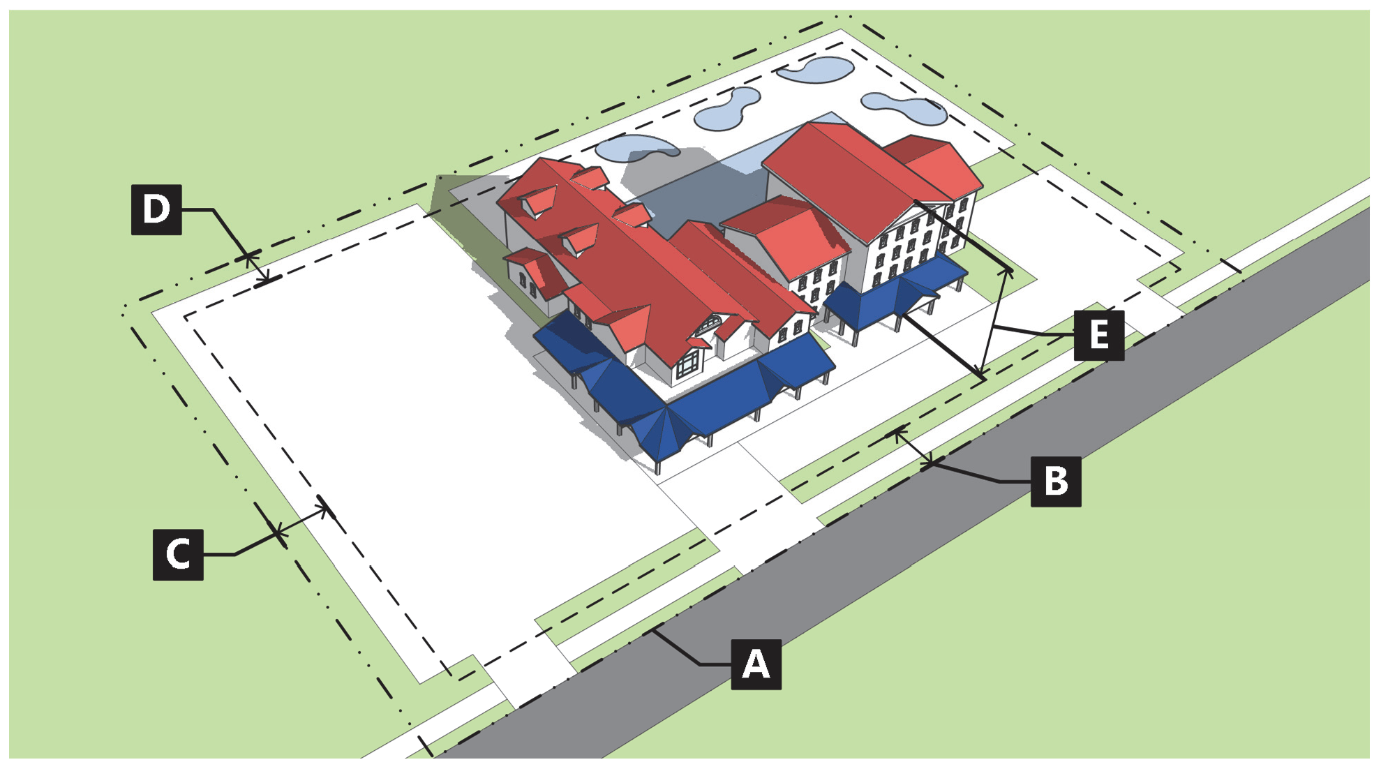
(b)
Standards.
(Ord. No. 19-2018, § 2(Exh. A), 8-2-2018; Ord. No. 9-2023, § 2, 10-26-2023)
070.020.140 - Light Industrial (I1) District.
(a)
Purpose. The I1 district is intended to accommodate a diverse mix of office, service, commercial, and lower-intensity industrial uses with limited impacts on adjacent neighborhoods. The allowable uses in the I1 district take place mostly indoors, with minimal outdoor storage and assembly. This district may include research and development operations and small-scale manufacturing uses.
Figure 020-12: I1 District Dimensional Standards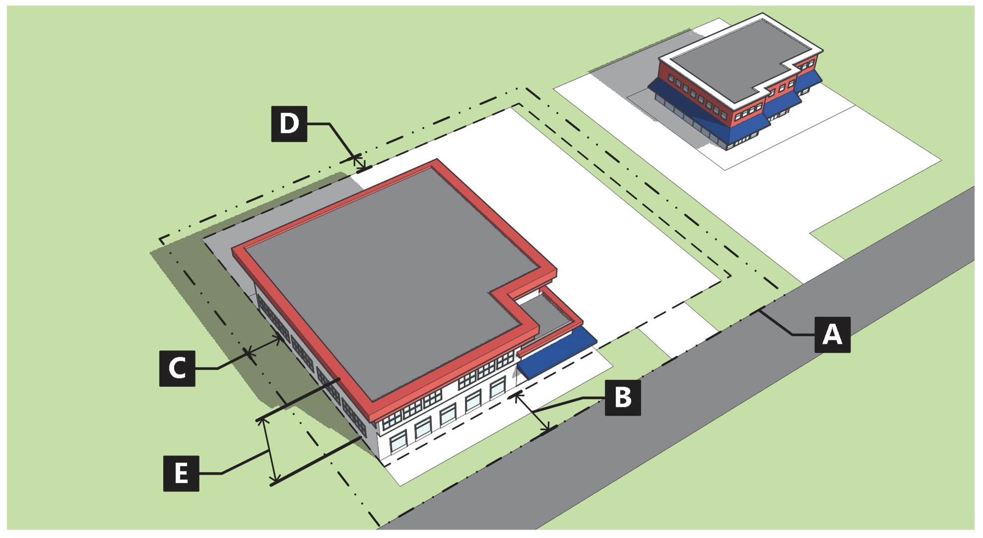
(b)
Standards.
(Ord. No. 19-2018, § 2(Exh. A), 8-2-2018; Ord. No. 15-2020, § 2(Exh. A), 7-2-2020; Ord. No. 9-2023, § 2, 10-26-2023)
070.020.150 - River Industrial (I2) District.
(a)
Purpose. The I2 district is intended to accommodate a variety of industrial and commercial uses in highly visible areas near Glenwood's river corridors. The I2 district is intended to place greater emphasis on aesthetics and compatibility in these sensitive areas.
Figure 020-13: I2 District Dimensional Standards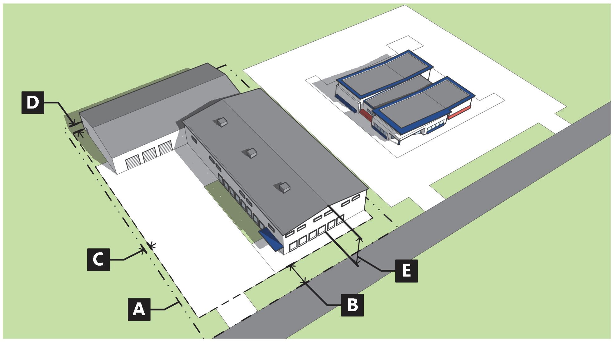
(b)
Standards.
(Ord. No. 19-2018, § 2(Exh. A), 8-2-2018; Ord. No. 15-2020, § 2(Exh. A), 7-2-2020; Ord. No. 9-2023, § 2, 10-26-2023)
070.020.160 - Institutional (IN) District.
(a)
Purpose. The IN district is intended to accommodate public and quasi-public uses and activities with unique operational and site characteristics. Uses in the IN district generally include essential services or activities to the City such as community centers, hospitals, and municipal operations. The IN district is intended to offer greater flexibility to base dimensional standards by requiring use of the Master Plan procedure (Subsection 070.060.050(b)) or the Location and Extent procedure (Subsection 070.060.050(d)).
Figure 020-14: IN District Dimensional Standards
(b)
Standards.
(Ord. No. 19-2018, § 2(Exh. A), 8-2-2018; Ord. No. 9-2023, § 2, 10-26-2023)
070.020.170 - Hillside Preservation (HP) District.
(a)
Purpose. The HP district is intended to provide for the protection and sensitive development of hillsides. The HP district recognizes the importance of Glenwood's hillside areas in terms of their prominence and character within the City. The HP district is intended to allow for reasonable use of hillsides, while protecting the natural and visual character of the surroundings. More specifically, the purpose of the HP district is to:
(1)
Minimize the negative environmental and visual effects of mass cut-and-fill of large pads and excessive terracing through retention of the natural topography of the hillsides;
(2)
Prevent soil erosion and landslides;
(3)
Provide safe circulation of vehicular and pedestrian traffic to and within hillside areas and to provide access for emergency vehicles necessary to serve the hillside areas;
(4)
Preserve visually significant slope banks, ridge lines, rock outcroppings, native plant materials, natural hydrology, and other areas of visual significance;
(5)
Encourage innovative architectural, landscaping, circulation, and site design that serve to preserve the significant natural resources and visual character of the City;
(6)
Protect the public from natural hazards caused by unstable slopes and soils, debris flow, erosion and other geologic hazards of hillside development; and
(7)
Minimize the threat and subsequent damage of wildfire through safe building practices.
(b)
Standards.
(1)
Dimensional Standards.
(2)
Additional Hillside Standards. Development in the HP district shall comply with the standards in Subsection 070.040.020(b), Hillside Development.
(Ord. No. 19-2018, § 2(Exh. A), 8-2-2018)
070.020.180 - Downtown Commercial Overlay (DDO) District.
(a)
General Provisions.
(1)
Purpose. The Downtown Commercial Overlay District is intended to promote downtown vibrancy and pedestrian engagement, with an emphasis on walkability and active ground-floor uses. The DDO district allows for retail, food and beverage establishments, indoor recreation and entertainment, and specific personal services as listed on the ground floor.
(2)
Applicability.
a.
General.
b.
The overlay standards shall apply to:
1.
New business licenses.
2.
Development on vacant land.
3.
Demolished buildings when the demolition involves more than eighty (80) percent of the ground floor area of the existing structure.
(3)
Exemptions. This section shall not apply to the following:
a.
Parks and open space.
b.
Existing ground floor is being remodeled, altered, or repaired to be compliant with Americans with Disabilities Act (ADA).
c.
Nonconforming structures that have been damaged or destroyed by fire or other causes may be restored pursuant to Section 070.010.070(d).
d.
Buildings on the National Historic Registry or Local Landmark that have existing residential on the ground floor.
(b)
Uses. Uses listed in Table 030.1: Table of Allowed Uses for the base zoning are limited in the layout or configuration of the ground floor within the overlay.
(1)
Area. Approved uses must be open to the public.
(2)
Permitted Uses.
a.
Food and beverage establishments.
b.
Retail.
c.
Recreation and entertainment, indoor.
d.
Commercial outdoor recreation use.
e.
Personal services, specifically:
1.
Beauty/barber shops.
2.
Shoe repair, alterations.
3.
Spas/massage.
(3)
Base Zoning District Uses. Uses allowed in the base zoning district and not listed in [Subsection] (2) above, proposed for the ground floor in the required layout or configuration found in [Subsection] (c) below within the overlay boundary shall be considered through a special use permit review process. (Subsection 070.060.050(e).)
(c)
Site Development and Improvement Standards.
(1)
Existing Building. Any existing building within the overlay district.
a.
New businesses that are approved uses can be located anywhere on the ground floor.
b.
New businesses that are not approved uses can only be located in an existing tenant space on the ground floor that was previously an unapproved use.
c.
Existing businesses that are approved uses located on the ground floor cannot be replaced with non-approved uses.
d.
Existing businesses that are not approved uses cannot expand on the ground floor.
(2)
Demolished Gutted Buildings or New Development. Any development on vacant land and gutted buildings involving more than eighty (80) percent of the ground floor area being demolished or the entire building.
a.
Seventy-five (75) percent of the building's linear street frontage must be an approved use.
b.
Any new buildings wider than seventy-five (75) feet must be designed to read as a series of buildings no wider than fifty (50) feet with a street-facing public entrance. Public entrances must be a minimum of ten (10) feet apart. If a building exceeds a width of seventy-five (75) feet, it must exhibit architectural distinctiveness, achieving this through one (1) of the following methods:
1.
Facade material or color changes must occur every fifty (50) feet or less.
2.
Recessed public entrances with a minimum depth of three (3) feet and a maximum depth of five (5) feet.
(3)
Parking Areas. One hundred (100) percent of off-street surface parking is required to occur behind the rear wall of the primary building. This shall only apply to development of vacant land, or demolished building properties.
a.
Cumulative Maximum Reduction for Parking Alternatives. The maximum reduction of required off-street parking spaces by any single parking alternative or combination of parking alternatives outlined in Subsection 070.040.060(e) shall be fifty (50) percent for development within the entire overlay boundary.
(d)
Standards. All dimensional and lot standards shall follow the base zoning district standards.
(Ord. No. 9-2023, § 2(Exh. A), 10-26-2023)
070.020.190 - Planned Unit Development (PUD) District.
(a)
Purpose. Planned unit developments (PUDs) are intended to allow for greater flexibility in the application of zoning and development standards than would otherwise be achieved through a base zoning district in exchange for greater benefit to the City of Glenwood Springs.
(b)
Establishment of a PUD District. PUD districts shall be established pursuant to the procedures in Subsection 070.060.040(b), Rezoning to PUD. Development in a PUD district shall be subject to the standards included in and/or referenced in an approved PUD plan.
(c)
Applicability of Development Standards.
(1)
Unless specifically modified by the PUD plan during the rezoning to PUD procedure, the PUD shall comply with all standards in this Code.
(2)
Where the PUD standards conflict with the standards in this Code, the regulations of the approved PUD plan shall control.
(3)
PUDs shall provide common open space as required by Section 070.040.040, Common Open Space.
(Ord. No. 19-2018, § 2(Exh. A), 8-2-2018; Ord. No. 9-2023, § 2(Exh. A), 10-26-2023)
Editor's note— Ord. No. 9-2023, § 2(Exh. A), adopted Oct. 26, 2023, enacted a new § 070.020.180 and renumbered the former § 070.020.180 as § 070.020.190 as set out herein. The historical notation has been retained with the amended provisions for reference purposes.
070.020.200 - Measurements and Exceptions.
(a)
Purpose. The purpose of this Section is to provide uniform requirements for measuring dimensional standards and to list any exceptions to the dimensional standards in this Code.
(b)
Lot and Site Requirements.
(1)
Minimum Lot Dimensions.
a.
Any lot that is created, developed, used, or occupied shall meet the minimum lot dimensions for the applicable zoning district unless otherwise established in this Code.
b.
No land needed to comply with the minimum lot dimensions or other standards in this Code shall be sold or leased away from such lot.
c.
New lots shall meet the lot dimensions in this Article and shall comply with Section 070.040.030, Site Development and Improvement Standards.
(2)
Number of Principal Buildings or Uses per Lot.
a.
No lot shall contain more dwellings than are permitted by the applicable zoning district.
b.
Multiple buildings may be permitted on a single lot if each building and site development complies with this Code.
(c)
Setbacks.
(1)
Measurement of Setbacks.
a.
Generally. Setbacks shall be measured as follows:
1.
Setback, Front. The minimum horizontal distance that a structure must be setback from the front lot line. The front setback extends across the full width of the lot.
2.
Setback, Rear. The minimum horizontal distance that a structure must be setback from the rear lot line. The rear setback extends across the full width of the lot.
3.
Setback, Side. The minimum horizontal distance that a structure must be setback from a side lot line. The side setback extends the full depth of the lot from the front property line to the rear property line.
b.
Single-Family Dwelling, Townhouse. Single-family townhouse dwellings sharing a common wall shall not be required to comply with side setback requirements except for the outside walls of the end units. (Figure 020-15)
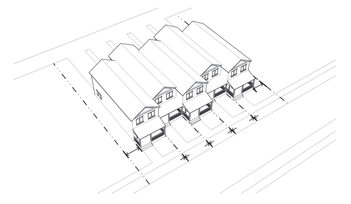
Figure 020-15: Measuring Setbacks for Attached Single-Family
(2)
Contextual Setbacks.
a.
Front. Where a vacant lot is adjacent to existing structures that do not meet the minimum front setback requirements for that zoning district, the front setback for the vacant lot shall be established as the lesser of the median average or mean average front setback of existing structures on that block.
b.
Rear.
1.
For Original Townsite lots, where development is proposed that will be adjacent to existing structures that do not meet the minimum rear setback requirements for that zoning district, the rear setback for the vacant lot shall be established as the lesser of the median average or mean average rear setback of existing structures on that block.
2.
Also see Subsection 070.040.080(d)(2), Dimensional Standards, for limitations on placement of accessory structures in rear yards.
(3)
Double-Frontage Lots. In the case of double-frontage lots, front setbacks shall apply to all frontages.
(4)
Corner Lots. On corner lots, the required front yard setback shall be observed along the street upon which the address is assigned (see measurement "A" in Figure 020-16), and a side yard setback shall be observed along the remaining street (see measurement "B" in Figure 020-16).
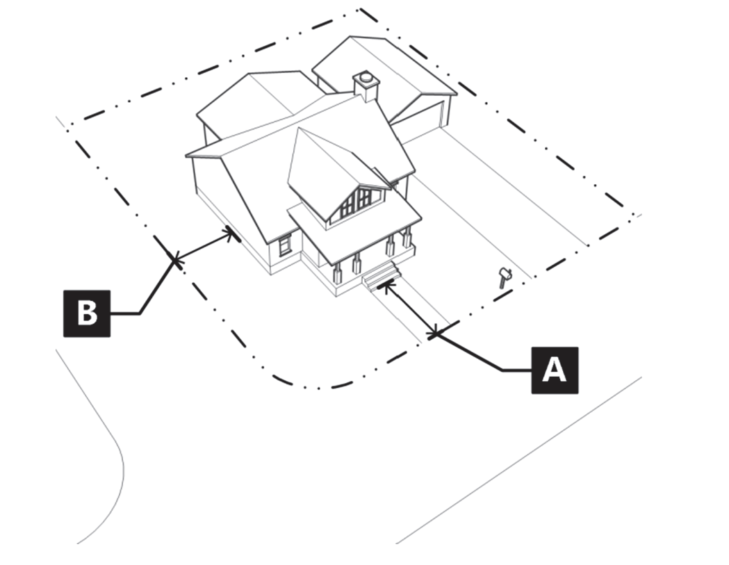
Figure 020-16: Measuring Setbacks on Corner Lots
(5)
Sight Distance Triangle Requirement. On corner lots where a front and side yard are required, no wall, fence, structure, sign, or any plant growth shall obstruct the sight lines of motor vehicle drivers and no such obstruction shall be over forty-two (42) inches tall. Sight distance triangle lines shall be determined by the City Engineer as prescribed in the Engineering Standards.
(6)
Exceptions to Setback Standards. The features listed in Table 020.20 shall be permitted to project into the required setbacks of the applicable zoning district. The exceptions apply to all zoning districts unless otherwise stated.
(d)
Building Height.
(1)
Measurement. Height shall be measured as the vertical distance above finished grade measured to the highest point of the coping of a flat roof or to the deck line of a mansard roof, or to the midpoint of the highest gable of a pitched or hipped roof. (See examples in Figure 020-17)
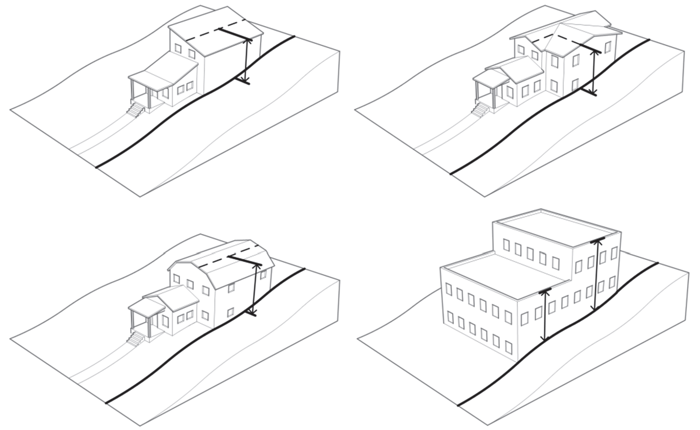
Figure 020-17: Examples of Building Height Mesasurment
(2)
Exceptions to Height Requirements. The features listed in Table 020.21 shall be permitted to project beyond the maximum height requirements of the applicable zoning district.
(Ord. No. 19-2018, § 2(Exh. A), 8-2-2018; Ord. No. 9-2023, § 2(Exh. A), 10-26-2023; Ord. No. 13-2024, § 2(Exh. B), 7-18-2024)
Note— See editor's note at § 070.020.190.