
Granville County Unincorporated
City Zoning Code
City Zoning Code
ARTICLE IV
DISTRICT INTENSITY AND BULK STANDARDS
Sec. 32-261.- Purpose.
The purpose of this article is to establish the basic intensity of use, bulk standards for lot area, setbacks and height.
(Ord. of 7-12-1999, div. 04.000)
Sec. 32-262. - District performance standards.
(a)
District performance standards are the minimum requirements for each use and shall apply to each district. These are gross density and floor area ratio requirements. In addition, whether the use requires public sewer is noted in table 04.100A.
(b)
This section provides the bulk standards that govern the design and placement of buildings or structures on lots. It provides minimum lot area requirements; lot width; setbacks for street, side and rear yards; and maximum height of the building or structure. See table 04.100B.
(c)
No lot as provided for in table 04.100A shall contain more than one principal building. Commercial, industrial or institutional uses or residential buildings may contain more than one principal use provided that they are located within one building and all such uses of the building are permitted within the district in which they are located (see article III). Multiple uses of a building shall meet all other standards of this chapter as determined by calculating the requirements of each use and adding them together. For example, parking for all uses combined shall be required on the lot upon which they are located.
(d)
The maximum height of buildings or structures is as shown in table 04.100A; provided, however, that church spires, belfries, cupolas, domes not intended for human occupancy, electrical transmission towers, recreational ball field light stanchions, flagpoles, grain elevators, and similar structures that are not capable of being occupied by humans, and public fire observation towers can be built to a maximum height of 80 feet. Amateur ham radio and citizen band antenna towers not capable of being occupied by humans can be built to a maximum height of 90 feet. The height limitations set forth in the preceding sentences for the specific buildings or structures listed above may only be exceeded if an applicant applies for, is granted, and complies with the terms of a minor special use permit in accordance with the provisions of this chapter applicable to minor special use permits.
(e)
As Granville County encourages the use of greenways, greenways (which are otherwise known as a bikeways, trails or open space) at least 50 feet in width are considered an option for developers and are not subject to minimum lot size requirements, nor the lot dimension (width) requirements as per the zoning district to which the land exists. A minimum of ten feet access to the greenway shall be provided from a public road right-of-way. Any greenway in a development shall be preserved by the developer and will be considered an independent piece of property. Unless the developer plans to retain ownership and provide maintenance of the greenway in perpetuity, the developer shall be required to set up a homeowner's association for the future ownership and maintenance of the greenway.
TABLE 04.100A
DISTRICT STANDARDS
TABLE 04.100B
BULK STANDARDS
* Uncovered stairs, landings, terraces, porches, balconies and fire escapes may project into any setback; but such projection may not exceed seven feet and may not be closer than ten feet to any property line. Architectural projections such as chimneys, flues, sills, eaves, belt courses and ornaments may also project into any setback, provided such projection is at least seven feet from any property line.
(Ord. of 7-12-1999, div. 1; Ord. of 1-3-2000, § 6; Ord. of 11-6-2000, § 1; Amend. (1) of 12-4-2006, § 1; Amend. of 4-20-2009, § 1; Amend. of 2-6-2012, § 1; Amend. of 3-19-2012, § 1; Amend. of 9-18-2014, § 1; Amend. of 4-19-2021(2), § 1)
Sec. 32-263. - Lot standards for PUDs.
(a)
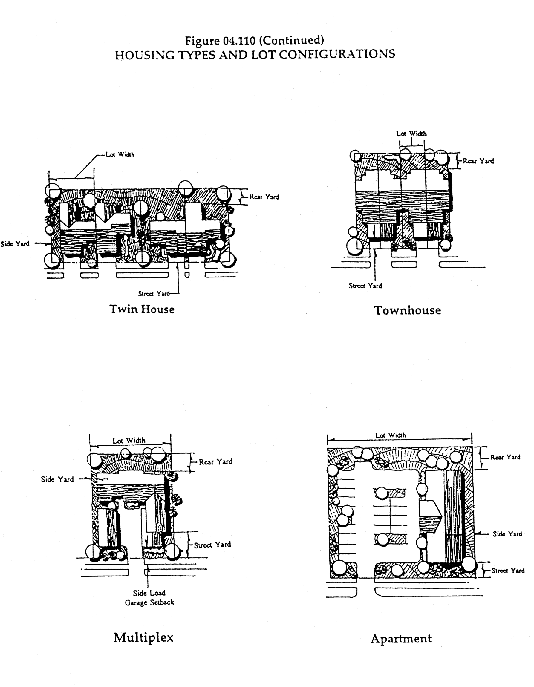
The standards contained in table 04.110 shall control the design of units in planned unit developments (PUDs). The owner may choose to use a mix of these dwelling unit types to achieve the desired plan. Figure 04.110 contains illustrations of the different unit types.
TABLE 04.110
LOT STANDARDS FOR PLANNED UNIT DEVELOPMENTS
(b)
Access to a primarily residential PUD may be allowed through a neighborhood business zoning district provided such access is approved as a component of a major special use permit.
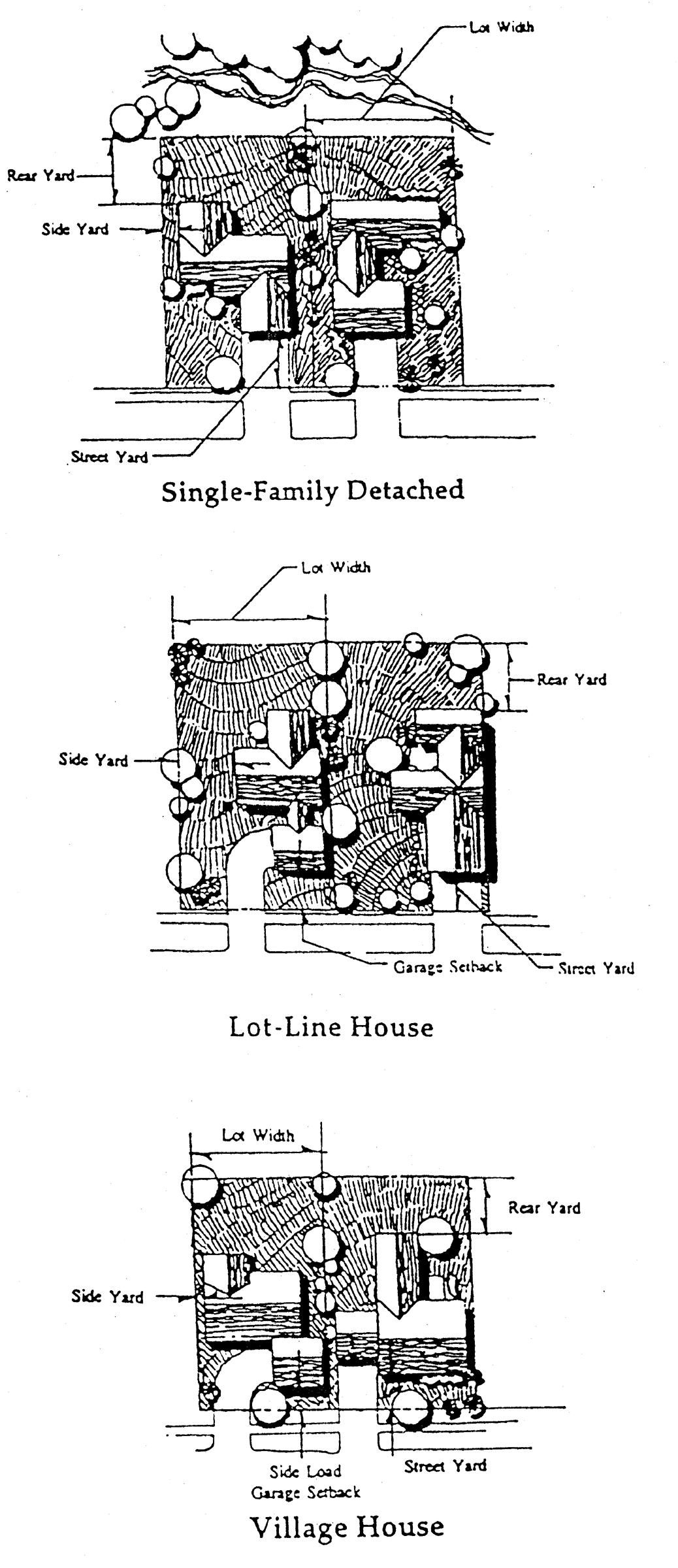
FIGURE 04.110 HOUSING TYPES AND LOT CONFIGURATIONS(1)
(Ord. of 7-12-1999, § 04.110; Amend. (1) of 4-2-2007, § 2; Amend. of 2-18-2008, § 1; Amend. of 4-19-2021(2), § 1)
Editor's note— Amendment (1) of April 2, 2007, changed the title of § 32-263 from "Lot standards for clusters and PUDs" to "Lot standards for PUDs."
Sec. 32-264. - Buffer between zoning districts—Buffer standards.
Whenever a buffer strip is required by this article, such strip shall meet the specifications of this section, unless different specifications are given in another article of this chapter.
(1)
Buffer strips shall be required under this section for property zoned either Prime Industrial District (I-1), General Industrial District (I-2), Highway Business District (HB), or Neighborhood Business District (NB) when the industrially-zoned property or commercially-zoned property is adjacent to a residentially-zoned property.
(2)
The buffer strip shall consist of a planted strip which shall be a minimum of 25 feet in width, shall be composed of evergreen bushes, shrubs, and/or trees such that at least two rows of coverage are provided from the ground to a height of four feet when planted. A driveway or pedestrian walkway leading to the land use on the property may cross the buffer.
(3)
All buffer strips shall become part of the lot(s) on which they are located, or in the case of commonly-owned land, shall belong to the homeowners or property owners association.
(4)
The buffer strip shall be maintained for the life of the development. Maintenance shall be ongoing and shall be the responsibility of the property owner, or, if the property is rented, the lessee.
(5)
If a natural screen is already in place which will adequately fulfill the purpose of the buffer strip, the zoning administrator may, in writing, allow a substitution of all or part of this screen for the buffer strip. Written permission of the zoning administrator shall be obtained before removing any existing natural buffer.
(6)
Where, because of intense shade or soil conditions, a planting screen cannot be expected to thrive, the zoning administrator may, in writing, allow the substitution of a well-maintained wood or masonry wall at least six feet in height in place of the planted screen.
(7)
When such permission is granted in subsection (6), above, the 25-foot buffer strip may be used for driveway and parking so long as such use does not interfere with the six-foot wall and no permanent building or structure is allowed to encroach on the buffer. Parking shall be located behind the six-foot wall.
(Amend. (1) of 6-19-2006, § 1; Amend. of 3-17-2008, § 1)
Sec. 32-265. - Planned unit development plan notation regarding voluntary agricultural district designation.
A planned unit development major special use site plan shall designate the existence of any voluntary agricultural district located within one mile of the proposed planned unit development. The designation shall be a note on the plan that states: "There is land located within one mile of this planned unit development that is designated a Voluntary Agricultural District. The current tax map number of the property designated a Voluntary Agricultural District is ___________."
(Amend. of 4-3-2017(1), § 1; Amend. of 4-19-2021(2), § 1)

