
Granville County Unincorporated
City Zoning Code
City Zoning Code
ARTICLE XII
PARKING AND LOADING DESIGN STANDARDS
Sec. 32-791. - Purpose.
This article provides the standards for parking and loading improvements. These standards need to be consistent with the county's community character, as well as with standards for public health and safety.
(Ord. of 7-12-1999, div. 12.000)
Sec. 32-811. - Parking stall dimensions.
(a)
Table 12.110 specifies the minimum horizontal widths for standard parking rows, aisles and modules (also see figure 12.110).
(b)
The standard parking space is nine feet by 18 feet.
(c)
Parking space length can be reduced to 16½ feet, including wheel stop, if additional space of 1½ feet in length is provided for the car's front overhang. The unpaved area shall be planted in ground cover, but shall not count towards the required parking lot landscaping.
(d)
Parking spaces shall have a vertical clearance of at least eight feet.
FIGURE 12.110
PARKING STALL DIMENSIONS
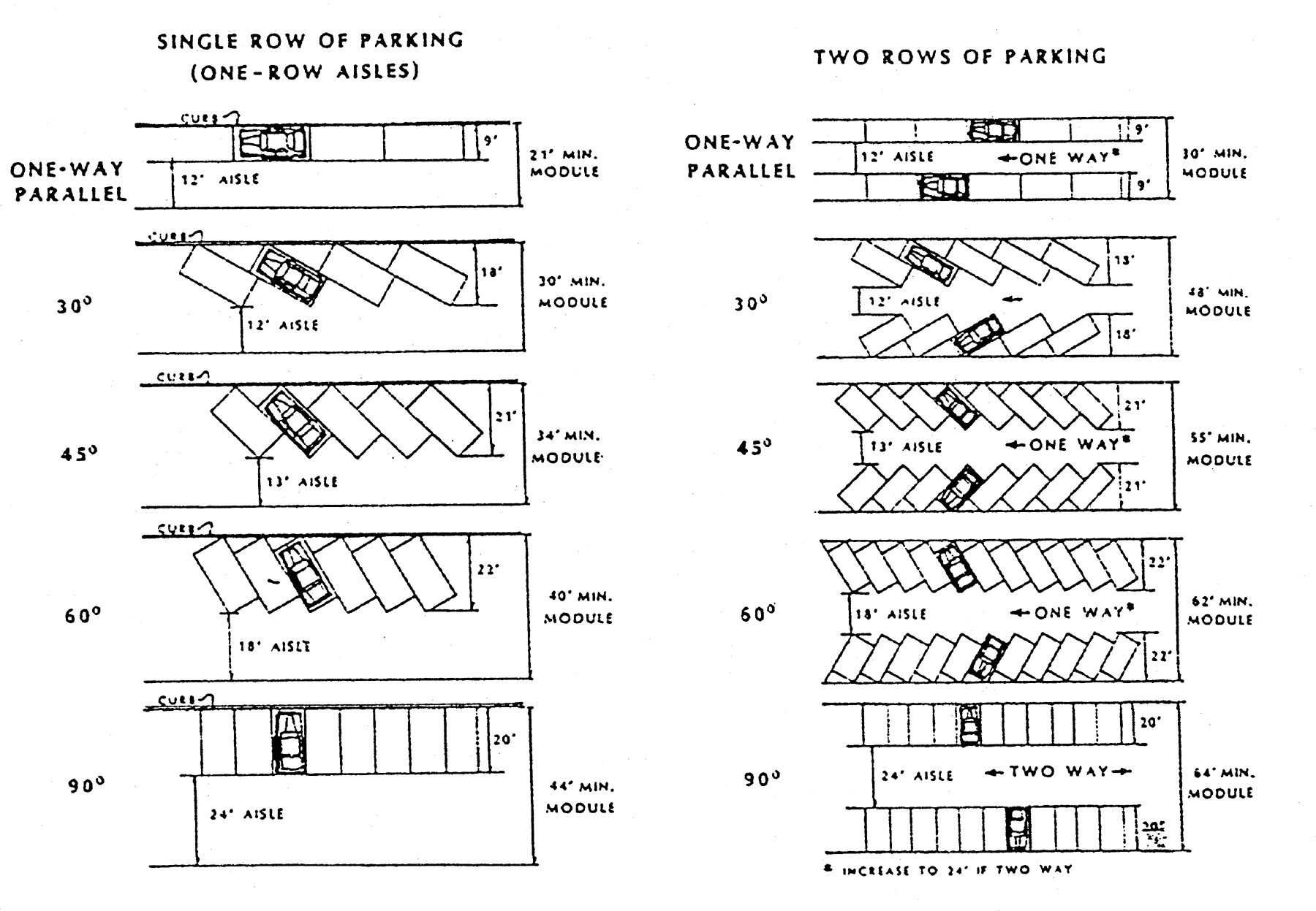
FIGURE 12.110 PARKING STALL DIMENSIONS
TABLE 12.110
MINIMUM HORIZONTAL PARKING WIDTHS FOR STANDARD AUTOMOBILES
(Ord. of 7-12-1999, § 12.110)
Sec. 32-812. - Accessible parking.
(a)
All uses, other than single-family residential served by on-lot parking, shall provide parking spaces for motor vehicles which transport disabled persons in accordance with this section's standards and the state building code, volume 1-C, chapter 4, as amended. See appendix 8 of this chapter for chapter 4, state accessibility code, for barrier-free parking standards.
(b)
Accessible parking spaces shall be located as close as possible to an entrance which allows such persons to enter and leave the parking area and building without assistance. If possible, the spaces shall be located so that the accessible route from the accessible spaces to the accessible entrance should not cross a driving aisle or road.
(c)
Residential units designed for occupancy by disabled persons shall provide one accessible parking space for each dwelling unit designed for such occupancy.
(d)
Off-street parking spaces required for the disabled by this chapter shall count toward fulfilling this chapter's total off-street parking requirements.
(e)
Other guideline of this chapter for accessibility to public facilities shall be in accordance with regulations issued by federal agencies, including the United States Department of Justice, under the Americans With Disabilities Act of 1990. More specifically, these regulations include 28 CFR 36, Nondiscrimination on the Basis of Disability by Public Accommodations and in Commercial Facilities, Final Rule.
(f)
No accessible spaces are required for valet parking lots.
(Ord. of 7-12-1999, § 12.111)
Sec. 32-813. - Location of parking.
If the off-street parking spaces required by this chapter cannot be reasonably provided on the same lot on which the principal use is located, such space may be provided on any land within 400 feet of the principal use or building, provided such land is in the same ownership as the principal use. Such land shall be used for no other purpose as long as the principal use exists.
(Ord. of 7-12-1999, § 12.130)
Sec. 32-814. - Off-street parking design standards.
All off-street parking shall meet the following design standards:
(1)
All off-street parking areas shall be designed so vehicles do not back out into any road or public right-of-way except for parking facilities serving single-family residential lots and overflow parking facilities accommodating less than five vehicles.
(2)
Each required parking space, except valet parking spaces, shall have unobstructed access from a road or alley or from an aisle or drive connecting with a road or alley, without moving another vehicle.
(3)
All off-street parking facilities shall be designed with appropriate vehicular access to a street or alley in such a manner which causes the least interference with traffic movements.
(Ord. of 7-12-1999, § 12.140)
Cross reference— Streets, sidewalks and other public places, ch. 41.
Sec. 32-815. - Parking surfaces.
(a)
Parking lots for commercial, industrial and indoor amusement or recreation uses with more than 16 spaces shall be paved with concrete, paving blocks, asphalt or other all-weather surface. Pavers or grids are permitted in low-volume parking or overflow areas.
(b)
Light-use area, those needed only 25 days per year or less, may be provided with pervious pavements or grids that permit grass to grow through the blocks. Those parking areas intended for the handling, loading and unloading of livestock animals from vehicles or trailers in parking areas shall be permitted to be impervious gravel surfaces in the interest of safety in handling animals.
(c)
Gravel shall not be considered to be paving as required by subsection (a) of this section except as provided for livestock animals in subsection (b) of this section.
(Ord. of 7-12-1999, § 12.160; Ord. of 2-4-2000, § 2)
Sec. 32-816. - Outdoor loading bay area standards.
(a)
Dimensions.
(1)
Each off-street loading space's minimum area, excluding area for maneuvering, shall be 720 square feet, with a minimum width of 12 feet. Where semitrailers are prohibited, the minimum area shall be reduced to 300 square feet.
(2)
Each outdoor loading bay area's minimum dimensions shall be 12 feet wide and 25 feet long, unless the land development administrator determines that a larger loading bay is necessary. At no time shall any part of a truck or van be allowed to extend into a public thoroughfare or right-of-way while the truck or van is being loaded or unloaded. If the outdoor loading area is covered but not totally enclosed, the minimum height of the outdoor loading bay area shall be 14 feet.
(b)
Maneuvering space. Adequate off-street truck maneuvering space shall be provided on-lot and not within any public street right-of-way or other public lands.
(c)
Location. All loading areas are required to be located on the same lot as the building or lot served by the loading area.
(d)
Blocking access. Blocking loading spaces or parking spaces is prohibited. Loading spaces or parking spaces shall not be located to block access. Permanent or movable structures of any type, including trash receptacles or compactors, shall be prohibited from parking, loading or access areas.
(e)
Fire exit or emergency access. Off-street loading facilities shall be designed so as not to interfere with any fire exits or emergency access facilities to either a building or site.
(Ord. of 7-12-1999, § 12.160)