
Grass Valley City Zoning Code
ARTICLE 2
- ZONES, ALLOWABLE USES, AND ZONE STANDARDS
Chapter 17.20 - DEVELOPMENT AND LAND USE APPROVAL REQUIREMENTS
Sections:
Chapter 17.21 - TRADITIONAL COMMUNITY DEVELOPMENT ZONES
Sections:
Chapter 17.22 - RESIDENTIAL ZONES
Sections:
Chapter 17.24 - COMMERCIAL AND INDUSTRIAL ZONES
Sections:
Chapter 17.26 - SPECIAL PURPOSE ZONES
Sections:
Chapter 17.28 - COMBINING ZONES
Sections:
17.20.010 - Purpose.
This chapter describes the city's requirements for the approval of proposed development and new land uses. The permit requirements established by this development code for specific land uses are in Chapters 17.21 through 17.28.
17.20.020 - General requirements for development and new land uses.
Each land use and/or structure shall be established, constructed, reconstructed, altered, moved or replaced in compliance with the following requirements:
A.
Allowable Use. The land use shall be allowable by this development code in the zone applied to the site. The basis for determining whether a use is allowable is described in Section 17.20.030 (allowable land uses and planning permit requirements).
B.
Permit and Approval Requirements. Any planning permit or other approval required by Section 17.20.030 (allowable land uses and planning permit requirements) shall be obtained before the issuance of any required grading, building, or other construction permit, and before the proposed use is constructed, otherwise established or put into operation, unless the proposed use is listed in Section 17.20.040 (exemptions from planning permit requirements).
C.
Development Standards, Conditions of Approval. Each land use and structure shall comply with the development standards of this chapter, applicable standards and requirements in Articles 3 (site planning and project design standards), 4 (standards for specific land uses), 5 (resource management), and 6 (site development regulations), and any applicable conditions imposed by a previously granted planning permit.
D.
Legal Lot. The site of a proposed development or new land use shall be a lot that was legally created in compliance with the Subdivision Map Act and Article 8 (subdivision regulations and procedures).
17.20.030 - Allowable land uses and planning permit requirements.
A.
Allowable Land Uses. The uses of land allowed by this development code in each zone are listed in tables of allowable land uses in Chapters 17.21 through 17.26, together with the type of planning permit required for each use. Each land use listed in the tables is defined in Article 10 (glossary).
1.
Establishment of an Allowable Use.
a.
Any one or more land uses identified by the tables in Chapters 17.21 through 17.26 as being allowable within a specific zone may be established on any lot within that zone, subject to the planning permit requirements of Subsection B., and compliance with all applicable requirements of this development code.
b.
Where a single lot is proposed for development with two or more of the land uses listed in the tables at the same time, the overall project shall be subject to the highest permit level required by Subsection B. for any individual use. For example, a site proposed for development or occupancy with one use that is listed as permitted, and another use that is listed as requiring use permit approval shall require use permit approval for all development and uses.
2.
Use Not Listed.
a.
A land use that is not listed in the tables in Chapters 17.21 through 17.26 and is determined by the director to not be included in Article 10 (glossary) under the definition of a listed land use, is not allowed within the city, except as otherwise provided Subsection A.3, or Section 17.20.040 (exemptions from planning permit requirements).
b.
A land use that is not listed in the tables within a particular zone is not allowed within that zone, except as otherwise provided Subsection A.3, or Section 17.20.040 (exemptions from planning permit requirements).
3.
Similar and Compatible Use May be Allowed. The director may determine that a proposed use not listed in this article is allowable as follows:
a.
Required Findings. The director may determine that a proposed use is similar to and compatible with a listed use and may be allowed, only after first making all of the following findings with the determination:
(1)
The characteristics of, and activities associated with the use are similar to one or more of the listed uses, and will not involve a greater intensity than the uses listed in the zone;
(2)
The use will be consistent with the purposes of the applicable zone;
(3)
The use will be consistent with the general plan, and any applicable specific plan;
(4)
The use will be compatible with the other uses allowed in the zone; and
(5)
The use is not listed as allowable in another zone.
A determination that a use qualifies as a similar and compatible use, and the findings supporting the determination shall be in writing.
b.
Applicable Standards and Permit Requirements. When the director determines that a proposed, but unlisted, use is similar and compatible to a listed use, the proposed use will be treated in the same manner as the listed use in determining where it is allowed, what permits are required, and what other standards and requirements of this development code apply.
c.
Referral for Determination. The director may refer the question of whether a proposed use qualifies as a similar and compatible use directly to the commission for a determination at a public meeting.
d.
Appeal. A determination of similar and compatible use may be appealed in compliance with Chapter 17.91 (appeals).
B.
Permit Requirements. The tables listing allowable land uses in Chapters 17.21 through 17.26 provide for land uses that are:
1.
Permitted subject to compliance with all applicable provisions of this development code. These are shown as "P" uses in the tables;
2.
Allowed subject to the approval of a minor use permit (Section 17.72.060), and shown as "MUP" uses in the tables;
3.
Allowed subject to the approval of a use permit (Section 17.72.060), and shown as "UP" uses in the tables;
4.
Allowed subject to the type of city approval required by a specific provision of Chapter 17.44 (standards for specific land uses), and shown as "S" uses in the tables; and
5.
Not allowed in particular zones, and shown as "C" in the tables.
Note: A permitted land use, or a use authorized through the approval of a minor use permit or use permit may also require a development review permit (Section 17.72.030), a building permit, and/or other permit required by the Municipal Code.
17.20.035 - Prohibition of medical marijuana cultivation and dispensaries.
A.
Purpose and Intent. It is the purpose and intent of this chapter to preclude marijuana cultivation and marijuana dispensaries within the city.
B.
Definitions. The words and phrases included in the section shall have the following meanings, unless it is clearly apparent from the context that another meaning is intended:
1.
"Marijuana" is defined as that term is defined in Health and Safety Code section 11018 as that section may be amended from time to time.
2.
"Marijuana Dispensary" means a cooperative, collective, dispensary, operator, establishment, provider, association or similar entity that cultivates, distributes, dispenses, stores, exchanges, processes, delivers, makes available, transmits and/or gives away marijuana in the city for any purpose, including a mobile marijuana dispensary as defined in Chapter 5.60 of this Code.
3.
"Marijuana Cultivation" means the planting, growing, harvesting, drying or processing of marijuana plants or any part thereof.
C.
Marijuana Cultivation Prohibited.
1.
Marijuana cultivation is not a permitted use and is prohibited in all zones throughout the city. No permit or any other applicable license or entitlement for use, not any business license, shall be approved or issued for marijuana cultivation within the city.
2.
Marijuana cultivation within the city is declared to be a public nuisance and may be abated by the city either pursuant to the Grass Valley Municipal Code or any other available remedies, including, but not limited to, declaratory relief and civil injunctions.
D.
Marijuana dispensaries Prohibited.
1.
Marijuana dispensary is not a permitted use and is prohibited in all zones throughout the city. No permit or any other applicable license or entitlement for use, not any business license, shall be approved or issued for the establishment, maintenance or operation of a marijuana dispensary within the city.
2.
The establishment, maintenance or operation of a marijuana dispensary within the city is declared to be a public nuisance and may be abated by the city either pursuant to the Grass Valley Municipal Code or any other available remedies, including, but not limited to, declaratory relief and civil injunctions.
e.
Violation and Enforcement. A violation of this section or non-compliance with any of the requirements of this chapter or applicable provisions of Title 17 (development code) or Grass Valley Municipal Code shall be subject to any enforcement remedies available under the law and/or the Grass Valley Municipal Code. In addition, the city may enforce the violation of this chapter by means of civil enforcement through a restraining order, a preliminary or permanent injunction or by any other means authorized by the law. Notwithstanding any other provisions of this Code, no conduct which is protected from criminal liability pursuant to the Compassionate Use Act (Health and Safety Code § 11362.5) and/or the Medical Marijuana Program Act (Health and Safety Code §§ 11362.7—11362.83) shall be made criminal by this Code.
(Ord. No. 764B, § 2, 2-23-2016; Ord. No. 816, § 6, 6-28-2022)
17.20.040 - Exemptions from planning permit requirements.
The planning permit requirements of this development code do not apply to the land uses, structures, and activities identified by this section. These are allowed in all zones subject to compliance with this section.
A.
General Requirements for Exemption. The land uses, structures, and activities identified by Subsection B. below are exempt from the planning permit requirements of this development code only when:
1.
The use, activity or structure is established and operated in compliance with the setback requirements, height limits, and all other applicable standards of this article (zones, allowable uses, and zone standards), and Articles 3 (site planning and project design standards), 4 (standards for specific land uses), 5 (resource management), 6 (site development regulations) and, where applicable, Chapter 17.90 (nonconforming uses, structures, and parcels); and
2.
Any permit or approval required by regulations other than this development code is obtained (for example, a building permit).
B.
Exempt Activities and Land Uses. The following are exempt from the planning permit requirements of this development code when in compliance with Subsection A. above.
1.
Decks, Paths and Driveways. Decks, platforms, on-site paths, and driveways that are not required to have a building permit or grading permit.
2.
Fences and Walls. See Section 17.30.040 (fences, walls, and screening).
3.
Interior Remodeling. Interior alterations that do not increase the gross floor area of the structure, or change the permitted use of the structure.
4.
Repairs and Maintenance.
a.
Single Dwellings. Ordinary repairs to, and maintenance of single dwellings.
b.
Multifamily, and Nonresidential Structures. Ordinary repairs to, and maintenance of multifamily residential and nonresidential structures, if:
(1)
The work does not change the approved land use of the site or structure, or add to, enlarge or expand the land use and/or structure; and
(2)
Any exterior repairs employ the same materials and design as the original construction.
5.
Small, Portable Residential Accessory Structures. A single portable structure per lot or unit, including pre-manufactured storage sheds or other small structures in residential zones, that are exempt from building permit requirements in compliance with the Municipal Code and the Uniform Building Code. Additional structures may be approved in compliance with Section 17.44.020 (accessory structures and uses), where allowed by the applicable zone.
6.
Solar Collectors. The addition of solar collectors to the roof or side of a building, provided that the collectors comply with applicable height limit requirements; and ground-mounted solar collectors that comply with the setback requirements and height limitations of the applicable zone and are not visible from off the site.
7.
Spas, Hot Tubs, and Fish Ponds. Portable spas, hot tubs, and constructed fish ponds, and similar equipment and structures that do not: exceed one hundred twenty square feet in total area including related equipment; contain more than two thousand gallons of water; or exceed three feet in depth.
8.
Utilities. The erection, construction, alteration, or maintenance by a public utility or public agency of utilities intended to service existing or nearby approved developments shall be permitted in any zone. These include: water; gas; electric; supply or disposal systems; including wires, mains, drains, sewers, pipes, conduits, cables, fire-alarm boxes, police call boxes, traffic signals, hydrants, etc., but not including new transmission lines and structures. Satellite and wireless communications antennas are not exempt, and are instead subject to Chapter 17.46 (telecommunications facilities).
17.20.050 - Temporary uses.
Requirements for establishing a temporary use (for example, a construction yard, seasonal sales lot, special event, temporary office trailer, etc.) are in Section 17.72.040 (limited term permits).
17.21.010 - Purpose.
This chapter lists the land uses that may be allowed within the traditional community development zones established by Section 17.12.020 (zoning map and zones), determines the type of planning permit/approval required for each use, and provides basic standards for site layout and building size.
17.21.020 - Applicability of standards.
Development and new land uses proposed within the traditional community development zones shall comply with the standards in this chapter for the applicable zone, as follows:
A.
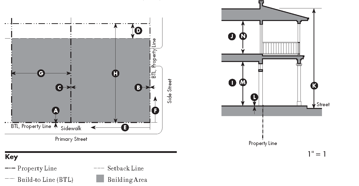
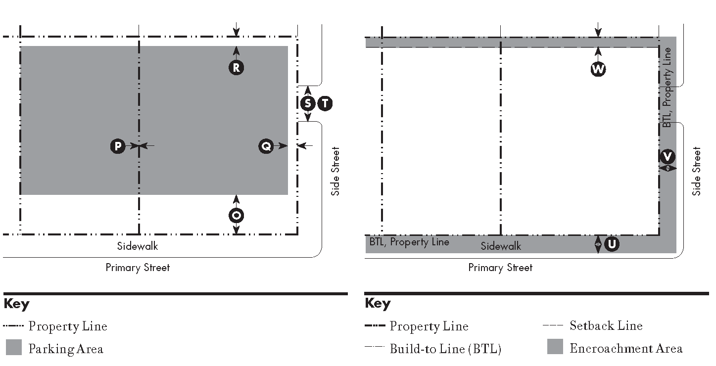
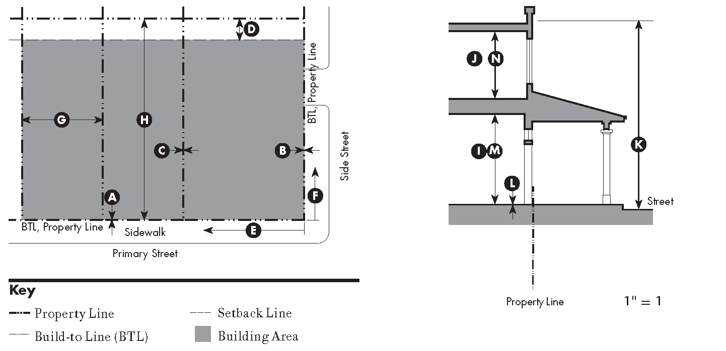
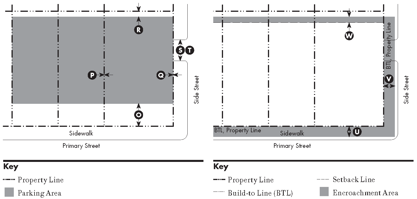
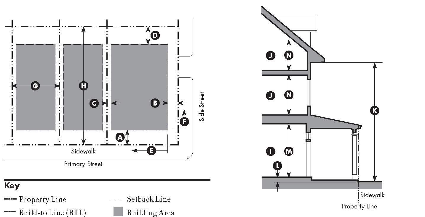
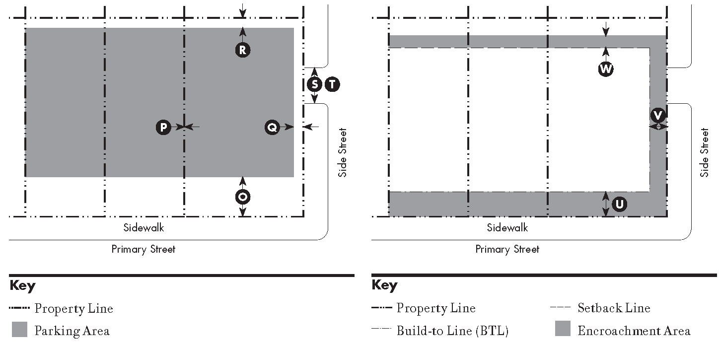
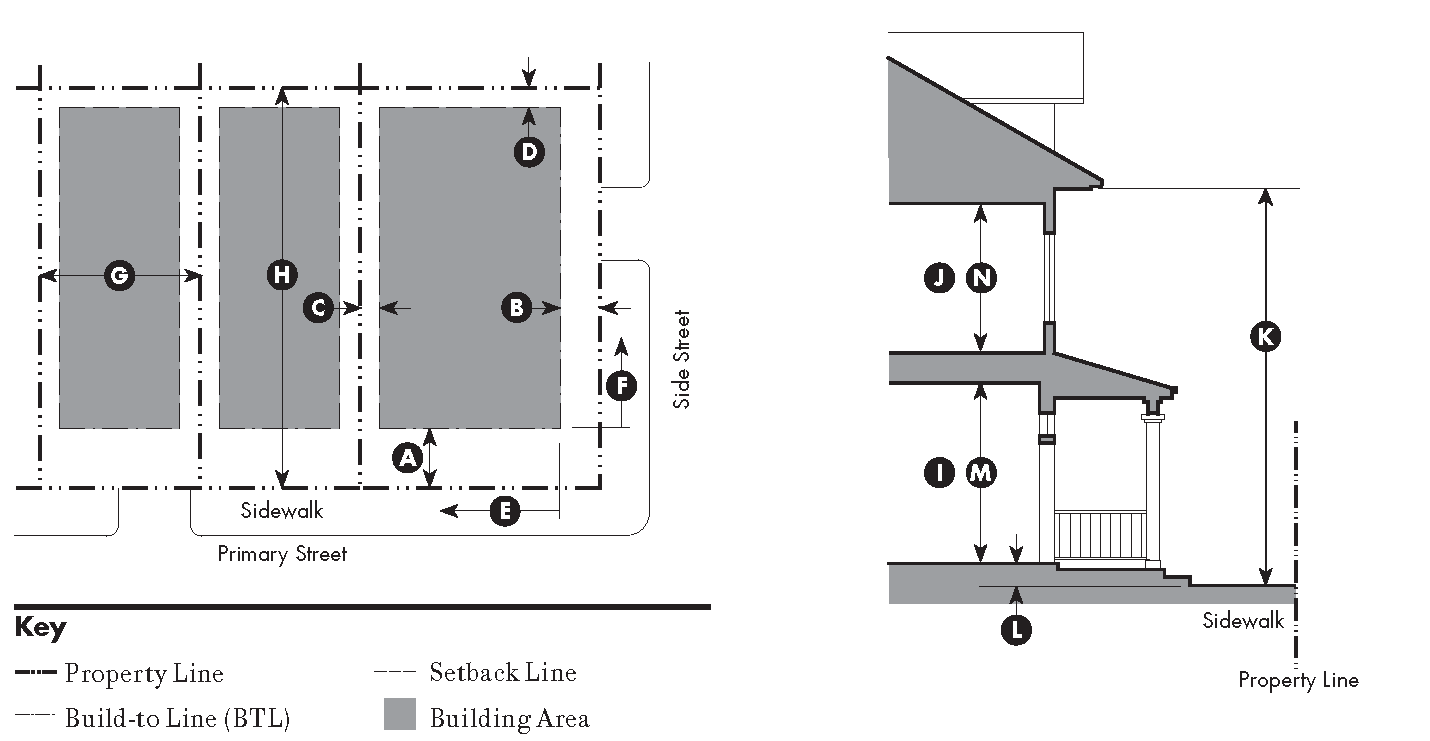
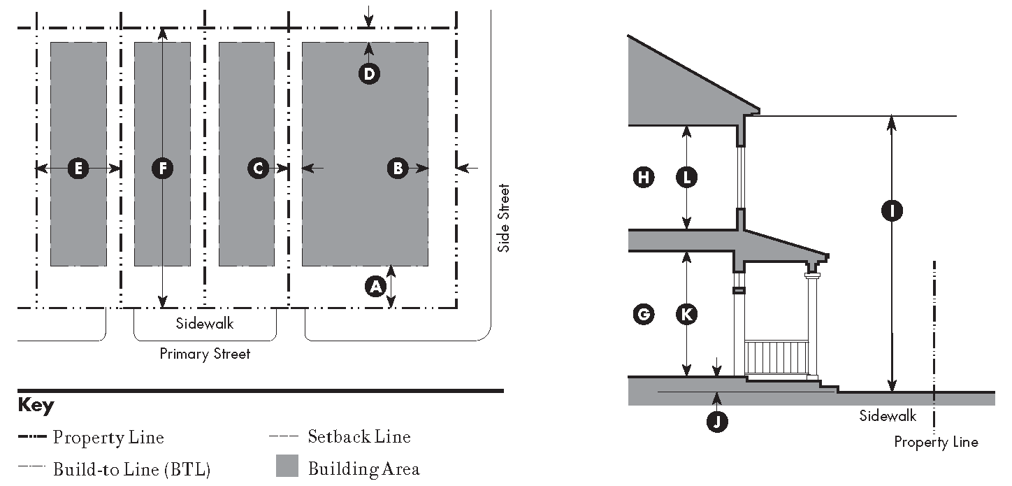
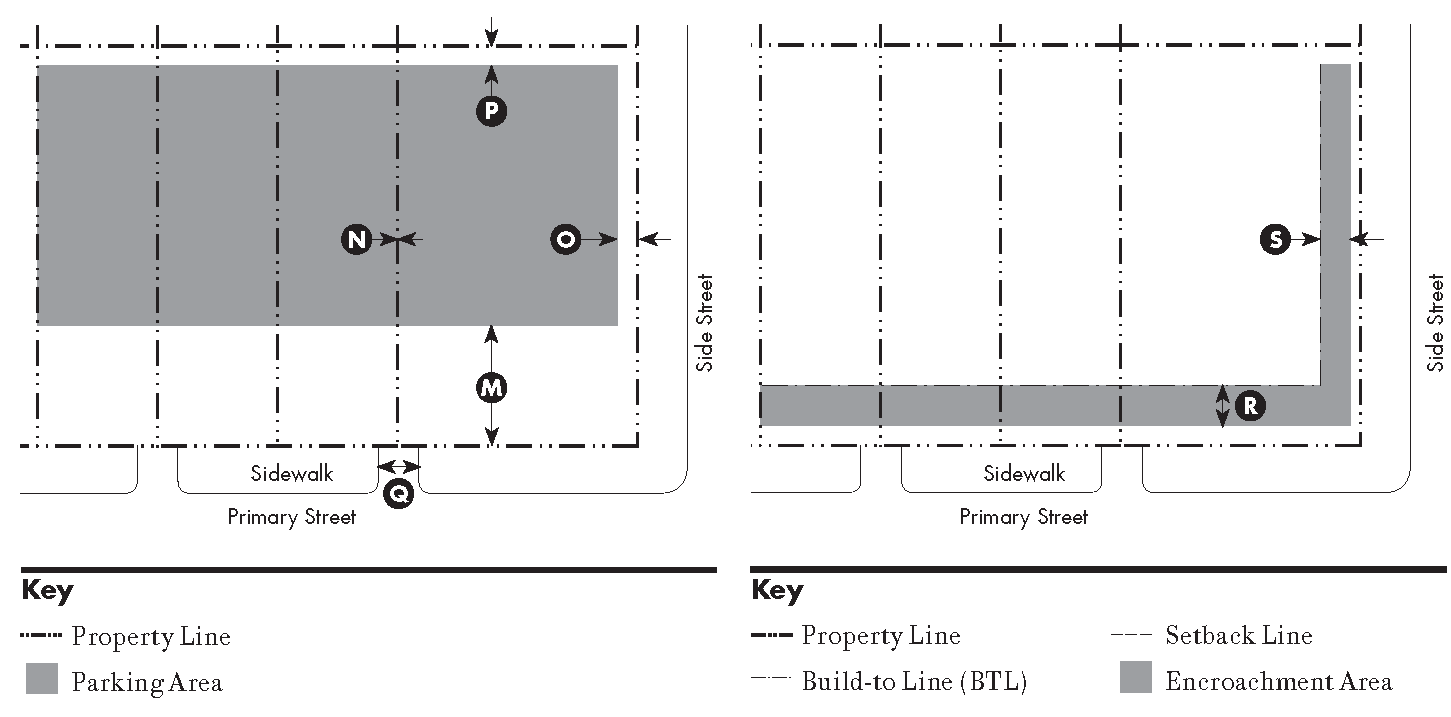
Building Placement. Each proposed structure shall comply with the build-to line, setback, and buildable area requirements in Sections 17.21.040 through 17.21.090 as required for the applicable zone, except as provided by Section 17.30.030 (build-to-line and setback requirements and exceptions), and except for the encroachments allowed in each zone by Sections 17.21.040 through 17.21.090.
B.
Use. Only the land uses allowed by Sections 17.21.040 through 17.21.090 shall be established in the applicable zone in compliance with Chapter 17.20 (development and land use approval requirements).
C.
Height. No structure shall exceed the height limit established by Sections 17.21.040 through 17.21.090 for the applicable zone, except as provided by Section 17.30.050 (height limits and exceptions).
D.
Parking. On-site parking shall be provided and located in compliance with Sections 17.21.040 through 17.21.090 for the applicable zone, and designed in compliance with Chapter 17.36 (parking and loading).
E.
Frontage Types. Only the frontage types allowed by Sections 17.21.040 through 17.21.090 shall be constructed in the applicable zone, in compliance with Section 17.21.100 (frontage type standards).
17.21.030 - Purposes of the traditional community development zones.
A.
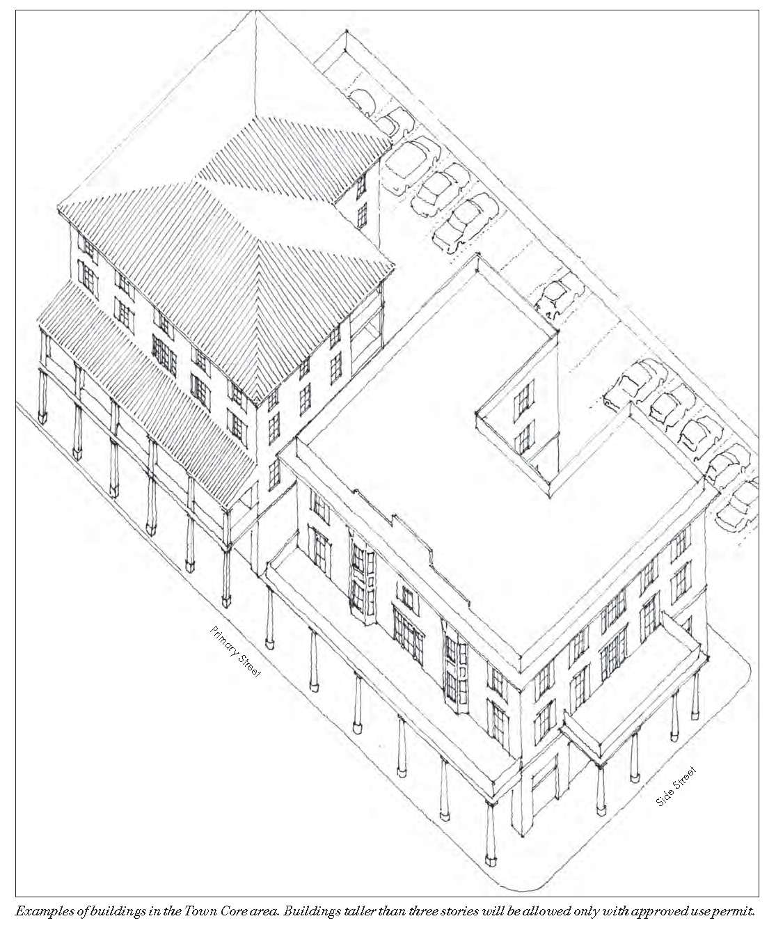
Town Core (TC). The primary intent of this zone is to strengthen the mixed-use, pedestrian-oriented nature of the existing historic downtown. The secondary intent is to establish secondary mixed-use, pedestrian-oriented centers within large, regional districts that are likely to redevelop in the mid and long term. These areas include large, auto-oriented commercial districts. The redeveloped centers will encourage compact development, provide a wide range of housing opportunities, including work force housing, and promote walkable and bikeable communities. The TC zone may be applied to areas previously designated with the C-2 and C-2-A zoning districts, provided that:
1.
Shopfront-related frontage types only with ground floor commercial are required;
2.
The zone will continue to promote a mix of residential, commercial, civic, and institutional uses;
3.
The zone will focus on the existing downtown area; and
4.
This zone may also be an option for auto-oriented commercial districts to allow them to evolve into mixed-use centers as time and economic opportunity allow.
B.
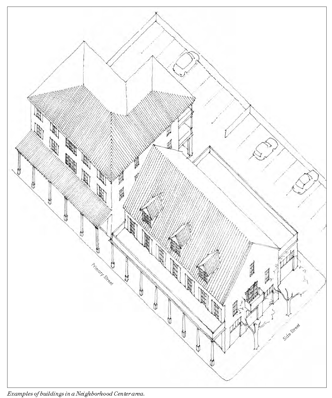
Neighborhood Center (NC). The primary intent of this zone is to strengthen the existing neighborhood structure of Grass Valley by promoting and enhancing the vitality of existing neighborhood-serving commercial centers and thus promoting pedestrian-oriented neighborhoods. The secondary intent is to create additional mixed-use centers/nodes, for instance along corridors, that will provide focal points for mixed-use infill development. This will provide opportunities for redevelopment in a manner that will convert such corridors from their current nondescript and uniform character into vibrant pedestrian-oriented neighborhoods that strengthen the character of Grass Valley. The NC zone may be applied to properties previously designated in a number of existing zoning districts, provided that:
1.
The zone can be expanded to use name of neighborhood (e.g. "NC-Sunrise Hill");
2.
Shopfront frontage types only are required (at a smaller scale than core); and
3.
The zone is intended to encourage mixed-use buildings that are compatible in size, shape, and scale with existing residential neighborhoods.
C.
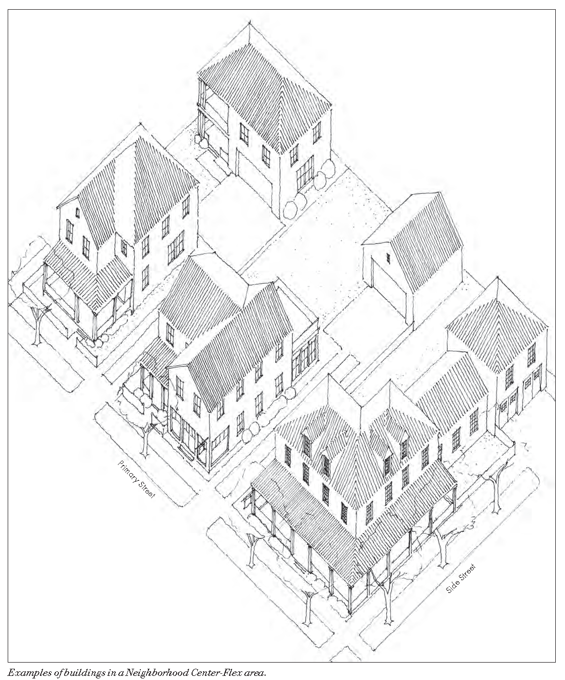
Neighborhood Center-Flex (NC-Flex). The primary intent of this zone is to work in combination with the NC zone to promote the vitality of corridors and centers within different neighborhoods. This zone intends to promote flexibility of use, allowing the market to determine ground floor character while establishing the built form in order to ensure neighborhood compatibility. The nature of development within these zones will be informed by and will enhance the character of existing conditions within historic neighborhoods. The South Auburn corridor is a good example of an area appropriate for the application of this zone. The NC-Flex zone standards may apply to properties designated with a variety of existing zoning districts, including OP, R-1, C-1, C-2, and R-3, provided that the zone:
1.
May use the name of the applicable neighborhood or area (e.g. "NC-Flex-S. Auburn Corridor");
2.
Allows for medium/high density housing near mixed-use centers to help support the centers and promote a walkable neighborhood;
3.
Allows residential or commercial on ground floors; and
4.
Anticipates that frontages are likely to vary (between zero feet and twelve feet) by specific area based on existing conditions.
D.
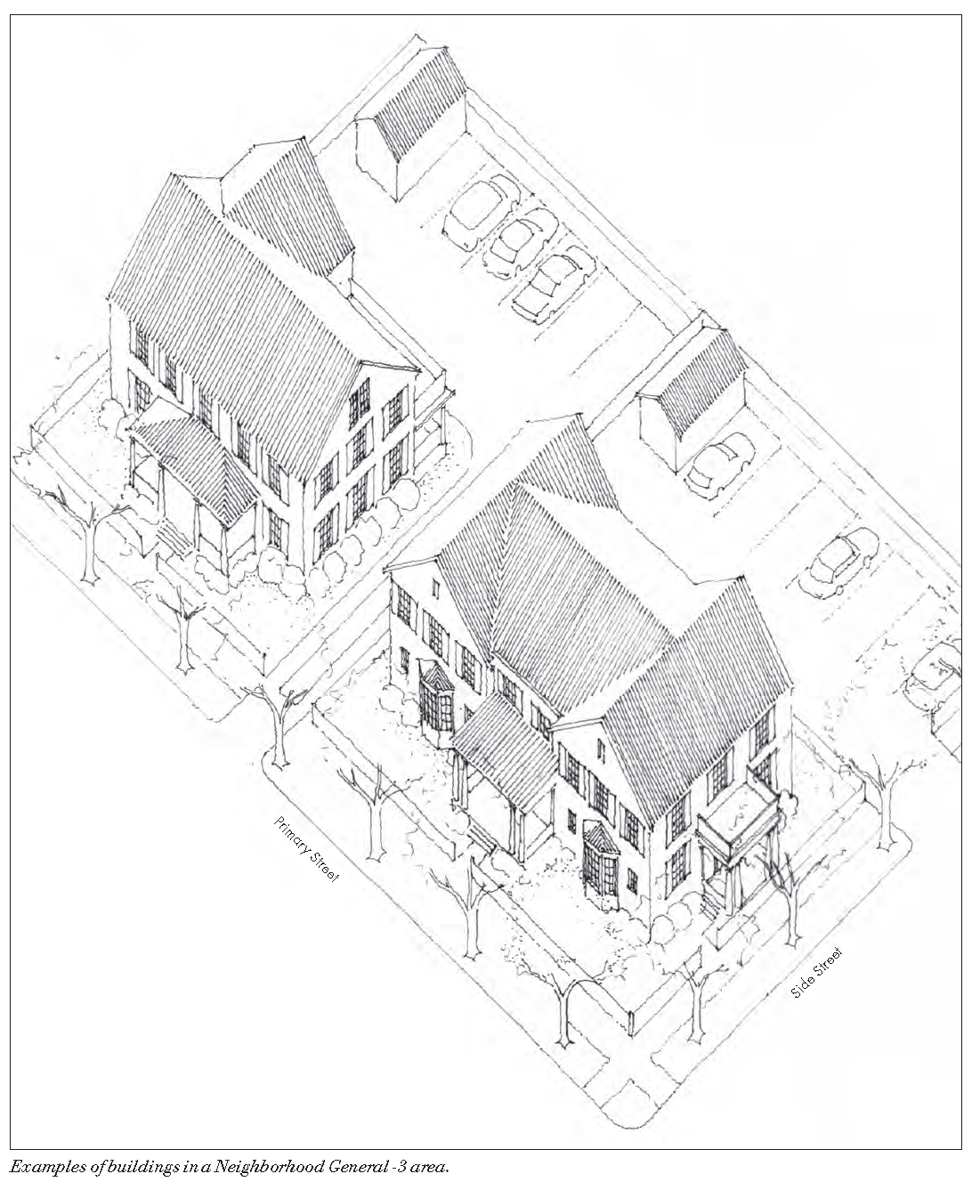
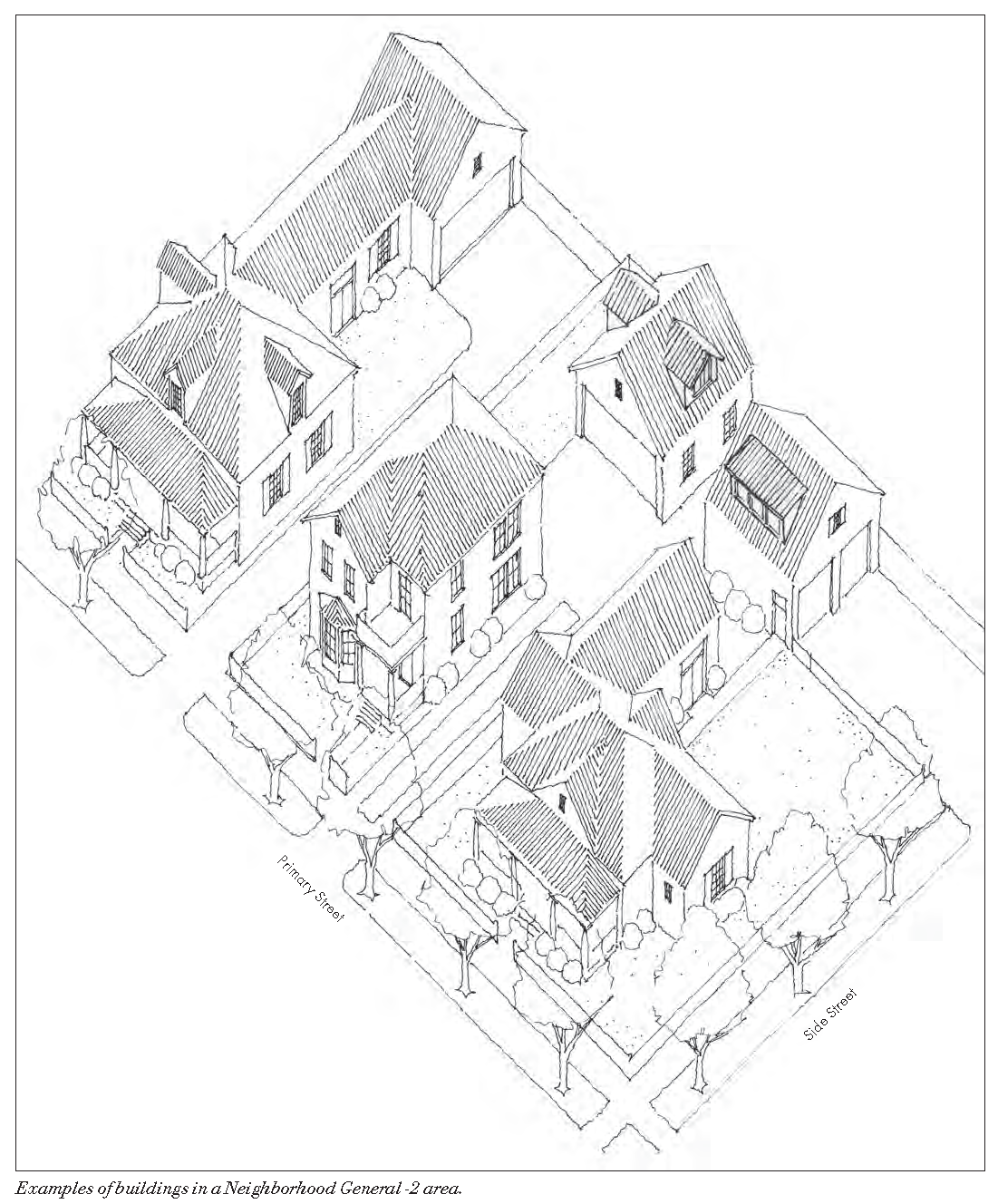
Neighborhood General-3 (NG-3). The intent of this zone is to reinforce the character of the existing neighborhood fabric while encouraging additional housing to be provided. This zone will require well-designed density in the form of larger buildings that maintain a compatible size, shape, and scale with existing neighborhood architecture. Good examples of the scale and character of this housing should be large historic homes within the city that have been divided into multiple apartments. The NG-3 zone may be applied to properties previously designated in the R-2A and R-3 zoning districts, provided that the zone:
1.
May include the name of the applicable neighborhood or area (e.g. "NG-3-Ohio Heights");
2.
May be applied to areas that have historically been single-family but have been designated to evolve into higher density housing due to location within neighborhoods and near centers; and
3.
The development standards will reinforce the character of the existing historic fabric along the street, but in a way that may encourage additional housing to be provided.
E.
Neighborhood General-2 (NG-2). The primary intent of this zone is to strengthen the character of existing historic neighborhoods within Grass Valley. It seeks to protect and enhance the unique character of existing neighborhoods, particularly in locations where this character may be most susceptible to change. The NG-2 zone may be applied to properties previously designated within the R-1 and R-2 zoning districts, provided that the zone:
1.
May include use name of the applicable neighborhood or area (e.g. "NG-2-Sunrise Hill");
2.
Will work in coordination with existing preservation standards or guidelines; and
3.
May designate specific areas within historic neighborhoods that have atypical existing conditions, such as extremely small lots or houses, within which specific development standards may be created to preserve the character.
17.21.040 - Town Core (TC) Standards.
17.21.050 - Neighborhood Center (NC) Standards
17.21.060 - Neighborhood Center-Flex (NC-Flex) Standards
17.21.070 - Neighborhood General-3 (NG-3) Standards.
17.21.080 - Neighborhood General-2 (NG-2) Standards
17.22.010 - Purpose.
This chapter lists the land uses that may be allowed within the residential zones established by Section 17.12.020 (zoning map and zones), determines the type of planning permit/approval required for each use, and provides basic standards for site layout and building size.
17.22.020 - Purposes of the residential zones.
The purposes of the individual residential zones and the manner in which they are applied are as follows:
A.
RE (Residential Estate) Zone. The RE zone is applied to areas of the city that are appropriate for single dwellings, but where infrastructure limitations and/or environmental constraints limit the ability for development to achieve urban densities. This zone is also used to facilitate annexation to the city. The RE zone is consistent with and implements the urban estate density (UED) designation of the general plan.
B.
R-1 (Single Residential) Zone. The R-1 zone is applied to areas of the city that are appropriate for neighborhoods of single dwellings on standard urban lots, surrounding the more densely developed city core. The r-1 zone is consistent with and implements the urban low density (ULD) designation of the general plan.
C.
R-2 (Two-Family Residential) Zone. The R-2 zone is applied to areas of the city that are appropriate for a mixture of both single- and two-family dwellings. The R-2 zone is consistent with and implements the urban low density (ULD) and urban medium density (UMD) designations of the general plan.
D.
R-2A (Medium Density Residential) Zone. The R-2A zone is applied to areas of the city that are appropriate for neighborhoods with a variety of housing types located in proximity to parks, schools, and public services. The R-2A zone is consistent with and implements the urban medium density (UMD) designation of the general plan.
E.
R-3 (Multiple Dwelling Residential) Zone. The R-3 zone is applied to areas of the city that are appropriate for a variety of higher density housing types, located in proximity to parks, schools, and public services. The R-3 zone is consistent with and implements the urban high density (UHD) designation of the general plan.
17.22.030 - Residential zone allowable land uses and permit requirements.
A.
General Permit Requirements. Table 2-7 identifies the uses of land allowed by this development code in each residential zone, and the planning permit required to establish each use, in compliance with Section 17.20.030 (allowable land uses and planning permit requirements).
B.
Requirements for Certain Specific Land Uses. Where the last column in Table 2-7 ("specific use regulations") includes a section number, the referenced section may affect whether the use requires a minor use permit or use permit, and/or may establish other requirements and standards applicable to the use.
(Ord. No. 818, § 3(Exh. A), 9-13-2022)
17.22.040 - Residential zone site planning and building standards.
Subdivisions, new land uses and structures, and alterations to existing land uses and structures, shall be designed, constructed, and established in compliance with the requirements in Tables 2-8 and 2-9, in addition to the applicable standards (e.g., landscaping, parking and loading, etc.) in Article 3.
TABLE 2-8 RE, R-1, AND R-2 ZONE DEVELOPMENT STANDARDS
TABLE 2-9: R-2A AND R-3 ZONE DEVELOPMENT STANDARDS
17.24.010 - Purpose.
This chapter lists the land uses that may be allowed within the commercial and industrial zones established by Section 17.12.020 (zoning map and zones), determines the type of planning permit/approval required for each use, and provides basic standards for site layout and building size.
17.24.020 - Purposes of commercial and industrial zones.
The purposes of the individual commercial zones and the manner in which they are applied are as follows:
A.
C-1 (Community Business District) Zone. The C-1 zone is applied to areas of the city that are appropriate for small-scale facilities providing convenience shopping and services. The C-1 zone implements and is consistent with the commercial land use designation of the general plan.
B.
C-2 (Central Business District) Zone. The C-2 zone is applied to areas of the downtown not covered by the TC (town core) zone in Chapter 17.21 (traditional community development zones), where existing auto-oriented development is expected to be maintained. The C-2 zone implements and is consistent with the commercial land use designation of the general plan.
C.
C-3 (Heavy Commercial) Zone. The C-3 zone is applied to areas of the city that are intended to provide for heavier and auto-oriented land uses that are inappropriate in C-1 areas and within the downtown. The C-3 zone implements and is consistent with the commercial land use designation of the general plan.
D.
OP (Office Professional) Zone. The OP zone is applied to areas of the city that are intended to serve the office and institutional needs of the community that cannot be accommodated within the downtown. Other related and office-supporting uses may also be allowed. The OP zone implements and is consistent with the office and professional land use designation of the general plan.
E.
CBP (Corporate Business Park) Zone. The CBP zone is applied to areas of the city appropriate for employment with a "campus" type character, which includes landscaped open space between buildings, screened service areas, uniform sign and street lighting standards and maintenance of a landscape theme throughout. Existing uses that become nonconforming when the zone is established may remain but are expected to eventually phase into conforming uses. This zone will provide opportunities for corporate administrative offices and medium size research and development firms to locate in Grass Valley within a high-quality development. Land uses within the zone should be compatible with adjacent residential uses and buffered from them. High standards of appearance and design will be required and maintained with restrictions on outdoor storage and activities with obnoxious characteristics. The CBP zone implements and is consistent with the office and professional and business park designations of the general plan.
F.
M-1 (Light Industrial) Zone. The M-1 zone is applied to areas appropriate for a range of light industrial uses. The M-1 zone implements and is consistent with the manufacturing-industrial designation of the general plan.
G.
M-2 (General Industrial) Zone. The M-2 zone is applied to areas appropriate for a range of heavy industrial activities including manufacturing, assembly and processing, the storage and distribution of raw materials, aggregate plants, and related industrial uses that are generally compatible with and require locations removed from residential and visitor serving uses. The M-2 zone implements and is consistent with the manufacturing-industrial designation of the general plan.
17.24.030 - Commercial and industrial zone land uses and permit requirements.
A.
General Permit Requirements. Table 2-10 identifies the uses of land allowed by this development code in each commercial and industrial zone, and the planning permit required to establish each use, in compliance with Section 17.20.030 (allowable land uses and planning permit requirements).
B.
Requirements for Certain Specific Land Uses. Where the last column in Table 2-10 ("specific use regulations") includes a section number, the referenced section may affect whether the use requires a minor use permit or use permit, and/or may establish other requirements and standards applicable to the use.
(Ord. No. 818, § 3(Exh. A), 9-13-2022)
17.24.040 - Commercial and industrial zone site planning and building standards.
Subdivisions, new land uses and structures, and alterations to existing land uses and structures, shall be designed, constructed, and/or established in compliance with the requirements of Tables 2-11, 2-12, and 2-13, in addition to the applicable development standards (e.g., landscaping, parking and loading, etc.) in Article 3.
TABLE 2-11: C-1, C-2, AND C-3 ZONE DEVELOPMENT STANDARDS
TABLE 2-12: OP AND CBP ZONE DEVELOPMENT STANDARDS
TABLE 2-13: M-1 AND M-2 ZONE DEVELOPMENT STANDARDS
(Ord. No. 818, § 3(Exh. A), 9-13-2022)
17.24.050 - Additional commercial and industrial zone standards.
A.
C-2 Zone Standards. A use permit for a dwelling shall be approved only if the lot area per dwelling unit is at least two thousand square feet, exclusive of any portion of the lot used for commercial purposes.
B.
OP Zone Standards. All sales, displays and storage in the OP zone shall be conducted within an enclosed building, unless open sales, display and storage is specifically approved on the site plan or within the provisions of this chapter.
C.
CBP Zone Standards. Proposed development and new land uses within the CBP zone shall comply with the following standards in addition to those in Section 17.24.040 (commercial and industrial zone site planning and building standards).
1.
Height Limit Exceptions. Heating, cooling, other roof equipment and fire storage facilities may extend above the thirty-five-foot height limit established by Section 17.24.040, provided that they are screened and integrated into the architecture of the building; except when no equipment is mounted on the roof (e.g., all mechanical equipment is enclosed under and does not penetrate the roof), the maximum height of the building may be increased to forty-five feet subject to Design Review approval.
2.
Mechanical Equipment. Outdoor mechanical equipment, transformers, utility vaults and meters, fire protection apparatus, and other utilities shall be treated as an integral part of the building design. When it is necessary to locate the equipment between the front of the building and the street, it shall be screened from view.
3.
Solar Access and Energy Conservation Guidelines. Buildings should be designed and oriented to maximize solar access and minimize heating and cooling requirements. Where appropriate, energy conservation methods such as glazed/double paned windows, recessed entryways, awnings and solar collectors should be utilized as appropriate.
4.
Location of Manufacturing Activities. All manufacturing activities shall be located within an entirely enclosed building.
17.26.010 - Purpose.
This chapter lists the land uses that may be allowed within the special purpose zones established by Section 17.12.020 (zoning map and zones), determines the type of planning permit/approval required for each use, and provides basic standards for site layout and building size.
17.26.020 - Purposes of the special purpose zones.
The purposes of the individual special purpose zones and the manner in which they are applied are as follows:
A.
OS (Open Space) Zone. The OS zone is applied to properties that are largely unimproved and used for the preservation of natural resources and habitats, passive outdoor recreation, scenic resources, and/or for the protection of public health and safety (e.g., preservation of flood plains). Allowable uses are limited to those that support maintenance and/or recreational uses. The OS zone implements and is consistent with the parks and recreation land use designation of the general plan.
B.
REC (Recreation) Zone. The REC zone is applied to the sites of public parks and recreational facilities. Allowable uses are limited to recreational uses, and the structures needed to support those uses, and facility and site maintenance. The REC zone implements and is consistent with the parks and recreation land use designation of the general plan.
C.
P (Public) Zone. The P zone is applied to the sites of existing and proposed federal, state, and local government uses, and non-profit community service uses. The P zone implements and is consistent with the public, institutional, non-governmental, school, and utilities land use designations of the general plan.
D.
SP (Specific Plan) Zone. The SP zone is intended to accommodate various types of development such as professional and administrative offices, industrial parks, commercial service centers, neighborhood and district shopping centers, multifamily housing developments, single dwelling residential developments and any other use or combination of uses. The zone is intended to encourage the flexibility of design and development of land to promote the most appropriate use, to support high standards, to preserve the natural features and qualities of the site, to counteract the effects of urban congestion and monotony, to increase economy in provision of streets and utilities, to create attractive, identifiable centers for work, commercial services and residential development in Grass Valley.
17.26.030 - Special purpose zone land uses and permit requirements.
A.
General Permit Requirements. Table 2-14 identifies the uses of land allowed by this development code in each special purpose zone, and the planning permit required to establish each use, in compliance with Section 17.20.030 (allowable land uses and planning permit requirements).
B.
Requirements for Certain Specific Land Uses. Where the last column in Table 2-14 ("specific use regulations") includes a section number, the referenced section may affect whether the use requires a minor use permit, or use permit, and/or may establish other requirements and standards applicable to the use.
(Ord. No. 818, § 3(Exh. A), 9-13-2022)
17.26.040 - Special purpose zone site planning and building standards.
Subdivisions, new land uses and structures, and alterations to existing land uses and structures, shall be designed, constructed, and/or established in compliance with the requirements in Table 2-15 in addition to the applicable development standards (e.g., landscaping, parking and loading, etc.) in Article 3.
TABLE 2-15: OS, REC, AND P ZONE DEVELOPMENT STANDARDS
17.26.050 - OS zone requirements.
No new structure shall be erected or structurally enlarged within the OS zone unless the council has approved the plans and drawings filed in compliance with this section.
A.
Plan and Drawing Requirement. The owner shall submit two copies of each of the following drawings to the department for council review when applying for a building permit.
1.
Site Plan. A site plan, drawn to scale showing:
a.
The proposed layout of the structures and other improvements including driveways, pedestrian walks, off-street parking and off-street loading areas, landscaped areas, fences, walls and prominent natural terrain features;
b.
The locations of entrances and exits and the direction of traffic flow into and out of off-street parking and off-street loading areas, the location of each parking space and each loading berth, and areas for turning and maneuvering vehicles; and
c.
How utilities and drainage are to be provided.
2.
Landscape Plan. A landscape plan, drawn to scale, showing the locations of existing trees and other plant material on the site and surrounding area, the trees and other planting material proposed to be removed or retained on the site, and the location and proposed design of landscaped areas and the varieties and sizes of plant materials to be provided.
3.
Architectural Drawings. Architectural drawings drawn to scale, including floor plans in sufficient detail to permit computation of parking or yard requirements, and showing all elevations of the proposed structures as they will appear upon completion. All exterior surfacing materials and colors shall be specified.
4.
Sign Drawings. Scale drawings of all signs showing size, location, material, colors, and illumination if any.
5.
Additional Information. The council may require additional information if necessary to determine whether the purposes of this section are being carried out, or may authorize omission of any or all of the drawings required by this section if they are not necessary.
B.
Criteria for Approval. Council approval shall require that the project complies with all applicable city policies and standards, and the following standards.
1.
Adequate traffic and pedestrian circulation and access way shall be provided, dedicated and improved as necessary to avoid congestion and to prevent adverse affects on neighboring property.
2.
All buildings or structures shall be arranged to permit convenient access for the city's emergency and service equipment. The applicant may be required to install and maintain fire hydrants, stand pipes and other fire protection devices.
3.
All buildings and landscaping shall have the scale and proportions which are appropriate to their size, to surrounding areas, and to the intent of the OS zone.
4.
Building elevations shall be compatible with the characteristics of the surrounding areas and the intent of the OS zone, as determined by the review authority.
5.
Landscaping, exterior lighting, walls, fences and screened planting shall be compatible with the characteristics of the surrounding areas, and the intent of the OS zone.
(Ord. No. 818, § 3(Exh. A), 9-13-2022)
17.26.060 - P zone requirements.
A.
Applicability. The requirements of this section apply to proposed development within the P zone in addition to the standards in Section 17.26.040 (special purpose zone site planning and building standards).
B.
Site Planning and Design Requirements. Site planning and design requirements in P zones shall be determined through use permit review and approval, or through the site plan review process provided by this section where Section 17.26.030 (special purpose zone land uses and permit requirements) does not require use permit approval. No use shall be commenced and no building permit shall be issued for any structure within the P zone until a site plan has been approved in compliance with this section.
C.
Site Plan Preparation and Review.
1.
Application Requirements. The required site plan shall specify and show, as applicable:
a.
Lot dimensions;
b.
All proposed structures, including their location, dimensions, heights, and proposed uses;
c.
Walls and fences, including their location, height, and materials;
d.
Off-street parking, including its location, number of spaces, and dimensions of parking areas, and their internal circulation patterns;
e.
Access to and on the site, including pedestrian, vehicular, service, points of ingress and egress;
f.
Signs, including their location, size, height, and type;
g.
Loading areas including their location, dimensions, number of spaces, and internal circulation;
h.
Lighting, including its location and type, and measures to ensure compliance with Section 17.30.060 (outdoor lighting);
i.
Landscaping and irrigation, including its location and proposed plant and tree varieties;
j.
The location, dimensions and method of improvement of all property to be dedicated to the public or to public utilities; and
k.
Plans or reports detailing the proposed treatment of disposal of sewage and/or industrial waste.
2.
Site Plan Review. Each site plan shall be submitted to and approved by the council after a public hearing in compliance with Chapter 17.92 (public hearings).
a.
A site plan may be approved, modified and approved or approved subject to conditions, or rejected.
b.
After approval, a site plan may be amended in the same manner as a site plan as first approved in compliance with this section.
c.
If the council determines that a proposed site plan may unreasonably interfere with the use or enjoyment of property in the vicinity or endanger the public peace, health, safety, or general welfare, the council may reject the plan, or modify or condition the approval of the plan to address the problems.
d.
A site plan may be required prior to recommending a change of zone, and the council may approve a site plan subject to securing a change in zone.
D.
Effect of Site Plan Approval. No person shall fail to comply with any approved site plan or any applicable conditions of approval, nor shall a building permit be issued for a structure that would not comply with the applicable approved site plan.
(Ord. No. 818, § 3(Exh. A), 9-13-2022)
17.26.070 - REC zone requirements.
A.
Applicability. The requirements of this section apply to proposed development within the REC zone in addition to the standards in Section 17.26.040 (special purpose zone site planning and building standards).
B.
Landscaping. Significant landscaping shall be incorporated into the required front setback, as determined by the review authority.
C.
Open Space. Open space shall be maintained on each site, including the following environmentally sensitive areas: 100-year flood plains as delineated on FEMA maps, environmentally sensitive wetlands, slopes in excess of thirty percent, lakes and ponds. In preserving these environmentally sensitive areas, emphasis shall be placed on maintaining the natural characteristics of the property while ensuring that any proposed development is harmonic with the terrain and provides buffer yards for neighboring land uses. Areas designated as environmentally sensitive shall remain in their natural and undisturbed state and shall be maintained in such a manner as to not create a fire hazard.
17.26.080 - SP zone requirements.
A.
Applicability.
1.
Area of Application. An SP zone may be established by an amendment to this development code, or as a prezoning for any area within the boundary of the general plan. Each SP zone shall be a logical geographical unit and may include one or more parcels. An SP zone may be broken down into subareas for the purpose of assigning specific development standards and regulations.
2.
Development Standards. Site requirements, uses permitted and all other conditions on development shall be determined as part of the adoption of an SP zone and may be incorporated into the zoning ordinance by reference.
3.
General Plan Consistency. An SP zone shall conform to the policies of the applicable general plan designation.
4.
Minimum Site Area. The minimum size for an SP zone shall be five acres. Smaller parcels may be combined in an application to meet minimum qualification for land area.
5.
Establishment of an SP Zone. The rezoning of property to apply an SP zone shall include the adoption of the following requirements:
a.
Identification of geographical area where district standards and subarea standards apply;
b.
Description of the intent and character of area development;
c.
Identification of environmental mitigation measures and important features to be preserved;
d.
Identification of uses permitted and uses requiring use permits;
e.
Identification of street and right-of-way standards and easements for provisions of utilities and pathways; and
f.
Identification of standards for height and bulk, set-back, parking, lot size, percentage of open space and type of landscaping.
B.
Rezoning Procedure. The procedure for designating property with the SP zone shall comply with the requirements for rezoning in Chapter 17.94 (amendments).
C.
Amendments to SP Zone. An SP zone as applied to property may be amended only as follows.
1.
Determination of Amendment Type. The director will be responsible for determining whether an amendment proposal is major or minor. A major amendment shall follow the procedure required by subsection B. for new districts. A minor amendment may be approved or denied by the director. The decision shall be made in writing and in event of a denial, the applicant may appeal the decision to the commission. The appeal shall be in writing filed with the secretary of the commission within fifteen days after the director's decision.
2.
Criteria for Determination. The director shall apply the following criteria when determining whether a proposal is a major or minor amendment:
a.
Introduction of land uses not discussed previously;
b.
Major changes in layout of land uses;
c.
Alteration of circulation concepts;
d.
Changes in densities or design standards; and
e.
Changes in plan which may create or increase environmental impacts.
3.
Findings Required for Approval. The following findings shall be considered by a review authority prior to a recommendation for approval:
a.
Changes have occurred in the community since the specific plan was adopted.
b.
The amendment will benefit the specific plan area or the community.
c.
The amendment is consistent with the general plan.
d.
The change will not adversely affect adjacent properties and can properly be serviced.
e.
There are physical constraints associated with the property that make the amendment warranted.
D.
Development Map Requirements. The purpose of a development map is to ensure the requirements, standards and intent of the specific plan zone are met for sites within the specific plan area.
1.
Applicability and Application Requirements.
a.
No construction or building permit may be approved on a site in the SP zone without the review and approval of a development map by the director/commission to ensure its consistency with the requirements of the zone.
b.
A development map application shall be submitted on the form provided by the department, and shall include the fee required by the city's fee schedule, and all documents and materials specified by the director.
2.
Adoption of Development Map. A development map shall be reviewed and approved as follows:
a.
Responsibilities of Director. The director shall:
(1)
Determine that the application is complete;
(2)
Review the development map for compliance with the general plan, the SP zone, applicable environmental mitigation measures and other city requirements;
(3)
Circulate copies of the development map and related information to appropriate departments and agencies for review (this may occur concurrently with environmental review and subdivision review);
(4)
Hold a development map conference with the applicant and commentary agencies prior to the commission hearing; and
(5)
Prepare a report for the commission including comments from other agencies, environmental determination and a recommendation.
b.
Responsibilities of Commission. The commission shall:
(1)
Hold a public hearing on the development map following the notice procedure in Chapter 17.92 (public hearings); and
(2)
Approve, deny or modify the development map. The decision of the commission may be appealed to the council.
3.
Amendment of Development Map. A development map may be amended only as follows:
a.
Development map changes may be approved by the director provided the director first determines that they do not conflict with the intent of initial development plan approval or with the SP zone.
b.
If the director determines that changes in the development map may conflict with its initial approval, the application shall be decided by the commission.
E.
Annexation of SP Zone. The procedure for annexation shall be as follows:
1.
The SP zone must be adopted by the council.
2.
Following adoption, lands in the area that are contiguous to the existing city boundary will be eligible to apply for annexation.
3.
Annexations will be processed through LAFCO and will be considered on the basis of the city's adequacy to provide services.
17.28.010 - Purpose.
The provisions of this chapter regulate development and new land uses in the combining zones established by Section 17.12.020 (zoning map and zones), and provide guidance for development within the combining zones in the form of standards that apply to proposed development in addition to the standards and regulations of the primary zone, where important site, environmental, safety, compatibility, or design issues require particular attention in project planning.
17.28.020 - Applicability of combining zones.
The provisions of this chapter apply to proposed land uses and development in addition to all other applicable requirements of this development code. Any perceived conflict between the provisions of this chapter and any other provision of this development code shall be resolved in compliance with Section 17.10.050 (rules of interpretation).
A.
Mapping of Combining Zones.
1.
Zoning Map Symbols. The applicability of any combining zone to a specific site is shown by the combining zoning map symbol established by Section 17.12.020 (zoning map and zones), being appended as a suffix to the symbol for the primary zone on the zoning map. The combining zones are applied to property through the rezoning process (Chapter 17.94).
2.
Symbols for Modification of Standards. A combining zone may modify the required building site area or width, or the permitted building height from that required by the primary zone if so specified on the zoning map. These specifications may be in excess or be less than the requirements of the primary zone, and shall be shown as follows:
a.
A number preceding and connected by a hyphen with the zone symbol shall designate the minimum required building site width in feet. Example: 200-C1.
b.
A number following and connected by a hyphen with the zone symbol shall designate the minimum required building site area. Where the number is greater than one hundred, it shall indicate the area in square feet; where the number is less than one hundred, it shall indicate the area in net acres. Example: C1-20,000 or C1-1.
c.
A number following the zone symbol, and enclosed by parenthesis, shall designate the minimum number of square feet of land area required for each dwelling unit. Example: R3 (4,300).
d.
A combining zone may modify the maximum building height otherwise required by the primary zone with a number shown below and separated by a line from the primary zone symbol; the number shall designate the maximum allowed height for a building or structure in feet. Example: C1/65.
e.
The preceding symbols may be used in any combination to show minimum site, width, minimum site area, minimum area per dwelling unit or maximum height. Example: 100-C1-15,000/65 or 100-R3-20,00 (4,000)/40.
f.
The letter "X" following the primary zone symbol requires that the minimum building site area shall be as shown on the final map or parcel map of record. Example: R1-X.
B.
Allowed land uses, permit requirements, development standards. Except as may be otherwise provided by this chapter for a specific combining zone:
1.
Any land use normally allowed in the primary zone by this Article may be allowed within a combining zone, subject to any additional requirements of the combining zone;
2.
Development and new land uses within a combining zone shall obtain the zoning approvals required by this Article for the primary zone; and
3.
Development and new land uses within a combining zone shall comply with all applicable development standards of the primary zone, all other applicable provisions of this development code (e.g., Article 3 - Site planning and project design standards), and the city's design guidelines to the extent determined by the review authority and/or specific provisions of the design guidelines.
17.28.030 - Design (D) combining zone.
A.
Purpose. The -D (design) combining zone is intended to provide to provide controls and safeguards to preserve and enhance areas of historical, civic or cultural value to the city. Recognizing that Grass Valley is endowed with these areas and that the protection and preservation of these sites will maintain the quality of life, enhance the tourism industry, the regulations of this combining zone will be of benefit to the economy and enrichment of the city.
B.
Rezoning Requirements.
1.
Criteria for Area and Standards. The following criteria shall be used in establishing regulations for an area to be rezoned with the -D combining zone, and the selection of the area to be rezoned:
a.
Areas of special or unique natural beauty and aesthetic interest forming a basic resource in the economy of the city, the preservation of which would enhance the tourism industry; and
b.
Places, sites, structures or uses which have special historical interest.
2.
Findings for Rezoning. The following finding or findings shall be made a part of a rezoning ordinance to apply the -D combining zone to property:
a.
The specific special and unique natural beauty and aesthetic interest of the place, site, structure or use; and/or
b.
The specific special historic interest of the place, site, structure or use.
C.
Architectural Standards. So that buildings, structures, signs, landscaping, etc., will be keeping with the findings stipulated in Subsection B.2, the commission shall take the following items under consideration in approving plans for a site within the -D combining zone.
1.
The height, bulk and area of buildings;
2.
Setbacks from property lines;
3.
The color, textures and materials of the exterior walls;
4.
The type, pitch and material of roofs;
5.
The type, size and location of signs;
6.
Landscaping and parking lot layout;
7.
The relationship to other buildings and/or uses in the area;
8.
The architectural treatment as related to any historical buildings or structures; and
9.
The location and treatment of the site as related to its natural setting, including grading, cuts and fills and preservation of trees and natural ground cover.
D.
Commission Review of Proposed Plans. No building permit shall be issued for construction within the -D combining zone until the proposed plans have been approved or conditionally approved by the commission.
1.
Application Requirements. The applicant shall submit required data on the items to be considered in Subsection C. for commission approval.
2.
Referral for Advice. In its review of plans, the commission may seek the advice of any person or organization, who, in the opinion of the commission is qualified to give the advice. The person or organization must be devoid of any and all financial interest in the development under consideration.
3.
Changes to Project. If the commission finds that the proposed structure or uses are incompatible to the purpose and intent of the -D combining zone, the commission or its designated representative shall endeavor to have the plans changed to conform to the purpose and intent of the combining zone.
4.
Appeal. If the applicant is not satisfied with the commission's or its representative's action, they may appeal the decision to the council in compliance with Chapter 17.91 (appeals).
E.
Destruction or Alteration of Historical Buildings. No historical building in the -D combining zone shall be moved or relocated, torn down, demolished, destroyed, altered, improved or otherwise changed in exterior appearance except as follows:
1.
If any historical building is damaged by an act of God, including earthquake or fire, the owner may repair the building if he secures a permit from the commission or its authorized representative.
2.
An owner making any alteration to the exterior of a historical building or intending to move or relocate the building shall submit plans and secure approval from the commission or its authorized representative prior to construction and/or issuance of a building permit.
17.28.040 - Historical (H) combining zone.
A.
Purpose. The -H (Historical) combining zone is intended to identify important cultural resource sites and structures in the city, to ensure that any proposal to alter the state of the site or structure is carefully considered prior to implementation.
B.
Applicability. All proposed construction, demolition, exterior alteration, addition, modification of a structure or part of a structure or sign within the -H combining zone shall comply with all applicable requirements of this section.
C.
Historic Review.
1.
When Required. Historic review in compliance with this section shall be required prior to:
a.
The issuance of a building permit for any new construction, demolition, or exterior alterations, additions, or modifications of a structure or part of a structure, or sign.
2.
Exempt Activities. The activities listed below are exempt from the provisions of this section. All construction or improvement activities seeking an exemption shall be submitted to and reviewed by the department to ensure that such work is in compliance with this section:
a.
Repainting of a building or sign with a color listed on a paint company's historic color palette and consistent with color patterns established by other buildings in the historic combining zone; or
b.
Signs that comply with the following criteria:
i.
Meet the size, number, and type standards listed in table 3-11.
ii.
Suspended signs shall be at least three-fourths inch MDO, wood or similar material and include a trim element (paint or wood) around the edge of the sign.
iii.
Projecting or suspended signs shall be pedestrian oriented.
iv.
The style, color, and design shall be consistent with the character and themes of other signs in the historical combining zone.
v.
No signs shall be located above the awning, unless previously existing.
vi.
Door signs are exempt from the total of three permitted signs only if they include a small logo or name of business, hours of operation, and phone number.
c.
Modifications to the structure which exposes and restores original architectural features such as exterior materials, windows and openings.
3.
Application Requirements. An application for historic review shall include the materials and information required by the department.
4.
Consultation. In reviewing plans, the development review committee shall consult with the planning commission and the Grass Valley Historical Commission, the Nevada County Landmarks Commission, the Nevada County Historical Society, and other persons and agencies and organizations knowledgeable in the history of Grass Valley.
5.
Timing of Review. The development review committee shall review submitted plans at its next regular or special meeting and report its approval, conditional approval or denial to the applicant and the building official within thirty days.
6.
Public Hearing. The development review committee may call for public hearings as it may deem necessary or desirable prior to approving submitted plans. If a public hearing is to be held, notice shall be provided and the hearing shall be conducted in compliance with Chapter 17.92 (public hearings).
7.
Criteria for Application Approval. In reviewing a project within the -H combining zone, the development review committee shall consider its relationship to nearby buildings, the general character of the area within the zone, and the proposed conformity with the design criteria in the "Design Manual, Downtown Historic Area, Grass Valley, California," prepared by WPM Planning Team, Inc., in December 1981, on file in the city clerk's office and described from time-to-time by resolution of the city council.
D.
Standards for Awnings, Canopies, Unroofed Porches and Similar Structures. Building materials and construction in "-H" districts shall conform to applicable City Codes in force except that in areas where awnings or similar structures are allowed, the following shall apply:
1.
Dimensional Requirements.
a.
Awnings, marquees, canopies and unroofed porches may extend over public property in zones where there are no setback requirements.
b.
Awnings may extend over public property not more than seven feet from the face of a building not within two feet of the curb line measured horizontally. All portions of awnings shall have at least eight feet of clearance above public walkways.
c.
Marquees, canopies, and unroofed porches shall have at least nine feet minimum clearance above the paved roadway or sidewalks surface whichever is higher. No structure shall extend beyond the curb line.
d.
Marquees, canopies, and unroofed porches shall be provided with gutters and downdrains concealed in supports or walls and made to drain under walkways.
e.
Posts supporting canopies and unroofed porches on the street side of walkways shall be at least one foot back of the curb line to the face of the post and the canopy or unroofed porch designed so that it will be supported if any one post is removed. A greater curb line to post face may be required by the building inspector if the slope of the adjacent street will cause vehicles to lean into posts.
2.
Construction Materials.
a.
Awnings shall have non-combustible covering supported on non-combustible frames attached to the building.
b.
Canopy and unroofed porch posts shall be of reinforced concrete, steel or other non-combustible materials supported by concrete footings.
c.
Marquees, canopies, and unroofed porches shall be provided with an automatic sprinkling system if one-hour fire resistive construction is not provided. Complete fire-retardant treated wood, in locations protected from contact with rainwater may be used in conjunction with one-hour fire-resistive construction on the remainder of the structure. Roofs shall be fire-retardant.
17.28.050 - Mobile home and mobile home park (MH) combining zone.
The -MH combing zone may be combined through rezoning with other zones applicable to specific property to translate the requirements of the regulations of Section 17.44.150 mobile/manufactured homes and mobile home parks.
17.28.060 - Mining and reclamation (MR) combining zone.
The -MR (mining and reclamation) combining zone may be combined through rezoning with other zones applicable to specific property, excluding residential zones, to translate the requirements of the regulations of Chapter 17.42 (mining and reclamation) into the development/mining of a selected site.
17.28.070 - Hills Flat business district (HFBD) combining zone.
A.
Purpose. The Hills Flat Business District (HFBD) combining zone applies to an area around the Idaho-Maryland Road/East Main Street intersection. This combining zone is intended to implement several programs from the Idaho-Maryland Road/East Main Street Redevelopment Study adopted in March 2010. This combining zone also establishes additional use restrictions and design regulations through the implementation of the city's community design guidelines.
B.
Use Restrictions. All uses in Table 2-10 are allowed as noted with the exception of drive-through restaurants, which are prohibited. The city has determined this type of use is not appropriate for this area due to traffic-related impacts.
C.
Development Standards. Besides the development standards required in the applicable C-2 or C-3 zone, any new structures and alterations shall comply with the following standards:
1.
All outdoor storage use shall be screened as viewed from public rights-of-way to the extent feasible. The city recognizes full screening may not be obtained due to the elevation changes on local roads and highways. Any proposal for outdoor storage shall include a plan for screening as part of the development review process. The screening shall include a decorative finish that complements the existing or proposed building. The review authority may consider a solid landscaped hedge in conjunction with the fence or wall.
2.
To the extent feasible, street facades must be built to the property line of every corner. The city recognizes there are several parcels in this area that have curved street frontages. In those instances, the building shall include additional architectural elements in order to have as much of the building along the property line as practicable.
3.
All street facades shall have a primary ground-floor entrance.
4.
Buildings shall be a minimum of sixteen feet in height.
5.
Rear-facing buildings, loading docks, overhead doors, and other service entrances are prohibited on street frontages.
6.
Canopies, awnings, and balconies may encroach over the property line on the street.
D.
Project Review and Streamlining. An additional objective of the redevelopment study and implementation of this combining zone is to encourage attractive redevelopment of this area. This can be accomplished by encouraging new buildings to front the street and placing parking behind the building. Creative use of landscaping can also assist in the enhancement of the study area.
If development projects comply with the base zone standards and standards listed above, the city will streamline the processing of applications by allowing development review permits to be reviewed and decided upon as follows:
1.
New buildings or additions of two thousand square feet or less: Community development director approval;
2.
New buildings or additions between two thousand one and ten thousand square feet: Development review committee approval;
3.
New buildings or additions greater than ten thousand one square feet: Planning commission approval.
17.28.080 - Southeast industrial district (SEID) combining zone.
A.
Purpose. The southeast industrial district (SEID) combining zone applies to the area east of La Barr Meadows Road and west of Empire Mine State Park in the vicinity of Amsel Way as depicted in Figure 2-1. This combining zone is intended to permit the continuation, intensification, and expansion of the uses of properties within the combining zone according to the permitted uses established for the combining zone.
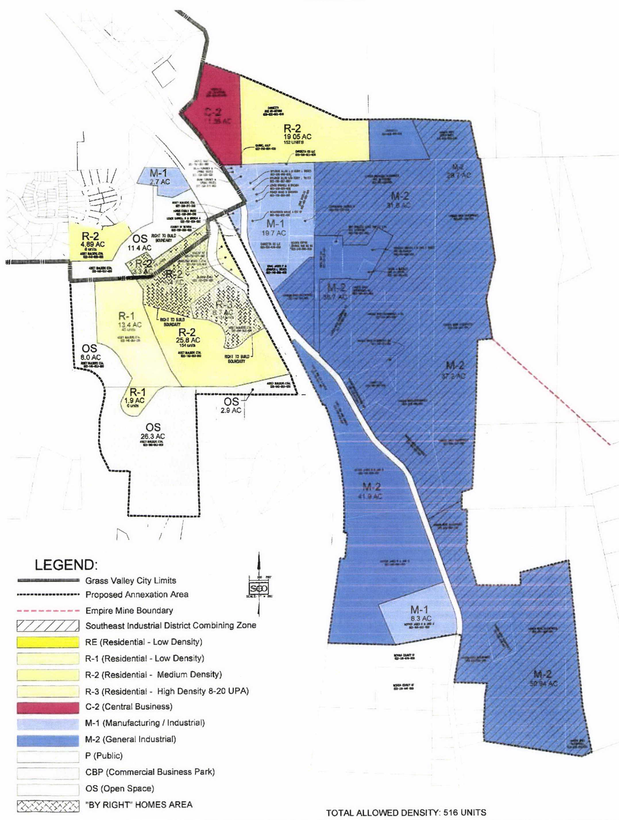
Figure 2-1. Southeast Industrial District
B.
Permitted Uses. All uses in Table 2-10 are allowed by right as noted in the M-1 and M-2 Zone of the Development Code as designated by the Grass Valley Development Code Section 17.24.030, with the addition of the following permitted uses, which shall also be allowed by right:
1.
Concrete, gypsum and plaster product manufacturing, including asphalt production.
2.
Crushing, sorting and recycling of concrete, asphalt, aggregate, and construction materials.
3.
Outdoor storage and sales of building, construction, and landscape materials including the import, export, and storage of aggregate products, rock, dirt, sand and or soil without a grading or stockpile permit.
4.
Stump grinding, brush chipping, and the manufacturing, storage and sale of materials incidental to building and landscape materials sales.
5.
Incidental burning of stumps, brush, and other dry woody materials.
6.
Vehicle and equipment services.
7.
Manufacturing and Processing - Heavy, including manufacturing of equipment incidental to permitted uses in the combining zone.
8.
Fuel dealership.
9.
Construction, farm and heavy equipment sales and rentals.
10.
Bio-mass energy generation.
11.
All other uses permitted in the city's C.B.P, M-1 and M-2 Zone without a permit.
12.
Storage—Personal storage facility.
13.
Storage—Outdoor.
14.
Communication or antenna towers.
15.
All other existing nonconforming uses and activities in place at the time of adoption of this combining zone.
C.
Performance Standards Exemption for Existing Uses.
1.
Except as provided by state law, development within the SEID combining zone shall be subject to the performance standards specified in the Grass Valley Development Code Sections 17.30.070 and 17.30.090, except as those sections are specifically modified by the performance standards contained in Subsection C.2 below ("SEID combining zone performance standards"). In the event of a conflict between Sections 17.030.070 and 17.030.090 and the SEID combining zone performance standards, the SEID combining zone performance standards shall apply.
2.
SEID Combining Zone Performance Standards:
a.
Setbacks.
i.
Building Setbacks. Front and side building setbacks shall be a minimum of fifteen feet from the back of curb.
ii.
Parking Setbacks. Front and side parking setbacks shall be a minimum of five feet from the curb. Parking shall be allowed in the front setback if separated by a minimum five-foot wide landscape area or walkways.
iii.
Creek and Riparian Setbacks. Buildings must have a minimum setback of thirty feet from creek and riparian zones.
b.
Fences, Walls and Screening.
i.
Eight-foot chain-link fencing shall be allowed
ii.
Walls over forty-eight inches shall be allowed without benching for retaining walls so that retaining walls over six feet may be allowed. Bunker walls on frontages shall have an eight-foot maximum.
iii.
Screening shall not be required for any existing uses or future uses.
c.
Outdoor lighting. Existing uses shall not be required to conform to city standards related to lighting, except as they relate to cut-lighting and/or shielding directing light towards the ground and as necessary to maintain compliance with worker safety requirements under state law.
d.
Dust. Developments in the SEID combing zone must, at a minimum, comply with NSAQMD requirements.
e.
Vibrations. Shall be allowed to continue based on existing uses.
f.
Odors. Shall be allowed to continue with similar or same as existing uses. Asphalt, manure, and other industrial uses and products may be allowed to have an odor that may be noticeable beyond the property line.
g.
Solid Waste and Recycling. Solid waste and recycling facilities may be allowed to abut residentially designated properties or uses but must provide a one hundred-foot buffer/setback.
h.
Signs and Flagpoles. Second story and roof signs shall be allowed. Up to three hundred square feet of signage shall be allowed per parcel. No irrigated landscaping shall be required around the base of signs. Existing non-conforming signs may remain and can be maintained or replaced. There shall be no height limit imposed on flagpoles.
i.
Outdoor Displays and Material Storage. Outdoor (rental equipment) displays shall have no maximum height. All outdoor displays shall be allowed in setbacks and anywhere that does not disrupt traffic circulation, parking, or walkways. Cargo containers shall be allowed for rental or sale, but cannot be stacked more than two high. Material storage shall be allowed in non-frontage setbacks, and displayed with no height restrictions.
j.
Processing Facilities. Processing facilities shall be allowed to abut residentially designated properties or uses but must provide a one hundred-foot buffer/setback. There shall be no maximum number or volume of inbound or outbound shipments, employee traffic, customer traffic or maximum size of the processing facilities.
k.
Hillside and Ridgeline Development. No building shall be allowed on slopes greater than thirty percent. There shall be no maximum retaining wall height or bench minimum. Grading may be allowed on slopes exceeding thirty percent.
l.
Grading. Grading shall be allowed to occur between October 15 and April 15 when weather conditions permit, and adequate best management practices are utilized. Grading must meet requirements of the California Construction General Permit for Stormwater Discharges. All environmentally sensitive areas must be avoided, or mitigation measures must be implemented and therefore grading may occur within thirty feet of environmentally sensitive areas when appropriately mitigated.
m.
Subdivision Standards. No traffic calming measure shall be required for subdivisions. No pedestrian walkways or bike paths, or funding for either, shall be required for subdivisions. Parcels shall not be required to have gas, electric or sewer connections if already adequately served by existing utilities or can be served by existing of future private water wells and septic systems. City street names will be selected by the developer and approved by the city council.
n.
Parking.
i.
Building and landscape material display and outdoor storage shall require one parking space per every five thousand square feet of bulk material (bunkers or stockpiles).
ii.
On street parking (local road/driveway) shall be permitted without director approval and included in the parking space count so long as the road design allows for on street parking.
iii.
Rental Equipment Parking. Parking spaces may be gravel.
iv.
Vehicle Service Repair. No minimum number of spaces shall be required for existing or proposed truck or equipment maintenance shops.
v.
Loading Areas. Loading areas shall be allowed anywhere except where they encroach into stalls or driveways.
o.
Noise. Existing uses or future uses shall not be required to conform to city standards related to noise, except that noise levels may not exceed CalOSHA standards related to worker and public safety.
p.
Hours of Operation. There shall be no restriction on hours or days of operations for existing uses or future uses.
q.
Open Space and Natural Areas. Areas left open or in natural condition shall be planned and included as a buffer between land uses and/or biological mitigation areas and therefore performance standards relating to adequate traffic and circulation, fire protection devices, utility and drainage mapping, trails, benches, lighting, trash receptacles, shall not be required. To reduce fire risks to the region, all open space areas can be maintained by mechanical thinning, clearing, grazing, or hand removal without a permit. All open space and natural areas must comply with any requirements under state law. All open space areas may include onsite waste water disposal and water wells. All wastewater disposal or wells must comply with any requirements under state law.
r.
Driveways. There shall be no required modification or alteration of any existing driveway. New driveways shall not be required to conform to city standards regarding driveways, and may be created, altered or modified without city approval.
D.
Project Review. Equipment or structures related to manufacturing concrete products or processing landscaping and building materials, including rock crushers, asphalt plants, batch plant structures, repair and fabrication shops, office spaces, or similar equipment or buildings that is customary and incidental to such use, may be installed subject only to the issuance of a building permit. Notwithstanding subsection (C), the addition of all other buildings or structures shall be subject to the standards in Chapter 17.30 and discretionary review by the following individual or body:
1.
Community Development Director. New buildings or additions to existing buildings of ten thousand square feet or less.
2.
Development Review Committee. New buildings or additions to existing buildings of between ten thousand and one and twenty thousand square feet.
3.
Planning Commission. New buildings or additions to existing buildings of more than twenty thousand and one square feet.
E.
Taxes and Assessments. The city shall not to impose, levy, or collect any fee, charge, tax or assessment (including, but not limited to, a standby charge) within the SEID combining zone related to a city service or utility except in exchange for service requested by and provided to existing or new uses within the SEID combining zone. In the event that the city provides such a service for an existing use, the city charge shall not exceed the standard utility connection fees.
F.
Financing Public Improvements or Facilities. The city shall not impose, levy, or collect any fee, charge, tax or assessment (including, but not limited to, a standby charge) from properties within the SEID Combining Zone related to the financing of a public improvement or facility, or the operation or maintenance of a public improvement or facility.
G.
Dedications of Rights-of-Way. The city shall not require the dedication of, or take, rights-of-way or other property within the SEID combining zone for public use. Notwithstanding the foregoing, the city may request, but shall not require, the dedication of right-of-way as part of the city's development review process for any discretionary project, including a new building or an addition to an existing building, of more than five thousand square feet.
H.
Existing Legally Nonconforming Uses. The city shall not impose any restriction or limitation on the hours of operation, number of employees, the number of vehicle or truck trips, number of customers, noise, dust, lights, odor, vibrations, or the amount or volume of material hauled in or out of existing legal non-conforming uses in place at the time of adoption of this combining zone.
(Ord. No. 811, § 3(Exh. B), 1-11-2022)