Grass Valley City Zoning Code
ARTICLE 5
RESOURCE MANAGEMENT
Chapter 17.50 - CREEK AND RIPARIAN RESOURCE PROTECTION
Sections:
Chapter 17.52 - CULTURAL AND HISTORIC RESOURCE PRESERVATION
Sections:
Chapter 17.54 - HILLSIDE AND RIDGELINE DEVELOPMENT
Sections:
17.50.010 - Purpose.
This chapter provides standards for the protection of watercourse and riparian resources within the city, including provisions for adequate buffer areas between watercourses and adjacent development, to retain the watercourses as valuable natural amenities as appropriate.
17.50.020 - Applicability.
The provisions of this chapter apply to proposed development on any site adjacent to or crossed by any creek shown as a blue line on any current United States Geological Survey (USGS) 7.5-minute topographic quadrangle map, and the following: Magenta Ravine, Peabody Creek, and Slide Ravine. Proposed development shall also comply with Municipal Code Chapter 15.52 (flood prevention damage). This chapter does not apply to the above watercourses which have been previously channelized. Channelized as used in this section means watercourses lying within underground pipes or culverts or exposed concrete culverts. Projects adjacent to Nevada Irrigation District canals shall provide an analysis to establish appropriate protection measures based on the factors of the canal abutting the project. These measures will include provisions for fencing, elimination of runoff into the canal, establishment of the appropriate setbacks, notification procedures for seepage issues, and other improvements to protect the canal.
17.50.030 - Streambed analysis required.
Each planning permit application for a project that is subject to this chapter shall include a site-specific streambed analysis prepared by a hydrologist, civil engineer, or other qualified professional approved by the city to identify the precise boundary/top of bank of the watercourse. The director may waive the requirement for a streambed analysis if it is determined that the project, because of its size, location, or design will have no impact on the watercourse, or that sufficient information already exists, and further analysis is not necessary. The streambed analysis is not required if the project is outside the one-hundred-year floodplain. A required streambed analysis shall include all information and materials required by the department.
17.50.040 - Development standards.
A.
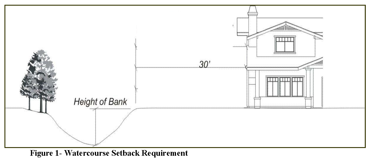
Watercourse Setback Requirement. Each proposed structure shall be set back thirty feet from the top of the bank (see Figure 1).
1.
The following setbacks apply to properties being annexed into the city:
Lots with an average lot depth of less than 155 feet: .....30 feet
Lots with an average lot depth between 156—175 feet: .....40 feet
Lots with an average lot depth between 176—225 feet: .....60 feet
Lots with an average lot depth of more than 226 feet: .....100 feet
2.
The review authority may grant an exception to the setback requirement:
a.
Where an existing structure is being replaced and is not within a one-hundred-year floodplain, or where the application of the setback would be inconsistent with the urbanized character of the site and adjacent parcels. See Section 17.90.030 (restrictions on nonconforming uses and structures); or
b.
When a legal lot of record has not been developed with a structure or developed to the extent permitted by the zoning and the application of the watercourse setback would preclude any structure on the property or subdivision and subsequent development of the property to the extent permitted by zoning.
c.
Any application for an exception noted in "b" above shall include a resource management plan prepared by a qualified biologist or botanist on the city-approved list. The resource management plan shall include measures which will minimize impacts to the watercourse and enhance runoff filtration. These measure should include: enhancement and/or restoration of the riparian vegetation area; removal of non-native vegetation; decompaction of soils and/or incorporation of organic material to improve runoff filtration; incorporation of bioswales in drainage plans to filter parking areas; and, incorporation of other best management practices (BMPs) which provide long-term protection of the water quality.
B.
Top of Bank Defined. The "top of bank" shall mean the upper elevation of land, having a slope not exceeding ten percent, which confines the channel waters flowing in the watercourse in their normal winter flow.
C.
Use of Required Setback. A path or trail may be within a watercourse setback; however, no other structure, road, parking access or space, paved area, or swimming pool shall be constructed within a watercourse or watercourse setback.
D.
Alteration of Natural Features. No grading or filling, planting of exotic/non-native or non-riparian plant species or removal of native vegetation shall occur within a watercourse or watercourse setback area, except:
1.
The review authority may grant an exception where the work is authorized for flood control purposes by permits issued by the California State Department of Fish and Game, and/or all other applicable local, state, and federal agencies having authority over the creek; and
2.
As otherwise provided by this section.
E.
Design of Drainage Improvements. Where daylighted drainage improvements are approved, they shall be placed in the least visible locations and naturalized through the use of river rock, earthtone concrete, and landscaping with native plant materials.
F.
Bank Stabilization. Development or land use changes that increase impervious surfaces or sedimentation may result in channel erosion. Therefore, the city engineer may require measures to stabilize watercourse banks.
1.
Rehabilitation is the preferred method of stabilization, with the objective of maintaining the natural character of the watercourse and riparian area. Rehabilitation may include enlarging the channel at points of obstruction, clearing obstructions at points of constriction, limiting uses in areas of excessive erosion, and restoring riparian vegetation.
2.
Concrete channels and other mechanical stabilization measures shall not be allowed unless no other alternative exists.
3.
If bank stabilization requires other than rehabilitation or vegetative methods, hand-placed stone or rock rip-rap are the preferred methods.
G.
Physical and Visual Access. Proposed subdivisions and other development shall provide public access to watercourses as follows, and as required by the review authority.
1.
Map Act Requirements. A proposed subdivision shall comply with the public access requirements of Map Act Chapter 4, Article 3.5 (public access to public resources).
2.
Streets. A proposed subdivision shall provide public access and visibility to watercourses through the use of single-loaded frontage roads adjacent to creeks, but outside of the watercourse setback. Where a single-loaded street is not possible, frequent access to trails along the watercourse and public open space should be provided at least every three hundred feet, and may occur at the end of dead-end streets.
3.
Trails. The review authority may require subdivisions and other proposed development to provide multipurpose creekside trails.
H.
Open Space Areas.
1.
Open space areas within watercourse setbacks shall include planting for riparian enhancement with native shrubs and trees.
2.
Open space areas outside of watercourse setbacks may include paths and trails, lighting, benches, play and exercise equipment, and trash receptacles, where appropriate.
3.
Allow installation of decorative, open design fencing in the open space area within watercourse setbacks.
(Ord. No. 818, § 3(Exh. A), 9-13-2022)
17.50.010 - Findings and purpose.
A.
Findings. The City of Grass Valley has a distinctive physical character and rich history that is reflected in its many cultural resources, such as historic structures and sites located within Grass Valley's 1872 Historic Townsite and delineated on the City of Grass Valley 1872 Historic Townsite Map. These irreplaceable resources are important to the community's economic vitality, quality of life, and sense of place, and deserve protection from deterioration, damage, and inappropriate alteration or demolition.
The California Environmental Quality Act (CEQA) provides specific treatment measures for significant historic resources and the establishment of clear and concise local guidance for the preservation and enhancement of such resources, which inevitably lends clarity and certainty to the review of development applications involving designated or significant historic resources (rated 1—2) within Grass Valley's 1872 Historic Townsite.
B.
Purpose. This chapter promotes the public health, safety and welfare through the protection, enhancement and preservation of those properties, structures, sites, artifacts and other cultural resources that represent significant and distinctive elements within the 1872 Historic Townsite. This includes the city's cultural, educational, social, economic, political and architectural history. Specifically, this chapter, reflective of the 1872 Townsite boundaries, sets forth regulations and procedures to:
1.
Preserve and promote the continuing use and upkeep of Grass Valley's historic buildings, structures, sites and districts.
2.
Foster the retention and restoration of historic buildings and other cultural resources that promote tourism, economic vitality, sense of place, and cultural diversity.
3.
Encourage private stewardship of historic buildings and other cultural resources through incentives where possible.
4.
Implement the historic preservation goals and policies of the City of Grass Valley through the existing historic context, historic design review guidelines, general plan, and ordinances.
5.
Promote the conservation of valuable material and embodied energy in historic structures through their continued use, restoration and repair, and on-going maintenance.
6.
Promote the knowledge, understanding and appreciation of the city's distinctive character, cultural resources, and history.
7.
Establish the policy of the city to pursue all reasonable alternatives to achieve compliance with this chapter for the protection of historic resources.
17.52.020 - Applicability to residential properties.
The provisions of this chapter shall apply to new construction, reconstruction, additions, modifications, alterations, rehabilitation, and relocation of properties and structures that meet the following criteria:
1.
The property or structure is used primarily for residential purposes; and
2.
The property or structure is designated a Priority 1 or 2 resource on the Inventory of Historic Resources.
17.52.030 - Definitions.
For the purposes of this chapter, certain terms, words and their derivatives are used as follows:
"Accessory Structure" a structure which is subordinate or incidental and directly related to a permitted use or structure on the same parcel, such as a barn, shed, or carriage house. As used in this chapter, accessory structures may include structures that have achieved historic significance in their own right, as determined through survey and appropriate documentation.
"Adverse Effects" effects, impacts, or actions that is detrimental or potentially detrimental to a historic resource's condition, character, or architectural or historical integrity.
"Alteration" change, repair, replacement, remodel, modification, or new construction to:
a.
The exterior of an historic resource;
b.
The significant character defining features of an historic resource, including, but not limited to, the structural elements which support the exterior walls, roof, or exterior elements, together with windows, doors, siding, porches, roof shapes, dormers, and ornamentation, such as gingerbread;
c.
Other construction on a lot; or
d.
Character defining features of the interior of a historic resource if the structure's significance is wholly or partially based on interior features and the resource is publicly accessible, such as a library or public type building.
"Alteration" does not include ordinary landscape maintenance, unless the landscaping is identified as significant at the time a property is determined to be individually significant or a contributing element to a historic district. "Alteration" also does not include ordinary property maintenance or repair that is exempt from a building permit, and is consistent with the Secretary of the Interior Standards for Treatment of Historic Properties.
"California Register" means the California Register of Historical Resources defined in California PRC 5024.1 and in CCR Title 14 Chap 11.5, Sec 4850 et seq. as it may be amended.
"California State Historical Building Code" means if the building is determined to be historically significant under any state, federal, regional or local criteria, the building shall be subject to the historical building code. Any improvements to the historic structure either on-site or at a relocated site shall be eligible to be evaluated and regulated by the historical building code.
"Character Defining Features" as outlined in the City of Grass Valley Design Review Guidelines for the 1872 Historic Townsite (2010) and the U.S. Department of the Interior's National Register Bulletin 15 and Preservation Brief 17: "How to Identify Character Defining Features", the architectural character and general composition of a resource, including, but not limited to, type and texture of building material; type, design, and character of all windows, doors, stairs, porches, railings, molding and other appurtenant elements; and fenestration, ornamental detailing, elements of craftsmanship, finishes, etc.
"Contributing Historic Resources" a designation that may be applied to buildings, structures, or objects within the Historic 1872 Townsite that maintain their original or attained historic and architectural character, and contribute either by themselves or in conjunction with other buildings or structures to the unique or historic character of a neighborhood(s), district, or to the city as a whole. These properties are designated Priority 1 or 2 in the Inventory of Historic Resources.
"Cultural Resource" any prehistoric or historic district, site, landscape, building, structure, or object included in, or potentially eligible for, local, state or national historic designation, including artifacts, records, and material remains related to such a property or resource.
"Demolition," for the purpose of this chapter, "demolition" refers to any act or failure to act that destroys, removes, or relocates, in whole or in part, a historical resource such that its historic or architectural character and significance are materially altered (refer to the Municipal Code Chapter 15.60).
"Deterioration" the significant worsening of a structure's condition and/or architectural or historic integrity, due to lack of maintenance, organisms, neglect, weathering and other natural forces.
"Feasible" capable of being accomplished in a successful manner within a reasonable period of time, taking into account cultural, economic, environmental, historic, legal, social and technological factors. Structural feasibility means that a building or other structure can be repaired or rehabilitated so as to be safe and usable without significant loss of historic fabric. Factors to be considered when making this determination include the existence of new technologies that will allow the design of the work and the ability to repair, supplement or replace loadbearing members and the thermal and moisture protection systems required for continued use of the structure, as well as the physical capacity of the structure to withstand the repair and/or rehabilitation process without the danger of further damage.
"Grass Valley Design Guidelines for the 1872 Historic Townsite" means the city's design guidelines used to assist property owners in making decisions on the preservation, restoration, and rehabilitation of their property or buildings.
"Grass Valley Historic Commission (GVHC)" is the Grass Valley Historical Commission consists of five members and one alternate, each appointed by the city council for a four-year term. The commission's function is to identify and verify historical resources and encourage their preservation.
"Historic Building Code" means the most recent version of the California Historical Building Code, Title 25, Part, 8, as defined in Sections 18950 to 18961 of Division 12, Part 2.7 of Health and Safety Code (H&SC), a part of California State law.
"Historic Context" means historic context are those events or themes in the history of Grass Valley by which a specific occurrence, property, or site is understood and its meaning and significance is made clear, and as defined in the adopted City of Grass Historic Context available through the City of Grass Valley Planning Department.
"Historic District/Historical Preservation District" means areas or neighborhoods with a collection or concentration of listed contributing historic properties, where historic properties help define the area or neighborhood's unique architectural, cultural, and historic character or sense of place. Historic districts are delineated on the official Grass Valley Historic District Maps maintained by the city.
"Historic Property or Resource" means a property, including land and buildings, which possesses aesthetic, architectural, cultural, historic or scientific significance, and which is included in and rated a 1 or 2 in the Grass Valley Historical Resource Inventory of the 1872 Historic Townsite, or otherwise is potentially eligible for local, state or national historic designation.
"Historic Status" means historic designation of a listed resource or property as approved by the city council.
"Improvement" means any building, structure, fence, gate, landscape, hardscape, wall, work of art, or other object constituting a physical feature of real property or any part of such feature.
"Inappropriate Alteration" means alterations to historic resources which are inconsistent with these provisions and/or the historic preservation program guidelines.
"In-kind" means using materials that are identical in composition, shape, form, and design. This does not preclude the use of modern materials nor does it discourage other materials that are sympathetic or more appropriate to meet energy calculations or structural demands.
"Integrity, Architectural or Historical" means the ability of a property, structure, site, building, improvement or natural feature to convey its identity and authenticity, including, but not limited to, its original location, period(s) of construction, setting, scale, design, materials, detailing, workmanship, uses and association.
"Inventory of Historic Resources" means the list of historically designated resources and properties, consisting of the Master List and Contributing Properties List of Historic Resources within the Grass Valley 1872 Historic Townsite, and any properties, objects, sites, gardens, sacred places and resources subsequently added to the inventory, as determined to meet criteria outlined herein and approved by the city council.
"Maintenance" is a term that refers to keeping a historic property in a condition that does not result in deterioration or damage to significant architectural features or elements resulting in its degradation to a level that it would not be considered a significant resource.
"Major Projects" means projects that have the potential to significantly alter the character of a historic property through additions, changes in massing, height, scale, and design elements.
"Massing" means the spatial relationships, arrangement and organization of a building's physical bulk or volume.
"Minor Projects" means a smaller scale project that does not involve a major alteration to a significant property.
"Minor Restoration" means a term that implies maintaining a building to a standard that preserves its historic character.
"Modern Contributing Resources" means a designation which may be applied to properties and resources which are less than fifty years old, but which exemplify or include significant works of architecture or craftsmanship or are associated with a person or event significant to the city's history.
"National Register of Historic Places (NRHP)" is the official inventory of districts, sites, buildings, structures, and objects significant in American history, architecture, engineering, archaeology and culture, which is maintained by the Secretary of the Interior under the authority of the Historic Sites Act of 1935 and the National Historic Preservation Act of 1966.
"Neglect" means the lack of maintenance, repair or protection of a listed property, resource, site or structure, which results in significant deterioration, as determined by the GVHC, director, or city council, based on visual and physical evidence.
"Non-Contributing Resource" means a designation which may be applied to properties and resources in historic districts which are typically less than fifty years old, have greatly diminished integrity, and do not support the prevailing historic character of the district or other listing criteria as outlined herein. These properties are designated Priority 3 or 4 in the Inventory of Historic Resources.
"Preservation" means the act or process of applying measures necessary to sustain a historic site, building or other structure's historically significant existing form, integrity, and materials through stabilization, repair and maintenance.
"Primary Structure" means the most important building or other structural feature on a parcel in terms of size, scale, architectural or historical significance, as determined by the committee.
"Reconstruction" means the act or process of recreating the features, form and detailing of a non-surviving building or portion of building, structure, object, landscape, or site for the purpose of replicating its appearance at a specific period of time and in its historic location.
"Rehabilitation" means the act or process of making possible a compatible use for a property through repair, alterations, and additions, while preserving those portions or features which convey its architectural, cultural, or historic values.
"Relocation" means removal of a resource from its original site and its re-establishment in essentially the same form, appearance and architectural detailing at another location.
"Restoration" means the act or process of accurately depicting the form, features, and character of a property as it appeared at a particular period of time by means of the removal of features from other periods in its history and reconstruction of missing features from the restoration period.
"Scale" means the proportions of architectural design that relate to human size or other relative size measure.
"Secretary of the Interior's Standards" means the Secretary of the Interior's Standards for the Treatment of Historic Properties, as published by the U.S. Department of the Interior and as amended from time to time.
"Stabilization" means the act or process of applying measures designed to reestablish a weather resistant enclosure and the structural stability of an unsafe or deteriorated property, while maintaining the essential form as it exists at present.
"Survey" means a systematic process for identifying and evaluating a community's historic resources using established criteria. "Survey" may also refer to the documentation resulting from a survey project.
17.52.040 - Grass Valley Historic Commission (GVHC).
A.
Duties. The duties of the GVHC as it pertains to the implementation of this chapter include the following:
1.
Recommend historic resource preservation program guidelines that implement this chapter and provide guidance to persons or institutions planning projects subject to city review that involve historic properties within the Grass Valley Historic 1872 Townsite.
2.
Make recommendations on alterations or changes to historic districts.
3.
Review properties, buildings, and other resources for potential inclusion on the city's inventory of historic resources, including those properties, areas, sites, buildings, structures or other features having significant historical, cultural, architectural, community, scientific or aesthetic value to the citizens of Grass Valley. The commission may also recommend to the council that such properties be added to the inventory of historic resources.
4.
Maintain and update the inventory of historic resources.
5.
Consolidate information regarding cultural resources and promotion; participation in, or sponsorship of educational and interpretive programs that foster public awareness and appreciation of cultural resources.
6.
Support and promote incentive programs approved by the council that are directed at preserving and maintaining historic resources.
7.
Provide information for property owners preparing local, state and federal historic nominations to utilize preservation incentives, such as the Mills Act and federal tax incentives, including, but not limited to rehabilitation tax credits.
8.
Respond to referrals by the director, development review committee, planning commission and city council.
9.
Provide interested property owners with advice and information on building design and materials that can maintain the historic character of a building.
B.
GVHC and Role of the City Staff. The GVHC is assisted by staff of the city, including, but not limited to, the community development department. The director is responsible for interpreting and implementing this chapter and assisting the GVHC carry out its duties.
17.52.050 - Historic resource designation.
The city utilizes two classifications to designate historic resources and properties. The two categories of historic significance are the "contributing" and "non-contributing" properties.
A.
Contributing Historical Resources. The most unique and important resources and properties in terms of age, architectural or historical significance, rarity, or association with important persons or events in the city's past, which are rated as Priority 1 and 2 properties in the inventory of historic resources.
B.
Non-Contributing Resources. Buildings, properties and other features in historic districts, which are less than fifty years old, have not retained their original architectural character, or which do not support the prevailing historic character of the district, and are rated as Priority 3 and 4 properties in the Inventory of Historic Resources.
17.52.060 - Procedures for inclusion in the inventory of historic resources.
A.
Application for Inclusion. The property owner may request a resource be designated as a contributing historical resource in the inventory of historic resources by submitting an application to the director, accompanied by all available information documenting the historic significance and architectural character of the resource. The GVHC, and planning commission may also recommend, or the city council may directly request, the addition of a resource to the historical resources inventory.
B.
Review Process. The GVHC shall review all applications for inclusion, whether initiated by the city or a property owner, to determine if a property proposed for inclusion meets eligibility criteria as described in this chapter. The GVHC will review the eligibility criteria for a proposed listing at a noticed public hearing. The director shall provide notification to the property owner and public, as required by city standards. At the public hearing, or in no case more than sixty days from the hearing date, the GVHC shall forward a recommendation on the application to the city council. The city council will take action on the application to add or not add the resource to the historical resources inventory. The decision of the city council is final.
C.
Removal from Inventory of Historic Resources. It is the general intention of the city not to remove a property from the inventory of historic resources. Council may, however, rezone a property to remove historic overlay zoning, or remove the property from the inventory if the structure on the property no longer meets eligibility criteria for inclusion, following the process for inclusion set forth in paragraph B.
17.52.070 - Project evaluation and review process.
A.
Purpose. The purpose of this section is to encourage property owners to preserve, restore, and rehabilitate their property in a manner that promotes the city's cultural and architectural heritage. The overall goal is to provide property owners with tools that will help retain the historic character, fabric and features of a building as a means to enhance property values. This can be accomplished by using in-kind or compatible building materials and a compatible design, if feasible, when rehabilitating, restoring, or expanding a building within the 1872 Historic Townsite. The city will rely on the adopted City of Grass Valley Design Guidelines for the 1872 Historic Townsite (Guidelines) to accomplish this purpose.
B.
Project Categories. As used in this chapter, changes to a building fall under three basic categories:
1.
Exempt Projects. The routine maintenance and restoration of buildings, which includes in-kind replacement of deteriorated or damaged historic fabric and materials;
2.
Minor Projects. This includes exterior modifications or alterations that maintain the historic integrity of the building and that comply with the Guidelines; and,
3.
Major Projects. This includes exterior modifications that alter the character defining features, such as its shape, elevation, massing, and scale and do not comply with the guidelines. The development review committee shall review all major projects. If a project is a major project, the city encourages a property owner to first meet with the GVHC prior to formal submittal of an application. The GVHC can provide a property owner with suggestions on design and resource materials that will help maintain the historic character of the building.
C.
Permit Review. The city's review process established in Section 17.72.030 of the development code shall determine the level of review for all projects in the 1872 Historic Townsite. While the focus of this section is on properties rated as a Priority 1 and 2, the city will also encourage property owners with Priority 3 and 4 properties to use the guidelines.
1.
Projects exempt from a development review permit pursuant to Section 17.72.030. These projects are reviewed by the director as part of a building permit review process. This includes exempt and minor projects as defined in this chapter. The director shall review changes to all buildings within the 1872 Historic Townsite and make recommendations to encourage compliance with the guidelines.
2.
Projects subject to a development review permit pursuant to Section 17.72.030. These projects are reviewed by the development review committee and/or planning commission as part of the development review process. These include projects that are defined as a major project as used in this chapter. In reviewing a project in the 1872 Historic Townsite, the development review committee and/or planning commission shall consider the guidelines in its decision and make recommendations to encourage compliance.
17.52.090 - Criteria for determination of historical significance.
For the purpose of determining the historical significance or inclusion in the inventory of historic resources of a building or structure the following criteria shall apply:
1.
The building or structure has character, interest or value as a part of the heritage of the City of Grass Valley; or
2.
The location of the building or structure is the site of a significant historic event; or
3.
The building or structure is identified with a person(s) or group(s) who significantly contributed to the culture and development of the City of Grass Valley; or
4.
The building or structure exemplifies a particular architectural style or way of life important to the city; or
5.
The building or structure exemplifies the best remaining architectural type in a neighborhood; or
6.
The building or structure is identified as the work of a person whose work has influenced the heritage of the city, the state or the United States; or
7.
The building or structure reflects outstanding attention to architectural design, detail, materials or craftsmanship; or
8.
The building or structure is related to landmarks or historic districts and its preservation is essential to the integrity of the landmark or historic district; or
9.
The unique location or singular physical characteristics of the building or structure represent an established and familiar feature of a neighborhood; or
10.
The building, structure or site has the potential to yield historical or archaeological information.
17.52.120 - Appeals.
Any person may appeal the decision of the planning director or the GVHC pursuant to this chapter to the planning commission. Decisions of the planning commission pursuant to this chapter may be appealed to the city council. An appeal must be submitted in writing with the required appeal fee (if applicable) to the community development department within fifteen days following the final date of the action for which an appeal is made. The written appeal shall include the reason(s) why the report should or should not be required; or why the building permit should be granted, denied or exempt from the provisions of this chapter.
17.54.010 - Purpose.
The provisions of this chapter are intended to:
A.
Preserve the city's environmental and scenic resources by encouraging the retention of natural topographic features and vegetation;
B.
Recognize that as the slope of a development site increases so does the potential for environmental degradation including slope failure, and increased storm water runoff that will also increase the potential for erosion, and waterway sedimentation;
C.
Encourage grading practices that are appropriate in hillside areas; and
D.
Encourage structures on hillside parcels to be designed with scale, massing, architectural design and detailing appropriate to maintain the visual character of hillsides as natural and open.
17.54.020 - Applicability.
A.
Applicability of Chapter. The requirements and guidelines in this chapter apply to subdivisions, and all other proposed development or a new land use on a building site with a slope of twenty percent or greater in an area identified on the city's protected ridgelines map. Proposed hillside development shall also comply with the city's stormwater management program and the city improvement standards as they relate to temporary and permanent erosion control for hillside development.
B.
Limitation on Hillside Development. No new grading or other construction shall occur on a slope of more than thirty percent, except where the review authority determines that there is no alternative building site available on an existing parcel with a slope of thirty percent or less. In granting an exception in compliance with this section, the review authority shall ensure that the proposed project complies with all other standards of this chapter to the maximum extent feasible.
C.
Permit Requirements. A proposed project that is subject to this chapter shall require approval through the permit process otherwise required by this development code for the project.
D.
Adjustments to Standards. The review authority may grant an adjustment to the standards of this chapter as part of development review where it first finds that:
1.
The adjustment is either necessary to allow a house with reasonable floor area on a site with excessive slope or other environmental constraints; or
2.
The adjustment will result in less visual impact than would development in compliance with the standard being adjusted.
17.54.030 - Hillside subdivision standards.
A proposed subdivision shall comply with the following standards:
A.
Parcel and Building Site Slope. No parcel other than an open space parcel shall be created:
1.
With an overall average slope of thirty percent or more; or
2.
Without at least one building site of at least five thousand square feet that has no slope of twenty percent or more, and that will allow a house to be constructed in compliance with all other applicable provisions of this chapter.
B.
Roads. Each new road shall follow natural terrain contours to the maximum extent feasible to minimize grading. Proposed driveways shall comply with the requirements of Section 17.54.040 (site planning and development standards).
17.54.040 - Site planning and development standards.
Each structure shall be located in the most accessible, least visually prominent, most geologically stable, portion or portions of the site, and at the lowest feasible elevation. Structures shall also be aligned with the natural contours of the site. Siting structures in the least prominent locations is especially important on open hillsides where the high visibility of construction should be minimized by placing structures so that they will be screened by existing vegetation, depressions in topography, or other natural features.
A.
Site Access. Each driveway shall follow natural terrain contours to minimize grading, and also shall comply with the following standards.
1.
Common driveways that serve more than one parcel are encouraged, and may be required, to reduce the total amount of grading and pavement.
2.
Drainage from a driveway shall be directed in a controlled manner to the drainage facilities of the nearest road, subject to the approval of the city engineer.
3.
A driveway shall not have a grade steeper than five percent within ten feet of a garage or carport entry. Driveway finished grade shall not exceed an average of twenty percent slope for residential uses; a five-percent deviation for special construction techniques may be approved by the city engineer.
B.
Setbacks. A new structure or addition is prohibited within fifty vertical feet of a ridgeline unless this restriction completely precludes development of the property. An exception may be granted if the review authority first finds that:
1.
There are no feasible building sites on the parcel that avoid ridgeline development;
2.
In the case of a subdivision, the density has been reduced to the minimum standards consistent with the general plan density range;
3.
No new subdivision of parcels is created that will result in ridgeline development; and
4.
The development will avoid significant adverse visual impacts due to modifications in structural design including height, bulk, size, foundation, siting, and landscaping.
C.
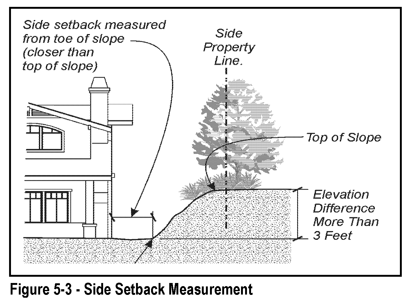
Side and Rear Setback from Slope. Where a building site abuts a parcel with an elevation that is three feet or more above or below that of the site, the side and/or rear setback required by the applicable zone shall be measured from the nearest toe or top of slope to the structure, whichever is closer. See Figure 5-3.
E.
Height Limits. Each proposed structure shall comply with the following height limits, in addition to the height limit of the applicable zone.
1.
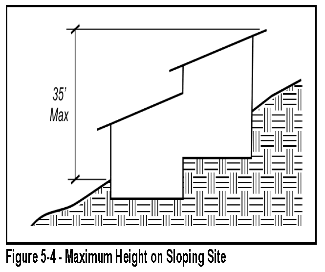
Total Height Limit. No structure shall exceed a height of twenty-four feet, measured in compliance with Section 17.30.050 (height limits and exceptions), and shall not exceed a total height of thirty-five feet, measured from the lowest elevation on the site where the structure touches the grade, to the highest point of the roof. See Figure 5-4.
2.
Placement of Structures. Proposed structures shall comply with the following standards, to maintain the natural appearance of hillsides and ridgelines.
a.
Each structure shall be located as follows; provided that the review authority may modify or waive these standards where it determines that a structure on the only feasible building site of an existing parcel cannot comply.
(1)
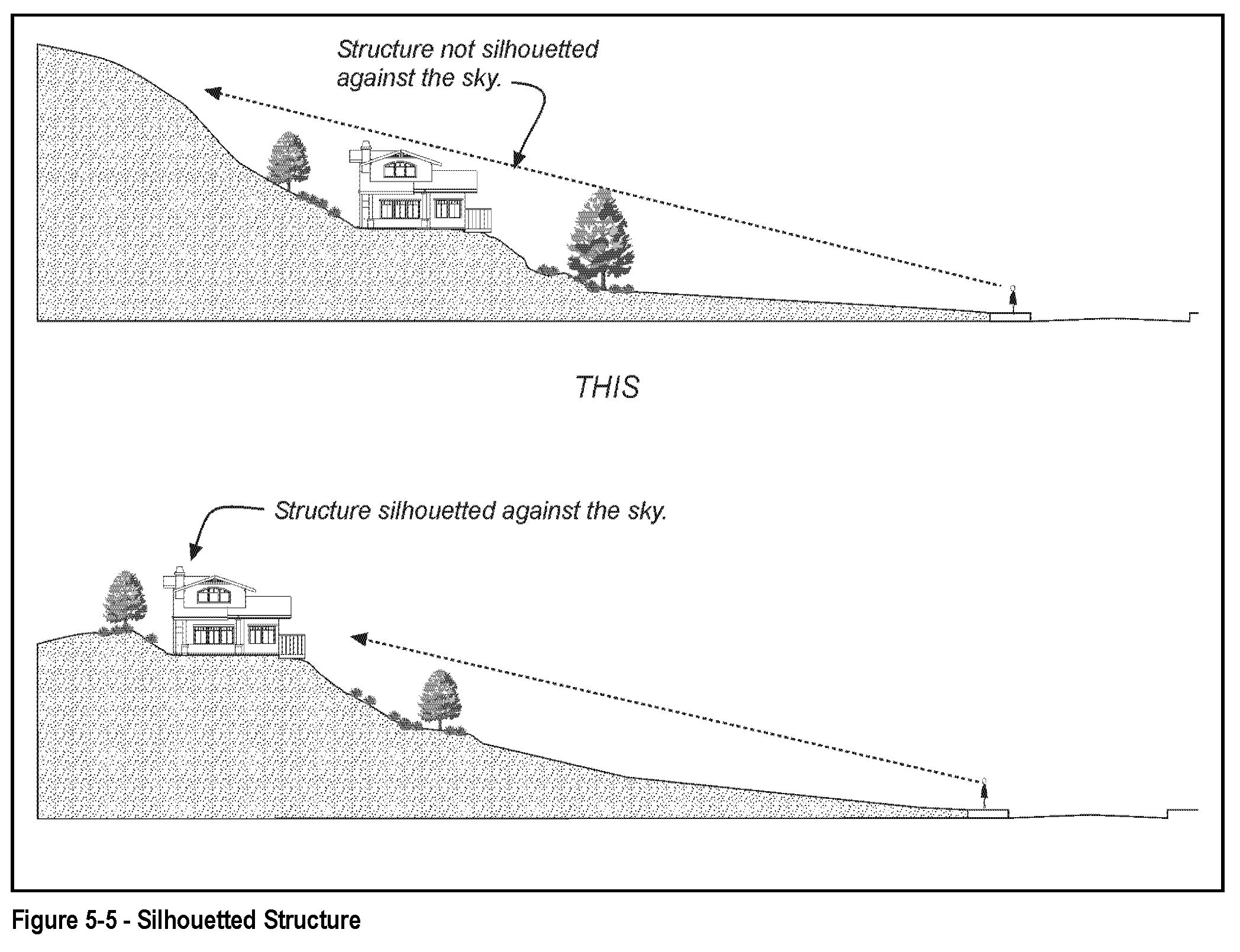
No part of a proposed structure shall appear silhouetted against the sky above the nearest ridge or knoll when viewed from a public street. See Figure 5-5.
(2)
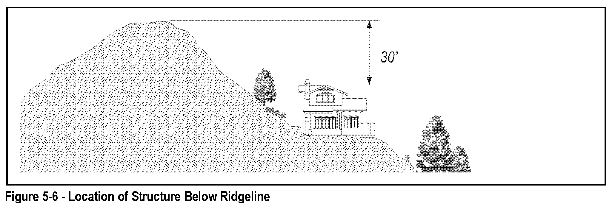
The topmost point of a proposed structure and all site grading shall be at least thirty feet below the top of the nearest ridge or knoll. See Figure 5-6.
b.
Each structure shall be located to take advantage of existing vegetation for screening, and should include the installation of additional native plant materials to augment existing vegetation, where appropriate.
3.
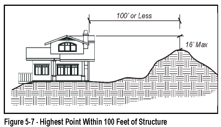
Height Limit Above Ridgeline. Where the review authority determines that a legal lot existing prior to the effective date of this section contains no feasible building site other than where a structure will extend above the ridgeline, proposed structures shall not exceed a height of sixteen feet above the highest point on the ridgeline or hilltop within one hundred feet of the proposed structure. See Figure 5-7.
4.
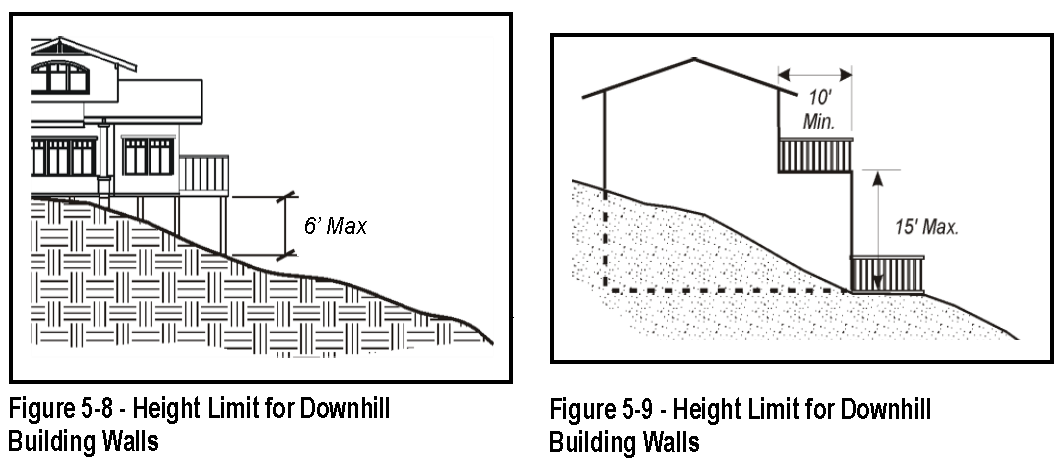
Height of Lowest Floor Level. The vertical distance between the lowest point where the foundation meets grade and the lowest floor line of the structure shall not exceed six feet (see Figure 5-8).
5.
Downhill Building Walls. No single building wall on the downhill side of a house shall exceed fifteen feet in height above grade. Additional building height on a downhill side may be allowed in fifteen-foot increments, where each increment is stepped-back from the lower wall a minimum of ten feet (see Figure 5-9).
6.
Decks. No portion of the walking surface of a deck with visible underpinnings shall exceed a height of six feet above grade. Decks shall be integrated into the architecture of the house, not appearing as an "add-on" to the primary building mass (see Figure 5-8).
F.
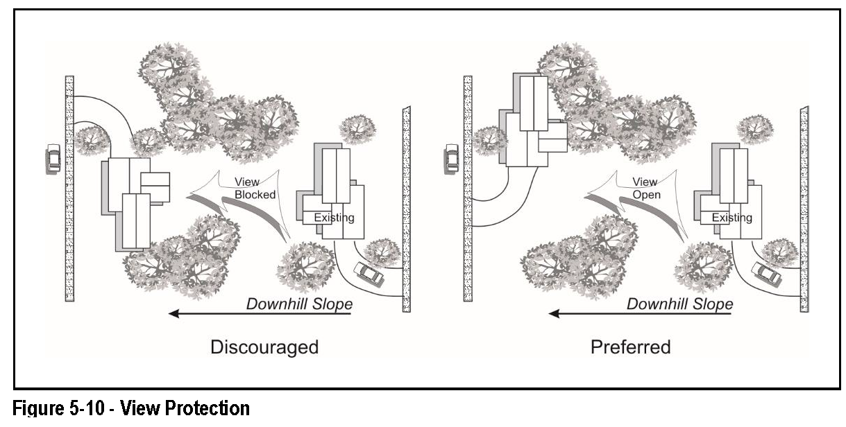
View Protection Guidelines. A proposed structure should be designed and located so that it avoids blocking views from other properties to the maximum extent feasible, as follows. See Figure 5-10.
1.
New structures and tall landscaping should not be placed directly in the view of the primary living areas on a neighboring parcel (for the purposes of this section, "primary living area" means a living room, family room, dining room, master bedroom, or outdoor patio with seating).
2.
Mechanical equipment may be placed on rooftops or below a deck only if the equipment is not visible from off the site, except for unobtrusive solar collectors that are compatible with the roof line and architecturally integrated with the structure. This equipment shall also comply with the height limits in Subsection E.2.
G.
Exterior lighting. See Section 17.30.060 (outdoor lighting).
H.
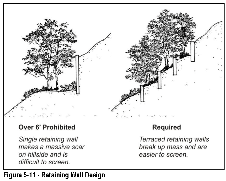
Retaining Walls. An embankment to be retained that is over six feet in height shall be benched above six feet in height so that no individual retaining wall above six feet in height is taller than thirty-six inches, and each bench is a minimum width of thirty-six inches. See Figure 5-11.
I.
Support Structures. Support structures (for example, columns, pilings, etc.) below the lowest floor on the downhill side of a house, shall be enclosed unless visible structural members are an integral feature of the architectural design. Support structure wall surfaces shall not exceed six feet in height.
17.54.050 - Building design guidelines.
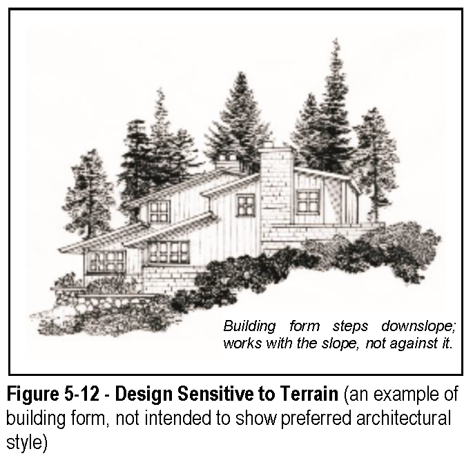
Building and site design should generally utilize varying setbacks and structure heights, split-level foundations, and low retaining walls to blend structures into the terrain. See Figure 5-12.
A.
Maximum Floor Area. The gross floor area of all structures on a parcel should not exceed thirty percent of the areas of the parcel with a slope of less than fifteen percent, and zero percent of the areas with slopes in excess of fifteen percent.
B.
Windows. Windows, balconies, and outdoor living areas generally should be located to protect the privacy of adjacent homes and yards. Windows visible from off the site should be glazed with non-glare glass.
C.
Exterior Wall Surfaces. The apparent size of exterior wall surfaces visible from off the site should be minimized through the use of single-story elements, setbacks, overhangs, roof pitches, landscaping, and/or other means of horizontal and vertical articulation to create changing shadow lines and break up massive forms.
D.
Colors and Materials. A mixture of materials and color should be used to blend structures with the natural appearance of the hillside:
1.
Based upon the graphic principle that darker colors are less noticeable than light colors, darker tones, including earth tones should generally be used for building walls and roofs on highly visible sites so that buildings appear to blend in with the natural terrain.
2.
Exterior finish materials should be appropriate to the architectural style of the structure and compatible with the hillside environment.
E.
Roofs. Roof pitches should be placed to follow the angle of the slope; but with variations to avoid a monotonous appearance. See Figure 5-12.
F.
Landscaping. See Chapter 17.34 (landscaping standards).