
Henry County Unincorporated
City Zoning Code
City Zoning Code
CHAPTER 3
- PROTECTION OF NATURAL FEATURES AND RESOURCES
Sec. 3.00.00. - Generally.
The provisions set forth in chapter 3 are intended to protect the natural features and natural resources within Henry County, and to implement policies in the Henry County Comprehensive Plan. The natural features and natural resources included in chapter 3 are the floodplain, watersheds, wetlands, groundwater, river corridors, and open spaces.
Sec. 3.01.00. - Floodplain protection.
3.01.01.
General provisions.
A.
The purpose of this article is to protect, maintain and enhance the public health, safety, environment and general welfare and to minimize public and private losses due to flood conditions in flood hazard areas, as well as to protect the beneficial uses of floodplain areas for water quality protection, streambank and stream corridor protection, wetlands preservation, and ecological and environmental protection by provisions designed to:
1.
Require that uses vulnerable to floods, including facilities which serve such uses, be protected against flood damage at the time of initial development, ground disturbance or construction;
2.
Restrict or prohibit uses which are dangerous to health, safety and property due to flooding or erosion hazards, or which increase flood heights, velocities, or erosion;
3.
Control filling, grading, dredging, and other development which may increase flood damage or erosion;
4.
Prevent or regulate the construction of flood barriers which will unnaturally divert flood waters or which may increase flood hazards to other lands;
5.
Limit the alteration of natural floodplains, stream channels, and natural protective barriers, which are involved in the accommodation of flood waters; and
6.
Protect the stormwater management, water quality, streambank protection, stream corridor protection, wetland preservation, and ecological functions of natural floodplain areas.
B.
Applicability. This article shall be applicable to all areas of special flood hazard within Henry County.
C.
Basis for establishing areas of special flood hazard, areas of future-conditions flood hazard and associated floodplain characteristics—Flood area maps and studies. For the purposes of defining and determining "areas of special flood hazard," "areas of future-conditions flood hazard," "areas of shallow flooding," "base flood elevations," "floodplains," "floodways," "future-conditions flood elevations," "future-conditions floodplains," potential flood hazard or risk categories as shown on FIRM maps, and other terms used in this article, the following documents and sources may be used for such purposes and are adopted by reference thereto:
1.
The flood insurance study (FIS), dated May 16, 2006, with accompanying maps and other supporting data and any revision thereto. For those land areas acquired by a municipality through annexation, the current effective FIS and data for Henry County dated May 16, 2006, with accompanying maps and other supporting data and any revision thereto.
2.
Other studies, which may be relied upon for the establishment of the base flood elevation or delineation of the base or one-percent (100-year) floodplain and flood-prone areas, including:
a.
Any flood or flood-related study conducted by the United States Army Corps of Engineers, the United States Geological Survey or any other local, state or federal agency applicable to Henry County; and
b.
Any base flood study conducted by a licensed professional engineer which has been prepared utilizing FEMA approved methodology and approved by Henry County Stormwater Management Department.
3.
Other studies, which may be relied upon for the establishment of the future-conditions flood elevation or delineation of the future-conditions floodplain and flood-prone areas, including:
a.
Any flood or flood-related study conducted by the United States Army Corps of Engineers, the United States Geological Survey, or any other local, state or federal agency applicable to Henry County; and
b.
Any future-conditions flood study conducted by a licensed professional engineer which has been prepared utilizing FEMA approved methodology approved by the Henry County Stormwater Management Department.
4.
The repository for public inspection of the FIS, accompanying maps and other supporting data is located at Henry County Stormwater Management Department.
D.
Warning and disclaimer of liability. The degree of flood protection required by this article is considered reasonable for regulatory purposes and is based on scientific and engineering considerations. Larger floods can and will occur; flood heights may be increased by manmade or natural causes. This article does not imply that land outside the areas of special flood hazard or uses permitted within such areas will be free from flooding or flood damages. This article shall not create liability on the part of Henry County or any officer or employee thereof for any flood damages that result from reliance on this article or any administrative decision lawfully made there under.
E.
Compatibility with other regulations. This article is not intended to modify or repeal any other article, rule, regulation, statute, easement, covenant, deed restriction or other provision of law. The requirements of this article are in addition to the requirements of any other article, rule, regulation or other provision of law, and where any provision of this article imposes restrictions different from those imposed by any other article, rule, regulation or other provision of law, whichever provision is more restrictive or imposes higher protective standards for human health or the environment shall control.
F.
Severability. If the provisions of any section, subsection, paragraph, subdivision or clause of this article shall be adjudged invalid by a court of competent Henry County, such judgment shall not affect or invalidate the remainder of any section, subsection, paragraph, subdivision or clause of this article.
G.
Responsibility for administration. The Henry County Stormwater Management Department Director or designee is hereby appointed to administer and implement the provisions of this article.
3.01.02.
Permit procedures and requirements.
A.
Permit application requirements. No owner or developer shall perform any development activities on a site where an area of special flood hazard or area of future-conditions flood hazard is located without first meeting the requirements of this article prior to commencing the proposed activity.
Unless specifically excluded by this article, any landowner or developer desiring a permit for a development activity shall submit to the Henry County Environmental Compliance and Plan Review Department a permit application on a form provided by the Environmental Compliance and Plan Review Department for that purpose.
No permit will be approved for any development activities that do not meet the requirements, restrictions and criteria of this article.
B.
Floodplain management plan requirements. An application for a development project with any area of special flood hazard or area of future-conditions flood hazard located on the site shall include a floodplain management/flood damage prevention plan. This plan shall include the following items:
1.
Site plan drawn to scale, which includes, but is not limited to:
a.
Existing and proposed elevations of the area in question and the nature, location and dimensions of existing and/or proposed structures, earthen fill placement, amount and location of excavation material, and storage of materials or equipment;
b.
For all proposed structures, spot ground elevations at building corners and twenty-foot or smaller intervals along the foundation footprint, or one (1) foot contour elevations throughout the building site;
c.
Proposed locations of water supply, sanitary sewer, and utilities;
d.
Proposed locations of drainage and stormwater management facilities;
e.
Proposed grading plan;
f.
Base flood elevations and future-conditions flood elevations;
g.
Boundaries of the base flood floodplain and future-conditions floodplain;
h.
If applicable, the location of the floodway; and
i.
Certification of the above by a licensed professional engineer or surveyor.
2.
Building and foundation design detail, including, but not limited to:
a.
Elevation in relation to mean sea level (or highest adjacent grade) of the lowest floor, including basement, of all proposed structures;
b.
Elevation in relation to mean sea level to which any nonresidential structure will be floodproofed;
c.
Certification that any proposed nonresidential floodproofed structure meets the criteria in subsection 3.01.03.C.2.;
d.
For enclosures below the base flood elevation, location and total net area of flood openings as required in subsection 3.01.04.A.5.; and
e.
Design plans certified by a licensed professional engineer for all proposed structure(s).
3.
Description of the extent to which any watercourse will be altered or relocated as a result of the proposed development;
4.
Hard copies and digital files of computer models, if any, copies of work maps, comparison of pre- and post-development conditions base flood elevations, future-conditions flood elevations, flood protection elevations, special flood hazard areas and regulatory floodways, flood profiles and all other computations and other information similar to that presented in the FIS;
5.
Copies of all applicable state and federal permits necessary for proposed development, including, but not limited to, permits required by Section 404 of the Federal Water Pollution Control Act, Amendments of 1972, 33 U.S.C. 1334; and
6.
All appropriate certifications required under this article. The approved floodplain management/flood damage prevention plan shall contain certification by the applicant that all development activities will be done according to the plan or previously approved revisions. Any and all development permits and/or use and occupancy certificates or permits may be revoked at any time if the construction and development activities are not in strict accordance with approved plans.
C.
Construction stage submittal requirements. For all new construction and substantial improvements on sites with a floodplain management/flood damage prevention plan, the permit holder shall provide to the director of the building department or designee:
1.
A certified as-built elevation certificate; or
2.
Floodproofing certificate for nonresidential construction including the lowest floor elevation or floodproofing level immediately after the lowest floor or floodproofing is completed.
A final elevation certificate shall be provided after completion of construction including final grading of the site. Any lowest floor certification made relative to mean sea level shall be prepared by or under the direct supervision of a licensed land surveyor or professional engineer and certified by same. When floodproofing is utilized for nonresidential structures, said certification shall be prepared by or under the direct supervision of a licensed professional engineer or architect and certified by same using the FEMA Floodproofing Certificate. This certification shall also include the design and operation/maintenance plan to assure continued viability of the floodproofing measures.
Any work undertaken prior to approval of these certifications shall be at the permit holder's risk. The Henry County Stormwater Management Department Director or designee shall review the above referenced certification data submitted. Deficiencies detected by such review shall be corrected by the permit holder immediately and prior to further work being allowed to proceed. Failure to submit certification or failure to make the corrections required hereby shall be cause to issue a stop work order for the project.
D.
Duties and responsibilities of the administrator. Duties of the Henry County Stormwater Management Department Director or designee shall include, but shall not be limited to:
1.
Review all development applications and permits to assure that the requirements of this article have been satisfied and to determine whether proposed building sites will be reasonably safe from flooding;
2.
Review proposed development to assure that all necessary permits have been received from those governmental agencies from which approval is required by federal or state law, including, but not limited to, Section 404 of the Federal Water Pollution Control Act, Amendments of 1972, 33 U.S.C. 1334;
3.
When base flood elevation data or floodway data have not been provided, then the Henry County Stormwater Management Department Director or designee shall require the applicant to obtain, review and reasonably utilize any base flood elevation and floodway data available from a federal, state or other sources in order to meet the provisions of sections 3.01.03 and 3.01.04;
4.
Review and record the actual elevation in relation to mean sea level (or highest adjacent grade) of the lowest floor, including basement, of all new and substantially improved structures;
5.
Review and record the actual elevation, in relation to mean sea level to which any substantially improved structures have been floodproofed;
6.
When floodproofing is utilized for a nonresidential structure, the Henry County Stormwater Management Department Director or designee shall review the design and operation/maintenance plan and obtain certification from a licensed professional engineer or architect;
7.
Notify affected adjacent communities and the Georgia Department of Natural Resources (GA DNR) prior to any alteration or relocation of a watercourse and submit evidence of such notification to the Federal Emergency Management Agency (FEMA);
8.
Where interpretation is needed as to the exact location of boundaries of the areas of special flood hazard (e.g. where there appears to be a conflict between a mapped boundary and actual field conditions) the Henry County Stormwater Management Department Director or designee shall make the necessary interpretation. Any person contesting the location of the boundary shall be given a reasonable opportunity to appeal the interpretation as provided in this article. Where floodplain elevations have been defined, the floodplain shall be determined based on flood elevations rather than the area graphically delineated on the floodplain maps;
9.
All records pertaining to the provisions of this article shall be maintained in the office of the Henry County Stormwater Management Department Director or designee and shall be open for public inspection;
10.
Coordinate all FIRM revisions with the GA DNR and FEMA; and
11.
Coordinate with the planning and zoning department the review of applicable variance applications and make recommendations that will be presented to the Henry County Board of Commissioners.
3.01.03.
Standards for development.
A.
Definition of floodplain boundaries.
1.
Studied "A" zones, as identified in the FIS, shall be used to establish base flood elevations whenever available.
2.
For all streams with a drainage area of one hundred (100) acres or greater, the future-conditions flood elevations shall be provided by the Henry County Stormwater Management Department. If future-conditions elevation data is not available from the Henry County Stormwater Management Department, then it shall be determined by a licensed professional engineer using a method approved by FEMA and the Henry County Stormwater Management Department.
B.
Definition of floodway boundaries. The width of a floodway shall be determined from the FIS or FEMA approved flood study. For all streams with a drainage area of one hundred (100) acres or greater, the regulatory floodway shall be provided by the Henry County Stormwater Management Department. If floodway data is not available from the Henry County Stormwater Management Department, it shall be determined by a licensed professional engineer using a method approved by FEMA and the Henry County Stormwater Management Department.
C.
General standards.
1.
No development shall be allowed within any area of special flood hazard or area of future-conditions flood hazard that could result in any of the following:
a.
Raising the base flood elevation or future-conditions flood elevation equal to or more than 0.01 foot;
b.
Reducing the base flood or future-conditions flood storage capacity;
c.
Changing the flow characteristics as to the depth and velocity of the waters of the base flood or future-conditions flood as they pass both the upstream and the downstream boundaries of the development area; or
d.
Creating hazardous or erosion-producing velocities, or resulting in excessive sedimentation.
2.
Any development within any area of special flood hazard or area of future-conditions flood hazard allowed under subsection 3.01.03.C.1. shall also meet the following conditions:
a.
Compensation for storage capacity shall occur between the average ground water table elevation and the base flood elevation for the base flood, and between the average ground water table elevation and the future-condition flood elevation for the future-conditions flood, and lie either within the boundaries of ownership of the property being developed and shall be within the immediate vicinity of the location of the encroachment. Acceptable means of providing required compensation include lowering of natural ground elevations within the floodplain, or lowering of adjoining land areas to create additional floodplain storage. In no case shall any required compensation be provided via bottom storage or by excavating below the elevation of the natural (pre-development) stream channel unless such excavation results from the widening or relocation of the stream channel;
b.
Cut areas shall be stabilized and graded to a slope of no less than two (2.0) percent;
c.
Effective transitions shall be provided such that flow velocities occurring on both upstream and downstream properties are not increased or decreased;
d.
Verification of no-rise conditions (less than 0.01 foot), flood storage volumes, and flow characteristics shall be provided via a step-backwater analysis meeting the requirements of subsection 3.01.03.D.;
e.
Public utilities and facilities, such as water, sanitary sewer, gas, and electrical systems, shall be located and constructed to minimize or eliminate infiltration or contamination from floodwaters; and
f.
Any significant physical changes to the base flood floodplain shall be submitted as a conditional letter of map revision (CLOMR) or conditional letter of map amendment (CLOMA), whichever is applicable. The CLOMR submittal shall be subject to approval by the Henry County Stormwater Management Department using the FEMA Community Concurrence forms before forwarding the submittal package to FEMA for final approval. The responsibility for forwarding the CLOMR to FEMA and for obtaining the CLOMR approval shall be the responsibility of the applicant. Within six (6) months of the completion of development, the applicant shall submit as-built surveys and plans for a final letter of map revision (LOMR).
D.
Engineering study requirements for floodplain encroachments. An engineering study is required, as appropriate to the proposed development activities on the site, whenever a development proposes to disturb any land within the future-conditions floodplain, except for a residential single-lot development on streams without established base flood elevations and floodways. This study shall be prepared by a licensed professional engineer and made a part of the application for a permit. This information shall be submitted to and approved by the Henry County Stormwater Management Department prior to the approval of any permit which would authorize the disturbance of land located within the future-conditions floodplain. Such study shall include:
1.
Description of the extent to which any watercourse or floodplain will be altered or relocated as a result of the proposed development;
2.
Step-backwater analysis, using a FEMA-approved methodology approved by the Henry County Stormwater Management Department. Cross-sections (which may be supplemented by the applicant) and flow information will be obtained whenever available. Computations will be shown duplicating FIS results and will then be rerun with the proposed modifications to determine the new base flood profiles, and future-conditions flood profiles;
3.
Floodplain storage calculations based on cross-sections (at least one (1) every one hundred (100) feet) showing existing and proposed floodplain conditions to show that base flood floodplain and future-conditions floodplain storage capacity would not be diminished by the development;
4.
The study shall include a preliminary plat, grading plan, or site plan, as appropriate, which shall clearly define all future-conditions floodplain encroachments.
E.
Floodway encroachments. Located within areas of special flood hazard are areas designated as floodway. A floodway may be an extremely hazardous area due to velocity flood waters, debris or erosion potential. In addition, floodways must remain free of encroachment in order to allow for the discharge of the base flood without increased flood heights. Therefore, the following provisions shall apply:
1.
Encroachments are prohibited, including earthen fill, new construction, substantial improvements or other development within the regulatory floodway, except for activities specifically allowed in subsection 3.01.03.E.2. below.
2.
Encroachments for bridges, culverts, roadways and utilities within the regulatory floodway may be permitted provided it is demonstrated through hydrologic and hydraulic analyses performed in accordance with standard engineering practice that the encroachment will not result in any increase to the pre-project base flood elevations, floodway elevations, or floodway widths during the base flood discharge. A licensed professional engineer must provide supporting technical data and certification thereof; and
3.
If the applicant proposes to revise the floodway boundaries, no permit authorizing the encroachment into or an alteration of the floodway shall be issued by the environmental compliance and plan review department until an affirmative conditional letter of map revision (CLOMR) is issued by FEMA or a no-rise certification is approved by the Henry County Stormwater Management Department.
F.
Maintenance requirements. The property owner shall be responsible for continuing maintenance as may be needed within an altered or relocated portion of a floodplain on the property so that the flood-carrying or flood storage capacity is maintained. The Henry County Stormwater Management Department may direct the property owner (at no cost to Henry County) to restore the flood-carrying or flood storage capacity of the floodplain if the owner has not performed maintenance as required by the approved floodplain management plan on file with the Henry County Stormwater Management Department.
3.01.04.
Provisions for flood damage reduction.
A.
General standards. In all areas of special flood hazard and areas of future-conditions flood hazard the following provisions apply:
1.
New construction and substantial improvements of structures (residential or nonresidential), including manufactured homes, shall not be allowed within the limits of the future-conditions floodplain, unless all requirements of subsections 3.01.03.C., D., and E. have been met;
2.
New construction and substantial improvements shall be anchored to prevent flotation, collapse and lateral movement of the structure;
3.
New construction and substantial improvements shall be constructed with materials and utility equipment resistant to flood damage;
4.
New construction and substantial improvements shall be constructed by methods and practices that minimize flood damage;
5.
Elevated buildings. All new construction and substantial improvements that include any fully enclosed area located below the lowest floor formed by foundation and other exterior walls shall be designed so as to be an unfinished or flood resistant enclosure. The enclosure shall be designed to equalize hydrostatic flood forces on exterior walls by allowing for the automatic entry and exit of floodwater.
a.
Designs for complying with this requirement must either be certified by a licensed professional engineer or architect to meet or exceed the following minimum criteria:
1.
Provide a minimum of two (2) openings having a total net area of not less than one (1) square inch for every square foot of enclosed area subject to flooding;
2.
The bottom of all openings shall be no higher than one (1) foot above grade; and
3.
Openings may be equipped with screens, louvers, valves or other coverings or devices provided they permit the automatic flow of floodwater in both directions.
b.
So as not to violate the "lowest floor" criteria of this article, the unfinished and flood resistant enclosure shall solely be used for parking of vehicles, limited storage of maintenance equipment used in connection with the premises, or entry to the elevated area; and
c.
The interior portion of such enclosed area shall not be finished or partitioned into separate rooms.
6.
All heating and air conditioning equipment and components (including ductwork), all electrical, ventilation, plumbing, and other service facilities shall be designed and/or located three (3) feet above the base flood elevation or one (1) foot above the future-conditions flood elevation, whichever is higher, so as to prevent water from entering or accumulating within the components during conditions of flooding;
7.
Manufactured homes shall be anchored to prevent flotation, collapse, and lateral movement. Methods of anchoring may include, but are not limited to, use of over-the-top or frame ties to ground anchors. This standard shall be in addition to and consistent with applicable state requirements for resisting wind forces;
8.
All proposed development shall include adequate drainage and stormwater management facilities per the requirements of the Henry County Stormwater Management Department to reduce exposure to flood hazards;
9.
New and replacement water supply systems shall be designed to minimize or eliminate infiltration of floodwaters into the system;
10.
New and replacement sanitary sewage systems shall be designed to minimize or eliminate infiltration of floodwaters into the systems and discharges from the systems into floodwaters;
11.
On-site waste disposal systems shall be located and constructed to avoid impairment to, or contamination from, such systems during flooding;
12.
Other public utilities such as gas and electric systems shall be located and constructed to avoid impairment to them, or public safety hazards from them, during flooding;
13.
Any alteration, repair, reconstruction or improvement to a structure which is not compliant with the provisions of this article, shall be undertaken only if the nonconformity is not furthered, extended or replaced;
14.
If the proposed development is located in multiple flood zones, or multiple base flood elevations cross the proposed site, the higher or more restrictive base flood elevation or future condition elevation and development standards shall take precedence;
15.
When only a portion of a proposed structure is located within a flood zone or the future conditions floodplain, the entire structure shall meet the requirements of this article; and
16.
Subdivision proposals and other proposed new development, including manufactured home parks or subdivisions, shall be reasonably safe from flooding:
a.
All such proposals shall be consistent with the need to minimize flood damage within the flood-prone area;
b.
All public utilities and facilities, such as sewer, gas, electrical, and water systems shall be located and constructed to minimize or eliminate flood damage; and
c.
Adequate drainage shall be provided to reduce exposure to flood hazards.
B.
Building standards for structures and buildings within the future-conditions floodplain.
1.
Residential buildings.
a.
New construction. New construction of principal residential structures shall not be allowed within the limits of the future-conditions floodplain unless all requirements of subsections 3.01.03.C., D., and E. have been met. If all of the requirements of subsections 3.01.03.C., D., and E. have been met, all new construction shall have the lowest floor, including basement, elevated no lower than three (3) feet above the base flood elevation or one (1) foot above the future-conditions flood elevation, whichever is higher. Should solid foundation perimeter walls be used to elevate the structure, openings sufficient to automatically equalize the hydrostatic flood forces on exterior walls shall be provided in accordance with standards of subsection 3.01.04.A.5.
b.
Substantial improvements. Substantial improvement of any principal residential structure shall have the lowest floor, including basement, elevated no lower than three (3) feet above the base flood elevation or one (1) foot above the future-conditions flood elevation, whichever is higher. Should solid foundation perimeter walls be used to elevate a structure, openings sufficient to automatically equalize the hydrostatic flood forces on exterior walls shall be provided in accordance with standards of subsection 3.01.04.A.5.
2.
Nonresidential buildings.
a.
New construction. New construction of principal nonresidential structures shall not be allowed within the limits of the future-conditions floodplain unless all requirements of subsections 3.01.03.C., D. and E. have been met. If all of the requirements of subsections 3.01.03.C., D. and E. have been met, all new construction shall have the lowest floor, including basement, elevated no lower than one (1) foot above the base flood elevation or at least as high as the future-conditions flood elevation, whichever is higher. Should solid foundation perimeter walls be used to elevate the structure, openings sufficient to automatically equalize the hydrostatic flood forces on exterior walls shall be provided in accordance with standards of subsection 3.01.04.A.5. New construction that has met all of the requirements of subsections 3.01.03.C., D. and E. may be floodproofed in lieu of elevation. The structure, together with attendant utility and sanitary facilities, must be designed to be watertight to one (1) foot above the base flood elevation, or at least as high as the future-conditions flood elevation, whichever is higher, with walls substantially impermeable to the passage of water and structural components having the capability of resisting hydrostatic and hydrodynamic loads and the effect of buoyancy. A licensed professional engineer or architect shall certify that the design and methods of construction are in accordance with accepted standards of practice for meeting the provisions above, and shall provide such certification to the Henry County Stormwater Management Department Director or designee using the FEMA Floodproofing Certificate along with the design and operation/maintenance plan.
b.
Substantial improvements. Substantial improvement of any principal nonresidential structure located in A1-30, AE, or AH zones, may be authorized by the Henry County Stormwater Management Department Director or designee to be elevated or floodproofed. Substantial improvements shall have the lowest floor, including basement, elevated no lower than one (1) foot above the base flood elevation or at least as high as the future-conditions flood elevation, whichever is higher. Should solid foundation perimeter walls be used to elevate the structure, openings sufficient to automatically equalize the hydrostatic flood forces on exterior walls shall be provided in accordance with standards of subsection 3.01.04(A)5. Substantial improvements may be floodproofed in lieu of elevation. The structure, together with attendant utility and sanitary facilities, must be designed to be watertight to one (1) foot above the base flood elevation, or at least as high as the future-conditions flood elevation, whichever is higher, with walls substantially impermeable to the passage of water and structural components having the capability of resisting hydrostatic and hydrodynamic loads and the effect of buoyancy. A licensed professional engineer or architect shall certify that the design and methods of construction are in accordance with accepted standards of practice for meeting the provisions above, and shall provide such certification to the Henry County Stormwater Management Department Director or designee using the FEMA Floodproofing Certificate along with the design and operation/maintenance plan.
3.
Accessory structures and facilities. Accessory structures and facilities (i.e., barns, sheds, gazebos, detached garages, recreational facilities and other similar non-habitable structures and facilities) which meet the requirements of subsections 3.01.03.C., D. and E. and are permitted to be located within the limits of the future-conditions floodplain shall be constructed of flood-resistant materials and designed to provide adequate flood openings in accordance with subsection 3.01.04.A.5. and be anchored to prevent flotation, collapse and lateral movement of the structure.
4.
Standards for recreational vehicles. All recreational vehicles placed on sites must either:
a.
Be on the site for fewer than one hundred eighty (180) consecutive days and be fully licensed and ready for highway use (a recreational vehicle is ready for highway use if it is licensed, on its wheels or jacking system, attached to the site only by quick disconnect type utilities and security devices, and has no permanently attached structures or additions); or
b.
Meet all the requirements for residential buildings—substantial improvements (subsection 3.01.04(B)1.b.), including the anchoring and elevation requirements.
5.
Standards for manufactured homes.
a.
New manufactured homes shall not be allowed to be placed within the limits of the future-conditions floodplain unless all requirements of subsections 3.01.03(C), (D) and (E) have been met. If all of the requirements of subsections 3.01.03(C), (D) and (E) have been met, all new construction and substantial improvement shall have the lowest floor, including basement, elevated no lower than three (3) feet above the base flood elevation or one (1) foot above the future-conditions flood elevation, whichever is higher. Should solid foundation perimeter walls be used to elevate the structure, openings sufficient to automatically equalize the hydrostatic flood forces on exterior walls shall be provided in accordance with standards of subsection 3.01.04.A.5.
b.
Manufactured homes placed and/or substantially improved in an existing manufactured home park or subdivision shall be elevated so that:
1.
The lowest floor of the manufactured home is elevated no lower than three (3) feet above the level of the base flood elevation, or one (1) foot above the future-conditions flood elevation, whichever is higher; and
2.
The manufactured home chassis is elevated and supported by reinforced piers (or other foundation elements of at least an equivalent strength) of no less than thirty-six (36) inches in height above grade.
c.
All manufactured homes must be securely anchored to an adequately anchored foundation system to resist flotation, collapse and lateral movement in accordance with standards of subsection 3.01.04.A.7.
C.
Building standards for structures and buildings authorized adjacent to the future-conditions floodplain.
1.
Residential buildings. For new construction and substantial improvement of any principal residential building or manufactured home, the elevation of the lowest floor, including basement and access to the building, shall be at least three (3) feet above the base flood elevation or one (1) foot above the future-conditions flood elevation, whichever is higher. Should solid foundation perimeter walls be used to elevate the structure, openings sufficient to automatically equalize the hydrostatic flood forces on exterior walls shall be provided in accordance with standards of subsection 3.01.04.A.5.
2.
Nonresidential buildings. For new construction and substantial improvement of any principal nonresidential building, the elevation of the lowest floor, including basement and access to the building, shall be at least one (1) foot above the level of the base flood elevation or at least as high as the future-conditions flood elevation, whichever is higher. Should solid foundation perimeter walls be used to elevate the structure, openings sufficient to automatically equalize the hydrostatic flood forces on exterior walls shall be provided in accordance with standards of subsection 3.01.04.A.5. Nonresidential buildings may be floodproofed in lieu of elevation.
D.
Building standards for residential single-lot developments on streams without established base flood elevations and floodway (A-zones). For a residential single-lot development not part of a subdivision that has areas of special flood hazard, where streams exist but no base flood data have been provided (A-zones), the Henry County Stormwater Management Department Director or designee shall review and reasonably utilize any available scientific or historic flood elevation data, base flood elevation and floodway data, or future-conditions flood elevation data available from a federal, state, local or other source, in order to administer the provisions and standards of this article.
If data are not available from any of these sources, the following provisions shall apply:
1.
No encroachments, including structures or fill material, shall be located within an area equal to twice the width of the stream or fifty (50) feet from the top of the bank of the stream, whichever is greater.
2.
In special flood hazard areas without base flood or future-conditions flood elevation data, new construction and substantial improvements shall have the lowest floor of the lowest enclosed area (including basement) elevated no less than three (3) feet above the highest adjacent grade at the building site. Flood openings sufficient to facilitate automatic equalization of hydrostatic flood forces shall be provided for flood-prone enclosures in accordance with subsection 3.01.04.A.5.
E.
Building standards for areas of shallow flooding (AO-zones). Areas of special flood hazard may include designated "AO" shallow flooding areas. These areas have base flood depths of one (1) to three (3) feet above ground, with no clearly defined channel. In these areas the following provisions apply:
1.
All new construction and substantial improvements of residential and nonresidential structures shall have the lowest floor, including basement, elevated to no lower than one (1) foot above the flood depth number in feet specified on the flood insurance rate map (FIRM), above the highest adjacent grade. If no flood depth number is specified, the lowest floor, including basement, shall be elevated at least three (3) feet above the highest adjacent grade. Flood openings sufficient to facilitate automatic equalization of hydrostatic flood forces shall be provided in accordance with standards of subsection 3.01.04.A.5.;
2.
New construction and substantial improvement of a nonresidential structure may be floodproofed in lieu of elevation. The structure, together with attendant utility and sanitary facilities, must be designed to be water tight to the specified FIRM flood level plus one (1) foot above the highest adjacent grade, with walls substantially impermeable to the passage of water, and structural components having the capability of resisting hydrostatic and hydrodynamic loads and the effect of buoyancy. A licensed professional engineer or architect shall certify that the design and methods of construction are in accordance with accepted standards of practice, and shall provide such certification to the Henry County Stormwater Management Department Director or designee using the FEMA Floodproofing Certificate along with the design and operation/maintenance plan; and
3.
Drainage paths shall be provided to guide floodwater around and away from any proposed structure.
F.
Standards for subdivisions.
1.
All subdivision proposals shall identify the areas of special flood hazard and areas of future-conditions flood hazard therein and provide base flood elevation data and future-conditions flood elevation data;
2.
All residential lots in a subdivision proposal shall have sufficient buildable area outside of the future-conditions floodplain such that encroachments into the future-conditions floodplain for residential structures will not be required; and
3.
All subdivision plans will provide the elevations of proposed structures in accordance with subsection 3.01.02.B.
3.01.05.
[Reserved.] (Variance procedures are found in section 11.02.04 of ULDC.)
3.01.06.
Violations, enforcement and penalties. Any action or inaction which violates the provisions of this article or the requirements of an approved stormwater management plan or permit, may be subject to the enforcement actions outlined in this section. Any such action or inaction which is continuous with respect to time is deemed to be a public nuisance and may be abated by injunctive or other equitable relief. The imposition of any of the penalties described below shall not prevent such equitable relief.
A.
Notice of violation. If the Henry County Stormwater Management Department Director or designee determines that an applicant or other responsible person has failed to comply with the terms and conditions of a permit, an approved stormwater management plan or the provisions of this article, it shall issue a written notice of violation to such applicant or other responsible person. Where a person is engaged in activity covered by this article without having first secured a permit therefor, the notice of violation shall be served on the owner or the responsible person in charge of the activity being conducted on the site. The notice of violation shall contain:
1.
The name and address of the owner or the applicant or the responsible person;
2.
The address or other description of the site upon which the violation is occurring;
3.
A statement specifying the nature of the violation;
4.
A description of the remedial measures necessary to bring the action or inaction into compliance with the permit, the stormwater management plan or this article and the date for the completion of such remedial action;
5.
A statement of the penalty or penalties that may be assessed against the person to whom the notice of violation is directed; and
6.
A statement that the determination of violation may be appealed to the Henry County Stormwater Management Department by filing a written notice of appeal within thirty (30) days after the notice of violation.
B.
Penalties. In the event the remedial measures described in the notice of violation have not been completed by the date set forth for such completion in the notice of violation, any one (1) or more of the following actions or penalties may be taken or assessed against the person to whom the notice of violation was directed. Before taking any of the following actions or imposing any of the following penalties, the Henry County Stormwater Management Department shall first notify the applicant or other responsible person in writing of its intended action, and shall provide a reasonable opportunity, of not less than ten (10) days (except, that in the event the violation constitutes an immediate danger to public health or public safety, twenty-four (24) hours' notice shall be sufficient) to cure such violation. In the event the applicant or other responsible person fails to cure such violation after such notice and cure period, the Henry County Stormwater Management Department may take any one (1) or more of the following actions or impose any one (1) or more of the following penalties:
1.
Stop work order. The environmental compliance and plan review department may issue a stop work order which shall be served on the applicant or other responsible person. The stop work order shall remain in effect until the applicant or other responsible person has taken the remedial measures set forth in the notice of violation or has otherwise cured the violation or violations described therein, provided the stop work order may be withdrawn or modified to enable the applicant or other responsible person to take the necessary remedial measures to cure such violation or violations.
2.
Withhold certificate of occupancy. The Henry County Building Department may refuse to issue a certificate of occupancy for the building or other improvements constructed or being constructed on the site until the applicant or other responsible person has taken the remedial measures set forth in the notice of violation or has otherwise cured the violations described therein.
3.
Suspension, revocation or modification of permit. The Henry County Stormwater Management Department may suspend, revoke or modify the permit authorizing the development project. A suspended, revoked or modified permit may be reinstated after the applicant or other responsible person has taken the remedial measures set forth in the notice of violation or has otherwise cured the violations described therein, provided such permit may be reinstated (upon such conditions as the Henry County Stormwater Management Department may deem necessary) to enable the applicant or other responsible person to take the necessary remedial measures to cure such violations.
4.
Civil penalties. In the event the applicant or other responsible person fails to take the remedial measures set forth in the notice of violation or otherwise fails to cure the violations described therein within ten (10) days, or such greater period as the Henry County Stormwater Management Department shall deem appropriate (except, that in the event the violation constitutes an immediate danger to public health or public safety, twenty-four (24) hours' notice shall be sufficient) after the Henry County Stormwater Management Department has taken one (1) or more of the actions described above, the Henry County Stormwater Management Department may impose a penalty not to exceed one thousand dollars ($1,000.00) (depending on the severity of the violation) for each day the violation remains unremedied after receipt of the notice of violation.
5.
Criminal penalties. For intentional and flagrant violations of this article, the Henry County Code Enforcement Department may issue a citation to the applicant or other responsible person, requiring such person to appear in Henry County Magistrate Court to answer charges for such violation. Upon conviction, such person shall be punished by a fine not to exceed one thousand dollars ($1,000.00) or imprisonment for sixty (60) days or both. Each act of violation and each day upon which any violation shall occur shall constitute a separate offense.
(Ord. No. 15-04, 4-21-15; Ord. No. 22-12, § I, 11-29-22)
Sec. 3.02.00. - Illicit discharge.
3.02.01.
Description. An illicit discharge is defined as any discharge to a municipal or county separate storm sewer system (stormwater drainage system) that is not composed entirely of stormwater runoff, except for discharges allowed under a national pollutant discharge elimination system (NPDES) permit or nonpolluting flows. These nonstormwater discharges occur due to illegal dumping or illegal connections to the stormwater drainage system. This model ordinance provides communities with the authority to deal with illicit discharges and establishes enforcement actions for those persons or entities found to be in noncompliance or that refuse to allow access to their facilities.
3.02.02.
Introduction. It is hereby determined that:
Discharges to Henry County's separate storm sewer system that are not composed entirely of stormwater runoff contribute to increased nonpoint source pollution and degradation of receiving waters;
These nonstormwater discharges occur due to spills, dumping and improper connections to Henry County's separate storm sewer system from residential, industrial, commercial or institutional establishments.
These nonstormwater discharges not only impact waterways individually, but geographically dispersed, small volume nonstormwater discharges can have cumulative impacts on receiving waters.
The impacts of these discharges adversely affect public health and safety, drinking water supplies, recreation, fish and other aquatic life, property values and other uses of lands and waters;
These impacts can be minimized through the regulation of spills, dumping and discharges into Henry County's separate storm sewer system;
Localities in the State of Georgia are required to comply with a number of state and federal laws, regulations and permits which require a locality to address the impacts of stormwater runoff quality and nonpoint source pollution due to improper nonstormwater discharges to Henry County's separate storm sewer system.
It is determined that the regulation of spills, improper dumping and discharges to the Henry County's separate storm sewer system is in the public interest and will prevent threats to public health and safety, and the environment.
3.02.03.
General provisions.
A.
Purpose and intent. The purpose of this section is to protect the public health, safety, environment and general welfare through the regulation of nonstormwater discharges to Henry County's separate storm sewer system to the maximum extent practicable as required by federal law. This section establishes methods for controlling the introduction of pollutants into Henry County's separate storm sewer system in order to comply with requirements of the NPDES permit process. The objectives of this section are to:
1.
Regulate the contribution of pollutants to Henry County's separate storm sewer system by any person;
2.
Prohibit illicit discharges and illegal connections to Henry County's separate storm sewer system;
3.
Prevent nonstormwater discharges, generated as a result of spills, inappropriate dumping or disposal, to Henry County's separate storm sewer system; and
4.
To establish legal authority to carry out all inspection, surveillance, monitoring and enforcement procedures necessary to ensure compliance with this section.
B.
Applicability. The provisions of this section shall apply throughout the unincorporated area of Henry County.
C.
Compatibility with other regulations. This section is not intended to modify or repeal any other ordinance, rule, regulation, other provision of law. The requirements of this section are in addition to the requirements of any other ordinance, rule, regulation, or other provision of law, and where any provision of this section imposes restrictions different from those imposed by any other ordinance, rule, regulation, or other provision of law, whichever provision is more restrictive or imposes higher protective standards for human health or the environment shall control.
D.
Severability. If the provisions of any section, subsection, paragraph, subdivision or clause of this section shall be adjudged invalid by a court of law within Henry County, such judgment shall not affect or invalidate the remainder of any section, subsection, paragraph, subdivision or clause of this section.
E.
Responsibility for administration. Henry County Stormwater Management Department shall be responsible for the implementation and administration of this section. Authorized staff within the department, in cooperation with public officers of Henry County Code Enforcement, shall be responsible for the enforcement of the provisions contained herein.
3.02.04.
Prohibitions.
A.
Prohibition of illicit discharges. No person shall throw, drain, or otherwise discharge, cause, or allow others under its control to throw, drain, or otherwise discharge into Henry County's separate storm sewer system any pollutants or waters containing any pollutants, other than stormwater.
The following discharges are exempt from the prohibition provision above:
1.
Water line flushing performed by a government agency, other potable water sources, landscape irrigation or lawn watering, diverted stream flows, rising groundwater, groundwater infiltration to storm drains, uncontaminated pumped groundwater, foundation or footing drains (not including active groundwater dewatering systems), crawl space pumps, air conditioning condensation, springs, natural riparian habitat or wetland flows, and any other water source not containing pollutants;
2.
Discharges or flows from firefighting, and other discharges specified in writing by Henry County as being necessary to protect public health and safety;
3.
The prohibition provision above shall not apply to any nonstormwater discharge permitted under an NPDES permit or order issued to the discharger and administered under the authority of the state and the Federal Environmental Protection Agency, provided that the discharger is in full compliance with all requirements of the permit, waiver, or order and other applicable laws and regulations, and provided that written approval has been granted for any discharge to Henry County's separate storm sewer system.
B.
Prohibition of illegal connections. The construction, connection, use, maintenance or continued existence of any illegal connection to Henry County's separate storm sewer system is prohibited.
1.
This prohibition expressly includes, without limitation, illegal connections made in the past, regardless of whether the connection was permissible under law or practices applicable or prevailing at the time of connection.
2.
A person violates this ordinance if the person connects a line conveying sewage to Henry County's separate storm sewer system, or allows such a connection to continue.
3.
Improper connections in violation of this ordinance must be disconnected and redirected, if necessary, to an approved onsite wastewater management system or the sanitary sewer system upon approval of the Henry County Water and Sewerage Authority.
4.
Any drain or conveyance that has not been documented in plans, maps or equivalent, and which may be connected to the storm sewer system, shall be located by the owner or occupant of that property upon receipt of written notice of violation from Henry County requiring that such locating be completed. Such notice will specify a reasonable time period within which the location of the drain or conveyance is to be completed, that the drain or conveyance be identified as storm sewer, sanitary sewer or other, and that the outfall location or point of connection to the storm sewer system, sanitary sewer system or other discharge point be identified. Results of these investigations are to be documented and provided to Henry County.
3.02.05.
Industrial or construction activity discharges. Any person subject to an industrial or construction activity NPDES stormwater discharge permit shall comply with all provisions of such permit. Proof of compliance with said permit may be required in a form acceptable to Henry County prior to allowing discharges to Henry County's separate storm sewer system.
3.02.06.
Access and inspection of properties and facilities. Duly authorized representatives from the Henry County Stormwater Management Department shall be permitted to enter and inspect properties and facilities at reasonable times as often as may be necessary to determine compliance with this section.
A.
If a property or facility has security measures in force which require proper identification and clearance before entry into its premises, the owner or operator shall make the necessary arrangements to allow access by stormwater management staff.
B.
The owner or operator shall allow stormwater management staff ready access to all parts of the premises for the purposes of inspection, sampling, photography, videotaping, examination and copying of any records that are required under the conditions of an NPDES permit to discharge stormwater.
C.
Stormwater management staff shall have the right to set up on any property or facility such devices as are necessary in the opinion of Henry County to conduct monitoring and/or sampling of flow discharges.
D.
The stormwater management department may require the owner or operator to install monitoring equipment and perform monitoring as necessary, and make the monitoring data available to stormwater management staff. This sampling and monitoring equipment shall be maintained at all times in a safe and proper operating condition by the owner or operator at his/her own expense. All devices used to measure flow and quality shall be calibrated to ensure their accuracy.
E.
Any temporary or permanent obstruction to safe and easy access to the property or facility to be inspected and/or sampled shall be promptly removed by the owner or operator at the written or oral request of Henry County Stormwater Management Department and shall not be replaced. The costs of clearing such access shall be borne by the owner or operator.
F.
Unreasonable delays in allowing stormwater management staff access to a facility is a violation of this section.
G.
If the stormwater management department has been refused access to any part of the premises from which stormwater is discharged, and stormwater management staff is able to demonstrate probable cause to believe that there may be a violation of this section, or that there is a need to inspect and/or sample as part of a routine inspection and sampling program designed to verify compliance with this section or any order issued hereunder, or to protect the overall public health, safety, environment and welfare of the community, then the stormwater management department may seek issuance of a search warrant from the magistrate court of Henry County.
3.02.07.
Notification of accidental discharges and spills. Notwithstanding other requirements of law, as soon as any person responsible for a facility, activity or operation, or responsible for emergency response for a facility, activity or operation has information of any known or suspected release of pollutants or nonstormwater discharges from that facility or operation which are resulting or may result in illicit discharges or pollutants discharging into stormwater, Henry County's separate storm sewer system, state waters, or waters of the U.S., said person shall take all necessary steps to ensure the discovery, containment, and cleanup of such release so as to minimize the effects of the discharge.
Said person shall notify the authorized enforcement agency in person or by phone, facsimile or in person no later than twenty-four (24) hours of the nature, quantity and time of occurrence of the discharge. Notifications in person or by phone shall be confirmed by written notice addressed and mailed to Henry County Stormwater Management Department within three (3) business days of the phone or in person notice. If the discharge of prohibited materials emanates from a commercial or industrial establishment, the owner or operator of such establishment shall also retain an on-site written record of the discharge and the actions taken to prevent its recurrence. Such records shall be retained for at least three (3) years. Said person shall also take immediate steps to ensure no recurrence of the discharge or spill.
In the event of such a release of hazardous materials, emergency response agencies and/or other appropriate agencies shall be immediately notified.
Failure to provide notification of a release as provided above is a violation of this section.
3.02.08.
Violations, enforcement and penalties.
A.
Violations. It shall be unlawful for any person to violate any provision or fail to comply with any of the requirements of this section. Any person who has violated or continues to violate the provisions of this section, may be subject to the enforcement actions outlined in this section or may be restrained by injunction or otherwise abated in a manner provided by law.
In the event the violation constitutes an immediate danger to public health or public safety, stormwater management staff are authorized to enter upon the subject private property, without giving prior notice, to take any and all measures necessary to abate the violation and/or restore the property. The stormwater management department is authorized to seek costs of the abatement as outlined in [subsection] 3.02.08.E.
B.
Notice of violation. Whenever the stormwater management department finds that a violation of this section has occurred, they may order compliance by written notice of violation.
1.
The notice of violation shall contain:
a.
The name and address of the alleged violator;
b.
The address when available or a description of the building, structure or land upon which the violation is occurring, or has occurred;
c.
A statement specifying the nature of the violation;
d.
A description of the remedial measures necessary to restore compliance with this ordinance and a time schedule for the completion of such remedial action;
e.
A statement of the penalty or penalties that shall or may be assessed against the person to whom the notice of violation is directed; and
f.
A statement that the determination of violation may be appealed to the Henry County Board of Commissioners by filing a written notice of appeal within thirty (30) days of service of notice of violation.
2.
Such notice may require without limitation:
a.
The performance of monitoring, analyses, and reporting;
b.
The elimination of illicit discharges and illegal connections;
c.
That violating discharges, practices, or operations shall cease and desist;
d.
The abatement or remediation of stormwater pollution or contamination hazards and the restoration of any affected property;
e.
Payment of costs to cover administrative and abatement costs; and
f.
The implementation of pollution prevention practices.
C.
Appeal of notice of violation. Any person receiving a notice of violation may appeal the determination to the board of commissioners. The notice of appeal must be received within thirty (30) days from the date of the notice of violation. Hearing on the appeal before the board of commissioners or his/her designee shall take place within thirty (30) days from the date of receipt of the notice of appeal. The decision of the appropriate authority or their designee shall be final.
D.
Enforcement measures after appeal. If the violation has not been corrected pursuant to the requirements set forth in the notice of violation, or, in the event of an appeal, within fifteen (15) days of the decision of the appropriate authority upholding the decision by Henry County, then representatives of the stormwater management department may enter upon the subject private property and are authorized to take any and all measures necessary to abate the violation and/or restore the property. It shall be unlawful for any person, owner, agent or person in possession of any premises to refuse to allow the government agency or designated contractor to enter upon the premises for the purposes set forth above.
E.
Costs of abatement of the violation. Within fifteen (15) days after abatement of the violation, the owner of the property will be notified of the cost of abatement, including administrative costs. The property owner may file a written protest objecting to the assessment or to the amount of the assessment within fifteen (15) days of such notice. If the amount due is not paid within thirty (30) days after receipt of the notice, or if an appeal is taken, within thirty (30) days after a decision on said appeal, the charges shall become a special assessment against the property and shall constitute a lien on the property for the amount of the assessment, at the discretion of the county attorney.
Any person violating any of the provisions of this section shall become liable to Henry County by reason of such violation.
F.
Civil penalties. In the event the alleged violator fails to take the remedial measures set forth in the notice of violation or otherwise fails to cure the violations described therein within ten (10) days, or such greater period as Henry County shall deem appropriate, after Henry County has taken one (1) or more of the actions described above, Henry County may impose a penalty not to exceed one thousand dollars ($1,000.00) for each day the violation remains unremedied after receipt of the notice of violation.
G.
Criminal penalties. For intentional and flagrant violations of this section, Henry County may issue a citation to the alleged violator requiring such person to appear in the Magistrate Court of Henry County Court to answer charges for such violation. Upon conviction, such person shall be punished by a fine not to exceed one thousand dollars ($1,000.00) or imprisonment for sixty (60) days or both. Each act of violation and each day upon which any violation shall occur shall constitute a separate offense.
H.
Violations deemed a public nuisance. In addition to the enforcement processes and penalties provided, any condition caused or permitted to exist in violation of any of the provisions of this section is a threat to public health, safety, welfare, and environment and is declared and deemed a nuisance, and may be abated by injunctive or other equitable relief as provided by law.
I.
Remedies not exclusive. The remedies listed in this ordinance are not exclusive of any other remedies available under any applicable federal, state or local law and Henry County may seek cumulative remedies.
Henry County may recover attorney's fees, court costs, and other expenses associated with enforcement of this section, including sampling and monitoring expenses.
Sec. 3.03.00. - Stream buffer protection.
3.03.01.
Description. This section provides a framework to develop buffer zones for streams, as well as the requirements that minimize land development within those buffers. It is the purpose of these buffer zone requirements to protect and stabilize stream banks, protect water quality and preserve aquatic and riparian habitat.
3.03.02
Title. This section shall be known as the "Henry County Stream Buffer Protection Ordinance."
3.03.03
Findings and purposes.
A.
Findings. Whereas, the Henry County Board of Commissioners find that buffers adjacent to streams provide numerous benefits, including:
1.
Protecting, restoring, and maintaining the chemical, physical and biological integrity of streams and their water resources;
2.
Removing pollutants delivered in urban stormwater;
3.
Reducing erosion and controlling sedimentation;
4.
Protecting and stabilizing stream banks;
5.
Providing for infiltration of stormwater runoff;
6.
Maintaining base flow of streams;
7.
Contributing organic matter that is a source of food and energy for the aquatic ecosystem;
8.
Providing tree canopy to shade streams and promote desirable aquatic habitat;
9.
Providing riparian wildlife habitat;
10.
Furnishing scenic value and recreational opportunity;
11.
Providing opportunities for the protection and restoration of greenspace.
B.
Purposes. It is the purpose of this section to protect the public health, safety, environment, and general welfare; to minimize public and private losses due to erosion, siltation, and water pollution; and to maintain stream water quality by provisions designed to:
1.
Create buffer zones along the streams of Henry County for the protection of water resources; and
2.
Minimize land development within such buffers by establishing buffer zone requirements and by requiring authorization for any such activities.
3.03.04.
Applicability. This section shall apply to all land development activity on property containing a stream protection area as defined in this section. These requirements are in addition to, and do not replace or supersede, any other applicable buffer requirements established under state law and approval or exemption from these requirements do not constitute approval or exemption from buffer requirements established under state law or from other applicable local, state or federal regulations.
A.
Grandfather provisions. This section shall not apply to the following activities:
1.
Work consisting of the repair or maintenance of any lawful use of land that is zoned and approved for such use on or before the effective date of this section.
2.
Existing development and on-going land disturbance activities including but not limited to existing agriculture, silviculture, landscaping, gardening, and lawn maintenance, except that new development or land disturbance activities on such properties will be subject to all applicable buffer requirements.
3.
Any land development activity that is under construction, fully approved for development, scheduled for permit approval or has been submitted for approval as of the effective date of this section.
4.
Land development activity that has not been submitted for approval, but that is part of a larger master development plan, such as for an office park or other phased development that has been previously approved within two (2) years of the effective date of this section.
B.
Exemptions. The following specific activities are exempt from this section. Exemption of these activities does not constitute an exemption for any other activity proposed on a property.
1.
Activities for the purpose of building one (1) of the following:
a.
A stream crossing by a driveway, transportation route or utility line;
b.
Public water supply intake or public wastewater outfall structures;
c.
Intrusions necessary to provide access to a property;
d.
Public access facilities that must be on the water including boat ramps, docks, foot trails leading directly to the river, fishing platforms and overlooks;
e.
Unpaved foot trails and paths;
f.
Activities to restore and enhance stream bank stability, vegetation, water quality and/or aquatic habitat, so long as native vegetation and bioengineering techniques are used.
2.
Public sewer line easements paralleling the creek, except that all easements (permanent and construction) and land disturbance should be at least twenty-five (25) feet from the top of the bank. This includes such impervious cover as is necessary for the operation and maintenance of the utility, including, but not limited to, manholes, vents, and valve structures. This exemption shall not be construed as allowing the construction of roads, bike paths or other transportation routes in such easements, regardless of paving material, except for access for the uses specifically cited above.
3.
Land development activities within a right-of-way existing at the time this section takes effect or approved under the terms of this section.
4.
Within an easement of any utility existing at the time this section takes effect or approved under the terms of this section, land disturbance activities and such impervious cover as is necessary for the operation and maintenance of the utility, including, but not limited to, manholes, vents, and valve structures.
5.
Emergency work necessary to preserve life or property. However, when emergency work is performed under this section, the person performing it shall report such work to Henry County on the next business day after commencement of the work. Within ten (10) days thereafter, the person shall apply for a permit and perform such work within such time period as may be determined by Henry County to be reasonably necessary to correct any impairment such emergency work may have caused to the water conveyance capacity, stability or water quality of the protection area.
6.
Forestry and silviculture activities on land that is zoned for forestry, silvicultural or agricultural uses and are not incidental to other land development activity. If such activity results in land disturbance in the buffer that would otherwise be prohibited, then no other land disturbing activity other than normal forest management practices will be allowed on the entire property for three (3) years after the end of the activities that intruded on the buffer.
After the effective date of this section, it shall apply to new subdividing and platting activities.
Any land development activity within a buffer established hereunder is prohibited unless a variance or administrative waiver is granted pursuant to chapter 11.
3.03.05.
Land development requirements.
A.
Buffer requirements. All land development activity subject to this section shall meet the following requirements:
1.
An undisturbed natural vegetative buffer shall be maintained for fifty (50) feet, measured horizontally, on both banks (as applicable) of the stream as measured from the top of the stream bank. If defined banks are not identifiable, the protected buffer shall be measured from other identifiable features such as the "point of wrested vegetation" (O.C.G.A. § 12-7-6(15)(A)) or the "ordinary high water mark" (33 CFR 328.3(e)).
2.
An additional setback shall be maintained for twenty-five (25) feet, measured horizontally, beyond the undisturbed natural vegetated buffer, in which all impervious cover shall be prohibited. Grading, filling and earthmoving shall be minimized within the setback, as determined by the director of stormwater management or designee.
3.
For all proposed residential site developments utilizing mass grading/master drainage plans, an undisturbed natural vegetative buffer shall be maintained for seventy-five (75) linear feet, measured horizontally, on both sides of all streams (as applicable) on or adjacent to the subject property, as measured from the top of the streambank(s). If defined banks are not identifiable, the protected buffer shall be measured from other identifiable features such as the "point of wrested vegetation" (O.C.G.A. § 12-7-6(15)(A)) or the "ordinary high water mark" (33 CFR 328.3(e)). An additional setback shall be maintained for twenty-five (25) linear feet, measured horizontally, beyond the undisturbed natural vegetative buffer, in which all impervious cover shall be prohibited (totaling one hundred (100) linear feet). Additionally, an undisturbed natural vegetative buffer shall be maintained for fifty (50) linear feet, measured horizontally, from all wetlands located on or adjacent to the subject site.
4.
No septic tanks or septic tank drain fields shall be permitted within the buffers described above in sections 3.03.05.1., 3.03.05.2., and 3.03.05.3.
3.03.06.
Variance procedures.
A.
Variances from the above buffer requirements may be granted in accordance with the following:
1.
Where a parcel was platted prior to the effective date of this section, and its shape, topography or other existing physical condition prevents land development consistent with this section, and the Henry County Stormwater Management Department finds and determines that the requirements of this section prohibit the otherwise lawful use of the property by the owner, the Henry County Board of Commissioners of Stormwater Management Department may grant a variance, per chapter 11, from the buffer requirements hereunder, provided such variance require mitigation measures to offset the effects of any proposed land development on the parcel.
3.03.07.
Compatibility with other buffer regulations and requirements. This section is not intended to interfere with, abrogate or annul any other ordinance, rule or regulation, statute, or other provision of law. The requirements of this section should be considered minimum requirements, and where any provision of this section imposes restrictions different from those imposed by any other ordinance, rule, regulation or other provision of law, whichever provisions are more restrictive or impose higher protective standards for human health or the environment shall be considered to take precedence.
3.03.08.
Additional information requirements for development on properties with a buffer zone. Any permit applications for property requiring buffers hereunder must include the following:
A.
A site plan showing:
1.
The location of all streams on the property;
2.
Limits of required stream buffers on the property;
3.
Buffer zone topography with contour lines at no greater than five-foot contour intervals;
4.
Delineation of forested and open areas in the buffer zone; and,
5.
Detailed plans of all proposed land development in the buffer;
B.
A description of all proposed land development within the buffer; and,
C.
Any other documentation that Henry County may reasonably deem necessary for review of the application and to ensure that the buffer zone ordinance is addressed in the approval process.
D.
All buffer areas must be recorded on the final plat of the property following plan approval.
3.03.09.
Responsibility. Neither the issuance of a development permit nor compliance with the conditions thereof, nor with the provisions of this section shall relieve any person from any responsibility otherwise imposed by law for damage to persons or property; nor shall the issuance of any permit hereunder serve to impose any liability upon Henry County, its officers or employees, for injury or damage to persons or property.
3.03.10.
Inspection. Henry County may cause inspections of the work in the buffer to be made periodically during the course thereof and shall make a final inspection following completion of the work. The permittee shall assist Henry County in making such inspections. Henry County shall have the authority to conduct such investigations as it may reasonably deem necessary to carry out its duties as prescribed in this section, and for this purpose to enter at reasonable time upon any property, public or private, for the purpose of investigating and inspecting the sites of any land development activities within the protection area. No person shall refuse entry or access to any authorized representative or agent who requests entry for purposes of inspection, and who presents appropriate credentials, nor shall any person obstruct, hamper, or interfere with any such representative while in the process of carrying out official duties.
3.03.11.
Violations, enforcement and penalties. Any action or inaction which violates the provisions of this section, or the requirements of an approved site plan or permit may be subject to the enforcement actions outlined in chapter 12. Any such action or inaction which is continuous with respect to time is deemed to be a public nuisance and may be abated by injunctive or other equitable relief. The imposition of any of the penalties described in chapter 12 shall not prevent such equitable relief.
3.03.12.
Appeal. Any person aggrieved by a decision or order of Henry County, may appeal in accordance with section 12.04.00 of the ULDC.
3.03.13.
Severability. If any article, section, subsection, paragraph, clause, phrase, or provision of this section shall be adjudged invalid or held unconstitutional, such decision shall not affect or invalidate the remaining portions of this section.
(Ord. No. 17-17, § I, 12-5-17; Ord. No. 23-10, § I, 11-28-23)
Sec. 3.04.00. - Watershed protection areas.
3.04.01.
Generally.
A.
Purpose. The purpose of this section is to identify and protect the established water supply watershed districts within Henry County. This section sets forth development standards intended to maintain the quality and quantity of the water supply in Henry County and adjacent jurisdictions.
B.
Applicability. Regulations in this section are to be applied in addition to regulations found elsewhere in this ULDC for the specified watershed protection areas and be consistent with the goals of the comprehensive plan.
3.04.02.
Establishment of watershed protection areas. The following watershed protection areas (WPA) are hereby established and designated. The WPA's listed below with an asterisk (*) are subject to the water quality critical area and limited development area development regulations in sections 3.04.04 and 3.04.05.
A.
Indian Creek Watershed Protection Area (ICWPA).* The Indian Creek Watershed Protection Area is defined as follows: All land that lies on each side of Indian Creek and each perennial stream that flows into Indian Creek to the ridge line from the S.H. Gardner Reservoir Dam located on Indian Creek just north of Indian Creek Road to the beginning points of Indian Creek and each perennial stream that drains into Indian Creek within said area. Indian Creek is a tributary to the Towaliga River and is contained within the Towaliga River Watershed Protection Area.
B.
Long Branch Creek Watershed Protection Area (LBWPA).* The Long Branch Creek Watershed Protection Area is defined as follows: All land that lies on each side of Long Branch Creek and each perennial stream that flows into Long Branch Creek to the ridge line from the Long Branch Dam located just north of Locust Grove-Griffin Road to the beginning points of Long Branch Creek and each perennial stream that drains into Long Branch Creek in said area. Long Branch Creek is a tributary to the Towaliga River and is contained within the Towaliga River Watershed Protection Area.
C.
Shoal Creek Watershed Protection Area (SCWPA).* The SCWPA is described and designated as follows: All land within the boundaries of Henry County located in the Shoal Creek drainage basin upstream from the Shoal Creek Tandem Reservoir Dam, being that portion of Henry County which lies northerly and westerly of Lovejoy Road.
D.
Towaliga River Watershed Protection Area (TRWPA).* The TRWPA is described and designated as follows: All land that lies on each side of the Towaliga River and each perennial stream that flows into the Towaliga River to the ridge line from Steel Mills Dam located just north of Locust Grove-Griffin Road to the beginning points of the Towaliga River and each perennial stream that drains into the Towaliga River in said area.
E.
Tussahaw Creek Watershed Protection Area (TCWPA).* The TCWPA is described and designated as follows: All land that lies on each side of Tussahaw Creek and each perennial stream that flows into Tussahaw Creek to the ridge line from the Tussahaw Reservior Dam located just west of Fincherville Road to the beginning points of Tussahaw Creek and each perennial stream that drains into Tussahaw Creek in said area. The main perennial streams that flow into the Tussahaw Creek are: Peeksville Creek and its tributaries; Wolf Creek and its tributaries; and Malholms Creek and its tributaries. All of said creeks are located in the Tussahaw Watershed Protection Area.
F.
Walnut Creek Watershed Protection Area (WCWPA). The WCWPA is described and designated as including tracts and parcels of land that lie within the 6th and 7th Districts of Henry County, Georgia, as delineated on the Walnut Creek Watershed Map which is made part of this section. The WCWPA includes Walnut Creek and tributaries, including Birch Creek and Crittle Creek. The WCWPA also includes the City of McDonough reservoir. Refer to Ordinance No. 03-06-16 of the City of McDonough Walnut Creek and Tussahaw Creek Watershed Protection Districts.
G.
Little Cotton Indian Creek Watershed Protection Area (LCICWPA). The LCICWPA is described and designated as follows: All land that lies on each side of Little Cotton Indian Creek and each perennial stream that flows into Little Cotton Indian Creek to the ridge line from the WJ Hooper Reservoir Dam located just west of Springdale Road to the beginning points of Little Cotton Indian Creek and each perennial stream that drains into Little Cotton Indian Creek in said area. The main perennial streams that flow into the WJ Hooper Reservoir are: Rum Creek and its tributaries; Reeves Creek and its tributaries; Little Cotton Indian Creek and its tributaries; and Pates Creek and its tributaries. All of said creeks are located in the Little Cotton Indian Creek Watershed Protection Area. The LCICWPA flows into the WJ Hooper Reservoir which is owned and operated by the Clayton County Water Authority.
H.
Pates Creek Watershed Protection Area (PCWPA). The PCWPA is described and designated as follows: All land within the boundaries of Henry County located in the Pates Creek Reservoir drainage basin upstream from the Edgar J. Blalock Reservoir Dam, being that portion of Henry County which lies westerly of Pates Creek Drive. The PCWPA flows into the Edgar J. Blalock Reservoir which is owned and operated by the Clayton County Water Authority.
3.04.03.
Watershed protection area map. A map of each watershed protection area shall be maintained by Henry County and the Henry County Water and Sewerage Authority or the Clayton County Water Authority (hereinafter called "authority"). These maps are adopted herein by reference. The following map is for illustrative purposes; maps described in section 3.04.02 are the official maps of watershed protection areas.
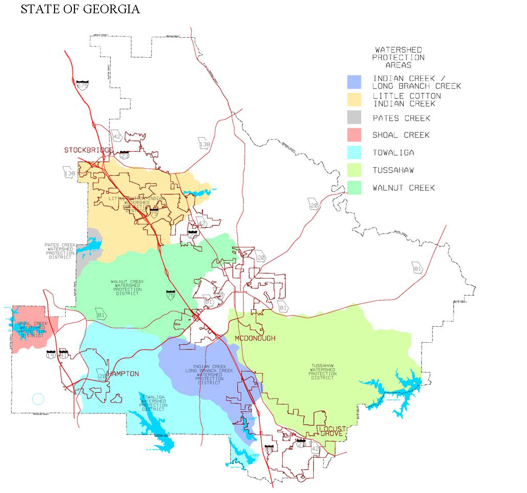
Figure 3.1 Watershed Protection Areas Map
3.04.04.
Water quality critical area. A water quality critical area is established for each watershed protection area. The water quality critical area for each of the above-stated watershed protection area, except the WCWPA, is:
A..
All land that lies adjacent to the normal pool level of a reservoir and extending either to the ridge line boundary of the watershed or five hundred (500) feet, whichever is shorter; and
B.
All land extending a distance of three (3) miles upstream from the normal pool level of the reservoir that is adjacent to each perennial stream upstream from the reservoir and extending either to the ridge line boundary of the watershed on each side of the perennial stream or five hundred (500) feet, whichever is shorter.
C.
The normal pool level elevation* of the existing reservoirs of the authority are as follows:
Indian Creek Reservoir contour line El. 728.0;
Long Branch Reservoir contour line El. 720.0;
Lower Towaliga River Reservoir contour line El. 658.0;
Upper Towaliga River Reservoir contour line El. 720.0;
Tussahaw Creek Reservoir contour line El. 600.0;
Shoal Creek Reservoir contour line El. 845.0;
*Elevations are based on U.S. Geological Survey Datum
3.04.05.
Limited development area. A limited development area is established for the remaining part of the watershed protection area that is located outside of the water quality critical area and extending to the ridge line of each watershed district.
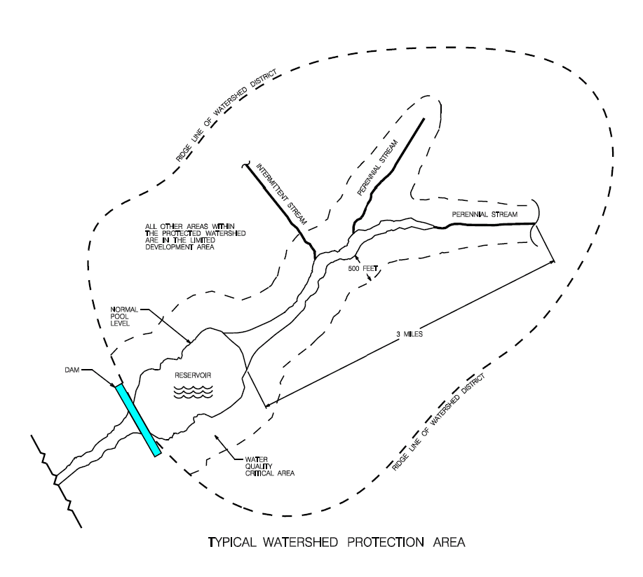
Figure 3.2.
If a perennial stream abuts or crosses any property within the limited development area described in section 3.04.05, specific regulations apply (see Table 3.04.09).
3.04.06.
Specific provisions for WCWPA.
A.
The City of McDonough Reservoir Protection Area is established as that area seven hundred fifty (750) feet in width surrounding the existing property owned by the City of McDonough on which is located the City of McDonough reservoir. This area shall be measured from the normal pool elevation (seven hundred twenty-three (723.0) feet contour above mean sea level) at the reservoir.
B.
The Walnut Creek Limited Development Area includes all land area within the WCWPA, exclusive of those properties contained within and subject to regulations of the City of McDonough Reservoir Protection Area.
3.04.07.
Specific provisions for LCICWPA and PCWPA.
A.
The Little Cotton Indian Creek Reservoir Protection Area and Pates Creek Reservoir Protection Area are established as that area one hundred fifty (150) feet in width surrounding each respective reservoir's normal pool elevation.
B.
The perennial stream corridors of the LCICWPA and PCWPA shall be protected by the following criteria:
1.
An undisturbed buffer shall be maintained for a distance of one hundred (100) feet on both sides of the stream measured from the stream banks.
2.
No impervious surface shall be constructed within a 150-foot setback on both sides of the stream as measured from the stream banks.
3.
Septic tanks and septic tank drainfields are prohibited in the 150-foot setback on both sides of the stream as measured from the stream banks.
For the purposes of subsection 3.04.07, perennial streams are defined as streams that flow throughout the whole year as indicated on the most current USGS quadrangle map.
C.
The following uses shall be exempted from the above buffers and setbacks, provided the listed uses do not impair the quality of the drinking water stream:
1.
Utilities, provided that said utilities:
a.
Are located as far from stream bank as reasonably possible,
b.
The installation and maintenance of the utilities shall be such to protect the integrity of the buffer and setback areas to the extent reasonably possible.
2.
Forestry and agricultural activities.
3.
Structures and infrastructure existing within the above setback and buffer, as of date of adoption.
4.
Development activities on recorded parcels existing at the date of adoption that would be unbuildable by the above buffer and setback requirements.
D.
Hazardous or toxic materials storage, disposal, use or generation (except handling as regulated in section 3.04.10) is prohibited within both watershed protection areas.
E.
New sanitary landfills shall have synthetic liners and leachate collection systems.
F.
Sections 3.04.09 and 3.04.11 are not applicable to either the LCICWPA and PCWPA.
G.
Variances from the provisions of this subsection may be granted in accordance with section 11.02.06.
3.04.08.
Uses in watershed protection areas. The following table identifies permissible and prohibited uses within the water quality critical area and limited development area of watershed protection areas:
Table 3.04.08. Uses in Watershed Protection Areas and Limited Development Areas.
3.04.09.
Hazardous materials handling. New facilities located within the watershed protection area that handle hazardous materials of a type and amounts requiring a permit from the Georgia DNR or that require disposal by a hazardous materials handler permitted or licensed by the Georgia DNR at a hazardous materials facility, shall perform their operations on impermeable surfaces having spill and leak collection systems. Such spill and leak collections systems shall be shown on the development plan in detail and shall be approved pursuant to procedures for development plan approval set forth in subsection 12.02.02.E.6.
3.04.10.
Site design standards for specific uses in watershed protection areas. Proposed development shall comply with both the standards for watershed protection areas and the standards for the zoning district in which the proposed development is located. Where standards are specified for the same item in both the zoning district standards and the watershed protection area standards, the stricter standard shall be required.
Table 3.04.10. Site Design Requirements Within Watershed Protection Areas.
3.04.11.
Buffers in watershed protection areas. Buffers are required in watershed protection area as follows:
A.
Buffers within water quality critical areas and the City of McDonough reservoir protection area. A natural or enhanced vegetative buffer shall be maintained for a distance of one hundred fifty (150) feet from the normal pool level of a reservoir and one hundred (100) feet on both sides of any other surface water as measured from the banks.
B.
Surface water buffers within the limited development area. A natural or enhanced vegetative buffer shall be maintained for a distance of one hundred (100) feet on both sides of any surface water as measured from the banks.
3.04.12.
Specific requirements for septic tanks and drainfields within watershed protection areas.
A.
Septic tanks and septic tank drain fields are prohibited in the setback areas established in section 3.04.10 for buildings and impervious surfaces in watershed protection areas.
B.
Septic tanks and septic tank drain fields for residential development shall have a minimum one hundred (100) feet setback from any surface water.
C.
In the City of McDonough Reservoir protection area, septic tanks and septic tank drain fields for residential development shall have a minimum one hundred fifty (150) feet setback from the normal pool elevation of the reservoir and from any surface water.
3.04.13.
Alternative provisions for impervious surface limitations.
A.
The percentage of impervious surface shall be determined by the sum of all land areas to be covered by impervious structures during the development of the property (i.e., roads, streets, driveways, houses, buildings, parking areas), divided by the total site area.
B.
The impervious surface of a single-family residential development within the limited development area may be increased up to thirty-five (35) percent provided that:
1.
Development of land in the limited development area includes area(s) set aside to remain in natural vegetation or open space in the amount of two (2) times the area of impervious surface above the twenty-five (25) percent limit. Ownership of such parcels in fee simple or as a conservation easement shall be conveyed to the county, a homeowners' association, a government agency, or nonprofit entity, as approved by the county.
2.
If the recipient of the property or conservation easement is to be an existing or proposed organization other than a governmental entity, the developer shall submit to the county articles of association or incorporation which establish the entity. Said document shall be approved in writing by the county prior to approving said development. Any proposed changes in said articles shall require the prior written approval of the county.
3.
If the recipient is a homeowners' association, membership in the homeowners' association shall be mandatory for property owners and made a required covenant in all deeds issued or passed. The association shall provide voting and use rights in the natural vegetated area when applicable and charge dues or levy assessments to cover expenses which may include tax liabilities of common areas, and for the maintenance of such common areas, natural vegetated areas, improvements, rights-of-way, utilities, etc. Such association shall be responsible for the perpetuation, maintenance, and function of all common lands, uses, and facilities.
4.
All lands and improvements shall be described and identified as to location, size, use and control in a restrictive covenant. The details of all easements conveyed shall be likewise described. These restrictive covenants shall be written so as to run with the land and become a part of the deed of each lot or dwelling unit within the development.
5.
Such restrictive covenants and the association shall continue in effect so as to control the availability of facilities for their intended function, and to protect the development from additional unplanned densities and use. Such associations shall not be dissolved, nor shall such association dispose of any land set aside for the purposes of this section, by sale or otherwise without prior written consent of the county.
6.
Any and all natural vegetated areas shall be held in common ownership by the dwelling unit owners. Any change in the natural or vegetated area, other than to maintain it in reasonable order and condition in accordance with the approved final development plan, shall require prior written approval of the county.
7.
The natural vegetated area may be set aside by the developer by acquiring property in fee simple or a conservation easement within the watershed district.
C.
The impervious surfaces for industrial, commercial, offices, institutional, public, and multifamily residential development within the limited development area may be increased up to seventy-five (75) percent impervious surfaces.
1.
All permanent stormwater control structures and easements for maintenance and access shall be recorded in the final plat of the property in accordance with the procedures set forth in subsection 12.02.03.
D.
A development may participate in a regional wet detention pond program which has been established by one (1) or more public or private entities subject to the following conditions:
1.
Runoff from the development drains into a regional stormwater management control facility approved by the county.
2.
An agreement between the county and the landowner has been executed which guarantees participation in the regional stormwater arrangement of the property and the detention pond.
3.
Construction of a regional detention pond meets or exceeds the design requirements of the stormwater management provisions set forth in section 8.04.00.
E.
A development may provide an alternative method for stormwater control other than a wet detention pond provided that it is in compliance with the stormwater management requirements set forth in section 8.04.00, and design criteria for pollutant removal equivalent to those associated with wet detention ponds included in the Georgia Stormwater Management Manual, as amended.
(Ord. No. 12-06, § I, 2-7-12; Ord. No. 12-08, § I, 5-19-12)
Sec. 3.05.00. - Wetland protection.
3.05.01.
Generally.
A.
Purpose. The purpose of the regulations in this section is to promote wetland protection, while taking into account varying ecological, economic development, recreational, and aesthetic values. The regulations set forth in this section are intended to limit activities that may damage wetlands, and to require that such activities be located on upland sites to the greatest degree practicable as described in the comprehensive plan. The regulations set forth in this section are further intended to protect wetlands from alterations that will significantly affect or reduce their primary functions for water quality, floodplain protection, erosion control, groundwater recharge, aesthetic nature, and provision of wildlife habitat.
B.
Applicability. Regulations for the protection of wetlands, set forth in this section, shall apply to all lands within wetlands located within the jurisdiction of Henry County.
3.05.02.
National wetland inventory (NWI) maps. The U.S. Department of the Interior, National Wetland Inventory Maps (NWI Maps), together with all explanatory matter thereon and attached thereto, is hereby adopted by reference and declared to be a part of this ULDC. NWI maps are available at http:wetlands.fws.gov.
3.05.03.
Determination of wetlands boundary.
A.
Generally.
1.
The NWI maps are general reference documents, and wetland boundaries indicated on the maps are approximations. The purpose of the NWI maps is to alert developers/landowners if the property proposed for development is within or adjacent to a wetland.
2.
The NWI maps do not represent the boundaries of jurisdictional wetlands within Henry County and cannot serve as a substitute for a delineation of wetland boundaries by the U.S. Army Corps of Engineers, as required by Section 404 of the Clean Water Act, as amended.
B.
Where it is determined that wetlands are located on property proposed for development, a determination of the location and extent of the wetlands shall be made by the U.S. Army Corps of Engineers or a qualified environmental engineer. A local permit for development within wetlands shall not be issued until a determination has been made by the U.S. Army Corps of Engineers as to whether jurisdictional wetlands exist on the site. If there are jurisdictional wetlands on the site that will be disturbed by the proposed development, the applicant shall first obtain a wetlands alteration section 404 permit from the U.S. Army Corps of Engineers.
3.05.04.
Permissible activities within wetlands. Lawful activities set forth in this section shall be allowed as of right within a wetland. Constructing, grading, filling, draining, or dredging shall be permissible only as provided.
A.
Conservation or preservation of soil, water, vegetation, fish, and other wildlife, provided they do not affect waters of Georgia or of the United States in such a way that would require a permit as required by section 404 of the Clean Water Act.
B.
Outdoor passive recreational activities, including fishing, bird watching, hiking, boating, horseback riding, and canoeing.
C.
Forestry practices applied in accordance with best management practices approved by the Georgia Forestry Commission and as specified in section 404 of the Clean Water Act.
D.
The cultivation of agricultural crops. Agricultural activities shall be subject to best management practices approved by the Georgia Department of Agriculture.
E.
The pasturing of livestock, provided that riparian wetlands are protected, that soil profiles are not disturbed, and that approved agricultural best management practices are followed.
F.
Education, scientific research, and nature trails.
3.05.05.
Prohibited activities within wetlands. The following activities are prohibited within wetlands:
A.
Receiving areas for toxic or hazardous waste or other contaminants.
B.
Hazardous or sanitary waste landfills.
C.
Other uses prohibited in the underlying zoning district.
3.05.06.
Temporary activities within wetlands. The following activities may be permissible on a temporary basis, provided that emergency conditions require the activity:
A.
Maintenance or repair, subject to the following requirements:
1.
Maintenance and repair is limited to lawfully located roads, structures, and facilities used in the service to the public to provide transportation, electricity, gas, water, telephone, telegraph, telecommunication, or other services;
2.
The roads, structures, or facilities are not materially changed or enlarged;
3.
Written notice prior to the commencement of work has been given to Henry County; and
4.
The work is conducted using best management practices to ensure that flow and circulation patterns and chemical and biological characteristics of the wetland are not impaired and that any adverse effect on the aquatic environment shall be minimized.
B.
Temporary water level stabilization measures associated with ongoing silvicultural operations.
C.
Limited ditching, tilling, dredging, excavating, or filling done solely for the purpose of maintaining or repairing existing drainage systems necessary for the cultivation of agricultural crops, provided that the maintenance or repair activity does not result in the impairment, alteration, or loss of wetlands not previously subject to agricultural and silvicultural use as set forth in subsection 3.05.04.D. above.
D.
Limited excavating and filling necessary for the repair and maintenance of piers, walkways, nature trails, observation decks, wildlife management shelters, boathouses, or other similar water-related structures, provided that they are built on pilings to allow unobstructed flow of water and preserve the natural contour of the wetland.
3.05.07.
Buffers required.
A.
Location of buffer. A buffer shall be located adjacent to and running parallel with the boundary established pursuant to subsection 3.05.03 above. The buffer shall provide an area of protection between the wetland, whether or not subsequently removed pursuant to U.S. Army Corps of Engineers permit and any permissible activity within or adjacent to the wetland.
B.
Buffer standards.
1.
The buffer shall be a minimum of twenty-five (25) feet in width.
2.
All natural vegetation shall be retained and maintained within the buffer.
3.
The number and types of plants required within the buffer shall be as set forth in section 5.02.00.
Sec. 3.06.00. - Groundwater recharge protection.
3.06.01.
Generally.
A.
Purpose. The provisions of this section are intended to protect groundwater as follows:
1.
Restricting land uses that generate, use, or store dangerous pollutants in recharge areas;
2.
Limiting density of development; and
3.
Ensuring that any development that occurs within the recharge area shall have no adverse effect on groundwater quality.
B.
Applicability. The provisions of this section apply to all lands mapped as significant recharge areas by the Georgia Department of Natural Resources (DNR) in Hydrologic Atlas 18, 1989 edition, as amended, or as identified in the comprehensive plan.
3.06.02.
Determination of pollution susceptability. Limitations on land use activities are based on the degree to which the aquifer is susceptible, or at risk, to pollution from spills, discharges, leaks, impoundments, application of chemicals, injections, and other human activities. The Georgia DNR has prepared maps of pollution susceptibility, which categorize land in areas of high, medium, and low potential for groundwater pollution. These maps shall be the basis for determining the locations for limited land use activities set forth in subsection 3.06.03.
3.06.03.
Limitations and site design requirements for land use activities.
Table 3.06.03. Land Use Limitations and Site Design Requirements Within the Groundwater Protection Area.
A.
At a minimum, the liner required for new agricultural waste impoundment sites shall be constructed of compacted clay having a thickness of one (1) foot and a vertical hydraulic conductivity of less than 5 × 10 -7 cm/sec or other criteria established by the U.S. Soil Conservation Service.
B.
The following soil groupings are for use with Tables DHR MT-1 and DHR MT-2.
Sec. 3.07.00. - River corridor protection.
3.07.01.
Generally.
A.
Purpose. The purpose of river corridor protection standards is to help maintain high water quality of the designated rivers.
B.
Applicability. The standards of this section apply to all river corridors designated by the State of Georgia because of their unique environmental importance. The South River in Henry County is a designated river.
C.
Stricter standards apply. Proposed development shall comply with both the standards for river corridor protection, the standards for the zoning district in which the proposed development is located, and the goals of the comprehensive plan. Where standards are specified for the same item in both the zoning district standards and the river corridor standards, the stricter standard shall be required.
3.07.02.
River corridor protection area. The river corridor protection area extends from the top of the riverbank on both sides of the river for a distance of one hundred fifty (150) feet landward. The top of the riverbank is the uppermost part of the riverbank, usually marked by a break in the slope. All land that lies within this corridor is part of the river corridor protection area.
3.07.03.
Buffer requirements for the river corridor protection area. A natural vegetative buffer area shall be maintained for a distance of one hundred (100) feet on both sides of the river as measured from the riverbanks.
3.07.04.
Permissible uses within the river corridor protection area. The following specific land uses are permissible within the river corridor protection area, subject to the standards listed for each use:
A.
A single-family dwelling together with permissible accessory structures, limited to one (1) per tract of land, may be located within the buffer area;
B.
Road crossings and utility crossings;
C.
Timber production and harvesting, consistent with best management practices of the Georgia Forestry Commission, and protection of the water quality of the river as required by the Clean Water Act;
D.
Wildlife and fishery management activities;
E.
Wastewater treatment;
F.
Recreational activities that are river dependent and that do not interfere with the maintenance of the required buffer;
G.
Walking paths;
H.
Natural water quality treatment or purification;
I.
Agricultural production and management, consistent with best management practices of the Georgia Soil and Water Conservation Commission, protection of the water quality of the river as required by the Clean Water Act, and consistent with all requirements of the Georgia Department of Agriculture; and
J.
Uses that are specifically permissible by the Georgia DNR or under section 404 of the Clean Water Act.
3.07.05.
Prohibited uses within the river corridor protection area. The following specific land uses are prohibited within the river corridor protection area:
A.
Septic tanks and septic tank drain fields;
B.
Handling areas for receiving and storage of hazardous waste, unless located within port facilities that comply with all federal and state laws and regulations for the handling and transport of hazardous waste and the operations are performed on impermeable surfaces having spill and leak protection systems as described by the Georgia DNR;
C.
Hazardous waste landfill; and
D.
Solid waste landfill.
Sec. 3.08.00. - Open space connectivity system and green space system.
(Reserved)