
Henry County Unincorporated
City Zoning Code
City Zoning Code
CHAPTER 8
- INFRASTRUCTURE IMPROVEMENTS
Sec. 8.00.00. - Generally.
The purpose of this chapter is to establish standards and requirements for the provision of infrastructure by all development. This chapter contains requirements for the transportation system, set forth in section 8.01.00, including streets, sidewalks, streetlights, and clear visibility at intersections. Requirements for off-street parking and loading and the design of parking lots and loading areas are set forth in section 8.02.00. Requirements for utilities are set forth in section 8.03.00.
Sec. 8.01.00. - Transportation system standards.
8.01.01.
Generally.
A.
No person shall do any paving work, or any other related or similar roadwork, on, or adjacent to, a county road without a permit.
B.
All transportation system design, street design, and construction for nonlocal roadways shall comply with Georgia Department of Transportation (GDOT) requirements. The latest edition of the GDOT manual, "Standard Specifications, Construction of Roads and Bridges," shall apply.
C.
Where conflict arises between GDOT standards and this section concerning non-local roadways the stricter standard shall apply. Design of local roadways shall be governed by the policies as stated within the ULDC; however, construction methods/practices of said roadways shall be governed by the stricter of the GDOT standards and the ULDC.
D.
All materials, equipment, labor and other matters related to street construction shall be provided by the applicant. The following is a summary of the improvements required:
1.
All streets, roads, and alleys shall be graded to their full width right-of-way by the applicant so that the pavements and sidewalks, when installed in the future, can be constructed on the same level plane. The preparation of the right-of-way before grading is started and the construction of cuts and fills shall be accomplished according to the specifications of the county (see subsections 8.01.05.I. and K.
2.
Three (3) copies of an as-built subgrade centerline profile shall be submitted to the county. The profile shall include both proposed and as-built centerline elevations at every even station. No curb and gutter or waterlines shall be installed prior to subgrade approval.
3.
An adequate drainage system, including necessary curb, pipes, culverts, headwalls, intersectional drains, drop inlets, bridges, swale ditches, and detention areas, shall be provided for the proper drainage of all surface water. The drainage system shall be designed by a registered professional engineer, licensed in the State of Georgia.
4.
After preparation of the subgrade the roadbed shall have base material and paving applied according to county specifications (see subsections 8.01.05.I. and K.
E.
Roadways may be created by:
1.
Dedication;
2.
Prescription;
3.
Express grant of an easement;
4.
Deed;
5.
Special statutory proceeding; or
6.
Condemnation.
F.
County roadways classification:
1.
Private road.
a.
A private road is a roadway that is created by an easement from a landowner to a certain individual or individuals and the use of said road can be controlled by the parties to the easement.
b.
Only one (1) building permit shall be issued by a private easement roadway.
c.
A private roadway shall not be maintained by the county.
2.
Public road.
a.
A paved public roadway is a roadway where the general public has acquired an implied easement for a roadway over the property of others by virtue of the unobstructed use of said roadway for a sufficient length of time to establish a public easement over the roadway. Public roadways are roadways over which the public has the right to travel, but have not been accepted by the board of commissioners as county roads and the county assumes no responsibility to maintain said roadways.
b.
An unpaved public roadway with rights-of-way of sixty (60) feet or greater is used for the general public purpose and is maintained by the county consistent with the maintenance policy developed by the Henry County Department of Transportation (county DOT).
c.
An unpaved public roadway with deeded rights-of-way of fifty (50) feet or greater but less than sixty (60) feet is used for the general public purpose and was deeded to the county at a time when a fifty-foot right-of-way was sufficient according to the ordinances in effect in the county at the time of acceptance. These roadways shall be maintained by the county consistent with the maintenance policy developed by the county DOT and in accordance with deeded rights-of-way.
d.
An unpaved public roadway with rights-of-way less than sixty (60) feet is used for the general public purpose and is maintained by the county in accordance with the maintenance policy developed by the county DOT, but shall not be maintained to the same standard as roads categorized in subsection 8.01.01.E. hereof, because of insufficient rights-of-way. These roads shall be upgraded to subsection 8.01.01.E. as rights-of-way of sixty (60) feet or greater and deeded to Henry County by adjoining landowners.
3.
County road. A county roadway is one that has been acquired by dedication, prescription, by the express grant of easement, by deed, by statutory proceedings, or by condemnation, and further has been accepted by the board of county commissioners and designated as a "county road" and the county has assumed the responsibility to maintain said road for the general public.
G.
Upon compliance with all of the provisions of the ULDC, building permits may be issued for building on public roads upon the applicant signing a "statement of understanding" that said roadway is a public road and that the county assumes no responsibility for the maintenance of said road until such time as it becomes feasible and advisable to accept said roadway as a "county road." The county at such time shall accept said road as a county road provided that the property owners along said road convey a right-or-way to the county conveying the minimum width required by the county.
H.
Upon compliance with the provisions of this ULDC, building permits may be issued on county roads.
8.01.02.
Traffic impact studies (TIS).
A.
Purpose and intent. Understanding the demands placed on the county's transportation network by development is an important dimension of assessing the overall impacts of development. All development generates traffic, and it may generate enough traffic to create congestion and thus require the community to invest more capital funds into the transportation network in the form of new roads, traffic signals and intersection improvements. Traffic congestion results in a number of problems, including economic costs due to delayed travel times, air pollution and accidents. By requiring traffic impact studies for proposed developments meeting certain thresholds, the county will be better able to determine the transportation demands of development proposals and provide for reduction of adverse impacts on the transportation system.
B.
Objectives. The county finds that requiring a traffic impact study for proposed developments that meet certain thresholds will help to achieve the following objectives:
(a)
To foster and support the coordinated and comprehensive transportation plan.
(b)
Provide transportation investments that reinforce the land use plans and development vision of the county.
(c)
Forecast additional traffic associated with new development, based on accepted practices.
(d)
Determine the improvements that are necessary to accommodate the new development.
(e)
Allow the county government to assess the impacts that a proposed development may have and assist the county government in making decisions regarding development proposals.
(f)
Help to ensure safe and reasonable traffic conditions on streets after the development is complete.
(g)
Reduce the negative impacts created by developments by helping to ensure that the transportation network can accommodate the development.
(h)
Protect the substantial public investment in the street system.
(i)
Provide information relevant to comprehensive planning, transportation planning, future transit planning and the provision of programs and facilities for traffic safety, road improvements, transportation demand management, pedestrian access and other transportation system considerations.
C.
Thresholds of applicability. A traffic impact study shall be required for all developments that are expected to generate more than one hundred (100) new trips during an a.m. or p.m. peak hour or more than seven hundred fifty (750) new trips in an average day or involves the construction of fifty thousand (50,000) square feet or greater of nonresidential building space, in single or multiple phases. Those developments of regional impact (DRIs) which require DRI evaluation as a result of zoning action (rezoning, comprehensive plan amendment, variance, conditional use, and/or modification) are exempt from the aforementioned criteria. All DRIs which have not been evaluated as a DRI at the time of zoning action, but that meet or exceed the threshold(s) established by the Georgia Department of Community Affairs (DCA) and the Atlanta Regional Commissioner (ARC) to require evaluation as a DRI at the time of permitting or other non-zoning action related evaluation or review, shall comply with Section 8.01.02(C) of the ULDC. All DRIs shall adhere to the guidelines set forth by DCA. The traffic study shall be prepared in accordance with industry accepted standards, including at a minimum, level of service impacts for adjacent roadways and intersections and a mitigation package to address the cumulative effects from the project's impact. Said applicant shall be also required to coordinate and fund any recommended mitigation measures limited to project related improvements with applicable federal, state and local agencies including the Georgia Regional Transportation Authority (GRTA) and the ARC. The determination of a traffic study shall be made during the zoning request stage, during the phase in which a site plan is submitted for a land disturbance permit, or at such time any other non-zoning action or administrative request is made. Traffic impact studies shall be required for submittal at such time a land disturbance permit or other development permit is applied for, or at such time any other non-zoning action or administrative request is made and shall not be required during the zoning process.
(a)
A traffic impact study shall be required for all DRIs which have not been evaluated as a DRI at the time of zoning action, but that meet or exceed the threshold(s) established DCA and ARC to require evaluation as a DRI at the time of permitting or other non-zoning action related evaluation or review. All DRIs shall adhere to the guidelines set forth by DCA.
(b)
The traffic impact study shall meet all applicable ARC and GRTA standards and shall be prepared in accordance with industry accepted standards, including at a minimum, level of service impacts for adjacent roadways and intersections and a mitigation package to address the cumulative effects from the project's impact. Said applicant shall be also required to coordinate and fund any recommended mitigation measures limited to project related improvements with applicable federal, state and local agencies including GRTA and the ARC.
(c)
The traffic impact study completed as part of the DRI review process may be utilized to meet the requirements of this code section.
(d)
No development permit or any non-zoning action administrative approval, including, but not limited to, administrative waiver requests, Master Sign Plan approvals, or zoning verification forms, shall be granted or approved until the DRI review has been completed and a Notice of Decision (NOD) has been granted by GRTA.
(e)
Any and all project related improvements recommended within the GRTA NOD Attachment A shall be the responsibility of the owner/developer.
(f)
No Certificate of Occupancy (CO) shall be granted until all project related improvements recommended within the GRTA NOD Attachment A applicable to the proposed development have been completed meeting all applicable Henry County Department of Transportation (HCDOT), Georgia Department of Transportation (GDOT), and/or SPLOST standards.
D.
Exemptions.
(a)
A traffic impact study is not required if a development proposal is initiated by the county.
(b)
A development proposal may be exempted from the traffic impact study requirement by the director of transportation planning, if a prior traffic impact study for the subject property has been submitted to the county and determined to fulfill the impact study requirement based on existing road conditions.
(c)
Any development of regional impact (DRI) that complies with the rules of the Georgia Department of Community Affairs (DCA), including the Atlanta Regional Commission (ARC) and Georgia Regional Transportation Authority (GRTA), which have been evaluated as a DRI at the time of zoning action, shall be exempt from this ordinance.
(1)
Any DRI that complies with the rules of the DCA, including the ARC and GRTA, which have not been evaluated as a DRI at the time of zoning, but that meet or exceed the threshold(s) to require evaluation as a DRI at the time of permitting or other non-zoning action related evaluation or review, shall comply with Section 8.01.02(C) of the ULDC.
(d)
A traffic impact study will not be required by the county for those developments with frontage and access along a state route.
E.
Trip generation data. The source for trip generation rates for the purposes of this ordinance shall be "Trip Generation" published by the Institute of Transportation Engineers (ITE), most recent edition, unless otherwise approved by the director of transportation planning. Determinations of whether this ordinance applies shall be made based on application of data from ITE Trip Generation, which may change from time to time, or as otherwise approved by the director of transportation planning.
F.
Determination of applicability. At the time a development proposal is filed, or during any pre-application meeting for zoning proposal, exclusive of variances and modifications to a zoning condition, the transportation planning director or his/her designee shall determine whether a traffic impact study shall be required according to this section. The planning and zoning and development plan review directors shall submit a proposed concept plan including proposed land uses to the transportation planning department. In order for a calculation to be made on the expected trip generation of the proposed development and compare it to the thresholds specified in this section to determine whether a traffic impact study is required.
Applicants for development proposals shall provide sufficient information about the development proposal (e.g., number of dwelling units, square footage of buildings, number of employees, land area of the development, etc.) for the transportation planning department to apply professionally accepted trip generation rates to the proposed development. The planning and zoning director shall not accept a development proposal for processing unless it contains the data on the proposed development necessary to apply available trip generation rates. The transportation planning director shall issue a letter of determination to the departments of planning and zoning and development plan review within five (5) business days, should it be determined that a traffic impact study is warranted. All traffic studies shall be required to be submitted before the issuance of any development permits, including, but not limited to, a land disturbance, clearing and grading, building permit and/or development permit.
G.
Cases where data are not available. In the event that information submitted by the applicant of the development proposal is sufficient to calculate the trip generation that would be expected to result from the proposed development, but trip generation rates or other data are not available or in sufficient quantity of studies to make a determination of applicability under the terms of this section, the following shall apply:
(a)
The planning and zoning and/or development plan review department director and the director of transportation planning shall coordinate with each other to determine if:
(1)
Professionally acceptable trip generation rates applicable to the subject development exist from other reputable sources, such as the Journal of the Institute of Transportation Engineers;
(2)
Other trip generation studies of similar developments are available; or
(3)
Professionally acceptable trip generation rates for one (1) or more similar land uses can be used in making the determination of applicability.
If the director of transportation planning is able to provide such information and determines it is professionally reputable, then the planning and zoning and/or development plan review department directors shall use said data as may be interpreted by the director of transportation to make the determination of applicability. The directors shall have no more than ten (10) working days to comply with the provisions of this paragraph, when it applies.
(b)
In the event the director of transportation planning pursuant to paragraph (a) of this section, the director of transportation planning shall notify the department that initiated the review to notify the applicant in writing that professionally accepted trip generation rates are not available for purposes of making a determination of applicability.
(c)
Upon receipt of notice described in paragraph (b) of this section, the applicant for a development proposal shall have thirty (30) days to have a qualified professional prepare and submit a peak-hour trip generation study as defined by this ordinance.
H.
Specifications for peak-hour trip generation studies.
(a)
Discounting of pass-by trips. The peak-hour trip generation study may subtract from the empirical data on actual vehicle trips those trips that are reasonably considered to be "pass-by" trips as defined by this ordinance, using professionally accepted assumptions about the percent of pass-by trips approved by the director of transportation planning.
(b)
Reduction for internal trips in multiuse or mixed use developments. In calculating the new trips generated from a proposed development containing multiple uses or mixed uses, a qualified professional with the approval of the director of transportation planning may apply a percentage reduction to the total vehicle trips shown in any peak hour trip generation study to account for internal trips, as defined in this ordinance, so as to account for (discount) the number of internal trips reasonably expected to occur in such multiuse or mixed use development. Said reduction shall not exceed twenty-four (24) percent of total trips generated.
I.
Study scope meeting. Once it is determined that a traffic impact study is required, a scoping meeting must be held with the developer or his or her consultant and the appropriate representatives of the county. It will be the responsibility of the developer or his or her consultant to initiate this meeting. The purpose of this meeting is to discuss the availability of site specific information concerning the development, available forecasts of traffic volumes, and to ensure the applicant understands the content requirements for traffic impact studies.
J.
Required contents of a traffic impact study. A traffic impact study must evaluate the adequacy of the existing transportation system to serve the proposed development and determine the expected effects of the proposed development on the transportation system. The traffic impact study must provide adequate information for county staff to evaluate the development proposal and, when appropriate, recommend conditions of approval.
The qualified professional preparing the traffic impact study is encouraged to coordinate preparation with local staff and staff from other jurisdictions, as appropriate, to ensure that all necessary components are included in the traffic impact study and to reduce revision and review time. In order to be reviewed, the traffic impact study must include the following minimum components:
(a)
Title page. A title page listing the name of the proposed development and its location.
(b)
Table of contents. A table of contents outlining the study shall be provided.
(c)
Certification. The study shall be signed and stamped by a qualified professional.
(d)
Executive summary. An executive summary, discussing the development, the major findings of the analysis and any recommendations made by the qualified professional.
(e)
Vicinity map. A vicinity map showing the location of the proposed project in relation to the transportation system of the area.
(f)
Study area map. A map of the traffic impact study area. For purposes of this ordinance, the traffic impact study area shall be determined according to trip generation rates as follows. In the event there is a difference as a result of applying peak and total trips, the more restrictive requirement (larger study area) shall apply.
Table 08.01.02: Study Area Size Requirements
(g)
Inventory of transportation facilities in the study area. A description of transportation facilities in the study area, including roadway names, locations and functional classifications, intersection lane configurations and traffic control (including signal timing), existing rights-of-way, transit routes and stops (if any), pedestrian and bicycle facilities and planned transportation system improvements. An existing lane configuration sketch shall be submitted for all roadways and intersections within the study area.
(h)
Site plan and development data. A complete description of the proposed development, including a site plan, with the best available information as to the nature and size of each proposed use and the proposed location and traffic control of all proposed access points, including the distance from all proposed access points to adjacent accesses and/or streets, including those across a street right-of-way from the subject development.
(i)
Existing traffic volumes. Peak and total daily traffic volumes on all arterial, collector and local streets within the study area. Traffic counts should be no more than one (1) year old when the report is prepared. Traffic counts between one (1) and three (3) years old may be used if factored to the current year. Traffic counts older than three (3) years will not be accepted. Utilizing available data from an industry accepted source, i.e., Georgia Department of Transportation, Henry County Department of Transportation, Atlanta Regional Commission.
(j)
Facility performance. Existing performance of the transportation system, including levels of service (LOS) and volume/capacity ratios (V/C) for all intersections and road segments, as appropriate, within the study area. Identification of any project related improvements necessary to mitigate the impact on the level of service (LOS) for the abutting roadways and unsignalized/signalized intersection resultant from the trips generated by the proposal.
(k)
Trip generation. Complete trip generation figures for all aspects of the proposed development. The source for trip generation rates shall be "Trip Generation" published by the Institute of Transportation Engineers (ITE), most recent edition, unless otherwise approved by the director of transportation planning. If phased development is proposed, the study shall include projections for the year that each phase of the development is planned to be complete. The traffic impact study shall also include trip generation data for any pending and approved developments that would affect the study area. The county staff shall facilitate the review of applicable files by a qualified professional to determine the names and development characteristics of pending and approved developments in the study area.
(l)
Trip distribution and assignment. Trip distribution for the proposed development. For developments expected to generate more than thirty (30) truck trips per day, the study shall include separate trip distribution figures for trucks.
(m)
Forecast traffic volumes without the development. Forecast traffic volumes without the development, on all arterial, collector and local roads within the study area, in the year that the proposed development is planned to commence, and in the horizon year. Qualified professionals should consult county transportation staff for information to determine the most appropriate sources or methods of determining future traffic volumes. If phased development is proposed, the traffic impact study shall include projections for the year that each phase of the development is planned to be complete.
(n)
Forecast performance without the development. Forecast performance, including levels of service (LOS) and volume/capacity (V/C) ratios of the transportation system without the development in the year that each phase is planned to be complete and in the horizon year.
(o)
Forecast traffic volumes with the development. Forecast traffic volumes with the development, on all arterial, collector and local roads within the study area, in the year that the proposed development is planned to commence and in the horizon year.
(p)
Forecast performance with the development. Forecast performance, including levels of service (LOS) and volume/capacity (V/C) ratios of the transportation system with the development in the year that each phase is planned to be complete and in the horizon year.
(q)
Sight distance. A safety analysis of the site accesses and an assessment whether adequate sight distances are provided at driveways and streets abutting the development.
(r)
Operational characteristics. Analysis of prevailing operating speeds, if significantly different than speed limits, right and left turn lane warrants, queue lengths, acceleration and deceleration lanes including lengths and tapers, throat lengths, channelization, and other characteristics of the site accesses, which exist and may be needed, as appropriate. The traffic impact study shall address whether driveways and intersections are located and spaced safely and designed to accommodate expected traffic volumes and maneuvers. The operational characteristics analysis shall also evaluate the turning and traveling characteristics of the vehicles that will be using the proposed development and the adequacy of the geometrics of the existing and proposed roadway (public and/or private) configurations to accommodate these characteristics.
(s)
On-site circulation. The traffic impact study shall address whether on-site vehicular and pedestrian circulation and parking layouts are safe and efficient.
(t)
Significant impacts. Analysis as appropriate of any potential adverse or controversial effects of the proposed development on the transportation system in the area. Examples of possible effects include, but are not limited to, infiltration of nonresidential traffic into residential neighborhoods, traffic noise, creation of potential for traffic violations, conflicting turning movements with other driveways, any new pedestrian or bicycle transportation needs arising from the development, etc.
(u)
Mitigation measures and costs. Listing of all intersections and road segments that are forecasted to be level of service "E" and "F" in the horizon year, or if phased, in the years that each phase is planned to be complete, and an identification and description of specific mitigation measures including signal, turn lane, or other warrant analyses as appropriate and necessary to bring these intersections and road segments into compliance with a level of service "C" or other county adopted level of service for said road segment or intersection. Should the proposed development reduce the level of service, mitigation factors must be included and will be included as a condition of final plat approval. If roadway improvements are needed, the study shall show a drawing at an engineering scale of one (1) inch equals twenty (20) feet for all recommended lane configurations. If signalization is warranted by the traffic signal warrants outlined in the Manual on Uniform Traffic Control Devices (MUTCD), a warrant analysis shall also be conducted as a part of the traffic impact study. If a traffic signal is warranted, the warrant package in the study shall show a drawing at an engineering scale of one (1) inch equals twenty (20) feet detailing the signal design and phasing plans. The estimated cost associated with implementing all such mitigation measures shall be provided in the traffic impact study. The traffic impact study may take into account any city/county/state-approved roadway, traffic signalization and other improvements in determining mitigation measures and providing recommendations.
(v)
Alternative transportation. Alternative transportation (sidewalk, bicycle, transit) needed as a result of the study, shall be identified.
(w)
References. A listing of all technical documents and resources cited or consulted in preparing the traffic impact study.
(x)
Technical appendix. Relevant technical information, including, but not limited to: copies of raw traffic count data used in the analysis, calculation sheets and/or computer software output for all LOS and V/C calculations in the analysis, and warrant worksheets for signals, turn lanes, signal phasing, etc. used in the analysis.
K.
Additional technical specifications. The director of transportation planning is further authorized to promulgate and require the use of additional technical specifications for conducting traffic impact studies, which shall be consistent with analysis methods included in the most recent Highway Capacity Manual, Manual on Uniform Traffic Control Devices, and/or Traffic Access and Impact Studies for Site Development: A Recommended Practice (Washington, DC: Institute of Transportation Engineers, 1991), as may be amended or republished from time-to-time.
L.
Costs and fees. The county assumes no liability for any costs or time delays (either direct or consequential) associated with the preparation and review of traffic impact studies. There shall be no application review fee for a traffic impact study.
M.
Submittal and review of study. The applicant for the proposed development or the qualified professional shall submit one (1) electronic copy of the traffic impact study and technical appendix, three (3) paper copies of the traffic impact study and one (1) paper copy of the technical appendix to the development plan review director. The development plan review director shall transmit the electronic copy, two (2) paper copies of the traffic impact study and the paper copy of the technical appendix to the director of transportation planning, who may at his or her discretion submit copies of the report to applicable review agencies which may include the Georgia Department of Transportation, the Georgia Regional Transportation Authority, an adjacent local jurisdiction and/or metropolitan planning organization or regional development center. Within ten (10) working days of receipt of a traffic impact study, the director of transportation shall review all calculations and analyses and determine if they are complete, reasonable, understandable, consistent and fully explained. The conclusions presented in the traffic impact study shall be consistent with and supported by the data, calculations and analyses in the report. Calculations, graphs, tables, data and/or analysis results that are contrary to good common sense or not consistent with and supported by the data will not be accepted. In such events, the director of transportation shall return the traffic impact study to the development applicant for correction.
N.
Recommendations for mitigation of impacts. Within fifteen (15) working days of receipt of a completed traffic impact study, the departments of transportation and transportation planning shall complete his or her review of the study and submit to the development plan review department director or his/her designee all recommendations for mitigation measures as stated in the traffic impact study and include any interpretations or recommended conditions of approving the development proposal that will mitigate traffic impacts of the proposed development.
O.
Determination of project and system improvements. Upon receipt of the recommendations of the director of transportation planning with regard to the traffic impacts of the development proposal, the transportation planning director and department of transportation engineering staff will determine which mitigation measures constitute project improvements and/or system improvements. The director of transportation planning, with the assistance of the planning and zoning service division director and public works division director will as necessary determine the proportion of the cost of such improvement(s) that can reasonably be attributed to the development as a project or system improvement.
P.
Conditions of development approval for project improvements. upon the determination of project improvements needed to mitigate the traffic impacts of the development proposal as provided in section 08.02.17 of this Code, the development plan review director and/or assigned staff member shall require as part of the final development plans that the mitigation measures and roadway improvements be by the developer as conditions of approval of the development proposal.
Q.
System improvements. The transportation planning director shall include system improvement recommendations in the conditions for approval of the development plan. In the case of system improvements, the applicant shall have the following options:
(a)
The applicant may voluntarily agree to pay for the cost of providing the system improvements, or a pro-rated share of the cost of said system improvements that are reasonably attributed to the subject development, as determined by the county.
(b)
If the mitigation measure is a system improvement listed in the county's comprehensive transportation plan or SPLOST Program transportation project list, then the applicant may agree to install the system improvement and the county may agree to provide a credit or partial credit for the improvement.
(c)
The county may subsequently use the traffic impact study for future long range transportation planning efforts and may consider the recommendations of the traffic impact study in a future update of its transportation system plan, capital improvement plan and/or the capital improvement element of the comprehensive plan.
(d)
The county may find that the proposed development will provide substantial adverse impacts on the transportation system. Mitigation measures may be necessary, if the county is unable to provide adequate transportation facilities within a reasonable amount of time after the impacts of said development would occur. The board of commissioners may reduce the development density or intensity of the development so that the adverse impacts of the development proposal do not degrade transportation facilities below adopted level of service standards. A phasing of the development may be required in a manner that adequate public facilities will be provided publicly or privately, or in cases where such alternatives do not address the adverse impacts, then an application for a development proposal may be denied.
R.
Appeal. An applicant for a development proposal may appeal a decision of the director of transportation planning or the planning and zoning director in the administration and interpretation of this ordinance to the board of commissioners in accordance with section 12.04.00.
8.01.03.
Access requirements.
A.
Requirements for connection to existing street system.
1.
All proposed development shall provide a street system that is connected to the existing or planned street system as shown in the comprehensive plan and comprehensive transportation plan. All proposed streets shall be continuous and in alignment with existing, planned or platted streets.
2.
Proposed streets shall be extended to the boundary lines of the tract to be developed or subdivided, unless prevented by topography or other physical conditions.
3.
Whenever there exists adjoining the tract to be subdivided a dedicated or platted half-width street or alley, the other half-width shall be platted.
B.
Frontage on a state highway or arterial street.
1.
When a tract fronts on a state highway, major arterial, or minor arterial street, a frontage street may be required for access to individual lots.
2.
All residential lots in a subdivision shall take direct access only from within the subdivision.
3.
Any access to a state highway shall be consistent with the requirements of the GDOT.
C.
No approval shall be granted for a subdivision, or subsequent phase or addition to an existing subdivision, unless the property is served by a paved county road, with right-of-way sufficient to meet the requirements of subsection 8.01.05.I.
D.
Specific access requirements for developments.
1.
Emergency vehicle access shall be provided to all lots within a subdivision.
2.
In order to ensure emergency vehicle access, every subdivision with more than fifty (50) lots shall have at least two (2) continuously open points of ingress/egress from the existing street system.
3.
Access points, whether private commercial/industrial drives or county roadways, shall line up directly across from one another when possible. For driveways/roadways that require an offset, the spacing between drives/roadways, whether on the same side or opposite side of the intersecting roadway shall be required to have the minimum centerline to centerline spacing: Thirty (30) mph or less → one hundred twenty-five (125) feet, thirty-five (35) mph → one hundred fifty (150) feet, forty (40) mph → one hundred eighty-five (185) feet, forty-five (45) mph → two hundred thirty (230) feet, fifty (50) mph two hundred seventy-five (275) feet, fifty-five (55) mph → three hundred fifty (350) feet. For intersecting roadways that are not classified as collector or above and have posted speed limits thirty (30) mph or less, private commercial/industrial driveways may be allowed to have a reduced offset requirement at HCDOT's discretion. (Source: GDOT Regulations for Driveway and Encroachment Control).
4.
Where a subdivision is providing two (2) or more connections to the existing street system pursuant to subsection 8.01.03.D.2., the requirement for two (2) points of ingress/egress is met. The requirement for access shall not be satisfied by a stub-out to a future, planned, or platted street that has not been constructed.
5.
A subdivision on a single, dead-end street, containing twenty (20) or fewer lots shall not be required to provide two (2) points of ingress/egress as otherwise required in paragraph D.2., above.
6.
Where a subdivision is allowed one (1) point of access pursuant to subsection 8.01.03.D.2., that entrance street shall be designed with a three (3) lane divided entrance street, as shown in Figure 8.3. The right turn lane shall be required to have a seventy-five-foot radius to provide needed lateral separation between two (2) cars exiting at the same time.
E.
Limitations on residential curb cuts. Within any residential zoning district (see subsection 8.01.03.D.3. for other driveway spacing requirements) where the lowering or cutting away of any curbs for purposes of ingress and egress is required, such curb cut shall be subject to the following provisions:
1.
Any parcel of property with frontage of less than one hundred (100) feet on any one (1) street shall be allowed only one (1) combined entrance and exit.
2.
Any parcel of property with frontage of one hundred (100) feet to 200 feet on any one (1) street shall be allowed no more than two (2) combined entrances and exits.
3.
Any parcel of property with frontage of more than two hundred (200) feet on any one (1) street shall be permitted additional entrances or exits after showing of actual requirements of convenience and necessity and upon approval of the HCDOT.
4.
At street intersections, no curb cut shall be located within fifty (50) feet of the intersections of two (2) curb lines or such lines extended, or within fifteen (15) feet of the intersection of two (2) property lines extended. When a culvert is required it shall receive approval from the county DOT.
5.
The distance between any two (2) curb cuts on the same side of the street and located on one (1) property shall be not less than ten (10) feet. Curb cut distance shall be measured between the points of tangency of the curb return radii and the established curb line of the abutting street.
6.
All driveways shall be constructed so as to be at least two (2) feet from any property line.
7.
The maximum width of any driveway shall not exceed forty (40) feet measured at the right-of-way line.
8.
The maximum width of any curb cut including curb returns shall not exceed fifty (50) feet.
9.
The sum of the two (2) curb return radii for any one (1) curb cut shall not exceed fifteen (15) feet.
8.01.04.
Joint access driveways and cross access easements. Joint access driveways and cross access easements shall be required in corridor overlay districts, interchange activity center zoning districts, and rural neighborhood commercial development areas according to the following provisions:
A.
Adjacent commercial or office properties shall provide a cross access drive and pedestrian access to allow circulation between sites through a system of joint use driveways and cross access easements as shown in Figure 8.4. The design of the joint or cross access area shall incorporate the following:
1.
A continuous service drive or cross access corridor extending the entire length of each block served to provide for driveway separation;
2.
Stub-outs and other design features to make it visually obvious that the abutting properties may be tied in to provide cross-access via a service drive; and
3.
Sufficient separation between side street access to the property and the major road to ensure safety.
B.
In order to ensure continuous availability of access to all properties, all property owners shall:
1.
Record an easement with the deed allowing cross access to and from other properties served by the joint use driveways and cross access or service drive;
2.
Record an agreement with the deed that remaining access rights along the thoroughfare shall be dedicated to the county and pre-existing driveways shall be closed and eliminated after construction of the joint-use driveways; and
3.
Record a joint maintenance agreement with the deed defining maintenance responsibilities of property owners.
8.01.05.
Design and construction standards for streets.
A.
Location.
1.
The location, arrangement, extent, width, and grade of all streets shall conform to the comprehensive plan and the transportation system plan, and shall be considered in relation to existing and planned streets, topographical conditions, public safety and convenience, and proposed use of land to be served by the streets. The layout of a subdivision shall conform to the requirements and design principles described in this ULDC.
2.
The location of all streets and roads shall conform to the comprehensive plan and the transportation system plan. Provision shall be made in developments for the construction of streets at locations shown in the comprehensive plan and transportation system plan.
3.
Whenever a tract to be subdivided includes any part of a major arterial, minor arterial, major collector, or minor collector street designated on the comprehensive plan or transportation system plan, such part of said street shall be installed by the applicant in the location and at the full width indicated by the functional classification for right-of-way and pavement widths indicated in this ULDC.
B.
Design and construction standards for curb and gutter.
1.
Curbs shall be required in all residential subdivisions.
2.
Curbs shall be required for streets in commercial and industrial subdivisions.
3.
Curbs in all subdivisions shall be L-back curbs twenty-four (24) inches in overall width, six (6) inches thick, and shall have an eighteen (18) inch gutter. Rollback curbs may be installed in the R-3, R-4 or R-5 zoning districts.
4.
Curb and gutter immediately adjacent to the major travel lane along roadways with a posted speed limit of forty (40) miles per hour or forty-five (45) miles per hour shall be L-back curbs thirty (30) inches in overall width, six (6) inches thick, and shall have a twenty-four (24) inch gutter. The curb and gutter shall be per GDOT Standard 9032B.
5.
All curbs shall be constructed of Portland cement concrete.
6.
Curbs shall be designed to provide handicapped access at street intersections, wherever sidewalks are constructed.
C.
Street grade standards.
1.
Grades on major and minor arterials shall not exceed five (5) percent and grades on local residential streets shall not exceed twelve (12) percent.
2.
All changes in grade shall be connected by vertical curves which adhere to the design criteria as set forth by the more restrictive of the 1990 or 2004 AASHTO Guide, A Policy on Geometric Design of Highways and Streets.
D.
[Radius of horizontal curves.] The radius of horizontal curves on local residential streets within a subdivision shall be no less than two hundred (200) feet. The horizontal radius for collector and arterial streets or any streets with a design speed of more than twenty-five (25) miles per hour shall comply with the latest version of the American Association of State Highway and Transportation Officials (AASHTO) standards. The radius of horizontal curves on local commercial and industrial streets within a subdivision shall be no less than three hundred (300) feet.
E.
Street intersection standards.
1.
Street intersections shall be as nearly at right angles as possible.
2.
In residential subdivisions no intersection shall be at an angle of less than eighty (80) degrees or more than one hundred (100) degrees.
3.
Street intersections in commercial and industrial subdivisions shall be at an angle of not less than ninety (90) degrees, if at all possible. At HCDOT's discretion, street intersection angle may be allowed to be between eighty (80) degrees and one hundred (100) degrees.
4.
The minimum curb radius at street intersections shall not be less than twenty-five (25) feet in residential subdivisions. For streets/roadways to have a dual lane exit, the exit curb radius shall not be less than seventy-five (75) feet. Where a county collector or an arterial roadway intersects with another county collector or arterial roadway the minimum radii at the intersection shall be fifty (50) feet.
5.
The minimum curb radius of street intersections for industrial and commercial subdivisions shall be fifty (50) feet. For commercial/industrial streets/roadways to have a dual lane exit, the exit curb radius shall not be less than seventy-five (75) feet.
6.
Pedestrian ramps shall be designed for all intersections in accordance with standard drawings for subdivisions and residential developments designed to include sidewalks and shall meet the minimum standards in of the Georgia Accessibility Code, Chapter 120-3-20 of The Rules and Regulations of The Georgia Safety Fire Commissioner. The curb shall be de-pressed to accommodate future installations at the same time as the curb.
7.
Interior subdivision street intersections shall have a minimum centerline offset of at least one hundred twenty-five (125) feet when not aligned directly across from one another. See subsection 8.01.03.D.3 for requirements of intersection offsets on roadways with posted speed limits over thirty (30) mph.
F.
[Minimum tangent lengths.] The minimum tangent lengths on roadways with superelevation shall be governed by the minimum runoff and runout lengths necessary to adequately transition the superelevation rates required for the curvature based on the design speed and maximum allowable superelevation rate of the roadway. Design speeds, typical sections of roadway, maximum superelevation rates, and other roadway design items are to be set by HCDOT on an individual roadway basis. The minimum tangent lengths on commercial and industrial subdivision streets is one hundred (100) feet.
G.
[Dead end street.] Local streets designed to have one (1) end permanently closed and not connected with any existing street, proposed future street, or not intended to extend to the property line of an adjacent tract, shall be no longer than seven (7) times the lot width required by the underlying zoning district, unless necessary due to the topographic or other physical conditions of the property.
1.
Permanent residential dead-end streets shall be joined by a cul-de-sac with a paved turnaround having an outside diameter of eighty (80) feet (40-foot radius) and a right-of-way of at least one hundred ten (110) feet diameter. Dead-end streets designed to be permanent and that exceed more than eight hundred (800) feet in length may be required to have a cul-de-sac turn around midway between the entrance intersection and the end of the street to provide maneuvering for emergency vehicles, when the dead-end street is the only street in a subdivision.
2.
Stub streets which are intended to provide access for future development within a tract of land or adjacent tracts shall be required to have a temporary turnaround area having a diameter of at least eighty (80) feet, consisting of six (6) inches of graded aggregate base.
3.
For subdivisions with a temporary turnaround, it shall be required of the applicant to provide a letter of credit equal to the cost of permanent cul-de-sac construction, in accordance with the standards of section 12.02.13.
H.
[Alleys.] Alleys may be provided at the rear of lots in residential, commercial, and industrial subdivisions.
I.
Right-of-way and pavement width standards.
Table 8.01.05. Right-of-way and Pavement Width Standards
* The county DOT may require additional right-of-way and pavement widths in specific situations. Roadways with medians and/or additional laneage will require extra right-of-way and pavement widths.
† Roadways with posted speed limits of forty (40) mph or forty-five (45) mph will require thirty-inch curb and gutter.
J.
Additional street system requirements for major subdivisions or commercial/industrial development.
1.
Private streets are permissible and shall meet and adhere to all county standards. Every subdivision with private streets shall have a mandatory homeowners' association.
2.
Subdivisions that adjoin existing streets shall dedicate additional right-of-way if needed to meet the minimum street right-of-way requirements.
3.
Half streets shall be prohibited except where essential to the reasonable development of the subdivision.
4.
Where it is determined to be practical to require the dedication of the additional half when adjoining property is subdivided, the other half of the street shall be platted to create a full width right-of-way serving the adjoining tracts of land.
5.
Any subdivision or development which has an entrance onto a state highway, major arterial, minor arterial, or collector county road shall provide lanes for deceleration, ingress, and egress. Design requirements of the GDOT shall be met on state roads and design requirements of the county DOT shall be met on county roads.
6.
Any subdivision or development which has an entrance onto a major arterial, minor arterial, or collector roadway shall be required to design and construct a left turn lane improvement if the criteria is met as stipulated in Chapter 4 of the GDOT Regulation for Driveway and Encroachment Control. The developer will also be responsible for acquisition of right-of-way as well as for the relocation of utilities.
7.
The names of proposed streets shall not duplicate existing street names, irrespective of the use of the word street, avenue, boulevard, drive, place, court, etc., in the naming of the street.
K.
[No parking.] No parking areas shall be established for the use of fire equipment and emergency vehicles to ensure access to the premises in cases of emergency. Said areas shall be marked "Fire Lane-No Parking." The fire lane areas shall comply with provisions of the Henry County Code of Public Safety.
8.01.06.
Construction requirements for residential, industrial, and commercial subdivision streets. The grading, base, and pavement for street construction shall be as follows:
A.
Grading. All streets shall be graded to the elevations shown on the approved construction plans.
1.
The contractor may begin clearing and grubbing the project after:
a.
A development permit has been issued by the county;
b.
A pre-construction conference has been held, the division director or designee duly notified; and
c.
All required silt and erosion control measures have been installed and approved.
2.
Clearing and grubbing.
a.
All trees, stumps, logs, roots, grass, weeds, poles, and other objectionable matter shall be cleared and grubbed from within the construction limits of the project.
b.
A thirty-foot undisturbed buffer shall be maintained on all property lines prior to submission of construction plans.
c.
No rubbish or other material resulting from the clearing and grubbing of the roadway shall be buried at the site.
d.
If burning is permitted, all burn pits shall be located outside of the roadway construction limits. After burning, the pit shall be cleared out. A county inspection is required prior to backfilling and must be shown on the final plat.
3.
Excavation.
a.
All grading operations shall be planned and executed by the contractor in such a manner as to provide suitable subgrade material for the roadway with the top twelve (12) inches compacted to one hundred (100) percent maximum dry density, ninety-five (95) percent below the top.
b.
In areas where the material in place is not suitable for subgrades, these areas shall be undercut a minimum of twelve (12) inches and backfilled with suitable material.
c.
All rock and boulders in the roadbed shall be excavated and the space backfilled to the correct grade with suitable material.
d.
Any stones, broken rock, or boulders resulting from the grading of the roadway may not be placed in any roadway fill area except when approved by the division director or designee and then under his supervision.
e.
During the construction of the roadway on a day-to-day basis, the roadbed edges shall be kept lower than the center and the grading shall be done so that the surfaces of the excavated areas and fill shall be kept reasonably smooth and well drained. Adequate surface ditches shall be cut at the tops of cut slopes, extending to each end of the cuts in order to carry the water from the side hill. Side ditches or gutters emptying from cuts to fill areas shall be turned outward so as to prevent erosion of the fill slopes.
4.
Placement of fill.
a.
Fill construction shall not begin until all clearing and grubbing of the fill area has been completed.
b.
All depressions in the ground shall be filled level with the adjacent surface using suitable material and compacted to the approximate density of the surrounding soil before placement of the fill is begun.
c.
The entire area upon which fill is to be placed shall be plowed, scarified, and finely broken up to a depth of a minimum of six (6) inches.
d.
Before the placement of fill material is begun, all loosened soil shall be compacted the approximate density of the underlying soil.
e.
Where a depth of fill and surfacing is three (3) feet or less, the original ground shall be compacted a minimum twelve (12) inches deep to at least ninety-five (95) percent of the maximum laboratory dry density as determined from representative samples of the material being compacted.
f.
In areas where layers of organic or other unstable materials exist, the existing ground shall be excavated, for the full width of the fill area, to an underlying stable material. The subgrade thus created shall then be compacted to the approximate density of the underlying material.
g.
All fill material shall be deposited and spread in uniform horizontal layers, not more than six (6) inches thick, for the full width of the fill area, and these layers shall be kept uniform by the use of graders, bulldozers or other approved equipment.
h.
Each layer shall be compacted within the range of optimum moisture content necessary to achieve the compaction required. Material containing too much water shall be dried to the correct moisture content. If the material is too dry, water shall be added and uniformly mixed with the soil before it is compacted.
i.
Fills shall be compacted to at least ninety-five (95) percent of the maximum dry density to within the top twelve (12) inches of the fill. The top twelve (12) inches of the fill shall be compacted to at least one hundred (100) percent of the maximum dry density.
j.
The entire roadbed shall be scarified and compacted with a sheep's foot or other approved rollers.
k.
While the work is in progress, contractor shall maintain the surface in a manner so that the excavation, fills, subgrade, base course, and ditches always present a smooth and even surface.
l.
The contractor shall have available on the job at all times at least one (1) motor patrol grader with adequate power to blade and maintain the roadbed. Suitable scarifiers shall also be available for use whenever necessary.
5.
Final finishing of roadway.
a.
After all excavation has been completed and all fills have been placed, the entire road bed surface shall be finally shaped with a grading machine supplemented with hand work whenever required, to secure a smooth surface and uniform cross-section.
b.
Slopes of cuts and fills shall also be carefully shaped to the true section specified.
c.
When final shaping is finished, the road surface shall conform accurately to the line, grade and cross section shown of plans, and no roots, sod, grass, stones, or other unsuitable material shall remain in the top twelve (12) inches of the finished roadbed.
d.
All ditches and drains shall be opened to effectively drain the roadway.
B.
Placement of curb and gutter.
1.
After sanitary sewer lines have been installed, all storm drainage in place, and the final finishing of the roadway has been approved by the division director or designee, and the centerline profile has been approved, the installation of the concrete curb and gutter may begin.
2.
All concrete curb and gutter shall be in accordance with Standard Drawing 3.7.1, available from the county or the county website at www.co.henry.ga.us.
3.
Any curb and gutter which does not conform to a true section, texture, line, and grade shall be removed and replaced as directed by the division director or designee.
4.
Water lines shall be installed after installation of the curb and gutter.
C.
Subgrade.
1.
Before placing any pavement base the entire surface of the subgrade shall be plowed, harrowed, and mixed to a depth of at least six (6) inches. If a subgrade stabilization material is required it shall be incorporated into the subgrade at this time.
2.
After the material has been thoroughly mixed the subgrade shall be brought into a proper line and grade and compacted to one hundred (100) percent of maximum dry density just prior to placing the base material.
3.
The centerline profile shall conform to the established elevations with an acceptable tolerance of one-half (½) inch.
4.
The acceptance crown tolerance shall be one-half (½) inch.
D.
Base construction.
1.
The division director or designee shall be notified twenty-four (24) hours prior to the placing of any base material.
2.
The division director or designee may authorize the placing of the base material after all equipment necessary for the proper construction of road base is on the project and the subgrade has been brought to the proper line, grade and crown, and compacted to the required density.
3.
The division director or designee shall check the completed base course after the base material has been placed and compacted to the required density. All areas found to be deficient shall be marked and corrected before any asphalt pavement is placed. Areas where the crown is found to exceed that which is specified or the exposed edge of the concrete gutter is less than the minimum depth required, shall be reshaped and rolled to obtain the required cross-section.
4.
After the compacted material has been approved, field tests shall be taken by the field contractor and development inspector, or by a professional engineer as directed by the division director or designee to determine the thickness of the constructed base course. Tests shall be taken at four hundred (400) feet intervals alternating between each lane and center of roadway. Measurements shall be taken per GDT-42, Method of Test for Measurement of Thickness of Bases and Subbases. Areas found to be deficient in thickness shall be corrected as directed by the division director or designee. No asphalt course shall be placed until deficiencies in base have been adequately addressed.
5.
A copy of all delivery tickets for the graded aggregate base material shall be furnished prior to placing any asphaltic concrete paving material. A shortage in the base material used shall require that the asphaltic concrete surface course thickness be increased.
6.
All work and materials shall be in accordance with the pertinent Graded Aggregate Construction sections of the Georgia Department of Transportation "Standard Specifications," latest edition.
E.
Soil cement.
1.
A soil cement base may be used to improve the subgrade, but shall not be used as a substitute for base construction.
F.
Paving.
1.
The contractor shall begin the construction of the asphaltic concrete pavement upon approval of the road base by the division director or designee.
2.
All asphaltic concrete material and construction shall be in accordance with the "hot mix asphaltic concrete construction" sections of the Georgia Department of Transportation "Standard Specifications," latest edition.
3.
The division director or designee shall check the cross section of the finished pavement. Any area found to be deficient shall be marked and a record of deficiencies made by the division director or designee.
4.
If, in the opinion of the division director or designee, the extent of deficiencies will impair the performance of the pavement, he shall direct that an overlay of a minimum thickness of one (1) inch be placed before the roadway is opened to traffic.
5.
A copy of the delivery tickets for the asphaltic concrete material used shall be furnished to the division director or designee at the time of completion of the work. If the delivery tickets indicate a shortage in the material used from the quantity estimated the division director or designee may require a minimum one (1) inch overlay of the streets.
6.
As mentioned in subsection 8.01.06.D.4, the GAB (Base) thickness is to be measured and accepted by the county prior to placement of any asphalt course. The applicant shall have core tests made to verify the thickness and compaction of the two-inch asphalt pavement course. The minimum core diameter shall be such that compaction of the sample can be determined in the lab and subsequent data supplied to the division director or designee. The compaction of the course shall be required to meet GDOT specifications per the asphalt mix placed. If a two (2) course asphalt section is required, the cores for the binder layer shall be cut, reviewed, and approved by the division director or designee prior to placement of the topping lift. Also, in the event that a two (2) course asphalt section is required, the cores for the topping lift, if between one and one-half (1½) inch and one and one-quarter (1¼) inch in thickness, shall be made to determine the thickness only. All cores shall be made on four hundred (400) feet intervals, alternating between each lane and center of roadway. If these cores indicate a deficiency in thickness or compaction of the asphalt pavement, an overlay shall be required when the following deficiencies occur:
a.
When the number of cores deficient in thickness within the allowable one-quarter (¼) of an inch tolerance, or deficient in compaction, exceeds thirty-five (35) percent of the total cores taken on one (1) street.
b.
When two (2) or more consecutive tests show a deficiency of more than one-quarter (¼) of an inch allowable tolerance or a deficiency in compaction. When a core shows a deficiency in excess of the allowable tolerance or compaction additional cores shall be taken to delineate the area of the deficient thickness/compaction.
7.
The applicant shall correct any deficiency with an overlay extending a minimum of one hundred fifty (150) feet beyond the outer limits of the deficient area for the full width of the street. Smooth, neat joints shall be saw cut normal to the roadway for full depth of asphalt pavement, removing the original pavement for a minimum of ten (10) feet at each end of the overlay. The thickness of the overlay shall be determined by the depth of the deficient area and shall not be less than one and one-quarter (1¼) inch in compacted thickness. The type of material used in the overlay shall be specified by the division director or designee.
G.
Shoulder and drainage improvements. After the paving has been inspected and approved, the pavement edges or behind the curb and gutter shall be backfilled and compacted and the ditches and back slopes properly graded, shaped, seeded and mulched. An eighty (80) percent stand of grass shall be obtained. All swales and ditches excavated below required depth shall be backfilled and compacted to ninety-five (95) percent of maximum dry density.
H.
[Compliance with minimum standards.] Road design and construction for residential subdivisions shall comply with the minimum standards shown below in subection 8.01.06.I. Acceleration and deceleration lane construction shall comply with the standards set forth in subsection 8.01.06.K. For roadways with more than one hundred fifty (150) lots of contributing traffic a pavement design is to be done and submitted to HCDOT for review. The GDOT Asphalt Pavement Design program is an accepted method for the pavement design submittal for roadways with more than one hundred fifty (150) lots of contributing traffic.
I.
Table of residential subdivision street construction standards.
Table 8.01.06(I). Residential Subdivision Street Roadway Standards
J.
[Design and construction requirements.] The design and construction requirements for subdivision developments for industrial, commercial, or office use and urban streets which are to be county arterial roads shall:
1.
Be required to have concrete curb and gutter along each side in accordance with Henry County Construction Standard No. 3.7.1.
2.
Comply with the minimum standards shown below in subsection 8.01.06.K.
K.
Table of industrial, commercial, and office subdivision street construction standards.
Table 8.01.06(K). Industrial, Commercial, and Office Subdivision Street Construction Standards
8.01.07.
Improvements to existing streets and rights-of-way for residential, commercial and/or industrial developments.
A.
Existing unpaved road. Any unpaved road upon which a development has frontage and access shall be widened and paved, according to the functional class of the road, as set forth in subsection 8.01.05.I. along the frontage* of the development to the nearest intersection with a paved county road. The minimum right-of-way required according to subsection 8.01.05.I. shall be dedicated along the entire frontage of the development back to the nearest intersection in which the roadway is to be improved. In addition to the design, construction, and right-of-way acquisition, the developer shall also be responsible for relocation of utilities. Where a development has frontage, but does not provide access to an unpaved road, the developer shall preserve right-of-way along the development's frontage for future improvements to the roadway.
* - In instances where improving a roadway to the limits of the frontage causes for an undesirable termination point for the improved roadway (i.e., alignment issues, topographic issues, etc.) the improvement shall be required to be further extended in order to provide for an acceptable tie-in to the existing roadway.
B.
Existing paved road. For any existing paved two (2) lane county road upon which a development has frontage and access that is less than twenty (20) feet in width and classified as a local roadway, or less than twenty-two (22) feet in width and classified as a collector roadway or greater, the roadway shall be widened relative to county specifications (see section 8.01.05.I. and tables 8.01.06.I. and K.) along the limits of the site's frontage. Widening of the roadway shall include improvements to the shoulder, ditch, and back-slope to meet county DOT Standards. Depending on the condition of the existing roadway (PACE's score of less than seventy (70)), there may be requirements for additional improvements to the overall roadway width along the site's frontage, such as improvements to the typical pavement section and resurfacing. For any roadway less than nineteen (19) feet in width, the roadway shall be required to be widened, possible typical pavement section improvement, placement of shoulder, ditch, and slopes to meet county DOT standards and resurfacing along the site's frontage, as well as outside of the site frontage limits up to the nearest roadway meeting Henry County standards as determined by the county DOT. The minimum right-of-way required according to section 8.01.05(I) shall be dedicated along the entire frontage of the development.
8.01.08.
Visibility at intersections.
A.
Corner lots. On corner lots within all zoning districts, no fence, shrubbery or other obstruction shall be placed within the sight line triangles that blocks or disrupts the line of sight based on a driver eye height of three and one-half (3.5) feet located fourteen (14) feet from edge of travel lane (when there is a deceleration lane, the driver eye shall be located fourteen (14) feet from edge of decel lane) and an object height of three and one-half (3.5) feet located in the center of each respective lane. The minimum distances required are shown in Table 8.01.08(B)(2). However, streetsigns, streetlights, mailboxes, or similar shall be permitted within the sight line triangles (see Figure 8.5 below).
B.
Intersection sight distance for all streets.
1.
Curb cuts shall be placed so as to provide for the minimum intersection sight distance based on the intersecting road's posted speed limit. The intersection sight distance is measured using a driver-eye height of three and one-half (3.5) feet and an object height of three and five-tenths (3.5) feet with the driver eye being located fourteen (14) feet beyond the edge of the travel lane (when there is a deceleration lane, the driver eye shall be located fourteen (14) feet from edge of decel lane) and an object height of three and one-half (3.5) feet located in the center of each respective oncoming lane.
2.
Table of minimum intersection sight distances relative to design speed posted on streets are:
Table 8.01.08(B). Intersection Sight Distance for 2-lane Roadway
Source: 1990 AASHTO Guide, A Policy on Geometric Design of Highways and Streets.
C.
Stopping sight distance for all streets.
1.
Minimum street centerline stopping sight distance shall be designed relative to the design speed of the street and shall be measured above the street centerline using a driver eye height of three and one-half (3.5) feet and an object height of six (6) inches.
2.
Table of minimum centerline stopping sight distances relative to design speed posted on streets are:
Table 8.01.08(C). Stopping Sight Distance
Source: 1990 and 2004 AASHTO Guide, A Policy on Geometric Design of Highways and Streets.
As info concerning the above minimum crest "k" values, where there is an intersecting street on or near the vertical curve, the minimum "k" value may not provide for the minimum intersection sight distance requirement. If this is the case, the "k" value for the crest curve will need to be increased in order to obtain the minimum intersection sight distance required.
8.01.09.
Pedestrian access and facilities requirements.
A.
Sidewalks shall be at least four (4) feet in width and four (4) inches in thickness and shall be constructed of Portland cement concrete. Sidewalks shall be installed no closer than two (2) feet to the back of curb line and shall not be constructed over any underground gas, electric, communications, or water and sewer utilities. Sidewalks and curbs, at street intersections, shall be designed to permit handicapped access (see construction standard detail for location of sidewalks). Sidewalks shall be required on both sides of streets within all commercial, industrial or residential subdivisions and all mixed use developments.
B.
Sidewalks shall be installed by the builder on lots upon which a dwelling is being constructed before the issuance of a certificate of occupancy. All sidewalks along common areas, including pond lots, amenity areas, open space, and lots containing existing homes or lots that are unbuildable, shall be installed by the developer before the end of the three-year maintenance period. After the three-year maintenance period has expired, any broken curbing and sidewalk will be repaired by the builder before a certificate of occupancy is issued.
C.
Twelve (12) months from the completion of at least ninety (90) percent of the dwellings in any subdivision, or phase of any subdivision, Henry County reserves the right to install sidewalks along any areas not yet containing sidewalks. The cost of construction and installation shall be repaid to Henry County via a lien placed on the adjacent property upon which the sidewalk fronts.
D.
The provisions established in this section may be applied to any project currently under review or under bond as of the date of adoption of this Code.
8.01.10.
Street names and signs requirements.
A.
Street names.
1.
All proposed street names within the county for new roads or roads within commercial, industrial, or residential subdivisions shall be approved by the division director or designee during the preliminary plat review process or prior to recording of the road and its right-of-way deed.
2.
Any request to change the name of an existing road shall be submitted to the division director or designee for review and approval, with the board of commissioners having final approval of the change.
B.
Street signs.
1.
The county DOT shall determine the need and location of street signs within a subdivision. The location of the street signs shall be determined during the review of the preliminary plat.
2.
The county's standard steel street posts or wooden four-inch by four-inch posts with horizontal reflectorized street name plates with four-inch letters shall be furnished and installed by county DOT.
3.
The cost of street signs and their installation shall be paid by the applicant at a fee determined by the county DOT. All funds collected for these signs shall be deposited into the county general fund account.
4.
The required fee shall be paid by the applicant when submittal of a final plat is made to the county.
5.
The request for an invoice and the ordering of signs shall come from the division director or designee to the county DOT.
8.01.11.
Streetlight and pedestrian light requirements.
A.
In order to ensure adequate illumination of public rights-of-way and promote safety and security, The American National Standard Practice for Roadway Lighting of the Illumination Engineering Society (RP-8-00), as approved by the American National Standards Institute (1993), as from time to time amended, is hereby adopted as the standard for the installation and operation of lighting in the county. At a minimum, the provision of pedestrian lights shall be required as per section 4.05.06.G.1.
B.
Approval of lighting plan.
1.
A lighting plan, which may be prepared by the streetlight provider, shall be provided to the division director or designee for the erection, construction, or installation of streetlight and/or pedestrian light fixtures or equipment upon which the illumination thereof falls upon public rights-of-way. This shall include security lights of all kinds and nature. The lighting plan shall illustrate the illumination provided by pedestrian lights. The overlap of pedestrian light illumination and streetlight illumination shall be minimized to such an extent that streetlights may not be required at all in areas where pedestrian lights, meeting the equivalent requirements of section 4.05.06.G.1 provide the required illumination without streetlights.
2.
Lighting plans shall be submitted with the final plat and any additions.
3.
Plans shall demonstrate how the proposed lighting meets the standards of this section and include a drawing showing the exact location of streetlights.
4.
No lighting shall be installed or operated without approval of the division director or designee.
C.
Streetlight and pedestrian light fixtures or equipment shall be erected, constructed, or installed by the applicant in such a manner to ensure that the lateral light distribution which causes a glare does not inhibit the users of the rights-of-way from safely traversing and using the rights-of-way.
D.
Streetlight and pedestrian light district requirements for new development.
1.
Streetlights shall be provided in new subdivisions, except in the RA and R-1 zoning districts, where new streets are required to be dedicated to the county or which allow lot access to existing county streets. Pedestrian lights shall be provided as required in section 4.05.05.
2.
The developer of residential subdivisions shall install streetlights and pedestrian lights with underground wiring. It shall be the responsibility of the applicant to coordinate the installation of the streetlights and pedestrian lights with the appropriate utility and the county consistent with the standards contained in this ULDC.
3.
Each property owner shall be assessed a rate based on the total cost of annual lighting charge within the district divided by the number of properties within the district. Unit cost of lighting fixture charges shall be based on fees provided by electric utility companies of both overhead and underground installation.
4.
The rates or charges for lighting service shall constitute assessments on the property so served. Those assessments shall be added to tax bills at the end of each year and shall constitute a lien upon the property. Said lien shall have the same priority as tax assessments and an execution may issue for the purpose of enforcing the lien including foreclosure and/or judicial sale.
E.
Streetlight and pedestrian light district requirements in existing residential development.
1.
Individuals owning real property in an existing residential area desiring to install streetlights and/or pedestrian lights may apply with the county to establish a streetlight and pedestrian light district.
2.
The application shall be supported by a petition signed by property owners representing more than fifty-one (51) percent of the property owners in the district which is sought to be established.
3.
Upon receipt of a complete streetlight application, the division director or designee will contact the utility provider to request a layout, price, and contract, if necessary, for the streetlights. For pedestrian lights, the proposed layout prepared by an engineer licensed in the State of Georgia, the fixture specifications, the unit price, and the contract, if necessary, shall be provided as part of a complete streetlight and pedestrian light district application.
F.
Up to three (3) additional streetlights or pedestrian lights may be added to an existing street light district by the division director or designee. If four (4) or more additional streetlights or pedestrian lights are required, the request must follow the procedure in section 8.01.11.E.2. above.
8.01.12.
Drainage standards for streets—Placement, location, and design.
A.
The size, length, and location of all surface drainage pipe or structures shall be shown on all preliminary plats. All storm drain pipes or culverts carrying stormwater from the street and adjacent property or through lots in the subdivision shall be extended to ten (10) feet from the rear property line. Stormwater shall be released into a channel or swale without causing scouring, erosion, or resulting in sedimentation of the receiving channel. The outlet channel shall include structural and vegetative measures to assure nonerosive velocities of stormwater.
B.
Installations, backfilling, and compaction around drainage pipes shall be in accordance with GDOT specifications. All pipes shall have a minimum cover of eighteen (18) inches from the bottom of the road base, and head walls or inlet basins constructed at the ends of the pipes.
C.
The design of drainage structures shall be based on recognized hydrological formulae.
D.
Piped collection systems for public streets (catch basins, inlets, cross drains, longitudinal piping), shall be designed for the 50-year storm.
E.
Road culverts, which carry live streams, shall be RCP and off-site drainage shall be designed for the 100-year storm and the developer's engineer is to provide a no-rise certification letter.
F.
Cross drain pipes within the public rights-of-way shall be designed and constructed at or near a ninety-degree angle with the roadway centerline. Where a slight skew is necessary, the pipe shall be placed within an eighty- to one-hundred-degree angle with the roadway centerline.
G.
Longitudinal pipes along a curved section of roadway shall be located on the inside of the curve to avoid pipe beneath the roadway footprint. In the event that the longitudinal pipe needs to be along the outside of the curve the pipe shall be wholly located outside the limits of the curb and gutter by use of additional junction boxes. For pipe at a cul-de-sac location, all pipe shall be wholly located outside of the footprint of the curb and gutter that encircles the cul-de-sac.
8.01.13.
Drainage standard for streets—Materials and installation.
A.
Standard specifications.
1.
All of the materials, methods of the construction, and workmanship for the work covered in reference to stormwater conveyance facility construction shall conform to the most recent Standard Specifications of the Georgia Department of Transportation (Georgia DOT).
2.
Allowable pipe material for all applications in drainage easements and public street rights-of-way, except as specified below, are aluminum-coated (Type 2) corrugated steel pipe (ASP), corrugated aluminum alloy pipe, smooth-lined corrugated polyethylene pipe (HDPE), or reinforced concrete pipe (RCP). Usage is summarized in the table below titled pipe material alternatives. Allowable pipe materials are indicated by an "X" in the Table 8.01.13.
3.
For roads constructed with public funds, either wholly or in part, or roads classified as major thoroughfares, materials which meet the Georgia DOT design standards shall be used unless an alternative is specifically approved by the Henry County Department of Transportation.
4.
Only reinforced concrete pipe (RCP) shall be used for all dams nine (9) feet or more in height with an impounding capacity of twenty (20) acre-feet or more unless the Georgia Safe Dams Program requires another material.
5.
Reinforced concrete pipe (RCP) shall be used under non-local roads when the ADT is greater than fifteen thousand (15,000) vehicles per day (vpd). Reinforced concrete pipe (RCP) or smooth-lined corrugated high density polyethylene (HDPE) pipe shall be used under nonlocal roads when the ADT is less than fifteen thousand (15,000) vpd.
The public works division may approve an alternative pipe material.
B.
Minimum pipe and pipe coating requirements. The type of pipe material used shall be in accordance with subsection 8.01.13.A, standard specifications.
1.
Reinforced concrete pipe shall be in not less than eight-foot joint lengths. All joints shall be bell and spigot type, with a rubber gasket conforming to ASTM C-443. Pipe shall be manufactured in accordance with AASHTO M-170 and/or ASTM C-76. Class of pipe and wall thickness shall be in accordance with 1030-D, Georgia DOT specification, Table No. 1.
2.
Aluminum-coated (Type 2) steel pipe shall comply with AASHTO M-274 for the coating and AASHTO M-36 for the pipe fabrication. Aluminum alloy pipe shall comply with AASHTO M-196 for material and fabrication.
3.
See the standard drawings for the minimum acceptable combinations of gages, diameters, and corrugation configurations for corrugated aluminum alloy pipe and pipe arches, and for corrugated aluminum-coated steel pipe and pipe arches.
4.
Each end of each pipe section, to be joined by a coupling band, shall have a minimum of two (2) annular corrugations. Coupling bands shall be so constructed to lap on an equal portion of each of the pipe sections to be joined. The connecting bands shall have a minimum of two (2) annular corrugations and fully engage, over the entire pipe periphery, one (1) corrugation on each pipe. Bands shall be fabricated from the same material as the pipe. The minimum band gauges for aluminum pipe and aluminized pipe shall be as specified in AASHTO M-196, Section 19, and AASHTO M-36, Section 9, respectively.
5.
Gaskets may be required as determined by the county in the field, and shall be either sleeve type or O-ring type and shall meet the requirements for gaskets as specified in AASHTO M-36, Section 9.3.
C.
[Structural plate drainage structures.] Structural plate drainage structures shall conform to the following specifications:
1.
Corrugated aluminum alloy structural plate pipe, pipe arches and arches shall consist of aluminum plates and galvanized bolts and nuts of the size, shape and thickness as shown on the approved plans. These structures shall conform to the requirements of AASHTO M-219.
D.
Smooth interior corrugated polyethylene pipe.
1.
This specification applies to high density polyethylene corrugated pipe with an integrally formed smooth interior (HDPE). HDPE pipe manufacturers shall be approved by the public works division.
2.
This pipe shall conform to the requirements of AASHTO M-294, Type S.
3.
Joints shall be as recommended by the manufacturer and approved by the county. Connections shall create a soil tight joint at a minimum and shall use a rubber gasket, which conforms to ASTM F-477.
4.
Installation shall be in accordance with ASTM Recommended Practice D2321, AASHTO Section 30, or as specified by the county.
Certification from the manufacturer that the product was manufactured, tested, and supplied in accordance with this specification shall be furnished to the county upon request.
Table 8.01.13 — Allowable Pipe Use
Notes:
1)
All pipe materials shall meet the minimum requirements of the Georgia Department of Transportation's Standard Specifications Construction of Transportation Systems, most current edition.
2)
Allow smoothed-lined HDPE, Type S (AASHTO M294) pipe for storm (longitudinal and cross) and side drain applications through 48-inch diameter so long as roadway's ADT is less than fifteen thousand (15,000) vehicles per day.
E.
Pipe installation.
1.
[Installation standards.] Reinforced concrete pipe (RCP), corrugated aluminum alloy pipe, corrugated aluminum coated steel pipe and smooth interior corrugated polyethylene pipe shall be installed in accordance with Section 550 of the Georgia DOT Standard Specifications, Construction of Roads and Bridges. Prior to approval of a final plat, the county may require the submittal of certification from a mandrel testing agency indicating that all installed pipe (other than RCP) does not exceed five-percent deflection. Based on field inspections, video surveillance may be conducted by the county or required by the county on storm drain installations before approval of the final plat or issuance of the certificate of occupancy. If required, video surveillance should be done after completion of all activities that may damage the pipe but prior to placement of base, paving or landscaping over or near the pipe. If video surveillance indicates problems such as pipe deformation, cracking or joint separation, the pipe shall be removed and replaced before approval.
2.
Bedding. All pipe structures shall be placed on stable earth or fine granular foundation, the characteristics of which would be expected to provide long-term stability. In all live stream pipe installations, in areas of low bearing solid or non-uniform foundations, in area where rock is encountered at the foundation level, or in other locations where conditions warrant, a minimum of six (6) inches of crushed stone bedding is required, (maximum size of stone shall be three-fourths-inch). Geotextiles or geogrids may also be required by the county in problem areas.
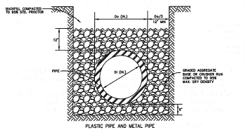
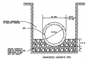
3.
Backfilling. Backfill for CSP, CAP, and HDPE pipe installations shall be constructed using graded aggregate base or crusher run six (6) inches below the bottom of pipe to twelve (12) inches above the pipe crown. Backfill for RCP pipe installations shall be constructed using graded aggregate base or crusher run six (6) inches below the pipe invert to one-quarter (¼) of the pipe diameter. Foundation backfill material shall be used for RCP above one-quarter (¼) of the pipe diameter (if graded aggregate base is not used above the one-quarter (¼) of the pipe diameter) as per Type I or Type II, as specified in sections 8.12.01 and 8.12.02 respectively, in Georgia DOT Standard Specifications. These materials shall be placed in layers of not more than six (6) inches loose. Compaction of these materials shall be accomplished by hand tamping or machine tamping. Required compaction levels are as follows:
4.
[Within street right-of-way.] Backfill within all street rights-of-way shall be compacted to ninety-five (95) percent maximum density, tested using the AASHTO Method T-99.
5.
[In other areas.] Backfill in all other areas shall be compacted to ninety (90) percent maximum density, tested using the AASHTO Method T-99.
6.
Construction loads and minimum covers. If drainage pipe is installed prior to the completion of grading, a minimum of four (4) feet of fill should be provided where needed to adequately protect the drainage structure during the land development phase, unless the structure itself is designed to withstand the anticipated live load during construction.
F.
End finish.
1.
Headwalls or other end treatments are required on all culverts and at the outlet of all piped collection systems. Where ends of pipe are located within, or near, the right-of-way and are parallel, or nearly parallel, with the roadway, safety end sections shall be required when the posted speed limit is thirty-five (35) mph and over.
2.
Headwalls are to be precast concrete, stone masonry with reinforced concrete footings, or poured in place, reinforced concrete with reinforced concrete footings. Precast concrete headwalls for corrugated aluminum coated steel pipe or aluminum alloy pipe shall be made with aluminum coated steel or aluminum alloy pipe stubs.
3.
End treatments that conform to the slope may be pre-cast concrete end sections; aluminum coated steel or aluminum alloy end sections, masonry, PE end sections, reinforced poured-in-place slope collars, or grouted rip-rap. Concrete and metal flared end sections shall conform to applicable Georgia DOT Standard Drawing 1120, 1122, or Detail D-39.
G.
Junction boxes and catch basins. Junction boxes and catch basins shall have metal manhole frames and lids for access.
H.
Other structures. Natural bottom arches and box culverts may be used in accordance with the latest standard specifications of the Georgia Department of Transportation. Bottomless culverts shall require that a scour analysis be done by a registered professional engineer in that field to Georgia Department of Transportation Specifications and Standards to ensure the soundness of the proposed structure.
I.
References.
Gwinnett County Stormwater Systems and Facilities Installation Standards and Specifications (SSFISS) Chapter 3 — rev07.06
U.S. Department of Transportation, Federal Highway Administration, 1984. Drainage of Highway Pavements. Hydraulic Engineering Circular No. 12.
(Ord. No. 10-20, § I(18), 6-15-10; Ord. No. 1703, § I, 2-7-17; Ord. No. 20-06, § II, 11-14-20; Ord. No. 22-06, § I, 9-7-22)
Sec. 8.02.00. - Off-street parking and loading requirements.
8.02.01.
Purpose and intent. It is the intent of section 8.02.00 to ensure the appropriate location and quantity of off-street parking and loading and to ensure that all developments provide adequate and safe storage and movement of vehicles consistent with good site design principles.
8.02.02.
Applicability.
A.
Except as provided in this section, no application for a building permit shall be approved unless there is included with the plan for such building, improvements, or use, a development plan showing the required space reserved for off-street parking and loading. Occupancy shall not be allowed unless the required off-street parking and loading facilities have been provided in accordance with those shown on the approved plan.
B.
Each use of land and each building or structure hereafter constructed or established, and each addition to a structure shall provide off-street parking and loading according to the standards set forth herein.
C.
When an addition is made to a building containing less than the required parking or loading requirements, off-street parking shall be provided for the entire building, based upon the standards in this section.
D.
No addition to an existing building shall be constructed which reduces the number of spaces, area, or usability of an existing parking lot or loading space, unless such building and its addition conform with the regulations for parking and loading contained herein.
8.02.03.
Maintenance. All off-street parking and loading areas shall be well maintained. Parking lots and loading areas shall be free of potholes, debris, weeds, broken curbs, and broken wheel stops.
8.02.04.
Calculation of required parking spaces and loading spaces.
A.
The table of parking and loading space standards specifies the required minimum number of off-street parking spaces for each listed use. Where the calculation of the required number of spaces results in a fraction, the number shall be rounded up to the next whole number.
B.
Where the unit of measure for determining the number of parking spaces is the number of seats in a facility, the number of seats shall be the maximum occupancy allowed pursuant to building and construction codes.
C.
When multiple uses occupy a building, or a mixed use development is proposed in separate buildings under unified control, the parking and loading requirement shall be met by each use, unless shared parking is approved according to the standards in section 8.02.08.
D.
Where a use is not listed in the table of parking and loading space standards, the division director or designee shall determine the appropriate parking and loading standard. The determination shall be based on the standards for similar uses.
8.02.05.
Parking and loading space standards.
Table 8.02.05. Parking and Loading Space Standards
8.02.06.
Handicapped accessible parking spaces.
A.
All uses shall provide parking spaces designated for handicapped access.
B.
Table of required handicapped parking:
Table 8.02.06(B). Required Handicapped Parking
C.
Handicapped spaces shall be marked on the pavement and by appropriate signage, both markings to use the universally accepted "Handicapped" symbol. Handicapped spaces shall be located in closest proximity to major building entrances, but in no event shall such spaces be more than one hundred (100) feet from an entrance.
D.
Ramps shall meet the design standards set forth in the Georgia Accessibility Code Chapter 120-3-20 of The Rules and Regulations of The Georgia Safety Fire Commissioner.
8.02.07.
Design requirements for parking lots, parking spaces, and loading areas. Off-street parking lots, individual parking spaces, loading areas, and loading stalls shall be designed to conform to the following criteria and standards:
A.
All multiple-family, commercial, and industrial uses shall provide a paved, dust-free surface. The use of approved permeable or pervious pavement materials is encouraged, provided such paving is approved for use by the county engineer.
B.
All off-street loading stalls shall have access from a public street.
C.
Loading stalls are not to hinder movement of pedestrians or vehicles over a street, sidewalk, or alley, or to and from an off-street parking area.
D.
Off-street parking and loading areas that are to be used at night shall include proper illumination for the safety of pedestrians, vehicles, and for security purposes. Lighting shall be located and shielded to avoid direct illumination of adjacent properties.
E.
Each off-street parking space shall be clearly marked, and directional arrows or signs shall be provided wherever necessary. Markers, directional arrows, and signs shall be properly maintained so as to ensure their maximum efficiency.
F.
All off-street parking, loading, and service areas shall be drained so as to prevent damage to abutting properties and/or public streets and shall be constructed of materials which shall assure a surface resistant to erosion.
G.
All off-street parking, loading, and service areas shall be separated from walkways, sidewalks, and streets by curbing or other suitable protective device.
H.
The following design standards shall be used to achieve compliance with parking provisions of this chapter. Construction standard drawings for standard parking spaces are available from the division director or designee or the Henry County website at www.co.henry.ga.us.
Table 8.02.07(H). Parking Space Dimensions
I.
There shall be provided adequate interior driveways to connect each parking space with a public right-of-way.
Table 8.02.07(I). Parking Lot Design
J.
The following are the design requirements for off-street loading stalls:
Table 8.02.07(J). Off-Street Loading Stall Design
8.02.08.
Shared parking arrangements.
A.
Adjacent uses, multiple uses within a unified development, or establishments with multiple tenants of different uses may provide shared parking facilities. Such shared parking facilities may have a reduced quantity of parking as compared to the sum of parking spaces required for each individual use.
B.
Where shared parking facilities are proposed, the following standards shall be met:
1.
There shall be a paved driveway connection between the adjacent developments such that automobiles may move from one (1) parcel or use to the adjacent parcel or use without exiting to the public street.
2.
There shall be a designated pedestrian connection from all uses to the shared parking facility.
3.
The owners of developments involved shall execute a cross-access and cross-parking agreement, provided in a recordable instrument, acceptable to Henry County. The agreement shall guarantee the joint use of a specified number of parking spaces.
4.
The number of spaces in the shared parking facility shall be determined by one (1) of the methods in subsection 8.02.08.C., below.
C.
The calculation of required spaces in a shared parking facility shall use one (1) of the two (2) methods described below:
1.
A parking study may be conducted to provide evidence of the combined parking requirements of the proposed uses.
a.
The study shall be prepared by a professional engineer with documented traffic expertise.
b.
The study shall include estimates of parking requirements based on professionally accepted data or studies, such as from the Institute of Traffic Engineers, Urban Land Institute, or other sources acceptable to Henry County.
c.
Parking requirements shall be based on uses that are the same or comparable to the proposed uses. Comparability shall be determined by density, scale, bulk, area, type of activity, and location in relationship to other uses and the transportation system.
d.
Parking requirements shall be based upon peak hours of need for each use proposed to share parking facilities. The hours of maximum, or peak, parking demand of the respective developments shall not overlap.
e.
The study shall document the source(s) of data used to develop recommendations.
f.
The study shall document the extent to which transportation system management and alternative forms of transportation (pedestrian and bicycle) reduce the parking requirement.
g.
The study shall document the availability of off-site parking to meet a portion of the parking requirements. Off-site parking shall not be located more than one hundred fifty (150) feet from the uses that require parking. The study shall be accompanied by documentation to demonstrate the continued availability of the off-site parking, such as easements or other recordable instruments.
2.
Shared parking may be determined by the following method:
a.
Calculate the parking requirement for each proposed use, as set forth in Table 8.02.05.
b.
Multiply each amount by the corresponding percentages from the table below for each of the five (5) time periods.
c.
Total the amount of parking for each time period.
d.
The highest parking requirement shall be the minimum number of spaces required for the shared use facilities.
Table 8.02.08(C). Shared Parking Demand Calculations
(Ord. No. 10-20, § I(19), 6-15-10)
Sec. 8.03.00. - Standards for utility infrastructure.
8.03.01.
Generally.
A.
All development shall include adequate provision for utility infrastructure in full compliance with the standards of section 8.03.00.
B.
All potential utilities shall be identified on the development plan in order to indicate compliance with placement standards set forth in section 8.03.02.
C.
All construction drawings shall be prepared and sealed by a professional engineer registered in the State of Georgia.
D.
No private utilities (including irrigation system/sprinklers) allowed in county right-of-way. If any are placed within the county right-of-way, Henry County shall not be responsible for any damage to utilities.
8.03.02.
Placement standards for all utilities.
A.
The standards for the placement of all utilities are shown in the figures 8-6, 8-7 and 8-8.
B.
Utilities shall be located within one (1) foot, plus or minus, of the specified plan locations shown in figures 8-6 and 8-7.
8.03.03.
Potable water system requirements.
A.
All potable water systems shall comply with the design and construction standards of the Henry County Water and Sewerage Authority (HCWSA).
B.
Extension within subdivisions. The applicant shall be responsible for the material and labor cost of extending water systems within a subdivision as directed and inspected by the HCWSA.
1.
The extensions of water mains within a subdivision shall be designed to provide adequate hydraulic capacity for future extensions to the surrounding area and shall be connected to existing surrounding water mains to accomplish desirable hydraulic looping.
2.
Dead-end mains within a subdivision shall be avoided, based on a determination by the HCWSA. Water mains in dead-end streets shall have a fire hydrant installed at the end of the line on a common lot corner according to the standard details provided by HCWSA.
C.
Hydrants. Hydrants shall be placed to ensure free and clear access from the nearest public right-of-way. No equipment, landscaping, mail boxes, or other structures shall be placed in such a manner as to obstruct clear access from the right-of-way to the fire hydrant.
8.03.04.
Wastewater system requirements.
A.
All wastewater systems shall comply with the design and construction standards of the HCWSA.
B.
Extension within subdivisions.
1.
The applicant shall be responsible for the material and labor cost of extending wastewater systems within a subdivision as directed and inspected by the HCWSA.
2.
Where it is anticipated that the HCWSA will extend a trunk or interceptor sewer line adjacent to the subdivision, sewer service lines shall be installed within the subdivision and temporarily plugged or capped at the points of service connection in the proposed lateral or trunk sewer line at individual lot lines in accordance with HCWSA specifications.
8.03.05.
Other utilities.
A.
A certificate of occupancy shall not be issued for structures in a subdivision or development until all necessary utilities have been installed in full compliance with the design, construction, and placement standards set forth in section 8.03.00.
B.
Exemptions. The following specific facilities shall be exempt from the requirements of this section, provided that the placement of these facilities complies with the requirement for free and clear access to fire hydrants as set forth in subsection 8.03.03.C.
1.
Poles used exclusively for street lighting, provided that the street lighting standards set forth in section 8.01.10 are met.
2.
Poles, overhead lines, and associated overhead structures owned by a utility company crossing over any portion of an area from which overhead wires are allowed.
3.
Overhead lines attached to the exterior of a building by means of a bracket or similar device and extending from one (1) location on the building, or to an adjacent building without crossing any street or right-of-way.
4.
Radio antennae and associated structures and equipment used for furnishing communications service.
5.
Service terminals and necessary pad-mounted electric transformer equipment installed above ground, used to distribute communications and electric service in underground systems.
C.
Electrical substations. Electrical substations are permissible in any zoning district, subject to the standards set forth in section 4.03.05. The utility company shall obtain an easement for these installations. The easement shall be clearly indicated on the preliminary and final plats.
Sec. 8.04.00. - Standards for stormwater management.
8.04.01.
Purpose and intent. The purpose of this article is to protect, maintain and enhance the public health, safety, environment, and general welfare by establishing minimum requirements and procedures to control the adverse effects of increased post-construction stormwater runoff and nonpoint source pollution associated with new development and redevelopment. Proper management of post- construction stormwater runoff will minimize damage to public and private property and infrastructure, safeguard the public health, safety, environment, and general welfare of the public, and protect water and aquatic resources. Additionally, the Henry County Stormwater Management Department is required to comply with several state and federal laws, regulations and permits and the requirements of the Metropolitan North Georgia Water Planning District's regional water plan related to managing the water quantity, velocity, and quality of post- construction stormwater runoff. This section seeks to meet that purpose through the following objectives:
1.
Establish decision-making processes surrounding land development activities that protect the integrity of the watershed and preserve the health of water resources;
2.
Require that new development and redevelopment maintain the pre-development hydrologic response in their post-development state as nearly as practicable in order to reduce flooding, streambank erosion, nonpoint source pollution and increases in stream temperature, and maintain the integrity of stream channels and aquatic habitats;
3.
Establish minimum post-development stormwater management standards and design criteria for the regulation and control of stormwater runoff quantity and quality;
4.
Establish design and application criteria for the construction and use of structural stormwater control facilities that can be used to meet the minimum post-development stormwater management standards;
5.
Encourage the use of nonstructural stormwater management and stormwater better site design practices, such as the preservation of greenspace and other conservation areas, to the maximum extent practicable. Coordinate site design plans, which include greenspace, with the county's greenspace protection plan;
6.
Establish provisions for the long-term responsibility for and maintenance of structural stormwater control facilities and nonstructural stormwater management practices to ensure that they continue to function as designed, are maintained, and pose no threat to public safety; and,
7.
Establish administrative procedures for the submission, review, approval, and disapproval of stormwater management plans, and for the inspection of approved active projects, and long-term follow up.
A.
Applicability.
1.
This section shall be applicable to all land development, including, but not limited to, site plan applications, subdivision applications, and grading applications, unless exempt pursuant to subsection 8.04.01.B below. These standards apply to any new development or redevelopment site that meets one (1) or more of the following criteria:
a.
New development that creates or adds five thousand (5,000) square feet or greater of new impervious surface area or that involves land disturbing activity of one (1) acre of land or greater;
b.
Redevelopment (excluding routine maintenance and exterior remodeling) that creates, adds, or replaces five thousand (5,000) square feet or greater of new impervious surface area or that involves land disturbing activity of one (1) acre or more;
c.
New development and redevelopment if:
i.
new development or redevelopment is part of a subdivision or other common plan of development, and
ii.
the sum of all associated impervious surface area or land disturbing activities that are being developed as part of such subdivision or other common plan of development meets or exceeds the threshold in (a) and (b) above;
d.
Any commercial or industrial new development or redevelopment, regardless of size, that is a hotspot land use as defined in this article; and
e.
Linear transportation projects that exceed the threshold in (a) or (b) above.
B.
[Exemptions.] The following activities are exempt from this section:
1.
Individual single-family or duplex residential lots that are not part of a subdivision or phased development project;
2.
Additions or modifications to existing single-family or duplex residential structures;
3.
Agricultural or silvicultural land management activities within areas zoned for these activities;
4.
Repairs to any stormwater management facility or practice deemed necessary by Henry County; and
5.
Repairs or extensions of public utilities including water, sewerage, gas, cable, etc.
C.
Designation of ordinance administrator. The county manager may from time to time appoint someone to administer and implement this section.
D.
Compatibility with other regulations. This section is not intended to modify or repeal any other ordinance, rule, regulation or other provision of law. The requirements of this section are in addition to the requirements of any other ordinance, rule, regulation, or other provision of law, and where any provision of this section imposes restrictions different from those imposed by any other ordinance, rule, regulation or other provision of law, whichever provision is more restrictive or imposes higher protective standards for human health or the environment shall control.
E.
Severability. If the provisions of any section, subsection, paragraph, subdivision, or clause of this section shall be adjudged invalid by a court of competent jurisdiction, such judgment shall not affect or invalidate the remainder of any section, subsection, paragraph, subdivision or clause of this section.
F.
Stormwater design manual. Henry County Stormwater Management Department staff will utilize the policy, criteria and information including technical specifications and standards in the latest edition of the Georgia Stormwater Management Manual and any relevant local addenda, for the proper implementation of the requirements of this section. The manual may be updated and expanded periodically, based on improvements in science, engineering, monitoring and local maintenance experience.
G.
Definitions.
Flooding means a volume of surface water that is too great to be confined within the banks or walls of a conveyance or stream channel and that overflows onto adjacent lands.
8.04.02.
Permit procedures and requirements.
A.
Permit application requirements.
1.
No owner or developer shall perform any land development activities without first meeting the requirements of this section prior to commencing the proposed activity.
2.
Unless specifically exempted by this section, any owner or developer proposing a land development activity shall submit to Henry County a permit application on a form provided by or acceptable to the county for that purpose.
3.
Unless otherwise exempted by this section, a permit application shall be accompanied by the following items in order to be considered:
a.
Pre-submittal meeting, stormwater concept plan, and stormwater management plan requirements.
B.
[Pre-submittal meeting request.] Before a land development permit application is submitted, an applicant may request a pre-submittal meeting with the Henry County Stormwater Management Department. The pre-submittal meeting should take place based on an early step in the development process such as before site analysis and inventory (GSMM section 2.4.2.4) or the stormwater concept plan (GSMM section 2.4.2.5). The purpose of the pre-submittal meeting is to discuss opportunities, constraints, and ideas for the stormwater management system before formal site design engineering. To the extent applicable, local and regional watershed plans, greenspace plans, trails and greenway plans, and other resource protection plans should be consulted in the pre-submittal meeting. Applicants must request a pre-submittal meeting with the Henry County Stormwater Management Department when applying for a determination of infeasibility through the practicability policy. To accomplish this goal the following information shall be included in the concept plan which shall be submitted in advance of the meeting:
1.
Existing conditions/proposed site plans. Existing conditions and proposed site layout sketch plans, which illustrate at a minimum: existing and proposed topography; perennial and intermittent streams; mapping of predominant soils from soil surveys (when available); boundaries of existing predominant vegetation and proposed limits of clearing and grading; and location of existing and proposed roads, buildings, parking areas and other impervious surfaces.
2.
Natural resources inventory. Site reconnaissance and surveying techniques shall be used to complete a thorough assessment of existing natural resources, both terrestrial and aquatic, found on the site. Resources to be identified, mapped, and shown on the stormwater management plan, shall include, at a minimum (as applicable):
a.
Topography (minimum of two-foot contours) and steep slopes (i.e., areas with slopes greater than fifteen (15) percent),
b.
Natural drainage divides and patterns,
c.
Natural drainage features (e.g., swales, basins, depressional areas),
d.
Natural feature protection and conservation areas such as wetlands, lakes, ponds, floodplains, stream buffers, drinking water wellhead protection areas and river corridors,
e.
Predominant soils (including erodible soils and karst areas), and
f.
Existing predominant vegetation including trees, high quality habitat and other existing vegetation.
3.
Better site design practices for stormwater management. Stormwater management plans shall preserve the natural drainage and natural treatment systems and reduce the generation of additional stormwater runoff and pollutants to the maximum extent practicable. Additional details can be found in the GSMM section 2.3.
4.
Stormwater runoff quality/reduction. Stormwater runoff quality/reduction shall be provided by using the following:
a.
For development with a stormwater management plan submitted before January 1, 2024, the applicant may choose either (A) runoff reduction or (B) water quality.
b.
For development with a stormwater management plan submitted on or after January 1, 2024, the applicant shall choose (A) runoff reduction and additional water quality shall not be required. To the extent (A) runoff reduction has been determined to be infeasible for all or a portion of the site using the practicability policy, then (B) water quality shall apply for the remaining runoff from a one and two-tenths-inch rainfall event and must be treated to remove at least eighty (80) percent of the calculated average annual post-development total suspended solids (TSS) load or equivalent as defined in the GSMM.
i.
Runoff reduction. The stormwater management system shall be designed to retain the first one (1.0) inch of rainfall on the site using runoff reduction methods, to the maximum extent practicable.
ii.
Water quality. The stormwater management system shall be designed to remove at least eighty (80) percent of the calculated average annual post-development total suspended solids (TSS) load or equivalent as defined in the GSMM for runoff from a one and two-tenths-inch rainfall event.
iii.
If a site is determined to be a hotspot as detailed in section 8.04.01.A., the Henry County Stormwater Management Department may require the use of specific or additional components for the stormwater management system to address pollutants of concern generated by that site.
5.
Local watershed plans, applicable greenspace projection plans, and any relevant resource protection plans will be consulted in the discussion of the concept plan.
C.
Stormwater management plan requirements.
1.
An application for development activity as defined in subsection 8.04.01.A., above shall be accompanied by a stormwater management plan and an inspection and maintenance agreement regarding ongoing maintenance of the stormwater management facilities.
2.
The stormwater management plan shall detail how post-development stormwater runoff will be controlled or managed and how the proposed project will meet the requirements of section 8.04.00.
3.
The stormwater management plan shall be in accordance with the criteria established in section 8.04.00. The plan shall contain the stamp and signature of a professional engineer licensed in the State of Georgia, who must verify that the design of all stormwater management facilities and practices meet the submittal requirements outlined in the submittal checklist(s) found in the stormwater design manual.
4.
The stormwater management plan shall contain sufficient information to demonstrate that the requirements and criteria in section 8.04.00 are being complied with and that opportunities are being taken to minimize adverse post-development stormwater runoff impacts from the proposed development. The plan shall consist of maps, narrative, and supporting design calculations (hydrologic and hydraulic) for the proposed stormwater management system. The plan shall include all of the information required in the stormwater management site plan checklist found in the Georgia Stormwater Management Manual Section E.
5.
The following information is required, at a minimum. Existing conditions hydrologic analysis for stormwater runoff rates, volumes, and velocities, which shall include:
a.
Topographic map of existing site conditions with the drainage basin boundaries indicated;
b.
Acreage, soil types and land cover of areas for each subbasin affected by the project;
c.
All perennial and intermittent streams and other surface water features;
d.
All existing stormwater conveyances and structural control facilities;
e.
Direction of flow and exits from the site;
f.
Analysis of runoff provided by off-site areas upstream of the project site; and
g.
Methodologies, assumptions, site parameters and supporting design calculations used in analyzing the existing conditions site hydrology.
6.
For redevelopment sites, predevelopment conditions shall be modeled using the established guidelines for the portion of the site undergoing land development activities.
7.
A post-development hydrologic analysis for stormwater runoff rates, volumes, and velocities, which shall include:
a.
A topographic map of developed site conditions with the post-development drainage basin boundaries indicated;
b.
Total area of post-development impervious surfaces and other land cover areas for each subbasin affected by the project;
c.
Calculations for determining the runoff volumes that need to be addressed for each subbasin for the development project to meet post-development stormwater management performance criteria;
d.
Location and boundaries of proposed natural feature protection and conservation areas as per chapter 3 of the ULDC;
e.
Documentation and calculations for any applicable site design credits that are being utilized; and
f.
Methodologies, assumptions, site parameters, and supporting design calculations used in analyzing the existing conditions site hydrology.
g.
If the land development activity on a redevelopment site constitutes more than fifty (50) percent of the site area for the entire site, then the performance criteria shall be met for the stormwater runoff from the entire site.
8.
The description, scaled drawings, and design calculations for the proposed post-development stormwater management system, which shall include:
a.
A map and/or drawing of the stormwater management facilities, including the location of nonstructural site design features and the placement of existing and proposed structural stormwater controls, including design water surface elevations, storage volumes available from zero (0) to maximum head, location of inlet and outlets, location of bypass and discharge systems, and all orifice/restrictor sizes;
b.
A narrative describing how the selected structural stormwater controls will be appropriate and effective;
c.
Cross-section and profile drawings and design details for each of the structural stormwater controls in the system, including supporting calculations to show that the facility is designed according to the applicable design criteria;
d.
A hydrologic and hydraulic analysis of the stormwater management system for all applicable design storms (including stage-storage or outlet rating curves, and inflow and outflow hydrographs);
e.
Documentation and supporting calculations to show that the stormwater management system adequately meets the post-development stormwater management performance criteria;
f.
Drawings, design calculations, elevations and hydraulic grade lines for all existing and proposed stormwater conveyance elements including stormwater drains, pipes, culverts, catch basins, channels, swales and areas of overland flow; and
g.
Where applicable, a narrative describing how the stormwater management system corresponds with any watershed protection plans as required in per chapter 3 of the ULDC or open space connectivity requirements for conservation subdivisions, as set forth in section 6.02.00.
9.
A downstream peak flow analysis is required, which includes the assumptions, results and supporting calculations to show safe passage of post-development design flows downstream. The analysis of downstream conditions in the report shall address each and every point or area along the project site's boundaries at which runoff will exit the property. The analysis shall focus on the portion of the drainage channel or watercourse immediately downstream from the project. This area shall extend downstream from the project to a point in the drainage basin where the project area is ten (10) percent of the total basin area. In calculating runoff volumes and discharge rates, consideration may need to be given to any planned future upstream land use changes. The analysis shall be in accordance with the stormwater design manual.
10.
An erosion and sedimentation control plan that meets the requirements of section 8.05.00.
11.
The landscaping plan, as required in section 5.00.00 shall describe how vegetation will be placed within and adjacent to stormwater management facilities.
12.
Detailed description of ongoing operations and maintenance procedures for stormwater management facilities and practices to ensure their continued function as designed and constructed or preserved. These plans shall identify the parts or components of a stormwater management facility or practice that need to be regularly or periodically inspected and maintained, and the equipment and skills or training necessary. The plan shall include an inspection and maintenance schedule, maintenance tasks, and responsible parties for maintenance, funding, access, and safety issues. Provisions for the periodic review and evaluation of the effectiveness of the maintenance program and the need for revisions or additional maintenance procedures shall be included in the plan.
13.
All stormwater management facilities shall be on its own lot with a minimum twenty-foot access easement to ensure access from a public right-of-way. All driveways, access easements, and emergency access easements must be paved and dust free. Such access shall be sufficient for all necessary equipment for maintenance activities. Depending on the depth of pipe, the drainage easement width may be required to be increased. There shall be a twenty-foot easement around the outside perimeter of the facility. All subdivision lots shall have a ten-foot drainage easement along all side and rear lot lines. Upon final inspection and approval, a plat or document indicating that such easements exist shall be recorded and shall remain in effect even with the transfer of title of the property.
14.
Runoff reduction infeasibility (RRI) form for determination of infeasibility. Runoff reduction infeasibility (RRI) forms for determination of infeasibility shall be maintained and supplied by the Henry County Stormwater Management Department. Such applications shall include, at a minimum:
a.
Applicant contact information.
b.
Description of the site.
c.
Maximum practicable runoff reduction volume.
d.
Stormwater concept plan.
e.
GSMM stormwater quality site development review tool for the stormwater concept plan.
f.
Justification that the site cannot accommodate best management practices that rely on evapotranspiration and reuse such as rainwater harvesting or green roofs.
g.
Site conditions.
8.04.03.
Detention design requirements.
A.
Generally.
1.
All stormwater detention facilities shall be designed to control the peak flow rates associated with storms having two-year, five-year, ten-year, twenty-five-year, fifty-year, and one hundred-year-storm frequencies.
2.
A variety of methods of achieving stormwater management goals shall be acceptable in providing detention facilities. The type of facility provided shall be based on the following criteria:
a.
The type of development which the detention facility is being provided;
b.
The type of development which the detention facility is intended to protect;
c.
Volume of stormwater to be stored;
d.
Origin and magnitude of the flows to be managed;
e.
Topographic opportunities and limitations;
f.
Safety considerations;
g.
Maintenance requirements;
h.
Aesthetic considerations;
i.
Likelihood of facility operation interfering with access to public or private facilities;
j.
Proximity of facility to property lines, utilities, buffers, etc.; and
k.
Similar site-specific constraints.
3.
Detention facilities may be of any of the following types, and two (2) or more types may be used in combination with one another:
a.
Underground detention/retention facilities;
b.
Lakes and ponds, whether excavated or created by damming a natural drainage feature or a combination of both methods, to be a feature of the development and shall include a method of water movement; or
c.
Normally dry and sodded basins, whether excavated or created by damming a natural drainage feature or a combination of both methods.
4.
Detention facilities for non-residential developments shall be underground detention/retention facilities. An underground detention/retention facility that is deemed not feasible by the Henry County Stormwater Department shall apply for an administrative waiver in accordance with subsection D below.
5.
Plans, specifications, and computations must be complete in detail sufficient to enable another engineer to fully check and verify the results and computations. The plans used for construction must contain basic design data, a project narrative, schedule of construction, name and address of person responsible for construction, the engineer's seal or stamp, signature and address and engineering drawings required for the project construction.
a.
The detention facility shall be provided with an overflow device or emergency spillway to accommodate the one-hundred-year frequency storm in the event the outflow control structure becomes obstructed with debris.
b.
The configuration of the detention facility, outflow and overflow control devices shall be clearly depicted in plan and cross-section on the construction drawings.
c.
Graded access easement, (maximum six (6) percent grade) around all detention ponds in areas inaccessible to vehicular traffic.
d.
Temporary sediment basins shall be designed and shown at all detention sites and all major drainage exits. The detention facility shall be designed to provide temporary silt protection.
e.
Underground detention facilities will require details that provide:
i.
The location and type of access protection for the detention facility;
ii.
An outline of maintenance procedures to be filed with the county;
iii.
Safety requirements as specified by the county for the site.
B.
As constructed certification of detention pond. After construction and before acceptance for occupation or otherwise the engineer shall submit a certified field run topographic map of the detention area and a revised hydrology study using the as-built topographic map to verify that the required detention storage and outflow rates are being provided.
C.
Detention pond fencing. When a detention structure is over four (4) feet deep or in a location that constitutes a danger to human habitation, it shall be protected by a permanent fence and warning signs. Fences shall be five-foot-high with a ten-foot-wide gate. Fences shall be located on the outside edge of the twenty-foot perimeter easement. No fences shall be built that would inhibit proper function of the drainage system.
D.
Variations. Administrative waivers permit a practice that is not consistent with a specific provision of this section, but is justified by its intent or purpose, or by hardship. The administrator of the ULDC or their designee shall have the authority to approve or disapprove administratively a request for an administrative waiver in accordance with section 11.03.00 of the ULDC, in addition to granting relief from section 8.04.03.
8.04.04.
Application procedures.
1.
File a land development application with the Henry County Building Department on the Henry County Building Department's form of application with the following supporting materials:
a.
The stormwater management plan prepared in accordance with section 8.04.02.C,
b.
A certification that the development will be performed in accordance with the stormwater management plan once approved,
c.
A [preliminary determination of infeasibility, as applicable, prepared in accordance with the practicability policy], and
d.
An acknowledgement that applicant has reviewed the Henry County Stormwater Management Department's form of inspection and maintenance agreement, and that applicant agrees to sign and record such inspection and maintenance agreement before the final inspection.
2.
Permit applications shall include the items set forth in section 8.04.02. above (two (2) copies of the stormwater management plan and the inspection maintenance agreement, if applicable, shall be included).
3.
Henry County shall inform the applicant whether the application, stormwater management plan and inspection and maintenance agreement are approved or disapproved.
4.
If either of the permit application, stormwater management plan or inspection and maintenance agreement is disapproved, Henry County shall notify the applicant of such fact in writing. The applicant may then revise any item not meeting the requirements hereof and resubmit the same, in which event subparagraph 3 above and this subparagraph shall apply to such re-submittal.
5.
Upon a finding by Henry County that the permit application, stormwater management plan and inspection and maintenance agreement, if applicable, meet the requirements of this section, Henry County may issue a permit for the land development project, provided all other legal requirements for the issuance of such permit have been met.
6.
Notwithstanding the issuance of the permit, in conducting the land development project, the applicant or other responsible person shall be subject to the following requirements:
a.
The applicant shall comply with all applicable requirements of the approved plan and this section and shall certify that all land clearing, construction, land development and drainage will be done according to the approved plan;
b.
The land development project shall be conducted only within the area specified in the approved plan;
c.
Henry County staff shall be allowed to conduct periodic inspections of the project;
d.
No changes may be made to an approved plan without review and written approval by Henry County; and,
e.
Upon completion of the project, the applicant or other responsible person shall submit the engineer's report and certificate and as-built plans required by section 8.04.03.B.
A.
Application review fees. The fee for review of any land development application shall be based on the fee structure established by Henry County, and payment shall be made before the issuance of any land disturbance permit or building permit for the development.
B.
Modifications for off-site facilities.
1.
The stormwater management plan for each land development project shall provide for stormwater management measures located on the site of the project unless provisions are made to manage stormwater by an off-site or regional facility. The off-site or regional facility must be located on property legally dedicated for the purpose, must be designed and adequately sized to provide a level of stormwater quantity and quality control that is equal to or greater than that which would be afforded by on-site practices and there must be a legally obligated entity responsible for long-term operation and maintenance of the off-site or regional stormwater facility. In addition, on-site measures shall be implemented, where necessary, to protect upstream and downstream properties and drainage channels from the site to the off-site facility.
2.
A stormwater management plan must be submitted to Henry County which shows the adequacy of the off-site or regional facility.
3.
To be eligible for a modification, the applicant must demonstrate to the satisfaction of Henry County that the use of an off-site or regional facility will not result in the following impacts to upstream or downstream areas:
a.
Increased threat of flood damage to public health, life, and property;
b.
Deterioration of existing culverts, bridges, dams, and other structures;
c.
Accelerated streambank or streambed erosion or siltation;
d.
Degradation of in-stream biological functions or habitat; or
e.
Water quality impairment in violation of state water quality standards, and/or violation of any state or federal regulations.
8.04.05.
Post-development stormwater management performance criteria. The following performance criteria shall be applicable to all stormwater management plans, unless otherwise provided for in this section:
A.
Water quality. All stormwater runoff generated from a site shall be adequately treated before discharge. It will be presumed that a stormwater management system complies with this requirement if:
1.
It is sized to treat the prescribed water quality treatment volume from the site, as defined in the Georgia Stormwater Management Manual;
2.
Appropriate structural stormwater controls or nonstructural practices are selected, designed, constructed, or preserved, and maintained according to the specific criteria in the Georgia Stormwater Management Manual; and
If a site is determined to be a hotspot as detailed in section 8.04.01., the Henry County Stormwater Department may require the use of specific or additional components for the stormwater management system to address pollutants of concern generated by that site.
B.
Stream channel protection. Stream channel protection shall be provided by using all of the following three (3) approaches:
1.
Preservation, restoration and/or reforestation (with native vegetation) of the applicable stream buffer;
2.
Twenty-four-hour extended detention storage of the one-year, twenty-four-hour return frequency storm event;
3.
Erosion prevention measures such as energy dissipation and velocity control.
C.
Overbank flooding protection. Downstream overbank flood protection shall be provided by controlling the post-development peak discharge rate to the pre-development rate for the twenty-five-year, twenty-four-hour storm event.
D.
Extreme flooding protection. Extreme flood protection shall be provided by controlling the one hundred-year, twenty-four-hour storm event such that flooding is not exacerbated.
E.
Structural stormwater controls. All structural stormwater management facilities shall be selected and designed using the appropriate criteria from the Georgia Stormwater Management Manual. All structural stormwater controls must be designed appropriately to meet their intended function. For other structural stormwater controls not included in the Georgia Stormwater Management Manual, or for which pollutant removal rates have not been provided, the effectiveness and pollutant removal of the structural control must be documented through prior studies, literature reviews, or other means and receive approval from Henry County before being included in the design of a stormwater management system. In addition, if hydrologic or topographic conditions, or land use activities warrant greater control than that provided by the minimum control requirements, Henry County may impose additional requirements deemed necessary to protect upstream and downstream properties and aquatic resources from damage due to increased volume, frequency, and rate of stormwater runoff or increased nonpoint source pollution loads created on the site in question. Applicants shall consult the Georgia Stormwater Management Manual for guidance on the factors that determine site design feasibility when selecting and locating a structural stormwater control.
F.
Stormwater credits for nonstructural measures. The use of one (1) or more site design measures by the applicant may allow for a reduction in the water quality treatment volume required under section 8.04.02.C. The applicant may, if approved by Henry County, take credit for the use of stormwater better site design practices and reduce the water quality volume requirement. For each potential credit, there is a minimum set of criteria and requirements which identify the conditions or circumstances under which the credit may be applied. The site design practices that qualify for this credit and the criteria and procedures for applying and calculating the credits are included in the Georgia Stormwater Management Manual.
G.
Drainage system guidelines. Stormwater conveyance facilities, which may include, but are not limited to, culverts, stormwater drainage pipes, catch basins, drop inlets, junction boxes, headwalls, gutter, swales, channels, ditches, and energy dissipaters shall be provided when necessary for the protection of public right-of-way and private properties adjoining project sites and/or public rights-of-way. Stormwater conveyance facilities that are designed to carry runoff from more than one (1) parcel, existing or proposed, shall meet the following requirements:
1.
Methods to calculate stormwater flows shall be in accordance with the stormwater design manual;
2.
All culverts, pipe systems and open channel flow systems shall be sized in accordance with the stormwater management plan using the methods included in the stormwater design manual; and
3.
Design and construction of stormwater conveyance facilities shall be in accordance with the criteria and specifications found in the stormwater design manual.
H.
Dam design guidelines. Any land disturbing activity that involves a site which proposes a dam shall comply with the Georgia Safe Dams Act and Rules for Dam Safety as applicable.
8.04.06.
Construction inspections of post-development stormwater management system.
A.
Inspections to ensure plan compliance during construction. Periodic inspections of the stormwater management system construction shall be conducted by the staff of Henry County or conducted and certified by a professional engineer who has been approved by the county. Construction inspections shall utilize the approved stormwater management plan for establishing compliance. All inspections shall be documented with written reports that contain the following information:
1.
The date and location of the inspection;
2.
Whether construction is in compliance with the approved stormwater management plan;
3.
Variations from the approved construction specifications; and
4.
Any other variations or violations of the conditions of the approved stormwater management plan.
If any violations are found, the applicant shall be notified in writing of the nature of the violation and the required corrective actions.
B.
Final inspection and as built plans. Upon completion of a project, and before a certificate of occupancy shall be granted, the applicant is responsible for certifying that the completed project is in accordance with the approved stormwater management plan. All applicants are required to submit actual "as-built" plans for any stormwater management facilities or practices after final construction has been completed. The plan must show the final design specifications for all stormwater management facilities and practices and must be certified by a professional engineer. A final inspection by Henry County staff is required before the release of any performance securities can occur.
8.04.07.
Ongoing inspection and maintenance of stormwater facilities and practices.
A.
Long-term maintenance inspection of stormwater facilities and practices. Stormwater management facilities and practices included in a stormwater management plan that are subject to an inspection and maintenance agreement must undergo ongoing inspections to document maintenance and repair needs and ensure compliance with the requirements of the agreement, the plan and this section.
A stormwater management facility or practice shall be inspected on a periodic basis by the responsible person in accordance with the approved inspection and maintenance agreement. In the event that the stormwater management facility has not been maintained and/or becomes a danger to public safety or public health, Henry County shall notify the person responsible for carrying out the maintenance plan by registered or certified mail to the person specified in the inspection and maintenance agreement. The notice shall specify the measures needed to comply with the agreement and the plan and shall specify the time within which such measures shall be completed. If the responsible person fails or refuses to meet the requirements of the inspection and maintenance agreement, Henry County may correct the violation as provided in subsection 8.04.07.D. hereof.
Inspection programs by Henry County may be established on any reasonable basis, including, but not limited to: routine inspections; random inspections; inspections based upon complaints or other notice of possible violations; and joint inspections with other agencies inspecting under environmental or safety laws. Inspections may include, but are not limited to: reviewing maintenance and repair records; sampling discharges, surface water, groundwater, and material or water in stormwater management facilities; and evaluating the condition of stormwater management facilities and practices.
B.
Right-of-entry for inspection. The terms of the inspection and maintenance agreement shall provide for Henry County staff to enter the property at reasonable times and in a reasonable manner for the purpose of inspection. This includes the right to enter a property when it has a reasonable basis to believe that a violation of this section is occurring or has occurred and to enter when necessary for abatement of a public nuisance or correction of a violation of this section.
C.
Records of maintenance activities. Parties responsible for the operation and maintenance of a stormwater management facility shall provide records of all maintenance and repairs to Henry County.
D.
Owner's failure to maintain the stormwater management system. The terms of the inspection and maintenance agreement shall provide for what constitutes a failure to maintain a stormwater management system and the enforcement options available to the Henry County Stormwater Management Department. If a site was developed before the requirement to have an inspection and maintenance agreement or an inspection and maintenance agreement was for any reason not entered into, recorded, or has otherwise been invalidated or deemed insufficient, then:
1.
An owner's failure to maintain the stormwater management system so that it performs as it was originally designed shall constitute and be addressed as a violation of, or failure to comply with, owner's property maintenance obligations pursuant to section 3, article 1; and
2.
To address such a failure to maintain the stormwater management system, the Henry County Stormwater Department shall have all the powers and remedies that are available to it for other violations of an owner's property maintenance obligations, including without limitation prosecution, penalties, abatement, and emergency measures.
(Ord. No. 23-06, § I, 6-6-23; Ord. No. 23-10, § II, 11-28-23)
Sec. 8.05.00. - Reserved.
Editor's note— Ord. No. 10-05, adopted June 1, 2010, deleted § 8.05.00 which pertained to erosion and sedimentation control and derived from Ord. No. 09-05, adopted Sept. 15, 2009. User is directed to Code section 3-5 for provisions pertaining to this subject.
Sec. 8.06.00. - Development impact fees.
8.06.01.
Generally.
A.
Authority.
1.
This section has been prepared and adopted by the board of commissioners of Henry County, Georgia, in accordance with the authority provided by Article 9, Section 2, Paragraph 3 of the Constitution of the State of Georgia, the Georgia Development Impact Fee Act (O.C.G.A. § 36-71-1 et seq. as amended), and such other laws as may apply to the provision of public facilities and the power to charge fees for such facilities.
2.
The provisions of this section shall not be construed to limit the power of Henry County, Georgia, to use any other legal methods or powers otherwise available for accomplishing the purposes set forth herein, either in substitution of or in conjunction with this section.
3.
This section shall apply to all areas under the regulatory control and authority of Henry County, Georgia, and such other areas as may be included by intergovernmental agreement.
B.
Findings. The board of commissioners of Henry County, Georgia, finds and declares:
1.
That an equitable program for planning and financing public facilities to serve new growth and development is necessary in order to promote and accommodate orderly growth and development and to protect the public health, safety, and general welfare of the citizens of Henry County; and
2.
That certain public facilities as herein defined have been and must be further expanded if new growth and development is to be accommodated at the same level of service available to existing development; and
3.
That it is fair and equitable that new growth and development shall bear a proportionate share of the cost of such public facilities necessary to serve new growth and development.
C.
Purpose.
1.
The purpose of this section is to impose impact fees, as hereinafter set forth, for certain public facilities, as hereinafter defined.
2.
It is also the purpose of this section to ensure that adequate public facilities are available to serve new growth and development in Henry County and to provide that new growth and development bears a proportionate share of the cost of new public facilities needed to serve them.
D.
Intent. This section is intended to implement and be consistent with the Henry County Comprehensive plan, as it may be adopted or amended in accord with the Georgia Comprehensive planning Act (O.C.G.A. § 50-8-1 et seq.); and the applicable Minimum Standards and Procedures for Local Comprehensive planning and the Development Impact Fee Compliance Requirements, both as adopted by the Georgia Board of Community Affairs and amended from time to time.
E.
Provisions. The provisions of this section shall be construed so as to effectively carry out its purpose in the interest of the public health, safety, and general welfare of the citizens of the county.
8.06.02.
Imposition of development impact fees.
A.
Any person who after the effective date of this section engages in development shall pay a development impact fee in the manner and amount set forth in this section.
B.
Construction not subject to impact fees. The following projects and construction activities do not constitute "development" as defined in this section, and are therefore not subject to the imposition of impact fees:
1.
Rebuilding no more than the same number of units of development as defined in this section that were removed by demolition, or destroyed by fire or other catastrophe, on the same lot or property.
2.
Remodeling or repairing a structure that does not result in an increase in the number of units of development.
3.
Replacing a residential housing unit with another housing unit on the same lot or property.
4.
Placing or replacing a manufactured home in a manufactured home park on a prepared manufactured home pad in existence and operation prior to the effective date of this section.
5.
Placing a temporary transportable construction office or a temporary transportable sales office on a lot during the period of construction or build-out of a development project.
6.
Constructing an addition to or expansion of a residential housing unit that does not increase the number of housing units.
7.
Adding uses that are typically accessory to residential uses and intended for the personal use of the residents, such as a deck or patio, satellite antenna, pet enclosure, or private recreational facilities such as a swimming pool.
C.
Grandfathered projects.
1.
Notwithstanding any other provision of this section, that portion of a project for which a valid building permit has been issued for platted and recorded lot(s) prior to the effective date of this ordinance, shall not be subject to any increases as set forth in [Ordinance No. 24-06] so long as the permit remains valid and construction has commenced and is pursued according to the terms of the permit.
a.
Said construction shall be commenced, pursued, and completed within the allowable time established by the building permit in accordance with section 103.6.1 of the ULDC.
b.
Building permits submitted prior to July 23, 2024, shall be grandfathered under the impact fee structure outlined in Resolution No. 22-214. All other applications shall not be grandfathered, including, but not limited to, land disturbance permits, rezonings and/or other trade permits.
D.
Method of calculation.
1.
Any development impact fee imposed pursuant to this section shall not exceed a project's proportionate share of the cost of system improvements, shall be calculated on the basis of the establishment of service areas, and shall be calculated on the basis of levels of service for public facilities that are the same for existing development as for new growth and development, as established in the capital improvements element of the comprehensive plan.
2.
Notwithstanding anything to the contrary in this section, the calculation of impact fees shall be net of credits for the present value of ad valorem taxes or other revenues as established in the capital improvements element of the comprehensive plan, and which:
a.
Are reasonably expected to be generated by new growth and development; and
b.
Are reasonably expected on the basis of historical funding patterns to be made available to pay for system improvements of the same category and in the same service area for which an impact fee is imposed.
3.
The method of calculating impact fees for public facilities under this section shall be maintained for public inspection as a part of the official records of Henry County, Georgia, and may be amended from time to time by official act.
4.
In addition to the cost of new or expanded system improvements needed to be built to serve new development, the cost basis of a development impact fee may also include the proportionate cost of existing system improvements to the extent that such public facilities have excess service capacity and new development will be served by such facilities, as established in the capital improvements element of the comprehensive plan.
5.
Development impact fees shall be based on actual system improvement costs or reasonable estimates of such costs, as set forth in the capital improvements element of the comprehensive plan.
8.06.03.
Rules of construction and definitions. The provisions of this section shall be construed so as to effectively carry out its purpose in the interest of the public health, safety, and general welfare of the citizens of Henry County.
A.
Rules of construction. Unless otherwise stated in this section, the following rules of construction shall apply to the text of this section:
1.
In the case of any difference of meaning or implication between words or phrases as used in this section and as used in other codes, regulations or laws of Henry County, such difference shall not affect the meaning or implication of such words or phrases as used in this section.
2.
In the case of any difference of meaning or implication between the text of this section and any caption, illustration, summary table or illustrative table, the text shall control.
3.
The word "shall" is always mandatory and not discretionary; the word "may" is permissive.
4.
Words used in the present tense shall include the future and words used in the singular number shall include the plural and the plural the singular, unless the context clearly indicates the contrary.
5.
The word "person" includes an individual, a corporation, a partnership, an incorporated association, or any other legal or similar entity.
6.
The conjunction "and" indicates that all the connected terms, conditions, provisions, or events shall apply.
7.
The conjunction "or" indicates that the connected items, conditions, provisions, or events may apply singly or in any combination.
8.
The use of "either … or" indicates that the connected items, conditions, provisions, or events shall apply singly and not in combination.
9.
The word "includes" or "including" shall not limit a term to the specific example but is intended to extend its meaning to all other instances or circumstances of like kind or character.
10.
The section and paragraph headings and enumerations used in this section are included solely for convenience and shall not affect the interpretation of this section.
B.
Definitions. As used in this section, the following terms shall have the meaning set forth below.
1.
Administrator means the county manager of Henry County, Georgia, or the county manager's designee, who is hereby charged with implementation and enforcement of this section.
2.
Board of commissioners means the elected governing body of Henry County, Georgia.
3.
Building permit is the permit required for new construction, completion of construction, or an interior finish pursuant to the applicable building code. As used herein, the term shall not include permits required for remodeling, rehabilitation, or other improvements to an existing structure provided there is no increase in the demand placed on those public facilities as defined herein.
4.
Capital improvement means an improvement with a useful life of ten years or more, by new construction or other action, which increases the service capacity of a public facility.
5.
Capital improvements element means a component of the Henry County comprehensive plan that sets out projected needs for system improvements during the planning horizon established therein, a schedule of capital improvements that will meet the anticipated need for system improvements, and a description of anticipated funding sources for each required improvement, as most recently adopted or amended by the board of commissioners.
6.
Commencement of construction, for private development, means initiation of physical construction activities as authorized by a development or building permit and leading to completion of a foundation inspection or other initial inspection and approval by a public official charged with such duties; and for public projects, means expenditure or encumbrance of any funds, whether they be development impact fee funds or not, for a public facilities project, or advertising of bids to undertake a public facilities project.
7.
Completion of construction means the issuance of the final certificate of occupancy by the appropriate governmental jurisdiction. The date of completion is the date on which such certificate is issued.
8.
Community work program means the component of the comprehensive plan that lays out the specific activities the county plans to undertake during the five years following adoption of the plan.
9.
Comprehensive plan (AKA comprehensive land use plan) means the Henry County plan or planning elements as adopted or amended in accord with the Georgia Comprehensive Planning Act (O.C.G.A. § 50-8-1 et seq.) and the applicable minimum standards and procedures for local comprehensive planning as adopted by the Georgia Board of Community Affairs.
10.
County means Henry County, a legal subdivision of the State of Georgia, and also refers to the board of commissioners or to the appropriate county official appointed by the board of commissioners, whenever official action is taken or required.
11.
Day means a calendar day, unless otherwise specifically identified as a "work" day or other designation when used in the text.
12.
Developer means any person or legal entity undertaking development.
13.
Development means any construction or expansion of a building, structure, or use; any change in use of a building, or structure; or any change in the use of land; any of which creates additional demand and need for public facilities, as defined herein.
14.
Development approval means written authorization, such as issuance of a building permit, land disturbance permit or other approval for grading or site development, or other forms of official action required by local law or regulation which authorizes the commencement of construction.
15.
Development impact fee means a payment of money imposed upon development as a condition of development approval to pay for a proportionate share of the cost of system improvements needed to serve new growth and development.
16.
Encumber means to legally obligate by contract or otherwise commit to use by appropriation or other official act of Henry County, Georgia.
17.
Excess capacity means that portion of the capacity of a public facility or system of public facilities which is beyond that necessary to provide adequate service to existing development at the adopted level-of-service standard.
18.
Feepayor means that person or entity who pays a development impact fee, or his or her legal successor in interest where the right or entitlement to any refund of previously paid development impact fees which is required by this section has been expressly transferred or assigned to the successor in interest. In the absence of an express transfer or assignment of the right or entitlement to any refund of previously paid development impact fees, the right or entitlement shall be deemed "not to run with the land."
19.
Individual assessment determination means a finding by the administrator that an individual assessment study does or does not meet the requirements for such a study as established by this section or, if the requirements are met, the fee calculated therefrom.
20.
Individual assessment study means the engineering, financial, or economic documentation prepared by a fee pay or applicant to allow individual determination of a development impact fee other than by use of the applicable fee schedule.
21.
Level of service means a measure of the relationship between service capacity and service demand for public facilities as established by Henry County, Georgia, in terms of demand to capacity ratios, the comfort and convenience of use or service of such public facilities, or both.
22.
Present value means the current value of past, present, or future payments, contributions, or dedications of goods, services, materials, construction, or money, as calculated using accepted methods of financial analysis for determination of "net present value."
23.
Project means a particular development on an identified parcel of land.
24.
Project improvements means site improvements and facilities that are planned, designed, or built to provide service for a particular development project and that are necessary for the use and convenience of the occupants or users of the project and that are not "system" improvements. The character of the improvement shall control a determination of whether an improvement is a "project" improvement or a "system" improvement, and the physical location of the improvement on-site or off-site shall not be considered determinative of whether an improvement is a "project" improvement or a "system" improvement. If an improvement or facility provides or will provide more than incidental service or facility capacity to persons other than users or occupants of a particular project the improvement or facility is a system improvement and shall not be considered a project improvement. No improvement or facility included in a plan for public facilities and approved for public funding by Henry County, Georgia shall be considered a project improvement.
25.
Property owner means that person or entity that holds legal title to property.
26.
Proportionate share means that portion of the cost of system improvements that is reasonably related to the service demands and needs of a project.
27.
Public facilities means (a) parks, open space, and recreation areas and related facilities; and (b) public safety facilities, including sheriff, inmate housing, animal control, fire rescue, emergency medical, emergency management, and E911 communications facilities; and (c) libraries and related facilities.
28.
Service area means a geographic area defined by the board of commissioners, in which a defined set of public facilities provide service to development within the area. Service areas shall be designated on the basis of sound planning or engineering principles or both.
29.
System improvement costs means costs incurred to provide additional public facilities capacity to serve new growth and development for planning, design, and construction, land acquisition, land improvement, design and engineering related thereto, including the cost of constructing or reconstructing system improvements or facility expansions. System improvement costs include, but are not limited to, the construction contract price, surveying and engineering fees, related land acquisition costs (including land purchases, court awards and costs, attorneys' fees, and expert witness fees; and expenses incurred for qualified staff or any qualified engineer, planner, architect, landscape architect, or financial consultant for preparing or updating the capital improvements element; and administrative costs, provided that such administrative costs shall not exceed three percent of the total amount of the costs. Projected interest charges and other finance costs may be included if the impact fees are to be used for the payment of principal and interest on bonds, notes, or other financial obligations issued by or on behalf of Henry County to finance the capital improvements element. System improvement costs do not include routine and periodic maintenance expenditures, personnel training, and other operating costs.
30.
System improvements means capital improvements that are public facilities designed to provide service to more than one project or to the community at large, in contrast to "project" improvements.
31.
ULDC means the Unified Land Development Code of Henry County, Georgia,
32.
Unit of development means the standard incremental measure of land development activity for a specific type of land use upon which the rate of demand for public service and facilities is based, such as a dwelling unit, square foot of floor area, motel room, etc.
33.
Unused or excess impact fee means any individual impact fee payment from which no amount of money or only a portion thereof has been encumbered or expended according to the requirements of this section.
8.06.04.
Fee assessment and payment.
A.
Fee schedule.
1.
Payment of a development impact fee pursuant to the fee schedule attached hereto and incorporated herein as Attachment A for a property located inside of Henry County, shall constitute full and complete payment of the project's proportionate share of system improvements as individually levied by Henry County, and shall be deemed to be in compliance with the requirements of this section.
2.
When a land development activity for which an application for a building permit has been made includes two or more buildings, structures or other land uses in any combination, including two or more uses within a building or structure, the total development impact fee shall be the sum of the fees for each and every building, structure, or use, including each and every use within a building or structure.
3.
In the event that an applicant contends that the land use category of the proposed development is not shown on the fee schedule or fits within a different category, then:
a.
The administrator in his or her sole discretion shall make a determination as to the appropriate land use designation and the appropriate development impact fee.
b.
In making such determination, the administrator may require such additional information from the applicant as necessary to form a logical fee determination relative to the impact fees shown on the adopted fee schedule.
c.
If a land use designation is not in a category contained in this section, then an appropriate new category may be added by the administrator and an appropriate fee established under the county's current impact fee methodology, subject to annual confirmation by the board of commissioners.
d.
Impact fees for other uses not included shall be determined in accordance with the methodologies contained in the capital improvements element of the comprehensive plan, or other methodologies as approved by the board of commissioners.
e.
Appeals from the decision of the administrator shall be made to the board of commissioners in accordance with the administrative appeals section, below.
B.
Timing of assessment and payment.
1.
Development impact fees shall be assessed at the time of application for a building permit.
2.
Impact fees may be collected any time a building permit is active, but shall be collected no later than the final building permit inspection for issuance of a certificate of occupancy for the development.
a.
Impact fees collected as part of the final building permit inspection shall be paid in the form of cash or certified check or other certified funds prior to the release of the certificate of occupancy.
b.
Impact fees may be reassessed based on actual construction prior to issuance of a certificate of completion, if applicable, and shall be paid prior to the release of the certificate of occupancy.
3.
For projects not involving issuance of a building permit, all development impact fees shall be collected at the time of approval of the development permit or such other authorization to commence construction or to commence use of a property.
4.
If the final use of a building cannot be determined at the time of issuance of the initial building permit, the administrator shall have the authority to assess a development impact fee based on the most likely use of the building, and may adjust the fee assessment prior to issuance of a certificate of completion (if applicable).
a.
Impact fees may be reassessed based on actual construction and shall be collected prior to approval of a certificate of occupancy.
b.
An adjustment may result in a refund to the feepayor or payment of the marginal increase of the adjusted fee over the amount already paid.
5.
Notwithstanding any other provision of this section, any future change in demand for public facilities in excess of the average demand anticipated at the time of issuance of the building permit shall be assessed such additional fee as would otherwise have been due. Future changes in demand may result from a change in the land use category of the occupant of the building or property, the expansion of a building or use on a property that results in an increase in the units of development (as defined herein), or the subsequent discovery of facts unknown or misrepresented at the time of issuance of the building permit.
C.
Individual assessment determinations. Individual assessments of development impact fees may be established as follows:
1.
At their option, an applicant for development approval may petition the administrator for an individual assessment determination of development impact fees due for their project in lieu of the fee established on the fee schedule attached hereto and incorporated herein as Attachment A.
2.
In the event that an applicant elects an individual assessment, the applicant shall submit an individual assessment study. Each individual assessment study shall:
a.
Be based on relevant and credible information from an accepted standard source of engineering or planning data; or,
b.
Be based on actual, relevant, and credible studies or surveys of facility demand conducted in Henry County or its region, carried out by qualified engineers or planners pursuant to accepted methodology; and,
c.
Provide any other written specifications as may be reasonably required by the administrator to substantiate the individual assessment determination.
3.
The administrator in his or her sole discretion shall determine whether the content of an individual assessment study satisfies the requirements of this section. A negative determination by the administrator may be appealed to the board of commissioners in accordance with the administrative appeals procedures of this section.
4.
Any fee approved as an individual assessment determination shall have standing for 180 days following the date of approval. Payment of such an approved individual assessment determination shall constitute full and complete payment of the project's proportionate share of system improvements and shall be deemed to be in compliance with the requirements of this section.
D.
Fee certification. Upon application to the administrator, a developer may receive a certification of the development impact fee schedule attached hereto and incorporated herein as Attachment A or a certified fee for a particular project, as applicable. Such certified schedule or fee shall establish the development impact fee due for a period of 180 days from the date of certification, even if new or revised rate schedules are adopted in the interim.
E.
Exemptions.
1.
Henry County recognizes that certain office, retail trade and industrial development projects may provide extraordinary benefit in support of the economic advancement of the county's citizens over and above the access to jobs, goods, and services that such uses offer in general. To encourage such development projects, the board of commissioners may grant a reduction in the impact fee for such a development project upon the determination and relative to the extent that the business or project represents extraordinary economic development and employment growth of public benefit to Henry County.
2.
In addition, the board of commissioners recognizes that impact fees, in some circumstances, can negatively affect the affordability of housing, particularly "workforce" housing.
3.
To encourage development projects of public benefit to Henry County, the board of commissioners shall first adopt exemption criteria to guide the granting of a reduction in the impact fee for:
a.
A business development project that represents extraordinary economic development and employment growth, and/or
b.
A residence or housing project that will increase the affordability of housing to disadvantaged individuals or families.
8.06.05.
Deposit and expenditure of fees.
A.
Maintenance of funds.
1.
All development impact fee funds collected for future expenditure on construction or expansion of facilities pursuant to this section shall be maintained in one or more interest-bearing accounts until encumbered or expended. Restrictions on the investment of development impact fee funds shall be the same that apply to investment of all such funds generally.
2.
Separate accounting records shall be maintained for each public facility category of system improvements.
3.
Interest earned on development impact fees shall be considered funds of the account on which it is earned and shall be subject to all restrictions placed on the use of development impact fees under this section. Interest earned each fiscal year shall be distributed among the various funds in proportion to their end-of-year balances on hand.
B.
Expenditures; restrictions.
1.
Expenditures from the impact fee accounts shall be made only for the system improvements in the public facility category for which the development impact fee was assessed and collected.
2.
Expenditures from the impact fee account for a particular public facility category shall be made only for projects that are listed for that category in the most recently adopted capital improvements element.
a.
Such expenditures for a specific project may be based on the amount of the actual cost of the project, but …
b.
Such expenditures may not exceed the percentage of impact fee eligibility established for such project in the capital improvements element.
c.
Expenditures for projects not listed in the capital improvements element may be made only after they have been included in the capital improvements element by amendment adopted by the board of commissioners.
3.
Notwithstanding anything to the contrary in this section, the following shall be considered general revenue of Henry County, and may be expended accordingly:
a.
Impact fees collected to recover the present value of excess capacity in existing system improvements;
b.
Any portion of an impact fee collected as a repayment for expenditures made by Henry County for system improvements intended to be funded by such impact fee; and,
c.
Any portion of an impact fee collected for administration of the impact fee program, and any such additional amount assessed for repayment of the cost of preparing the capital improvements element of the comprehensive plan.
C.
Annual report.
1.
The administrator shall prepare an annual report to the board of commissioners as part of the annual audit describing the amount of any development impact fees collected, encumbered, and used during the preceding fiscal year by category of public facility.
2.
Such annual report shall be prepared following guidelines of the Georgia Department of Community Affairs (DCA), and submitted to the Atlanta Regional Commission in conjunction with the annual update of the community work program of the comprehensive plan. The annual update of the community work program shall maintain, at a minimum, a schedule of system improvements for each of the subsequent five years and may include changes in funding sources or project costs, or changes in the scheduling of projects than as otherwise shown in the most recently adopted capital improvements element.
3.
The annual report is to be closely tied to and updates the most recently adopted capital improvements element as approved by the Georgia Department of Community Affairs. No new projects that are not included within the capital improvements element may be added to the annual report. Such additions must be made as an amendment of the capital improvements element in accordance with the procedures contained in this section.
8.06.06.
Credits. When eligible, feepayors shall be entitled to a credit against impact fees otherwise due and owing under the circumstances and in the manner set forth in this section.
A.
Credits; restrictions.
1.
Except as provided in paragraph 2 below, no credit shall be given for construction, contribution, or dedication of any system improvement or funds for system improvements made before the effective date of this section.
2.
If the value of any construction, dedication of land, or contribution of money made by a developer (or his or her predecessor in title or interest) prior to the effective date of this section for system improvements that are included for impact fee funding in the most recently adopted capital improvements element of the comprehensive land use plan, is greater than the impact fee that would otherwise have been paid for the project, then the developer shall be entitled to a credit for such excess construction, dedication, or funding. Notwithstanding anything to the contrary in this section, any credit due under this section shall not constitute a liability of Henry County, and shall accrue to the developer to the extent of impact fees assessed for new development for the same category of system improvements within the same service area.
3.
In no event shall credit be given for project improvements, or for system improvements not included for impact fee funding in the most recently adopted capital improvements element of the comprehensive plan.
B.
Granting of credits.
1.
Credit shall be given for the present value of any construction of improvements, contribution or dedication of land, or payment of money by a developer or his or her predecessor in title or interest for system improvements of the same public facilities category and in the same service area for which a development impact fee is imposed, provided that:
a.
The system improvement is included for impact fee funding in the most recently adopted capital improvements element of the comprehensive land use plan;
b.
The amount of the credit does not exceed the portion of the system improvement's cost that is eligible for impact fee funding, as shown in the most recently adopted capital improvements element; and
c.
The board of commissioners shall have explicitly approved said improvement, contribution, dedication, or payment and the value thereof prior to its construction, dedication, or transfer.
2.
The credit allowed pursuant to this section shall not exceed the impact fee due for such system improvement unless a greater credit is authorized under a private agreement executed under the provisions of section 8-06-08 of this section. In the event that a developer enters into such a private agreement with the county to construct, fund, or contribute system improvements such that the amount of the credit created is in excess of the impact fee which would otherwise have been paid for the development project, the developer shall be reimbursed for such excess construction, funding, or contribution from impact fees paid by other development which is benefited by such improvements.
C.
Guidelines for credit valuation. Credits under this section shall be valued using the following guidelines:
1.
For the construction of any system improvements by a developer or his or her predecessor in title or interest and accepted by the county, the developer must present evidence satisfactory to the administrator of the original cost of the improvement, from which present value may be calculated.
2.
For any contribution or dedication of land for system improvements by a developer or his or her predecessor in title or interest and accepted by the county, the original value of the land shall be the same as that attributed to the property by the validated tax appraisal at the time of dedication, from which present value may be calculated.
3.
For any contribution of capital equipment that qualifies as a system improvement by a developer or his or her predecessor in title or interest and accepted by the county, the value shall be the original cost to the developer of the capital equipment or the cost that Henry County, Georgia, would normally pay for such equipment, whichever is less.
4.
For any contribution of money for system improvements from a developer or his or her predecessor in title or interest accepted by the county, the original value of the money shall be the same as that at the time of contribution, from which present value may be calculated.
5.
In making a present value calculation, the discount rate used shall be the net of the interest returned on a State of Georgia, AA rated or better municipal bond less average annual inflation, or such other discount rate as the board of commissioners in its sole discretion may deem appropriate.
D.
Credits; application.
1.
Credits shall be given only upon written request of the developer to the administrator. A developer must present written evidence satisfactory to the administrator at or before the time of development impact fee assessment.
2.
The administrator, in his or her sole discretion, shall review all claims for credits and make determinations regarding the allowance of any claimed credit, and the value of any allowed credit.
3.
Any credit approved by the administrator shall be acknowledged in writing by the administrator and calculated at the time of impact fee assessment.
4.
Credit denials by the administrator may be appealed to the board of commissioners in accordance with the provisions for administrative appeals in this section.
E.
Credits; abandoned building permits. In the event that an impact fee is paid but the building permit is abandoned, credit shall be given for the present value of the impact fee against future impact fees for the same parcel of land, upon submission of adequate evidence to the administrator that an impact fee was received by the county, the amount paid, and that the building permit was abandoned.
8.06.07.
Refunds.
A.
Eligibility for a refund.
1.
Upon the request of a feepayor regarding a property on which a development impact fee has been paid, the development impact fee shall be refunded if:
a.
Capacity is available in the public facilities for which the fee was collected but service is permanently denied; or,
b.
The development impact fee has not been encumbered or construction has not been commenced within six years after the date the fee was collected.
2.
In determining whether development impact fees have been encumbered, development impact fees shall be considered encumbered on a first-in, first-out (FIFO) basis.
B.
Notice of entitlement to a refund. When the right to a refund exists due to a failure to encumber the development impact fees, the administrator shall provide written notice of entitlement to a refund to the feepayor who paid the development impact fee at the address shown on the application for development approval or to a successor in interest who has given adequate notice to the administrator of a legal transfer or assignment of the right to entitlement to a refund and who has provided a mailing address. Such notice shall also be published in a newspaper of general circulation in Henry County within 30 days after the expiration of the six-year period after the date that the development impact fee was collected and shall contain a heading "Notice of Entitlement to Development Impact Fee Refund." No refund shall be made for a period of 30 days from the date of said publication.
C.
Filing a request for a refund. All requests for refunds shall be made in writing to the administrator within one year of the time the refund becomes payable or within one year of publication of the notice of entitlement to a refund, whichever is later. Failure to make a claim for a refund within said time period shall result in a waiver of all claims to said funds. Such funds together with the accrued interest thereon shall be transferred to the general revenue account of Henry County.
D.
Payment of refunds.
1.
All refunds shall be made to the feepayor within 60 days after it is determined by the administrator that a sufficient proof of claim for refund has been made, but no sooner than 30 days after publication of the notice of entitlement to the refund.
2.
A refund shall include a refund of a pro rata share of interest actually earned on the unused or excess impact fee collected.
3.
In no event shall a feepayor be entitled to a refund for impact fees assessed and paid to recover the cost of excess capacity in existing system improvements, for any portion of an impact fee collected as a repayment for expenditures made by Henry County for system improvements intended to be funded by such impact fee, or for that portion of the fee payment that was assessed for administration of the impact fee section or for recovery of the cost of preparation of the capital improvements element of the comprehensive plan.
8.06.08.
Private contractual agreements.
A.
Private agreements; authorized. Nothing in this section shall prohibit the voluntary mutual approval of a private contractual agreement between the county and any developer or property owner or group of developers and/or property owners in regard to the construction or installation of system improvements and providing for credits or reimbursement for system improvement costs incurred by a developer, including interproject transfers of credits or providing for reimbursement for project improvement costs which are used or shared by more than one development project, provided that:
1.
The system improvements are included for impact fee funding in the most recently adopted capital improvements element of the comprehensive plan; and,
2.
The amount of any credit or reimbursement granted shall not exceed the portion of the system improvement's cost that is eligible for impact fee funding.
B.
Private agreements; provisions. A private contractual agreement for system improvements may include, but shall not be limited to, provisions that:
1.
Modify the estimates of impact on public facilities according to the methods and provisions concerning the calculation of impact fees, provided that any such agreement shall allow the county to assess additional development impact fees after the completion of construction according to the fee schedule set forth as Attachment A to this section.
2.
Permit construction of, dedication of property for, or other in-kind contribution for specific public facilities of the type for which development impact fees would be imposed n lieu of or with a credit against applicable development impact fees.
3.
Permit a schedule and method of payment appropriate to particular and unique circumstances of a proposed project in lieu of the requirements for payment under this section, provided that acceptable security is posted ensuring payment of the development impact fees. Forms of security that may be acceptable include a cash bond, irrevocable letter of credit from a bank authorized to do business within the State of Georgia, a surety bond, or lien or mortgage on lands to be covered by the building permit.
C.
Private agreements; procedure.
1.
Any private agreement proposed by an applicant pursuant to this section shall be submitted to the administrator for review, negotiation, and submission to the board of commissioners.
2.
Any such agreement must be presented to and approved by the board of commissioners prior to the issuance of a building permit.
3.
Any such agreement shall provide for execution by mortgagees, lien holders or contract purchasers in addition to the landowner, and shall require the applicant to submit such agreement to the clerk of superior court for recording.
8.06.09.
Periodic review and amendments.
A.
Amendments to this section.
1.
This section may be amended from time to time as deemed appropriate or desirable. Any such amendment to this section, including an amendment to the development impact fee schedule (Attachment A hereto), shall follow the procedures for adoption of a section imposing a development impact fee as set out and required under the Georgia Development Impact Fee Act (O.C.G.A. § 36-71-1 et seq., as amended).
2.
At least once each calendar year, as part of its annual capital improvement program process or as part of any other planning process, the board of commissioners may review the capital improvements element and calculation of development impact fees, and may amend the capital improvements element, fee calculation methodology, or development impact fee schedule, in accordance with subsection B.2, below, as deemed appropriate and necessary.
3.
Interim amendments to the impact fee schedule regarding the establishment of new land use categories by the administrator are expressly authorized, and shall be confirmed by the board of commissioners when this section is subsequently amended.
B.
Capital improvements element periodic review.
1.
Annual update. At least once each year, the board of commissioners shall review and may update the community work program so as to maintain, at a minimum, a schedule of system improvements for each of the subsequent five years. The capital improvements element update may include changes in funding sources or project costs, or changes in the list or scheduling of projects. The capital improvements element update shall be submitted to the Atlanta Regional Commission for their review, in accordance with the development impact fee compliance requirements as adopted by the Board of Community Affairs of the State of Georgia.
2.
Amendment. In conducting a periodic review of the capital improvements element and calculation of development impact fees, the board of commissioners may determine to amend the capital improvements element itself. Amendments to the capital improvements element shall comply with the procedural requirements of the development impact fee compliance requirements as adopted by the Board of Community Affairs of the State of Georgia, and shall be required for any change to the capital improvements element that would:
a.
Change the list of system improvement projects by adding, deleting, or substantially modifying the projects;
b.
Redefine or extend growth projections, land development assumptions, or goals or objectives that would affect system improvements proposed in the capital improvements element;
c.
Add new public facility categories for impact fee funding;
d.
Change service levels established for an existing impact fee public facility category; or
e.
Make any other revisions needed to keep the capital improvements element up to date.
C.
Continuation of validity. Failure of the board of commissioners to undertake a periodic review of the capital improvements element shall result in the continued use and application of the latest adopted development impact fee schedule and other data. The failure to periodically review such data shall not invalidate this section.
8.06.010.
Administrative appeals.
A.
Eligibility to file an appeal. Only applicants or feepayors who have already been assessed an impact fee by the county or who have already received a written determination of individual assessment, refund, or credit amount shall be entitled to an appeal.
B.
Appeals process.
1.
The aggrieved applicant or fee payor must file a written appeal with the administrator within 15 days of the receipt of written determination of the amount of the development impact fee due, or entitlement to an amount of a refund or credit. Such written appeal shall be of sufficient content to clearly and unequivocally set forth the basis for the appeal and the relief sought.
2.
Such written appeal shall state the basis for the appeal and the relief sought, and shall include:
a.
The name and address of the aggrieved applicant or feepayor;
b.
The location of the affected property;
c.
A copy of any applicable written decision or determination made by the administrator from which the appeal is taken.
3.
Within 15 days after receipt of the appeal, the administrator shall make a written decision with respect to the appeal. Such decision shall be of sufficient content to set forth the basis for the determination.
4.
Appeals from the decision of the administrator shall be made to the board of commissioners within 30 days of receipt by the aggrieved applicant or feepayor of the administrator's decision. Delivery by hand or certified mail to, or posting upon the property, at the address given by the aggrieved applicant or feepayor in the application for relief shall constitute "receipt by the aggrieved applicant or feepayor" under this provision.
5.
The Board of commissioners shall thereafter establish a reasonable date and time for a hearing on the appeal, give written notice thereof to the applicant or feepayor, and decide the issue within a reasonable time following the hearing. Any party making an appeal shall have the right to appear at the hearing to present evidence and may be represented by counsel.
C.
Payment of impact fee during appeal.
1.
The filing of an appeal shall not stay the collection of a development impact fee as a condition to the issuance of a building permit or other development approval (as defined herein).
2.
A developer may pay a development impact fee to obtain a building permit or other development approval, and by making such payment shall not be estopped from exercising this right of appeal or receiving a refund of any amount deemed to have been collected in excess.
8.06.011.
Enforcement and penalties.
A.
Enforcement authority.
1.
The enforcement of this section shall be the responsibility of the administrator and such personnel as the administrator may designate from time to time.
2.
The administrator shall have the right to inspect the lands affected by this section and shall have the right to issue cease and desist orders and citations for violations. Refusal of written notice of violation under this section shall constitute legal notice of service.
3.
The administrator may suspend or revoke any building permit or withhold the issuance of other development approvals if the provisions of this section have been violated by the developer or the owner or their assigns.
4.
For any violation, the administrator shall have the authority to issue a citation. The citation shall be in the form of a written official notice issued in person or by certified mail to the owner of the property, or to his or her agent, or to the person performing the work.
a.
The citation shall cite the specific provision of this section that is being violated and shall include, as an attachment, the text of the specific provision excerpted from this section.
b.
The receipt of a citation shall require that corrective action be taken within 30 days unless otherwise extended at the discretion of the administrator. In the case of an emergency as determined by the administrator, the time in which corrective action must be taken may be appropriately shorter than 30 days. If the required corrective action is not taken within the time allowed, the administrator may use any available civil or criminal remedies to secure compliance, including revoking a permit.
B.
Violations.
1.
Knowingly furnishing false information on any matter relating to the administration of this section shall constitute an actionable violation.
2.
Proceeding with construction of a project that is not consistent with the project's impact fee assessment, such as the use category claimed or units of development indicated, shall constitute an actionable violation.
3.
Failure to take corrective action following the receipt of a citation shall constitute an actionable violation.
4.
A violation of this section of the ULDC shall be a misdemeanor punishable according to law. However, in addition to or in lieu of criminal prosecution, the board of commissioners shall have the power to sue in law or equity for relief in civil court to enforce this section of the ULDC, including recourse to such civil and criminal remedies in law and equity as may be necessary to ensure compliance with the provisions of this section of the ULDC, including, but not limited to, injunctive relief to enjoin and restrain any person from violating the provisions of this section of the ULDC and to recover such damages as may be incurred by the implementation of specific corrective actions.
8.06.012.
Repealer, severability, and effective date.
A.
Repeal of conflicting laws. Any and all sections, resolutions, or regulations, or parts thereof, in conflict with this section are hereby repealed to the extent of such conflict.
B.
Severability. If any sentence, clause, part, paragraph, section, or provision of this section is declared by a court of competent jurisdiction to be invalid, the validity of the section as a whole or any other part hereof shall not be affected.
C.
Incorporation by reference of Georgia law. It is the intent of the board of commissioners that this development impact fee section of Henry County, Georgia, comply with the terms and provisions of the Georgia Development Impact Fee Act (O.C.G.A. § 36-71-1 et seq. as amended). To the extent that any provision of this section is inconsistent with the provisions of said chapter 36-71, the latter shall control. Furthermore, to the extent that this section is silent as to any provision of said chapter 36-71 that is otherwise made mandatory by said chapter 36-71, such provision shall control and shall be binding upon the county.
D.
Effective date. This section shall take effect upon its adoption on July 23, 2024, by the Board of Commissioners of Henry County, Georgia.
Attachment A. Impact fee schedule.
Other uses: Impact fees for other uses not included shall be determined in accordance with the methodologies contained in the impact fee methodology report and capital improvements element of Henry County, Georgia, or other methodologies as approved by the county.
(Ord. No. 22-05, 8-2-22; Ord. No. 23-1, § I, 1-4-23; Ord. No. 24-06, Exh. A, 7-23-24)
Sec. 8.07.00. - Illustrations of Design Concepts and Requirements:
Figure 8.1 Reserved.
Figure 8.2 Reserved.
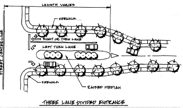
Figure 8.3
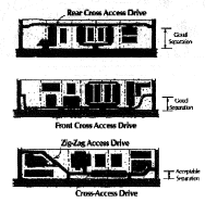
Figure 8.4
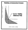
Figure 8.5
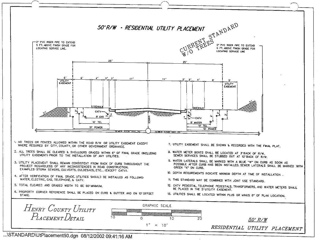
Figure 8.6
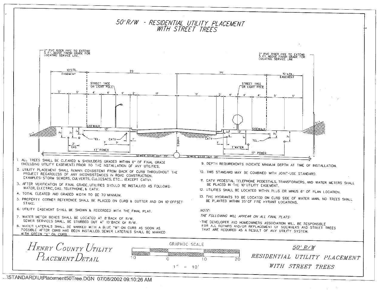
Figure 8.7
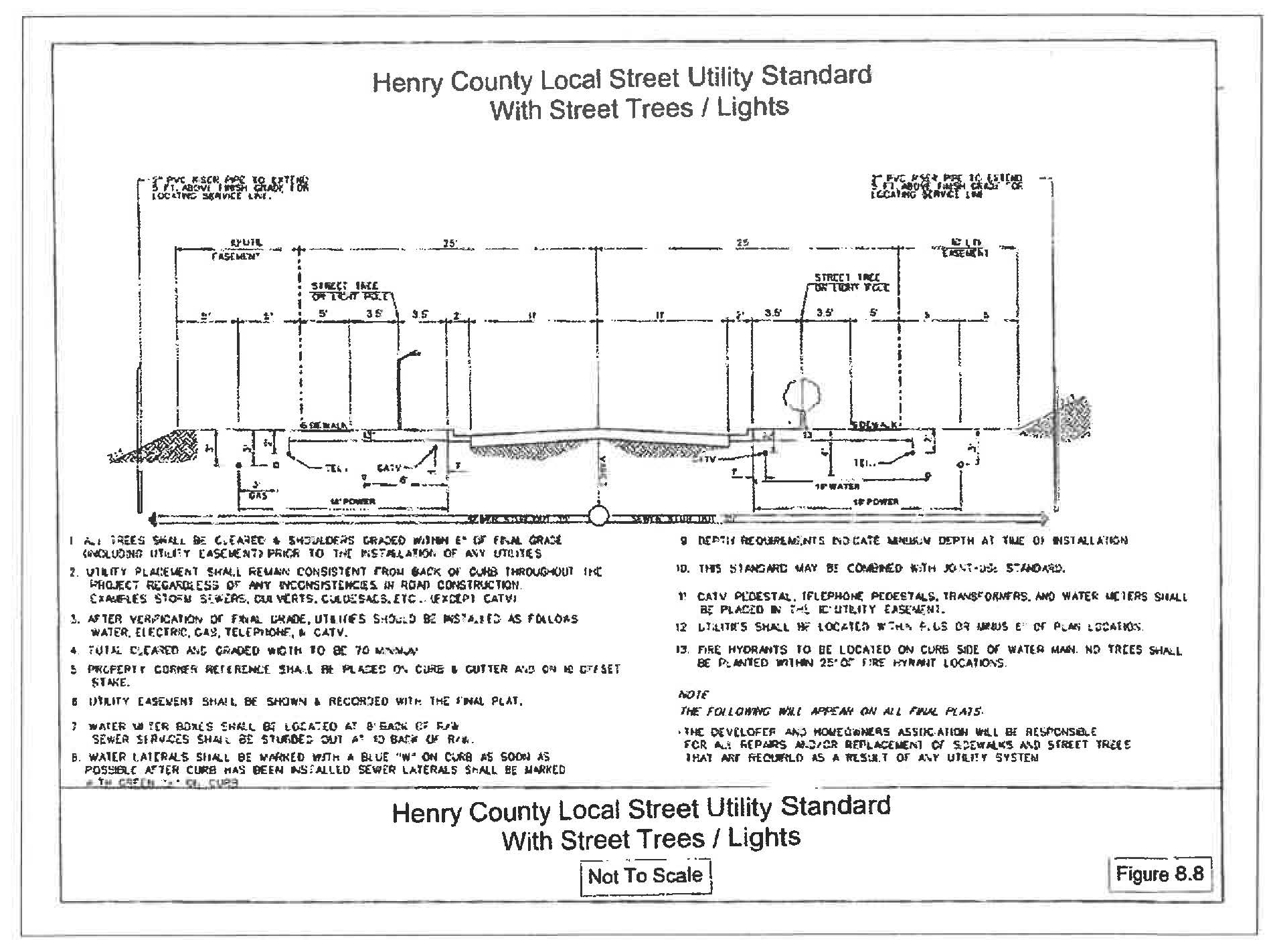
Figure 8.8