
Hesperia City Zoning Code
CHAPTER 16
40 - HILLSIDE DEVELOPMENT REGULATIONS
Sections:
16.40.010 - Purpose of provisions.
The purpose of this chapter is to establish standards and guidelines for the review and approval of development on hillsides and other slopes, as defined below, which, due to their topography, require special consideration to assure that they are developed in a way that will substantially maintain their natural character and environmental and aesthetic values in accordance with the provisions set forth in this chapter.
(Ord. 228 Exh. A (§ 1), 1996)
16.40.020 - Definition and scope.
Hillside areas include all those areas which have a slope of twenty (20) percent or greater. This chapter does not apply to lots for which an active tentative map was approved prior to the effective date of this chapter and which is developed in accordance with the general plan. This chapter also does not apply for any project for which a specific plan has been adopted.
(Ord. 228 Exh. A (§ 2), 1996)
16.40.030 - General objectives.
A.
To preserve the most visually significant slope and ridgelines in as natural a condition as possible;
B.
To minimize the effects of grading and ensure that the natural character of the hillside is retained;
C.
To preserve, to the maximum extent possible, visually significant rock outcroppings, native plant materials, natural hydrology, and areas of historical or visual significance identified by the general plan or the environmental review process;
D.
To preserve views of significant visual features as viewed both from within the project as well as from outside the project area;
E.
To encourage a variety of structures and foundations, gracing techniques, lot sizes, site design and spacing of homes and developments;
F.
To discourage mass grading of large pads and excessive terracing;
G.
To provide safe circulation of vehicular and pedestrian traffic to and within hillside areas and to provide for emergency vehicles access necessary to serve hillside areas, including access to open space within the project;
H.
To provide for safety against unstable slopes subject to erosion and deterioration in order to protect lives and property.
(Ord. 228 Exh. A (§ 3), 1996)
16.40.040 - Slope analysis requirements and criteria.
A.
Overall residential density within projects involving hillside areas shall not exceed the designation(s) shown on the general plan land use map.
B.
For the purpose of this section, slope shall be defined as the relationship between the change in elevation (rise) of the land and the horizontal distance (run) over which that change in elevation occurs. The percent of any given slope is determined by dividing the rise by the run on the natural slope of the land.
C.
For the purpose of determining the amount and location of land falling into each slope class, the applicant shall submit a slope analysis map consisting of a base topographical map of the subject property. The map is to be prepared and signed by a qualified person, such as a civil engineer or land surveyor, in accordance with the Business and Professions Code. Such a map shall have a scale of not less than one inch to two hundred (200) feet and a contour interval of not more than two feet within areas of less than twenty (20) percent slope and a contour interval of ten feet where the slope is twenty (20) percent or more. The map shall also include all adjoining property within one hundred (100) feet of the site boundaries. A tabulation of the amount of land within the project area for each slope class shall be provided.
D.
In preparing a slope analysis map, those small portions of ravines, ridges and terraces of less than one hundred fifty (150) feet in width at their widest measurement, which extend into an area of a different slope class, shall be regarded as part of that bordering slope class.
E.
The slope analysis map shall be submitted in conjunction with any site plan review, conditional use permit or subdivision application affecting land within the scope of this chapter. The reviewing authority for a project involving hillsides should be determined by the application filed as specified in Chapter 16.12.
F.
A soils report shall also be submitted with the application to develop land within the scope of this chapter. The report shall identify any unsafe conditions that may limit or preclude development and shall be prepared by a licensed civil engineer or other qualified person in accordance with the Business and Professions Code.
G.
The maximum density and the percent of a site area to remain in a natural state within each slope class shall be determined by a slope analysis that is applied to the slope-density/natural-area table shown below:
Slope-Density/Natural-Area Table
H.
Grading of any site shall be based on the applicable slope class as described below:
I.
Building setbacks, grading, construction, maximum slope heights, and slope drainage facilities shall be designed in accordance with standard engineering practices, the development code, applicable chapters of the Building Code and procedures established by this chapter.
J.
The building official may require special construction methods of structures where it has been determined to have potential geologic or soils hazards.
K.
Any fuel modification areas or planted slopes shall be landscaped and maintained in accordance with the Hesperia Recreation and Park District and Fire Marshal.
L.
Sloped areas not included as part of a private lot shall be dedicated to the park district and annexed into the district's landscape and lighting maintenance district. An exception to this requirement will be considered for projects within planned developments that include the formation of a homeowners association. The association shall be formed for the purpose of maintaining common amenities such as golf courses, club houses, or pools as well as common landscaping. Associations formed for the sole purpose of maintaining streets and right-of-way landscaping are not acceptable.
(Ord. 228 Exh. A (§ 4), 1996)
(Ord. No. 2021-01, 3(Exh. A), 6-1-21)
16.40.050 - Drainage and runoff control.
Runoff from activities subject to a development permit shall be properly controlled to prevent erosion and downstream flooding. Erosion control and surface flow containment facilities stall be constructed and maintained to prevent discharge of sediment to surface waters or storm drainage systems. The following measures shall be used for runoff control, and shall be adequate to control runoff from a one hundred (100) year storm:
A.
The identification of building and access envelopes and nonbuildable areas required to minimize disturbance of erodible areas of any proposed development site;
B.
All development drainage systems shall be designed to the satisfaction of the city engineer to mitigate effects of runoff, in accordance with the San Bernardino County Flood Control District Hydrology Manual and good engineering practice. Detention and/or retention facilities shall be provided to mitigate increases in runoff from storms of varying intensity. Desilting and/or debulking facilities shall be provided where necessary to ensure the storm drain system will function as designed;
C.
Any concentrated runoff which cannot be effectively dispersed over nonerodible channels or conduits to the nearest drainage course shall be contained within on-site percolation devices. Where water will be discharged to natural ground or channels, appropriate energy dissipators shall be installed to prevent erosion at the point of discharge;
D.
Runoff from disturbed areas shall be treated in a manner satisfactory to the city engineer to prevent the escape of sediment from the disturbed area;
E.
No earth, organic or construction material shall be deposited in or placed where it may be directly carried into a stream, lake, marsh, slough, lagoon or body of standing water. It is the developer's responsibility to secure and maintain any required storm water pollution prevention program and National Pollution Discharge Elimination System Permits from the State Regional Water Quality Control Board;
F.
Where land-disturbing activities are in proximity to lakes or natural watercourses, a buffer zone is required along the land-water margin of sufficient width to confine visible siltation within twenty-five (25) percent of the buffer zone nearest the land-disturbing activities;
G.
Where possible, drainage channels should be placed in less visible locations, and more importantly, should receive a naturalizing treatment including native rock, colored concrete, and landscaping so that the structure appears as an integral part of the environment. In all cases, a suitable liner shall be designed in accordance with city standards;
H.
Natural drainage courses should be preserved and enhanced to the extent possible. Rather than filling them in, drainage features should be incorporated as an integral part of the project design in order to enhance the overall quality and aesthetics of a site, to provide attractive open space vistas, and to preserve the natural character of the area.
(Ord. 228 Exh. A (§ 5), 1996)
16.40.060 - Supplemental review guidelines.
These hillside development guidelines are intended to facilitate the appropriate development of hillside areas. These guidelines are not intended to be strict standards, but rather, to provide direction to encourage development which is sensitive to the unique characteristics common to hillside properties. Their purpose is not to restrict an individual from proposing an innovative or alternative method of design in a hillside area; innovation is, in fact, encouraged as long as the end result is one which respects the hillside and is consistent with the purposes expressed in this chapter and in the goals and objectives of the general plan.
A.
Site Design.
1.
Design of building sites should be located to the natural terrain. Structures should be located in such a way as to minimize necessary grading and to preserve natural features such as prominent knolls or ridgelines.
2.
Preserve views of significant visual features as seen from both within and outside a hillside development. When designing lots and plotting homes, the following provisions should be taken into consideration.
a.
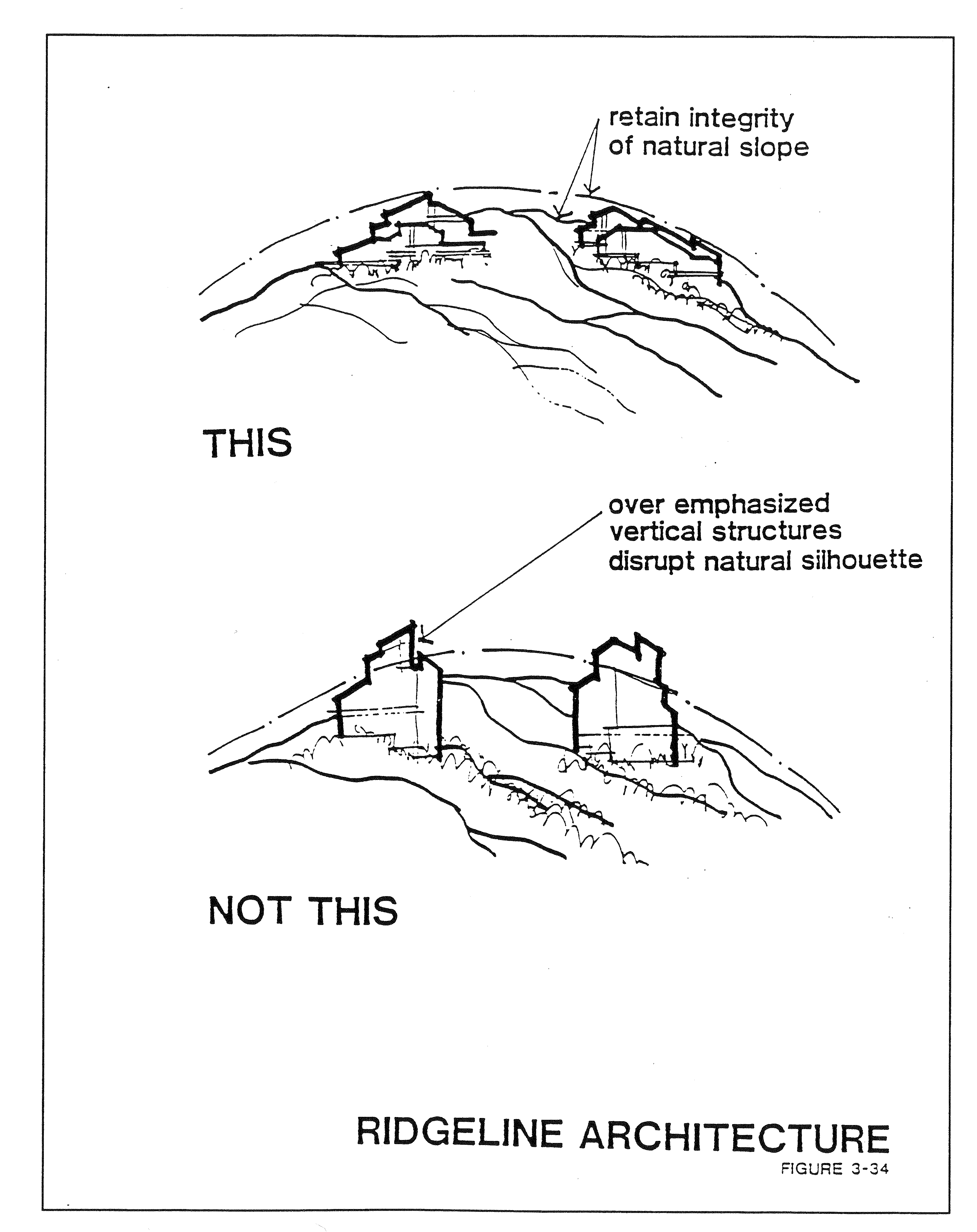
Homes constructed along ridgelines shall be designed to be compatible with the general gradient of the existing landform. The developer should avoid architectural styles that over emphasize vertical surfaces and disrupt the natural silhouette of the ridge.
b.
Homes should be oriented to allow view opportunities, although such views may be limited; however, residential privacy should not be unreasonably sacrificed.
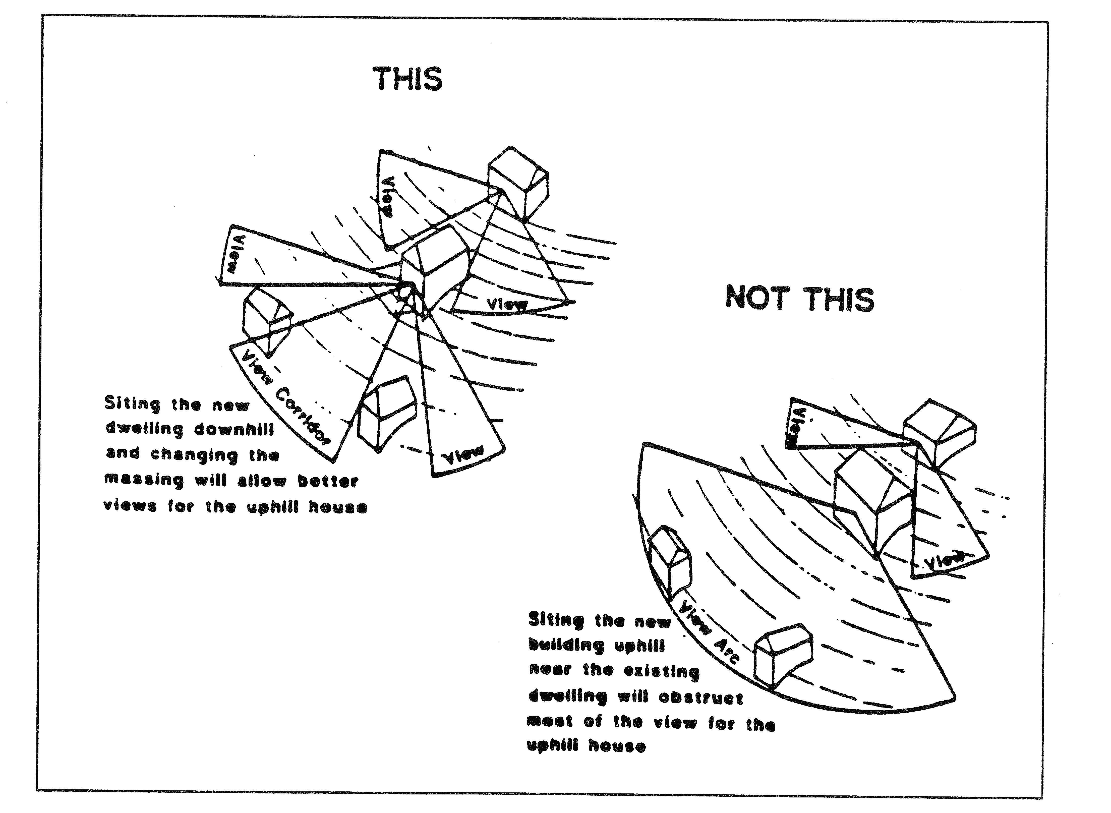
c.
Homes should be located in a manner that will retain outward views from each unit and preserve or enhance vistas, particularly those seen from public places.
d.
Any significant public vista or view corridor as seen from a secondary, collector, or major arterial should be protected.
3.
Significant visual features, such as large rock formations or groupings of protected plants or trees, shall be given special consideration in the design of the subdivision. Disturbance of such areas shall be avoided, unless in conflict with construction safety requirements or fire prevention standards.
B.
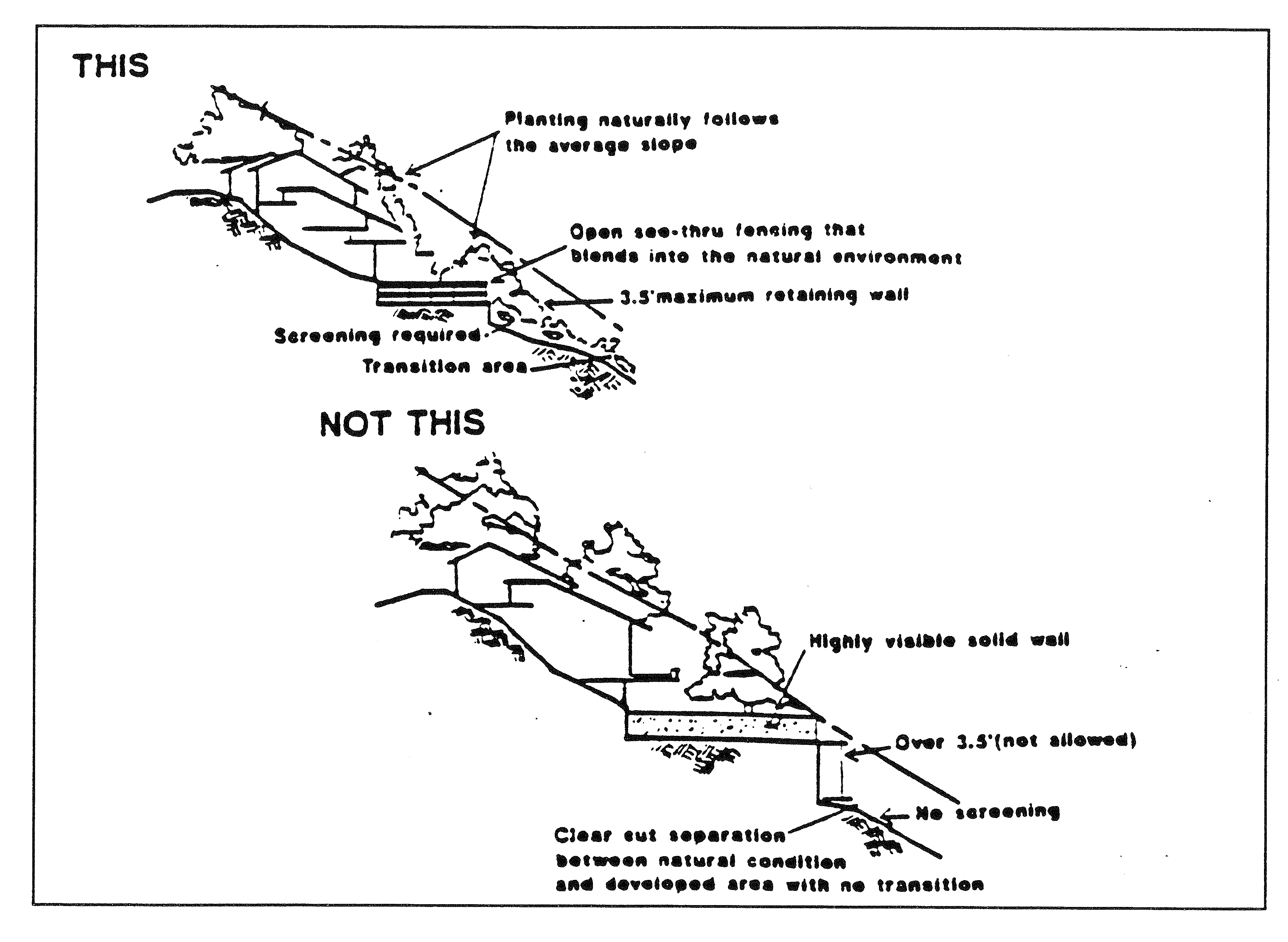
Walls and Fences. Walls and fences can be used to define a sense of place and create an attractive appearance. However, walls should not dominate a view, and their height should be limited adjacent to a street or trail or within a rear yard. Terracing and extensive landscaping can reduce the effective bulk. In addition, street front walls should incorporate varying design and natural materials. The use of open view fencing is encouraged, so long as adequate public safety and residential privacy are maintained.
1.
Retaining walls used to create pads or yard areas shall be minimized. Where possible, the structure shall be located to conceal the wall and cut slope. Where retaining wall or fences are adjacent to roads or are visible from public areas, they shall be built, where feasible of natural materials indigenous to the area. Non-native materials designed and colored to blend in with the surrounding area may be substituted.
2.
Introduction of landscaping within hillside areas should make maximum use of texture, color, be capable of blending in with the natural landscape and help soften the effects of buildings, walls, pavement and grading.
3.
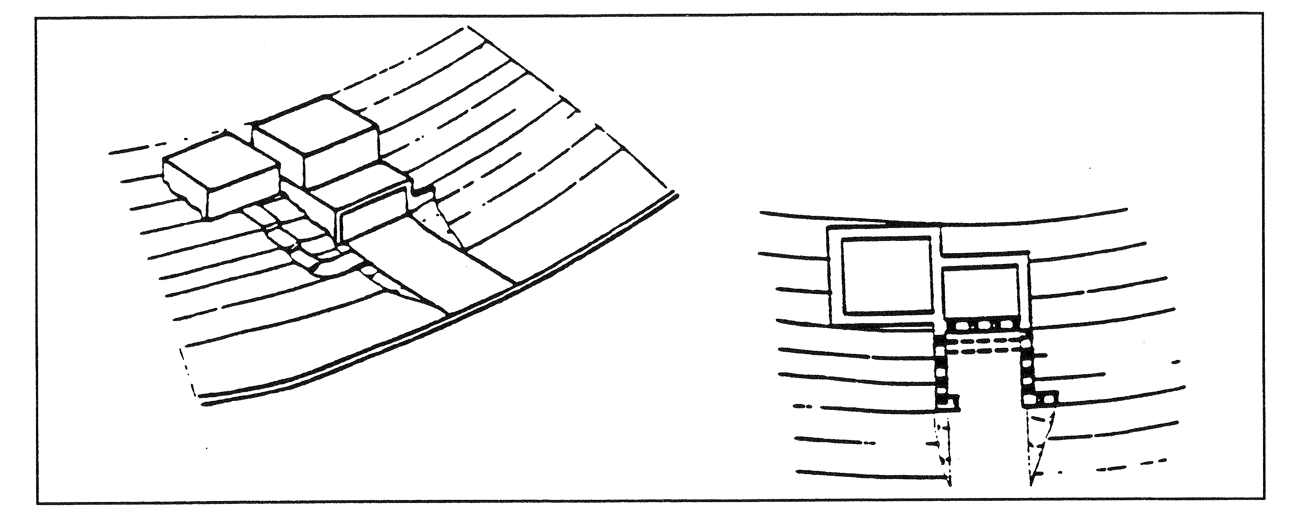
Retaining walls or other support structures should be designed to minimize their visual impact through techniques such as terracing, crib walls, and appropriate landscaping.
4.
Where retaining structures are required for hillside roads, efforts should be made to integrate them with the foundation walls of the adjacent residence and natural materials should be used in conjunction.
C.
Driveways and Roadways.
1.
Roadways should conform to the natural landform. They should not greatly alter the physical and visual character of a hillside by creating large notches in ridgelines or by defining wide straight alignments. Reduced road sections, split sections, and parking bays should be considered in the layout of hillside streets to reduce grading.
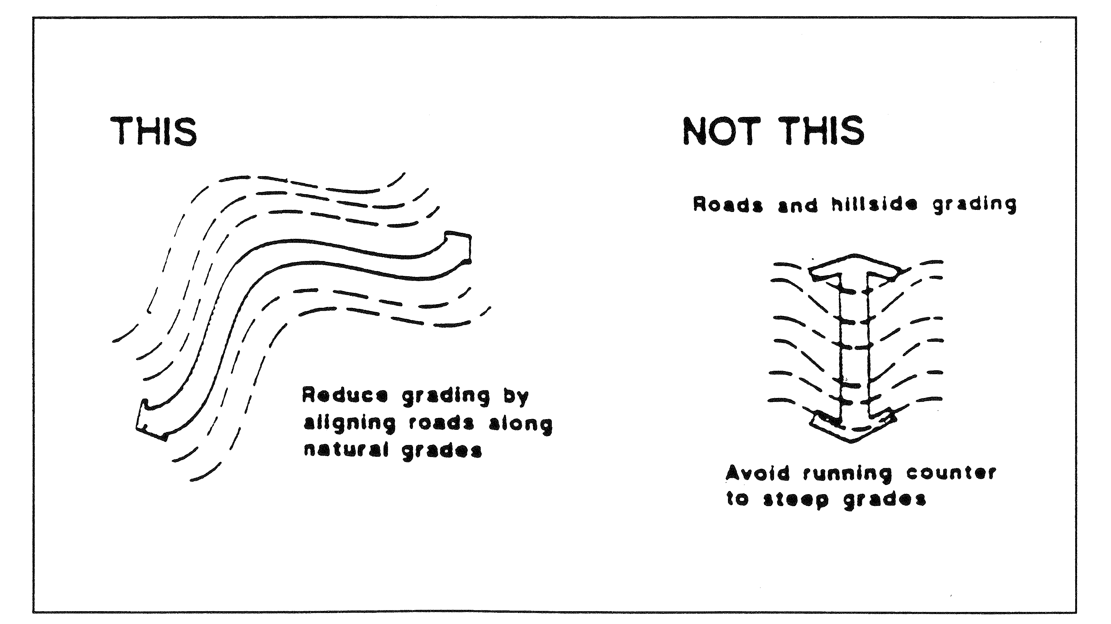
2.
Local road and driveway alignments shall be designed to conform to existing topography and to minimize grading. Road grades shall be kept as flat as possible. Roads exceeding ten percent and driveway grades exceeding fourteen (14) percent require design to the satisfaction of the city engineer. Collector and larger roads shall have grade limits reviewed on a case by case basis.
3.
Driveways shall be designed to provide for approved fire access lanes to any structure more than one hundred fifty (150) feet from a public street. Access roads shall be a minimum of twelve (12) feet in width, and have a vertical clearance of thirteen (13) feet, six inches. The maximum grade shall be twelve (12) percent for asphalt and fifteen (15) percent for concrete. All cases exceeding these standards shall be reviewed on a case by case basis by the fire chief in accordance with the fire protection standards of the Hesperia Fire Protection District.
D.
Grading.
1.
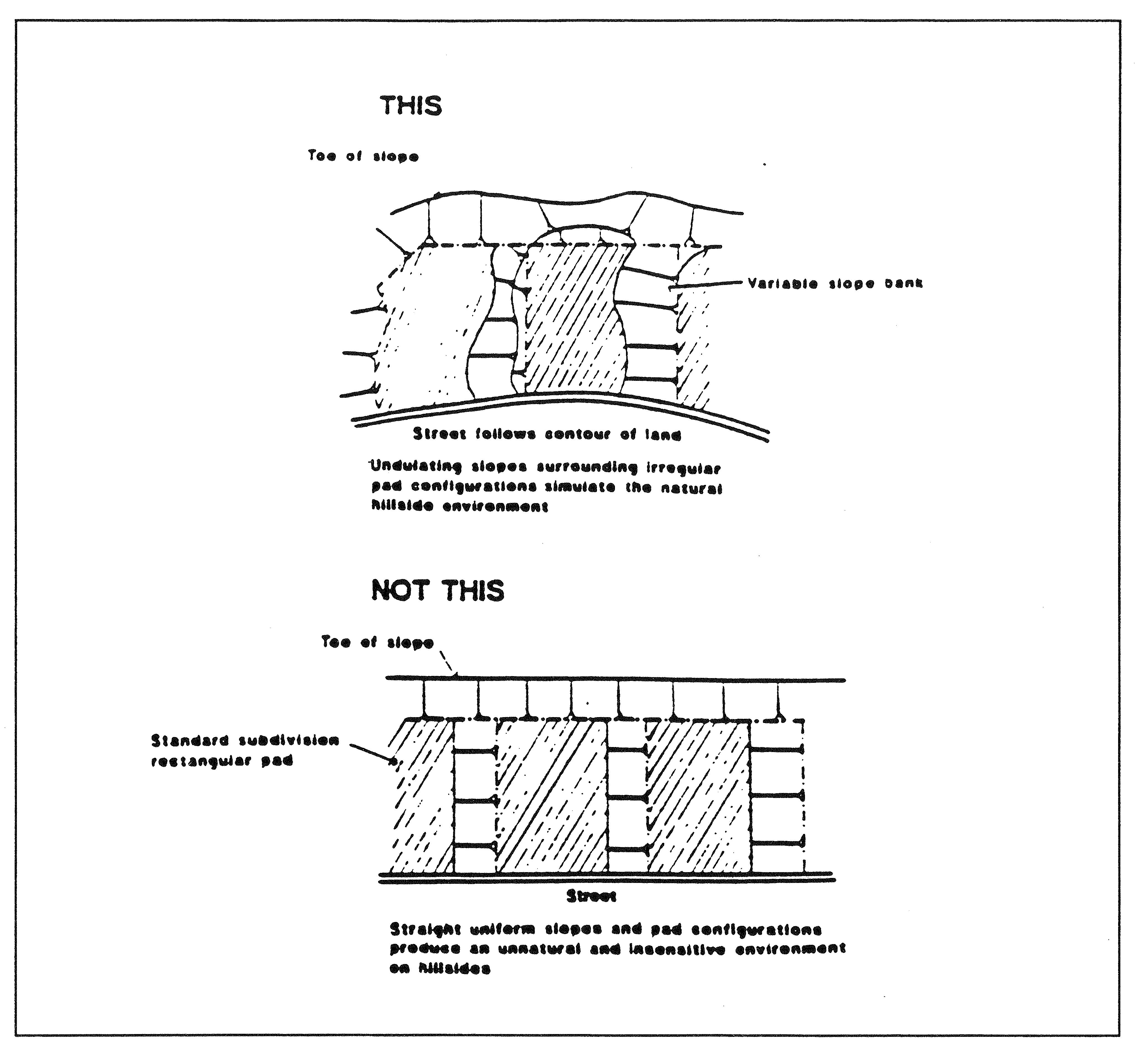
Contour grading techniques should be used to provide a variety of both slope percentage and slope direction in a three dimensional undulating pattern similar to existing, adjacent terrain. The following concepts should be utilized:
a.
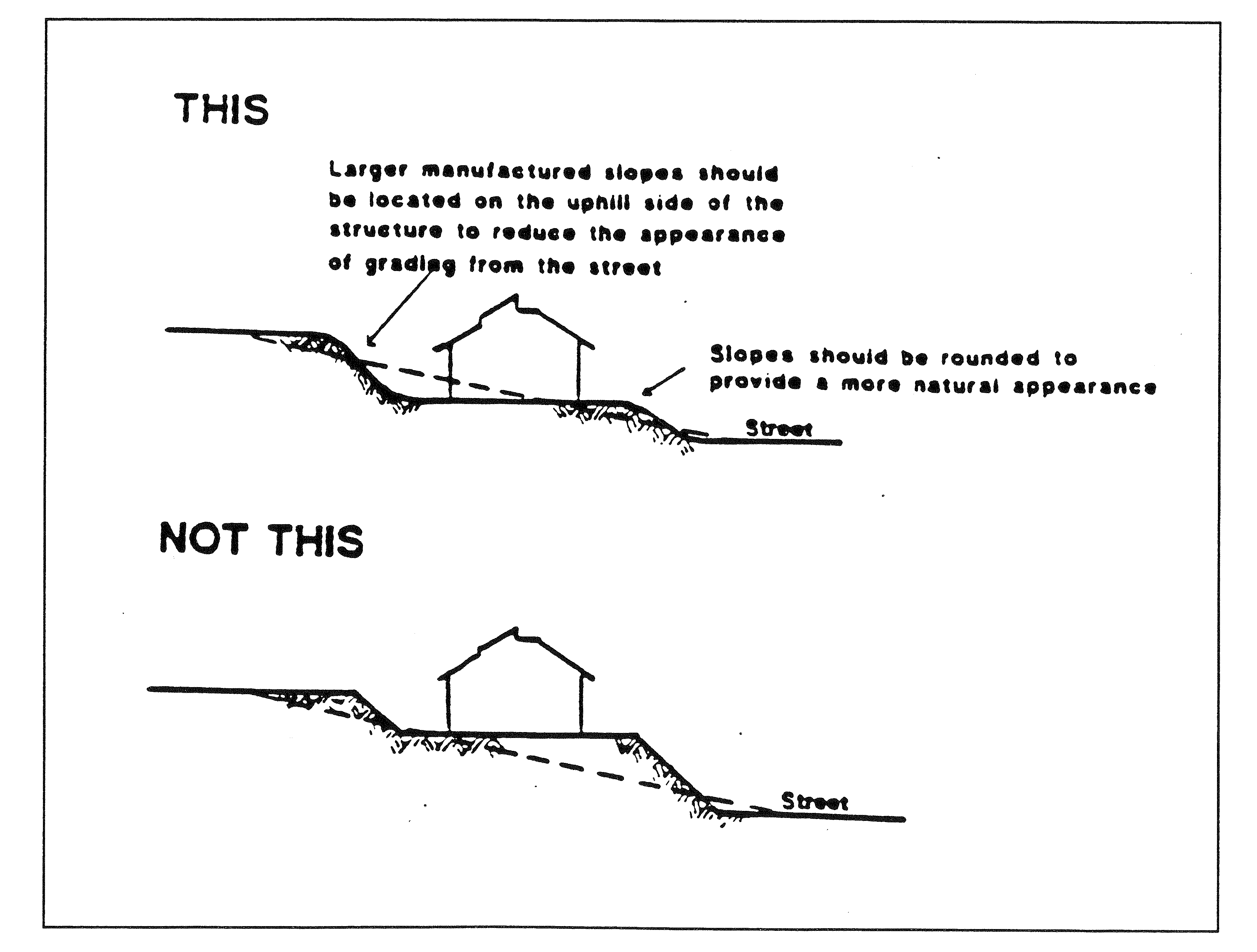
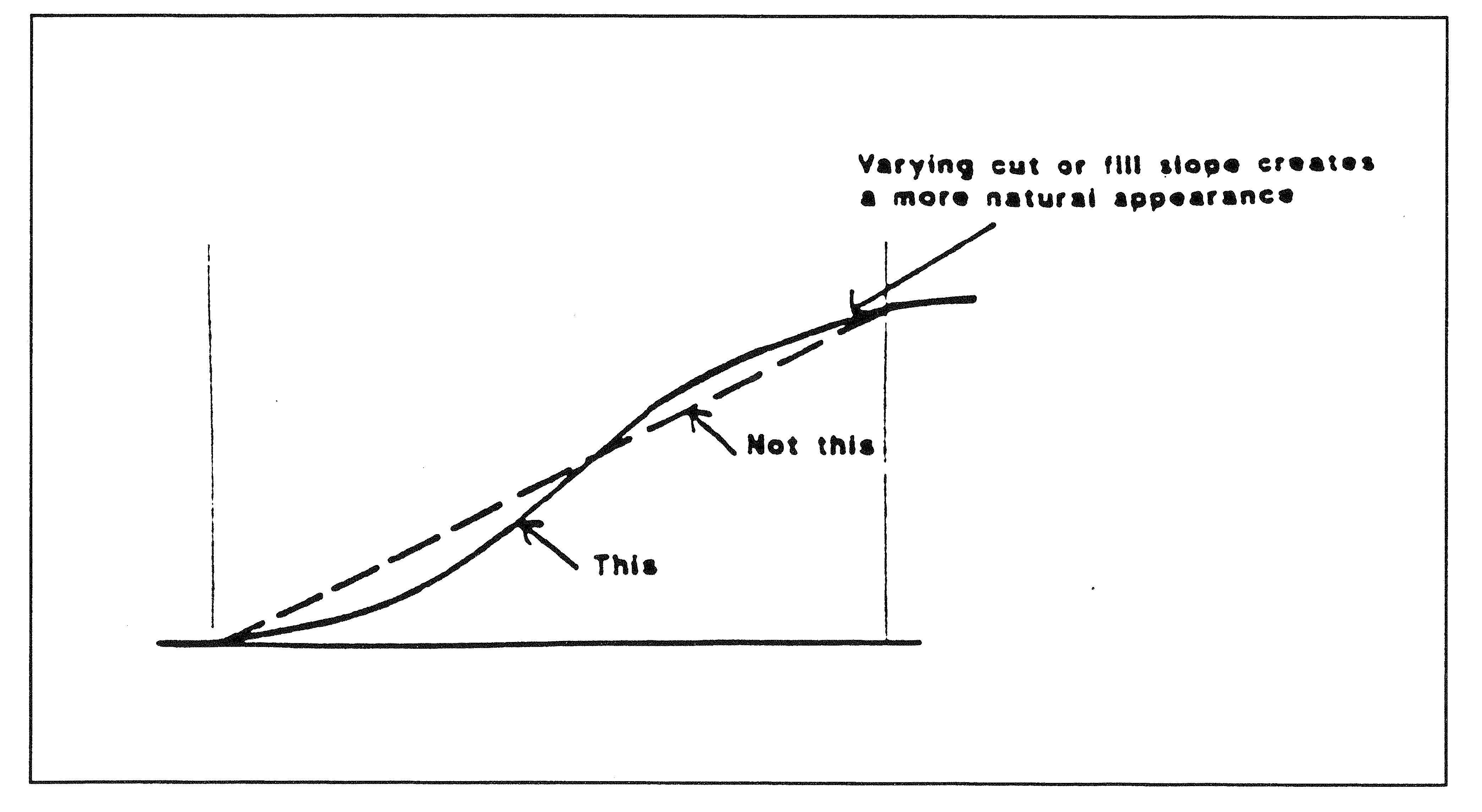
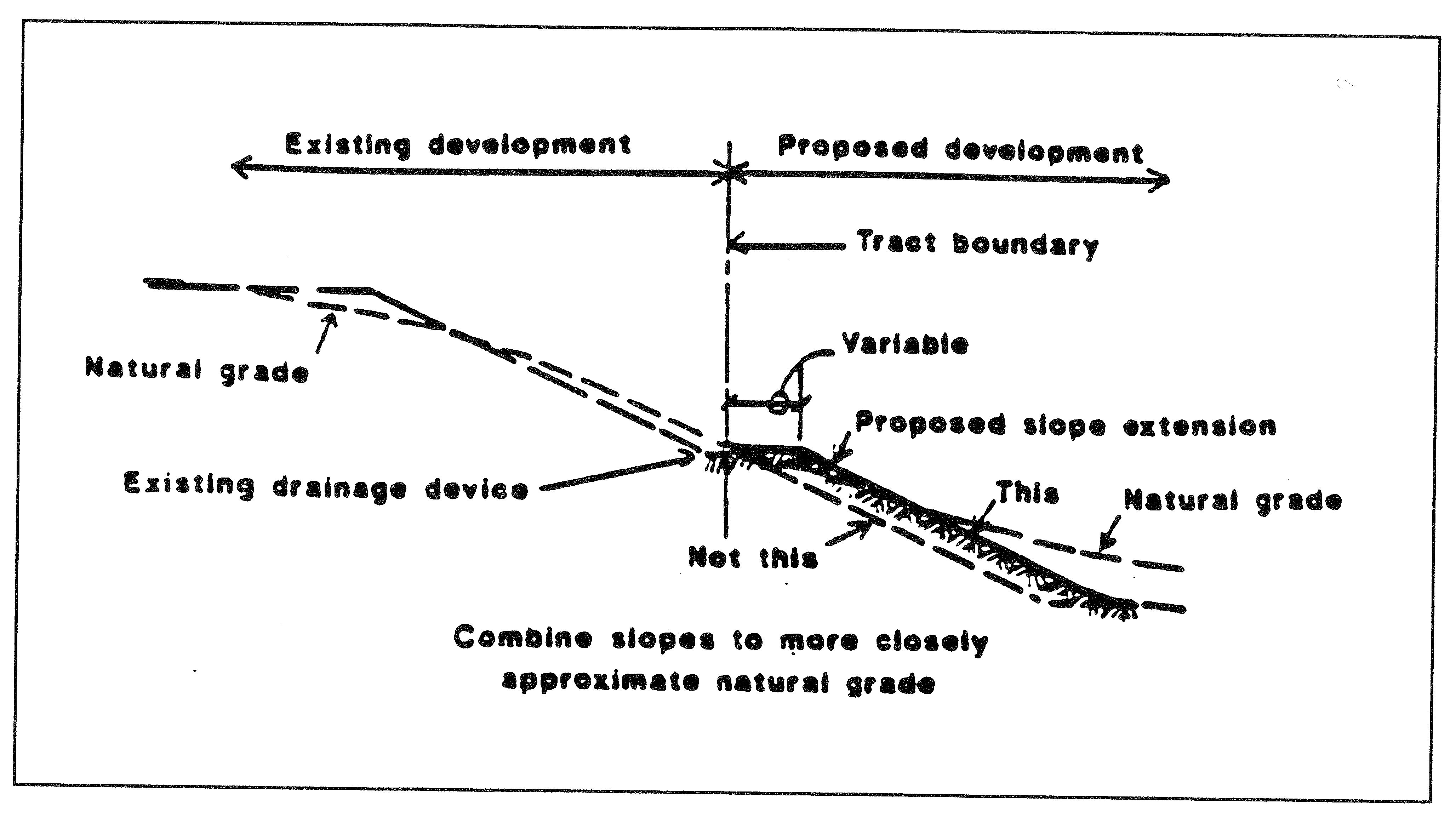
Hard edges left by cut and fill operations should be given a rounded appearance that closely resembles the natural contours of the land.
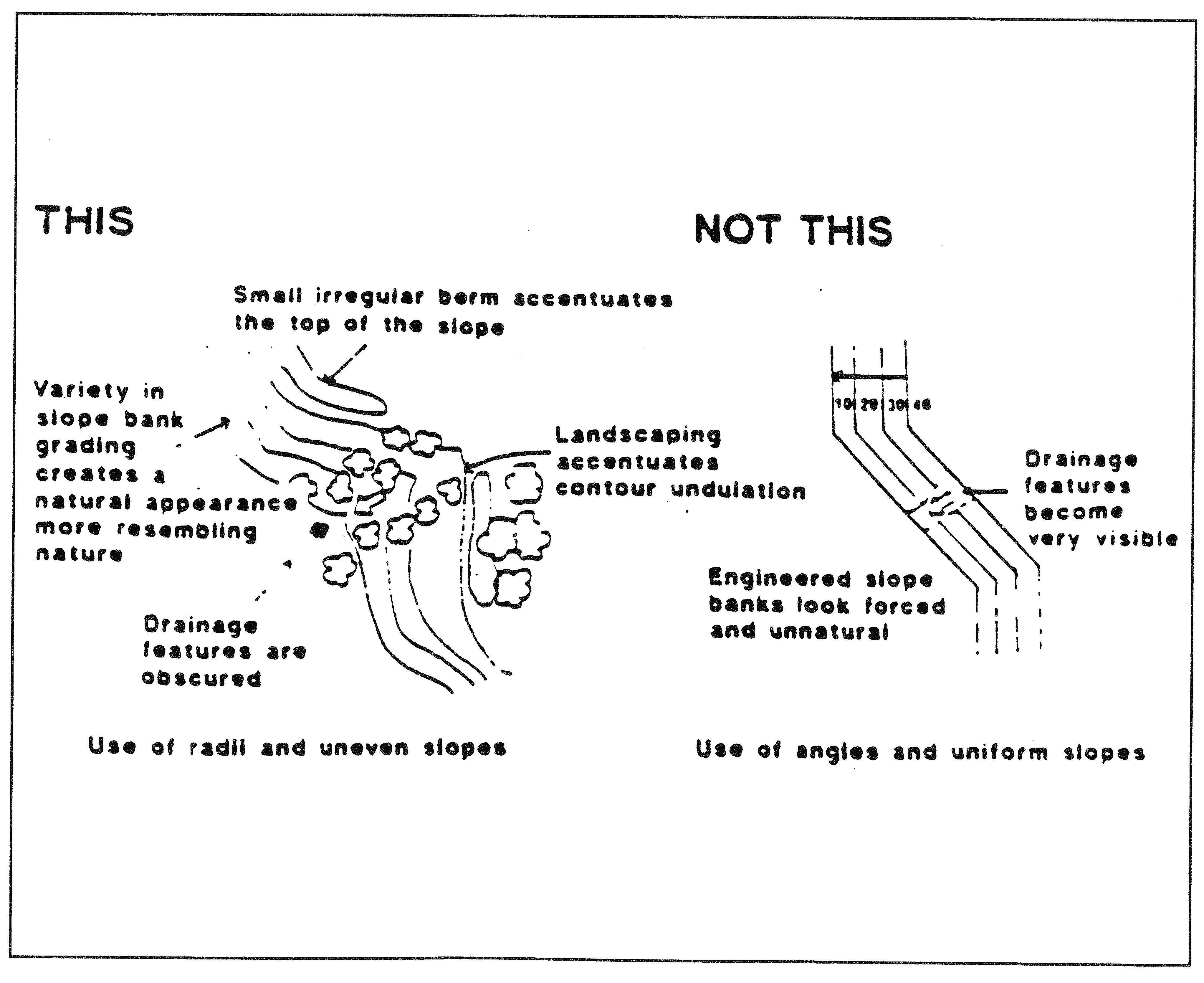
b.
Manufactured slopes adjacent to roadways should be modulated by sufficient berming, regrading and landscaping to create visually interesting and pleasing streetscapes.
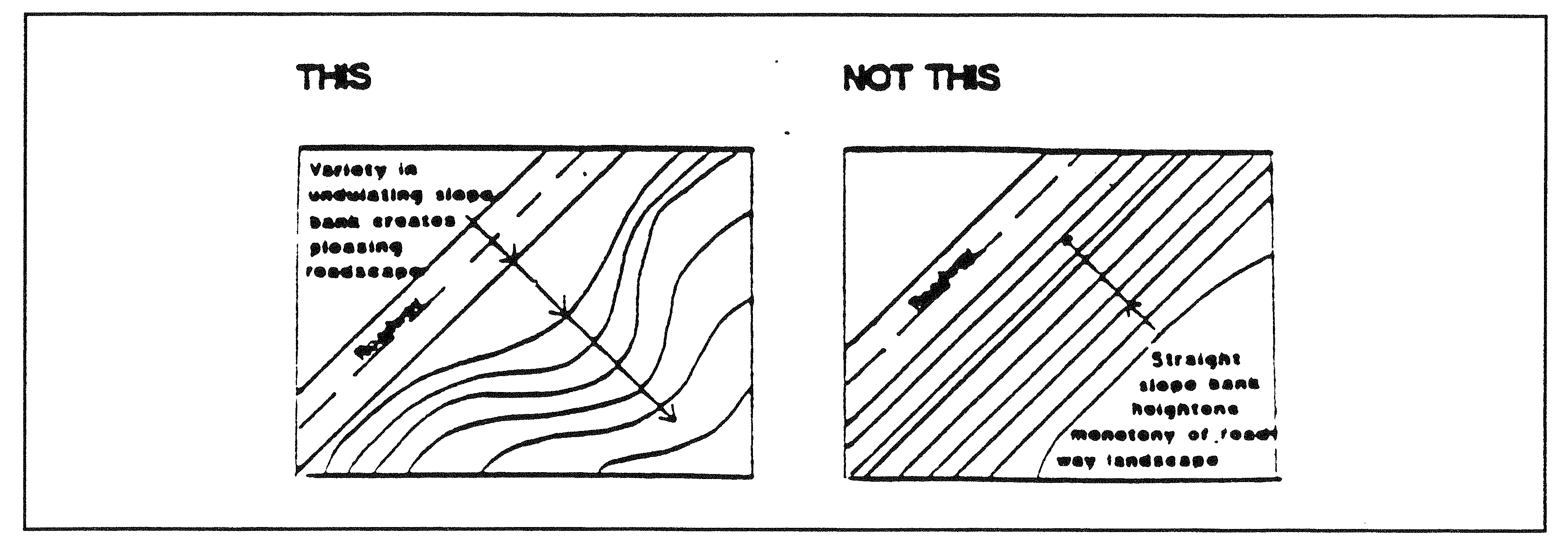
c.
Where cut or fill conditions are created, slopes should be varied rather than left at a constant angle which may be unstable or create an unnatural, rigid, "engineered" appearance. Portions of the graded slope may exceed the maximum allowed within the slope class in order to achieve this objective.
d.
The angle of any graded slope should be gradually adjusted to the angle of the natural terrain.
e.
When adjacent pad elevations exceed ten feet, and terrace grading techniques are used, the pad configuration should be softened with variable, undulating slopes created to give a more pleasing and natural appearance.
(Ord. 228 Exh. A (§ 6), 1996)