
Hesperia City Zoning Code
CHAPTER 16
20 - GENERAL REGULATIONS
ARTICLE IV.- PARKING AND LOADING STANDARDS[15]
Editor's note— Ord. No. 2010-07, § 3(Exh. A), adopted Oct. 5, 2010, amended Art. IV, in its entirety to read as herein set out. Former Art. IV, §§ 16.20.077—16.20.120, pertained to similar subject matter and derived from Ord. 135, Exh. A (Art. 3, §§ 1—5), adopted 1992; Ord. 238, § 4(D), adopted 1996; Ord. 250, Exh. A(part), adopted 1998; and Ord. 2007-15, § 5(Exh. A)(part), adopted 2007.
ARTICLE VII.- DENSITY BONUS PROGRAM[16]
Editor's note— Ord. No. 2011-03, § 3(Exh. A), adopted May 3, 2011, amended Art. VII in its entirety to read as herein set out. Former Art. VII pertained to similar subject matter and derived from Ord. 149, Exh. A, adopted 1992; and Ord. 232, § 4, adopted 1996.
ARTICLE XII.- LANDSCAPE REGULATIONS[17]
Editor's note— Ord. No. 2010-06, § 2(Exh. A), adopted Aug. 17, 2010, amended Art. XII in its entirety to read as herein set out. Former Art. XII, §§ 16.20.550—16.20.650, pertained to similar subject matter and derived Ord. 2006-18, § 4(Exh. A (part)), adopted 2007.
16.20.010 - Applicability of provisions.
Except as provided in this article, all yards or setbacks shall be as set forth in the land use districts or zones.
(SBCC § 87.0501)
16.20.015 - General provisions.
A.
Where setbacks are provided within a land use district, front yard setbacks shall mean distance from a road right-of-way unless otherwise specified within this section.
B.
Where setbacks are provided within a land use district, side and rear yard setbacks are from adjacent lot lines unless otherwise specified within this section.
C.
Yards or other open spaces required around an existing building or which are hereafter provided around any building for the purpose of complying with the yard provisions of a land use district or zone shall not be considered as providing a yard or open space for any other building.
D.
Yards or required open space on an adjoining lot shall not be considered as providing a yard or open space on a lot whereon a building is to be erected.
E.
On through lots, front yards shall be provided on all street frontages.
F.
If any future right-of-way line has been established by provisions of a specific ordinance, community plan, zoning or similar document, the measurement of the yard shall be made from the future right-of-way or future property line.
G.
All street setbacks shall include provision for a minimum half-width of thirty (30) feet for any valley or desert right-of-way and twenty (20) feet for any mountain right-of-way unless otherwise specified by provisions of a specific ordinance, community plan, zoning or similar document.
H.
Side yards on the street sides of corner lots require the same building setback as do front yards unless otherwise specified within the provisions of a specific ordinance, community plan, zoning or similar document.
I.
When the side lines of a lot converge to a point or to a rear lot line narrower than ten feet, for setback purposes the rear lot line is considered to be a line parallel to the front lot line measuring ten feet between the two side lot lines. The rear yard depth is measured from the ten foot line to the nearest part of the principal building on the lot.
J.
For the purposes of side yard regulations, the following dwellings with common party walls shall be considered as one building occupying one lot: semi-detached two- and four-family dwellings, row dwellings, group dwellings and court apartments.
K.
Street setback lines, as delineated on all final maps, parcel maps and records of survey maps recorded in the city between March 1, 1948, and January 1, 1987, or on composite development plans on file with the community development department shall be the street and yard setback distances required on the property within said final maps, parcel maps, or records of survey. Notwithstanding any other provision of the development code, any request to modify or deviate from a building setback line designated on a recorded map or final map shall be revised through the issuance of a certificate of correction to the parcel map or final map.
L.
Any primary use structure which is constructed upon a portion of two or more lots which are held in a common contiguous ownership shall not be required to adhere to the yard setback requirements specified for those lot lines upon which the construction has taken place. All other requirements specified by this code shall apply to this type of construction, including those requirements for distance between structures and required setbacks as measured from the combined perimeter boundary of the contiguous parcels.
M.
Front street setback lines shall be established, so wherever possible the yard width at such a setback line is at least the minimum width specified by the applicable zone/land use district, unless otherwise allowed by this title.
(Ord. 2001-09 Exh. A (part), 2001: amended during 12/98 supplement; SBCC § 87.0505)
16.20.020 - Exceptions.
In computing the depth of a rear yard where such yard opens into an alley, one-half (½) the width of such alley may be assumed to be a portion of the required rear yard.
(SBCC § 87.0510)
16.20.025 - Street setbacks—Applicability of provisions.
Unless otherwise specified in the development code, the regulations in this chapter shall apply only to zone districts and only when specifically cited within said zone districts.
(Amended during 12/98 supplement; SBCC § 87.0601)
16.20.030 - General provisions—Street setbacks.
Any structure hereafter erected, enlarged, relocated or structurally altered, which is located or is to be located on property abutting any street, road easement or freeway, shall conform to the street setbacks as set forth in the following subsections:
A.
Where the street is located on a right-of-way width of sixty (60) feet or less, the minimum street setback shall be fifty-five (55) feet, measured from the centerline.
B.
Where the street is located on a right-of-way width of more than sixty (60) feet, the minimum street setback shall be twenty-five (25) feet in addition to one-half (½) of the width of the existing right-of-way measured from the centerline.
C.
Where the roadway is a private road easement, the minimum street setback shall be twenty-five (25) feet measured from the recognized easement line.
D.
Where residential buildings and accessory structures are constructed or remodeled on reversed corner lots, the applicable building setbacks in the street side yard may be reduced to twenty-five (25) feet along major arterial and arterial streets and to fifteen (15) feet along secondary arterial, collector and local streets.
(Ord. 2001-09 Exh. A (part): amended during 1997 codification; SBCC § 87.0605)
16.20.035 - Service station setbacks.
A.
Protective pump island canopies shall maintain a setback of five feet from the right-of-way shown on the adopted master plan of highways.
B.
Pump islands, when designed parallel to the nearest right-of-way, shall maintain a setback of fifteen (15) feet from the right-of-way shown on the circulation element of the general plan, specific plan or adopted community plan.
C.
Pump islands, when designed at an angle of thirty (30) degrees or more to the nearest right-of-way, shall maintain a setback of twenty-five (25) feet from the right-of-way shown on the circulation element of the general plan, specific plan or adopted community plan.
D.
Area lighters shall maintain a setback of one foot from the right-of-way shown on the circulation element of the general plan, specific plan or adopted community plan.
E.
All other structures over four feet in height shall maintain setbacks as required in the street setback section for zone districts or as required by the applicable specific plan or community plan.
(SBCC § 87.0701(a))
16.20.040 - Reserved.
Editor's note— Ord. No. 2019-08, § 3(Exh. B), adopted June 4, 2019, repealed § 16.20.040, which pertained to apartment building separations and derived from Ord. 250(part), 1997; SBCC § 87.0701(b).
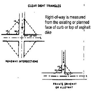
16.20.045 - Clear sight triangles.
A.
Adequate visibility for vehicular and pedestrian traffic shall be provided at clear sight triangles at all ninety (90) degree angle intersections of public rights-of-way and private driveways, through the following measures:
1.
There shall be no man made visual obstruction in clear sight triangles which exceed thirty-six (36) inches above grade level, except by no more than seven posts or columns each with a width no greater than twenty-six (26) inches within the clear sight triangle formed at a street intersection and no more than three posts or columns not to exceed twenty-six (26) inches in width be within the clear sight triangle at the intersection of a driveway and a street. These columns may include a decorative cap not to exceed thirty (30) inches in width. Open wire fences, including chain link, shall not exceed seventy-two (72) inches in height above grade within clear sight triangles.
2.
There shall be no monument signs, walls, or non-open wire fences allowed within a clear sight triangle, which is higher than thirty-six (36) inches above grade except as permitted by Section 16.20.070.
B.
Clear sight triangles are right triangles which are measured as follows:
1.
The ninety (90) degree angle is formed by the intersection of either;
a.
The intersection of the edges of two roadways as measured from the face of curb, top of asphalt dike, or if unpaved, the location of the curb or dike as per the standard street cross section of the right-of-way; or
b.
The intersection of the edge of a private driveway or alley as measured from the face of curb, top of asphalt dike, or if unpaved, the location of the curb or dike as per the standard street cross section of the right-of-way of an intersecting roadway.
2.
The two forty-five (45) degree angles of a clear sight triangle shall each be located as follows:
a.
Roadway Intersections. Thirty (30) feet from the roadway intersection.
b.
Private Driveway or Alleyway. Fifteen (15) feet from the intersection.
3.
Diagrams:
(Ord. 250 (part), 1997; Ord. 43 § 1, 1989; SBCC § 87.0701(c))
(Ord. No. 2009-09, § 3(Exh. A), 10-20-09)
16.20.050 - Open animal enclosures.
A.
Open animal enclosures shall be kept at least seventy (70) feet from buildings used for human habitation, public park, school, hospital or church buildings on adjoining lots or parcels, and shall maintain a clearance of at least five feet from interior side and rear property lines, and fifteen (15) feet from side street rights-of-way, excepting an alley or bridle path, unless the animals are confined by a five foot chain link fence or a five foot wood fence with horizontal members no more than six inches apart, which fence may be located on an interior side or rear lot line and fifteen (15) feet from a side street right-of-way. The area of human habitation shall not include cabanas, patios, attached or detached private garages or storage buildings.
B.
Exception. Those parcels of land upon which a use of keeping and maintaining a horse, or horses, has been established prior to the date of construction of a building used for human habitation located on a neighboring parcel, regardless of any other provisions of this code, shall have applicable to them a nonconforming use right. Such nonconforming use right shall be only that a horse or horses may be kept at a minimum of fifty (50) feet from buildings used for human habitation on adjoining lots or parcels providing the following are complied with:
1.
Shall maintain a clearance of at least five feet from interior side and rear property lines;
2.
Shall maintain a clearance of fifteen (15) feet from side street rights-of-way excepting an alley or bridle path;
3.
Fences shall maintain a height of at least five feet and shall be of such construction as to preclude the escape of animals within the enclosure.
(Ord. 250 (part), 1997; SBCC § 87.0701(d))
16.20.055 - Height increases.
A.
Single household dwellings in land use districts or zone districts that impose a height limitation of thirty-five (35) feet or less may exceed the height limit by up to twenty-five (25) feet, when two side yards of at least twenty (20) feet are provided.
B.
Public buildings in land use districts or zone districts that impose a height limitation of thirty-five (35) feet or less may exceed the thirty-five (35) foot height limit by up to twenty-five (25) feet when the required front, side and rear yards are increased an additional one foot in excess of minimum requirements for each four feet in height above thirty-five (35) feet.
(Ord. 250 (part), 1997; SBCC § 87.0401)
16.20.060 - Special height limits.
A.
Special height limits up to fifty (50) percent greater than that specified in the land use districts or zones may be granted for the following structures, by the building official, subject to department review:
1.
Cupolas, domes, skylights and gables;
2.
Ornamental towers and spheres;
3.
Church steeples and towers;
4.
Flag poles;
5.
Birdhouses;
6.
Residential chimneys, flues, smokestacks and enclosures;
7.
Mechanical equipment and its screening;
8.
Elevator housings;
9.
Bulkheads and skylights;
10.
Monuments;
11.
Barns, silos, grain elevators, windmills and other farm buildings or structures in rural conservation or agricultural districts;
12.
Noncommercial antennae up to sixty-five (65) feet in residential districts;
13.
Fire or parapet walls;
14.
Fire and hose towers;
15.
Stairway housing;
16.
Water tanks;
17.
Cooling towers, gas holders, smokestacks or other structures in industrial districts which are required by permitted industrial processes;
18.
Windmills and solar energy collectors in residential or commercial districts;
19.
Water towers;
20.
Observation and carillon towers;
21.
Radio and television station towers;
22.
Distribution and transmission cables and towers;
23.
Outdoor theater screens;
24.
Sign spires;
25.
Penthouses;
26.
Other roof structures and mechanical appurtenances similar to those listed above.
(Ord. 250 (part), 1997; SBCC § 87.0405)
16.20.065 - General provisions.
All required yards or court areas shall be open and unobstructed from finished grade or from such other specified level at which the yard or court is required, to the sky, except for structures allowed in yard or court by the table in Section 16.20.075. The architectural projections listed in Section 16.20.075 must be attached to the principal building allowed on the lot.
(Ord. 250 (part), 1997; SBCC § 87.0801)
(Ord. No. 2009-09, § 3(Exh. A), 10-20-09)
16.20.070 - Clear areas.
The projections listed in the table in Section 16.20.075 may not, in any event, encroach on the following:
A.
The clear sight triangle required at traffic intersections by Sections 16.20.045.
B.
Within five feet of any yard in which the projection is not allowed.
C.
Within five feet of any lot line (three feet for substandard lots). (Exception: Projections listed in items 1 and 6 in Section 16.20.075 may encroach to within three feet of a lot line.)
(Ord. 250 (part), 1997; SBCC § 87.0805)
(Ord. No. 2009-09, § 3(Exh. A), 10-20-09)
(Ord. No. 2019-01, § 3(Exh. A), 2-5-19)
16.20.072 - Fences and walls.
A.
Fences and walls within the front yard setback may be approved by the director of development services or his designee as provided in subsection B and shall require the approval of a plot plan.
B.
Standards for Fences and Walls within the Front Yard Setback Area. The maximum height of a wall, fence or hedge shall be limited to a maximum of thirty-six (36) inches above grade when view-obscuring; however, non-view-obscuring estate type fences (i.e., those constructed of ornamental metal and masonry pillars) may be constructed in the front yard up to a maximum of six (6) feet above grade (Chain link with slats is not considered an ornamental fence, and is limited in height to thirty-six (36) inches unless on a lot at least fifteen thousand (15,000) square feet or larger). The director of development services or his designee may limit the height and alter the size and location of fences and pillars, based on the position of the residence as well as other factors, which may include the topography of the site, development on adjacent parcels, and legally located structures and utilities. In no event shall any view-obscuring portion of the estate type fence, other than pillars consistent with Section 16.20.045, exceed the maximum height of thirty-six (36) inches above grade. The maximum height of fences, walls, and hedges shall be as provided within the table below:
C.
Fences, walls or yard enclosures (not including animal enclosures) shall be constructed of approved materials. Approved materials include masonry block, split face block, wrought iron, chain link, wood or plastic slats, vinyl fencing, and split rail. Any other material must be approved by the Director or designee as a fencing material. Fencing constructed of approved materials must still meet all other requirements of this code, including but not limited to design standards and permitting requirements.
D.
All fencing shall be constructed to add to the overall look of the property, installed in a professional manner using treated materials to withstand the environment. In no case shall a fence be constructed of secondhand or castoff materials not originally designed for fencing. Examples of prohibited materials include, but are not limited to garage doors, corrugated metal scrap, mattresses, tires, car parts, and plywood less than five-eighths inches thick, plywood not of a grade approved by the director or designee, particle board, paper, visgueen plastic, plastic tarp, cloth or similar material.
E.
Animal enclosures shall be constructed of materials treated and installed to withstand the environment, be appropriate for the keeping of animals, and be properly maintained. Animal enclosures shall meet all other requirements of this code. The materials listed as prohibited in Section D are also prohibited for use as an animal enclosure.
(Ord. No. 2019-01, § 3(Exh. A), 2-5-19; Ord. No. 2021-01, 3(Exh. A), 6-1-21)
Editor's note— Ord. No. 2019-01, § 3(Exh. A), adopted February 5, 2019, set out provisions intended for use as § 16.20.080. For purposes of classification, and at the editor's discretion, these provisions have been included as 16.20.072.
16.20.075 - Table of projections into yards and courts.
(Ord. 2006-23 § 5 (Exh. A), 2006; Ord. 2001-09 Exh. A (part), 2001: Ord. 2001-14 § 2, 2001; Ord. 250 Exh. A (part), 1998; Ord. 237 § 5, 1996; Ord. 43 § 2, 1989; SBCC § 87.0810)
(Ord. No. 2009-09, § 3(Exh. A), 10-20-09; Ord. No. 2022-02, § 3(Exh. A), 3-15-22)
16.20.077 - Parking standards of calculation.
A.
When the minimum number of parking spaces required is based upon building area, the parking formula within this chapter shall be calculated using the gross building floor area in square feet. The gross building floor area is defined as the entire area of the building(s) within the exterior building walls, inclusive of the wall thickness. The area within a mezzanine, as defined by the building code, used solely for storage shall not be included in parking calculations.
B.
If the calculation of required parking spaces results in a fractional number, that number shall be rounded to the nearest whole number with 0.5 rounded up to the next whole number.
C.
A project site for purposes of the parking ordinance is defined as the gross site acreage. Gross site acreage is defined as the net property site acreage in addition to the area from the property line to the centerline of all public rights-of-way and alleys across the site frontage. The project site shall be defined as the net developed site acreage if less than seventy-five (75) percent of the site area is to be developed. The net developed site acreage shall also be used in phased projects, requiring that a larger proportion of the required parking spaces be provided earlier during the project's development. A project adjacent to an existing project shall not be considered part of the adjacent project unless irrevocable reciprocal access and parking easements between the two sites are executed and coordination of site design is accomplished to city standards. This includes but is not limited to use of shared driveways and drive aisles and compliance with the standards within Sections 16.16.490, 16.16.495, 16.16.500, and 16.16.505.
(Ord. No. 2010-07, § 3(Exh. A), 10-5-10)
16.20.080 - Parking requirements.
Adequate parking shall be provided on-site for each use, with minimum parking requirements established per Tables 16.20.080 (A) and 16.20.080 (B). Where deemed appropriate by the reviewing authority, additional parking may be required.
Table 16.20.080 (A)
Residential Parking Requirements
Table 16.20.080 (B)
Commercial and Industrial Parking Requirements
(Ord. 2007-15 § 5 (Exh. A) (part), 2007: Ord. 135 Exh. A (Art. 3 § 1), 1992)
(Ord. No. 2010-07, § 3(Exh. A), 10-5-10; Ord. No. 2021-01, 3(Exh. A), 6-1-21)
16.20.085 - Parking standards.
A.
The required parking spaces shall be located on the same site with the main use or building except as provided herein. Property within the ultimate right-of-way of a street or highway shall not be used to provide required parking or loading facilities.
B.
On-site parking shall be restricted to those areas which are paved and designated for vehicle parking unless authorized through an approved temporary special event, site plan review or conditional use permit.
C.
When the occupancy or use of any premises is changed to a different use, parking to meet the requirements of Section 16.20.080 shall be provided for the new use or occupancy unless otherwise permitted.
D.
When the occupancy or use of any premises is altered, enlarged, expanded or intensified, additional parking to meet the requirements of Section 16.20.080 shall be provided for the additional area and/or use.
E.
No required parking space or loading area shall be discontinued, reduced or altered in any manner below the requirements established in this article unless replacement parking facilities are provided in accordance with Chapter 16.20.
F.
Where two or more uses are located in a single building or a single premises, required parking shall be provided for each specific use except as part of a mixed-use development as approved by a site plan review or conditional use permit.
G.
Shared parking may be approved by the reviewing authority; provided, that times of operation of the involved businesses are not the same, as specified herein.
1.
Up to fifty (50) percent of the parking facilities required by this article for a use considered to be primarily a daytime use may be provided by a use considered to be primarily a nighttime use; up to fifty (50) percent of the parking facilities required by this article for a use considered to be primarily a nighttime or Sunday use may be provided by a use considered to be primarily a daytime use; provided, that such reciprocal parking area shall be subject to conditions as set forth in subsection (G)(3) of this section.
2.
The following uses are typical daytime uses: banks, business and professional offices, clothing or repair or service shops, and similar uses. The following uses are typical of nighttime and/or Sunday uses: auditoriums, fraternal lodges, churches and theaters. The reviewing authority shall determine the parking requirements of the uses proposed for joint parking.
3.
Conditions Required for Joint Use.
a.
A building or use for which application is being made for authority to utilize the existing off-street parking facilities provided by another building or use, shall be located within one hundred fifty (150) feet of such parking facilities and shall be authorized as part of a recorded irrevocable reciprocal access and parking agreement.
b.
The applicant shall provide written documentation as approved by the reviewing authority that there will be no substantial conflict in the principal operating hours for the buildings or uses for which the joint use of off-street parking facilities is proposed.
c.
Parties concerned in the joint use of off-street parking facilities shall provide evidence of agreement for such joint use by a proper legal instrument approved by the city attorney as to form and content.
H.
Parking Spaces. Each full-sized off-street parking space shall have dimensions not less than nine feet in width and eighteen (18) feet in length, except parallel parking stalls which shall be a minimum of eight feet in width and twenty-four (24) feet in length. A maximum of twenty-five (25) percent of the total number of parking spaces provided may be a minimum of eight feet, six inches in width and eighteen (18) feet in length. These reduced-width spaces should not be located in close proximity to a primary building entrance(s). These reduced-width spaces may be provided at the end(s) of a row(s) of nine-foot-wide spaces as needed due to site constraints. However, these spaces shall not be alternated with nine-foot-wide spaces within an individual row(s) of spaces.
I.
Parking spaces may overhang sidewalks and landscaped areas by up to two feet, provided the encroachment does not reduce a required handicapped accessible path of travel and landscaping does not interfere with the allowed encroachment. All walkways adjacent to overhanging parked cars shall have a clear width of four (4) feet.
J.
Those areas designated for use by motorcycles shall consist of a minimum usable area of fifty-six (56) square feet.
K.
Parking spaces for recreational vehicles, when required, shall measure a minimum of ten feet by thirty (30) feet. Number and location shall be approved by the reviewing authority.
L.
A portion of the required parking spaces for medical office uses and government facilities may be designated for employees. The number and location shall be approved by the reviewing authority.
M.
Handicapped parking shall be provided in accordance with the requirements of state law.
N.
Individual parking stalls shall be legibly marked off on the pavement by means of painting, texture, or contrasting materials as approved by the reviewing authority. Arrows painted on paving shall dictate direction of traffic flow. Parking stall striping, directional arrows and parking stall identification shall meet the following standards:
1.
All parking stalls shall be clearly striped and permanently maintained with four-inch-wide double or hairpin lines on the surface of the parking facility, with the two lines located an equal distance of nine inches on either side of the stall sidelines as shown on Figure 1;
2.
All aisles, entrances and exits shall be clearly marked with directional arrows painted on the parking surface.
3.
All parking space rows shall be separated from drive aisles by landscaped areas at least four feet in width as shown in Figure 4. In addition, a minimum one foot wide concrete sidewalk shall be provided adjacent to the parking space to allow drivers and passengers to exit the vehicle without stepping into landscaped areas as shown on Figure 2.
O.
Entryways to parking areas shall be well-defined and recognizable with adequate lighting and signage provided to facilitate the traffic flow. All portions of parking areas shall be illuminated at minimum 0.1 foot-candle intensity. A maximum illumination of 0.5 foot-candles at the property lines abutting a street or residentially designated property is allowed.
P.
Parking and maneuvering areas shall be so arranged that any vehicle entering the public right-of-way must do so traveling in a forward direction. The parking area shall be designed so that a car entering the parking area shall not be required to enter a street to move from one location to any other location within the parking area or premises or make an abrupt turn upon entering the site.
Q.
Parking areas shall be designed so as to prevent vehicles from maneuvering within the first twenty (20) feet of a vehicular entrance as measured from the curb as shown on Figure 2.
R.
Minimum aisle widths for two-way traffic shall be twenty-six (26) feet as shown in Figure 3. In areas commonly used by oversized vehicles, such as delivery areas and loading zones, the minimum aisle width shall be thirty (30) feet.
S.
Minimum aisle widths for one-way traffic shall be in accordance with Figure 3; unless adjacent to loading areas, in which case a sixteen-foot drive aisle width is required; or if wider access is required by the fire department.
T.
The required off-street parking and loading areas and access drives shall be surfaced per specifications of the reviewing authority. Parking and loading facilities shall be surfaced and maintained with asphaltic, concrete, or other permanent, impervious surfacing material. Alternate surface material may be considered by the reviewing authority, if shown that such material will not cause adverse effects and that it will remain in a usable condition.
U.
All parking and loading facilities shall be graded and provided with permanent storm drainage facilities. Surfacing, curbing, and drainage improvements shall be sufficient to preclude free flow of water onto adjacent properties or public streets or alleys, and to preclude standing pools of water within the parking facility, unless otherwise approved by the reviewing authority. Parking spaces may overhang sidewalks and landscaped areas by up to two feet, provided the encroachment does not reduce a required handicapped accessible path of travel and landscaping does not interfere with the allowed encroachment. All walkways adjacent to overhanging parked cars shall have a clear width of four (4) feet.
V.
Head-in parking, which would necessitate full frontage access to the street or highway, shall not be permitted.
W.
Parking areas shall be designed to facilitate sweeping and reduce trash buildup; wheel stops or a minimum two-foot wide raised sidewalk in accordance with Figure 1 shall be provided as approved by the reviewing authority.
Figure 1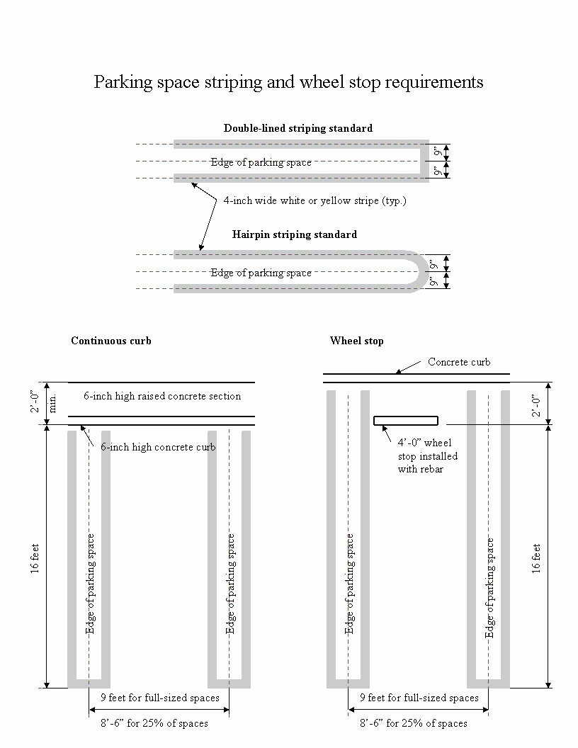
Figure 2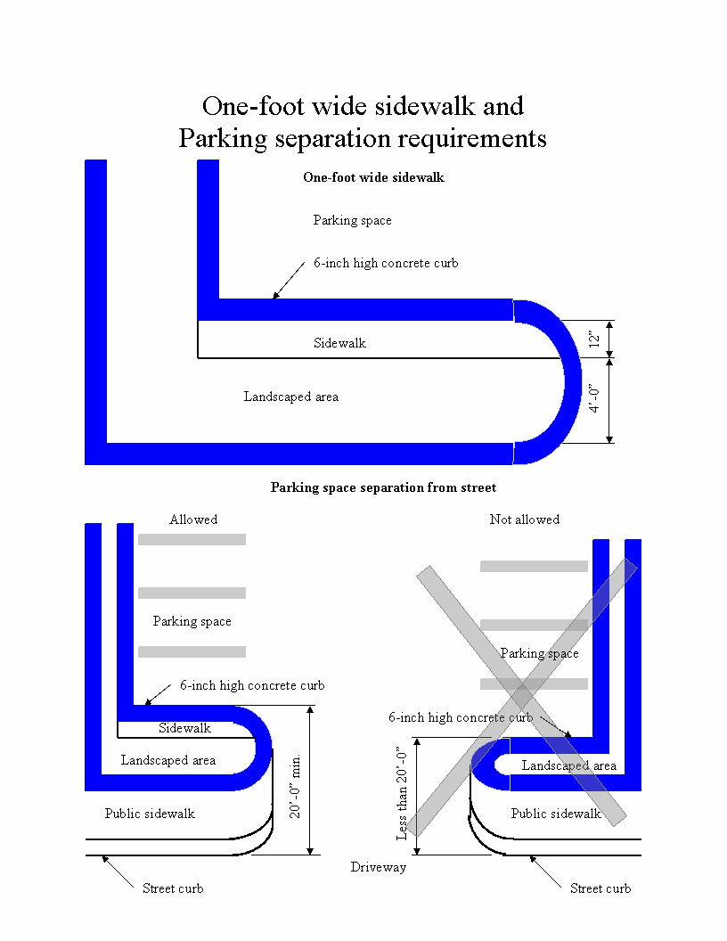
Figure 3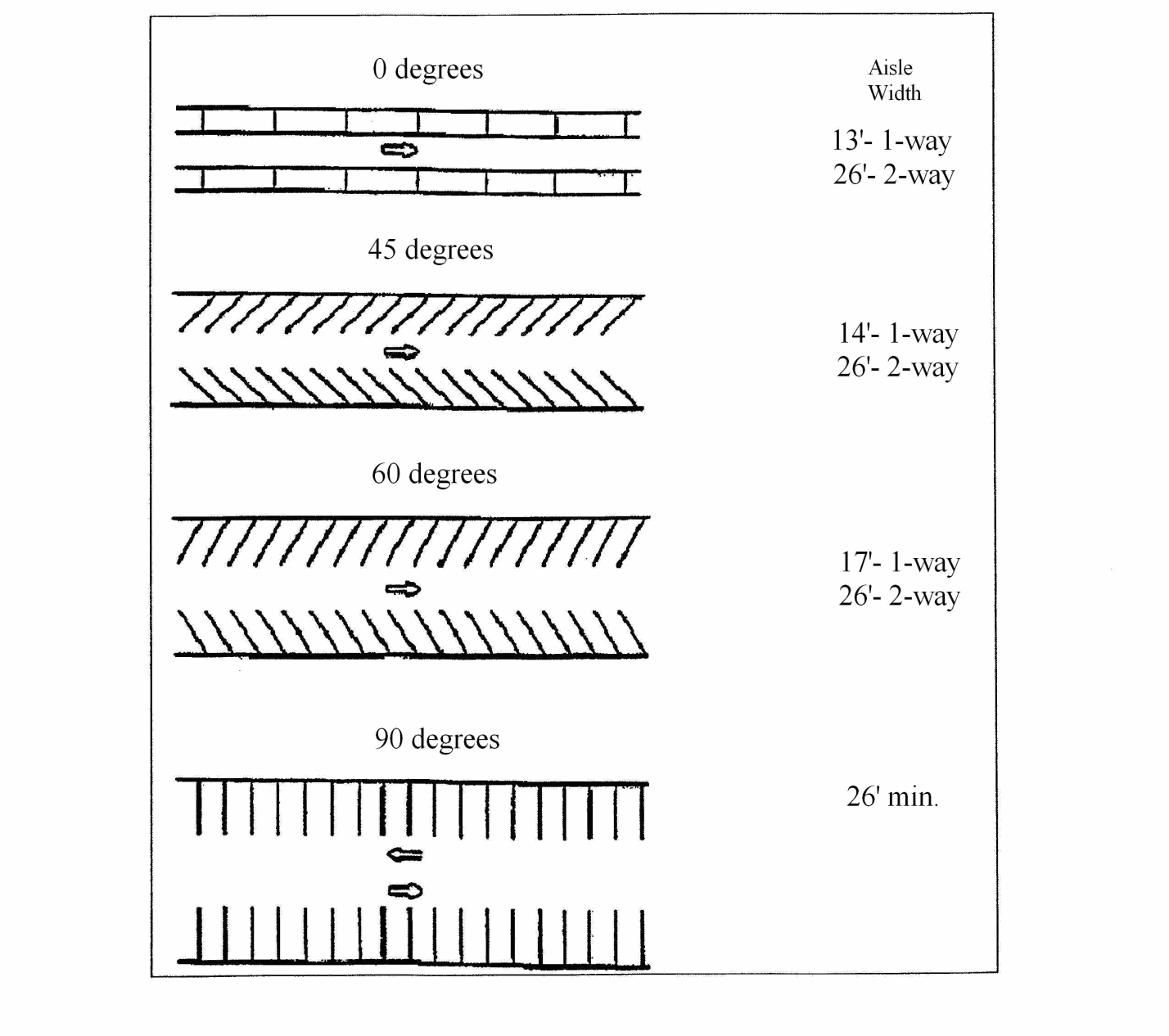
Figure 4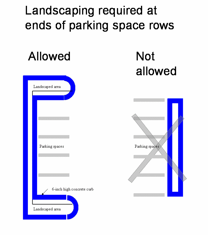
X.
Visitor parking areas shall be provided near visitor entrances. Where appropriate, visitor drop-off zones shall be provided near visitor entrances.
Y.
Pedestrian walkways shall be provided to connect parking areas to destination points. Walkways shall be paved, lighted and have adequate signage to direct pedestrian traffic.
Z.
Lights shall be provided to illuminate parking facilities pursuant to the provisions of this code.
AA.
Areas used for primary circulation, or for frequent idling of vehicle engines, or for loading activities, shall be designed and located to minimize impacts on adjoining properties, including provisions for screening or sound baffling.
BB.
Parking structures shall be permitted. Exterior design shall be architecturally compatible with the main building. The parking structure should merge with or extend from the main building, rather than be an isolated structure. Automobiles should be screened to a height of three feet, six inches to four feet on each level, and the space remaining above the screening element, up to the ceiling of the next floor, shall remain open and unobstructed. Facades should be multi-textured or have other architectural relief.
Where the height of the structure is limited by other sections of the development code, or other adopted city ordinance, resolution or code, one additional floor or story may be allowed subject to approval of the reviewing authority under the following conditions:
1.
At least seventy-five (75) percent of the ground floor is used for off-street parking, access and maneuvering;
2.
Use of the remaining ground floor area is limited to manager's offices, elevators, service facilities, and building access facilities including entrance foyer or lobby;
3.
Ground floor parking shall be screened, insofar as practical, from surrounding uses and from public view.
CC.
Vehicle Parking. No person shall park or permit the parking of a vehicle on private property for the purpose of selling or offering the vehicle for sale, unless this activity is the primary permitted use on the property and all licenses and permits have first been obtained and all regulatory requirements have first been satisfied.
Exception: Notwithstanding any provision to the contrary, a property owner or tenant in lawful possession thereof, may park a vehicle for sale on his or her property; provided that, at all times the vehicle is parked and offered for sale on the property, under the following conditions:
1.
The owner or tenant is actually occupying said property;
2.
The vehicle which is offered for sale is owned by and where applicable, registered to the property owner or tenant with the California Department of Motor Vehicles or other appropriate agency;
3.
The activity of offering the vehicle for sale and/or its location on the property does not violate any other section of the Hesperia Municipal Code, including, without limitation, front and side yard setback requirements;
4.
No more than one vehicle is offered for sale on the property at any one time.
DD.
Definitions. The following words and phrases shall have the meanings as ascribed to them by this section:
"Person" as used in this section means and includes, but is not limited to, any individual, partnership, firm, association, corporations, joint venture, or legal entity or any combination thereof.
"Sale" is defined to include the activities of selling, leasing, renting or hiring out of any vehicle.
"Undeveloped lot, tract or parcel" means any share, portion or division of real estate on which no structure requiring a building permit exists and which may be further developed or subdivided in accordance with the city's zoning regulations. For the purposes of this chapter, lots, tracts or parcels that are in the process of being developed with an approved development permit are considered undeveloped.
"Vehicle" as used in this section means a device by which any person or property may be propelled, moved, or drawn upon a highway, excepting a device moved exclusively by human power or used exclusively upon stationary rails or tracks.
This includes, without limitation, any automobile, truck, trailer, motorcycle, semi-trailer, moped, camper, commercial or recreational vehicles. "Vehicle" as used herein also means to include, without limitation, boats of any kind, camper shells, and any portable commercial or recreational equipment which is attached to, transported by or capable of being transported, upon a highway by another vehicle.
(Ord. No. 2010-07, § 3(Exh. A), 10-5-10; Ord. No. 2021-01, 3(Exh. A), 6-1-21; Ord. No. 2022-14, § 3(Exh. B), 11-15-22)
16.20.090 - Residential parking standards.
In addition to those standards contained in Section 16.20.085 of this article, the following design standards shall apply to residential districts and developments:
A.
Covered off-street parking spaces in a garage or carport shall be a minimum of nine feet in width and nineteen (19) feet in depth of unobstructed area provided for parking purposes. A fully enclosed two-car garage shall have a minimum interior size of nineteen (19) feet in width and nineteen (19) feet in depth. The required minimum measurements may not include the exterior walls or supports of the structure.
B.
Driveways providing access to garages, carports and parking areas serving two or less dwelling units shall be a minimum of twelve (12) feet in width. When an accessory garage is proposed, which is required for either the principal residence or a second dwelling unit, the driveway requirements shall be as follows:
1.
For developed residential lots less than two acres in size, the driveway providing access to an accessory garage shall be surfaced with asphalt paving a minimum of two inches in thickness or concrete with a minimum thickness of three and one-half inches or other permanent, impervious surfacing material per the specifications of the reviewing authority. An alternate surface material may be considered by the reviewing authority, if shown that such material will not cause adverse effects and that it will remain in a usable condition.
2.
For developed residential lots greater than two acres in size which front upon an unpaved street, the driveway providing access to an accessory garage shall be dust-proofed with either slag, gravel, or similar surface material as approved by the reviewing authority, if shown that such material will not cause adverse effects and that it will remain in a usable condition.
C.
Driveways providing access to garages, carports, and open parking spaces serving three or more dwelling units shall be a minimum of thirteen (13) feet in width for one-way traffic, and twenty-six (26) feet for two-way traffic. Where garages or carports are located on both sides of the driveway, a thirty-foot wide accessway between garage or carport spaces for two-way traffic shall be provided.
D.
Driveways which are separate from the right-of-way or common drive aisle and which provide access to garages shall be a minimum length of twenty (20) feet, excluding that portion within the public right-of-way or common drive aisle.
E.
No property owner shall sublease, subrent or otherwise make available to residents of other properties, the off-street parking spaces required by this article.
F.
All required covered off-street parking spaces shall be located so as to be conveniently accessible to the dwelling unit served by such parking space, not to exceed one hundred fifty (150) feet or as approved by the reviewing authority.
G.
All recreational vehicle parking and/or storage areas located within the front yard as allowed by the development code, or other applicable adopted city ordinance, resolution, or code shall be surfaced with either concrete, asphalt, gravel, or crushed rock. Recreational vehicles shall not be stored in the public right-of-way. "Stored" is defined as being parked in the public right-of-way for more than seventy-two (72) hours.
H.
Commercial Vehicle Parking in Residential and Agricultural Areas. The parking of commercial vehicle(s) in residential or agriculturally zoned areas of the city is designed for the owner/operator of a single commercial vehicle. Allowing for more than a single truck or trailer may lead some properties to be used as small scale truck yards, or truck operations. The appearance and use of a residential property in this manner may lead to noise, blight, and may disturb surrounding residents, limiting the enjoyment of their property. The intent of this chapter is to provide regulations regarding the parking of commercial vehicles so as to enable truck operators to park their vehicle at their home, while protecting the nature of residential neighborhoods.
1.
Definitions.
a.
This subsection shall apply to commercial vehicles having a manufacturer's gross vehicle weight rating (GVWR) of twenty-six thousand (26,000) pounds, or more, parked or left standing in residential or agricultural areas.
b.
For purposes of this subsection, and unless otherwise stated, a truck shall be considered to be one truck or tractor
c.
For purposes of this subsection one trailer shall be either a single long trailer whether enclosed or open or a set of double trailers designed to be towed together.
d.
For purposes of this subsection, unless stated, a commercial vehicle shall be defined as one truck or tractor and one trailer or set of double trailers.
e.
For purposes of this chapter, an overly heavy load shall be defined by applicable standards from the California Department of Transportation, as may be amended from time to time.
2.
Parking Requirements in General.
a.
No commercial vehicle shall be left to idle for longer than five minutes, nor blow air horns.
b.
No commercial vehicle shall have cargo transferred from such commercial vehicle to another.
c.
No refrigeration unit on any commercial vehicle shall be operated within three hundred (300) feet of any inhabited place, except with the consent of the person in charge of each such inhabited place.
d.
Commercial vehicles used for the transportation of hazardous waste, overly heavy loads, hazardous materials, or garbage, or which harbor vermin or pestilence, or which emit noxious or offensive odors, shall not be parked or stored in residential or agricultural areas.
3.
Street Parking.
a.
It shall be unlawful for any person to park or leave standing on any public street, including within the public right-of-way, any commercial vehicle.
Exceptions:
(a)
During the first twenty-four (24) hours during which the vehicle is mechanically disabled.
i.
While a commercial vehicle is making a pick-up or delivery of materials or goods to or from any building or site.
b.
No commercial vehicle shall be parked or left standing on any street or right-of-way unless it is a minimum of twelve (12) feet from the centerline of the street, or twelve (12) feet per lane, if more than one lane, and under no circumstances parked in any travel lanes.
c.
No commercial vehicle shall be parked or left standing within one hundred (100) feet of any street intersection.
I.
Parking on Private Property - Permit Required.
1.
Pursuant to the requirements of this section, any operator or owner who desires to park a commercial vehicle on their property shall obtain a permit to do so. The permit shall be renewed annually and the cost of the permit shall be as adopted by resolution of the city council. Issuance of the permit shall be as required by this chapter.
2.
Permit Requirements-Residential Commercial Vehicle Parking.
i.
Any person desiring to park commercial vehicles on residential or agricultural property shall apply annually for a commercial vehicle parking permit. The parking permit shall include an administrative fee, inspection fee and road maintenance fee as adopted by resolution of the city council.
ii.
Any person desiring to park a commercial vehicle on a residential or agricultural property shall also obtain a city business license.
iii.
Applicants for a commercial vehicle parking permit shall complete a parking permit application on a form approved by the city manager or designee.
iv.
Prior to issuance and renewal of a commercial vehicle permit, an annual inspection shall be made on the commercial vehicle and the proposed residence where the commercial vehicles will be parked. The inspection shall be performed by an official of the city. Any violations noted by the city shall be abated within the time frame stated on the notice given to the owner or operator of the commercial vehicle. A permit shall not be issued until all violations are corrected. Any violations existing after the date given for correction shall be considered a public nuisance. This inspection shall not supersede or replace any requirement or inspection required by the Department of Transportation and shall be limited to the scope of this code.
v.
The commercial vehicle permit shall be affixed on the right front interior visor of the commercial vehicle it is issued to and shall not be removed.
vi.
The application for permit shall also disclose the number of trailers associated with the commercial vehicle their primary use (materials hauled). It shall also include any identifying registration numbers assigned to each trailer.
vii.
Failure to obtain and maintain a commercial vehicle parking permit shall be considered a public nuisance.
J.
Residential Commercial Vehicle Parking-Restrictions. This section shall apply to all commercial vehicles parked or stored in the city as of the adoption of this chapter.
A.
After 90 (ninety) days from the date of the adoption of this chapter, no new commercial vehicle parking permits shall be issued. Existing permits and business licenses can and must be renewed annually to keep "grandfathered" status. All business license and permit holders can only maintain the original number of commercial vehicles on their property which -their original permit was granted for.
B.
Commercial vehicles which are legally registered, and for which the property owner or operator has obtained a valid City of Hesperia business license and truck parking permit within one hundred eighty (180) days of the date of the adoption of this chapter shall be allowed the following:
1.
One commercial vehicle may be parked on the operator's lot if such lot is at least eighteen thousand (18,000) square feet in area.
2.
One additional commercial vehicle, up to a maximum of three such vehicles, may be parked on the operator's lot for each additional one-half acre of land.
3.
No commercial vehicle shall be parked or left standing unless all parts of such vehicle are at least fifteen (15) feet from houses on adjacent properties.
4.
A commercial vehicle may be parked in the driveway of the operator's lot, provided that such vehicle is fully on private property. Storage of trailers in front setback areas is prohibited.
5.
Parking of commercial vehicles on property immediately adjacent to and with the same street frontage as an operator's residential or agricultural property is permitted when the adjacent property is under the same ownership, or with the express written consent of the adjacent property owner. Improvements to the property may be required if dust or noise complaints are received by the city.
C.
Commercial vehicles which are legally registered, but for which there is no active business license and/or no truck parking permit as of one hundred eighty (180) days after the adoption of this chapter shall be subject to the following:
1.
One commercial vehicle may be parked on the operator's lot if such lot is at least forty-three thousand five hundred and sixty (43,560) square feet (one acre) in area.
2.
The commercial vehicle must be parked out of the front and side-yard setbacks and fully parked within the backyard of the residence and situated so as to be out of public view. One additional truck and one additional trailer may be permitted upon application and payment of fee.
D.
All commercial vehicles shall comply with the following regardless of Section A, B, or C above.
1.
No commercial vehicle shall be parked or left standing unless all parts of such vehicle are at least fifteen (15) feet from houses on adjacent properties.
2.
Storage of trailers in front setback areas is prohibited.
3.
The permit is non-transferable to another person, vehicle, or property. The parking permit shall list the owner or operator of the commercial vehicle and proof of operation or valid registration shall be required.
4.
Parking of commercial vehicles not owned or operated by the owner or operator listed on the permit, on any property by a person who is not the owner or operator shall be prohibited.
5.
Any change in the number of commercial vehicles stored at the property shall be immediately reported to the city and any additional fees incurred shall be paid immediately.
6.
In the event that a parking permit is surrendered pursuant to this chapter and the commercial vehicles are parked or stored in the city, the owner or operator shall apply for and secure a new commercial vehicle parking permit and pay all fees required.
7.
Any change of address of the owner/operator shall be disclosed to the city within fourteen (14) days and an amended permit shall be issued with the correct information. Any new location shall comply with this code.
8.
Commercial vehicles leaving the city roadway to park on residential or agricultural property must ensure they do not damage the roadway edge, water meters or any other public or private property. Commercial vehicles are prohibited from driving over curbs and sidewalks that have not been improved for a driveway. If the vehicle damages the roadway edge the permit applicant or holder will be required to improve their driveway with an asphalt approach connecting to the roadway edge to prevent damage.
K.
A maximum of two trailers, may be stored outside of a building on any residentially or agriculturally zoned property. No commercial vehicle or trailer shall be stored on a residentially or agriculturally zoned property unless a lawfully established and occupied residence exists on the property owned or occupied by the operator. Property owners or renters are prohibited from allowing or charging money to nonresidents to park commercial vehicles on residential or agricultural property. In no event shall a commercial vehicle or trailer be used as a dwelling unit or residence.
L.
A maximum of two of each type of accessory vehicle, up to a maximum of three accessory vehicles, may be stored outside of a building on any residentially or agriculturally zoned property. No accessory vehicle shall be stored on a residentially or agriculturally zoned property unless a lawfully established and occupied residence exists on the property. Accessory vehicles shall not be stored between the front property line and the primary residential structure, except within the driveway. In addition, each accessory vehicle shall be at least fifteen (15) feet from the primary residential structure on adjacent properties and at least ten feet behind the street side yard property line. In no event shall an accessory vehicle be used as a dwelling unit
(Ord. No. 2010-07, § 3(Exh. A), 10-5-10; Ord. No. 2012-12, § 3(Exh. A), 7-3-12; Ord. No. 2020-13 § 3(Exh. A), 1-19-21; Ord. No. 2021-01, 3(Exh. A), 6-1-21; Ord. No. 2021-03, § 3(Exh. A), 8-17-21)
16.20.095 - Nonresidential parking standards.
A.
Motorcycles. Facilities with twenty-five (25) or more parking spaces shall provide at least one designated parking area for use by motorcycles. Developments with over one hundred (100) spaces shall provide motorcycle parking at the rate of one percent. Areas delineated for use by motorcycles shall meet standards set forth in Section 16.20.085(J).
B.
Bicycles. Commercial and office areas may provide locking facilities for bicycle parking at any location convenient to the facility for which they are designated. Whenever possible, weatherproofing or facility covering should be used.
C.
Transportation Plans. Facilities may decrease their required number of parking spaces, subject to the adoption by the reviewing authority of an approved transportation management plan supplied by the applicant which may include, but is not limited to, provisions for mass transit, car pooling, staggered work hours, etc.
D.
Where nonresidential parking areas abut residential land use districts, they shall be screened pursuant to the Development Code.
E.
Parking on Undeveloped Lots in Nonresidential Areas. It is unlawful for commercial vehicles, passenger cars, light trucks, or any other type of vehicle to be located on vacant, nonresidential lots. This prohibition applies whether vehicles are parked to allow the drivers to patronize a business or make a pick-up or delivery of materials or goods to or from any building or site, are displayed for sale on a lot owned by the registered vehicle owner, or any other purpose except:
i.
As part of an approved temporary use permit for the sale of Christmas trees or pumpkins, a circus or carnival, or other use authorized by Section 16.12.382.
ii.
A use authorized by an approved site plan review or conditional use permit.
iii.
During development of the site pursuant to approved building and grading permits.
F.
Street Parking in Nonresidential Areas.
1.
It shall be unlawful for any person to park or leave standing on any public street, including within the public right-of-way, any commercial vehicle, except:
i.
During the first twenty-four (24) hours during which the vehicle is mechanically disabled.
ii.
While a commercial vehicle is making a pick-up or delivery of materials or goods to or from any building or site, provided parking is allowed within the street.
iii.
No commercial vehicle shall be parked or left standing on any street or right-of-way unless it is a minimum of twelve (12) feet from the centerline of the street, or twelve (12) feet per lane, if more than one lane, and under no circumstances parked in any travel lanes.
iv.
No commercial vehicle shall be parked or left standing within one hundred (100) feet of any street intersection.
(Ord. No. 2010-07, § 3(Exh. A), 10-5-10; Ord. No. 2011-07, 8-2-11; Ord. No. 2012-12, § 3(Exh. A), 7-3-12; Ord. No. 2020-13 § 4(Exh. B), 1-19-21)
16.20.100 - Loading areas.
A.
All hospitals, institutions, hotels, commercial and industrial uses shall provide loading spaces not less than ten feet in width, twenty (20) feet in length, and fourteen (14) feet in height, except for those spaces intended for use by tractor trailers which shall be a minimum of twelve (12) feet in width, forty-five (45) feet in length and fourteen (14) feet in height, as follows:
B.
All loading and delivery facilities shall be situated to ensure that all loading and unloading takes place on-site and in no case within adjacent public rights-of-way, or other traffic areas on-site.
C.
Wherever possible, sites shall be designed so that parking areas are separate from loading areas.
D.
Backing of trucks from the public right-of-way onto a site for loading shall be allowed only at the ends of cul-de-sac streets, except in cases where it is determined by the reviewing authority that site constraints exist and where a safe alternative is provided.
E.
Loading facilities shall be located in the rear and interior side yard areas wherever possible.
F.
Any door in a building where such door abuts a vehicular area and provides an opening of eight feet by eight feet or larger, shall be considered to be a loading door. No loading door or loading bay shall face a public right-of-way, unless such loading facilities are adequately screened from public view by use of walling, landscaping or other means approved by the reviewing authority.
G.
For sites within view of freeways or major arterials, loading areas should be oriented away from public view from the freeway or major arterials.
H.
Loading areas shall be designed as an integral part of the building's architecture.
I.
Concrete pads shall be required at all loading bays.
J.
Truck terminals or yards and motor vehicle storage/impound facilities or other uses which do not require paving, shall be provided at the minimum with an approved dust-binding agent, slag, crushed rock or the equivalent thereof, as approved by the reviewing authority.
(Ord. No. 2010-07, § 3(Exh. A), 10-5-10)
16.20.120 - Civil remedies.
The violation of any of the provisions of this article shall constitute a nuisance and may be abated by the city through civil process by means of restraining order, preliminary or permanent injunction or in any other manner provided by law for the abatement of such nuisances.
(Ord. No. 2010-07, § 3(Exh. A), 10-5-10)
16.20.125 - Noise.
A.
Noise Measurement. Noise will be measured with a sound level meter, which meets the standards of the American National Standards Institute (ANSI Section S1.4-1979, Type 1 or Type 2). Noise levels shall be measured using the "A" weighted sound pressure level scale in decibels (ref. pressure = 20 micro-newtons per meter squared). The unit of measure shall be designated as dB(A). The building official shall be the noise control officer.
B.
Noise Standards.
1.
The following table describes the noise standard for emanations from any source, as it affects adjacent properties:
NOISE STANDARDS
* Due to wind noise, the maximum permissible noise level may be adjusted so that it is no greater than five dB(A) above the ambient noise level.
2.
No person shall operate or cause to be operated any source of sound at any location or allow the creation of any noise on property owned, leased, occupied or otherwise controlled by such person, which causes the noise level, when measured on any other property, either incorporated or unincorporated, to exceed:
a.
The noise standard for that receiving land use (as specified in subsection (B)(1) of this section) for a cumulative period of more than thirty (30) minutes in any hour; or
b.
The noise standard plus five dB(A) for a cumulative period of more than fifteen (15) minutes in any hour; or
c.
The noise standard plus ten dB(A) for a cumulative period of more than five minutes in any hour; or
d.
The noise standard plus fifteen (15) dB(A) for a cumulative period of more than one minute in any hour; or
e.
The noise standard plus twenty (20) dB(A) for any period of time.
C.
If the measured ambient level exceeds any of the first four noise limit categories above, the allowable noise exposure standard shall be increased to reflect the ambient noise level. If the ambient noise level exceeds the fifth noise limit category, the maximum allowable noise level under this category shall be increased to reflect the maximum ambient noise level.
D.
If the alleged offense consists entirely of impact noise or simple tone noise, each of the noise levels in subsection (B)(1) of this section shall be reduced by five dB(A).
E.
Exempt Noises. The following sources of noise are exempt:
1.
Motor vehicles not under the control of the industrial use;
2.
Emergency equipment, vehicles and devices;
3.
Temporary construction, repair, or demolition activities between seven a.m. and seven p.m. except Sundays and federal holidays.
(Ord. 2002-07 Exh. A, 2002; Amended during 1997 codification; Ord. 75 § 2 (part), 1990; SBCC § 87.1305)
16.20.130 - Vibration.
A.
Vibration Standard. No ground vibration shall be allowed which can be felt without the aid of instruments at or beyond the lot line; nor will any vibration be permitted which produces a particle velocity greater than or equal to 0.2 inches per second measured at or beyond the lot line.
B.
Vibration Measurement. Vibration velocity shall be measured with a seismograph or other instrument capable of measuring and recording displacement and frequency, particle velocity or acceleration. Readings are to be made at points of maximum vibration along any lot line next to a residential or commercial district or a community industrial lot.
C.
Exempt Vibrations. The following sources of vibration are not regulated by this code:
1.
Motor vehicles not under the control of the industrial use;
2.
Temporary construction, maintenance or demolition activities between seven a.m. and seven p.m. except Sundays and federal holidays.
(SBCC § 87.1310)
16.20.135 - Glare.
A.
Glare levels shall be measured with a photoelectric photometer, following the standard spectral luminous efficiency curve adopted by the International Commission on Illumination.
B.
Any activity producing glare in a community industrial or regional industrial district shall be carried on so that direct or indirect light from the source shall not cause glare above 0.5 footcandles when measured in a residential district or lot.
(Amended during 1997 codification; SBCC § 87.1320)
16.20.140 - Electrical disturbances.
No activity or land use shall cause electrical disturbance that adversely affects persons or the operation of any equipment across lot lines and is not in conformance with the regulations of the Federal Communications Commission.
(SBCC § 87.1330)
16.20.150 - Desert soil erosion and fugitive dust control.
On parcels of one acre or greater in size, land being utilized for residential purposes may only be cleared or natural vegetation removed in order to provide for the installation of building pads, driveways, landscaping, agriculture or for some other structure or reasonable use normally appurtenant to residential uses. The office of building and safety may issue permits for further grading or clearance of vegetation subject to department review or in furtherance of weed abatement actions by the city or fire district. The purpose of this regulation is to reduce disturbances to fragile desert soils as much as practical in order to reduce the amount of fugitive dust that can for long periods of time adversely affect residents on the subject parcel and those residents and land uses downwind of the subject parcel.
(SBCC § 87.1401)
16.20.160 - Minimum residential construction standards.
A.
The following standards shall be applied to all permitted construction or installation within the city of all detached single-family residential structures unless otherwise specified within this code.
1.
Manufactured home foundation systems shall comply with either Section 18551 of the State Health and Safety Code or California Administrative Code, Title 25, Chapter 2, Sections 1333 and 1334, which shall include tie down, clip, or anchoring systems designed by a registered civil engineer to resist lateral forces for the subject manufactured home.
2.
Siding material shall consist of stucco, wood, brick, stone, or decorative concrete block. Synthetic products of a similar appearance, equivalent durability and providing equivalent fire resistance shall be permitted. Metal siding, if utilized, shall be non-reflective and horizontally lapping. The exterior covering material shall extend to a point at or near grade except if an approved solid wood, metal, concrete or masonry perimeter foundation is used, the exterior covering material need not extend below the top of the foundation.
3.
The roofing material shall be of materials customarily used in the local area and shall be approved by the building official. All residential structures shall have eave and gable overhangs of not less than twelve (12) inches measured from the vertical side of the residential structure, unless overhangs are architecturally incompatible with the design of the structure as approved by the building official.
4.
All entries/exits shall be completed per Chapter 33 of the Uniform Building Code.
5.
The minimum habitable floor area for detached single-family residential units shall be one thousand (1,000) square feet measured from the exterior of the structure. The minimum habitable floor area shall be one thousand two hundred (1,200) square feet within the residentially zoned area known as the Mesa, generally bounded by Lime Street, Main Street and Rock Springs Road on the north; Glendale Road and the Mojave River on the east; the southern boundary of T4N, R4W on the south; and Santa Fe Avenue East and "I" Avenue on the west, except for Tract 8019, known as Hesperia Mobilehome Estates. The minimum habitable floor area shall be one thousand four hundred (1,400) square feet in Tract 6082, generally bounded by Maple Avenue on the east; Hercules Street on the north; Tamarisk Avenue on the west; and Willow Street on the south. The minimum habitable floor area for single-family homes within small lot subdivisions as defined in the Hesperia development code, shall be eight hundred (800) square feet.
These minimum habitable floor area requirements do not apply to below market rate units, adopted specific plans, or to second dwelling units constructed on lots where a primary dwelling unit is constructed.
The provisions of this subsection shall also not apply to any existing structures, or projects which have been issued building permits as of the effective date of the ordinance codified in this subsection. Any such existing structure may be altered, repaired or reconstructed with a minimum habitable floor area greater than or equal to its originally approved dimensions without regard to the provisions of this subsection.
6.
Minimum floor width and depth shall each average twenty (20) feet measured from the exterior of the structure excluding garages, porches, patio, eaves, cabanas and pop-outs.
7.
All residential structures shall have a fully enclosed two-car garage with a minimum interior size of nineteen (19) feet wide and nineteen (19) feet long, and constructed in compliance with the Uniform Building Code.
8.
For single family in-fill lots, if the same floor plan is used for adjacent homes, one (1) shall be the reverse of the other and have a different elevation. No two (2) adjacent homes using the same floor plan shall have the same exterior color scheme and treatment. A minimum of two (2) different floor plans shall be required for three (3) or more adjacent lots.
9.
Utility hookups and an area to accommodate installation of a clothes washer and dryer shall be provided within the primary structure or within an enclosed accessory structure.
B.
Except as otherwise provided within this code, any manufactured home installed or constructed in accordance with the provisions of this section shall be allowed where this code allows the construction of a detached single-family residential structure.
C.
A building permit for the installation of a manufactured home not within an approved and properly licensed manufactured home development shall not be issued, if more than ten years have elapsed between the date of manufacture and the date of the application for the issuance of the permit to install such manufactured home.
D.
All dwellings constructed after the effective date of the ordinance codified in this section shall be served by a community water purveyor or by an approved private system. Approval shall be based upon availability and production of an adequate potable water source and fire flow supply.
E.
All dwellings constructed after the effective date of the ordinance codified in this section shall be served by a public utility electrical service or by an approved private system. Approval of a private system shall be based upon the substitution of a continuous, dependable and safe alternative supply.
F.
Approval of alternate private utilities shall be based upon the proximity of public utilities and the submittal of a proven alternate system. All approvals shall be made by the building official and plans, specifications, engineering and testing may be requested prior to the approval.
(Ord. 251 § 4, 1997; Ord. 84 § 6(G, H), 1990)
(Ord. No. 2021-01, 3(Exh. A), 6-1-21)
16.20.161 - Issuance of building permits and certificates of occupancy.
A.
Building Permit. No Building permit shall be issued until: (i) All public improvements have been fully completed, dedicated, and accepted, or if allowed, security has been posted as required herein; (ii) the city has accepted the developer's offer to dedicate the improvements by approval of the final map(s); and (iii) necessary minimum improvements have been completed to provide public services and all weather access to the lot for which the building permit is being requested.
B.
Damages; Repairs. Notwithstanding any acceptance of or notices of completion of public improvements, all public improvements shall be maintained in good working condition prior to the issuance of any building permit or certificate of occupancy. Any damage to improvements associated with the development must be repaired or replaced by the developer to the satisfaction of the city. Repairs and replacements include, but are not limited to, sidewalks and walkways, curbs, gutters, utilities, water service lines, and sewer laterals.
(Ord. No. 2024-06, § 2, 5-7-24)
16.20.165 - Dedication of additional highway right-of-way.
Before building permits are issued and the construction of the structure or improvement for which the building permit is requested would result in increase or change in vehicular traffic, the dedication of additional highway right-of-way may, at the discretion of the director of transportation/flood control/airports, be required to the extent necessary to achieve the purposes in accordance with the county general plan, any adopted specific plan or the provisions of any specific ordinance which has established a future right-of-way line. Where none of the foregoing exist, the required dedication shall be a thirty (30) foot half-width from centerline, except that on section lines, quarter section lines, and sixteenth section lines in the desert areas, a forty (40) foot half-width from section lines and quarter section lines and a thirty (30) foot half-width from sixteenth section lines shall be required.
(Amended during 1997 codification; SBCC § 87.1101)
16.20.170 - Installations of street improvements.
Before building permits are issued for residential, commercial, administrative, professional, industrial and public uses, and the construction of the structure or improvement for which the building permit is requested would result in an increase or change of vehicular traffic such that the construction of street improvements as defined is necessary for the purposes of protecting adequately public safety and health as a result of the increase or change in vehicular traffic, or surface drainage, the installation of the street improvements may, at the discretion of the city engineer, be required to the extent necessary to achieve the purposes and in accordance with the current adopted county standards. "Street improvements" include any or all of curb and gutter, sidewalks, concrete driveway approaches, drainage structures, paving, back-filling and preparation of the road surface to rough grade for the placement of paving and other necessary improvements as determined by the city engineer.
(Amended during 1997 codification; SBCC § 87.1105)
16.20.175 - Delayed improvements—Bonding.
Such right-of-way dedication and installation of street improvements shall be required prior to the occupancy of the premises or commencement of the above-referenced uses, and where it is impractical to install the required improvements at the time of the proposed development, an agreement in writing shall be entered into with the city to make such improvements, and a cash deposit, a surety bond or such other form of surety as may be acceptable to the city engineer in an amount equal to the estimated cost of the improvements as determined by the county engineer, shall be posted with the city in lieu thereof, to guarantee the installation of such improvements. In the latter event, the actual installation of street improvements may be delayed until written demand therefor is made by the city. If surety bonds are submitted, they shall be furnished by a surety company authorized to write such bonds in the state of California.
(Amended during 1997 codification; SBCC § 87.1110)
16.20.180 - Waiver of requirements—Procedure.
Requirements for all improvements in the public right-of-way will be specified by the city. Request for a waiver of any of these requirements may be made to the city engineer who shall have the authority to approve modifications or reject any of the requirements.
A.
Prior to waiving or modifying any improvement requirement, the city engineer shall find as follows:
1.
That the waiver or modification of the required improvement would not adversely affect the public health and safety;
2.
That neither the improvements being waived nor the modifications authorized delete improvements which are a necessary prerequisite to the orderly development of the surrounding area.
B.
Prior to waiving any improvement requirement, the city engineer may require a written agreement from the applicant, agreeing to participate in any street improvement program for the area in which the property is located, whether privately or publicly initiated. This agreement shall be recorded with the county recorder.
C.
Appeal of Action by City Engineer. Any decision by the city engineer pertaining to a request to waive or modify required improvements may be appealed to the planning commission.
(Amended during 1997 codification; SBCC § 87.1115)
16.20.185 - Building and safety department determination.
Before an occupancy permit shall be issued for any such building or structure, the building and safety department shall determine the following:
A.
That all of the required dedications have been provided;
B.
That all of the required street improvements have either been installed or that a cash deposit, surety bond or other form of acceptable surety in an amount equal to the estimated cost of the street improvements has been posted with the county department of transportation/flood control/airports to assure the installation of said street improvements.
(Amended during 1997 codification; SBCC § 87.1120)
16.20.190 - Purpose and intent.
The purpose of the density bonus program is to encourage the production of housing for lower income households by offering developers density increases beyond the maximum allowed under the applicable zoning district and land use element of the general plan in exchange for the construction of below-market rate units. In addition, other development incentives may be permitted. Further, the intent of the density bonus program is to implement state law and the city's housing element.
(Ord. 2011-03, § 3(Exh. A), 5-3-11)
16.20.195 - Definitions.
As used in this article, the following terms are defined in this section:
"Additional incentive" means a regulatory concession as described in Government Code Section 65915 that may include, but not be limited to, the reduction of site development standards or zoning code requirements, approval of mixed-use zoning in conjunction with the housing development or any other regulatory incentive, which would result in identifiable cost avoidance or deductions, that are offered in addition to a density bonus.
"Affordable rent" means monthly housing expenses, including a reasonable allowance for utilities, for rental target units reserved for very low, lower-or moderate-income households, not exceeding the following calculation"
1.
Extremely Low-Income - Unless otherwise provided by law, households at thirty (30) percent of the area median income, adjusted for household size, multiplied by thirty (30) percent and divided by twelve (12);
2.
Very Low-Income - Unless otherwise provided by law, households at fifty (50) percent of the area median income, adjusted for household size, multiplied by thirty (30) percent and divided by twelve (12);
3.
Low-Income - Unless otherwise provided by law, households at eighty (80) percent of the area median income, adjusted for household size, multiplied by thirty (30) percent and divided by twelve (12);
4.
Moderate-Income - Unless otherwise provided by law, households at one hundred twenty (120) percent of the area median income, adjusted for household size, multiplied by thirty percent and divided by twelve (12);
5.
Above Moderate - Unless otherwise provided by law, households greater than one hundred twenty (120) percent of the area median income, adjusted for household size, multiplied by thirty (30) percent and divided by twelve (12).
"Area median income" means median income levels for San Bernardino County as calculated annually by the U.S. Department of Housing and Urban Development (HUD) based on the Primary Metropolitan Statistical Area (PMSA) median income levels by family size. Such levels are calculated on the basis of gross annual household income, considering household size and number of dependents, income of all wage earners, and all other sources of household income.
"Below-market rate (BMR) units" means dwelling units that are affordable to very low and low-income groups as defined in this section.
"Density bonus" means a density increase over the otherwise maximum allowable residential density permitted under the zone district and general plan.
"Density bonus unit" means those residential units granted pursuant to the provisions of this chapter, which exceed the maximum residential density of the development site.
"Dwelling unit" means one or more rooms, designed, occupied, or intended for occupancy as separate living quarters, with full cooking, sleeping, and bathroom facilities for the exclusive use of a single household.
"Housing development" means construction of projects consisting of five or more residential units or lots, including single-family and multi-family, that are proposed to be constructed pursuant to this chapter.
"Liveable floor area" means and shall refer to the living area as measured from the outside of walls and excluding garages, carports, exterior courtyards, patios or balconies.
"Low-income household" means households whose income does not exceed eighty (80) percent of the area median income.
"Senior citizens" means persons at least sixty-two (62) years of age (or fifty-five (55) years of age if the project is at least thirty-five (35) dwelling units).
"Senior citizen housing" means a housing development consistent with the California Fair Employment and Housing Act, that has been "designed to meet the physical and social needs of senior citizens," and which otherwise qualifies as "housing for older persons"; as that phrase is used in the Federal fair Housing Amendments Act of 1988 and its implementing regulations, and as that phrase is used in Civil Code Section 51.3.
"Target unit" means a dwelling unit within a housing development, which will be reserved for sale or rent to, and affordable to, very low-, lower, or moderate-income households.
(Ord. 2011-03, § 3(Exh. A), 5-3-11)
16.20.200 - Approval required.
Density bonuses may be granted as part of the normal approval process for site plans, subdivisions, planned developments or other land use applications in accordance with Chapter 16.12 and other adopted applicable ordinances, resolutions or standards. Any additional incentives, as specified in Section 16.20.230, and density bonus agreements shall be approved by the city council.
(Ord. 2011-03, § 3(Exh. A), 5-3-11)
16.20.205 - Density bonus provisions.
A.
Percent density bonus or other incentives of equivalent financial value based upon the land cost per dwelling unit shall be granted as follows:
1.
Ten percent of the total units of a housing development are designated for low-income households;
2.
Five percent of the total units of a housing development are designated for very-low-income households;
3.
A housing development designated for senior citizens as defined in Section 16.20.195.
Note: A developer requesting a density bonus above twenty (20) percent is strongly encouraged to arrange a pre-application conference in accordance with the provisions specified in Chapter 16.12 prior to submittal of a formal application.
(Ord. 2011-03, § 3(Exh. A), 5-3-11; Ord. No. 2021-01, 3(Exh. A), 6-1-21)
16.20.207 - Additional density bonus.
A.
The maximum density bonus for any project, even when combined with other available bonuses, is fifty (50) percent.
(Ord. 2011-03, § 3(Exh. A), 5-3-11; Ord. No. 2021-01, 3(Exh. A), 6-1-21)
16.20.210 - Required findings for approval.
A.
Notwithstanding Section 16.20.205(A), the following findings shall be made in order to approve the proposed development:
1.
The proposed development conforms to the General Plan;
2.
The proposed development will not have a specific, adverse impact upon the public health or safety, and there are feasible methods available to satisfactorily mitigate or avoid the adverse impact(s) identified.
B.
The above findings shall be made in addition to findings specified in Chapter 16.12 or other adopted applicable ordinances, resolutions or standards.
(Ord. 2011-03, § 3(Exh. A), 5-3-11)
16.20.215 - Minimum development size.
The density bonus provisions of this article shall only apply to residential developments of five or more dwelling units.
(Ord. 2011-03, § 3(Exh. A), 5-3-11)
16.20.220 - Below Market Rate (BMR) unit characteristics.
BMR units shall be evenly distributed throughout the project. The applicant may reduce either the size or interior amenities of the BMR units as long as there are not significant identifiable differences between the BMR units and the market rate units visible from the exterior of the units and the size and design of the units are reasonably consistent with the market rate units in the project; provided, that all units conform to the requirements of the applicable adopted city codes, ordinances, resolutions or policies. BMR units provided shall have at least the same number of bedrooms as the average unit in the project and if the floor area of the BMR units is not the same as the floor area of the market rate units within the project, each of the BMR units shall satisfy the following minimum total floor area:
(Ord. 2011-03, § 3(Exh. A), 5-3-11)
16.20.225 - Phasing requirements.
BMR units in a residential project or phase of a residential project shall be constructed concurrently with the construction of market rate units in the residential project or phase of that residential project.
(Ord. 2011-03, § 3(Exh. A), 5-3-11)
16.20.230 - Incentives and concessions.
A.
If requested by the applicant, a qualifying project shall be entitled to at least one of the following incentives, unless the city makes the findings required by Government Code Section 65915(d)(1). The applicant shall receive the following number of incentives or concessions:
1.
Once incentive or concession for projects that include ten percent of lower income units, or five percent of very-low income units or ten percent of moderate-income units in condominium projects.
2.
Two incentive or concessions for projects that include twenty (20) percent of lower income units, or ten percent of very-low income units or twenty (20) percent of moderate income units in condominium projects.
3.
Three incentives or concessions for projects that include thirty (30) percent of lower income units, or fifteen (15) percent of very-low income units or thirty (30) percent of moderate income units in condominium projects.
B.
The following incentives may be utilized in conjunction with a density bonus to help facilitate increased density on the project site and to reduce construction costs. Incentives for each project shall be determined on a case-by-case basis, based upon project conditions such as proximity to community services, infrastructure capacity, topographical constraints, site size; and occupancy type. At least one of the following additional incentives shall be permitted in addition to the density bonus; unless the city makes a written finding that the additional concession or incentive is not required in order to provide for affordable housing costs as defined in Section 50052.5 of the Health and Safety Code:
1.
A reduction in site development standards or a modification of zoning code requirements where it can be demonstrated that said flexibility will result in improved circulation within the site, increased open space areas, provision of recreational amenities, or other improvement to the overall design of the site, including, but not limited to, a reduction in setback and square footage requirements and in the ratio of vehicular parking spaces that would otherwise be required. A reduction in parking spaces for density bonus projects may be requested and requires approval from the city, using the following formula:
i.
Studio and one-bedroom units - one space.
ii.
Two to three bedroom units — two spaces.
iii.
Four or more bedroom units - two and one-half spaces.
iv.
The required parking spaces include handicap spaces and guest parking. Required parking must be on-site and may be uncovered. Tandem parking is permitted.
2.
Approval of mixed use zoning in conjunction with the housing project if commercial, office, industrial, or other land uses will reduce the cost of the housing development and if the commercial, office, industrial, or other land uses are compatible with the housing project and the existing or planned development in the area where the proposed housing project will be located;
3.
The integration of child care facilities, either on-site or adjacent to the project may grant the project one of the following, provided that the childcare facility must remain open as long as the units are to remain affordable, and the children attending the facility come from dwelling units in proportion to the income categories required within the associated project.
i.
Additional residential floor area equal to the area of the childcare facility
ii.
An additional incentive or concession that contributes to the economic feasibility of the construction of the childcare facility.
4.
The integration of mixed structures, such as duplexes, triplexes, and four-plexes, within a single housing development in a single-family residential zone district, where it can be demonstrated that such integration can be designed so as to maintain a single-family residential atmosphere and make more efficient use of infrastructure;
5.
Applications for density bonuses shall be given priority status over other development projects in an effort to reduce processing time as much as possible;
6.
Deferment of certain development fees as approved by the city;
7.
Other regulatory incentives or concessions which result in identifiable cost reductions.
(Ord. 2011-03, § 3(Exh. A), 5-3-11)
16.20.232 - Land donations.
Donation of land to the city, entities the applicant to a density bonus of up to fifteen (15) percent, provided that all of the following conditions are met:
A.
The land must be transferred to the city or a housing developer approved by the city, no later than the approval of the final subdivision map or approval of the development application.
B.
The land must have developable acreage and zoning to permit the development of units for very-low income households of not less that ten percent of the total of the units in the proposed development project. The density bonus may be increased by one percent for every additional one percent of land donated. The maximum density bonus may be up to thirty-five (35) percent.
C.
The transferred land must be at least one acre in size or permit the development of forty (40) units, have the appropriate land use designation and be served by adequate public infrastructure.
D.
The transferred land shall have all the necessary approvals in place, other than building permits, for development of the very-low income units.
E.
The units on the transferred land shall be deed-restricted, consistent with other below market rate units as required by the city.
F.
The land is transferred to the local agency or to a housing developer approved by the local agency. The local agency may require the applicant to identify and transfer the land to the developer.
G.
The transferred land may be within the development project, or within one-quarter mile of the boundary of the proposed development.
H.
A proposed source of funding for the very low income units shall be identified not later than the date of approval of the final subdivision map, parcel map, or residential development application.
(Ord. 2011-03, § 3(Exh. A), 5-3-11)
16.20.233 - Condo conversion incentives for low income housing development.
A.
The city shall grant a density bonus or provide incentives of equivalent financial value when a project to convert apartments to condominiums provides at least thirty-three (33) percent of the total units of the proposed condominium project to persons and families of low to moderate income or fifteen (15) percent of the total units of the proposed condominium project of lower income households.
B.
An applicant shall be ineligible for a density bonus or other incentives under this section if the apartments proposed for conversion constitute a housing development for which a density bonus or other incentives were provided under Section 16.20.205.
(Ord. 2011-03, § 3(Exh. A), 5-3-11)
16.20.235 - Preliminary proposal.
A developer may submit a preliminary proposal for a density bonus prior to a formal application. The city shall respond within ninety (90) days of receipt of a written proposal, notifying the developer in writing of the procedures which will be followed in processing the application.
(Ord. 2011-03, § 3(Exh. A), 5-3-11)
16.20.240 - Density bonus agreement.
A developer requesting a density bonus shall submit a density bonus agreement in a form approved by the city attorney. The density bonus agreement shall be approved by the city council and shall run with the land. The agreement may include, but not be limited to, the following provisions:
A.
The number of requested housing units above the amount allowed by the existing zoning and general plan designation, and the additional incentives requested;
B.
The number of BMR units by number of bedrooms and income group to be provided in the project;
C.
The term of affordability for BMR units, as specified in Section 16.20.250;
D.
The standards for maximum qualifying income for BMR units;
E.
The standards for maximum rents or sales prices for the BMR units;
F.
The process to be used to certify tenant/homeowner incomes;
G.
The arrangements for monitoring of the BMR units;
H.
How vacancies will be marketed and filled;
I.
Restrictions and enforcement mechanisms binding on property upon sale or transfer;
J.
Penalties and enforcement mechanisms in event of failure to maintain affordability provisions;
K.
The process and criteria for selection of a manager or management agency of multi-family projects which shall include provisions for review and approval by the city;
L.
Any other provisions deemed necessary by the city.
(Ord. 2011-03, § 3(Exh. A), 5-3-11)
16.20.245 - Calculating BMR and density bonus units.
In determining the number of BMR units proposed pursuant to Section 16.20.205, any decimal fraction less than 0.5 shall be rounded down to the nearest whole number, and any decimal fraction of 0.5 or more shall be rounded up to the nearest whole number.
(Ord. 2011-03, § 3(Exh. A), 5-3-11)
16.20.250 - Term of affordability.
A.
If only twenty (20) to thirty-five (35) percent density bonus is granted, then affordability of the approved low-income or very-low-income BMR units shall be maintained for a period of thirty (30) years, beginning on the date of issuance of the certificate of occupancy for the unit.
B.
If a density bonus is granted for moderate income units, then affordability of the approved moderate income BMR units shall be maintained for a period of forty-five (45) years (ownership units) or fifty-five (55) years (rental units), beginning on the date of issuance of the certificate of occupancy for the unit.
(Ord. 2011-03, § 3(Exh. A), 5-3-11)
16.20.255 - Rental housing units.
A.
Rents for those units in a rental housing development designated for very-low-income households shall not exceed thirty (30) percent of fifty (50) percent of the monthly area median income, as adjusted annually by HCD for household size. If the BMR units are rented to Section 8 certificate holders, then the maximum rents for those units shall be as determined by the San Bernardino County Housing Authority.
B.
Rents for units designated for low-income households shall not exceed thirty (30) percent of sixty (60) percent of the monthly area median income, as adjusted annually by HUD for household size. If the BMR units are rented to Section 8 certificate holders, then the maximum rents for those units shall be as determined by the San Bernardino County Housing Authority.
C.
In calculating rents for senior citizen BMR units, any services, such as meals or individual medical care, offered above those normally provided for independent living units, shall be optional, and shall not be included in calculating maximum rents.
D.
The following table shall be used in determining the household size for BMR units:
An exception to the above table shall be made for units designated for senior citizens. The exception is that a household size of one shall be assumed for a single bedroom unit.
(Ord. 2011-03, § 3(Exh. A), 5-3-11)
16.20.260 - Ownership housing units.
A.
Sales prices of BMR ownership units shall be established at levels affordable to very-low low-income, and moderate-income households. Original sales prices shall be stated, per unit, in each development's approved tentative tract map, planned development or specific plan.
B.
The total required down payment, excluding closing costs, for the BMR units, shall not exceed ten percent of the purchase price.
C.
The provisions of this section shall be included in the density bonus agreement, and shall run with the land.
(Ord. 2011-03, § 3(Exh. A), 5-3-11)
16.20.265 - Eligibility requirements for BMR unit occupants.
Only low and very-low and moderate-income (ownership units) households shall be eligible to occupy BMR units. The city shall select potential occupants of BMR units from a list of those persons qualified on the basis of household income, the median combined household income statistics calculated annually by HCD, all sources of household income and assets, a relationship between household size and the size of available units, and further criteria and an equitable selection method to be established in conformance with the terms of this article. No distinction shall be made between adults and children, unless BMR units are designated for senior citizens.
(Ord. 2011-03, § 3(Exh. A), 5-3-11)
16.20.267 - Changes in state density bonus laws.
It is the intent of the city council that the provisions of this chapter shall be interpreted so as to fulfill the requirements of Government Code Section 65915 et seq., notwithstanding changes in state laws revising percentages, numerical thresholds and/or other standards applicable to the granting of density bonuses or related incentives that may occur after the effective date of this chapter. Accordingly, it is the further intent of the city council that any such changed percentages, numerical thresholds or other standards shall be deemed to supersede and govern any conflicting percentages, numerical thresholds or other standards contained in this chapter, to the maximum extent permitted by law.
(Ord. 2011-03, § 3(Exh. A), 5-3-11)
16.20.270 - Purpose.
The purpose of this article is to ensure the protection, enhancement, perpetuation and use of structures and sites of historic architectural, and engineering significance, located within the city, that are of cultural and aesthetic benefit to the community.
(Ord. 77 § 2 (§ 810.0701), 1990)
16.20.275 - Authority to declare a registered landmark.
A.
The sole authority to declare registered landmarks or other historic resources shall be vested in the city council.
B.
When necessary, the city council shall conduct a public hearing for the purpose of evaluating matters relating to preservation of historical resources.
(Ord. 77 § 2 (§ 810.0705), 1990)
16.20.280 - Powers and duties of city council.
The following powers and duties shall be assigned to the city council on all matters relating to historic resources:
A.
To administer the provisions of this article;
B.
To initiate public hearings to consider matters relating to historic resources;
C.
To create and maintain a current register of landmark designations for public use and information;
D.
To review, evaluate and make a determination on the designation of a site, structure, or object as a registered landmark, and cause a resolution to be prepared stating findings in support of the determination.
(Ord. 77 § 2 (§ 810.0710), 1990)
16.20.285 - Definition of a registered landmark.
A registered historic, cultural or natural landmark shall be any real property such as a building, structure, site, archeological excavation, or object that is unique or significant because of its location, design, setting, materials, workmanship or aesthetic feeling, and which meets one or more of the criteria specified in Section 16.20.290.
(Ord. 77 § 2 (§ 810.0715), 1990)
16.20.290 - Landmark designation review criteria.
When designating a landmark, the city council shall consider the following criteria in making its determination:
A.
Historical and Cultural Significance.
1.
The proposed landmark is particularly representative of an historical period, type, style, region, or way of life.
2.
The proposed landmark is an example of a type of building which was once common but is now rare.
3.
The proposed landmark is of greater age than most of its kind.
4.
The proposed landmark was connected with someone who is or was renowned, important, or a local personality.
5.
The proposed landmark is connected with a business or use which was once common but is now rare.
6.
The architect or builder was significant.
7.
The site is the location of an important historic event or building.
B.
Historic Architectural and Engineering Significance.
1.
The construction materials or engineering methods used in the proposed landmark are unusual, significant, or uniquely effective.
2.
The design of the proposed landmark contains details and materials that possess extraordinary or unique aesthetic qualities.
C.
Neighborhood and Geographic Setting.
1.
The proposed landmark materially benefits the historic character of the neighborhood.
2.
The proposed landmark in its location represents an established and familiar visual feature of the neighborhood, community or city.
(Ord. 77 § 2 (§ 810.0720), 1990)
16.20.295 - List of declared registered landmarks.
The city council shall authorize the preparation and maintenance of a list of all such declared landmarks and historic resources. The list shall be made available to the general public by the community development department.
(Ord. 77 § 2 (§ 810.0725), 1990)
16.20.300 - Markers for a registered landmark.
Upon declaration of a landmark or historic resource, the city council shall determine which landmarks or historic resources shall receive markers. The markers shall be approved by the council.
(Ord. 77 § 2 (§ 810.0730), 1990)
16.20.305 - Change of use, alteration or demolition of a registered landmark or historic resource.
Demolishing, defacing, altering, adding to, changing the use, or in any way altering a registered landmark or historic resource shall be permitted only as specified in this section.
A.
Change of use or the initiation of any structural change of a designated landmark or historic resource shall require site approval pursuant to Chapter 16.12;
B.
Prior to approval of the application, the reviewing authority shall make the following findings in addition to the findings listed under Chapter 16.12:
1.
The use or structural change proposed will not be detrimental to a structure or feature of significant aesthetic, cultural, architectural or engineering interest or value of an historic nature; or
2.
The applicant has demonstrated that denial of the application will result in immediate and substantial hardship;
3.
The action proposed is necessary to correct an unsafe, unhealthful or dangerous condition on the property.
C.
Any proposed change of use shall be consistent with the zone designation and the goals and policies contained within the general plan.
(Ord. 250 Exh. A (part), 1998; Ord. 77 § 2 (§ 810.0735), 1990)
16.20.310 - Unsafe or dangerous conditions.
None of the provisions of this article shall be construed to prevent any measures of construction, alteration, removal, demolition or relocation necessary to correct the unsafe or dangerous conditions of any structure, other feature, or part thereof, when such condition has been declared unsafe or dangerous by the building official, after informing the city council when the structure is a landmark, and where the proposed measures have been declared necessary by such official to correct the condition; provided, however, that only such work as is necessary to correct the unsafe or dangerous condition may be performed pursuant to this section. In the event any structure or other feature shall be damaged by fire or other calamity, the building official may authorize, prior to the council's review, that amount of repair or demolition necessary to correct an unsafe condition.
(Ord. 77 § 2 (§ 810.0740), 1990)
16.20.315 - Purpose.
It is the intent of these regulations to mitigate or prevent community wide problems of blight and deterioration which can be brought about by the concentration of adult entertainment businesses in close proximity to each other or proximity to other incompatible uses such as schools for minors, public parks and residentially zoned districts. The city council finds that it has been demonstrated in various communities that the concentration of adult entertainment businesses causes an increase in the number of transients in the area, an increase in crime, and can cause other businesses and residents to move elsewhere because of harmful secondary effects of such businesses. It is, therefore, the purpose of these regulations to establish reasonable and uniform regulations to prevent the concentration of adult establishments or their close proximity to incompatible uses, while permitting the location of adult businesses in certain areas.
(Ord. 266 § 3 (part), 1998)
16.20.320 - Definitions.
A.
It is the intent of this article that the definitions set forth in the Hesperia development code shall apply but only where they do not conflict with any definition set forth in this article.
B.
Establishment of an Adult Entertainment Business. As used herein, to "establish" an adult entertainment business means and includes any of the following:
1.
The opening or commencement of operation of any adult entertainment business as a new business.
2.
The conversion of any existing business, whether or not an adult entertainment business, to any adult entertainment business as described herein.
3.
The addition of any adult entertainment business as defined herein to any existing adult entertainment business if the addition results in expansion of the place of business. For purposes of this paragraph, "expansion" means any increase in the size of the building within which the business is conducted by either construction or use of an adjacent building or any portion thereof, or any temporary facility or area, whether located on the same or an adjacent lot or parcel of land.
C.
Specified Anatomical Areas. As used herein, "specified anatomical areas" means and includes any of the following:
1.
Less than completely and opaquely covered human genitals, pubic region, buttocks, anus or female breast below a point immediately above the top of the areola; or
2.
Human male genitals in a discernibly turgid state, even if completely and opaquely covered.
3.
Any device, costume, or covering that simulates any of the body parts specified in subdivisions 1 or 2 of this subsection.
D.
Specified Sexual Activities. As used herein, "specified sexual activities" means and includes any of the following, whether performed directly or indirectly through clothing or other covering:
1.
The fondling or other erotic touching, actually or simulated, of human genitals, pubic region, buttock or female breast;
2.
Sex acts, actual or simulated, including acts of sexual intercourse, oral copulation, sodomy, or bestiality; or
3.
Masturbation, actual or simulated; or
4.
Excretory functions as part of or in connection with any of the activities set forth in subdivisions 1 through 3 of this subsection.
E.
Adult Entertainment Establishment. An "adult entertainment establishment" is any place of business in which one or more of the following activities are conducted:
1.
"Adult bookstore" means a commercial establishment which, as a regular and substantial part of its business, devotes inventory or product lines for display, shelf, rack, table, stand, or floor area used for the display and sale of the following:
a.
Books, magazines, periodicals, or other printed matter, or photographs, films, motion pictures, video cassettes, slides, tapes, records, or other forms of visual or audio representation which are characterized by an emphasis upon the depiction or description of "specified sexual activities" or "specified anatomical areas"; and/or
b.
Instruments, artificial devices or paraphernalia which are designed for use in connection with "specified sexual activities." The term "product line" refers to items which are all identical, such as numerous copies of the same book or periodical.
2.
"Adult motion picture establishment" means a commercial establishment with a capacity of more than fifty (50) persons, used for the presentation, exhibition or display of films, motion pictures, video cassettes, slides or similar photographic reproductions projected on a screen, which are distinguished or characterized by an emphasis on matter depicting, describing, or relating to "specified sexual activities" or "specified anatomical areas." For purposes of this subdivision and subdivisions 3, 4, 5, 6, 7, 8 and 12, "substantial portion of the total presentation time" means a regular and substantial course of conduct.
3.
"Adult mini-motion picture theater" means a commercial establishment with a capacity of more than five but less than fifty (50) persons, used for the presentation, exhibition or display of films, motion pictures, video cassettes, slides or similar photographic reproductions projected on a screen, and in which a substantial portion of the presentation time is distinguished or characterized by an emphasis on matter depicting, describing, or relating to "specified sexual activities" or "specified anatomical areas."
4.
"Adult motion picture arcade" means any place to which the public is permitted or invited wherein coin or slug-operated or electronically, electrically or mechanically controlled still or motion picture machines, projectors, or other image-producing devices are maintained to show images to five or fewer persons per machine at any one time, in which a substantial portion of the presentation time is distinguished or characterized by an emphasis on matter depicting, describing, or relating to "specified sexual activities" or "specified anatomical areas."
5.
"Adult drive-in theater" means an open lot or part thereof, with appurtenant facilities, devoted primarily to the presentation of motion pictures, films, theatrical productions and other forms of visual productions, for any form of consideration to persons in motor vehicles or on outdoor seats, in which a substantial portion of the total presentation time of the material being presented is distinguished or characterized by an emphasis on matter depicting, describing, or relating to "specified sexual activities" or "specified anatomical areas."
6.
"Adult cabaret" means a nightclub, bar, restaurant or similar establishment during which a substantial portion of the total presentation time features live performances which are distinguished or characterized by an emphasis on "specified sexual activities" or by exposure of "specified anatomical areas" and/or feature films, motion pictures, video cassettes, slides or other photographic reproductions which are distinguished or characterized by an emphasis upon the depiction or description of specified sexual activities" or "specified anatomical areas" for observation by patrons.
7.
"Adult motel or hotel" means a hotel or motel or similar commercial establishment offering public accommodations for any form of consideration which provides patrons with closed-circuit television transmissions, films, motion pictures, video cassettes, slides, or other photographic reproductions, a substantial portion of the presentation time of which is distinguished or characterized by an emphasis upon the depiction or description of "specified sexual activities" or "specified anatomical areas" for observation by patrons.
8.
"Adult theater" means a theater, concert hall, auditorium, or similar commercial establishment either indoor or outdoor in nature which, for any form of consideration, regularly features live performances, a substantial portion of the total presentation time of which is distinguished or characterized by an emphasis on "specified sexual activities" or "specified anatomical areas" for observation by patrons.
9.
"Adult model studio" means any establishment open to the public where, for any form of consideration or gratuity, figure models who display "specified anatomical areas" are provided to be observed, sketched, drawn, painted, sculpted, photographed, or similarly depicted by persons, other than the proprietor, paying such consideration or gratuity.
This provision shall not apply to any school of art which is operated by an individual, firm, association, partnership, corporation or institution which meets the requirements established in the Education Code of the state of California for the issuance or conferring of, and is in fact authorized thereunder to issue and confer, a diploma.
10.
"Sexual encounter establishment" means a commercial establishment, other than a hotel, motel or similar establishment offering public accommodations which, for any form of consideration, provides a place where two or more persons may congregate, associate, or consort in connection with "specified sexual acts" or the exposure of "specified anatomical areas."
This definition does not include an establishment where a medical practitioner, psychologist, psychiatrist or similar professional person licensed by the state of California engages in sexual therapy.
11.
"Body painting studio" means any establishment or business which provides the service of applying paint or other substance whether transparent or nontransparent to or on the human body when such body is wholly or partially nude in terms of "specified anatomical areas."
12.
"Other adult entertainment businesses" means any other business or commercial establishment not herein defined:
a.
Wherein for any form of consideration the establishment provides entertainment to patrons in which a substantial portion of the total presentation time is characterized by an emphasis on depicting, describing or relating to "specified sexual activities" or "specified anatomical areas"; or
b.
Which devotes more than fifty (50) percent of the total area used for display of its stock in trade to items, instruments and paraphernalia which are characterized by an emphasis on depicting, describing, or relating to "specified sexual activities";
c.
"Characterized by an emphasis upon" means the dominant or essential theme of the object described by such theme.
13.
"Lingerie modeling studio" means an establishment where, for any form of consideration, lingerie is modeled by a person or persons for viewing by persons paying such consideration.
(Ord. 266 § 3 (part), 1998)
16.20.325 - Zones for adult entertainment establishments—Development standards.
For the purpose of these regulations, adult uses are permitted uses only in those areas of the city designated on the land use element of the Hesperia general plan as industrial/commercial and as set forth herein. In addition to the standards imposed herein, the development standards applicable to the establishment of an adult business shall be as set forth in the Hesperia development code for a zone and use most comparable to the proposed adult business, as determined by the planning director.
(Ord. 266 § 3 (part), 1998)
16.20.330 - Minimum proximity requirements.
No adult entertainment establishment shall be established within specified distances of certain specified land uses as set forth below:
A.
No such establishment shall be established within five hundred (500) feet of any other adult entertainment establishment.
B.
No such establishment shall be established within five hundred (500) feet of any residence, residential zone, church, chapel or similar place of worship, any funeral parlor, mortuary or similar facility, any school, licensed day care center, hospital, clinic or medical facility, park, playground or any other recreational facility where large numbers of minors travel or congregate.
C.
No such establishment shall be established within one thousand (1,000) feet of the centerline of Interstate 15 or the centerline of Main Street.
(Ord. 266 § 3 (part), 1998)
16.20.335 - Measurement of distance between uses.
The distance between any two adult entertainment establishments shall be measured in a straight line, without regard to intervening structures, from the closest exterior structural wall off each business. The distance between any adult entertainment establishment and any school, day care facility, public park or residential zone, etc., shall be measured in a straight line, without regard to intervening structures, from the closest exterior structural wall of the adult entertainment business to the closest property line of the school, day care facility, public park, or residential zone.
(Ord. 266 § 3 (part), 1998)
16.20.340 - Closed viewing areas.
No adult use or adult entertainment business shall maintain closed areas, booths, cubicles, rooms or other areas within its place of business that are used, designed, or furnished for private sexual activity. No nudity or specified sexual activities by customers shall be permitted on the premises. All portions of the premises shall be available by access and visual inspection at all times during normal business hours by representatives of the sheriffs department, health department, fire department or any city inspectors for the purpose of insuring compliance with all applicable laws.
(Ord. 266 § 3 (part), 1998)
16.20.345 - Adult entertainment zoning permit required.
It is unlawful to establish or operate, or cause to permit to be operated, any adult entertainment establishment without first obtaining an adult entertainment zoning permit from the planning director.
(Ord. 266 § 3 (part), 1998)
16.20.350 - Permit application.
A.
Any person, association, partnership, corporation or other entity desiring to obtain an adult entertainment zoning permit shall file an application with the director on a form provided by the director. The application shall be accompanied by a nonrefundable application processing fee in the amount established by city council resolution.
B.
The application for a permit shall contain the following information:
1.
The name, address and telephone of the applicant. If the applicant is a corporation, the applicant shall set forth the name of the corporation exactly as shown in its articles of incorporation, the date and place of incorporation, the names and addresses of the officers, directors, and each stockholder owning more than ten percent of the stock of the corporation. If the applicant is a partnership, the applicant shall set forth the name and residence address of each of the partners, including limited partners. If one or more of the partners is a corporation, the provision of this section pertaining to a corporate applicant shall apply. The applicant corporation or partnership shall designate one of its officers or general partners to act as its responsible managing officer.
2.
Name, address and telephone number of the person who shall manage and operate the establishment for which the permit is requested. The name and address of a person authorized to accept service of legal notices.
3.
The proposed business name of the adult entertainment establishment and description of the type of adult establishment.
4.
Street address of the proposed adult entertainment establishment and parcel number for the property.
5.
A plot plan for the property depicting the location of the building housing the adult entertainment establishment on the property.
6.
If the adult entertainment establishment was in existence as of the effective date of these regulations, the date the establishment first commenced operation.
7.
Any other information reasonably necessary to accomplish the purposes of these regulations.
8.
The signature of the record owners of the property consenting to the establishment of an adult entertainment business.
9.
A statement signed by the applicant that he or she has not had an adult entertainment business permit or substantially similar permit, revoked or suspended by any governmental jurisdiction in the previous twelve (12) calendar months and a statement, under penalty of perjury, that the information submitted is true and correct.
C.
Referral to Other City Departments. The director may refer the application to other city departments to determine whether the premises where the adult entertainment establishment is located, or will be located, complies with the city's building, health, zoning and fire ordinances or other applicable ordinances or laws. City departments may conduct an inspection of the premises to determine compliance with the ordinances and laws they administer.
D.
Action on Application. The director shall determine whether to grant or deny the permit within thirty (30) working days after receipt of a complete application.
(Ord. 266 § 3 (part), 1998)
16.20.355 - Grounds for permit denial/revocation.
A.
The director shall approve the permit unless he or she determines from a consideration of the application, city inspection of the premises or other pertinent information that:
1.
Information contained in the application or supplemental information requested from the applicant is false in any material detail.
2.
The proposed location of the adult entertainment business would not comply with the requirements of Section 16.20.325 or 16.20.330.
3.
The operation of the adult entertainment business is or will be in violation of one or more provisions of these regulations.
4.
The premises where the adult entertainment business is or will be located does not comply with all applicable laws, including but not limited to the city's building, health, zoning, and fire ordinances.
5.
That a permit to operate any adult entertainment establishment has been issued to the applicant, a partner of the applicant, or a stockholder of the applicant which stockholder owns more than ten percent of the applicant's corporate stock, which permit has been suspended and the period of suspension has not yet ended.
B.
Notice of permit denial shall be in writing and shall state the grounds therefor, and notify the applicant of the applicant's right to appeal. Notice shall be personally served on the permit applicant or mailed to the address listed on the application form.
C.
After notice and a hearing, an adult entertainment permit may be suspended for up to one year or revoked for any of the reasons specified as grounds for permit denial in subsection (A) of this section.
D.
Any interested person may appeal a decision of the director as provided for in Section 16.12.055 of the development code.
(Ord. 266 § 3 (part), 1998)
16.20.360 - Permit conditions.
The director may condition the issuance of an adult entertainment zoning permit by imposing reasonable conditions to insure compliance with these provisions and other sections of the Hesperia Municipal Code.
(Ord. 266 § 3 (part), 1998)
16.20.365 - Sale or transfer of business.
A.
No permit issued pursuant to this article may be assigned or transferred without the prior written approval of the director. The applicant shall apply for a transfer on a form provided by the director, and shall pay a nonrefundable application processing fee in the amount established by city council resolution.
B.
Transfer of Partnership or Corporate Ownership. An application for approval of a transfer of a permit shall be required prior to any change in an interest in a partnership or ownership of ten percent or more of the stock of a corporation to any person not listed on the application filed by said applicant.
C.
An application for transfer of a permit may be denied for any of the grounds specified for denial of an original permit application in Section 16.20.355. Procedures for notice of denial of a transfer and appeal thereof shall be identical to those procedures for denial of a permit application specified in Section 16.20.355.
(Ord. 266 § 3 (part), 1998)
16.20.370 - New permit required.
The permittee must apply for a new adult entertainment permit as follows:
A.
Prior to any change in the location of the adult entertainment establishment.
B.
Prior to the conversion of any existing adult entertainment establishment to any other type of adult entertainment establishment as described herein.
C.
Prior to any change in the business name of the adult entertainment establishment.
D.
Prior to the enlargement of any existing adult entertainment establishment.
(Ord. 266 § 3 (part), 1998)
16.20.375 - Display of permit.
Each person to whom or for who a permit has been granted shall display said permit in a conspicuous place within the adult entertainment establishment so the same may be readily seen by persons entering the premises.
(Ord. 266 § 3 (part), 1998)
16.20.380 - Appeal procedures for adult entertainment permits.
A.
Who May Appeal. Any interested person may appeal the issuance, denial of issuance, suspension or revocation of an adult entertainment permit to the city council in accordance with the provisions of this section.
B.
Appeal Period. A written appeal petition must be filed with the city clerk no later than fourteen (14) calendar days after the decision sought to be appealed; provided, however, that if fourteen (14) days expires on a date that city hall is not open for business, then the appeal period shall be extended to the next business day. Failure to file a timely appeal petition deprives the city council of jurisdiction to hear the appeal.
C.
Form of Appeal Petition. The appeal petition must indicate why the applicant contends the decision was incorrect or must provide extenuating circumstances which the applicant contends would justify reversal or modification of the decision. A fee in an amount established by resolution of the city council shall be submitted with the appeal petition.
D.
Stay of Decision. The effectiveness of any decision to suspend or revoke an adult entertainment permit shall be stayed during: (1) the appeal period set forth in subsection (B) of this section; and (2) the pendency of any appeal.
E.
City Council Consideration. The city council shall consider a timely filed appeal at its first available regular meeting following submission of the appeal, unless the applicant consents in writing to an extension. At least ten days prior to the appeal hearing before the city council, written notice of such hearing shall be mailed to the applicant. The city council may continue the appeal hearing as necessary or convenient.
F.
City Council Decision. No later than forty-five (45) days from the filing of a timely appeal, unless the appellant consents in writing to an extension, the city council shall render a decision on the appeal. The city council may affirm, modify or reverse the decision being appealed. The decision of the city council shall be made by resolution and shall be final. No later than three city business days after the city council's decision, notice of the decision and a copy of the resolution shall be mailed by first class mail, postage prepaid, to the appellant. Such notice shall contain the substance of the following statement: "You are hereby notified that the time within which judicial review may be sought is governed by California Code of Civil Procedure Section 1094.6."
G.
Judicial Review. The appellant may seek judicial review of the city council's decision in accordance with California Code of Civil Procedure Section 1094.5 et seq., or as otherwise permitted by law.
(Ord. 266 § 3 (part), 1998)
16.20.385 - Purpose.
The purpose of these provisions is to establish reasonable limits for the size and number of accessory structures allowed in all residential and agricultural zone districts in order to ensure land use compatibility. These provisions balance the existing rights of property owners to develop and use their properties for residential and agricultural purposes with the desires of the surrounding residents to collectively regulate development to protect the unique character of the neighborhood.
(Ord. 2001-13 Exh. A § 9 (part), 2001)
16.20.390 - Allowable accessory building area.
The size of accessory buildings permitted upon lots within the A-2 (General Agricultural) zone district shall be unlimited. Lots within all other residential and agricultural zone districts shall be permitted a one thousand (1,000) square foot aggregate accessory building up to a maximum aggregate accessory building area not to exceed seven and one-half (7.5) percent of the net lot area. Each accessory building shall be in compliance with all Title 16 regulations. The area of a guest house or accessory dwelling unit, shall be in addition to and shall not be considered as part of the allowable accessory building area authorized under this section.
(Ord. 2001-13 Exh. A § 9 (part), 2001; Ord. No. 2021-01, 3(Exh. A), 6-1-21; Ord. No. 2022-02, § 3(Exh. A), 3-15-22)
16.20.395 - Reserved.
Editor's note— Ord. No. 2022-02, § 3(Exh. A), adopted March 15, 2022, repealed § 16.20.395, which pertained to allowable accessory building area increases and derived from Ord. 2001-13 Exh. A § 9 (part), 2001.
16.20.400 - Allowable accessory structure area.
The size of accessory structures permitted upon lots within the A-2 (General Agricultural) zone district shall be unlimited. Lots within all other residential and agricultural zone districts shall be permitted a maximum aggregate accessory structure area not to exceed fifteen (15) percent of the net lot area. The allowable accessory structure area shall be in addition to, and not a part of the allowable accessory building area. Each accessory structure shall be in compliance with all Title 16 regulations.
(Ord. 2001-13 Exh. A § 9 (part), 2001)
(Ord. No. 2022-02, § 3(Exh. A), 3-15-22)
16.20.405 - Reserved.
Editor's note— Ord. No. 2022-02, § 3(Exh. A), adopted March 15, 2022, repealed § 16.20.395, which pertained to allowable accessory structure area increases and derived from Ord. 2001-13 Exh. A § 9 (part), 2001.
16.20.410 - Accessory building height limitations.
Accessory buildings shall not exceed thirty-five (35) feet in height and a maximum of two and one-half stories. Accessory buildings within thirty (30) feet of any side or rear property line shall not exceed twenty (20) feet in height. The allowable height increases within Section 16.20.055 shall not apply to accessory buildings.
(Ord. 2001-14 Exh. A § 1 (part), 2001)
(Ord. No. 2022-02, § 3(Exh. A), 3-15-22)
16.20.415 - Accessory structure height limitations.
Accessory structures shall not exceed sixteen (16) feet in height except agricultural accessory structures such as windmills, silos, water tanks and similar accessory farm structures, and other specific structures which are regulated by Section 16.20.060. The allowable height increases within Section 16.20.055 shall not apply to accessory structures.
(Ord. 2001-14 Exh. A § 1 (part), 2001)
16.20.420 - Metal accessory buildings.
Metal accessory buildings shall only be allowed in the A, RR and R1-18000 zone districts. Metal buildings shall be located between the rear of the primary residence and the rear property.
(Ord. 2001-14 Exh. A § 1 (part), 2001)
(Ord. No. 2022-02, § 3(Exh. A), 3-15-22)
16.20.425 - Cargo containers, trailers without axles and similar storage containers.
Individual storage containers shall not exceed 400 square feet in individual area and nine and one-half feet in height. Storage containers shall only be allowed in the A, RR and R1-18,000 zone districts. In these zone districts, a maximum of one storage container shall be allowed on lots less than two gross acres. Lots that are two gross acres and larger shall be allowed a maximum of two storage containers. Storage containers shall be located between the rear of the primary residence and the rear property line. Each storage container shall be painted in an earth tone color in an adequate thickness to cover prior logos, writing and paint color. Each storage container shall be in compliance with all Title 16 regulations.
(Ord. 2001-14 Exh. A § 1 (part), 2001)
(Ord. No. 2021-01, 3(Exh. A), 6-1-21; Ord. No. 2022-02, § 3(Exh. A), 3-15-22)
16.20.430 - Applicability of provisions.
These development standards are applicable to the Oak Hills Community Plan area as defined on the city's land use plan. These standards shall be applicable in lieu of similar standards within the city's development code, otherwise, the city's standards shall apply.
(Ord. 2002-09 Exh. A (part), 2002)
16.20.440 - A-1-2 1/2 Zone District, property development standards.
(Ord. 2002-09 Exh. A (part), 2002)
16.20.450 - R-1 and RR Zone Districts, property development standards.
A.
Within areas which contain significant environmental or topographic constraints, clustering of residential uses may be encouraged to preserve natural resources and mitigate environmental impacts. Maximum permitted density will be determined through the development review process, based upon environmental and infrastructure conditions.
B.
A final or parcel map may establish front yard setbacks no less than twenty-two (22) feet provided the average setback of all parcels is at least twenty-five (25) feet.
(Ord. 2002-09 Exh. A (part), 2002)
16.20.460 - R-3 Zone District, property development standards.
A.
Maximum permitted density will be determined through the development review process, based upon environmental and infrastructure conditions.
B.
A final or parcel map may establish front yard setbacks no less than twenty-two (22) feet provided the average setback of all parcels is at least twenty-five (25) feet.
(Ord. 2002-09 Exh. A (part), 2002)
16.20.470 - C-1 Zone District, property development standards.
A.
Minimum lot size can be less than two and one-half acres if the subdivision application is filed concurrently with a planned development, site plan review or conditional use permit application.
B.
Only one side yard is required to provide for emergency access. If the adjacent property is not designated commercial or industrial, a side yard shall be required along that side of the property.
C.
A rear yard is required only when the adjacent property is not designated commercial or industrial.
D.
Site design should incorporate effective internal circulation for both vehicular and pedestrian traffic, as well as buffering if adjacent to residential uses.
(Ord. 2002-09 Exh. A (part), 2002)
16.20.480 - C-2 and C-4 Zone Districts, property development standards.
A.
Minimum lot size can be less than five acres if the subdivision application is filed concurrently with a planned development, site plan review or conditional use permit application.
B.
Only one side yard is required to provide for emergency access. If the adjacent property is not designated commercial or industrial, a side yard shall be required along that side of the property.
C.
A rear yard is required only when the adjacent property is not designated commercial or industrial.
D.
Site design within general commercial use areas should include effective internal circulation, designed to minimize traffic impacts on adjacent arterial streets.
E.
Regional commercial uses should have access from major highways or arterials, and be of a size and configuration to facilitate development of businesses attracting consumers from a regional market area. Minimum site area for a development project within a regional commercial area should be ten acres.
(Ord. 2002-09 Exh. A (part), 2002)
16.20.490 - C-3 Zone District, property development standards.
A.
Minimum lot size can be less than five acres if the subdivision application is filed concurrently with a planned development, site plan review or conditional use permit application.
B.
Only one side yard is required to provide for emergency access. If the adjacent property is not designated commercial or industrial, a side yard shall be required along that side of the property.
C.
A rear yard is required only when the adjacent property is not designated commercial or industrial.
(Ord. 2002-09 Exh. A (part), 2002)
16.20.500 - I-1 and I-2 Zone Districts, property development standards.
A.
Minimum lot size can be less than five acres if the subdivision application is filed concurrently with a planned development, site plan review or conditional use permit application.
B.
Only one side yard is required to provide for emergency access. If the adjacent property is not designated commercial or industrial, a side yard shall be required along that side of the property.
C.
A rear yard is required only when the adjacent property is not designated commercial or industrial.
D.
Where possible, industrial areas should be separated from residential areas by natural or manmade barriers, such as drainage courses, utility easements, railroad tracks, or major arterials. Adequate land use and design buffers to mitigate impacts of truck traffic, noise, emissions, and other potential land use conflicts, must be addressed through the design review process.
(Ord. 2002-09 Exh. A (part), 2002)
16.20.510 - Resource conservation designation, property development standards.
(Ord. 2002-09 Exh. A (part), 2002)
16.20.520 - Public/institutional zone district, property development standards.
(Ord. 2002-09 Exh. A (part), 2002)
16.20.530 - Flood hazard protection areas, property development standards.
A.
No structure or use shall be constructed, located or substantially improved and no land shall be graded or developed in the applicable area, except upon approval of a plan which provides that the proposed development will not result in any increase in flood levels during the occurrence of the base flood discharge.
B.
All proposed land use permits within areas subject to the city's flood hazard protection regulations shall meet all of the requirements necessary for approval of a permit in accordance with Chapter 8.28 of the municipal code.
(Ord. 2002-09 Exh. A (part), 2002)
16.20.540 - SD, PCD, C/SD, FD and CCD land use designations, property development standards.
A.
Alternate Standards. An approved development plan or specific plan may establish different design standards including accessory sign standards. See suffix modifications in the community plan text for limitations within the applicable land use designations.
B.
A map suffix may allow minimum lot size to be more than one acre (e.g. CCD-5=Planned Development-five acre minimum). A map suffix may also indicate maximum dwelling units per acre (e.g. CCD-3/1=Planned Development-three dwelling units per acre).
C.
Minimum Lot Size. An approved development plan or specific plan may approve lot sizes smaller than ten acres. The combination of open spaces and concentrations of smaller lot areas shall be compatible with the land uses on surrounding properties.
D.
Only one side yard is required to provide for emergency access. If the adjacent property is not designated commercial or industrial, a side yard shall be required along that side of the property.
E.
A rear yard is required only when the adjacent property is not designated commercial or industrial.
F.
Uses Allowed. An approved development plan or specific plan may allow intermixing of residential, commercial and industrial uses, provided there is a determined need for such special development standards. See suffix modifications within the community plan text for limitations within the applicable land use designations.
G.
Standards within approved developments shall apply in lieu of conflicting standards in the development code. All standards established by the development code which do not conflict with the approved development plan or specific plan shall apply to the project.
(Ord. 2002-09 Exh. A (part), 2002)
16.20.550 - Purpose.
The purpose of this chapter is to provide water conservation and landscape development standards and guidelines that will promote the general welfare of city of Hesperia residents through creating responsible outdoor environment which will:
A.
Decrease the use of water for landscaping purposes by requiring the efficient use of irrigation; aggregate materials; low water use plant materials; regular maintenance of landscaped areas and irrigation; utilizing xeriscaping principles, and restricting the use of turf and ornamental water features;
B.
Achieve variety and diversity of landscaping within commercial, industrial, and residential developments using materials and plants that are appropriate to the high-desert climate with a common theme;
C.
Enhance the appearance of all development by providing standards relating to the quality, quantity, and functional aspects of landscaping and landscape screening;
D.
Create aesthetically pleasing views and vistas along public streets;
E.
Complement and enhance the functional and aesthetic design of new building and site development projects so as to protect and enhance property values;
F.
Provide visual screening of parking, loading, and storage areas;
G.
Mitigate the adverse impacts of higher intensity land uses upon lower intensity uses through the provision of needed landscape buffers.
H.
Use water efficiently by setting a maximum applied water allowance as an upper limit for water use and reduce water use to the lowest practical amount.
(Ord. No. 2010-06, § 2(Exh. A), 8-17-10)
16.20.560 - Definitions.
"Applied water" means the portion of water supplied by the irrigation system to the landscape.
"Approved plant list" means a list of plants that are approved for use within developments in the city of Hesperia. The list is continually updated and maintained by the development services department.
"Arterial corridor" includes all secondary arterials, arterials, and major arterials within the city of Hesperia, as mapped on the City of Hesperia Master Plan of Arterial Highways.
"Bark" means large chips of tree bark to be used as groundcover in landscape areas.
"Boulder" means a single rock larger than two feet in width by two feet in height. Boulders may be a natural material or pre-fabricated, but shall be approved by the development services director or his/her designee.
"Controller" means an irrigation controller that utilizes either sensors and electronic data regarding current wind, humidity, temperature, and other weather conditions or historical records to determine the amount of water necessary for irrigation.
"Ecological restoration project" means a project where the site is intentionally altered to establish a defined, indigenous, historic ecosystem.
"Estimated applied water use" means the average annual total amount of water estimated to be necessary to keep plants in a healthy state, calculated as provided in the guidelines. It is based on the reference evapotranspiration rate, the size of the landscape area, plant water use factors, and the relative irrigation efficiency of the irrigation system.
"ET adjustment factor" or "ETAF" is equal to the plant factor divided by the irrigation efficiency factor for a landscape project, as described in the guidelines. The ETAF is calculated in the context of local reference evapotranspiration, using site-specific plant factors and irrigation efficiency factors that influence the amount of water that needs to be applied to the specific landscaped area.
A combined plant mix with a site-wide average plant factor of 0.5 (indicating a moderate water need) and average irrigation efficiency of 0.71 produces and ET adjustment factor of (.07) = (0.5/0.71, which is the standard of water use efficiency generally required by the water efficient landscape ordinance and the guidelines, except that the ETAF for a special landscape area shall not exceed 1.0.
"Guidelines" refers to the Guidelines for Implementation of the Water Efficient Landscape Ordinance, as adopted by the city, which describes procedures calculations, and requirements for landscape project subject to this water efficient landscape ordinance.
"Hardscape" means materials such as concrete, asphalt, decorative pavers, walls, and tiles. Hardscape is not inclusive of rock groundcovers.
"Hydrozone" means a portion of the landscaped area having plants with similar water needs. A hydrozone may be irrigated or non-irrigated.
"Homeowner installed landscape" means any landscaping either installed by a private individual for a single-family residence or installed by a licensed contractor hired by a homeowner. A homeowner, for purposes of this ordinance, is a person who occupies the dwelling he or she owns. This definition excludes speculative homes, which are not owner-occupied dwellings and which are subject under this ordinance to the requirements applicable to developer-installed residential landscape projects.
"Irrigation efficiency" means the measurement of the amount of water beneficially used divided by the amount of water applied. Irrigation efficiency is derived from measurements and estimates of irrigation system characteristics and management practices. The minimum average irrigation efficiency for purposes of this water efficient landscape ordinance is 0.71. Greater irrigation efficiency can be expected from well designed and maintained systems.
"Land-use action means projects submitted to the development services department for review and approval, including but not limited to: site plan reviews; conditional use permits; and tentative tract maps, variances, and minor exceptions.
"Landscape area" means all the planting areas, turf areas, and water features in a landscape design plan subject to the maximum applied water allowance calculation. The landscape area does not include footprints of buildings or structures, sidewalks, driveways, parking lots, decks, patios, gravel or stone walks, other pervious or non-pervious hardscapes, and other non-irrigated areas designated for non-development (e.g., open spaces and existing native vegetation).
"Landscape contractor" means a person licensed by the state of California to construct, maintain, repair, install, or subcontract the development of landscape systems.
"Landscape documentation package" means the documents required to be provided to the city for review and approval of landscape design projects, as described in the guidelines.
"Landscape project" means total area of landscape in a project, as provide in the definition of "landscaped area," meeting the requirements under section of this Water Efficient Landscape Ordinance.
"Maximum applied water allowance" (MAWA) means the upper limit of annual applied water for the established landscaped area as specified in this section. It is based upon the area's reference evapotranspiration, the ET adjustment factor, and the size of the landscape area. The estimated total water use shall not exceed the maximum applied water allowance. Special landscape areas, including recreation areas, areas permanently and solely dedicated to edible plants such as orchards and vegetable gardens, and areas irrigated with recycled water are subject to the MAWA with an ETAF not to exceed 1.0.
"Mulch" means organic material that provides protection and improves the soil when applied to the soil surface. Shredded mulch is not permitted as groundcover.
"Non-living groundcover" means groundcover that does not include live plant materials, such as bark and rock.
"Non-residential" means all uses not categorized under residential, such as administrative professional, public/institutional, or agricultural uses.
"Plant factor" or "plant water use factor" is a factor, when multiplied by ETo, estimates the amount of water needed by plants. For purposes of this ordinance, the plant factor range for low water use plants is 0 to 0.3, the plant factor range for moderate water use plants is 0.4 to 0.6, and the plant factor range for high water use plants is 0.7 to 1.0. Plant factors cited in this ordinance are derived from the Department of Water Resources 2000 publication "Water Use Classification of Landscape Species".
"Production home" means single-family residential home to be built based on stock plans on file with the city of Hesperia.
"Recreational area" means areas dedicated to active play such as parks, sports fields, and golf courses where turf provides a playing surface.
"Recycled water", "reclaimed water", or "treated sewage effluent water" means treated or recycled waste water of a quality suitable for non-potable uses such as landscape irrigation and water features. This water is not intended for human consumption.
"Reference evapotranspiration" or "ETo" means a standard measurement of environmental parameters which affect the water use of plants. ETo is expressed in inches per day, month, or year and is an estimate of the evapotranspiration of a large field of four- to seven-inch tall, cool-season grass that is well watered. Reference evapotranspiration is used as the basis of determining the maximum applied water allowance so that regional differences in climate can be accommodated.
"Rehabilitated landscape" means any re-landscaping project that requires a permit, plan check, or design review, meets the requirements of Section 16.20.570 and the modified landscape area is equal to or greater than two thousand five hundred (2,500) square feet, is fifty (50) percent of the total landscape area, and the modifications are completed within one year.
"Small lot subdivision": Single-family residential subdivisions consisting of lots less than seven thousand two hundred (7,200) square feet in size.
"Special landscape area" (SLA) means an area of the landscape dedicated solely to edible plants, areas irrigated with recycled water, water features using recycled water and areas dedicated to active play such as parks, sports fields, golf courses, and where turf provides a playing surface.
"Water-efficient desert plants" means plants that require minimal supplemental water upon initial planting, are native to desert climates, and survive well within the High Desert. These plants are identified within Hesperia's approved plant list.
"Water-efficient landscaping" means a landscape that is designed and maintained to function in a healthful and visually pleasing manner in compliance with the standards provided in this chapter. This generally involves the strategic use of plants which have minimal water requirements for subsistence, plants native to hot/dry environments (xeriscape), minimal use of turf, appropriate use of trees (help to lower air and soil temperatures, reducing the potential for moisture loss) and hardscape to achieve an overall landscape concept that is water conserving.
"WUCOLS" means the Water Use Classification of Landscape Species published by the University of California Cooperative Extension, the Department of Water Resources and the Bureau of Reclamation, 2000, and as may be revised from time to time.
"Xeriscape": A combination of seven common-sense gardening principles that save water while creating a lush and colorful landscape which include:
• Planning and designing for water conservation
• Create practical turf areas
• Select low water usage plants and group plants of similar water needs together
• Use soil amendments as needed for the site and type of plant to be used
• Use woodchips (bark) to slow evaporation
• Irrigate efficiently with equipment that delivers the correct amount of water at the correct time
• Properly maintain landscaping
(Ord. No. 2010-06, § 2(Exh. A), 8-17-10)
16.20.570 - General provisions and administration.
A.
All projects that require approval of a new or revised site plan review, conditional use permit, variance, tentative tract map or other discretionary approval after the effective date of this ordinance shall provide and maintain landscaping in compliance with the provisions of this chapter.
B.
The landscaping standards and requirements established by Sections 16.20.550 through 16.20.610 shall apply to all new developments and projects that are:
1.
New construction and rehabilitated landscapes for public agency projects and private development, projects with a landscape area equal to or greater than two thousand five hundred (2,500) square feet requiring a building or landscape permit, plan check or design review;
2.
New construction and rehabilitated landscapes which are developer-installed in a single-family and multi-family projects with a landscape area equal to or greater than two thousand five hundred (2,500) square feet requiring a building or landscape permit, plan check or design review;
3.
The landscape maintenance provisions of Section 16.20.650 shall apply to all new and/or existing development, including single-family residences.
C.
This ordinance does not apply to:
1.
Registered local, state or federal historical sites;
2.
Cemeteries; or
3.
Ecological restoration projects that do not require a permanent irrigation system; or
4.
Mined-land reclamation projects that do not require a permanent irrigation system; or
5.
Plant collections, as part of botanical gardens and arboretums open to the public; or
6.
Homeowner provided landscaping for single-family homes as well as multifamily projects, such as in the case of a patio area of a condominium or townhome.
D.
It is the duty of the development services department to enforce all permitting and entitlement provisions of this chapter. The director or his/her designee may impose such conditions deemed necessary to achieve the purpose of this chapter.
E.
Application for a landscaping permit shall be made through submittal to the development services department.
1.
No developer shall install landscaping within a project without first receiving a permit.
2.
A permit shall be issued when the application is properly made, all fees are paid, and the proposed landscaping has been reviewed and approved by the planning division, water district, and Hesperia Recreation and Park District for compliance with all city ordinances.
3.
Fees for landscaping permits shall be set by resolution of the city council.
4.
All plant materials shall be consistent with Hesperia's approved plant list.
5.
The installation of the landscaping and irrigation materials required by this chapter shall be completed and shall be approved by the development services director or his/her designee prior to the issuance of a certificate of occupancy for the structure, or prior to the use of the facility if no structure is involved.
F.
Landscaping shall be installed and maintained in a manner that allows free ingress or egress from any door, window, fire escape, driveway parking space, sidewalk or other area required for pedestrian, bicycle motor vehicle or equestrian travel.
G.
Abatement and removal may be ordered for any landscaping when the development services director, or his/her designee, determines the landscaping to be unsafe or a public nuisance as defined in development code Section 8.32.040.D. Landscaping constructed, altered, abandoned or maintained in violation with this chapter shall be determined to be a public nuisance and shall be subject to abatement and/or removal and replacement.
H.
Landscaping shall be maintained in a manner consistent with this code. If approved landscaping is removed and/or replaced with materials that do not meet the minimum requirements of this code the property owner will be required to remove all non-compliant landscaping and install landscaping consistent with this code to the satisfaction of the development services director or his/her designee.
I.
Projects within a specific plan shall meet the minimum requirements of this chapter as well as the standards in the respective specific plan. In case of conflict between the two chapters, the specific plan regulations shall apply.
(Ord. No. 2010-06, § 2(Exh. A), 8-17-10)
16.20.580 - Design modification approval.
In order to encourage and allow design flexibility, applicants may utilize an administrative design modification which may be approved by the development services director or his/her designee, when the modification meets all of the following criteria:
A.
Shall be consistent with Sections 16.20.550, Purposes.
B.
Shall use exclusively water-efficient desert plants as identified in Hesperia's approved plant list.
C.
Shall demonstrate excellence in design.
D.
Shall provide greater color and diversity than otherwise required by Sections 16.20.550 to 16.20.650.
(Ord. No. 2010-06, § 2(Exh. A), 8-17-10)
16.20.590 - Landscape standards for all zoning districts.
The following standards apply to all new and revised site plan reviews conditional use permits, variances, tentative tract maps and other discretionary approvals which include all residential, commercial, industrial, and non-residential developments:
A.
Irrigation. All landscaped areas shall be served by an approved permanent automatic irrigation system that provides adequate coverage.
1.
Controllers are required and shall feature automatic adjustment for weather and seasonal variations in irrigation requirements.
2.
Irrigation shall provide one hundred (100) percent coverage of all plant materials.
3.
Pop-up spray head irrigation and turf shall be located a minimum of four feet from driveways, hardscape, and public sidewalks in order to reduce overspray.
4.
Irrigation for shrubs and trees shall consist of drip, bubbler, and other low-flow irrigation types.
5.
Hydrozones.
a.
Each valve shall irrigate a hydrozone with similar site slope, sun exposure, soil conditions, and plant materials with similar water use.
b.
Sprinkler heads and other emission devices shall be selected based on what is appropriate for the plant type within that hydrozone.
c.
Individual hydrozones that mix plants of moderate to low or moderate to high water use may be allowed if:
i.
Plant factor calculation is based on the proportions of the respective plant water uses and their plant factor; or
ii.
The plant factor for the higher water using plant is used for calculation.
d.
Individual hydrozones that mix high and low water use plants shall not be permitted.
e.
On the landscape design plan and irrigation design plan designate the areas irrigated by each valve, and assign a number to each valve. Use this valve number in the hydrozone information table. This table can also assist with the irrigation audit and programming the controller.
6.
Spray irrigation shall be scheduled between eight p.m. and ten a.m. unless weather conditions prevent it. Operation of the irrigations system outside the normal watering window is allowed for the auditing and system maintenance.
B.
Landscape Design. Landscape designs shall consider such elements as its function, consistency with the building, compatibility to the area, mounding, special features, clustering for a natural appearance when possible, and the use of hardscape and drought tolerant plant materials for water conservation.
1.
All shrubs shall be planted in non-uniform clusters to soften and vary the slope plane. Trees shall be planted in clusters if possible.
2.
Planting in linear formations, evenly spaced, is discouraged unless the development is using a formal landscape palette or providing a hedge for screening. Landscaping shall be clustered in order to achieve a more natural appearance. The massing of trees and shrubs into groups containing three or more plants is required unless standards elsewhere within this chapter require only a single element (e.g., single trees within parking lot planter islands). Planting of single shrub specimens, unless used to repeat an element already established within a massed planting in the same visual area, is prohibited.
3.
Landscaping along street frontages should coordinate with adjacent properties to provide a consistent visual corridor, except when waived by the development services director or his/her designee.
4.
Landscaping shall be denser near entryways of structures in order to define the entrance within the site.
5.
Slopes. Slopes exceeding 5:1 shall not utilize spray irrigation. A minimum six-inch concrete curb shall be located at the bottom of the slope in order to contain non-living groundcover within the landscaping planter.
C.
Approved Plant List. All plant materials shall be consistent with Hesperia's approved plant list, available at the City of Hesperia Planning Division. Applicants may request plants be added to the list by contacting the planning division, at which point a determination will be made.
D.
Groundcover. Non-living and living groundcover shall provide one hundred (100) percent coverage of all landscape areas that are not covered by trees or shrubs.
1.
Non-living Groundcover.
a.
Areas absent of plant materials or alternate materials (boulders, hardscape) shall not be counted towards the total required landscape coverage.
b.
Rock materials or bark shall be utilized for all areas that are not covered by plant materials. Bark shall not be used on any slope exceeding 5:1.
c.
Rock is permitted. Rock color shall be approved by the planning division, a uniform grey color is not permitted.
1.
Decomposed granite is permitted but shall be properly maintained to provide one hundred (100) percent ground coverage.
2.
Rock less than ¾ inch in size (such as pea gravel) is permitted as one component of non-living ground cover if it is used in conjunction with an accent of ¾" or larger rock, fieldstone, cobble, etc.
d.
Coarse decorative bark may be utilized, but the chips shall be a minimum of two inches in size and installed to a minimum depth of two inches. Shredded mulch is permitted but shall be maintained to provide one hundred (100) percent ground coverage.
e.
Boulders are encouraged to provide visual interest within a project and shall be counted towards the minimum landscaping requirement when combined with non-living or living groundcover. A boulder shall have a minimum width of two feet or a minimum height of two feet.
f.
All non-living groundcover shall be installed and maintained a minimum of two inches below adjacent hardscape, including sidewalks and curbs.
g.
Non-living groundcover may be eliminated if the developer provides additional plant material of at least one shrub per five square feet of landscaped area.
2.
Living Groundcover.
a.
Plant materials to be used shall be consistent with the city's approved plant list.
b.
Plants to be used as groundcover shall have well established roots as well as new and established growth.
E.
Shrubs.
1.
Shrubs shall be provided at a minimum average of five shrubs per one hundred (100) square feet of landscape area.
2.
Shrubs shall be a minimum of five gallons in size.
a.
The shrub shall be well-established within the five-gallon pot.
b.
New and established growth shall be evident on the shrub.
c.
Shrubs shall be a minimum of eighteen (18) inches in height or a minimum of eighteen (18) inches in width.
3.
Shrubs shall be planted in clustered arrangements that provide an informal and natural appearance to the landscaping.
F.
Trees.
1.
Twenty-four-inch box trees shall be a minimum of one inch DBH (diameter at breast height) at the time of planting.
2.
Shall be a minimum of fifteen (15) gallons in size, and shall have a mix of fifteen-gallon and twenty-four-inch box as described in the landscape matrix.
3.
Root barriers shall be provided for all trees that will be located within six feet of any structure, pavement, or alternate material such as waterlines, building foundations, concrete flatwork, or turf area.
4.
All trees shall be staked with at least two stakes, one shall be located on the prevailing windward side (southwest).
G.
Hedges.
1.
Shrubs used for screening shall be planted at intervals to provide a dense screen and be capable of growing to a height of three feet within three years of planting.
H.
Retention Basins. Retention basins within all zoning districts shall be landscaped around the exterior portion of the basin. No irrigation shall be located at the bottom of the basins or the slopes of the basins.
1.
Trees shall be planted at a rate of one tree per fifty (50) linear feet.
2.
Shrubs shall be planted at a rate of five shrubs per one hundred (100) square feet of planter area.
3.
Living and non-living groundcover shall provide one hundred (100) percent coverage of the exterior portion of the retention basin.
(Ord. No. 2010-06, § 2(Exh. A), 8-17-10)
16.20.600 - Single-family residential standards.
These standards are in addition to the landscape standards for all zone districts.
A.
All new single-family residential developments shall provide landscaping and an automatic underground irrigation system for the area of the site between the street curb and the front of the structure and from each side property line to the side of the structure, including parkways.
B.
One or more no-turf plans shall be offered in all residential zoning districts R-1 7,200 (single-family residential with a minimum lot size of seven thousand two hundred (7,200) square feet in size) and shall be showcased within the front yard of one or more model homes.
C.
Turf.
1.
Turf is not permitted in front yards or street side yards of small lot subdivisions.
2.
A maximum of twenty (20) percent of the front yard and side yard landscaping may be turf in all other single-family residential developments.
D.
Landscaping Materials. A variety of plant materials shall be utilized.
1.
A minimum of one type of tree, three types of shrubs, three types of plant groundcovers, and two types of non-living groundcover shall be provided for each small-lot subdivision residential lot. A minimum of one type of tree, four types of shrubs, four types of plant groundcover, and three types of non-living groundcover shall be provided for all other residential lots.
2.
A minimum of two textures, colors, or sizes of groundcover is required in all new developments. This may be achieved through utilizing rock and boulders, providing different colored rock in different areas of landscaping, using different textures of rock throughout the landscaping, or utilizing a combination of bark and hardscape elements.
3.
Providing hedges or low decorative walls as well as varied heights of trees and shrubs is strongly encouraged to provide visual interest within the landscaping.
E.
A minimum ten-foot wide planted parkway within the public right-of-way shall be provided along all secondary arterial streets or larger bordering small-lot subdivisions. A minimum five-foot wide planted parkway within the public right of way shall be provided along all secondary arterial streets or larger within all other single-family residential developments.
F.
Trees Within New Subdivisions.
1.
All trees shall be located outside of the required clear sight triangle, per development code Section 16.20.045.
2.
At least twenty-five (25) percent of the trees to be installed within the front or street side yards of a residential subdivision shall be twenty-four-inch box trees.
a.
In order to encourage the use of water-efficient desert plants, twenty-five (25) percent of the trees to be installed within standard subdivisions and thirty (30) percent of the trees to be installed within small lot subdivisions may be five gallons in size if they are exclusively water-efficient desert plants as identified by the Hesperia approved plant list.
3.
One required tree shall be located within the public right-of-way landscaped area adjacent to the street, or, if no landscaping within the public right-of-way is required, all trees shall be located in the front yard and street side yard.
4.
Minimum number of trees required.
a.
Lots with sixty (60) feet of street frontage or less shall have a minimum of one tree in the front yard.
b.
Lots with sixty (60) feet or more of street frontage shall have a minimum of two trees in the front yard.
c.
All corner lots shall have a minimum of two trees, regardless of the street frontage. One tree shall be in the front yard area, and one tree shall be located on the street side yard.
4.
All required street trees on east-west streets shall be deciduous species and all required street trees on north-south streets of a development shall be evergreen species.
G.
Entry Statements. Entry statements are required for all residential developments over fifty (50) units in size that contain privately maintained common areas. Statements shall consist of a monument sign or wall sign and enhanced landscaping located on private property at the primary entrance to the project as determined by city staff.
H.
Education.
1.
A literature package describing water conserving landscaping designs shall be prominently displayed within all model home sales offices. The package may be obtained from the planning division, or assembled by the developer. The display shall include the following information, plus any relevant information the developer would like to include:
a.
A Guide to High Desert Landscaping. Available at your local water district offices and the planning division offices.
b.
Water Efficient Landscaping. Available at your local water district office, the planning division office, or the Mojave Desert Resource Conservation District.
2.
Developers shall provide a disclosure notifying residences of the front yard landscaping requirements of this ordinance that shall be signed by the homebuyer with the escrow documents. The disclosure shall be submitted to and approved by the planning department prior to final inspection of the sales trailer or the first residence within the tract.
(Ord. No. 2010-06, § 2(Exh. A), 8-17-10)
16.20.610 - Commercial, industrial, non-residential, and multi-family residential standards.
These standards are in addition to the landscape standards for all zone districts.
A.
All setbacks, parkways, and areas not occupied by structures, buildings or hardscape shall be landscaped. Areas visible from the public right-of-way that are proposed for development in another phase shall be temporarily seeded and irrigated or treated with an appropriate inorganic ground cover for dust and soil erosion control, if said phase will not begin construction within six months of completion of the previous phase. If the phase does not begin within six months, plans for permanent landscaping shall be submitted to the planning division, and landscaping shall be installed. This requirement does not apply to areas of the site that remain undisturbed.
B.
Landscape Coverage.
1.
A minimum of five percent of the project site shall be landscaped in commercial, industrial, and non-residential projects.
2.
A minimum of fifteen (15) percent of the project site shall be landscaped in multi-family projects. In addition, all non-hardscape areas shall be landscaped.
C.
Landscaping Materials. A variety of plant materials shall be utilized. All landscape areas that are not covered by plants at time of planting shall be covered with bark, rock, or boulders. Plant types should vary in height to provide visual interest within the project.
1.
Turf is not permitted as a design element within the project's landscaping. Turf may be permitted for recreational uses such as picnic areas or employee break areas with approval of the development services director or his/her designee.
2.
For projects less than one-acre, a minimum of two types of trees, four types of shrubs, and two types of plant groundcovers are required.
3.
For projects one-acre to 2.5 acres in size, a minimum of three types of trees, four types of shrubs, and three types of plant groundcover are required.
4.
For projects larger than 2.5 acres in size, a minimum of four types of trees, six types of shrubs, and four types of plant groundcover are required.
D.
Landscape Planters.
1.
Landscape planters a minimum of eight feet in width shall be provided adjacent to the front and street side yard property lines in the commercial, non-residential, and multi-family zoning districts. In industrial districts landscape planters a minimum of eight feet in width shall be provided adjacent to the front yard property line and a minimum of five feet in width shall be provided adjacent to the street side yard property line. This may include the landscaped area within the public right-of-way.
2.
All required landscaped areas shall be a minimum of four feet in width and are to be bounded on all sides by six-inch concrete curbing, unless it is bordered by sidewalk. If the planter slopes down towards the sidewalk a six-inch concrete curb is also required.
E.
Trees.
1.
Within commercial, non-residential, and multi-family parking lots trees shall be planted at a total of one tree for every six parking stalls. Within industrial parking lots trees shall be planted at a total of one tree for every eight parking stalls.
a.
Trees shall have a broad canopy that will provide shade in the summer months.
b.
Trees shall be planted along the required handicap path of travel, sidewalks, or near trash enclosures. When possible, trees may be planted in clusters.
2.
Trees shall be planted in areas of public view adjacent to and along structures, at an equivalent of one tree per fifty (50) linear feet of building which has public exposure in commercial, non-residential, and multi-family districts.
3.
Trees shall be planted in areas of public view adjacent to and along structures at an equivalent of one tree per seventy (70) linear feet of building which is visible from any public right-of-way within industrial districts.
4.
All required trees shall be a minimum of fifteen-gallon size and at least twenty-five (25) percent of the trees to be used in new development shall be twenty-four-inch box in the commercial district and multi-family district and at least twenty (20) percent of the trees to be used in new development shall be twenty-four-inch box in the industrial district.
5.
In order to encourage the use of desert, water efficient plants, twenty-five (25) percent of the trees to be installed within commercial and multi-family district developments and twenty (20) percent of the trees to be installed within industrial district developments may be five gallons in size if they are exclusively water-efficient desert plants as identified by the Hesperia approved plant list.
F.
Affordable Housing Incentive. As an incentive for affordable housing, any development that provides housing affordable to seniors or persons of very low or low income through an agreement with the city and as defined by the state department of housing and community development, may use one-gallon shrubs and five-gallon trees within the development.
G.
Screening. The use or combination of berms, shrubs, trees, and low level walls and structures shall be used to screen parking areas facing public streets, loading areas, trash enclosures, and utilities from public view.
1.
A six-foot decorative block wall is required along all property lines that abut property designated for residential use within the commercial, non-residential, and industrial districts. The wall shall screen all parking areas, and a minimum five-foot landscape planter shall be located adjacent to the wall within the development in order to provide a landscape buffer between the development and the residential use. Trees shall be located within this planter for screening and shall be evergreen.
2.
All parking stalls facing public streets shall utilize screening to eliminate headlight glare into the right-of-way, and shall be consistent with Section 16.20.045, clear sight triangles, and Section 16.20.075, projections into yards. All screening used to block headlight glare shall be thirty-six (36) inches in height above the adjacent parking surface.
a.
A combination of shrubs, trees, or low level walls shall be located within the required landscape planter adjacent to the right of way and shall provide the required three foot high screening. In addition, berms may be used when possible in larger planter areas.
3.
Landscape berms shall be incorporated wherever possible within the landscape setback and landscape areas surrounding parking and loading areas.
4.
The height and size of the berms and low walls shall vary whenever possible to provide interest and visual access to buildings.
H.
Entry Statements. Entry statements are required on all multi-family developments over fifty (50) units, and all industrial, commercial, and non-residential developments over five acres in size. Statements shall consist of a monument sign or wall sign and enhanced landscaping located on private property at the primary entrance to the project.
(Ord. No. 2010-06, § 2(Exh. A), 8-17-10)
16.20.620 - Single-family residential landscaping requirements summary matrix.
(Ord. No. 2010-06, § 2(Exh. A), 8-17-10)
16.20.630 - Commercial, industrial, non-residential, and multi-family residential landscaping requirements summary matrix.
# Turf is not permitted except for specific recreational use as approved by the Development Services Director or his/her designee.
(Ord. No. 2010-06, § 2(Exh. A), 8-17-10)
16.20.640 - Landscape design and irrigation design plan.
A.
Hesperia's approved plant list shall be used in the preparation of landscape plans. The plant list is available at the planning division and will be updated on a continual basis.
B.
Landscape and irrigation plans shall be prepared, stamped, and signed by a licensed landscape architect, architect, engineer, land surveyor, certified irrigation designer, licensed landscape contractor, or any other person authorized to design an irrigation system with the following statement "I have complied with the criteria of the ordinance and applied them accordingly for the efficient use of water in the irrigation design plan".
C.
Prior to issuance of a building permit, three copies of a landscape design plan consisting of landscape and irrigation plans consistent with the requirements of this chapter. Plans shall be drawn at a minimum scale of one inch equals eight feet (maximum sheet size 24" × 36") and shall be submitted to the building and safety division as part of the landscape documentation package (Appendix A)
D.
Landscape documentation package includes:
1.
Project information: date, project applicant, project address (parcel/lot number), total landscape area, project type (e.g new, rehabilitated, public, private, cemetery, homeowner-installed), water supply (e.g., potable, recycled, well) and identify the local retail water purveyor if the applicant is not served by a private well, checklist of all documents in the landscape documentation package, project contacts, applicant signature and date with statement "I agree to comply with the requirements of the water efficient landscape ordinance and submit a complete landscape documentation package."
2.
Water efficient landscape worksheet:
a.
Hydrozone information table.
b.
Water budget calculations—Maximum Applied Water Allowance (MAWA) and Estimated Total Water Use (ETWU).
3.
Soil management report;
4.
Landscape design plan
5.
Irrigation design plan;
E.
Prior to construction, the project applicant shall:
1.
Submit a landscape documentation package to the local agency.
F.
Upon approval of the landscape documentation package by the local agency, the project applicant shall:
1.
Receive a permit or approval of the plan check or design review and record the date of the permit in the certificate of completion;
2.
Submit a copy of the approved landscape documentation package along with the record drawings, and any other information to the property owner or his/her designee; and
3.
Submit a copy of the water efficient landscape worksheet to the local water purveyor.
G.
Water efficient landscape worksheet.
1.
A project applicant shall complete the water efficient landscape worksheet which contains two sections:
a.
A hydrozone information table for the landscape project; and
b.
A water budget calculation for the landscape project. For the calculation of the maximum applied water allowance and estimated total water use, a project applicant shall us the ETo value of 66.2.
2.
Water budget calculations shall adhere to the following requirements:
a.
The plant factor used shall be from WUCOLS. The plant factor ranges from o to 0.3 for low water use plans, form 0.4 to 0.6 for moderate water use plants, and from 0.7 to 1.0 for high water use plants.
b.
All water features shall be included in the high water use hydrozone and temporarily irrigated areas shall be include in the low water use hydrozone.
c.
All special landscape areas shall be identified and their water use calculated as described below.
d.
ETAF for special landscape areas shall not exceed 1.0. For the purpose of determining maximum applied water allowance, average irrigation efficiency is assumed to be 0.71. Irrigation systems shall be designed, maintained, and managed to meet or exceed and average landscape irrigation efficiency of 0.71.
3.
Maximum applied water allowance shall be calculated using the equation:
MAWA = (ETo) (0.62) [(0.7 × LA) + (0.3 × SLA)]
ETo = Reference Evapotranspiration (inches per year)
0.62 = Conversion Factor (to gallons)
0.7 = ET Adjustment Factor (ETAF)
LA = Landscape Area including SLA (square feet)
0.3 = Additional Water Allowance for SLA
SLA = Special Landscape Area (square feet)
4.
Estimated total water use shall be calculated using the equation below. The sum of the estimated total water use calculated for all hydrozones shall not exceed MAWA.
ETWU = [(ETo) (0.62)] [(PF × HA)/IE + SLA)]
ETo = Reference Evapotranspiration (inches)
PF = Plant Factor form WUCOLS
HA = Hydrozone Area [high, medium, and low water use areas] (square feet)
SLA = Special Landscape Area (square feet)
0.62 = Conversion Factor
IE = Irrigation Efficiency (minimum 0.71)
I.
The landscape plan shall be drawn on project base sheets and be fully dimensioned and shall comply with Section 16.20.590.
J.
Irrigation Plan. A fully dimensioned irrigation plan shall be drawn on project base sheets separate from the landscape design plan. The scale and format shall be the same as the landscape plan and comply with Section 16.20.590.
(Ord. No. 2010-06, § 2(Exh. A), 8-17-10)
16.20.642 - Recycled water.
A.
The installation of recycled water irrigation systems shall allow for the current and future us of recycled water, unless an exemption has been granted as describe in Section 16.20.642(B).
B.
Irrigation systems and decorative water features shall use recycled water unless a written exemption has been granted by the city stating that recycled water meeting all public health codes and standards is not available and will not be available for the foreseeable future.
C.
All recycled water irrigation systems shall be designed and operated in accordance with all applicable local and state laws.
D.
Landscapes using recycled water are considered special landscape areas. The ET adjustment factor for special landscape areas shall not exceed 1.0.
(Ord. No. 2010-06, § 2(Exh. A), 8-17-10)
16.20.645 - Irrigation audit, irrigation survey, and irrigation water use analysis.
A.
All landscape irrigation audits hall be conducted by a certified landscape irrigation auditor certifying that all irrigation systems, plant materials, and landscape features have been installed and operate as approved, and shall submit that certification to the city prior to occupancy and use.
B.
For new construction and rehabilitated landscape projects installed after January 1, 2010, as described in Section 16.20.570:
1.
The project applicant shall submit an irrigation audit report with the certificate of completion to the city that includes: inspection, system tune-up, system test with distribution uniformity, reporting overspray or run off that causes overland flow, and preparation of an irrigation schedule:
(Ord. No. 2010-06, § 2(Exh. A), 8-17-10)
16.20.650 - Landscape and irrigation maintenance schedule.
A.
Landscapes shall be maintained to ensure water use efficiency. A regular maintenance schedule shall be submitted with the certificate of completion.
B.
A regular maintenance schedule shall include, but not be limited to, routine inspection; adjustment and repair of the irrigation system and its components; aerating and dethatching turf areas; replenishing mulch; fertilizing; pruning; weeding in all landscape areas, and removing and obstruction to emission devices. Operation of the irrigation system outside the normal watering window is allowed for auditing and system maintenance.
C.
All landscaped areas shall be maintained in a healthy and growing condition and shall receive regular pruning, fertilizing, and trimming. Turf shall not exceed six inches in height. All dead plant material shall be removed and replaced in a timely manner.
D.
All irrigation systems shall be kept operable, including adjustments, replacements, repairs and cleaning as part of regular maintenance. Repair of all irrigation equipment shall be done with the originally installed components or their equivalents.
E.
All landscaped areas shall be kept free of weeds and debris.
F.
If a parcel is proposed for residential, industrial, commercial or institutional use, maintenance of any landscaping in the public right-of-way between the curb of any street abutting the parcel and the property line shall be the responsibility of the owner of that parcel, unless the Hesperia Parks and Recreation District has assumed responsibility for maintenance.
G.
A project applicant is encouraged to implement sustainable or environmentally-friendly practices for overall landscape maintenance.
(Ord. No. 2010-06, § 2(Exh. A), 8-17-10)
16.20.660 - Purpose.
These provisions define the type, number, and regulations regarding the keeping of animals in residential and agricultural designations and zones in order to ensure land use compatibility. These provisions balance the desire for animal keeping with the rights of neighboring property owners. This article also includes regulations which provide minimum distances between areas for the keeping of animals and habitable structures in furtherance of maintaining land use compatibility.
(Ord. No. 2011-13, § 3(Exh. A), 9-20-11; Ord. No. 2012-08, § 3(Exh. A), 6-19-12; Ord. No. 2017-18, § 3(Exh. A), 10-17-17)
16.20.670 - Requirements and key.
Table 16.20.680 (A) through Table 16.20.680 (F) provide the regulatory requirements to allow private animal keeping in the City. These regulations additionally apply to zones within the Main Street and Freeway Corridor Specific Plan. In interpreting and applying the provisions of this article, such provisions shall be held to the minimum requirements for the promotion of public health, safety, comfort, convenience and general welfare. Whenever there is any question regarding the interpretation of the provisions of this article or their application to any specific case or situation, the development services director or designee shall interpret the intent of this article. The following key legend demonstrates which symbol corresponds with the applicable permit process.
(Ord. No. 2011-13, § 3(Exh. A), 9-20-11; Ord. No. 2012-08, § 3(Exh. A), 6-19-12; Ord. No. 2017-18, § 3(Exh. A), 10-17-17)
16.20.680 - Animal allowances.
The quantity and type of animals shall be regulated as follows:
Table 16.20.680 (A) - Animal allowances in the Limited Agricultural (A1) and General Agricultural (A2) designations
Table 16.20.680 (B) - Animal allowances in the Rural Residential (RR) designation and the Rural Estate Residential (RER) zone
Table 16.20.680 (C) - Animal allowances in the Single-Family Residence (R1) designation
Table 16.20.680 (D) - Animal allowances in the Low Density Residential (LDR) zone
Table 16.20.680 (E) - Animal allowances in the Very Low Density Residential (VLR) zone
Table 16.20.680 (F) - Animal allowances in the Multiple-Family Residence (R3) designation, and the Medium Density Residential (MDR), the High Density Residential (HDR), and the Mixed Use (MU) zones
(Ord. No. 2017-18, § 3(Exh. A), 10-17-17; Ord. No. 2021-01, 3(Exh. A), 6-1-21)
Editor's note— Ord. No. 2017-18, § 3(Exh. A), adopted October 17, 2017, amended § 16.20.680 in its entirety to read as herein set out. Former § 16.20.680 pertained to permit requirements for animals by land use designation, and derived from Ord. No. 2011-13, § 3(Exh. A), 9-20-11; Ord. No. 2012-08, § 3(Exh. A), 6-19-12).
16.20.690 - Additional animal regulations applicable to residential or agricultural designations/zones.
[A.]
Total allowed is combined with..." means that combinations of specific animal types are allowed, provided the total allotment on any parcel shall not be exceeded. When combining animals, it is not the intent here to allow each animal at its maximum density. Instead these animals shall be allowed as a proportion of the property's allotment. In order to determine if the property's allotment is not exceeded, one must first determine the area of property required by each animal (see Table 1). The area required for each animal on the property is added up to determine if the total amount exceeds the property's lot size. The total amount shall not exceed the property's lot size. On a one acre property, a combination of animals consistent with this provision would be equivalent to fifteen (15) fowl, twenty (20) small animals, and four goats (see Figure 1).
Table 1 - Example of area required for each animal in the RR zone
Figure 1 - Example of Area Required When Combining Animals
B.
Exotic animals (not normally domesticated), as defined within Section 16.08.215 and Title 14, Section 671 of the California Fish and Game Only, shall be allowed if approved as part of an exotic animal permit. Foxes and minks are only permitted in the A2 zone with an exotic animal permit.
C.
Fishbowls and aquariums are allowed as accessory uses. This is applicable only to small private fish, amphibian, and reptile collections and does not allow large tanks and/or buildings in which fish and other animals are kept and shown to the public.
D.
Ostriches and emus are only permitted in the A2 zone.
E.
Commercial raising of rabbits or other small animals and cattle is permitted in the A1, RER, and VLR zones on lots at least one gross acre in size and one hundred fifty (150) feet of street frontage.
F.
In the A2 zone, noncommercial animal keeping shall not exceed the number allowed in the A1 designation. Large scale animal keeping shall be limited to local and industry standards.
G.
Apiaries shall be regulated by Section 6.12.080 of the municipal code.
H.
Prior to being weaned, the offspring of an allowed animal type shall be permitted.
I.
Lots with a minimum net lot area of ten thousand (10,000) square feet previously within the RR designation shall be allowed one horse. This applies to properties zoned R1, LDR, VLR. This is consistent with the Development Code prior to adoption of Resolution No. 2010-058, which established the general plan update.
(Ord. No. 2017-18, § 3(Exh. A), 10-17-17)
Editor's note— Ord. No. 2017-18, § 3(Exh. A), adopted October 17, 2017, amended § 16.20.690 in its entirety to read as herein set out. Former § 16.20.690 pertained to number of animals allowed by land use designation, and derived from Ord. No. 2011-13, § 3(Exh. A), 9-20-11; Ord. No. 2012-08, § 3(Exh. A), 6-19-12).
16.20.700 - Standards for the keeping of animals.
A.
General animal use regulations. The keeping of animals shall be in accordance with Article XIII of Chapter 16.20 and Title 6.
1.
All animals shall be allowed as an accessory use to a primary use except on a minimum five gross acre vacant parcel within the R1 designation and as a permitted agricultural use within the RR, RER, A1, and A2 Designations. On a vacant five gross acre property designated R1, one cow or two goats are allowed per acre or four hundred (400) fowl per acre.
2.
All buildings and enclosures for animals, except for cats, dogs, and pot-bellied pigs, shall be in accordance with Section 16.16.105 entitled "Animal buildings and structures."
3.
The location of corrals, fenced enclosures, barns, stables, stalls and similar enclosures used to confine horses shall conform to the clearances as set forth in this section and Chapter 16.20, street setback regulations. Whenever the words "keeping" or "kept" are used in this section, they shall mean and include maintaining, grazing, riding, leading, exercising, tying, hitching, stabling and allowing to run at large. Riding or leading of horses to or from the premises in order to gain access to a bridle path, alley or street is allowed. Fences shall be a minimum height of five feet and capable of securing horses.
B.
Standards of care and licensing of animals.
1.
All areas used for the keeping of animals shall be adequately maintained to reduce odors and other negative effects in accordance with Title 6 of the Municipal Code.
2.
All animals shall be licensed as required by Title 6.
3.
Commercial animal facilities shall comply with Title 6.
C.
Educational animal project. An educational animal project may be permitted as a temporary accessory use on a lot and shall require approval of an educational animal project application in accordance with this chapter.
1.
The number of animals that may be permitted is shown in Table 16.20.690. Animals born to the project animal pursuant to an approved educational animal project permit under the age of four months may also be kept.
2.
Combinations of the listed animals may be kept, provided the maximum number does not exceed the allowable number within Table 16.20.710.
Table 16.20.710
Allowed Number of Animals For an Educational Animal Project
3.
An educational animal project shall be subject to the following. The educational animal project shall be kept only on an improved and occupied lot or parcel.
a.
Such animals shall be kept at least seventy (70) feet from buildings used for human habitation, public park, school, hospital or church buildings on adjoining lots or parcels. Buildings used for human habitation shall not include cabanas, patios, attached or detached private garages or storage buildings.
b.
Areas for animal keeping shall be a minimum of five feet from interior side and rear property lines, and fifteen (15) feet from side street rights-of-way, excepting an alley or bridle path. Animals shall not be kept within any front yard.
c.
The animals shall be confined by a five-foot high chain link fence or a five foot wood fence with horizontal members no more than six inches apart, in accordance with the fencing limitations within the Development Code.
4.
An exemption shall be made to allow for the purpose of conducting animal projects by 4-H, FFA or other state accredited program members, specifically and exclusively; provided, the members obtain an educational animal project permit, which shall be subject to the following conditions:
a.
Educational animal project permits shall be issued for twenty-four (24) months, during which time unscheduled monthly inspections shall be conducted. Permits may be extended on a twelve (12) month basis. Requests for extensions shall be evaluated based on inspections, any complaints on file, and other applicable information. The permit shall become invalid when the permittee reaches nineteen (19) years of age, or in the event the 4-H or FFA project is discontinued;
b.
Property owners contiguous to the permittee shall be notified prior to the issuance of a permit and shall be renotified in the event an extension is requested;
c.
In the event of a complaint, or if unsatisfactory conditions are identified through inspection, the 4-H, FFA or other accredited program representative shall cooperate with city staff to enforce the conditions of the educational animal project permit;
d.
All operation and maintenance regulations established under an approved educational animal project permit shall be met.
e.
Any violation of the permit requirements may result in the revocation of the educational animal project permit. The permittee shall be given written notification prior to consideration for revocation.
(Ord. No. 2011-13, § 3(Exh. A), 9-20-11; Ord. No. 2012-08, § 3(Exh. A), 6-19-12)
16.20.750 - Purpose and intent.
The purpose of regulating donation bins is to ensure public safety, avoid public nuisance, and promote compatibility of the use with surrounding uses and properties.
(Ord. No. 2017-02, § 4(Exh. A), 1-17-17)
16.20.760 - Definition.
Donation Bin. As used herein, shall mean a small detached structure placed on private property used for the deposit of donated household goods such as clothing and shoes, small appliances, toys, etc., intended for collection by the charity or other nonprofit organization with ownership of the bin.
(Ord. No. 2017-02, § 4(Exh. A), 1-17-17)
16.20.770 - Development criteria
Donation bins are permitted on developed sites in all commercial and industrial zones subject to the following:
A.
A special use permit application shall be submitted and approved administratively (by planning staff) prior to placement of any donation bin.
B.
A maximum of one donation bin may be placed on any one developed commercial or industrial lot. Development must have previously been approved by the city.
C.
Donation bins shall be spaced apart from one another by a minimum distance of three hundred (300) feet.
D.
Permits for donation bins shall be issued to non-profit organizations only. A copy of the organization's 501(c) shall be submitted with the special use permit application.
E.
No donation bin shall be placed within the public right-of-way, landscaped areas, required parking spaces, or on vacant land.
(Ord. No. 2017-02, § 4(Exh. A), 1-17-17)
16.20.780 - Prohibited locations.
A.
All residential and agricultural zones and land use designations.
B.
Within the public institutional zone and all public facilities, including schools, parks and public places.
C.
Vacant land, including the undeveloped portion of a commercial or industrial project.
D.
Public right-of-ways, utility easements, and utility corridors.
(Ord. No. 2017-02, § 4(Exh. A), 1-17-17)
16.20.790 - Approval process.
Donation bins shall not be placed on any location within the city without approval by the planning division, based on the following requirements:
A.
Application: Applicant shall file an application for a special use permit.
B.
Authorization: If the property owner is not the applicant, the owner's written authorization on the city form is required and shall be notarized.
C.
Exhibits: Provide three copies of the exhibits described below:
1.
Elevation drawings or photographs of the proposed donation bin are required. Drawings and donation bin specifications shall be fully dimensioned.
2.
Site plan shall depict location of all structures, parking areas, trash enclosures, landscaping, and pedestrian walkways, including disabled access, potentially affected by the donation bin. Buildings and parking stalls shall be dimensioned, and the site plan shall be drawn to scale. Include all boundaries and property features including but not limited to, north arrow, vicinity map, scale, public utility poles and boxes, guy wires, signs, fire hydrants and fire lanes.
D.
Grant deed for property.
E.
Copy of the organization's 501(c) for proof of non-profit status.
F.
The planning division will issue one numbered permit per approved donation bin to be permanently affixed in a conspicuous location on the front of the box. Permits are not transferrable.
(Ord. No. 2017-02, § 4(Exh. A), 1-17-17)
16.20.800 - Development standards.
A.
Donation bins shall not exceed the dimensions of six feet wide by six feet deep (thirty-six (36) square feet), and eight feet in height.
B.
Donation bins must be placed within the buildable area of the lot. Donation bins shall be located on gravel, concrete or asphalt.
C.
Donation bins shall have paved access.
D.
Donation bins shall be located no closer than ten feet from existing buildings or structures, interior property lines and property lines adjacent to public streets.
E.
Donation bins shall be located a minimum of one hundred (100) feet away from residential property or properties designated or zoned for residential or agricultural uses.
F.
All donations must be fully contained within the bin. Donations not fully contained within the bin are considered a public nuisance and subject to removal by the city at the property and/or bin owner's expense. Donation bin's shall state on their exterior: "No donation items shall be left outside this bin."
G.
Donation bins shall contain contact information consisting at a minimum, the name of the nonprofit organization and a valid phone number.
H.
Donation bins shall be maintained in good condition with no graffiti or excessive signage. Graffiti shall be removed within forty-eight (48) hours.
I.
Nonprofit organizations shall obtain a no-cost business license from the City of Hesperia.
(Ord. No. 2017-02, § 4(Exh. A), 1-17-17)