
Hildale City Zoning Code
CHAPTER 24
SENSITIVE LANDS
Sec 152-24-1 Purpose
To further the peace, health, safety and welfare of the inhabitants of the city, development within hillside areas must be accomplished in a manner that minimizes potential flooding and erosion; provides protection from other hazards; and encourages preservation of natural scenic beauty. The objectives to be achieved include the following:
- Preserve unique geologic features, ridgelines and hillsides; and maintain open space.
- Minimize the amount of grading and earthwork including street excavation and site grading.
- Design and construct roads to minimize scars from cuts and fills and avoid permanent scarring of hillsides.
- Stabilize steep hillsides, retain moisture, prevent erosion, and preserve the beauty of unique landscape.
- Encourage street right of way, lot layout and structure designs that minimize grading, excavation, and land disturbance generally.
- Encourage density transfers and cluster type development to minimize disturbance of steep or sensitive terrain and important archaeological sites.
- Maintain scenic qualities by minimizing the visual impact of manmade structures on the natural environment while allowing reasonable land use.
- Protect property rights through application of the "takings review" procedure set forth in section 152-7-21 of this chapter.
Sec 152-24-2 Sensitive Lands Defined
For the purposes of this chapter, the following lands are "sensitive lands" and shall be subject to the requirements of this chapter:
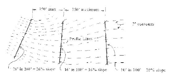
- Any area where there is a change in elevation which is equal to or greater than ten percent (10%) (1 foot of vertical grade change for every 10 feet of horizontal run) for a distance of one hundred feet (100') or more, and where said grade change covers an area of at least two (2) contiguous acres, or an entire parcel if said parcel is less than two (2) acres. (See section 152-24-9, appendix diagram A, of this chapter.)
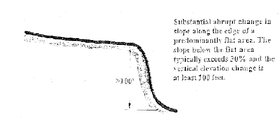
- Any area within one hundred feet (100') of the edge of a bluff. The "edge of a bluff" means an area where there is a substantial abrupt change in slope along the edge of a predominantly flat area of land. The slope of the land below the abrupt edge typically has a grade that is near or exceeds thirty percent (30%) or greater, and has a vertical elevation change of at least one hundred feet (100') or greater, and lies within sensitive lands described in subsection A of this section. (See section 152-24-9, appendix diagram B, of this chapter.)
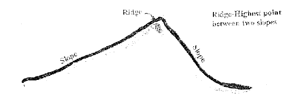
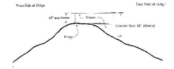
- The boundaries of all areas within one hundred (100) vertical feet of a ridgeline. A "ridgeline" means the junction of a rising steep slope on one side and a descending slope that may be gentle or steep on the opposite side. (See section 152-24-9, appendix diagram C, of this chapter.)
Sec 152-24-3 Determination Of Applicability
- Application Of Chapter:
The regulations contained in this chapter shall apply to land development which includes any of the following:- Any grading not associated with an approved project of the types listed in subsection A3 of this section, when such grading will:
- Disturb ten thousand (10,000) square feet or more of land area;
- Create a cut or fill over three feet (3') in height; or
- Create trenching over two hundred feet (200') in length.
- Any activity associated with a building permit, including grading on a vacant lot or parcel not previously approved in accordance with the provisions of this chapter, but excluding any lot or parcel located in a subdivision which received preliminary plat approval prior to the effective date of this chapter.
- Any preliminary plat, planned development, site plan review, conditional use permit and any other land use development permit authorized by this Land Use Code.
- Hillside and ridge areas as set forth in subsection 152-24-5A of this chapter.
- Any grading not associated with an approved project of the types listed in subsection A3 of this section, when such grading will:
- Support Information:
An applicant may provide information to support a determination that the project is not located on sensitive lands. Further on site investigation from licensed professionals may be necessary to conclude whether or not a project is located on sensitive lands. - Zoning Administrator Determination:
If additional information is provided by an applicant, the zoning administrator shall review the information and make a final determination whether or not the project is subject to this chapter. The zoning administrator may also review the project on site and may determine the project is not located on sensitive lands and therefore not subject to this chapter. The decision of the zoning administrator may be appealed in accordance with the provisions of section 152-7-19 of this chapter. - Other Applications:
In most instances the application required by this chapter is intended to be submitted as a parallel application with another land use application such as a preliminary plat under chapter 39, "Subdivisions", of this chapter and processed simultaneously. - Conflicting Provisions:
This chapter sets forth provisions that may affect other chapters of this chapter and subdivision regulations set forth in chapter 39, "Subdivisions", of this chapter. In the event of conflict, the more restrictive provisions shall apply unless the less restrictive provision specifically provides otherwise. - Zone Change Requests On Sensitive Lands:
Any application to change the zone designation on sensitive lands shall be consistent with the Hildale general plan. - Exceptions:
Exceptions to the provisions of this chapter may be granted by the city council upon recommendation from the planning commission when:- An alternative solution is proposed for the protection of the sensitive land, based on sound and generally accepted engineering and land development principles, and said alternative will result in equal or better protection than development under the standards of this chapter; and is consistent with the purposes of this chapter. The alternative shall also be consistent with the general plan policies affecting sensitive lands;
- The size of the parcel existing before the effective date of the adoption of this chapter is determined by the planning commission to be too small to effectively apply the provisions of this chapter, and conditions can be added to the project to minimize safety and general welfare concerns.
- The parcel is zoned for a nonresidential use and the planning commission determines the site requires grading inconsistent with the provisions of this chapter, and conditions can be added to the project to minimize safety and general welfare concerns.
Sec 152-24-4 Procedure
- Preliminary Activities:
The following requirements shall govern any preliminary activity such as surveying, testing, or design related activities conducted on sensitive lands subject to the provisions of this chapter for the purpose of exploring, evaluating and/or establishing locations for any development, when such preliminary activity may result in:
*Physical disturbance of the site of more than ten thousand (10,000) square feet;
*Cuts or fills more than three feet (3') in depth; or
*Trenching more than two hundred feet (200') in length.- Proposals for preliminary activities shall be submitted to the zoning administrator for review and approval. Areas of proposed disturbance shall be staked at the applicant's expense. Following staking, city representatives shall have a reasonable opportunity to observe the staking. Prior to granting a permit for preliminary activities, depending on the scale of the activity, the zoning administrator may request written input from the city engineer.
- After observation of a proposed development site, the zoning administrator and the city engineer may authorize issuance of a permit for preliminary activity. The permit shall be limited to the staked areas of proposed disturbance and may include conditions for the following:
- Implementation of adequate erosion control measures to protect affected areas. Supplemental erosion control measures may also be required between initial disturbance and either construction of permanent improvements, or restoration of disturbed areas.
- Limitations on cuts and fills to ensure that such cuts and fills are made only where necessary to obtain access for required testing, and that no safety problems will be created.
- Requirements for restoration of disturbed areas where permanent improvements are not constructed within a reasonable time following the disturbance.
- Any other reasonable condition necessary to avoid unnecessary land disturbance and to protect adjoining property.
- Approvals from state or federal agencies that have jurisdiction over development action on the site shall be required before permit issuance.
- Following the completion of any preliminary surveying, testing, or design related activities in accordance with this subsection, any permanent improvements subsequently developed or installed shall conform to the provisions of this chapter.
- Development Project And Permit Review Authority:
The designated authority for the review and approval of projects subject to the provisions of this chapter is as follows:- Planning Commission Responsibility:
Any proposal for development other than building and grading permits for a single-family dwelling shall be reviewed by the planning commission to determine compliance with requirements of this chapter. A development plan required for a project subject to chapter 39, "Subdivisions", of this chapter shall be reviewed and approved by the planning commission at the preliminary plat stage. Appeals of a planning commission decision on sensitive land issues shall be made in accordance with the provisions of section 152-7-19 of this chapter. - Zoning Administrator Responsibility:
The zoning administrator is responsible for applying the provisions of this chapter to single-family building permits and grading permits for single-family dwellings on parcels not associated with a project previously approved by the planning commission, and approving these permits when found to be consistent with this chapter. Appeals of the zoning administrator's decision shall be heard in accordance with the provisions of section 152-7-19 of this chapter. - City Council Responsibility:
Following receipt of a recommendation from the planning commission, or on appeal, the city council shall hold a public hearing on the application. Following a public hearing the city council may approve, approve with conditions, or deny the proposed development plan. - Final Approval:
Final approval shall require satisfactory compliance with all of the requirements of the development plan and compliance with any companion application conditions, i.e., preliminary plat, conditional use permit, zoning map change, or other applicable requirements of this Land Use Code.
- Planning Commission Responsibility:
Sec 152-24-5 Hillsides And Ridge Areas
- Applicability:
The following procedures, submittal requirements and standards shall apply to those projects located on lands identified as having at least one of the following characteristics:- Slopes over ten percent (10%) which are:
- Identified through computer generated programs capable of calculating slopes on topographic maps prepared with two foot (2') contour interval accuracy; or
- Established by profile lines drawn perpendicular to contour lines at intervals no greater than one hundred fifty feet (150') apart, when the slope, measured along any one hundred foot (100') segment of the profile line is ten percent (10%) or greater. (See section 152-24-9, appendix diagram A, of this chapter.)
- A slope shall be subject to this chapter only when a contiguous identified area of ten percent (10%) or greater exceeds two (2) acres, or if the site is less than one acre and the entire site is ten percent (10%) or greater.
- Lands located within one hundred (100) vertical feet of a ridgeline measured perpendicular from the ridgeline; and
- Lands located within one hundred feet (100') of an edge of a bluff.
- Slopes over ten percent (10%) which are:
- Conceptual Review:
At the option of the applicant, a concept plan may be submitted for review by either city staff and/or the planning commission. The purpose of conceptual review is to determine general consistency of the concept plan with this chapter. While comments may be offered, no approval or denial action on the concept plan will occur. The submittal of the concept plan should include the information set forth in subsections B1 and B2 of this section. While not mandatory, the submittal of all data listed will enable the staff and planning commission to provide more thorough comments on the concept plan.- A development plan map, drawn to a scale of one inch equals one hundred feet (1" = 100') or larger, which shows:
- Two foot (2') contour intervals where slopes are zero to twenty nine percent (0 - 29%); and five foot (5') contour intervals where slopes are thirty percent (30%) or greater. Contour maps based on interpolation of maps with larger contour intervals are not acceptable.
- Natural slopes having grades of ten to twenty nine percent (10 - 29%) and natural slopes of thirty percent (30%) or greater shall be color shaded clearly showing the difference between the two (2) categories.
- Proposed development layout of lots, roads, schools, churches, parks, open space, fire stations, commercial, cut or fill slopes or area of disturbances, and any other proposed land use.
- The grades of all existing or proposed roads.
- A report which indicates:
- Total development area;
- Total number of lots and dwelling units;
- Proposed density, and/or density to be transferred, including applicable bonus if any;
- Percentage of each use, such as residential, commercial, recreational, roads, etc.; and
- The justification for the project design, which includes a statement on how the project is consistent with the general plan and this chapter, emphasizing how mitigation has been applied to reduce impact on sensitive lands, or how sensitive lands have been avoided.
- A development plan map, drawn to a scale of one inch equals one hundred feet (1" = 100') or larger, which shows:
- Development Plan Submittal:
Following conceptual review, if such was requested by the applicant, development plan approval shall be obtained. The following information and reports along with any fee established by the city's schedule of fees, shall be submitted as part of an application for development plan approval, and may be in addition to information required for preliminary plat approval for a subdivision:- Development Plan:
A development plan which clearly shows:- Two foot (2') contours. The contour map shall be prepared and certified by a licensed professional civil engineer or surveyor drawn at a scale no smaller than one inch equals one hundred feet (1" = 100'). Contour maps based on interpolation of maps with larger contour intervals are not acceptable.
- Field surveys may be required of the applicant by the city to verify the accuracy of the contour lines shown on the contour map.
- Slopes having grades of ten to twenty nine percent (10 - 29%) and natural slopes of thirty percent (30%) or greater shall be color shaded clearly showing the difference between the two (2) categories. This contour information shall either be computer based, or based on profile lines drawn perpendicular to contours at intervals no less than one hundred fifty feet (150') apart, nor greater than seventy five feet (75') from an existing or proposed property line. Grades shall then be determined by calculating the slope along one hundred foot (100') segments of the profile. (See section 152-24-9, appendix diagram A, of this chapter.)
- To determine required minimum lot size (subsection 152-24-6B of this chapter) the average natural grade of each proposed parcel shall be calculated, and indicated on the development plan. The average grade shall be determined by calculating the grade of the natural slope between two (2) opposing property lines, based on profiles taken perpendicular to the contours, no less than one hundred fifty feet (150') apart, nor greater than seventy five feet (75') from an existing or proposed property line. Small washes or rock outcrops which have slopes distinctly different from surrounding property may be excluded from slope determination, if the exclusion of such small areas from slope determination will not be contrary to the overall purpose of this chapter, as reasonably determined by the zoning administrator.
- The proposed development layout of lots, roads, proposed road grades, open space, area of disturbances, and existing native vegetation.
- Soils Investigation Report:
A soils investigation report which contains the following information:- Nature, distribution and classification (unified soil classification) of existing soils to the appropriate depth of influence by the proposed development, but not less than ten feet (10') deeper than the proposed excavations or to bedrock.
- Strength of existing soils, bearing capacity of supporting soils, settlement estimates, collapse and shrink-swell characteristics, lateral pressures and trench excavation limitations.
- Groundwater levels that may affect development and estimated elevation of high groundwater levels.
- Appropriate laboratory testing for classification, consistency, strength and consolidation conditions.
- Slope stability.
- A written statement by the geotechnical engineer, civil engineer, or geologist preparing the soils report describing the general suitability of the site for the owner's intended use. The report shall identify soil constraints to development and shall state the professional opinion of the author as to whether the proposed development plan will mitigate and/or eliminate said constraints in a manner as to prevent hazard to life, hazard to property, and adverse effects. If the soil report prepared for a subdivision shows the presence of critically expansive soils, high water table, organic soils, liquefiable soils, collapsible soils, or other soil problems which, if not corrected, would lead to structural defects of the proposed buildings, damage to the building from the water, or premature deterioration of the public improvements, a soil investigation of each lot in the subdivision shall be required by the city.
- Geotechnical Report:
A geotechnical and geological report subject to the standards and requirements provided therein. - Grading And Drainage Plan:
A grading and drainage plan report which includes stormwater management, erosion, and grading plans describing the methods by which surface water, natural drainage, erosion and sedimentation loss, and hydrologic hazards that will be controlled during and after construction. The plan shall include the following information:- The grading plan shall show present topography, including the location and depth of all proposed fills and cuts of finished earth surfaces, and/or use of retaining walls including height, using a contour interval of two feet (2') when grades are zero to twenty nine percent (0 - 29%) and five foot (5') contours when grades thirty percent (30%) and over.
- The proposed area to be graded shall be clearly delineated on the plan.
- All calculations and proposed details used for design and construction of debris basins, impoundments, diversions, dikes, waterways, drains, culverts and other water management or soil erosion control measures shall be shown. Drainage calculations shall determine runoff volume and peak discharge using the "rational method", "SCS curve number method", or appropriate equivalent. Data provided should include:
- Rainfall depth, duration and distribution;
- Watershed slope and drainage area delineation;
- Land condition of watershed surface;
- Topography of drainage area; and
- Soil descriptions in watershed. Erosion calculations shall employ predictions of soil loss sheet erosion using the universal soil loss equation or equivalent. Data to be provided should include factors of:
- Rainfall intensity and duration;
- Soil erodibility;
- Land slope and length of slope or topography;
- Condition of the soil surface and land management practices in use; and
- Surface cover, grass, pavements, etc.
- License Required:
All required reports shall be prepared by persons licensed to practice their specialty or expertise in the state of Utah, if such license for practice is required. - Expert Advice:
In reviewing technical reports, calculations, and plans which may be required, the city staff or city engineer may find it necessary to obtain the advice of other experts regarding the adequacy of the reports submitted, and the validity of the conclusions and recommendations reached in the reports. In such cases the city staff or city engineer may consult with such experts, with the reasonable costs of these consultations to be borne by the developer prior to any public hearing. The planning commission or city council may require payment by the developer of the costs of such consultations a condition of preliminary or final plat approval.
- Development Plan:
Sec 152-24-6 Hillsides And Ridge Areas; General Development Standards
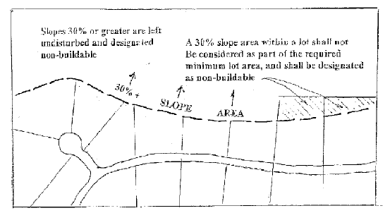
- Unbuildable Slopes:
Except as may be allowed by an exception as set forth in subsection 152-24-3G of this chapter, slopes of thirty percent (30%) or greater shall be undisturbed. Such areas shall be designated as a nonbuildable area if part of a residential lot, or at the election of the owner, these slopes may be offered to the city or a duly created nonprofit conservation organization. Slopes of thirty percent (30%) or greater, if included within a lot, shall not be considered as lot area contributing to the minimum area required in subsection B of this section. (See section 152-24-9, appendix diagram D, of this chapter.) Slopes thirty percent (30%) and greater, but not exceeding forty percent (40%), may be used for street location purposes when needed to provide two (2) ways of access to the project, when the planning commission finds that:- No significant harm will result and the roadway can be provided without creating an obviously visible scar on the hillside;
- The proposed modification will result in a more functional and improved plan; and
- The developer/builder agrees to comply with any conditions or requirements imposed by the planning commission to mitigate any adverse effects which may result from the proposed roadway.
- Subdivision Lot Size:
- The following minimum lot sizes shall be required unless the existing base zone district requires a larger lot area. Lots with slopes averaging less than ten percent (10%) shall be subject to the lot size requirement of the base zone district.
Average Slope (Percent) Minimum Lot Area (Square Feet) Estimated Net Density1 (Units Per Acre) 10 15,000 2.32 11 16,500 2.11 12 18,000 1.94 13 19,500 1.79 14 21,000 1.66 15 22,500 1.55 16 24,000 1.45 17 25,500 1.37 18 27,000 1.29 19 28,500 1.22 20 30,000 1.16 21 31,500 1.11 22 33,000 1.06 23 34,500 1.01 24 36,000 0.97 25 37,500 0.93 26 39,000 0.89 27 40,500 0.86 28 42,000 0.83 29 43,500 0.8
- Based on the assumption that approximately 20 percent of the project area will be streets, the net density shown expresses the estimated yield per acre. As lots increase in size, the actual street percentage will typically decline resulting in a slight increase in net density.
- The following minimum lot sizes shall be required unless the existing base zone district requires a larger lot area. Lots with slopes averaging less than ten percent (10%) shall be subject to the lot size requirement of the base zone district.
- Density Limitations:
- The maximum number of units allowed within a project site shall not exceed the lesser of the following:
- The maximum units allowed by the existing zone district on the project site, plus any bonus allowed by subsection D of this section;
- The maximum number of units resulting from the application of the minimum lot size standards of subsection B of this section, plus any bonus units allowed by this chapter; and
- The maximum number of units allowed by the general plan, plus any bonus units allowed by this chapter.
- To determine the maximum number of allowed units for a project as limited by subsection C1 of this section, the following methods shall be applied:
- The maximum density of a zone district is calculated as follows:
- When all proposed streets are known, the acreage of the total project site shall be reduced by the acreage of existing and proposed streets. This resulting net acreage factor is converted to total square feet and is then divided by the minimum parcel size in single-family zone districts to yield the number of permitted dwelling units. In multiple-family districts the total net acreage shall be divided by the allowed number of units per acre as prescribed by the applicable zone district.
- When the acreage of proposed streets has not been determined, the total acreage of the project site shall be reduced by twenty percent (20%) to accommodate streets, and the resulting net acreage factor is converted to square feet and then divided by the minimum parcel size in single-family zone districts to yield the number of permitted dwelling units. In multiple-family districts the total net acreage shall be divided by the allowed number of units per acre as prescribed by the applicable zone district.
Example 1 - Acreage of streets is known: R1-10 zone Total site acres = 100 net acres (not including street acreage) 100 acres x 43,560 square feet = 4,356,000 square feet total 4,356,000 square feet divided by 10,000 square foot lots = 436 lots Example 2 - Acreage of streets is unknown: R1-10 zone Total site acres = 100 acres 100 acres x .80 = 80 net acres 80 x 43,560 square feet = 3,484,800 square feet total 3,484,800 square feet divided by 10,000 square foot lots = 348 lots
- If densities are calculated using the minimum lot size provisions of subsection B of this section, the total net acreage of each slope category shall be divided by the allowed minimum parcel size of the applicable slope category. Total net acreage shall be determined by reducing total acreage within a slope category by the acreage of existing and proposed streets, or by the twenty percent (20%) street factor using the applicable method of either subsection C2a(1) or C2a(2) of this section. The minimum parcel size allowed by the applicable slope category shall then be divided into the net acreage to determine the dwelling unit yield for the slope category. This calculation shall be done for each slope category of ten percent (10%) or greater on the project site to determine the total allowable number of dwelling units on the project site.
- The general plan densities noted on the future land use map shall be gross densities. Therefore, the maximum number of units permitted by the general plan is determined by dividing the total acreage of the project site (including the acreage of proposed streets if known), by the maximum density (units per acre) as allowed by the applicable general plan land use category.
- The maximum density of a zone district is calculated as follows:
- Any proposed rezoning in sensitive land areas shall be consistent with the general plan and the densities shown on the future land use map.
- If the planned development overlay zone is applied, density may exceed the base zone density to the extent allowed in chapter 23 of this chapter, subject to provisions therein. However, if the density transfer option noted in subsection D of this section is requested in combination with the density bonus provisions of chapter 23 of this chapter, the combination of planned development and density transfer bonuses shall not exceed twenty five percent (25%).
- The maximum number of units allowed within a project site shall not exceed the lesser of the following:
- Density Transfer:
A density transfer from steep slopes (generally greater than 20 percent) and ridge areas to moderate slopes (generally less than 20 percent) on or off site is encouraged and allowed through the processing of a planned development, providing the purposes of this chapter and the general plan are maintained. A density transfer bonus may be allowed as follows:Note:Slope Bonus Factor1 10 - 14% 1.25 15 - 20% 1.5 21 - 25% 2 26 - 29% 2.5 30% or greater No bonus is permitted, but density may be transferred at a rate of 1 dwelling unit for each 10 acres - The allowable transfer including the bonus shall be determined by multiplying the density allowed based on the percent of slope as provided in subsection B of this section by the bonus factor. (Example: In a 26 percent slope area, based on an estimated net density of 0.89 units per acre, applying the bonus [0.89 units per acre x 2.5 bonus factor] a total of 2.23 units per acre of 26 percent slope area may be transferred.)
- Maximum Impervious Material Coverage:
The maximum allowable lot coverage by impervious material (roofs, driveways, walks, patios) shall not exceed fifty percent (50%) maximum coverage on slopes ten to fourteen and nine-tenths percent (10 - 14.9%), and shall not exceed thirty five percent (35%) maximum coverage on slopes fifteen percent (15%) or greater. Areas of impervious material shall be estimated and included in the total impervious surface area calculation for stormwater design purposes.
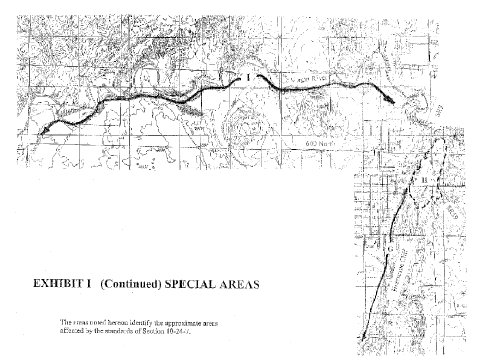
Sec 152-24-7 Special Area Development Standards
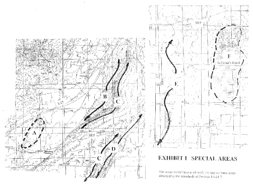
- The standards identified below for each special area shall be applied in addition to the other requirements of this chapter when applicable. It is recognized sensitive lands may be developed in alternative ways that will reduce hazards and preserve aesthetic qualities as effectively as the standards listed below. Therefore, an applicant may propose alternative standards through the "exception" process as permitted by subsection 152-24-3G of this chapter. (See section 152-24-9, "Appendix", of this chapter, for the location of these special areas.)
- Area A - Reserved
- Area B - Reserved
- Area C - Reserved
- Area D - Reserved
- Area E - Reserved
- Area F -Reserved
- Area G -Reserved
- Area H - Reserved
- Area I - Reserved
Sec 152-24-8 Grading, Drainage And Street Development Standards
- Grading, Drainage And Erosion:
The total watershed area shall be used to determine the amount of stormwater runoff generated before and after construction.- A grading and drainage report shall be prepared in which the developer shall describe the methods intended to be employed to control the increased erosion during construction.
- The developer shall be responsible for interim stabilization of all disturbed areas during construction to prevent erosion, and for final stabilization when construction is completed.
- The "SCS curve number method", "rational method", or other stormwater computation method as approved by the city engineer shall be used in computing runoff.
- Maps of the development site at a scale of one inch equals two hundred feet (1" = 200') shall be provided by the developer to the city engineer defining the boundaries of any floodplain and the limits of the watershed.
- Existing drainage and floodway channels shall remain as historically located except that roads and utilities may be installed across such channels as approved by the planning commission and the city council. Where these channel modifications are planned, the developer shall obtain permits from the Utah division of water rights and U.S. army corps of engineers when required by these agencies. The developer shall provide evidence of such permits to the city prior to issuance of a grading permit. Structures and/or lots shall be arranged so as to ensure adequate setbacks from all drainage and floodway channels. The 100-year storm shall be that basis for calculating setbacks.
- Facilities for the collection of stormwater runoff shall be required to be constructed on development sites according to the following requirements:
- Such facilities shall be the first improvements or facilities constructed on the development site.
- Such facilities shall be designed so as to detain safely and adequately the maximum expected stormwater runoff for a minimum 152-year storm, while allowing an off site discharge not to exceed one-tenth (0.1) cubic foot per second per acre. Regardless, stormwater mitigation shall limit runoff volumes and flows so they do not exceed predevelopment levels.
- Such facilities shall be so designed as to divert surface water away from cut faces or sloping surfaces of a fill.
- The existing natural drainage system shall be utilized to the extent possible in its unimproved state.
- Where drainage channels are required, wide shallow swales lined with grass, rock, or other approved material shall be used instead of cutting narrow, deep drainage ditches.
- Flow retarding devices, such as detention ponds, check dams, and recharge berms, shall be used where practical to minimize increases in runoff volume and peak flow rate due to development.
- Erosion control measures on a development site and a drainage design system to control stormwater erosion during and after construction shall be contained in a grading and drainage report submitted by the developer.
- No grading or stripping shall be permitted except as part of a development plan approved in advance by the planning commission, or when such is a preliminary investigative action and is subject to subsection 152-24-4A of this chapter.
- A description of any hydrologic hazards associated with the proposed development site and adjacent area shall be required. Hydrologic hazards may include high water table, surface water impoundments, gradient of the property, floodplains, etc.
- Cut And Fill Slopes:
Development standards for cuts and fill follow:- Cut and fill slopes regulated by the building code shall comply with the following unless more restrictive standards are otherwise recommended in an approved soils and geology report:
- Cut and fill slopes shall not exceed sixteen feet (16') in vertical height. Proposed slopes that are separated by less than fifty feet (50') of horizontal distance shall be considered a single slope, and their combined height shall not exceed sixteen feet (16'). (See section 152-24-9, appendix diagram L, of this chapter.) The fifty foot (50') spacing standard shall apply to slopes on the same lot or within fifty feet (50') of a slope on an adjacent lot.
- Benching and terracing may only occur as a means to reduce the appearance of a slope sixteen feet (16') or less in height (i.e., creating 2 8-foot slopes instead of a single 16 foot slope).
- Cut and fill slopes shall not exceed a slope ratio of two feet (2') horizontal to one foot (1') vertical, except as follows:
- A cut slope is proposed in a stable rock based material and the steeper cut would be preferable over the use of a retaining wall or the revegetation of a larger two to one (2:1) slope, and when the erosion potential will not be increased. Such determination shall be made by a licensed civil engineer or geologist.
- The following additional slope standards shall apply:
- No slopes shall be cut steeper than the bedding plane, fracture, fault or joint in any formation where the cut slope lies on the dip of the strike line of the fracture, bedding plane, fault or joint.
- No slopes shall be cut in an existing landslide, mudflow or other form of naturally unstable slope.
- If the material of a slope is of such composition and character as to be unstable under the anticipated maximum moisture conditions, the slope angle shall be reduced to a stable value or increased through retention using a method approved by the city engineer and certified as to its stability by a professional soils engineer.
- Any cut or fill slope composed of loose material (i.e., not cut into solid rock) shall be revegetated and a permanent irrigation system provided.
- Fill slopes shall not be constructed on natural slopes steeper than two feet (2') horizontal to one foot (1') vertical.
- A roadway cut and fill slope located outside a dedicated public right of way shall be located within a recorded easement providing for slope protection and preservation. The easement shall be in a form acceptable to the city.
- Cut and fill slopes regulated by the building code shall comply with the following unless more restrictive standards are otherwise recommended in an approved soils and geology report:
- Retaining And Stacked Rock Walls:
The following standards shall be applied to retaining walls:- The maximum height of a retaining or stacked rock wall shall not exceed sixteen feet (16'). Retaining or stacked rock walls separated by less than fifty feet (50') of horizontal distance shall be considered as a single wall, and their combined height shall not exceed sixteen feet (16'). (See section 152-24-9, appendix diagram L, of this chapter.) The fifty foot (50') spacing standard applies to walls or slopes on the same lot and when the wall or slope is within fifty feet (50') of a wall or slope on an adjacent lot.
- The vertical height of the retaining wall or stacked rock wall when combined with a cut or fill slope shall be considered part of the allowed slope height (i.e., a 6 foot retaining wall adjacent to a 10 foot cut slope totals 16 feet, and is therefore maximum height of the allowed slope).
- Wherever possible the material and/or color of the retaining or stacked rock wall shall be earth tones indigenous to the area.
- The use of retaining and stacked rock walls to reduce earth and vegetation disturbance is encouraged, especially when revegetation is not practical and the slope would be visible to the public.
- The design of retaining walls and stacked rock walls over four feet (4') in height require engineering design and shall conform to building code requirements.
- Streets And Rights Of Way:
The following street standards shall apply:- The city's street standards and specifications shall apply to all development, except where conditions related to proper development of sensitive land areas necessitate altering these standards as described below and elsewhere in this chapter and as may be otherwise approved by the city.
- Street grade requirements:
Normal Permissible Exception
Maximum grade 8 percent 12 percent
Maximum grade street
Intersections
5 percent As determined by the planning commission - Streets, roadways and private accessways shall follow as nearly as possible the natural terrain.
- Two (2) points of access to a through road shall be provided for emergency and firefighting equipment access for residential projects containing thirty (30) or more lots or residential units. The second access may be temporary when the planning commission finds:
- The access road is developed to a grade, width, structural standard and surface capable of accommodating emergency vehicles and two-way traffic; and
- Permanent secondary access will be provided in the future as other phases of the project are developed, and/or there is reasonable expectancy the development of adjacent lands in the foreseeable future will provide the second permanent access.
- All fill slopes shall be contained within a public right of way, or shall be located within recorded easements providing for slope protection and preservation. The easements shall be in a form acceptable to the city.
- Variations of street design standards developed to solve sensitive land and functional problems may be presented to the planning commission for consideration. Examples of such variations may be the use of split roadways to avoid deep cuts, one-way streets, modifications of surface drainage for curb, gutter and sidewalk design and other innovative designs for sensitive lands development.
- The provisions of this chapter shall not apply to streets or rights of way already constructed or which have heretofore been approved by the city.
- On Site Development:
The property owner or developer shall be fully responsible for making all improvements in accordance with the development site approval, e.g., streets, utilities, drainage, erosion, walls and vegetation requirements. - Bond:
In addition to the provisions requiring the posting of a bond as set forth in chapter 39 of this chapter, the developer or property owner shall be required to guarantee the stabilization of grading sites, cuts and fills, and construction of stormwater runoff facilities, and the construction of recreation space as may be required in this chapter. Such bond shall be in an amount equal to one hundred ten percent (110%) of the cost of construction of such work and shall continue for eighteen (18) months after the completion date of such.
Sec 152-24-9 APPENDIX: List Of Diagrams And Exhibits
- Slope determination
- Bluff
- Ridgeline
- Nonbuildable area
- Density clustered on lower one-third of slope
- Bluff trail
- Sullivan's Knoll
- Ridge top setback
- Special areas
- Typical profile Hildale Cliff
- Bluff setback point
- Maximum allowed cut/fill/retaining walls
- Maximum building height on Hildale Cliff
Diagrams:
A - Slope determination
B - BLUFF
C - RIDGELINE
D - NONBUILDABLE AREA
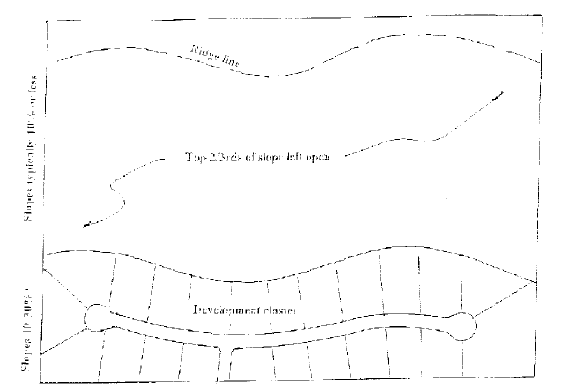
E - DENSITY CLUSTERED ON LOWER ONE-THIRD OF SLOPE
F - BLUFF TRAIL
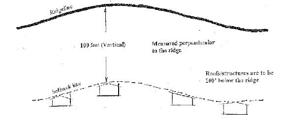
H - RIDGE TOP SETBACK
J - TYPICAL PROFILE HURRICANE CLIFF
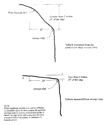
K - BLUFF SETBACK POINT
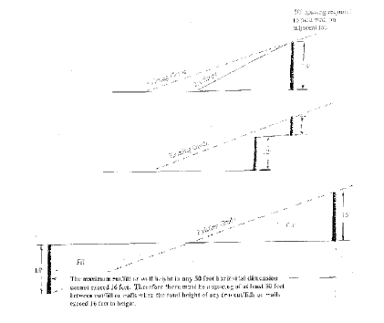
L - MAXIMUM ALLOWED CUT/FILL/RETAINING WALLS
M - MAXIMUM BUILDING HEIGHT ON HURRICANE CLIFF