
Hillsborough County Unincorporated
City Zoning Code
City Zoning Code
ARTICLE V
DEVELOPMENT OPTIONS
PART 5.00.00 - GENERALLY
Development may be pursued in a variety of different ways. This Article sets forth the development options established by Hillsborough County. Depending on the circumstances of particular development scenarios, these options may be used singly or jointly. Where necessary the provisions relating to the different development options contain design standards that supplement or replace particular standards in Article VI, and procedures which supplement or replace particular procedures in Article X.
PART 5.03.00 - PLANNED DEVELOPMENT DISTRICTS[1]
Editor's note— Ord. No. 06-18, § 2, adopted August 1, 2006, amended Part 5.03.00, in its entirety, to read as herein set out. See also the Table of Amendments.
PART 5.04.00 - PLANNED VILLAGE[2]
Editor's note— Ord. No. 21-39, adopted Oct. 14, 2021, effective Oct. 22, 2021, amended Part 5.04.00 in its entirety to read as herein set out. Former Part 5.04.00, §§ 5.04.01 and 5.04.02, pertained to general provisions and design rules, and derived from Ord. No. 00-21, § 2, adopted May 18, 2000; Ord. No. 05-22, § 2, adopted Nov. 17, 2005; and Ord. No. 09-62, Item K, adopted Oct. 26, 2009, effective Feb. 1, 2010.
PART 5.08.00 - MIXED-USE AND INFILL TND CODE[3]
Editor's note— Ord. No. 13-22, § 2, effective August 15, 2013, establishes a moratorium on the acceptance and processing of new applications for rezoning to the Mixed-Use Development zoning district as set out in section 2, "Board of County Commissioners hereby declares zoning in progress and establishes a moratorium on the acceptance and processing of new applications for rezoning to the Mixed-Use Development zoning district for a period of 180 days from the effective date of this Ordinance in order to preserve status quo while the provisions of the district are being reviewed. This moratorium will not prevent the development of any property in accordance with the provisions of its current zoning designation or the consideration of any rezoning application other than those requesting rezoning to the Mixed-Use Development zoning district."
Sec. 5.01.01. - Generally
A.
Purpose
The purpose of the Subdivision Regulations is to set forth regulations regarding the subdivision and development of land in unincorporated Hillsborough County in order to protect the health, safety, welfare, and general well being of the citizens of Hillsborough County.
B.
Objectives
It is intended that the implementation of these regulations accomplish the following objectives:
1.
Provide efficient and effective review, determination, and compliance procedures;
2.
Ensure proper legal description, identification, monumentation, and recording of property boundaries;
3.
Ensure adequate access;
4.
Prevent the haphazard subdivision of land and the inadequate provision of physical improvements;
5.
Ensure that a subdivision development complies with other rules and regulations, such as zoning and environmental regulations, pertinent to the development;
6.
Ensure safe and convenient traffic control;
7.
Prevent flooding within subdivision developments by providing adequate flood control and drainage facilities;
8.
Ensure the installation of necessary and adequate roads, water, wastewater, and sidewalk facilities; and
9.
Ensure compliance with Chapter 163, Florida Statutes, and the Future of Hillsborough Comprehensive Plan.
C.
Applicability
Whenever land in unincorporated Hillsborough County is divided so as to constitute a subdivision as defined herein, such subdivision of land shall be in compliance with the requirements set forth in these regulations. The entire parent parcel for any subdivision shall be reviewed by the County in conjunction with the subdivision review for any portion of the parent parcel. The subdivision of land shall be reviewed as a Certified Parcel Subdivision, Platted Subdivision With No Improvement Facilities, Platted Subdivision With Improvement Facilities.
D.
Compliance with Comprehensive Plan
No division of land shall be allowed that is in conflict with the densities, intensities, or other provisions of the Future of Hillsborough Comprehensive Plan.
E.
Compliance with Other Regulations
No parcel of land shall be created, either by inclusion within or exclusion from a proposed subdivision, which cannot be properly utilized for a permitted use under the existing Zoning Regulations. A subdivision development shall meet or exceed the relevant requirements of all land development regulations adopted by Hillsborough County. The approval of a subdivision development does not abrogate any legal requirement to comply with the regulations of any other governmental agency, local, state, or federal, which may have jurisdiction over the proposed activity.
F.
Taxes
No land shall be divided or subdivided and no drawing or plat of the division or subdivision of any land shall be filed or recorded in the public records of any court until all taxes have been paid on the land.
G.
Exemptions
Certain parent parcels or subdivisions created prior to July 26, 1989 may be exempt from these regulations. (See 11.03.00, Nonconformities.)
H.
Design Objectives
A subdivision development should be designed to create a functional and attractive environment, minimize adverse impacts, provide maximum livability, provide safe and efficient access and circulation, and generally be an asset to a community. The Administrator may, in the application of these standards and guidelines, exercise design discretion to achieve the intent and purpose of these regulations.
Sec. 5.01.02. - Subdivision Types
A.
Generally
Subdivision regulations apply when a parent parcel is subdivided.
B.
Classification of Subdivisions
There are two types of subdivision reviews regulating the division of property in unincorporated Hillsborough County. They are as follows:
1.
Certified Parcel Subdivision Review
a.
Certain parent parcels may be subdivided, subject to a Certified Parcel Subdivision review, and not be required to be reviewed as a Platted Subdivision. This is an administrative determination limited to a maximum of two lots, which contain no improvement facilities; and
(1)
Have direct access to an existing publicly owned and maintained right-of-way; or
(2)
Have direct access to an existing privately owned and maintained right-of-way which meets County standards; or
(3)
Have access to an existing publicly-owned and maintained right-of-way via a legally established existing common use area or easement, provided the easement width meets the standards of 6.02.01 B 4 c.
(4)
Compliance with the adequate facilities provisions (commonly known as "concurrency") prescribed by this Code.
b.
The following types of parcels shall qualify for review as a Certified Parcel Subdivision, provided the criteria described in the subsection above are met:
(1)
Are part of a platted subdivision approved by the BOCC.
(2)
The residual parcel (of a parent tract) not required by the County or proposed by the applicant for inclusion within a Platted Subdivision.
(3)
Any number of parent parcels or certified parcels assembled into a larger parent or certified parcel.
(4)
Parent parcels created by platted lot, deed, or folio number prior to July 26, 1989.
(5)
Parcels created by the court under probate or testate.
(6)
Parcels for which a Site Development Plan has been approved.
(7)
Parcels granted legal nonconforming status per 11.03.00.
2.
Platted Subdivision Review
A Platted Subdivision is a subdivision for which roads, easements for access, drainage, or utilities, conservation or preservation areas or easements, and/or improvement facilities may be required or proposed depending on the size and location of the subdivision. Platting of lots shall be required for this type of subdivision.
(Ord. No. 97-18, § 2, 12-18-97; Ord. No. 99-25, § 2, 11-18-99; Ord. No. 08-15, § 2, 6-12-08, eff. 10-1-08)
Sec. 5.02.01. - Purpose
A.
Construction activity upon the land is an element in the process of community development. Such activity impacts public utilities, facilities, roadways and adjacent land and their use. Therefore, in the interest of the public health, safety and welfare, it is necessary that these activities be carried out in a proper and orderly fashion and in accordance with Hillsborough County standards.
B.
The purpose of the site development regulations is to establish procedures and standards for the review of construction activities and site development, except for single family and duplex residential development, and Community Residential Type A, in order to ensure the following:
1.
Provision of efficient and effective review, determination and compliance procedures;
2.
Prevention of flooding within developments by ensuring adequate flood control and drainage facilities are provided;
3.
Traffic hazards are minimized and traffic flow is enhanced, including pedestrian traffic;
4.
Developments are compatible with the sites as well as adjacent uses;
5.
Developments are responsive to the environment and protection of environmentally sensitive areas;
6.
Availability and type of water and wastewater utilities serving the sites;
7.
Developments have adequate fire protection; and
8.
Compliance with Chapter 163, Florida Statutes and the Future of Hillsborough Comprehensive Plan.
9.
Compliance with the adequate facilities provisions (commonly known as "concurrency") prescribed by this Code.
(Ord. No. 99-25, § 2, 11-18-99)
Sec. 5.02.02. - General Requirements
A.
Site development plans shall be required for all new development in accordance with the site development regulations of this Article in order to assist Hillsborough County administrative officials in assuring that development is in compliance with all applicable ordinances, regulations and resolutions of this County.
B.
All land uses shall be required to have a site development plan approved by the Administrator and any other department or agency deemed necessary by the Administrator prior to the issuance of a Natural Resources Permit or building permit or commencing any on site land alteration or construction activity. Single family, two family detached dwellings and Community Residential Home Type A, on individual lots with their accessory uses and structures shall be exempt from the site development regulations.
C.
In instances where lots have been created and Improvement Facilities have been approved and constructed in accordance with the subdivision regulations, then a site development review shall be required for development upon those lots except as provided herein.
D.
All development reviewed under the site development regulations shall comply with the densities and intensities and other provisions established within the Future of Hillsborough Comprehensive Plan; unless otherwise excepted therein.
E.
All development shall meet or exceed the requirements of all land development regulations as established and adopted by Hillsborough County, the state of Florida and the federal government unless such requirements have been waived by those governments.
F.
The approval of a Site Development Plan and the issuance of a Natural Resources/Landscaping Permit are required by Hillsborough County before building permits may be issued for construction.
G.
Where lands have been or are subdivided or resubdivided, but ownership is described by metes and bounds without recording a plat in the manner and form required by regulations in effect at the effective date of the site development regulations, such lands may be used in accordance with the terms of the site development regulations provided:
1.
That all necessary public facilities, services, and utilities are available to or located on such lands, or an agreement satisfactory to the Board has been made and recorded whereby the deficiencies in necessary public facilities, services, or utilities will be remedied, and appropriate waivers, variances, or exemptions have been obtained; or
2.
That a plat of such land be recorded in the manner and form of and subject to, the requirements existing in regulations in effect at the time of the recording of such plat.
Sec. 5.02.03. - Unified Site Development Plans
A.
Nothing in this Code or this Part shall be construed to prevent the submission of a unified plan for a site(s) comprised of multiple zoning districts, parent parcels or lots, provided the site is under unified ownership and/or control at the time of application for Preliminary Site Development Plan or site construction plan approval.
B.
In no event may this authority to approve a unified development plan be construed to grant or extend use privileges or to alter standards otherwise prescribed by this Code for a Zoning Lot, Parent Parcel or Lot (for example, commercial parking may not be extended into a portion of the site where commercial parking is not otherwise permitted).
C.
Because the unified site development plan is optional to the applicant(s), the Administrator may exercise broad discretion in the review and approval of unified site development plans, and may impose conditions upon such approval through legally enforceable instruments to assure that the intent of this Code is met, that the integrity of the unified site development plan is maintained and that the public interest is properly protected, including, but not limited to, maintaining compliance with Planned Development zoning requirements pursuant to Section 6.02.19 and Section 6.03.14 of this Code. Such approval conditions may impose additional requirements including but not limited to certifications, reciprocal easements and/or agreements, development agreements, dedications, reservations, plats and other means as may be deemed appropriate.
(Ord. No. 14-3, § 2(Exh. A), (Item IV-A), (13-0719), 1-30-14, eff. 2-6-14; Ord. No. 15-15, § 2(Exh. A), Item A.1(15-0461), 6-18-15, eff. 6-25-15)
Sec. 5.02.04. - Preservation of Natural Features
Site development plans shall be designed so as to conform to and take advantage of topographic and other natural features of the land, including the preservation of existing trees, wetlands, water bodies, wetlands and environmentally sensitive areas as required by law, ordinance and rule. Preservation Areas and Conservation Areas shall be shown on the Site Development Plan. Applicable setbacks from these areas shall also be shown. No new development, nor expansion nor replacement of existing development shall be permitted in areas designated on the Future Land Use Map as Natural Preservation, unless consistent with conservation purposes, such as passive recreation.
Sec. 5.02.05. - Compliance with this Code
No parcel of land shall be created or used which does not meet the minimum requirements of this Code.
Sec. 5.02.06. - Compliance with Subdivision Regulations
No parcel of land shall be developed under the site development regulations which has been subdivided improperly. Upon the determination by the Administrator that the parcel is part of an improper subdivision, the applicant shall be required to do one of the following:
A.
Plat the proposed lot;
B.
Vacate the existing subdivision and replat the proposed subdivision;
C.
Determine if a variance to the subdivision regulations is appropriate.
Sec. 5.03.01. - Generally
A.
These districts are used for customized purposes in cases where standard district regulations are inadequate to protect surrounding property or where design flexibility is sought. The intent of these districts is to encourage creative, innovative, and/or mixed use development, and to insure and promote land use compatibility and harmony for land that is to be planned and developed as a whole in a single development operation or a definitely programmed series of development phases.
(Ord. No. 06-18, § 2, 8-1-06)
Sec. 5.03.02 - General requirements
A.
The application shall be submitted in accordance with the requirements listed in Section 6.0 of the Development Review Procedures Manual (DRPM).
B.
Mixed-Use Comprehensive Plan Categories. Applications greater than two (2) acres in size that are located in a Mixed-Use Comprehensive Plan Category shall be required to be rezoned to a PD, PD-S or a mixed use standard zoning district.
(Ord. No. 06-18, § 2, 8-1-06; Ord. No. 08-30, § 2, eff. 2-1-09)
Sec. 5.03.03 - Additional notice requirements
A.
The required public notice shall specifically note that the PD application creates its own customized zoning district and that the PD application and approval process may be used to obtain variances from the non-district regulations as set forth in Section 11.04.02.B, excluding the hardship provision.
(Ord. No. 06-18, § 2, 8-1-06)
Sec. 5.03.04. - Planned development district options
There are two district options an applicant may select from when applying for a Planned District rezoning.
A.
Planned Development - (PD)
The PD District is intended to be used when unified, large scale, mixed use developments are proposed in areas lacking a predominant urban/suburban development pattern and adjacent land use compatibility is not a significant factor. Broad, general concept plans would be permitted with limited flexibility to accommodate land use changes in response to evolving market conditions.
B.
Planned Development - Specific (PD-S)
The PD-S District is intended to be used for the purpose of binding development to a negotiated specifically detailed site plan with a list of specific conditions that insures compatibility and harmony with surrounding areas.
(Ord. No. 06-18, § 2, 8-1-06)
Sec. 5.03.05. - General site plan information
A.
Planned Development - (PD)
The General Site Plan for PD districts shall include sufficient information in accordance with the site plan submittal requirements referenced in the Development Review Procedures Manual Section 6.2.1.7 (General Development Plan).
B.
Planned Development - Specific (PD-S)
The General Site Plan for PD-S districts shall include sufficient information in accordance with the site plan submittal requirements referenced in the Development Review Procedures Manual.
1.
Concurrent Preliminary Plat and/or Site Development Review Option - applicants for PD-S zoning shall have the option of simultaneously applying for a concurrent preliminary plat and or site development review provided they include all of the information and documentation required in accordance with the Development Review Procedure Manual Sections 4.1.4.1.2.2.1.D (Preliminary Plat) or Section 4.1.5.1.1.D (Preliminary Site Development Plan).
C.
Transportation Information Required in all Planned Development Plans
In addition to subsections A and B above, General Development Plans for proposed PD districts shall provide the following transportation information:
1.
Any applicable standards and guidelines for access to Public Roads for residential projects or subdivisions per Section 6.02.01 of this Code shall be incorporated to the site plan design including, but not limited to:
a.
Provide multiple direct connections in its local street system to and between local destinations, such as parks, schools, and shopping, without requiring the use of arterial streets;
b.
Incorporate and continue all collector or local streets stubbed to the boundary of the development plan by previously approved but unbuilt development;
c.
Provide street stubs to facilitate access to all abutting properties or to logically extend the street system into the surrounding area to ensure future street connections where a proposed development abuts unplatted land or a future development phase of the same development;
d.
Connect streets, alleys, and pedestrian pathways to other streets and to existing and projected streets outside the proposed subdivision or other development;
e.
The arrangement of streets in new projects shall make provisions for the continuation of existing arterial and collector streets from adjoining areas, or for their projection where adjoining land is not subdivided. Where the proposed PD is adjacent to another subdivision, property owned by the Board of Education (currently, or planned as, a school site), or commercial areas, direct access shall be provided for non-motorized traffic where feasible;
2.
Any applicable standards and guidelines for Access Management per Section 6.04.00 of this Code shall be incorporated in the site plan design, including, but not limited to, Cross-Access Criteria and Requirements found in Section 6.04.03.Q. of this Code shall be incorporated in the site plan design as provided below:
a.
When each of the following conditions exist, provisions for vehicular and pedestrian cross-access must be demonstrated:
i.
The site is on at least one roadway with an Access Management Classification of 1 through 6.
ii.
The site has a commercial or office land use or zoning designation, and is adjacent to a parcel which also has a commercial or office land use designation or zoning and which has access on the same roadway.
b.
When each of the following conditions exists, provisions for pedestrian cross-access must be demonstrated:
i.
The site has frontage on at least one roadway with an Access Management Classification of 1 through 6,
ii.
The site has a commercial or office land use or zoning designation and is adjacent to a parcel having frontage on the same roadway which has a land use or zoning designation allowing 12 dwelling units per acre or more, or
iii.
The site has a residential land use or zoning designation allowing 12 dwelling units or more per acre and is adjacent to a parcel having a land use or zoning designation of 12 dwelling units or more per acre or a commercial or office land use or zoning designation and which has access on the same roadway.
c.
When the criteria in a or b above are met, provisions for cross-access must be demonstrated as established below:
i.
If the adjacent site is developed and, in the opinion of Hillsborough County, cross-access is feasible, the developer shall show the appropriate cross-access to the property line of the adjacent parcel.
ii.
If the adjacent site is developed but, in the opinion of Hillsborough County, cross-access is not feasible at this time, the developer shall design and designate on the site plan the location of future cross access, but will not be required to construct the cross-access at the time of initial site development. The owner shall commit, in writing, to construct and allow cross-access at such time as Hillsborough County determines that cross-access is feasible and desirable.
iii.
If the adjacent site is undeveloped, the developer shall indicate the cross-access to the property line of the adjacent parcel in anticipation of future connection when that site is developed.
3.
Any applicable Private and Charter Schools Vehicle, Circulation, Queuing and Parking requirements found in Section 6.03.13 of this Code shall be incorporated in the site plan design.
4.
Any applicable requirements contained within Article III, Special Districts, of this Code shall be incorporated in the site plan design.
5.
Requests for relief from the above requirement to show this information on the PD site plan shall be reviewed in accordance with the LDC Section 5.03.06.C.6.b. for Variations for Site Design. Requests for relief from each individual requirement shall be processed in accordance the applicable variance process (e.g. most Section 6.04 standards are varied through the Section 6.04.02.B. Administrative Variance Process).
6.
Notwithstanding the above, the extent to which compliance with individual requirements shall be demonstrated on a PD site plan may be a function of the amount of detail shown on the PD site plan. For example, when detailed internal designs are not provided, determination of compliance with minimum throat depth standards (reference Sections 6.04.03.G. and 6.04.04.A.) can be deferred to the site/construction plan review process.
(Ord. No. 06-18, § 2, 8-1-06; Ord. No. 20-17, § 2(Exh. A), 9-24-20, eff. 10-2-20; Ord. No. 21-41, § 2(Exh. A), 10-21-21, eff. 10-28-21)
Sec. 5.03.06. - Review procedures
A.
Generally
Except as modified below, the Procedure for Amendments to the Official Zoning Atlas in Part 10.03.00 of this Code and Section 6.0 of the Development Review Procedures Manual shall be followed in the review of a PD application.
B.
Pre-submittal Requirements
1.
Pre-Submittal Conference - Prior to submitting an application for a PD or PD-S District, the applicant shall be permitted to have a pre-submittal conference with Zoning and other applicable staff. If the petitioner elects to have a pre-submittal conference, a sketch plan shall be provided for review at the conference which is intended to address the following:
a.
The relationship between the anticipated project and surrounding uses and the consistency of the proposed development with the County's Comprehensive Plan and/or stated planning and development principles of the Land Development Code.
b.
The nature, design and appropriateness of the proposed land use arrangement for the size and configuration of the property involved.
2.
Neighborhood Meeting - An applicant shall be required to conduct a neighborhood meeting if requested by any resident that received mailed notice of the rezoning provided the meeting is requested 14 calendar days prior to the Zoning Hearing Master Hearing. The applicant's contact information (name, telephone number, and/or email address) shall be included in the rezoning notice. This information is to be utilized for contacting the applicant's representative to obtain additional information and for requesting a neighborhood meeting.
Applicant Initiated Neighborhood Meeting - As an option to satisfy the neighborhood meeting requirement, the applicant may conduct a neighborhood meeting prior to and in lieu of receiving a request by a noticed resident. If the applicant chooses to have the neighborhood meeting, notice of the meeting (to include the location, time, and date of the meeting) must be included in the required mailed notice of the rezoning. The applicant initiated neighborhood meeting must be held a minimum of 10 days after the required notice deadline.
a.
If a neighborhood meeting is required, or initiated by the applicant to satisfy this requirement, the meeting must start between 6:00 pm and 7:30 pm on weekdays and between 9:00 am and 5:00 pm on weekends. The meeting must be held within the general area of the subject application. A summary of the meeting as well as a sign-in sheet for those attending the meeting shall be submitted by the applicant for inclusion in the staff report.
b.
Mailed notice of the neighborhood meeting shall comply with notification distances set forth in Section 10.03.02.E.1 and to neighborhoods which qualify in Section 10.03.03.F
C.
Actions by the Board of County Commissioners
1.
Actions by the Board shall be as provided for amendments generally. It may grant the application in accord with PD and other applicable regulations, approve with modifications and/or conditions, or may deny the application.
2.
If the amendment is granted, the Board shall, in its amending action, approve the General Development Plan or indicate required modifications or conditions. Such approved plans, with any required modifications or conditions, shall be binding in determinations concerning consistency of applicable subdivision and site development plans.
3.
If the amendment is granted, the development shall be required to be in accord with applicable subdivision and site development plans meeting the requirements of these and other regulations, as supplemented or modified by the Board in the particular case as part of the amending action, and shall conform to any time limitations established by the Board on beginning and completion of the development as a whole or in specified stages.
4.
Before development may proceed, any required agreements, contracts, sureties, and other instruments involved must be executed and found to be in compliance with the Board of County Commissioner's conditions by the appropriate officer(s) and agencies.
5.
If in approving the amendment the Board designates by condition any site design features or conditions which it identifies as being a "critical design feature", then any proposed alteration to such a feature or condition shall require a public hearing, as provided in Section 5.03.07.A. A critical design feature is any essential feature or condition of zoning identified by the applicant and confirmed by the public as necessary to the development of the planned development (PD) district which upon review is designated as such by the Board.
6.
Variations for Site Design
a.
The purpose of the Planned Development District is to allow flexibility in certain site development standards in order to achieve creative, innovative, and/or mixed use development. The following non-district regulations may be varied as part of a Planned Development based upon the criteria contained herein:
(1)
Part 6.05.00, Parking and Loading Requirements;
(2)
Part 6.06.00, Landscaping, Irrigation, and Buffering Requirements; and
(3)
Part 6.07.00, Fences and Walls.
(4)
Requests to vary any other non-district regulations in this Code must be reviewed and approved through separate application in accordance with Part 11.04.00.
b.
The following are the criteria for consideration of a variation through a Planned Development District:
(1)
The variation is necessary to achieve creative, innovative, and/or mixed use development that could not be accommodated by strict adherence to current regulations.
(2)
The variation is mitigated through enhanced design features that are proportionate to the degree of variation.
(3)
The variation is in harmony with the purpose and intent of the Hillsborough County Land Development Code.
(4)
The variation will not substantially interfere with or injure the rights of adjacent property owners.
c.
The project narrative shall include a description of each variation being requested and a description of how each variation complies with the criteria contained herein. The PD site plan must identify all variations being proposed.
d.
Recommendations of the Zoning Hearing Master and the Zoning Administrator shall include a finding regarding whether the variations requested as part of a Planned Development rezoning meet the criteria. Approval of any planned development that includes a variation of non-district regulations shall constitute a finding by the BOCC that the variations meet the criteria contained herein.
7.
Approval by the Board of County Commissioners of a PD-S District site plan with the Concurrent Preliminary Plat, Site Development Review and/or Construction Plan Option shall also constitute approval of the Preliminary Site Development Plan, Preliminary Plat and/or Construction Plan. However, the Preliminary Site Development Plan, Preliminary Plat and/or Construction Plan shall be subject to expiration six months from the approval date of the PD-S District, in accordance with expiration procedures set forth in the Development Review Procedures Manual (DRPM) for Preliminary Plans, Preliminary Plats and/or Construction Plans.
D.
Applicability of Subdivision and/or Site Development Plan Regulations
After a PD or PD-S district has been established, no Building Permit shall be issued therein unless and until the applicable subdivision construction plans or site development construction plans have been approved in accordance with the provisions contained in this Code. Such subdivision and site development plans shall be consistent with the approved Certified General Development Plan, all commitments made and any restrictions placed on the approved Certified General Development Plan, and any documents, graphic, map, or other such information provided as part of the official record for the approval of the PD district.
E.
Conflicts
In cases where the approved certified site plan graphic and/or notes are in conflict with specifically approved zoning conditions, the more restrictive requirement shall prevail. Where there are conflicts between the certified site plan graphics or list of conditions and non-district related regulations in the LDC, the most restrictive requirement shall prevail unless a variance has been requested by the applicant and approved with the appropriate findings by the Board of County Commissioners, as provided by Section 5.03.06.B.6.
F.
General Site Plan Certification
1.
The general site plan that is to be certified as part of the PD approval process must be submitted to the County prior to approval of the PD application by the Board. If changes are made to the site plan at the BOCC hearing, then approval of the site plan and zoning shall be continued to the next meeting. Any and all changes to the list of conditions must be certified by the Administrator within 30 days of approval by the Board.
(Ord. No. 06-18, § 2, 8-1-06; Ord. No. 08-30, § 2, eff. 2-1-09; Ord. No. 14-3, § 2(Exh. A), (Item IV-A), (13-0719), 1-30-14, eff. 2-6-14; Ord. No. 21-18, § 2(Exh. A), 5-20-21, eff. 5-27-21)
Sec. 5.03.07. - Changes to approved PD districts
A.
Changes to Critical Design Features
1.
Changes to any condition on the site plan or to the list of conditions that have received a "critical design feature" designation shall be considered a Major Modification and shall be reviewed in accordance with procedures in Sec. 10.03.00.
B.
Changes to Approved PD Site Plans
The Administrator is authorized to approve the administrative modifications specifically listed in this section of the PD Ordinance, as long as they are in harmony with the originally approved PD district. The Administrator shall not have the power to approve changes that constitute a minor or a major modification of the approval. A minor modification shall require approval by resolution of the Board and shall be heard in the form of a personal appearance. A major modification shall require approval of the Board and shall be handled in the same manner as the original approval.
1.
Administrative Modification: The Administrator is authorized to approve the following modifications to approved Planned Development Districts:
a.
Reduce the number of parking spaces by an amount not to exceed 10 percent of the approved spaces, provided the reduction meets the minimum off-street parking requirement for the uses.
b.
Any relocation of approved density or intensity farther than 500 feet from the zoning lot boundaries or farther than 200 feet from any part of the planned district which has been constructed or sold to an owner or owners different from the applicant requesting the change.
c.
A change from multi-family to single family, if it does not increase external impacts such as, but not limited to, transportation, schools, parks, or utilities and is consistent in lot size, coverage, and yards with other single-family portions of the development. If no single-family units are included in the project, the requirements of the RSC-9 district shall be the minimum permitted.
d.
Allow interim passive agricultural uses, as defined by this Code, prior to development, site construction plan approval and/or final subdivision plat approval of the planned district or portion(s) thereof, provided the agricultural activity will not impede development in any part of the district under separate ownership. Additionally, the allowance shall be restricted to planned districts or portions thereof that were agriculturally zoned at the time of rezoning to PD. Upon qualification for interim passive agricultural uses under this provision, the allowance for such uses shall run with the land irrespective of any subsequent zoning changes, including rezoning to a standard district, unless expressly prohibited by condition or restriction imposed by the zoning change, and provided that passive agricultural uses were permitted on the property under its zoning, or through this provision, on November 1, 2012.
e.
Allow redevelopment of mobile home parks in the Urban Service Area with affordable housing at the same permitted density with any housing type pursuant to the affordable housing requirements of Section 6.11.07 of this Code and connection to public water and wastewater services. The project shall be subject to the affordable housing standards in Sections 6.11.07 and 6.01.02 of this Code for the RSC-9 district unless alternative standards are necessary to achieve the permitted density. Such alternative standards shall be subject to approval of the Administrator as being the minimum necessary for the provision of affordable housing pursuant to Section 6.11.07 of this Code. If alternative standards are requested, the applicant shall provide written justification with a detailed explanation of why the alternative standards are necessary to achieve the permitted density.
f.
Allow modifications to the site plan for the configuration and adjustments of internal driveways and/or parking areas that do not affect setbacks, buffers, site access or any other approved conditions or standards.
g.
Allow the conversion of mobile home units to single family conventional units.
2.
Minor Modification: In reaching a decision as to whether or not the changes are substantial enough to be considered a minor modification, the Administrator shall, after reviewing the record of the project, determine if any of the following changes are present:
a.
Any change in parking areas resulting in a reduction of more than ten percent in the number of approved spaces which also reduce any minimum required spaces.
b.
Significant changes in the basic form.
c.
Any reduction in the amount of open space/recreation area or any substantial change in the location or characteristics of open space.
d.
Changes in location, or type of pedestrian or vehicular accesses or circulation, or any increase or decrease in the number of pedestrian or vehicular accesses.
e.
Any increase in density or intensity within 500 feet of the zoning lot boundaries or within 200 feet of any part of the planned district which has been constructed or sold to an owner or owners different from the applicant requesting the change. Relocation of uses, density or intensity which triggers these thresholds shall be considered a minor modification.
f.
Any increase in density or intensity of use of up to five percent usable floor area, three percent of the number of dwelling units, or five percent in the amount of outside land area devoted to sales, displays, or demonstrations over the entire PD. In no case shall the intensity or density be increased over the maximum permitted by the PD district in general or the Comprehensive Plan.
g.
An increase in structure height less than 15 feet or an increase in number of stories.
h.
Any change in a condition specifically required by the Board as part of the PD amendment. However, any condition which merely restates a Code requirement without deviation may be modified by the Administrator if the regulation allows a waiver or if the regulation has subsequently been changed by the Board of County Commissioners.
i.
Any decrease in required yards, except that when such decrease is to apply to three or less single-family lots within the project, the change shall be reviewed per Section 11.04.
j.
Any deletion of a specifically approved use.
k.
Any increase in the area allocated to any land use type, except open space/recreation area, by ten percent or less.
l.
Any increase in traffic generation, up to ten percent.
m.
Any request for a decrease in intensity from commercial to residential support or conventional single-family, or from commercial or office to conventional single-family, shall be considered a minor modification.
n.
If any of the above changes are present, the change shall be considered a minor modification.
3.
Major Modification: In reaching a decision as to whether the changes are substantial enough to be considered a Major Modification, the Administrator shall, after reviewing the record of the project, determine if any of the following changes are present:
a.
Any increase in intensity of use shall be considered to be an increase of more than five percent usable floor area, or an increase of more than three percent in the number of dwelling units, or an increase of more than five percent in the amount of outside land area devoted to sales, displays, or demonstrations over the entire PD. In no case shall the intensity or density be increased over the maximum permitted by the PD district in general or the Comprehensive Plan.
b.
Any increase in structure height of 15 feet or greater.
c.
Any addition of a use from the specifically approved use. However, a change from multi-family to single family shall be an administrative modification if it does not increase external impacts such as, but not limited to, transportation, schools, parks, or utilities and is consistent in lot size, coverage, and yards with other single-family portions of the development.
d.
Any increase in the area allocated to any land use type, except open space, by more than ten percent.
e.
Any increase in traffic generation by more than ten percent.
f.
If any of the above changes are present, the change shall be considered a major modification.
TABLE 5.1
CHANGES IN APPROVED GENERAL PLANS
N/A = not applicable
C.
Time Limits for Approved PD Site Plans
If site construction plans, or the equivalent thereof, have not been approved for all or part of a PD rezoning within five (5) years, or such longer period of time as may be approved by the Board of County Commissioners, of the effective date of the PD rezoning or last modification thereto, then the certified PD General Development Plan shall expire for the internal transportation network and external access points, as well as for any conditions related to the internal transportation network and external access points.
If site construction plans, or the equivalent thereof, have been approved for all or part of an approved PD district within five (5) years, or such longer period of time as may be approved by the Board of County Commissioners, of the effective date of the PD rezoning or last modification thereto, then the General Development Plan shall remain valid until the expiration date of the initially-approved site construction plans or any other subsequently-approved site construction plans or until five (5) years, or such longer period of time as may be approved by the Board of County Commissioners, of the effective date of the PD rezoning, whichever is longer.
Any portion of the internal transportation network and/or external access points constructed pursuant to approved site construction plans is not subject to expiration.
Upon expiration, re-certification of the PD General Site Plan for those portions that have expired shall require a Minor Modification to the PD, in accordance with subsection B above, the scope of review of which shall be to reevaluate the internal transportation network, external access points and any conditions pertaining to the internal transportation network and external access points of the PD for consistency with current Comprehensive Plan policies and Code regulations.
Such reevaluation shall include consideration of the existing transportation network, existing development, and how any modification to the previously approved internal transportation network, external access points and any conditions pertaining to the internal transportation network and external access points would affect the ability to develop the approved uses.
1.
Upon initial review of a PD or at any time thereafter, the BoCC may approve a duration exceeding five (5) years when supported by evidence that the characteristics of the property or the scope, scale or anticipated timing or phasing of the project would make a longer duration more practical or is reasonably necessary to complete the project in its entirety.
2.
If a PD is approved along with a development agreement, the PD shall have a duration of at least the duration of the development agreement.
3.
The property owner may request the Administrator to allow a one-year extension of development rights to the original PD conditions and General Site Plan, provided the following is met:
a.
The request is submitted to the Administrator at least thirty (30) days prior to expiration.
b.
The applicant must provide a written explanation as to the status of the project and the need for the extension.
4.
Notwithstanding anything to the contrary, this Subsection C. shall not apply to any PD approved before May 20, 2021, or to any PD for which a complete application was pending as of May 20, 2021. However, this Subsection C. shall apply to modifications to an otherwise exempt PD that proposes a substantial modification to the internal transportation network, external access points and any conditions pertaining to the internal transportation network and external access points.
(Ord. No. 06-18, § 2, 8-1-06; Ord. No. 12-24, § 2(Exh. A)(Item IV.C)(12-0681), 10-25-12, eff. 11-1-12; Ord. No. 16-21, (Exh. A)(Item I-02)(16-1070), 10-11-16, eff. 10-18-16; Ord. No. 18-30, § 2(Exh. A), 10-11-18, eff. 10-18-18; Ord. No. 21-18, § 2(Exh. A), 5-20-21, eff. 5-27-21; Ord. No. 25-33, § 2(Exh. A), 5-8-25, eff. 5-13-25)
Sec. 5.04.01. - Purpose and sub-plan designation areas
The purpose of this section is to implement the Comprehensive Plan policies for the Residential Planned-2 (RP-2) Future Land Use Category and to describe what is desired in the area. Projects with a proposed density in excess of 1 dwelling unit per 5 gross acres shall require approval of a Planned Development (PD) rezoning. The PD rezoning shall clearly demonstrate compliance with the RP-2 criteria that meets the Planned Village's intent established within the Comprehensive Plan and the following Land Development Code regulations. These regulations and other portions of the Land Development Code shall be cited and referred to as the "Code."
This portion of the Code includes rules for the Balm Village Plan Area and North Village Plan area, as shown in Figure 5.04-1. These areas intend to provide regulations to balance growth and rural character while providing improvements in supporting infrastructure and services.
The RP-2 areas shall include a mixture of residential Neighborhoods, non-residential uses to serve the Neighborhood, open space, preservation lands, agricultural uses, civic uses, and recreational uses (consistent with the Balm Community Plan in the Livable Communities Element of the Comprehensive Plan). The RP-2 areas shall be a collection of Neighborhoods that have been designed with a range of housing types and lot sizes.
To achieve densities greater than 1 dwelling unit per 5 gross acres, projects shall provide enhanced Neighborhood design and benefits to the community not found or required in typical developments in exchange for a greater density.
(Ord. No. 21-39, § 2(Exh. A), 10-14-21, eff. 10-22-21)
Sec. 5.04.02. - Applicability
The standards within this section shall apply to development outside the Urban Service Area within the RP-2 Future Land Use Category which includes the Balm Village Plan Area and North Village Plan Area as shown in Figure 5.04-1.
In addition to the standards provided herein, development within these RP-2 areas shall be required to meet all other applicable sections of the Code. Where any provision of the RP-2 regulations conflicts with any other standards or regulations of the Code, Part 5.04.00 of the Code shall prevail.
Specifically, the standards of this section shall apply to new residential/mixed use development requesting a gross density greater than 1 unit per 5 acres (Planned Village) as of October 14, 2021 and associated non-residential development. These standards apply to the Balm Village Plan Area for properties that are 160 acres or more in size (or under 160 acres when aggregating in accordance with the Future of Hillsborough Comprehensive Plan). The standards also apply to the North Village Plan Area for properties of 50 acres or more (or under 50 acres when aggregating in accordance with the Future of Hillsborough Comprehensive Plan). These provisions shall not apply to public schools, previously approved PDs, previously approved Planned Villages, previously approved subdivisions, and/or any project with unexpired preliminary site development approval as of October 14, 2021. Minor and Major Modifications to previously approved Planned Villages within the applicable area shall be evaluated for consistency with these regulations and shall comply to the greatest extent possible. In applications where only a portion of the previously approved Planned Village is proposed for modification, these regulations shall apply to the portion of the project subject to the modification.
Figure 5.04-1, RP-2 Plan Designation Areas Map
(Ord. No. 21-39, § 2(Exh. A), 10-14-21, eff. 10-22-21)
Sec. 5.04.03. - Design Rules and Other Requirements
A.
Form
1.
Overall Physical Form: The Neighborhood shall be designed to include various housing types and lot sizes and a Neighborhood Center(s). Larger lots or buffers/screening shall be provided on the perimeter to provide a transition and to screen the Neighborhood. Non-residential uses may be included in the Neighborhood and shall be integrated with the residential development area. At the time of rezoning, the site plan will be evaluated for compatibility with surrounding uses and prevailing rural character of the Balm Village Plan Area and North Village Plan Area.
2.
Neighborhood Centers: The Neighborhood Center(s) shall be designated inside or on the periphery of the Neighborhood. The minimum acreage of each Neighborhood Center shall be at least 1.5 percent of the gross acreage of the Neighborhood and shall be included for gross density residential calculations. Neighborhood Center acreage which exceeds 1.5 percent of the Neighborhood's gross acreage, unless associated with a Community Benefit, shall not be used for gross density calculations. The land counting towards a Neighborhood Center acreage requirement shall exclude right-of-way for roadways, Alleys, Pedestrian Thoroughfares and Multi-Use Trails. When developed, Non-enclosed uses, such as community gardens and flexible market space, shall contribute a maximum of 50 percent of the minimum Neighborhood Center acreage.
a.
Neighborhood Center(s) shall be developed in a block pattern. The following criteria shall be met:
i.
Each block shall have a maximum block perimeter of 1,800 feet.
ii.
All lands designated as the Neighborhood Center(s) shall be located within a block.
iii.
Block faces shall be formed by a roadway, Pedestrian Thoroughfare and/or Multi-Use Trail. For the purposes of these regulations, Pedestrian Thoroughfares shall be a minimum of 25 feet in width and consist of a minimum 8 foot wide publicly accessible sidewalk.
iv.
At least one block face shall be formed by a roadway.
v.
When a Pedestrian Thoroughfare is constructed, landscaped areas shall be provided on both sides of the sidewalk at the discretion of the developer and approved by County staff. The surface of the sidewalk shall consist of pavers or other similar materials. Amenities such as benches, planters, and/or ornamental or shade trees shall be provided within the Pedestrian Thoroughfares.
vi.
Use of Pedestrian Thoroughfares as a block face shall be subject to staff review and approval at the time of plat/site/construction plan review. Staff review shall be based on land use context, abutting property ownership, anticipated traffic volumes, and other vehicular and pedestrian safety considerations.
vii.
Adjustments to these requirements (due to environmental features, existing roadways, utilities, existing easements, and other site constraints) and/or to propose a modified form that meets or exceeds the intent of these regulations can be requested and will be evaluated at the time of initial rezoning or subsequent zoning modification.
viii.
All uses constructed within the Neighborhood Center must be located within a fully constructed and compliant block.
ix.
All transportation facilities providing connectivity or constituting a required block face shall be maintained by the public or otherwise located within a public access easement.
x.
Notwithstanding anything in the Code to the contrary, vehicular access shall only be permitted where consistent with Section 6.04.07 and 6.04.03.I, unless otherwise approved through the 6.04.02.B. administrative variance process.
b.
Neighborhood Center(s) uses shall include one or more of the following non-residential uses:
i.
Retail uses: retail uses permitted in the CN (Commercial, Neighborhood) zoning district except where not permitted in this Code, food truck courts, and flexible market space.
ii.
Office uses: professional services, business services, medical offices/clinics without emergency services, personal services, and/or health practitioner offices.
iii.
Other Neighborhood serving or support uses: publicly accessible parks (to be maintained by HOA), government/public use facilities, public or private schools, community gardens, flexible market space, churches/synagogues, childcare facilities, general indoor recreational uses. Public schools shall be permitted to be located within or external to a Neighborhood Center and shall be subject to the review in accordance to the interlocal agreement between Hillsborough County and the Hillsborough County School Board. Private and charter schools shall comply with Land Development Code Sections 6.11.88 (Schools) and 6.03.13 (Private and Charter Schools Vehicle Circulation, Queuing and Parking). For a public and/or private school to be located within a Neighborhood Center and contribute to the minimum size requirement, development in the required block form shall be provided to create a compact, pedestrian-oriented development.
iv.
Uses Not permitted: gas stations including convenience stores with gas, and drive-thrus are not permitted in the Neighborhood Center.
c.
Parking: All on-site parking serving Neighborhood Center uses shall be located to the rear and/or sides of the principal buildings/use. Notwithstanding the above, one row of angled parking spaces adjoining the principal building shall be permitted.
d.
When a Neighborhood Center use is adjacent to a non-Neighborhood Center use within the Neighborhood, buffering and screening per Land Development Code Section 6.06.06 and Part 6.11.00 shall not be required. Any fences or walls used for required screening shall comply with the requirements found in this Code. Uses within the Neighborhood Center are not required to provide buffers and screening between uses.
3.
Residential development form shall have options based on housing types and lot sizes provided:
a.
Residential development made up of 1/2 acre or greater lot sizes for the entirety of residential development as described in Section 5.04.04.B.
b.
Residential development made up of lot types less than of 1/2 acre shall follow the following criteria:
i.
Residential development located within a quarter-mile radius (measured via straight line distance) of the Neighborhood Center boundary is referred to in these regulations as Internal Residential development. Internal Residential development shall be provided in a pedestrian-oriented development form and shall be located within a block. Residential development located outside of quarter-mile radius from the Neighborhood Center boundaries is not subject to block size requirements.
ii.
Each block shall have a maximum block perimeter of 2,640 feet.
iii.
Block faces shall be formed by a roadway, Pedestrian Thoroughfare and/or Multi-Use Trail. For the purposes of these regulations, a Pedestrian Thoroughfare shall be a minimum of 25 feet in width and consist of a minimum 8 foot wide publicly accessible sidewalk.
iv.
At least one block face shall be formed by a roadway.
v.
When a Pedestrian Thoroughfare is constructed, landscaped areas shall be provided on both sides of the sidewalk at the discretion of the developer and approved by County staff. The surface of the sidewalk shall consist of pavers or other similar materials. Amenities such as benches, planters, and/or ornamental or shade trees shall be provided within the Pedestrian Thoroughfares.
vi.
Use of a Pedestrian Thoroughfare as a block face shall be subject to staff review and approval at the time of plat/site/construction plan review. Staff review shall be based on land use context, abutting property ownership, anticipated traffic volumes and other vehicular and pedestrian safety considerations.
vii.
Adjustments to these requirements (due to environmental features, existing roadways, utilities, existing easements, and other site constraints) and/or to propose a modified form that meets or exceeds the intent of these regulations can be requested and will be evaluated at the time of initial rezoning or subsequent zoning modification.
viii.
All Internal Residential development must be located within a fully constructed and compliant block.
ix.
All transportation facilities providing connectivity or constituting a required block face shall be maintained by the public or otherwise located within a public access easement; and
x.
Notwithstanding anything in the Code to the contrary, vehicular access shall only be permitted where consistent with Section 6.04.07 and 6.04.03.I. unless otherwise approved through the 6.04.02.B. administrative variance process.
4.
Connectivity: Neighborhoods are to be connected externally and interconnected internally to provide connections between residential, open space and Neighborhood Center uses.
a.
Where a Neighborhood Center abuts an external project boundary, the PD site plan shall identify locations where future connectivity (such as stub outs), as established by the block patterns, is anticipated to be extended into and continued by adjacent properties that are undeveloped or otherwise will redevelop, except where otherwise precluded by environmentally sensitive areas that cannot otherwise be mitigated as approved by the appropriate regulatory agency(ies). Alternatively, an approved PD shall provide sufficient flexibility on the PD site plan and within the zoning conditions to allow for future connection into the facilities by others within a designated area corresponding with the potential location of future required access, without further modification to the PD or consultation with the underlying landowner. Such connections shall be subject to compliance with Section 6.04 of the LDC.
b.
The Neighborhoods shall include through roadways at least every 1,320 feet. Where possible, through roads should be planned to run adjacent to Neighborhood Centers.
c.
Gates and Emergency Access. Vehicular, pedestrian, and Multi-Use Trail access into and through the Neighborhood shall not be restricted by gates or other security measures, that would inhibit vehicular or pedestrian connectivity and accessibility by the general public, including guardhouses and gatehouses. This regulation does not prohibit entry features for Neighborhoods if they do not restrict vehicular or pedestrian access by the general public, nor shall it be construed to require the County to accept entry features within County owned rights-of-way. Gates shall only be permitted where necessary for required emergency access facilities and shall meet the requirements of Section 6.02.01.H. and/or Section 6.03.01.D. as applicable.
B.
Mixture of Housing Types and Lot Sizes
1.
Housing Types.
a.
Balm Village Plan Area: Each Neighborhood shall be developed with at least three different housing types from the list below, unless providing only 1/2 acre or greater lot sizes. When providing at least three different housing types, no less than 20 percent should be provided of each housing type. The proposal of different lot sizes for the same Housing Type shall not be counted separately. The proposal of different garage accesses (front or rear) for the same Housing Type shall not be counted separately. Housing types are detached units. Alternately, Neighborhoods may be developed entirely with Type 1 and/or Type 2 Housing Types. Housing Type locations shall be provided on the general rezoning site plan.
b.
North Village Plan Area: Each Neighborhood shall contain at least three different housing types from the list below, unless providing only 1/2 acre or greater lot sizes. When providing at least three different housing types, no less than 10 percent should be provided of each housing type. The proposal of different lot sizes for the same Housing Type shall not be counted separately. The proposal of different garage accesses (front or rear) for the same Housing Type shall not be counted separately. Housing types are detached units. Alternately, Neighborhoods may be developed entirely with Type 1 and/or Type 2 Housing Types. Housing Type locations shall be provided on the general rezoning site plan.
Table 5.04-2
Housing Types
C.
Residential Densities
Community Benefits: To encourage public/community benefits, projects may qualify for a density increase above the base permitted density of 1 unit per 5 gross acre (unless otherwise specified by existing zoning) to a maximum permitted density of 2 units per gross acre by providing Community Benefits as outlined in Table 5.04-1. The Community Benefits provided must exceed the minimum development standards as required within the Code to be eligible for the density increase. Hillsborough County staff shall review a project's eligibility to use Community Benefit options based on Table 5.04-1. Community Benefits exceeding the minimum required in Table 5.04-1 by 100% may count as two benefits as approved by the Board of County Commissioners.
Table 5.04-1
Community Benefits
* These community benefits shall require that at least 50% of required on-site or off-site square footage shall receive a Certificate of Occupancy prior to the final plat approval of more than 75% of the residential units. 100% of the required on-site or off-site square footage shall receive a Certificate of Occupancy prior to the final plat approval of more than 90% of the residential units.
** Compliance with these community benefits shall be identified/demonstrated on the general site plan of the rezoning application.
*** These community benefits shall require written agreement/acceptance by the receiving entity of the dedicated land to provide assurances at the time of rezoning the benefit will be provided. Additionally, documentation of the conveyance of that land to the receiving entity required prior to final plat approval.
**** Benefit may be used more than once if offering multiple benefits satisfying or furthering distinct Community goals.
D.
Neighborhood Center Development (on-site and off-site)
1.
New Neighborhoods with a PD rezoning are not required to construct non-residential uses as part of Neighborhood Center(s) when residential units are constructed, but are required to provide space for Neighborhood Center(s) to be shown on the general rezoning site plan. On-site, Neighborhood Center uses can be constructed in the required Neighborhood Center as residential units are constructed as a Community Benefit as specified in Table 5.04-1.
2.
Neighborhood Center uses can be developed off-site (Nodal Development) as a Community Benefit (utilizing Table 5-04-1). Development of Neighborhood Centers must follow Section 5.04.03 In such cases Nodal Development is to be located within a two (2) mile walking or driving travel distance of 50 percent of the gross Neighborhood area. Neighborhood Center(s) uses shall include one or more of the following:
a.
Retail uses: retail uses permitted in the CN (Commercial, Neighborhood) zoning district except where not permitted in this Code, food truck courts, and flexible market space.
b.
Office uses: professional services, business services, medical offices/clinics without emergency services, personal services, and/or health practitioner offices.
c.
Uses Not permitted: Gas stations including convenience stores with gas, and drive-thrus are not permitted in the Neighborhood Center.
3.
Notwithstanding anything within Section 6.04.03.Q. or 6.02.01.A. to the contrary, in addition to any of the requirements therein, a minimum of one access or cross access connection shall be provided between the off-site Neighborhood Center and each project frontage. Exceptions may be made where such access/cross access does not comply with Section 6.04.07 access spacing standards or where otherwise necessary to avoid an on-site or off-site environmental feature. Connections not otherwise required per 6.04.03.Q. may seek relief through the waiver process at the time of initial rezoning or subsequent zoning modification. Connections required by 6.04.03.Q. must also seek relief through the process specified within Section 6.04.02.B. Such connections shall be constructed concurrent with the initial increment of the commercial development.
E.
Non-residential Building Design
1.
The following building design requirements shall apply to all non-residential buildings located on-site in the Neighborhood or off-site as Nodal Development.
a.
All non-residential buildings (excluding agricultural structures, churches, and schools) shall be limited to two stories in height (not to exceed 35 feet).
b.
All non-residential buildings (excluding agricultural structures, churches, and schools) shall have metal or shake-style shingle roofs with a minimum pitch of four to 12 and a maximum pitch of eight to 12. Mansard roofs shall not be permitted. They shall be externally clad with brick, stone, wood slats or vinyl slat-style siding. Stucco cladding shall not be permitted.
c.
Parking shall follow Section 5.04.03 of this Code.
d.
All non-residential buildings (excluding agricultural structures, churches, and schools) shall incorporate the design features in Table 5.04-3. For required Roofs Architectural Elements, at least one of the specified design features shall be utilized on all elevations facing roadways and/or parking areas, unless otherwise specified. Additionally, all windows shall have mullions. For required Façades Architectural Element, at least two of the specified design features shall be utilized on all elevations facing roadways and/or parking areas, unless otherwise specified.
Table 5.04-3: Non-residential building elements
1 At least one design feature shall be utilized for every 50 feet of roof length along adjacent roadways and/or parking areas.
2 Blank walls shall not exceed 40 percent of a principal frontage. At least 60 percent of the horizontal length of each façade along roadways and/or parking areas shall be comprised of elements, to break-up blank walls, such as porches, doors, recessed entryways, arcades, porticos and/or pilasters. Windows, shutters, transoms, and awnings must not make up the entirety of the 60 percent of the horizontal length of each façade to be reviewed by County staff. Horizontal banding and other predominately horizontal elements shall not contribute towards satisfaction of this requirement.
F.
Perimeter Buffering and Screening
1.
Buffer Widths and Screening: To enhance the outward appearance and create visual compatibility with the surrounding character of the Neighborhood, either buffers with screening or larger lots shall be required around the entire perimeter boundary of the Neighborhood.
a.
Buffers and screening shall be provided around the entire perimeter of the site as listed in Table 5.04-4, which provides buffering and screening options. Within the buffer area, the developer shall provide screening if required. Sidewalks and Multi-use Trails may be provided within 100-foot or 250-foot wide buffers. All plant species shall be selected from the Hillsborough County Development Services Department Approved Tree and Hedge Materials List as applicable. There are several circumstances where there are additional buffer width and screening requirements than those listed in Table 5.04-4 as follows:
i.
Number of buffer width transitions: The developer shall limit the number of different buffer width transitions found in Table 5.04-4 on any one side of the perimeter of a Neighborhood. The intent of the buffer is to provide compatibility.
ii.
Primary access: There are additional buffering requirements along a Neighborhood boundary line that abuts a external roadway where the Neighborhood's primary access point(s) is on the same external roadway. There are three buffering and screening options: (1) A 250-foot wide buffer with screening requirements outlined in Table 5.04-4 shall be required along a Neighborhood boundary when utilizing smaller housing types (Type 3, Type 4). (2) No buffer width and screening shall be required with the Type 1 Housing Type (Estate Lots) along the Neighborhood boundary line. (3) 25' buffer widths and screening from Table 5.04-4 shall be provided where Type 2 Housing Types are provided along the Neighborhood boundary line. Stormwater facilities may be permitted within this 250-foot wide buffer.
iii.
Scenic Roadways: There are three buffering and screening options where the Neighborhood boundary line is adjacent to a Scenic Roadway. (1) A 250-foot wide buffer with no required screening shall be required. (2) No buffer width and screening shall be required with the Type 1 Housing Type (Estate Lots) along the Neighborhood boundary line. (3) 25-foot buffer widths and screening from Table 5.04-4 shall be provided where Type 2 Housing Types are provided along the Neighborhood boundary. If Neighborhood Center is located along the Neighborhood property line adjacent to a Scenic Roadway, a 25-foot wide buffer with screening shall not be permitted.
iv.
ELAPP Lands: A 250-foot wide buffer with no required screening shall be required where the Neighborhood boundary line is directly adjacent to ELAPP-acquired property or separated from ELAPP-acquired property by a roadway of 50 feet or less in right-of-way width ("shared boundary"). The intent of the buffer is to provide for compatibility between new development and ELAPP-acquired property and provide adequate space to: 1) safely conduct necessary land management activities (e.g. prescribed burns) on ELAPP-acquired property; 2) protect the adjacent Neighborhood from potential wildfire and limit smoke impacts from prescribed burns; and 3) reduce the potential for activities that would be incompatible with the appropriate maintenance of ELAPP-acquired property including, but not limited to, illegal dumping and unauthorized access from the adjacent Neighborhood. The buffer width may be reduced in certain segments based on a recommendation from the Conservation and Environmental Lands Management Department that a reduced buffer would be adequate to ensure compatibility; however, under no circumstance shall the width of the buffer at any one point be less than 100 feet from the shared boundary.
v.
Neighborhood Centers: Where a Neighborhood Center is located along a Neighborhood's boundary which abuts an external roadway, a 25-foot wide buffer with landscaping shall be permitted between the Neighborhood Center and abutting external roadway. The landscaping provided shall include the tree and shrub plantings required for 25-foot wide buffers per Table 5.04-4. The remainder of this property line, if any, shall be buffered and screened in accordance with Table 5.04-4. If this Neighborhood boundary is as described in a.ii. above, the remainder of this property line shall be buffered and screened in accordance with a.ii.
b.
Additional buffering and screening standards are as follows:
i.
The developer is encouraged to preserve existing native/Florida Friendly vegetation within the required buffer area to the when possible. Preservation of existing native/Florida Friendly vegetation may count towards required buffer plantings. To count towards required buffer plantings the preserved vegetation must be consistent in size, quantity, and quality of the required buffer plantings.
ii.
For all required buffers, where there are preserved wetlands and wetland setbacks, the screening requirement of Table 5.04-4 shall not be required in the segment of the buffer where the wetland and wetland setbacks occur.
iii.
Existing trees and vegetation may be utilized to meet the buffering/screening requirements of Table 5.04-4 if consistent in size and quality of required buffer plantings. One existing tree or shrub will be equivalent to two required trees or shrubs respectively.
iv.
Trees may be grouped, staggered, or clustered for flexibility in the design and placement of required trees.
v.
Berms are permitted, but not required. If installing berms, they may consist of an undulating height and alignment with a side slope of 3:1 maximum, so long as the berm height meets the minimum specified in Table 5.04-4. The berms shall have a minimum flat top of 5 feet in width. Berms shall not be constructed through areas of preserved vegetation or within the dripline of existing trees to remain.
vi.
Monument signs may be allowed in the buffer area in accordance with the Code.
vii.
Access/cross-access, sidewalks or Multi-Use Trail stub-outs and/or connections shall be permitted across all buffer areas regardless of width.
viii.
Any required tree and/or shrub plantings shall be located on the outward fence side not on the inward fence side internal to the Neighborhood.
ix.
All buffers shall be platted as separate tracts to be owned and maintained by the Homeowners' Association or similar entity.
c.
Larger Lots: The Single-Family Residential Detached - Front Loading (Type 2 Housing Type) may be used to reduce the required buffer width to 25 feet per Table 5.04-4. Estate Lots (Type 1 Housing Type) do not have a required buffer width or screening requirements. Perimeter lots shall not supersede required buffer widths along ELAPP lands above and/or a Scenic Roadways found in Section 6.06.03.I. of the Code.
Table 5.04-4: Buffering/Screening Options
G.
Fences and Walls
1.
All fences and walls with the Neighborhood and/or off-site Nodal development shall be limited to the following design standards and materials:
a.
Split rail, three-board, four-board, horse wire with single board, or other natural wood fencing, with a minimum spacing of four feet between posts and 12 inches between spanning members. The base below the spanning members shall be a maximum of two feet in height above ground level.
b.
Masonry columns with spanning members comprised of metal, wood, concrete, or other similar materials. The base below the spanning members shall be a maximum of two feet in height above ground level. Columns shall be a maximum of three feet in width and shall be spaced at least four feet apart. The base and columns shall be encased in brick or stone and the spanning members shall have a maximum opacity of 50 percent.
c.
Green or black chain link fencing is permitted, however attaching of slats or other nonvegetative screening to the fence shall be prohibited.
d.
Fences and walls shall not be placed within a Scenic Corridor easement as described in Land Development Code Section 6.06.03.I. (Scenic Roadways).
H.
Active Open Space
1.
All Neighborhoods are required to provide Active Open Space.
a.
A minimum of 2.5 percent of the gross acreage of the Neighborhood shall provide active open space. Such areas shall be designated and identified on the general site plan during the rezoning process. This minimum active open space acreage shall not be removed for density calculations. Any active open space acreage provided above the minimum 2.5% shall be removed for density calculations.
2.
Types of active Open Space shall include the following:
a.
Community Farms;
b.
Active recreational areas (to include, but not be limited to playfields, courts, and skateparks) not located within a Neighborhood Center;
c.
Passive recreation areas (to include, but not limited to, walking paths, equestrian trails, off-road bicycle paths, tot lots, plazas, and greens) not located within a Neighborhood Center. When such passive recreation areas are located around a stormwater facility or natural lake, only the acreage of the recreation area shall be included in the active open space acreage;
d.
Community Gardens not located within a Neighborhood Center;
e.
Community Gathering Places;
3.
The following shall not count towards the active Open Space minimum acreage requirement:
a.
Public or private Golf Courses;
b.
HOA-only amenity areas (pools, clubhouse, recreation center);
c.
Stormwater Management facilities;
d.
Naturally occurring and manmade lakes;
e.
Perimeter buffers and as required per Section 5.04.03.F. of this Code; or
f.
Environmentally Sensitive Areas as defined in the Future of Hillsborough Comprehensive Plan.
I.
Lighting (Dark Sky lighting standards)
1.
Lighting shall be in accordance with Section 6.10.00 of this Code and the following provisions:
a.
All lighting fixtures shall be constructed and designed to prevent light from emitting upwards toward the dark night sky. All fixtures except for streetlighting fixtures, including security lighting, must be cutoff fixtures. Cutoff fixtures shall project all its light in a downward motion. Canopy lighting fixtures shall be designed to be completely recessed within the canopy.
b.
An exterior lighting plan prepared by a professional licensed by the State of Florida to prepare lighting plans or a full-time employee of an electric utility shall be provided for all developments meeting the applicability criteria established under Section 6.10.00.
c.
Additionally, exterior lighting, including temporary or special events lighting, shall not blink, flash or oscillate.
J.
Other Transportation Requirements
1.
Roads internal to the site shall meet Hillsborough County Transportation Technical Manual (TTM) standards to the greatest extent possible.
2.
Roadway facilities providing access to new development are required to bring substandard roadways up to County standards pursuant to Section 5.04.04 of this Code.
3.
Public and private road rights-of-way may contain preserved or planted vegetation, including trees, provided the proper permitted are obtained and the preserved or planted vegetation is in accordance with the landscaping standards of the Transportation Technical Manual and Development Review Procedures Manual.
4.
Alleys. Notwithstanding anything in the LDC to the contrary, Alleys when utilized may be publicly maintained or, if private, shall be publicly accessible. Additionally:
a.
Alley rights-of-way shall be a minimum of 20 feet in width for one-way Alleys and a minimum of 26 feet in width for two-way Alleyways;
b.
Both ends of an Alley shall connect with a roadway if the Alley accommodates only one-way traffic or the alley accommodates two-way traffic but is longer than 150 feet;
c.
Alleys shall only provide a secondary means of access to abutting residential property and are not intended for general vehicular traffic circulation (i.e. each use accessed via an Alleyway must have primary frontage onto a roadway or Pedestrian Thoroughfare); and
d.
Use of Alleys for commercial traffic must be considered through the waiver process at the time of initial zoning or subsequent zoning modification.
(Ord. No. 21-39, § 2(Exh. A), 10-14-21, eff. 10-22-21)
Sec. 5.04.04. - Substandard Roadways
A.
Terminology
For purposes of this section, the term TTM shall mean the latest edition of the Hillsborough County Transportation Technical Manual for Subdivision and Site Development Projects.
B.
General Requirement
1.
Developments with vehicular access to an existing substandard public or private roadway may be required to make improvements to the public and private roadway network.
2.
For the purposes of this section, a public or private roadway shall be considered substandard if one or more of the following Essential Elements are not met:
a.
Lane Widths, i.e. width of the travel lane and any auxiliary lanes serving the site shall be in accordance with the minimum TTM width requirements;
b.
Presence of Curb, i.e. whether an urban roadway section has the required curbing per the TTM;
c.
Presence of Stabilized Shoulders, i.e. whether a rural roadway section has the minimum required shoulders per the TTM;
d.
Elements of Roadside Safety, i.e. whether clear zone and/or clear recovery standards are met or otherwise mitigated;
e.
Presence of Bicycle Facilities, i.e. whether a rural roadway section has the minimum width for bicycle facilities (5-foot wide paved shoulders), or whether an urban roadway section has the minimum width for bicycle lanes (7-foot wide buffered bicycle lanes), as required per the TTM. Multi-purpose trails may be considered to satisfy this minimum Essential Element. Two-way cycle tracks (separated from the travel lanes via raised curbing) may be considered through the Design Exception process.
f.
Ability to Accommodate Sidewalk Facilities, i.e. whether a roadway has the ability to accommodate pedestrian facilities (e.g. a sidewalk or multi-purpose pathway) within the roadway corridor, in minimum widths consistent with required TTM standards. Multi-purpose trails may be considered to satisfy this minimum Essential Element.
3.
For the purposes of this section, a public or private roadway shall not be considered substandard if the roadway complies with the Essential Elements listed above but does not comply with a Non-Essential Element of the Typical Section. Examples of non-essential elements include, but are not limited to, width of the right-of-way, ditch slopes, width of existing sidewalk facilities, type of bicycle facilities (i.e. traditional bicycle lane vs. buffered bicycle lane), type of curb, etc.
C.
Scope of Required Improvements
1.
Where a development constructs a vehicular access to a substandard public or private roadway, the developer may be required to improve the public and private roadway network, such that a path of travel exists between each project driveway and a public roadway complying with all Essential Elements. Generally, this shall mean that the public and private roadway network will be improved between each driveway and the nearest roadway meeting minimum Essential Element standards; however, nothing herein shall be construed to prevent a developer from improving a longer stretch of roadway if they prefer to do so.
2.
Gated or otherwise restricted vehicular connections providing access solely for emergency vehicles shall not trigger the substandard roadway requirement.
3.
Where improvements are required, the developer shall improve the roadway to current County standards for the applicable Typical Section, as found within the TTM or otherwise required herein, unless otherwise approved in accordance with the Section 6.04.02.B. Administrative Variance process or TTM Design Exception process as outlined in the TTM.
4.
Where sufficient right-of-way exists to allow a developer to improve the substandard public or private roadway network, the developer shall comply with all Essential Elements listed within Section 5.04.05.B. above. Additionally, the following Additional Element shall apply:
5.
Location of Required Sidewalk Facilities, i.e., when a sidewalk is required consistent with Section 6.02.08 or 6.03.02 of this Code, such sidewalk shall be physically located in accordance with the applicable TTM Typical Section to the greatest extent possible.
6.
Where insufficient right-of-way exists or there are additional constraints (e.g., lack of stormwater facilities to accommodate required drainage), Section 6.04.02.B. Administrative Variances or TTM Design Exceptions may be considered provided:
a.
The Administrative Variance and Design Exception are processed concurrently with a Planned Development zoning application or Planned Development zoning modification; and
b.
Where insufficient right-of-way exists along a project's public or private roadway frontages, the developer shall provide sufficient right-of-way along such frontage(s) where necessary.
7.
For the purposes of this section, nothing herein shall be construed as requiring a developer to construct sidewalk improvements not otherwise required pursuant to Sections 6.02.08 or 6.03.02 of this Code. However, to the extent that the developer proffers construction of additional pedestrian facilities, such facilities shall be located consistent with the applicable Typical Section, except as otherwise described herein.
8.
The County Engineer shall be authorized to grant TTM Design Exceptions to existing and proposed roadways at the time of plat/site/construction plan review for a development, provided such Design Exception only authorizes a deviation to a Non-Essential Element.
9.
Notwithstanding the above, a sidewalk shall not be considered substandard or non-compliant if an existing or future sidewalk facility does not comply with locational requirements, provided such deviation is the minimum necessary to avoid a utility pole, landscape feature, or other obstruction within the right-of-way.
D.
Exceptions
1.
Notwithstanding anything herein to the contrary, Section 6.04.02.B. Administrative Variances and TTM Design Exceptions causing non-compliance with an Essential Element may be considered (regardless of whether there is sufficient right-of-way) where:
a.
The County Engineer makes an explicit finding that such Administrative Variance or Design Exception is necessary to protect or otherwise furthers the public health, safety and welfare and the BOCC makes an explicit finding that such Administrative Variance or Design Exception meets Vision Zero goals or is otherwise appropriate;
b.
A multi-purpose trail is proposed in lieu of required sidewalks and bicycle facilities; or
c.
A Design Exception is necessary to transition the design of an existing roadway corridor.
E.
Timing of Required Improvements
A substandard roadway shall be improved prior to or concurrent with the phase of development which takes access to the substandard roadway.
(Ord. No. 21-39, § 2(Exh. A), 10-14-21, eff. 10-22-21)
Sec. 5.05.01. - General Provisions
A.
Short Title
This section shall be known and may be cited as the "Hillsborough County Development Agreement Regulations."
B.
Purpose
It is the intent of this section to set forth the procedures and requirements necessary for Hillsborough County to consider and enter into Development Agreements. It is the further intent of this division to encourage a strong commitment to comprehensive and capital facilities planning, ensure the provision of adequate public facilities for development concurrent with the impacts of development, encourage the efficient use of resources, and reduce the economic cost of development.
C.
Definitions
The definitions set forth in Section 163.3221, Florida Statutes, shall apply to this section.
D.
Legal Status
To the extent of any conflict with the 1985 Hillsborough County Zoning Code, as amended, or any other regulations of Hillsborough County, and except as herein specifically provided, this section supersedes the 1985 Hillsborough County Zoning Code, as amended, and other regulations, with respect to the subject matter hereof.
Sec. 5.05.02. - Procedures
A.
Initial Determination
1.
The purpose of the Initial Determination is to avoid time being wasted on Development Agreements which clearly are not in the interests of the County. This advance review of the feasibility of entering into a Development Agreement will be based on the impacts and benefits of the development.
2.
All developers wishing to initiate a Development Agreement shall provide the following information, prior to formal application, to enable the initial determination to be made.
a.
Generalized description of development and of the impacts and benefits of the project.
b.
General information such as the name and address of the owner, applicant, and agent; site area; location; and legal description.
c.
Any developer commitments and anticipated special benefits or impacts of the development.
d.
Any anticipated approvals, waivers, variances, special exceptions or government commitments sought by the developer.
3.
Since the Initial Determination is an informal procedure, only very general information will be required and the format of the applicant's submittal may be as simple as a letter. The analysis of the impacts of the development on public facilities should not be detailed. The initial determination of capacity performed for concurrency is sufficient detail for the initial determination of transportation impacts, for example. A Development Agreement reviewer will render an Initial Determination within ten working days of submittal of an application. In unique situations where a developer demonstrates a dire time constraint, the initial determination will be in two working days. The determination may be positive, negative or inconclusive. If inconclusive or negative, the review will specify what the basis for the determination is.
B.
Application
1.
The developer has the right to submit an application after the initial determination regardless of the conclusion of the initial determination.
2.
Application shall be made in accordance with Section 17.0 of the Development Review Procedures Manual and the requirements below. It shall include a fee as established by the Board. There will be no minimum or maximum size of development for which a Development Agreement may be requested. At the time of application, a statement of ownership and authorization from the owner to proceed shall be required. A land title report shall be required prior to entering into the agreement, and may be in the form of documents which satisfy staff as to the validity of title. Documentation submitted to satisfy validity of title shall be considered acceptable for a three-month period and will need to be updated thereafter. Similarly, the required traffic analysis may be one performed up to three (3) months prior to submittal of the application. However, if significant development has taken place subsequent to the submitted traffic analysis, the applicant may be called on to update it. Similarly, in situations where no significant development has occurred, a traffic analysis may be acceptable beyond three months.
3.
Only a qualified applicant may file an application to enter into a Development Agreement. A qualified applicant is a person who has legal or equitable interest in the real property which is the subject of the Development Agreement. If there is a question as to the sufficiency of the applicant's interest in the subject real property with respect to entering into the agreement, the Administrator may request and rely upon an opinion of the County Attorney's Office.
C.
Staff Report
The Administrator shall prepare and file with the Clerk to the Board of County Commissioners a staff report and recommendation within 90 working days of the application's submittal. Notwithstanding the foregoing, if the Administrator determines that an application is insufficient, the applicant shall be provided with a statement of any additional information required within 30 working days of the application's submittal, and the report and recommendation of County staff shall be due 90 working days from the receipt by the Administrator of a sufficient submittal.
D.
Review Process
1.
Where a development is undergoing a number of simultaneous reviews (e.g. rezoning and development agreement review) these will, to the extent possible, be unified into one review process. Fee reductions may be considered in such instances, especially if one review is immediately subsequent to another. Material prepared for one review (e.g transportation analysis) may be filed for another, if appropriate.
2.
Once an application is filed, the time frames established herein shall be followed. If the information provided by the applicant is deficient, he shall have the right to provide additional information. The review time shall be extended accordingly.
3.
A reviewer shall review and formulate a recommendation on every Development Agreement application. The reviewer may request review of the application by the appropriate departments or agencies.
E.
Notice
1.
Notice shall be provided:
a.
By the applicant publishing an advertisement approximately seven days before each public hearing on the application in a newspaper of general circulation and readership in Hillsborough County.
b.
By the applicant mailing notice with proof of mailing to all owners of property, as reflected on the current year's tax roll, lying within 500 feet in every direction when the subject parcel is within an agricultural or rural category of the Comprehensive Plan, and 250 feet in every direction when the parcel is within any of the remaining plan categories. Public rights-of-way less than 1,000 feet, as measured at the site, shall be excluded in calculating notification distances. When a water body less than 1,000 feet in width intervenes in the required notice distance and extends beyond the notice distance, only the property owners adjacent to the water body will receive the extended notice. However, when a water body intervenes, but does not extend beyond notice distance, the water body shall not be recognized for the purpose of notice. Notice shall be mailed at least 15 calendar days prior to the first hearing on the application.
2.
As required by Section 163.3225, Florida Statutes, the form of the notices of intention to consider adoption of a Development Agreement shall specify:
a.
The time and place of each hearing on the application;
b.
The location of the land subject to the development agreement;
c.
The development uses proposed on the property, including the proposed population densities and proposed building intensities and height;
d.
Instructions for obtaining further information regarding the request, including where a copy of the proposed agreement can be obtained.
F.
Hearings
The Board of County Commissioners shall conduct two public hearings on each application. The public hearings may take place during the regularly scheduled Zoning Review Meetings of the Board of County Commissioners. The day, time, and place of the second public hearing shall be announced at the first public hearing. At the conclusion of the second public hearing, the Board of County Commissioners shall approve, approve with modifications, or deny the application.
(Ord. No. 99-25, § 2, 11-18-99; Ord. No. 99-26, § 2, 11-18-99; Ord. No. 00-38, § 2, 11-2-00; Ord. No. 01-26, § 2, 9-12-01; Ord. No. 05-22, § 2, 11-17-05)
Sec. 5.05.03. - Requirements of a Development Agreement
A.
General Information
A Development Agreement shall, at a minimum, include the following:
1.
A legal description of the land subject to the agreement and the names of the legal and equitable owners;
2.
The duration of the agreement;
3.
A general description of the development, the development uses permitted on the land including population densities, and building intensities and height, and a description of the impacts and benefits of the development;
4.
The land use designation of the property under the Future Land Use Element of the Future of Hillsborough Comprehensive Plan;
5.
The current zoning of the property;
6.
A description of public facilities that will service the development, including who shall provide such facilities;
7.
A description of any developer commitments;
8.
The date any new facilities, if needed, will be constructed;
9.
A schedule to assure public facilities are available concurrent with impacts of the development;
10.
A description of any reservations or dedications of land for public purposes;
11.
A description of all local development permits approved or needed to be approved for the development of the land;
12.
Any anticipated approvals, waivers, variances or special exceptions sought by the developer;
13.
A finding that the development permitted or proposed is consistent with the Future of Hillsborough Comprehensive Plan and land development regulation;
14.
A statement indicating that the failure of the agreement to address a particular permit, condition, term, or restriction shall not relieve the developer of the necessity of complying with the law governing said permitting requirements, condition, term, or restriction;
15.
Such conditions, terms, restrictions, or other requirements determined to be necessary by Hillsborough County for the public health, safety, or welfare of its citizens;
16.
With respect to any public facilities to be designed and/or constructed by the developer, design and construction shall be in compliance with all applicable Federal, State, and County standards and requirements in order to insure the progress, quality and cost effectiveness of construction of the public facilities, to resolve in a timely manner design and construction related problems which may occur, and to protect the safety and welfare of the public. The standards and requirements shall include, but not be limited to, guarantees of performance and quality and project controls (including scheduling, quality controls, and quality assurance).
B.
Stipulations
All Development Agreements shall contain stipulations regarding the following, where applicable:
Parties involved; notice and hearing dates; property location; approved uses, densities, intensities and heights; duration; regulations and fees applicable; public facilities and concurrency schedule; dedications and permits required; consistency with Comprehensive Plan and land development regulations; conditions and terms of approval, with any phasing if needed; design/construct agreement to cover developer-provided public improvements, if required by the County; standard performance and warranty provisions on improvements to be accepted by the County; policies with regard to changes to approved development; policies with regard to changes to the agreement; resolution for disputes; cure period for defaults; and the basis for revocation.
C.
Phasing
A development agreement may provide that the entire development or any phase thereof be commenced or concluded within a specific period of time.
D.
Developer Commitments
With respect to developer commitments that would be eligible for impact fee credits, nothing herein shall affect the eligibility to qualify for credits under appropriate impact fee ordinances. In order to be eligible for credits, the expenditure must have been subject to not less than three quotes in awarding the construction contract.
Sec. 5.05.04. - Post-Approval
A.
Amendment and Cancellation of Agreement by Mutual Consent
A Development Agreement may be amended or canceled by mutual consent of the parties to the Agreement or by their successors in interest. Prior to amending a Development Agreement, the Board of County Commissioners shall hold two public hearings on the proposed amendment.
B.
Term
The term of a Development Agreement shall not exceed five years or such time as Sec. 163.3220—163.3243, Florida Statutes, may provide. A Development Agreement may be extended by mutual consent of the Board of County Commissioners and the developer, subject to public hearings in accordance with 5.05.02 E & F. The term of any one extension shall not exceed five years or such time as Sec. 163.3220, et. seq., Florida Statutes, may provide.
C.
Recordation
Within 14 days after Hillsborough County enters into the Development Agreement, the Clerk to the Board of County Commissioners shall have the agreement recorded in the Public Records of Hillsborough County. A copy of the recorded Development Agreement shall be submitted to the Department of Community affairs within 14 days after the Agreement is recorded. If the Agreement is amended, canceled, modified, extended, or revoked, the Clerk shall have notice of such action recorded in the public records and such recorded notice shall be submitted to the Department of Community Affairs.
D.
Periodic Review
1.
The County shall review the development subject to the Development Agreement every 12 months, commencing 12 months after the effective date of the Agreement.
2.
The County shall begin the review process by giving notice to the developer that the County intends to undertake a periodic review of the development.
3.
If the County finds and determines that the developer has complied in good faith with the terms and conditions of the Agreement during the period under review, the review for that period is concluded.
4.
If the County makes a preliminary finding that there has been a failure to comply with the terms of the Development Agreement, the Board of County Commissioners shall conduct a public hearing at which the developer may demonstrate good faith compliance with the terms of the Agreement. If the Board of County Commissioners finds and determines on the basis of substantial competent evidence that the developer has not complied in good faith with the terms and conditions of the Agreement during the period under review, the Board of County Commissioners may modify or revoke the Agreement.
E.
Governing Laws and Policies
The laws and policies governing development specifically approved in a Development Agreement shall be as set forth in Section 163.3233, Florida Statutes.
F.
Enforcement
Enforcement of the terms of a Development Agreement shall be as set forth in Section 163.3243, Florida Statutes, and as otherwise provided in this Code.
Sec. 5.06.01. - General Provisions
A.
Short Title
This Part shall be known and may be cited as the "Hillsborough County Community Development District Regulations."
B.
Purpose
It is the intent of this section to set forth the procedures and requirements necessary for Hillsborough County to consider and approve Community Development Districts. It is the further intent of this division to encourage a strong commitment to capital facilities planning, management and financing to ensure the provision of adequate capital infrastructure to service projected growth without overburdening the general taxpayer.
C.
Governing Laws and Policies
The laws and policies governing development specifically approved in a Community Development District shall be as set forth in Chapter 190, Florida Statutes.
D.
Enforcement
Enforcement of the terms of a Community Development District shall be as set forth in Chapter 190, Florida Statutes, and as otherwise provided in this Code.
E.
Definitions
The definitions set forth in Chapter 190, Florida Statutes, shall apply to this section.
F.
Legal Status
To the extent of any conflict with the 1985 Hillsborough County Zoning Code, as amended, or any other regulations of Hillsborough County, and except as herein specifically provided, this section supersedes the 1985 Hillsborough County Zoning Code, as amended, and other regulations, with respect to the subject matter hereof.
G.
Requirements of a Community Development District Application, Notice and Hearings, and Operating Requirements
The requirements of the Community Development District Application, notice and hearings and operating requirements shall be as set forth in Chapter 190, Florida Statutes.
Sec. 5.06.02. - Procedures
A.
Counseling Phase
1.
An applicant shall submit a draft petition to the County Administrator for a preliminary determination of the sufficiency of the proposal prior to formally filing a petition.
2.
Staff shall identify the appropriate departments to review the draft petition and solicit their commentary.
3.
Reviewers submit comments to staff.
4.
Staff reviews the departments' commentary and schedules a meeting with the potential applicant to discuss and clarify the identified issues and problems.
5.
After clarifications and deficiencies have been identified and addressed by the potential applicant, staff may schedule a Community Development District work shop with the Board to include various County entities, and other agencies, as necessary. The identification of additional concerns stemming from the workshop is the final informal step prior to the applicant formally filing the petition requesting the establishment of a Community Development District for a defined area.
B.
Formal Filing Phase
1.
Applications for Community Development Districts shall be in accordance with Section 16.0 of the Development Review Procedures Manual. The Board of County Commissioners shall fix the schedule of fees and charges imposed for the filing and processing of each application, except where set by the State.
2.
Only a qualified applicant may file an application to establish a Community Development District. A qualified applicant is a person who has legal or equitable interest in the real property which is the subject of the Community Development District. If there is a question as to the sufficiency of the applicant's interest in the subject real property with respect to entering into the agreement, the County staff may request and rely upon an opinion of the County Attorney's Office.
3.
Staff shall schedule a public hearing with the Board within 45 days of the formal filing of the petition; i.e., the date of the filing referenced in Step 1 of this phase.
4.
The applicant shall publish the Notice of Public Hearing after approval of the Notice by the County Attorney's office, for the Community Development District, once a week for four successive weeks prior to the Board of County Commissioners public hearing date.
C.
Staff Review Phase
1.
The Administrator shall prepare and file with the Clerk to the Board of County Commissioners a staff report and recommendation within sufficient time to allow a public hearing to be held within 45 days of the application's submittal. Notwithstanding the foregoing, within 90 days after an application for the establishment of a Community Development District has been filed the Board may transfer the application to the Florida Land and Water Adjudicatory Commission, which shall make the determination to grant or deny.
2.
Staff shall evaluate the petition for consistency with the State and local Comprehensive Plans.
3.
Typically, the Administrator will transmit copies of the petition to the County Attorney's Office, Budget Department, the Planning Commission, and various departments or agencies for review and comment.
4.
Reviewers shall identify the general and specific issues that fall within the purview of the individual department.
5.
The staff report shall address the issues and concerns identified in the individual reviews conducted by the various departments.
(Ord. No. 01-26, § 2, 9-12-01)
Sec. 5.07.01. - Generally
A.
Intent
It is the policy of the County that landowners subject to development restrictions as the result of regulations protecting environmentally sensitive lands, agricultural resources, or historic sites, should be provided regulatory incentives to permanently restrict such lands from urbanization. While such regulations may be legally imposed where they further a legitimate public purpose and are reasonable, the transfer of development rights provides a vehicle to enable the private market to allocate economic benefits to landowners in the restricted areas, thereby enhancing the viability of businesses in the sending areas and avoiding potential legal disputes between the private landowners and the County. This Part establishes procedures for transferring densities from sending to receiving parcels. At the voluntary request of the landowners in the sending areas and the receiving areas, the County may increase densities in the receiving areas and correspondingly reduce densities in the sending areas.
B.
Transfer Requirements
This Section is intended to be used for the protection of preservation or conservation areas, and historic landmarks which have been designated within sending areas by the Board of County Commissioners, preserving farmland for agricultural purposes, providing public waterfront access or farm worker housing. The transfer permits the transfer of densities or floor area between two (2) separately owned or commonly held properties, whether or not they are contiguous to each other. Provided that the standards as set forth below are met, all or part of the development potential of a property may be transferred to a property within a receiving area.
1.
Development rights shall only be transferred from a property located in a designated sending area to a property located in a designated receiving area identified in Table 5.07-1 below.
2.
The property from which the development rights are transferred shall be placed under a permanent conservation easement running in favor of Hillsborough County. If the properties are in common ownership, the owner shall sign the easements transferring said development rights. Should two (2) or more owners be involved, the owner(s) of the property to be restricted shall sign over the easement and proof of the sale of the development rights documents shall be recorded with the County Register of Deeds in the same manner that a sale of the fee simple would be recorded.
3.
No property shall be left with less development rights than there are existing dwellings on said properties, or less than one (1) dwelling unit development right for any parcel which would otherwise be eligible for a dwelling unit. Those portions of said properties for which a permanent conservation easement is held by the County is to be held in common ownership or is to be deeded into public ownership.
C.
Sending Areas
Severable Development Rights are hereby created in the Sending Areas designated below. Sending properties require that the landowner has recorded a conservation easement, or reserved rights-of-way, in accordance with the provisions of this Part.
D.
Receiving Areas
No severable development rights shall be exercised in conjunction with the development of a subdivision of any parcel of land that is not located in a receiving area. A parcel of land which receives development rights pursuant to this Section shall be referred to as a "receiver site." The areas listed in Column "C" of Table 5.07-1 are hereby designated as receiving areas for purposes of transferring severable development rights.
Table 5.07-1
Footnotes for Table 5.07-1:
1. Except as limited by Section 5.07.01.B.3.
2. "Development potential" means the density or floor area ratio permitted by the underlying zoning district and applicable policies of the Comprehensive Plan. Notwithstanding, for development rights transfer for historic sites, the development rights are based on the underlying adopted land use category of the historic landmark's sending parcel(s).
3. Environmentally Sensitive Areas include any of the following: (1) any land area approved for acquisition or transfer of a less than fee interest pursuant to the provisions of the Hillsborough County Environmental Lands Acquisition and Protection (ELAP) Program established by Ordinance No. Ord. 87-1, as amended, or (2) any land area approved for acquisition or transfer of a less than fee interest pursuant to the Land Conservation Act of 1972, Chapter 259, Florida Statutes.
4. "TND" refers to that portion of a Traditional Neighborhood Development District designated as a Neighborhood subarea, Commercial subarea or Core subarea.
5. "TOD" refers to a Transit-Oriented Development as defined by this Code.
(Ord. No. 02-13, § 2, 8-1-02)
Sec. 5.07.02. - Procedures
A.
Application For Permit
Transfer of Development Rights requests shall be reviewed in accordance with the general procedures and requirements for amendments to the official zoning atlas at Part 10.03.00.
B.
Agreement Between Property Owners With Enforcement Running to the County
For development rights transfer in farmlands and environmentally sensitive areas, the applicants shall agree to bind themselves and their successors in title, individually and collectively, to maintain the pattern of development proposed in such a way that for the area of application as a whole there will be conformity with applicable zoning regulations. Parties to enforcement of such agreement shall include Hillsborough County. No such agreement shall be accepted without approval of the Office of the County Attorney as to the legal sufficiency of the documents involved; and no such Transfer of Development Rights Permit shall be issued prior to such approval.
C.
Findings Required to Support Issuance of Permit; Limitations on Effect of Permit
1.
Upon written findings by the Board of County Commissioners that, in fact, the area of land covered by the application is compact, regular, and logical in relation to the form of development proposed, that the proposed development for the area as a whole conforms to the intent and requirements set forth above, and that the proposed agreement assures future protection of public interest and achievement of public objectives to the same or a higher degree than would application of the regulations to the individual properties, the Transfer of Development Rights Permit shall be issued, provided approval as to the legal sufficiency of the documents involved has been obtained from the Office of the County Attorney.
2.
No such permit shall have the effect of diminishing the requirements or increasing the maximum allowances of this Code, as applied to the area of the application as a whole, but the Transfer of Development Rights Permit may allow specified changes in the effect of the regulations on specified individual lots or locations within the area of application, so long as the overall balance remains in accord with regulations generally applicable.
D.
Recording Agreement
At time of issuance of the Transfer of Development Rights Permit, the agreement, including the amount of credits transferred and the legal description of the sending parcel(s) which shall be part of the conditions, shall be filed by the Administrator with the Clerk of the Circuit Court of Hillsborough County, the office of the Administrator, and the office of the Building Inspector. Notations shall be made by the Administrator on the Official Zoning Atlas for future guidance in administration and as a public record.
E.
Changes in Development Pattern or Agreement
The pattern of development, and the agreement between the owners, shall not be changed except by the issuance of a new Transfer of Development Rights Permit in the manner herein established.
(Ord. No. 02-13, § 2, 8-1-02)
Sec. 5.08.01. - Purpose
The Mixed-Use and Infill TND Code implements the following provision of the Comprehensive Plan:
• Future Land Use Element, Community Design Component, Section 2.1, Goal 1 and related policies: Plan a pattern of compact, livable and walkable neighborhoods and communities within the urban service area which are supported by locally-oriented employment, goods and services.
• Future Land Use Element, Community Design Component, Section 5.2, Goal 13 and related policies: Within urban and/or suburban areas of the County, encourage new developments or infill developments to incorporate a mix of uses.
(Ord. No. 02-13, § 2, 8-1-02; Ord. No. 11-24, § 2(Exh. A)(11-0607), 12-5-11, eff. 2-1-12)
Sec. 5.08.02. - Applicability
The provisions of this Part shall apply only within the Urban Service Area. As of June 12, 2014, no further lands shall be rezoned to this district.
(Ord. No. 02-13, § 2, 8-1-02; Ord. No. 11-24, § 2(Exh. A)(11-0607), 12-5-11, eff. 2-1-12; Ord. No. 14-18, § 2(Exh. A)(Item IV-B)(14-0472), 6-12-14, eff. 6-19-14)
Sec. 5.08.03. - Procedures
There are two classifications of development under this Part: Mixed-Use Development and Infill TND. Infill TND includes two subclassifications: Pedestrian Oriented Development (POD) and Transit Oriented Development (TOD).
A.
Zoning Approval
1.
Parcels Designated as Mixed-Use or TND in a Community Plan
a.
The County may initiate an amendment to the Official Zoning Atlas as provided in Part 10.03.00 of this Code to apply the Mixed-Use Development, Infill POD or Infill TOD districts to property so designated in an adopted Community Plan in the Future of Hillsborough Comprehensive Plan. Mixed-Use Developments shall be subject to the commercial location criteria found in FLUE Policy 22.2. In such cases, unless otherwise required by a Community Plan, the Mixed-Use/TND districts shall be considered overlay districts and the property owner shall have the option of conforming with the development provisions of this Part in their entirety or the development provisions of the underlying zoning in their entirety. The Official Zoning Atlas shall bear the designation of the underlying zoning district and the designation "MUD (Mixed-Use Development)," "Infill TND Overlay (POD)," or "Infill TND Overlay (TOD)." For example: RSC-9/Infill TND overlay (POD).
b.
A landowner may initiate a rezoning as provided in Part 10.03.00 of this Code to a Mixed-Use Development, Infill TND (POD), or Infill TOD (TOD) district for property so designated in an adopted Community Plan in the Future of Hillsborough Comprehensive Plan. Mixed-Use Developments shall be subject to the commercial location criteria found in FLUE Policy 22.2. If the rezoning is approved, the development provisions of this Part shall be mandatory for the subject property. The Official Zoning Atlas shall bear only the designation of MUD (Mixed-Use Development), Infill TND (POD), or Infill TND (TOD), as applicable.
2.
Parcels not Designated as TND in a Community Plan, or Located Outside a Community Plan.
A landowner may initiate a rezoning as provided in Part 10.03.00 of this Code to a Mixed-Use Development, Infill POD or Infill TOD for property not so designated in an adopted Community Plan, or located outside of a Community Plan, subject to approval of a rezoning. Mixed-Use Developments shall be subject to the commercial location criteria found in FLUE Policy 22.2. If a rezoning to an Infill TND district is requested, the applicant shall bear the burden of documenting compliance with the location requirements of Section 5.08.04.B of this Part. If the rezoning is approved, the development provisions of this Part shall be mandatory for the subject property. The Official Zoning Atlas shall bear only the designation MUD (Mixed-Use Development), Infill TND (POD), or Infill TND (TOD), as applicable.
B.
Permitted Densities and Intensities
Except as otherwise provided herein, the maximum densities and intensities permitted in Mixed-Use Developments and Infill TNDs shall conform with Table 5.01-1(A) below.
Table 5.08-1(A) Permitted Densities and Intensities
As part of its deliberations for Infill TND districts, the Board of County Commissioners may consider, without a Comprehensive Plan amendment, a density/intensity bonus for a traditional neighborhood development which provides for the integration of uses, compatible scale, internal relationship and linkages of uses, residential diversity, and shopping and job opportunities. To be considered for a density/intensity bonus, a rezoning to Infill TND shall be required and the project shall meet the following criteria:
1.
The project conforms with all requirements of this Part for an Infill TND (POD) or Infill TND (TOD).
2.
The project is located in a residential or commercial land-use category allowing four or more dwelling units to the acre.
3.
The project is located within the Urban Service Area and there is sufficient public infrastructure and facilities in place within one-half mile to meet the demands of the proposed development and existing development in the surrounding area.
4.
The project has direct access, as defined by the Land Development Code, to public streets.
5.
The project is designed to accommodate the use of mass transit services within the development.
6.
The project does not include industrial uses.
The density/intensity bonus shall not exceed the levels shown in Table 5.08-1(B), below, and may be reduced at the discretion of the Board of County Commissioners due to site constraints, compatibility with surrounding uses and other factors.
Table 5.08-1(B), Infill TND Density/Intensity Bonus Limits
Mixed-Use Development districts shall be eligible for density and/or intensity bonuses in accordance with the requirements of FLUE Policy 19.3.
C.
Site Development Approval
After a Mixed-Use Development or Infill TND Overlay District or Rezoning is approved, site development under the provisions of this Part shall be permitted subject to administrative approvals required by this Code. No additional approval of the Board of County Commissioners shall be required. Development of "Greenfield TND" districts approved prior to February 1, 2012, under former regulations of this Code shall conform with the Mixed-Use Development requirements herein. Such Greenfield TND districts shall retain any density/intensity bonuses and exemptions from commercial location criteria that were approved at time of rezoning/overlay approval.
D.
Variances and Design Exceptions
1.
The following aspects of a Mixed-Use Development or TND are considered essential to the concept of reducing the number and length of automobile trips and promoting civic design, and therefore shall in no circumstance be waived or varied:
a.
The allocation of subareas (see Section 5.08.04A, Table 5.08-2);
b.
Minimum densities and intensities (see Section 5.08.04.A, Table 5.08-2);
c.
The phasing of residential and non-residential development established in the section entitled "Adequacy of Public Facilities" (see Section 5.08.06.A thru 5.08.06.E);
d.
The minimum percent of Neighborhood subarea lots in a Mixed-Use Development that must be within 1,320 feet of a parcel designated for commercial use in a Commercial subarea and which takes access from an "A" Street/ (see Section 5.08.07A.2.).
e.
The required mixture of residential and non-residential uses for Pedestrian-Oriented Development (see Section 5.08.04.B.1.b);
f.
The distance between the proposed development and transit facilities for Transit-Oriented Development (see Section 5.08.04.B.1.b);
g.
Maximum average block lengths (see Section 5.08.07.B.1);
h.
Street design standards (see Section 5.08.09).
2.
The following aspects of a Mixed-Use Development or TND may be varied by not more than 20 percent by the Land Use Hearing Officer pursuant to Part 11.04 of this Code:
a.
Maximum nonresidential building size (Section 5.08.07.A, Table 5.08-4);
b.
Maximum front setback (Section 5.08.07.A, Table 5.08-4);
c.
Minimum garage and carport setbacks (see Section 5.08.07.D);
d.
Maximum individual block length (Section 5.08.07.B.2); and
e.
Maximum driveway widths (see Section 5.08.07.).
3.
Any other aspect of a Mixed-Use Development or TND may be varied by the Land Use Hearing Officer consistent with the requirements of Part 11.04 of this Code.
4.
Design Exceptions - Authority and Procedure
The Administrator shall review and may approve requests for administrative design exceptions pursuant to the procedures and standards provided in the Land Development Code. [4]
(Ord. No. 02-13, § 2, 8-1-02; Ord. No. 04-27, § 2, 6-10-04; Ord. No. 04-46, § 2, 11-4-04; Ord. No. 07-25, § 2, 11-1-07, eff. 2-1-08; Ord. No. 11-24, § 2(Item B)(11-0607), 12-5-11, eff. 2-1-12)
At the time of this TND Code's adoption, an administrative waiver process has not been adopted in the Land Development Code. Paragraph D.4. is included in anticipation that such a process will be created.
Sec. 5.08.04. - Mixed-Use/TND Development Parameters
There is no minimum or maximum size for a Mixed-Use Development or TND, although development parameters must be followed as established in Subsections A and B below.
A.
Mixed-Use Development
a.
A Mixed-Use Development more than 50 acres in size must include;
i.
At least one Neighborhood subarea; and
ii.
At least one Commercial subarea; and
iii.
For developments 320 acres or greater in size, at least one Greenspace subarea. These subareas shall comply with the provisions of Table 5.08-2, below.
b.
A Mixed-Use Development 50 acres or less in size must allocate Neighborhood and Commercial entitlements in accordance with the minimums and maximums set out in Table 5.08-2, but those entitlements may be developed anywhere on site.
Table 5.08-2 Allocation of Subareas
B.
Infill TND
An Infill TND involves existing parcels surrounded by developed areas as described below. An Infill TND shall be either a Pedestrian-Oriented Development (POD) per Subsection 1 below or a Transit-Oriented Development (TOD) per Subsection 2 below.
a.
A Pedestrian-Oriented Development may be considered where:
i.
The streets within the proposed development and connecting to the proposed development within a one-quarter mile radius comply with the connectivity ratio standards of Section 5.08.09.B; and,
ii.
The proposed development and area within one-half mile of the project perimeter have a mixture of residential and non-residential development containing no less than 15 percent and no more than 85 percent residential Equivalent Development Units. Only the area within one-half mile that is linked by a continuous sidewalk system to the proposed development shall be taken into consideration. Sidewalks shall not be considered "continuous" if interrupted by natural or man-made barriers to pedestrian movement, by an arterial street or by any street with more than two lanes of traffic including continuous turn lanes unless there is a designated crosswalk with pedestrian-call traffic control devices. For purposes of computing the balance of residential and non-residential development established above, one dwelling unit or 800 square feet on non-residential floor space shall equal one Equivalent Development Unit.
b.
A Transit-Oriented Development may be considered where:
i.
The proposed development is located within one-half mile of a passenger rail station within one-half mile of a stop along a mass transit route that links without transfer the proposed development to a passenger rail station or within one-quarter mile of a major bus boarding area comprised of at least four sheltered bus stops within a linear distance of one mile; and,
ii.
A continuous sidewalk system, as described Subsection 2.b[1.b] above, links the proposed development to the rail station, the transit stop on a route directly linking to a rail station, or all four shelters in the major bus boarding area; and,
iii.
The proposed development contains only those commercial or residential uses permitted by this Part. Certain land uses that typically do not generate transit ridership and require access primarily by automobile are expressly prohibited; General Light Industrial, Warehousing (LBCS Function 3600 and Structure 2700), Mini-warehouses (LBCS Structure 2710), Plant Farms (LBCS Function 9140 and Structure 8400), Fast food with drive-through (LBCS Activity 2310), Car Sales (new or existing) (LBCS Function 2110-2115) Gas Stations (LBCS Function 2116), Furniture Stores (LBCS Function 2121) and Lumber Yards/Building Materials (LBCS Function 2126). These land uses shall be defined in accordance with the most recent edition of the American Planning Association, Land-Based Classification Standards, hereby incorporated by reference Sec. 5.08.05, Uses and Building Types.
C.
Uses
a.
Mixed-Use Development
i.
Over 50 acres
1.
General uses and specific building types shall be permitted in each subarea in accordance with Table 5.08-3, below and in accordance with applicable Comprehensive Plan policies. Commercial and office uses located at the perimeter of a project shall be permitted pursuant to Comprehensive Plan locational criteria.
2.
Not less than 75 percent of the land area within a Commercial subarea shall be reserved for commercial uses (LBCS Structure 2000).
ii.
Under 50 acres
1.
General uses and specific building types shall be permitted in each subarea in accordance with Table 5.08-3, below and in accordance with applicable Comprehensive Plan policies.
b.
Infill TND
An Infill TND may include the following general uses and specific building types as described in Table 5.08-3, below, in the columns labeled "Infill-POD' or "Infill-TOD".
c.
Mixed-Use/TNDs with Density/Intensity Bonuses
Uses in Mixed-Use Developments or Infill TNDS granted density and/or intensity bonuses by the Board of County Commissioners per Section 5.08.03.C of this Part shall be regulated in accordance with the above, except that in all cases industrial uses shall be prohibited.
Table 5.08-3 Permitted Building Types
Editor's note—Rules of Interpretation for Table 5.08-3: "P" means the general use and building type is permitted by right; "P1" means the general use and building type is permitted by right only on a Boulevard, Avenue, Main Street or designated B Street: bland cell (") means the general use and building type is prohibited; "B" means the general use and building type is permitted only on a designated "B" Street: and "R" means the general use and building type is permitted only where at least 50 percent of the floor area is devoted to residential uses. The general uses and building types listed above shall be construed in accordance with the following documents: American Planning Association, Land-Based Classification Standards, LBCS Structure Dimension with Detail Descriptions (June 1, 2011), hereby incorporated by reference, and where not defined therein, Article 12 of this Code. [The LBCS can be viewed at http://www.planning.org/lbcs/index.html].
(Ord. No. 02-13, § 2, 8-1-02; Ord. No. 03-9, § 2, 6-5-03; Ord. No. 04-46, § 2, 11-4-04; Ord. No. 07-25, § 2, 11-1-07, eff. 2-1-08; Ord. No. 11-24, § 2(Exh. A)(11-0607), 12-5-11, eff. 2-1-12)
Sec. 5.08.06. - Adequacy of Public Facilities
The applicant shall comply with Part 4.02.00 of this Code (Adequate Public Facilities). Because a Mixed-Use Development or TND involves a balance between residential and non-residential facilities and a high level of pedestrian infrastructure, many trips are typically captured on-site or are made by non-vehicular modes such as walking or public transportation. Accordingly, the transportation impact of a Mixed-Use Development or TND project may be computed as follows for concurrency purposes.
A.
Net Trip Generation
An applicant requesting concurrency review for a Mixed-Use Development or Infill TND shall calculate the project's net trip generation either by using the latest edition of Institute of Transportation Engineers (ITE) Trip Generation, Informational Report, and ITE Trip Generation Handbook or a detailed traffic analysis and trip generation study using methodologies approved by Hillsborough County. Additional reductions in trips are allowed as provided in B., C., D. and E below. A Development Agreement may be utilized to address the requirements of this section as provided in Section 5.05.00 of the Land Development Code. In all Mixed-Use Developments, the infrastructure (i.e., streets, sidewalks, water, sewer, lighting, etc.) for the first 50 percent of all dwelling units shall be constructed either concurrent with the non-residential infrastructure or prior to the issuance of a building permit for any non-residential use. This infrastructure requirement is not applicable if the residential use will be vertically integrated with the non-residential use, or if the subject site is 50 acres or below in size.
B.
Mixed-Use Development.
The net trips calculated as described in Section 5.08.06.A above may be reduced by an additional eight percent if the project qualifies as a Mixed-Use Development.
C.
Pedestrian-Oriented Development
If a project qualifies as a Pedestrian-Oriented Development (POD), the net trips calculated as described in Section 5.08.06.A. may be reduced by the applicable amount shown in Table 5.08-4 below.
Table 5.08-4
POD Trip Reductions
Editor's note—Rules of Interpretation for Table 5.08-4: For purposes of computing the percentages established above, one dwelling unit or 800 square feet of non-residential space shall equal one Equivalent Development Unit. The computations shall include only the uses within the areas established in 5.08.04.B.1. above.
D.
Transit-Oriented Development
If a project qualifies as a Transit-Oriented Development (TOD), the net trips calculated as described in Section 5.08.06.A may be reduced by the applicable amount shown in Table 5.08-5(a) below.
Table 5.08-5(a)
TOD Trip Reductions
E.
Pedestrian-Oriented and Transit-Oriented Development
A proposed development that qualifies as both a Pedestrian-Oriented and Transit-Oriented Development shall reduce the number of trips calculated in accordance with Section 5.08.06.A above by combining the applicable reductions identified in Table 5.08.4 and Table 5.08-5(a). In no instance, however, shall the sum of the combined reduction exceed 40 percent.
(Ord. No. 02-13, § 2, 8-1-02; Ord. No. 07-25, § 2, 11-1-07, eff. 2-1-08;; Ord. No. 11-24, § 2(Item B)(11-0607), 12-5-11, eff. 2-1-12)
Sec. 5.08.07. - Lot and Building Standards
Lots and structures within a Mixed-Use Development or TND shall conform to the following:
A.
General
1.
All lots shall abut a Street or a civic space.
2.
A minimum of 75 percent of all residential lots within a Neighborhood subarea shall be located no further than 1,320 feet from a parcel designated for a commercial use in a Commercial Subarea which takes access from an "A" Street(as defined in Section 5.08.09. D below).
3.
Lot dimensions, setback, height and building size in each subarea of a Mixed Use Development shall conform to the standards of Table 5.08-5(b) below, unless otherwise provided in Section 5.08.03-D. Residential development in an Infill TND shall conform with the Neighborhood subarea standards in Table 5.08-5, and nonresidential development in an Infill TND shall conform with the Commercial subarea standards.
Table 5.08-5(b) Lot and Building Standards
4.
The principal entrance of all buildings (excluding outbuildings) shall face, though need not abut, a Street, a square or common open space. Additionally, single-family homes on corner lots shall face the Street on the side of the block with relatively greater length.
5.
Porches with open or screen-enclosed sides, stoops, balconies, awnings and bay windows may encroach a maximum of 50 percent into required setbacks.
B.
Blocks
1.
The average length of all block faces in the development shall not exceed 400 feet; and,
2.
No individual block face shall exceed 1,000 feet in length.
These provisions shall apply to each phase of a Mixed-Use Development or TND unless the proposed blocks are designated for the entire Mixed-Use Development or TND, in which case the block lengths shall be averaged over the entire Mixed-Use Development or TND.
C.
Residential Driveways
Within the Neighborhood subareas or a residential Infill TND, driveways in front yards shall not exceed ten feet in width at any point between the front lot line and the front plane of the principal building, including covered porch where present. This requirement shall not apply to driveways in front yards functioning as side yards on corner lots, or for lots containing multi-family, or hotel structures where a two-way drive is proposed.
D.
Garages and Carports
The entry face of a garage accessed through a front yard, including a front yard functioning as a side yard, shall be set back a minimum of 20 feet from the property line from which it is accessed. Additionally, garages shall be placed at least ten feet further from the Street than the front plane of the principal building, including covered porch if present. Except as noted herein, setbacks for detached garages shall comply with the accessory structure requirements of this Code.
Carports are not required to be placed behind the front plane of the principal building. However, the entry face of a carport accessed through a front yard, including a front yard functioning as a side yard, shall be set back a minimum of 20 feet from the property line from which it is accessed, unless the principal building is also served by a garage, in which case the carport shall be required to meet only the minimum building setbacks required by this Part. In no case, however, shall a carport be closer to the Street than the front plane of the principal building, excluding porch if present. Except as noted herein, setbacks for detached carports shall comply with the accessory structure requirements of this Code.
E.
Vistas
1.
Prominent Sites shall be reserved for the following building types: (A) civic Buildings; (B) Hotels; or (C) Office Buildings.
2.
Buildings located on a Prominent Site shall be not less than two stories in height, and shall be designed as provided in subsection 3, below.
3.
Buildings located on a Prominent Site shall include at least four of the categories of design elements specified in subsections a through e, below.
a.
Steeples, cupolas, turrets or similar architectural roof features.
b.
Gable or hipped roof styles, or a flat roof with a frieze, cornice or parapet along the roof line.
c.
A portico, colonnade or arcade adjoining the sidewall.
d.
Front façade exterior materials consisting of masonry, terra cotta or materials similar in appearance and durability.
e.
Windows with vertical dimensions which are at least twice the horizontal dimensions, and spaced at intervals of not more than three feet, or square windows spaced at regular intervals of not more than two feet. Windows shall be at least three feet in width.
(Ord. No. 02-13, § 2, 8-1-02; Ord. No. 11-24, § 2(Exh. A)(11-0607), 12-5-11, eff. 2-1-12)
Sec. 5.08.08. - Design
A.
Nonresidential Façades
The following requirements shall apply to all principal nonresidential buildings located in a Commercial Subarea, or located on an "A" Street in any subarea. Notwithstanding the above, those nonresidential buildings which are only permitted on "B" Streets shall not be subject to the design criteria of this Section.
1.
Façades shall be parallel to straight frontage lines and the chord of curved or broken frontage lines.
2.
Not less than 60 percent or more than 90 percent of the total surface area of the front elevation shall be in public entrances and windows. Windows utilized to meet this requirement shall be transparent.
3.
Walls or sections of walls without windows or entryways on the ground floor shall not exceed 20 feet in length.
4.
All street-level retail uses with sidewalk frontage shall have an individual entrance with direct access to the sidewalk, regardless of any other access which may be provided. Retail uses on corner lots with frontages on two sidewalks shall have an individual entrance on each sidewalk, or one entrance oriented diagonally to the corner with direct access to both sidewalks.
5.
Doors shall be recessed at least one foot into the face of the building to provide a sense of entry and add variety to the streetscape. The recessed area shall have a minimum spatial dimension of one square foot per 1,000 square feet of floor space on the ground floor of the use served by the door, and in all cases shall not be less than 15 square feet. The spatial dimension shall be calculated by multiplying the width of the recessed area by its height. For corner entrances serving two sidewalks as provided above, the minimum spatial dimension of the recessed area shall be increased by 50 percent.
6.
The maximum setback requirements may be waived for an area not to exceed 90 percent of the frontage in order to accommodate courtyards.
7.
Buildings shall be articulated so that façades which face public streets and exceed 50 feet in horizontal length shall include vertical piers, columns, colonnades or other vertical visual elements to break the plane of the façade. Such vertical visual elements shall be spaced 15 feet to 35 feet apart along the façade. This provision shall not apply to the conversion of a residential building to a commercial use.
8.
Galleries and arcades may be constructed over sidewalks in the public right-of-way provided an easement agreement is approved by and dedicated to Hillsborough County to guarantee public use of the sidewalks. In such cases, the distance from the storefront to the inside face of the support columns shall be a minimum of eight feet, and the distance from the outside face of the support columns to the inside edge of the street curb shall be no less than 36 inches and no more than 48 inches.
B.
Residential Façades
The requirements shall apply to all principal residential buildings, excluding detached single-family homes and attached two-family structures.
1.
Façades shall be parallel to straight frontage lines and the chord of curved or broken frontage lines.
2.
Walls or sections of walls without windows or entryways on the ground floor shall not exceed 20 feet in length.
3.
Buildings shall be articulated so that façades which face public streets and exceed 50 feet in horizontal length shall include vertical piers, columns, colonnades or other vertical visual elements to break the plane of the façade. Such vertical visual elements shall be spaced 15 feet to 35 feet apart along the façades.
C.
Fences
Fences shall be regulated in accordance with Part 6.07.00 of this Code, except that fences in front yards, including front yards functioning as side yards, shall be limited to a maximum height of four feet within ten feet of the right-of-way line or to the principal building line, whichever is greater.
Table 5.08-6 Frontage Illustrations
The following are examples of frontage treatments consistent with the intent of this Part
| Description | Illustration |
Subareas
where appropriate | |||
|---|---|---|---|---|---|
Greenspace
|
Neighborhood
|
Core
|
Commercial
| ||
| Common Lawn: The façade set back at least 20 feet from the frontage line. The front is typically unfenced and adjoins adjacent yards. Common lawns are suitable frontages for higher speed thoroughfares, as the large setback provides a buffer from the traffic. |  | * | * | ||
| Porch and Fence: The façade is set back from the frontage line with an attached porch and front yards are bordered by fences with a maximum height of four feet. |  | * | * | * | |
| Dooryard: The façade is set back from the frontage line with an elevated garden or terrace or sunken court between the façade and the frontage line. This type can effectively buffer residential quarters from the sidewalk, while removing the private yard from public encroachment. The terrace is suitable for restaurants and cafés as the eye level of the sitter is level with that of the passerby standing. This can also provide natural lighting and access to a basement. | 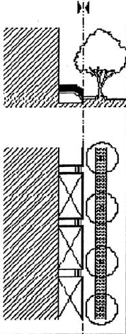 | * | * | * | |
| Courtyard: A portion of the façade exceeds the maximum setback generally permitted. The courtyard thus created is suitable for gardens, cafés and similar pedestrian-oriented uses. This type of façade should be used sparingly and in conjunction with the preceding two frontage types to produce a varied streetscape. Trees within the courtyard should be placed so that their canopies overhang the sidewalks. | 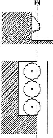 | * | * | * | |
| Stoop: The façade is aligned close to the frontage line with the general story elevated above the sidewalk securing privacy for the windows. This type is suitable for ground floor residential uses such as rowhouses and apartment buildings. This type may be interspersed with the Shopfront. | 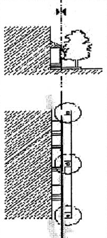 | * | * | * | |
| Shopfront: The façade is near the frontage line with an entrance at sidewalk grade to a first floor commercial use. It is commonly equipped with a cantilevered shed roof, awning or attached gallery. While residential units are appropriate on upper stories, they are not appropriate on the first floor. | 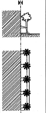 | * | * | * | |
| Gallery and Arcade: The fai?1/21/21/21/21/21/21/2ade includes an attached gallery or arcade. The enclosed building area may extend over the sidewalk above the gallery or arcade but the ground floor remains at or behind the lot line. This type is appropriate for retail, office or institutional uses. | 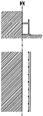 | * | * | ||
;adv=6;Graphics and techniques © Duany-Plater-Zyberk & Co.
(Ord. No. 02-13, § 2, 8-1-02; Ord. No. 11-24, § 2(Item B)(11-0607), 12-5-11, eff. 2-1-12)
Sec. 5.08.09. - Transportation
A.
Generally
"Streets" shall mean the internal roadways within a Mixed-Use Development or TND, and such Streets may be constructed and maintained in either of the following manners:
• Publicly dedicated and maintained internal roadways within a Mixed-Use Development or TND in accordance with the meaning given to Streets in Part 12.01 of this Code.
• Privately constructed and maintained internal roadways within a Mixed-Use Development or TND constructed to TND Street Standards. The developer shall provide a perpetual, non-exclusive easement to the public for pedestrian and vehicular ingress/egress only across such private Streets.
The developer may elect, at its sole discretion, to utilize public or private Streets, or a combination thereof.
All Streets within any Mixed-Use Development or TND, excluding regulated roadways as defined in the Hillsborough County Comprehensive Plan, shall conform to the design standards established in this Section and the Transportation Technical Manual cross sections and design criteria for Traditional Neighborhood Developments ("TND Street Standards"), which are hereby incorporated by this reference. TND Street Standards, including, but not limited to, traffic calming, lane width reductions, removal of travel lanes for on-street parking, etc., shall not be applied to any regulated roadways as defined in the Comprehensive Plan where such treatments will reduce the system capacity and resulting level of service of the existing conditions through and around the proposed Mixed-Use Development or TND. Any development impacting a regulated road (including those utilizing TND street standards), shall meet the adopted level of service standards as defined in Section 4.02 of the Land Development Code. In some cases this may necessitate adding capacity on other existing roadways or by constructing new roadways that provide a bypass for moving vehicles around the Mixed-Use Development or TND. The construction of additional connections to the adjacent local road network may also provide additional capacity to compensate for the reduction in capacity that may result from the application of TND Street Standards to a regulated roadway.
The developer is responsible for the traffic capacity-LOS studies being performed during the planning stages of development. The studies shall be performed in accordance with criteria established by the County in the Development Review Procedures Manual.
B.
Connectivity
All Streets within the Mixed -Use Development or TND shall achieve a connectivity ratio of not less than 1.5. For purposes of this subsection, "connectivity ratio" is the number of Street links divided by the number of nodes. A "link" is each portion of a Street defined by a node at both ends or at one end. A "node" is the intersection of two or more Streets, a cul-de-sac head or a dead-end. Notwithstanding, connections with existing Streets and stub outs to adjacent properties to accommodate future street connections shall not be considered nodes. Additionally, alleys and their connections shall not be included in the connectivity ratio calculation. This subsection shall not apply to any portion of a Greenspace.
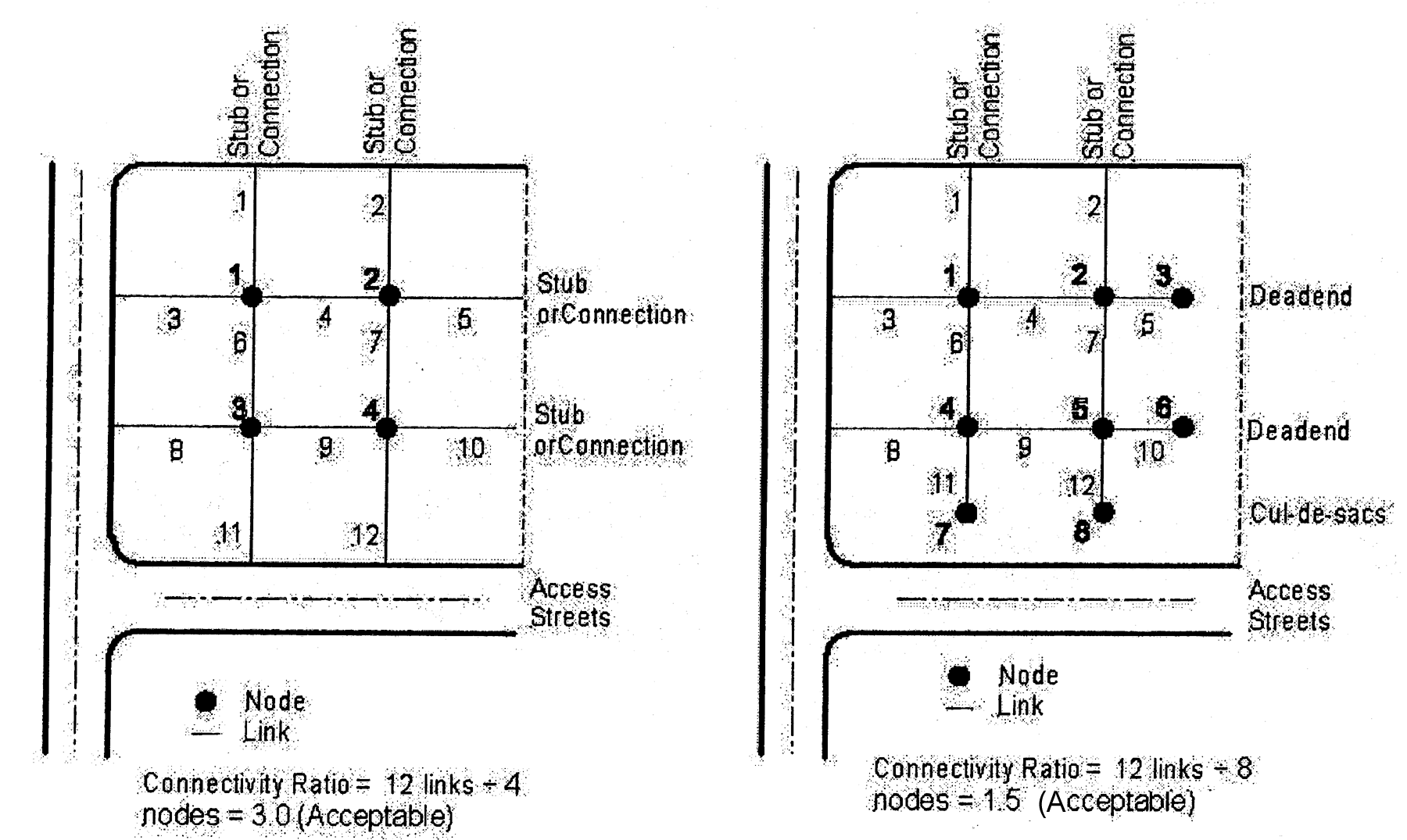
Connectivity Ratio Illustrations
C.
Sidewalks
1.
Within the Neighborhood subareas, sidewalks shall be separated from the roadway by a planting strip of at least seven feet in width.
2.
All sidewalks shall be a minimum of five feet wide. Sidewalk design shall comply with the Americans with Disabilities Act, Florida Accessibility Code standards, Hillsborough County Sidewalk Master Plan, and the Transportation Technical Manual.
D.
Designation of "A" Streets and "B" Streets
All Streets, excluding alleys, within a Mixed-Use Development shall be designated an "A" Street or a "B" Street, as follows:
a.
"A" Streets
"A" Street access is restricted to building types and uses that promote pedestrian activity, and which benefit from pedestrian and/or transit access. A Street shall be classified an "A" Street unless otherwise designated on the Site Plan.
b.
"B" Streets
"B" Street access is permitted for uses which rely primarily on automobile or truck access, or which are incompatible with uses normally permitted in a Neighborhood or Commercial subarea because of heavy traffic, noise, vibrations, glare, or similar impacts. In order to maintain the integrity of the design concepts of this Code, the lineal footage of "B" Streets shall be restricted as follows:
i.
"B" Streets shall not exceed ten percent of the total linear length of all streets within the Commercial subareas, except that on sites of 50 acres or less "B" Streets shall not exceed a maximum of 90 percent of the total linear length of all streets within the Commercial subareas; and,
ii.
"B" Streets may be designated by individual block faces; however, no block face shall be split by "A" Street and "B" Street designations, except that this restriction shall not apply to sites 50 acres or below.
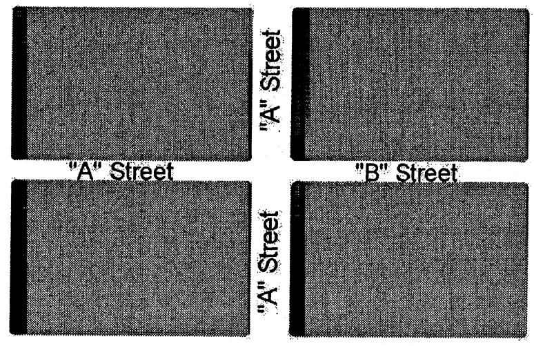
Figure 1: Acceptable A-B Street Layout
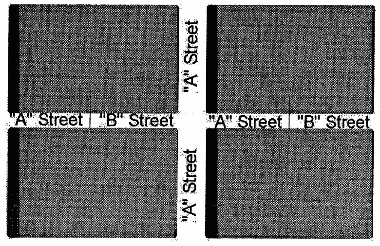
Figure 2: Unacceptable A-B Street
Layout
E.
Traffic Calming
The following provisions describe and establish standards for permitted traffic calming devices using the roadway classifications described in subsection A, above. The descriptions set forth herein are described in the documents entitled Residential Traffic Control Handbook (published by the Hillsborough County Engineering and Construction Services Department, Rev. May 5, 1994), and R. Ewing, Traffic Calming: State of the Practice (Institute of Transportation Engineers (ITE) and the Federal Highway Administration (FHWA), 1999), which document is hereby incorporated by this reference. Traffic calming devices as set forth in Column (A) may be established for the roadway classifications as set forth in Columns (B) through (E), below. An asterisk (*) means that the device is permitted, while a blank cell means that the device is not permitted.
Table 5.08-7 Traffic Calming Devices
(Ord. No. 02-13, § 2, 8-1-02; Ord. No. 07-25, § 2, 11-1-07, eff. 2-1-08; Ord. No. 11-24, § 2(Item B)(11-0607), 12-5-11, eff. 2-1-12)
Sec. 5.08.10. - Utilities
A.
Utilities shall comply with the requirements of Part 6.06.00 of this Code. Additionally, all utilities shall be located underground.
B.
Dumpsters shall be surrounded by a wall, fence, hedge, or a combination of these elements. These elements shall be at least one foot taller than the dumpster. Where a Rowhouse abuts an alley right-of-way that is less than 20 feet in width, the applicant shall provide a dumpster at the end of the alley for centralized waste collection. The dumpster shall conform to the specifications of the solid waste collection service provider.
C.
Air-handling equipment and the similar mechanical devices shall not be located within the front yard.
(Ord. No. 02-13, § 2, 8-1-02; Ord. No. 11-24, § 2(Item B)(11-0607), 12-5-11, eff. 2-1-12)
Sec. 5.08.11. - Civic Spaces and Civic Buildings
A.
Location and Size
The provisions of this Section shall apply only to a Mixed-Use Development over 50 acres in size. The provisions of this Section shall not apply to an Infill TND.
1.
All residential and non-residential lots with frontage on "A" Streets (see Section 5.08.09.B.1) shall be located within three blocks or one-quarter of a mile, whichever is less, of a Civic Space as defined in Table 5.08-8, below, or a Civic Building. .
2.
Within a Neighborhood Subarea, at least one Civic Space shall be designed as a park, plaza, square or green.
3.
Civic Spaces shall adjoin a Street, sidewalk, Trail or other common area or public facility.
B.
Ownership and Maintenance
Civic Spaces shall be owned, preserved and maintained by a homeowner's association, condominium association, a private conservation organization or Hillsborough County. Nothing in this Part shall require the County to accept a proposed dedication.
(Ord. No. 02-13, § 2, 8-1-02; Ord. No. 07-25, § 2, 11-1-07, eff. 2-1-08; Ord. No. 11-24, § 2(Item B)(11-0607), 12-5-11, eff. 2-1-12)
Sec. 5.08.12. - Landscaping, Screening and Buffering
A.
All uses shall comply with the buffering requirements of Section 6.06.05 of this Code, except that nonresidential uses on "A" Streets shall not be buffered from adjacent residential uses.
B.
All roadway landscaping shall conform to the Hillsborough County Transportation Technical Manual for design considerations of sight distance, recovery and maintenance areas. Additionally, street trees shall conform to the requirements of Section 6.06.04 of this Code.
(Ord. No. 02-13, § 2, 8-1-02; Ord. No. 11-24, § 2(Item B)(11-0607), 12-5-11, eff. 2-1-12)
Sec. 5.08.13. - Parking
A.
Except as otherwise provided by this subsection, parking requirements for all uses shall be in accordance with the Parking Standards of this Code (Part 6.05.00).
B.
The minimum off-street parking requirements for a proposed use shall be reduced by the number of on-street parking spaces adjacent to the use. Spaces that are adjacent to more than one use shall contribute to the parking requirement of the use with the greatest frontage on the space.
C.
Parking lots shall be located at the rear or at the side of buildings, or to the interior of a block. Not more than two rows of parking shall be located to the side of a building on an "A" Street.
D.
Parking lots shall not be located at a Prominent Site nor at the intersection of thoroughfares. Parking lots along frontages shall be screened by a masonry wall not exceeding four feet in height and/or a hedge in accordance with Section 6.06.03 of this Code. Parking lots shall be planted with indigenous shade trees at a minimum ratio of one tree per ten parking space.
E.
Parking structures shall comply with the following requirements:
1.
Direct pedestrian access from the structure to each adjacent Street shall be provided.
2.
Except for vehicle entrances as described below, the ground floor of the structure shall be developed with enclosed nonresidential floor space to a minimum building depth of 30 feet along the entire length of the structure on each block face, except where separated from the Street by another building, parking lot and/or landscaped open space with a minimum depth of 30 feet.
3.
Vehicle entrances to the structure shall be a maximum of 48 feet in width and shall be separated from other vehicle entrances to the structure or other parking structures on the same block face by a minimum distance of 400 feet.
Table 5.08-8 Civic Space Types
| Description | Illustration |
|---|---|
| Greenway: A Greenway is a common area consisting of not less than ten continuous acres that includes any area protected from development pursuant to Part 4.01.00 of this Code, any "greenway" as defined in the Florida Greenways and Trails Act (Florida Statutes § 260.013(4), as may be amended from time to time), or any Greenway identified in the Greenways Master Plan. Greenways shall not be located between an area designated as a Neighborhood subarea and the Commercial or Core subarea that is designated for compliance with the maximum separation requirement of Section 5.08.07.A.2, so as to excessively lengthen or substantially hamper pedestrian travel between the Neighborhood subarea and Commercial/Core subarea. | 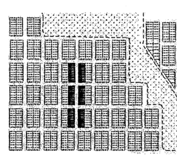 |
| Park: A common open space available for recreation. Its landscape includes paved paths and trails, lawns, trees and open shelters. Parks shall include at least one shelter, open play area, community center gymnasium, ballfield, or sports complex consistent with the "Design Standards for Neighborhood Parks" published by the Hillsborough County Parks and Recreation Department (October 10, 2001), which are hereby incorporated by this reference. Parks shall include at least one continuous acre. |  |
| Green: A common open space located at the intersection of streets and bounded by streets with facing buildings on all sides. A square includes paved walks, lawns, trees, benches and ornamental structures such as fountains. |  |
| Square: A common open space located at the intersection of streets and bounded by streets with facing buildings on all sides. A square includes paved walls, lawns, trees, benches and ornamental structures such as fountains. |  |
| Plaza: A common space at the intersection of streets devoted to civic purposes and temporary commercial activities, such as craft shows, farmers markets, etc. A plaza is surrounded by streets with facing buildings and includes lawns, trees, walks, ornamental structures, buildings and durable pavement for parking. | 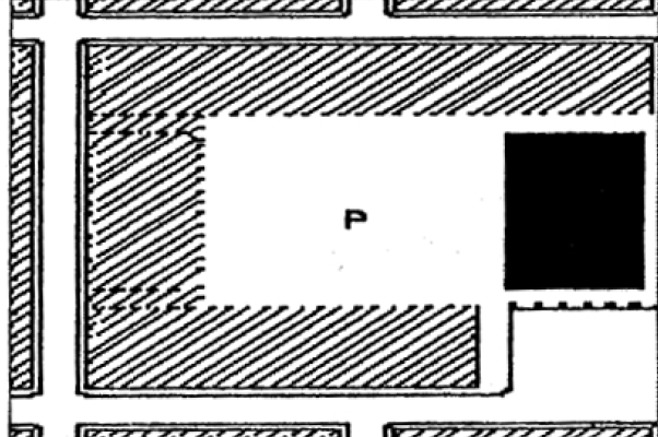 |
Graphics and technique for Parks, Greens, Squares, and Plazas © Duany-Plater-Zyberk & Co. Greenbelt graphic © 2001 Freilich, Leitner & Carlisle.
(Ord. No. 02-13, § 2, 8-1-02; Ord. No. 11-24, § 2(Item B)(11-0607), 12-5-11, eff. 2-1-12)
Sec. 5.08.14. - Mass Transit Facilities
Mixed-Use Developments and TNDs granted a density and/or intensity bonus by the Board of County Commissioners per Section 5.08.03 C of this Part shall be designed to accommodate the use of mass transit services within the Development to maximize ridership. Design and location of the transit facilities shall be subject to approval of HARTline.
(Ord. No. 04-46, § 2, 11-4-04; Ord. No. 11-24, § 2(Exh. A)(11-0607), 12-5-11, eff. 2-1-12; Ord. No. 11-24, § 2(Item B)(11-0607), 12-5-11, eff. 2-1-12)
Sec. 5.09.01. - Purpose
By providing an alternative to conventional subdivisions that encourages a more efficient form of land development, conservation subdivisions seek to fulfill the following purposes:
(A)
To implement adopted land use policies, as set forth in the Hillsborough County Comprehensive Plan, to promote a more efficient use of land;
(B)
To implement adopted environmental protection policies, as set forth in the Hillsborough County Comprehensive Plan, to preserve a variety of irreplaceable and environmentally sensitive resource lands, including those containing unique natural features such as Natural Plant Communities, wetlands, waterways, and floodplains;
(C)
To provide for the conservation and maintenance of open land within Hillsborough County for active or passive recreational use by its residents;
(D)
To protect and retain areas with productive agricultural soils for continued or future agricultural use, by conserving blocks of land large enough to allow for viable farming operations;
(E)
To allow innovation and greater design flexibility and efficiency in the siting and maintenance of services and infrastructure, including the opportunity to reduce the length of roads and utility runs;
(F)
To conserve scenic vistas and elements of the County's rural character.
(Ord. No. 02-13, § 2, 8-1-02; Ord. No. 07-25, § 2, 11-1-07, eff. 2-1-08)
Sec. 5.09.02. - Applicability
Conservation development is a technique used to promote the preservation of environmentally sensitive areas, agricultural lands and common open space. The term "Conservation Subdivision" shall refer to a residential subdivision in which development is guided to and clustered on the most suitable portions of a tract, in order to allow key environmental resources, additional open spaces and agricultural lands to be protected and preserved for the benefit and enjoyment of the community. Lots are placed together into one or more groupings within defined areas on a parcel, and are separated from other groupings and/or from adjacent developments by the protected open space. To achieve this type of development, the guidelines contained in this ordinance provide an alternative to traditional subdivision standards, allowing flexibility in lot dimensions, configuration and development standards. The guidelines also provide for density bonuses to encourage the utilization of Conservation Subdivisions.
1.
Conservation Subdivisions shall be permitted only in those zoning districts shown in Table 5.09-1, below.
2.
The subdivision shall utilize only the type(s) of dwellings permitted by the property's zoning.
(Ord. No. 02-13, § 2, 8-1-02; Ord. No. 07-25, § 2, 11-1-07, eff. 2-1-08; Ord. No. 09-62, Item A, 10-26-09, eff. 2-1-2010)
Sec. 5.09.03. - Procedures
A.
Subdivision Plat Approval Required
In all cases a Conservation Subdivision shall be approved in accordance with the platting procedures described in Section 10.01.00 of this Code, regardless of the number of lots created. Upon approval the Conservation Subdivision shall be identified on the Official Zoning Atlas by a "CS" designation and the applicable plat book and page.
(Ord. No. 02-13, § 2, 8-1-02; Ord. No. 07-25, § 2, 11-1-07, eff. 2-1-08; Ord. No. 09-62, Item A, 10-26-09, eff. 2-1-2010)
Sec. 5.09.04. - Size and Location of Site
A Conservation Subdivision shall include at least five acres of contiguous land. There is no maximum project size for a Conservation Subdivision.
(Ord. No. 02-13, § 2, 8-1-02; Ord. No. 07-25, § 2, 11-1-07, eff. 2-1-08; Ord. No. 09-62, Item A, 10-26-09, eff. 2-1-2010)
Sec. 5.09.05. - Density
A.
Base Density
Except when a density bonus is permitted in accordance with the requirements of Section 5.09.08, the gross density of a Conservation Subdivision shall not exceed the maximum density shown in Table 5.09-1 for the property's zoning. Gross density shall be calculated in the manner described by the Future Land Use Element of the Comprehensive Plan. Notwithstanding, wetland density credits shall not be permitted where prohibited by an adopted Community Plan.
Table 5.09-1 Density
(Ord. No. 02-13, § 2, 8-1-02; Ord. No. 07-25, § 2, 11-1-07, eff. 2-1-08; Ord. No. 09-53, Item L, 6-11-09, eff. 10-1-09; Ord. No. 09-62, Item A, 10-26-09, eff. 2-1-2010)
Sec. 5.09.06. - Lot Requirements
A.
Arrangement and Size
1.
Lots shall be arranged in a contiguous pattern as set forth in the lot design standards of Section 6.02.00 of this Code.
2.
At least one row of Buffer Lots shall be provided within the proposed subdivision along all portions of the site boundary along external roadways and where the adjacent property is developed with or, if vacant, is required to have single-family or two-family lots with an average size that is greater than 200 percent of the average lot size of the proposed subdivision. Alternatively, Additional Open Space comprised of passive area and/or agricultural lands with a minimum width of 200 feet in the Rural Service Area and 100 feet in the Urban Service Area may be provided within the proposed subdivision along said portions of the boundary.
3.
Buffer Lots shall conform with the minimum size and width requirements of the property's zoning district, unless a greater lot size is required to utilize septic tanks under the requirements of Section 6.01.06 of this Code. Lots served by septic tanks shall have a minimum of one-half acre of upland area except when located in a Wellhead Resource Protection Area, in which case the lots shall have at least one acre of upland area.
4.
No minimum size or width is required for Cluster Lots, subject to septic tank requirements of Section 6.01.06 of this Code. Lots served by septic tanks shall be have a minimum of one-half acre of upland area except when located in a Wellhead Resource Protection Area, in which case the lots shall have at least one acre of upland area.
B.
Development Standards
1.
Buffer Lots shall be subject to the development standards of the property's zoning district.
2.
Cluster Lots shall be subject to the development standards of the agricultural or residential zoning district, as applicable by permitted housing type, which has a minimum lot size that is nearest to the size of the smallest lot in the proposed subdivision. For example, if the smallest lot in the proposed subdivision is 8,000 square feet in size, the cluster lots shall be subject to RSC-6 development standards. If the smallest lot in the proposed subdivision is less than 5,000 square feet in size, the cluster lots shall be subject to RSC-9 or RDC-12 standards, as applicable by permitted housing type.
(Ord. No. 02-13, § 2, 8-1-02; Ord. No. 04-46, § 2, 11-4-04; Ord. No. 05-22, § 2, 11-17-05; Ord. No. 07-25, § 2, 11-1-07, eff. 2-1-08)
Sec. 5.09.07. - Additional Open Space.
A.
Required Percentage and Characteristics
1.
Additional Open Space shall be provided within a Conservation Subdivision in accordance with the property's service area classification as shown on Table 5.09-2.
2.
Additional Open Space shall not include the following elements:
a.
Golf courses; or
b.
Easements and rights-of-way for water, sewer, gas, electric, or other utilities, unless such easements are for underground lines and facilities within common open spaces meeting the requirements of this section; or
c.
Stormwater Management facilities such as detention ponds or retention ponds, unless such facilities meet the requirements of Section 5.09.07.B.5 below;
d.
Intensive agricultural operations, farmworker housing or other agricultural activities not expressly permitted by Section 5.09.07.B.7 below; or
e.
Required setbacks from Conservation and Preservation Areas, unless said setbacks are within designated Additional Open Space with a minimum width of 150 feet.
Table 5.09-2: Open Space Standards
Rules of Interpretation for Table 5.09-2:
Column (B) is the minimum percentage of the net project area which is not otherwise required to be designated Conservation or Preservation Areas under the requirements of this Code that must be reserved for Additional Open Space. The Additional Open Space shall include in the following order of priority up to the amount required by this Section: (1) environmentally sensitive areas which exceed the amount that must be designated Conservation or Preservation areas under other requirements of this Code; or (2) any land area, not otherwise protected by the requirements of this Code, that is approved for acquisition or transfer of a less than fee interest pursuant to the provisions of the Hillsborough County Environmental Lands Acquisition and Protection (ELAP) Program established by Ordinance No. Ord. 87-1, as amended, or (3) any land approved for acquisition or transfer at less than fee interest pursuant to the Land Conservation Act of 1972, Chapter 259, Florida Statutes. Upon satisfaction of this requirement, Additional Open Space may also include any other undeveloped lands on the site, including agricultural fields, subject to the provisions of this Section.
Column (C) establishes the maximum amount of Additional Open Space which may be developed for active uses. No minimum amount of space for active uses is required.
Column (D) establishes the maximum distance of any lot in the proposed development from Common Open Space. This requirement does not apply to agriculture land which is retained as Open Space for purposes of this Section.
B.
General Requirements
1.
In addition to other platting requirements of this Code, the preliminary plat for a Conservation Subdivision shall: 1) identify all residential lots as Buffer Lots or Cluster Lots; 2) identify the size of the smallest Cluster Lot and development standards for the Cluster Lots; and, 3) delineate all Additional Open Space and identify such space as passive, active and/or agricultural.
2.
All residential lots shall be located no more than 1,320 feet from Additional Open Space in the project. This requirement shall not apply to Additional Open Space reserved under this Part that is designated agricultural land.
3.
Additional Open Space shall be set aside through a conservation easement under the control of a homeowners association, condominium association, Hillsborough County or other appropriate public entity, or in the case of agricultural lands, a private party. Hillsborough County shall have a third-party right of enforcement for any such conservation easement created pursuant to this Section. Adequate documentation shall be provided of such conveyance to guarantee that all natural resource and open space portions of the development will be maintained in the manner approved.
4.
Active areas within Additional Open Space shall not be illuminated for activity after 8:00 p.m. Parking facilities for the active areas shall not be paved but shall be surfaced with alternative materials, such as gravel, acceptable to Hillsborough County except as otherwise required for parking for the disabled.
5.
Stormwater drainage and detention areas may be included as an integral part of the required Additional Open Space provided they are unfenced and surrounded by or adjoining passive open space that is improved with walking/jogging trails, horse riding trails, nature paths, picnic facilities, benches or similar amenities for common use by all subdivision residents and/or the general public. Such drainage and detention areas shall comprise no more than 20 percent of the required Additional Open Space.
6.
Bike paths and trails which conform to the requirements of the Transportation Technical Manual may contribute to Additional Open Space.
7.
Agricultural lands designated as Additional Open Space under the provisions of this Part shall, at time of platting, have a current Agricultural Classification for property tax purposes as determined by the Hillsborough County Property Appraiser. Use of the property shall be reserved for pasture lands, row crops, orchards, woodlands, bee hives, fish ponds and horse stables. Other agricultural uses, including but not limited to animal production units, packing houses, agricultural stands (except those selling only products grown on the site), plant farms and greenhouses, poultry and egg farms, dairies, farm worker housing and labor camps, agricultural manufacturing, kennels and any activity with significant structural coverage, intensity or off-site impacts, shall be prohibited.
C.
Maintenance Requirements
Additional Open Space shall be owned and maintained by a homeowner's association, private conservation organization or, in the case of agricultural lands, private party. Nothing in this Part shall require the County to accept a proposed dedication.
(Ord. No. 02-13, § 2, 8-1-02; Ord. No. 03-9, § 2, 6-5-03; Ord. No. 07-25, § 2, 11-1-07, eff. 2-1-08; Ord. No. 09-62, Item A, 10-26-09, eff. 2-1-2010)
Sec. 5.09.08. - Density Bonus
A bonus to increase the density of a proposed Conservation Subdivision above the maximum gross density permitted by the property's zoning as described in Section 5.09.05 shall be permitted for projects which, in addition to complying with all other requirements of this Part, incorporates some or all of the enhanced design features listed in Section 5.09.09 below. Projects which meet at least five out of seven requirements (where applicable) shall receive a maximum density bonus of 25 percent if located in the Rural Service Area and a maximum density bonus of 40 percent if located in the Urban Service Area. Sufficient proof and assurances of compliance with design features, as determined by Hillsborough County, shall be provided by the applicant prior to final plat approval.
(Ord. No. 09-62, Item A, 10-26-09, eff. 2-1-2010)
Sec. 5.09.09. - Enhanced Design Features Options
A.
For projects in the Rural Service Area, a minimum of 55 percent of the site area shall be reserved as Additional Open Space. For projects in the Urban Service Area, a minimum of 50 percent of the site area shall be reserved as Additional Open. The Additional Open Space shall conform with the Rules of Interpretation for Table 5.09-2.
B.
Additional Open Space adjacent to Outstanding Florida Waters and/or environmental preservation areas, as defined by the Comprehensive Plan, shall have a minimum width of 300 feet.
C.
Additional Open Space adjacent to conservation areas, as defined by the Comprehensive Plan, shall have a minimum width of 200 feet.
D.
Additional Open Space shall be located contiguous to all permanently preserved passive open spaces on adjacent parcels, such as ELAPP, SWFWMD, or other public/private preservation areas, which abut the project boundary. The Additional Open Space shall have a minimum width of 150 feet along the entire boundary shared with off-site open spaces.
E.
Additional Open Space located along the perimeter in lieu of Buffer Lots, as provided by Section 5.09.06.A.2, shall have a minimum width of 250 feet in the Rural Service Area and 200 feet in the Urban Service Area.
F.
Project shall incorporate a trail network that connects the Additional Open Space on the property. Pedestrian trail network shall utilize natural materials. Pedestrian trail must be in addition to any trails provided to meet the requirements of Section 5.09.07.B.5.
G.
Project shall develop a non-mandatory habitat enhancement/environmental restoration program subject to review and certification by EPC and/or PGM prior to final plat approval. Habitat enhancement program may include but is not limited to removal of exotic vegetation, normalizing hydroperiod of impacted wetlands, habitat creation, and development of a habitat management plan. Habitat enhancement points may not be obtained for actions mandated by current regulations (i.e. wetland mitigation, upland significant wildlife habitat).
(Ord. No. 09-62, Item A, 10-26-09, eff. 2-1-2010)
Sec. 5.10.01. - Purpose
The purpose of this section is to encourage the redevelopment of existing shopping centers, strip commercial, shopping malls, big-box retail sites, and other sites characterized by large expanses of surface parking into a development pattern which is pedestrian friendly, compatible with surrounding development, provides a visually attractive site design, and which reduces reliance on the automobile for vehicular trips. The provisions of this Section implement Policy B-6.2 of the Future Land Use Element.
(Ord. No. 02-13, § 2, 8-1-02)
Sec. 5.10.02. - Applicability
Existing parking lots adjoining the frontage of any commercial development located in established areas of strip commercial development may be replaced with buildings consistent with the requirements of this Section. A floor area bonus may be permitted to encourage such activities pursuant to Section 5.10.05. below.
(Ord. No. 02-13, § 2, 8-1-02)
Sec. 5.10.03. - Procedures
A Planned Development District (PD) rezoning or Major Modification to an existing Planned Development is required. The Board of County Commissioners shall render the following findings along with the approval of a PD rezoning:
A.
An improvement to the transportation system is clearly demonstrated by a reduction in the overall traffic impacts to adjoining roadways by replacing commercial uses with office uses or other uses which generate fewer vehicular trips.
B.
An improvement in access management is clearly demonstrated by deleting the number of access points, providing cross access, shared access, or realignment.
C.
An improvement to the visual qualities of the site is provided by reduced signage, greater open space and enhanced landscaping.
(Ord. No. 02-13, § 2, 8-1-02)
Sec. 5.10.04. - Size and Location of Site
There is no minimum or maximum size for a parcel subject to this Part.
(Ord. No. 02-13, § 2, 8-1-02)
Sec. 5.10.05. - Density and Intensity
A.
Redevelopment Activities
Redevelopment may consist of the following activities:
1.
The construction of additional buildings between a collector street right-of-way and the existing buildings (hereinafter "Additional Buildings"). The facades of the Additional Buildings that face the public right-of-way or the existing buildings on the lot, tract or parcel shall conform to Section 5.10.07 below.
2.
Commercial Apartments may be placed above new or existing office or retail uses, subject to policies B-4.5 and B-4.6 of the Comprehensive Plan Future Land Use Element. If not more than two commercial apartments are constructed on a single parcel, and the property is in a land use category permitting four du/a or more, neither the dwelling units nor the floor area shall be counted as density or intensity. If more than two such units are provided on a single parcel, or if the property is in a land use category of less than four du/a, the floor area of the commercial apartments shall not be included in the total floor area of the lot; however, the units shall be counted as dwelling units and meet the density requirements of the Comprehensive Plan. In the latter instance, lot area shall be proportionately assigned to each land use type, and the density and intensity thresholds of the Plan shall not be exceeded.
3.
Existing buildings may be demolished and replaced with new buildings (hereinafter "New Buildings") that conform to the requirements of this Section.
B.
The allowable FAR may be increased to 50 percent above the maximum FAR of the respective land use category where commercial uses are replaced with office uses or other uses which generate fewer vehicular trips.
(Ord. No. 02-13, § 2, 8-1-02)
Sec. 5.10.06 - Area, Height, Bulk, and Placement
The following provisions shall apply to any new buildings constructed on the site:
A.
Buildings shall be arranged into blocks not exceeding 400 feet in length.
B.
The following setback provisions shall apply:
For purposes of this subsection, the front setback shall be measured from the right-of-way of a public or private street. The maximum setback requirements may be waived for an area not to exceed 90 percent of the frontage in order to accommodate courtyards. Where a maximum front setback has been established, the front building wall or a Courtyard shall adjoin the sidewalk.
(Ord. No. 02-13, § 2, 8-1-02; Ord. No. 03-9, § 2, 6-5-03)
Sec. 5.10.07. - Design
The following provisions shall apply to any new buildings constructed on the site:
A.
Ground Floor Design
All buildings subject to this Section shall have their principal entrance opening to a street, square, plaza, or sidewalk. The principal entrance shall not open onto a parking lot. Pedestrian access from the public sidewalk, street right-of-way or driveway to the principal structure shall be provided through an improved surface. The ground floor of the entryway shall align with the sidewalk elevation.
B.
Enclosure Ratio
The Enclosure Ratio between buildings shall be at least 1:3. For purposes of this subsection, "Enclosure Ratio" means the ratio of building height to the distance between buildings facing across a Street. The distance between buildings shall be measured from the front facade including any porch, stoop, or other area integral to the building. Building height shall be measured from the sidewalk elevation to the cornice of the front facade.
C.
Windows and Entryways
The facades facing the public right-of-way or an internal street shall conform to the requirements this subsection.
1.
The ground floors of all buildings shall be designed to encourage and to complement pedestrian-scale activity by the use of windows and doors arranged so that the uses are visible from and/or accessible to the street on not less than 50 percent of the length of the first floor street frontage.
2.
The following percentage of the total surface area of the front elevation shall be in public entrances or windows (including retail display windows). Where windows are used, they shall be transparent.
Fenestration Standards
a.
Ground Floor: 60 percent minimum.
b.
Second Floor and above: 20 percent minimum and 50 percent maximum.
3.
Solid walls shall not exceed 20 feet in length.
4.
All street level retail uses with sidewalk frontage shall be furnished with an individual entrance and direct access to the sidewalk in addition to any other access which may be provided. This standard shall not apply to any lot with a street frontage of less than 24 feet. An entryway shall not be less than one square foot for each 1,000 square feet of floor area on the ground floor, and in all cases shall not be less than 15 square feet.
D.
Pedestrian-Oriented Uses
In order to stimulate pedestrian activity, the first floor (street level) of any new building abutting a major arterial roadway, minor arterial roadway or major collector roadway shall devote not less than 50 percent of the net first floor area to retail uses. Residential dwellings shall be permitted above the first floor of any building with commercial and/or retail uses on the first floor.
E.
Mechanical Equipment
Mechanical equipment, electrical meter and service components, and similar utility devices, whether ground level, wall mounted, or roof mounted, shall be screened from view at the front property line. Exterior screening materials shall be the same as the predominant exterior materials as the principal building.
(Ord. No. 02-13, § 2, 8-1-02)
Sec. 5.10.08. - Transportation
The design of streets internal to the site shall conform to the requirements for a "Main Street" as set forth in the Street Design Standards of the Transportation Technical Manual.
(Ord. No. 02-13, § 2, 8-1-02)
Sec. 5.10.09. - Parking
A.
Except as otherwise provided by this subsection, parking requirements for all uses shall be in accordance with the Parking Standards of this Code (Part 6.05.00).
B.
Parking lots shall be located at the rear or at the side of buildings, or to the interior of a block. Not more than two rows of parking shall be located to the side of a building.
C.
Parking lots shall not be located at a Prominent Site nor at the intersection of thoroughfares. Parking lots along frontages shall be masked by a building, a masonry wall not exceeding four feet in height, and/or a hedge in accordance with § 6.06.03 of this Code. Parking lots shall be planted with indigenous shade trees at a minimum ratio of one tree per ten parking space.
D.
Parking structures shall not lead directly to the buildings they serve, but shall provide a pedestrian access route along a frontage line to the main building entrance. Parking structures shall comply with at least one of the following standards:
1.
The first floor of frontages of parking structures shall be dedicated to commercial use to a minimum depth of 30 feet.
2.
The parking structure shall not exceed a width of 48 feet for a distance of 30 feet from the public right-of-way, and shall not be located closer than 400 feet along the same side of the block from another parking structure. Where the parking structure exceeds the prescribed width beyond 30 feet from the public right-of-way, that portion of the structure shall be concealed by commercial buildings or civic spaces.
(Ord. No. 02-13, § 2, 8-1-02)
Sec. 5.11.01. - General Provisions
A.
Findings
1.
Traffic congestion on major roadways constitutes a growing problem, which adversely affects the economy, the environment, and the public health, safety and welfare.
2.
The Future of Hillsborough Comprehensive Plan for Unincorporated Hillsborough County identifies major roadways and transportation corridors that are needed to provide for and promote coordinated transportation planning and right-of-way protection, to preserve corridors for future transportation use to accommodate planned future growth, to maintain established transportation level of service standards, and to assure a safe, efficient and sustainable transportation system for the citizens of Hillsborough County.
3.
It is in the best interest of the citizens of Hillsborough County to anticipate future needs for transportation corridors and to assure that development is planned in a manner that is compatible with planned future transportation corridors.
(Ord. No. 05-10, § 2, 6-16-05, eff. 10-1-05)
Sec. 5.11.02. - Purpose and Authority
The purposes of this Part, which is adopted in accordance with Section 163.3177(6)(b), Florida Statutes and Section 337.273(6), Florida Statutes, are to:
A.
Implement the Future of Hillsborough Comprehensive Plan for Unincorporated Hillsborough County and especially the future transportation plan and objectives and policies for Future Transportation Corridors;
B.
Provide a basis for coordinating the provision of transportation facilities with new development on designated corridors where the construction and improvement of transportation facilities is expected; and
C.
Protect the rights of landowners whose land is designated for future transportation use.
(Ord. No. 05-10, § 2, 6-16-05, eff. 10-1-05)
Sec. 5.11.03. - Applicability
This Part shall apply to all land within or abutting future transportation corridors designated on the Corridor Plan Listing (Appendix G of the Transportation Element) pursuant to Objective 1.5 of the Transportation Element of the Future of Hillsborough Comprehensive Plan for Unincorporated Hillsborough County.
(Ord. No. 05-10, § 2, 6-16-05, eff. 10-1-05)
Sec. 5.11.04. - Severability
If any section, subsection, paragraph, sentence, clause, or phrase of this Part is for any reason held by a court of competent jurisdiction to be unconstitutional or otherwise invalid, the validity of the remaining portions of this Part shall continue in full force and effect.
(Ord. No. 05-10, § 2, 6-16-05, eff. 10-1-05)
Sec. 5.11.05. - Consistency with the Transportation Plan and Protection from Encroachment
A.
General Requirement
All development on or adjacent to planned future corridors designated for improvement in the Future of Hillsborough Comprehensive Plan for Unincorporated Hillsborough County and identified on the Corridor Plan Listing shall be consistent with the transportation functions of those corridors. Planned future corridors shall be protected from encroachment by structures, parking areas, or drainage facilities, except as may be allowed on an interim basis in accordance with Section 5.11.09.
B.
Determination of Alignment and Setbacks
Where an alignment of a designated corridor has been established by engineering study and/or design, all proposed structural improvements shall conform to the building setbacks in that zoning district and other setbacks required by this Code, and such setbacks shall be measured from the identified right-of-way line for the new alignment.
Where an alignment has not been established by engineering study and/or design, the applicant may propose, and Hillsborough County shall establish, an approximate alignment consistent with the need to provide continuity of the corridor, as well as to meet conceptual site planning needs of the project. The generalized widths indicated in this Code shall be used to determine an appropriate alignment, except where Hillsborough County has designated an alternative width. The following techniques shall be considered for maintaining the continuity of the corridor and protecting the corridor from encroachment:
1.
For existing roads, the future centerline shall be the centerline of the existing right-of-way, except where the County Administrator or her/his designee determines that an alternative centerline alignment would be clearly less harmful to the environment, would displace fewer residents and businesses, or is more technically or financially feasible as determined by Hillsborough County. On state roads, comments on the proposed alignment will be solicited from the Florida Department of Transportation and reviewed in evaluating the proposed alignment.
2.
For new roads on new alignments, the Administrator shall establish an approximate alignment that maintains the continuity of the corridor and minimizes adverse social, environmental and economic impacts of the transportation project. On state roads, comments on the proposed alignment will be solicited from the Florida Department of Transportation and reviewed in evaluating the proposed alignment.
3.
The approximate alignment shall be the basis for applying required setbacks for zoning. When the specific alignment is later established through engineering study and design, the setback may be reduced through administrative approval up to, but not exceeding, ten percent of the otherwise required setback, provided that such reduction is necessitated solely by the final alignment of the right-of-way.
(Ord. No. 05-10, § 2, 6-16-05, eff. 10-1-05)
Sec. 5.11.06. - Density/Intensity Credit
Hillsborough County may approve the on-site transfer of development rights, based on the gross density or intensity allowable on the site prior to any set-aside for future right-of-way. The transfer shall be from land designated as a future transportation corridor on the Corridor Plan Listing to other portions of the site not designated as a future transportation corridor. Approval of transfer of development rights may include consideration of variances from site design standards necessitated by the increased net density or intensity of the portions of the site receiving the transfer of development rights. Such variances may be granted administratively for up to, but not exceeding, ten percent of the otherwise required standard.
(Ord. No. 05-10, § 2, 6-16-05, eff. 10-1-05)
Sec. 5.11.07. - Clustering of Structures
Clustering of structures may be allowed to preserve the full development rights of the property while siting structures to avoid encroachment into the corridor. Clustering of structures under this provision may include administrative approval to reduce setbacks between buildings within a project site, reduction of buffers within a project site, or variances from other site design requirements. This provision is not intended to reduce perimeter buffer yards designed to ensure compatibility of proposed development with adjacent uses.
(Ord. No. 05-10, § 2, 6-16-05, eff. 10-1-05)
Sec. 5.11.08. - Right-of-Way Dedication
A property owner may, at any time during the application process for site development approval of a project, voluntarily dedicate and convey lands within the project site to Hillsborough County that are in a future transportation corridor or future right-of-way. Where an alignment has been established by engineering study or design, lands to be dedicated and conveyed shall be within the designated future right-of-way. Where an alignment has not been established, an approximate alignment shall be established as provided in Section 2.2.
Projects proposed adjacent to or abutting a designated future transportation corridor, may, as a condition of zoning or site development approval, be required to dedicate and convey at no cost to the County, lands within the project site that are necessary for that transportation corridor to Hillsborough County provided that any required dedications and conveyances shall not exceed the amount of land that is roughly proportionate to the impacts of the development on the transportation network. The following shall also apply:
A.
Dedication and conveyance required under this Part shall occur by recordation on the face of the plat, deed, or other method acceptable to Hillsborough County prior to the granting of a development order approval, or in the case of plat applications, prior to final plat approval. If final approval of the application is denied, the deed or other instrument of dedication and conveyance shall be voided and returned to the applicant.
(Ord. No. 05-10, § 2, 6-16-05, eff. 10-1-05)
Sec. 5.11.09. - Interim Use of Reserved Land
Interim use of land within a future transportation corridor may be permitted to preserve some economic use of the land until it is needed for transportation purposes. Such uses shall conform to the use provisions of the zoning district and the following additional provisions shall apply.
A.
Uses directly related to the primary use of the project site, such as parking, entry features (e.g., signage, gatehouses, architectural features, fountains, walls, etc.), stormwater retention facilities, or temporary sales or leasing offices, may be allowable on an interim basis pursuant to the following conditions:
1.
As a condition of preliminary or final development order, the applicant must agree to relocate these uses elsewhere on the project site at the property owner's expense. Such conditions shall specify the terms and conditions of the relocation, including timing of the relocation required by this Part.
2.
Relocation of approved interim uses shall be beyond the setback area.
3.
Relocation sites shall be identified on the development plans submitted with the preliminary or final development order application. Sites identified for future relocation shall be reserved for that purpose.
4.
The stormwater retention facility may, at the discretion of Hillsborough County, be incorporated into the design of the future transportation facility retention facilities. Should this option be chosen by the County, the developer need not relocate the stormwater retention facility provided that the property for the stormwater facility is donated to the local government, which will assume maintenance responsibility for the facility.
B.
Uses not necessarily directly related to the principal use of the site, but which do not involve substantial structural improvements, including but not limited to outdoor storage, agricultural uses, temporary vendors, golf driving ranges, and neighborhood fairs may be allowable on an interim basis, pursuant to the following:
1.
Such uses must be allowed by the underlying zoning on the property.
2.
As a condition of the preliminary or final development order, the applicant must agree to discontinue these uses on the project site by a specified date. Such conditions shall specify the terms and conditions of both the approval of interim uses pursuant to this Part and the discontinuance of interim uses as required in this Part.
(Ord. No. 05-10, § 2, 6-16-05, eff. 10-1-05)
Sec. 5.11.10. - Economically Beneficial Use of Property
The County may elect to not apply certain provisions of this Part to a particular parcel of property if application of such provisions would prevent all economically beneficial use of the property. Any appeals, pursuant to Article X of this Code, of decisions regarding the application of the provisions of this Part shall be limited to appeals by the owner of the property that would otherwise be subject to the provisions of this Part.
(Ord. No. 05-10, § 2, 6-16-05, eff. 10-1-05; Ord. No. 05-22, § 2, 11-17-05)