
Jacksonville City Zoning Code
PART 3
- SCHEDULE OF DISTRICT REGULATIONS
SUBPART C. - COMMERCIAL USE CATEGORIES AND ZONING DISTRICTS[2]
Editor's note— Ord. 2007-704-E, § 1, amended the Code by repealing former Subpt. C, §§ 656.310—656.315, and adding a new Subpt. C. Former Subpt. C pertained to similar subject matter, and derived from Ord. 91-59-148; Ord. 91-522-167; Ord. 91-527-268; Ord. 91-761-410; Ord. 92-58-30; Ord. 92-955-674; Ord. 92-1760-1438; Ord. 92-2020-1431; Ord. 93-178-112; Ord. 93-407-256; Ord. 93-672-1055; Ord. 94-77-412; Ord. 94-195-171; Ord. 94-339-274; Ord. 94-483-331; Ord. 94-505-349; Ord. 94-769-462; Ord. 94-1309-746; Ord. 96-305-296; Ord. 96-579-380; Ord. 97-405-E; Ord. 96-730-461; Ord. 98-528-E; Ord. 1999-242-E; Ord. 1999-834-E; Ord. 1999-546-E; Ord. 1999-1009-E; Ord. 2000-55-E; Ord. 2000-743-E; Ord. 2001-814-E; Ord. 2002-608-E; and Ord. 2003-755-E.
Cross reference— Businesses, trades and occupations, Tit. VI.
SUBPART D. - INDUSTRIAL USE CATEGORIES AND ZONING DISTRICTS[3]
Cross reference— Businesses, trades and occupations, Tit. VI.
SUBPART H. - DOWNTOWN OVERLAY ZONE AND DOWNTOWN DISTRICT USE AND FORM REGULATIONS[4]
Editor's note— Ord. 2019-196-E, § 6, amended the Code by repealing former Subpart H, §§ 656.361.1—656.361.26, and adding a new Subpart H. Former Subpart H pertained to the Downtown Overlay Zone and Downtown District Regulations, and derived from Ord. 2003-627-E; Ord. 2005-227-E; Ord. 2007-174-E; Ord. 2007-564-E; Ord. 2007-588-E; Ord. 2007-956-E; Ord. 2009-325-E; Ord. 2009-401-E; Ord. 2010-449-E; Ord. 2010-901-E; Ord. 2011-643-E; Ord. 2012-234-E; Ord. 2012-364-E; Ord. 2014-560-E; Ord. 2017-399-E; Ord. 2017-665-E; and Ord. 2018-769-E.
SUB PART I. - SPRINGFIELD ZONING OVERLAY AND HISTORIC DISTRICT REGULATIONS[5]
Editor's note— Ord. 2000-302-E, § 1, effective December 21, 2000, amended the Code by adding a new Subpart I, §§ 656.370—656.375. In order to avoid duplication of Section numbers, the provisions have been renumbered as §§ 656.365—656.369.1 at the discretion of the editor.
SUBPART L. - MAYPORT ROAD ZONING OVERLAY AND MAYPORT VILLAGE WORKING WATERFRONT DISTRICT[6]
Editor's note— Ord. 2008-833-E, § 1, amended the Code by changing the title of Subpart L.
SUBPART M. - SAN MARCO OVERLAY ZONE[7]
Editor's note— Ord. 2004-1105-E, § 1, amended the Code by repealing former Subpart M, §§ 656.399.1—656.399.9, and adding a new Subpart M. Former Subpart M pertained to the Lake Marco Overlay Zone, and derived from Ord. 2003-1527-E, § 1.
SUBPART P. - INDUSTRIAL SANCTUARY AND AREAS OF SITUATIONAL COMPATIBILITY OVERLAY ZONES[9]
Editor's note— Ord. No. 2007-398-E, § 4, amended the Code by adding a new Subpart N, §§ 656.377.1—656.377.13. In order to avoid duplication of subpart designation and section numbering, the provisions have been redesignated at the direction of the City.
Sec. 656.300.- Comprehensive Plan Land Use Categories.
Land use categories are included in this Part, with the titles as indicated:
(a)
Residential Categories:
Rural Residential
Low Density Residential
Medium Density Residential
High Density Residential
(b)
Commercial Categories:
Residential-Professional-Institutional
Neighborhood Commercial
Community/General Commercial
Regional Commercial
Central Business District
(c)
Industrial Categories:
Business Park
Light Industrial
Heavy Industrial
Water Dependent-Water Related
(d)
Miscellaneous Categories:
Agriculture
Public Buildings and Facilities
Conservation
Recreation and Open Space
(Ord. 91-59-148, § 1)
Sec. 656.301. - Zoning district titles.
District titles and sections in this Zoning Code where the information pertinent to these titles may be found are included in this Part, with the abbreviations of the titles as indicated:
(Ord. 91-59-148, § 1; Ord. 2008-969-E, § 1; Ord. 2014-279-E, § 1; Ord. 2015-338-E, § 1; Ord. 2017-318-E, § 14)
Sec. 656.302. - General categorization of districts.
(a)
Where the phrases all residential districts, residential district, zoned residentially or residentially zoned are used in this Zoning Code, these phrases shall be construed to include the following districts: RR-Acre, RLD-120, RLD-100A, RLD-100B, RLD-90, RLD-80, RLD-70, RLD-60, RLD-50, RLD-40, RLD-TND, RLD-TNH, RMD-A, RMD-B, RMD-C, RMD-D, RHD-A, RHD-B, RMD-S, RLD-M, RMD-MH Districts and no others.
(b)
Where the phrase commercial district is used in this Zoning Code, the phrase shall be construed to include the CO, CRO, CN, CCG-1, CCG-2, CCBD, CRO-S, CN-S, CCG-S, CCG-1-M, CCG-2-M, and RO Districts and no others.
(c)
Where the phrase industrial district is used in this Zoning Code, the phrase shall be construed to include the IBP, IL, IH, and IW Districts and no other.
(d)
Provisions of this Zoning Code which apply to residential, commercial, industrial or other districts shall apply to those portions of a Planned Unit Development (PUD) which are devoted to uses permitted in these respective districts, unless specifically provided otherwise in the written description of the intended plan of development.
(Ord. 91-59-148, § 1; Ord. 91-761-410, § 1; Ord. 2008-969-E, § 1; Ord. 2014-279-E, § 1; Ord. 2015-338-E, § 1; Ord. 2017-318-E, § 15)
Sec. 656.303.- Purposes and intent.
The residential categories allow for different types of housing such as single-family dwellings, multiple-family dwellings, day care, group homes, foster care, and other congregate living facilities in appropriate locations. Not included are hotels, motels, campgrounds, travel trailer parks for the transient population, and other similar commercial facilities. Also excluded in the residential category are institutional residential facilities, such as jails, prisons, hospitals, dormitories and residential military facilities.
Areas depicted for residential uses on the Future Land Use Maps of the Comprehensive Plan are shown under four residentially dominated plan categories: Rural Residential, Low Density Residential, Medium Density Residential, and High Density Residential. Various housing types, ranging from single-family dwellings at a density of one unit per acre, to multiple-family dwellings at densities of over 20 dwelling units per acre, are allowed as priority uses in the various districts. Achievement of the density ranges of the various categories will only be permitted when full urban services are available to the development site. The maximum density recommended in the various residential categories shall apply to the land included in each development permit requested, whether in single or multiple ownership.
Certain nonresidential uses are also permitted as secondary or supporting uses, subject to the provisions of Part 3. Neighborhood Supporting Recreation and Public/Semi-public Facilities, such as private and public schools, churches, day care centers, utility stations, branch libraries, community centers, utility substations, as well as neighborhood commercial, cultural and conservation uses, may be permitted in appropriate locations. Golf and country clubs and similar supporting uses may be allowed as part of a residential community that is developed subject to a site plan approval.
New neighborhood commercial uses shall not be allowed as secondary/supporting uses where such uses would constitute an intrusion into an existing single-family area.
In order to encourage more compact development patterns, mixed use, planned unit and cluster developments are also allowed.
Not all potential uses are permitted or permissible by exception anywhere in the residential categories. The exact type of land use and the density or intensity appropriate at any one location will be determined using the criteria and standards in this Chapter and in the Locational Criteria and supporting policies of the Future Land Use Element of the Comprehensive Plan.
(Ord. 91-59-148, § 1; Ord. 2002-608-E, § 1; Ord. 2008-969-E, § 1)
Sec. 656.304. - Rural Residential Category.
This category provides rural estate residential opportunities in the suburban area of the City. Housing developments at a net density range of up to two dwelling units per acre will be allowed when community scale potable water and sewer facilities are available to the site, and one unit per net acre when the site will be served with on-site water and wastewater facilities. Generally, single-family dwellings and mobile homes will be the predominant land uses in this category.
The following primary and secondary zoning districts may be considered in the Rural Residential Category depicted on the Future Land Use Maps of the Comprehensive Plan.
A.
Primary zoning districts. The primary zoning districts shall include the following:
(1)
Residential Rural-Acre (RR-Acre); Section 656.304.
(2)
Residential Low Density-120 (RLD-120); Section 656.305.
(3)
Residential Low Density-100A (RLD-100A); Section 656.305.
This district allows primarily single-family dwellings on large lots in the suburban and rural areas of the City. The district requirements for the Residential Rural-Acre (RR-Acre) and the Residential Low Density (RLD-120 and RLD-100A) Zoning Districts are specified below.
I.
Residential Rural-Acre (RR-Acre) District.
(a)
Permitted uses and structures.
(1)
Single-family dwellings.
(2)
Foster care homes.
(3)
Community residential homes of six or fewer residents meeting the performance standards and development criteria set forth in Part 4.
(4)
Family day care homes meeting the performance standards and development criteria set forth in Part 4.
(5)
Essential services, including water, sewer, gas, telephone, radio, television and electric, meeting the performance standards and development criteria set forth in Part 4.
(6)
Churches, including a rectory or similar use, meeting the performance standards and development criteria set forth in Part 4.
(7)
Golf courses meeting the performance standards and development criteria set forth in Part 4.
(8)
Neighborhood parks, pocket parks, playgrounds or recreational structures which serve or support a neighborhood or several adjacent neighborhoods, meeting the performance standards and development criteria set forth in Part 4.
(9)
Country clubs meeting the performance standards and development criteria set forth in Part 4.
(10)
Animals, other than household pets, meeting the performance standards and development criteria set forth in Part 4.
(11)
Home occupation meeting the performance standards and development criteria set forth in Part 4.
(b)
Permitted accessory uses and structures. See Section 656.403.
(c)
Permissible uses by exception.
(1)
Cemeteries and mausoleums but not funeral homes or mortuaries.
(2)
Schools meeting the performance standards and development criteria set forth in Part 4.
(3)
Excavations, Lakes, and Borrow pits subject to the regulations contained in Part 9.
(4)
Bed and breakfast establishments meeting the performance standards and development criteria set forth in Part 4.
(5)
Essential services, including water, sewer, gas, telephone, radio, television and electric, meeting the performance standards and development criteria set forth in Part 4.
(6)
Day care centers meeting the performance standards and development criteria set forth in Part 4.
(7)
Churches, including a rectory or similar use, meeting the performance standards and development criteria set forth in Part 4.
(8)
Home occupations meeting the performance standards and development criteria set forth in Part 4.
(d)
Minimum lot requirements (width and area). For single-family dwellings and mobile homes, the minimum lot requirements (width and area), except as an otherwise required for certain other uses, are as follows:
(1)
Width—100 feet.
(2)
Area—43,560 square feet.
(e)
Maximum lot coverage by all buildings and structures. 25 percent. Impervious surface ratio as required by Section 654.129.
(f)
Minimum yard requirements. The minimum yard requirements for all permitted or permissible uses and structures are as follows:
(1)
Front—25 feet.
(2)
Side—Ten feet.
(3)
Rear—Ten feet.
(g)
Maximum height of structures. 35 feet.
II.
Residential Low Density-120 (RLD-120) and Residential Low Density-100A (RLD-100A) Districts. The permitted uses and structures, accessory uses and structures, permissible uses by exception, minimum lot and yard requirements, maximum lot coverage, impervious surface ratios, and height of buildings and structures shall be as provided in Section 656.305.
B.
Secondary zoning districts. The following secondary zoning districts may be permitted in the Rural Residential Category as depicted on the Future Land Use Maps of the Comprehensive Plan, subject to the district regulations for same:
(1)
Commercial Office (CO); Section 656.311.
(2)
Commercial Neighborhood (CN); Section 656.312.
(3)
Agriculture (AGR); Section 656.331.
(4)
Public Buildings and Facilities (PBF-1); Section 656.332.
(5)
Public Buildings and Facilities (PBF-2); Section 656.332.
(6)
Conservation (CSV); Section 656.333.
(7)
Planned Unit Development (PUD); Section 656.340.
The aforementioned secondary zoning districts may be permitted provided that the supplemental criteria and standards for same specified in Subpart G, Part 3 are met.
(Ord. 91-59-148, § 1; Ord. 91-761-410, § 1; Ord. 91-761-410, § 1; Ord. 94-340-447, § 2; Ord. 2000-90-E, § 1; Ord. 2002-608-E, § 1; Ord. 2008-969-E, § 1; Ord. 2019-375-E, § 1)
Sec. 656.305. - Low Density Residential Category.
This category includes residential developments in a density range of up to seven dwelling units per acre when full urban services are available. Generally, single-family dwellings will be the predominant land use in this category, although patio homes, townhomes, and multiple-family dwellings may also be permitted in appropriate locations. Minimum lot size shall be one-half acre per dwelling unit when both centralized potable water and wastewater treatment are not available. The lot size may be reduced to one quarter acre per dwelling unit if either one of these services is available. Secondary and supporting nonresidential uses described herein may also be permitted, subject to the criteria set forth in this Section below.
The following primary and secondary zoning districts may be considered in the Low Density Residential Category depicted on the Future Land Use Map series of the Comprehensive Plan.
A.
Primary zoning districts. The primary zoning districts shall include the following:
(1)
Rural Residential-Acre (RR-Acre); Section 656.304.
(2)
Residential Low Density-120 (RLD-120); Section 656.305.
(3)
Residential Low Density-100A (RLD-100A); Section 656.305.
(4)
Residential Low Density-100B (RLD-100B); Section 656.305.
(5)
Residential Low Density-90 (RLD-90); Section 656.305.
(6)
Residential Low Density-80 (RLD-80); Section 656.305.
(7)
Residential Low Density-70 (RLD-70); Section 656.305.
(8)
Residential Low Density-60 (RLD-60); Section 656.305.
(9)
Residential Low Density-50 (RLD-50); Section 656.305.
(10)
Residential Low Density-40 (RLD-40); Section 656.305.
(11)
Residential Low Density-TND (RLD-TND); Section 656.305.
(12)
Residential Low Density-TNH (RLD-TNH); Section 656.305 & Section 656.414.
The Residential Low Density (RLD) zoning districts allow for single-family dwellings at minimum lot sizes permitted in each district as specified below along with certain supporting open space uses, community facilities and utilities described below. The district requirements for the Residential Low Density (RLD-120, RLD-100A, RLD-100B, RLD-90, RLD-80, RLD-70, RLD-60, RLD-50, RLD-40, RLD-TND, RLD-TNH) zoning districts are specified below.
I.
Residential Rural-Acre (RR-Acre) District. The permitted uses and structures, accessory uses and structures, permissible uses by exception, minimum lot and yard requirements, maximum lot coverage, impervious surface ratio, and height of buildings and structures shall be as provided in Section 656.304.
II.
Residential Low Density (RLD) Districts.
(a)
Permitted uses and structures.
(1)
Single-family dwellings.
(2)
Townhomes (RLD-TNH only)
(3)
Foster care homes.
(4)
Family day care homes meeting the performance standards and development criteria set forth in Part 4.
(5)
Community residential homes of six or fewer residents meeting the performance standards and development criteria set forth in Part 4.
(6)
Essential services, including water, sewer, gas, telephone, radio, television and electric meeting the performance standards development criteria set forth in Part 4.
(7)
Churches, including a rectory or similar use, meeting the performance standards and development criteria set forth in Part 4.
(8)
Golf courses meeting the performance standards and development criteria set forth in Part 4.
(9)
Neighborhood parks, pocket parks, playgrounds or recreational structures which serve or support a neighborhood or several adjacent neighborhoods, meeting the performance standards and development criteria set forth in Part 4.
(10)
Country clubs meeting the performance standards and development criteria set forth in Part 4.
(11)
Home occupations meeting the performance standards and development criteria set forth in Part 4.
(b)
Permitted accessory uses and structures. See Section 656.403.
(c)
Permissible uses by exception.
(1)
Cemeteries and mausoleums but not funeral homes or mortuaries.
(2)
Schools meeting the performance standards and development criteria set forth in Part 4.
(3)
Borrow pits subject to the regulations contained in Part 9.
(4)
Bed and breakfast establishments meeting the performance standards and development criteria set forth in Part 4.
(5)
Reserved.
(6)
Essential services, including water, sewer, gas, telephone, radio, television and electric meeting the performance standards and development criteria set forth in Part 4.
(7)
Day care centers meeting the performance standards and development criteria set forth in Part 4.
(8)
Animals other than household pets meeting the performance standards and development criteria set forth in Part 4.
(9)
Churches, including a rectory or similar use, meeting the performance standards and development criteria set forth in Part 4.
(10)
Home occupations meeting the performance standards and development criteria set forth in Part 4.
(d)
Minimum lot requirements (width and area). For single-family dwellings the minimum lot requirements (width and area), except as otherwise required for certain other uses, are as follows:
(1)
Width:
(i)
RLD-120—120 feet.
(ii)
RLD-100A—100 feet.
(iii)
RLD-100B—100 feet.
(iv)
RLD-90—90 feet.
(v)
RLD-80—80 feet.
(vi)
RLD-70—70 feet.
(vii)
RLD-60—60 feet.
(viii)
RLD-50—50 feet.
(ix)
RLD-40—40 feet.
(x)
RLD-TND—40 feet (requires access from an alley, or detached garage located behind the home).
(xi)
RLD-TNH—15 feet; 25 end unit; and See Section 656.414.
(2)
Area:
(i)
RLD-120—43,560 square feet.
(ii)
RLD-100A—21,780 square feet.
(iii)
RLD-100B—14,000 square feet.
(iv)
RLD-90—9,900 square feet.
(v)
RLD-80—8,800 square feet.
(vi)
RLD-70—7,200 square feet.
(vii)
RLD-60—6,000 square feet.
(viii)
RLD-50—5,000 square feet.
(ix)
RLD-40—4,000 square feet.
(x)
RLD-TND—4,000 square feet.
(xi)
RLD-TNH—See Section 656.414.
(e)
Maximum lot coverage by all buildings and structures as listed below. Impervious surface ratios as required by Section 654.129.
(1)
RLD-120—25 percent.
(2)
RLD-100A, RLD-100B—40 percent.
(3)
RLD-90, RLD-80, RLD-70—45 percent.
(4)
RLD-60, RLD-50, RLD-40—50 percent.
(5)
RLD-TND—65 percent.
(f)
Minimum yard requirements. The minimum yard requirements for all uses and structures are as follows; provided, however that unenclosed front porches may extend five feet into the required front yard setback, and side opening garages may extend five feet into the required front yard setback as long as the garage doors do not face the street in the RLD-120, RLD-100A, RLD-100B, RLD-90, RLD-80, RLD-70, RLD-60, RLD-50, and RLD-40 Zoning Districts.
(1)
RLD-120:
(i)
Front—25 feet.
(ii)
Side—7.5 feet.
(iii)
Rear—10 feet.
(2)
RLD-100A:
(i)
Front—25 feet.
(ii)
Side—7.5 feet.
(iii)
Rear—10 feet.
(3)
RLD-100B:
(i)
Front—20 feet.
(ii)
Side—7.5 feet.
(iii)
Rear—10 feet.
(4)
RLD-90:
(i)
Front—20 feet.
(ii)
Side—5 feet.
(iii)
Rear—10 feet.
(5)
RLD-80:
(i)
Front—20 feet.
(ii)
Side—5 feet.
(iii)
Rear—10 feet.
(6)
RLD-70:
(i)
Front—20 feet.
(ii)
Side—5 feet.
(iii)
Rear—10 feet.
(7)
RLD-60:
(i)
Front—20 feet.
(ii)
Side—5 feet.
(iii)
Rear—10 feet.
(8)
RLD-50:
(i)
Front—20 feet.
(ii)
Side—5 feet.
(iii)
Rear—10 feet.
(9)
RLD-40:
(i)
Front—20 feet.
(ii)
Side—3 feet.
(iii)
Rear—10 feet.
(10)
RLD-TND (requires access from an alley or detached garage located behind the home):
(i)
Front—5 to 20 feet.
(ii)
Second Front Yard—10 feet.
(iii)
Side—3 feet.
(iv)
Rear—10 feet.
(11)
RLD-TNH: See Section 656.414.
(g)
Maximum height of structures. 35 feet.
(h)
Minimum open space. The gross density for an RLD Zoning District may not exceed the Land Use Category density. Where individual lot sizes may exceed the Land Use Category density, open space or conservation shall be platted as a separate tract and designated as "open space" on such plat.
B.
Secondary zoning districts. The following secondary zoning districts may be permitted in the Low Density Residential Category as depicted on the Future Land Use Maps of the Comprehensive Plan, subject to the district regulations for same:
(1)
Residential Medium Density-A; Section 656.306.
(2)
Residential Medium Density-B; Section 656.306.
(3)
Commercial Office (CO); Section 656.311.
(4)
Commercial Residential Office (CRO); Section 656.311.
(5)
Commercial Neighborhood (CN); Section 656.312.
(6)
Agriculture (AGR); Section 656.331.
(7)
Public Buildings and Facilities-1 (PBF-1); Section 656.332.
(8)
Public Buildings and Facilities-2 (PBF-2); Section 656.332.
(9)
Conservation (CSV); Section 656.333.
(10)
Planned Unit Development (PUD); Section 656.340.
The aforementioned secondary zoning districts may be permitted provided that the supplemental criteria and standards for same specified in Subpart G, Part 3 are met.
(Ord. 91-59-148, § 1; Ord. 91-635-272, § 1; Ord. 91-761-410, § 1; Ord. 93-1760-1171, § 1; Ord. 2000-90-E, § 2; Ord. 2002-608-E, § 1; Ord. 2008-969-E, § 1; Ord. 2014-279-E, § 1; Ord. 2019-375-E, § 1; Ord. 2022-448-E, § 1)
Sec. 656.306. - Medium Density Residential Category.
This category permits residential developments in a gross density range as allowed in the Medium Density Residential Category of the Comprehensive Plan when full urban services are available to the site. Secondary and supporting nonresidential uses described in this category may also be permitted at appropriate locations subject to the performance standards and development criteria set forth in this Section. Medium density residential developments may be sited as transitional uses between single-family and commercial or public/semi-public use areas. Developments with higher densities should be sited in or adjacent to mass transit corridors and stations.
The following primary and secondary zoning districts may be considered in the Medium Density Residential Category depicted on the Future Land Use Maps of the Comprehensive Plan.
A.
Primary zoning districts. The primary zoning districts shall include the following:
(1)
Residential Low Density-60 (RLD-60); Section 656.305.
(2)
Residential Low Density-50 (RLD-50); Section 656.305.
(3)
Residential Low Density-40 (RLD-40); Section 656.305.
(4)
Residential Low Density-TND (RLD-TND); Section 656.305.
(5)
Residential Low Density-TNH (RLD-TNH); Section 656.305 & Section 656.414.
(6)
Residential Medium Density-A (RMD-A); Section 656.306.
(7)
Residential Medium Density-B (RMD-B); Section 656.306.
(8)
Residential Medium Density-C (RMD-C); Section 656.306.
(9)
Residential Medium Density-D (RMD-D); Section 656.306.
(10)
Residential Medium Density-MH (RMD-MH); Section 656.306.
Generally, multiple-family dwellings such as apartments, condominiums, townhomes and rowhouses will be the predominant land use in the Residential Medium Density Districts, although other multiple-family, mobile home parks, single-family and mobile home subdivisions may also be developed in appropriate locations. Certain supporting open space uses, community facilities and utilities also may be permitted.
The district requirements for the Residential Low Density (RLD-60, RLD-50, RLD-40, RLD-TND, RLD-TNH) and the Residential Medium Density (RMD-A, RMD-B, RMD-C, RMD-D, and RMD-MH) zoning districts are specified below.
I.
Residential Low Density-60 (RLD-60), Residential Low Density-50 (RLD-50), Residential Low Density-40 (RLD-40), Residential Low Density-TND (RLD-TND) and Residential Low Density-TNH (RLD-TNH) Districts. The permitted uses and structures, accessory uses and structures, permissible uses by exception, minimum lot and yard requirements, maximum lot coverage, impervious surface ratios, and height of building and structures shall be as provided in Section 656.305.
II.
Residential Medium Density-A (RMD-A), Residential Medium Density-B (RMD-B), Residential Medium Density-C (RMD-C), and Residential Medium Density-D (RMD-D).
(a)
Permitted uses and structures.
(1)
Single-family dwellings.
(2)
Multiple-family dwellings (RMD-B, RMD-C, and RMD-D Districts only).
(3)
Townhomes, subject to Section 656.414.
(4)
Housing for the elderly.
(5)
Family day care homes meeting the performance standards and development criteria set forth in Part 4.
(6)
Foster care homes.
(7)
Community residential homes of six or fewer residents meeting the performance standards and development criteria set forth in Part 4.
(8)
Essential services, including water, sewer, gas, telephone, radio, television and electric, meeting the performance standards and development criteria set forth in Part 4.
(9)
Churches, including a rectory or similar use, meeting the performance standards and development criteria set forth in Part 4.
(10)
Golf courses meeting the performance standards and development criteria set forth in Part 4.
(11)
Parks, playgrounds and playfields or recreational or community structures meeting the performance standards and development criteria set forth in Part 4.
(12)
Country clubs meeting the performance standards and development criteria set forth in Part 4.
(13)
Home occupations meeting the performance standards and development criteria set forth in Part 4.
(14)
Cottages.
(b)
Permitted accessory uses and structures.
(1)
See Section 656.403.
(2)
In connection with multiple-family dwellings, including housing for the elderly, coin-operated laundromats and other vending machine facilities, day care centers, establishments for sale of convenience goods, personal and professional service establishments; provided, however, that these establishments shall be designed and scaled to meet only the requirements of the occupants of these multiple-family dwellings or housing for the elderly and their guests with no signs or other external evidence of the existence of these establishments.
(3)
In connection with housing for the elderly, in projects with a minimum of 150 bedrooms, facilities for the sale of alcoholic beverages to occupants and their guests in accordance with (i) a Special Restaurant Exception beverage license issued pursuant to F.S. Ch. 561, as may be amended from time to time, and (ii) Part 8 of the City's Zoning Code; provided, that there are no signs or other external evidence of the existence of these facilities.
(c)
Permissible uses by exception.
(1)
Cemeteries and mausoleums but not funeral home or mortuaries.
(2)
Schools meeting the performance standards and development criteria set forth in the Part 4.
(3)
Borrow pits subject to the regulations contained in Part 9.
(4)
Bed and breakfast establishments meeting the performance standards and development criteria set forth in Part 4.
(5)
Essential services, including water, sewer, gas, telephone, radio, television and electric, meeting the performance standards and development criteria set forth in Part 4.
(6)
Day care centers meeting the performance standards and development criteria set forth in Part 4.
(7)
Nursing homes.
(8)
Residential treatment facilities.
(9)
Private clubs.
(10)
Commercial Neighborhood Retail Sales and Service or Professional Office structurally integrated with a multi-family use, not exceeding 25% of the structure which it is a part.
(11)
Churches, including a rectory or similar use, meeting the performance standards and development criteria set forth in Part 4.
(12)
Home occupations meeting the performance standards and development criteria set forth in Part 4.
(13)
Emergency shelter homes (RMD-C and RMD-D Districts only).
(14)
Community residential homes of seven to 14 residents meeting the performance standards and development criteria set forth in Part 4.
(15)
Golf driving ranges.
(16)
Boarding houses (RMD-D and RMD-E Districts only).
(17)
Group care homes (RMD-B, RMD-C, RMD-D and RMD-E Districts only).
(d)
Minimum lot requirements (width and area). For single-family dwellings, cottages, mobile homes and multiple-family dwellings, the minimum lot requirements (width and area), except as otherwise required for certain other uses, are as follows:
(1)
Single-family dwellings (RMD-A through RMD-D):
(i)
Width—40 feet.
(ii)
Area—4,000 square feet.
(2)
Cottages (RMD-A through RMD-D):
(i)
Width - 25 feet.
(ii)
Area - 1,500 square feet.
(3)
All other uses:
(i)
Width—60 feet.
(ii)
Area as provided below, or as otherwise required pursuant to the performance standards and development criteria set forth in Part 4:
(A)
RMD-B—6,000 square feet for the first two family units and 2,900 square feet for each additional unit, not to exceed 15 units per acre.
(B)
RMD-C—6,000 square feet for the first two family units and 2,100 square feet for each additional unit, not to exceed 20 units per acre, only where the density requirements of the Comprehensive Plan are met.
(C)
RMD-D—6,000 square feet for the first two family units and 1,340 square feet for each additional unit not to exceed 30 units per acre.
(e)
Maximum lot coverage by all buildings and structures.
(1)
Cottages. 70 percent. 80 percent impervious surface ratio.
(2)
All other uses. 50 percent. Impervious surface ratios as required by Section 654.129.
(f)
Multiple-family dwellings on same lot. A multiple-family dwelling with four units or more that directly faces, or backs up to, another multiple-family dwelling with at least four units shall provide a separation of at least 40 feet.
(g)
Minimum yard requirements.
(1)
Multiple-family dwellings:
(i)
Front—20 feet.
(ii)
Side—Ten feet.
(iii)
Rear—20 feet.
(2)
Multiple-family dwellings with more than one principal structure on the lot:
(i)
Front—20 feet.
(ii)
Side—20 feet.
(iii)
Rear—20 feet.
(3)
Single-family dwellings located on individual lots:
(i)
Front—20 feet.
(ii)
Side—3 feet, or zero lot line provided ten feet on one side between buildings. For existing single family residential uses, zero lot line shall only be permitted through an Administrative Deviation.
(iii)
Rear—Ten feet.
(4)
All other uses:
(i)
Front—20 feet.
(ii)
Side—20 feet.
(iii)
Rear—20 feet.
(5)
Accessory use structures used in conjunction with multiple-family:
(i)
Front—Accessory uses or structures shall not be permitted in a required front yard.
(ii)
Side and rear—Ten feet.
(6)
Cottages:
(i)
Front - 20 feet, or if parking provided in the side yard, then five feet.
(ii)
Side - Three feet, or zero lot line provided nine feet on one side.
(iii)
Rear - Ten feet.
(h)
Maximum height of structures.
(1)
Single-family dwellings, rooming houses, boardinghouses, child care centers, day care centers —35 feet.
(2)
All other uses—45 feet; provided, however, that height may be unlimited where all required yards are increased by one foot for each one feet of building height or fraction thereof in excess of 45 feet.
B.
Secondary zoning districts. The following secondary zoning districts may be permitted in the Medium Density Residential Category as depicted on the Future Land Use Maps of the Comprehensive Plan, subject to the district regulations for same.
(1)
Commercial Office (CO); Section 656.311.
(2)
Commercial, Residential and Office (CRO); Section 656.311.
(3)
Commercial Neighborhood (CN); Section 656.312.
(4)
Agriculture (AGR); Section 656.331.
(5)
Public Buildings and Facilities-1 (PBF-1); Section 656.332.
(6)
Public Buildings and Facilities-2 (PBF-2); Section 656.332.
(7)
Conservation (CSV); Section 656.333.
(8)
Planned Unit Development (PUD); Section 656.340.
The aforementioned secondary zoning districts may be permitted provided that the supplemental criteria and standards for same specified in Subpart G herein are met.
(Ord. 91-59-148, § 1; Ord. 91-761-410, § 1; Ord. 93-1760-1177, § 2; Ord. 94-485-373, § 1; Ord. 94-504-375, § 1; Ord. 94-503-392, § 1; Ord. 2002-608-E, § 1; Ord. 2008-969-E, § 1; Ord. 2014-279-E, § 1; Ord. 2015-95-E, § 1; Ord. 2019-375-E, § 1; Ord. 2021-174-E, § 1; Ord. 2023-347-E, § 1; Ord. 2024-870-E, § 1)
Sec. 656.307. - High Density Residential Category.
Primary uses in this category include multi-family residential developments at gross densities of 20 to 60 dwelling units per acre. Because of the traffic and other infrastructure impacts such uses generate, high density residential areas must be located in close proximity to an arterial road and be supplied with full urban services in order for development to occur. High density residential areas shall be sited in or adjacent to mass transit corridors and stations. Certain nonresidential uses which may also be permitted in this category include supporting commercial recreational and public buildings and facilities at appropriate locations, subject to the criteria set forth in this Section.
The following primary and secondary zoning districts may be considered in the High Density Residential Category depicted on the Future Land Use Maps series of the Comprehensive Plan.
A.
Primary zoning districts. The primary zoning districts shall include the following:
(1)
Residential Medium Density- D (RMD- D); Section 656.306.
(2)
Residential High Density-A (RHD-A); Section 656.307.
(3)
Residential High Density-B (RHD-B); Section 656.307.
Generally, multiple-family dwellings and mixed use developments will be the predominant land use in this category. Certain supporting open space, recreation use, community facilities and utilities may also be permitted, as are conservation areas.
I.
Residential Medium Density-D (RMD-D) District. The permitted uses and structures, accessory uses and structures, permissible uses by exception, minimum lot and yard requirements, maximum lot coverage, impervious surface ratio, and height of buildings and structures shall be as provided in Section 656.306.
II.
Residential High Density-A (RHD-A) and Residential High Density-B (RHD-B) Districts.
(a)
Permitted uses and structures.
(1)
Multiple-family dwellings.
(2)
Commercial neighborhood retail and service establishments structurally integrated with a multiple-family dwelling not exceeding 25% of the total floor area.
(3)
Professional office uses structurally integrated with a multiple-family dwelling not exceeding 25% of the total floor area.
(4)
Community residential homes of six or fewer residents meeting the performance standards and development criteria set forth in Part 4.
(5)
Housing for the elderly.
(6)
Essential services, including water, sewer, gas, telephone, radio, television and electric, meeting the performance standards and development criteria set forth in Part 4.
(7)
Churches, including a rectory or similar use, meeting the performance standards and development criteria set forth in Part 4.
(8)
Parks, playgrounds and playfields or recreational or community structures meeting the performance standards and development criteria set forth in Part 4.
(9)
Bed and breakfast establishments meeting the performance standards and development criteria set forth in Part 4.
(10)
Home occupations meeting the performance standards and development criteria set forth in Part 4.
(11)
Family day care homes meeting the performance and development criteria set forth in Part 4.
(b)
Permitted accessory uses and structures.
(1)
See Section 656.403.
(2)
In connection with multiple-family dwellings, including housing for the elderly, coin-operated laundromats and other vending machine facilities, day care centers, establishments for sale of convenience goods, personal and professional service establishments; provided, however, that these establishments shall be designed and scaled to meet only the requirements of the occupants of these multiple-family dwellings or housing for the elderly and their guests with no signs or other external evidence of the existence of these establishments.
(c)
Permissible uses by exception.
(1)
Cemeteries and mausoleums but not funeral homes or mortuaries.
(2)
Elementary and secondary schools meeting the performance standards and development criteria set forth in Part 4.
(3)
Essential services, including water, sewer, gas, telephone, radio, television and electric, meeting the performance standards and development criteria set forth in Part 4.
(4)
Nursing homes.
(5)
Residential treatment facilities.
(6)
Private clubs.
(7)
Day care centers meeting the performances standards and development criteria set forth in Part 4.
(8)
Churches, including a rectory or similar use, meeting the performance standards and development criteria set forth in Part 4.
(9)
Home occupations meeting the performance standards and development criteria set forth in Part 4.
(10)
Community residential homes of seven to 14 residents meeting the performance standards and development criteria set forth in Part 4.
(11)
Boarding houses.
(12)
Supporting Commercial Retail Sales and Service Establishments or Supporting Professional Offices uses in conjunction with multi-family.
(d)
Minimum lot requirements (width and area). For all uses, except as otherwise required for certain uses, the minimum lot requirements are as follows:
(1)
RHD-A—1,100 square feet for each family unit, not to exceed 32 units per acre.(2) RHD-B—735 square feet for each family unit, not to exceed 60 units per acre.
(e)
Maximum lot coverage by all buildings and structures as listed below. Impervious surface ratios as required by Section 654.129.
(1)
RHD-A—60 percent.
(2)
RHD-B District—80 percent.
(f)
Minimum yard requirements.
(1)
Multiple-family dwellings on individual lot in RHD-A District:
(i)
Front—20 feet.
(ii)
Side—Ten feet.
(iii)
Rear—20 feet.
(2)
Multiple-family dwellings with more than one principal structure on the lot in RHD-A District:
(i)
Front—20 feet.
(ii)
Side—20 feet.
(iii)
Rear—20 feet.
(3)
Multiple-family dwellings on individual lot or with more than one principal structure on the lot in RHD-B District:
(i)
Permitted uses and structures:
(A)
Front—25 feet.
(B)
Side and rear—40 feet.
(ii)
Accessory use structures used in conjunction with a permitted use:
(A)
Front—Accessory use structures shall not be permitted in front yards as they are established by the location of the principal use structures.
(B)
Side and rear—5 feet.
(4)
All other uses:
(i)
Front—10 feet.
(ii)
Side—Ten feet.
(iii)
Rear—20 feet.
(g)
Height of structures.
(1)
RHD-A District—Maximum height shall be 45 feet; provided, however, that the height may be unlimited where all required yards are increased by one foot for each one foot of building height or fraction thereof in excess of 45 feet.
(2)
RHD-B District—Maximum height shall be 60 feet; provided, however, that the height may be unlimited where all required yards are increased by one foot for each three feet of building height or fraction thereof in excess of 60 feet.
(3)
All other uses and accessory use structures—See Section 656.403.
B.
Secondary zoning districts. The following secondary zoning districts may be permitted in the High Density Residential Category as depicted on the Future Land Use Maps of the Comprehensive Plan, subject to the district regulations for same.
(1)
Commercial Office (CO); Section 656.311.
(2)
Commercial Residential and Office (CRO); Section 656.311.
(3)
Commercial Neighborhood (CN); Section 656.312.
(4)
Commercial Community/General-1 (CCG-1); Section 656.313.
(5)
Public Building and Facilities-1 (PBF-1); Section 656.332.
(6)
Public Building and Facilities-2 (PBF-2); Section 656.332.
(7)
Conservation (CSV); Section 656.333.
(8)
Planned Unit Development (PUD); Section 656.340.
The aforementioned secondary zoning districts may be permitted provided that the supplemental criteria and standards for same specified in Subpart G herein are met.
(Ord. 91-59-148, § 1; Ord. 93-1760-1171, § 3; Ord. 95-868-763, § 1; Ord. 2008-969-E, § 1; Ord. 2019-375-E, § 1)
Sec. 656.310.- Purpose and intent.
Commercial categories provide for sales and service activities, such as retail, personal and professional services, offices, hotels, entertainment, and amusement facilities. Commercial recreation and entertainment activities, such as amusement parks and marinas, are also allowed in this category. Multiple-family dwellings, when developed as part of an integrated mixed use project, are also permitted in some categories consistent with the Medium Density Residential and High Density Residential Category regulations and other provisions of Part 3.
Not all potential uses are permissible anywhere in the commercially designated areas. The exact type of land use and the density or intensity appropriate at any one location will be determined using the criteria and standards in this Chapter and in the Operative Provisions of the Future Land Use Element of the Comprehensive Plan.
(Ord. 2007-704-E, § 1)
Sec. 656.311. - Residential-Professional-Institutional Category.
This mixed use category primarily for office, institutional and medium density residential uses. Large scale institutional uses, which require supporting residential and office components, are permitted, as are office-professional uses, nursing homes, day care centers and related uses when sited in compliance with all applicable development regulations.
The category permits housing and mixed use developments in a gross density range of up to 20 dwelling units per acre when full urban services are available to the site. Generally, multi-family dwellings such as apartments, condominiums, townhomes and rowhouses will be the predominant land use in this category, although cluster and patio home developments, and supporting professional, office and institutional uses may also be developed in appropriate locations. Developments in this category are frequently appropriate transitional uses between residential and nonresidential areas.
The following primary and secondary zoning districts may be considered in the residential professional and institutional category depicted on the Future Land Use Maps of the Comprehensive Plan.
A.
Primary zoning districts. The primary zoning districts shall include the following:
(1)
Residential, Medium Density-D (RMD-D); Section 656.306.
(2)
Commercial Office (CO); Section 656.311.
(3)
Commercial Residential and Office (CRO); Section 656.311.
(4)
Residential Office (RO); Section 656.311.
The commercial office and residential mixed use districts allow for business and professional offices and medium density residential uses of a density of 20 dwelling units per acre.
I.
Residential Medium Density-D (RMD-D). Permitted uses and structures, accessory uses and structures, permissible uses by exception, minimum lot and yard requirements, maximum lot coverage, impervious surface ratio, and height of buildings and structures shall be as provided in Section 656.306.
II.
Commercial Office (CO) District.
(a)
Permitted uses and structures.
(1)
Medical and dental or chiropractor offices (but not clinics or hospitals).
(2)
Professional or business offices.
(3)
Cosmetology and similar uses including facilities for production of eyeglasses, hearing aids, dentures, prosthetic appliances and similar products either in conjunction with a professional service being rendered or in a stand alone structure not exceeding 4,000 square feet.
(4)
Day care centers incidental to a professional office
(5)
Essential services, including water, sewer, gas, telephone, radio, television and electric, meeting the performance standards and development criteria set forth in Part 4.
(6)
Single family dwellings which were originally constructed as single family dwellings.
(b)
Permitted accessory uses and structures. See Section 656.403.
(c)
Permissible uses by exception.
(1)
Day care centers meeting the performance standards and development criteria set forth in Part 4.
(2)
Churches, including a rectory or similar use, meeting the performance standards and development criteria set forth in Part 4.
(3)
Off-Street parking lots meeting the performance standards and development criteria set forth in Part 4.
(d)
Minimum lot requirements (width and area).
(1)
Width—60 feet.
(2)
Area—6,000 square feet (except as otherwise required for certain uses).
(e)
Maximum lot coverage by all buildings and structures. 50 percent. Impervious surface ratio as required by Section 654.129.
(f)
Minimum yard requirements.
(1)
Front—20 feet.
(2)
Side—10 feet.
(3)
Rear—10 feet.
(g)
Maximum height of structures. 35 feet; provided, height may be unlimited where all required side yards are increased one foot for every one foot of building height in excess of 35 feet. No building shall be higher than 35 feet, when located adjacent to a single family use or zoning district.
(h)
Limitations on permitted and permissible uses by exception. Unless otherwise provided, all of the permitted and permissible uses by exception in the CO District are limited by the following conditions:
(1)
No retail sales, display or storage of merchandise shall be permitted.
(2)
No vehicles other than passenger automobiles or trucks of not more than 3/4-ton payload capacity or 5,000 pounds in actual scale weight shall be used in the business operation.
III.
Commercial, Residential and Office (CRO) District.
(a)
Permitted uses and structures.
(1)
Medical and dental office or clinics (but not hospitals).
(2)
Professional and business offices.
(3)
Multiple-family dwellings.
(4)
Single family dwellings.
(5)
Schools meeting the performance standards and development criteria set forth in Part 4.
(6)
Vocational, trade or business schools.
(7)
Colleges and universities.
(8)
Fraternity and sorority houses.
(9)
Churches, including a rectory or similar uses, meeting the performance standards and development criteria set forth in Part 4.
(10)
Parks, playgrounds and playfields or recreational or community structures meeting the performance standards and development criteria set forth in Part 4.
(11)
Adult Congregate Living Facility (but not group care home or residential treatment facility).
(12)
Libraries, museums and community centers.
(13)
Radio and television broadcasting studios and offices (subject to Part 15).
(14)
Banks without drive-through, savings and loan institutions, and similar uses.
(15)
Art galleries, dance, art, gymnastics, fitness centers, martial arts and music studios, and theaters for stage performances (but not motion picture theaters).
(16)
Cosmetology and similar uses including facilities for production of eyeglasses, hearing aids, dentures, prosthetic appliances and similar products either in conjunction with a professional service being rendered or in a stand alone structure not exceeding 4,000 square feet.
(17)
Bed and breakfast establishments meeting the performance standards and development criteria set forth in Part 4.
(18)
Essential services, including water, sewer, gas, telephone, radio, television and electric, meeting the performance standards and development criteria set forth in Part 4.
(19)
Community residential homes of up to six residents meeting the performance standards and development criteria set forth in Part 4.
(20)
Hospice facilities.
(21)
Employment office (but not a day labor pool).
(22)
Cottages, as provided in Section 656.306.
(b)
Limitations on permitted uses. All of the permitted uses in the CRO District are limited by the following conditions unless otherwise provided:
(1)
Retail sales, display or storage of merchandise shall be subordinate and clearly incidental to a permitted use.
(2)
No vehicles, other than passenger automobiles or trucks of not more than three-quarter-ton payload capacity or 5,000 pounds actual scale weight shall be used.
(c)
Permitted accessory uses and structures. See Section 656.403.
(d)
Permissible uses by exception.
(1)
Cemeteries and mausoleums but not funeral homes or mortuaries.
(2)
Residential treatment facilities.
(3)
Off-street parking lots for premises requiring off-street parking meeting the performance standards and development criteria set forth in Part 4.
(4)
Community residential homes of seven to 14 residents meeting the performance standards and development criteria set forth in Part 4.
(5)
Emergency shelter meeting the performance standards and development criteria set forth in Part 4.
(6)
Group care home meeting the performance standards and development criteria set forth in Part 4.
(7)
Essential services meeting the performance standards and development criteria set forth in Part 4.
(8)
Day care centers meeting the performance standards and development criteria set forth in Part 4.
(9)
Home occupations meeting the performance standards and development criteria set forth in Part 4.
(10)
Drive-through facilities in conjunction with a permitted or permissible use or structure.
(11)
Rooming houses.
(12)
Private clubs.
(13)
Churches, including a rectory or similar use, meeting the performance standards and development criteria set forth in Part 4.
(14)
Retail outlets for the sale of food, leather goods and luggage, jewelry (including watch repair but not pawn shops), art, cameras or photographic supplies (including camera repair), sporting goods, hobby shops and pet shops (but not animal kennels), musical instruments, television and radio (including repair incidental to sales), florist or gift shops, delicatessens, bake shops (but not wholesale bakeries), and dry cleaning pickup stations, all not to exceed 50 percent of the gross floor area of the buildings of which they are a part.
(i)
Sale, display and preparation shall be conducted within a completely enclosed building.
(ii)
Products shall be sold only at retail.
(iii)
No sale, display or storage of secondhand merchandise shall be permitted.
(15)
Restaurants, including the facilities for the sale and service of all alcoholic beverages for on-premises consumption only, subject to the following condition:
(i)
Seating shall not exceed a capacity of 60; provided, that seating may be unlimited where total floor area of the restaurant does not exceed ten percent of the gross floor area of the building of which it is a part.
(16)
Pharmacies in existence with a valid exception as of the effective date of Ordinance 2018-75-E shall continue to be legally permitted uses and shall not be deemed legal nonconforming uses.
(e)
Minimum lot requirements (width and area).
(1)
Width:
(i)
Single-family dwellings—50 feet.
(ii)
Multiple-family dwellings—50 feet.
(iii)
All other uses 70 feet (except as otherwise required for certain uses).
(2)
Area:
(i)
Single-family dwellings—5,000 square feet.
(ii)
Multiple-family dwellings—6,000 square feet for the first two family units and 2,100 square feet for each additional unit.
(iii)
All other uses—7,000 square feet (except as otherwise required for certain uses).
(f)
Maximum lot coverage by all buildings and structures. 50 percent. Impervious surface ratio as required by Section 654.129.
(g)
Minimum yard requirements.
(1)
Single-family dwellings:
(i)
Front—20 feet.
(ii)
Side—5 feet; provided that the combined side yards shall be no less than 15 feet.
(iii)
Rear—10 feet.
(2)
Multiple-family dwellings:
(i)
Front—20 feet.
(ii)
Side—10 feet.
(iii)
Rear—20 feet.
(3)
Multiple-family dwellings with more than one principal structure on the lot:
(i)
Front—20 feet.
(ii)
Side—20 feet.
(iii)
Rear—20 feet.
(4)
All other uses:
(i)
Front—20 feet.
(ii)
Side—10 feet.
(iii)
Rear—20 feet.
(h)
Accessory use structure used in conjunction with multi-family structure:
(1)
Front—Accessory use structures shall not be permitted in front yards as they are established by the location of the principal structure.
(2)
Side and rear—5 feet
(i)
Maximum height of structures.
(1)
Single-family dwellings—35 feet.
(2)
Accessory Use Structures—15 feet, provided the structure may be one foot higher for each 3 feet of additional setback up to the height of the primary structure or the structure shall otherwise be required the same setbacks of the primary structure.
(3)
All other uses—45 feet; provided however, that height may be unlimited where all required yards are increased by one foot for every one foot of building height in excess of 45 feet.
IV.
Residential Office (RO) District.
(a)
Permitted uses and structures.
(1)
Professional and business offices.
(2)
Multiple-family dwellings.
(3)
Single family dwellings.
(4)
Parks, playgrounds and playfields or recreational or community structures meeting the performance standards and development criteria set forth in Part 4.
(5)
Bed and breakfast establishments meeting the performance standards and development criteria set forth in Part 4.
(6)
Essential services, including water, sewer, gas, telephone, radio, television and electric, meeting the performance standards and development criteria set forth in Part 4.
(7)
Community residential homes of up to six residents meeting the performance standards and development criteria set forth in Part 4.
(b)
Limitations on permitted uses. All of the permitted uses in the RO District are limited by the following conditions unless otherwise provided:
(1)
Retail sales, display or storage of merchandise shall be subordinate and clearly incidental to a permitted use.
(2)
No vehicles, other than passenger automobiles or trucks of not more than three-quarter-ton payload capacity or 5,000 pounds actual scale weight shall be used.
(c)
Permitted accessory uses and structures. See Section 656.403.
(d)
Permissible uses by exception.
(1)
Libraries and community centers.
(2)
Cemeteries and mausoleums but not funeral homes or mortuaries.
(3)
Medical and dental office or clinics (but not hospitals).
(e)
Minimum lot requirements (width and area).
(1)
Width:
(i)
Single-family dwellings—50 feet.
(ii)
Multiple-family dwellings—50 feet.
(iii)
All other uses—70 feet (except as otherwise required for certain uses).
(2)
Area:
(i)
Single-family dwellings—5,000 square feet.
(ii)
Multiple-family dwellings—6,000 square feet for the first two family units and 2,100 square feet for each additional unit.
(iii)
All other uses—7,000 square feet (except as otherwise required for certain uses).
(f)
Maximum lot coverage by all buildings and structures. 50 percent. Impervious surface ratio as required by Section 654.129.
(g)
Minimum yard requirements.
(1)
Single-family dwellings:
(i)
Front—20 feet.
(ii)
Side—5 feet.
(iii)
Rear—10 feet.
(2)
Multiple-family dwellings:
(i)
Front—20 feet.
(ii)
Side—10 feet.
(iii)
Rear—20 feet.
(3)
Multiple-family dwellings with more than one principal structure on the lot:
(i)
Front—20 feet.
(ii)
Side—20 feet.
(iii)
Rear—20 feet.
(4)
All other uses:
(i)
Front—20 feet.
(ii)
Side—10 feet.
(iii)
Rear—20 feet.
(h)
Accessory use structure used in conjunction with single-family or multi-family structure:
(1)
Front—Accessory use structures shall not be permitted in front yards as they are established by the location of the principal structure.
(2)
Side and rear—1 foot.
(i)
Maximum height of structures.
(1)
Principle structures—35 feet.
(2)
Accessory Use Structures—15 feet, provided the structure may be one foot higher for each 3 feet of additional setback up to the height of the primary structure or the structure shall otherwise be required the same setbacks of the primary structure.
(j)
The requirements set forth above in (e), (f), (g), (h) and (i) for this Residential Office District shall apply unless otherwise provided for in a specific Zoning Overlay.
B.
Secondary zoning districts. The following secondary zoning districts may be permitted in the Residential-Professional Office Category as depicted on the Future Land Use Maps of the Comprehensive Plan, subject to the district regulations for same.
(1)
Residential Low Density-60 (RLD-60); Section 656.305.
(2)
Reserved.
(3)
Residential Medium Density-A (RMD-A); Section 656.306.
(4)
Residential Medium Density-B (RMD-B); Section 656.306.
(5)
Residential Medium Density-C (RMD-C); Section 656.306.
(6)
Residential Medium Density-D (RMD-D); Section 656.306.
(7)
Residential Medium Density-MH (RMD-MH); Section 656.306.
(8)
Agriculture (AGR); Section 656.331.
(9)
Commercial Neighborhood (CN); Section 656.312.
(10)
Public Buildings and Facilities (PBF); Section 656.332.
(11)
Conservation (CSV); Section 656.333.
(12)
Planned Unit Development (PUD); Section 656.340.
The aforementioned secondary zoning districts may be permitted provided that the supplemental criteria and standards for same specified in Subpart G, Part 3 are met.
(Ord. 2007-704-E, § 1; Ord. 2008-969-E, § 4; Ord. 2015-338-E, § 1; Ord. 2018-75-E, § 2; Ord. 2019-375-E, § 1; Ord. 2023-347-E, § 1; Ord. 2024-256-E, § 1)
Sec. 656.312. - Neighborhood Commercial Category.
This category permits retail uses, office commercial uses and services establishments which serve the daily needs of contiguous residential neighborhoods. Neighborhood commercial sites should abut a roadway classified as a collector or higher facility on the adopted Functional Highway Classification Map. Sites with two or more property boundaries on transportation rights-of-way will be considered preferred locations for neighborhood serving uses. Mobile food vehicles which employ an open flame, propane or combustible fuel to prepare food, are prohibited from preparing, distributing or selling food or beverages, or in any other way operating as a food service business, on any property that dispenses gasoline or other flammable petroleum products for commercial sale within 300 feet from the pump or other mechanism that dispenses the gasoline or other flammable petroleum products for commercial sale. This prohibition does not extend to adjacent properties regardless of their distance from the pump or other mechanism that dispenses gasoline or other flammable petroleum products.
The following primary and secondary zoning districts may be considered in the Neighborhood Commercial Category depicted on the Future Land Use Maps of the Comprehensive Plan.
A.
Primary zoning districts. The primary zoning districts shall include the following:
(1)
Commercial Office (CO); Section 656.311.
(2)
Commercial Neighborhood (CN); Section 656.312.
These districts allow neighborhood commercial uses which include convenience goods, personal services, and other low intensity retail and office uses developed in freestanding or shopping center configurations. Normally, such shopping centers will be anchored by a food store and will contain other supporting retail and office uses.
I.
Commercial Office (CO) District. The permitted uses and structures, accessory uses and structures, permissible uses by exception, minimum lot and yard requirements, maximum lot coverage, impervious surface ratio, and height of buildings and structures shall be as provided for in Section 656.311 herein.
II.
Commercial Neighborhood (CN) District.
(a)
Permitted uses and structures.
(1)
Medical and dental or chiropractor offices and clinics (but not hospitals).
(2)
Professional and business offices.
(3)
Multi-family residential vertically integrated with a permitted use on the ground floor.
(4)
Neighborhood retail sales and service establishments, however no individual building footprint shall exceed 40,000 square feet.
(5)
Service establishments such as barber or beauty shops, shoe repair shops.
(6)
Restaurants without drive-in or drive-through facilities.
(7)
Banks without drive-thru tellers and financial institutions, travel agencies and similar uses.
(8)
Libraries, museums and community centers.
(9)
An establishment or facility which includes the retail sale of beer or wine in sealed containers for off-premises consumption.
(10)
Veterinarians meeting the performance standards and development criteria set forth in Part 4.
(11)
Essential services, including water, sewer, gas, telephone, radio, television and electric, meeting the performance standards and development criteria set forth in Part 4.
(12)
Employment office (but not a day labor pool).
(13)
Churches, including a rectory or similar use, meeting the performance standards and development criteria set forth in Part 4.
(14)
Art galleries, dance, art, gymnastics, fitness center, martial arts, music and photography studios, and theaters for stage performances (but not motion picture theaters).
(15)
Pharmacies in existence as of the effective date of Ordinance 2018-75-E shall be legally permitted uses and shall not be deemed legal nonconforming uses.
(b)
Permitted accessory uses and structures. See Section 656.403.
(c)
Permissible uses by exception.
(1)
Off-street parking lots for premises requiring off-street parking meeting the performance standards and development criteria set forth in Part 4.
(2)
Filling or gas stations, with ancillary single bay automated car wash, meeting the performance standards and development criteria set forth in Part 4.
(3)
Retail outlets for sale of used wearing apparel, toys, books, luggage, jewelry, cameras and sporting goods.
(4)
An establishment or facility which includes the retail sale of beer or wine for on-premises consumption.
(5)
An establishment or facility which includes the retail sale and service of all alcoholic beverages including liquor, beer or wine for on-premises consumption.
(6)
Permanent or restricted outside sale and service in conjunction with a restaurant, meeting the performance standards and development criteria set forth in Part 4.
(7)
Drive-thru facilities in conjunction with a permitted or permissible use or structure.
(8)
Day care centers meeting the performance standards and development criteria set forth in Part 4.
(9)
Animal boarding for household pets, meeting the performance standards and development criteria set forth in Part 4.
(10)
Automated Car Washes meeting the performance standards and development criteria set forth in Part 4.
(11)
Auto Laundry, meeting the performance standards and development criteria set forth in Part 4.
(d)
Minimum lot requirements (width and area).
(1)
Minimum lot width—75 feet, except as otherwise required for certain uses.
(2)
Minimum lot area—7,500 square feet, except as otherwise required for certain uses.
(e)
Maximum lot coverage by all buildings and structures. 50 percent. Impervious surface ratio as required by Section 654.129.
(f)
Minimum yard requirements.
(1)
All uses:
(i)
Front—10 feet or, where the lot is adjacent to a residential district the required front yard setback of the residential district, whichever is greater.
(ii)
Side—None.
(iii)
Rear—Ten feet.
(g)
Maximum height of structures. 60 feet, provided the building height shall not exceed 45 feet when adjacent to a single family use of zoning district.
(h)
Limitations on permitted or permissible uses by exception. All of the permitted or permissible uses by exception are subject to the following provisions unless otherwise provided for:
(1)
Sale, display, preparation and storage shall be conducted within a completely enclosed building.
(2)
Products shall be sold only at retail.
B.
Secondary zoning districts. The following secondary zoning districts may be permitted in the Commercial Neighborhood Category as depicted on the Future Land Use Maps of the Comprehensive Plan, subject to the district regulations for same.
(1)
Agriculture (AGR); Section 656.331.
(2)
Public Buildings and Facilities-1 (PBF-1); Section 656.332.
(3)
Public Buildings and Facilities-2 (PBF-2); Section 656.332.
(4)
Conservation (CSV); Section 656.333.
(5)
Commercial Residential Office (CRO); Section 656.311.
(6)
Planned Unit Development (PUD); Section 656.340.
The aforementioned secondary zoning districts may be permitted provided that the supplemental criteria and standards for same specified in Subpart G, Part 3 are met.
(Ord. 2007-704-E, § 1; Ord. 2008-473-E, § 1; Ord. 2013-186-E, § 1; Ord. 2017-701-E, § 1; Ord. 2018-75-E, § 3; Ord. 2019-375-E, § 1; Ord. 2025-159-E, § 2)
Sec. 656.313. - Community/General Commercial Category.
This category allows a wide range of retail sales and services including general merchandise, apparel, food and related items. General commercial uses include offices, highway commercial, entertainment and similar other types of commercial developments. Mobile food vehicles which employ an open flame, propane, or combustible fuel to prepare food are prohibited from preparing, distributing or selling food or beverages, or in any other way operating as a food service business, on any property that dispenses gasoline or other flammable petroleum products for commercial sale within 300 feet from the pump or other mechanism that dispenses the gasoline or other flammable petroleum products for commercial sale. This prohibition does not extend to adjacent properties regardless of their distance from the pump or other mechanism that dispenses gasoline or other flammable petroleum products.
The following primary and secondary zoning districts may be considered in the Community/General Commercial Category depicted on the Future Land Use Maps of the Comprehensive Plan.
A.
Primary zoning districts. The primary zoning districts shall include the following:
(1)
Commercial Office (CO); Section 656.311.
(2)
Commercial Residential Office (CRO); Section 656.311.
(3)
Commercial Neighborhood (CN); Section 656.312.
(4)
Commercial Community/General-1 (CCG-1); Section 656.313.
(4)
Commercial Community/General-2 (CCG-2); Section 656.313.
(5)
Public Buildings and Facilities-2 (PBF-2); Section 656.332.
I.
Commercial Office (CO) District. The permitted uses and structures, accessory uses and structures, permissible uses by exception, minimum lot and yard requirements, maximum lot coverage, impervious surface ratio, and height of buildings and structures shall be as provided in Section 656.311.
II.
Commercial Residential Office. The permitted uses and structures, accessory uses and structures, permissible uses by exception, minimum lot and yard requirements, maximum lot coverage, impervious surface ratio, and height of buildings and structures shall be as provided in Section 656.311.
III.
Commercial Neighborhood (CN) District. The permitted uses and structures, accessory uses and structures, permissible uses by exception, minimum lot and yard requirements, maximum lot coverage, impervious surface ratio, and height of buildings and structures shall be as provided in Section 656.312.
IV.
Commercial Community/General-1 (CCG-1) District.
(a)
Permitted uses and structures.
(1)
Commercial retail sales and service establishments
(2)
Banks, including drive-thru tellers, savings and loan institutions, and similar uses.
(3)
Professional and business offices, buildings trades contractors that do not require outside storage or the use of heavy machinery, ditching machines, tractors, bulldozers or other heavy construction equipment and similar uses.
(4)
Hotels and motels.
(5)
Commercial indoor recreational or entertainment facilities such as bowling alleys, swimming pools, indoor skating rinks, movie theaters, indoor facilities operated by a licensed pari-mutuel permitholder, adult arcade amusement centers operated by a licensed permitholder, game promotions or sweepstakes utilizing electronic equipment, meeting the performance standards and development criteria set forth in Part 4, drawings by chance conducted in connection with the sale of a consumer product or service utilizing electronic equipment, meeting the performance standards and development criteria set forth in Part 4, and similar uses.
(6)
Art galleries, museums, community centers, dance, art or music studios.
(7)
Vocational, trade or business schools and similar uses.
(8)
Day care centers or care centers meeting the performance standards and development criteria set forth in Part 4.
(9)
Off-street commercial parking lots meeting the performance standards and criteria set forth in Part 4.
(10)
Adult Congregate Living Facility (but not group care homes or residential treatment facilities).
(11)
An establishment or facility which includes the retail sale and service of beer or wine for off-premises consumption or for on-premises conjunction with a restaurant.
(12)
Retail plant nurseries including outside display, but not on-site mulching or landscape contractors requiring heavy equipment or vehicles in excess of one-ton capacity.
(13)
Express or parcel delivery offices and similar uses (but not freight or truck terminals)
(14)
Veterinarians and animal boarding, subject to the performance standards and development criteria set forth in Part 4.
(15)
Personal property storage establishments meeting the performance development criteria set forth in Part 4.
(16)
Retail outlets for the sale of used wearing apparel, toys, books, luggage, jewelry, cameras, sporting goods, home furnishings and appliances, furniture and similar uses.
(17)
Essential services, including water, sewer, gas, telephone, radio, television and electric, meeting the performance standards and development criteria set forth in Part 4.
(18)
Churches, including a rectory or similar use.
(19)
Outside retail sales of holiday items, subject to the performance standards and development criteria set forth in Part 4.
(20)
Wholesaling or distributorship businesses located within a retail shopping center (but not on an out-parcel or within a stand-alone structure), provided such use is limited to 30 percent of the total gross square footage of the retail shopping center of which the wholesaling use or activity is a part, and further provided there is no warehousing or storage of products not directly associated with the wholesaling or distributorship businesses located on the premises.
(21)
Assembly of components and light manufacturing when in conjunction with a retail sales or service establishment, conducted without outside storage or display.
(22)
Filling or gas stations meeting the performance standards and development criteria set forth in Part 4.
(23)
Dancing entertainment establishments not serving alcohol. This provision shall not supersede any other approvals or requirements for such use found elsewhere in this Chapter or elsewhere in the Ordinance Code.
(24)
Mobile Car Detailing Services and automated car wash facilities meeting the performance standards and development criteria set forth in Part 4.
(25)
Textile Recycling Collection Bins meeting the development criteria and performance standards set forth in Part 4, Section 656.421 (Textile Recycling Bins).
(b)
Permitted accessory uses and structures. See Section 656.403.
(c)
Permissible uses by exception.
(1)
An establishment or facility which includes the retail sale and service of all alcoholic beverages including liquor, beer or wine for on-premises consumption or off-premises consumption or both.
(2)
Permanent or restricted outside sale and service, meeting the performance standards and development criteria set forth in Part 4.
(3)
Residential treatment facilities and emergency shelters.
(4)
Multi-family residential integrated with a permitted use.
(5)
Crematories.
(6)
Service garages for minor or major repairs by a franchised motor vehicle dealer as defined in F.S. § 320.27(1)(c)1.
(7)
Auto laundry or manual car wash.
(8)
Pawn shops (limited to items permitted in the CCG-1 Zoning District and provided that no outside storage or display of products is allowed).
(9)
Recycling collection points meeting the performance standards and development criteria set forth in Part 4.
(10)
Retail sales of new or used automobiles by a franchised motor vehicle dealer as defined in F.S. § 320.27(1)(c)1.
(11)
Blood donor stations, plasma centers and similar uses.
(12)
Private clubs.
(13)
Restaurants with the outside sale and service of food meeting the performance standards and development criteria set forth in Part 4.
(14)
Billiard parlors.
(15)
Service and repair of general appliances and small engines (provided that no outside storage or display of products is allowed).
(16)
Schools meeting the performance standards and development criteria set forth in Part 4.
(17)
Dancing entertainment establishments serving alcohol. This provision shall not supersede any other approvals or requirements for such use found elsewhere in this Chapter or elsewhere in the Ordinance Code.
(18)
Nightclubs.
(19)
Service garages for minor repairs, provided that all work is conducted indoors and no outside storage or display is allowed.
(20)
Indoor gun ranges meeting the performance standards and development criteria set forth in Part 4.
(21)
Sale of new or used tires, meeting the performance standards and development criteria set forth in Part 4.
(22)
Off-street parking lots not adjacent to residential districts or uses, meeting the performance standards and development criteria set forth in Part 4.
(d)
Minimum lot requirements (width and area). None, except as otherwise required for certain uses.
(e)
Maximum lot coverage by all buildings. None, except as otherwise required for certain uses. Impervious surface ratio as required by Section 654.129.
(f)
Minimum yard requirements.
(i)
Front—None.
(ii)
Side—None
Where the lot is adjacent to a residential district, a minimum setback of 15 feet shall be provided.
(iii)
Rear—10 feet.
(g)
Maximum height of structures. Sixty feet.
(h)
Limitations on permitted or permissible uses by exception. All of the permitted and permissible uses by exception in the CCG-1 District are subject to the following provisions unless otherwise provided for:
(1)
Sale, service and display, preparation and storage shall be conducted within a completely enclosed building, unless otherwise provided for, and no more than 30 percent of the floor space shall be devoted to storage.
V.
Commercial Community/General-2 (CCG-2) District.
(a)
Permitted uses and structures.
(1)
Commercial Retail Sales and Service Establishments.
(2)
Retail sales of new or used automobiles, trucks and tractors, mobile homes, boats, pawnshops subject to Part 4, automotive vehicle parts (but not automobile wrecking yards, junkyards or scrap processing yards), heavy machinery and equipment, dairy supplies, feed, fertilizer, plant nurseries, lumber and building supplies and similar products.
(3)
Service stations, truck stops, automated car wash meeting the performance standards and development criteria set forth in Part 4, auto laundry, mobile car detailing services, major automotive repair, car or truck rental, restaurants, laundromat or dry cleaners, veterinarians, animal boarding kennels meeting the performance standards and development criteria set forth in Part 4, pest control, carpenter or cabinet shops, home equipment rentals, job printing or newspapers, radio or television offices and studios, blood donor stations and similar uses.
(4)
Commercial, recreational and entertainment facilities such as carnivals or circuses, theaters (including open-air theaters), skating rinks, athletic complexes, arenas, auditoriums, convention centers, go-cart tracks, driving ranges, indoor and outdoor facilities operated by a licensed pari-mutuel permitholder, adult arcade amusement centers operated by a licensed permitholder, game promotions or sweepstakes utilizing electronic equipment, meeting the performance standards and development criteria set forth in Part 4, drawings by chance conducted in connection with the sale of a consumer product or service utilizing electronic equipment, meeting the performance standards and development criteria set forth in Part 4, and similar uses.
(5)
Fruit, vegetable, poultry or fish markets.
(6)
All types of professional and business offices.
(7)
Reserved.
(8)
Small scale operations including wholesaling, warehousing, storage, distributorship business where the total operation does not require more than 10,000 square feet of floor space, no vehicle is used in excess of one and one-half ton capacity, all merchandise is stored within an enclosed building and no heavy machinery or manufacturing is located on the premises.
(9)
Hotels and motels.
(10)
Day care centers and care centers meeting the performance standards and development criteria set forth in Part 4.
(11)
Hospital, nursing homes, assisted living facilities, group care homes, housing for the elderly or orphans and similar uses.
(12)
Boatyards.
(13)
Racetracks for animals or vehicles.
(14)
Adult entertainment.
(15)
Light manufacturing, processing (including food processing but not slaughterhouse), packaging or fabricating.
(16)
Off-street commercial parking lots meeting the performance standards and development criteria set forth in Part 4.
(17)
Retail outlets for sale of used wearing apparel, toys, books, luggage, jewelry, cameras, sporting goods, home furnishing and appliances, furniture and similar uses.
(18)
Recycling collection points meeting the performance standards and development criteria set forth in Part 4.
(19)
Essential services, including water, sewer, gas, telephone, radio, television and electric, meeting the performance standards and development criteria set forth in Part 4.
(20)
Private clubs.
(21)
Churches, including a rectory or similar use.
(22)
Personal property storage establishments meeting the performance standards and development criteria set forth in Part 4.
(23)
Vocational, trade and business schools.
(24)
Banks, including drive-thru tellers.
(25)
Dancing entertainment establishments not serving alcohol. This provision shall not supersede any other approvals or requirements for such use found elsewhere in this Chapter or elsewhere in the Ordinance Code.
(26)
A restaurant which includes the retail sale and service of all alcoholic beverages including liquor, beer or wine for on-premises consumption.
(27)
An establishment or facility which includes the retail sale of beer or wine for off-premises consumption.
(28)
The sale of new or used tires, meeting the performance standards and development criteria set forth in Part 4.
(29)
Textile Recycling Collection Bins meeting the development criteria and performance standards set forth in Part 4, Section 656.421 (Textile Recycling Bins).
(b)
Permitted accessory uses. See Section 656.403.
(c)
Permissible uses by exception.
(1)
Residential treatment facilities or emergency shelter.
(2)
Rescue missions.
(3)
Day labor pools.
(4)
Crematories.
(5)
An establishment or facility which includes the retail sale and service of all alcoholic beverages including liquor, beer or wine for on-premises consumption.
(6)
Building trades contractors with outside storage yards meeting the performance standards and development criteria set forth in Part 4.
(7)
Travel trailer parks meeting the performance standards and development criteria set forth in Part 4.
(8)
Automobile storage yards.
(9)
Bus, semi-tractor (but not trailer) or truck parking and/or storage.
(10)
Schools meeting the performance standards and development criteria set forth in Part 4.
(11)
Dancing entertainment establishments serving alcohol. This provision shall not supersede any other approvals or requirements for such use found elsewhere in this Chapter or elsewhere in the Ordinance Code.
(12)
Nightclubs.
(13)
An establishment or facility which includes the retail sale of all alcoholic beverages, not in conjunction with a restaurant, including liquor, beer or wine for on-premises consumption or off-premises consumption or both.
(14)
Manual car wash.
(15)
Indoor gun ranges meeting the performance standards and development criteria set forth in Part 4.
(d)
Minimum lot requirements (width and area). None, except as otherwise required for certain uses.
(e)
Maximum lot coverage by all buildings. None, except as otherwise required for certain uses. Impervious surface ratio as required by Section 654.129.
(f)
Minimum yard requirements.
(i)
Front—None.
(ii)
Side—None,
(iii)
Rear—Ten feet.
(iv)
Where the lot is adjacent to a residential district without an intervening street, a minimum yard of 25 feet shall be provided along private property lines adjoining the residential district. No improvements other than landscaping, visual screening or retention may be permitted in the required yard.
(g)
Maximum height of structures. Sixty feet.
VI.
A. Public Buildings and Facilities-2 (PBF-2) District. The permitted uses and structures, accessory uses and structures, permissible uses by exception, minimum lot and yard requirements, maximum lot coverage, impervious surface ratio, and height of buildings and structures shall be as provided in Section 656.332.
B.
Secondary zoning districts. The following secondary zoning districts may be permitted in the Community/General Commercial Category as depicted on the Future Land Use Maps of the Comprehensive Plan, subject to the district regulations for same.
(1)
Industrial Business Park-1 (IBP); Section 656.321.
(2)
Agriculture (AGR); Section 656.331.
(3)
Public Buildings and Facilities-1 (PBF-1); Section 656.332.
(4)
Public Buildings and Facilities-3 (PBF-2); Section 656.332.
(5)
Conservation (CSV); Section 656.333.
(6)
Recreation and Open Space (ROS); Section 656.334.
(7)
Planned Unit Development (PUD); Section 656.340.
The aforementioned secondary zoning districts may be permitted provided that the supplemental criteria and standards for same specified in Subpart G, Part 3 are met.
(Ord. 2007-704-E, § 1; Ord. 2007-1047-E, § 4; Ord. 2010-326-E, § 4; Ord. 2011-643-E, § 1, 10-25-11; Ord. 2015-100-E, § 2; Ord. 2015-782-E, § 2; Ord. 2017-318-E, § 16; Ord. 2017-231-E, § 2; Ord. 2018-75-E, § 4; Ord. 2017-842-E, § 2; Ord. 2018-538-E, § 1; Ord. 2019-375-E, § 1; Ord. 2021-111-E, § 1; Ord. 2021-145-E, § 1; Ord. 2025-159-E, § 2; Ord. 2025-255-E, § 1)
Sec. 656.314. - Central Business District Category.
This is a mixed land use category that is coterminous with the jurisdictional area of the Downtown Investment Authority (DIA). The category allows medium to high-density residential (including loft apartments), commercial, industrial, institutional, recreational, and entertainment uses, as well as transportation and communication facilities. Loft apartments consisting of residential units within large, formerly nonresidential buildings converted or partially converted to residential purposes will be permitted throughout the Central Business District Category in the Downtown Overlay Zone. The exact location, distribution, and density/intensity of various types of land use in the DIA's jurisdictional area is guided by the Central Business District Future Land Use Category as described in the Future Land Use Element of the City's adopted Comprehensive Plan, the Business Investment and Development Plan (BID), and the Downtown Overlay Zone and Downtown District Regulations in Sec. 656.361.
The requirements for the Commercial Central Business District zoning district are codified in Subpart H of this Part 3 of the Zoning Code, also referenced as Section 656.361. The following primary and secondary zoning districts may be considered in the Commercial Central Business District Category as depicted on the Future Land Use Maps of the 2030 Comprehensive Plan.
A.
Primary zoning district. Commercial Central Business District (CCBD); Section 656.361.
B.
Secondary zoning district. Planned Unit Development (PUD); Section 656.340.
PUD districts existing as of July 1, 2019 and located in the Central Business District land use category on the Future Land Use Map shall be subject to Subpart H (Downtown Overlay Zone and Downtown District Regulations), also cited as Section 656.361, as amended by Ordinance 2019-196-E, to the extent not inconsistent with the various regulations and performance standards attached to those PUD districts.
(Ord. 2007-704-E, § 1; Ord. 2008-969-E, § 4; Ord. 2011-643-E, § 2; Ord. 2012-364-E, § 10; Ord. 2018-769-E, § 1; Ord. 2020-695-E, § 2)
Sec. 656.320.- Purposes and intent.
The industrial categories allow for uses associated with processing, manufacturing, warehousing and distribution operations. Also included are construction and utility maintenance yards and machinery repair shops. In addition, non-industrial supporting uses with similar external impacts are allowed. Such uses include railroad switching yards, truck terminals, bus and train stations, trade and technical training facilities, medical facilities, and utility plants and facilities, including spoil disposal sites, sanitary landfills, recycling centers, air strips, business/professional offices, hotels, motels, restaurants, gas stations and similar supporting commercial uses. Mobile food vehicles which employ an open flame, propane, or combustible fuel to prepare food are prohibited from preparing, distributing or selling food or beverages, or in any other way operating as a food service business, on any property that dispenses gasoline or other flammable petroleum products for commercial sale within 300 feet from the pump or other mechanism that dispenses the gasoline or other flammable petroleum products for commercial sale. This prohibition does not extend to adjacent properties regardless of their distance from the pump or other mechanism that dispenses gasoline or other flammable petroleum products.
The Comprehensive Plan includes four industrial land use categories: Light Industry, Heavy Industry, Water Dependent-Water Related and Business Park. Some industries produce adverse impacts, such as noise, odors, toxic chemicals and wastes, and transportation conflicts and should therefore be isolated away from residential and other low intensity use areas.
Not all potential uses are permissible anywhere in the industrially designated areas. The exact type of land use and the intensity appropriate at any one location will be determined using the criteria and standards in this Chapter and in the Comprehensive Plan.
The loss of industrial lands combined with residential intrusion into established industrial areas has created a need to protect existing strategically located industrial lands for future expansion and economic development. Industrial Sanctuaries are areas of the City that have been identified as being crucial to the long term economic well-being of the City. Existing Sanctuaries include property surrounding the Cecil Commerce Center and port related properties along the St. Johns River and northeast quadrant of the County inside of S.R. 9A. It is the intent of the Comprehensive Plan and Zoning Code to protect these industrial areas from intrusion of non-industrial users. Relaxation of certain site development standards within an Industrial Sanctuary are intended to attract and retain industrial users in these areas.
(Ord. 91-59-148, § 1; Ord. 2007-560-E, § 1; Ord. 2025-159-E, § 3)
Sec. 656.321. - Business Park Category.
This mixed land use category is primarily intended to accommodate low to moderate intensity office and industrial parks, which are generally developed as commercial subdivisions. Land uses permitted in this category include business/professional offices including banks and financial institutions, research and development activities, radio and T.V. studios, light manufacturing, fabrication and assembly, service establishments, major institutions, light industrial, and warehousing uses. Commercial offices comprise 70 to 90 percent of the land area in this category, while service, major institutional and light industrial uses constitute the remaining 10 to 30 percent. A portion of the land area in this category, not to exceed 25 percent, may be devoted to hotels, motels, restaurants, and similar supporting commercial uses.
In addition to the secondary and supporting uses allowed in all industrial categories, communication facilities, utilities, off-street parking lots, vocational trade, technical or industrial schools, private clubs, churches, day care centers, nursing homes and similar other public facilities meeting the performance standards and criteria in the Land development Regulations will also be allowed in this category. The location, type, scale and density/intensity of the supporting and secondary uses shall be compatible with the overall character of the existing, as well as the proposed future development of the area. Residential uses may be allowed within this category including single and multi-family residences, which were originally designed and legally built as single and multi-family residences prior to adoption of the Comprehensive Plan, and newly constructed units, live/work lofts, and other mixed use projects as long as they are outside any airport environ as identified in the Land Development Regulations, outside the Coastal High Hazard Area and within a density range of 1 to 20 units per acre.
Business parks shall be located in areas designated for this category on the FLUMs. The standards as in the Land Development Regulations and the criteria herein only designate locations that may be considered for business parks. Consideration does not guarantee the approval of a particular site for business parks in any given location. Site access to roads classified as arterial or higher on the adopted Highway Functional Classification System Map, which is part of the 2010 Comprehensive Plan, is preferred except for sites located within the Jacksonville DIA's jurisdictional boundaries.
The following primary and secondary zoning districts may be considered in the Business Park Category depicted on the Future Land Use Maps of the Comprehensive Plan.
A.
Primary zoning districts. The primary zoning districts shall include the following:
(1)
Industrial Business Park (IBP); Section 656.321.
The Industrial Business Park District allow business/professional offices, and light industrial uses along with certain supporting commercial, open space, community facilities and utilities.
I.
Industrial Business Park (IBP) District.
(a)
Permitted uses and structures.
(1)
Medical and dental or chiropractor offices and clinics.
(2)
Hospitals.
(3)
Professional offices.
(4)
Business offices.
(5)
Banks (including drive-thru tellers) loan companies, mortgage brokers, stockbrokers and similar financial institutions.
(6)
Union halls.
(7)
Warehousing, wholesaling, distribution and similar uses, and light manufacturing, fabrication, assembling of components, printing and similar uses.
(8)
Manufacturer's agents and display rooms, offices of building trades contractor (not including outside storage or use of a vehicle in excess of one-ton capacity or any equipment, machinery, ditching machines, tractors, bulldozers or other heavy construction equipment).
(9)
Research, dental and medical laboratories, manufacturers of prosthetic appliances, dentures, eyeglasses, hearing aids and similar products.
(10)
Radio or television broadcasting offices or studios subject to Part 15 of the Zoning Code.
(11)
Vocational, technical, business, trade or industrial schools and similar uses.
(12)
Essential services, including water, sewer, gas, telephone, radio and electric, meeting the performance standards and development criteria set forth in Part 4.
(13)
Off-street parking lots for premises requiring off-street parking lots, meeting the performance standards and development criteria set forth in Part 4.
(14)
Textile Recycling Collection Bins meeting the development criteria and performance standards set forth in Part 4, Section 656.421 (Textile Recycling Bins).
(b)
Permitted accessory uses. See Section 656.403.
(c)
Permissible uses by exception.
(1)
Retail sales and service of alcoholic beverages for on-premises consumption, not to exceed 25 percent of the building of which it is a part or 40 seats whichever is greater.
(2)
Day care centers or care centers meeting the performance standards and criteria set forth in Part 4.
(3)
Essential services, including water, sewer, gas, telephone, radio and electric, meeting the performance standards and development criteria set forth in Part 4.
(4)
Churches, including a rectory and similar uses, meeting the performance standards and development criteria set forth in Part 4.
(5)
Retail sales of all types of merchandise, service establishments including restaurants, and the retail sale and service of alcoholic beverages for either on-premises or off-premises consumption or both. The aforementioned shall not exceed 50 percent of the building of which it is a part.
(6)
Animal hospitals, veterinary clinics, animal boarding places, dog parks.
(7)
Outside storage subject to the performance standards and development criteria set forth in Part 4.
(8)
Fitness centers.
(9)
Off-street parking lots not adjacent to residential districts or uses, meeting the performance standards and development criteria set forth in Part 4.
(d)
Minimum lot requirements (width and area).
(1)
Width—100 feet.
(2)
Area—10,000 square feet.
(e)
Maximum lot coverage by all buildings and structures. 65 percent. Impervious surface ratio as required by Section 654.129.
(f)
Minimum yard requirements.
(1)
Front—20 feet.
(2)
Side—10 feet.
(3)
Rear—10 feet.
(g)
Maximum height of structures. 35 feet, provided, however, height may be unlimited where all required yards are increased by one foot for each three feet of building height or fraction thereof in excess of 35 feet.
(h)
Limitations on permitted or permissible uses by exception. All of the permitted and permissible uses by exception in the IBP District are subject to the following unless otherwise provided for:
(1)
They shall be conducted entirely within an enclosed building, except for outside storage approved by exception.
(2)
They shall be provided with off-street loading facilities which are located at the rear or side of the building and visually screened from an abutting public or approved private street.
(3)
Off-street parking shall comply with Part 12 Landscaping Requirements
B.
Secondary zoning districts. The following secondary zoning districts may be permitted in the Business Park Category as depicted on the Future Land Use Maps of the Comprehensive Plan, subject to the district regulations for same.
(1)
Public Buildings and Facilities-1 (PBF-1); Section 656.332.
(2)
Public Buildings and Facilities-2 (PBF-2); Section 656.332.
(3)
Residential Medium Density (RMD-D); Section 656.306.
(4)
Residential High Density (RHD-A); Section 656.307.
(5)
Agriculture (AGR); Section 656.331.
(6)
Conservation (CSV); Section 656.333.
(7)
Planned Unit Development (PUD); Section 656.340.
The aforementioned secondary zoning districts may be permitted, provided that the supplemental criteria and standards for same specified in Subpart G, Part 3 are met.
(Ord. 91-59-148, § 1; Ord. 91-761-410, § 1; Ord. 2007-560-E, § 1; Ord. 2012-364-E, § 10; Ord. 2015-782-E, § 3; Ord. 2017-318-E, § 17; Ord. 2018-75-E, § 5; Ord. 2017-842-E, § 2; Ord. 2019-375-E, § 1; Ord. 2021-145-E, § 2)
Sec. 656.322. - Light Industrial Category.
This category includes industrial uses which have fewer objectionable impacts such as noise, odor, toxic chemical and wastes. Types of primary uses include light assembly and manufacturing, packaging, processing including scrap processing, manufacturing of paints, enamels and allied products but not the manufacturing of the resins and other components from which such products are made, concrete batching plants, storage/warehousing including bulk storage of liquids, research and development activities, transportation terminals including freight terminals, radio/T.V. studios, transmission and relay towers, yard waste composting, recycling facilities, business/professional offices, medical clinics, veterinarians, vocational/trade schools and building trade contractors. Secondary uses include railroad yards, truck terminals, bus and rail stations, solid waste management facilities including composting and recycling operations, institutional uses, and public facilities such as trade and technical schools, health clinics, fire stations, utility plants, churches and day care centers; commercial, retail and service establishments, broadcasting studios including transmitters, telephone and cellular phone towers, business as well as professional offices including veterinarians, filling stations, restaurants and similar other supporting commercial uses. The location, type, scale and density/intensity of the supporting and secondary uses shall be compatible with the overall character of the existing, as well as the proposed future development of the area. Residential uses allowed within this category may include single and multi-family residences which were originally designed and legally built as single and multi-family residences prior to adoption of the Comprehensive Plan, but shall not permit new residential units except as otherwise provided for in the Land Development Regulations as accessory uses.
Light industrial uses shall be located in areas designated for such use on the FLUMs. The standards in the Land Development Regulations and the criteria herein only designate locations that may be considered for light industrial uses. Consideration does not guarantee the approval of a particular light industrial use in any given location. Site access to roads classified as collectors or higher on the adopted highway functional classification system map, which is part of the 2010 Comprehensive Plan, is preferred except for sites located within the Jacksonville DIA's jurisdictional boundaries.
Light industrial uses serving as complementary or supporting uses serving other primary land use categories may be permitted in mixed use planned unit developments (PUDs) outside the areas depicted for such use on the FLUMs.
The following primary and secondary zoning districts may be considered in the Light Industry Category depicted on the Future Land Use Maps of the Comprehensive Plan.
A.
Primary zoning districts. The primary zoning districts shall include the following:
(1)
Industrial Business Park (IBP); Section 656.321.
(2)
Industrial Light (IL); Section 656.322.
(3)
Public Building and Facilities-2 (PBF-2); Section 656.332.
These districts permit light industrial uses, offices, public facilities and supporting retail commercial uses described below.
I.
Industrial Business Park (IBP) District. The permitted uses and structures, accessory uses and structures, permissible uses by exception, minimum lot and yard requirements, maximum lot coverage, impervious surface ratio, and height of buildings and structures shall be as provided in Section 656.321.
II.
Industrial Light (IL) District.
(a)
Permitted uses and structures.
(1)
Wholesaling, warehousing, storage or distribution establishments (but not concrete batch mixing plants) and similar uses.
(2)
Light manufacturing, processing (including food processing but not slaughterhouse), packaging or fabricating.
(3)
Printing, publishing or similar establishments.
(4)
Business and professional offices.
(5)
Service establishments catering to commerce and industry, including linen supply, laundry and dry cleaning plants, freight movers, communications services, business machine services, hiring and union halls, employment agencies, sign companies.
(6)
Restaurants, (regulated by DBPR - Division of Hotels and Restaurants) including retail sale and service of beer and wine for consumption on premises
(7)
Automobile service stations, major repair garages, mobile car detailing, auto laundry, and automated car wash meeting the performance standards and development criteria set forth in Part 4.
(8)
Vocational, technical, trade or industrial schools and similar uses.
(9)
Medical clinics.
(10)
Freight, bus, trucking, shipping or other transportation terminals, commercial parking lots and garages, truck stops, express offices and terminal facilities and telephone exchanges, repair or installation facilities and similar uses.
(11)
Radio or television broadcasting offices, studios, transmitters, telephone and cellular telephone towers.
(12)
Scrap processing, indoor, clean activity, meeting the performance standards and development criteria set forth in Part 4.
(13)
Bulk storage yards, (but not concrete batch mixing plants) including bulk storage of flammable and combustible products and other products not deemed extremely hazardous may store up to 250,000 gallons (cumulatively). If not stored within a completely enclosed building or structure, the property, site, or outside storage use shall be visually screened by a six-foot fence or wall not less than 95 percent opaque.
(14)
Building trades contractors with outside storage yards and heavy construction equipment if storage, including heavy construction machinery, not within a completely enclosed building or structure, is visually screened by a six-foot fence or wall not less than 95 percent opaque.
(15)
Outdoor storage yards and lots including auto storage yards (but not scrap processing yards or concrete batch mixing plants) if storage is completely enclosed by a six-foot fence or wall not less than 95 percent opaque.
(16)
Retail outlets in conjunction with wholesaling establishments if the area designated for retail sales does not exceed ten percent of the gross floor area of the building of which it is a part.
(17)
Banks, including drive-thru tellers.
(18)
Recycling facilities meeting the performance standards and development criteria set forth in Part 4.
(19)
Retail sales of heavy machinery, farm equipment and building materials including outside display.
(20)
Essential services, including water, sewer, gas, telephone, radio and electric, meeting the performance standards and development criteria set forth in Part 4.
(21)
Veterinarians, animal boarding, and dog parks meeting the performance standards and development criteria set forth in Part 4.
(b)
Permitted accessory uses.
(1)
See Section 656.403.
(2)
Residential facilities (including not more than one mobile home) located on the same premises as an industrial use for the use of watchmen or caretakers whose employment requires residence on the premises.
(c)
Permissible uses by exception.
(1)
An industrial or commercial use which is not otherwise permitted or permissible in this Zoning Code, except the following:
(i)
Acid, chemical, fertilizer or insecticide manufacture or storage.
(ii)
Explosives manufacturing or storage.
(iii)
Paint, oil (including linseed), shellac, turpentine, lacquer or varnish manufacture.
(iv)
Paper and pulp manufacture.
(v)
Petroleum refining.
(vi)
Stockyards or feeding pens and livestock auctions.
(vii)
A use which is potentially dangerous, noxious or offensive to neighboring uses or the public in general by reason of smoke, odor, noise, flare, fumes, gas, vibration, threat of fire or explosion, emission of particulate matter or radiation.
(2)
Recycling facilities and yards meeting the performance standards and development criteria set forth in Part 4.
(3)
Care centers meeting the performance standards and development criteria set forth in Part 4.
(4)
Churches, including a rectory and similar uses, meeting the performance standards and development criteria set forth in Part 4.
(5)
Retail sales and service of all alcoholic beverages for either off-premises consumption or on-premises consumption or both.
(6)
Retail sales including outside display.
(7)
Yard waste composting facility including the mulching process, meeting the performance standards and development criteria set forth in Part 4.
(8)
Indoor facilities operated by a licensed pari-mutuel permitholder, adult arcade amusement centers operated by a licensed permitholder, or game promotions or sweepstakes utilizing electronic equipment, meeting the performance standards and development criteria set forth in Part 4, drawings by chance conducted in connection with the sale of a consumer product or service utilizing electronic equipment, meeting the performance standards and development criteria set forth in Part 4, and similar uses.
(9)
Manual car wash.
(10)
Fitness centers.
(d)
Minimum lot requirements (width and area). None.
(e)
Maximum lot coverage by all buildings. None. Impervious surface ratio as required by Section 654.129.
(f)
Minimum yard requirements. None.
(g)
Maximum height of structures. None.
(h)
Limitations on permitted and permissible uses by exception. All of the permitted and permissible uses by exception in the IL Zoning District, other than outside storage shall be conducted within an enclosed building.
III.
Public Building and Facilities-2 (PBF-2) District. The permitted uses and structures, accessory uses and structures, permissible uses by exception, minimum lot and yard requirements, maximum lot coverage, impervious surface ratio, and height of buildings and structures shall be as provided in Section 656.332.
B.
Secondary zoning districts. The following secondary zoning districts may be permitted in the Light Industrial Category as depicted on the Future Land Use Maps of the Comprehensive Plan, subject to the district regulations for same.
(1)
Commercial Community/General-1 (CCG-1); Section 656.313.
(2)
Commercial Community/General-2 (CCG-2); Section 656.313.
(3)
Public Buildings and Facilities-1 (PBF-1); Section 656.332.
(4)
Agriculture (AGR); Section 656.331.
(5)
Conservation (CSV); Section 656.333.
(6)
Planned Unit Development (PUD); Section 656.340.
The aforementioned secondary zoning districts may be permitted provided that the supplemental criteria and standards for same specified in Subpart G, Part 3 are met.
(Ord. 91-59-148, § 1; Ord. 91-761-410, § 1; Ord. 91-1290-590, § 1; Ord. 2007-560-E, § 1; Ord. 2010-326-E, § 5; Ord. 2012-364-E, § 10; Ord. 2015-100-E, § 3; Ord. 2015-782-E, § 4; Ord. 2017-318-E, § 18; Ord. 2018-75-E, § 6; Ord. 2019-375-E, § 1; Ord. 2024-618-E, § 1)
Sec. 656.323. - Heavy Industrial Category.
Heavy industrial uses are generally likely to produce adverse physical and environmental impacts such as noise, land, air and water pollution and transportation conflicts. Accordingly, compatibility of heavy industrial developments with surrounding land uses is a major concern. The type of uses and activities allowed in the Heavy Industrial Category includes mining, heavy manufacturing repair and other uses similar in character along with necessary supporting uses. Heavy industrial land uses must be buffered by other less intense transitional land uses, such as office, light industry or open space, etc., to protect residential and other sensitive land uses, i.e., schools, health care facilities, etc. Heavy industries must be located with convenient access to the transportation network which includes major highways, railroads, airports and port facilities. Site access to roads classified as arterials or higher on the adopted Functional Highway Classification Map of the Comprehensive Plan, is preferred except for sites located within planned industrial parks. Sites with railroad access and frontage on two highways are preferred locations for heavy industrial development.
The following primary and secondary zoning districts may be considered in the Heavy Industrial Category depicted on the Future Land Use Maps of the Comprehensive Plan.
A.
Primary zoning districts. The primary zoning districts shall include the following:
(1)
Industrial Business Park (IBP); Section 656.321.
(2)
Industrial Light (IL); Section 656.322.
(3)
Industrial Heavy (IH); Section 656.323.
(4)
Public Buildings and Facilities-1 (PBF-1); Section 656.232.
(5)
Public Buildings and Facilities-2 (PBF-2); Section 656.232.
Land uses which are allowed within the above districts include mining, heavy manufacturing, repair, fabrication, assembly, packaging, processing and distribution operations. Railroad switching yards, solid waste management facilities, utility plants and similar other uses are also permitted, along with supporting commercial and institutional uses. A detailed description of the uses which are permitted or are permissible by exception in these districts is given below.
I.
Industrial Business Park (IBP) District. The permitted uses and structures, accessory uses and structures, permissible uses by exception, minimum lot and yard requirements, maximum lot coverage, impervious surface ratio, and height of buildings and structures shall be as provided in Section 656.321.
II.
Industrial Light (IL) District. The permitted uses and structures, accessory uses and structures, permissible uses by exception, minimum lot and yard requirements, maximum lot coverage, impervious surface ratio, and height of buildings and structures shall be as provided in Section 656.322.
III.
Industrial Heavy (IH) District.
(a)
Permitted uses and structures.
(1)
An industrial, manufacturing, distribution, storage or wholesaling use which is otherwise lawful, except those uses listed hereunder as being permissible only by exception.
(2)
Railroad switching facilities and repair and storage areas for railway equipment.
(3)
Service establishments catering to commerce and industry, including, linen supply, laundry and dry cleaning plants, freight movers, communications services, business machine services, sign companies, restaurants (including drive-thru restaurants), the retail sale and service of beer and wine, hiring and union halls, employment agencies, and day labor pools.
(4)
Automobile service stations, major repair or service garages, truck stops, mobile car detailing, auto laundry, and automated car washes meeting the performance standards and development criteria set forth in Part 4, and similar uses.
(5)
Freight, trucking, shipping or other transportation terminals.
(6)
Outdoor storage yards and lots including automobile wrecking or storage yards and junkyards (but not scrap processing yards) if storage is completely enclosed by a six-foot fence or wall not less than 95 percent opaque.
(7)
Scrap processing, indoor, clean activity, meeting the performance standards and development criteria set forth in Part 4.
(8)
Bulk storage of flammable liquids, but not refining or processing if storage not within a completely enclosed building or structure is visually screened by a six-foot fence or wall not less than 95 percent solid.
(9)
Trade and technical training facilities.
(10)
All types of professional and business offices.
(11)
Medical and dental offices and medical clinics.
(12)
Establishments for the retail sale of heavy machinery and equipment, boats, farm equipment, machinery supplies, lumber and building supplies and similar uses.
(13)
Concrete batch mixing plants.
(14)
Recycling facilities and yards meeting the performance standards and development criteria set forth in Part 4.
(15)
Essential services, including water, sewer, gas, telephone, radio and electric, meeting the performance standards and development criteria set forth in Part 4.
(16)
Yard waste composting facility including the mulching process, meeting the performance standards and development criteria set forth in Part 4.
(17)
Establishments engaged in the manufacturing of paints, varnishes, lacquers, enamels and shellac, putties, wood fillers and sealers, paint and varnish removers, paint brush cleaners and allied products, but excluding therefrom the manufacturing of the resins and other components from which such products are manufactured.
(18)
Waste tire site, waste tire processing center, or tire recycling, as defined in Rule 62-701, Florida Administrative Code (Solid Waste Management Facilities) and Section 403.717, Florida Statutes (Waste tire and lead-acid battery requirements).
(b)
Permitted accessory uses.
(1)
See Section 656.403.
(2)
Residential facilities (including not more than one mobile home) located on the same premises as an industrial use for the use of watchmen or caretakers whose employment requires residence on the premises.
(c)
The following uses are permitted by right within an Industrial Sanctuary or otherwise permissible by exception.
(1)
Scrap processing, outdoor, unclean activity meeting the performance standards and development criteria set forth in Part 4.
(2)
Facilities for recycling construction demolition debris, meeting the performance standards and development criteria set forth in Part 4.
(3)
Explosives manufacturing or storage.
(4)
Paint, oil (including linseed), shellac, turpentine, lacquer or varnish manufacture.
(5)
Paper and pulp manufacture.
(6)
Petroleum refining.
(7)
Outdoor storage of scrap or processed scrap generated through scrap processing, indoor, clean activity.
(8)
Care centers meeting the performance standards and development criteria set forth in Part 4.
(9)
Construction and demolition recycling facilities.
(10)
Churches, including a rectory and similar uses, meeting the performance standards and development criteria set forth in Part 4.
(11)
Essential services, including water, sewer, gas, telephone, radio and electric, meeting the performance standards and development criteria set forth in Part 4.
(d)
Permissible uses by exception.
(1)
Establishments or facilities which include the retail sale and service of alcoholic beverages for either on-premises or off-premises consumption, or both.
(2)
Commercial retail and service establishments in support of an industrial use.
(3)
Hazardous waste transfer stations, meeting the performance standards and development criteria set forth in Part 4.
(4)
Sanitary landfills and construction and demolition debris landfills meeting the performance standards and development criteria set forth in Part 4.
(5)
Mining.
(6)
Automobile service stations, major repair or service garages, truck stops, manual car wash, and similar uses.
(e)
Minimum lot requirements (width and area). None.
(f)
Maximum lot coverage by all buildings. None. Impervious surface ratio as required by Section 654.129.
(g)
Minimum yard requirements. None.
(h)
Maximum height of structures. None.
(i)
Limitations on permitted or permissible uses by exception. All of the permitted and permissible uses by exception in the IH District are subject to the provision that noise levels from an activity shall not exceed 75 dbA at a point where the district adjoins a commercial district and 65 dbA at a point where the district adjoins a residential district.
IV.
Public Buildings and Facilities (PBF) Districts. The permitted uses and structures, accessory uses and structures, permissible uses by exception, minimum lot and yard requirements, maximum lot coverage, impervious surface ratio, and height of buildings and structures shall be as provided in Section 656.332.
B.
Secondary zoning districts. The following secondary zoning districts may be permitted in the Heavy Industrial Category as depicted on the Future Land Use Maps of the Comprehensive Plan, subject to the district regulations for same.
(1)
Commercial Community/General-1 (CCG-1); Section 656.313.
(2)
Commercial Community/General-2 (CCG-2); Section 656.313.
(3)
Agriculture (AGR); Section 656.331.
(4)
Conservation (CSV); Section 656.333.
(5)
Planned Unit Development (PUD); Section 656.340.
The aforementioned secondary zoning districts may be permitted provided that the supplemental criteria and standards for same specified in Subpart G, Part 3 are met.
(Ord. 91-59-148, § 1; Ord. 91-761-410, § 1; Ord. 91-1290-590, § 2; Ord. 92-955-674, § 5; Ord. 94-450-275, § 1; Ord. 94-436-709, § 1; Ord. 2007-560-E, § 1; Ord. 2009-872-E, § 1; Ord. 2015-100-E, § 3; Ord. 2017-231-E, § 3; Ord. 2019-375-E, § 1)
Sec. 656.324. - Water Dependent—Water Related Category.
This mixed use category is intended primarily for land uses that require deep water access to the St. Johns River. The primary purpose of the category is to protect and support orderly expansion of the Port of Jacksonville. Major uses allowed in this land use category, therefore, include ports, harbors, industrial docks, related transportation, storage and similar other uses. Other water dependent uses, which may not be related to the port such as utility plants, water related recreation facilities, and fishing villages along with supporting commercial and public facilities are also permissible activities in appropriate locations.
The following primary and secondary zoning districts may be considered in the land use category depicted on the Future Land Use Maps of the Comprehensive Plan.
A.
Primary zoning districts. The primary zoning districts shall include the following:
(1)
Industrial Water (IW) District; Section 656.324.
Ports, harbors, industrial docks and ancillary/accessory uses such as railroad yards, storage and distribution facilities are the primary land uses in industrial water district. Nonmanufacturing, storage, processing, transportation, dredge disposal and other similar uses, which are related to and support the port are also permitted, even though they may not require deep water access. All the uses permitted in these districts are described below.
I.
Industrial Water (IW) District.
(a)
Permitted uses and structures.
(1)
Piers, docks and wharves.
(2)
Terminals for freight or passengers arriving or departing by ship.
(3)
Facilities for construction, maintenance and repair of vessels.
(4)
Ship supply establishments and facilities.
(5)
Wholesale and retail establishments dealing primarily in bulk materials delivered by ship and railroad or by ship and truck in combination.
(6)
Military installations, other than residential.
(7)
Heliports.
(8)
Radio, television and telephone transmission and relay stations and towers.
(9)
Hiring halls and other places of assembly for registration for or assignment of employment primarily related to uses within the district.
(10)
Uses which are directly related to port activities such as:
(i)
Freight, trucking, shipping or other transportation terminals.
(ii)
Distribution centers, packaging and crating operations.
(iii)
Offices.
(iv)
Warehousing and storage, including open storage but not bulk storage of flammable liquids.
(v)
Manufacturing and processing.
(vi)
Service activities such as commercial parking lots or garages, restaurants (including drive-in or drive-thru restaurants), including the retail sales and service of beer and wine and clinics in connection with industrial activities.
(vii)
Scrap processing, indoor, clean, meeting the performance standards and development criteria set forth in Part 4.
(viii)
Bulk storage of flammable liquids, but not refining or processing.
(11)
Dredge disposal.
(12)
Essential services, including water, sewer, gas, telephone, radio and electric, meeting the performance standards and development criteria set forth in Part 4.
(b)
Permitted accessory uses.
(1)
See Section 656.403.
(2)
Residential facilities (including not more than one mobile home) located on the same premises as an industrial use for the use of watchmen or caretakers whose employment requires residence on the premises.
(c)
The following uses are permitted by right within an Industrial Sanctuary or otherwise permissible by exception.
(1)
A commercial or industrial use that can be demonstrated to be directly related to port activities, including retail sale and service of alcoholic beverages for either on-premises consumption or off-premises consumption, or both, not otherwise provided for.
(2)
Outdoor storage of scrap or processed scrap generated through scrap processing.
(3)
Utility plants.
(4)
Water-related recreation facilities.
(5)
Commercial Marinas.
(6)
Churches, including a rectory and similar uses, meeting the performance standards and development criteria set forth in Part 4.
(7)
Essential services, including water, sewer, gas, telephone, radio and electric, meeting the performance standards and development criteria set forth in Part 4.
(d)
Minimum lot requirements (width and area). None.
(e)
Minimum lot coverage by all building. None. Impervious surface ratio as required by Section 654.129.
(f)
Minimum yard requirements. None.
(g)
Maximum height of structures. None.
(h)
Limitations on permitted or permissible uses by exception. All of the permitted and permissible uses by exception in the IW District are subject to the provision that noise levels from an activity shall not exceed 75 dbA at a point where the lot adjoins a commercial district and 65 dbA at a point where the district adjoins a residential district.
B.
Secondary zoning districts. The following secondary zoning districts may be permitted in the Water Dependent-Water Related Category as depicted on the Future Land Use Map series of the Comprehensive Plan, subject to the district regulations for same.
(1)
Public Buildings and Facilities-1 (PBF-1); Section 656.332.
(2)
Public Buildings and Facilities-2 (PBF-2); Section 656.332.
(3)
Agriculture (AGR); Section 656.331.
(4)
Reserved.
(5)
Conservation (CSV); Section 656.333.
(6)
Planned Unit Development (PUD); Section 656.340.
The aforementioned secondary zoning, districts may be permitted, provided that the supplemental criteria and standards for same specified in Subpart G, Part 3 are met.
(Ord. 91-59-148, § 1; Ord. 91-761-410, § 1; Ord. 91-1290-590, § 3; Ord. 2007-560-E, § 1; Ord. 2019-375-E, § 1)
Sec. 656.330.- Purposes and intent.
This is a broad grouping of several land use categories which provide for community facilities, utilities, outdoor recreation and nonurban activities including natural preservation.
Four plan categories are included in this Subpart: Public Buildings and Facilities, Recreation and Open Space, Agriculture and Conservation. There are no subcategories within any of these land use categories. Each category permits the primary and secondary uses/activities described in this Subpart. The range of uses allowed in the various categories vary widely from nature preserves and farm lands to power plants, airports and waste management facilities. Many uses permitted in various land use categories in Subpart E are also allowed as secondary or supporting uses in land use categories described in Subparts B, C and D of this Part 3.
Not all potential uses are permissible anywhere in the area designated for a land use category depicted on the Future Land Use Maps of the Comprehensive Plan. The exact type of land use and the density or intensity appropriate at any one location will be determined using the criteria and standards in this Chapter and the Comprehensive Plan.
(Ord. 91-59-148, § 1)
Sec. 656.331. - Agriculture.
The primary activities allowed in this category are agriculture and related uses. Resource-based activities allowed in this category are agriculture and related uses that do not attract spin-off urban development or may not be a desirable activity in the urbanized area because of external impacts on adjacent lands are also allowed. Full urban services and facilities will not be provided by the City and are not required for the other uses in the Agriculture Land Use Category. The following primary and secondary zoning districts may be considered in the Agriculture Category depicted on the Future Land Use Maps of the Comprehensive Plan.
A.
Primary zoning districts. The primary zoning districts shall include the following:
(1)
Agriculture (AGR); Section 656.331.
(2)
Public Buildings and Facilities-2 (PBF-2); Section 656.332.
These districts allow agriculture and related uses such as farming, horticulture, forestry and logging, storage, processing and wholesale distribution of farm supplies and products and resource dependent uses such as conservation, recreation, and mining and single-family homes, mobile homes and supporting public facilities. Natural conservation areas are also permitted.
I.
Agriculture (AGR) District.
(a)
Permitted uses and structures.
(1)
Agricultural, horticultural and forestry uses, including the keeping and raising of farm animals and poultry, if structures for animals and poultry are not located within 25 feet of a property line and if goats, sheep or swine are not kept or permitted within 200 feet of a property line.
(2)
Dude ranches, riding academies, or boarding stables, if structures for the housing of animals are not located within 100 feet of a property line, private camps, country clubs, golf courses, parks, camping grounds and recreational areas and travel trailer parks.
(3)
Game preserves, wildlife management areas, fish hatcheries and refuges.
(4)
Bird sanctuaries meeting the performance standards and development criteria set forth in Part 4.
(5)
Watersheds, water reservoirs, control structures and wells.
(6)
Essential services, including water, sewer, gas, telephone, radio and electric, meeting the performance standards and development criteria set forth in Part 4.
(7)
Roadside stands only for the sale of agricultural products grown on the premises.
(8)
Barns, greenhouses, stables and other uses customarily accessory to agricultural, horticultural or forestry activities.
(9)
Land application of grade I domestic sludge when applied utilizing a splash pan or equivalent device approved by the Director of the Duval County Health Department, and when applied pursuant to the requirements of F.A.C. 17-7.540(4), as may be amended or renumbered from time to time, is considered to be a normal accessory use in conjunction with a permitted farming operation subject to no more than six dry tons being applied per acre per year.
(10)
Land application of grade II domestic sludge and mixtures of grade I and grade II domestic sludge, when applied utilizing a splash pan or equivalent device approved by the Director of the Duval County Health Department is considered to be a normal accessory use in conjunction with a permitted farming operation. Application rates shall be those specified in the permit required under Section 474.103.
(11)
Animal hospitals, veterinary clinics, animal boarding places and dog kennels located on an individual and separate lot, provided all yards, area, frontage and other requirements of the Zoning Code are met for each structure within the zoning district of which it is a part, and fur farms, provided that no structures for the housing of animals shall be located within 200 feet of a property line unless in a soundproof building.
(12)
Marinas meeting the siting criteria of the Conservation/Coastal Management Element.
(13)
Cemeteries and mausoleums.
(14)
Single-family dwellings or mobile homes as follows:
(i)
One dwelling unit (d.u.) per 100 acres of land for lots of record of 640 acres (section) or more in size.
(ii)
One dwelling unit (d.u.) per 40 acres of land area for lots of record of 160 acres (one-quarter section) up to but not including 640 acres (section) in size.
(iii)
One dwelling unit (d.u.) per ten acres of land area for lots of record of 40 acres and up to but not exceeding 160 acres.
(iv)
One dwelling unit (d.u.) per two and one-half acres of land for lots of record up to but not including 40 acres.
(v)
Family homestead partitions for construction of single-family dwellings or mobile home(s), shall be permitted on a conforming lot for occupation by immediate family member(s).
(15)
Home occupation meeting the performance standards and development criteria set forth in Part 4.
(b)
Permitted accessory uses and structures.
(1)
See Section 656.403.
(2)
Temporary housing of farm labor on the premises of agricultural activities requiring this labor.
(c)
Permissible uses by exception.
(1)
Radio or television transmitters, antenna and line-of-sight relay devices.
(2)
Airports, airparks, airstrips and airfields.
(3)
Class II or Class III sanitary landfills and construction and demolition debris landfills or recycling facility only in conjunction with an aforementioned use; provided, however, that such landfills and recycling facilities must meet the performance standards and development criteria set forth in Part 4.
(4)
Poultry and animal slaughtering and dressing and livestock auction facilities.
(5)
Rifle, shotgun or pistol shooting ranges, field archery ranges, golf driving ranges and par-three golf courses.
(6)
Race tracks for animals or vehicles.
(7)
Columbariums and crematories.
(8)
Sludge disposal or utilization site.
(9)
Truck stops.
(10)
Bed and breakfast establishments meeting the performance standards and development criteria set forth in Part 4.
(11)
Churches, including a rectory and similar uses, meeting the performance standards and development criteria set forth in Part 4.
(12)
Home occupations meeting the performance standards and development criteria set forth in Part 4.
(13)
Essential services, including water, sewer, gas, telephone, radio and electric, meeting the performance standards and development criteria set forth in Part 4.
(14)
Borrow pits, subject to the regulations contained in Part 9.
(15)
Sale and service of alcoholic beverages for on-premises or off-premises consumption in conjunction with a permitted or permissible use.
(16)
Sawmills.
(17)
Bait and tackle shops, commercial hunting or fishing camps.
(18)
Yard waste composting facility including the mulching process, meeting the performance standards and development criteria set forth in Part 4.
(19)
School buses meeting the performance standards and development criteria set forth in Part 4.
(20)
Retail outlets for live plants, fresh fruits and vegetables grown on premises, feed, fertilizer and other farm supplies. Retail outlets for live plants, fresh fruits and vegetables shall not be on lots or parcels having road frontage of less than 200 feet.
(21)
Day care centers meeting the performance standards and development criteria set forth in Part 4.
(d)
Minimum lot requirements (width and area) for all uses are as follows except as may be herein modified herein by specific use performance standards and development criteria, or for residential uses.
(1)
Width—100 feet.
(2)
Area—Two and one-half acres.
(e)
Maximum lot coverage by all buildings. Ten percent. Impervious surface ratio as required by Section 654.129.
(f)
Minimum yard requirements.
(1)
Front—25 feet.
(2)
Side—Ten feet, provided, that the combined side yards shall not be less than 25 feet.
(3)
Rear—Ten feet.
(g)
Maximum height of structures. 35 feet.
II.
Public Building and Facilities-2 (PBF-2). The permitted uses and structures, accessory uses and structures, permissible uses by exception, minimum lot and yard requirements, maximum lot coverage, impervious surface ratio, and height of buildings and structures shall be as provided in Section 656.332.
B.
Secondary zoning districts. The following secondary zoning districts may be permitted in the Agriculture Category, as depicted on the Future Land Use Maps of the Comprehensive Plan, subject to the district regulations for same.
(1)
Public Buildings and Facilities-1 (PBF-1); Section 656.332.
(2)
Public Buildings and Facilities-3 (PBF-3); Section 656.332.
(3)
Conservation (CSV); Section 656.333.
(4)
Planned Unit Development (PUD); Section 656.340.
The aforementioned secondary zoning districts may be permitted provided that the supplemental criteria and standards for same specified in Subpart G, Part 3 are met.
(Ord. 91-59-148, § 1; Ord. 91-1290-590, § 4; Ord. 92-433-486, § 1; Ord. 94-340-447, § 3; Ord. 96-640-402, § 1; Ord. 2008-513-E, § 1; Ord. 2015-782-E, § 5; Ord. 2018-75-E, § 7; Ord. 2019-375-E, § 1)
Sec. 656.332. - Public Buildings and Facilities Category.
This is a broad land use category that depicts major public use or community service activities. Uses include all types of public facilities; i.e., institutional, communication and utilities, and transportation. With the exception of utility substations and other similar nontrip generation uses, community and regional serving public/semi-public sites should abut a roadway classified as a collector or higher facility on the adopted Functional Highway Classification Map of the Comprehensive Plan.
The following primary and secondary zoning districts may be considered in the Public Buildings and Facilities Category depicted on the Future Land Use Maps of the Comprehensive Plan.
A.
Primary zoning districts. The primary zoning districts shall include the following:
(1)
Public Building and Facilities-1 (PBF-1); Section 656.332.
(2)
Public Building and Facilities-2 (PBF-2); Section 656.332.
(3)
Public Building and Facilities-3 (PBF-3); Section 656.332.
These districts allow uses and activities that provide community service functions such as public buildings and grounds, schools, colleges and universities, criminal justice facilities, military installations, public/private institutions, major public utilities, and transportation facilities as described below.
It is the intent of this Zoning Code that all lands which are owned or leased by federal, State or local governments and are used for a purpose which is particularly and peculiarly related to governmental functions shall be located in a PBF-1 District. Any lawful government activity is permitted upon the lands without restriction so long as the title to the land is vested in or leased by the government and provided such use is consistent with the Comprehensive Plan. However, public housing shall not be considered a purpose which is particularly and peculiarly related to governmental functions, and need not be located in a PBF-1 District, so long as such housing is located in a zoning district which would otherwise permit such housing.
I.
Public Building and Facilities-1 (PBF-1) District.
(a)
Permitted uses and structures. All lawful government uses, except those governmental uses listed hereunder as being permissible only by exception and further provided such uses are consistent with the Comprehensive Plan. This includes collection bins for textile recycling meeting the development criteria and performance standards set forth in Part 4, Section 656.421 (Textile Recycling Bins). This provision shall not preclude essential services meeting the performance standards and development criteria set forth in Part 4 herein from being also located in residential, commercial, industrial and other zoning districts which specifically provide for the same.
(b)
Permissible uses by exception.
(1)
Essential services, including water, sewer, gas, telephone, radio and electric, meeting the performance standards and development criteria set forth in Part 4.
(2)
Solid waste management facilities.
(3)
Any government use structure containing more than 40,000 square feet.
(4)
Any government use structures containing more than one principal structure on a lot.
(c)
Minimum lot requirements (width and area). None.
(d)
Minimum yard requirements. None.
(e)
Maximum height of structures. None.
(f)
Impervious surface ratio as required by Section 654.129.
II.
Public Buildings and Facilities-2 (PBF-2) District.
(a)
Permitted uses and structures.
(1)
Institutions, including middle and secondary schools, colleges and universities.
(2)
Private clubs.
(3)
Art galleries, libraries, museums and community centers.
(4)
Homes for the aged or orphans, including professional offices associated therewith, and similar uses.
(5)
Parks, playgrounds and playfields or recreational or community structures meeting the performance standards and development criteria set forth in Part 4.
(6)
Churches, including a rectory or similar uses, meeting the performance standards and development criteria set forth in Part 4.
(7)
Nursing homes.
(8)
Essential services, including water, sewer, gas, telephone, radio and electric, meeting the performance standards and development criteria set forth in Part 4.
(9)
Hospitals, including professional offices, medical clinics and pharmacies, associated therewith.
(10)
Cemeteries.
(11)
Hospice facilities.
(12)
Collection bins for textile recycling meeting the development criteria and performance standards set forth in Part 4, Section 656.421 (Textile Recycling Bins).
(b)
Permitted accessory uses and structures. See Section 656.403.
(c)
Permissible uses by exception.
(1)
Communication facilities.
(2)
Private utilities.
(3)
Care centers meeting the performance standards and development criteria set forth in Part 4.
(4)
Essential services, including water, sewer, gas, telephone, radio and electric, meeting the performance standards and development criteria set forth in Part 4.
(5)
Sale and service of alcoholic beverages for on-premises or off-premises consumption in conjunction with a permitted of permissible use by exception.
(6)
Churches, including a rectory or similar uses, meeting the performance standards and development criteria set forth in Part 4.
(7)
Off-street parking lots meeting the performance standards and development criteria set forth in Part 4.
(8)
Homeless center.
(d)
Minimum lot requirements (width and area).
(1)
Width—70 feet.
(2)
Area—7,000 square feet.
(e)
Minimum yard requirements.
(1)
Front—20 feet.
(2)
Side—Ten feet.
(3)
Rear—Ten feet.
(f)
Maximum height of structures. 35 feet; provided, that height may be unlimited where all required yards are increased by one foot for each three feet of building height or fraction thereof in excess of 35 feet.
(g)
Maximum lot coverage by all buildings. 35 percent. Impervious surface ratio as required by Section 654.129.
III.
Public Buildings and Facilities-3 (PBF-3) District.
(a)
Permitted uses and structures.
(1)
Institutions, including middle and secondary schools, colleges and universities.
(2)
Private clubs.
(3)
Art galleries, libraries, museums and community centers.
(4)
Homes for the aged or orphans and similar uses.
(5)
Parks, playgrounds and playfields or recreational or community structures meeting the performance standards and development criteria set forth in Part 4.
(6)
Churches, including a rectory or similar uses, meeting the performance standards and development criteria set forth in Part 4.
(7)
Nursing homes.
(8)
Communication facilities.
(9)
Group care homes meeting the performance standards and development criteria set forth in Part 4.
(10)
Hospitals, professional offices, medical clinics and pharmacies, associated therewith.
(11)
Essential services, including water, sewer, gas, telephone, radio and electric, meeting the performance standards and development criteria set forth in Part 4.
(12)
Public transportation terminals such as airports and bus or train stations including normal uses customarily associated therewith including gift or curio shops, service establishments such as auto rental and travel agencies, barber or beauty shops, retail sales and service of alcoholic beverages for either on- or off-premise consumption, professional and business offices, wholesaling, warehousing, distribution and freight terminals, light manufacturing and fabricating, aeronautical schools, golf courses, agricultural, horticultural and forestry uses, aircraft maintenance and restoration facilities, and similar uses.
(13)
Cemeteries.
(14)
Hospice facilities.
(15)
Collection bins for textile recycling meeting the development criteria and performance standards set forth in Part 4, Section 656.421 (Textile Recycling Bins).
(b)
Permitted accessory uses and structures. See Section 656.403.
(c)
Permissible uses by exception.
(1)
Private utilities.
(2)
Sanitary landfills and construction and demolition debris landfills meeting the performance standards and development criteria set forth in Part 4.
(3)
Care centers meeting the performance standards and development criteria set forth in Part 4.
(4)
Criminal justice facilities.
(5)
Ball parks, stadiums and arenas, etc.
(6)
Essential services, including water, sewer, gas, telephone, radio and electric, meeting the performance standards and development criteria set forth in Part 4.
(7)
Reserved.
(8)
Military installations.
(9)
Sale and service of alcoholic beverages for on-premises or off-premises consumption in conjunction with a permitted or permissible use by exception.
(10)
Churches, including a rectory or similar uses, meeting the performance standards and development criteria set forth in Part 4.
(11)
Off-street parking lots meeting the performance standards and development criteria set forth in Part 4.
(12)
Yard waste composting including the mulching process, meeting the performance standards and development criteria set forth in Part 4.
(13)
Uses which are directly related to a permitted or permissible use by exception in the PBF-3 District, such as:
(i)
Hotels or motels.
(ii)
Golf courses.
(iii)
Service stations.
(iv)
Restaurants.
(v)
Car rental agencies.
(vi)
Fire stations.
(vii)
Warehousing.
(d)
Minimum lot requirements (width and area).
(1)
Width—100 feet.
(2)
Area—10,000 square feet.
(e)
Minimum yard requirements.
(1)
Front—20 feet.
(2)
Side—Ten feet.
(3)
Rear—Ten feet.
(f)
Maximum height of structures. 35 feet; provided, however, that height maybe unlimited where all required yards are increased by one foot for each three feet of building height or fraction thereof in excess of 35 feet.
(g)
Maximum lot coverage by all buildings. 60 percent. Impervious surface ratio as required by Section 654.129.
B.
Secondary zoning district. The following secondary zoning districts may be permitted in the Public Buildings and Facilities Category as depicted on the Future Land Use Maps of the Comprehensive Plan, subject to the district regulations for same.
(1)
Agriculture (AGR); Section 656.331.
(2)
Conservation (CSV); Section 656.333.
(3)
Planned Unit Development (PUD); Section 656.340.
The aforementioned secondary zoning districts may be permitted provided that the supplemental criteria and standards for same specified in Subpart G, Part 3 are met.
(Ord. 91-59-148, § 1; Ord. 91-761-410, § 1; Ord. 91-1290-590, § 5; Ord. 92-955-674, § 6; Ord. 93-1968-1157, § 1; Ord. 94-697-395, § 1; Ord. 94-968-555, § 1; Ord. 98-1018-E, § 1; Ord. 2017-842-E, § 2; Ord. 2019-375-E, § 1)
Sec. 656.333. - Conservation Category (CSV).
Conservation lands are areas with valuable environmental resources, such as sensitive vegetation, high value habitat, wetlands, high aquifer recharge potential, and unique coastal areas. The conservation areas depicted on the Future Land Use Maps of the Comprehensive Plan include resource systems which are highly sensitive and easily destroyed by indiscriminate human activity and therefore, are protected through public or private ownership and management. Conservation areas include regional, State or national forests, parks, sanctuaries and preserves.
The following primary and secondary zoning districts may be considered in the Conservation Category depicted on the Future Land Use Maps of the Comprehensive Plan.
A.
Primary zoning district. The primary zoning districts shall include the following:
(1)
Conservation (CSV); Section 656.333.
The district allows uses which are consistent with the primary purpose of preserving the natural habitat, resources and functions of the areas designed for conservation on the Future Land Use Maps. Use potential of these areas is limited to natural open space, resource protection and limited recreation as described below.
I.
Conservation (CSV) Districts.
(a)
Permitted uses and structures.
(1)
Regional, State or national forests, parks, sanctuaries and preserves.
(2)
Special management areas.
(3)
Public and private wildlife management areas.
(4)
Valuable environmental resources, such as sensitive vegetation, high-value habitat, wetlands, high aquifer recharge potential, and unique coastal areas.
(5)
Essential services, including water, sewer, gas, telephone, radio and electric, meeting the performance standards and development criteria set forth in Part 4.
(b)
Permitted accessory uses and structures. See Section 656.403.
(c)
Minimum lot requirements. None.
(d)
Minimum yard requirements. None.
(e)
Maximum height of structures. None.
(f)
Impervious surface ratio as required by Section 654.129.
B.
Secondary zoning districts. The following secondary zoning districts may be permitted in the Conservation Category as depicted on the Future Land Use Map of the Comprehensive Plan, subject to the district regulations for same.
(1)
Recreation and Open Space (ROS); Section 656.334.
(2)
Agriculture (AGR); Section 656.331.
(3)
Planned Unit Development (PUD); Section 656.340.
The aforementioned secondary zoning districts may be permitted provided that the supplemental criteria and standards for same specified is Subpart G, Part 3 are met.
(Ord. 91-59-148, § 1; Ord. 91-761-410, § 1; Ord. 2019-375-E, § 1)
Cross reference— Conservation and historic preservation, Tit. VII.
Sec. 656.334. - Recreation and Open Space Category.
This category includes lands used for activities that are associated with outdoor recreation in public and/or private ownership. Pastoral open space managed by the Recreation and Parks Department is also included.
The following primary and secondary zoning districts may be considered in the Recreation and Open Space Category depicted on the Future Land Use Maps of the Comprehensive Plan.
A.
Primary zoning district. The primary zoning district shall include the following:
Recreation and Open Space (ROS); Section 656.334.
These districts allow outdoor recreation uses such as parks, playgrounds, golf courses, driving ranges, marinas, and spectator sports facilities. Public open space, developed or undeveloped, is also allowed, as are natural preservation areas which need to be protected.
I.
Recreation and Open Space (ROS) District.
(a)
Permitted uses and structures.
(1)
Dude ranches, riding academies or boarding stables, if structures for the housing of animals are not located within 100 feet of a property line.
(2)
Private camps, camping grounds, parks and recreational areas and travel trailer parks.
(3)
Playgrounds and playfields.
(4)
Country clubs, private clubs and golf courses meeting the performance standards and development criteria set forth in Part 4.
(5)
Rifle, shotgun or pistol shooting ranges, field archery ranges, golf driving ranges and par-three golf courses.
(6)
Marina, bait and tackle shops, commercial hunting or fishing camps.
(7)
Fairgrounds.
(8)
Open space, including natural vegetation/landscaping, water-bodies, etc.
(9)
Essential services, including water, sewer, gas, telephone, radio and electric, meeting the performance standards and development criteria set forth in Part 4.
(b)
Permitted accessory uses and structures. See Section 656.403.
(c)
Permissible uses by exception.
(1)
Sale and service of alcoholic beverages for on-premises or off-premises consumption in conjunction with a permitted or permissible use by exception.
(2)
Race tracks for animals or vehicles.
(3)
Ball parks, stadiums and arenas, etc.
(4)
Essential services, including water, sewer, gas, telephone, radio and electric, meeting the performance standards and development criteria set forth in Part 4.
(d)
Minimum lot requirement (width and area). The minimum lot requirement (width and area) for all uses is:
(1)
Width—100 feet.
(2)
Area—65,340 square feet.
(e)
Maximum lot coverage by all buildings. Ten percent. Impervious surface ratio as required by Section 654.129.
(f)
Minimum yard requirements. The minimum yard requirements for all uses and structures are:
(1)
Front—25 feet.
(2)
Side—25 feet.
(3)
Rear—25 feet.
(g)
Minimum height of structures. 35 feet.
B.
Secondary zoning districts. The following secondary zoning districts may be permitted in the Recreation and Open Space Category as depicted on the Future Land Use Maps of the Comprehensive Plan, subject to the district regulations for same.
(1)
Public Buildings and Facilities-1 (PBF-1); Section 656.332.
(2)
Agriculture (AGR); Section 656.331.
(3)
Conservation (CSV); Section 656.333.
(4)
Planned Unit Development (PUD); Section 656.340.
The aforementioned secondary zoning districts may be permitted provided that the supplemental criteria and standards for same specified in Subpart G, Part 3 are met.
(Ord. 91-59-148, § 1; Ord. 91-761-410, § 1; Ord. 2011-732-E; Ord. 2019-375-E, § 1)
Editor's note— Ordinance 2007-839-E, § 18, authorized updated department/division names pursuant to reorganization.
Sec. 656.340.- Planned Unit Development—PUD.
It is the intent and purpose of this district that Planned Unit Developments, both large scale, which consists of five acres or more, and small scale, which consists of less than five acres, be utilized to create living environments that are responsive to the needs of their inhabitants; to provide flexibility in planning, design and development; to encourage innovative approaches to the design of community environments; to encourage the fulfillment of housing needs appropriate to various lifestyles and income levels; to encourage the integration of different housing types within a development; provide an opportunity for new approaches to ownership; to provide for an efficient use of land; to provide an environment compatible with surrounding land use; to adapt the zoning process to changes in construction and development technology; to encourage the preservation of the natural site features; to provide community environments that are so designed and located as to be an integral part of the total ecosystem; to encourage the design of communities and structures adapted to the local climate; thereby promoting the public health, safety, morals, order, comfort, convenience, appearance, prosperity, and general welfare of the City of Jacksonville. It is further intended that the Planned Unit Development district may be utilized to implement the Comprehensive Plan. It is not the intent to utilize the Planned Unit Development district solely to diminish the usual application of the provisions of the Zoning Code. The Planned Unit Development district process shall not be used to discriminate against or otherwise violate civil rights of the existing or future residents, users or occupants of the PUD. The rights of people with disabilities to access and use housing in the form of dwelling units, community residential homes or group homes shall not be more restrictive in a PUD than in equivalent conventional zoning districts. In addition, within a PUD, mobile food vehicles which employ an open flame, propane or combustible fuel to prepare food, are prohibited from preparing, distributing or selling food or beverages, or in any other way operating as a food service business, on any property that dispenses gasoline or other flammable petroleum products for commercial sale within 300 feet from the pump or other mechanism that dispenses the gasoline or other flammable petroleum products for commercial sale. This prohibition does not extend to adjacent properties regardless of their distance from the pump or other mechanism that dispenses gasoline or other flammable petroleum products.
(Ord. 91-59-148, § 1; Ord. 92-2017-1458, § 7; Ord. 2016-367-E, § 1; Ord. 2017-36-E, § 3; Ord. 2025-159-E, § 4)
Sec. 656.341. - Procedures.
(a)
Pre-application conference. Prior to the preparation of an application for rezoning to the Planned Unit Development district, each applicant should meet with the Planning and Development Department and other affected and/or interested City departments, where applicable, regional and State agencies, representatives of adjacent municipalities and counties, as deemed necessary by the Department, in connection with the preparation of an Application for Rezoning to the Planned Unit Development district. For properties located within the Downtown Overlay Zone, as defined in Section 656.361.2, a pre-application conference with the staff of the Downtown Investment Authority is mandatory prior to the preparation of an application for rezoning to the Planned Unit Development district. The general outlines of the proposal, evidenced schematically by site plan(s) and a written description of the intended plan of development, sufficient for the understanding of the proposed development, should be provided by the applicant for consideration at such meeting(s), before the filing of such an application for rezoning. The purpose of the pre-application conference shall be to assist in bringing the overall application as consistent as possible into conformity with these and other regulations, to define specifically those variations from the usual application of the provisions of the Zoning Code, and to furnish the applicant with recommendations that would inform and assist with the preparation of the components of an application for rezoning to the Planned Unit Development district.
(b)
Authorization to file an application for rezoning to planned unit development district. All applications for rezoning to the Planned Unit Development district, including applications for minor modifications thereto, shall be submitted to the Planning and Development Department prior to filing. The Department shall verify that the application is complete and sufficient for review, including any specific requirements from the pre-application conference, prior to filing.
(c)
Required exhibits for an application for rezoning to planned unit development.
(1)
An application for rezoning to the Planned Unit Development district shall proceed in general as other applications for rezoning and in addition to the information usually required for such applications, a commitment by all owners within the boundaries of the proposed Planned Unit Development which requires the following:
(i)
To proceed with the development in accordance with the site plan(s), written description of the intended plan of development and any condition(s) set forth by the Council in the ordinance which approves the Planned Unit Development district; and
(ii)
To bind their successors in title to proceed with the development according to subsection (c)(1)(i) of this Section.
(2)
An application for rezoning to the Planned Unit Development district shall in addition to the aforementioned, be accompanied by the following, in sufficient copies as deemed necessary by the Planning and Development Department for referrals and recommendations:
(i)
Site plan(s), map(s), and drawing(s), or other graphic documents of the proposed Planned Unit Development depicted at an appropriate scale as determined by the Department, shall indicate the following, unless, for good cause described in writing and filed in the PUD application file, it is determined by the Department that such exhibits are not necessary for review of the same:
(A)
The existing site characteristics including any significant variations of elevations, water course(s), unique natural features, and natural vegetation.
(B)
The location of all land uses by acreage, density including the number of dwelling units, intensity, and/or nonresidential floor area of such uses. A legend including the following applicable information shall be provided as part of the site plan(s) in accordance with the following format:
(C)
The existing and proposed vehicular circulation system, pedestrian circulation system and points of ingress and egress to the development, including rights-of-way and paving widths. In addition, all existing and proposed rights-of-way, driveways and median openings (if any) within 660 feet of the proposed development.
(D)
Site plan(s), map(s), drawing(s), traffic studies and/or other studies and reports, as may be by the Department.
All of the aforereferenced required exhibits may be required by the Department in order to make the findings, determinations and recommendations. Additional information as needed may be required by the Department during the review.
(E)
A small scale Planned Unit Development, in addition to the aforementioned required exhibits, as determined by the Department, may be detailed to the point of the site plan(s) providing the building layout, elevations and/or other details related to site design for the proposed development consistent with the written description of the intended plan of development.
(ii)
A written description of the intended plan of development shall be submitted to the Department clearly describing all of the following:
(A)
Permitted uses and structures, permitted accessory uses and structures, permissible uses by exception, minimum lot requirements (width/area), maximum lot coverage by all buildings and structures, impervious surface ratios as required by Section 654.129, minimum and/or maximum yard requirements, maximum height of structures and any limitations on permitted and/or permissible uses by exceptions.
(B)
A description of specifically how the proposed Planned Unit Development differs from the usual application of the provisions of the Zoning Code, including but not limited to any departures from the requirements of the following Parts: Supplementary Regulations; Off-Street Parking Regulations; Nonconforming Lots, Uses and Structures; Alcoholic Beverages; Excavations, Lakes and Borrow Pits; Regulations related to Airports and Lands Adjacent Thereto; Adult Entertainment and Service Facilities; Landscape and Tree Protection Regulations, and Sign Regulations. Any deviation or waiver of Zoning Code requirements proposed in an application, including any applicable zoning overlay, and any subdivision regulations, design standards or other requirements shall be identified in a separate enumerated section of the written description with an explanation given as to why each deviation or waiver is necessary. Failure of the applicant to disclose any deviations or waivers requested in this manner shall mean that the normal applicable Zoning Code provisions, zoning overlay, subdivision regulations, design standards or other requirements shall apply.
(C)
The name of the project and the names of the professional project planners(s), architect(s), engineer(s), developer(s) and quantitative data as follows: size in acres of the total development; total number of dwelling units and/or nonresidential floor area or both; total amount of recreation and/or open space; amount of public and/or private rights-of-way, and the proposed land coverage of all buildings and structures.
(D)
A schedule indicating the approximate date(s) when construction of the phases within the proposed Planned Unit Development are to be initiated and completed.
(E)
A written statement of the intent for the continued operation and maintenance of those areas and functions described herein and facilities which are not to be provided, operated, or maintained by the City. This information shall include a statement made by the developer or land owner identifying what legal entity shall be obligated to maintain common areas, landscaping, parking or other shared areas of the Planned Unit Development. The establishment of the legal entity shall be made prior to the completion of any phase of development, certificate of occupancy, and prior to any modification requested of the Planned Unit Development. Evidence of the establishment of the legal entity shall be submitted along with initial permit requests to the Building Inspection Division.
(F)
A written statement, accompanied by a drawing if needed, to indicate how the Planned Unit Development conforms to any zoning overlay within which it may be located, and any departures, if allowed by the overlay.
All required and supplementary data, exhibits, information, site plan(s), etc. submitted as part of an application for rezoning to Planned Unit Development district, including any additional data, exhibits, information, site plan(s), etc. and amendments thereto, shall be clearly identified by title, name, date, exhibit and/or other notation acceptable to the Planning and Development Department.
(d)
Criteria for review. In evaluation and consideration of an application for rezoning to the Planned Unit Development district, the Planning and Development Department, Planning Commission (or, in the case of properties located within the Downtown Overlay Zone, as defined in Section 656.361.2, the Downtown Development Review Board) and the City Council including the appropriate committee thereof shall evaluate and consider the following criteria in addition to the criteria set forth in Section 656.125, Ordinance Code:
(1)
Consistency with the Comprehensive Plan. No Planned Unit Development may be approved unless it is consistent with the Comprehensive Plan.
(2)
Consistency with the Concurrency Management System. The established levels of service standards adopted in the Comprehensive Plan.
(3)
Allocation of residential land use. That any residential land use in an application for rezoning to the Planned Unit Development district shall not exceed the projected holding capacity reflected in the background data and analysis contained within the Future Land Use Element of the Comprehensive Plan.
(4)
Internal compatibility. All land uses proposed within a proposed Planned Unit Development should be compatible with other proposed uses and not have any undue adverse impact on any neighboring use. An evaluation of the internal compatibility of a proposed Planned Unit Development shall be based on the following factors:
(i)
The streetscape;
(ii)
The existence or absence of, and the location of, open spaces, plazas, recreational areas and common areas;
(iii)
The use of existing and proposed landscaping;
(iv)
The treatment of pedestrian ways;
(v)
Focal points and vistas;
(vi)
The use of the topography, physical environment and other natural features;
(vii)
Traffic and pedestrian circulation pattern;
(viii)
The use and variety of building setback lines, separations and buffering;
(ix)
The use and variety of building groupings;
(x)
The use and variety of building sizes and architectural styles;
(xi)
The use and variety of materials;
(xii)
The separation and buffering of vehicular use areas and Sections of vehicular use areas;
(xiii)
The variety and design of dwelling types;
(xiv)
The particular land uses proposed and the conditions and limitations thereon;
(xv)
The form of ownership proposed for various uses;
(xvi)
Compatible relationship between land uses in a mixed use project; and
(xvii)
Any other factor deemed relevant to privacy, safety, preservation, protection or welfare of any use within the proposed Planned Unit Development.
(5)
External compatibility. All land uses within a proposed Planned Unit Development should be compatible with existing and planned uses of properties surrounding the proposed Planned Unit Development and not have any avoidable or undue adverse impact on existing or planned surrounding uses. An evaluation of the external compatibility of a proposed Planned Unit Development shall be based on the following factors:
(i)
Those areas of the proposed Planned Unit Development located on or near its perimeter and the conditions and limitations thereon;
(ii)
The type, number and location of surrounding external uses;
(iii)
The Comprehensive Plan and existing zoning on surrounding lands; and
(iv)
Any other factor deemed relevant to the privacy, safety, preservation, protection or welfare of lands surrounding the proposed Planned Unit Development which includes any existing or planned use of such lands.
(6)
Intensity of development. The residential density and intensity of use of a proposed Planned Unit Development should be compatible with and have no undue adverse impact upon the physical and environmental characteristics of the site and surrounding lands. The permitted residential density and intensity of use in a proposed Planned Unit Development may be adjusted in consideration of the following factors:
(i)
The locations of various proposed uses within the proposed Planned Unit Development and the degree of compatibility of such uses with each other and with surrounding uses;
(ii)
The amount and type of protection provided for the safety, habitability and privacy of land uses both internal and external to the proposed Planned Unit Development;
(iii)
The existing residential density and intensity of use of surrounding lands;
(iv)
The availability and location of utility services and public facilities and services;
(v)
The amount and size of open spaces, plazas, common areas and recreation areas;
(vi)
The use of energy-saving techniques and devices, including sun and wind orientation;
(vii)
The existence and treatment of any environmental hazards to the proposed Planned Unit Development property or surrounding lands;
(viii)
The access to and suitability of transportation arteries within the proposed Planned Unit Development and existing external transportation systems and arteries; and
(ix)
Any other factor deemed relevant to the limitation of the intensity of development for the benefit of the public health, welfare and safety.
(7)
Usable open spaces, plazas, recreation areas. Usable open spaces, plazas and recreation areas provided within a proposed Planned Unit Development shall be evaluated based on conformance with the policies of the Comprehensive Plan and the sufficiency of such areas to provide appropriate recreational opportunities, protect sensitive environmental areas, conserve areas of unique beauty or historical significance, provide structure to neighborhood design, and encourage compatible and cooperative relationships between adjoining land uses.
(8)
Impact on wetlands. Development within a proposed Planned Unit Development shall be consistent with the limitations specified within the wetland categories as defined in the Comprehensive Plan; i.e., Saltwater Marshes, Riverine/Estuarine Wetlands, and All Other Wetlands.
(9)
Listed species regulations. Development within a proposed Planned Unit Development may be subject to a listed species survey as required by the Comprehensive Plan.
(10)
Off-Street parking including loading and unloading areas. Sufficient off-street parking, including loading and unloading areas for vehicles, including bicycles shall be provided.
(11)
Sidewalks, trails, and bikeways. The design of a proposed Planned Unit Development should incorporate appropriate pedestrian and bicycle accessways so as to provide for a variety of movement opportunities.
(e)
Enactment of the ordinance for a planned unit development. Following the public hearings, as required for all applications for rezoning, the City Council may enact an ordinance, which clearly identifies and/or lists all data, exhibits, information, site plan(s), etc. being approved as part of the Planned Unit Development district, establishing a Planned Unit Development district including any conditions related thereto, based upon findings that the Planned Unit Development district will accomplish the objectives and meet the standards of the district and is consistent with the Comprehensive Plan. Any monetary contributions shall be conditions listed in the ordinance and the conditions shall contain a minimum dollar amount for such contribution, the timing of the payment, the Department responsible for accepting the payment, and the Department who will be assigned the payment, including the appropriate revenue account number for the payment. Any nonmonetary contributions, including but not limited to recreation facilities, shall be conditions listed in the ordinance and the conditions shall contain a minimum value of such nonmonetary contribution.
Development within a Planned Unit Development district shall proceed substantially in accordance with the site plan(s), written description of the intended plan of development and any conditions set forth by the City Council in the ordinance which approves the Planned Unit Development district.
(f)
No Planned Unit Development shall be approved to allow a deviation from any use, design element or any other requirement placed on a property by an applicable zoning overlay. A waiver of this prohibition shall require an affirmative vote of a majority of the full City Council plus one additional member. A waiver of this Section shall also require an affirmative vote of a majority of the full City Council plus one additional member of the City Council.
(g)
Modifications to a Planned Unit Development district. An amendment to an approved Planned Unit Development district may be accomplished through either an Administrative Modification, Minor Modification, or by filing an application for rezoning, meeting criteria as herein described.
(1)
Administrative modifications. In order to facilitate deviations to an approved Planned Unit Development district, the Director of Planning and Development may authorize administrative modifications which comply with the following criteria:
(i)
There is no change in the approved land use(s) including the amount, configuration and location thereof, no increase in the number of dwelling units or amount of nonresidential floor area, or any associated characteristics of any use.
(ii)
Driveways and/or streets are located in the same general location, are the same or fewer number originally approved, perform the same general function and maintain the same public and/or private rights therein.
(iii)
There is no change of any specific dimension or setback depicted on the site plan(s) or in the written description of the intended plan of development.
(iv)
There is no change to any condition(s) set forth by the City Council in the ordinance which approved the Planned Unit Development district.
The Director is authorized to promulgate the rules and procedures necessary to implement an Administrative Modification. Additionally, the Director shall transmit a copy of any request for Administrative Modification to any District Council Member within five days of receipt, for the District Council Member's review and comment. The District Council Member may provide written comments to the Planning and Development Department regarding the applicability of the Administrative Modification criteria contained herein within the time frame established for the Department's review of the request for Administrative Modification.
For purposes of this subsection, for administrative modifications for properties located within the Downtown Overlay Zone, as defined in Section 656.361.2, all references to "Director of Planning and Development" or "Planning and Development Department" shall mean the Downtown Development Review Board.
(2)
Minor modifications. In order to facilitate minor modifications to an approved Planned Unit Development district, the Planning Commission may authorize minor modifications which comply with the following criteria:
(i)
That there is no change in the approved permitted use(s), including the amount and general location thereof and no movement or relocation of specific uses on or along the perimeter of the site, no increase in the number of dwelling units or amount of nonresidential floor area, or any associated characteristics of any use.
(ii)
Driveways and/or streets do not significantly alter the general distribution of traffic or modify the public or private rights therein. Any changes to the traffic or pedestrian circulation pattern resulting from the proposed changes in the application for minor modification to the Planned Unit Development must maintain the external compatibility requirements of Section 656.341(d). If the locations of entrances or driveways to the Planned Unit Development were the subject of staff recommendations, or were modified by submission of a revised site plan or revised written description at the time of adoption of the Planned Unit Development or any major modification thereof, no change in such locations shall be allowed by minor modification.
(iii)
There is no change to any condition(s) set forth by the City Council in the ordinance which approved the Planned Unit Development district.
(iv)
That a compatible relationship between land uses within the Planned Unit Development and with land uses adjoining the Planned Unit Development district are maintained with the proposed changes in the application for minor modification to the Planned Unit Development, through the use of buffers, fencing and other landscaping requirements. External compatibility requirements of Section 656.341(d) must be maintained. If the location, width, height, material or other similar characteristics of any perimeter boundary buffers, fencing, screening or setbacks were the subject of staff recommendations, or were modified by submission of a revised site plan or revised written description at the time of adoption of the Planned Unit Development or any major modification thereof, no change in such locations shall be allowed by minor modification.
(v)
That a compatible relationship between land uses within the Planned Unit Development and with land uses adjoining the Planned Unit Development district are maintained with the proposed changes in the application for minor modification to the Planned Unit Development, through the use of lot sizes and height of structures along the perimeter boundaries of the Planned United Development. External compatibility requirements of Section 656.341(d) must be maintained. If the lot sizes or height of any perimeter boundary buffers were the subject of staff recommendations, or were modified by submission of a revised site plan or revised written description at the time of adoption of the Planned Unit Development or any major modification thereof, no change in such locations shall be allowed by minor modification.
The Planning Commission is authorized to promulgate the rules and procedures necessary to implement a minor modification. Additionally, the Director shall transmit a copy of any request for Minor Modification to any District Council Member within five days of receipt, for the District Council Member's review and comment. The District Council Member may provide written comments to the Planning and Development Department regarding the applicability of the Minor Modification criteria contained herein within the time frame established for the Department's review of the request for Minor Modification.
Minor modifications to an approved Planned Unit Development district shall be advertised and noticed in a manner prescribed herein:
Notice of the time and place of the public hearing which is required to be held by this Section with respect to each minor modification shall be posted at least 14 days in advance of the scheduled public hearing by United States mail to all owners of real property within 350 of the boundaries of the land upon which a minor modification is requested; provided, that where such notice is determined by the Director to be insufficient to ensure actual notice to a majority of adjoining owners, he may require mailed notice to be given to such owners as the Director may determine to be appropriate. For the purpose of notice requirements to adjoining owners, the names and addresses of the owners shall be deemed to be those on the current tax records in the Office of the Property Appraiser. The failure of an owner required by this Section to be notified by mail to receive the notice shall not invalidate or otherwise have any effect upon a public hearing or action taken by the Commission on an application for minor modification, and the applicant for a minor modification shall post signs at intervals of not more than 200 feet along all street sides of property upon which the request is made in the form required by the Commission within three working days after the filing for a minor modification. The sign shall be posted in full view of the public on each street side of the land involved in a manner consistent with Section 656.124(c) and shall be maintained by the applicant until a final determination has been made on the minor modification. The sign shall be removed by the applicant within ten working days after final action by the Commission. Appeals from decisions of the Commission shall be pursuant to Section 656, Part 1, Subpart D, Ordinance Code.
For purposes of this subsection, for minor modifications for properties located within the Downtown Overlay Zone, as defined in Section 656.361.2, all references to "Planning Commission" or "Planning and Development Department" shall mean the Downtown Development Review Board. Furthermore, the requirement contained in this subsection concerning mailed notification to owners of real property within 350 feet of the boundaries of the land upon which the minor modification is requested shall not apply unless such notice is determined by Downtown Investment Authority staff to be appropriate, however, the applicant shall submit an electronic version of the published notice to DIA staff for placement on the City's website.
(3)
Major changes. In order to facilitate any other change to an approved Planned Unit Development district, an application for rezoning shall be filed in a manner consistent with other applications for rezoning.
(h)
Verification of substantial compliance with the Planned Unit Development district.
(1)
Required review. Prior to any portion of development within a Planned Unit Development district, an applicant shall submit detailed development plans to the Department, pursuant to the procedures in this subsection, for verification of substantial compliance with the approved Planning Unit Development ordinance, adopted written description, and adopted site plan.
(2)
Application requirements. In addition to any documentation required by subsection (3) below, the applicant shall submit the following sets of detailed development plans for the portion of the Planned Unit Development proposed to be developed:
(i)
Three sets to the Department.
(ii)
One set to the City Council Research Division.
(iii)
One set to the District Council Member.
(iv)
Any Property located within the Downtown Overlay Zone, as defined by Section 656.361.2, an additional set of PUD plans shall be provided to a designated staff member of the Downtown Investment Authority for review and comment on those properties.
(3)
Parks and recreation. In addition to the detailed development plans required by subsection (2) above, the applicant shall provide documentation and instrumentation to indicate the ownership and maintenance responsibility for any proposed neighborhood park, pocket park, playfield or recreational structure to the following:
(i)
One copy to the Department.
(ii)
One copy to the City Council Research Division.
(iii)
One copy to the District Council Member.
(iv)
One copy to the Recreation and Parks Department.
(v)
One copy to the Office of General Counsel.
(4)
Department review. At least two planners shall review the application for verification of substantial compliance for consistency with the approved Planned Unit Development ordinance, adopted written description and adopted site plan. Prior to issuing a determination on the application for verification of substantial compliance, the Department shall forward its preliminary findings, in writing, to the District Council Member.
(5)
District Council Member comments. The District Council Member may provide written comments regarding the Department's preliminary findings within five business days of receipt of the preliminary findings. The District Council Member may choose to provide written comments through the City Council Research Division. Disputes between the Department and the District Council Member shall be resolved as provided herein.
(6)
Compliance finding. If the Department finds the application in compliance with the approved Planned Unit Development ordinance, adopted written description, and adopted site plan, and the application is not appealed pursuant to subsection (7) below, then the Department shall provide approved copies of the application as follows:
(i)
One copy to the Department official file.
(ii)
One copy to the Zoning Counter.
(iii)
One copy to the District Council Member.
(iv)
One copy to the applicant.
(7)
Dispute resolution. Disputes between the Department and the District Council Member during preliminary review shall be heard by the Planning Commission pursuant to the following:
(i)
The District Council Member or the Department may request dispute resolution by the Planning Commission.
(ii)
The Planning Commission shall conduct a hearing at the next regularly scheduled meeting.
(iii)
The Planning Commission's review is limited to whether or not the application substantially complies with the approved Planned Unit Development ordinance, adopted written description and adopted site plan. No additional conditions may be imposed on the applicant by the Planning Commission.
(iv)
The parties to the proceeding are the District Council Member, the Department, and the applicant. No other parties shall be permitted to comment.
(v)
The record shall consist of the approved Planned Unit Development ordinance, the adopted written description, the adopted site plan, the application for verification of substantial compliance, the Department's preliminary findings, the District Council Member's comments, and any additional information provided at the Planning Commission hearing by the parties.
(vi)
The Planning Commission shall issue a finding regarding substantial compliance on the date of the hearing and this finding shall be the final agency action for the City, with appeals to a court of competent jurisdiction. If the Commission finds the application in compliance, then the staff to the Commission shall distribute copies consistent with subsection (6) above. If the Commission finds the application not in compliance, the Commission shall issue a letter to the applicant so stating.
(Ord. 91-59-148, § 1; Ord. 92-2017-1458, § 8; Ord. 95-211-772, § 2; Ord. 98-678-E, § 5; Ord. 2000-90-E, § 4; Ord. 2005-893-E, § 1; Ord. 2005-1293-E, § 1; Ord. 2006-1395-E, § 1; Ord. 2007-564-E, § 19; Ord. 2011-47-E, § 2; Ord. 2011-732-E; Ord. 2011-47-E, § 2; Ord. 2016-140-E, § 16; Ord. 2016-367-E, § 1; Ord. 2018-855-E, § 1; Ord. 2019-375-E, § 1; Ord. 2024-373-E, § 2)
Editor's note— Ordinance 2007-839-E, § 18, authorized updated department/division names pursuant to reorganization.
Sec. 656.342. - Standards and performance criteria.
The Planning Commission may adopt standards and performance criteria to be followed in the Commission's review of PUDs, which provide requirements for open space, off-street parking, land-use intensity, setbacks and other design parameters. Upon adoption by the Planning Commission, such standards and performance criteria may be modified or amended only upon specific action by the Planning Commission. Such standards and criteria shall be published and made available to the public for utilization in the planning and development of PUDs.
(Ord. 91-59-148, § 1)
Sec. 656.343. - Planned Unit Development—Satellite Community (PUD-SC).
A proposed Planned Unit Development over 1,000 acres that is located outside the urban service boundary shall be designed and developed as a Planned Unit Development Satellite Community. A PUD-SC is a mixed use development that includes a residential component, employment center(s) (commercial and office uses), and supporting public facilities. A centrally located park or square will become the focal point of the community, around which commercial, public, and high-density residential uses will be located. Vehicular, pedestrian and bicycle access are required between community centers and emphasize an interconnected network of streets, bicycle paths, and pedestrian walkways. Residential neighborhoods within satellite communities may contain appropriately scaled supporting neighborhood commercial nodes.
The intent of this Subpart is to guide development in the outlying areas of the City into compact satellite communities. This development pattern will:
(a)
Allow residents to shop and work nearby, reducing the traffic congestion and extended work-based automobile trips from the exclusive development of single-family homes in the outlying areas.
(b)
Increase the mobility of the elderly and the young, with shopping and institutional uses located within walking distance of residences.
(c)
Reduce public and private costs associated with the provision of urban services.
(d)
Increase opportunities for pedestrian and bicycle mobility and reduce automobile trips.
(e)
Distribute automobile traffic within the village onto an established hierarchy of through streets.
(Ord. 91-59-148, § 1)
Sec. 656.344. - Procedures.
(a)
General use requirements. The minimum size for a PUD-SC is 500 acres. Between 50 and 75 percent of the development's gross acreage shall be devoted to residential use, with a mix of densities and housing types. The overall gross residential density shall be at least two and one-half units per acre. The development shall include commercial, office, institutional and public uses, which must be located in the community center. Select industrial uses and large-scale office uses may be located on the periphery of the development.
(b)
Community center. Every PUD-SC shall contain a definable core area, referred to as a community center. This center will function as a shopping area, public space and employment center. The center shall be accessible by a collector or an arterial street. This space shall contain a park or plaza as a focal point. Commercial, office, and public uses shall be located in the community center. Residential uses will be allowed, particularly in second stories above commercial or office space and in moderate to high-density clusters surrounding the center core area.
(c)
Public use. An area in the community center will be dedicated for public buildings such as community centers, post offices and libraries. Public buildings shall face the central park or shall be adjacent to that park. A larger PUD-SC shall contain public spaces or small parks in the periphery to serve surrounding residential development.
(d)
Internal circulation. A PUD-SC shall have an internal circulation pattern so that vehicular, pedestrian and bicycle ways link all parts of the development. Bikeways and sidewalks shall be separate from streets, and shall directly link residential and nonresidential uses.
(e)
Provision of urban services. A PUD-SC shall have a centralized water and sewer systems. Police and fire services will be provided.
(f)
Parking. On-street parking spaces will be credited toward parking requirements for commercial, institutional and public uses.
(g)
Signage. Free-standing signs in a PUD-SC shall be monument style only. This provision shall not be modified by a PUD-SC condition, shall not apply to attached signage, and shall supersede any conflicting provisions in Chapter 656.
(h)
Impervious surface ratios. Impervious surface ratios shall be required pursuant to Section 654.129.
(Ord. 91-59-148, § 1; Ord. 91-761-410, § 1; Ord. 2005-93-E, § 1; Ord. 2019-375-E, § 1)
Sec. 656.350.- Supplemental criteria and standards for secondary zoning districts.
Designated secondary zoning districts may be permitted in the land use categories as specified in this Part, provided that the following supplemental criteria and standards are met for certain designated secondary zoning districts, in addition to the zoning district regulations for the same, to the extent that both the permitted uses and permissible uses by exception found in the above-referenced zoning districts are consistent with the 2010 Comprehensive Plan:
(a)
AGR District:
(1)
The minimum lot area shall be five acres.
(2)
The site shall be located outside the urban area as defined in the Comprehensive Plan.
(b)
RR District: There are no additional criteria for this district.
(c)
RLD-120, RLD-100A, RLD-100B, RLD-90, RLD-80, RLD-70, RLD-60, RLD-50, RLD-40, RLD-TND, RLD-TNH Districts: There are no additional criteria for these districts.
(d)
RMD-A and RMD-B Districts: There are no additional criteria for these districts.
(e)
RMD-C, RMD-D and RMD-E Districts: The site shall have frontage on a collector street or higher classification on the Functional Highway Classification Map of the Comprehensive Plan.
(f)
RMD-MH District: The site, if used for a mobile home park, shall have frontage on a collector street or higher classification on the Functional Highway Classification Map of the Comprehensive Plan.
(g)
RHD-A and RHD-B Districts: The site shall have frontage on a collector street or higher as classified on the Functional Highway Classification Map of the Comprehensive Plan.
(h)
CO, CRO and CN Districts:
(1)
The site shall be located at the intersection of two streets classified as principal arterial, for arterial, or collector streets as identified on the Functional Highway Classification Map of the Comprehensive Plan. This precludes consideration for an intersection with a limited access facility as one or both of the two intersecting roadways.
(2)
The maximum distance of the use from the specified intersection as represented by intersection of the centerlines of the rights-of-way shall not exceed one block length or 660 feet, whichever is less, and shall be at least 100 feet from any local street.
(3)
The total area zoned for CO, CRO or CN Districts at an intersection shall not exceed 16 acres.
(4)
Not more than half (50 percent) of the above acreage shall be located in any one quadrant of the intersection.
(i)
CCG-1 and CCG-2 Districts.
(1)
The site shall be located on a principal arterial or minor arterial or at the intersection of two streets classified as collector streets on the Functional Highway Classification Map of the Comprehensive Plan, or shall be immediately adjacent to another parcel zoned CCG-1 or within 100 feet of same.
(2)
The minimum site size shall be one acre.
(j)
IBP-1 District:
(1)
The site shall have frontage on a principal arterial, minor arterial or collector street as classified on the Functional Highway Classification Map of the Comprehensive Plan.
(2)
The minimum site area shall be one acre.
(3)
The site shall be located no more than 150 feet from an existing permitted primary zoning district or another IBP-1 District measured along an arterial or collector street.
(k)
PBF-1 District: The use, if located within a developed low density residential area, shall primarily serve the immediate residential area or shall constitute an essential service required for the residential area, unless there is an existing use.
(l)
PBF-2 District:
(1)
The site shall have frontage on a principal arterial, minor arterial or collector street as classified on the Functional Highway Classification Map of the Comprehensive Plan.
(2)
The minimum lot area shall be two acres.
(m)
PBF-3 District: The site shall be located at the intersection of two streets classified as principal arterial, minor arterial or collector streets as identified on the Functional Highway Classification Map of the Comprehensive Plan. This precludes consideration for an intersection with a limited access facility as one or both of the two intersecting roadways.
(n)
ROS District:
(1)
The site shall have frontage on a principal arterial, minor arterial or collector street as classified on the Functional Highway Classification Map of the Comprehensive Plan.
(2)
The minimum site area shall be two acres.
(o)
CSV District: There are no additional criteria for this district.
(p)
PUD District:
(1)
The uses permitted may be only those permitted in the primary or secondary use zoning districts for the site area as depicted on the Future Land Use Maps of the Comprehensive Plan, unless specifically described otherwise within the accompanying written description; provided however, that the same is consistent with the functional land use classification.
(2)
Uses which are permitted or permissible by exception in a secondary use zoning district shall be subject to the supplemental criteria and standards for same specified in Section 656.350. The same shall be provided for in the written description of the intended plan of development for the proposed PUD, unless specifically described otherwise within the accompanying written description; provided however, that the same is consistent with the functional land use classification.
(Ord. 91-59-148, § 1; Ord. 91-527-268, § 2; Ord. 91-761-410, § 1; Ord. 2017-318-E, § 19)
Sec. 656.361.1.- Purpose and Intent.
It is the purpose and intent of this Subpart H to create and establish a Downtown Overlay Zone, which will promote and encourage the revitalization and growth of Downtown as a desirable high density mixed-use area by maximizing the use of all available resources, ensuring a high degree of compatibility between new and existing uses, promoting mixed use developments, promoting access and focus on the St. Johns River and its tributaries, streamlining the review and approval process for projects, providing flexibility in both the uses allowed, as well as the physical design of, projects, and ensuring quality development that is in keeping with the traditional Downtown urban fabric. The land included within the Downtown Overlay Zone shall be subject to the Downtown District Use and Form Regulations contained in this Subpart H.
The Downtown Overlay Zone and the Downtown District Use and Form Regulations work in concert with the Downtown Investment Authority's Business Investment and Development Plan (BID Plan). The Downtown Overlay Zone is coextensive with the jurisdiction of the Downtown Investment Authority (DIA), as described in Sec. 55.105, Ordinance Code. Within the existing Downtown Overlay Zone, the Downtown Districts are hereby amended pursuant to Ordinance 2019-196-E, and are set out in this Subpart H. In order to accomplish the general purpose of promoting residential and mixed use development in the Downtown area, it is necessary to have a Downtown Overlay Zone which gives special consideration to certain uses and the utilization of form regulations and their associated Downtown design guidelines because of the unique characteristics of Downtown. The Downtown District Use and Form Regulations shall supersede the other provisions of this Chapter 656, except as otherwise specifically provided herein. The majority of the land within the Downtown Overlay Zone is designated Central Commercial Business District (CCBD) as referenced in Section 656.314, but described in this Subpart H. The Overlay District provides additional flexibility and regulations as described in this Subpart H.
Some land within the Overlay Zone is zoned Planned Unit Development (PUD) and shall retain their own regulations and performance standards; however, these parcels shall be required to comply with the processes and regulations set forth in this Subpart H, except to the extent of any express conflict with the specific terms of the applicable PUD.
The Downtown District Use and Form Regulations are divided into sections describing use (Use Regulations) and form (Form Regulations). The Use Regulations within this Overlay are further divided into the uses permitted in all Overlay Districts, and specific bonus uses that are permitted in a specific District, or permissible in that District through the zoning exception process. The list of uses permitted throughout the Downtown Overlay Zone are also the uses permitted in the CCBD zoning district. By allowing additional bonus uses permitted by right, and additional uses permissible by exception that are District specific, the City retains the ability to shape the character of different Districts within the large and diverse area that comprises Downtown. DDRB is authorized to approve, approve with conditions, or deny an exception application.
The Form Regulations within this Downtown Overlay Zone describe the requirements for the form of the structures and development on both the private and the public land Downtown. Each section begins with "Purpose and Intent" to inform the designer of the overall vision. The Form Regulations set out what is required of a structure or site; however, alternatives are provided to allow flexibility and lessen the need for deviations from the Form Regulations. A deviation from any Form Regulations may be sought, but some Form Regulations require the satisfaction of additional criteria beyond those generally applicable to all deviations. Unless otherwise specified in this Subpart H, DDRB is authorized to approve, approve with conditions, or deny a deviation application.
The previously adopted Downtown Design Guidelines (Guidelines) are hereby superseded and amended pursuant to Ordinance 2019-196-E to the extent the same conflict with any provisions in this Subpart H, including incorporated graphics and illustrations. It is contemplated that the Guidelines shall be updated, in their entirety, by the Downtown Investment Authority (DIA) by July 1, 2020, to conform to Ordinance 2019-196-E. The Guidelines illustrate, refine and explain the Form Regulations through the use of graphics and examples. Although not codified within Chapter 656, the Guidelines are nonetheless intended to be followed by the designer because they are clarifications of the Form Regulations. The Guidelines shall be made readily available through the DIA, the City's Legislative Services Division, and on the City's website. To the extent not inconsistent herewith, the Guidelines may be amended by the DIA, with the assistance of the DDRB, without further Council action.
Together, the Form Regulations and the Design Guidelines are reflective of a form-based, design-oriented approach to reviewing and approving Downtown development projects.
The previously adopted Riverfront Park Design Criteria, dated July 2000, are hereby replaced in their entirety with the Riverwalk Park Design Criteria, dated February 2019 and available on the City's website and on file with the Legislative Services Division accompanying Ordinance 2019-196-E. The Riverwalk Park Design Criteria shall govern the development of the Riverwalk adjacent to the bulkhead or shoreline and over water along the riverfront of both the north and south banks of the River along the entire river frontage Downtown. The Riverwalk Park Design Criteria provide the design intent and specifications for the development of the Riverwalks and shall be made readily available through the DIA, the Legislative Services Division, and on the City's website.
The previously adopted Downtown Streetscape Design Guidelines prepared for the Jacksonville Economic Development Corporation (JEDC) shall be updated by the DIA by July 1, 2020, to conform to Ordinance 2019-196-E. These are guidelines intended to guide all development within the right-of-way, whether implemented by a governmental entity or a private developer. The current Downtown Streetscape Design Guidelines shall be followed to the extent not inconsistent with Ordinance 2019-196-E, until superseded by an update approved by the DIA.
Previously granted Deviations and waivers remain in force and effect without converting to a non-conforming status. Development proposals that have received Conceptual Approval from DDRB prior to June 1, 2019 shall be allowed to proceed through Final Approval and construction, even if in conflict with these regulations, if consistent with the previously granted Conceptual Approval and the regulations in effect at the time of Conceptual Approval. If a Deviation would have been required under the regulations in effect at the time of Conceptual Approval but has not yet been granted, the Deviation request shall proceed under these requirements.
(Ord. 2019-196-E, § 6)
Sec. 656.361.2. - Downtown Overlay Zone Map and Boundaries.
The boundaries of the Downtown Overlay Zone and its Overlay Districts (Overlay Districts or Districts) are shown on the Downtown Overlay Zone Map below.
Downtown Overlay Zone Map - 2019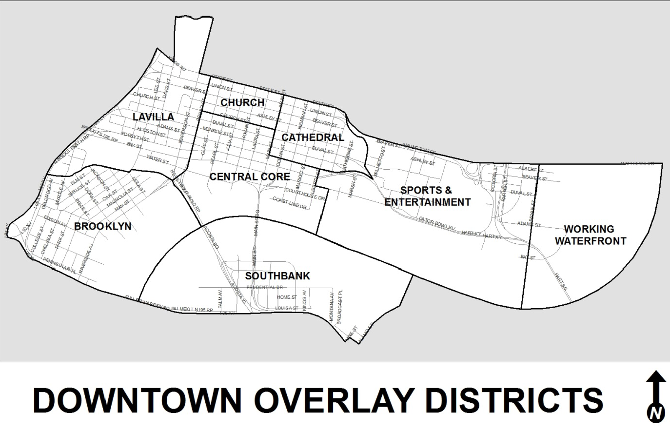
More specifically, the Downtown Overlay Zone boundaries are coextensive with the jurisdictional boundaries of the Downtown Investment Authority, which is described in Sec. 55.105, Ordinance Code, and includes all land within the following boundaries:
Begin at the intersection of a northwesterly prolongation of the northerly right-of-way line of State Street with the westerly boundary of Interstate - 95; thence run southerly along said westerly boundary of Interstate - 95 to an intersection with a northwesterly prolongation of the Fuller Warren Bridge over the St. Johns River and the northerly right-of-way line of that portion of Interstate 95 leading westerly from said Fuller Warren Bridge; thence southeasterly and easterly along said northerly right-of-way line of said Interstate 95 and said Fuller Warren Bridge to an intersection with the southeasterly right-of-way line of Vine Street; thence northeasterly along said southeasterly right-of-way line of Vine Street to an intersection with the northeasterly line of that certain alley running southeasterly through block 17, as shown on reed fourth subdivision of South Jacksonville, as recorded in Plat Book 1, Page 46 of the former public records of said County; thence southeasterly along said northeasterly alley line to an intersection with the northwesterly right-of-way line of Alamo Street; thence northeasterly along said northwesterly right-of-way line of Alamo Street to an intersection with the center line of the St. Johns River; thence easterly, northeasterly and northerly along the center line of the St. Johns River to an intersection with the northerly right-of-way of Matthews Bridge and Arlington Expressway; thence westerly along last said northerly right-of-way of said Matthews Bridge and Arlington Expressway to an intersection with the northerly right-of-way of State Street; thence westerly along last said northerly right-of-way line of State Street to an intersection with the westerly right-of-way line of Jefferson Street; thence northerly along last said westerly right-of-way line of Jefferson Street to an intersection with the easterly prolongation of the northerly boundary of the lands described and recorded in Official Records 7755, Page 2375 of said Current Public Records; thence northwesterly along last said line to an intersection with the easterly right-of-way line of Davis Street; thence southerly along last said easterly right-of-way line of Davis Street to an intersection with aforesaid northerly right-of-way line of State Street; thence westerly along last said northerly right-of-way line of said State Street to the point of beginning.
The Downtown Overlay Zone Map represents the Zoning Overlay for the boundaries herein described. The Zoning Atlas shall depict the Downtown Overlay Zone as described above, on the applicable Zoning Atlas map. The boundaries of each Downtown District are described as follows:
Brooklyn District: Beginning at the centerline of McCoy's Creek and the westerly line of Interstate 95; thence run southerly along the westerly line of Interstate 95 to the northerly line of the westerly approach to the Fuller Warren Bridge; thence southeasterly and easterly along the northerly line of the westerly approach to the centerline of the Fuller Warren Bridge; thence easterly along the centerline of the Fuller Warren Bridge to the centerline of the St. Johns River; thence northeasterly and northerly along the centerline of the St. Johns River to the centerline of the Acosta Bridge; thence northwesterly and westerly along the centerline of the Acosta Bridge to the centerline of the Florida East Coast Railroad; thence westerly and northwesterly along the centerline of the Florida East Coast Railroad to the centerline of Park Street; thence westerly along the centerline of Park Street to the centerline of McCoy's Creek; thence northwesterly and westerly along the centerline of McCoy's Creek to the point of beginning.
LaVilla District: Beginning at the centerline of Broad Street and the centerline of State Street; thence northerly along said centerline line of Broad Street 1,726.25 feet to a point as defined in the legal description prepared by Sunshine State Surveyors, Inc., dated September 24, 1990 on the Blodgett Homes site housing the State Regional Service Center; thence westerly along said line as referenced in the above survey to the centerline of Davis Street; thence southerly along said centerline of Davis Street to the centerline of Kings Road; thence westerly along said centerline of Kings Road to the northerly line of Interstate 95; thence southerly along the westerly right-of way line of Interstate 95 to the centerline of McCoy's Creek; thence southerly along the centerline of McCoy's Creek to the centerline of Park Street; thence northwesterly and westerly along the centerline of Park Street to the centerline of the Florida East Coast Railroad; thence southeasterly and easterly along the centerline of the Florida East Coast Railroad to the centerline of the Acosta Bridge and the centerline of Broad Street; thence northerly along the centerline of Broad Street to the point of beginning.
NorthCore District: Beginning at the centerline of Broad Street and the centerline of State Street; thence easterly along the centerline of State Street to the centerline of Main Street; thence southerly along the centerline of Main Street to the centerline of Church Street; thence easterly along the centerline of Church Street to the centerline of Broad Street; thence northerly along the centerline of Broad Street to the point of beginning.
Cathedral District: Beginning at the centerline of Main Street and the centerline of State Street; thence run easterly along the centerline of State Street to the centerline of Hogan's Creek; thence southerly along the centerline of Hogan's Creek to the centerline of Adams Street; thence westerly along the centerline of Adam's Street to the centerline of Main Street; thence northerly along the centerline of Main Street to the point of beginning.
Central Core District: Beginning at the centerline of the St. Johns River and the centerline of the Acosta Bridge; thence run westerly along the centerline of the Acosta Bridge to the centerline of Broad Street; thence run northerly along the centerline of Broad Street to the centerline of Church Street; thence easterly along the centerline of Church Street to the centerline of Main Street; thence southerly along the centerline of Main Street to the centerline of Adams Street; thence easterly along the centerline of Adams Street to the center line of Liberty Street; thence southerly along the centerline of Liberty Street to the centerline of Bay Street; thence easterly along the centerline of Bay Street for a distance of approximately 425 feet to the centerline of Washington Street as shown on the Official Map of Jacksonville dated March 5, 1877; thence proceeding southerly along the centerline of Washington Street as shown on the Official Map of Jacksonville dated March 5, 1877 to the St. Johns River; thence southerly along the prolongation of said centerline to the centerline of the St. Johns River; thence westerly along the centerline of the St. Johns River to the point of beginning.
Sports and Entertainment District: Beginning at the centerline of Liberty Street at the centerline of Adams Street; thence run southerly along the centerline of Liberty Street to the centerline of Bay Street; thence easterly along the centerline of Bay Street for a distance of approximately 425 feet to the centerline of Washington Street as shown on the Official Map of Jacksonville dated March 5, 1877; thence proceeding southerly along the centerline of Washington Street to the St. Johns River; thence southerly along the along the prolongation of said centerline as shown on the Official Map of Jacksonville dated March 5, 1877 to the centerline of the St. Johns River; thence easterly along the centerline of the St. Johns River for a distance of approximately 6,800 feet to an imaginary line drawn by the prolongation of the centerline of Bryan Street southerly into the St. Johns River; thence northerly along that imaginary line drawn to the centerline of Bay Street; thence northerly along the centerline of Bryan Street to the center line of the Arlington Expressway; thence proceed westerly along the centerline of the Arlington Expressway to the centerline Hogan's Creek; thence southerly along the centerline of Hogan's Creek to the centerline of Adams Street; thence westerly along the centerline of Adam's Street to the point of beginning.
Working Waterfront District: Beginning at the centerline of the St. Johns River and the centerline of the Matthews Bridge; thence proceed westerly along the centerline of the Matthews Bridge to the centerline of Bryan Street; thence proceed southerly along the centerline of Bryan Street to the centerline of Bay Street; thence southerly of a prolongation thereof to an intersection with the centerline of the St. Johns River; thence northeasterly and northerly along the centerline of the St. Johns River to the point of beginning.
Southbank District: Begin at the point of the center line of the St. Johns River on the centerline of the Fuller Warren Bridge; thence easterly along said centerline to a point of intersection with the southwesterly edge of the southbound roadway of South Main Street; thence northeasterly along a line drawn straight from the last described point to the northwesterly corner of Lot 18, Block 1, Bostwick's Subdivision of Block 46 in South Jacksonville, as shown on plat recorded in Plat Book 3, Page 68 of the current public records of said County, said northwest corner being located in the northeasterly right-of-way line of the northbound approach to said South Main Street from said Interstate 95; thence southeasterly and easterly along said northeasterly right-of-way line and northerly right-of-way line of Interstate 95 to an intersection with the southeasterly right-of-way line of Vine Street; thence northeasterly along said southeasterly right-of-way line of Vine Street to the northeasterly line of that certain alley running southeasterly through Block 17, Reeds Fourth Subdivision of South Jacksonville, as shown on plat recorded in Plat Book 1, Page 46 of the former public records of said County; thence southeasterly along said northeasterly alley line to an intersection with the centerline of Alamo Street; thence northeasterly along said centerline of Alamo Street to its intersection with the northerly right-of-way line of Utah Avenue; thence easterly along said northerly right-of-way line to its intersection with the northerly prolongation of the centerline of Barbara Avenue; thence continue northerly along the prolongation of the centerline of Barbara Avenue, a distance of 390 feet, more or less, to the center of a drainage canal; thence continue northeasterly along the centerline of said drainage canal to a point where said canal empties into a shallow bay; thence continue northerly along the waters of said bay to a point on the centerline of the St. Johns River; thence westerly and southerly along said center line of the St. Johns River to the point of beginning.
(Ord. 2019-196-E, § 6; Ord. 2022-383-E, § 1)
Sec. 656.361.3. - Definitions.
The definitions contained in Part 16 of the Zoning Code shall apply. Those terms which are specific to this Subpart H are defined as follows:
Accessory Parking Lot means a surface parking facility that provides a majority of available parking for a specific use or uses, such as for the exclusive use of customers, users or employees of a particular business or location. The facility may be located on or off the site of the use or uses to which it is accessory. A fee may or may not be charged. An accessory parking lot need not be under the same ownership as the specific use or uses to which it is accessory. If not under the same ownership, evidence of a long-term lease must be provided supporting the claim the lot is an accessory parking lot to the specific use or uses.
Area, Amenity means the space between the curb and the clear pedestrian area which area is intended to accommodate public facilities (such as light poles, signal devices, transformers, and other above ground utilities), landscaping, and street furnishings. This area is generally a minimum of four feet in width as measured from the back of curb toward the pedestrian clear area where right-of-way width permits.
Area, Frontage means the area adjacent to building frontages which serves as a transition area through which pedestrians do not generally pass as it is directly adjacent to building features. It is adjacent to the pedestrian clear area. The Frontage Area may include sidewalk cafés, outdoor display and similar uses.
Area, Pedestrian Clear means the clear area typically in the middle of the sidewalk that primarily accommodates pedestrian circulation which in all instances must be a minimum of five feet in width but is generally a minimum of eight feet in width in Downtown.
ASE (Automated Skyway Express) means the elevated mass transit system existing in the Downtown area as managed by the Jacksonville Transportation Authority.
BID Plan means the Downtown Investment Authority's Business Investment and Development Plan, which is an update of the two existing Community Redevelopment Area Plans for Downtown (Northbank and Southbank) along with the Business Investment Plan.
Commercial Surface Parking Lot means a parking facility that provides parking, in whole or the majority part, as a commercial enterprise, for four or more motor vehicles for a fee on a first-come-first-served basis, or by hourly or monthly contract. Such a parking lot is not primarily associated with any other use or uses, such as for the exclusive use of customers, users or employees of a particular business or location. The term does not include a commercial parking garage which is a building primarily used for the provision of parking for a fee. If a parking lot has a mix of dedicated spaces for a particular use or uses and general, first-come-first-served spaces, if such general spaces represent a majority of the available parking spaces, it shall be considered a Commercial Surface Parking Lot.
Creekfront Easement means that 25-foot wide public access easement running parallel and along each side of McCoy's Creek and Hogan's Creek as described in subsection 656.361.2.I (Creek Views and Creekfront Design).
DDRB means the Downtown Development Review Board established by Section 656.361.9.
DIA means the Downtown Investment Authority established in Chapter 55 (Economic Development), Part III (Downtown Investment Authority), Ordinance Code.
Differentiated Building Mass means a design strategy that attempts to break up the visual appearance of buildings or structures by use of offsets and other methods to articulate the horizontal and vertical planes of buildings in order to mitigate the effect of large looming buildings or structures.
Downtown District Regulations means the codified Use Regulations found in Section 656.361.5, and the Form Regulations found in Section 656.361.6, Ordinance Code.
Frontage means the part of a building, structure, lot or element that is adjacent to and generally parallel to a street right-of-way, the Riverwalk, or public access easement along a creek.
Ground-Floor means the at-grade, first floor of a building or structure.
Major Renovation means an expansion or renovation of existing development equal to 50 percent of the assessed value of the lot improvements according to the Property Appraiser or an expansion of the total square footage of a structure by 50 percent or more, including cumulative expansions totaling 50 percent.
On-Site Parking means a surface or structured parking facility which is used for the sole purpose of parking motorized vehicles located on the same property as the principle use for which the parking is utilized.
Pedestrian Entrance means a primary point of pedestrian access to the interior of a building or structure.
Pedestrian Skywalk means an elevated walkway connecting two structures and located above existing grade.
Pedestrian Zone. See "Zone, Pedestrian."
Private Realm means the buildings and areas within private property that are privately owned, designed and maintained. The Private Realm also includes Urban Open Space located on private property fully open to the public and integrated into the adjacent Public Realm and semi-private areas that may be required to be accessible on a limited basis as part of the Public Realm as Urban Open Spaces, but such areas are designed, constructed and maintained as part of the Private Realm.
Public Realm means the area beyond the edge of private areas that includes the Pedestrian Zone and the Vehicular Zone within the public right-of-way.
Streetscape means the visual character of a street as determined by various elements such as structures, landscaping, open space, natural vegetation and view.
Structured parking means parking for vehicles in a structure, and includes ground level parking covered by a building, but does not include a shade structure.
Urban Open Space means an area within the Private Realm that is immediately adjacent to the Public Realm and integrated therewith. Unlike what is generally or conventionally considered "open space" within the suburban context, Urban Open Space is not just landscaping or seating or the absence of a building or structure, but rather is an area built for human activity and engagement and is comprised of public art, interactive equipment such as swings, exercise equipment, information kiosks, etc. as the anchor of that space. Urban Open Space also includes semi-private areas that may be fenced or gated but activities within are visible from the Public Realm, accessible directly from the Public Realm, and open to the public during business and service hours. It does not lose its character as Urban Open Space if dedicated to the public or conveyed to the City.
View and Access Corridor means a linear view toward, and perpendicular to, either the St. Johns River, McCoy's Creek or Hogan's Creek, down either a public right-of-way or access easement within a block.
View Shed means the area that is visible from a specific location, such as a building, and includes all surrounding points that are in line-of-sight with that location and excludes points that are beyond the horizon or obstructed by other buildings.
Water's Edge Restaurant means any freestanding restaurant which seeks a zoning exception pursuant to Section 656.131, Ordinance Code, for all or any portion of the structure to be located within the established 50-foot setback from the river's edge (Zone A).
Zone, Pedestrian means the combination of the Frontage Area, the Pedestrian Clear Area, and the Amenity Area that make up the space between the edge of curb or roadbed and the building frontage, or if no building, then the Build-To Line, which may be identified by a frontage wall. This area is commonly referred to as the sidewalk.
Zone, Vehicular means the roadbed, including on-street parking and the curb, if any.
(Ord. 2019-196-E, § 6; Ord. 2022-383-E, § 1)
Sec. 656.361.4. - General Standards.
All development and redevelopment in the Downtown Overlay Zone including, but not limited to, all Public Works and JTA projects and streetscape projects, partnerships with the City that require funding, and all projects that require permits of any type for the development or redevelopment of a site, building, structure, or right-of-way shall be subject to the Use Regulations, the Form Regulations, the Design Guidelines, the Riverwalk Park Design Criteria, and the following general standards:
A.
The use shall be consistent with the BID Plan which includes the Community Redevelopment Plans and with the Central Business District Future Land Use Category as described in the Future Land Use Element of the City's adopted Comprehensive Plan.
B.
The form shall be in keeping with the general purpose and intent of the Downtown Overlay Zone, and Downtown Districts, including the Downtown Design Guidelines, or any amendments thereto, and the Riverwalk Park Design Criteria.
C.
The use, building or structure will not negatively impact or injure the value of adjacent properties by noise, lights, traffic or other factors or otherwise detract from the immediate environment.
D.
All applications and plans submitted shall be considered within the context of the BID Plan, the Downtown District Regulations, the Downtown Design Guidelines, and the Riverwalk Park Design Criteria to assure a consistency and compatibility among proposed and existing development, with respect to parking requirements, access, setbacks, building height, mass and transparency, etc.
E.
All applications and plans submitted shall be consistent with the City's adopted Mobility Plan and Public Facility Level of Service Standards identified in the Capital Improvements Element of the Comprehensive Plan. The requirements associated with the above are implemented separately with DIA through the approval of a redevelopment agreement and associated allocation of development rights which includes mitigation of impacts (transportation, utilities, police and fire protection, and similar impacts) by the applicant resulting from the development. Approval of the application and plans can occur during the above review, or before the above review, at the discretion of the applicant, subject to compliance with the above requirements before building permit applications are filed with the Building Official.
F.
All permitted activities (sale, service and display, preparation and storage) within the Downtown Overlay Zone shall be conducted within a completely enclosed building, unless specifically provided otherwise. Any person or entity seeking to hold an outdoor commercial or recreational activity shall first obtain a permit from the City's Special Events Division, pursuant to Part 1 of Chapter 191, Ordinance Code.
(Ord. 2019-196-E, § 6; Ord. 2020-695-E, § 3)
Sec. 656.361.5.1. - Uses Permitted Generally—Applicable to all Overlay Districts Zoned CCBD.
The use provisions in the various Overlay Districts are exclusive and a use not included under permitted or permissible uses shall be prohibited in the District. The following uses are permitted throughout Downtown (in all Overlay Districts) for parcels zoned CCBD:
A.
Retail and wholesale sales of food, pharmacies, wearing apparel, toys, sundries and notions, books and stationery and newsstands, leather goods and luggage, jewelry stores, watch repairs and art, camera and photographic supplies (including camera repair), sporting goods, hobby shops, and pet shops (but not including animal kennels), musical instruments, florist or gift shops, delicatessens, bakeries (including outdoor display of any of the foregoing merchandise during the normal business hours of the adjacent business), home furnishings and appliances (including repair incidental to sale) in completely enclosed buildings, office merchandise in completely enclosed buildings, hardware, new automobile parts (including rebuilt parts but not installation, repair or rebuilding of parts) in completely enclosed buildings, tire sales only if sales and display are entirely within an enclosed building.
B.
Service establishments such as barber or beauty shops, shoe repair shops, interior decorators, spas and skin care salons, tailors or dressmakers, radio and television broadcasting offices and studios (but not antenna or transmitting facilities), funeral homes (but not crematories), blueprinting, job printing, newspapers, radio and television repair shops, travel agencies, employment offices (but not day labor pools) and similar uses.
C.
Other Service establishments including laundry or dry cleaning pick up or drop off establishments with no cleaning to occur on premises and veterinarians but not animal boarding kennels, carpenter or cabinet shops and similar uses.
D.
Restaurants, including restaurants with the retail sale and service of all alcoholic beverages, for on-premises consumption, but not drive-in or drive-thru facilities. The minimum distance limitations in Part 8 (Alcoholic Beverages) of this Chapter 656 shall not apply to this use.
E.
Banks, loan companies, mortgage brokers, stockbrokers and similar financial institutions.
F.
All types of professional and business offices, union halls and similar uses (excluding day labor pools).
G.
Schools, colleges, universities, business, trade or vocational schools.
H.
Art galleries, museums, community centers, dance, art or music studios, and similar uses.
I.
Hotels and motels, bed and breakfasts.
J.
Floral, fruit, vegetable, poultry or fish markets.
K.
In all Overlay Districts, with the exception of the NorthCore District, entertainment establishments or facilities, including nightclubs, billiard parlors, dance halls, and private clubs, etc. with or without the retail sale and service of all alcoholic beverages for either on-premises or off-premises consumption, or both, (but not adult entertainment or dancing entertainment establishments) and with no minimum distance limitations outlined in Part 8 (Alcoholic Beverages) of this Chapter 656.
L.
Automobile parking garages.
M.
Multiple-family dwellings as standalone uses or as part of a mixed-use building, and dormitories when in conjunction with a college or university.
N.
Housing for the elderly, Assisted Living Facilities (ALF) and nursing homes.
O.
Day care or adult care centers meeting the performance standards and development criteria set forth in Part 4.
P.
Churches, places of worship, and other places of assembly including a rectory and similar uses, providing that minimum distance limitations outlined in Part 8 (Alcoholic Beverages) of this Chapter 656 do not apply.
Q.
Medical or dental clinics.
R.
Medical or dental laboratories when incorporated within a medical or dental clinic.
S.
Marinas.
T.
Public utilities such as lift stations, pump stations, wells, electric substations and chilled water plants (but not a hazardous waste transfer station).
U.
An establishment or facility in which beer, wine, or other alcoholic beverages, as those terms are defined in Chapter 561 through Chapter 565, Florida Statutes, are produced for on-site consumption and off-site sales that meet the following criteria: (1) Beer production not to exceed 10,000 barrels (310,000 gallons), and off-site sales to a State licensed wholesaler not to exceed 75 percent of production; (2) An on-site retail sales and service area shall comprise at least ten percent of the gross square foot area of the facility; and (3) The on-site retail sales and service area shall be accessible from the main public entrance, identified for access by the public. Part 8 (Alcoholic Beverages) of this Chapter 656 shall not apply to this use.
V.
Within the Private Realm (not within the right-of-way), permanent or restricted outside sale and service of food and beverages, including beer, wine and alcohol, meeting the performance standards and development criteria set forth in Part 4 of this Chapter 656. Within the Public Realm, outside sale and service of food and beverages, including beer, wine and alcohol, meeting the requirements of Part 8 (Downtown Sidewalk Cafes) of Chapter 250. Part 8 (Alcoholic Beverages) of this Chapter 656 shall not apply to this use. Within the NorthCore District, permanent or restricted outside sales of beer, wine and alcohol, both in the Private and Public Realms, must be in conjunction with a restaurant with outside sale and service of food.
W.
Retail sales of new or used automobiles and trucks (providing that all activities, including vehicle storage and showrooms, are within an enclosed building), Rental of automotive vehicles with no surface lot storage except in conjunction with a hotel.
X.
In All Overlay Districts: Commercial recreational or entertainment facilities in completely enclosed buildings such as theaters, art studios, fitness centers, etc. but not adult entertainment or service or adult arcades, indoor shooting galleries or gaming establishments.
Y.
Hospitals.
Z.
Temporary parking for:
1.
No longer than two years entirely for governmental uses on the site of the government use;
2.
No longer than four years on a site that is used primarily for government use or to satisfy the parking needs for National Football League games or other special events hosted at the Stadium and/or Daily's Place, which may include subordinate private use when not required for governmental uses or event parking;
3.
Special Event parking approved in advance by the Office of Special Events, for special events such as sporting events, concerts, theatrical performances, boat shows, car sales, or other City and DIA authorized special events that last no longer than three days in duration; or
4.
Construction Staging lots approved by DDRB that last no longer than the schedule of construction for the buildings/structures or two years, whichever is less, and which are properly maintained for the duration of the authorized period.
AA.
Homeless centers and rescue missions that exist as of March 1, 2019; provided, however that: by July 1, 2024, all of these existing facilities must have all activities, including waiting or queuing lines, in a completely enclosed structure; and, these existing facilities may not be expanded in scope or footprint unless such structural expansion is directly related to enclosing space for the activities, waiting or queuing lines.
BB.
Parks.
CC.
Distribution of artisan or craft merchandise, other than beer, wine or alcohol, when in conjunction with a retail or restaurant use with an on-site point of sale, where distribution and storage is equal to or less than 50 percent of the total business/building area, or 10,000 square feet, whichever is less.
(Ord. 2019-196-E, § 6; Ord. 2022-383-E, § 1; Ord. 2024-478-E, § 1)
Sec. 656.361.5.2. - Uses Regulated by District.
A.
Brooklyn District.
1.
Bonus uses.
(a)
Warehousing, storage or distributorship businesses when in conjunction with an on-site point of sale, and where the total operation does not require more than 10,000 square feet or where the warehousing, storage or distribution business is equal to or less than 75 percent of the total building area, whichever is less.
(b)
Detached Single-Family Homes.
2.
Uses permissible by exception.
(a)
Drive-in or drive through facilities for any permitted use (including, but not limited to, restaurants, dry cleaners, and banks) are permissible only by exception, provided:
i.
The service window or device and all queuing lines are located entirely within an enclosed structure such as a parking garage; or
ii.
When in conjunction with an existing, multi-use building the service window or device is contiguous to and accessed from an improved vehicle use area (e.g. parking lot) other than a Commercial Surface Parking Lot, existing as of 2014, and all queuing lines are located within such approved vehicle use area.
(b)
Personal property storage establishments meeting the criteria contained in Section 656.361.5.4.
(c)
Commercial Surface Parking Lot meeting the exception criteria contained in Section 656.361.5.3.
(d)
Filling or Fueling Stations with fewer than eight fueling stations.
(e)
Service garage for minor repairs provided there is no outdoor storage of vehicles and vehicle service bays do not face the public right-of-way.
(f)
Auto laundry.
(g)
Thrift stores (retail outlets for the sale of used goods).
(h)
Wholesaling or distributorship businesses in conjunction with on-site retail sales where the total operation requires more than 10,000 square feet of floor space or where the warehousing, storage or distribution business is greater than 75 percent of the total building area; in all instances warehousing, storage or distribution business must be in conjunction with an on-site point of sale and cannot exceed 25,000 square feet in area.
(i)
Manufacturing of medical, dental or optical products in conjunction with a retail point of sale or a clinic; or as a standalone facility not to exceed 10,000 square feet.
(j)
Day Labor pool provided all activities, including waiting or queuing, are completely located within an enclosed facility.
(k)
Water's Edge Restaurants, meeting the exception criteria found in Section 656.131, Ordinance Code, and the development standards found in 656.361.5.4.(B).
B.
LaVilla District.
1.
Bonus uses.
(a)
Warehousing, storage or distributorship businesses when in conjunction with an on-site point of sale, and where the total operation does not require more than 10,000 square feet or where the warehousing, storage or distribution business is equal to or less than 75 percent of the total building area, whichever is less.
(b)
Detached Single-Family Homes.
2.
Uses permissible by exception.
(a)
Drive-in or drive through facilities for any permitted use (including, but not limited to, restaurants, dry cleaners, and banks) are permissible only by exception and provided the service window or device and all queuing lines are located entirely within an enclosed structure such as a parking garage.
(b)
Service garage for minor repairs provided there is no outdoor storage of vehicles and vehicle service bays do not face the public right-of-way.
(c)
Personal property storage establishments meeting the criteria contained in Section 656.361.5.4.
(d)
Commercial Surface Parking Lot meeting the exception criteria contained in Section 656.361.5.3.
(e)
Filling or Fueling Stations with fewer than eight fueling stations.
(f)
Auto laundry.
(g)
Thrift stores (retail outlets for the sale of used goods).
(h)
Wholesaling or distributorship businesses in conjunction with on-site retail sales where the total operation requires more than 10,000 square feet of floor space or where the warehousing, storage or distribution business is greater than 75 percent of the total building area; in all instances warehousing, storage or distribution business must be in conjunction with an on-site point of sale and cannot exceed 25,000 square feet in area.
(i)
Manufacturing of medical, dental or optical products in conjunction with a retail point of sale or a clinic; or as a standalone facility not to exceed 10,000 square feet.
(j)
Day Labor pool provided all activities, including waiting or queuing, are completely located within an enclosed facility.
(k)
Multi-story mixed use facility including not more than 16 filling or fueling stations, and a minimum 5,000 square feet of restaurant space as well as at least one other permitted use such as office or retail.
C.
NorthCore District.
1.
Bonus uses.
(a)
Detached Single-Family Homes.
(b)
Warehousing storage or distributorship businesses when in conjunction with an on-site point of sale, and where the total operation does not require more than 10,000 square feet or where the warehousing, storage or distribution business is equal to or less than 75 percent of the total building area, whichever is less.
2.
Uses permissible by exception.
(a)
Drive-in or drive through facilities for any permitted use (including, but not limited to, restaurants, dry cleaners, and banks) are permissible only by exception, provided:
i.
The service window or device and all queuing lines are located entirely within an enclosed structure such as a parking garage; or
ii.
When in conjunction with an existing, multi-use building the service window or device is contiguous to and accessed from an improved vehicle use area (e.g. parking lot) other than a Commercial Surface Parking Lot, existing as of 2014, and all queuing lines are located within such approved vehicle use area.
(b)
Personal property storage establishments meeting the criteria contained in Section 656.361.5.4.
(c)
Commercial Surface Parking Lot meeting the exception criteria contained in Section 656.361.5.3.
(d)
Auto laundry.
(e)
Thrift stores (retail outlets for the sale of used goods).
(f)
Day Labor pool provided all activities, including waiting or queuing, are completely located within an enclosed facility.
D.
Cathedral District.
1.
Bonus uses.
(a)
Detached Single-Family homes.
2.
Uses permissible by exception.
(a)
Drive-in or drive through facilities for any permitted use (including, but not limited to, restaurants, dry cleaners, and banks) are permissible only by exception and provided the service window or device and all queuing lines are located entirely within an enclosed structure such as a parking garage.
(b)
Commercial Surface Parking Lot meeting the exception criteria contained in Section 656.361.5.3.
(c)
Auto laundry.
(d)
Thrift stores (retail outlets for the sale of used goods).
(e)
Day Labor pool provided all activities, including waiting or queuing, are completely located within an enclosed facility.
E.
Central Core District.
1.
Bonus uses: None.
2.
Uses permissible by exception.
(a)
Drive-in or drive through facilities for any permitted use (including, but not limited to, restaurants, dry cleaners, and banks) are permissible only by exception, provided:
i.
The service window or device and all queuing lines are located entirely within an enclosed structure such as a parking garage; or
ii.
When in conjunction with an existing, multi-use building the service window or device is contiguous to and accessed from an improved vehicle use area (e.g. parking lot) other than a Commercial Surface Parking Lot, existing as of 2014, and all queuing lines are located within such approved vehicle use area.
(b)
Auto laundry.
(c)
Thrift stores (retail outlets for the sale of used goods).
(d)
Day Labor pool provided all activities, including waiting or queuing, are completely located within an enclosed facility.
(e)
Private clubs.
(f)
Water's Edge Restaurants, meeting the exception criteria found in Section 656.131, Ordinance Code, and the development standards found in 656.361.5.4.(B).
F.
Sports and Entertainment District.
1.
Bonus uses.
(a)
Commercial recreational or entertainment facilities in completely enclosed buildings or outdoors such as billiard parlors, bowling alleys, swimming pools, skating rinks, dance halls, carnivals or circuses, theaters (including open-air theaters), indoor shooting galleries, archery or blade throwing ranges, pony rides, athletic complexes, arenas, auditoriums, convention centers, go-cart tracks, driving ranges and similar uses, but not adult entertainment or service or adult arcades.
(b)
Manufacturing uses in existence on March 1, 2019.
(c)
Private Clubs.
2.
Uses permissible by exception.
(a)
Drive-in or drive through facilities for any permitted use (including, but not limited to, restaurants, dry cleaners, and banks) are permissible only by exception, provided:
i.
The service window or device and all queuing lines are located entirely within an enclosed structure such as a parking garage; or
ii.
When in conjunction with an existing, multi-use building the service window or device is contiguous to and accessed from an improved vehicle use area (e.g. parking lot) other than a Commercial Surface Parking Lot, existing as of 2014, and all queuing lines are located within such approved vehicle use area.
(b)
Auto laundry.
(c)
Thrift stores (retail outlets for the sale of used goods).
(d)
Water's Edge Restaurants, meeting the exception criteria found in Section 656.131, Ordinance Code, and the development standards found in 656.361.5.4.(B).
G.
Working Waterfront District.
1.
Bonus uses: All uses permitted within the IW Zoning District.
2.
Uses permissible by exception.
(a)
Drive-in or drive through facilities for any permitted use (including, but not limited to, restaurants, dry cleaners, and banks) are permissible only by exception, provided:
i.
The service window or device and all queuing lines are located entirely within an enclosed structure such as a parking garage; or
ii.
When in conjunction with an existing, multi-use building the service window or device is contiguous to and accessed from an improved vehicle use area (e.g. parking lot) other than a Commercial Surface Parking Lot, existing as of 2014, and all queuing lines are located within such approved vehicle use area.
(b)
Day Labor pool provided all activities, including waiting or queuing, are completely located within an enclosed facility.
(c)
Service garage for minor repairs provided there is no outdoor storage of vehicles and vehicle service bays do not face the public right-of-way.
(d)
Bulk storage yard.
(e)
Bulk processing, including flammable liquids.
(f)
Water's Edge Restaurants, meeting the exception criteria found in Section 656.131, Ordinance Code, and the development standards found in 656.361.5.4.(B).
H.
Southbank District.
1.
Bonus uses: None.
2.
Uses permissible by exception.
(a)
Drive-in or drive through facilities for any permitted use (including, but not limited to, restaurants, dry cleaners, and banks) are permissible only by exception and provided the service window or device and all queuing lines are located entirely within an enclosed structure such as a parking garage.
(b)
Filling or Fueling Stations with fewer than eight fueling stations.
(c)
Commercial Surface Parking Lot meeting the exception criteria contained in Section 656.361.5.3.
(d)
Auto laundry.
(e)
Thrift stores (retail outlets for the sale of used goods).
(f)
Service garage for minor repairs provided there is no outdoor storage of vehicles and vehicle service bays do not face the public right-of-way.
(g)
Manufacturing of medical, dental or optical products in conjunction with a retail point of sale or a clinic; or as a standalone facility not to exceed 10,000 square feet.
(h)
Private clubs.
(i)
Water's Edge Restaurants, meeting the exception criteria found in Section 656.131, Ordinance Code, and the development standards found in 656.361.5.4.(B).
(Ord. 2019-196-E, § 6; Ord. 2022-383-E, § 1; Ord. 2025-74-E, § 1)
Sec. 656.361.5.3. - Commercial Surface Parking Lot Exception Criteria.
All Commercial Surface Parking Lots were to come into compliance with the screening and landscaping standards of the former Sections 656.361.16 and 656.361.17 by 2014, thus any existing Commercial Surface Parking Lot that is not in compliance with those regulations is subject to immediate Code Enforcement action. Commercial Surface Parking Lots shall meet the following criteria.
In addition to the general requirements for obtaining a zoning exception, the Downtown Development Review Board must find that a parking deficiency exists in the area the commercial surface parking lot is proposed, that there is a bona fide need from adjacent property owners and users, that an additional supply of parking is necessary, and that the demand cannot be met by existing parking facilities. In addition to the zoning exception criteria listed under Section 656.131(i)—(xiv), to demonstrate a bona fide need, the applicant shall also include the following information as part of the application a parking needs study that provides the following minimum information:
A.
Identify all parking facilities within 700 feet of proposed Commercial Surface Parking Lot, including connections to services that provide access to parking facilities outside of 700 feet;
B.
Identify occupancy rates of identified parking facilities;
C.
Establish the deficiency of parking supply of identified parking facilities;
D.
Identify new users of the proposed commercial surface parking lot;
E.
Identify the number of new users of the proposed commercial surface parking lot;
F.
Identify the end trip of the new users of the proposed commercial surface parking lot;
G.
Identify rate structure for commercial surface parking lot users;
H.
Identify percentage of daily versus monthly users;
I.
Identify parking agreements with users and percentage of public versus private users; and
J.
Any additional information DDRB staff may request to assist in evaluating the necessity of the proposed commercial surface parking lot.
(Ord. 2019-196-E, § 6)
Sec. 656.361.5.4. - Development Standards for Uses Regulated by District.
The following additional development standards shall apply to uses permitted and permissible in Downtown:
A.
Personal property storage. It is the intent that self-storage facilities are part of a mixed-use building with ground floor activation.
1.
All storage shall be located within the building, and outside storage of any type, including the outside storage of moving vans, trailers, vehicles and boats, shall not be permitted.
2.
For ground floor building facades that front public streets, at least 50 percent of street frontages shall be devoted as functional space for at least one primary use unrelated to, and not an accessory to, the self-storage facility. For the purposes of meeting this requirement, functional space does not include vehicle use areas, open space, or other non-activation activities, but does include uses such as professional and medical offices, commercial retail sales and services, eating and drinking establishments, and art galleries.
3.
No more than 25 percent of the ground floor building facade fronting a public street may be wrapped with the rental and management office associated with the self-storage facility.
4.
Direct access to the individual self-storage units located in the building shall not be provided from the exterior of the building. Access to the individual self-storage storage units shall be provided by internal hallways.
5.
The minimum height of a building containing a self-storage facility shall be three stories.
6.
The maximum height of a building containing a self-storage facility shall be the maximum height permitted in the Downtown Overlay District in which it is located.
7.
Building facades visible from the public right-of-way must have the appearance of an office, retail or residential building through the use of doors, windows, awnings, and other appropriate building elements.
Personal property storage facilities are prohibited along any waterway.
B.
Water's Edge Restaurants. Water's Edge Restaurants, including those that utilize the open-air dining over sovereign submerged lands option provided by Rule 18-21.004, Florida Administrative Code, are exempt from the 50-foot setback requirement so long as the exception criteria in Section 656.131 and all of the following criteria are met:
1.
The width of the building, or width of a structure blocking the view to the waterfront is not greater than 75 feet;
2.
The restaurant must be open to the general public with no qualifying requirements, such as club membership, stock ownership, or equity interest;
3.
The restaurant is prohibited from blocking a View and Access Corridor;
4.
Only one exempt restaurant is allowed between any two View and Access Corridors;
5.
The height of the building and structure, as measured from the finished floor elevation, is no greater than 20 feet in height, or up to 35 feet in height to accommodate rooftop restaurant, bars, or other activities; and
6.
A Riverwalk Easement of equal required width is provided by the applicant as close as practicable to the waterfront.
(Ord. 2019-196-E, § 6; Ord. 2022-383-E, § 1)
Sec. 656.361.6.1. - General.
A.
Regulations. These Form Regulations define the design objectives for the elements that determine the image of Downtown, and refine the concepts of the BID Plan, translating it into an operational document that eliminates the guesswork developers and their architects face for development in Downtown Jacksonville.
The intent is to provide for flexibility and creativity in the form or design of individual sites and structures while also defining the space for a vibrant experience within the public realm, and maintaining views of the river from properties and public rights-of-way well back from the river so that the visual connection to the river is enjoyed throughout downtown. Flexibility in the requirements has been built into this Section in order to eliminate the need for Deviations.
The Form Regulations are grouped into two sections: the Private Realm, which applies to buildings and areas within private property; and the Public Realm, the area beyond the edge of Private Realm, that includes the pedestrian zone and vehicular zone.
B.
Guidelines. The Downtown Design Guidelines, as superseded by these Regulations, and as time to time amended by the Downtown Investment Authority consistent herewith, provide a further explanation of the Regulations offering a variety of schematic figure design options to meet the requirements of the Downtown Overlay Zone Regulations. These Guidelines may be amended by the DIA without City Council approval if the amendment is consistent with the BID Plan and this Subpart, but shall be amended to be consistent with these Regulations by July 1, 2020. All development, including new construction and renovation or rehabilitation of existing buildings and structures, should be consistent with the Guidelines as well as complying with the Regulations contained in this Part unless specifically exempted. The Guidelines may be accessed through the City's Legislative Services Division, the DIA website, or the City's website.
C.
Riverwalk Park Design Criteria. All development along the river, both public and private, shall be consistent with the Riverwalk Park Design Criteria dated February 2019 as adopted pursuant to Ordinance 2019-196-E and available on the City website and from Legislative Services as on file with Ordinance 2019-196-E. The Riverwalk Park Design Criteria shall govern the development of the Riverwalk adjacent to the bulkhead and over water along the riverfront of both the north and south banks of the River along the entire river frontage Downtown. The Riverwalk Park Design Criteria provide the design intent and specifications for the development of the Riverwalk. These documents may be accessed through the City's Legislative Services Division, the DIA website, or the City's website.
D.
Application to Historic Buildings. With respect to any locally designated historic landmark, or any contributing structure in the Downtown national historic district, or any federally designated landmark, the following regulations shall not apply to the extent they would require any modification of the historic facade that would otherwise be preserved or restored. If modifications to a historic structure are proposed such that it would no longer be deemed a contributing structure or eligible for local designation, then the modifications to the facade shall conform to the requirements below.
(Ord. 2019-196-E, § 6)
Sec. 656.361.6.2. - Private Realm Regulations.
New development and redevelopment of existing structures should contribute to the creation of a coherent, well-defined and active public realm that supports pedestrian activity and social interaction, and to the creation of a well-organized and functional private realm that supports the needs of tenant businesses and residents. New development and redevelopment also should contribute to a visually and functionally integrated pattern of development that reads as a consistent and attractive whole. Thus, the general building forms and functions and how they are organized on the site and in relation to surrounding development have as much to do with the area's character and function as a building's aesthetic characteristics.
A.
Build-to lines/Lot Frontage.
1.
Purpose and Intent: Establishment and support of the civic life of the street are important elements in the creation of a dynamic pedestrian-oriented downtown. Siting buildings at or near the right-of-way line, or the Private Realm edge, gives spatial definition to the Public Realm that is critical to supporting pedestrian activity. Residential uses on the street level shall be spatially separated from the Public Realm sidewalk for privacy. Any setback permitted from the Build-To Line shall accommodate site specific Urban Open Spaces or semi-private Urban Open Spaces to maintain the urban character and streetscape edge and the integration and engagement of the public pedestrian corridors with the proposed public or semi-private Urban Open Space.
2.
Build-To Requirements for all new buildings:
(a)
All new buildings and structures, whether residential or non-residential, shall directly address the public street, Riverwalk, Creekfront Easements, and View and Access Corridors (rather than having buildings oriented to parking lots).
(b)
Buildings shall be pulled forward to the interior edge of the Pedestrian Zone and shall provide continuous frontage along public sidewalks to maintain the urban character and streetscape edge, except where:
(1)
The building is set back to accommodate optional Urban Open Space or vehicular drop-off as allowed below, and such frontage is pedestrian-oriented with pedestrian-scaled elements that work to activate the street along adjacent sidewalks; or
(2)
The building is set back to accommodate an expansion of the Pedestrian Zone which may be for a wider than required Pedestrian Clear Area, Amenity Area or Frontage Area; or
(3)
The buildings are separated for a pedestrian path or vehicular alley, breaking the continuous frontage.
(c)
Public Realm Pedestrian Zone (sidewalk) minimum widths are addressed in detail in subsection 656.361.6.3.B:
(1)
The Pedestrian Clear Area shall be the highest priority within the Pedestrian Zone and generally a minimum of eight feet in width but in no event less than five feet in width in areas of constrained right-of-way;
(2)
The Amenity Area shall be a minimum of four feet in width, except as provided in subsection 656.361.6.3.B.4 in constrained areas;
(3)
The Frontage Area shall be a minimum of two feet in width.
(d)
If the existing sidewalk is less than the minimum required Pedestrian Clear Area, or if there is no sidewalk, and there is not adequate right-of-way between the edge of curb and the right-of-way line to expand the sidewalk to meet the required width, then the developer shall provide an additional building setback in order to provide the space required for the Pedestrian Clear Area.
(e)
If there is no existing sidewalk, one shall be constructed which complies with the width requirements for the Pedestrian Zone.
(f)
Buildings located adjacent to both open space amenities (e.g., plazas, parks, the Riverwalk, Creekfront Easements, and View and Access Corridors to the waterfront) and public streets shall be designed with a dual orientation so that they provide a public face or architecturally appropriate facade to both the primary street frontage and to the public or semi-public urban open space, Creekfront Easements, or View and Access Corridors.
(g)
On corner parcels, building design shall be used to define and activate the intersection as an important node.
(h)
The height and placement requirements within the Riverfront Zones supersede these Build-To requirements in the case of a conflict.
(i)
A set back from the Build-To Line to accommodate a vehicular drop off will be allowed only if all of the following are met:
(1)
No parking or cab standing is allowed; and
(2)
The vehicular use area (stabilized surface upon which vehicles move or park) shall be separated from the right-of-way by an Urban Open Space area at least 25 feet in depth.
(j)
No portion of a vehicular use area may be deemed an Urban Open Space.
(k)
For non-residential use at street level, other than a parking garage, the front plane of the building or structure shall be located as follows:
(1)
On the right-of-way line, unless:
(i)
Additional setback is required to provide the required width for Pedestrian Zones pursuant to the Public Realm Regulations contained in subsection 656.361.6.3, in which case the Build-To line is the new setback line; or
(ii)
On a setback line off the right-of-way provided that the intervening space, utilized by the public but maintained as Private Realm, is developed as Urban Open Space that expressly activates and addresses the public realm (see the Urban Open Space criteria in subsection 656.361.6.3.D), and is to accommodate either: site specific public urban open spaces such as plazas, courtyards, vistas, entryways, or the like; or semi-private spaces such as a sidewalk café or retail uses, which are open to the public during business hours.
(l)
If the development spans the entire length of the block, then Urban Open Space shall be provided either at a corner, or as an indentation from the Build-To Line along a minimum of ten percent of the frontage. The Urban Open Space shall not be merely landscaping, but useable as Public Realm or Semi-private Urban Open Space. See Illustration 6.2.A, below.
Illustration 6.2.A Build-To Line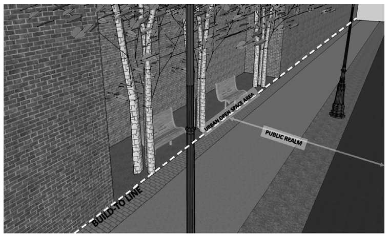
(m)
For residential units at street level on the street frontage: In order to provide ample visual separation between the residential unit and the public realm, the first floor shall be either:
(1)
Raised a minimum of three feet above the sidewalk; but no greater than six feet, or one foot above the minimum flood elevation; whichever is greater; or
(2)
Set back from the required Pedestrian Zone interior edge the lesser of the setback required to align with the front plane of other residential structures on the street or set back a distance of between five feet and 15 feet, exclusive of stairs that are used to access the dwelling unit. The setback area shall be developed as Urban Open Space or otherwise enhanced to improve the aesthetic appearance from or engagement with the Pedestrian Zone. An example of pedestrian engagement close to the Pedestrian Zone might be an open front porch.
(3)
Access to ground-floor residential units shall be directly from the street to promote active residential street frontage. Stoops, front porches, porticos, and/or forecourts shall be incorporated to buffer residential uses and provide pedestrian interest.
(n)
Parking garages on the street level shall meet the criteria of subsection 656.361.6.2.K (Off Street Parking) and subsection 656.361.6.2.B (Private Realm Urban Open Space).
3.
Build-ToRequirements forexisting buildings. The Build-To Line shall not apply in the event of Major Renovation of an existing building, and the existing facade setback may be maintained. However, the following shall apply:
(a)
If there is existing and conforming surface On-Site Parking, the parking lot shall be re-constructed to meet the requirements of Section 656.361.6.2.K (Off Street Parking) and subsection 656.361.6.2.L (Screening and Landscaping of Surface Parking, Trash Storage, and Loading Areas); and
(b)
The area between the existing building or conforming On-Site Parking and required interior edge of the Pedestrian Zone, if any, shall meet the Urban Open Space requirements of subsection 656.361.6.2.B below.
4.
Deviations from the Build-To Line. Deviations from the Build-To requirements may be allowed by the DDRB only if the decision is based on competent substantial evidence that deviating from the requirement meets all of the General Deviation Criteria contained in subsection 656.361.8.B, and in addition meets all of the criteria listed for the Deviation requested below:
(a)
A Deviation from the Build-To line to modify the requirement of visual separation between the private dwelling unit space and the Public Realm may be allowed only if the applicant can demonstrate that compliance is not feasible on the site due to site specific conditions not generally found within Downtown.
(b)
A Deviation from the Build-To line to permit a building frontage line farther away from the street than the Build-To Line may be allowed only if all of the following are met:
(1)
The streetscape edge shall be maintained by architectural features (arcades and walls), site furnishings (e.g., flagpoles, light standards) or landscape elements (e.g., palms) which provide continuity between the proposed building and the building line of adjoining structures.
(2)
Walls and other features utilized to create a frontage line at the Build-To Line shall not block the view into or out of the semi-private areas.
(3)
A building shall not be set back with only landscape strips along the entire facade facing a street. Instead, Urban Open Spaces shall be consolidated to an area of the building site that creates a mix of hard surfaces and landscaping without the entire building being set back from the street.
(4)
A building shall not be set back to allow on-site parking along the street frontage, even if the streetscape edge contains the architectural features mentioned above.
(c)
A Deviation from the Build-To line to move the building frontage line closer to the street than the Build-To Line may be allowed only if each of the following are met:
(1)
The applicant can demonstrate that compliance is not feasible on the site due to site specific conditions not generally found within Downtown;
(2)
The Pedestrian Zone may in no event be reduced to less than five feet and the combined Pedestrian and Amenity Zones to not less than eight feet; and
(3)
The Pedestrian and Amenity Zones are consistent with the adjacent developed properties.
(d)
A Deviation from continuous frontage or Urban Open Space along the Build To line may be allowed only if the applicant can demonstrate that compliance is not feasible on the site due to site specific conditions not generally found within Downtown.
B.
Urban Open Space: Open to the Public or Semi-Private.
1.
Purpose and Intent: Urban Open Spaces are effectively extensions of the Pedestrian Zone and are to be utilized for public congregation, rest, relaxation, and recreation or enjoyment adjacent to and integrated into the Public Realm corridor and serve to activate the sidewalks and engage pedestrians. Urban Open Spaces shall generally be open to the public or may be Semi-Private such as an outdoor seating restaurant open during business hours of the restaurant. Unless dedicated and conveyed to the City, and the City accepts maintenance thereof, all Urban Open Space shall be maintained by the owner thereof.
2.
Requirements for all Urban Open Space—Open to the public or semi-private:
(a)
Shall be accessible and visible from the adjoining Pedestrian Zone.
(b)
Entryways and steps to these urban open spaces shall be kept wide and welcoming in character.
(c)
Shall be handicap accessible.
(d)
No portion of a vehicular use area or the Vehicular Zone may be deemed an Urban Open Space.
3.
Urban Open Space open to the public: Urban Open Space open to the public shall be designed for public congregation and recreation such as: plazas, courtyards, entry ways, or the like, and shall be designed to integrate, but not interrupt, the streetscape edge at the Build-To Line. See the following Illustrations.
(a)
The following amenities are examples of appropriate Urban Open Space features: ornamental fountains, waterfalls, sculptures, trellises, arbors, seating facilities, landscape features, shade structures, street trees, etc.
(b)
Design features of these Urban Open Spaces shall serve to enhance the visual and functional quality of the adjoining corridor and be compatible with public facilities such as in the Amenity Area of the Pedestrian Zone.
(c)
The Urban Open Space required in order to have a vehicular drop off shall provide landscaping, shade and seating, or other amenities to activate the use of the sidewalk, rather than just landscaping to enhance the structure beyond. This must be an extension of the Pedestrian Zone.
4.
Semi-private Urban Open Space Requirements:
(a)
Semi-private Urban Open Spaces such as a sidewalk café or retail use, which is open to the public during business hours shall be open to the public as patrons a minimum of four hours per day.
(b)
Walls or screening utilized in this area shall not block the view into or out of the semi-private areas, but a physical separation is allowed.
5.
Deviations by the DDRB: Where Urban Open Space is provided as an option in lieu of meeting other requirements, no Deviation from the requirements of Urban Open Space contained in 656.361.6.2.B.2 are allowed unless it can be shown that the Urban Open Space intent of 656.361.6.1.B.1 has otherwise been satisfied. Where Urban Open Space is required by these Regulations, such as in subsection 656.361.6.2.A (Build-to lines/Lot Frontage) regarding a development that spans the entire block length, or the setback of street level residential uses, Deviations may be allowed by the DDRB, and the decision must be based on competent substantial evidence that the request meets the General Deviation Criteria contained in subsection 656.361.8.B, and in addition that:
(a)
If no required Urban Open Space is provided, then visual interest and engagement such as living walls, windows containing displays, or art walls shall be provided.
C.
Building Massing and Form.
1.
Purpose and Intent: It is important that future buildings are designed so that their scale and massing does not overwhelm the Public Realm and make it unattractive or inhospitable. The modulation of a block and the massing of buildings significantly impacts how the size of a building is perceived by a person at street level. New buildings and additions should reinforce the historic pattern with indentations and upper-level step-backs oriented to the many existing low to mid-rise buildings. The following regulations seek to ensure integration of new buildings into the existing character of the area, while allowing for more intense development and taller buildings. Buildings that frame and define the street and express a fine-grain character contribute to the quality of the Public Realm and the pedestrian experience. Well-articulated and detailed street walls are important to the fabric of the City and help to establish a human-scale urban experience. The design of different elements of a building is critical: tower designs create the skyline image of a city; the mid-portions of buildings provide visual interest to pedestrians and serve as attractive backgrounds for public open spaces; and the ground floor designs activate the street and enrich the pedestrian environment.
2.
Requirements:
(a)
Enhance the skyline. The upper portion of a tall building shall be designed to promote the visual interest and variety in the downtown skyline. Existing landmarks shall be respected while responding to the skyline's present and planned profile.
(b)
Create a transition in bulk and scale.
(1)
The massing of a new building shall be composed to create a transition to the height, bulk, and scale of nearby existing developed properties. This Section is not intended to limit permitted height, or restrict new development potential, especially when nearby previously developed properties are vacant or abandoned, or significantly underdeveloped, but to include architectural transitions to the existing development.
(2)
Height limits are established and upper level setbacks from parcel boundaries for tall buildings are encouraged to create large-scale transitions in height, bulk, and scale. More refined transitions in bulk and scale shall also be considered.
(3)
Buildings on District edges shall be developed in a manner that creates a step, or transition, in perceived height, bulk, and scale between the development potential of the adjacent District, unless there is an intervening elevated roadway or bridge structure.
(c)
Block modulation.
(1)
Full block building developments shall be broken up into distinct volumes that are in proportion to one another, while preserving the integrity of the building's design, and create transitions in bulk and scale.
(2)
Repetitive elements or monolithic treatments that create a half- or full-block massing or appearance shall be avoided. Large scale building facades where the total building length is greater than 250 feet fronting a street, shall include a substantial facade modulation or a building mass separation.
(3)
Building design shall use a variety of color, material and texture in order to express variety, avoid monotony and distinguish different building volumes.
3.
Deviations allowed by DDRB:
(a)
Deviations to the skyline, transition, building modulation and massing requirements may be authorized if and in addition to the general Deviation criteria, DDRB finds that the proposed architecture of the building is unique, innovative and will positively impact the downtown image as well as immediately adjacent buildings and development sites.
D.
Height of Buildings and Structures.
1.
Purpose and intent: It is the intent of this subsection to provide the greatest flexibility in creativity and design of individual projects while still respecting the surrounding character of existing patterns of development.
2.
Requirements: The height of buildings and structures is unlimited within the Overlay Zone with the following exceptions:
(a)
Brooklyn District - 90-foot height limit from the centerline of Chelsea St. to Interstate 10, as shown on Map 6.2.D, below;
(b)
LaVilla District - 75-foot height limit;
(c)
Cathedral District - 65-foot height limit;
(d)
Waterfront Design and River Views - See subsection 656.361.6.2.H.
Map 6.2.D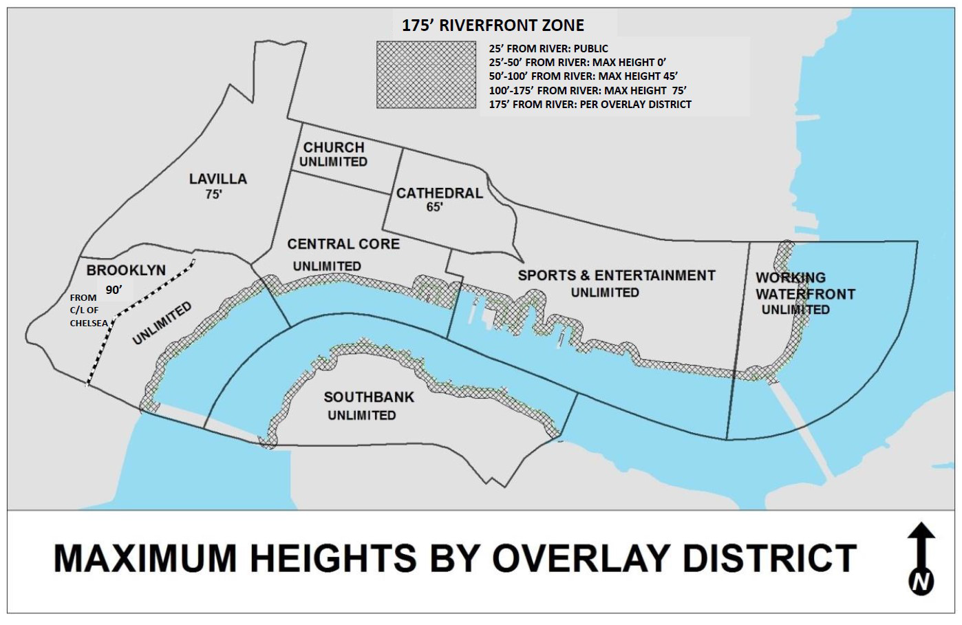
3.
Measurement of structure height. The height of a structure shall be measured from natural grade, or historically modified grade as it exists on March 1, 2019. In the case of a sloped lot within a Riverfront Zone as discussed in this Section, the height of a structure shall be measured from said grade at the lowest portion of the lot within the applicable Riverfront Zone.
4.
Deviations allowed by the DDRB: Deviations to the height limitations in the Brooklyn, LaVilla and Cathedral Districts, other than in the Riverfront Zone, may be allowed by the DDRB if the decision is based on competent substantial evidence that the request meets the General Deviation Criteria contained in subsection 656.361.8.B, and in addition that:
(a)
The Deviation will not adversely impact the uniform District character (i.e. site is on District boundary); and
(b)
The Deviation does not allow development that adversely diminishes the prominence of historically designated buildings in the District; and
(c)
The Deviation will buffer the remainder of the District from elevated roadway or undesirable use or provide a transition to a higher use across the District boundary or the Deviation is requested to permit development of a transit oriented development in the LaVilla District consistent with the LaVilla master plan.
E.
Facade Differentiation.
1.
Purpose and Intent: Building facades are the "walls" that give definition to the public realm, and contribute significantly to the character of an area. The doors, windows, and detailing that animate these facades both activate the streetscape and establish a pleasing sense of order and proportion. It is important that they be neither too dull nor too busy, and that they present a perceptible unity without sacrificing variety. Facade differentiation is essential in order to create architectural interest at the street level, enhance the urban character, and involve the pedestrian on the street with the adjacent building. See Illustration 6.2.E, below. Street level is defined as the space from the sidewalk up 30 feet.
2.
Requirements:
(a)
To provide pedestrian scale and interest, building facades of new structures, or reconstruction of existing facades that face public streets, sidewalks, Urban Open Space areas and other pedestrian areas, shall incorporate differentiated building walls, open and inviting facades, human/pedestrian scale, and variety of detail and form by addressing variation in wall planes, horizontal and vertical articulation, glazing, materials, finishes, and colors.
(b)
Articulation and detailing shall include features such as building entrances, display windows, awnings, canopies, balconies, bays, horizontal banding, sills, fenestration, alcoves, awnings, light fixtures, and other design features that add human scale and visual interest to the facades.
(c)
Articulation of building volumes, changes in rooflines and fenestration patterns, introduction of vertical architectural features such as columns and pilasters, the use of decorative detailing and architectural elements, and changes in building materials and color shall be used to vary facades and define distinct modules of the buildings.
(d)
Facades at the lower levels of the building that face public streets and urban open space areas shall be architecturally subdivided and should include some form of modulation or articulation at appropriate intervals in order to promote visual interest and a comfortable pedestrian scale that is reminiscent of traditional pedestrian-oriented shopping and residential districts.
(e)
Continuous massing at street level that is not articulated with architectural feature expression, shadow relief, projections, setbacks and recesses is prohibited.
(f)
Buildings should incorporate a variety of vertical and horizontal modulations to develop distinct architectural volumes, break up monotonous volumes and create a fine-grain character.
(g)
Solid portions of walls shall contain enhanced materials, deep reveals and scoring, or other textures.
Illustration 6.2.E Facade Differentiation
3.
Deviationsallowed by the DDRB: Deviations may be allowed by the DDRB if the decision is based on competent substantial evidence that the request meets the General Deviation Criteria contained in subsection 656.361.8.B, and in addition that:
(a)
The Public Realm is fully developed and adequately addressed by Urban Open Space; and
(b)
Pedestrian scale and visual interest at the street level is maintained without facade differentiation by other specific features and enhancements to the pedestrian experience.
F.
Building Entrances.
1.
Purpose and Intent: Development should be designed to improve the pedestrian's experience of downtown Jacksonville by respecting existing development patterns, providing frequent pedestrian entries along the street and the waterfronts, providing cover, and signaling the entrance through architectural features rather than relying solely on signage. See Illustration 6.2.F, below.
Illustration 6.2.F Building Entrances
2.
Requirements:
(a)
Pedestrian entrances to buildings shall be well defined and accentuated through the use of facade articulation, architectural detail, and use of materials. Strategies for this include:
(1)
Creating a recessed entry bay;
(2)
Incorporating the entrance into a taller vertical mass (e.g., a small tower) that is differentiated from the rest of the building;
(3)
Sheltering the entrance with a canopy, awning, or overhang;
(4)
Employing architectural features such as columns, pilasters, clerestory windows and sidelights, decorative tiles and light fixtures; and
(5)
Enhancing the ground surface at the entry with decorative paving.
(b)
There shall be at least one pedestrian entrance door on each building elevation facing a street or a waterway, but an entrance is not required on each View and Access Corridor, as shown in Figure 6.2.F below, unless:
Figure 6.2.F Pedestrian Entrances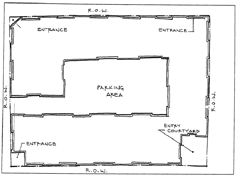
(1)
The building fronts on more than two streets in which case Pedestrian Entrances shall only be required on two frontages, and an Urban Open Space shall be included on the building facade(s) lacking an entrance; or
(2)
A public entrance on more than one street facade is a demonstrated safety concern as determined by staff of DDRB. If this is determined to be the case, then an Urban Open Space shall be included on the building facade(s) lacking an entrance; or
(3)
in the case of a site with three or more frontages, a building shall locate its service area and loading facilities on one of the least prominent frontages and shall not be required to provide an entrance or urban open space on that facade, but will comply with the screening requirements herein.
(c)
The Pedestrian Entrance(s), which are by definition the main or primary entrances to a building, shall face the street or a waterway and not a parking lot.
(d)
The Pedestrian Entrance(s) to a hotel or residential use, and to an office use in the Brooklyn and Southbank Districts, may be set back from the Build To Line, as required by the Build To Line Section, to provide for a motor court drop-off area.
(e)
If interior-block parking exists, there may be secondary entrances from the parking lot, or mid-block pedestrian passages from the parking lot to the street.
(f)
An entrance shall be provided for each retail or restaurant establishment street frontage exceeding 50 feet. Where such frontages exceed 150 feet, one entrance shall be provided for each 150 feet of frontage or portion thereof.
(g)
Pedestrian ramps within the public right-of-way are prohibited, except where necessary for required disabled access to existing buildings when no alternative is available.
(h)
Features for shade and protection from the rain are required over entrances to buildings. The lowest point of these features shall be no less than 8 feet from the sidewalk measured vertically. See subsection 656.361.6.3.C regarding requirements for protecting pedestrians from the elements.
(i)
The building lobby in an office, hotel or other commercial building shall be designed as a clearly defined and demarcated standout architectural feature of the building.
(j)
Entries to stores and ground-floor commercial uses shall be visually distinct from the rest of the store facade, with creative use of scale, materials, glazing, projecting or recessed forms, architectural details, color and/or awnings. These entries shall have direct at-grade access from the sidewalk or from an Urban Open Space adjacent to and accessible from the sidewalk.
(k)
The use of awnings, canopies, and over-hangs shall be encouraged in order to highlight entrances and give definition to the facade, and to provide shelter and shade over building entrances and display windows. Awnings shall:
(1)
Be in scale with the building and designed to be complementary to the overall design of the building;
(2)
Avoid covering transom windows and other architectural elements;
(3)
Be of durable materials that can stand up to the weather;
(4)
Not interfere with the tree canopy or signage; and
(5)
Provide an eight-foot minimum clearance above the finished sidewalk. See Pedestrian Protection from the Elements subsection below.
3.
Deviations allowed by the DDRB: Deviations from the following requirements may be allowed by the DDRB only if the decision is based on competent substantial evidence that deviating from the requirement meets all of the General Deviation Criteria contained in subsection 656.361.8.B, and in addition meets all of the criteria listed for each requirement below:
(a)
A Deviation from the requirement to have architecturally well-defined entrances, may be allowed only if each of the following are met:
(1)
The overall architecture of the building would be adversely impacted by a well-defined entrance; and
(2)
Other streetscape or Urban Open Space features are incorporated to clearly signal the entrance.
(b)
A Deviation from the requirement that the main entrance must face the street or a waterway may be allowed only if one of the following is met:
(1)
The development is entirely residential or office in the Brooklyn or Southbank Districts, and a courtyard entrance is provided; or
(2)
The development is second story over enclosed surface parking, an interior entrance elevator from the parking provides access, and the exterior of the parking lot is wrapped a minimum of 50 percent of the facade length with retail or other active uses with street or waterway frontage entrances.
(c)
A Deviation from the requirement that a Pedestrian Entrance be provided on each street or waterway frontage, other than as permitted above, may be allowed if the applicant can demonstrate that compliance is not feasible on the site due to site specific conditions not generally found within Downtown.
G.
Transparency.
1.
Purpose and Intent: The urban environment will be enhanced by minimizing the area of blank wall space on the ground-floor level. The purpose of the transparency requirement is to encourage continuity of retail and pedestrian consumer service uses and to provide a pleasant, rich, and diverse experience for pedestrians by visually connecting activities occurring within a structure to adjacent sidewalk and Riverwalk areas, prohibiting fortress-like facades at the street level and avoiding a monotonous environment. All buildings and structures with street or waterway frontage shall meet, as shown in Figure 6.2.G, below, the following requirements.
Figure 6.2.G Transparency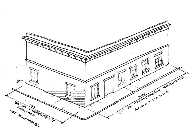
2.
Requirements:
(a)
At least 50 percent of each new or re-constructed building facade, between the height of two feet and ten feet above the sidewalk or Riverwalk grade shall be transparent.
(b)
Uses which can be seen from the sidewalk inside the building within the required transparency area shall be habitable space, or space able to be occupied, and shall not be devoted to parking areas, truck loading areas, vehicular access ways, or storage.
(c)
The required transparency area shall not apply to those portions of building frontage with ground floor residential units located fronting the sidewalk.
(d)
The required transparency area shall not apply to buildings of historic significance, or churches, synagogues or other buildings of religious worship existing as of March 1, 2019.
(e)
Large expanses of solid walls are prohibited and shall not exceed 20 feet in width.
(f)
Reflective or mirror glass, heavily tinted bronze, black or gray glass is prohibited at the street or Riverwalk level.
(g)
Glass materials at street or Riverwalk level shall exhibit visible light transmittance of a minimum of 60 percent.
(h)
Projecting balconies facing public streets shall be an average of no less than 40 percent open or transparent (perforated mesh, 40 percent translucent glass, or open rail) above a height of 18 inches, measured from the balcony walking surface.
3.
Deviations allowed by the DDRB: Deviations may be allowed by the DDRB if the decision is based on competent substantial evidence that the request meets the General Deviation Criteria contained in subsection 656.361.8.B, and in addition that:
(a)
As to a Deviation from the 50 percent ground floor transparency requirement and/or the requirement that no solid wall shall exceed 20 feet in width between two feet and ten feet in height may be allowed only if all of the following are met:
(1)
The use of the ground floor space is unique and not commonly found throughout Downtown (such as a museum, convention center, hospital or arena); and
(2)
The use must be protected from light, or visibility into the space would create bona fide security concerns; and
(3)
The design of the exterior facade incorporates living walls, murals or other facade treatments that would engage the pedestrian in the space where transparency would be required.
(b)
As to a Deviation from the requirement that the transparent area must be occupied space may be allowed only if all of the following are met:
(1)
The use of ground floor space for parking, loading, or storage has been approved by Deviation; and
(2)
The design of the exterior facade incorporates living walls, murals or other facade treatments that would engage the pedestrian in the space where transparency would be required.
H.
Waterfront Design and River Views: setbacks, height and access corridors.
1.
Purpose and Intent: It is the intent of this subsection to encourage and protect enticing views of the river from as many places in downtown as possible by providing View and Access Corridors at the street level, to maximize overall value by providing both enhanced public spaces at the riverfront and by facilitating river and creek views from as many buildings as possible, as well as managing building forms and massing to be respectful of the context of the surrounding buildings and of the pedestrian environment by stepping buildings up from the river and defining height zones as delineated hereunder to allow views around, over and through the architecture, and, to respect the scale of the context in which development occurs. Additionally, it is the intent to encourage activation of the waterfronts by treating them similarly to street fronts, particularly in terms of transparency and building entrances.
Illustration 6.2.H River Views and Height of Buildings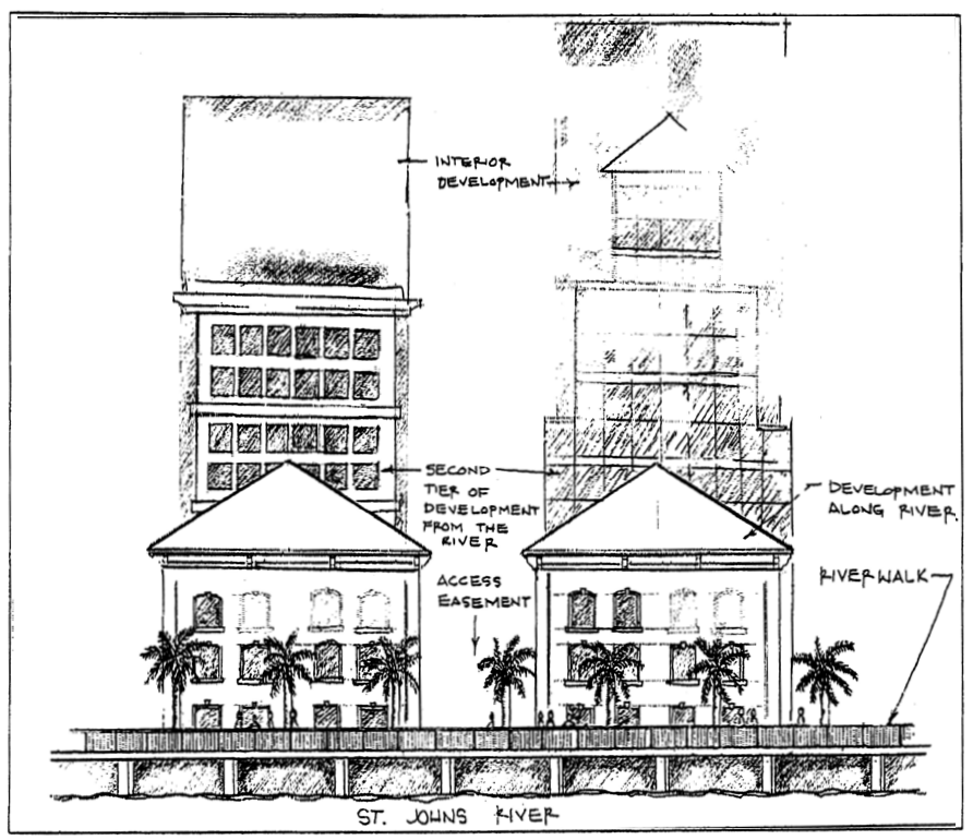
The purpose of the Riverfront Zones, depicted in Table 6.2.H below, is to protect pedestrian scale along the waterfront and provide for spacing horizontally through corridors to promote the views of and access to the river. Because the land generally slopes down to the river, attention must be paid to the views to the river from a higher elevation as one's vantage point recedes from the river.
The purpose of the Waterfront Design regulations is to: 1) protect and promote the City's downtown waterfront as a community resource, 2) provide for an orderly development or redevelopment of the waterfront, 3) foster high quality design of the riverfront development, 4) ensure increased public access to and along the water's edge, and 5) create a pedestrian-oriented environment along the waterfront. The following requirements shall apply to all property located along the St. Johns River waterfront.
2.
Requirements for River View and Access Corridors: View and Access Corridors (which provide both view and physical public access and are generally perpendicular to the waterfront) and rights-of-way shall be maintained by adherence to the following:
(a)
No existing public right-of-way, opened or unopened, or View and Access Corridor as required by this Section, which leads to or toward the riverfront may be closed, abandoned, vacated, or visually blocked from street level up to a height of 35 feet as measured at the river side of the first street that is generally parallel to the river, unless an alternate public View and Access Corridor meeting the requirements below is provided. Any alternate View and Access Corridor shall:
(1)
Be of equal width parallel to the water and length perpendicular to the water as the right-of-way or View and Access Corridor to be closed or blocked; and
(2)
Be located such that the distance between View and Access Corridors after the contemplated closure is no more than 300 feet from the centerline of one to another except as provided in (4) below; and
(3)
Connect to the first street that is generally parallel to the river; and
(4)
Where feasible, align with a longer existing perpendicular View and Access Corridor landward of the first street that is generally parallel to the river. In order to achieve this alignment, a distance of up to 350 feet between rights-of-way and View and Access Corridors would be allowed administratively without the need for Deviation provided the Corridor width is also proportionately increased beyond the 40-foot minimum.
(b)
Where the distances between the centerlines of generally perpendicular rights-of-way or View and Access Corridors running between the first street generally parallel to the river and the river exceeds 300 feet one or more additional 40-foot wide (minimum) and 35-foot in height (minimum) easement(s) for View and Access Corridor(s) to the river shall be provided, generally perpendicular to the river and perpendicular to the first street parallel to the river, to the extent possible, such that the distance between the inside edges of the View and Access Corridor easements or rights-of-way shall not exceed 250 feet. By way of explanation, a building may be designed for River View Zones B and C, and in the unlimited height area, to a maximum of 250 feet in length generally parallel to the river, but more importantly, parallel to the first street that generally parallels the river in order to provide a meaningful view to the river from that first street. If an existing View and Access Corridor is not located every 300 feet (centerline to centerline), then the View and Access Corridor to be provided shall be aligned with a longer existing perpendicular View and Access Corridor landward of the first street that is generally parallel to the river, if feasible. In order to achieve this alignment, a distance of up to 350 feet between Corridors would be allowed administratively without the need for Deviation provided the corridor width is also proportionately increased beyond the 40-foot minimum.
(c)
The View and Access Corridor shall be a landscaped easement, open to the public as a walkway. The View and Access Corridor shall be designed to allow, and specifically invite public physical and visual access to the river. See Illustration 6.2.H-2, below.
Illustration 6.2.H-2 River View Corridors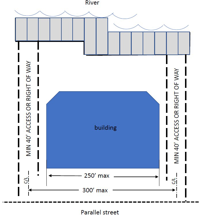
(d)
A building shall be oriented such that its primary axis is perpendicular to the river and designed so as to minimize impediments to water views from principal public view points at ground level and from higher portions of nearby buildings.
(e)
If a site is redeveloped that previously closed a public right-of-way to the river, that right-of-way shall be reopened or a View and Access Corridor shall be provided over the former right-of-way if the closed portion in question aligns with an existing open and developed right-of-way, across the first street parallel to the river and by reopening the closed portion a longer View Corridor to the river would be achieved than by providing the View Corridor required in 656.361.6.2.H.2(b), above or 656.361.6.2.H (g) below. This provision shall not require the re-opening or prevent the closure of any right-of-way meeting the requirements for superior alternate corridors described in 656.361.6.2.H.2 (a). The intent of these Regulations is to maintain a consistent visual connection with the river, and the historic pattern of street ends at the river provide this connection.
(f)
A View and Access Corridor can be blocked above 35 feet from grade within Zones B and C and within the unlimited height area, but only if it is open and clear up to 35 feet in height as first measured at the river side of the first street that is generally parallel with the river and continuing that clear area level to the river. The View and Access Corridor shall be a minimum of 40 feet in width, beginning at the river and continuing up to and connecting with the first street that generally parallels the river, so that those traveling at ground level along that street can see the river.
(g)
In the event the distance between View and Access Corridors is increased beyond 300 feet as described above in order to allow alignment with a longer perpendicular Corridor or right-of-way, and the width of the View and Access Corridor itself is proportionately increased, the maximum allowable building width adjacent to the View and access Corridor shall also be proportionately increased above the 250-foot maximum. By way of illustration, if a 50-foot wide View and Access Corridor exists at a distance of 350 feet from the next adjacent Corridor, and by adding 25 feet in width to that Corridor it would then align with a longer Corridor perpendicular to the river, the distance to the interior edge of the Corridor could be increased to 325 feet and the building width on the adjacent parcel increased to 275 feet.
3.
Setback from River parallel to the Waterfront. Public access along the riverfront, as well as preservation of river views and pedestrian scale parallel to the waterfront shall be maintained by adherence to the following:
(a)
Consistent with the adopted Community Redevelopment Area Plans for Downtown Northbank and Southbank, a 50-foot minimum setback from the St. Johns River's water edge shall be enforced, except for projects granted a Water's Edge Restaurant exception. This setback may be achieved by providing an average building or vertical structure setback of 50 feet from the bulkhead or mean high water line, with a minimum setback of 40 feet in all locations. No building element or vertical structure that reduces the setback to less than 50 feet may extend more than 50 feet in length parallel to the waterfront, and other portions of the same building shall be setback beyond 50 feet in order to achieve the average setback of 50 feet across the entire building frontage. This waterfront setback is Zone A, from the water's edge measured from the waterside face of the bulkhead or the rip-rap revetment at the Mean High Water Line ("MHWL") extending landward of the river, as established at the time of request for a building permit and DDRB review, as shown in Table 6.2.H and Map 6.2.H below.
Table 6.2.H Riverfront Zones
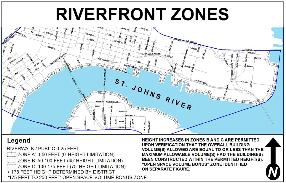
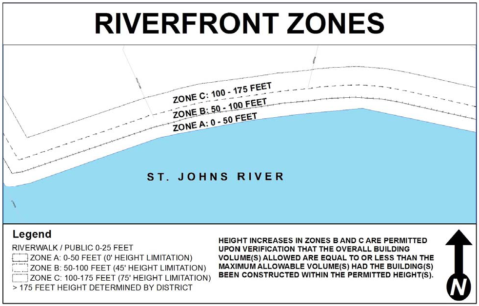
Map 6.2.H Riverfront Zones Maps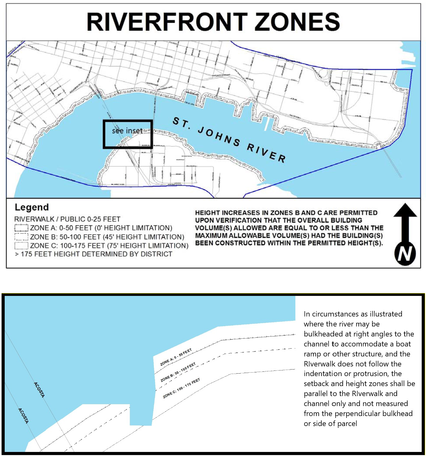
(b)
The Public Realm must be activated and open to the public within the 25 feet closest to the bulkhead or mean high water line. Only public amenities such as street lights, gazebos, shade structures, etc. and signage and interactive or storytelling features, all consistent with the Riverfront Park Design Guidelines, shall be allowed within the 25 feet of Zone A closest to the water.
(c)
In the event the adjacent Riverwalk is already in existence and was constructed over water pursuant to a submerged lands lease, and
(1)
The proposed upland development will provide a continuous connection to the existing Riverwalk by expanding the Riverwalk inward to and beyond the face of the bulkhead or mean high water line; and
(2)
The upland owner has granted to the City unrestricted permission to repair, maintain and enhance the existing Riverwalk in its present location, then Zone A shall be measured from the outside face of the existing Riverwalk inward toward the upland.
(d)
Riverwalk. Within Zone A, a minimum 25 foot wide perpetual easement or dedication of property, running the length of the setback shall be granted to the City for the Riverwalk, adjacent to the bulkhead or mean high water line of the river, whichever is farther upland, for the purpose of construction of a public Riverwalk along the riverfront to be part of a continuous Riverwalk system. Such conveyance shall occur prior to issuance of a building permit for the proposed building or structure. Construction of the Riverwalk shall comply with the provisions of this subsection and the design standards set forth in the Riverwalk Park Design Criteria dated February 2019, as may be amended from time to time, which standards are hereby adopted and on file in the Legislative Services Division, the City Engineer's Office, and the DIA. In the event the adjacent Riverwalk is already in existence and was constructed over water pursuant to a submerged lands lease, such easement or dedication shall be satisfied by either an upland easement entitling the City to obtain a submerged lands lease or a binding agreement consenting to application for and the grant of a submerged land lease to the City for construction, repair, maintenance, replacement and enhancement of the existing Riverwalk.
(e)
In Zone A, outside of the 25-foot band closest to the water, Zone A may be activated with non-permanent structures and furnishings such as tables, chairs and umbrellas that are completely open and accessible to the Riverwalk for use with cafes, bars and the like located outside of Zone A; Urban Open Space amenities such as fountains and public recreational amenities of a height no greater than 18 feet (entirely open to the public without charge); and private accessory uses not to exceed four feet in height, and fully visible from the Riverwalk such as swimming pools, patios, putting greens and other horizontal private outdoor recreational amenities in which case a transparent fence may be allowed no closer to the water than 26 feet from the bulkhead or MHWL separating the private uses from the Riverwalk easement.
4.
Height Zones parallel to the Waterfront. Preservation of river views and pedestrian scale parallel to the waterfront shall be maintained. A Water's Edge Restaurant granted a zoning exception shall not be required to be calculated in the volume bonus. Adherence to the following criteria shall constitute a "safe harbor" that the intent of the Regulation has been achieved without the need for a Deviation:
(a)
In Zones B and C, the height of a structure, including all permanent structures and appurtenances such as roofs over rooftop bars, mechanical equipment, elevator housing, etc., shall generally be limited as provided in Table 6.2.H above, but may be increased if the goal of protecting pedestrian scale along the waterfront is achieved through alternate designs of equal or lower volume thus increasing the open space adjacent to Zone A and providing relief from a continuous development wall plane parallel to the river. The maximum buildable volume within Zone B on a given parcel (45 feet in height × 50 feet in depth x the parcel frontage width generally not to exceed 250 feet) could be used entirely within Zone B or partially or wholly transferred to Zone C, and could be used in any configuration of height and width. Likewise, the buildable volume in Zone C could also be used in any configuration of height and width or transferred wholly or in part to Zone B. By way of example, a height increase would be appropriate where the allowable building width parallel to the river (after taking into account the required view and access easements from interior roadways contained in Section 656.361.6.H.2.) is decreased and the volume of taller building within the applicable zone is equal to or less than the permitted volume within the zone had the height requirement been met. The intent is to allow flexibility for height increases in Zones B and C where public views and access are increased beyond the minimum and to encourage narrower waterfront building frontages with corresponding open space in exchange for increased height thus maintaining the goals of preserving the open feel of the adjacent Zone A and the views from and value of interior properties.
(b)
Furthermore, consistent with the goal of encouraging narrower buildings and greater open space adjacent to View and Access Corridors, an additional volume bonus, as depicted in Illustration 6.2.H, below, shall be available for open space in the first 75 feet of the unlimited height zone parallel and adjacent to Zone C as follows:
To be eligible for volume bonus credit:
(1)
The full height unobstructed open space must be immediately adjacent to the View and Access Corridor(s); and
(2)
The open space must be a continuation and extension of open space provided in Zones A and B effectively providing a wider view to the river continuously from the riverfront to a distance of 175 feet to 250 feet off the river, (unobstructed by any building protrusion at ground level or above grade); and
(3)
The volume bonus shall only be available for height increase in Zone C.
(4)
The volume bonus shall be calculated as the width of the qualified open space that is the distance between (i) the exterior edge of the building at its widest point between the waterfront and 250 feet off the river and (ii) the adjacent View and Access Corridor (including any expansion of the corridor adjacent to the waterfront zones), multiplied by the depth of the additional open space not to exceed 75 feet (distance between 175 feet and 250 feet off the river that is to remain unobstructed) times 150 (the height that would create a continuous plane from the river through Zones B and C to a distance of 250 feet). The resulting volume may be used to increase height in Zone C.
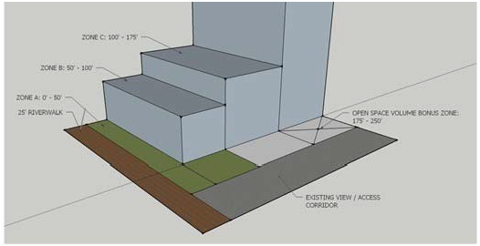
The above illustrates the Open Space Volume Bonus Zone with a constant building plane between the St. Johns River and 250′. In this instance, the bonus volume applied in Zone C is calculated at: 75′ × 75′ × 150′ = 843,750 cubic feet.
Illustration 6.2.H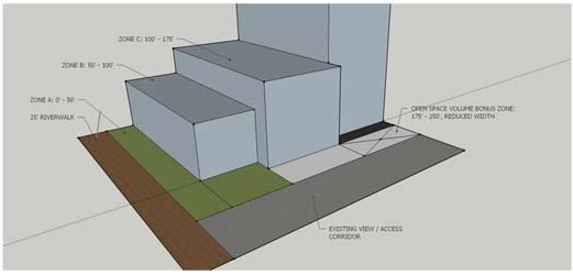
The above illustrates the Open Space Volume Bonus Zone where the building edge in Zone C is closer to the view/access corridor than the adjacent building edges within 250′ of the St. Johns River. In this instance, the bonus volume applied in Zone C is calculated at: 45′ × 75′ × 150′ = 506,250 cubic feet.
Map 6.2.H (including Volume Bonus)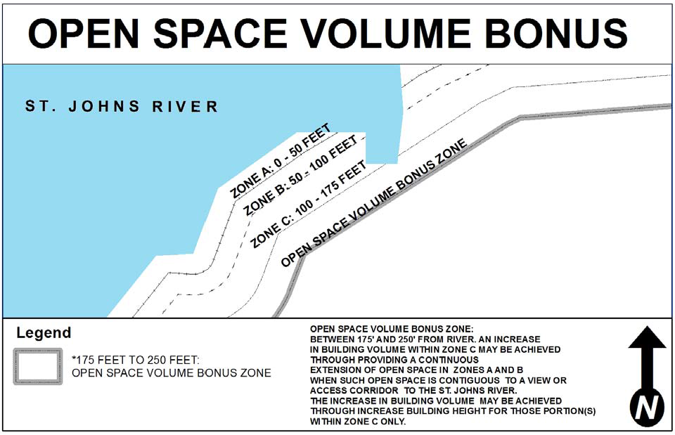
(c)
The approval of a height increase in Zones B and/or C while maintaining the maximum volume, including any open space volume bonus, shall be administrative based upon a verification that the overall volume allowed by the maximum width and maximum height along the river pursuant to Table 6.2.H is equal to or greater than the volume proposed. Height may be transferred between Zones B and C as well as within a Zone but may not be transferred to Zone A.
5.
Deviations: Except as specifically authorized in this subsection, no Deviation from 656.361.6.2.H. shall be allowed. The ability to deviate from River View Corridors, from Zone A setback or permitted uses, from Zone B and C height limitations where the volume within the Zone is increased without a volume trade as described above, and/or Riverwalk is specifically vested in the City Council.
Deviations may be allowed by the City Council, following consideration and issuance of a recommendation regarding same by DDRB, if the decision is based on competent substantial evidence that the request meets all of the General Deviation Criteria contained in subsection 656.361.8.B, and in addition meets all of the criteria listed below.
(a)
Regarding a Deviation for Zone A Encroachment, the request meets all of the following additional criteria:
(1)
There is no feasible alternative for development of the site; and
(2)
The development provides substitute public benefits through other Urban Open Space or activated semi-private facilities, (such as restaurants, bars, museums or other similar venues open to the public and located on the frontage of the building), or publicly accessible boat slips or water taxi stops, additional public access points beyond those required, wider view or access corridors, or the like.
(b)
Regarding a Deviation from the requirement to provide view and/or access corridors at the specified intervals,
(1)
The development provides substitute public benefits through other Urban Open Space or activated semi-private facilities, (such as restaurants, bars, museums or other similar venues open to the public and located on the frontage of the building), or publicly accessible boat slips or water taxi stops, additional public access points beyond those required, wider view or access corridors, or the like; and
(2)
There are unique characteristics of the site that warrant the Deviation such as alternative major access points. Examples of these would include public parks just beyond the 300-foot boundary, an accessible creekfront bisecting site, or bridge structures or overpasses that would make a View Easement in the required location unnecessary, unusable or undesirable.
(c)
Regarding a Deviation for greater height in Zone B or C where collective volume within the Zones is increased:
(1)
The view and access corridors are increased above the minimum required to provide superior public access to and along the riverfront. By way of example, a height increase could be appropriate where the allowable building width parallel to the river (after taking into account the required view and access easements from interior roadways contained in Section 656.361.6.2.H.2.) is reduced resulting in a narrower waterfront building frontage with corresponding open space increased thus maintaining the goals of preserving the open feel of the adjacent Zone A and the views from and value of interior properties; and
(2)
The development provides substitute public benefits through other Urban Open Space or activated semi-private facilities (such as restaurants, bars, museums or other similar venues open to the public and located on the frontage of the building), or publicly accessible boat slips or water taxi stops; and
(3)
The building or structure shall not have a significant adverse effect upon light, air, solar and visual access of properties surrounding the proposed site or of the river; and
(4)
Sufficient articulation of the building or structure has occurred to respect the scale of adjacent buildings and structures; and
(5)
The increased height of the building or structure is necessary for the successful function of the building or structure; and
(6)
There are unique characteristics of the site that require the Deviation such as overpass structures, bridges, or utility easements that prevent development in some portion of Zone B or C or that require the proposed building to be elevated in order to achieve an equivalent view of the river.
(d)
Deviation for greater height of a free-standing waterfront restaurant than provided in Section 656.361.6.2.H.(4)(d), which shall meet at least the General Deviation Criteria.
I.
Creek Views and Creekfront Design.
1.
Purpose and intent. It is the intent of this Section to encourage enticing views of the creeks from as many places within the vicinity of the creeks as possible, as well as to encourage building forms and massing that is respectful of the context of their surroundings and the pedestrian environment by stepping buildings up from the creeks and defining height zones as delineated hereunder to break up building form to allow views through the architecture, particularly down public rights-of-way, to discourage large undifferentiated building masses and encourage building breaks, respect the scale of the context in which development occurs, including transition between development segments or areas, and encourage a variety of roof forms. The Creekfront Zone is defined as an area 40 feet in width parallel to the top of bank or bulkhead of the creek and includes the setback and easement areas described below.
2.
Requirements.
(a)
A minimum 25-foot wide public use easement (Creekfront Easement) shall be provided along and parallel to each side of McCoy's and Hogan's Creeks to facilitate development of the McCoy's and Hogan's Creek Linear Parks and multiuse trail system. Such easement shall be measured from the bulkhead or top of bank as it exists as of March 1, 2019 or the top of bank of the creek as relocated pursuant to the McCoy's Creek Capital Improvement project, whichever requires less of the adjacent developable lot. Developers of properties along McCoy's and Hogan's Creeks shall negotiate with the City to dedicate an easement or transfer fee title adequate in length and width to the City for a pedestrian walkway, bike path and associated landscaped areas to be funded and maintained by the City.
(b)
View and Access Corridors perpendicular to the creeks shall be preserved and created consistent with requirements for View and Access Corridors to the river contained in subsection 656.361.6.2.H above.
(c)
An average 40-foot, minimum 30-foot setback, from the creeks shall be maintained to provide views and pedestrian scale parallel to the creek frontage. Such setback shall be measured from the bulkhead or top of bank as it exists as of March 1, 2019, or from the property line of the adjacent lot, whichever is greater. No primary structures or parking facilities may be located within the setback, however non-permanent structures such as tables, chairs and umbrellas, that are completely open and accessible to the creekfront easement for use with cafes, bars and the like located outside the setback; pop-up tents and portable kiosks for retail or similar uses that are accessible to the public and not maintained in place overnight; Urban Open Space amenities such as fountains and public recreational amenities; private outdoor recreational amenities that are fully visible from the easement; and semi-private uses meeting the Urban Open Space requirements, all may be allowed within the setback outside the easement area above, provided they do not exceed 18 feet in height.
3.
Deviations: The ability to deviate from these Requirements is specifically vested in the City Council. Deviations for setback encroachment may be allowed by the City Council, following consideration and issuance of a recommendation regarding same by DDRB, if the decision is based on competent substantial evidence that the request meets the General Deviation Criteria contained in subsection 656.361.8.B, and in addition meets all of the criteria listed below:
(a)
Regarding a Deviation for setback encroachment:
(1)
The development provides substitute public benefits through other Urban Open Space or activated semi-private facilities, additional public access points beyond those required, wider view or access corridors, or the like; and
(2)
The location and height of building or structure do not have a significant adverse effect upon light, air, solar and visual access to the creek or the linear park to be constructed within the creekside easement; and
(3)
The reduced setback of the structure or improvement from the creek is necessary for the successful function of the building or structure.
(b)
Regarding a Deviation from the requirement to provide view and/or access corridors at the specified intervals:
(1)
The development provides substitute public benefits through other Urban Open Space or activated semi-private facilities, additional public access points beyond those required, wider view or access corridors, or the like; and
(2)
There are unique characteristics of the site that warrant the Deviation such as alternative major access (view and physical access) points or major vertical infrastructure that prevents or impedes view and access. Examples of these would include public parks just beyond the 300 foot boundary that provide alternate view and access, or bridge structures or overpasses or other impediments would make an access easement in the required location unusable or undesirable.
J.
Rooftops.
1.
Purpose and Intent. Rooftops serve a number of functions. Traditionally, they have housed mechanical equipment, elevator overruns and stair towers. Progressively, they have been integrated into sustainability strategies for buildings, utilizing green roofs and solar equipment. Roofs are now more often used for active uses as well, such as rooftop bars and restaurants, recreation space or gardening.
The roof serves a utilitarian function but can also be seen as a tremendous amenity. It serves as the "fifth facade" when seen from taller adjacent buildings and becomes part of the cityscape. Use of the rooftop for activities, for sustainability, and as a positive contributor to the cityscape are all strongly encouraged. Since they "cap" the building, they have the potential to create an image on the City skyline.
The creation of accessible terraces and urban open space on rooftops is encouraged, particularly to take advantage of views of surrounding features such as the St. Johns River, McCoy's Creek, and Hogan's Creek. The incorporation of "green" roofs into building design to manage stormwater runoff and reduce energy consumption is also strongly encouraged. Permanent roof structures such as mechanical equipment, elevator overruns, stair towers, and permanent roofs over bars or other areas will not count toward the height calculation except within the Riverfront Zones B and C, as shown on Table 6.2.H and Map 6.2.H. In these Riverfront Zones, the height will count toward the volume calculation.
2.
Requirements.
(a)
All roofs shall be considered a "fifth elevation" and should strive to be visually appealing from taller and nearby buildings.
(b)
All mechanical equipment, appurtenances, and access areas shall be intentionally grouped and screened architecturally within fully covered enclosures consistent with the overall composition of the building. This requirement shall not apply to residential buildings where individual equipment for each unit is located on the roof, in which case the equipment shall be screened from street view and shall not exceed five feet in height unless completely enclosed.
(c)
For all commercial buildings, mechanical enclosures shall have a screened or louvered top to improve views from above and to provide required air circulation.
(d)
Independent mechanical screens shall be set back a minimum of ten feet from the building facade.
(e)
Large roof areas (measuring more than 10,000 square feet) are encouraged to exhibit patterns of roofing colors and materials. Roof gardens and eco-roofs can be employed to achieve these patterns.
(f)
Rooftop equipment enclosures shall be designed in such a manner that they not only hide rooftop equipment, but they are integrated into the design of the overall building.
(g)
Open railings, planters, clerestories, skylights, play equipment, parapets, and firewalls may extend up to ten feet above the maximum height limit with unlimited roof coverage.
(h)
Solar collectors may extend up to seven feet above the maximum height limit with unlimited roof coverage.
(i)
The following rooftop features may extend up to 15 feet above the building roof, as long as the combined coverage of all features listed in this subsection does not exceed 20 percent of the roof area, or 25 percent if the total includes stair or elevator penthouses or screened mechanical equipment:
(1)
Solar collectors;
(2)
Stair and elevator penthouses;
(3)
Mechanical equipment; and
(4)
Play equipment and open-mesh fencing, as long as the fencing is at least 15 feet from the roof edge.
(j)
The following rooftop features may extend up to a height of 50 feet above the building roof:
(1)
Radio and television receiving equipment; and
(2)
belfries or spires, together with that portion of the roof that supports them;
(k)
All green roofs shall be designed to permit routine maintenance and irrigation, as necessary.
(l)
All vertical rooftop forms, surfaces, and elements shall use high-quality cladding materials the same as, or similar to, the typical surfaces of the walls below.
(m)
Permanent construction canopies and roofs for rooftop bars and restaurants, recreation facilities, and cabanas shall be considered a part of the total building height.
(n)
Non-permanent shade canopies and umbrellas may extend up to 15 feet above the roof.
(o)
Rooftop swimming pools, decking, patios, and fitness equipment shall be allowed with unlimited coverage.
(p)
There shall be no maximum surface coverage for mechanical equipment on residential building rooftops provided such equipment is less than five feet in height.
3.
Deviations allowed by the DDRB. Deviations from the following requirements may be allowed by the DDRB only if the decision is based on competent substantial evidence that deviating from the requirement meets all of the General Deviation Criteria contained in subsection 656.361.8.B and in addition meets all of the criteria listed for each requirement below:
(a)
As to a Deviation from the requirements for grouping and screening mechanical equipment:
(1)
Due to unique circumstances of the site and the building design, the rooftop regulation cannot be met; and
(2)
Occupants of nearby existing buildings will not be able to see the unscreened equipment from upper story windows or rooftop occupied spaces;
(b)
As to a request for additional height above the rooftop, the Deviation shall be evaluated on the basis of:
(1)
The public benefits provided;
(2)
Consistency with the City's land use policies;
(3)
The feature will be compatible with and will not adversely affect the downtown skyline;
(4)
The feature will not have a significant adverse effect upon light, air, solar and visual access of properties within a 300-foot radius of the subject property boundary lines;
(5)
The feature, supporting structure and structure below will be compatible in design elements such as bulk, profile, color, and materials.
(6)
The feature will not adversely affect the function of existing transmission or receiving equipment within a five-mile radius.
(7)
The increased size is necessary for the successful function of the feature; and
(8)
Due to unique circumstances of the site and the building design, the rooftop Regulation cannot be met.
K.
Off-Street Parking.
1.
Purpose and intent: The impact of parking and service areas, both structured (parking garages) and surface lots, in downtown shall be minimized by:
(a)
Requiring activation of the ground level of parking structures;
(b)
Discouraging new surface parking of greater than six spaces visible from the right-of-way, except On-Site surface parking for residential uses;
(c)
Requiring the screening and landscaping of existing Accessory and On-site surface lots, pursuant to subsection 656.361.6.2.L, by July 1, 2024;
(d)
Locating surface parking lots and garages away from sidewalks and pedestrian connections and within projects or off service alleys;
(e)
Locating loading and service docks away from sidewalks and pedestrian connections;
(f)
Ensuring that design of parking lots minimally affect the pedestrian environment;
(g)
Providing active uses such as shops and restaurants on the ground floor of garages to engage pedestrians;
(h)
Requiring landscaping and architectural treatments to soften the appearance of surface parking lots and parking garages;
(i)
Promoting development of structured parking, particularly within the Central Core District;
(j)
Discouraging surface parking lots in all Districts except the Central Core District where they are prohibited;
(k)
Discouraging the demolition of existing buildings or structures to create surface parking lots; and
(l)
Limiting the number of surface parking spaces allowed based upon Use.
2.
Requirements for Number of Spaces:
(a)
Minimum parking spaces required for any use Downtown: none.
(b)
Maximum surface parking spaces allowed:
(1)
Residential: equal to the minimum requirements stated in Part 6 of this Chapter 656, (ten percent less if located within 700 feet of a transit station entrance);
(2)
Hotel: equal to the minimum requirements stated in Part 6 of this Chapter 656;
(3)
All other uses may have the following maximum number of spaces:
(i)
50 percent of what would be required by Part 6 of the Zoning Code for the use.
(ii)
Within 700 feet of transit station entrance, reduce maximum by ten percent of required above.
(c)
Maximum number of structured parking spaces: unlimited.
(d)
Within the Riverfront and Creekfront Zones, the following additional parking standards shall apply:
(1)
Within 100 feet from the waterfront of the St. Johns River or 50 feet of a Downtown creek, surface parking other than handicap is prohibited, unless it is under a bridge or elevated roadway and is completely screened from the waterfront.
(2)
Drop off areas are not considered "parking."
(3)
Any new surface parking or parking structure is encouraged to make ten percent of the spaces at grade or on the ground floor open to the public at all times; where such public parking is available, signage shall be incorporated to indicate public parking with the big blue "P."
(4)
Parking spaces in any parking garage shall not front the waterway. There must be an intervening non-parking use (such as residential, hotel, office, etc.)
3.
Requirements for Form of Parking areas.
(a)
New parking garages (public or private).
(1)
50 percent of the total ground floor street frontage, not including entrances into the garage, must be activated utilizing one of the methods detailed below:
(i)
Non-parking active use such as retail, commercial, residential, or office use that would activate the street; or
(ii)
Urban Open Space with a minimum 20-foot depth, 20-foot width and 25-foot height; or
(iii)
A combination of non-parking active use and Urban Open Space.
(2)
The required minimum 50 percent activation may be achieved in the aggregate but shall not represent less than 25 percent of each street frontage.
(3)
Notwithstanding the foregoing, property along the Emerald Trail or within the FAB-REP boundary must provide 100 percent non-parking active use or Urban Open Space along all such street frontages less garage entrances.
(4)
To the greatest extent practicable, owners will strive to make 50 percent of spaces open to the public during non-business hours, of the associated business.
(5)
The entire vertical height of an exposed facade of a parking structure, including parking structures integrated within a larger building, shall be clad in a material architecturally compatible with the other occupied floors of the building and/or compatible with the material used to cover the exterior of the abutting building. Such material shall effectively and attractively obscure the view to the interior of all parking decks. Plants may be used to augment the screen.
(6)
Parking structures shall be designed such that sloping circulation bays are not expressed in the exterior treatment of the parking structure on any street frontage.
(7)
The design of the parking structure shall insure that parked cars are not visible from the street level, except as may be unavoidable at entrances and exits.
(8)
Parking structure vehicular ingress and egress shall be located on secondary streets unless there is only one frontage or traffic conditions prohibit.
(9)
Where the parking structure has one street frontage, this frontage shall be considered the primary street.
(10)
Where a parking structure has two or more street frontages, one is primary and the remaining are secondary.
(11)
Prior to final site plan approval of the parking structure by DDRB, the Traffic Engineer shall provide written comment to DDRB staff as to the acceptability of proposed ingress and egress for the parking structure and potential impacts on traffic.
(b)
New surface, or expansion of existing surface parking:
(1)
Prohibited in the Central Core and Southbank Districts;
(2)
In Districts other than the Central Core, new or expansion surface parking of more than six spaces for non-residential uses, whether Accessory or On-Site, is prohibited unless interior to the parcel and wrapped by building on the street frontage;
(3)
For residential use parcels, On-Site or Accessory structured parking shall meet the Requirements of 656.361.6.2.G (Transparency) and for surface parking, shall meet the Requirements of 656.361.6.2.L (Screening and Landscaping of Surface Parking, and Trash, Storage and Loading Areas);
(4)
In the Sports and Entertainment and Working Waterfront Districts, new or expansion of surface parking of more than six spaces for non-residential uses, whether Accessory or On-Site, is allowed so long as it is interior to the parcel and wrapped by building on the street frontage, or as otherwise approved by grant of a Zoning Exception.
(c)
Existing surface parking - (public or private):
(1)
All "Accessory" and "On-site" surface parking shall come into compliance with subsection 656.361.6.2.L, (Screening and Landscaping of Surface Parking, Trash, Storage, and Loading Areas) requirements on or before July 1, 2024.
(i)
Within 90 days of the adoption hereof Notice shall be provided by the Downtown Investment Authority to the owners of record of the existing surface lots impacted by this Section.
(ii)
Within 90 days of the adoption hereof, the Downtown Investment Authority, with the assistance of DDRB, shall update and depict graphically the applicable Screening and Landscaping requirements.
(iii)
Within six months from the date of adoption hereof, the Downtown Investment Authority shall develop a policy and consider the creation of a Parking Screening Grant for cases of economic hardship and to incentivize early compliance with this requirement for Accessory and On-site surface parking.
(2)
All existing Commercial Surface Parking Lots were required to be in compliance with the previous regulations of 656.361.16 and 656.351.17 by the year 2014, thus, to the extent that they are not in compliance, are subject to immediate Code Enforcement action.
(d)
Temporary Surface Parking Lots as described in Sec. 656.361.5.1 (Uses Permitted Generally: applicable to all Overlay Districts zoned CCBD) for Use Z shall not be subject to the screening and landscaping requirements below in 656.361.6.2.L.
4.
Deviations allowed by the DDRB: In compliance with the Comprehensive Plan, no Deviation is allowed to authorize new surface parking in the Central Core or to increase spaces above the maximum allowed in any District within Downtown. No Deviation is allowed from the Screening and Landscaping of Surface Parking, Trash, Storage, and Loading Areas requirements applicable to new surface parking lots in Districts where such parking is allowed. Deviations from the requirements of this subsection K (Off-Street Parking) may be allowed by the DDRB only if the decision is based on competent substantial evidence that deviating from the requirement meets all of subsection 656.361.8.B (General Deviation Criteria), and in addition meets all of the criteria listed for each Deviation below:
(a)
As to a Deviation from the requirement to provide Urban Open Space or non-parking active use on the street frontage:
(1)
Due to unique circumstances of the site and the building design, this requirement(s) cannot be practicably met through any of the alternatives to activate the frontage provided herein; and
(2)
Some other alternative street level activation of the garage frontage is proposed which is found to have a public benefit and is sufficient to screen the parking areas as well as engage the pedestrian.
(b)
As to a Deviation from the restrictions on new On -Site surface parking (in Districts other than the Central Core where no Deviation is allowed):
(1)
The applicant can demonstrate that construction of a parking garage on site or wrapping the surface parking with a building is not feasible on the site due to site specific conditions not generally found within Downtown; and
(2)
There is a demonstrated shortage of available parking within a one-quarter mile radius of the site;
(c)
As to a Deviation from the restrictions on new Accessory surface parking (in Districts other than the Central Core where no Deviation is allowed):
(1)
The applicant can demonstrate that the permitted six spaces is inadequate for its needs and construction of a parking garage or location not visible from the right-of-way is not feasible; and
(2)
There is a demonstrated shortage of available parking within a one-quarter mile radius of the site;
L.
Screening and Landscaping of Surface Parking, Trash, Storage, and Loading Areas.
1.
Purpose and Intent: These requirements are applicable to all new Accessory or On-Site parking lots, and new and existing Commercial Surface Parking lots. Existing Commercial Surface Parking Lots were required to be in compliance with the previous regulations of 656.361.16 and 656.351.17 by the year 2014, and shall continue to be subject to the requirements for screening and landscaping below without any phase in period. Thus, to the extent that they are not in compliance, are subject to immediate Code Enforcement action.
2.
Requirements:
(a)
Screening for trash, storage, loading, outdoor equipment, for new and existing Accessory and On-site surface lots, and for new and existing Commercial Surface Parking Lots. Existing Accessory and On-site surface lots shall meet these standards by July 1, 2024. Existing Commercial Surface Parking Lots shall be subject to immediate Code Enforcement action. Surface parking lots of a size greater than 299 spaces are exempt from this screening fence/wall and hedge requirement. Parking lots containing 299 spaces or less shall be screened along each right-of-way line, as shown in Figure 6.2.L, below, as follows:
Figure 6.2.L
(1)
A three-foot maximum height masonry wall, finished with stucco if smooth concrete block, with a five-foot (minimum) landscape strip with shrubs three feet in height at the time of planting and spaced appropriately for the species so that a complete hedge will be obtained within two years between the wall and the property line. Wrought iron metal picket style fencing shall be placed on top of the masonry wall no taller than three feet in height with the total fence height not exceeding six feet; or
(2)
Six-foot transparent wrought iron style metal fence with three-foot high shrubs, spaced at 2½ feet on center, planted in a five-foot (minimum) landscape strip between the fence and the property line; or
(3)
A 15-foot wide landscape area where vehicles, trash receptacles, equipment, etc. are sufficiently screened to an 85 percent opacity within two years of planting, through a combination of trees and shrubs.
(b)
Chain link fences are prohibited Downtown, unless used for temporary construction fencing only and the fence is covered entirely with a DDRB approved windscreen and the applicant agrees to comply with the DDRB guidelines concerning wind screen fences. All construction site fencing will meet the requirements of the DDRB wind screen regulations in all districts and will be installed on all construction sites within DIA's jurisdiction.
(c)
Landscaping for surface parking. Within the boundaries of Downtown, the requirements of Chapter 656, Part 12 are hereby waived to the extent of any conflict and superseded by the following. Surface parking areas visible from the street or waterfront shall be landscaped according to the following requirements:
(1)
Zero to 50 spaces: Perimeter landscaping adjacent to the right-of-way shall be provided as follows:
(i)
A landscaped area of not less than ten square feet for each linear foot of parking lot street frontage, including driveways shall be provided. The depth of the landscape area may vary, however, at least 50 percent shall be a minimum of a five-foot wide strip. The remaining area shall be provided within 30 feet of the right-of-way;
(ii)
Not less than one tree on each side of a driveway accessing the parking lot shall be provided, but in no case less than one tree for each 50 linear feet of parking lot frontage, or fraction thereof, on the right-of-way;
(iii)
At least 50 percent of the trees planted or preserved shall be medium or large trees, as categorized in the Jacksonville Tree Commission's Approved Tree Planting List, that will provide shade for cars and pedestrians ("Shade Trees"); and
(2)
51 to 299 spaces: In addition to the requirements above for Zero to 50 space surface parking lots, the following shall be provided:
(i)
Each row of parking shall be terminated by a curbed landscape island ("Terminal Island") with inside dimensions of not less than eight feet wide, excluding the curb, and 17 feet long for standard sized parking spaces, and 15 feet long for compact spaces;
(ii)
If a double row of parking spaces is planned, two Terminal Islands shall be provided; and
(iii)
Each Terminal Island shall contain at least one tree (two trees for a terminal island of a double row); and
(3)
300 or more spaces:
(i)
Subject to Subpart C (Landscaping Requirements) of Part 12 (Landscape and Tree Protection Regulations) within this Chapter 656, with the additional requirement to meet the General Criteria for Trees and Required Tree to Soil Volume Ratio stated below; and
(ii)
No Deviations are allowed for the requirement to provide the trees and the landscape strip along the street frontage.
(d)
General Criteria for Trees:
(1)
Tree species shall be chosen from the Jacksonville Tree Commission's Approved Tree Planting List.
(2)
Single trunk trees shall have a minimum four-inch caliper at the time of planting. The height may vary depending on the species of tree;
(3)
Multi-trunked trees shall have a minimum of three trunks and an overall height of 12 feet at the time of planting; and
(4)
Palms shall have a minimum 16 feet of clear trunk at the time of planting.
(e)
Required Tree to Soil Volume Ratio. Soil volume refers to the cubic feet of soil required for adequate root growth of a tree, generally based upon a three-foot depth. A healthy root system is one of the most critical factors enabling trees to withstand hurricane-force winds. In non-urban settings, the soil volume may be much larger due to the space available, and the lack of underground utilities and other obstructions. In an urban setting, the volumes are necessarily lessened due to the limited amount of space. The following are the minimums necessary for successful tree growth, along with other techniques such as utilization of structural soil, suspended sidewalks, root paths, and planting strips:
(1)
Small trees: 300 cubic feet;
(2)
Medium trees: 1,200 cubic feet; and
(3)
Large trees: 1,800 cubic feet.
(4)
A 25 percent reduction is allowed in the volumes when the soil is shared between trees.
(f)
When the capacity of any existing Accessory Parking Lot is increased for any reason, the entire lot must be brought into compliance with all the requirements in this Subpart H pertaining to same prior to the site being utilized as Accessory parking. All Accessory Parking Lots must come into compliance with these regulations on or before July 1, 2024.
3.
Deviations allowed. No Deviation is allowed except as enumerated below. All Deviations must be based on competent substantial evidence that the request meets the General Deviation Criteria contained in subsection 656.361.8.B, and any criteria below.
(a)
No Deviation is allowed from the Screening and Landscaping of Surface Parking, Trash, Storage, and Loading Areas requirements applicable to new surface parking lots in Districts where such parking is allowed;
(b)
Deviations may be allowed by the DDRB for existing lots containing over 50 spaces for the perimeter fencing requirement if it can be shown that there is a substantial public benefit; and
(c)
Deviations for existing and new surface parking lots may be allowed by the DDRB for the planting area requirements if a suitable permeable material is provided for the irrigation of the plant material.
M.
Demolition and Vacant Lot Regulations.
1.
Purpose and Intent: The demolition of structures not only causes a disruption in fabric of the built environment, but can also cause blight and a public nuisance. The following regulations seek to ensure that the demolition of structures is only done when necessary, and once done is replaced by a level site as aesthetically pleasing as possible until future development is accomplished on the site.
2.
Requirements:
(a)
Prior to January 1, 2014, all undeveloped lots were to have met minimum standards including: removal of rubbish and debris; leveling the site by the removal of brick or concrete foundations, etc. and changes in grade; replacement of landscaping removed; and sodding as required by Part 4 of Chapter 320. If a vacant lot has not been brought into compliance with this requirement, it is subject to immediate Code Enforcement action.
(b)
If a lot has a building, structure or use to be demolished, the lot shall also meet the minimum standards as identified below:
(1)
Demolition of any building or structure downtown shall be consistent with Chapter 320, Ordinance Code.
(2)
In addition to the above, prior to the issuance of a demolition permit for a building or structure that is either listed on the National Register of Historic Places, is a contributing structure within Downtown's historic district, or that is designated as a landmark, the following must occur:
(i)
the applicant shall provide a plan for redevelopment of the property;
(ii)
DDRB must determine that the redevelopment plan is in compliance with the BID and CRA Plan; and
(iii)
DDRB must give Conceptual and Final Approval of the redevelopment project.
(3)
Upon the approval by DDRB of the above, and the Building Inspection Division of the demolition, issuance of a City demolition permit, completion of the authorized demolition, and removal of the materials, debris and rubbish from the site, the site shall be restored in accordance with this Section.
(4)
All vacant properties shall be graded to a uniform level, free of irregular surface changes. All concrete slabs, brick foundations, etc. that would prohibit the proper growth of required landscaping, shall be removed from the site. Changes in grade between the subject property and adjacent properties shall be minimized.
(5)
Any landscaping that is removed shall be replaced pursuant to subsection 656.361.6.2.L and as approved by DDRB.
(6)
The vacant lot shall have sod or grass planted on the entire vacant lot pursuant to Part 4, Chapter 320, Ordinance Code, except those areas planted with trees and shrubs, and as approved by DDRB.
(7)
If the vacant lot is used for the storage of materials, equipment, etc., but not cars, the vacant lot shall meet the perimeter landscape requirements of subsection 656.361.6.2.L for lots of a size from zero to 50 spaces.
(8)
All vacant lots brought into conformance with this Section shall be maintained pursuant to Part 5, Chapter 518, Ordinance Code.
(9)
The vacant lot shall not be used to park cars, unless it is approved as a Temporary Parking Lot by the DDRB. Such Temporary Parking Lot shall be catalogued and administered by the DDRB as to the time limits and other factors regarding its temporary nature.
3.
Deviations allowed by the DDRB. All Deviations must be based on competent substantial evidence that the request meets the General Deviation Criteria contained in subsection 656.361.8.B.
(a)
Deviations may be allowed by the DDRB for demolition of structures if it can be shown that there are approved plans for construction redeveloping the site within 1 year.
(Ord. 2019-196-E, § 6; Ord. 2022-383-E, § 1)
Sec. 656.361.6.3. - Public Realm Regulations.
The beauty and livability of a city depends greatly on the design of its streets. The character and quality of the space between the curb and the face of a building substantially impacts the way people walking in the city feel about it. Creating comfort for the pedestrian is an important way to generate positive economic activity on the street. Public sidewalks should provide a direct and continuous pedestrian network that connects blocks and buildings to each other with a clear, unobstructed pedestrian travelway that is designed to accommodate the needs of a broad range of users, including the elderly, those with disabilities, and young children. Sidewalks should be richly appointed with improvements and facilities that enhance the pedestrian experience but should avoid clutter and congestion.
A.
Functional Zones and Areas. The Public Realm includes the Pedestrian Zone and the Vehicular Zone, as illustrated in Figure 6.3.A, below.
Figure 6.3.A Public Realm
The Pedestrian Zone Requirements are intended to promote a more walkable downtown by improving pedestrian comfort, safety and convenience. The Pedestrian Zone is further divided into three functional areas. The Pedestrian Clear Area is the middle of the pedestrian zone and primarily accommodates pedestrian circulation. The Amenity Area generally is adjacent to the street and accommodates public facilities such as street trees, ground cover, permeable paving to protect trees from compaction but also allow water to penetrate to the roots, street furniture, trash cans, kiosks, lights, utility poles, and parking meters, signs, and other obstructions to pedestrian travel. These areas are typically distinguished by a change in materials, from hard materials to greenery, though in areas of high pedestrian traffic the amenity area may include less planting and more paving. The Frontage Area is adjacent to building frontages and serves as a transition area where pedestrians do not generally pass as it is directly adjacent to building features. The Pedestrian Zone functional areas are illustrated in Figure 6.3.A-2, below.
Illustration 6.3.A-2
B.
Pedestrian Zone (Sidewalk).
1.
Purpose and Intent. The Pedestrian Zone serves several functions - circulation facility, social space, and amenity area - and must accommodate numerous features and facilities to support these functions. The widths of the Pedestrian Zone areas should vary in response to context, but Pedestrian Zone width should be distributed amongst the three areas according to the following priorities: pedestrian (highest), amenity (middle), frontage (lowest, except when activated as a sidewalk cafe).
2.
Requirements for the Pedestrian Clear Area.
(a)
The Pedestrian Clear Area shall be a minimum of five feet in width in all areas regardless of right-of-way width. Where adequate right-of-way exists beyond the edge of the Vehicular Zone, the Pedestrian Clear Area shall be expanded to at least eight feet (six feet adjacent to permitted sidewalk cafes) prior to expanding the adjacent Amenity Area beyond the four-foot minimum or expanding the Frontage Area. When the right-of-way allows for a greater Pedestrian Zone width, the additional width may be allocated to Amenity Area, Frontage Area or Pedestrian Clear area as desired.
(b)
The Pedestrian Clear Area shall maintain a minimum vertical height clearance of eight feet, clear of overhanging tree limbs, protruding fixtures such as awnings, or other horizontal obstruction.
(c)
Transitions in width of the pedestrian clear areas shall be signaled by a transitional element.
(d)
Paving. Paving shall be installed in the streetscape. The type of paving, design and paving materials shall comply with the standards as set forth in the Downtown Jacksonville Streetscape Standards. Paving may be pervious in certain areas in order to accommodate street trees, as approved by a City Landscape Architect or Arborist.
3.
Requirements for the Frontage Area.
(a)
The Frontage Area shall be a minimum of two feet in width in order to accommodate standpipes, building protrusions and ledges, etc. as well as merchandise displays, planters, art, and portable signage (e.g., menu stand). This zone may expand as desired to accommodate permitted sidewalk café and other similar uses, but only after a minimum six-foot Pedestrian Clear area has been achieved in the case of permitted sidewalk cafes, or eight-foot Pedestrian Clear area has been achieved for any other use within the Frontage Area, and a minimum four-foot Amenity Area has been provided.
(b)
Sidewalk cafes (See Chapter 250, Part 8 (Downtown Sidewalk Cafes), Ordinance Code) are encouraged and shall generally be located in the Frontage Area. However, in certain situations, sidewalk cafes and other commercial activities may be allowed to occupy the Amenity Area rather than the Frontage Area or where extra wide sidewalks occur, in both the Frontage and Amenity Areas.
(c)
Sidewalk cafes that have more formal dining facilities (i.e., offer waiter service to their tables) or more than a single row of tables shall provide a decorative element, such as a railing, rope divider, etc., that delineates the café from the Pedestrian Clear Area.
4.
Requirements for the Amenity Area.
(a)
The Amenity Area shall generally have a depth, as measured from the back of curb, of four feet minimum. Once the eight-foot Pedestrian Clear Area width has been accommodated, and a minimum Frontage Area has been provided, the Amenity Area may be expanded as desired, to accommodate additional trees, shade trees, street furniture and the like. Amenity Area width shall conform to adjacent properties or transitions in width from adjacent Amenity Areas shall be signaled by a transitional element.
(b)
In locations where right-of-way is constrained, in order to prioritize the Pedestrian Clear Area, the requirements for the Amenity Area may be reduced, undulating, or satisfied by bump-outs between on-street parking spaces provided that all required streetlights, traffic signage, trees, street furniture and other amenities are accommodated within such modified Amenity Area(s) and do not interfere with the Pedestrian Clear Area. Also, pervious paving may be allowed in both the Amenity area and the Pedestrian Clear Area to accommodate tree growth and health.
(c)
Vertical fixtures, furnishings, and similar elements within the Amenity Area shall be setback at least two feet from the face of the curb to avoid conflict with on-street parking in areas where on-street parking is allowed. Rights-of-way maintained by the Florida Department of Transportation shall be governed by the standards set by that agency.
(d)
Trash receptacles shall be located in the Amenity Area and generally placed near intersections (but beyond 20 feet from the nose of the intersection), near major building entrances, and adjacent to outdoor seating areas.
(e)
Each receptacle shall prevent wind and rain from entering the container, and have the option of being anchored to the pavement.
(f)
Newspaper racks, if any, shall be consolidated.
(g)
Streetlights. The type, number, and spacing of streetlights shall comply with the standards set forth in the Downtown Jacksonville Streetscape Standards and as approved by the City Engineer.
(h)
Street Furniture. Street furniture shall be installed in the Amenity Area where appropriate. The type, number and spacing of street furniture shall comply with the standards as set forth in the Downtown Jacksonville Streetscape Standards.
(i)
General Criteria for Trees. Trees shall be planted in the streetscape. The type of tree, number of trees, and spacing of trees shall comply with the following standards. To the extent that the Downtown Streetscape Design Guidelines are not inconsistent with these standards, the Guidelines shall be followed.
(1)
Trees and palms shall be chosen from the Jacksonville Tree Commission's Approved Tree Planting List;
(2)
Single trunk trees shall have a minimum four-inch caliper at the time of planting. The height may vary depending on the species of tree;
(3)
Multi-trunked trees shall have a minimum of three trunks and an overall height of 12 feet at the time of planting;
(4)
Palms shall have a minimum of 16 feet of clear trunk;
(j)
Required Tree to Soil Volume Ratio. Soil volume refers to the cubic feet of soil required for adequate root growth of a tree, generally based upon a three-foot depth. A healthy root system is one of the most critical factors enabling trees to withstand hurricane-force winds. In non-urban settings, the soil volume may be much larger due to the space available, and the lack of underground utilities and other obstructions. In an urban setting, the volumes are necessarily lessened due to the limited amount of space. The following are the minimums necessary for successful tree growth, along with other techniques such as utilization of structural soil, suspended sidewalks, root paths, and planting strips:
(1)
Small trees: 300 cubic feet;
(2)
Medium trees: 1200 cubic feet; and
(3)
Large trees: 1800 cubic feet.
(4)
A 25 percent reduction is allowed in the volumes when the soil is shared between trees. See the following link for more information: http://hort.ufl.edu/woody/documents/EP309.pdf.
(k)
Irrigation. Automatic Irrigation systems shall be installed underground to service all trees and other landscape material, and the irrigation system shall be maintained in operable condition at all times. The type and size of irrigation system shall comply with City's Land Development Regulations. An alternative to automatic irrigation may be used upon approval by a City Landscape Architect or Arborist of another method of providing water and nutrients to the tree and other plant material.
(l)
Inspection. Inspection of trees planted pursuant to this subsection shall occur six months after planting to ensure all trees are in healthy condition. Trees found to be in a declining condition shall be replaced within 30 days of notice thereof. If replacement is necessary, there shall be a re-inspection six months after replacement and the provisions of this subsection shall apply to the re-inspection.
5.
Transit Shelter Requirements. Transit shelters shall be installed where appropriate and located within the Amenity Area. The type and design, number, spacing and location of transit shelters shall be approved by the DDRB pursuant to subsection 656.361.7 (Application and Procedure) and comply with the standards set forth in the Downtown Jacksonville Streetscape Standards to the extent that they are not inconsistent with the standards in this ordinance, and as approved by the City's Engineer, if required. The transit shelter design type shall be chosen from at least three options provided by JTA, whose design shall be in keeping with the historic character of the downtown streetscape furniture and street lights, or as approved by the JTA. Such approval by the City's Engineer, if required, shall occur before final approval of the transit shelter by the DDRB. Any changes to the transit shelter after the DDRB approval by JTA and/or the City's Engineer shall be communicated to the DDRB, and approval granted by the DDRB prior to the City's Engineer approving such changes. The following criteria shall apply:
(a)
The permitted transit shelter site, excluding overhangs, shall be no larger than 16 feet long by ten feet high by five feet wide, and no larger than 80 square feet in size.
(b)
The overhang shall have a minimum clearance of eight feet and be set back from the back of curb a minimum of two feet.
(c)
When a shelter is located on the street side of a sidewalk, there shall be a minimum four-foot clearance for pedestrian traffic between the front of the shelter and the nearest back of curb.
(d)
Transit shelters must be at least six feet from any driveway.
(e)
Transit shelters shall only number one per side of street per block, except the bus rapid transit stations as shown on JTA's Jacksonville BRT Phase I map, a copy which is on file with the DIA. The DDRB may approve an exception to allow more than one transit shelter per side of the street per block when it is requested by the transportation authority due to high transit ridership, safety concerns and/or it is in the best interest of the riders.
(f)
Transit shelters must be a minimum of ten feet from an intersection or crosswalk.
(g)
Transit shelters must be a minimum of six feet from any building entrance or exit.
(h)
Transit shelters may not obstruct any view of traffic or roadway signage.
(i)
Transit shelters may be illuminated with lighting that is interior to the structure and shall not interfere with the ability of vehicular users of the road to read traffic signs or see traffic signals.
(j)
Transit shelters shall include, at a minimum, one trash can per shelter and the trash can shall not obstruct the minimum clearance as established in subsection (c) of this Section.
(k)
Transit shelters and associated pull-outs that disrupt more than 50 percent of any one side of the street, per block, shall meet the Downtown Streetscape Design Standards for the side of the street, per block, that is disrupted.
(l)
Existing transit shelters shall not be required to meet these standards until replaced with a new transit shelter, which shall meet the requirements of this subsection.
(m)
Any signage associated with transit shelters and associated areas shall be subject to Chapter 656, Part 13, Subpart B.
(n)
In the event that any portion of this Section, including any exception contained herein, is declared invalid, unenforceable, unconstitutional or void, or is permanently enjoined, or if the existence of any provision of this Section would result in any other portion of this Chapter or Chapter 326 or Article 23 of the Charter being held to be invalid, unenforceable, unconstitutional or void, and the court does not sever such invalid portion of this Section, then the invalid portion of this Section is repealed and invalid and thereafter no signs of the type included within the exemption shall be erected without compliance with the remainder of this Chapter and this Ordinance Code. It is the specific intent that the invalidity of any portion of this Section shall not affect any other section, subsection, paragraph, subparagraph, sentence, phrase, clause or word of this Chapter, Chapter 326, Article 23 of the Charter, or this Ordinance Code.
(o)
Streetscape maintenance agreement. At the time of issuance of a certificate of occupancy, all property owners constructing streetscapes shall be required to execute a maintenance agreement or other similar agreement, in a form acceptable to the City, in which the property owner agrees to (a) maintain and repair all elements of the streetscape when needed, unless the City determines it will maintain and repair the streetscape improvements, and (b) comply with the provisions of Part 5 of Chapter 518.
6.
Deviations. Deviations from the following requirements may be allowed by the DDRB only if the decision is based on competent substantial evidence that deviating from the requirement meets all of the General Deviation Criteria contained in subsection 656.361.8.B, and in addition meets all of the criteria listed for each requirement below:
(a)
A Deviation from the width requirements of the Areas will only be allowed only if such use and facilities enhance the overall quality of the Public Realm and do not impede pedestrian traffic or conflict with access to on-street parking.
C.
Pedestrian Protection from the Elements.
1.
Purpose and intent: In the urban environment and our climate, it is essential to provide pedestrians with protection from sun and rain. Building designs should incorporate features that provide pedestrian shelter from the elements to the greatest extent possible. Protection may come in the form of structures such as overhangs, canopies and awnings, or from shade trees on-site or in the Streetscape.
Illustration 6.3.C Awnings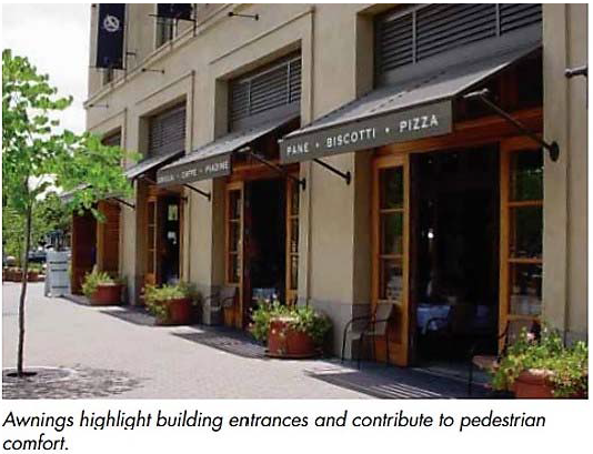
2.
Requirements for shade.
(a)
There shall be shade provided for at least 40 percent of the Public Realm Pedestrian Zone associated with each new development, such percentage coverage to be measured from the right-of-way line to two feet interior of the face of the curb. Existing street trees may be used in this calculation.
(b)
If shade trees are provided, they must meet the definition, pervious surface requirement, and pruning restrictions as contained in Chapter 656 (Zoning Code) Part 12 (Landscape Code), and must reach the percentage shade coverage requirement within 5 years.
(c)
If Crape Myrtles are used, hat-racking is prohibited.
(d)
In the absence of existing street trees that provide shade in the public right-of-way, the adjacent development shall:
(1)
Incorporate building projections into the right-of-way, roof overhangs, awnings and similar protections from rain, located between eight and 20 feet above grade to provide a minimum 40 percent shade along the frontage; or
(2)
The development shall install trees within the right-of-way to produce 40 percent shade within five years of the issuance of the Certificate of Occupancy. The developer shall consult with the City Arborist for the appropriate tree species for the location and provide the appropriate planting area and soil amendments and structure; or
(3)
A combination of (1) and (2), above.
3.
Requirements for Protection from the elements.
(a)
Protection from the elements, which may include trees or structural features shall be incorporated in new development and in any major renovation of an existing building that alters the exterior of existing building.
(b)
Awnings, arcades, recessed entry doors, or other structural elements that provide shade from the sun and protection from the rain shall be provided over all doors.
(c)
In order to accomplish protection from the elements, portions of a building or structure such as: awnings, balconies, structural elements, overhangs and cantilevered shelters, may be allowed to extend over or into the public right-of-way to within two feet of the curb, subject to the approval of the Director of the Public Works Department, as shown in Figure 6.3.C, below, and subject to compliance with the following:
Figure 6.3.C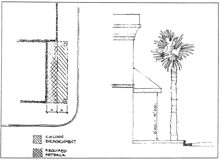
(1)
The minimum vertical clearance between the established grade of the public right-of-way and the underside of the encroaching structure is at least eight feet.
(2)
Supporting columns will be permitted within the Pedestrian Zone when the grade level floor of the structure is set back a distance equal to or greater than the Pedestrian Zone area lost to the supporting columns, as shown in Figure 6.3.C above. This requirement shall not apply in the case of an existing building where an addition or alteration may result in the necessity to locate supporting columns within the Pedestrian Zone.
(3)
A Pedestrian Zone consistent with the Public Realm regulations is provided.
(4)
Structures built over the public right-of-way shall not interfere with any element of the streetscape including, but not limited to, lighting, landscaping, and pedestrian circulation.
(5)
The structure extension has been reviewed, with due consideration to public right-of-way width, above ground and underground utilities (including the need for overhead crane access to underground transformers), pedestrian views or visibility, and adjacent structures.
(d)
Buildings or structures may provide awnings, arcades or other structural elements that provide shade from the sun and protection from rain, etc., over windows and other transparent elements, subject to the requirements of this Section.
4.
Deviations allowed by the DDRB: Deviations may be allowed by the DDRB if the decision is based on competent substantial evidence that the request meets the General Deviation Criteria contained in subsection 656.361.8.B, and in addition that:
(a)
Regarding Shade: If it can be shown that due to the height and orientation of the building that shade will be provided on the sidewalk between noon and 6:00 p.m. without the addition of trees or other shade features;
(b)
Regarding Protection from the rain: Entrance porticos, awnings or similar features are architecturally incompatible, and an alternate compatible accommodation is proposed.
D.
Vehicular Zone.
1.
Pedestrian skywalks (over street connections) between buildings are prohibited unless they connect two properties under the same ownership and use and are essential to such use. Examples of essential uses would be public health uses such as hospitals or public services such as mass transit stations. Any proposed skywalk shall be shown on schematic site plans for evaluation. The DDRB shall consider the total impact of the skywalk and its appropriateness to the site and surrounding area including, but not limited to, its effect on shadowing, lighting, transparency, view corridors, and other features of public or private property. DDRB review and approval of the preliminary schematic site plans is required under Section 656.361.9, Ordinance Code, prior to applying for additional approval. After all other required approvals are obtained, the final schematic plans shall be submitted to DDRB for review and approval prior to construction.
E.
Grid Pattern.
1.
Purpose and Intent: The layout of downtown shall maintain the traditional block patterns with a grid of streets, develop currently unopened streets thus minimizing the creation of long distances between vehicular and pedestrian access points, and by requiring new large development proposals to respect the existing downtown street pattern. All buildings, structures and roadway construction shall meet the following criteria:
2.
Requirements:
(a)
All new construction of buildings and structures and rehabilitation of existing buildings and structures shall respect the existing downtown street pattern.
(b)
No closures of right-of-way will be allowed, unless it can be shown to the satisfaction of the DDRB and ultimately the City Council, that the public benefits significantly outweigh the negative impacts on the downtown traffic network.
(c)
No existing public right-of-way, opened or unopened, which leads to or toward the riverfront as shown on the Riverfront Zones Map, as shown in Figure 6.2.H, may be closed, vacated, or visually blocked unless a superior alternate public access and/or view corridor is provided. "Superior" in this circumstance would be providing a view corridor that is longer or wider than the right-of-way being closed.
3.
Deviations allowed: The ability to close or vacate a right-of-way or deviate from this Regulation is specifically vested in the City Council.
(a)
No existing public right-of-way, opened or unopened, which leads to or toward the riverfront as shown on the Riverfront Zones Map, as shown in Figure 6.2.H, may be closed, vacated, or visually blocked unless a superior alternate public access and/or view corridor is provided. "Superior" in this circumstance would be providing a view corridor that is longer or wider than the right-of-way being closed.
(b)
Closures of other Downtown streets and Deviations may be allowed by the Council if the decision is based on competent substantial evidence that the request meets the General Deviation Criteria contained in subsection 656.361.8.B, and in addition that the public benefits significantly outweigh the negative impacts on the downtown vehicular and pedestrian mobility network. In order to determine that the public benefits of the closure(s) significantly outweigh the negative impacts, a positive finding, based on substantial competent evidence, must be made on each of the following criteria as consistent with the BID Plan:
(1)
The proposed closure(s) will not be detrimental to the public health, safety and welfare;
(2)
Pedestrian access is provided and maintained through the proposed development;
(3)
The altered vehicular or pedestrian circulation pattern will provide a more user-friendly transportation route, for both vehicles and pedestrians, and improved corridors by enhanced streetscape improvements; and
(4)
If the closure is to vehicular traffic only and a pedestrian promenade or multi-use path remains, the proposed building(s) and structure(s) will face the right-of-way with pedestrian access from those rights-of-way available to the general public.
(Ord. 2019-196-E, § 6)
Sec. 656.361.7.1. - Application and Review Procedure to DDRB and Council; Appeals.
A.
Application. All development proposed within downtown shall be reviewed by the DDRB staff for consistency with the Use Regulations, the Form Regulations, the Downtown Design Guidelines, and the Riverwalk Park Design Criteria (if applicable).
All developers are required to meet with DDRB staff and staff of such other City agencies or departments as DDRB staff may determine to be necessary to discuss conceptual designs and other elements of a proposed project for staff review and feedback prior to an application for DDRB review being deemed complete. After the pre-application meeting with staff to discuss the proposed project the applicant may request DDRB staff to agenda the proposed project for Conceptual Approval at the next available DDRB meeting, subject to submittal of required items pursuant to subsection B, below, and completion of such other City reviews as warranted by staff. DDRB staff shall prepare a report to be presented to DDRB recommending approval, approval with condition or denial, which shall incorporate and take into account any comments submitted from any other reviewing City staff.
B.
Required Submissions for Conceptual Approval. The developer shall submit an application containing the following information (Submittals shall be 11 inches by 17 inches in size) to the DDRB staff:
1.
An application for the project (obtained online from the DDRB website);
2.
A vicinity plan and digital photographs showing the project in relation to the surrounding blocks and streets (include all properties within 300 feet of project property boundary lines);
3.
A site plan, including vehicular access, parking, landscaping, existing streetscape, Pedestrian Zone and building footprint (minimum scale: 1′ = 50′0″);
4.
Building massing, showing all sides, and showing the building concept in context with the surrounding buildings, street widths, and streetscape;
5.
A presentation on a USB compatible storage device in PowerPoint or similar format acceptable to DDRB staff that includes all items above, and other information necessary to fully describe the project, or as requested by DDRB staff.
C.
Required Submissions for Final Approval. In addition to the items listed in (1) through (5) above, the following items must be submitted with the application for final approval:
1.
A floor plan;
2.
Building elevations (all sides) (minimum scale: 1/16″ = 1′0″, except if such scale is not practical due to magnitude of the project, a scale agreed to by the DDRB staff may be acceptable);
3.
Site and building section, including sidewalk (minimum scale: 1/16″ = 1′0″, except if such scale is not practical due to magnitude of the project, a scale agreed to by the DDRB staff may be acceptable);
4.
A table outlining the square footage amount and percent of each type of use for each building or structure, including the number of parking spaces to be provided for each use; and
5.
A perspective drawing of the building;
6.
A landscape plan;
7.
A signage plan;
8.
A streetscape plan including a breakdown of the Pedestrian Zone detailing the Pedestrian Clear Area, the Frontage Area and the Amenity Area;
9.
A lighting plan;
10.
Samples of exterior finishes (the samples shall be mounted on a presentation board or other format acceptable to DDRB staff and presented to DDRB); and
11.
A presentation on a USB compatible storage device in PowerPoint or similar format acceptable to DDRB staff that includes all items (1)—(7), above, and other information necessary to fully describe the project, or as requested by DDRB staff (which may also include a traffic impact analysis).
All items shall be in color, fully rendered, and shall incorporate conditions imposed by the DDRB at conceptual approval, if any, including any requested design Deviations pursuant to Section 656.361.8 (Deviations). Submittals shall be 11 inches by 17 inches in size. (Minimum scale for items 1, 2, and 3 above shall be 1/16″ = 1′0″ and (6) through (9) above shall be 1″ = 30′, except if such scale is not practical due to magnitude of the project, a scale agreed to by the DDRB staff at conceptual review may be acceptable). For phased projects, presentation boards may be per phase. On larger projects staff shall also request presentation boards be provided of the building rendering and site plan that are 36 inches by 44 inches in size, or such other size as is acceptable to DDRB staff;
D.
Classification of Projects. Upon receipt of the application and required information, DDRB staff will classify the proposed developments as follows:
1.
Staff Review Only.
(a)
Landscaping sufficiency regarding number, species, size, and placement of trees; soil to tree ratio; and alternatives for irrigation;
(b)
Streetscape elements that comply with the Pedestrian Zone requirements applicable to unconstrained rights-of-way;
(c)
Minor structural changes to exterior facades or structures;
(d)
Signs that comply with Subpart B of Chapter 656, Part 13 - Downtown Sign Overlay Zone;
(e)
Projects that consist only of landscaping, hardscaping, street furnishings, and/or vehicle use area components, and do not require any Deviation;
(f)
Other classifications delegated to DDRB staff by DDRB; and
(g)
Minor changes to applications previously approved by the DDRB.
2.
DDRB Review.
(a)
New construction;
(b)
Major structural changes to exterior facade of existing structures;
(c)
Signs that require a special sign exception pursuant to Section 656.1333(j) and comprehensive sign plans required by Section 656.1333(b)(2), which shall require only Final Approval by DDRB;
(d)
Streetscape elements in constrained rights-of-ways where the generally required minimum Amenity Area, Pedestrian Clear Area, or Frontage Area is reduced in width, shared with the Vehicular Zone or encroaches on private property;
(e)
Staff review classifications deemed appropriate by DDRB staff for review by the DDRB;
(f)
Significant changes to applications previously approved by the DDRB, which shall require only Final Approval by DDRB; and
(g)
DDRB shall have an opportunity to review and provide comments and recommendations for Capital Improvement Projects that are undertaken by, or on behalf of, the City, independent agencies, or the DIA that have a total cost greater than $100,000, a useful life of more than ten years, and that do not require a Deviation or Special Exception. Such projects include, but are not limited to, streetscape projects, road narrowing or lane elimination projects, public buildings, and park or public space projects and do not include projects that are of a purely maintenance or utility infrastructure nature or that are otherwise listed herein as requiring staff review only.
E.
Staff Review. Projects classified as "Staff Review Only" will be reviewed by DDRB staff and approved, approved with conditions, or denied within ten working days of submittal of a complete application. Staff will notify the applicant of an incomplete application within five days of receipt of the application.
F.
Procedures to be followed by the DDRB.
1.
Projects classified as "DDRB Review Required" will be considered by the DDRB at a scheduled meeting within 30 working days of submittal of a completed application at a scheduled monthly DDRB meeting. The applicant may present the project at the meeting.
2.
The DDRB will review projects using a two-step process, except as otherwise provided in this Section. The first step is a Conceptual Approval, whereby the applicant's project will be reviewed and conceptually approved, conceptually approved with conditions or denied based upon the District Regulations, the Downtown Design Guidelines, and the Riverwalk Park Design Criteria, if applicable. The second step is a Final Approval, whereby the applicant brings the project back to DDRB within one year to be reviewed and approved, approved with conditions, or denied based upon the Regulations and applicable Guidelines. Prior to consideration by the DDRB for Final Approval, it is the intent of this Section that the application and project will have received such reviews and approvals as DDRB staff deems necessary so that the DDRB is presented at Final Approval with as complete a project as possible, considering all design, architectural, engineering, traffic, utilities, fire and life safety, environmental, historic, landscape and streetscape and any other site and project development issues which may be associated with completion of the proposed project.
3.
For multi-phase projects consisting of construction or renovation of two or more separate buildings or structures, DDRB review shall be conducted as follows:
(a)
The two-step process outlined in subparagraph (2), above, shall first be applied to conceptual and final approval of the overall development site and consider compliance of the overall site plan with the requirements contained in this Subpart H relating to view corridors, setbacks, heights, street closures, river views and encroachment. Furthermore, the DDRB shall also consider streetscape plans and landscaping plans, if such are available; and
(b)
Following final approval of the overall site plan, the applicant shall then present the development or redevelopment plans for each building or structure contained in the multi-phase project for individual consideration by the DDRB using the two-step process contained in subparagraph (2), above. The DDRB shall also consider all aspects of the project requiring DDRB review and approval pursuant to this Subpart and not considered in the initial site plan approval process described in subpart (a), above.
The intent of this Section is to authorize the DDRB to consider those projects wherein an applicant proposes an overall site development consisting of multiple building development or redevelopment by first considering the overall site layout and cumulative impact of the entire project on surrounding properties and later considering design-type matters associated with the project's individual buildings.
4.
The decision of the DDRB shall be reduced to writing within ten business days, and is effective upon execution by the Chair and the DDRB staff that prepared the written decision.
5.
If a project is denied, the Chief Building Official shall not take any further action concerning the application.
6.
Upon approval of a project with or without conditions by the DDRB, building permits shall be issued for development, subject to compliance with all applicable Building Code requirements, including any required conditions imposed by the DDRB. DDRB approvals shall be valid for one year from the date of approval, but may be extended upon written request to DDRB staff for just cause, but in no event shall an extension be granted for more than one additional year beyond the original approval date. DDRB approvals may be granted for longer periods of time, if the applicant is subject to a Redevelopment Agreement that incorporates:
(a)
A performance schedule of completion for the project;
(b)
An allocation of development rights that is consistent with the Central Business District Future Land Use Category as described in the Future Land Use Element of the City's adopted Comprehensive Plan, the BID Plan, and the Public Facility Level of Service Standards identified in the Capital Improvements Element of the Comprehensive Plan; and
(c)
Applicant participation in the Mobility Plan prioritized projects for Downtown that are approved by DIA and City Council.
7.
Any locally or federally designated landmark, building, structure, site, or structure or site within a locally or federally designated historic district within the Downtown Overlay Zone subject to review under Chapter 307 shall be governed by the provisions of Chapter 307, and the provisions of this Section shall apply to the extent they do not conflict with Chapter 307. These structures are exempt from DDRB Conceptual Review but are required to receive Final Approval by the DDRB after issuance of any required Certificates of Appropriateness.
8.
No Certificate of Occupancy shall be issued by the Building Official until all requirements approved by the DDRB have been completed. The DDRB will review completed projects and will forward a letter to the Building Official indicating whether or not the project has met all of DDRB approved requirements within ten working days of completion of the project. The developer of the project will be required to notify DDRB staff of the completion of the project. Any changes to the approved plan shall be provided to the DDRB or its staff for review and further consideration. No modifications to DDRB approved projects and associated approved building plans shall be submitted to the Building Official for modification until such revised plans have been reviewed and approved by DDRB.
G.
Appeals of Overlay Regulation decisions.
1.
Appeal of DDRB decision to DIA.
(a)
Standing. Except for DDRB decisions pertaining to zoning exceptions, zoning variances or zoning waivers, as outlined in Subpart D of Part 1 of the Zoning Code which are appealable only to the City Council pursuant to Section 656.148, any adversely affected person as defined in Section 656.1601, Ordinance Code, may appeal a final decision of the DDRB to the DIA.
(b)
Notice. Notice of Appeal shall be provided to the DIA Executive Director, at the DIA office within 14 days of the effective date of the written decision. The Notice of Appeal shall be in a form created by the DIA in consultation with the Office of General Counsel. Timing and form of briefs and other papers shall be set out in the Notice of Appeal form.
(c)
Standard of Review. The DIA's review of the appeal shall be a de novo review, without giving deference or weight to the decision of DDRB. DIA shall have the benefit of the record below and may include the same in its review as well as applicable law and additional testimony and evidence. The record shall include all evidence and testimony presented to the DDRB. The DIA may affirm, reverse or modify each written decision or it may remand the matter back to the DDRB with specific instructions for further action, by adopting a written order.
(d)
Procedural Matters. The DIA shall have the authority to:
(1)
Accept briefs and other papers to be filed on behalf of any party, provided all papers are submitted at or prior to the DIA hearing;
(2)
Hear oral argument on behalf of any party;
(3)
Adjourn, continue, or grant extensions of time for compliance with these rules, whether or not requested by a party, provided no requirement of law is violated;
(4)
Dispose of procedural requests or similar matters including motions to amend and motions to consolidate;
(5)
Keep a record of all persons requesting notice of the decision in each case;
(6)
Grant withdrawal requests by the appellant; and
(7)
Enter into settlement agreements regarding the matter appealed, so long as there is no financial impact to the City.
(8)
Individually view the property which is the subject of the appeal.
(9)
Adopt appellate procedures similar to the procedures outlined in Sections 656.141 and 656.142, Ordinance Code.
(e)
Decision. The DIA's decision shall be reduced to writing and shall become effective upon execution by the Chair and the DIA staff person that prepared the written decision.
2.
Appeal of DIA decision to City Council.
(a)
Standing. Any adversely affected person may appeal a decision of the DIA to the City Council.
(b)
Notice. Notice of Appeal shall be provided to the Legislative Services Division within 14 days of the effective date of the DIA's written decision. The Notice of Appeal of DIA Decision shall be in a form created by the DIA in consultation with the Office of General Counsel. Timing and form of briefs and other papers shall be set out in the Notice of Appeal form. The Office of General Counsel shall prepare and file a Resolution on the appeal.
(c)
Standard of Review. The Council's review of the appeal shall be limited to a consideration of whether:
(1)
the applicable design criteria contained in the Design Guidelines, the District Regulations and the Riverwalk Park Design Criteria (if applicable) were properly applied by the DDRB and the DIA;
(2)
the decision was supported by competent, substantial evidence; and
(3)
procedural due process was afforded.
The City Council shall have the authority to adopt the Procedural Matters listed above in subsection 656.361.7.G.1. in its determination.
(d)
Decision. If the Council determines the criteria were properly applied, competent substantial evidence supported the decision, and procedural due process was afforded, it shall adopt a resolution to that effect. If the Council determines that the criteria were not properly applied, or the decision was not based upon competent substantial evidence, or procedural due process was not afforded, the Council shall enact a resolution remanding the matter back to the DIA or the DDRB for further consideration. The Council may suggest additional findings or give directions to the DIA or DDRB to assist it in effectively reconsidering the matter. Within ten working days of the Council's remand to the DIA or DDRB, the DIA or DDRB shall consider the matter and within five working days issue a written decision to the applicant and the appellant, with a copy to the Building Official, which shall be deemed to be the final decision of the City.
3.
Appeal of City Council decision to the Courts. Due to the quasi-judicial and de novo nature of the review performed by the City Council, the review upon appeal should be limited to whether due process was afforded, and whether the City applied the correct law, or as otherwise stated, departed from the essential requirements of law.
(Ord. 2019-196-E, § 6; Ord. 2020-695-E, § 3; Ord. 2024-39-E, § 2)
Sec. 656.361.8. - Deviations.
A.
General Considerations.
1.
The Form Regulations identify which body has authority to approve a Deviation from each Section thereof. The DDRB has the authority to grant Deviations for all Form Regulations in subsection 656.361.6.2 except as specified in subsection 656.361.6.2.H (Waterfront Design and River Views: setbacks, height and access corridors) and subsection 656.361.6.2.I (Creek Views and Creekfront Design), which require a final decision by the City Council for specified Deviations. Except as otherwise provided in this Section, any request for a Deviation, whether the final Deviation decision rests with the City Council or the DDRB, shall be heard by the DDRB initially in a Workshop format. Participation by an applicant in a Workshop requires that the designer(s) of the project present the need for the Deviation along with potential alternative design solutions.
2.
The following requests for Deviation are exempt from the Workshop requirement, unless the project fronts the St. Johns River, Hogans Creek, or McCoy's Creek:
(a)
Existing buildings, when the requested Deviation would not expand or intensify the non-conformity;
(b)
Building entrance criteria for new construction; and
(c)
Rooftop criteria for new construction.
3.
The Zoning Administrator shall not have the authority to grant Administrative Deviations in the Overlay Zone.
4.
Certain Form Regulations must be met in their entirety in order for an economic incentive of any kind to be granted to a development. Although Deviations may be granted for design so that the project may be constructed, this does not amount to "meeting" the Regulation in order to establish eligibility for the economic incentive. Approval of an economic incentive by the DIA for a project shall not be taken into consideration by the DDRB in their deliberations regarding the project's consistency with the Use or Form Regulations.
5.
Approval by the DIA of an economic incentive assumes that the project will meet the Regulations as written, without a Deviation. See subsections 656.361.6.2.H and 656.361.6.2.I.
6.
Deviations shall be approved by a 2/3 vote of the membership of the initial jurisdictional body, as well as any appellate procedure. Waiving this requirement shall be stated in the title of the resolution or ordinance pertaining to the Deviation, and shall adhere to the Council Rules regarding the waiver of an ordinance.
7.
All Deviations must be based upon the General Deviation Criteria, in addition to any specific criteria contained in the Section pertinent to that Regulation. All of the General Deviation Criteria must be met, and an explanation of each must be provided by the developer/applicant. A separate positive determination must be made for each criterion by the reviewing body, based upon competent, substantial evidence, in order to grant the Deviation.
B.
General Deviation Criteria.
1.
The effect of the proposed Deviation is consistent with and furthers the objectives, policies, design and intentions of the BID Plan;
2.
The request is not based exclusively upon a desire to reduce the cost of developing the site, but would accomplish a substantial public benefit;
3.
The proposed Deviation will not diminish property values in the area surrounding the site and will not interfere with or injure the rights of adjacent properties;
4.
The request is not a self-imposed hardship;
5.
The proposed reduction or Deviation will not be detrimental to the public health, safety or welfare, result in additional public expense or the creation of nuisances; and
6.
Either there are unique site characteristics such as parcel shape, location, existing utility easements, etc. that prevent development consistent with these Regulations, OR strict compliance with these Regulations will cause undue economic hardship to the developer/applicant. Proof of undue economic hardship must include the following:
(a)
Schematic design showing compliance with the Regulations;
(b)
Schematic design proposed for the Deviation;
(c)
Explanation of how the proposed design attempts to meet the Regulation, and how the cost to do so is prohibitive;
(d)
An estimate, prepared by a credible professional in either the cost of construction or the loss of income:
(1)
Cost of Construction: provided by a licensed contractor, appraiser, or credible professional experienced in the type of construction proposed, comparing the cost of construction to comply with the Regulations with the cost of the design proposed; or
(2)
An estimate, prepared by a licensed appraiser or other credible professional, of the loss of income based upon compliance with the Regulations; and
(e)
Complying with the Regulation must cost 50 percent or more than the cost to implement the proposed design.
(Ord. 2019-196-E, § 6; Ord. 2024-39-E, § 3)
Sec. 656.361.9. - Downtown Development Review Board.
There is hereby established within the DIA, a Downtown Development Review Board (DDRB) to assist the DIA in its duties. The DDRB staff is housed within the DIA, thus "DDRB staff" and "DIA staff" may be used interchangeably. See also Section 55.110, Ordinance Code.
A.
Membership. The DDRB shall consist of 20 members, nine voting members and 11 ex officio members, who shall be appointed by the Mayor and confirmed by the City Council to serve staggered terms of two years. Members of the DDRB shall continue in office for the terms of their respective office or until their qualified successors have been appointed or confirmed. No member appointed to the committee for three consecutive full terms shall be eligible for appointment to the next succeeding term. At each regularly scheduled July meeting, the DDRB members shall elect a chairperson to serve as such for that annual term. In addition, there shall be 11 ex officio members who shall serve in connection with matters which require their technical or professional expertise. The DDRB shall consist of the following:
1.
Voting members. Voting members shall serve for a term of two years commencing on July 1. The architects, landscape architect and contractor, developer or realtor terms as listed in subsection 656.361.9(1)(a)—(c) shall commence in even years; and the downtown property owners' terms and the urban planners' terms as listed in subsection 656.361.9(1)(d) and (e) shall commence in odd years. Nothing herein shall effect partial terms or unexpired terms. Notwithstanding the above, these positions shall serve as follows:
(a)
Two architects, for an initial term of one year and thereafter for a two year term;
(b)
One landscape architect, for an initial term of one year and thereafter for a two year term;
(c)
One contractor, developer or realtor who does work within the downtown area, for an initial term of one year and thereafter for a term of two years;
(d)
Three downtown property owners or owners of or full time employees at a business or professional office as defined in Part 16 of this Chapter 656, located within the downtown area, for an initial term of two years; and
(e)
Two urban planners, for an initial term of two years;
2.
Ex officio nonvoting members:
(a)
Building Official, or designee;
(b)
Traffic Engineer, or designee;
(c)
Director, DIA, or designee;
(d)
Director, Planning and Development Department, or designee;
(e)
The City Council President, or designee;
(f)
Chairman, Downtown Vision, Inc., or designee;
(g)
Director of the Jacksonville Transportation Authority, or designee;
(h)
Chairman, Jacksonville Waterways Commission, or designee;
(i)
Chairman, Jacksonville Historic Preservation Commission, or designee;
(j)
Chairman, First Coast Transportation Planning Organization, or designee, and
(k)
Chairman, Duval County School Board, or designee.
(l)
Each ex officio member shall become a member of the DDRB immediately upon assuming their office or position listed above and shall remain a member for as long as they continue to hold that office or position or until they designate in writing another individual.
B.
Organization and Proceedings.
1.
The DDRB shall adopt rules and procedures necessary for the conduct of its affairs. Five voting members shall constitute a quorum. With a quorum, the majority vote of those members present shall be necessary to take any action.
2.
No member shall serve more than three consecutive full terms. A vacancy shall be filled in the same manner as the original appointment. All members shall serve without compensation.
3.
Members shall continue in office for the term of their respective office, or until they are reappointed and confirmed, or until their qualified successors have been appointed and confirmed.
4.
If any appointed member fails to attend three consecutive meetings without cause and prior approval of the chairman or for any other reason of just cause, that member shall be subject to removal by the Mayor.
5.
Any member may resign from the DDRB by tendering a resignation in writing to the Office of the Mayor with a copy to the Chair of the DDRB and the DIA Director.
C.
Powers and Duties. DIA shall have the responsibility and authority to approve any amendments to the Downtown Design Guidelines, recommend and review proposed changes to the Downtown District Regulations, interpret the BID Plan, approve development and redevelopment projects within the Downtown Overlay Zone, and succeed to all of the powers of the former Downtown Development Authority.
In order to assist the DIA in carrying out this responsibility, the DDRB shall have the following powers and duties:
1.
To review and make decisions with respect to all applications for development and redevelopment regarding use and form within the Downtown Overlay Zone to:
(a)
To ensure consistency and compatibility of all proposed development and redevelopment with the BID Plan;
(b)
To ensure consistency with the Central Business District Future Land Use Category as described in the Future Land Use Element of the City's adopted Comprehensive Plan and Public Facility Level of Service Standards identified in the Capital Improvements Element of the Comprehensive Plan; and
(c)
To consider the design related issues of each application to ensure compliance with these Downtown District Regulations, the Downtown Design Guidelines, The Riverwalk Park Design Criteria, the Downtown Streetscape Design Guidelines, and all related approved design guidelines and standards, subject always to the ultimate authority of the DIA to interpret the BID Plan, the Downtown Overlay Zone, and Downtown Design Guidelines;
2.
To periodically review and make recommendations as necessary to the DIA with respect to these Downtown District Regulations, the Downtown Design Guidelines, the Downtown Streetscape Design Guidelines, and the Riverwalk Park Design Criteria and related development standards and guidelines, including proposed amendments or revisions thereto. Any amendments to the Downtown Design Guidelines shall be recommended by the DDRB for adoption by the DIA. Any proposed amendments to the Downtown District Regulations, the Downtown Streetscape Design Guidelines, and the Riverwalk Park Design Criteria shall be recommended by the DDRB for recommendation to the DIA, who in turn may recommend to the City Council for adoption; and
3.
To review and make decisions regarding requests for zoning exceptions, zoning variances, and other zoning requests, and to review and make recommendations regarding rezonings, including companion Future Land Use Map amendments, pertaining to properties located within the Downtown Overlay Zone that would otherwise be heard by the Planning Commission. However, the Planning Commission remains the Local Planning Agency for matters related to the Comprehensive Plan, including but not limited to Future Land Use Map and text amendments. For rezonings within the Downtown Overlay that have a companion Future Land Use Map amendment, both the Planning Commission and DDRB shall review and make recommendations to the City Council and the DIA, as the case may be; and
4.
To hear appeals from decisions of the DDRB staff; and
5.
To approve requests for Deviations from the Design Guidelines and the District Regulations, other than the Waterfront Design and Riverviews: setbacks, height and access corridors (subsection 656.361.6.2.H), and Creek Views and Creekfront Design (subsection 656.361.6.2.I) and Grid Pattern (subsection 656.361.6.2.E). With respect to Deviation requests from these subsections, the DDRB shall hear and make an advisory recommendation to City Council regarding such Deviation requests.
(Ord. 2019-196-E, § 6; Ord. 2020-695-E, § 3; Ord. 2022-383-E, § 1)
Sec. 656.365.- Legislative findings and intent.
The Council hereby finds and determines as follows:
(a)
Pursuant to the adoption of Ordinance 91-733-570 on January 28, 1992, the City Council established the Springfield Historic District. Since that date, various studies and plans, including the Neighborhood Action Plan, Historic Springfield District, October, 1992, and the Springfield Action Plan dated May, 1997, as revised August, 1998, a copy of which is on file in the Office of the Council Secretary and in the Planning and Development Department, have recommended the implementation of a zoning district overlay to resolve zoning-related problems in the Springfield Historic District.
(b)
The Springfield Historic District consists of more than 12 City blocks, approximately one square mile in size, with 3,800 structures and a population of over 6,900. The number of historic structures totaled 1,890 (115 of which are landmark buildings) in 1991. The District is the largest historic residential district in Florida.
(c)
The Springfield Historic District contains 3,800 dwelling units, 1,890 of which are historic dwelling units. Homestead properties in the area were reported at only 521 in August, 1998. Based on these numbers, only 14 percent of the District was owner occupied as of August 1998.
(d)
Over a period of many years, zoning and land use changes in Springfield have served to encourage the decline of the area and not its redevelopment. The Springfield Historic District has been negatively affected by current zoning districts which do not recognize the unique character of the neighborhood. For many years prior to the establishment of the District, the City allowed intensive and intrusive uses to locate in the neighborhood and did not encourage the type of development that promotes and sustains a stable, economically viable, and primarily single-family/owner-occupied neighborhood. Standard zoning districts also do not recognize the small lots, high lot coverage and other aspects of the neighborhood's unique development pattern.
(e)
Within the one square mile area of the Springfield Historic District, the Council finds there is a disproportionately large number of rooming houses and automotive uses, including automotive sales and repairs and related automotive uses.
(f)
As noted in the Springfield Action Plan, the population of Springfield has been in decline during the course of the past two years. Since 1980, the population in Springfield has decreased from 8,049 persons to a 1990 Census count of 6,969 persons. This decrease is primarily attributable to a decline in household size, an increase in vacancy rate, and a decline in building permit activity. Population projections show a continued decline in population into the year 2020, unless the area becomes more attractive as a place to live and invest. In 1990, average (mean) income was only $8,860 per household (only 48 percent of the County's average). Estimates of poverty levels in 1990 affected nearly 46 percent per cent of these households. Fifty percent of the households had a median income of less than $5,710. Income characteristics as found in census data for 1990, on a Countywide basis, show average incomes have increased by more than 80 percent since 1980. However, similar gains for the Springfield neighborhood have not occurred. In 1990, 52 percent of the households had a median income of less than $10,000 and only 9.4 percent with incomes above the County average of $35,618.
(g)
The Springfield Historic District is an invaluable resource to the City and its citizens and should be preserved for future generations.
(h)
The property disinvestment and blight caused by incompatible zoning and other factors associated with core City decline must be reversed through a comprehensive revitalization program that will include zoning districts tailored to the neighborhood. Standards should allow appropriate and compatible development to proceed without the high costs associated with variances and administrative deviations required to deviate from current lot and use standards.
(i)
The zoning districts and regulations contained in this Subpart I were developed with the participation and assistance of neighborhood residents, property owners and City staff.
(j)
The Planning Commission and the Urban Affairs and Planning Committee considered these districts and regulations, held public hearings and made their recommendations to the Council.
Based on the foregoing findings, the Council hereby establishes the Springfield Zoning Overlay and Historic District Regulations contained in this Subpart I for the purpose of encouraging residential owner-occupants, allowing for mixed uses and home businesses, discouraging over-intensive uses, and providing performance standards and special regulations for uses allowed by exception.
(Ord. 2000-302-E, § 1; Ord. 2017-36-E, § 4)
Sec. 656.366. - Definitions.
The definitions contained in Part 16 of the Zoning Code shall apply. Those terms which are specific to this Subpart are defined as follows:
(a)
Original use means the original use of a structure at the time of its construction.
(b)
Historic use means the use of a structure between the time of its construction and 1942 (50 years prior to the date of establishment of the local historic district).
(c)
Live-work lofts means residential units within large, formerly nonresidential buildings such as schools or warehouses that have been converted to residential purposes. Live-work lofts shall be considered multiple-family units.
(d)
Certificate of appropriateness (COA) means a written document approved by the Jacksonville Historic Preservation Commission or administratively by the Jacksonville Planning and Development Department pursuant to Section 307.107 allowing an applicant to proceed with approved alterations, demolition, relocation, or new construction of a designated landmark, landmark site, or property in a historic district, following a determination of the proposal's suitability based upon applicable criteria.
(e)
Interior apartment means a residential unit located within an existing residential structure.
(f)
E-business means a business that produces the majority of its revenue through internet transactions and does not involve on-site storage, handling or distribution of products.
(Ord. 2000-302-E, § 1)
Sec. 656.367. - Boundaries and zoning overlay.
The Springfield Zoning Overlay generally follows the boundaries as depicted in the map (Figure 1) of the Springfield Action Plan, produced by the Jacksonville Planning and Development Department in May, 1997, as revised in August, 1998. Variations from the map in the Springfield Action Plan are reflected in the northern and southern boundaries of the overlay district. More specifically, the Springfield Zoning Overlay includes all parcels located within the following boundaries:
Beginning at the west side of North Main Street where it crosses Hogans Creek; thence north and west along Hogans Creek to Broad Street; thence north along the centerline of Broad Street and Boulevard to the abandoned Seaboard Coast Line railroad right-of-way to north of West 12th Street; thence east along the abandoned railroad right-of-way to North Pearl Street; thence south along the centerline of North Pearl Street to West 12th Street; thence east along the centerline of West 12th Street to North Main Street; thence north along the center of North Main Street to the abandoned Seaboard Coast Line railroad right-of-way north of Warren Street; thence east along the railroad right-of-way to Walnut Street; thence south along the centerline of Walnut Street to East 11th Street; thence east along the centerline of East 11th Street to the right-of-way of the St. Johns River Terminal Company railroad located just east of Ionia Street and Clark Street; thence south along said railroad right-of-way to East First Street; thence west along the centerline of East First Street to its intersection with Walnut Street; thence south along the centerline of Walnut Street to Phelps Street; thence west along the centerline of Phelps Street to North Market Street; thence south along the centerline of North Market Street to its crossing over Hogans Creek; thence west and north along Hogans Creek to the point of beginning.
The Council hereby adopts the Springfield Zoning Overlay, shown at Figure 3B, which is not included herein, but is on file and available for inspection in the Office of the Council Secretary. The land included within this overlay shall be subject to the Springfield Historic District Regulations contained in this Subpart I. These regulations shall supersede the provisions of Chapter 656, Ordinance Code, as applied to all property within the boundaries of the Springfield Zoning Overlay, except as otherwise specifically provided herein.
(Ord. 2000-302-E, § 1)
Sec. 656.368. - Springfield Historic Zoning Districts.
Springfield Historic Zoning Districts include the following:
I.
Residential Medium Density-Springfield (RMD-S) District.
(a)
Permitted uses and structures.
(1)
Single-family dwellings.
(2)
New two-family dwellings meeting the performance standards and development criteria set forth in this Section.
(3)
Original use two-family dwellings.
(4)
Original use multiple-family dwellings. Such dwellings cannot include more units than were within the structure at the time of construction.
(5)
Community residential homes of six or fewer residents meeting the performance standards and development criteria set forth in Part 4 of the Zoning Code.
(6)
Housing for the elderly meeting the performance standards and development criteria set forth in Part 4 of the Zoning Code, if applicable.
(7)
Family day care homes meeting the performance standards and development criteria set forth in Part 4 of the Zoning Code.
(8)
Foster care homes.
(9)
Essential services, including water, sewer, gas, telephone, radio, television and electric, meeting the performance standards and development criteria set forth in Part 4 of the Zoning Code.
(10)
Churches, including a rectory or similar use, meeting the performance standards and development criteria set forth in Part 4.
(11)
Neighborhood parks, pocket parks, playgrounds or recreational structures which serve or support a neighborhood or several adjacent neighborhoods, meeting the performance standards and development criteria set forth in Part 4 of the Zoning Code.
(12)
Bed and breakfast establishments meeting the performance standards and development criteria set forth in Part 4 of the Zoning Code.
(b)
Permitted accessory uses and structures.
(1)
Interior apartments in connection with single-family, owner-occupied properties, meeting the Springfield performance standards and development criteria set forth in Section 656.369.
(2)
Free-standing garages.
(3)
One free-standing garage apartment in connection with single-family, owner-occupied properties, meeting the Springfield performance standards and development criteria set forth in Section 656.369.
(4)
Original use garage apartments contributing structures only.
(5)
Home occupations meeting the Springfield performance standards and development criteria set forth in Section 656.369.
(6)
Pay phones meeting the Springfield supplemental standards and development criteria set forth in Section 656.369.1.
(7)
Satellite dishes meeting the Springfield supplemental standards and development criteria set forth in 656.369.1.
(8)
Vending machines meeting the Springfield supplemental standards and development criteria set forth in Section 656.369.1.
(c)
Permissible uses by exception.
(1)
Historic use two-family dwellings, with a COA also required after granting of exception.
(2)
Historic use multiple-family dwellings, with a COA also required after granting of exception.
(3)
Elementary and secondary schools meeting the performance standards and development criteria set forth in Part 4 of the Zoning Code.
(4)
Essential services, including water, sewer, gas, telephone, radio, television and electric, meeting the performance standards and development criteria set forth in Part 4 of the Zoning Code.
(5)
Nursing homes meeting the performance standards and development criteria set forth in Part 4 of the Zoning Code, if applicable.
(6)
Private clubs.
(7)
Day care centers meeting the performance standards and development criteria set forth in Part 4 of the Zoning Code.
(8)
Churches, including a rectory or similar use, meeting the performance standards and development criteria set forth in Part 4.
(9)
Home occupations meeting the Springfield performance standards and development criteria set forth in Section 656.369.
(10)
Group care homes, meeting the performance standards and development criteria set forth in Part 4, if applicable.
(d)
Prohibited uses. New rooming houses are not allowed in the district and existing rooming houses must conform to the standards set forth in Section 656.369(f).
(e)
Those uses that were considered legally nonconforming special uses pursuant to Ord. 2000-302-E, § 1 and Ord. 2007-1046-E, §§ 1, 2, that existed prior to December 21, 2000, the effective date of Ord. 2000-302-E, § 1, are permitted as of right if such use is authorized in the property's underlying zoning district. Except where otherwise permitted as of right or by a validly issued exception, such properties shall not expand their square footage, relocate, or increase the number of non-staff residents, and, if the use ceases for six consecutive months, the property shall comply with all current zoning requirements.
(f)
Minimum lot requirements (lot width and area). For single-family dwellings and multiple-family dwellings the minimum lot requirements (width and area), except as otherwise required for certain other uses, are as follows:
(1)
Single-family dwellings
(A)
Lot width: 25 feet.
(B)
Lot area: 2,500 square feet.
(2)
Two-family dwellings:
(A)
Lot width: 75 feet.
(B)
Lot area: 9,000 square feet.
(3)
All other uses:
(A)
Lot width: 75 feet.
(B)
Lot area: 9,000 square feet.
(g)
Minimum building size for (new) two-family dwellings. 2,250 square feet.
(h)
Maximum lot coverage by all buildings and structures. 50 percent. Impervious surface ratio as required by Section 654.129.
(i)
Minimum yard requirements.
(1)
Front setback: Ten-foot minimum and 15-foot maximum or generally compatible with surrounding contributing structures (within 25 percent of average required front yard of adjacent contributing structures).
(2)
Side setback: 14 percent of lot width, rounded off to the nearest whole number divided equally per side.
(3)
Rear setback: Ten feet.
(4)
Garages and garage apartments shall be located within 50 feet of the rear property line, subject further to the following:
(A)
In the case of a through-lot abutting an alleyway, the alleyway shall be deemed to be the rear property line of the parcel.
(B)
In any other instance, the garage or garage apartment shall not be located forward of the front plane of the primary structure on the property.
(j)
Maximum height of structures.
(1)
Principal structures: 45 feet.
(2)
Accessory structures shall be no higher than principal structures.
(k)
Number of off-street parking spaces required. No minimum parking is required, except for churches with more than 50 sanctuary seats, which must provide at least 50 percent of the minimum number of off-street parking spaces required pursuant to Part 6 of the Zoning Code.
II.
Commercial, Residential and Office-Springfield (CRO-S) District.
(a)
Permitted uses and structures.
(1)
Medical and dental or chiropractor offices (but not hospitals).
(2)
Medical and dental or chiropractor clinics (but not hospitals).
(3)
Professional offices.
(4)
Business offices.
(5)
Facilities for the production of eyeglasses, hearing aids, dentures, prosthetic appliances and similar products in conjunction with a professional service being rendered at the time provided.
(6)
Single-family dwellings.
(7)
New two-family dwellings meeting the performance standards and development criteria set forth in this Section.
(8)
Original use two-family dwellings.
(9)
Original use multiple-family dwellings. Such dwellings cannot include more units than were within the structure at the time of construction.
(10)
Private clubs.
(11)
Schools meeting the performance standards and development criteria set forth in Part 4 of the Zoning Code.
(12)
Churches, including a rectory or similar uses, meeting the performance standards and development criteria set forth in Part 4 of the Zoning Code.
(13)
Parks, playgrounds and playfields or recreational or community structures meeting the performance standards and development criteria set forth in Part 4 of the Zoning Code.
(14)
Homes for the aged or orphans and similar uses, meeting the performance standards and development criteria set forth in Part 4 of the Zoning Code, if applicable.
(15)
Libraries, museums and community centers.
(16)
Radio and television broadcasting studios and offices without antenna or transmitting facilities.
(17)
Banks, savings and loan institutions, and similar uses (but not drive-thru tellers).
(18)
Art galleries, music, photography, dance, art, gymnastics, karate and martial arts studios, theaters for stage performances (but not motion picture theaters), and similar uses.
(19)
Vocational, trade or business schools.
(20)
Cosmetology and similar uses.
(21)
Bed and breakfast establishments meeting the performance standards and development criteria set forth in Part 4 of the Zoning Code.
(22)
Essential services, including water, sewer, gas, telephone, radio, television and electric, meeting the performance standards and development criteria set forth in Part 4 of the Zoning Code.
(23)
Community residential homes of up to six residents meeting the performance standards and development criteria set forth in Part 4 of the Zoning Code, if applicable.
(24)
Hospice facilities, meeting the performance standards and development criteria set forth in Part 4 of the Zoning Code, if applicable.
(b)
Limitations on permitted uses. All of the permitted uses in the CRO District are limited by the following conditions, unless otherwise provided:
(1)
Retail sales shall be subject to the criteria set forth in Section 656.369.
(2)
No manufacture, repair, assembly or work of a mechanical nature of any kind shall be permitted and no machinery shall be used other than normal office equipment such as typewriters, calculators, computers and bookkeeping machines.
(c)
Permitted accessory uses and structures. In addition to the requirements of Section 656.403, the following are also permitted accessory uses and structures:
(1)
Interior and accessory apartments in conjunction with any other permitted use except new two-family and original use multiple-family dwellings, meeting the Springfield performance standards and development criteria set forth in Section 656.369.
(2)
Free-standing garages.
(3)
One free-standing garage apartment in connection with single-family, owner-occupied properties, meeting the Springfield performance standards and development criteria set forth in Section 656.369.
(4)
Original use garage apartments in conjunction with contributing structures only.
(5)
Pay phones meeting the Springfield supplemental standards and development criteria set forth in Section 656.369.1.
(6)
Satellite dishes meeting the Springfield supplemental standards and development criteria set forth in 656.369.1.
(7)
Vending machines meeting the Springfield supplemental standards and development criteria set forth in Section 656.369.1.
(d)
Permissible uses by exception.
(1)
Historic use two-family dwellings, with a COA also required after granting of exception.
(2)
Historic use multiple-family dwellings, with a COA also required after granting of exception.
(3)
Live-work lofts meeting the Springfield performance standards and development criteria set forth in Section 656.369.
(4)
Off-street parking lots for premises requiring off-street parking meeting the performance standards and development criteria set forth in Part 4 of the Zoning Code, and the Springfield performance standards and development criteria set forth in Section 656.369.
(5)
Nursing homes, meeting the performance standards and development criteria set forth in Part 4 of the Zoning Code, if applicable.
(6)
Group care homes meeting the performance standards and development criteria set forth in Part 4 of the Zoning Code, if applicable.
(7)
Housing for the elderly, meeting the performance standards and development criteria set forth in Part 4 of the Zoning Code, if applicable.
(8)
Essential services, including water, sewer, gas, telephone, radio, television and electric, meeting the performance standards and development criteria set forth in Part 4 of the Zoning Code.
(9)
Day care centers meeting the performance standards and development criteria set forth in Part 4 of the Zoning Code, if applicable.
(10)
Home occupations meeting the Springfield performance standards and development criteria set forth in Section 656.369.
(11)
Private clubs.
(12)
Churches, including a rectory or similar use, meeting the performance standards and development criteria set forth in Part 4 of the Zoning Code.
(13)
Commercial production and service activities such as:
(A)
Retail outlets for the sale of food and drugs, leather goods and luggage, jewelry (including watch repair but not pawn shops), art, cameras or photographic supplies (including camera repair), sporting goods, hobby shops and pet shops (but not animal kennels), musical instruments, television and radio (including repair incidental to sales), florist or gift shops, delicatessens, bake shops (but not wholesale bakeries), drugs and similar products, and dry cleaning pickup stations.
(B)
Facilities for the production of eyeglasses, hearing aids, dentures, prosthetic appliances and similar products in conjunction with a professional service being rendered at the time.
(C)
The uses in subparagraphs (A) and (B) are subject to the following limitations:
(i)
Sale, display, preparation and storage shall be conducted within a completely enclosed building.
(ii)
Products shall be sold only at retail.
(14)
Restaurants, including facilities for the sale and service of alcoholic beverages for on-premises consumption only, subject to the following conditions:
(A)
Seating shall not exceed a capacity of 40.
(B)
Food is ordered from a menu, prepared and served for pay for consumption on premises only.
(e)
Prohibited uses. New rooming houses are not allowed in the district and existing uses must conform to the standards for rooming houses in Section 656.369(f).
(f)
Those uses that were considered legally nonconforming special uses pursuant to Ord. 2000-302-E, § 1 and Ord. 2007-1046-E, §§ 1, 2, that existed prior to December 21, 2000, the effective date of Ord. 2000-302-E, § 1, are permitted as of right if such use is authorized in the property's underlying zoning district. Except where otherwise permitted as of right or by a validly issued exception, such properties shall not expand their square footage, relocate, or increase the number of non-staff residents, and, if the use ceases for six consecutive months, the property shall comply with all current zoning requirements.
(g)
Minimum lot requirements.
(1)
Lot width:
(A)
Single-family dwellings: 25 feet.
(B)
Two-family dwellings: 75 feet.
(C)
All other uses: 35 feet (except as otherwise required for certain uses).
(2)
Lot area:
(A)
Single-family dwellings: 2,500 square feet.
(B)
Two-family dwellings: 9,000 square feet.
(C)
All other uses: 4,500 square feet (except as otherwise required for certain uses).
(h)
Maximum lot coverage by all buildings and structures. 50 percent. Impervious surface ratio as required by Section 654.129.
(i)
Minimum yard requirements.
(1)
Front setback: Ten-foot minimum and 15-foot maximum or generally compatible with surrounding contributing structures (within 25 percent of average required front yard of adjacent contributing structure).
(2)
Side setback: 14 percent of lot width, rounded off to the nearest whole number divided equally per side.
(3)
Rear setback: Ten feet.
(4)
Garages and garage apartments shall be located within 50 feet of the rear property line, subject further to the following:
(A)
In the case of a through-lot abutting an alleyway, the alleyway shall be deemed to be the rear property line of the parcel.
(B)
In any other instance, the garage or garage apartment shall not be located forward of the front plane of the primary structure on the property.
(j)
Maximum height of structures.
(1)
Principal structures: 45 feet.
(2)
Accessory structures shall be no higher than principal structures.
(k)
Number of off-street parking spaces required. No minimum parking is required, except for churches with more than 50 sanctuary seats, which must provide at least 50 percent of the minimum number of off-street parking spaces required pursuant to Part 6 of the Zoning Code, and live-work loft units, which must provide at least 80 percent of the minimum number of off-street parking spaces required for multiple-family units pursuant to Part 6 of the Zoning Code.
(l)
Special parking standards. The number of parking spaces provided shall not exceed the minimum number of parking spaces required under Part 6 of the Zoning Code.
III.
Commercial Neighborhood Springfield (CN-S) District. This zoning district is designed to accommodate existing historic neighborhood original use commercial properties and new neighborhood commercial uses that are compatible with the residential character of the neighborhood. Properties with original use and historic use neighborhood commercial structures do not have to meet lot, yard, and lot coverage requirements.
(a)
Permitted uses and structures.
(1)
Professional offices.
(2)
Business offices.
(3)
Retail outlets for sale of food and drugs, wearing apparel, sundries and notions, books and stationery, jewelry (including watch repair but not pawnshops), delicatessens, bakeshops (but not wholesale bakeries), drugs and similar products, subject to the other limitations specified in this Section.
(4)
Service establishments such as barber or beauty shops, shoe repair shops, restaurants (limited to 40 seats, without drive-in or drive-thru facilities), with the outside sale and service of food meeting the performance standards and development criteria set forth in Part 4 of the Zoning Code), interior decorators, tailors or dressmakers, subject to the other limitations specified in this Section.
(5)
Essential services, including water, sewer, gas, telephone, radio, television and electric, meeting the performance standards and development criteria set forth in Part 4 of the Zoning Code.
(6)
Churches, including a rectory or similar use, meeting the performance standards and development criteria set forth in Part 4 of the Zoning Code.
(7)
Art galleries, dance, art, gymnastics, karate and martial arts, music and photography studios, and theatres for stage performances (but not motion picture theatres).
(b)
Permitted accessory uses and structures. In addition to the requirements of Section 656.403, the following are also permitted accessory uses and structures:
(1)
Accessory apartments in conjunction with any other permitted use if such apartments are limited to the second story of the building or to under 50 percent of the building ground floor space.
(2)
Pay phones meeting the Springfield supplemental standards and development criteria set forth in Section 656.369.1.
(3)
Satellite dishes meeting the Springfield supplemental standards and development criteria set forth in Section 656.369.1.
(4)
Vending machines meeting the Springfield supplemental standards and development criteria set forth in Section 656.369.1.
(c)
Permissible uses by exception.
(1)
An establishment or facility which includes the retail sale of beer or wine for on-premises consumption, in conjunction with the service of food which is ordered from a menu and prepared or served for pay for consumption on-premises.
(2)
Essential services, including water, sewer, gas, telephone, radio, television and electric, meeting the performance standards and development criteria set forth in Part 4 of the Zoning Code.
(3)
Day care centers meeting the performance standards and development criteria set forth in Part 4 of the Zoning Code.
(d)
Prohibited uses. New rooming houses are not allowed in the district and existing rooming houses must conform to standards for rooming houses in Section 656.369(f).
(e)
Those uses that were considered legally nonconforming special uses pursuant to Ord. 2000-302-E, § 1 and Ord. 2007-1046-E, §§ 1, 2, that existed prior to December 21, 2000, the effective date of Ord. 2000-302-E, § 1, are permitted as of right if such use is authorized in the property's underlying zoning district. Except where otherwise permitted as of right or by a validly issued exception, such properties shall not expand their square footage, relocate, or increase the number of non-staff residents, and, if the use ceases for six consecutive months, the property shall comply with all current zoning requirements.
(f)
Minimum lot requirements (width and area) for all uses.
(1)
Minimum lot width: 40 feet, except as otherwise required for certain uses.
(2)
Minimum lot area: 3,000 square feet, except as otherwise required for certain uses.
(g)
Maximum lot coverage by all buildings and structures. 80 percent. Impervious surface ratio as required by Section 654.129.
(h)
Minimum yard requirements.
(1)
All uses:
(i)
Front setback: No minimum, ten-foot maximum.
(ii)
Side setback: When adjacent to residentially zoned property, a minimum side yard of 15 feet shall be provided.
(iii)
Rear setback—when adjacent to residentially zoned property, a minimum rear yard of 15 feet shall be provided.
(i)
Maximum height of structures.
(1)
Principal structures: 45 feet.
(2)
Accessory structures shall be no higher than principal structures.
(j)
Building width. Building width must exceed 70 percent of lot width.
(k)
Locational criteria. This zoning district is limited to properties with continuous frontage on two streets (excluding alleys).
(l)
Limitations on permitted uses or permissible uses by exception. All of the permitted or permissible uses by exception are subject to the following provisions:
(1)
Sale, display, preparation and storage shall be conducted within a completely enclosed building.
(2)
Products shall be sold only at retail.
(3)
Building footprint limited to 3,000 square feet.
(4)
Gross floor area for nonresidential uses limited to 4,000 square feet.
(5)
Restaurants are limited to 40 seats.
(6)
Only fascia or wall signs are allowed, with a size limitation of 20 square feet.
(7)
Rear and side yards that are adjacent to residentially zoned property must contain a wall, fence, or hedge at least six feet in height. This visual screen must be at least 85 opaque.
(m)
Number of off-street parking spaces required. No minimum parking is required, except for churches with more than 50 sanctuary seats, which must provide at least 50 percent of the minimum number of off-street parking spaces required pursuant to Part 6 of the Zoning Code.
(n)
Special parking standards. The number of parking spaces provided shall not exceed the minimum number of parking spaces required under Part 6 of the Zoning Code.
IV.
Commercial Community/General-Springfield (CCG-S) District.
(a)
Permitted uses and structures.
(1)
Retail outlets for sale of food and drugs, wearing apparel, toys, sundries and notions, books and stationery, leather goods and luggage, jewelry (including watch repair) art, cameras or photographic supplies (including camera repair), sporting goods, hobby shops and pet shops (but not animal boarding kennels), musical instruments, florist or shops, delicatessens, bakeries (but not wholesale bakeries), home furnishings and appliances (including repair incidental to sales), office equipment or furniture, antiques, hardware, new automobile parts (including rebuilt parts not installation, repair or rebuilding of parts) and accessories and similar uses.
(2)
Service establishments such as barber or beauty shops, shoe repair shops, restaurants, interior decorators, reducing salons or gymnasiums, self-service laundries or dry cleaners, tailors or dressmakers, laundries or dry cleaning pickup stations, dry cleaning and laundry package plants in completely enclosed buildings using nonflammable liquids such as perchloroethylene and with no odor, fumes or steam detectable to normal senses from off the premises, radio and television broadcasting offices and studios, communication antennas, funeral homes, marinas, blueprinting, job printing (but not newspaper), radio and television repair shops, travel agencies, employment offices, (but not day labor pools), home equipment rental and similar uses.
(3)
Banks (including drive-thru tellers), loan companies, mortgage brokers, stockbrokers and similar financial institutions.
(4)
All types of professional and business offices, newspaper offices (but not printing), employment offices, union halls, buildings trades contractors (not requiring outside storage or the use of a vehicle in excess of one-ton capacity or equipment, machinery, ditching machines, tractors, bulldozers or other heavy construction equipment) and similar uses.
(5)
Original use single-family dwellings.
(6)
Original use two-family dwellings.
(7)
Original use multiple-family dwellings.
(8)
Commercial indoor recreational or entertainment facilities such as bowling alleys, swimming pools, indoor skating rinks, theaters (including motion picture theaters but not open-air theaters), and similar uses (but not dance halls).
(9)
Art galleries, museums, community centers, music, photography, gymnastics, karate and martial arts studios, theaters for stage performances (but not motion picture theaters) dance, art, vocational, trade or business schools and similar uses.
(10)
Homes for aged and orphans.
(11)
Nursing homes.
(12)
Day care centers or care centers meeting the performance standards and development criteria set forth in Part 4 of the Zoning Code.
(13)
Off-street commercial parking lots meeting the performance standards and criteria set forth in Part 4 of the Zoning Code and the Springfield performance standards and development criteria set forth in Section 656.369.
(14)
Hospitals, sanitariums and similar uses.
(15)
An establishment or facility which includes the retail sale and service of beer or wine for off-premises consumption or for on-premises conjunction with the service of food which is ordered from a menu and prepared or served for pay for consumption on-premises.
(16)
Retail plant nurseries (including outside display but not landscape contractors requiring heavy equipment or vehicles in excess of one-ton capacity).
(17)
Veterinarians meeting the performance standards and development criteria set forth in Part 4 of the Zoning Code.
(18)
Retail outlets for the sale of used wearing apparel, toys, books, luggage, jewelry, cameras, sporting goods, home furnishings and appliances, furniture and similar uses.
(19)
Essential services, including water, sewer, gas, telephone, radio, television and electric, meeting the performance standards and development criteria set forth in Part 4 of the Zoning Code.
(20)
Churches, including a rectory or similar use.
(21)
Schools meeting the performance standards and development criteria set forth in Part 4 of the Zoning Code.
(b)
Permitted accessory uses and structures. In addition to the requirements of Section 656.403, the following are also permitted accessory uses and structures:
(1)
Interior apartments in conjunction with any other permitted use if such apartments are limited to the second story of the building or to under 50 percent of the building ground floor area.
(2)
Pay phones meeting the Springfield supplemental standards and development criteria set forth in Section 656.369.1.
(3)
Satellite dishes meeting the Springfield supplemental standards and development criteria set forth in Section 656.369.1.
(4)
Vending machines meeting the Springfield supplemental standards and development criteria set forth in Section 656.369.1.
(c)
Permissible uses by exception.
(1)
An establishment or facility which includes the retail sale and service of all alcoholic beverages including liquor, beer or wine for on-premises consumption or off-premises consumption or both, including permanent or restricted outside sale and service, meeting the performance standards and development criteria set forth in Part 4 of the Zoning Code.
(2)
New multiple-family structures.
(3)
Live-work lofts meeting the criteria set forth in Section 656.369.
(4)
Crematories.
(5)
Service stations, service garages for minor repairs and car washer.
(6)
Recycling collection points meeting the performance standards and development criteria set forth in Part 4 of the Zoning Code.
(7)
Essential services, including water, sewer, gas, telephone, radio, television and electric, meeting the performance standards and development criteria set forth in Part 4 of the Zoning Code.
(8)
Private clubs.
(9)
Restaurants with the outside sale and service of food meeting the performance standards and development criteria set forth in Part 4 of the Zoning Code.
(10)
Billiard parlors.
(11)
Residential treatment facilities for persons with disabilities, meeting the performance standards and development criteria set forth in Part 4 of the Zoning Code, if applicable.
(12)
Emergency shelter homes, meeting the performance standards and development criteria set forth in Part 4 of the Zoning Code, if applicable.
(d)
Intensive uses.
(1)
Prohibited uses. New rooming houses are not allowed in the district and existing uses must conform to standards for rooming houses in Section 656.369(f).
(2)
Automotive uses. Existing automotive-related uses, including auto repair, auto sales, tire stores, and similar uses, must conform to the following standards within three years from the effective date of this ordinance:
(A)
No outdoor storage or car display is allowed unless it is screened from adjacent residences by a wall, fence or hedge. This visual screen must be at least six feet in height and at least 85 percent opaque.
(B)
Any new outdoor car display or temporary storage of properly licensed automobiles and pick-up trucks must be screened from a public street by wrought iron style fencing of iron, steel, or aluminum construction with vertical pickets, or by a combination of a masonry retaining wall with wrought iron style fencing, which fencing shall be located within ten feet of the public right-of-way.
(C)
Hours of operation are limited to 7:00 a.m. to 7:00 p.m.; and
(D)
Parking of cars and storage of material is not allowed on public rights-of-way, sidewalks, and adjacent properties.
(E)
Facilities that are adjacent to residentially zoned property or that are located across a public right-of-way or alley from residentially zoned property must perform activities that produce sustained and objectionable noise solely within soundproofed buildings or within buildings with bays that do not face residentially-zoned properties.
(e)
Those uses that were considered legally nonconforming special uses pursuant to Ord. 2000-302-E, § 1 and Ord. 2007-1046-E, §§ 1, 2, that existed prior to December 21, 2000, the effective date of Ord. 2000-302-E, § 1, are permitted as of right if such use is authorized in the property's underlying zoning district. Except where otherwise permitted as of right or by a validly issued exception, such properties shall not expand their square footage, relocate, or increase the number of non-staff residents, and, if the use ceases for six consecutive months, the property shall comply with all current zoning requirements.
(f)
Minimum lot requirements (width and area). None, except as otherwise required for certain uses.
(g)
Maximum lot coverage by all buildings. None, except as otherwise required for certain uses. Impervious surface ratio as required by Section 654.129.
(h)
Minimum yard requirements.
(1)
Front setback: None, maximum ten feet.
(2)
Side setback: None, if the building on the adjacent lot is built to the property line or if the adjacent lot is vacant. Unless no space is left between buildings on adjacent lots, a space of not less than six feet shall be provided between buildings. Where the lot is adjacent to a residential district, a minimum setback of 15 feet shall be provided.
(3)
Rear setback: 15 feet.
(i)
Maximum height of structures.
(1)
Principal structures: 45 feet.
(2)
Accessory structures shall be no higher than principal structures.
(j)
Building width: Building width must exceed 70 percent of lot width.
(k)
Limitations on permitted uses or permissible uses by exception. All of the permitted and permissible uses by exception in the CCG-S District are subject to the following provisions:
(1)
Sales, service and display, preparation and storage shall be conducted within a completely enclosed building, unless otherwise provided for.
(l)
Number of off-street parking spaces required: No minimum parking is required, except for churches with more than 50 sanctuary seats, which must provide at least 50 percent of the minimum number of off-street parking spaces required pursuant to Part 6 of the Zoning Code, and multiple-family and live-work loft uses, which must provide at least 80 percent of the minimum number of off-street parking spaces required pursuant to Part 6 of the Zoning Code.
(m)
Special parking standards:
(1)
The number of parking spaces provided shall not exceed the minimum number of parking spaces required under Part 6 of the Zoning Code.
(2)
On-site or off-site parking areas are allowed within 30 feet of a street right-of-way if a wall is provided parallel to the right-of-way. This wall shall be located within ten feet of the right-of-way or shall generally follow the front wall of surrounding buildings. The wall shall be a three-foot high solid wall with a three-foot high metal picket fence on top of the wall.
(Ord. 2000-302-E, § 1; Ord. 2004-815-E, § 1; Ord. 2017-36-E, § 5; Ord. 2019-375-E, § 1)
Sec. 656.369. - Springfield performance standards and development criteria.
The following permitted uses or permissible uses by exception shall meet the performance standards and criteria listed under each use. These uses are in addition to, rather than in lieu of, the supplementary regulations of Section 656.401, as applicable.
(a)
Interior apartments. Interior apartments shall be allowed subject to the following criteria:
(1)
Interior apartments are limited to one single-family unit per lot and shall be allowed within structures over 1,600 square feet.
(2)
Within the RMD-S District, the owner of a principal structure with an interior apartment must reside on the premises.
(3)
The maximum size of the interior apartment shall not exceed 1,000 square feet or 25 percent of the principal structure floor area, whichever is less. If the property also has a home occupation operating under the provisions of this Section, the total floor area devoted to both uses shall not exceed 1,250 square feet or 35 percent of the floor area of the residence, whichever is less.
(4)
Within the RMD-S District, rear or side entrances for interior apartments shall be required unless the original design of the contributing structure has a front entrance for the interior apartment.
(b)
Garage apartments. Garage apartments shall be allowed subject to the following criteria:
(1)
Garage apartments must be located behind the primary structure.
(2)
There should be a visual relationship to the main house. For new structures this shall be accomplished through similar roof shape, porches, paint color, and other physical characteristics. For existing structures this shall be accomplished through similar paint colors and other physical characteristics.
(3)
The building footprint shall be limited to 25 percent of the gross floor area of principal structure on the lot, or 750 square feet, whichever is less.
(c)
Home occupations. Home occupations shall be allowed subject to the following criteria:
(1)
Home occupations are intended to be small-scale, limited businesses that do not detract from the residential character of the neighborhood. Home occupations shall be accessory to the principal residential use. Home occupations shall meet the following standards:
(A)
Home occupations may occupy up to 500 square feet or 25 percent of the floor area of the residence, whichever is less. If the property also has an accessory apartment, total floor area devoted to both uses shall not exceed 1,250 square feet or 35 percent of the floor area of the residence, whichever is less.
(B)
Home occupations must be operated by a homeowner whose principal residence is on-site.
(C)
Home occupations shall have no more than three persons engaged in operating the businesses at one time.
(D)
A nonilluminated wooden sign, not exceeding ten square feet, may be placed on the front wall of the residence. No other changes in the outside appearance of the building or visible evidence of the conduct of the home occupation shall be allowed.
(E)
Home occupation retail uses allowed include antique shops, bakeries (not wholesale), clothing shops, studios, small appliance repair shops, florists, hand craft shops for custom work (no noise, odor, or chemical waste), secondhand stores, and specialty shops. Other allowed home occupation uses include: professional and medical offices, music lessons, photography studios, tutoring and E-businesses.
(F)
Prohibited home occupations shall include, but are not limited to, the following: beauty/barber shops, group instruction with over two students, outdoor repair shops, taxi or limousine services, on-premises food or drink sales, and auto repairs.
(G)
Home occupations generally may not generate more than four clients/customers at one time and 20 per day.
(H)
Hours of operation for retail uses must be between 9:00 a.m. and 5:00 p.m. Hours of operation for other uses may continue until 9:00 p.m., by appointment only.
(I)
No outdoor storage or display shall be allowed.
(J)
No flammable or hazardous materials shall be stored on premises.
(K)
There will be no equipment or process used in the home occupations which creates noise, vibration, glare, fumes, odors, or electrical interference detectable to the normal senses off the property.
(L)
In the case of electrical interference, no equipment or process shall be used which creates visual or audible interference in the radio or television receiver off the premises or causes fluctuations in line voltage off the premises.
(M)
No home occupation shall be conducted in an open porch, carport, shed, temporary building, or on the grounds. Activities must be confined to the principal or accessory structure.
(N)
Any supplies stored on the premises shall be for the purpose of maintaining and operating the home occupation.
(O)
The address of the home occupation shall not be advertised.
(P)
The business shall not in any manner deal in firearms or ammunition.
(Q)
Business deliveries by trucks larger than three quarter ton trucks shall not be allowed. Deliveries must occur between 10:00 a.m. and 4:00 p.m.
(d)
Live-work lofts.
(1)
Live-work lofts shall be allowed in original use nonresidential existing buildings that are over 7,500 square feet in size.
(2)
Minimum unit size of live-work loft units is 850 square feet.
(3)
Buildings with live-work loft units may devote up to 20 percent of interior building space for community/assembly/recreational purposes intended for the use of building and neighborhood residents.
(4)
Buildings with live-work loft units may devote up to 15 percent of building space for supportive retail or service use.
(e)
Off-street parking lots.
(1)
Off-street parking lots must be accessed only from a rear alley.
(2)
Off-street parking lots must be set back at least 20 feet from the front property line and must be screened from non-alley rights-of-way by a wall, fence, or hedge that is at least four feet in height. Parking lots in the CCG-S district must meet the standards for that district.
(f)
Rooming houses are no longer permitted in the districts. Rooming houses may continue if they comply with the standards and criteria of this subsection within one year from the effective date of this legislation. Beginning November 1, 2008 and thereafter, all rooming houses shall provide the following information to the Director:
(1)
Information showing or depicting the accurate square footage of the facility's livable interior space and number of habitable rooms, as it existed on December 21, 2000; and
(2)
Affidavit as to number of residents authorized to legally occupy the rooming house on or before December 21, 2000; and
(3)
Number of persons considered by the rooming house to be occupying the facility.
Those rooming houses which provide the above information in a timely manner are considered legally non-conforming and shall be allowed to continue operation until such time as the legally non-conforming status ceases, as provided in this Chapter. As relating to the information submitted as required in this subsection, rooming houses shall not expand their square footage, relocate the facility or increase the number of residents in the facility. The City shall through annual inspections also ensure that such rooming house uses comply with the following standards, and if the property is not in compliance with the standards after a reasonable time allowed for correction of the violation, if the facility fails to timely submit the information required herein, or if the rooming house use intensifies, expands, or relocates, the rooming house use shall not be allowed to continue.
Notwithstanding anything to the contrary in the zoning code, the occupancy of a rooming house shall not exceed any applicable occupancy limitation otherwise required by any federal, State or local law, rule or regulation.
(1)
Chain link fences shall not be allowed in any yards along public streets (not including alleys), and must be located at least six feet behind the closest vertical plane of the primary structure.
(2)
The use shall comply with all applicable City property maintenance and unsafe building codes.
(3)
Twenty-four-hour, on-site management shall be required.
(Ord. 2000-302-E, § 1; Ord. 2007-1046-E, §§ 1, 2; Ord. 2017-36-E, § 6)
Sec. 656.369.1. - Springfield supplemental standards and development criteria.
(a)
Pay phones and vending machines.
(1)
Pay phones and vending machines may not be located on public rights-of-way.
(2)
Pay phones and vending machines may not be located in required yards.
(3)
Pay phones and vending machines in the RMD-S and CRO-S districts must be located within a structure.
(4)
Pay phones and vending machines in the CN-S and CCG-S districts must be located along a building front only, within five feet of the front wall of the primary entrance. The building must be occupied. Pay phones and vending machines shall not obstruct a sidewalk, and must be removed within 30 days of a building being vacated.
(b)
Satellite dishes. Satellite dishes and associated structures, including but not limited to poles, posts, and other mounting or supportive devices, may not be located within a required yard or within the public right-of-way.
(Ord. 2000-302-E, § 1)
Sec. 656.370.- Legislative findings and intent.
The Council finds and determines that:
(a)
The Future Land Use Element of the City of Jacksonville 2010 Comprehensive Plan includes the following policies pertaining to residential enclaves:
Policy 3.1.3. The City shall, through studies conducted by the Department, identify areas in the City meeting the criteria for residential enclaves as defined in this element and subsequently protect these areas from premature fragmentation by intrusive nonresidential uses.
Policy 3.1.4. The City shall allow expansion of residential uses within identified residential enclaves, and permit renovation and reconstruction of existing structures in the these areas.
Policy 3.2.19. Residential uses shall be classified as nonconforming uses within industrially designated areas, except in the case of designated residential enclaves as defined in this element.
(b)
It is the intent of the Council to implement the goals, objectives and policies of the 2010 Comprehensive Plan, including the above policies, through the adoption of this Subpart J, and the provisions hereof are intended to be the minimum necessary to accomplish such policies.
(c)
The requirements, procedures and criteria established in this ordinance are necessary for the health, safety and welfare of the citizens of the City of Jacksonville.
(d)
It is the intent of the Council to protect existing residential enclaves that meet the criteria established in this ordinance.
(Ord. 93-261-143, § 1)
Sec. 656.371. - Declaration of policy.
Based on the findings made in Section 656.370 above, the Council hereby declares it to be the policy of the City to protect existing residential enclaves in nonresidentially designated areas from premature fragmentation by intrusive nonresidential uses. Residential uses occurring within designated residential enclaves, pursuant to the criteria established herein, shall be considered conforming uses. Owners of residential structures located in such designated residential enclaves shall be allowed to renovate or reconstruct those structures and new residential structures may be constructed on lots of record located therein pursuant to the procedures set forth herein.
(Ord. 93-261-143, § 1)
Sec. 656.372. - Purpose.
The policies contained in the Future Land Use Element of the 2010 Comprehensive Plan provide that the Planning and Development Department shall establish criteria to identify those residential enclaves surrounded by nonresidential uses which should be protected from premature fragmentation by intrusive nonresidential uses. Since such residential enclave areas were often designated for nonresidential use on the Future Land Use Map series of the 2010 Comprehensive Plan, they were zoned for nonresidential use. In order to provide protection for residential enclaves which are located within nonresidential zoning districts, a procedure for designating appropriate residential enclaves and related overlay zoning is being established.
(Ord. 93-261-143, § 1)
Sec. 656.373. - Definitions.
As used in this Subpart:
(a)
Residential enclave means a geographical area having a residential land use that is partially or totally surrounded by a nonresidential land use, which forms a distinct enclosed unit. The enclave is also a small, historically established, residential neighborhood existing in an area that is programmed to transition to nonresidential land uses within the time frame of the 2010 Comprehensive Plan. Residential enclaves may consist of dwelling units arranged in relation to a neighborhood center and/or a significant cultural or natural feature.
(b)
Residential Enclave Overlay Zone means an overlay zoning district designated by the City Council for a residential enclave area for the purpose of protecting the enclave area from premature fragmentation by intrusive nonresidential uses and allowing for the expansion, renovation, reconstruction or construction of residential uses therein on existing lots of record.
(c)
Residential uses mean activities within land areas used predominantly for single family or multifamily housing.
(d)
Historically Established Residential Neighborhood means a predominantly residential area that can be documented as established for at least 50 years. The Historically Established Residential Neighborhood can include structures that are not 50 years old or older.
(Ord. 93-261-143, § 1)
Sec. 656.374. - Criteria for designation as a residential enclave.
In order for a residential enclave area to qualify for designation under this Subpart J, the area shall meet all of the following criteria:
(1)
The residential enclave area is proposed in the Future Land Use Map series of the 2010 Comprehensive Plan for nonresidential use;
(2)
The residential enclave is presently zoned for nonresidential use;
(3)
The enclave area is an existing predominantly residential use area contain with [containing] only a few incidental supporting commercial uses;
(4)
The enclave area contains not less than 25 residential structures;
(5)
The area is completely or nearly completely surrounded by nonresidential uses or, to a lesser extent, natural features such as a major water body or wetland area;
(6)
The enclave area may be described by a reasonably cohesive boundary line;
(7)
The area is not subject to heavy, excessive through traffic on interior roadways; and
(8)
The residential enclave area was an historically established residential neighborhood.
(Ord. 93-261-143, § 1; Ord. 94-444-170, § 1)
Sec. 656.375. - Designation procedures.
The following procedures shall apply with respect to the selection and designation of a residential enclave:
(a)
Planning and Development Department. The Planning and Development Department shall be responsible for recommending or nominating eligible residential enclaves to the Council. The Department shall make its recommendation to Council on each proposed designation in a report to be called Residential Enclave Nomination Report.
The report shall include the following:
(1)
A map showing proposed boundaries of the residential enclave area;
(2)
A descriptive evaluation of how the criteria listed in Section 656.374 above are met by the residential enclave area proposed for designation;
(3)
A map or aerial photograph showing the location of all buildings in the enclave area;
(4)
A map showing the existing land use of each lot in the area;
(5)
A zoning map showing the existing zoning of the residential enclave area and all lands within 350 feet of the area;
(6)
A table summarizing the number of structures in the enclave by type of use, including specific identification of any mobile homes in the area;
(7)
A location map and brief description of any known archaeologic or historic sites or structures within the enclave area and their significance.
(8)
A statement describing the recommended boundaries for the enclave area;
(9)
A list of the names and addresses of all owners and the real estate assessment file numbers of the properties within the boundaries of the proposed residential enclave, and a second similar list for all properties outside but within 350 feet of the residential enclave area; and
(10)
The recommended zoning district regulations which are proposed to apply in the proposed overlay zone for the residential enclave area.
(b)
Public meeting. Prior to, or upon completion of, the Residential Enclave Nomination Report, the Planning and Development Department shall hold one or more public meetings(s) in a location which is within or convenient to the proposed residential enclave. The purpose of the meeting is to allow property owners and residents of the enclave area and surrounding properties to discuss the merits of the enclave proposal with Department staff. The staff shall also explain the approval procedure for designation of the residential enclave and the proposed overlay zoning for the residential enclave area.
Notice of the time and place of the public meeting which is required to be held in or near the residential enclave area shall be posted by the Planning and Development Department as least 14 days in advance of the meeting, by United States mail, to the owners of all properties located within the enclave area and outside but within 350 feet of the boundaries of the enclave area. For the purpose of notice requirements to the owners, the names and addresses of owners shall be deemed to be those on the current tax records in the Office of the Property Appraiser. The failure of any owner required by this Section to be notified by mail to receive the notice shall not invalidate or otherwise have any effect upon the public meeting or on the nomination of the residential enclave area to the City Council. All notices required by this Section shall state clearly the boundaries of the proposed residential enclave area and the purpose of the proposed designation.
The Department staff shall also announce at the public meeting the anticipated date, time and place of the meeting of the Jacksonville Historic Preservation Commission required pursuant to paragraph (c) below to make its recommendations.
(c)
Jacksonville Historic Preservation Commission. Upon completion of the Residential Enclave Nomination Report, the Planning and Development Department shall forward copies of the report to the Jacksonville Historic Preservation Commission for review and comment. The Commission shall make a recommendation indicating whether it agrees that the proposed enclave area was an "historically established residential neighborhood." It shall also comment on the extent to which the residential character of the enclave area could be considered historic, and the presence and importance of any archaeological, historical or architectural structures, features or sites within the enclave area. The Commission's recommendation shall be transmitted to the Planning and Development Department and the City Council within 40 five days from the date of receipt of the Nomination Report from the Planning and Development Department.
(d)
City Council action. Copies of the Residential Enclave Nomination Report and the recommendation of the Jacksonville Historic Preservation Commission shall be forwarded by the Planning and Development Department to the City Council and the Office of General Counsel for approval by ordinance of the proposed residential enclave area designation. The Office of General Counsel shall prepare an ordinance for approval of the proposed designation of the residential enclave area including proposed zoning district regulations for the residential enclave overlay zone. A public hearing shall be held by the Council to consider the proposed designation, in the same manner as for a rezoning, pursuant to the notice requirements provided in Subpart C, Part 3, Chapter 656. In addition, the following supplemental notice requirements shall also apply:
(1)
Notices shall be sent to all owners of real property within the residential enclave area as well as to those property owners outside but within 350 feet of the residential enclave area.
(2)
The signs to be posted shall be in the form required by the appropriate committee of Council and shall be posted in full view of the public. The signs shall be posted on the boundaries of the proposed residential enclave area at each public right-of-way intersecting the boundary of the proposed enclave overlay zone, or at such other locations and such intervals as will ensure that the signs will be seen by as many persons as possible.
(3)
The mailed notices shall include the following information and documents:
(a)
The boundaries of the proposed residential enclave area;
(b)
The purpose of the proposed designation; and
(c)
A discussion of the implications of the proposed designation, both positive and negative.
(e)
The ordinance approving a proposed residential enclave designation shall include an amendment to Chapter 656, Ordinance Code, incorporating the proposed overlay zoning district and related zoning district regulations which shall apply to the residential enclave area.
(f)
The Council Secretary shall notify each property owner within the residential enclave of the final action taken by the City Council within 14 days from the effective date of any ordinance approving same, and shall cause the ordinance approving the designation of the residential enclave to be recorded in the official records of Duval County, Florida. The Council Secretary shall also notify the Property Appraiser's Office of the designation.
(g)
Following Council approval of the designation, the Director shall enter the designation on the Zoning Atlas in accordance with Section 656.203.
(Ord. 93-261-143, § 1; Ord. 94-444-170, § 2)
Sec. 656.376. - Applicability and effect.
The regulations on land use set forth in any ordinance adopted pursuant to the provisions of this Subpart shall be applicable to all lands lying within the designated residential enclave area. Notwithstanding the zoning district regulations set forth elsewhere in this Chapter, the provisions of this Subpart J, shall override and supersede all such other regulations to the extent specifically set forth in each ordinance designating a residential enclave. The use of any property within a designated residential enclave in accordance with the underlying industrial or commercial zoning shall be subject to review and approval by City Council by ordinance. In its review of proposed nonresidential uses, the Council shall assure that existing residential uses are adequately buffered from nonresidential uses.
(Ord. 93-261-143, § 1)
Sec. 656.377. - Amendment or rescission of designation.
The designation of any residential enclave area may be amended or rescinded pursuant to the same procedure utilized for the original designation.
(Ord. 93-261-143, § 1)
Sec. 656.380.- Purpose and intent.
The Traditional Neighborhood Development (TND) district is designed to ensure the development of land along the lines of traditional neighborhoods. Its provisions adapt the urban conventions which were normal in the United States from colonial times until the 1940s. The TND zoning prescribes the following physical conventions:
(a)
The neighborhood is limited in area to that which can be traversed in a ten- to 15-minute walk.
(b)
Provides a mix of housing densities and types.
(c)
Residences, shops, workplaces and civic buildings are located in close proximity.
(d)
A well defined and detailed system of interconnected streets serve the needs of the pedestrian and the car equitably, providing multiple routes to all parts of the neighborhood.
(e)
Physically defined open spaces in the form of plazas, squares and parks provide places for formal social activity and recreation.
(f)
Civic buildings reinforce the identity of the neighborhood, providing places of assembly for social, cultural and religious activities.
(Ord. 94-607-773, § 1)
Sec. 656.381. - Definitions.
The following definitions shall be applicable in the TND district. When there are conflicts between the terms used herein and definitions provided elsewhere in the Ordinance Code and related rules and regulations, the TND Subpart shall take precedence. Terms used throughout this Subpart shall take their commonly accepted meaning unless otherwise defined in Chapter 656. Terms requiring interpretation specific to this Subpart are as follows:
Alley. A vehicular passageway designed in accordance with the land development procedures manual (LDPM) allowing ingress, egress, maintenance and all utilities and which provides secondary and/or service access to the sides or rear of lots.
Alley lights. Lighting as designed and provided per developer. Light standard to be uniform and of JEA standard.
Artisanal use. The manufacture and sale of artifacts utilizing only hand-held and/or table mounted electrical tools contained within an enclosed structure.
Block. A combination of building lots serviced by an alley, the perimeter of which abuts public use lands (in most cases public rights-of-way).
Civic building. Any permitted or required civic use building when located in a civic use lot.
Colonnade. A roof or building structure, extending over the sidewalk, open to the street and sidewalk except for supporting columns or piers.
Cornice line. A molded and projecting horizontal member that crowns an architectural composition. A cornice line shall project a minimum of two inches from the front elevation of the structure.
Curb radius. The curved edge of the street at intersections, measured at the edge of the travel lanes.
Front porch. A front porch is an un-air conditioned and unglazed, roofed structure attached to the front of the dwelling unit.
Frontage line. The property line adjacent to the street or square. In the case of a corner lot, that part of the building lot having the narrowest frontage on any street shall be considered the frontage line.
Greenbelt. An optional open space area adjoining the neighborhood proper and no less than 150 feet wide at any place.
Guest house. The provision of no more than four bedrooms for letting. Food service may be included between the hours of 6:00 a.m. and 11:00 a.m. The maximum length of stay shall not exceed 14 days.
Limited office use. A business or the supply of professional services housed in an area not to exceed 1,000 gross square feet.
Maintenance easement. A perpetual exterior wall easement, minimum four feet in width.
Meeting hall. A building designed for public assembly, containing an area equivalent to a minimum of four square feet per dwelling unit. The total number of dwelling units shall be established at the time of the TND approval.
Neighborhood proper. The built-up area planned for development within a TND, including blocks, streets, squares and parks, but excluding greenbelts or other open green periphery areas.
Outbuilding. A secondary structure used for residential, parking or storage use.
Park. An open space whose area is delineated by the surrounding building frontage lines within the neighborhood proper.
Parking area. Vehicular use area, pursuant to Section 656.1501, but excluding alleys.
Pedestrian pathways. Pedestrian pathways are interconnecting paved walkways that provide pedestrian passage through blocks running from street to street.
Plaza. An open space area within a town center on which all shopfront lots front.
Private open space. That space on each lot that is for the private use of the inhabitants of such lot.
Rear lot line. Boundary of the alley adjacent to the rear of a lot.
Residential use. Any lot, plot, parcel, or piece of land or any building used for dwelling purposes.
Setback. The horizontal distance from the property line on which the enclosed portion of the building shall be built.
Shared parking. Any parking spaces intended to be utilized for more than one use occurring on a single lot or within a single building, where persons utilizing the spaces are unlikely to need the spaces at the same time of day.
Square. An outdoor, pedestrian public open space tract whose area is defined by adjacent buildings' frontage lines.
Street lamp. A light standard not to exceed 16 feet in height located in TND streets #1, 2, 3, or TND village center. Boulevard light heights may be higher than 16 feet where appropriate. Street lighting design shall meet the minimum standards developed by the illumination engineering society.
Street tree, large. A tree with a mature height of 50 feet to 100 feet. Examples include: Live Oak, Shumard Oak, Sweet Gum, Tulip Tree, Sycamore, Red Maple, Bald Cypress, Southern Magnolia, and River Birch.
Street tree, medium. A tree with a mature height of 30 feet to 45 feet. Examples include: Bradford Pear and American Holly.
Street tree, small. A tree with a mature height of 15 feet to 30 feet. Examples include: Dogwood, Crape Myrtle, and Wax Myrtle.
Street vista. A view through or along a street centerline which is not less than 600 feet in length.
Streetedge. A masonry wall, wood fence or electrostatically-plated black aluminum or wrought iron fence, two and one-half feet to four feet in height, no less than 50 percent opaque, or a hedge which will reach 85 percent opacity and a minimum of three feet in height in two years placed along the frontage line.
Streetwall. A masonry or wood wall, or electrostatically plated black aluminum or wrought iron fence six feet in height, no less than 25 percent or more than 50 percent opaque (except for service yards which require no less than 50 percent opacity) built along the frontage line. Any openings shall be gated. The percent opacity shall be calculated including all openings.
Through street. A street functionally classified as a collector in the City of Jacksonville comprehensive plan.
Town center. A town center is an optional and accessory use to the TND providing for larger scale commercial shopfront uses in buildings that front a plaza.
(Ord. 94-607-773, § 1)
Sec. 656.382. - Required design elements of a TND.
(a)
Land use. The entire land area of a TND shall be divided into a neighborhood proper and optional natural or greenbelt areas.
(b)
Size. Within a TND, the minimum size of the neighborhood proper shall be 40 acres and the maximum size shall not exceed 200 acres. Larger parcels shall be developed as multiple neighborhoods proper, each individually subject to all the provisions. A neighborhood proper may be located adjacent to, but shall not be bisected by, a street functionally classified as an arterial, or higher.
(c)
Density. The total number of dwelling units cannot exceed the functional land use category in which it is located. Except for the public use category, land uses in the TND are regulated by net lot area (street and alley rights-of-way excluded) as a percentage of the gross area of the neighborhood proper.
(d)
Land use allocation.
(1)
The following uses shall represent the listed percentages of the neighborhood proper:
(A)
Public use (five percent or five acres minimum, whichever is greater, excluding public and private rights-of-way);
(B)
Civic use (two percent minimum);
(C)
Shopfront use lots (two percent minimum, 20 percent maximum) - Town center use (maximum of 50 percent of shopfront use);
(D)
Rowhouse use lots (20 percent minimum, 50 percent maximum);
(E)
House use lots (30 percent minimum, 50 percent maximum);
(F)
Workshop use lots (three percent minimum, seven percent maximum).
(2)
Similar land use categories shall face across streets. Dissimilar categories may abut at rear lot lines. Public uses and civic uses are considered similar land use categories with all TND use categories.
(3)
Land use categories of one category greater or lesser intensity may abut at side lot lines (the street requirements of the greater intensity use shall govern) or face across a square or park. For example, house use may front rowhouse use; rowhouse use may front house use or shopfront use; shopfront use may front rowhouse use or workshop use; workshop use may front shopfront use.
(4)
The land use for corner lots which front on streets of dissimilar use may be designated the more intensive use category.
(e)
Lots and buildings.
(1)
All lots shall share a frontage line with a street or square.
(2)
All buildings shall have their main entrance opening to a street or square (except outbuildings).
(3)
All uses shall be conducted within completely enclosed buildings, unless otherwise specified herein.
(4)
Stoops, front porches and handicap ramps may encroach up to ten feet into the front yard setbacks, and shall not count against lot coverage limitations.
(5)
Colonnades shall have, at the sidewalk, a minimum clear height of ten feet (excluding signage or lighting) and a minimum clear width of eight feet (from frontage line to inside column face). Colonnades shall be constructed 36 inches from the frontage line. Awnings are permitted within the TND district but are not considered colonnades. Colonnades shall not cause roof drainage into the public right-of-way.
(6)
A maintenance easement must be provided on a lot adjacent to a zero-lot line property. The easement shall be kept clear of structures. This easement shall be shown on the plat and incorporated into each deed transferring title to the dominant and servient property. The wall shall be maintained in its original color and treatment unless otherwise agreed to in writing by the affected lot owners. Roof overhangs may penetrate the easement on the adjacent lot to a maximum of 24 inches, but the roof shall be so designed that water runoff from the dwelling placed on the lot line is limited to the easement area. The easement shall be maintained, unless otherwise agreed to in writing, by the two affected lot owners.
(7)
Outbuildings may be a maximum of two stories, not to exceed 26 feet in height and have a maximum building footprint of 500 gross square feet.
(8)
Any wall, fence or hedge built between the frontage line and a point even with the nearest enclosed edge of the house shall not be of a height greater than the streetedge.
(9)
The maximum perimeter of all blocks within the TND shall not exceed 2,000 feet. No block face shall have a length greater than 800 feet without an alley or pedestrian pathway providing through-access to another street or alley.
(f)
Streets, alleys and pedestrian pathways.
(1)
Traffic control signing shall be established for each community to satisfy intersecting street geometries and shall be installed at entrances and other appropriate locations.
(2)
Streets shall provide access to all lots.
(3)
All streets, alleys and pedestrian pathways shall connect to other streets within the TND. Except for local street #3, all streets within the TND shall connect to existing and projected streets outside the TND, if applicable. Cul-de-sacs, T-turnarounds and gated or dead-end streets are not permitted within the TND.
(4)
TND streets shall be constructed in accordance with the land development regulations relative to TND projects. A neighborhood proper may be located adjacent to, but shall not be bisected by, a street functionally classified as a minor arterial or higher.
(5)
Street furniture such as trash containers and bus benches shall be permanently secured to the sidewalk.
(6)
No sign, awning, lighting, wiring or other object higher than 27 inches from the ground shall extend more than four inches horizontally over any sidewalk from the column, post or wall on which it is mounted, nor shall the sign hang down above the sidewalk unless its bottom edge is at least nine feet above the sidewalk.
(7)
There shall be a continuous network of alleys to the rear of lots within the neighborhood proper, except as may be provided herein.
(8)
Alleys may be dedicated to the City as right-of-way, parceled out and owned by a homeowners association, or granted as an easement to the City. In any event, it shall be the responsibility of the homeowner's association to enforce clear passage and prohibit encroachment in the alleys. The cost of maintaining the stabilized surface of the alleys shall be as agreed upon at the time of the passage of the TND.
(9)
Pedestrian pathways shall be not less than ten feet nor more than 20 feet in width with a minimum pavement width of eight feet. Pedestrian pathways shall provide an unobstructed view, from street to street, no less than ten feet wide.
(g)
Parking.
(1)
Parking requirements for on-site parking shall be pursuant to Section 656.604, Ordinance Code. However, the applicant may reduce the number of spaces required by 25 percent, except in those instances where the use is exclusively residential or town center.
(2)
On-street parking directly fronting a lot shall count toward fulfilling the parking requirement of that lot. One parking space credit shall be given for every space in front of a lot that is over 50 percent of the length of the parking space. Civic use lots within or adjacent to public use tracts may count on-street parking fronting the public use tract toward their parking requirements.
(3)
Off-street parking areas shall be located at the rear or at the side of buildings. Streetwalls shall be built on the frontage line of parking areas.
(4)
Attached and detached single-family units shall each have a minimum of two parking spaces.
(5)
Size requirements of parking spaces shall be in accordance with Section 656.607, Ordinance Code.
(6)
Parking areas and parking garages shall not:
(A)
Abut street intersections;
(B)
Be adjacent to squares, parks or civic use lots; or
(C)
Terminate a street vista.
(7)
Adjacent parking areas shall have vehicular connections, via an alley.
(8)
An on-site or common off-site parking area is permitted in shopfront, rowhouse and workshop uses and shall be credited to the required parking for individual uses.
(9)
Off-street parking requirements may be met through off-site, and/or on-street parking areas within a 600-foot radius of the activity.
(h)
Landscaping.
(1)
Street trees should be used as a design element to provide visual identity to the TND and reinforce street hierarchy. Street trees shall be planted along all streets.
(2)
Spacing between street trees and their placement shall be pursuant to the land development procedures manual.
(3)
Parking areas with more than six spaces shall be designed pursuant to the provisions of the Landscape Code.
(i)
Open space.
(1)
Parks shall be paved for no more than ten percent of their area exclusive of dedicated rights-of-way. They shall be landscaped, and surrounded by building frontage lines whose collective linear footage is equivalent to at least 50 percent of the park perimeter's linear footage. Parks shall have a length-to-width ratio of at least three to one.
(2)
Plazas shall be limited to parking, landscaping, and permanent architectural and/or water-oriented features.
(3)
Private open spaces shall be open to the sky except for roofed porches. Atriums, gardens, garden courts, walks, patios, and other similar spaces shall count as private open space. Up to one-third of the private open space area may be a roof terrace.
(4)
Squares shall include streets on at least three sides. Squares shall be at least 75 percent paved and surrounded by shopfront use lots or rowhouse use lots on at least 60 percent of their perimeter (perimeter being defined as the aggregate of the frontage lines of the surrounding lots). For at least one square, hereinafter referred to as the mandatory square, shopfront uses shall be permitted on all the surrounding lots. Squares shall have a length-to-width ratio of no greater than three to one.
(5)
A greenbelt area shall be preserved in perpetuity in its natural condition, or enhanced by the owner as for example wetlands, stormwater management facilities, golf courses, or passive recreation.
(Ord. 94-607-773, § 1)
Sec. 656.383. - Prohibited uses.
The following nonexclusive list of uses are not permitted anywhere within a TND: Vending machines, including newspaper, except as an accessory use within a commercial building; detached signs; chemical manufacturing, storage or distribution as a primary use; gun shops, pawn shops, chicken hatcheries, packing houses, tire vulcanizing and retreading, automobile sales and rental, any commercial use in which patrons remain in their automobiles while receiving goods or services, except service stations; on-site enameling, painting or plating of materials for off-site use, except artists' studios and as provided in the workshop land use category; outdoor advertising or billboards; terminal or yard used for the business of carting, moving, or hauling goods, except delivery of goods to businesses within a TND; prisons or detention centers, except as accessory to a police station; manufacture, storage or disposal of hazardous waste materials; scrap yards; mobile homes; sand, gravel or other mineral extraction; or kennels.
(Ord. 94-607-773, § 1)
Sec. 656.384. - Public use.
(a)
Land use.
(1)
Land designated for public use shall be tracts consisting of parks, squares, greenbelts, and civic use buildings.
(2)
The only buildings permitted in public use tracts shall be civic use buildings.
(3)
A maximum of 15 percent of a park or square may be used as a civic use lot.
(4)
Large area recreational uses such as golf courses and multiple game fields shall be located outside the neighborhood proper.
(b)
Land allocation.
(1)
Each neighborhood proper shall contain at least one square, no less than 60,000 square feet and no greater than 120,000 square feet. No single square or park can be more than 45 percent of the public use area. This mandatory square shall be within a 300-foot radius of the geometric center of the neighborhood proper.
(2)
The remaining required public use tracts shall be divided into lesser tracts and distributed such that no part of the neighborhood proper is further than a 600-foot radius from a park or square.
(3)
Squares, parks and waterfronts shall have at least 50 percent of their perimeter abutting public use or semi-public tracts or streets.
(c)
Lots and buildings. Setbacks for civic use buildings shall be indicated on the master plan at the time of final council approval.
(d)
Parking. Parking on public use tracts shall be restricted to required parking for civic use facilities located thereon. Such parking shall be graded, compacted and paved. Public use tracts shall permit a maximum of 15 percent of the land area of each tract to be used for civic use lots including required parking.
(Ord. 94-607-773, § 1)
Sec. 656.385. - Civic use.
(a)
Land use. Land designated for civic use may include meeting halls, open-air community structures such as bandshells and pavilions, libraries, elementary and middle schools, day care centers, police stations, fire stations, post offices, private clubs, churches, playgrounds, museums, cultural societies and visual and performing arts buildings excluding adult entertainment facilities.
(b)
Land allocation.
(1)
Civic use lots shall be located within or adjacent to a square or park tract or on a lot terminating a street vista.
(2)
The developer shall covenant to construct a meeting hall on a civic use lot, on or adjacent to the mandatory square upon the sale of 50 percent of the lots and/or units of the neighborhood proper.
(c)
Lots and buildings. Buildings located on civic use lots shall not exceed 40 feet in height, excluding spires, cupolas, monuments, flag poles, and chimneys.
(d)
Parking.
(1)
The number of required parking spaces for civic uses shall be in accordance with Part 6 of this Chapter; however, required parking may be provided within a 600-foot radius of the civic use facility provided that the required parking is under common lease or ownership with the civic use building it serves and that the same is approved at a public hearing.
(2)
Civic uses within or adjacent to a public use tract may utilize the on-street parking fronting the public use tract toward its parking requirement.
(3)
When on-site parking is provided, no less than 75 percent of the off-street parking places shall be to the rear of the building. Access may be through the frontage.
(e)
Signage. Two wall signs shall be permitted for each structure, not to exceed a combined total of eight square feet.
(Ord. 94-607-773, § 1)
Sec. 656.386. - Shopfront use.
(a)
Land use.
(1)
Commercial uses as permitted in the Commercial Neighborhood (CN) district, residential uses, including guesthouses, and other similar uses as may be approved by the City Council at the time of the TND approval, except those listed as prohibited uses. At least 50 percent of the gross square footage of the shopfront use development shall be allocated to residential and/or guest house use.
(2)
Residential uses, except for entries and lobbies to residential uses, are not permitted on the ground floors of shopfront use buildings.
(b)
Land allocation.
(1)
A maximum of three shopfront use lots may be consolidated for the purpose of constructing a single building.
(2)
A maximum of 50 percent of all shopfront use lots may be consolidated.
(3)
A minimum of two shopfront use lots shall front on the mandatory square.
(c)
Lots and buildings.
(1)
Shopfront use lots shall have a maximum width of 50 feet and a minimum width of 25 feet.
(2)
Street-front entries shall be at grade to allow handicap access.
(3)
Buildings on shopfront use lots shall have the facade or column face of the colonnade built directly on the frontage line along at least 70 percent of their linear frontage. For lots at street intersections, the building shall be built directly on the side street frontage for at least 50 percent of its linear frontage.
(4)
The unbuilt portion of the frontage line shall have a streetwall built directly upon it.
(5)
Buildings on shopfront use lots shall have a setback of zero feet along at least one side property line. There shall be a three feet minimum setback from the rear lot line.
(6)
Buildings on shopfront use lots shall cover no more than 50 percent of the building lot area.
(7)
Buildings on shopfront use lots shall not be less than 24 feet in height and shall not exceed 40 feet in height (excluding chimneys and elevator towers). When fronting a square, buildings shall be no less than 30 feet in height. A cornice line shall define the first floor.
(8)
At least 25 percent of the lot shall be reserved for private open space.
(9)
Unenclosed balconies with a minimum of nine feet of clearance above grade shall be permitted to extend up to six feet over the sidewalk.
(10)
Colonnades are required when shopfront use lots front on the mandatory square. Enclosed space shall be permitted directly above the sidewalk.
(11)
An outbuilding is permitted on each lot.
(d)
Streets and alleys.
(1)
Shopfront use lots shall front on TND boulevards or TND village center streets as depicted in the band development procedures manual.
(2)
Posted vehicle speed for shopfront use streets shall not exceed the minimum allowed by law.
(3)
Shopfront use lots may front on a town center.
(4)
Shopfront use lots shall have their rear lot lines coinciding with an alley as depicted in the land development procedures manual.
(e)
Parking. No less than 75 percent of the off-street parking spaces shall be to the rear of the building. Vehicular access may be through the frontage only if an alley or side street providing access to the alley is not within 200 feet of the lot.
(f)
Signage. Any conflicting provisions of the City sign ordinances (Chapter 320, Chapter 656, Ordinance Code) notwithstanding, all signs shall be wall signs or cantilever signs and shall not exceed a total of 24 square feet per building with no more than three signs. Individual cantilever signs shall be mounted perpendicular to the building face and shall not exceed eight square feet. No sign shall be mounted above the first floor of the structure. All signs shall be nonilluminated.
(Ord. 94-607-773, § 1)
Sec. 656.387. - Town center use.
(a)
Land use.
(1)
The town center shall meet all requirements of the shopfront use category, except as modified below, and all other requirements of the TND, including requirements for parking lots if any part of the plaza is used for parking.
(2)
A minimum of 35 percent of the gross leasable building area (taken in sum) of the lots fronting the plaza shall be for residential use.
(3)
Town centers may include, in addition to Commercial Neighborhood (CN) uses, one grocery and/or department store use, each not exceeding 15,000 square feet of building footprint area.
(b)
Land allocation.
(1)
The town center buildings shall surround the plaza on at least 35 percent of its perimeter.
(2)
A maximum of 50 percent of the TND's allocation for shopfront use lots may be transferred to the town center. Any additional commercial area shall only be permitted where designated on the future land use map (FLUM).
(3)
There shall be no more than one town center in a TND.
(4)
A maximum of four lots fronting the town center plaza may be consolidated.
(c)
Lots and buildings.
(1)
Town center plazas shall extend no further than 600 feet along the through street from the centerline of the intersection and shall have a minimum area of 1,400 square feet per TND acre to a maximum of 200,000 square feet.
(2)
The town center shopfront uses shall be located no further than a 600-foot radius from other shopfront uses located on the mandatory square.
(3)
There shall be a direct street connection between the mandatory square and the town center plaza.
(4)
Colonnades are required on all shopfront use buildings fronting the town center plaza.
(5)
At least ten percent of the plaza shall be devoid of parking and developed with permanent architectural and/or water features as a focal point for the town center. Such focal point shall be in addition to other landscape requirements as provided in the TND.
(d)
Parking.
(1)
A portion of the town center plaza may be used for off-street parking.
(e)
Signage.
(Ord. 94-607-773, § 1)
Sec. 656.388. - Rowhouse use.
(a)
Land use.
(1)
Land designated for rowhouse use shall contain buildings for residential uses including townhouse, multifamily, limited office as permitted in the Commercial Office (CO) zoning district, guest houses, care centers/day care centers pursuant to Part 4 of this Chapter, and artisanal uses. Nonresidential uses are limited to 50 percent of the gross square footage for rowhouse use development.
(2)
One hundred percent of the building area above the ground floor shall be designated for residential use.
(b)
Lots and buildings.
(1)
A maximum of five rowhouse use lots may be consolidated for the purpose of constructing a single building containing multifamily dwellings.
(2)
A maximum of 50 percent of all rowhouse use lots may be consolidated.
(3)
Rowhouse use lots shall have a maximum width of 32 feet.
(4)
Rowhouse use buildings with the minimum setback shall have their front entry set to one side of the facade. This is to preserve the possibility of retro-fitting a ramp for wheelchair access.
(5)
Rowhouse use buildings shall be attached (built with no side setback or as a single building) with a minimum of five-unit segments. Lots comprising the end of the block adjacent to the street or alley may be attached in segments of two to five units.
(6)
Principle structures on rowhouse use lots shall be setback five to 15 feet from the frontage line. Such structures at street intersections shall be setback six feet from the frontage line and side street line. Setback requirements shall apply to the enclosed portion of the buildings only.
(7)
Principle structures on rowhouse use lots shall have a setback of zero feet from at least one side property line. There shall be a three-foot required rear yard setback.
(8)
An outbuilding is permitted on each lot. Outbuildings shall have no required side yard setbacks, but shall have a three-foot rear yard setback.
(9)
Setbacks on consolidated rowhouse use lots shall apply as in a single lot.
(10)
Principle structures on rowhouse use lots shall cover no more than 40 percent of the lot area. Outbuildings shall not count against lot coverage.
(11)
No building on rowhouse use lots shall exceed 35 feet in height (excluding chimneys and elevator towers) and a cornice line shall be used to define the first floor.
(12)
Principle structures on rowhouse use lots shall have a first floor front elevation 18 inches minimum above finished sidewalk grade.
(13)
A minimum of 30 percent of the building lot area shall be developed as private open space.
(14)
Rowhouse use lots shall have a streetedge built along the unbuilt parts of the frontage line.
(15)
Front porches are encouraged and shall count towards private open space requirements.
(c)
Streets and alleys.
(1)
Rowhouse use lots shall front on TND boulevards, TND village center streets, or TND local street #1 as depicted in the land development procedures manual.
(2)
Posted vehicle speeds for rowhouse use streets shall be the minimum allowable by law.
(3)
Rowhouse use lots shall have their rear lot lines coinciding with an alley as depicted in the land development procedures manual.
(d)
Parking. All off-street parking places shall be to the rear of the building. Access shall be only through an alley.
(e)
Signage. Any conflicting provisions of the City sign ordinance (Chapter 330, Chapter 656, Ordinance Code) notwithstanding, all signs shall be wall signs and limited to two signs and shall not exceed a cumulative total of four square feet. No signs shall be mounted above the first floor of a structure. All signs shall be nonilluminated.
(Ord. 94-607-773, § 1)
Sec. 656.389. - House use.
(a)
Land use. Land designated for house use shall contain single-family residential uses which may include home occupation.
(b)
Land allocation.
(1)
A maximum of two house use lots may be consolidated for the purpose of constructing a single residence.
(2)
A maximum of 50 percent of all house use lots may be consolidated.
(c)
Lots and buildings.
(1)
Principal structures on house use lots shall be raised a minimum of 18 inches from finished exterior sidewalk grade.
(2)
Principal structures on house use lots shall be setback five to 20 feet from the frontage line. However, if vehicular access is through the frontage, then the minimum setback, including the front porch, shall be five feet in order to assure a clear viewing zone. Such structures on corner lots shall be setback ten feet from the frontage line and the side street frontage.
(3)
House use lots shall have a minimum width of 40 feet and a maximum width of 75 feet with a minimum average lot size of 5,000 square feet.
(4)
Setbacks on consolidated house use lots shall apply as on a single lot.
(5)
Buildings on house use lots shall be setback from the side lot lines equivalent (in total) a minimum of 20 percent of the width of the lot. The entire setback may be allocated to one side. If buildings have a zero-foot setback on one side, a four-foot maintenance easement shall be required on the adjacent lot.
(6)
Principal structures on house use lots shall be setback a minimum of 20 feet from the rear lot line. Outbuildings on house use lots shall be setback a minimum of five feet from the rear lot line except on an alley, where it may have a three-foot setback. Side setbacks for outbuildings shall be the same as for the primary structures on the lot.
(7)
Principle structures on house use lots shall cover a maximum of 40 percent of the lot area. Outbuildings and front porches do not count in lot coverage.
(8)
No building on house use lots shall exceed 35 feet in height (excluding chimneys).
(9)
Principle structures on house use lots shall have a streetedge built along the frontage line.
(10)
All principal structures on house use lots shall have front porches which may count towards private open space requirements.
(11)
A front porch shall have a minimum depth of eight feet and a minimum width of 12 feet and, except for insect screening, shall only have supporting columns visible above 45 inches from the finished porch floor level. Side and rear porches are not subject to the depth requirements.
(12)
An outbuilding is permitted on each lot.
(d)
Streets and alleys.
(1)
House use lots shall front on TND local streets #1, #2, or #3 as depicted in the land development procedures manuals.
(2)
Maximum posted vehicle speed for house use streets #1, #2, or #3 shall be the minimum required by law.
(3)
House use lots shall have their rear lot lines coinciding with an alley, as depicted in the land development procedures manual, except where the rear lot adjoins a greenbelt.
(e)
Parking.
(1)
All off-street parking places shall be to the side or the rear of the building. Where no alley access exists and vehicular access is through the frontage, garages or carports shall be located a minimum of 20 feet behind the front plane of the primary structure.
(f)
Signage. One flush mounted wall sign not to exceed one square foot shall be permitted. All signs shall be nonilluminated.
(Ord. 94-607-773, § 1)
Sec. 656.390. - Workshop use.
(a)
Land use. Land designated for workshop use may contain one or more of the following uses:
Artists' studios and accessory gallery
Artisanal use
Automobile parking garages
Automobile minor service and repair shops
Bait and tackle shops
Bakeries (wholesale)
Banks (excluding drive-in teller services)
Cabinet shops
Cold storage warehouse
Dance studios
Dry cleaning and dying establishments
Gasoline service stations
Glass installation
Health and exercise clubs
Interior design shops
Leather goods manufacturing (excluding tanning)
Locksmith shops, sharpening and grinding shops
Hardware stores
Mail order offices and storage
Office buildings
Photography labs
Pottery shops
Printing shops
Restaurants (excluding drive-through service)
Secondhand stores
Upholstery and furniture shops
Veterinarian hospitals in sound proofed air conditioned buildings
Wholesale sales room and storage rooms
(b)
Land allocation.
(1)
Workshop use building lots shall constitute a minimum of three percent and a maximum of seven percent of the gross area of the neighborhood proper.
(2)
Workshop use lots shall not be within 300 feet of the geometric center of the neighborhood proper or the mandatory square. When a TND borders land designated on the FLUM as agriculture or open land, then workshop land use lots shall not be permitted within 330 feet of such neighborhood proper boundary.
(c)
Lots and buildings.
(1)
Buildings on workshop use lots shall have a setback of zero or five feet from the frontage line. The setback for corner lots shall not exceed five feet from the frontage line and the side street line.
(2)
Street-front entries shall be at-grade to allow handicap access.
(3)
Buildings on workshop use lots shall cover no more than 50 percent of the lot area.
(4)
A minimum of 15 percent of the lot area shall be developed as landscaped open space.
(5)
Buildings on workshop use lots shall not exceed 35 feet in height.
(6)
Workshop use lots shall be separated from other use types at the side and rear lot lines (except an entry on the alley) by a continuous masonry wall no less than six feet nor more than eight feet in height.
(7)
Workshop use lots shall have a maximum width of 300 feet.
(d)
Streets and alleys.
(1)
Workshop use lots shall front on Local Street #1 or #2, as depicted in the land development procedures manual.
(2)
Posted vehicle speed for workshop use streets shall be the minimum required by law.
(3)
Workshop use lots may front on through streets if approved by the City Council at the time of submission.
(4)
Workshop use lots shall have their rear lot lines adjacent to an alley, except where the rear lot line adjoins a greenbelt.
(Ord. 94-607-773, § 1)
Sec. 656.391. - Limitations on variances.
The following provisions of this TND Subpart shall not be varied:
(a)
The requirement for the use of alleys.
(b)
Curb requirements.
(c)
Front porch requirements.
(d)
Location of on-site parking.
(e)
Colonnades.
(f)
Rowhouse and house use with first floor is inches above finished grade.
(g)
Average block perimeter.
(h)
Public/semi-public use and civic use land allocation requirements.
(i)
Minimum land allocation requirements.
(j)
Street width requirements.
(k)
Maximum and minimum setback requirements.
(Ord. 94-607-773, § 1)
Sec. 656.392. - Architectural standards required.
Each TND shall contain architectural standards by which the structures will be developed. The purpose is not to demand cookie-cutter sameness, but to ensure design continuity in the neighborhood as a whole.
The architectural standards shall be presented as a part of the rezoning application as an attachment to the written description. The standards shall include the process for selecting the review board and the procedures for the administration of the board.
(Ord. 94-607-773, § 1)
Sec. 656.393. - Rezoning procedures.
(a)
Pre-application conference. Prior to the preparation of an application for rezoning to the traditional neighborhood development district, each applicant shall meet with the Planning and Development Department and other affected and/or interested City departments, and where applicable, regional and State agencies, representative of adjacent municipalities and counties, as deemed necessary by the Department, in connection with the preparation of an application for rezoning to the Traditional Neighborhood Development district. The general outlines of the proposal, evidenced schematically by site plan(s) and a written description of the intended plan of development, sufficient for the understanding of the proposed development, shall be provided by the applicant for consideration at such meeting(s), before the filing of such an application for rezoning. The purpose of the pre-application conference shall be to assist in bringing the overall application, as consistently as possible, into conformity with these and other regulations, to define specifically those variations from the usual application of the provisions of the Zoning Code, and to furnish the applicant with recommendations that would inform and assist with the preparation of the components of an application for rezoning to the Traditional Neighborhood Development district.
(b)
Authorization to file an application for rezoning to Traditional Neighborhood Development district. All applications for rezoning to the Traditional Neighborhood Development district, including applications for minor modifications thereto, shall be submitted to the planning and development department which shall verify that the application is complete and sufficient for review, including any specific requirements from the pre-application conference, prior to filing with the Building Inspection Division.
(c)
Required exhibits for an application for rezoning to Traditional Neighborhood Development.
(1)
An application for rezoning to Traditional Neighborhood Development district shall proceed in general as other applications for rezoning and in addition to the information usually required for such applications, a commitment by all owners within the boundaries of the proposed Traditional Neighborhood Development district which requires the following:
(i)
To proceed with the development in accordance with the site plan(s), written description of the intended plan of development and any condition(s) set forth by the Council in the ordinance which approves the Traditional Neighborhood Development district; and
(ii)
To bind their successors in title to proceed with the development according to subsection (c)(1)(i) of this Section.
(2)
An application for rezoning to the Traditional Neighborhood Development district shall, in addition to the aforementioned, be accompanied by the following, in sufficient copies as deemed necessary by the Planning and Development Department for referrals and recommendations:
(i)
Site plan(s), map(s), and drawing(s), or other graphic documents of the proposed Traditional Neighborhood Development district depicted at an appropriate scale as determined by the Department, shall indicate the following, unless it is determined by the Department that such exhibits are not necessary for review of the same:
(A)
The existing site characteristics including any significant variation of elevation, water course(s), unique natural features, and natural vegetation.
(B)
The location of all land uses by acreage, density including the number of dwelling units, intensity, and/or nonresidential floor area of such uses.
(C)
Dimensioned cross Sections showing the relationship between roadways, sidewalks, street trees and furniture, frontage walls, primary building setbacks, outbuildings setbacks, alleys, underground and aboveground utilities.
(D)
The existing and proposed vehicular circulation system, pedestrian circulation system, and points of ingress and egress to the development, including rights-of-way and paving widths. In addition, all existing and proposed rights-of-way, driveways, and median openings (if any) within 660 feet of the proposed development.
(E)
Site plan(s), map(s), drawing(s), traffic studies and/or other studies and reports, as may be required by the Department. All of the aforereferenced required exhibits may be required by the Department in order to make the findings, determinations and recommendations. Additional information as needed may be required by the Department during the review.
(F)
In addition to the aforementioned required exhibits, the Department may require information detailed to the point of the site plan(s) providing the building layout, elevations and/or other details related to site design for the proposed development consistent with the written description of the intended plan of development.
(ii)
A written description of the intended plan of development shall be submitted to the Department clearly describing the following:
1.
Names of the project and the owner, developer, planner, architects and engineers.
2.
Ownership and maintenance agreements of public use and civic use lots and buildings, alleys and roadways.
3.
Approximate dates when construction of the phases are to be initiated and completed.
4.
Continued operation and maintenance agreements.
5.
Architectural standards.
A legend including the following applicable information shall be provided as part of the site plan(s) in accordance with the following format:
Total gross acreage (minimum 40 acres, maximum 200 acres)
Acreage and percentage of neighborhood proper of each different land use:
_____
_____
(d)
Criteria for review. In evaluation and consideration of an application for rezoning to the Traditional Neighborhood Development district, the Planning and Development Department, Planning Commission and the City Council, including the appropriate committees thereof, shall evaluate and consider the following criteria:
(1)
Consistency with the comprehensive plan. No Traditional Neighborhood Development may be approved unless it is consistent with the comprehensive plan.
(2)
Consistency with the concurrency management system. The established levels of service standards adopted in the comprehensive plan.
(3)
Consistency with the requirements of Chapter 656, Subpart K, Traditional Neighborhood Development District.
(4)
Compatibility with existing and planned uses of properties surrounding the proposed Traditional Neighborhood Development and not have any avoidable or undue adverse impact on existing or planned surrounding uses.
(5)
Usable open spaces, plazas and recreation areas to provide appropriate recreational opportunities, protect sensitive environmental areas, conserve areas of unique beauty or historical significance, provide structure to neighborhood design, and encourage compatible and cooperative relationships between adjoining land uses.
(6)
Consistency with the limitations specified within the wetland categories as defined in the comprehensive plan; i.e., saltwater marshes, riverine/estuarine wetlands, and all other wetlands.
(7)
Listed species survey as required by the comprehensive plan.
(8)
Incorporation of appropriate pedestrian and bicycle accessways so as to provide for a variety of movement opportunities.
(e)
[Enactment of ordinance.] Following review by the Planning Commission, and the public hearings as required for all applications for rezoning, the City Council may enact an ordinance which clearly identifies and/or lists all data, exhibits, information, site plan(s), etc. being approved as part of the Traditional Neighborhood Development district, establishing a Traditional Neighborhood Development district including any conditions related thereto, based upon findings that the Traditional Neighborhood Development district will accomplish the objectives and meet the standards of the district and is consistent with the comprehensive plan.
Development within a Traditional Neighborhood Development district shall proceed substantially in accordance with all data, exhibits, information, site plans, etc. submitted and approved for the intended plan of development and any conditions set forth by the City Council in the ordinance which approves the Traditional Neighborhood Development district.
(f)
Modifications to a Traditional Neighborhood Development district. An amendment to an approved Traditional Neighborhood Development district may be accomplished through either an administrative deviation, minor modification, or by filing an application for rezoning. Any amendment must be in conformance with the criteria of this Subpart.
(1)
Administrative deviations. In order to facilitate deviations to an approved Traditional Neighborhood Development district, the Director of Planning and Development may authorize administrative deviations which comply with the following criteria:
(i)
There is no change in the approved land use(s) including the amount, configuration and location thereof, no increase in the number of dwelling units or amount of nonresidential floor area, or any associated characteristics of any use.
(ii)
Driveways and/or streets are located in the same general location, are the same or fewer in number than originally approved, perform the same general function and maintain the same public and/or private rights therein.
(iii)
There is no change of any specific dimension or setback depicted on the site plan(s) or in the written description of the intended plan of development.
(iv)
There is no change to any condition(s) set forth by the City Council in the ordinance which approved the Traditional Neighborhood Development district.
The Director is authorized to promulgate the rules and procedures necessary to implement an administrative deviation.
(2)
Minor modifications. In order to facilitate minor modifications to an approved Traditional Neighborhood Development district, the Planning Commission may authorize minor modifications which comply with the following criteria:
(i)
That there is no change in the approved land use(s), including the amount and general location thereof, no increase in the number of dwelling units or amount of nonresidential floor area, or any associated characteristics of any use.
(ii)
Driveways and/or streets do not significantly alter the general distribution of traffic and pedestrian circulation or its relationship to the street or modify the public or private rights therein.
(iii)
There is no change to any condition(s) set forth by the City Council in the ordinance which approved the Traditional Neighborhood Development district.
The Planning Commission is authorized to promulgate the rules and procedures necessary to implement a minor modification.
Minor modifications to an approved Traditional Neighborhood Development district shall be advertised and noticed in a manner prescribed herein: Notice of the time and place of the public hearing shall be as required by Section 656.136.
(3)
Major changes. In order to facilitate any other change to an approved Traditional Neighborhood Development district, an application for rezoning shall be filed in a manner consistent with other applications for rezoning.
(g)
Verification of substantial compliance with the Traditional Neighborhood Development district. Following the adoption of an ordinance creating a Traditional Neighborhood Development district and prior to any development within the same, three sets of detailed development plans for the portion of the Traditional Neighborhood Development district proposed to be developed shall be submitted to the Department for verification of compliance with the approved Traditional Neighborhood Development. If the plans are found to be in compliance with all approved data, exhibits, information, site plan(s), and written description of the intended plan of development, and any conditions approved as a part of the ordinance that approved the Traditional Neighborhood Development district, an approved copy shall be returned, as soon as practicable, to the developer or the designated agent, an approved copy shall be forwarded to the Building Inspection Division, and one approved copy shall regain on file in the office of the Planning and Development Department.
(Ord. 94-607-773, § 1)
Sec. 656.394. - Design review procedure.
The procedures for right-of-way and utility design review of a TND project shall be as required by the City's land development procedures manual (LDPM).
(Ord. 94-607-773, § 1)
Sec. 656.394.1.- Mayport Road Zoning Overlay.
(a)
Intent. The following additional requirements shall apply to lands within any Commercial Zoning Districts along Mayport Road within the City of Jacksonville. The intent of these additional requirements is to enhance the aesthetic and physical appearance of this gateway into the Beach Communities, retain and enhance property values, promote appropriate redevelopment of blighted areas, and create an environment that is visually appealing and safe for pedestrians, bicycles and vehicular traffic. If the requirements of this Section conflict with any other requirements in Chapter 656, then the stricter requirement shall prevail.
(b)
Delineation of Mayport Road Zoning Overlay. Within the City of Jacksonville, the Mayport Road Zoning Overlay shall be defined as the lands extending a depth of 200 feet from the outer edges of the right-of-way along Mayport Road in Zoning Districts designated as Commercial Office (CO), Commercial Residential Office (CRO), Commercial Neighborhood (CN), Commercial Community/General-1 (CCG-1), Commercial Community/General-2 (CCG-2), and Planned Unit Development (PUD) having commercial uses.
(c)
Building Form and Finish Materials. The following general provisions shall apply to all Development in the Mayport Road Zoning Overlay.
(1)
Roofs, which give the appearance of a flat roof from any street side of the building, are prohibited. Roofs may be gabled, hipped, mansard or otherwise designed to avoid the appearance of a flat roof from the adjoining street.
(2)
Open bay doors and other similar large doors providing access to work areas and storage areas shall not open towards or directly face Mayport Road.
(3)
The exterior finish of new buildings, and any exterior finish alterations and/or additions to the front side, street side or any side visible from adjoining residential properties of existing buildings, shall be of brick, wood, concrete, stucco, exterior insulation and finish systems (EIFS), architectural or split-face block, or other finish materials with similar appearance and texture. Metal clad, corrugated metal, plywood or Oriented Strand Board (OSB), and exposed plain concrete block shall not be permitted as exterior finish materials on the front or any street side of a building.
(4)
Exterior walls facing Mayport Road shall be relieved by doors, windows and architectural details.
(5)
Maximum building height shall be 35 feet.
(d)
Lighting. Exterior lighting shall be the minimum necessary to provide security and safety.
(1)
Direct lighting sources shall be shielded or recessed so that light does not directly illuminate adjacent properties.
(2)
Light poles without shielded luminary shall not exceed 15 feet in height.
(3)
Light poles with shielded luminary shall not exceed 35 feet in height.
(4)
Proposed lighting site plan showing the estimated illumination levels shall be shown on all plans submitted for site plan review.
(5)
Maximum contributed illumination at any property line shall be 0.5 foot candles.
(e)
Fences. The use of chain link, barbed wire, razor or concertina wire, and like fencing shall be prohibited where visible from any public right-of-way. Lawfully existing fencing at the time of the effective date of these regulations shall be permitted for ten years. After ten years from the effective date of these regulations, all fencing shall meet the requirements herein.
(f)
Landscaping and required buffers. The provisions of Section 656, Part 12 of this regulation shall apply, except that an average ten-foot wide Perimeter Landscape Buffer shall be required along the entire parcel frontage along Mayport Road.
(1)
The Perimeter Landscape Buffer shall consist of trees and shrubs as though required by Section 656.1215.
(2)
Where a building fronts Mayport Road a six-foot wide landscape planting area shall be maintained between the building and the parking area or any walkway.
(3)
All landscape materials shall be drought tolerant and heat resistant, as so identified in any publication issued by the State of Florida or its agencies.
(4)
Unhealthy or dead landscape materials, including sod and ground covers shall be replaced within 30 days of written notification from the City to the property owner.
(5)
Stormwater retention or detention facilities may be placed within required buffers, provided that required landscape materials are provided.
(6)
Lawfully existing landscaping at the time of the effective date of these regulations shall be permitted for ten years. After ten years from the effective date of these regulations, all landscaping shall meet the requirements herein.
(g)
Signs. Signs shall be regulated as set forth within Section 656, Part 13 of this Code except as follows:
(1)
Maximum signage allowed on site shall not exceed one square foot for each linear foot of right-of-way frontage.
(2)
Monument signs shall not exceed 96 square feet and shall be not closer than 150 feet apart.
(3)
Wall signs shall not exceed ten percent of total area of the facade or 300 square feet, whichever is less.
(4)
Maximum height of all monument signs shall not exceed eight feet height above the nearest public walkway.
(5)
Signs shall be constructed of a solid material such as wood, masonry or high-density urethane.
(6)
The following types of signs are prohibited: animated signs, automatic changing message devices except for signs depicting time and temperature, mobile signs, beacons or tracker lights or similar lighting components, mirror like or reflective materials, obscene signs, pennants, ribbons, streamers and similar elements.
(7)
Lawfully existing signage at the time of the effective date of these regulations shall be permitted for ten years. After ten years from the effective date of these regulations, all signage shall meet the requirements herein.
(Ord. 2008-833-E, § 1)
Sec. 656.395. - Legislative findings and intent.
The Council finds and determines as follows:
(a)
The Mayport Village has been negatively affected by current zoning districts which do not recognize the unique character of the community. For many years, zoning has allowed intensive and intrusive uses to locate in the Mayport Village and has not encouraged the kind of development that promotes and sustains a community which is stable and economically viable, and which consists primarily of a fishing village and a single-family/owner-occupied neighborhood. Standard zoning districts also do not recognize the small residential lots, waterfront land use, and other aspects of the unique development pattern of Mayport Village.
(b)
The fishing community of Mayport Village is a unique and invaluable resource to the City and its citizens and should be preserved for future generations.
(c)
The property disinvestment and blight caused by incompatible zoning and other factors associated with its geographic isolation from the City must be reversed through a comprehensive revitalization program that will include zoning districts tailored to the community.
(d)
Standards should allow appropriate and compatible development to proceed without the high costs associated with variances, waivers and administrative deviations required to depart from current lot and use standards.
(e)
The Mayport Village Working Waterfront zoning districts were developed with the participation and assistance of the Mayport Waterfront Partnership, neighborhood residents, business and property owners and City staff.
(f)
The Planning Commission and the Land Use and Zoning Committee considered these district regulations and made their recommendations to the Council.
(g)
These zoning districts will be implemented with the purpose of nurturing residential owner-occupants, allowing for mixed uses and home businesses, discouraging over-intensive uses, and providing performance standards and special regulations for uses allowed by zoning exception.
(Ord. 2001-910-E, § 1; Ord. 2006-452-E, § 1)
Sec. 656.396. - Adoption of Mayport Village Working Waterfront Zoning Districts.
The Council hereby adopts the Mayport Village Working Waterfront Zoning Districts, as defined herein. The land included within Mayport Village shall be subject to this Subpart L, and is visually depicted on the Mayport Village Boundary Map on file in the Planning and Development Department, as may be amended from time to time. These regulations shall supersede the provisions of Chapter 656, Ordinance Code, as applied to all property within the boundaries of Mayport Village, except as otherwise specifically provided herein.
(Ord. 2001-910-E, § 1; Ord. 2006-452-E, §§ 1, 2)
Sec. 656.397. - Mayport Village Working Waterfront Zoning Districts.
Mayport Village Working Waterfront Zoning Districts include the following:
I.
Mayport Village Commercial (CCG-2-M) District.
(a)
Permitted uses and structures.
(1)
All uses and structures that were legally conforming and/or legally nonconforming and lawfully permitted at the time of the adoption of these working waterfront regulations.
(2)
Retail outlets for sale of food and drugs, wearing apparel, toys, sundries and notions, books and stationary, leather goods and luggage, jewelry (including watch repair), art, cameras or photographic supplies (including camera repair), sporting goods, hobby shops, musical instruments, florists or shops, delicatessens, bakeries (but not wholesale bakeries), antiques (including antique furniture), and bait and tackle shops.
(3)
Service establishments such as barber or beauty shops, shoe repair shops, restaurants with no drive-through, tailors or dressmakers and marinas.
(4)
Banks and similar financial institutions.
(5)
All types of professional and business offices that are conducted within an enclosed building.
(6)
Hotels and motels.
(7)
Bed and breakfast establishments.
(8)
Art galleries, music, photography, dance, art, gymnastics, karate and martial arts, studios, theaters for stage performances (but not motion pictures), museums and community centers.
(9)
Off-street public and commercial parking lots when they are associated with uses in this zone.
(10)
An establishment or facility which includes the retail sale and service of beer or wine for off-premises consumption, or for on-premises consumption in conjunction with the service of food, which is ordered from a menu and prepared or served for pay and consumption on-premises.
(11)
Essential services, including water, sewer, gas telephone, radio, television and electric meeting the performance standards and development criteria set forth in Part 4 of the Zoning Code.
(12)
Outside retail sales of holiday items and retail specials (sidewalk sales) that do not impede the flow of pedestrian and vehicular traffic and meet the performance standards and development criteria set forth in Part 4 of the Zoning Code.
(13)
Storage, sale, service and repair of boats and marine engines and equipment.
(14)
Facilities related to the harvest, storage, processing and distribution of seafood.
(15)
Piers, docks, wharves, boat launches and pedestrian walkways for access to and along the waterfront.
(16)
Terminals or facilities for passengers arriving or departing by boat and freight associated with shipping.
(17)
Facilities for the construction of vessels not exceeding 120 feet.
(18)
Residential units provided, however, that they do not occupy greater than 80 percent of the gross square footage of the building(s) of which they are a part. Residential units shall not be located on the first floor.
(b)
Permitted accessory uses or structures are as stated in Section 656.403 of the Zoning Code.
(c)
Permissible uses by exception.
(1)
An establishment or facility which includes the retail sale and service of all alcoholic beverages including liquor, beer or wine for on-premises consumption and meeting the performance standards and development criteria set forth in Part 4 of the Zoning Code.
(2)
Service stations and service garages for minor repairs.
(3)
Drive-through facilities in conjunction with a permitted or permissible use or structure.
(d)
Minimum lot requirements (width and area): None, except impervious service may not exceed 80 percent, and as otherwise required for certain uses.
(e)
Minimum yard requirements:
(1)
Front or street side of property: ten feet.
(2)
Side: seven and one-half feet.
(3)
Rear: None.
(4)
Waterfront side: ten feet.
(f)
Maximum height of structures: 50 feet.
II.
Mayport Village Light Commercial (CCG-1-M) District.
(a)
Permitted use and structures.
(1)
All uses and structures that were legally conforming and/or legally nonconforming and lawfully permitted at the time of the adoption of these working waterfront regulations.
(2)
Retail outlets for sale of food and drugs, wearing apparel, toys, sundries and notions, books and stationary, leather goods and luggage, jewelry (including watch repair), art, cameras or photographic supplies (including camera repair), sporting goods, hobby shops, musical instruments, florists or shops, delicatessens, bakeries (but not wholesale bakeries) and antiques (including antique furniture).
(3)
Service establishments such as barber or beauty shops, shoe repair shops, restaurants with no drive-through, tailors or dressmakers and marinas.
(4)
Banks and similar financial institutions.
(5)
All types of professional and business offices that are conducted within an enclosed building.
(6)
Bed and breakfasts establishments.
(7)
Art galleries, music, photography, dance, art, gymnastics, karate and martial arts, studios, theaters for stage performances (but not motion pictures), museums and community centers.
(8)
Off street public and commercial parking lots subject to the requirements of Part 4 and Part 6 of the Zoning Code.
(9)
An establishment or facility which includes the retail sale and service of beer or wine for off-premises consumption, or for on-premises consumption in conjunction with the service of food, which is ordered from a menu and prepared or served for pay and consumption on-premises.
(10)
Essential services, including water, sewer, gas telephone, radio, television and electric meeting the performance standards and development criteria set forth in Part 4 of the Zoning Code.
(11)
Outside retail sales of holiday items and retail specials (sidewalk sales) that do not impede the flow of pedestrian and vehicular traffic and meet the performance standards and development criteria set forth in Part 4 of the Zoning Code.
(12)
Bus and other transportation terminals and facilities.
(13)
Storage of boats meeting the performance standards and development criteria set forth in Part 4 of the Zoning Code.
(14)
Residential units provided, however, that they do not occupy greater than 65 percent of the gross square footage of the building(s) of which they are a part. Residential units shall not be located on the first floor.
(b)
Permitted accessory uses or structure are as stated in Section 656.403 of the Zoning Code.
(c)
Permissible uses by exception:
(1)
An establishment or facility which includes the retail sale and service of all alcoholic beverages including liquor, beer or wine for on-premises consumption and meeting the performance standards and development criteria set forth in Part 4 of the Zoning Code.
(2)
Service stations and service garages for minor repairs.
(d)
Minimum lot requirements (width and area): None, except as otherwise required for certain uses.
(e)
Maximum lot coverage: Maximum 70 percent impervious; minimum 30 percent pervious.
(f)
Minimum yard requirements:
(1)
Front or street side of property (including corner lots): ten feet minimum, ten feet maximum.
(2)
Side: seven and one-half feet.
(3)
Rear: None.
(g)
Maximum height of structures: 42 feet.
III.
Mayport Public Buildings and Facilities (PBF-M) District.
(a)
Permitted uses and structures.
(1)
All uses and structures that were legally conforming and/or legally nonconforming and lawfully permitted at the time of the adoption of these working waterfront regulations.
(2)
All lawful government uses.
IV.
Mayport Public Parks and Open Space (ROS-M) District.
(a)
Permitted uses and structures:
(1)
Playgrounds, play fields, or other outdoor recreational and accessory facilities.
(2)
Temporary uses such as carnivals, festivals, concerts, arts and craft shows and associated parking.
(b)
Minimum yard requirements:
(1)
Front or street side of property: ten feet.
(2)
Side: ten feet.
(3)
Rear or waterfront side: ten feet.
V.
Mayport Village Residential (RLD-M) District.
(a)
Permitted uses and structures.
(1)
All uses and structures that were legally conforming and/or legally nonconforming and lawfully permitted at the time of the adoption of these working waterfront regulations.
(2)
Single-family dwellings.
(3)
Essential services, including water, sewer, gas, telephone, radio, television and electric.
(4)
Churches, including a rectory or similar use.
(5)
Neighborhood parks, pocket parks, playgrounds or recreational facilities.
(6)
Home occupations meeting the performance standards and development criteria set forth in the Zoning Code.
(7)
Fishing occupations where the resident holds a valid commercial fishing license issued by the State of Florida. Fishing occupation use entitles the resident to park commercial fishing vessels anywhere on the residing property and any adjacent vacant lot owned by the resident. Fishing occupation use also entitles the resident to store commercial fishing equipment, such as crab traps, rollers, nets, coolers, or similar equipment usually associated with commercial fishing, in yards.
(b)
Permitted accessory uses and structures are as stated in Section 656.403 of the Zoning Code.
(c)
Permissible uses by exception.
(1)
Bed and breakfast establishments.
(2)
Schools meeting the performance standards and development criteria set forth in Part 4 of the Zoning Code.
(d)
Minimum lot requirements (width and area):
(1)
Width: 50 feet.
(2)
Area: 5,000 feet.
(e)
Maximum lot coverage: Maximum 45 percent impervious.
(f)
Minimum yard requirements:
(1)
Front: 15 feet.
(2)
Side: five feet, providing that the combined side yards shall not be less than 15 feet.
(3)
Rear: ten feet.
(g)
Maximum height of structures: 35 feet.
VI.
Zoning limitations on signs. Signs shall comply with the requirements of Chapters 320 and 326 of the Ordinance Code, and with the applicable provisions of Chapter 479, Florida Statutes. All signs that are legally conforming and/or legally nonconforming and lawfully permitted at the time of the adoption of these sign regulations are permitted, and may be replaced at their current location providing that there is no increase in sign area or height. In addition, the following restrictions shall apply:
(a)
Mayport Village Residential (RLD-M) District.
(1)
One nonilluminated or externally illuminated sign not exceeding a maximum of one square foot in area and mounted flat against the wall of the building or structure is permitted, unless otherwise specifically prohibited in the Zoning Code; and
(2)
One nonilluminated sign not exceeding a maximum of 24 square feet in area may be permitted if specifically authorized by a zoning exception.
(b)
Mayport Village Commercial (CCG-2-M), Mayport Village Light Commercial (CCG-1-M), and Mayport Public Buildings and Facilities (PBF-M) Districts.
(1)
One nonilluminated or externally illuminated monument style sign, not exceeding 36 square feet in area; and
(2)
One nonilluminated, externally illuminated or internally illuminated wall sign, per tenant, not exceeding ten percent of the occupancy frontage, or eight square feet in area, whichever is less; or
(3)
In lieu of (2), one nonilluminated, externally illuminated or internally illuminated wall sign not exceeding five percent, or 36 square feet in area, per side of a building that fronts a collector or arterial roadway; or
(4)
In lieu of (2) and (3), one nonilluminated or externally illuminated awning or under canopy sign, per tenant, not exceeding ten percent of the occupancy frontage, or eight square feet in area, whichever is less; or
(5)
In lieu of (2), (3) and (4), one nonilluminated or externally illuminated awning or under canopy sign, per street frontage, per side of a building that fronts a collector or arterial roadway, not exceeding five percent of the occupancy frontage, or 36 square feet in area, whichever is less.
(c)
Mayport Public Parks and Open Space (ROS-M) District.
(1)
One nonilluminated or externally illuminated monument style sign, not exceeding 24 square feet in area.
(d)
Height.
(1)
Other than wall signs, under canopy signs, and awning signs, all signs in all districts shall be limited to a maximum of ten feet in height above the level of the adjacent ground.
(Ord. 2001-910-E, § 1; Ord. 2006-452-E, § 1)
Sec. 656.398 - Compliance with Architectural Design Guides for Mayport Village required; architectural review and approval process; appeals; Mayport Village Working Waterfront Zoning District acknowledgement.
(a)
Adoption of Architectural Design Guides for Mayport Village. All new development and redevelopment, including rehabilitation of existing buildings constructed prior to 1950, located within the Mayport Village Commercial (CCG-2-M), Mayport Village Light Commercial (CCG-1-M), and Mayport Public Buildings and Facilities (PBF-M) Districts shall be designed to reflect the vernacular of the era of the buildings constructed in Mayport Village during the 1920's, 1930's and 1940's and shall comply with the Architectural Design Guides for Mayport Village contained in the Historic Site Survey of Mayport Village, dated June 30, 2001, prepared by Godard Design Associates, Inc., based on the Secretary of the Interior's standards for rehabilitation, and on file with the Planning and Development Department.
(b)
Architectural review and approval process for commercial development and redevelopment. Architectural review and approval by the Planning and Development Department is required for all new commercial development and redevelopment in the Mayport Village Commercial (CCG-2-M), Mayport Village Light Commercial (CCG-1-M), and Mayport Public Buildings and Facilities (PBF-M) Districts to ensure compliance. Prior to the issuance of a building permit, applicants shall submit plans to the Mayport Waterfront Partnership, or its designated Architectural Review Committee, for review and a recommendation as to compliance with the Architectural Design Guides for Mayport Village. The plans and recommendation shall be transmitted by the Mayport Waterfront Partnership to the appropriate Chief in the Planning and Development Department within 30 days of submittal. The Chief shall review the plans and recommendation and issue a final determination of compliance within 14 days from the date of transmittal by the Mayport Waterfront Partnership. The determination by the Chief shall be deemed a Written Interpretation of the Director and may be appealed to the Planning Commission pursuant to Section 656.135 of the Zoning Code.
(c)
Mayport Village Working Waterfront Zoning District Acknowledgement.
(1)
No person shall sell, or otherwise transfer, lease or offer to lease or offer to sell, or otherwise transfer a structure or land within the Mayport Village Working Waterfront Zoning Districts (Zoning Districts), unless the prospective transferee or lessee has been given a Mayport Village Working Waterfront Zoning District Acknowledgement in writing, at the time of contract of sale, transfer, or lease, which Acknowledgement shall be included in the contract of sale, transfer, or lease agreement for leases greater than three months, as a part of the legal instrument that conveys the real property interest in the lands lying within the Zoning Districts. Whenever a owner or a lessor has entered into a contract with an agent for the purpose of selling or leasing a structure or land within the Zoning Districts, the regulations promulgated under this Section shall require the agent, on behalf of the owner or lessor, to ensure compliance with the requirements of this Section. Any person, who knowingly violates the provisions of this Section, including the agent of such person, shall be subject to enforcement by the City and shall be jointly and severally liable to the purchaser or lessee in an amount to be determined by a court of competent jurisdiction. Nothing in this Section shall affect the validity or enforceability of any sale, transfer, or lease or contract for the sale, transfer, or lease of any interest in real property, nor shall anything in this Section create a defect in the sale, transfer, or lease agreement.
(2)
No building permit shall be issued within the Mayport Village Working Waterfront Zoning Districts, unless the applicant provides a copy of a Mayport Village Working Waterfront Zoning District Acknowledgement signed by the owner and two witnesses, to the Planning and Development Department.
(3)
The Mayport Village Working Waterfront Zoning District Acknowledgement shall be in a form acceptable to the Office of General Counsel and the Planning and Development Department and may be amended from time to time. At a minimum, the Acknowledgment shall contain:
(i)
A statement that the property is within the Mayport Village Working Waterfront Zoning Districts and that the premises may be exposed to proximity to storage associated with the fishing occupation and its associated noises and odors.
(ii)
A certification by the owner of the property that the owner is aware that the property is located in a Mayport Village Working Waterfront Zoning District and has been advised to consult the City of Jacksonville Zoning Code provisions regulating the Mayport Village Working Waterfront Zoning Districts.
(iii)
A date, printed name and signature of owner, and printed names and signatures of two witnesses.
(Ord. 2001-910-E, § 1; Ord. 2006-452-E, § 1)
Sec. 656.399. - Lighting, utility lines.
All new development and redevelopment of commercial properties in the Mayport Village Commercial (CCG-2-M) and Mayport Village Light Commercial (CCG-1-M) Zoning Districts shall comply with the Lighting Standards for Mayport Village contained in the Mayport Design Guides dated June 30, 1999 and prepared by Godard Design Associates, Inc. The Lighting Standards for Mayport Village are on file with the Planning and Development Department. All electrical, telephone and TV cable lines shall be placed underground through conduits. All overhead utility lines are prohibited.
(Ord. 2001-910-E, § 1; Ord. 2006-452-E, § 1)
Sec. 656.399.1.- Legislative findings.
The Council hereby finds and determines as follows:
(a)
Within the greater San Marco Neighborhood Overlay Zone ("Zone" as defined hereafter) and within the Lake Marco Overlay Subzone ("Subzone" as defined hereafter) there currently exists a high degree of uniformity and sense of history of the design, style, massing, scale, rhythm and symmetry to the individual and interrelated development of the area.
(b)
Primarily because of the Zone's historical patterns of design and development, it and the Subzone therein is perceived as one of the most desirable places in the City of Jacksonville to work, eat, shop, live and play due to its close proximity to downtown, economic vitality, aesthetic appeal, historical integrity and distinctive overall charm.
(c)
In the past ten years, the Zone has experienced increased development pressure and many recent developments have digressed from the Zone's historical design, massing and platted building restriction lines and have deviated from the general zoning requirements in order to maximize short-term gain. Such a trend, if left unchecked and continuing unabated, would lead to a loss of vitality, character, aesthetic appeal, historical integrity and overall charm and eventually might contribute to the decline of the Zone in terms of desirability;
(d)
In order to preserve the economic vitality, character, aesthetic appeal, historical integrity and overall charm of the Zone, it is recommended that the following provisions of this Subpart M be adopted which provide special zoning restrictions, standards and processes which facilitate the historical design and platted patterns of development, especially those related to height, bulk and setbacks.
(Ord. 2004-1105-E, § 1)
Sec. 656.399.2. - Purpose.
The purpose of this Subpart M is to protect the economic vitality, character, aesthetic appeal, historical integrity and overall charm of the Zone by providing for zoning restrictions, standards and processes supplemental to the general terms of the Zoning Code and applicable only to properties within the Zone.
(Ord. 2004-1105-E, § 1)
Sec. 656.399.3. - Overlay zone boundaries.
The legal boundaries of the San Marco Overlay Zone ("Zone") and of the Lake Marco Subzone ("Subzone") therein are as set forth in the outlined map in Figure A [8] and hereby adopted as a zoning overlay by the Council.
(Ord. 2004-1105-E, § 1)
Editor's note— The exhibits for this Subpart are set out following Section 656.399.6.
Sec. 656.399.4. - Application.
The clear terms and conditions of this Subpart M apply to govern and control all construction, development or alteration activities undertaken or performed hereafter on lots and land lying within the boundaries of the Zone upon the effective date hereof. The effective date of this Subpart is December 3, 2004. No new Planned Unit Development zoning district ("PUD") or existing PUD administrative modification, minor modification, or major modification through rezoning shall be allowed that do not conform to the requirements of Section 656.399.6 (Lot aggregation and subdivision), the requirements of Section 656.399.7 (Overlay development standards), or the historic plats within the San Marco Overlay Zone.
(Ord. 2004-1105-E, § 1; Ord. 2016-367-E, § 1)
Sec. 656.399.5. - Construction and intent.
All applicable provisions of the Zoning Code not expressly modified and superseded by this Subpart M remain in full force and effect. In the event a court of competent jurisdiction finally determines there is an irreconcilable conflict or inconsistency between the Zoning Code and this Subpart, the more restrictive condition or term most closely associated with the remedial purpose of this Subpart shall be construed to apply where lawfully possible.
(Ord. 2004-1105-E, § 1)
Sec. 656.399.6. - Lot aggregation and subdivision.
The aggregation of lots lying within the Zone is allowed if the aggregation is proposed as a Planned Unit Development (PUD) pursuant to Subpart F of Part 3 of the Zoning Code and meets the requirements thereof. Unless the property is commercially zoned and located in a Transportation Corridor, such a PUD shall be limited to the issue of aggregation and shall not be utilized for a change in use or to waive or alter any other development standard established in the Overlay or the historic plats within the San Marco Overlay Zone. If the property is located in a Transportation Corridor and is commercially zoned, an increase in height may also be addressed by the PUD pursuant to Section 656.399.7. However, for any PUD application pursuant to this Section 656.399.6, the applicant's proposed PUD rezoning must demonstrate through an analysis of the Overlay requirements as part of the Department Report on the rezoning, that the aggregation maintains the economic vitality, character, aesthetic appeal, historical integrity and overall charm of the Zone. Only side yard setbacks and historic side building restriction lines for internal lots are waived if the lots are aggregated in this manner. For purposes of this Subpart M, the term "aggregation" means the zoning doctrine of merging separate and adjoining lots for purposes of determining and applying zoning requirements and/or building parameters. This Section shall not apply to limit the aggregation of lots for single-family development where such lots were lots of record and under common legal or equitable ownership within the Zone prior to March 9, 2004, and within the Subzone prior to June 30, 2003; or where two or more entire lots are aggregated to allow the construction of no more than one single-family residence on the entirety of such aggregated lot, and such newly aggregated lot shall be prohibited from future division to administratively allow another residence to be constructed. Further, after December 3, 2004, the subdivision of an existing lot lying wholly within the Zone into two or more lots is prohibited except where lots of record previously subdivided as according to the historical plats listed in Figure B are restored and reinstated to the closest degree possible by such subdivision.
(Ord. 2004-1105-E, § 1; Ord. 2016-367-E, § 1; Ord. 2016-802-E, § 1)
Figure A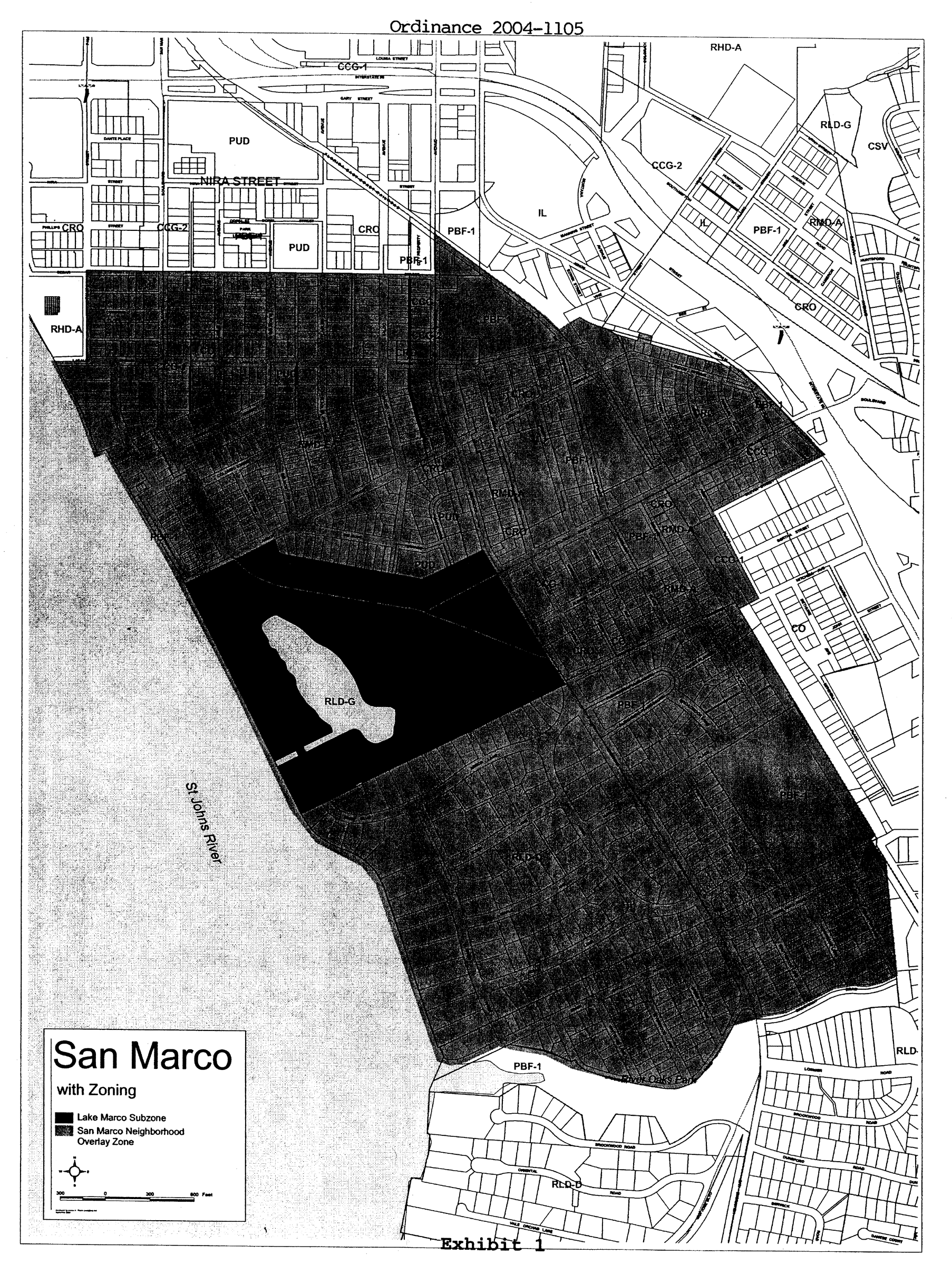
Figure B, Page 1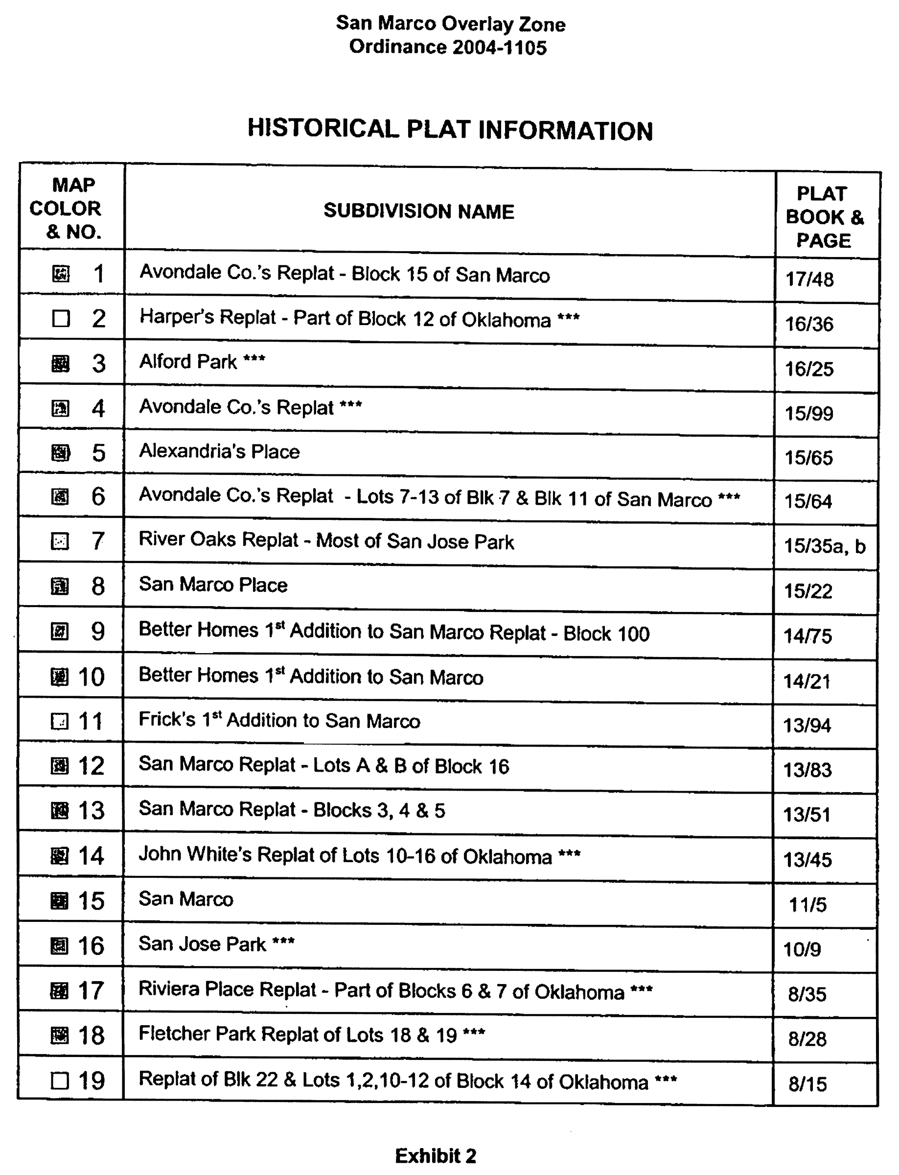
Figure B, Page 2
Figure B, Page 3
Figure B, Page 4
Figure B, Page 5
Figure B, Page 6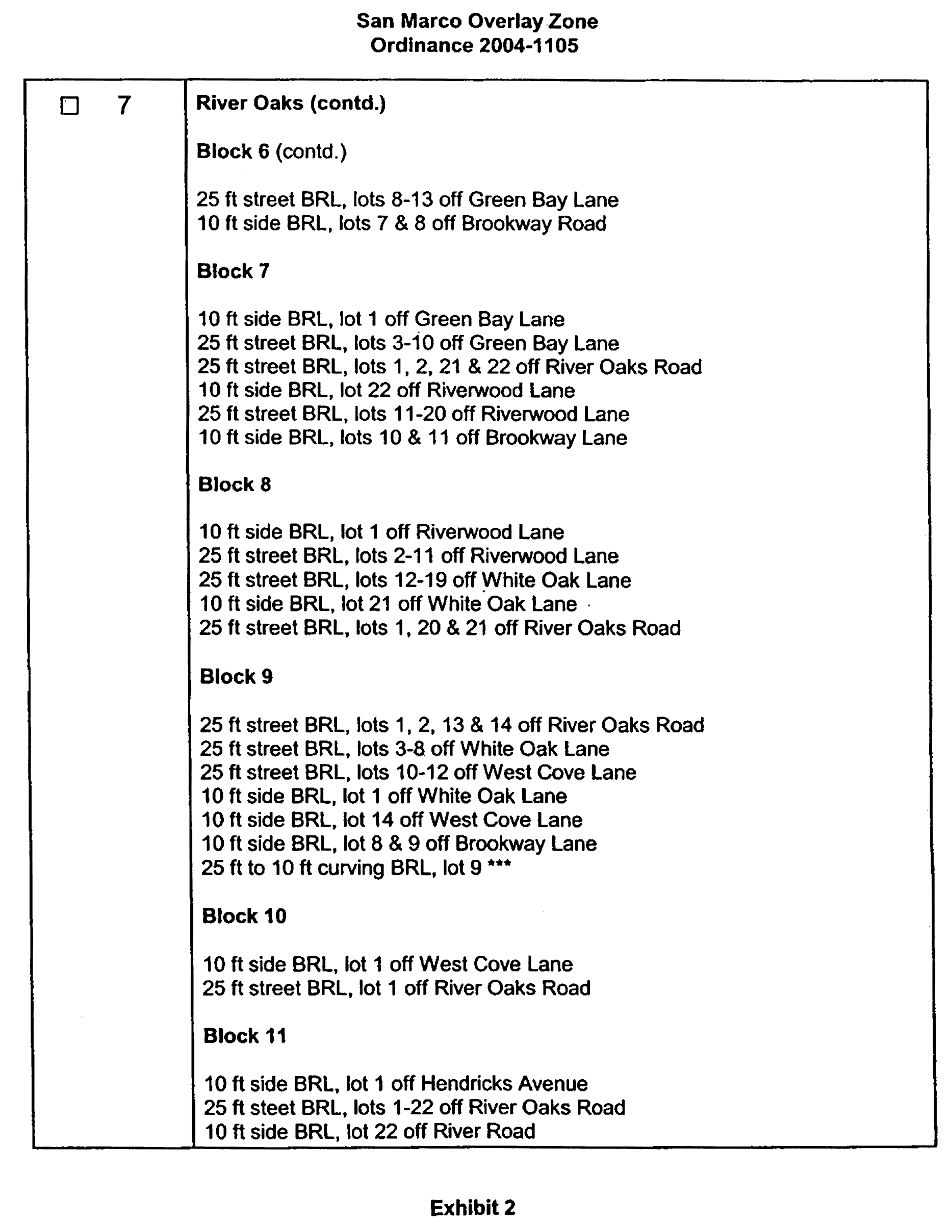
Figure B, Page 7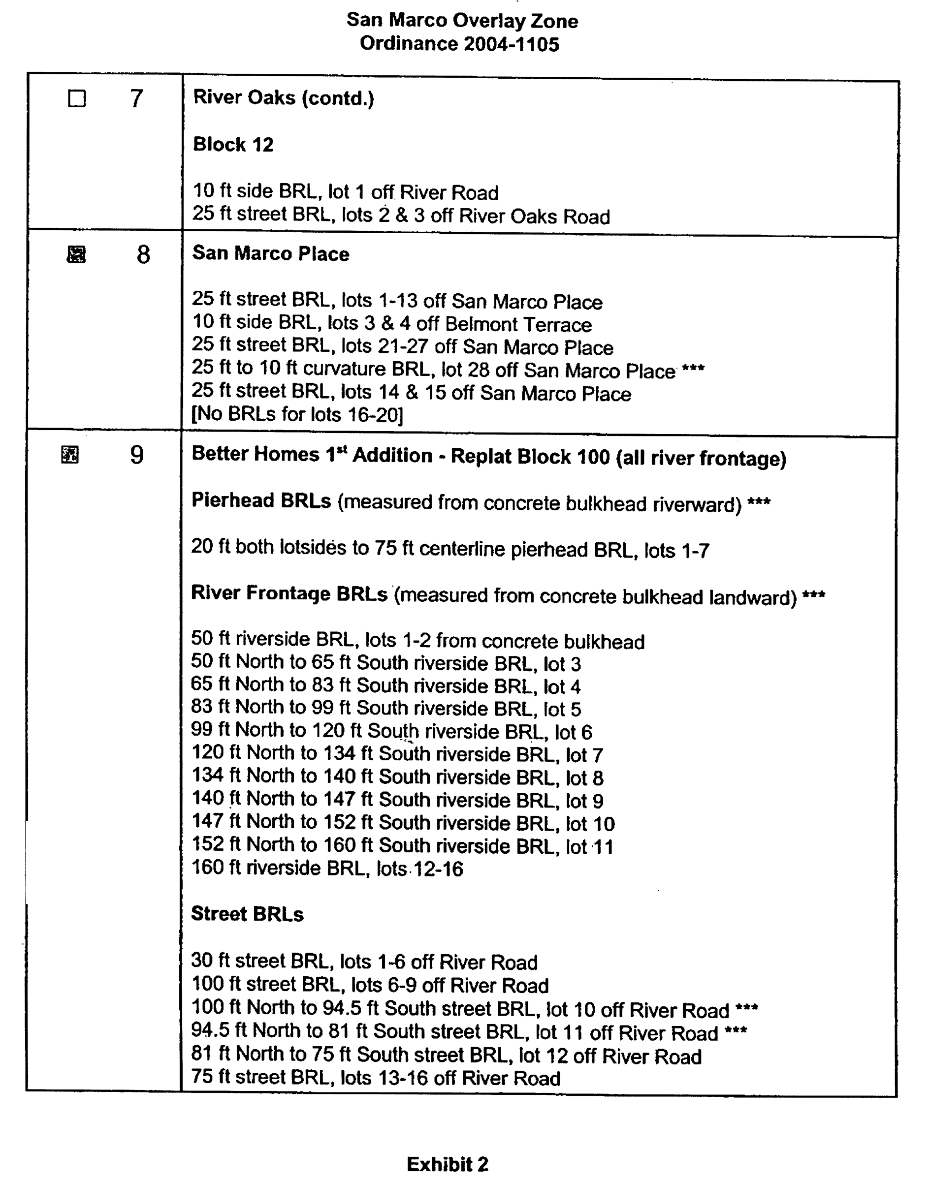
Figure B, Page 8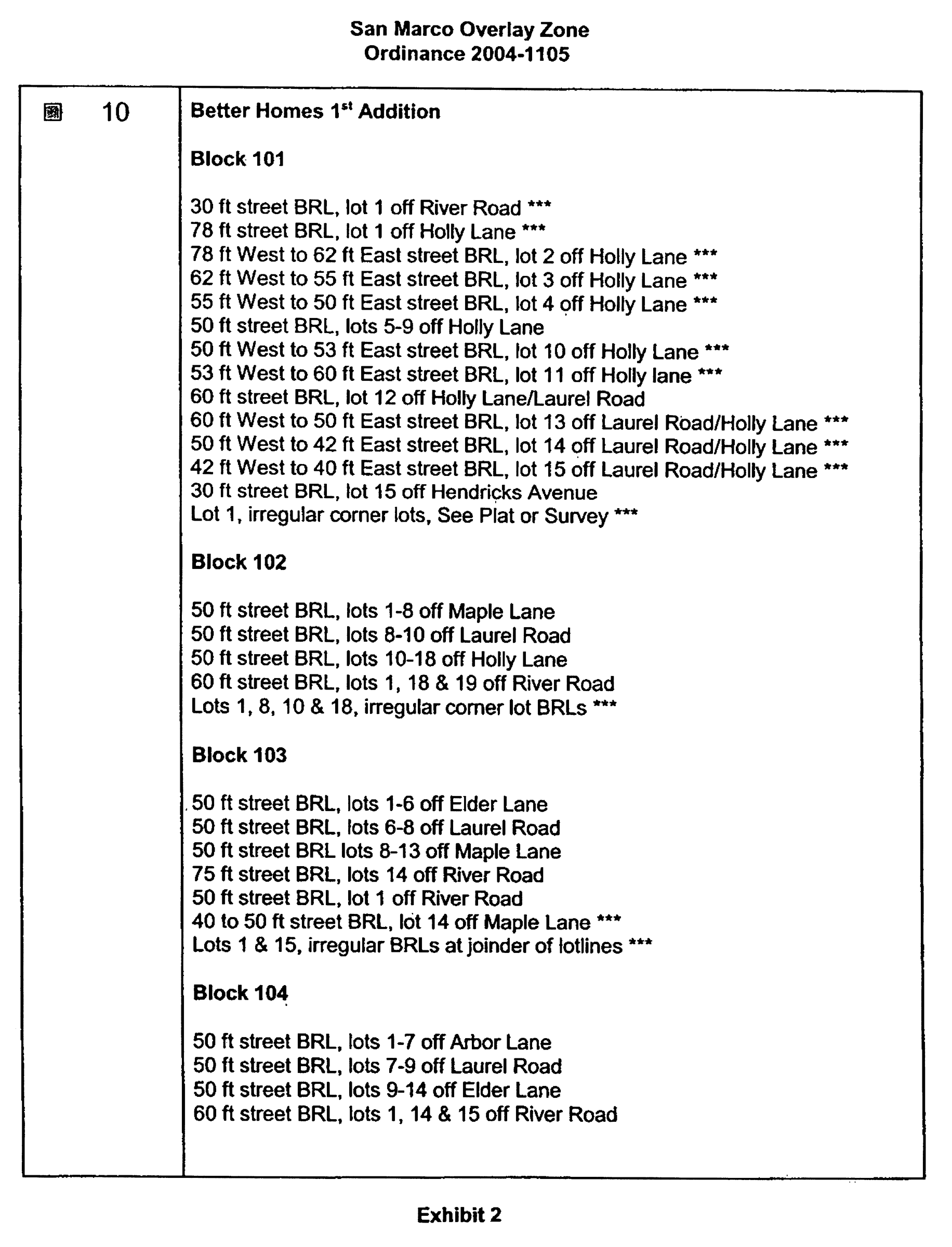
Figure B, Page 9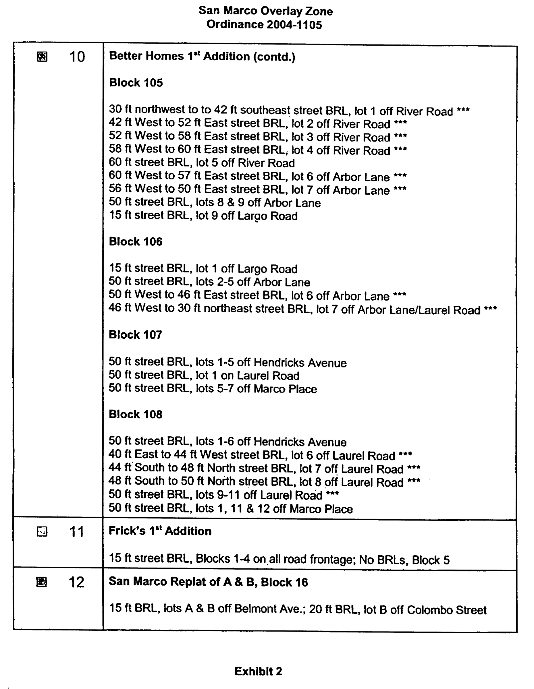
Figure B, Page 10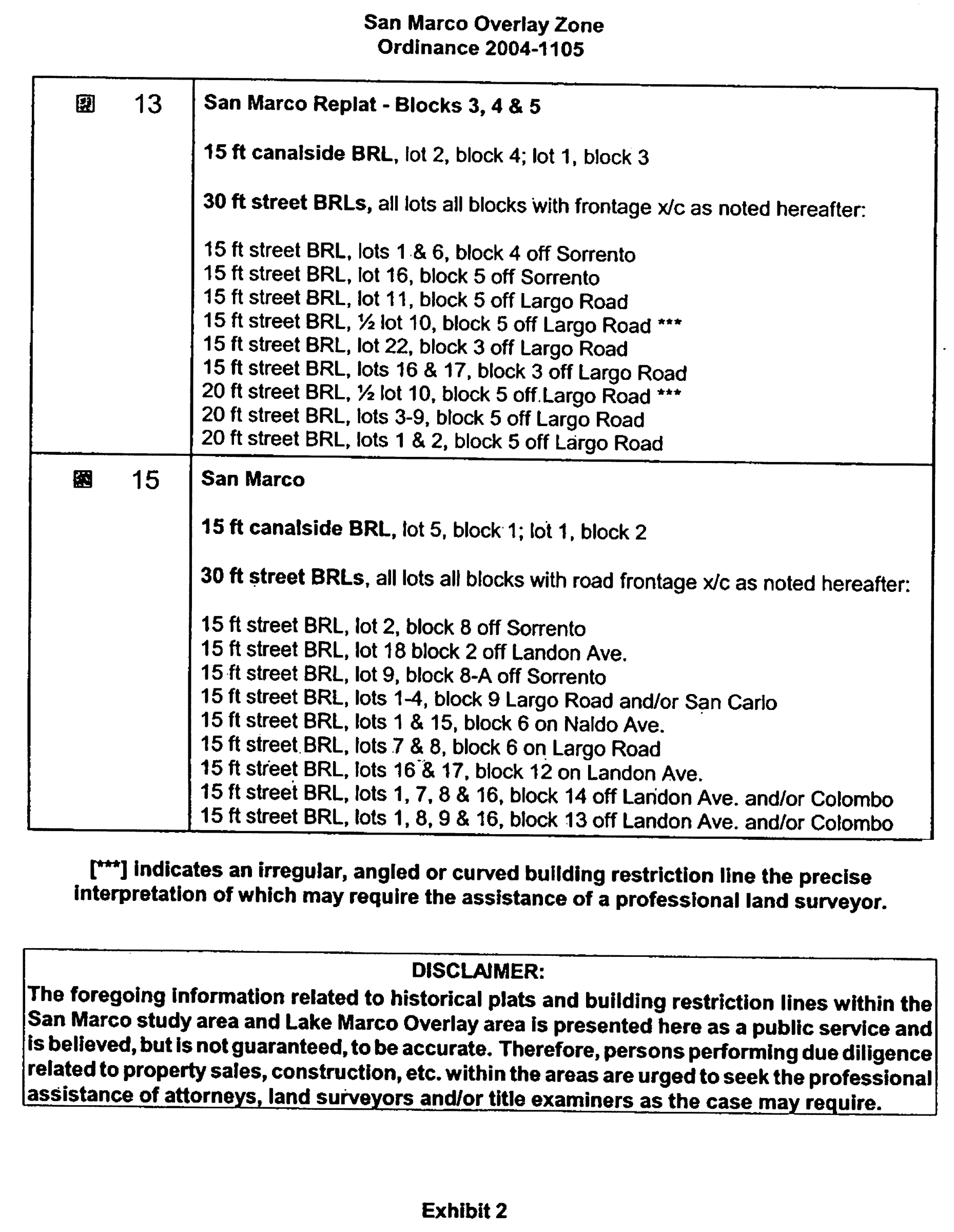
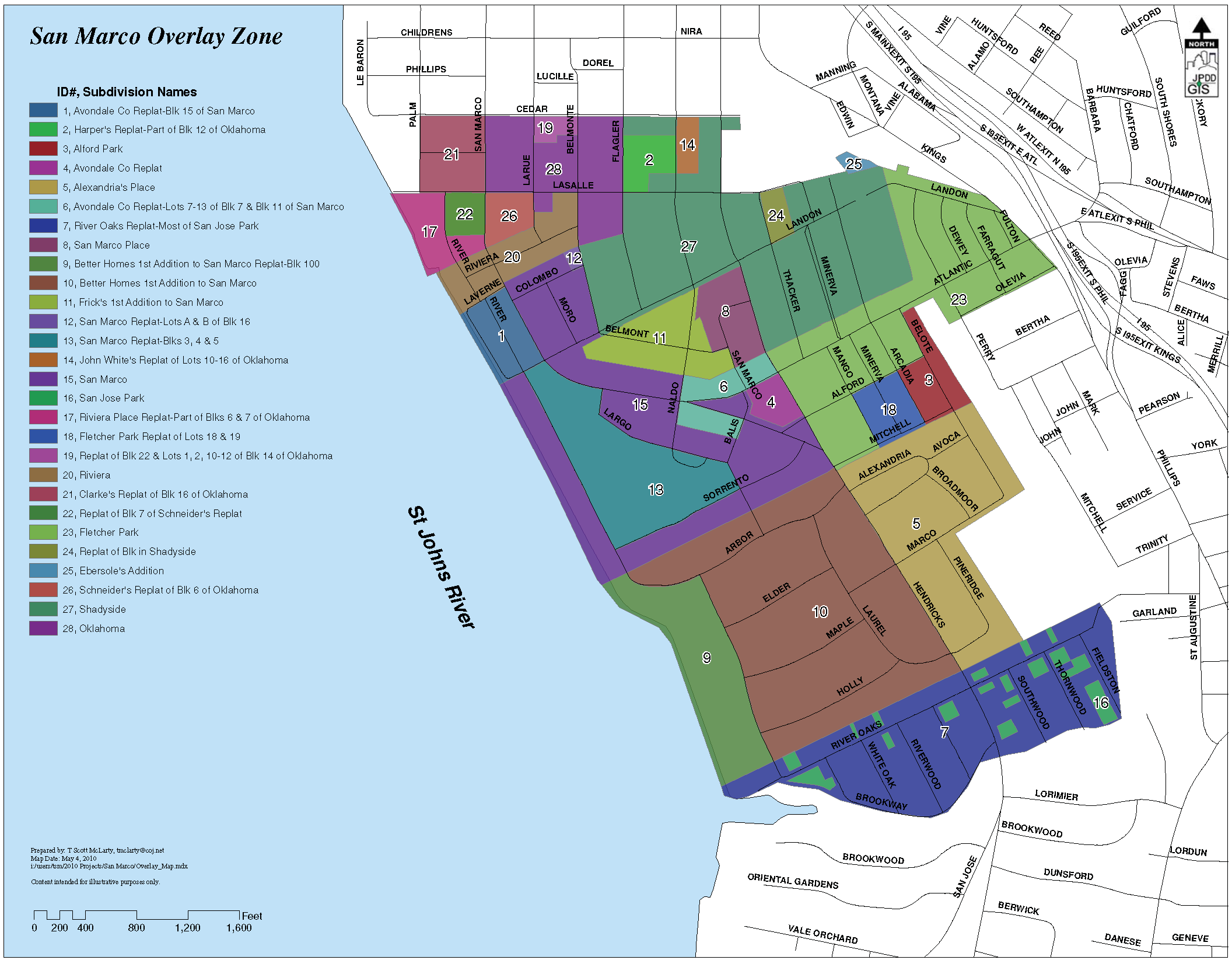
Figure C
(Ord. 2015-834-E, § 3)
Sec. 656.399.7. - Overlay development standards.
Except as otherwise provided in this Subpart M, the design, siting and building standards, criteria and limitations set forth expressly in this Subpart M with reference to lots with building restriction lines, setback and height, specific locations, specific development types and/or specific types of structures or equipment, shall supersede and prevail over any other inconsistent provisions of the Zoning Code including any PUD adopted subsequent to the effective date of this ordinance. Subsequent to the effective date of this ordinance any request for administrative deviation, variance, conventional rezoning, PUD rezoning, PUD administrative modification, PUD minor modification, or PUD major modification shall be limited by these Overlay development standards as well as Section 656.399.6, of this Overlay. For standards not expressly set forth in this Overlay, the standards relative to an underlying zoning district and other applicable, general provisions of the Zoning Code shall govern.
(a)
Building restriction line setbacks.
(1)
Where building restriction lines are depicted on the historical plats of lots listed in Figure B, such lines shall constitute setback lines and determine the size of each and every required, open "yard" for single-family, multi-family and commercial development, notwithstanding the size yard otherwise required pursuant to the Zoning Code. In the event an existing lot contains building restriction lines on a part, but not the whole, of such lot, the building restriction lines shall be deemed to continue in a linear and/or logical fashion to apply to the whole of the lot.
(2)
In the event no building restriction lines are depicted for a particular lot, or fail to delineate a front, rear or side yard on a particular lot, the size of all required yards shall be determined as may expressly be set forth hereinafter, or as otherwise provided by the Zoning Code.
(3)
The term "yard" shall be as defined in the Zoning Code, with the following exceptions:
(i)
For the following lots, the frontage on the waterway shall be deemed a rear yard, and specifically not a "yard, front" as defined in Section 656.1601, Ordinance Code:
1.
San Marco, for Lots 1 through 5 of Block 1, and Lots 1 through 18 of Block 2; and
2.
Better Homes First Addition to San Marco Replat Block 100, for Lots 1 through 16; and
(ii)
If a rear yard is designated in a lot's historic plat, that yard shall be deemed a rear yard for zoning purposes within this Overlay, unless otherwise specifically stated herein.
(4)
The term "combined" with reference to the required side yard means that one side of two may be reduced, so long as the total of the two side yards equals the required combined amount, with the reduction limited as follows: ten-foot combined, one side yard may be reduced to three feet; 12-foot combined, one side yard may be reduced to four feet; 15-foot combined, one side yard may be reduced to five feet; 20-foot combined, one side yard may be reduced to 7.5 feet.
(5)
For residential lots with frontage on three streets, the lot owner may request a setback reduction totaling no more than 15 feet "combined" as that term is used in subsection (4) above; provided however, that the primary front yard (where the front door faces the street and the property is addressed) may not be reduced to less than a 25-foot setback and the second front yard (adjacent to the side of the residence) may not be reduced to less than 15-foot setback. The setback reduction may be approved administratively by the Director without the need for an administrative deviation.
(b)
Specific location setback lines and provisions. The setback lines/required yards and other siting restrictions applicable to lots located within the historical plats of lands listed in Figure B, and identified and described further by current street name (and applicable to any successor street name thereto), are as follows:
(1)
Replat of Block 22 and Lots 1, 2, 10-12 of Block 14 of Oklahoma; Figure C, Location 19: 15-foot front yard setback and a ten-foot combined side yard setback.
(2)
Harpers Replat, Part of Block 25 of Oklahoma; Figure C, Location 2: Ten-foot front yard setback and a ten-foot combined side yard setback.
(3)
John White's Replat of Lots 10-16 of Oklahoma; Figure C, Location 14: Ten-foot front yard setback and a ten-foot combined side yard setback.
(4)
Shadyside; Figure C, Location 27: Lots abutting upon streets as follows:
(i)
Cedar Street - 20-foot front yard setback and a ten-foot combined side yard setback.
(ii)
LaSalle Street - 20-foot front yard setback and a ten-foot combined side yard setback.
(iii)
Landon Avenue west of Hendricks Avenue - 25-foot front yard setback and a 12-foot combined side yard setback.
(iv)
Landon Avenue east of Hendricks Avenue - ten-foot front yard setback and a 15-foot combined side yard setback.
(v)
Belmonte Avenue - 25-foot front yard setback and a 12-foot combined side yard setback.
(vi)
Flagler Avenue - 25-foot front yard setback and a 12-foot combined side yard setback.
(vii)
Naldo Avenue - 20-foot front yard setback for lots located on the east side of Naldo and a ten-foot front yard setback for lots located on the west side of Naldo, with a 12-foot combined side yard setback.
(viii)
Thacker Avenue - 20-foot front yard setback and a 15-foot combined side yard setback.
(ix)
Minerva Street - 20-foot front yard setback and a 15-foot combined side yard setback.
(x)
Arcadia Place - 20-foot front yard setback and a 15-foot combined side yard setback.
(5)
Replat of Block in Shadyside; Figure C, Location 24: Lots located along Thacker Avenue shall have a 20-foot front yard setback and a 15-foot combined side yard setback.
(6)
Oklahoma; Figure C, Location 28: Lots abutting upon Larue Avenue, Belmonte Avenue and Flagler Avenue shall have a 15-foot front yard setback and a 15-foot combined side yard setback.
(7)
Fletcher Park Replat of Lots 18 & 19; Figure C, Location 18: Lots abutting upon streets as follows:
(i)
Minerva Avenue - 20-foot front yard setback and a 15-foot combined side yard setback.
(ii)
Arcadia Avenue - Lots located along west side of Arcadia shall have a 20-foot front yard setback and a 15-foot combined side yard setback.
(iii)
Mango Avenue - Lots located along the east side of Mango shall have a ten-foot front yard setback except that parcels currently designated as CCG-1 zoning district shall have a zero (0) front yard setback.
(8)
Alford Park; Figure C, Location 3: For lots addressed on the east side of Arcadia Place a 35-foot front yard setback and a 15-foot combined side yard setback. For lots addressed on the east side of Belote Place a 25-foot front yard setback and a 15-foot combined side yard setback. For lots addressed on the west side of Belote Place a 20-foot front yard setback and a 15-foot combined side yard setback. For the lot addressed on the south side of Alford Place between Belote Place and Arcadia Place a ten-foot front yard setback and a 15-foot combined side yard setback. For the lot addressed on the north side of Mitchell Avenue between Belote Place and Arcadia Place a five-foot front yard setback and a 15-foot combined side yard setback. For corner lots having two front yards, the front yard setback limitation shall apply to each front yard. Notwithstanding these restrictions, any primary structure and any alterations to the primary structure that were constructed more than 50 years prior to January 1, 2025 that is made non-conforming by these setback limitations may be reconstructed on the structure's historic footprint.
(9)
Fletcher Park; Figure C, Location 23: For lots located along all streets except Atlantic Boulevard a 7.5-foot front yard setback and a 20-foot combined side yard setback.
(10)
Riviera; Figure C, Location 20: For lots located along the St. Johns River, the river shall be deemed to constitute the front yard while River Road shall constitute the rear yard, with a 20-foot front yard setback measured from the bulkhead required and a five-foot rear yard setback required for detached garages. For non-riverfront lots, a 20-foot front yard setback shall be required and a 15-foot combined side yard setback.
(11)
Clarke's Replat of Block 16 of Oklahoma; Figure C, Location 21: For lots located along LaSalle, Palm, Cordova and Cedar, a 20-foot front yard setback shall be required and a 15-foot combined side yard setback.
(12)
San Marco; For Lots 1 through 5 of Block 1, and Lots 1 through 18 of Block 2, the following shall apply:
(i)
The riverfront of such lots shall be considered the rear yard.
(ii)
The rear yard setback shall be 25 feet from the inland side of the bulkhead.
(iii)
The minimum setback for rear yard accessory structures from the inland side of the bulkhead shall be five feet, and five feet from adjacent lots.
(iv)
Permitted Accessory structures in rear yard:
a.
Fences not to exceed four feet in height; and
b.
Accessory structures not in excess of four feet in height such as swimming pools, hot tubs, water features, decks, barbeque and fire pits, mechanical equipment, etc., as long as such structures are set back from the inland side of the bulkhead and the adjacent lots by a minimum of five feet.
(v)
Permissible Accessory structures through administrative deviation in rear yard:
a.
Only one rear yard accessory structure is allowed per lot by administrative deviation. Such structures may be permitted for uses such as a summer kitchen, cabana, non-commercial greenhouse, storage shed or playhouse, and only provided that all of the following limitations, in addition to the limitations in Section 656.399.8, Ordinance Code, are satisfied:
i.
Structure, including roof overhang, not to exceed 150 square feet in area and 15 feet in total height including all roof features, as measured from the lower of either the undisturbed existing grade at the accessory structure, or one foot above the elevation of the property line at the road right-of-way;
ii.
Structure shall be set back a minimum of five feet from the inland side of the bulkhead and the adjacent lots;
iii.
Structure shall not obstruct the river view of any adjacent lot as viewed from the adjacent house, or the adjacent rear yard setback if no house exists, from an elevation of five feet from the finished floor elevation of the lowest room on the riverfront of such house; and
iv.
Since the structure will likely be visible from adjacent parcels, adequate landscape screening shall be provided to screen the structure.
(vi)
Prohibited Accessory structures in rear yards include garages and facilities for caretakers and accessory living quarters.
(vii)
Except as provided in (iv), no administrative deviation from this Section shall be permitted.
(13)
Better Homes First Addition to San Marco Replat Block 100; For Lots 1 through 5, the following shall apply:
(i)
The riverfront of such lots shall be considered the rear yard.
(ii)
Permitted Accessory structures in rear yards:
a.
Fences within 25 feet of the inland side of the bulkhead shall not exceed four feet in height;
b.
Fences between 25 feet to 50 feet from the inland side of the bulkhead shall not exceed six feet in height and any portion of the fence over four feet in height shall have a maximum opacity of 30%; and
c.
Structures not in excess of four feet in height such as swimming pools, hot tubs, water features, decks, barbeque and fire pits, mechanical equipment, etc., as long as such structures are set back from the inland side of the bulkhead and adjacent lots by a minimum of five feet.
(iii)
Permissible Accessory structures through administrative deviation in rear yards:
a.
Only one rear yard accessory structure per lot is allowed by administrative deviation. Such structure may be permitted for uses such as a summer kitchen, cabana, non-commercial greenhouse, storage shed or playhouse, and only provided that all of the following limitations, in addition to the limitations in Section 656.399.8, Ordinance Code, are satisfied:
i.
Structure, including roof overhang, not to exceed 150 square feet in area;
ii.
Structure height, including all roof features, not to exceed 15 feet as measured from the lower of either the undisturbed existing grade of the accessory structure, or one foot above the elevation of the property line at the road right-of-way;
iii.
Structure set back from the inland side of the bulkhead a minimum of 25 feet and from the adjacent lots a minimum of five feet;
iv.
Structure will not obstruct the river view of any adjacent lot as viewed from the adjacent house, or the adjacent BRL if no house exists, from an elevation of five feet from the finished floor elevation of the lowest room on the riverfront of such house; and
v.
Since the structure will likely be visible from adjacent parcels, adequate landscape screening shall be provided to screen the structure.
(iv)
Prohibited Accessory structures in rear yards include garages and facilities for caretakers and accessory living quarters.
(v)
Except as provided in (iii), no administrative deviation from this Section shall be permitted.
(14)
Better Homes First Addition to San Marco—Replat Block 100; For Lots 6 through 16, the following shall apply:
(i)
The riverfront of such lots shall be considered the rear yard.
(ii)
Permitted Accessory structures in rear yards:
a.
Fences, as measured in height from the undisturbed existing grade at the fence, the maximum allowable height is as follows:
i.
Within 40 feet of the inland side of the bulkhead—four feet;
ii.
Between 40 to 100 feet of the inland side of the bulkhead—six feet, however, any portion of the fence over four feet in height shall have a maximum opacity of 30 percent; and
iii.
Landward beyond 100 feet from the river—may be completely opaque up to six feet in height.
b.
Structures that do not exceed four feet in height such as swimming pools, hot tubs, water features, decks, barbeque and fire pits, mechanical equipment, etc., as long as such structures are set back from the inland side of the bulkhead and from the adjacent lots by a minimum of five feet.
(iii)
No Accessory structure in excess of four feet in height shall be permissible within 40 feet of the bulkhead or riverward lot line.
(iv)
Permissible Accessory structures through Administrative Deviation in rear yards:
a.
In the lower level of the rear yard, only one rear yard accessory structure is allowed per lot by administrative deviation. Such structure may be permitted for uses such as a summer kitchen, cabana, non-commercial greenhouse, storage shed or playhouse, and only provided that all of the following limitations, in addition to the limitations in Section 656.399.8, Ordinance Code, are satisfied:
i.
Structure, including roof overhang, not to exceed 400 square feet in area;
ii.
Structure set back from the inland side of the bulkhead a minimum of 40 feet, and from the adjacent lots a minimum of five feet;
iii.
Structure height, including all roof features, shall be a maximum of four feet above the lower of either the undisturbed existing grade of the subject property's riverward BRL, or one foot above the elevation of the property line at the road right-of-way;
iv.
Since the roof surface will likely be visible from adjacent parcels, architecturally compatible roof material and design as well as landscape screening shall be provided; and
v.
No mechanical equipment may be located on the roof of any such structure.
b.
In the upper level of the rear yard, only one rear yard accessory structure per lot is allowed by administrative deviation. Such structure may be permitted for uses such as a summer kitchen, cabana, non-commercial greenhouse, storage shed or playhouse, and only provided that all of the following limitations, in addition to the limitations in Section 656.399.8, Ordinance Code, are satisfied:
i.
Structure, including roof overhang, not to exceed 400 square feet in area;
ii.
Structure located a maximum of 32 feet, as measured from the riverfront BRL, toward the river, and a minimum of five feet from adjacent lots;
iii.
Structure height, including all roof features, shall be a maximum of 15 feet as measured from the lower of either the undisturbed existing grade of the subject property's riverward BRL, or one foot above the elevation of the property line at the road right-of-way;
iv.
Structure shall not obstruct the river view of any adjacent lot as viewed from the adjacent house from an elevation of five feet from the finished floor elevation of the lowest room on the riverfront of such house, or five feet above the adjacent riverward BRL if no house exists; and
v.
Structure shall be adequately landscaped and screened from adjacent lot.
c.
The allowable square footage of Accessory structures may be combined for a maximum of 600 square feet, including roof overhang, so long as the structure meets the other limitations of the location (upper or lower rear yard) within which it is placed.
(v)
Prohibited Accessory structures in rear yards include garages and facilities for caretakers and accessory living quarters.
(vi)
Except as provided in (iv), no administrative deviation from this Section shall be permitted.
(c)
Single-family dwelling development. The following additional standards and criteria shall govern single-family dwelling development and shall provide for the setback where not specified pursuant to either subsections (a) or (b) hereinabove:
(1)
General standards.
(2)
Facade standards. No more than 30 percent of the entire front facade should be comprised of a front-facing garage door but demonstration of this standard shall not be required as a condition precedent to the issuance of a building permit.
(3)
Permitted use. Single family development shall be permitted by right within the RMD-E and CRO zoning districts.
(d)
Multiple-Family Dwelling Development. The following additional standards and criteria shall govern multiple-family dwelling development and shall provide for the setback where not specified pursuant to either subsections (a) or (b) hereinabove:
(1)
General standards.
(2)
Facade requirements. For all facades along San Marco Boulevard, no more than 60 contiguous feet along the facade is permitted without a break or step back of a minimum depth of 20 feet into the lot interior for a minimum span of 15 feet.
(3)
Parking. All multiple-family development repairs or renovations commenced after the effective date of this Subpart exceeding 50 percent of the assessed value of an existing structure, shall make provision for adequate on-site parking to be located in the rear or side yards at a rate of at least one vehicular parking space per dwelling unit but shall provide greater parking as may be required by other provisions of the Zoning Code. However, if the repairs and renovations are proposed as part of a PUD rezoning, and all other standards in this Overlay are met, then a PUD including a request for a reduction in parking may be filed.
(e)
Commercial/Nonresidential development.
(1)
General standards.
(2)
Transportation Corridor Standards. For lots located abutting Hendricks Avenue, San Marco Boulevard and Atlantic Boulevard west of the railroad tracks, the following commercial development standards and terms shall be applicable:
(3)
Transportation Corridor Height Standards.
(a)
For lots located abutting the north side of Atlantic Boulevard from Hendricks Avenue east to the railroad tracks, and on the south side of and abutting Atlantic Boulevard from Hendricks Avenue to Arcadia Place, and then on Atlantic Boulevard from the railroad tracks east to Philips Highway, the maximum height of structures may be 50 feet in a conventional zoning district, or the height may be increased above 50 feet through a PUD pursuant to the following criteria:
(i)
For every 1 foot increase in height of the structure over 50 feet, the setback from an adjacent residential use shall be increased by one foot for every extra one foot of structure; and
(ii)
If the nearest residential use is across a public right-of-way, for every two feet of increase in height of the structure over 50 feet, the setback shall be increased by one foot; and
(iii)
The design must provide a transition from the proposed height to the height of adjacent uses. Criteria such as casting shadows and reduction in privacy, as well as the impact on adjacent residential uses, shall be considered.
(b)
For lots located abutting the west side of Hendricks Avenue from Alford Place to Cedar Street, and for lots located abutting the east side of Hendricks Avenue from the rear of lots fronting on Atlantic Boulevard, north to LaSalle Street, a PUD may be filed to request an increase the height above 35 feet so long as setbacks established by the Overlay are maintained or increased and the design techniques utilized create a transition from the proposed height to the adjacent uses. Transition criteria that shall be considered to determine whether an increase in height is warranted include, but are not limited to:
(i)
The casting of shadows;
(ii)
The reduction of privacy;
(iii)
The impact on adjacent residential uses; and
(iv)
The impact on nearby non residential structures and sites that are eligible for historic designation.
(4)
The lots numbered as 12, 13, 14 and 15 of Block 6 of the Plat of San Marco presently fronting on San Marco Boulevard shall have front yard setbacks of 30 feet.
(5)
Building orientation. All commercial buildings shall be oriented with an entrance and the primary facade facing a public right-of-way and shall be oriented specifically to San Marco Boulevard, Hendricks Avenue or Atlantic Boulevard, as applicable, where a commercial development abuts such rights-of-way.
(6)
Build-to line/front setbacks. Within the Subzone and for lots abutting Hendricks Avenue, San Marco Boulevard and Atlantic Boulevard, a minimum of 70 percent of the facade of a commercial building that fronts on the public right-of-way as to which the building is oriented shall be located not more than ten feet from such right-of-way, except that northeast of the railroad tracks along Atlantic Boulevard this requirement shall be extended to not more than 20 feet. Notwithstanding, pedestrian plazas and courtyards may break this build-to line but parking shall not be allowed in lieu of a pedestrian space unless it is located behind a landscaped street wall adjacent to the building line.
(f)
Equipment siting limitations. No air conditioner, heater or related equipment shall be sited or located in the required front yard.
(g)
Fencing along railroads. Where the rear property line of a lot within the Zone abuts an active railroad right-of-way, fences may be constructed to a height of ten feet along such rear property line.
(h)
Structure height.
(1)
The height of principle structures shall be measured from the lower of either the undisturbed existing grade at the perimeter of the building pad, or one foot above the elevation of the property line at the road right-of-way; and
(2)
The height of fences shall be measured from undisturbed existing grade.
(Ord. 2004-1105-E, § 1; Ord. 2015-834-E, § 1; Ord. 2016-367-E, § 1; Ord. 2017-862-E, § 1; Ord. 2025-9-E, § 1)
Sec. 656.399.8. - Limitations on administrative deviations.
Owners of property within the Zone may apply for an administrative deviation pursuant to Section 656.109 of the Zoning Code subject to the following additional requirements:
(a)
Compatibility Demonstration. In order for an administrative deviation application to be considered, the applicant must first demonstrate by competent, substantial evidence made a part of the application that the proposed development will as a threshold matter be compatible with the adjacent properties. Estimates of roof pitch and building height will be accepted where there is not a sufficient record of same contained in the Historic Properties Survey of the San Marco Area of Jacksonville prepared by Historic Properties Associates, Inc. and dated April 1990 (the "Historic Survey") for adjacent properties.
An application for administrative deviation will be considered where an application achieves a minimum of seven points on the following matrix/schedule by favorable comparison to the greater number of adjacent properties defined as those lots or lands that abut the property for which the deviation is sought and except that compatibility related to architectural style shall be determined by reference to the Historical Survey. Further, the Zoning Administrator or his or her designee may consider additional properties within the street frontage to be "adjacent" if there exists an insufficient number of abutting properties. Alternatively, the Zoning Administrator may find an application demonstrates sufficient compatibility by proposing creative solutions to lot-oriented issues or problems which maintain the historical scale, rhythm, style and character of the area and carry out the purposes of this Subpart M even though the strict requirements of the following compatibility matrix/schedule cannot be met:
Compatibility Matrix/Schedule
*as per the Historical Survey
(b)
Limitations on administration deviation standards. For each type of development and standard listed hereafter, administrative deviations may be sought subject to the applicable minimums, maximums, additional criteria and other limitations:
(1)
Single-family dwelling development.
(2)
Multiple-family dwelling development.
(3)
Commercial/nonresidential development.
(c)
Limited number of deviations. In any 365-day period, no deviation may be granted relaxing more than three of the standards listed above and no more than two such standards may be relaxed where one relates to lot coverage.
(Ord. 2004-1105-E, § 1; Ord. 2015-834-E, § 2)
Sec. 656.399.9. - Rebuilding after disaster and for garages.
In the event a building or detached accessory structure permitted or in existence as of March 9, 2004, is destroyed (more than 65 percent damaged as a measure of assessed value) such destroyed building or structure may be sited and rebuilt as it previously existed so long as reconstructed in accordance with all applicable provisions and specifications of the Florida Fire Prevention Code and the Florida Building Code, or successor codes, and other local provisions in the nature of building and fire codes. Further, any garage accessory structure, whether detached or attached to the principal structure, in existence on the effective date of this Subpart, may be repaired, renovated or reconstructed to the same height as previously existed upon the existing garage footprint lying: (1) up to one foot from the closest side and/or rear property line(s) without regard to lot coverage; or, (2) up to five feet into a required front yard without regard to lot coverage, and may in the process be expanded horizontally away from such side, rear or front yard reference points so long as height is not increased nor the applicable lot coverage requirement exceeded. Those wishing to avail themselves of the provisions and protections of this paragraph shall make special application to the Zoning Administrator seeking approval prior to commencement.
(Ord. 2004-1105-E, § 1)
Sec. 656.399.10.- Mandarin Road Overlay.
The Council finds that the properties within the Mandarin Road Overlay, as visually depicted in the Mandarin Road Overlay map following this Section, are predominantly developed at a density of one unit per acre or larger. Therefore, the following additional criteria shall be considered by the Planning and Development Department, the Local Planning Agency, and the City Council when evaluating any land use or zoning application within the Mandarin Road Overlay, to protect the character of the Overlay area and protect the health, safety, and welfare of the residents therein:
(a)
Whether the applicant has demonstrated that the proposed application is consistent with the established planning studies of Mandarin;
(b)
Whether the application would negatively affect or alter the character of Mandarin Road;
(c)
Whether the application is compatible with surrounding lot sizes and density, provided that development shall not exceed one dwelling unit per one net acre. A net acre does not include wetlands, rights-of-way and private roads and access easements;
(d)
Whether there are available public facilities to support the future development, such as water, sewer and fire protection;
(e)
Whether the application and subsequent future development would result in the destruction of natural resources such as wetlands, protected trees and/or specimen trees, and archaeologically sensitive areas;
(f)
Whether the subject property is within 2,000 feet of an historic landmark or landmark site designated by the Council pursuant to Section 307.104; and
(g)
Whether the application would increase density in the coastal high hazard area or would have a detrimental effect on hurricane evacuation timing.
(Ord. 2007-652-E, § 2; Ord. No. 2009-91-E, § 2)
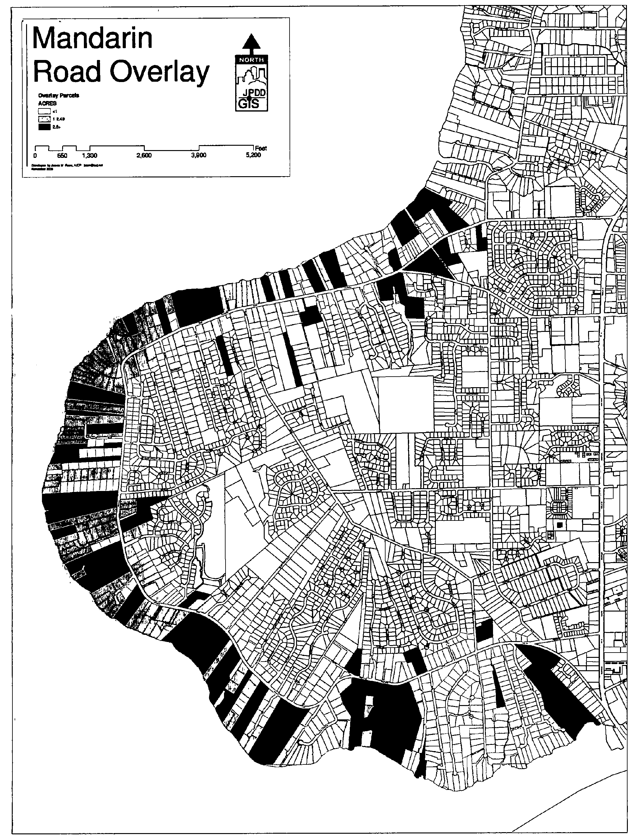
Exhibit 1. Mandarin Road Overlay
Sec. 656.399.11. - Mandarin Height Overlay.
The Council finds that restricting the height of structures in the Mandarin Height Overlay as provided herein will promote the orderly development of Mandarin and protect the character, aesthetic appeal, and quality of life for Mandarin residents. Therefore, the following criteria shall apply to all development applications and these criteria specifically supersede any other provisions in Chapter 656:
(a)
The Mandarin Height Overlay area is visually depicted in Exhibit 1 and generally described as the area in City Council District 6 south of Interstate 295 and west of Interstate 95, specifically excluding existing Developments of Regional Impact and an area north of Greenland Road and east of Derby Forest Drive.
(b)
The maximum height of any structure by right within the Overlay area shall be limited to 35 feet, unless the property is in a commercial land use category that does not directly abut a residential use, and is located within 1,000 feet of a limited access right-of-way interchange.
(c)
Height increases in excess of 35 feet within commercial land use categories that meet subsection (a) shall require an additional one foot of building setback for each three vertical feet, up to a maximum height of 60 feet. Any increase in height beyond 60 feet shall require approval through an Administrative Deviation.
(d)
Height increases beyond 35 feet for all other structures not addressed by subsections (a) and (b) shall require approval through an Administrative Deviation.
(Ord. 2007-653-E, § 2)
Sec. 656.399.12.- Legislative findings.
The Council hereby finds and determines as follows:
(a)
In 1990, the City of Jacksonville adopted a Historic Preservation Element as a part of the Comprehensive Plan with a goal to identify, document, protect and preserve the City's archaeological, historic, architectural, and cultural resources.
(b)
Pursuant to the policies of the Historic Preservation Element of the adopted Comprehensive Plan and the standards and provisions of Chapter 307, Historic Preservation and Protection, the City of Jacksonville has subsequently designated the local Riverside/Avondale Historic District and the St. Johns Quarter Historic District to protect, preserve and enhance these historic areas of the City.
(c)
The Riverside/Avondale Zoning Overlay area has been negatively affected by current zoning districts and applicable design standards which do not recognize the unique character of the various neighborhoods and mixed-use centers within this area.
(d)
Standard zoning districts do not recognize the small lots, high lot coverage and other aspects of the neighborhood's unique residential development pattern.
(e)
The Riverside/Avondale Zoning Overlay area is an invaluable resource to the City and its citizens and should be preserved for future generations.
(f)
The negative neighborhood impacts caused by incompatible zoning must be reversed through a comprehensive program that will include design standards tailored to the diverse communities of the Riverside/Avondale area including historic residential neighborhoods, mixed-use areas and non-residential corridors. Standards should allow appropriate and compatible development to proceed without the high costs associated with variances and administrative processes required to deviate from current lot and use standards.
(g)
Parts of Riverside and Avondale have been negatively impacted by zoning and land use changes that have not been compatible with the surrounding uses and have contributed to decline and inhibited revitalization efforts. These negative impacts and continued relaxation of zoning requirements in areas not suitable for office or other commercial development if left unchecked will continue to destabilize the neighborhood and allow intrusive uses into residential areas within the District.
(h)
The design standards and regulations contained in this Subpart O were developed with the participation and assistance of neighborhood residents, property owners and City staff.
(i)
The Planning Commission and the Land Use and Zoning Committee considered these districts and regulations, held public hearings and made their recommendations to the Council.
(j)
Based on the foregoing findings, the Council hereby establishes the Riverside/Avondale Zoning Overlay regulations contained in this Subpart O for the purpose of encouraging residential owner-occupants, allowing for mixed-uses and home businesses, discouraging over-intensive uses, and providing performance standards and special regulations for uses allowed by exception.
(Ord. 2008-192-E, § 3)
Sec. 656.399.13. - Purpose and intent.
(1)
The Riverside/Avondale Zoning Overlay area continues to face tremendous growth pressures due to the proximity of the area to downtown Jacksonville, and the beautiful waterfront areas along the St. Johns River. The purpose of the Riverside/Avondale Zoning Overlay and the regulations of this Subpart is to protect the character, economic vitality, aesthetic appeal and historical integrity of the Riverside/Avondale Zoning Overlay area by providing for supplemental zoning regulations and development standards which have been specifically established to support the Historic Districts of the Riverside/Avondale Zoning Overlay area and their environs.
(2)
Any deviations from these standards shall remain consistent with the purpose and intent of this overlay. It is the intent of this overlay to strongly discourage conversion of residential uses in Historic Residential Character areas. Requirements for parking, landscaping, and other performance standards shall be strictly enforced.
(3)
For any administrative deviations sought within the Riverside/Avondale Zoning Overlay, the Zoning Administrator must also find a positive finding that the request has 1) received a certificate of appropriateness, if required by Chapter 307 (Historic Preservation and Protection), 2) is necessary due to a requirement of Chapter 307 (Historic Preservation and Protection), if applicable, 3) required by federal or State law, if applicable, or 4) necessary to preserve and protect an exceptional specimen tree, protected tree or wetlands, if applicable. However, the Zoning Administrator may authorize an Administrative Deviation prior to issuance of a Certificate of Appropriateness, even if a Certificate of Appropriateness is required, if, for good cause described in writing and filed in the Administrative Deviation application file and the Certificate of Appropriateness application file, it is determined by the Director that the Administrative Deviation application may be heard prior to the issuance of a Certificate of Appropriateness.
(4)
All parking requirements in Historic Residential Character Areas shall be met on site.
(5)
Non-conforming site characteristics such as number of parking spaces and landscaping requirements for non-residential uses that are located in a Historic Residential Character Area shall be required to bring the existing non-conforming site characteristics into compliance upon reoccupation of the structure when such use ceases for more than 6 months.
(6)
A landmark or contributing structure may be reconstructed or reoccupied for its original intended use at anytime notwithstanding its non-conforming status and shall be deemed legal for zoning purposes.
(7)
A majority of area of the Riverside/Avondale Zoning Overlay is located within those areas designated as historic districts governed by Chapter 307, Historic Preservation and Protection. Those areas are unique in nature and will continue to be governed by Chapter 307. All development within those areas of the Riverside/Avondale Zoning Overlay governed by the requirements of Chapter 307, Historic Preservation and Protection, shall also abide by the height limitations established pursuant to Chapter 307.
(8)
The following additional criteria shall be considered by the Planning and Development Department, the Local Planning Agency, and the City Council when evaluating any land use or zoning application within the Riverside/Avondale Zoning Overlay District:
(a)
Whether the proposed rezoning is consistent with a the Riverside/Avondale Zoning Overlay District and the historic district regulations;
(b)
Whether the rezoning will negatively affect or alter the character of the character area or corridor;
(c)
Whether the rezoning and subsequent future development would result in the destruction of natural resources such as wetlands, protected trees or exceptional specimen trees; and
(d)
Whether the rezoning would have a negative affect on any contributing structures within the Riverside Avondale historic district, historic landmark or landmark site.
(9)
Right-of-way closures, including alleys, shall be discouraged in order to maintain the historic grid pattern.
(10)
Variances or deviations for reductions for lot requirements for non-residential uses in the Historic Residential Character areas shall be discouraged.
(11)
The standards set forth in the Subpart were designed to maintain the historical development pattern while encouraging infill and redevelopment that protects, preserves and enhances the unique character of the communities within the Riverside/Avondale Zoning Overlay Area. The design principles that guide these standards were developed for this Zoning Overlay Area through an extensive community participation process and include the following:
1.
Protect and enhance existing residential neighborhoods.
2.
Protect historic structures.
3.
Vary housing types in transition areas between commercial and residential uses.
4.
Buffer residential neighborhoods from highways.
5.
New development should maintain appropriate scale, height and density.
6.
Encourage responsible growth.
7.
Consider streetscape on major pedestrian corridors and around core retail areas.
8.
Provide and maintain public access to waterfront parks.
9.
Extend the Riverwalk.
10.
Develop new parks and open space.
11.
Re-use John Gorrie Middle School.
12.
Calm traffic throughout the district.
13.
Improve key intersections for pedestrians and as gateways.
14.
Organize parking supply in keeping with the traditional character of the overlay area.
15.
Encourage development of walkable streets and blocks.
16.
Buffer residential neighborhoods from new and existing commercial and office uses.
17.
Limit intensification of commercial and institutional uses.
18.
Manage continued development along corridors to harmonize such development with existing historic development patterns and structures.
(Ord. 2008-192-E, § 3; Ord. 2012-371-E, § 2)
Sec. 656.399.14. - Boundaries and Riverside/Avondale Zoning Overlay area.
The legal boundaries of the Riverside/Avondale Zoning Overlay are as set forth in the Figure 1.0 Boundary Map, above, and is hereby adopted as a zoning overlay by the Council. The legal boundaries are verbally defined as follows:
Beginning at the south side of I-95 at its point of crossing over the St. Johns River via the west end of the Fuller Warren Bridge; thence south and southwest along the shoreline of the St. Johns River to the mouth of Fishweir Creek; thence west and northwest along the north side of Fishweir Creek to the point of flowing under Roosevelt Boulevard (U.S. 17); thence north and northeast along the east side of Roosevelt Boulevard to the point of crossing over the CSX Railroad; thence north and northeast along the south boundary of the railroad right-of-way to the point of crossing under I-10/I-95; thence east and southeast along the south side of I-10/I-95 to the point of beginning.
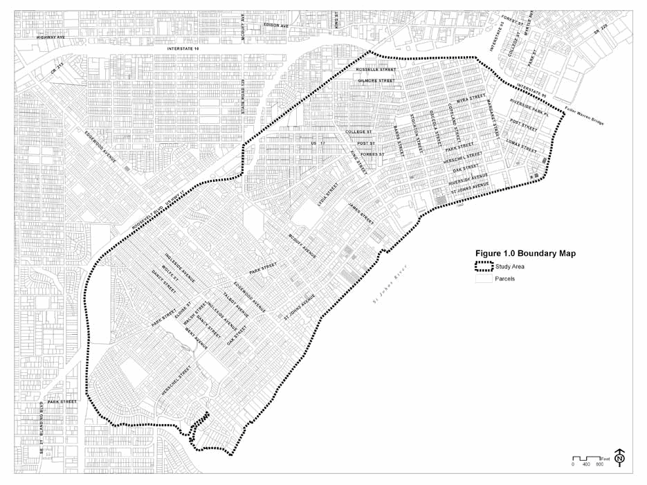
Figure 1.0 Boundary Map of Riverside/Avondale Zoning Overlay
(Ord. 2008-192-E, § 3)
Sec. 656.399.15. - Applicability.
When the regulations of this Zoning Overlay impose a different restriction upon the use of buildings or land, or upon the height of buildings, or require other conditions than are imposed or required by other ordinances, other than those ordinances approving Planned Unit Development, adopted prior to this Subpart, the provisions of this Section shall control. Additionally, the parking requirements of this Zoning Overlay shall supersede any conflicting parking requirements set forth in Part 6 of the Zoning Code. It is intended that this Subpart shall be applied to support the historic designation and characteristics of the Riverside/Avondale and St. Johns Quarter Historic Districts and to guide development and redevelopment to support the goals and objectives contained in the Comprehensive Plan and Chapter 307. Application and interpretations of this Subpart shall not be inconsistent with any requirement, process or procedure of Chapter 307, including decisions on applications brought thereunder.
(Ord. 2008-192-E, § 3; Ord. 2009-907-E, § 2)
Sec. 656.399.16. - Severability.
If any subsection or other portion of this Subpart or any application thereof to any person or circumstances is declared to be void, unconstitutional or invalid for any reason, such subsection or other portion, or the proscribed application thereof, shall be severable and the remaining provisions of this Subpart and all applications thereof not having been declared void, unconstitutional or invalid shall remain in full force and effect. The Council declares that no invalid or proscribed provision or application was an inducement to the enactment of this Subpart and that it would have enacted this Subpart regardless of the invalid or proscribed provision or application.
(Ord. 2008-192-E, § 3)
Sec. 656.399.17. - Definitions.
The definitions contained in Part 16 of the Zoning Code shall apply; however, those terms which are specific to this Subpart are defined as follows:
(a)
Block means a unit of land bounded by streets or by a combination of streets and public land, railroad rights-of-way, waterways, or any other barrier to the continuity of development.
(b)
Block face means the area of the block which faces a street.
(c)
Building frontage means the horizontal length of a wall of a building where such wall faces a street. The measurement of such length is along a line parallel to the street. Where a building is arranged to include establishments with exterior public entrances but no wall space facing a street, the horizontal dimension of one wall of each such establishment which faces a mall or other private way may be considered to be building frontage.
(d)
Building scale means the relationship between the mass of a building and its surroundings, including the width of street, open space, and mass of surrounding buildings.
(e)
Character area means designated geographical area where the predominant uses have been determined such as commercial, office, urban transition, or residential.
(f)
Contributing structure means a building or structure which was at least 50 years old at the time of the historic districts designation (1998), and which is within the boundaries of the designated historic district and which contributes to the historic or architectural character of the district and which is identified by the Council in its designation of the historic district.
(g)
Corridor means the roadway segment of a character area.
(h)
Historic residential character areas means those areas within the Riverside/Avondale Zoning Overlay that are not contained within the commercial character areas, office character areas, urban transition character areas or industrial character areas.
(i)
Historic setback means the front, side and rear setbacks of contributing principal structures at the time of their construction.
(j)
Historic use means the use of a structure between the time of its construction and 1948 (50 years prior to the date of establishment of the Riverside/Avondale historic district).
(k)
Interior apartment means a residential unit located within an existing residential structure.
(l)
Live/Work loft means residential units within large, formerly nonresidential buildings such as schools or warehouses that have been converted to residential purposes. Live-work lofts shall be considered multiple-family units.
(m)
Live/Work unit means a building/unit located and designed to accommodate an attached or detached building with residential uses, commercial uses or a combination of the two, all of which may occupy any story of the building.
(n)
Mass means the three-dimensional bulk of a structure determined by the height, width, and depth.
(o)
Non-contributing structure means a building or structure which was not at least 50 years old at the time of the historic districts designation (1998); or which is within the boundaries of the designated historic district and which does not contribute to the historic or architectural character of the district and which is identified by the Council in its designation of the historic district.
(p)
Original use means the original use of a structure at the time of its construction.
(q)
Principal building means a building in which the primary use of the lot on which the building is located is conducted.
(r)
Public space means squares, greens, plazas and neighborhood parks, pocket parks, riverwalks, pedestrian spaces and street ends.
(s)
Restaurant menu box signs means signs that incorporate a menu containing a listing of products and prices offered by the restaurant.
(t)
Riverside/Avondale historic district means the Riverside Avondale historic district and the St. Johns Quarter historic district.
(u)
Street art sign means any freestanding, three-dimensional, inanimate object that is not merchandise, and is used to attract the attention of potential customers.
(v)
Window Sign, attached means signs that are painted, posted, displayed, or etched on an interior translucent or transparent surface, including windows or doors.
(w)
Window Sign, unattached means signs that serve as advertising display located within 24-inch of a business window or door.
(Ord. 2008-192-E, § 3)
Sec. 656.399.18. - Riverside/Avondale Zoning Overlay: zoning district regulations.
All applicable provisions of the Zoning Code, including the underlying zoning district standards that are not expressly modified and superseded by this Subpart O shall remain in full force and effect. In the event a court of competent jurisdiction determines that there is an irreconcilable conflict or inconsistency between the Zoning Code and this Subpart, the more restrictive condition or term most closely associated with the remedial purpose of this Subpart shall be construed to apply where lawfully possible.
Within the Riverside/Avondale Zoning Overlay, in the areas designated as commercial, office and urban transition character areas, the predominant use shall continue to be as a mixed-use category primarily for commercial, office and multi-family residential uses. The application of this Zoning Overlay within the Historic Residential Character area shall recognize and respect the existing historic neighborhood wherein compatibility with the existing residential neighborhood shall be maintained over time.
I.
The following uses shall be permitted and permissible by exception throughout the Riverside/Avondale Zoning Overlay
a.
Permitted Uses.
(1)
Originally constructed for use or historic single family dwellings.
(2)
Originally constructed for use two-family dwellings.
(3)
Original use multi-family dwellings.
(4)
Originally constructed for non-residential use within a contributing structure.
b.
Permissible uses by exception
(1)
Historic two family dwellings.
(2)
Historic multifamily dwellings.
(3)
Live/work units
II.
Commercial, Residential, and Office (CRO) District within the Riverside/Avondale Zoning Overlay.
(a)
Permitted uses and structures are those permitted in Section 656.311(III)(a) for the CRO District, subject to the limitations set forth in this Subpart.
(b)
Permitted accessory uses and structures.
(1)
See Section 656.403.
(2)
Interior apartments in connection with single family, owner occupied properties, meeting the applicable Riverside/Avondale performance standards and development criteria.
(3)
One free-standing garage apartment in connection with single-family, owner-occupied properties, meeting the applicable Riverside/Avondale performance standards and development criteria.
(c)
Permissible uses by exception in all character areas.
(1)
Cemeteries and mausoleums but not funeral homes or mortuaries.
(2)
Essential services meeting the performance standards and development criteria set forth in Part 4.
(3)
Day care centers meeting the performance standards and development criteria set forth in Part 4.
(4)
Home occupations meeting the performance standards and development criteria set forth in Part 4.
(d)
Permissible uses by exception in the Office, Commercial, and Urban Transition Character Areas.
(1)
Rooming houses meeting the performance standards and development criteria for a bed and breakfast.
(2)
Private clubs.
(3)
Churches, including a rectory or similar use, meeting the performance standards and development criteria set forth in Part 4.
(4)
Off-street parking lots for premises requiring off-street parking meeting the performance standards and development criteria set forth in Part 4.
(5)
Community residential homes of seven to 14 residents meeting the performance standards and development criteria set forth in Part 4.
(6)
Nursing homes.
(7)
Group care home meeting the performance standards and development criteria set forth in Part 4.
(8)
Retail outlets for the sale of food and drugs, leather goods and luggage, jewelry (including watch repair but not pawn shops), art, cameras or photographic supplies (including camera repair), sporting goods, hobby shops and pet shops (but not animal kennels), musical instruments, television and radio (including repair incidental to sales), florist or gift shops, delicatessens, bake shops (but not wholesale bakeries), drugs and similar products, and dry cleaning pickup station, all not to exceed 50 percent of the gross floor area of the building of which it is a part.
(i)
Sale, display, preparation and storage shall be conducted within a completely enclosed building.
(ii)
Products shall be sold only at retail.
(9)
Restaurants, including the facilities for the sale and service of alcoholic beverages for on-premises consumption only subject to the following condition:
(i)
Seating shall not exceed a capacity of 60; provided that seating may be unlimited where total floor area of the restaurant does not exceed ten percent of the gross floor area of the building of which it is a part.
(ii)
Food is ordered from a menu, prepared and served for pay for consumption on premises only.
(Ord. 2008-192-E, § 3)
Sec. 656.399.19. - Identification of Character Areas.
The predominant historic and existing use in the Zoning Overlay is single-family residential. Historic small-scale multi-family structures are mingled within the residential Zoning Overlay. Historic neighborhood-based commercial uses exist in Avondale, Park and King and 5 Points. Over time some larger historic residential structures were converted to non-residential uses. These changes, as well as demolition of large areas of historic structures, led to certain areas and corridors changing in character.
The Overlay defines these character area changes and these areas are expressed as Character Areas. These character areas include the Commercial, Office, Urban Transition, Industrial and Historic Residential Character Areas, and are defined in Table 1. below and includes the following map which provides the boundaries for each character area.
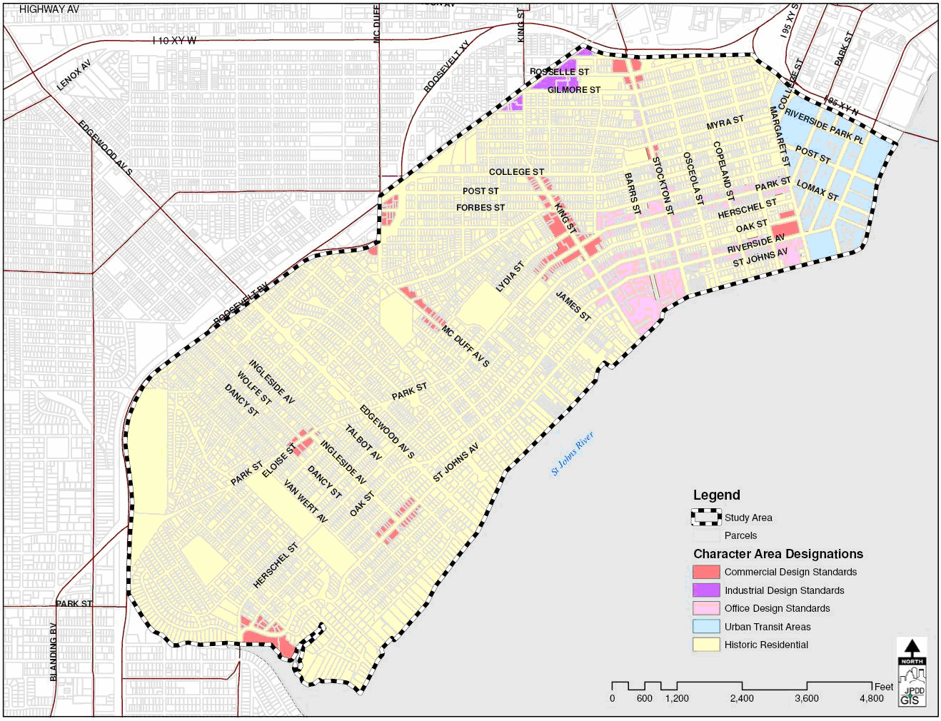
Figure 1.0 Character Area Map
All areas that are not provided in Table 1.0, Character Area Designation, are to be recognized as predominately residential in nature and all development standards within the historic neighborhoods should be governed by compatibility within the residential areas.
Each character area will have standards that must be met for massing, height, setbacks, parking and landscaping in order to encourage the identified character use of the area. Single family residential is allowed in any character area. The identification of the standard is by the character of the predominant existing uses within each area.
Table 1.0 Character Area Designation.
*(Note: This character area includes the northwest corner parcel)
(1)
45 feet in height shall not exceed three stories.
(2)
When adjacent to a single-family use, the side and rear setback shall increase one foot above the minimum set back requirement for every one foot in additional height above 35 feet.
The following standards will be provided in five sections as follows:
Commercial Character area design standards
Office Character area design standards
Urban transition Character area standards
Historic Residential Character area Standards
General standards, all development will be required to meet the standards regardless of character area and designation.
(Ord. 2008-192-E, § 3; Ord. 2009-443-E, § 1)
Sec. 656.399.20. - Bulk Standards.
The following Table 2.0, Bulk Standards, summarizes setbacks and height standards for the Riverside Avondale Overlay. In recognition of the historic pattern of residential structures within the Riverside/Avondale overlay, the current existing residential setbacks of structures are hereby deemed the minimum required setback under this overlay and shall not be considered non conforming setbacks. In addition, new construction standards may follow the existing built environment of that particular area when the built environment is considered a contributing structure as defined in Chapter 307 of this Code.
Table 2.0 Bulk Standards
(1)
Side setback on corner lots must satisfy the intersection visibility requirements set forth in Section 656.1218, Ordinance Code.
(2)
Determined by the Historic Setback of a contributing structure on the block adjacent and facing the proposed development. Except for increases for the side yard for the provision of access to the rear yard for parking, the setback may not deviate more than five feet on any side, front or rear.
(3)
The setback may be less than ten feet in the event the setback does not exceed the average historic setback on the block. An administrative deviation will be required if the setback is less than ten feet and deviates from the average historic setback on the block. The historic setback shall be determined by the established development pattern as determined as follows:
(a)
By the average setback of contributing structures on adjacent properties. If there is no contributing structure on the adjacent property, the closest property with an accessory structure with a similar use shall be used for determining the setback;
(b)
In the event the difference between the setbacks of contributing structures on adjacent properties, or the closest property with an accessory structure with a similar use, is ten feet or more, the historic setback shall be determined by the average setbacks of contributing structures on the same side of the block;
(c)
In the event there are less than four contributing structures on the side of the block, the historic setback shall be determined using the block on the opposite side of the street.
(Ord. 2008-192-E, § 3)
Sec. 656.399.21. - Compatibility Requirements.
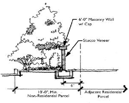
Table 3. Buffer Requirements
The following standards are required for any non-residential development that has
a rear or side yard adjacent to at least one single-family use:
(1)
Buffer. A buffer shall be utilized when any use other than a single family residential use abuts another single family residential use.
(a)
An alley shall be maintained with a minimum of ten feet of separation from the non-residential use to the single-family use. If the alley condition does not provide enough of a buffer, a continuous hedge and tree canopy shall be provided along with a maximum eight-foot fence, except for residential access.
(b)
A minimum ten-foot landscape buffer is required between adjacent tracts (rear property boundaries). Shrubs and groundcover shall comprise at least 30 percent of the landscaped area as detailed in Table 3. Buffer Requirements.
(2)
Lighting. The proposed development shall also control the effects of lights from automobiles or other sources. Where the site plan indicates potential adverse effects of parking or of other sources on the lot on which the non-residential use is to be located, such effects shall be eliminated, or at a minimum, prevented so that lights do not illuminate adjacent residential property below a height of five feet at the residential property line, or from shining into any residential window if there is to be non-residential parking on the premises after dark.
(3)
Building Design. The side of the building that is facing or backing up to any residential development must be treated with the same architectural design standards as the front of the building.
(Ord. 2008-192-E, § 3)
Sec. 656.399.22. - Commercial Character Area Design Standards.
Commercial Character areas identified in Table 1.0 Character Areas shall be required to meet the following design standards in addition to the general design standards as follows.
(1)
Parking Location. Parking is encouraged to be located at the rear of the primary structure. If an applicant provides all of the required parking in the rear, the rear parking lot area is a stable pervious surface with only the minimum required ADA requirements fulfilled for paved parking stalls and the driveway apron is adjacent to the street frontage, the following requirements can be reduced:
(a)
Although still required in any required buffer area, landscape shall not be required in the parking lot area of the lot.
(b)
The rear buffer may be reduced from ten feet to five feet when a six to eight-foot maximum opaque screen is provided.
(c)
Driveway width requirement shall be reduced from 24 feet to 12 feet wide for access to rear yard parking.
(2)
Parking requirements.
(a)
Except for conversions of structures to a restaurant with more than 100 seats and/or 2,500 square feet of total heated and cooled area, nightclub or any other establishment or facility which includes the retail sale and service of all alcoholic beverages including liquor, beer or wine for on-premises consumption, retail sales or service establishments and single-family residential uses located in contributing structures within an identified commercial character area shall have zero parking requirements.
(b)
Conversions of structures to a restaurant with more than 100 seats and/or 2,500 square feet of total heated and cooled area, nightclub or any other establishment or facility which includes the retail sale and service of all alcoholic beverages including liquor, beer or wine for on-premises consumption shall provide 50 percent of the required parking pursuant to Section 656.604.
(c)
Any expansion of contributing structures, after the date of the adoption of this Subpart shall provide 50 percent of the required parking for the expansion pursuant to Section 656.604 and Section 656.604(e)(3) for any type of office use.
(d)
Except for conversions to new structures for a restaurant with more than 100 seats and/or 2,500 square feet of total heated and cooled area, nightclub or any other establishment or facility which includes the retail sale and service of all alcoholic beverages including liquor, beer or wine for on-premises consumption, zero parking shall be required of new structures when such structures are built to the same or less than the square footage of a non-contributing structure if that structure is being replaced. However, all adjacent on-street parking shall be brought into compliance with Section 656.399.23(2)(b)(i)—(iv) and Table 4.
(e)
Except as set forth in above, the number of spaces for retail sales and service establishments and multi-family uses shall be 50 percent of the required number of spaces pursuant to Section 656.604 and Section 656.604(e)(3) for any type of office use, provided there are no additional parking credits applied under Section 656.607(d) of the Zoning Code. However contiguous on-street parking may be provided consistent with Section 656.399.23(2)(b)(i)—(iv) and Table 4.
(f)
Conversions to office uses for a contributing historic structure shall be required to provide a minimum of 50 percent of the required parking regulations in Section 656.604(e)(3), regardless of type of office use, and provided there are no additional parking credits applied under Section 656.607(d) of the Zoning Code. However contiguous on-street parking may be provided consistent with Section 656.399.23(2)(b)(i)—(iv) and Table 4.
(g)
Except as provided above, 65 percent of the required number of spaces in Section 656.604(e)(3) shall be provided for conversions to office uses, regardless of type of officer use, of non-contributing structures or new construction and provided there are no additional parking credits applied under Section 656.607(d) of the Zoning Code. However contiguous on-street parking may be provided consistent with Section 656.399.23(2)(b)(i)—(iv) and Table 4.
(Ord. 2008-192-E, § 3; Ord. 2012-339-E, § 1)
Sec. 656.399.23. - Office Character Area Standards.
Office Character areas identified in Table 1.0 Character Areas shall be required to meet the following design standards in addition to the general design standards as follows.
(1)
Parking Location. Parking is encouraged to be located at the rear of the primary structure. If an applicant provides all of the required parking in the rear, the rear parking lot area is a stable pervious surface with only the minimum required ADA requirements fulfilled for paved parking stalls and the driveway apron is adjacent to the street frontage, the following requirements can be reduced:
(a)
Although still required in any required buffer area, landscape shall not be required in the parking lot area of the lot.
(b)
The rear buffer may be reduced from ten feet to five feet when a six- to eight-foot maximum opaque screen is provided.
(c)
Driveway width requirement shall be reduced from 24 feet to 12 feet wide for access to rear yard parking.
(2)
Parking within the Right-of Way. Right-of-Way areas within Office Character Areas are permitted to create additional parking spaces provided the standards set forth in Table 3.0 and the following standards are met.
(a)
Exceptional specimen trees may not be removed to create parking areas.
(b)
Permitted parking shall be limited to the primary building fronting the character area, unless the property owner provides notarized letter(s) of consent from the adjoining affected property owner(s) in a form prescribed by the Director, and shall be designated and as follows:
(i)
Parallel Parking, six feet by 22 feet per parking stall and one canopy tree per space.
(ii)
45-degree head in parking, nine feet by 19 feet per parking stall and one canopy tree per three parking spaces.
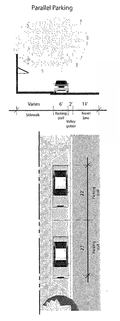
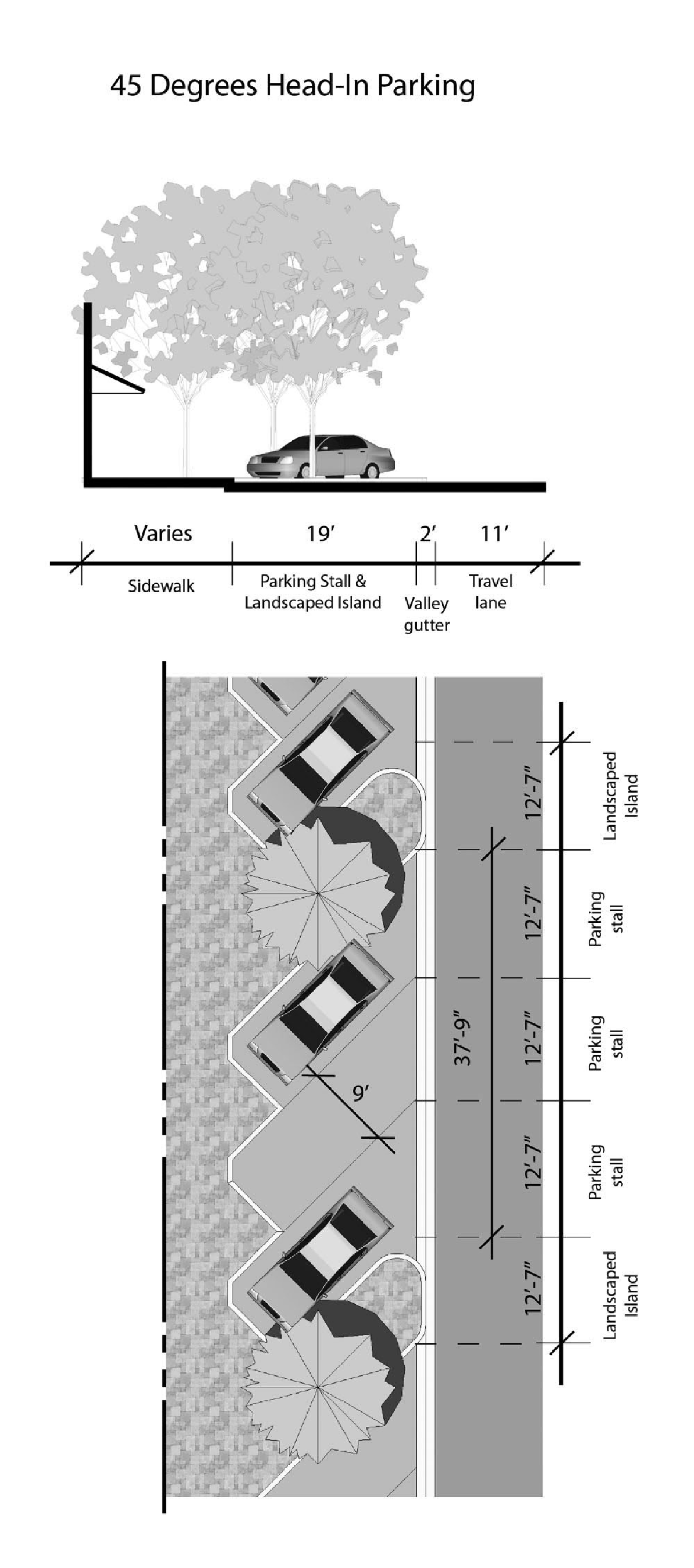
(iii)
60-degree head in parking, nine feet by 17 feet per parking stall and one canopy tree per three parking spaces.
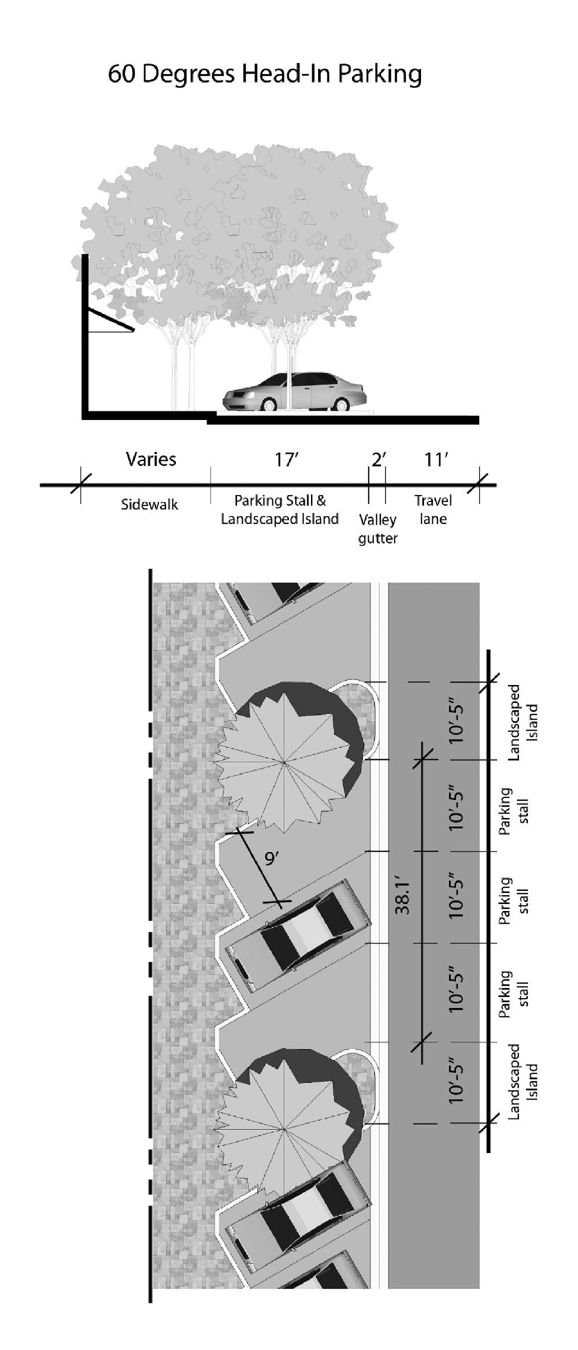
(iv)
90-degree head in parking, nine feet by 19 feet per parking stall and one canopy tree per three parking spaces.
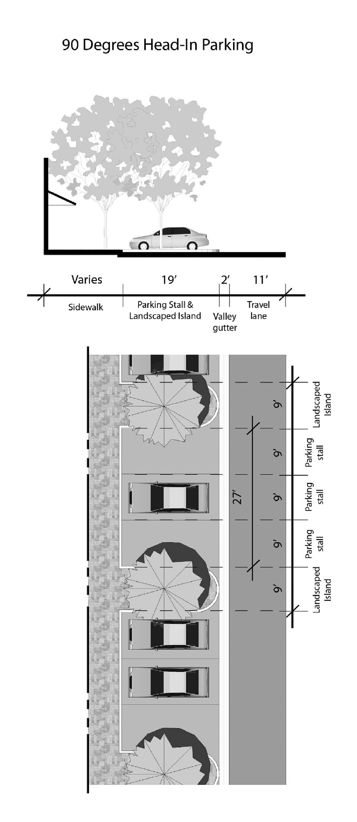
(3)
Parking Requirements.
(a)
Conversions to office or commercial uses for a contributing historic structure shall be required to provide a minimum of 50 percent of the required parking regulations in Section 656.604 and Section 656.604(e)(3) for any type of office use, and provided there are no additional parking credits applied under Section 656.607(d) of the Zoning Code. Conversions of contributing structures with a non-residential original use to residential uses may provide 50 percent of the required number of parking spaces set forth in Section 656.604(a). 65% of the required number of spaces in Section 656.604(e)(3) shall be provided for conversions to office uses for any type of office use, or Section 656.604 for commercial uses of non-contributing structures or new construction, provided there are no additional parking credits applied under Section 656.607(d) of the Zoning Code. However contiguous on-street parking may be provided consistent with Section 656.399.23(2)(b)(i)—(iv) and Table 4.
(Ord. 2008-192-E, § 3; Ord. 2009-443-E, § 2)
Sec. 656.399.24. - Urban Transition Design Standards.
Urban Transition Areas as identified in Table 1.0 Character Areas, shall be required to meet the following design standards in addition to the general design standards.
(1)
Building Design Criteria is located in Section 656.399.34 and shall also include distinctive design. Buildings taller than four stories shall display a distinctive design for the top of the building that can be achieved by various means including a change in materials, architectural detail, color, or step backs at the top floor, a prominent projecting cornice, or a roof with a form such as a curve, slope, or peak.
(2)
Compatibility Requirements found in Section 656.399.31, must be made if adjacent to a Historic Residential area as defined in Table 1.0 Character Area Designation.
(3)
On-Site Building Separation for Additional Building Height. Building height may be increased above 60 feet under the following circumstances:
(a)
Lot size less than ½ acre. A parcel that is less than ½ acre shall have the sideyard setback determined by measuring the total height of a building and dividing it by two to determine the minimum sideyard setback. A public open space that is a waterfront/plaza and/or park shall be located within the sideyard setback.
(b)
Lot size, ½ acre or more. A maximum building footprint of 20,000 sq. ft. per building on parcels ½ acre or larger shall be required. The width separation is as follows for multiple buildings on the same parcel. The building width separation is determined by the height of the first building to the second building, and so forth, to determine the separation required. The required separation shall be determined by the total building height divided by two. The area that is considered the width separation between buildings shall meet the following standards:
(i)
Mechanical equipment, service areas may not be located in between the buildings.
(ii)
Pool enclosures are not permitted in this location.
(iii)
Landscape and pedestrian walkways are permitted within the buildings.
(iv)
Waterfront plaza/park
(4)
For properties abutting the St. Johns River, a clear minimum 25 foot wide unobstructed view corridor from the right-of-way must be provided between buildings on the property and between any building on the property and the adjacent property line or any buildings on adjacent properties.
(5)
Open Space, 20 percent of the total developed site shall be public open space that provides visual and/or pedestrian access to the water.
(a)
Waterfront Plaza/Park is an area which promotes visual and pedestrian access which provides pedestrian-oriented amenities and landscaping to enhance the use of the space for passive activities such as resting, reading, picnicking, etc. To qualify as a pedestrian-oriented space, an area must have the following:
(i)
Visual and pedestrian access (including barrier free access) to the abutting structures from the public right-of-way or a non-vehicular courtyard.
(ii)
Paved walking surfaces of either concrete or approved unit paving.
(iii)
Lighting below 15 feet in height and providing at least two foot-candles (average) on the ground.
(iv)
At least three feet of seating area (bench, ledge, etc.) or one individual seat per 60 square feet of plaza area or open space.
(v)
The pedestrian-oriented space shall comply with the design regulations set forth in Section 656.361.21 and shall have:
(a)
Landscaping that does not act as a visual barrier.
(b)
Site furniture, artwork, or amenities such as fountains, kiosks, etc.
(c)
A pedestrian-oriented space shall not have:
(1)
Asphalt or gravel pavement;
(2)
Adjacent chain-link fences;
(3)
Adjacent blank walls without blank wall treatment as detailed in Section 656.399.34(7); and
(4)
Adjacent visual barriers which could represent a safety/security hazard.
(6)
Parking Requirements.
(a)
Parking requirements for retail sales or service establishments and single-family residential uses located in contributing structures within the Urban Transition Character Area shall be zero.
(b)
Parking shall be provided internal to the site and framed by buildings.
(c)
The number of parking spaces for buildings that are 45 feet or less shall be 25 percent of the required number of spaces pursuant to Section 656.604 and Section 656.604(e)(3) for any type of office use, and provided there are no additional parking credits applied under Section 656.607(d) of the Zoning Code.
(d)
The number of parking spaces for buildings that are greater than 45 feet shall be 50 percent of the required number of spaces pursuant to Section 656.604 and Section 656.604(e)(3) for any type of office use, and provided there are no additional parking credits applied under Section 656.607(d) of the Zoning Code.
(e)
Contiguous on-street parking may be provided consistent with Section 656.399.23(2)(b)(i)—(iv) and Table 4.
(Ord. 2008-192-E, § 3)
Sec. 656.399.25. - Historic Residential Character Area Standards.
(a)
Residential uses shall continue to be the predominant uses within this character area. The intent of this character area is to identify that all new investment of non-residential uses must respect the existing character of the area by developing smaller scale non-residential uses.
(b)
Conversions of residential uses are permitted only if all applicable standards are met and administrative modifications shall not be granted that allow more intensive uses throughout the designated areas of residential.
(c)
Structures for any new non-residential uses shall be consistent with the mass and scale of the surrounding contributing structures.
(d)
Development within the Residential Areas identified in Table 1.0 Character Area Designation shall be required to meet the following design standards in addition to the general design standards as follows.
(1)
Mass and scale. Buildings attached or detached when adjacent to existing residential must provide the following:
(a)
Attached Residential units, apartments or condominiums adjacent to or across the street from single family residential may not exceed 120 feet without a ten-foot minimum break.
(i)
The roofline should complement the adjacent single family residence. In the event there are two different styles of home, the proposed building shall be constructed to complement either style.
(ii)
Attached residential units must provide for every four units a minimum break of 20 feet.
(2)
Parking Requirements.
(a)
There are no additional parking credits applied under Section 656.607(d) of the Zoning Code. Additionally, parking for conversions to office uses or new structures shall be provided on-site and no shared parking agreements will be considered for determining compliance with the parking requirements. All on-site parking for office, single-family and duplex or quadplex multi-family uses shall be stabilized and of a pervious nature, except for the driveway and required ADA accessible spaces. Conversions of contributing structures with a non-residential original use to residential uses may provide 50 percent of the required number of parking spaces set forth in Section 656.604(a).
(b)
Parking in front yards is prohibited, unless in a designated driveway.
(c)
Parking is prohibited between the street edge and the sidewalk, or if no sidewalk exists, between the street edge and the property line.
(3)
Rooflines. Attached Residential and Nonresidential buildings shall be varied to reduce the scale of large buildings and to complement the scale and character of adjacent and street facing residential areas. Building facades that exceed 100 feet in length measured along the street frontage shall have variations in roofline or rooftop parapet. Rooftop equipment shall be concealed behind parapets or screened from views by pedestrians.
(4)
Garage apartments. Garage apartments shall be allowed subject to the following criteria:
(a)
Garage apartments must be located behind the primary structure.
(b)
There should be a visual relationship to the main house. For new structures this shall be accomplished through similar roof shape, porches, paint color, and other physical characteristics. For existing structures this shall be accomplished through similar paint color and other physical characteristics.
(c)
The building footprint shall be limited to 25 percent of the gross floor area of principal structure on the lot, or 750 square feet, whichever is less.
(d)
There shall be at least one foot side and rear setback from the eve and gutter of any garage apartment.
(e)
The maximum height of a garage apartment within the Historic District, as set forth in Chapter 307, Ordinance Code, shall not be limited by Section 656.403, Ordinance Code, but instead is governed by the Certificate of Appropriateness process as set forth in Chapter 307, Ordinance Code. The maximum height of a garage apartment outside of the Historic District shall be limited per Section 656.403, Ordinance Code.
(f)
The owner of the principal structure with a garage apartment must reside on the property.
(5)
Interior apartments. Interior apartments shall be allowed subject to the following criteria:
(a)
Interior apartments are limited to one single-family unit per lot and shall be allowed within structures over 1,600 square feet.
(b)
Within the Riverside/Avondale zoning overlay, the owner of the principal structure with an interior apartment must reside on the premises.
(c)
The maximum size of the interior apartment shall not exceed 1,000 square feet or 25 percent of the principal structure floor area, whichever is less. If the property also has a home occupation operating under the provisions of this Section, the total floor area devoted to both uses shall not exceed 1,250 square feet or 35 percent of the floor area of the residence, whichever is less.
(d)
Within the Riverside/Avondale Zoning Overlay, rear or side entrances for interior apartments shall be required unless the original design of the contributing structure has a front entrance for the interior apartment.
(Ord. 2008-192-E, § 3; Ord. 2009-443-E, § 2)
Sec. 656.399.26. - Industrial Character Area Design Standards.
Industrial Character Areas as identified shall be required to meet the general design standards set forth in Section 656.399.29 of this Subpart.
(Ord. 2008-192-E, § 3)
Sec. 656.399.27. - Setback Encroachments.
(a)
Special architectural features, such as balconies, bay windows, arcades, awnings, etc. may project into front setbacks and public rights-of-way on streets provided they are eight feet above the sidewalk and leave a minimum five foot wide unobstructed sidewalk. Support structures for these features shall be located such that they do not affect the clear sight triangle for travel lanes or the on-street parking.
(b)
Outdoor cafes may be in the setback if adjacent to a street, public plaza or park and follow the guidelines for outdoor cafes as permitted within the City limits.
(Ord. 2008-192-E, § 3)
Sec. 656.399.28. - Parking and Building Orientation Requirements by Corridor.
The following table provides additional provisions for parking and building orientation by corridor segment.
Table 4.0 Parking and Building Orientation
The existing street grid pattern shall be maintained and new block structure shall
be consistent with the adjacent grid pattern. The following standards shall be considered
for large scale development proposed in the Riverside/Avondale Zoning Overlay Area.
(1)
The foundation of urban form is the grid block structure. Existing or new streets (public or private) must divide the site into blocks. Block lengths shall be between 250 feet by 500 feet or consistent with the adjacent block grid.
(2)
The redevelopment site shall contain at least one pedestrian-oriented street, as defined throughout this Section. The length shall be several blocks, and an intersection of two pedestrian-oriented streets provides for an internal site focal point.
(3)
New internal streets shall be designed as pedestrian-oriented streets as outlined in the following chart.
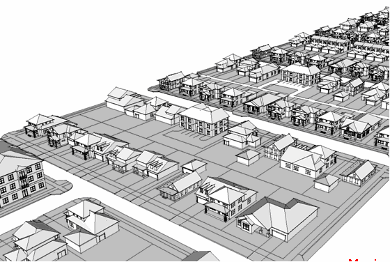
Table 5. Internal Street Design.
*Street furniture are those features associated with a street that are intended to
enhance the street's physical character and use by pedestrians, such as benches, bus
shelters, trash receptacles, planting containers, pedestrian lighting, kiosks, etc.
(Ord. 2008-192-E, § 3)
Sec. 656.399.29. - General Standards.
The following general site design standards apply to all development within the boundary of the Riverside/Avondale Zoning Overlay.
(1)
Form. Buildings shall form a consistent, distinct edge, spatially delineating the public street through maximum building setbacks that vary by no more than five feet from those of the adjacent building.
(2)
Open Storage. There shall be no open storage in any character area except the industrial area.
(3)
Sidewalks. There shall be sidewalks along the street edge(s) of the property. Sidewalks shall be placed to align with existing sidewalks. Existing historic pavers shall be maintained and preserved. When sidewalks must be replaced due to poor condition, material shall be consistent with the adjacent properties or the materials found on a majority of the block. If not replacing an existing sidewalk, new sidewalks shall be a minimum of five feet in width and shall be constructed with traditional pavers. Sidewalk connections from the principal building to the public sidewalk must be provided and be aligned to minimize walking distance. Landscaping adjacent to existing and proposed street sidewalks must be compatible with the City's existing streetscape standard.
(4)
Utilities. In new development, all utilities shall be located underground.
(5)
Screening. Trash, dumpsters, recycling receptacles, loading docks, service areas, and other similar areas must be located in parking areas or in a location that is not visible from corridor or urban transition frontages, and must be screened to minimize sound to and visibility from residences and to preclude visibility from adjacent streets.
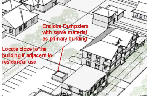
(6)
Mechanical equipment at ground level shall be placed on the parking lot side of the building away from view from adjacent Street frontage and shall be screened from view of any street by fencing, vegetations, or by being incorporated into a building. Loading docks, truck parking, outdoor storage, utility meters, HVAC equipment, trash dumpsters, trash compaction, and other service functions should be incorporated into the overall design of the building by walls of a material compatible with the material, style, color, texture, pattern, trim, and details of the main building and landscaping. The wall shall be one foot higher than the largest object being screened, but not more than ten feet high, on all sides where access is not needed.
(7)
Rooftop Mechanical Equipment shall be integrated into the overall mass of a building by screening it behind Parapets or by recessing it into roof structure.
(8)
Building Frontage. Except for Historic Residential Character areas, the building frontage shall occupy no less than 80 percent of a street facing entrance. If site constraints exist, a knee wall may be constructed with the following provisions.
(a)
Only 25 percent of the required frontage may be credited as part of a knee wall.
(b)
Minimum two feet in height to a maximum of three feet.
(c)
The knee wall must be an opaque material which complements the primary building's architecture by utilizing the same architectural style.
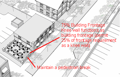
(9)
Unless the primary use of the property is for a stand alone parking lot, off-street surface parking lots must be located behind any frontage buildings. For those through lots fronting onto a navigable waterway, the parking lot must be screened from the waterway and the street by the building or by a knee wall with a ten-foot landscaped buffer or a landscaped open space with a minimum depth of 30 feet. The parking lot may be located on the side of a primary building frontage if:
(a)
the parking lot includes a knee wall. The knee wall shall be constructed as described above, in Section 656.399.29(8).
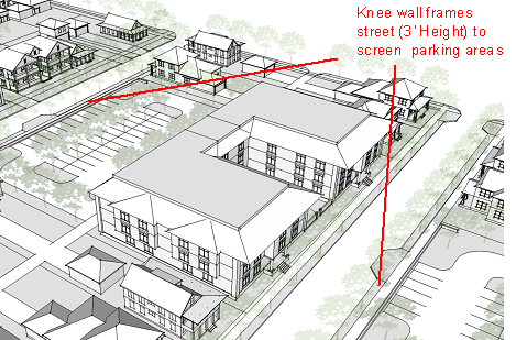
(b)
A maximum of two vehicular access/curb cuts to parking lots are allowed along the block face, subject to Access Management regulations. Vehicular access/curb cuts are not allowed on any block face less than 350 feet. Vehicular access drives shall connect each parking lot with at least two separate streets.
(10)
Parking garages shall comply with the following requirements:
(a)
Direct pedestrian access from and to each adjacent street shall be provided.
(b)
Except in Historic Residential Character Areas, the ground floor, except for vehicle entrances, shall be developed with enclosed commercial or civic floor space to a minimum building depth of 30 feet along the entire length of the structure on each facing street. The parking garage does not need commercial or civic floor space in the event the parking garage is separated from the street by another building and/or landscaped open space with a minimum depth of 30 feet, provided it is consistent with the established historic setback on the block.
(c)
Mass and scale of the parking garage shall be required to meet the building mass and scale requirements found in Section 656.399.33(3).
(d)
For those through lots fronting onto a navigable waterway, the parking garage must be screened by the building from either the waterway or the street. If the parking garage fronts the street, a facade compatible with the adjacent contributing structures shall be provided along the street frontage.
(Ord. 2008-192-E, § 3)
Sec. 656.399.30. - Walkways and Pedestrian Connections.
Parking lots shall be designed to allow pedestrians to safely move from their vehicles to the building. On small lots (30 spaces or less), this may be achieved by providing a sidewalk at the perimeter of the lot. On larger lots, corridors within the parking area should channel pedestrians from the car to the perimeter of the lot or to the building. These corridors are delineated by a paving material that differs from that of vehicular areas and are planted to provide shade.
(1)
Parking Lots containing more than 30 stalls shall have clearly defined pedestrian connections provided between:
(a)
A public right-of-way and building entrances;
(b)
Parking lots and building entrances;
(c)
Pedestrian walkways shall be landscaped with additional shade or ornamental trees equal to an average of one shade tree per 50 linear feet of walkway, unless the walkway is adjacent or included within an existing compliant buffer or frontage planting. The walkway shall not be less than five feet; and
(d)
Pedestrian connections shall be clearly defined by at least two of the following:
(i)
Six-inch vertical curb, or
(ii)
Textured paving, including across vehicular lanes, or
(iii)
A continuous landscape area at a minimum of three feet wide on at least one side of the walkway.
(e)
One shade tree shall be planted for each 200 square feet of separate additional landscaped area.
(Ord. 2008-192-E, § 3)
Sec. 656.399.31. - Riverfront Access.
Park space adjacent to the St. Johns River shall be maintained as public access points and adjacent properties shall be prohibited from blocking access and/or views from these locations.
(Ord. 2008-192-E, § 3)
Sec. 656.399.32. - Landscape Standards.
Landscape standards shall meet the following guidelines. Two types of landscape treatments, Urban Landscape and Street Trees are permitted either separately or in combination within any street facing location.
(a)
Urban Landscape. When buildings are being brought up to the street and utilizing a build to line, an urban buffer should be considered as an alternative to the required front buffer standards. The urban buffer shall be determined by the sidewalk width. A minimum eight-foot wide pedestrian area must be maintained for the length of the street frontage. Therefore, if the existing sidewalk is five feet wide an additional three feet shall be required as an urban buffer or front setback. ADA accessibility must be maintained at all times. The required front buffer for an urban type development shall be allowed to provide potted plants and small A-frame signage not exceeding three feet in height. At a minimum, a 36-inch diameter pot by 24 inches high should be provided every 20 lineal feet of building frontage. The plant species should be two times as high as the height of the pot. Low growing plants, flowering annuals should be planted at the base of the pot. All efforts should be made to preserve existing tree canopy within the right-of-way.
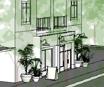
Urban Buffer
(b)
Street Trees. Trees shall have a minimum three-inch caliper and be of Florida No. 1 grade as per "Grades and Standards for Nursery Plants," Florida Department of Agriculture and Consumer Services. All landscaping shall meet FDOT visibility standards. For non-residential Character areas, one street tree shall be planted for every 30 linear feet or frontage or fraction thereof. For all other streets, one street tree shall be planted 40 to 60 feet on center. Street trees shall be planted a minimum of ten feet from any above ground utility, such as transformer pads and fire hydrants.
(Ord. 2008-192-E, § 3)
Sec. 656.399.33. - Public Space Standards.
The following public space standards shall be provided as follows:
(1)
The following provisions for public space are required for both non-residential buildings and residential buildings as follows:
(2)
Nonresidential Buildings larger than 10,000 square feet shall provide 20 square feet per 1,000 square feet of gross floor area.
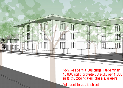
(3)
Attached residential buildings with ten units or greater shall include 50 square feet per unit of public space. The public space must be adjacent to a public street.
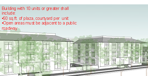
(4)
The space can be met by providing any of the following:
(a)
Green, a public space available for unstructured recreation, bounded on at least two sides by streets with facing buildings on all sides. A green is landscaped with lawns and trees, including existing or natural vegetation and paths and trails. Square, located at the intersection of streets and bounded on at least two sides by streets with facing buildings on all sides.
(b)
A square includes paved walks, lawns, trees, and ornamental structures such as fountains and gazebos.
(c)
Outdoor seating, an area with tables and chairs, potentially covered umbrella seating. This area can also function as an outdoor café that is open to the public for eating and/or drinking.
(d)
Courtyards, an area that may be landscaped, hardscaped, fountains and provide a seated area.
(e)
Community Garden is a grouping of garden plots available to residents for small scale cultivation.
(f)
All public spaces that include landscape in the ground, planters and/or pots must be irrigated.
(Ord. 2008-192-E, § 3)
Sec. 656.399.34. - Building Design.
The following standards are for building design of non residential building types, subject to Chapter 307 requirements, where applicable.
(1)
Building frontage. Building frontages shall occupy no less than 80 percent of a corridor within a Commercial Character Area or Urban Transition Character Area. If site constraints exist, a knee wall may be constructed with the following provisions.
(a)
Only 25 percent of the required frontage may be credited as part of a knee wall.
(b)
A knee wall must be constructed as described in Section 656.399.29(8).
(2)
Public entrance. Buildings that are open to the public shall have an entrance for pedestrians from the street to the building interior. This entrance shall be designed to be attractive and functionally be a distinctive and prominent element of the architectural design, and shall be open to the public during business hours. Buildings shall incorporate lighting and changes in mass, surface or finish to give emphasis to the entrances.
(3)
Nonresidential Buildings Mass and Scale. Buildings that are more than 150 feet in length shall comply with the following. No more than 60 feet of horizontal distance of wall shall be provided without architectural relief a minimum of 30 feet wide and three feet deep for building walls and frontage walls facing the street.

Variation of Mass and Scale
(4)
Building Facade. Buildings shall provide a foundation or base, typically from ground to bottom of the lower windowsills, with changes in volume or material. A clear visual division shall be maintained between the ground level floor and upper floors with either a cornice line or awning from 12 feet to 16 feet above Base Flood Elevation or grade, whichever applies to the proposed development.
(5)
Building Features. All buildings excluding single family detached homes shall utilize at least three of the following design features to provide visual relief along all elevations of the building:
(a)
Divisions or breaks in materials (materials should be drawn from a common palette).
(b)
Window bays.
(c)
Separate entrances and entry treatments, porticoes extending at least five feet.
(d)
Variation in roof lines.
(e)
Awnings installed in increments of 15 feet or less.
(f)
Dormers.
(g)
Canopies, extending at least five feet.
(h)
Overhang extending at least five feet.
(i)
Recessed entries (at least three feet from the primary facade).
(j)
Protruding entries (at least three feet from the primary facade).
(k)
Covered porch entries.
(6)
Storefront character. Commercial and mixed-use buildings shall express a storefront character. This guideline is met by providing all of the following architectural features along the building frontage as applicable.
(a)
Corner building entrances on corner lots.
(b)
Regularly spaced and similar-shaped windows with window hoods or trim (all building stories).
(c)
Large display windows on the ground floor. All street-facing, park-facing and plaza-facing structures shall have windows covering a minimum of 40 percent and a maximum 80 percent of the ground floor of each storefront's linear frontage. Blank walls shall not occupy over 50 percent of a street-facing frontage and shall not exceed 30 linear feet without being interrupted by a window or entry. Mirrored glass, obscured glass and glass block cannot be used in meeting this requirement. Display windows may be used to meet this requirement if the first floor has not been designed as a flood proof first floor.
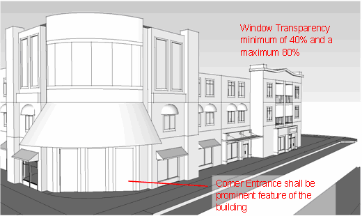
(7)
Orientation. The primary building entrances shall be visible and directly accessible from a public street. Building massing such as tower elements shall be used to call-out the location of building entries.
(8)
Lighting. All buildings shall have exterior lightings and shall be self contained to that building without glare or shine onto other areas of the site.
(Ord. 2008-192-E, § 3)
Sec. 656.399.35. - Signage.
(1)
Wall, projecting, marquee, or awning signs shall be clearly integrated with the architecture of the building and shall be consistent in design and materials with the architecture of the proposed building. The use of internal illumination is prohibited. Signage in the overlay should support the historic nature of the community and not detract from the area.
(2)
Except for those properties zoned CRO or residential properties, the maximum sign area permitted per sign is as follows.
(a)
Building Signage, a maximum of .5 copy area per store front lineal feet of store frontage.
(b)
Ground Signage shall be determined by the size of the principal building structure as follows.
(c)
Ground Signage shall be limited in height of five feet.
(d)
Pole signs shall be prohibited in this area.
(3)
Window Signage shall be limited to 20 percent of one window pane per storefront
(4)
Signs located on the interior of a structure, but visible from the exterior of the building, are permitted and are not charged against the maximum allowable signage area if such signs are not physically attached or painted to the window and do not obscure more than ten percent of ground floor street side building transparency. The ten percent is not to exceed total glass area calculated for both unattached and temporary window signs.
(5)
Temporary Signs can take the form of banners, window graphics, or as cards integrated with a window display. Temporary signs are permitted on the interior of the business establishment only and shall be no more than five square feet of text and shall not exceed ten square feet in size and no more than ten percent of ground floor street side building transparency. Temporary signs shall not be displayed more than 30 days in a calendar year.
(6)
Menu Boards. One menu board shall be allowed per street address. Menu boards shall not exceed eight square feet in size (sign and copy area is calculated on one side only) and shall be positioned so as to be adjacent to that restaurant or business listed on the board and information on that board shall advertise exclusively the goods and services of that business and be placed in a manner which is clearly visible to pedestrian traffic. Said menu boards shall not be placed in the City right-of-way without permission from the City Engineer. All signs shall be removed at the end of each business day. All signs shall be securely anchored to the ground.
(7)
Restaurant Menu Box Signs shall be located in a permanently mounted display box on the surface of the building within eight feet to the entry. The allowable area for restaurant menu signs shall be a maximum of four square feet and shall not be included in the calculation of allowable copy area.
(8)
Street art signs shall be permitted by meeting the following standards:
(a)
Street art shall be counted toward the maximum allowable copy area; the square footage of the street art shall be calculated by multiplying the greatest width by the greatest height of the object.
(b)
The maximum sign area per street art sign is eight square feet. Sign and copy area is calculated on one side only.
(c)
One piece of street art shall be allowed per street address. A minimum storefront width of 20 feet is required to be permitted street art.
(d)
The street art shall not encroach into the right-of-way more than two feet and shall not be placed in the right-of-way without a encroachment permit as required by Chapter 61. Street art shall not be secured to the tree guards or tree grates or disturb the sidewalk pavement within the right-of-way.
(e)
Street art shall be removed at the end of the business day.
(f)
Street art shall be located in the front of the business and address named on the sign permit and advertise that business exclusively.
(g)
The applicant may have one street art piece or a menu board, but not both.
(Ord. 2008-192-E, § 3)
Sec. 656.399.36. - Reconstruction.
Except as limited herein, any existing structure within the Riverside/Avondale Zoning Overlay District may be reconstructed, without meeting the parking and landscaping requirements only, to the same density, height and intensity of use as existed prior to the adoption of the Subpart. However in the Historic Residential Character Areas, only multi-family and institutional uses, such as churches, schools and hospitals may be reconstructed, without meeting the parking and landscaping requirements, to the same density, height and intensity of use as existed prior to the adoption of the Subpart. In the event the reconstruction would violate any required setback, the structure may be relocated, but only to the minimum extent necessary to allow the reconstruction to the same density, height and intensity of use. All other uses will be required to be reconstructed according to this Subpart.
(Ord. 2008-192-E, § 3)
Sec. 656.399.37.- Legislative findings and intent.
The Council finds and determines that:
(a)
The loss of industrial lands combined with residential intrusion into established industrial areas has created a need to protect existing strategically located industrial lands for future expansion and economic development. Several areas of the City have been identified as being crucial to the long term economic well-being of the City, including property surrounding the Cecil Commerce Center and port related properties along the St. Johns River.
(b)
The Future Land Use Element of the City of Jacksonville 2030 Comprehensive Plan states that "[i]n order to maximize the economic potential of industrial development, and to minimize the adverse impacts on other types of land uses, it is necessary to identify geographic areas suitable for various types of industry based on such factors as the labor force, accessibility to specific modes of transportation, need for expansion, and amenity factors for the labor force."
(c)
The Future Land Use Element of the City of Jacksonville 2030 Comprehensive Plan includes the following policies pertaining to industrial uses:
Policy 3.2.12. The City shall designate areas inappropriate for less intense development due to conditions such as excessive noise levels and incompatible surrounding land uses for intense commercial and light industrial use.
Policy 3.2.17. The City shall require Land Development Regulations to include incentives for new industry to locate in the form of industrial parks, centers, etc., in areas shown for industrial use on the Future Land Use Map series.
Policy 3.2.23. The City shall establish an industrial land use data base through the Planning Department and update it on a regular basis to monitor industrial development in the City, and to project the amount of land and public facilities needed to accommodate future industrial uses.
(Ord. 2007-398-E, § 4; Ord. 2017-796-E, § 1)
Sec. 656.399.38. - Declaration of policy.
Based on the findings made in Section 656.399.37 above, the Council hereby declares it to be the policy of the City to protect and preserve existing industrial areas of the City from premature fragmentation by intrusive residential and commercial uses and promote the expansion of industrial uses in those areas.
(Ord. 2007-398-E, § 4; Ord. 2017-796-E, § 2)
Sec. 656.399.39. - Purpose.
The City is hereby creating a procedure for the establishment of Industrial Sanctuary and Areas of Situational Compatibility overlay zones for the purpose of protecting and preserving appropriate areas within the City for industrial use.
(Ord. 2007-398-E, § 4)
Sec. 656.399.40. - Definitions.
As used in this Subpart:
(a)
Industrial Sanctuary means a distinct geographical area predominately consisting of industrial uses and zoning districts and strategically located for future expansion and economic development.
(b)
Industrial Sanctuary Overlay Zone means an overlay zoning district designated by the City Council for a distinct geographical area predominately consisting of industrial uses and zoning districts and strategically located for future expansion and economic development for the purpose of protecting and preserving the area from premature fragmentation by intrusive residential and commercial uses and promoting the expansion of industrial uses within the area.
(c)
Area of Situational Compatibility means a distinct area that may be suitable for industrial uses under certain circumstances.
(d)
Area of Situational Compatibility Overlay Zone means an overlay zoning district designated by the City Council for a distinct geographical area that may be suitable for industrial uses under certain circumstances.
(Ord. 2007-398-E, § 4)
Sec. 656.399.41. - Industrial sanctuary overlay zones and areas of situational compatibility overlay zones.
The legal boundaries of the Industrial Sanctuary Overlay Zones and Areas of Situational Compatibility Overlay Zones are as set forth and adopted in Map L-23 of the 2030 Comprehensive Plan Future Land Use Element.
(Ord. 2007-398-E, § 4; Ord. 2017-796-E, § 3)
Sec. 656.399.42. - Criteria for establishing an industrial sanctuary and area of situational compatibility overlay zone.
(a)
In order for an area to qualify for establishment as an industrial sanctuary overlay zone under this Subpart P, the area shall meet all of the following criteria:
(1)
The industrial sanctuary is located in the Future Land Use Map series of the 2030 Comprehensive Plan designated for industrial use;
(2)
The industrial sanctuary is presently zoned for industrial use;
(3)
The industrial sanctuary predominantly consists of industrial uses with only a few incidental supporting commercial uses;
(4)
The industrial sanctuary may be described by a reasonably delineated boundary line.
(5)
The industrial sanctuary is an area that is strategically located for future expansion and economic development.
(b)
In order for an area to qualify for establishment as an area of situational compatibility overlay zone under this Subpart P, the area shall meet all of the following criteria:
(1)
The area of situational compatibility is located in the Future Land Use Map series of the 2030 Comprehensive Plan designated for industrial use;
(2)
The area of situational compatibility is presently zoned for industrial use;
(3)
The area of situational compatibility consists of industrial uses;
(4)
The area of situational compatibility may be described by a reasonably delineated boundary line.
(5)
The area of situational compatibility is an area that may be suitable for industrial uses under certain circumstances.
(Ord. 2007-398-E, § 4; Ord. 2017-796-E, § 3)
Sec. 656.399.43. - Establishment and expansion procedures.
The following procedures shall apply with respect to the establishment or expansion of an industrial sanctuary or area of situational compatibility overlay zone:
(a)
Planning and Development Department. The Planning and Development Department shall be responsible for recommending or nominating eligible Industrial Sanctuaries or Areas of Situational Compatibility to the Council. The Department shall make its recommendation to Council on each proposed designation in a report to be called Industrial Sanctuary or Area of Situational Compatibility Nomination Report.
The report shall include the following:
(1)
A map showing the proposed boundaries of the industrial sanctuary or area of situational compatibility;
(2)
A descriptive evaluation of how the criteria listed in Section 656.399.42 above are met in the area proposed for establishment as an industrial sanctuary or area of situational compatibility;
(3)
A map showing the existing use of each lot in the area;
(4)
A zoning map showing the existing zoning of the proposed industrial sanctuary or area of situational compatibility and all lands within 300 feet of the area;
(5)
A statement describing the recommended boundaries for the industrial sanctuary or area of situational compatibility;
(6)
A list of the names and addresses of all owners and the real estate assessment file numbers of the properties within the boundaries of the proposed industrial sanctuary or area of situational compatibility, and a second similar list for all properties outside but within 300 feet of the industrial sanctuary or area of situational compatibility; and
(b)
City Council action. Copies of the Industrial Sanctuary or Area of Situational Compatibility Nomination Report shall be forwarded by the Planning and Development Department to the City Council and the Office of General Counsel. The Office of General Counsel shall prepare an ordinance for the proposed establishment of the industrial sanctuary or area of situational compatibility overlay zone pursuant to Chapter 650, Part 4, Ordinance Code, for amendments to the text of the Comprehensive Plan.
(c)
Reserved.
(d)
The Council Secretary shall notify each property owner within the industrial sanctuary or area of situational compatibility of the final action taken by the City Council within 14 days from the enactment of any ordinance adopting same, and shall cause the ordinance adopting the establishment of the industrial sanctuary or area of situational compatibility overlay zone to be recorded in the official records of Duval County, Florida. The Council Secretary shall also notify the Property Appraiser's Office of the establishment of the overlay zone.
(e)
Reserved.
(Ord. 2007-398-E, § 4; Ord. 2011-732-E; Ord. 2017-796-E, § 3)
Sec. 656.399.44. - Industrial sanctuary overlay zone permitted uses and permissible uses by exception.
(a)
In addition to the uses already permitted or permissible in the underlying zoning district, the following uses are all permitted uses in the Industrial Sanctuary Overlay Zone, subject to consistency with the land use category.
(1)
Scrap processing, outdoor, unclean activity meeting the performance standards and development criteria set forth in Part 4.
(2)
Facilities for recycling construction demolition debris, meeting the performance standards and development criteria set forth in Part 4.
(3)
Explosives manufacturing or storage.
(4)
Paint, oil (including linseed), shellac, turpentine, lacquer or varnish manufacture.
(5)
Paper and pulp manufacture.
(6)
Petroleum refining.
(7)
Outdoor storage of scrap or processed scrap generated through scrap processing, indoor, clean activity.
(8)
Care centers meeting the performance standards and development criteria set forth in Part 4.
(9)
Construction and demolition recycling facilities.
(10)
Churches, including a rectory and similar uses, meeting the performance standards and development criteria set forth in Part 4.
(11)
Essential services, including water, sewer, gas, telephone, radio and electric, meeting the performance standards and development criteria set forth in Part 4.
(b)
In addition to the uses already permissible by exception in the underlying zoning district, the following uses are permissible by exception in the Industrial Sanctuary Overlay Zone, subject to consistency with the land use category.
(1)
Establishments or facilities which include the retail sale and service of alcoholic beverages for either on-premises or off-premises consumption, or both.
(2)
Commercial retail and service establishments in support of an industrial use.
(Ord. 2007-398-E, § 4; Ord. 2017-796-E, § 3)
Sec. 656.399.45. - Industrial sanctuary overlay zone buffer requirements.
(a)
Industrial sanctuary overlay zone buffer distance requirements are set forth in Table 399-1 below and are applicable to all properties which have been rezoned or have been the subject of land use changes since June 1, 2007 within an industrial sanctuary overlay zone. The buffer areas may consist of passive recreation, underground utilities, off-street parking spaces and parking garages, stormwater retention, landscaping, visual screening, wetlands and other conservation lands. Public rights-of-way are deemed to satisfy the buffer distance requirements.
INDUSTRIAL SANCTUARY BUFFER STANDARD MATRIX
Table 399-1
Zoning District of property located within an Industrial Sanctuary overlay zone
|
Proposed LU/Zoning Change
| IW | IH | IL | IBP | CO, CRO | Commercial | RR, RLD | RMD, RHD |
|---|---|---|---|---|---|---|---|---|
| IW | 0 | 0 | 0 | LDC | LDC | LDC | LDC | LDC |
| IH | 0 | 0 | 0 | LDC | LDC | LDC | LDC | LDC |
| IL | 0 | 0 | 0 | LDC | LDC | LDC | LDC | LDC |
| IBP | LDC | LDC | LDC | 0 | LDC | LDC | LDC | LDC |
| CO, CRO, RO | 100' | 100' | 50' | LDC | 0 | LDC | LDC | LDC |
| Commercial | 50' | 50' | LDC | LDC | LDC | 0 | LDC | LDC |
| RR, RLD | 300' | 300' | 200' | 50' | LDC | LDC | 0 | LDC |
| RMD, RHD | 200' | 200' | 150' | LDC | LDC | LDC | LDC | 0 |
LDC = Refers to existing buffer requirements set forth in Part 12, Chapter 656, Ordinance Code.
Commercial includes those zoning districts listed in Section 656.302(b), except for the CO, CRO, and RO zoning districts.
RR and RLD includes all RLD zoning districts.
RMD and RHD includes all RMD and RHD zoning districts.
_____
The buffer requirements of this Section which apply to the above-referenced districts shall apply to those portions of a Planned Unit Development district which are devoted to uses permitted in these respective districts, unless specifically provided otherwise in the written description of the intended plan of development.
(b)
The buffer distance requirement shall be waived if the use of a property zoned IW is accessory to other industrial uses.
(c)
Within an industrial sanctuary overlay zone, the non-industrial property shall satisfy the buffer distance requirement. Within an industrial sanctuary overlay zone, if a proposed industrial use is located adjacent to an existing non-industrial use then the existing buffer requirements set forth in Part 12, Chapter 656, Ordinance Code shall apply to the industrial property.
(Ord. 2007-398-E, § 4; Ord. 2007-560-E, § 2; Ord. 2017-796-E, § 4)
Sec. 656.399.46. - Area of situational compatibility overlay zone buffer requirements.
(a)
Areas of situational compatibility overlay zone buffer distance requirements are set forth in Table 399-2 below and are applicable to all properties which have been rezoned or have been the subject of land use changes since June 1, 2007 within an area of situational compatibility overlay zone. The buffer areas may consist of passive recreation, underground utilities, off-street parking spaces and parking garages, stormwater retention, landscaping, visual screening, wetlands and other conservation lands. Public rights-of-way are deemed to satisfy the buffer distance requirements.
AREA OF SITUATIONAL COMPATIBILITY BUFFER STANDARD MATRIX
Table 399-2
Zoning District of property located within an Area of Situational Compatibility overlay
zone
|
Proposed LU/Zoning Change
| IW | IH | IL | IBP | CO, CRO | Commercial | RR, RLD | RMD, RHD |
|---|---|---|---|---|---|---|---|---|
| IW | 0 | 0 | LDC | 50' | 50' | LDC | 200' | 150' |
| IH | 0 | 0 | LDC | 50' | 50' | LDC | 200' | 150' |
| IL | 0 | 0 | 0 | LDC | LDC | 50' | 150' | 100' |
| IBP | LDC | LDC | 0 | 0 | 0 | LDC | 50' | LDC |
| CO, CRO, RO | LDC | LDC | 0 | 0 | 0 | LDC | 50' | LDC |
| Commercial | LDC | LDC | LDC | LDC | LDC | 0 | 50' | LDC |
| RR, RLD | 100' | 100' | 75' | LDC | LDC | 50' | 0 | LDC |
| RMD, RHD | 50' | 50' | 50' | LDC | LDC | LDC | LDC | 0 |
LDC = Refers to existing buffer requirements set forth in Part 12, Chapter 656, Ordinance Code.
Commercial includes those zoning districts listed in Section 656.302(b), except for the CO, CRO, and RO zoning districts.
RR and RLD includes all RLD zoning districts.
RMD and RHD includes all RMD and RHD zoning districts.
_____
The buffer requirements of this Section which apply to the above-referenced districts shall apply to those portions of a Planned Unit Development district which are devoted to uses permitted in these respective districts, unless specifically provided otherwise in the written description of the intended plan of development.
(b)
The buffer distance requirement shall be waived if the use of a property zoned IW is accessory to other industrial uses.
(c)
Within an area of situational compatibility overlay zone, the buffer requirements will not be required if the proposed use is adjacent to vacant property.
(d)
Reductions of the buffer distance requirements may be permitted by administrative deviation, pursuant to Section 656.109, Ordinance Code.
(Ord. 2007-398-E, § 4; Ord. 2007-560-E, § 1; Ord. 2017-796-E, § 5)
Sec. 656.399.47. - Applicability and effect.
The buffer and landscape requirements and the permitted uses shall supersede and prevail over any other inconsistent provisions of the Zoning Code; otherwise, the standards relative to an underlying zoning district and other applicable, general provisions of the Zoning Code shall govern.
(Ord. 2007-398-E, § 4)
Sec. 656.399.48. - Exception from requirements.
This Subpart is not applicable to those properties which are contained within areas that are Developments of Regional Impact. Additionally, the requirements of this Subpart shall not be applicable to any rezoning application which was officially filed with the Department prior to May 8, 2007, as evidenced by a receipt showing a paid application fee dated on or before May 8, 2007.
(Ord. 2007-398-E, § 4)
Sec. 656.399.49. - Reduction or rescission of overlay zones.
The Planning and Development Department shall be responsible for recommending the reduction or rescission of Industrial Sanctuaries or Areas of Situational Compatibility to the Council. The Department shall make its recommendation to Council on each proposed reduction or rescission in a report to be called Industrial Sanctuary or Area of Situational Compatibility Report. The reduction or rescission of any overlay zone in this Subpart shall be pursuant to the procedures set out in Chapter 650, Part 4, Ordinance Code for amendments to the text of the Comprehensive Plan.
(Ord. 2007-398-E, § 4; Ord. 2017-796-E, § 6)
Sec. 656.399.50.- Black Hammock Island Overlay.
The Council finds that permitting fences greater than four feet of height in the required front yard of residentially zoned districts on Black Hammock Island is appropriate and justified based on the local character and historical integrity of the area subject to certain limitations enumerated below. The maximum height of a fence located within the required front yard in the Black Hammock Island Overlay is six feet in height provided that the fence is not more than 50 percent opaque. The Black Hammock Island Overlay area is visually depicted and set forth in Figure 1.0 = Black Hammock Island Overlay Map below, and generally described as the area west of the Atlantic Ocean, South of the Nassau County line, and east of Cedar Point Road. These requirements shall not apply to any Federal, State or City-owned or controlled park properties. This provision shall specifically supersede any other provisions in Chapter 656.
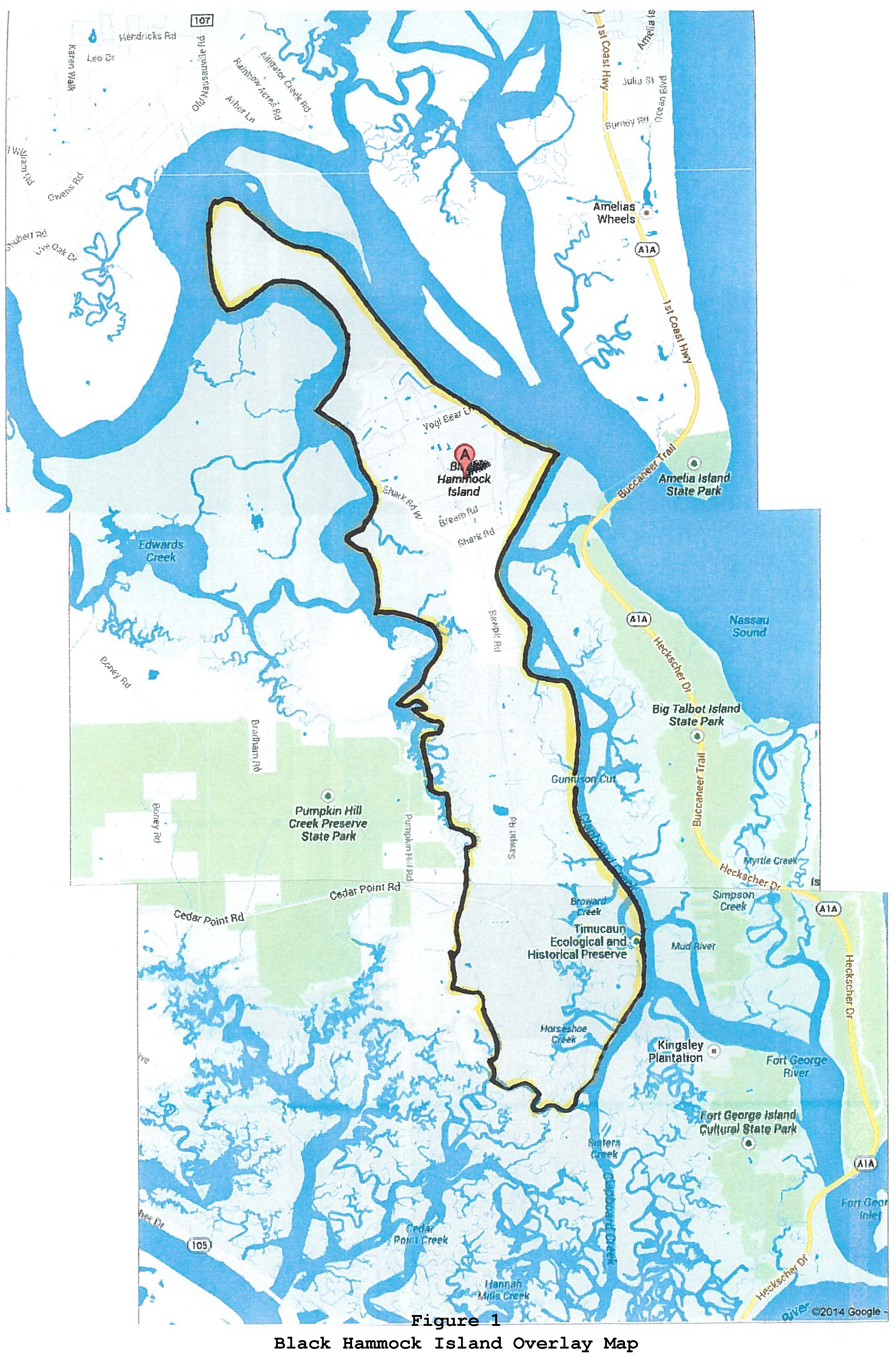
(Ord. 2014-147-E, § 2)
Sec. 656.399.51.- KingSoutel Crossing Overlay.
The Council finds that commercial design guidelines are desirable in the area described as the KingSoutel Crossing Community Redevelopment Area. The Overlay shall have boundaries coextensive with the Redevelopment Area. The KingSoutel Crossing Overlay area is visually depicted in Exhibit 1 (at the end of this Subpart) and generally described as the corridor running from the I-295 and New Kings Road Interchange Area on the north, south to the New Kings Road and Soutel intersection area, east to the Soutel and Norfolk Boulevard intersection area, and west to the I-295 and Pritchard Road Interchange Area. This provision shall specifically supersede any other provisions in Chapter 656.
(Ord. 2014-596-E, § 2)
Sec. 656.399.52. - KingSoutel Crossing Commercial Design Guidelines.
All commercial structures and development shall be designed in conformance with the "Jacksonville Design Guidelines and Best Practices Handbook," prepared by Miller Sellen Conner and Walsh and on file with the Planning and Development Department and available on the City's website.
(Ord. 2014-596-E, § 2)
Sec. 656.399.53. - Appeals.
The appellate procedure shall be as set out in Section 656.135, Ordinance Code. The Director of the Planning and Development Department is directed to create appeal procedures and notification format.
(Ord. 2014-596-E, § 2)
Exhibit 1. KingSoutel Crossing Redevelopment Area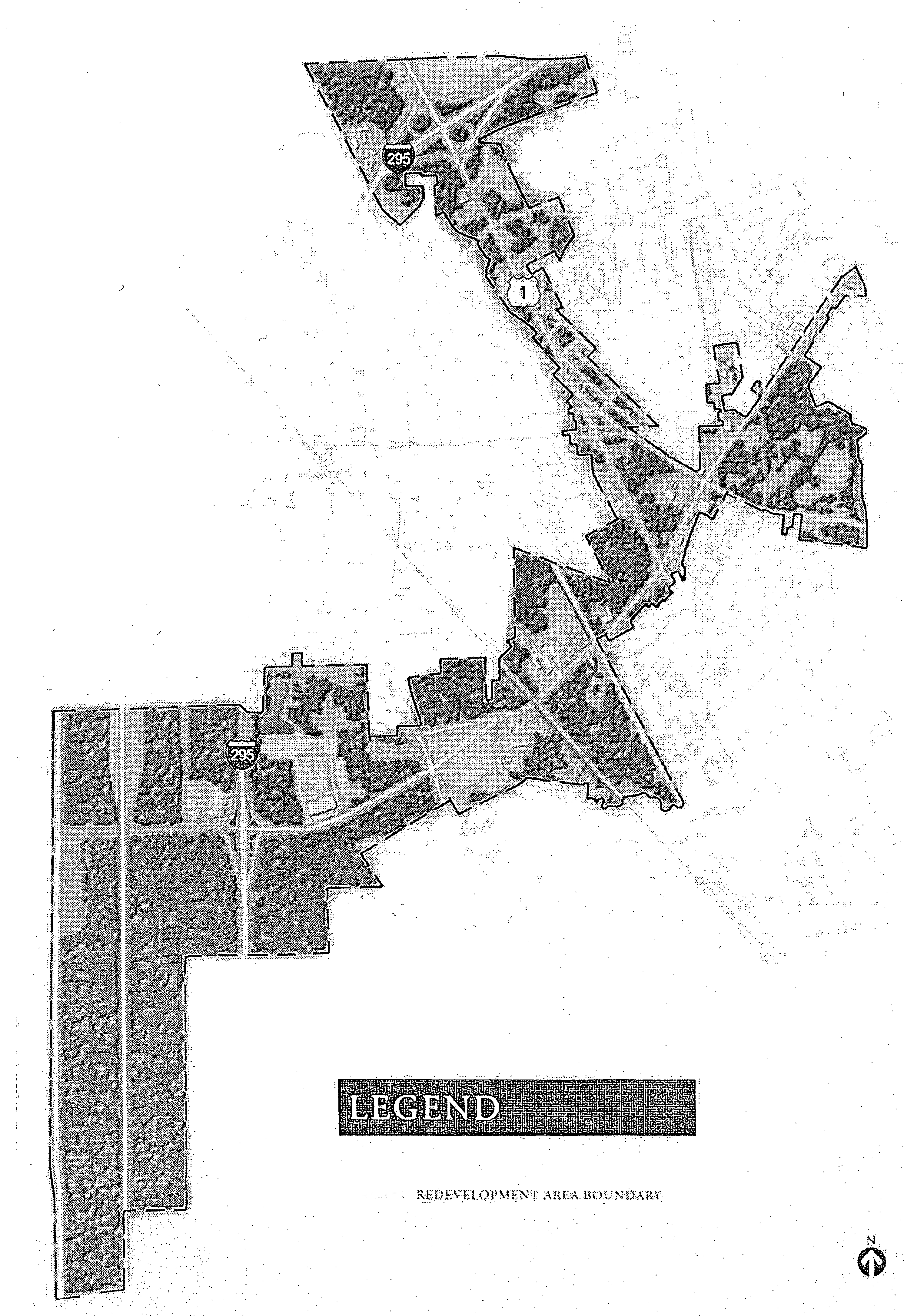
Sec. 656.399.54.- Legislative findings.
The Council hereby finds and determines as follows:
A.
In August 2015, pursuant to Resolution 2015-476-A, the City Council found that portions of University Boulevard, Merrill Road, and Arlington Road were "blighted" as that term is defined in Chapter 163, Part III, Florida Statutes, and in November 2015, pursuant to Ordinance 2015-738-E, the City Council established a new Community Redevelopment Agency, known as the Renew Arlington Community Redevelopment Agency ("RA/CRA") and approved a Community Redevelopment Plan (the "Plan") for the Community Redevelopment Area which was previously declared blighted.
B.
The Plan identified the need for a Zoning Overlay encompassing the Community Redevelopment Area as an objective of the Plan.
C.
The decline of commercial development along the RA/CRA Community Redevelopment Area corridors have contributed to blighted conditions within the RA/CRA Community Redevelopment Area (the "Redevelopment Area").
D.
Small lot sizes within the Redevelopment Area present challenges for modern commercial development, which often require lot acreage greater than one or two acres.
E.
Due to various challenges and limitations, commercial vacancies are common within the Redevelopment Area leading to a lack of investment along University Boulevard, Merrill Road, and Arlington Road.
F.
Legal non-conforming uses, such as single family residential uses on commercially-zoned properties, create an inconsistent land use pattern and a dangerous environment for pedestrians.
G.
Ensuring vehicular, pedestrian, and bicycle safety is a challenge due in part to a lack of landscaping, signage, and streetscape improvements.
H.
The performance standards and regulations contained in this Subpart S were developed with the participation and assistance of neighborhood residents, property owners and City staff.
I.
The Planning Commission and the Land Use and Zoning Committee considered these regulations, held public hearings and made their recommendations to the Council.
J.
Based on the foregoing findings, the Council hereby establishes the Renew Arlington Zoning Overlay (the "Zoning Overlay") regulations contained in this Subpart S, of Part 3, of the Zoning Code for the purpose of encouraging commercial development, discouraging high intensity uses, and providing performance standards, design guidelines and special regulations for uses to enhance the character and aesthetics of the Overlay area.
(Ord. 2019-239-E, § 1)
Sec. 656.399.55. - Intent.
A.
The intent of the Zoning Overlay requirements is to protect and enhance the Redevelopment Area's unique aesthetic and physical appearance; improve property values; promote an environment that is visually appealing and safe for vehicular, bicycle and pedestrian traffic; and promote appropriate redevelopment of blighted areas. Any deviations from these standards shall remain consistent with the purpose and intent of this Zoning Overlay.
B.
The standards set forth in this Subpart were designed to encourage infill and redevelopment within the Redevelopment Area that protects, preserves and enhances the unique character of the communities within the Zoning Overlay area. The design principles that guide these standards were developed for this Zoning Overlay through an extensive community participation process and include the following:
1.
Protect and enhance existing residential neighborhoods.
2.
Establish a Complete Streets program throughout the Redevelopment Area with the intent of providing safe passage for all.
3.
Create sustainable commercial/mixed-use corridors that act as local destinations.
4.
Ensure appropriate scale, height and density of new development and redevelopment.
5.
Calm traffic to ensure safety and encourage economic development along the corridors.
6.
Improve key intersections for pedestrians and as gateways to the Arlington neighborhood.
7.
Encourage development of walkable streets and blocks.
C.
Where landscaping and buffering requirements are in conflict with parking requirements, it is the intent of this Subpart that the landscaping and buffering requirements are met and relief from the parking regulations are requested by the property owner as necessary.
(Ord. 2019-239-E, § 1)
Sec. 656.399.56. - Boundaries of Zoning Overlay Area.
A.
Within the City of Jacksonville, the Renew Arlington Zoning Overlay Area shall be defined as the lands contained within the Renew Arlington Community Redevelopment Agency's boundary shown below as Figure 1, and hereby adopted as the Renew Arlington Zoning Overlay Area (the "Overlay Area") by the City Council.
Figure 1: Renew Arlington Zoning Overlay Area
The Renew Arlington "Redevelopment Area" is coextensive with the "Overlay Area."
(Ord. 2019-239-E, § 1; Ord. 2019-879-E, § 1)
Sec. 656.399.57. - Applicability.
A.
Unless otherwise stated in this Subpart, when the regulations of this Zoning Overlay impose a different restriction upon the use of buildings or land, or upon the height of buildings, or require other conditions than are imposed or required by other ordinances, other than those ordinances approving Planned Unit Development (PUD) adopted prior to this Subpart, the provisions of this Subpart shall control. Additionally, the parking requirements of this Zoning Overlay shall supersede any conflicting parking requirements set forth in Part 6 of the Zoning Code. It is intended that this Subpart shall be applied to support the RA/CRA designation and characteristics of the Redevelopment/Zoning Overlay Area and to guide development and redevelopment to support the goals and objectives contained in the Comprehensive Plan and the RA/CRA Redevelopment Plan.
B.
When a Lot extends beyond the boundaries of the Overlay Area as described, the entire Lot will be subject to the regulations of this Subpart. If a property within the Overlay Area is aggregated with a property outside the boundaries of the Overlay Area, the entire aggregated Lot will be subject to the regulations set forth in this Subpart. The term "aggregation" means the zoning doctrine of merging separate and adjoining lots for purposes of determining and applying zoning requirements and/or building parameters.
C.
Rezoning amendments to PUD zoning districts are permitted so long as the PUD zoning district does not circumvent the regulations contained within this Subpart.
D.
Regulations of this Zoning Overlay are not applicable to RLD zoning districts or RMD-A zoning districts.
E.
Single family residential uses not located in any RLD or RMD-A zoning district which are legally non-conforming on July 1, 2019 may be continued; provided, however, that:
1.
The structure of the non-conforming use shall not be enlarged, extended, reconstructed, moved or structurally altered except to change the use of the structure to a use permitted in the district. It shall not be divided nor shall a structure be added on the premises except for purposes and in a manner conforming to the regulations for the district in which these structures and premises are located and in compliance with this Subpart.
2.
Where a non-conforming use is superseded by a permitted use, a structure or structures and premises in combination shall thereafter conform to the regulations for the district in which the structure is located and for this Subpart. The non-conforming residential use shall not thereafter be resumed and no other non-conforming use shall be permitted.
3.
Except where governmental action impedes or denies access or governmental action requires upgrading of the premises, if the non-conforming residential use ceases for any reason for a period of 12 consecutive months, a subsequent use shall conform to the regulations of the district in which the use is located and this Subpart.
F.
Unless otherwise specified in this Subpart, non-conforming High Intensity Uses, as described in subsection 656.399.60, that are located within any Character Area shall bring their existing non-conforming development characteristics such as, but not necessarily limited to, site layout; building form and finish materials; building location; parking; lighting; walkways; and screening for non-residential and multi-family uses into compliance upon either:
1.
Reoccupation of the structure when such use ceases for more than six months; or
2.
A Major Renovation, as that term is defined in this Subpart.
G.
Unless otherwise specified in this Subpart, all non-conforming uses other than High Intensity Uses that are located in any Character Area, shall bring their existing non-conforming development characteristics such as, but not necessarily limited to, parking; lighting; walkways; and screening for non-residential and multi-family uses, into compliance upon either:
1.
Reoccupation of the structure when such use ceases for more than six months; or
2.
A Major Renovation, as that term is defined in this Subpart.
H.
Mandatory Compliance elements and deadline. Three elements of site improvements (Fencing, Landscaping/Landscape Buffers, and Signage) make up the "Mandatory Compliance elements." These elements are required to conform to this Zoning Overlay by April 28, 2025. This Mandatory Compliance is required regardless of whether the thresholds listed in subsection F or G above have been met, and is required for all Character Areas.
(Ord. 2019-239-E, § 1; Ord. 2019-879-E, § 1; Ord. 2024-699-E, § 1)
Sec. 656.399.58. - Severability.
A.
If any subsection or other portion of this Subpart or any application thereof to any person or circumstances is declared to be void, unconstitutional or invalid for any reason, such subsection or other portion, or the proscribed application thereof, shall be severable and the remaining provisions of this Subpart and all applications thereof not having been declared void, unconstitutional or invalid shall remain in full force and effect. The Council declares that no invalid or proscribed provision or application was an inducement to the enactment of this Subpart and that it would have enacted this Subpart regardless of the invalid or proscribed provision or application.
(Ord. 2019-239-E, § 1)
Sec. 656.399.59. - Definitions.
The definitions contained in Part 16 of the Zoning Code shall apply unless otherwise defined in this Subpart.
Brewpub means a microbrewery operating in conjunction with a restaurant.
Building Scale means the relationship between the mass of a building and its surroundings, including the width of the street, open space, and mass of surrounding buildings.
Lot means a parcel of land of at least sufficient size to meet minimum zoning requirements for use, coverage and area and to provide the landscape buffers, setbacks, parking and other elements herein required; provided, that the portion of a lot lying within a street or other right-of-way or access easement shall not be included in determining whether the lot meets minimum lot area requirements. The lot shall have frontage upon a publicly maintained or approved private street and may consist of:
(1)
A single lot of record;
(2)
A portion of a lot of record;
(3)
A combination of complete lots of record, of complete lots of record and portions of lots of record or of portions of lots of record;
(4)
A parcel of land described by metes and bounds; provided, that, in no case of division or combination, shall a residual lot or parcel be created which does not meet the requirements of this Zoning Code.
An aggregation of land by the above methods shall be considered a single Lot for the application of Zoning Codes & Land Development Regulations defined in the Land Development Procedures Manual (LDPM), so long as it is of sufficient size to meet minimum zoning requirements above.
Major Renovation means a total cumulative expansion, repair, or renovation of existing development, not including improvements made in order to comply with this Subpart, that is greater than or equal to 50 percent of the assessed value of the lot improvements at the start of any three-year period, according to the Property Appraiser within any three-year period, or the total square footage of a structure is expanded by 50 percent or greater, as well as any cumulative square footage expansions totaling 50 percent.
Mandatory Compliance deadline means April 28, 2025.
Mandatory Compliance elements means the three design standard elements of Fences, Landscaping/Landscape Buffers and Signage, as regulated in all Character areas, that property owners are required to bring into compliance with the Zoning Overlay by the Mandatory Compliance deadline.
Mass means the three-dimensional bulk of a structure determined by the height, width, and depth.
Microbrewery means an establishment or facility in which beer is produced for on-premises consumption (taproom) where production does not exceed 10,000 barrels per year and where off-site sales to a State licensed wholesaler do not exceed 75 percent of production. Microbreweries may sell their product to the public via a wholesaler or retailer or directly to the consumer through carry-outs or taproom.
Pedestrian Scale means the relationship between a person and their surroundings, including the width of the street and the height, mass, and design of surrounding buildings.
Public Space means public squares, greens, plazas and neighborhood parks, pocket parks, riverwalks, and pedestrian spaces.
RA/CRA Designer means a landscape architect, architect, engineer, or other designer whose services OED will provide, at no cost to the property owner, to assist the property owner with design services to formulate a schematic site plan ("site plan") in order redesign the site to obtain conformance with the Zoning Overlay, to the extent practicable. The property owner may choose to utilize the RA/CRA Designer or may use their own appropriate design professional. However, in order to utilize the consolidated review process of the Renew Arlington Design Review team, the site plan must be reviewed and approved by the RA/CRA Designer prior to submittal to the RADR team.
RA/CRA Mandatory Compliance Grant means a grant, administered by the Office of Economic Development ("OED"), available to property owners with sites that were not in conformance as of July 1, 2019 with any of the three Mandatory Compliance elements. The grant is designed to aid those property owners in complying with the requirements of the Zoning Overlay. The Grant guidelines and application forms are available on the OED website.
Renew Arlington Design Review team ("RADR") means the Planning and Development Department staff charged with providing a consolidated review of site plans addressing the Mandatory Compliance elements for the permitting process pursuant to Sec. 656.399.63, and for recommendations regarding Administrative Deviations pursuant to Sec. 656.399.64.
Street means and includes both public streets and approved private streets as defined in Part 16, unless further specified in this Subpart.
(Ord. 2019-239-E, § 1; Ord. 2019-879-E, § 1; Ord. 2024-699-E, § 2)
Sec. 656.399.60. - Special design standards for all character areas.
A.
High Intensity Uses are defined as those that are likely to create objectionable or excessive noise, lights, vibrations, fumes, odors, dust or physical activities, when taking into account the existing uses or zoning in the vicinity.
B.
Below are additional design standards for the specified High Intensity Uses. Where standards for these uses already existing within the Zoning Code, the more stringent requirement shall apply:
1.
Any location for the retail sale of new or used automobiles; trucks; tractors; mobile homes; boats; campers; RV's; heavy machinery and equipment; motorcycles; and/or other large motorized vehicles; shall have a minimum lot area of one acre. This standard shall become effective for existing uses and structures under paragraph (F) of the Applicability section of this Subpart.
2.
Any location used in part or full as an auto storage yard; off-street commercial parking lot; car and/or truck rental; dancing entertainment establishment; and/or auto service facility that stores more than ten cars on site; shall have a minimum lot area of one acre. This standard shall become effective for existing uses and structures under paragraph (F) of the Applicability section of this Subpart.
(a)
Any storage areas associated with these uses shall not be located between the street and the primary structure and must be screened by a six-foot wood, or composite wood fence, masonry wall, or pre-cast concrete panel wall that is at least 95 percent opaque.
3.
Service garages for major or minor auto repair; service stations that provide oil, grease or lubricant changes, the exchange of batteries, and changing tires; truck stops; tire sales or service; and/or collision centers; shall have a minimum lot area of one acre, and shall have a six-foot wood or composite wood fence or masonry or pre-cast concrete panel wall that is at least 95 percent opaque and placed between the street and any outside storage area. This standard shall become effective for existing uses and structures under paragraph (F) of the Applicability section of this Subpart.
(a)
The required fence shall be placed between the outside storage of vehicles and any required landscape buffer for that particular Character Area.
(b)
Metal panel, chain link, fabric screen or other similar fence types shall be prohibited.
C.
Design requirements for non-residential uses:
1.
All structures shall be prohibited from using any flashing, pulsing, running, strobing or other forms of non-sign related lighting designed to draw attention to the facility. This includes lights inside window frames, along roof or wall edges, around sign faces or along gas station canopies. This standard shall become effective on July 1, 2019.
2.
Accessory structures shall be designed to replicate primary structures. Materials such as corrugated metal, unpainted concrete block, or prefabricated car port structures shall not be permitted. Shipping containers shall be prohibited. This standard shall become effective for existing uses and structures under paragraph (F) of the Applicability section of this Subpart.
3.
Window signage shall allow a clear and unobstructed view from outside of the building into the building, and from inside the building to the outside, in a normal line of sight to deter criminal activity. This standard shall become effective for existing uses and structures on July 1, 2019.
(Ord. 2019-239-E, § 1)
Sec. 656.399.61. - Reserved.
Editor's note— Ord. 2019-879-E, § 1, amended the Code by repealing former § 656.399.61, which pertained to administrative deviations, and derived from Ord. 2019-239-E, § 1.
Sec. 656.399.62. - Character areas.
Given the differing aesthetics within the Redevelopment Area, the Zoning Overlay consists of five Character Areas. Each has distinct design guidelines and performance standards. These areas are as follows:
A.
University Village Character Area
B.
University Commercial Character Area
C.
Merrill Commercial Character Area
D.
Arlington Road Character Area
E.
Catalyst Character Areas
Figure 2: Renew Arlington Zoning Overlay-Character Areas Map
A.
University Village Character Area Standards.
1.
Boundaries: The University Village Character Area (the "UVCA") generally encompasses the area around, but not including, Jacksonville University (JU). Per the Overlay Character Area Map shown in Figure 2, and the enlarged UVCA Map shown in Figure 3, the UVCA is bounded to the north by Fort Caroline Road, including the parcels on the north side of the roadway, between the St. Johns River and University Club Boulevard. The western boundary is the St. Johns River, but not including the Jacksonville University Campus, from the Fort Caroline apartments just north of JU to Burdette Road. The southern boundary is Burdette Road from the St. Johns River to the east side of University Boulevard and then just north of Liddell Lane from University Boulevard to Cesery Boulevard. The eastern boundary is essentially Cesery Boulevard. The Character Areas Map in Figure 2 shall be consulted for parcels located at the periphery of the Character Areas because the specific boundaries are established by property lines, not roadways.
Figure 3 - University Village Character Area
2.
Intent: This area encompasses the neighborhood around Jacksonville University, with University Boulevard being the primary commercial corridor. This area is noted for its existing compact and dense multifamily and commercial uses. The area is inherently walkable, and the standards for this Section are intended to enhance walkability and offer a balanced mix of uses within the same Lot or integrated vertically or horizontally into a single structure. Generally, the standards will focus on pedestrian and bicycle access, cross connections between and among Lots, parking area reductions, green space enhancements, and an aggregation of shared Public Space.
3.
Design Guidelines:
(a)
Site layout.
(1)
Retention/detention ponds or drainage conveyance should be incorporated as an amenity into the site design wherever possible. Additionally, proposed site development or building additions should determine if stormwater storage credits are available from RA/CRA area-wide drainage improvements prior to initiating site design.
(2)
Aggregated water features should be incorporated into Public Spaces when possible.
(3)
Multiple parcel development should seek to create plazas or squares for enhancement of the public environment, rather than fractured small strips of green space.
(4)
The fencing of ponds or conveyances should be avoided. Ponds should not be located in the front of the property unless the pond has been designed in conjunction with the natural features of the site and is developed and will be maintained as a significant site amenity. Rectangular or linear shaped ponds should be avoided where visible from the Street. Ponds should be planted and maintained with native vegetation, as defined in Section 656.1203 of the Zoning Code. The proximity of the pond to pedestrian circulation should be considered in the design of the pond slopes. Designated and maintained walkways around ponds are encouraged.
(b)
Building form and finish materials.
(1)
The exterior finish of new buildings, and any exterior finish alterations and/or additions to the front side, Street side or any side visible from adjacent residential uses of existing buildings, shall be of brick, wood, concrete, stucco, exterior insulation and finish systems (EIFS), architectural or split-face block, or other finish materials with similar appearance and texture. Metal clad, corrugated metal, plywood, Oriented Strand Board (OSB), and exposed plain concrete block shall not be permitted as exterior finish materials on the front of or any Street side of a building.
(2)
Open bay doors and other similar large doors providing access to work areas and storage areas shall not open towards or directly face University Boulevard, Merrill Road or Fort Caroline Road. When allowable, Street-facing bay doors shall be commercial aluminum full-view.
(3)
Exterior window security bars shall be prohibited.
(4)
All new multi-story buildings shall reflect the actual floors within the building through use of window location, facade breaks, facade setbacks, balconies, etc. Multi-story buildings that face a public street, neighborhood or other internal commercial area that can be viewed by the public shall have architectural fenestration and/or facade articulations designed at Pedestrian Scale.
(5)
New buildings shall provide a foundation or base, such as from ground to bottom of the lower windowsills, with changes in volume or material. A clear visual division shall be maintained between the ground level floor and upper floors with either a cornice line or awning from 12 feet to 16 feet above Base Flood Elevation or grade, whichever applies to the proposed development.
(6)
Massing for new buildings shall be designed to address Pedestrian Scale by reducing the scale and proportion of the visual "monolithic box" through variations in wall heights, facade articulations and varied roof planes.
(7)
New commercial and mixed-use buildings shall have large display windows on the ground floor. All street-facing, park-facing and plaza-facing structures shall have windows covering a minimum of 40 percent and a maximum of 80 percent of the ground floor of each tenant's or occupants' linear frontage and shall not exceed 30 linear feet without fenestration. Mirrored glass, obscured glass and glass block cannot be used in meeting this requirement. Display windows may be used to meet this requirement. Windows may begin at ground level, or atop a knee wall, but shall have their bottom sill no higher than three feet from the finished floor height, when facing the street. Full-view bay door windows shall count towards the building window requirements.
(8)
New service garage buildings or additions meeting the applicability provisions of subsection 656.399.57.F regarding major or minor automotive repair shall provide street facing windows in the service bay sections of the building wall covering a minimum of 20 percent of the overall linear frontage of the building. Window proportions may vary to accommodate structural and facade articulation. The sill height of these windows shall be a maximum of five feet above the interior finished floor elevation. The portions of new service garage buildings or additions not providing service bays shall conform to the commercial building design standards herein. The service garage service bay windows shall otherwise conform to commercial building design standards.
Figure 4 - Pedestrian-Scale facade with fenestration covering a minimum of 40 percent
and maximum of 80 percent of occupants' linear frontage
(c)
Building location and street presence.
(1)
New structures shall be located no more than ten feet from the front property line facing a Street.
(2)
New structures shall have a maximum side yard of no more than ten feet, not including driveway aisle.
(3)
New structures shall have a minimum rear yard of 15 feet.
(d)
Height.
(1)
Single use structures shall be limited to 35 feet in height.
(2)
Multiuse or mixed use structures may have a maximum height of 45 feet.
(e)
Fences.
(1)
The use of barbed, razor, or concertina wire or similar fencing shall be prohibited where visible from any Street or sidewalk.
(2)
Woven metal fences are prohibited.
(3)
Chain link fencing visible from any Street shall be prohibited. Chain link fence may be used on the side (if not on a corner lot) and rear property lines and shall be vinyl coated in black or green color.
(4)
Fencing visible from any Street shall be composed of wood, stone, brick, masonry, pre-cast concrete, cast stone, vinyl or metal (in a wrought iron style).
(5)
Lawfully constructed fencing existing on July 1, 2019, shall meet the requirements herein by April 28, 2025.
(f)
Landscaping/Landscaped Buffers. Landscaping and tree protection shall be provided in accordance with Part 12 of the Zoning Code with the following additional and superseding provisions:
(1)
Uncomplimentary adjacent use Vehicular Use Area Buffer.
(i)
For a business existing as of July 1, 2019, where the Vehicular Use Area (VUA) of a non-residential property abuts a residential use, a minimum 85 percent opaque, six-foot high masonry wall, pre-cast panel, wood or vinyl fence, or similar, shall be provided on the side of the non-residential use.
(ii)
For businesses existing on July 1, 2019, where a building is adjacent to a residential use, a minimum 85 percent opaque, six-foot high wood, stone, brick, vinyl, masonry, pre-cast panel, or similar fence or wall shall be provided on the side of the non-residential use.
(2)
Right-of-way Vehicular Use Area Buffer.
(i)
A minimum five-foot landscape buffer shall be provided along the boundary of all non-residential VUAs abutting a Street right-of-way. No more than 25 percent of the landscaped area may be grass or mulch; the balance shall be landscaped with trees, shrubs or ground covers.
(3)
Lawfully existing landscaping as of July 1, 2019 shall meet the requirements herein by April 28, 2025.
(4)
Geographically separated parking areas shall be considered separate for purposes of Vehicular Use Area buffers and landscaping in the application of the Parking Lot Matrix in Part 6 of the Zoning Code.
(g)
Signage. Signage shall generally be consistent with Part 13 of the Zoning Code, with the following additional and superseding provisions below. Where sign regulations differ from those provided in this Subpart, the more stringent regulation shall apply.
(1)
One identity freestanding sign per Lot per Street frontage, provided they are located no closer than 200 feet apart (as measured in the Zoning Code); size determined as follows:
One additional identity sign shall be permitted if the Lot's Street frontage equals or exceeds 500 linear feet, provided signs are located no closer than 200 feet apart (as measured in the Zoning Code).
(2)
Pole mounted signs are prohibited.
(3)
Billboards and/or off-site signs, as defined in Section 656.1302, Ordinance Code, are prohibited unless otherwise allowed by existing agreements with the City of Jacksonville.
(4)
Animated signs; automatic changing message devices; mobile signs; beacons, tracker lights or similar lighting components; mirror-like or reflective materials; pennants; ribbons; streamers; inflatables; wind-activated signs; and similar are prohibited.
(5)
Remnant portions of former sign structures no longer conforming to this Subpart shall be removed on or before December 31, 2024.
(6)
Lawfully existing signage on July 1, 2019 shall meet the requirements herein April 28, 2025.
(h)
Parking. Unless otherwise superseded by State or federal statutes or regulations, parking shall be designed and provided in accordance with Part 6 of the Zoning Code with the following additional and superseding provisions:
(1)
Parking Location and Access.
(i)
Parking lots shall connect with adjoining CRA Lot development or provide for future connection if access is not currently available. A rear lane with cross parcel access easement may serve to connect multiple Lots with cross access where driveways may be limited due to safety and traffic operations.
(ii)
For new developments providing more than four parking spaces, the majority of parking on the site shall be located to the rear and side of the principal building.
(iii)
If all of the required parking is provided to the rear and side and at least 25 percent of the total parking lot area is a pervious parking surface, as defined in Section 656.1601, Ordinance Code, with only the minimum required ADA requirements fulfilled for paved parking spaces and the driveway apron is adjacent to the street frontage, the following requirements may be reduced:
a.
Driveway width requirement shall be reduced from 24 feet to 16 feet wide for access to rear yard parking with apron of no more than a one foot additional flair at the end of pavement for a total width of 18 feet at the right-of-way.
b.
The rear buffer may be reduced from ten feet to five feet when an eight-foot masonry wall, pre-cast panel, or similar is provided.
c.
While still required in any required buffer area, landscaping shall not be required in the internal landscape islands of the VUA where the minimum required parking is 25 spaces or less.
(iv)
Unless shared driveways are constructed, each Lot shall have only one driveway. Lots located at the corner of roads classified as collectors or higher may have one driveway per road frontage. Additional access points above the one permitted may be granted provided the continuous roadway frontage of the property is 500-feet or greater.
(v)
Existing non-residential and multi-family developments in place on July 1, 2019 that are not consistent with this Section shall be deemed non-conforming and shall be brought into compliance with this driveway requirement under the following conditions:
a.
When a new driveway connection permit is required for the existing development;
b.
When a Major Renovation is undertaken, as defined in this Subpart;
c.
When a 25 percent or greater increase in trip generation attributable to the existing development is documented; or
d.
If the principal activity on the property with any non-conforming access driveway is discontinued for a consecutive period of 365 days.
(2)
Parking Requirements.
(i)
Single-use residential developments, restaurants, and/or establishments that include the sale and service of beer, wine, or liquor for on-premises consumption, shall provide 100 percent of required parking.
(ii)
Uses not listed in (2)(i), above, are eligible for a reduction in the parking requirement up to 30 percent for a redevelopment project where on-street parking or area off-street parking is available within a 400-foot radius. Availability for shared parking credit towards on-site parking requirements may be established by mixed-use operating hours, staggered peak demand or agreement between properties to share parking facilities; or
a.
Developer may provide 80 percent of required parking; or
b.
Parking requirements may be reduced to 60 percent of the required parking for facilities that create shared driveways with neighboring properties. These reductions may be applied to each parcel that participates in the combination and total reduction of the number of driveways. A further five percent reduction may be granted for a reduction of two or more driveways.
(iii)
For parking lots with more than four spaces, additional required parking spaces may be reduced by up to five spaces, when additional bicycle parking is provided at a 2 for 1 ratio. A minimum of four spaces is required; parking reduction only applicable to spaces exceeding the minimum required four spaces. For example, where nine vehicular parking spaces are required and two bicycle parking spaces are provided above the requirement, then one vehicular parking space may be credited, allowing for a total of eight vehicular parking spaces instead of nine.
(i)
Walkways and Pedestrian Connections. Parking lots shall be designed to allow pedestrians to move safely from their vehicle to the building.
(1)
All parking lots with more than 40 spaces located more than 90 feet from a building entrance, measured perpendicular from the parking space to the structure entrance or from each entrance when multiple entrances front on the parking lot, shall have at least one sidewalk or other suitable pedestrian connection, not less than five feet wide between the parking lot and the building entrance, as well as between the Street right-of-way and the building entrance. The pedestrian connection(s) shall be centralized and minimize pedestrian and vehicle conflicts. This pedestrian connection shall be provided for every three parking aisles, where parking exceeds 90 linear feet from the building entrance.
(2)
Pedestrian connections shall be clearly defined by at least one of the following:
(i)
Six inch vertical curb, or
(ii)
A paving material that differs from that of the vehicular area, including across vehicular lanes, or
(iii)
A continuous landscape area at a minimum of two feet wide on at least one side of the walkway.
(3)
For properties with multiple tenants and/or multiple structures on site, pedestrian circulation shall be provided between tenants and/or structures through the use of a sidewalk or other suitable pedestrian connection, not less than five feet wide and where applicable, shall align with and connect to that of adjacent and contiguous properties. Sidewalk paving or other pedestrian connections, where applicable, must continue uninterrupted across the mouth of all curb cuts, subject to the City's Land Development Regulations.
(j)
Screening.
(1)
Any exterior garbage receptacles, dumpsters, open storage areas or mechanical equipment must be screened from view from Street rights-of-way and adjacent residential uses with 95 percent opaque material that is visually similar to materials used on the nearest facade of the principal structure, such as wood or vinyl. Additionally, garbage receptacles, dumpsters, open storage areas and/or mechanical equipment must be a minimum 25 feet from any residential uses and shall be incorporated into the main structure as a part of new construction or Major Renovation, as defined in this Subpart.
(k)
Lighting. Provide lighting systems that minimize glare, shadow, light pollution, and light trespass.
(1)
All sag lenses, drop lenses and convex lenses shall be prohibited.
(2)
At least 2.0 foot-candle (f.c.) minimum maintained lighting level is recommended, while 3.0—5.0 f.c. minimum maintained level is preferred. These levels shall generally apply to all parking and pedestrian areas. However, illumination levels at all property lines shall not exceed 0.5 f.c. when the building or parking areas are located adjacent to residential uses, and shall not exceed 1.0 f.c. when abutting other non-residential properties. Lighting levels can be reduced after business hours/closing to 0.5 f.c. minimum maintained for burglary and vandalism resistance, if the property does not have an existing problem with criminal incidents, and the owner deems it appropriate.
(3)
The use of cut-off fixtures with diffusers to focus the lighting where needed to minimize or eliminate light trespass is required.
(4)
All lighting lamp sources within parking and pedestrian areas shall be metal halide, compact fluorescent or LED; LED is preferred.
(5)
The maximum light pole height in all parking areas shall not exceed 30 feet, and the maximum light pole height in all pedestrian areas shall not exceed 15 feet.
(6)
Shrubs and trees shall not interfere with security lighting or common natural surveillance observation from Street or any buildings, including Street rights-of-way.
(7)
Illumination of exterior doors - All types of exterior doors shall be illuminated with outdoor lighting during the hours of darkness to allow ready-observation of persons entering or exiting.
(8)
Illumination address numbers - All street address or apartment/unit numbers (when existing) that are already required by existing codes shall also be illuminated during the hours of darkness.
(9)
Illumination of recessed areas - Alcoves and other recessed areas of buildings or fences that are capable of human concealment shall be illuminated during the hours of darkness.
4.
Additional Performance Standards.
(a)
Alcohol Distance Limitations.
(1)
Unless otherwise superseded by State or federal statutes or regulations, for permitted and permissible uses, any and all distance limitations and prohibitions found in Part 8 of the Zoning Code are waived and do not apply with regard to the distance between any and all location(s) selling and/or serving all alcoholic beverages for on-premises consumption in conjunction with a restaurant, microbrewery or brewpub, as defined in this Subpart, and the location of any and all established faith institutions or schools (inclusive of Jacksonville University). Uses subject to this standard shall not serve alcoholic beverages past midnight. For those uses that intend to serve alcoholic beverages past midnight, Part 8 of the Zoning Code shall apply.
(2)
Sale and service of all alcohol for off-premises consumption must meet the distance requirements otherwise required in the City's Zoning Code. Retail sale and service of all alcoholic beverages (license type 3PS) for off-premises consumption shall be discouraged.
(3)
All permitted and permissible alcohol related uses shall have a minimum separation between any residential use and any portion of the property used for the sale and service of alcohol, including outside sales and service locations of 100 feet, as measured from the nearest property line of the residential use to the nearest portion of the property defined for alcohol sales, unless otherwise incorporated into a mixed use project where uses are blended on the same parcel of land.
(b)
Drive-through window services and queuing lanes shall be placed in the side or rear yard of the Lot on which it is located. Drive-through window services and queuing lanes shall be located no closer than 50 feet to residential uses. Speaker systems shall not be aimed towards residential uses.
(c)
Off-street parking lots. Where permitted, off-street parking lots shall be subject to the following conditions:
(1)
There shall be no storage, sales, or service activity of any kind on these lots except where seasonal sales are permitted within the City's Zoning Code, Section 656.401(gg).
(2)
Vehicular parking on the lot shall be limited to vehicles for employee and customer parking.
(d)
Outdoor display of merchandise is prohibited.
B.
University Commercial Character Area Standards.
1.
Boundaries: The University Commercial Character Area (the "UCCA") generally encompasses the properties on the east side and west side of University Boulevard from Playa Way to Burdette Road. Per the Overlay Character Area Map shown in Figure 2, and the enlarged UCCA Map shown in Figure 5, the UCCA is bounded to the north by Burdette Road and Lake Lucina Drive between Harvey Street and the properties immediately east of University Boulevard. The western and eastern boundaries are defined by the commercial properties immediately to the west and east of University Boulevard, generally about 1 - 2 parcels on either side of the corridor from Burdette Road to Windermere Drive, and extending to about 3 - 4 parcels deep on either side to the west and east of University Boulevard from Windermere Drive to Arlington Road. The blocks between Arlington Road and Playa Way and Bretta Street and University Boulevard are also included in this Character Area. The southern boundary is Playa Way to the west of University Boulevard and the parcels just north of Arlington Elementary School on the east side of University Boulevard. The Character Areas Map in Figure 2 shall be consulted for parcels located at the periphery of the Character Areas because the specific boundaries are established by property lines, not roadways.
Figure 5 - University Commercial Character Area
2.
Intent. This area contains neighborhood support services and daily commercial needs serving the Arlington area. This area contains lots of various sizes and uses with varying commercial (primarily) intensities. Noted for its existing compact and dense multifamily and commercial uses, this Section of University Boulevard is inherently walkable, and the standards contained within this Section are intended to enhance walkability and offer a balanced mix of uses within the same Lot or integrated vertically or horizontally into a single structure. Generally, the standards herein focus on pedestrian and bicycle access, cross connections between and among Lots, parking area reductions, green space enhancements, and an aggregation of shared Public Space.
3.
Design Guidelines.
(a)
Site layout.
(1)
Retention/detention ponds or drainage conveyance should be incorporated as an amenity into the site design wherever possible, however proposed site development or building additions should determine if stormwater storage credits are available from CRA area-wide drainage improvements prior to initiating site design.
(2)
The fencing of ponds or conveyances should be avoided. Ponds should not be located in the front of the property unless the pond has been designed in conjunction with the natural features of the site and is developed and will be maintained as a significant site amenity. Rectangular or linear shaped ponds should be avoided where visible from the Street. Ponds should be planted and maintained with native vegetation as defined in Section 656.1203 of the Zoning Code. The proximity of the pond to pedestrian circulation should be considered in the design of the pond slopes.
(b)
Building form and finish materials.
(1)
The exterior finish of new buildings, and any exterior finish alterations and/or additions to the front side, Street side or any side visible from adjacent residential uses of existing buildings, shall be of brick, wood, concrete, stucco, exterior insulation and finish systems (EIFS), architectural or split-face block, or other finish materials with similar appearance and texture. Metal clad, corrugated metal, plywood, Oriented Strand Board (OSB), and exposed plain concrete block shall not be permitted as exterior finish materials on the front of or any Street side of a building.
(2)
Open bay doors and other similar large doors providing access to work areas and storage areas shall not open towards or directly face University Boulevard or Arlington Road. When allowable, Street-facing bay doors shall be commercial aluminum full-view.
(3)
Exterior window security bars shall be prohibited.
(4)
All new multi-story buildings shall reflect the actual floors within the building through use of window location, facade breaks, facade setbacks, balconies, etc. Multi-story buildings that face a Street, neighborhood or other internal commercial area that can be viewed by the public shall have architectural fenestration and/or facade articulations designed at Pedestrian Scale.
(5)
New buildings shall provide a foundation or base, such as from ground to bottom of the lower windowsills, with changes in volume or material. A clear visual division shall be maintained between the ground level floor and upper floors with either a cornice line or awning from 12 feet to 16 feet above Base Flood Elevation or grade, whichever applies to the proposed development.
(6)
Massing for new buildings shall be designed to address Pedestrian Scale by reducing the scale and proportion of the visual "monolithic box" through variations in wall heights, facade articulations and varied roof planes.
(7)
New commercial and mixed-use buildings shall have large display windows on the ground floor. All Street-facing, park-facing, and plaza-facing structures shall have windows covering a minimum of 40 percent and a maximum of 80 percent of the ground floor of each tenant's or occupants' linear frontage. and shall not exceed 30 linear feet without fenestration. Mirrored glass, obscured glass and glass block cannot be used in meeting this requirement. Display windows may be used to meet this requirement. Windows may begin at ground level, or atop a knee wall, but shall have their bottom sill no higher than three feet from the finished floor height, when facing the street. Full-view bay door windows shall count towards the building window requirements.
(8)
New service garage buildings or additions meeting the applicability provisions of subsection 656.399.57.F regarding major or minor automotive repair shall provide Street facing windows in the service bay sections of the building wall covering a minimum of 20 percent of the overall linear frontage of the building. Window proportions may vary to accommodate structural and facade articulation. The sill height of these windows shall be a maximum of five feet above the interior finished floor elevation. The portions of new service garage buildings or additions not providing service bays shall conform to the commercial building design standards herein. The service garage service bay windows shall otherwise conform to commercial building design standards.
(c)
Height.
(1)
Single use structures shall be limited to 35 feet in height.
(2)
Multiuse mixed use structures may have a maximum height of 45 feet.
(d)
Fences.
(1)
The use of barbed, razor or concertina wire or similar fencing shall be prohibited where visible from any Street or sidewalk.
(2)
Woven metal fences are prohibited.
(3)
Chain link fencing visible from any Street shall be prohibited. Chain link fence may be used on the side (if not on a corner lot) and rear property lines, and shall be vinyl coated in black or green color.
(4)
Fencing visible from any Street shall be composed of wood, stone, brick, pre-cast concrete, masonry, cast stone, vinyl or metal (in a wrought iron style).
(5)
Lawfully constructed fencing existing on July 1, 2019, shall meet the requirements herein by April 28, 2025.
(e)
Landscaping/Landscaped Buffers. Landscaping and tree protection shall be provided in accordance with Part 12 of the Zoning Code with the following additional and superseding provisions:
(1)
Uncomplimentary adjacent use Vehicular Use Area Buffer.
(i)
For a business existing as of July 1, 2019 where the Vehicular Use Area (VUA) of a non-residential property abuts a residential use, a minimum 85 percent opaque six-foot high masonry wall, pre-cast panel, wood or vinyl fence, or similar, shall be provided on the side of the non-residential use.
(ii)
For businesses existing on July 1, 2019, where a building is adjacent to a residential use, a minimum 85 percent opaque, six-foot high wood, stone, brick, vinyl, masonry, pre-cast panel, or similar fence or wall shall be provided on the side of the non-residential use.
(2)
Right-of-way Vehicular Use Area Buffer.
(i)
Lots fronting any Street right-of-way may replace the standard landscape buffer requirement with a minimum four-foot landscape buffer along the boundary of all non-residential vehicular use areas abutting Street right-of-way. No more than 25 percent of the landscaped area may be grass or mulch, the balance shall be landscaped with trees, shrubs or ground covers.
(3)
Lawfully existing landscaping as of July 1, 2019 shall meet the requirements herein by April 28, 2025.
(4)
Geographically separated parking areas shall be considered separate for purposes of Vehicular Use Area buffers and landscaping in the application of the Parking Lot Matrix in Part 6 of the Zoning Code.
(f)
Signage. Signage shall generally be consistent with Part 13 of the Zoning Code, with the following additional and superseding provisions below. Where sign regulations differ from those provided in this Subpart, the more stringent regulation shall apply.
(1)
One identity freestanding sign per Lot per Street frontage, provided they are located no closer than 200 feet apart (as measured in the Zoning Code); size determined as follows:
One additional identity sign shall be permitted if the Lot's Street frontage equals or exceeds 500 linear feet, provided signs are located no closer than 200 feet apart (as measured in the Zoning Code).
(2)
Pole mounted signs are prohibited.
(3)
Billboards and/or off-site signs, as defined in Section 656.1302, Ordinance Code, are prohibited unless otherwise allowed by existing agreements with the City of Jacksonville.
(4)
Animated signs; automatic changing message devices; mobile signs; beacons, tracker lights or similar lighting components; mirror-like or reflective materials; pennants; ribbons; streamers; inflatables; wind-activated signs; and similar are prohibited.
(5)
Remnant portions of former sign structures no longer conforming to this Subpart shall be removed on or before December 31, 2024.
(6)
Lawfully existing signage on July 1, 2019 shall meet the requirements herein April 28, 2025.
(g)
Parking. Unless otherwise superseded by State or federal statutes or regulations, parking shall be designed and provided in accordance with Part 6 of the Zoning Code with the following additional and superseding provisions:
(1)
Parking Location and Access.
(i)
Parking lots shall connect with adjoining CRA Lot development or provide for future connection if access is not currently available. A rear lane with cross parcel access easement may serve to connect multiple Lots with cross access where driveways may be limited due to safety and traffic operations.
(ii)
For new developments providing more than four parking spaces, the majority of parking on the site shall be located to the rear and side of the principal building.
(iii)
If all of the required parking is provided to the rear and side and at least 25 percent of the total parking lot area is a stable pervious surface with only the minimum required ADA requirements fulfilled for paved parking spaces and the driveway apron is adjacent to the Street frontage, the following requirements may be reduced:
a.
Driveway width requirement shall be reduced from 24 feet to 16 feet wide for access to rear yard parking with apron of no more than a one foot additional flair at the end of pavement for a total width of 18 feet at the right-of-way.
b.
The rear buffer may be reduced from ten feet to five feet when an eight-foot masonry wall, pre-cast panel, or similar is provided.
c.
While still required in any required buffer area, landscaping shall not be required in the internal landscape islands of the VUA where the minimum required parking is 25 spaces or less.
(iv)
Unless shared driveways are constructed, each Lot shall have only one driveway. Lots located at the corner of Streets classified as collectors or higher may have one driveway per road frontage. Additional access points above the one permitted may be granted provided the continuous roadway frontage of the property is 500-feet or greater.
(v)
Existing non-residential and multi-family developments in place on July 1, 2019 that are not consistent with this Section shall be deemed non-conforming and shall be brought into compliance with this driveway requirement under the following conditions:
a.
When a new driveway connection permit is required for the existing development;
b.
When a Major Renovation is undertaken, as defined in this Subpart;
c.
When a 25 percent or greater increase in trip generation attributable to the existing development is documented; or
d.
If the principal activity on the property with any non-conforming access driveway is discontinued for a consecutive period of 365 days.
Figure 6 - Conceptual image of parking and building street frontage - generally applies
to most Character Areas.
(2)
Parking Requirements.
(i)
Single-use residential developments, restaurants, and/or establishments that include the sale and service of beer, wine, or liquor for on-premises consumption, shall provide 100 percent of required parking.
(ii)
Uses not listed in (1) are eligible for a reduction in the parking requirement up to 30 percent for a redevelopment project where proof of on-street parking or area off-street parking is available within a 400-foot radius. Availability for shared parking credit towards on-site parking requirements may be established by mixed-use operating hours, staggered peak demand or agreement between properties to share parking facilities; or
a.
Developer may provide 80 percent of required parking; or
b.
Parking requirements may be reduced to 60 percent of the required parking for facilities that create shared driveways with neighboring properties. These reductions may be applied to each parcel that participates in the combination and total reduction of the number of driveways. A further five percent reduction may be granted for a reduction of two or more driveways.
(iii)
For parking lots with more than four spaces, additional required parking spaces may be reduced by up to five spaces, when additional bicycle parking is provided at a 2 for 1 ratio. A minimum of four spaces is required; parking reduction only applicable to spaces exceeding the minimum required four spaces. For example, where nine vehicular parking spaces are required and two bicycle parking spaces are provided above the requirement, then one vehicular parking space may be credited, allowing for a total of eight vehicular parking spaces instead of nine.
(h)
Walkways and Pedestrian Connections. Parking lots shall be designed to allow pedestrians to move safely from their vehicle to the building.
(1)
All parking lots with more than 40 spaces located more than 90 feet from a building entrance, measured perpendicular from the parking space to the structure entrance or from each entrance when multiple entrances from on the parking lot, shall have at least one sidewalk or other suitable pedestrian connection, not less than five feet wide between the parking lot and the building entrance, as well as between the Street right-of-way and the building entrance. The pedestrian connection(s) shall be centralized and minimize pedestrian and vehicle conflicts. This pedestrian connection shall be provided for every three parking aisles, where parking exceeds 90 linear feet from the building entrance.
(2)
Pedestrian Connections shall be clearly defined by at least one of the following:
(i)
Six-inch vertical curb, or
(ii)
A paving material that differs from that of the vehicular area, including across vehicular lanes, or
(iii)
A continuous landscape area at a minimum of two feet wide on at least one side of the walkway.
(3)
For properties with multiple tenants and/or multiple structures on site, pedestrian circulation shall be provided between tenants and/or structures through the use of a sidewalk or other suitable pedestrian connection, not less than five feet wide and where applicable, shall align with and connect to that of adjacent and contiguous properties. Sidewalk paving or other pedestrian connections, where applicable, must continue uninterrupted across the mouth of all curb cuts, subject to the City's Land Development Regulations.
(i)
Screening.
(1)
Any exterior garbage receptacles, dumpsters, open storage areas or mechanical equipment must be screened from view from Street rights-of-way and adjacent residential uses with 95 percent opaque material that is visually similar to materials used on the nearest facade of the principal structure, such as wood or vinyl. Additionally, garbage receptacles, dumpsters, open storage areas and/or mechanical equipment must be a minimum 25 feet from adjacent residential uses and shall be incorporated into the main structure as a part of new construction or Major Renovation, as defined in this Subpart.
(j)
Lighting. Provide lighting systems that minimize glare, shadow, light pollution, and light trespass.
(1)
All sag lenses, drop lenses and convex lenses shall be prohibited.
(2)
At least 2.0 foot-candle (f.c.) minimum maintained lighting level is recommended, while 3.0—5.0 f.c. minimum maintained level is preferred. These levels shall generally apply to all parking and pedestrian areas. However, illumination levels at all property lines shall not exceed 0.5 f.c. when the building or parking areas are located adjacent to residential uses, and shall not exceed 1.0 f.c. when abutting other non-residential properties. Lighting levels can be reduced after business hours/closing to 0.5 f.c. minimum maintained for burglary and vandalism resistance, if the property does not have an existing problem with criminal incidents, and the owner deems it appropriate.
(3)
The use of cut-off fixtures with diffusers to focus the lighting where needed to minimize or eliminate light trespass is required.
(4)
All lighting lamp sources within parking and pedestrian areas shall be metal halide, compact fluorescent or LED; LED is preferred.
(5)
The maximum light pole height in all parking areas shall not exceed 30 feet, and the maximum light pole height in all pedestrian areas shall not exceed 15 feet.
(6)
Shrubs and trees shall not interfere with security lighting or common natural surveillance observation from Streets or any buildings, including Street rights-of-way.
(7)
Illumination of exterior doors - All types of exterior doors shall be illuminated with outdoor lighting during the hours of darkness to allow ready-observation of persons entering or exiting.
(8)
Illumination of address numbers - All street address or apartment/unit numbers (when existing) that are already required by existing codes shall also be illuminated during the hours of darkness.
(9)
Illumination of recessed areas - Alcoves and other recessed areas of buildings or fences that are capable of human concealment shall be illuminated during the hours of darkness.
4.
Additional Performance Standards.
(a)
Drive-through window services and queuing lanes shall be placed in the side or rear yard of the Lot on which it is located. Drive-through window services and queuing lanes shall be located no closer than 50 feet to residential uses. Speaker systems shall not be aimed towards residential uses.
(b)
Off-street parking lots. Where permitted, off-street parking lots shall be subject to the following conditions:
(1)
There shall be no storage, sales, or service activity of any kind on these lots.
(2)
Vehicular parking on the lot shall be limited to vehicles for employee and customer parking.
(c)
Outdoor display of merchandise is prohibited.
C.
Merrill Commercial Character Area Standards.
1.
Boundaries. The Merrill Commercial Character Area (the "MCCA") generally encompasses the properties on the north side and south side of Merrill Road from Cesery Boulevard to Fort Wilderness Trail and Woolery Drive. Per the Overlay Character Area Map shown in Figure 2, and the enlarged MCCA Map shown in Figure 7, the MCCA is bounded to the north and south by the commercial properties along Merrill Road. The commercial area along this corridor typically extends approximately 1 - 2 parcels on either side of the roadway. The western boundary is Cesery Boulevard between Greenberry Lane and Glenn Rose Drive, and the eastern boundary is Fort Wilderness Trail between Merrill Road and Rocky Fort Trail and Woolery Drive from Merrill Road to one parcel south of Merrill Road. The Character Areas Map in Figure 2 shall be consulted for parcels located at the periphery of the Character Areas because the specific boundaries are established by property lines, not roadways.
Figure 7 - Merrill Commercial Character Area
2.
Intent. This area primarily encompasses commercial and institutional uses that serve the surrounding area. While the area contains lots of various sizes, the lots within this area tend to be somewhat larger than those along the other corridors within the CRA. This Section of Merrill Road is more auto-oriented, and as a result the standards contained within this Section are intended to focus on the safe and efficient movement of pedestrians, bicyclists, and automobiles, while offering a balanced mix of uses. Generally, the standards herein focus on safe and effective automobile access, green space enhancements, and design that is both aesthetic and functional.
3.
Design Guidelines.
(a)
Site layout.
(1)
Retention/detention ponds or drainage conveyance should be incorporated as an amenity into the site design wherever possible, however proposed site development or building additions should determine if stormwater storage credits are available from CRA area-wide drainage improvements prior to initiating site design.
(2)
The fencing of ponds or conveyances should be avoided. Ponds should not be located in the front of the property unless the pond has been designed in conjunction with the natural features of the site and is developed and will be maintained as a significant site amenity. Rectangular or linear shaped ponds should be avoided where visible from the Street. Ponds should be planted and maintained with native vegetation as defined in Section 656.1203 of the Zoning Code. The proximity of the pond to pedestrian circulation should be considered in the design of the pond slopes.
(b)
Building form and finish materials.
(1)
The exterior finish of new buildings, and any exterior finish alterations and/or additions to the front side, Street side or any side visible from adjacent residential uses of existing buildings, shall be of brick, wood, concrete, stucco, exterior insulation and finish systems (EIFS), architectural or split-face block, or other finish materials with similar appearance and texture. Metal clad, corrugated metal, plywood, Oriented Strand Board (OSB), and exposed plain concrete block shall not be permitted as exterior finish materials on the front of or any Street side of a building.
(2)
Open bay doors and other similar large doors providing access to work areas and storage areas shall not open towards or directly face Merrill Road. When allowable, Street-facing bay doors shall be commercial aluminum full-view.
(3)
Exterior window security bars shall be prohibited.
(4)
All new multi-story buildings shall reflect the actual floors within the building through use of window location, facade breaks, facade setbacks, balconies, etc. Multi-story buildings that face a Street, neighborhood or other internal commercial area that can be viewed by the public shall have architectural fenestration and/or facade articulations designed at Pedestrian Scale.
(5)
New buildings shall provide a foundation or base, such as from ground to bottom of the lower windowsills, with changes in volume or material. A clear visual division shall be maintained between the ground level floor and upper floors with either a cornice line or awning from 12 feet to 16 feet above Base Flood Elevation or grade, whichever applies to the proposed development.
(6)
Massing for new buildings shall be designed to address Pedestrian Scale by reducing the scale and proportion of the visual "monolithic box" through variations in wall heights, facade articulations and varied roof planes.
(7)
New commercial and mixed-use buildings shall have large display windows on the ground floor. All Street-facing, park-facing and plaza-facing structures shall have windows covering a minimum of 40 percent and a maximum of 80 percent of the ground floor of each tenant's or occupants' linear frontage and shall not exceed 30 linear feet of fenestration. Mirrored glass, obscured glass and glass block cannot be used in meeting this requirement. Display windows may be used to meet this requirement. Windows may begin at ground level, or atop a knee wall, but shall have their bottom sill no higher than three feet from the finished floor height, when facing the street. Full-view bay door windows shall count towards the building window requirements.
(8)
New service garage buildings or additions meeting the applicability provisions of subsection 656.399.57.F regarding major or minor automotive repair shall provide Street facing windows in the service bay sections of the building wall covering a minimum of 20 percent of the overall linear frontage of the building. Window proportions may vary to accommodate structural and facade articulation. The sill height of these windows shall be a maximum of five feet above the interior finished floor elevation. The portions of new service garage buildings or additions not providing service bays shall conform to the commercial building design standards herein. The service garage service bay windows shall otherwise conform to commercial building design standards.
(c)
Height.
(1)
Structures shall be limited to 35 feet in height.
(d)
Fences.
(1)
The use of barbed, razor or concertina wire or similar fencing shall be prohibited where visible from any Street or sidewalk.
(2)
Woven metal fences are prohibited.
(3)
Chain link fencing visible from any Street shall be prohibited. Chain link fence may be used on the side (if not on a corner lot) and rear property lines, and shall be vinyl coated in black or green color.
(4)
Fencing visible from any Street shall be composed of wood, stone, brick, pre-cast concrete, masonry, cast stone, vinyl or metal (in a wrought iron style).
(5)
Lawfully constructed fencing existing on July 1, 2019, shall meet the requirements herein by April 28, 2025.
(e)
Landscaping/Landscaped Buffers. Landscaping and tree protection shall be provided in accordance with Part 12 of the Zoning Code with the following additional and superseding provisions:
(1)
Uncomplimentary Adjacent Use Vehicular Use Area Buffer.
(i)
For a business existing as of July 1, 2019, where the Vehicular Use Area (VUA) of a non-residential property abuts a residential use, a minimum 85 percent opaque, six-foot high masonry wall, pre-cast panel, wood or vinyl fence, or similar, shall be provided on the side of the non-residential use.
(ii)
For businesses existing on July 1, 2019, where a building is adjacent to a residential use, a minimum 85 percent opaque, six-foot high wood, stone, brick, vinyl, masonry, pre-cast panel, or similar fence or wall shall be provided on the side of the non-residential use.
(2)
Right-of-way Vehicular Use Area Buffer.
(i)
Lots fronting Merrill Road may replace the standard landscape buffer requirement with a minimum four-foot landscape buffer along the boundary of all non-residential VUAs abutting Street right-of-way. No more than 25 percent of the landscaped area may be grass or mulch, the balance shall be landscaped with trees, shrubs or ground covers.
(3)
Lawfully existing landscaping as of July 1, 2019 shall meet the requirements herein by April 28, 2025.
(4)
Geographically separated parking areas shall be considered separate for purposes of Vehicular Use Area buffers and landscaping in the application of the Parking Lot Matrix in Part 6 of the Zoning Code.
(f)
Signage. Signage shall generally be consistent with Part 13 of the Zoning Code, with the following additional and superseding provisions below. Where sign regulations differ from those provided in this Subpart, the more stringent regulation shall apply.
(1)
One identity freestanding sign per Lot per Street frontage, provided they are located no closer than 200 feet apart (as measured in the Zoning Code); size determined as follows:
;adv=6;One additional identity sign shall be permitted if the Lot's Street frontage equals or exceeds 500 linear feet, provided signs are located no closer than 200 feet apart (as measured in the Zoning Code).
(2)
Pole mounted signs are prohibited.
(3)
Billboards and/or off-site signs, as defined in Section 656.1302, Ordinance Code, are prohibited unless otherwise allowed by existing agreements with the City of Jacksonville.
(4)
Animated signs; automatic changing message devices; mobile signs; beacons, tracker lights or similar lighting components; mirror-like or reflective materials; pennants; ribbons; streamers; inflatables; wind-activated signs; and similar are prohibited.
(5)
Remnant portions of former sign structures no longer conforming to this Subpart shall be removed on or before December 31, 2024.
(6)
Lawfully existing signage on July 1, 2019 shall meet the requirements herein April 28, 2025.
(g)
Parking. Unless otherwise superseded by State or federal statutes or regulations, parking shall be designed and provided in accordance with Part 6 of the Zoning Code with the following additional and superseding provisions:
(1)
Parking Location and Access.
(i)
Parking lots shall connect with adjoining CRA Lot development or provide for future connection if access is not currently available, all in accordance with Section 654.115, Ordinance Code. A rear lane with cross parcel access easement may serve to connect multiple Lots with cross access where driveways may be limited due to safety and traffic operations.
(ii)
For new developments providing more than four parking spaces, the majority of parking on the site shall be located to the rear and side of the principal building or the canopy of a gas station fueling pumps.
(iii)
If all of the required parking is provided to the rear and side and at least 25 percent of the total parking lot areas are pervious parking surfaces, as defined in Section 656.1601, Ordinance Code, with only the minimum required ADA requirements fulfilled for paved parking spaces and the driveway apron is adjacent to the street frontage, the following requirements may be reduced:
a.
Driveway width requirement shall be reduced from 24 feet to 16 feet wide for access to rear yard parking with apron of no more than a one-foot additional flair at the end of pavement for a total width of 18 feet at the Street right-of-way.
b.
The rear buffer may be reduced from ten feet to five feet when an eight-foot maximum masonry wall, pre-cast panel, or similar is provided.
c.
While still required in any required buffer area, landscaping shall not be required in the internal landscape islands of the VUA where the minimum required parking is 25 spaces or less.
(iv)
Unless shared driveways are constructed, each Lot shall have only one driveway. Lots located as the corner of Streets classified as collectors or higher may have one driveway per road frontage. Additional access points above the one permitted may be granted provided the continuous Street frontage of the property is 500-feet or greater, or as otherwise authorized by the Traffic Engineering Division and the Planning and Development Department, who shall consider the overall goals of the Overlay, particularly regarding pedestrian and vehicular safety.
(v)
Existing non-residential and multi-family developments in place on July 1, 2019 that are not consistent with this Section shall be deemed non-conforming and shall be brought into compliance with this driveway requirement under the following conditions:
a.
When a new driveway connection permit is required for the existing development;
b.
When a Major Renovation is undertaken, as defined in this Subpart;
c.
When a 25 percent or greater increase in trip generation attributable to the existing development is documented; or
d.
If the principal activity on the property with any non-conforming access driveway is discontinued for a consecutive period of 365 days.
Figure 8 - Conceptual before and after along Merrill Road.
(2)
Parking Requirements.
(i)
Single-use residential developments, restaurants, and/or establishments that include the sale and service of beer, wine, or liquor for on-premises consumption, shall provide 100 percent of required parking.
(ii)
Uses not in (i) are eligible for a reduction in the parking requirement up to 30 percent for a redevelopment project where proof of on-street parking or area off-street parking is available within a 400-foot radius. Availability for shared parking credit towards on-site parking requirements may be established by mixed-use operating hours, staggered peak demand or agreement between properties to share parking facilities; or
(iii)
Developer may provide 80 percent of required parking; or
(iv)
Parking requirements may be reduced to 60 percent of the required parking for facilities that create shared driveways with neighboring properties. These reductions may be applied to each Lot that participates in the combination and total reduction of the number of driveways. A further five percent reduction may be granted for a reduction of two or more driveways; or
(v)
For parking lots with more than four spaces, additional required parking spaces may be reduced by up to five spaces, when additional bicycle parking is provided at a 2 for 1 ratio. A minimum of four spaces is required; parking reduction only applicable to spaces exceeding the minimum required four spaces. For example, where nine vehicular parking spaces are required and two bicycle parking spaces are provided above the requirement, then one vehicular parking space may be credited, allowing for a total of eight vehicular parking spaces instead of nine.
(h)
Walkways and Pedestrian Connections. Parking lots shall be designed to allow pedestrians to move safely from their vehicle to the building.
(1)
All parking lots with more than 40 spaces located more than 90 feet from a building entrance, measured perpendicular from the parking space to the structure entrance or from each entrance when multiple entrances front on the parking lot, shall have at least one sidewalk or other suitable pedestrian connection, not less than five feet wide between the parking lot and the building entrance, as well as between the public right-of-way and the building entrance. The pedestrian connection(s) shall be centralized and minimize pedestrian and vehicle conflicts. This pedestrian connection shall be provided for every three parking aisles, where parking exceeds 90 linear feet from the building entrance.
(2)
Pedestrian connections from designated parking spaces to business entrances shall be clearly defined by at least one of the following:
(i)
Six-inch vertical curb, or
(ii)
A paving material that differs from that of the vehicular area, including across vehicular lanes, or
(iii)
A continuous landscape area at a minimum of two feet wide on at least one side of the walkway.
(3)
For properties with multiple tenants and/or multiple structures on site, pedestrian circulation shall be provided between tenants and/or structures through the use of a sidewalk or other suitable pedestrian connection, not less than five feet wide and where applicable, shall align with and connect to that of adjacent and contiguous properties. Sidewalk paving or other pedestrian connections, where applicable, must continue uninterrupted across the mouth of all curb cuts, subject to the City's Land Development Regulations.
(i)
Screening.
(1)
Any exterior garbage receptacles, dumpsters, open storage areas or mechanical equipment must be screened from view from public rights-of-way and adjacent residential uses with 95 percent opaque material that is visually similar to materials used on the nearest facade of the principal structure, such as wood or vinyl. Additionally, garbage receptacles, dumpsters, open storage areas and/or mechanical equipment must be a minimum 25 feet from adjacent residential uses and shall be incorporated into the main structure as a part of new construction or Major Renovation, as defined in this Subpart.
(j)
Lighting. Provide lighting systems that minimize glare, shadow, light pollution, and light trespass.
(1)
All sag lenses, drop lenses and convex lenses shall be prohibited.
(2)
At least 2.0 foot-candle (f.c.) minimum maintained lighting level is recommended, while 3.0—5.0 f.c. minimum maintained level is preferred. These levels shall generally apply to all parking and pedestrian areas. However, illumination levels at all property lines shall not exceed 0.5 f.c. when the building or parking areas are located adjacent to residential uses, and shall not exceed 1.0 f.c. when abutting other non-residential properties. Lighting levels can be reduced after business hours/closing to 0.5 f.c. minimum maintained for burglary and vandalism resistance, if the property does not have an existing problem with criminal incidents, and the owner deems it appropriate.
(3)
The use of cut-off fixtures with diffusers to focus the lighting where needed to minimize or eliminate light trespass is required.
(4)
All lighting lamp sources within parking and pedestrian areas shall be metal halide, compact fluorescent or LED; LED is preferred.
(5)
The maximum light pole height in all parking areas shall not exceed 30 feet, and the maximum light pole height in all pedestrian areas shall not exceed 15 feet.
(6)
Shrubs and trees shall not interfere with security lighting or common natural surveillance observation from Streets or any buildings, including Street rights-of-way.
(7)
Illumination of exterior doors - All types of exterior doors shall be illuminated with outdoor lighting during the hours of darkness to allow ready-observation of persons entering or exiting.
(8)
Illumination of address numbers - All street address or apartment/unit numbers (when existing) that are already required by existing codes shall also be illuminated during the hours of darkness.
(9)
Illumination of recessed areas - Alcoves and other recessed areas of buildings or fences that are capable of human concealment shall be illuminated during the hours of darkness.
4.
Additional Performance Standards.
(a)
Drive-through window services and queuing lanes shall be placed in the side or rear yard of the Lot on which it is located. Drive-through window services and queuing lanes shall be located no closer than 50 feet to residential uses. Speaker systems shall not be aimed towards residential uses.
(b)
Off-street parking lots. Where permitted, off-street parking lots shall be subject to the following conditions:
(1)
There shall be no storage, sales, or service activity of any kind on these lots.
(2)
Vehicular parking on the lot shall be limited to vehicles for employee and customer parking.
(c)
Outdoor display of merchandise is prohibited.
D.
Arlington Road Character Area Standards.
1.
Boundaries. The Arlington Road Character Area (the "ARCA") generally encompasses the properties on the north side and south side of Arlington Road from Marcheck Street to Rogero Road. Per the Overlay Character Area Map shown in Figure 2, and the enlarged ARCA Map shown in Figure 9, the ARCA is bounded to the north by Commerce Street; to the west by Marcheck Street; and to the east by Rogero Road. The southern boundary is defined by the commercial properties to the south of Arlington Road and extends approximately two to three properties deep between Marcheck Street and Rogero Road. The Character Areas Map in Figure 2 shall be consulted for parcels located at the periphery of the Character Areas because the specific boundaries are established by property lines, not roadways.
Figure 9 - Arlington Road Character Area
2.
Intent. This area encompasses historical and cultural/civic heritage sites providing the area with an anchor to its past. The area contains lots of various sizes and uses with varying commercial (primarily) intensities. Noted for its existing compact and dense multifamily and commercial uses, this corridor is inherently walkable, and the standards contained within this Section are intended to enhance walkability. Generally, the standards herein focus on pedestrian and bicycle access, cross connections between and among Lots, parking area reductions, green space enhancements, and an aggregation of shared Public Space.
3.
Design Guidelines.
(a)
Site layout.
(1)
Retention/detention ponds or drainage conveyance should be incorporated as an amenity into the site design wherever possible, however proposed site development or building additions should determine if stormwater storage credits are available from CRA area-wide drainage improvements prior to initiating site design.
(2)
The fencing of ponds or conveyances should be avoided. Ponds should not be located in the front of the property unless the pond has been designed in conjunction with the natural features of the site and is developed and will be maintained as a significant site amenity. Rectangular or linear shaped ponds should be avoided where visible from the Street. Ponds should be planted and maintained with native vegetation as defined in Section 656.1203 of the Zoning Code. The proximity of the pond to pedestrian circulation should be considered in the design of the pond slopes.
(b)
Building form and finish materials.
(1)
The exterior finish of new buildings, and any exterior finish alterations and/or additions to the front side, Street side or any side visible from adjacent residential uses of existing buildings, shall be of brick, wood, concrete, stucco, exterior insulation and finish systems (EIFS), architectural or split-face block, or other finish materials with similar appearance and texture. Metal clad, corrugated metal, plywood, Oriented Strand Board (OSB), and exposed plain concrete block shall not be permitted as exterior finish materials on the front of or any Street side of a building.
(2)
Open bay doors and other similar large doors providing access to work areas and storage areas shall not open towards or directly face Arlington Road. When allowable, Street-facing bay doors shall be commercial aluminum full-view.
(3)
Exterior window security bars shall be prohibited.
(4)
All new multi-story buildings shall reflect the actual floors within the building through use of window location, facade breaks, facade setbacks, balconies, etc. Multi-story buildings that face a public street, neighborhood or other internal commercial area that can be viewed by the public shall have architectural fenestration and/or facade articulations designed at Pedestrian Scale.
(5)
New buildings shall provide a foundation or base, such as from ground to bottom of the lower windowsills, with changes in volume or material. A clear visual division shall be maintained between the ground level floor and upper floors with either a cornice line or awning from 12 feet to 16 feet above Base Flood Elevation or grade, whichever applies to the proposed development.
(6)
Massing for new buildings shall be designed to address Pedestrian Scale by reducing the scale and proportion of the visual "monolithic box" through variations in wall heights, facade articulations and varied roof planes.
(7)
New commercial and mixed-use buildings shall have large display windows on the ground floor. All Street-facing, park-facing and plaza-facing structures shall have windows covering a minimum of 40 percent and a maximum of 80 percent of the ground floor of each tenant's or occupants' linear frontage and shall not exceed 30 linear feet without fenestration. Mirrored glass, obscured glass and glass block cannot be used in meeting this requirement. Display windows may be used to meet the requirement. Windows may begin at ground level, or atop a knee wall, but shall have their bottom sill no higher than three feet from the finished floor height, when facing the Street. Full-view bay door windows shall count towards the building window requirements.
(8)
New service garage buildings or additions meeting the applicability provisions of subsection 656.399.57.F regarding major or minor automotive repair shall provide Street facing windows in the service bay sections of the building wall covering a minimum of 20 percent of the overall linear frontage of the building. Window proportions may vary to accommodate structural and facade articulation. The sill height of these windows shall be a maximum of five feet above the interior finished floor elevation. The portions of new service garage buildings or additions not providing service bays shall conform to the commercial building design standards herein. The service garage service bay windows shall otherwise conform to commercial building design standards.
(c)
Height.
(1)
Structures shall be limited to 35 feet in height.
(d)
Fences.
(1)
The use of barbed, razor or concertina wire or similar fencing shall be prohibited where visible from any Street or sidewalk.
(2)
Woven metal fences are prohibited.
(3)
Chain fencing visible from any Street shall be prohibited. Chain link fence may be used on the side (if not on a corner lot) and rear property lines, and shall be vinyl coated in black or green color.
(4)
Fencing visible from any Street shall be composed of wood, stone, brick, pre-cast concrete, masonry, cast stone, vinyl or metal (in a wrought iron style).
(5)
Lawfully constructed fencing existing on July 1, 2019, shall meet the requirements herein by April 28, 2025.
(e)
Landscaping/Landscaped Buffers. Landscaping and tree protection shall be provided in accordance with Part 12 of the Zoning Code with the following additional and superseding provisions:
(1)
Uncomplimentary Adjacent Use Vehicular Use Area Buffer.
(i)
For a business existing as of July 1, 2019, where the Vehicular Use Area (VUA) of a non-residential property abuts a residential use, a minimum 85 percent opaque, six-foot high masonry wall, pre-cast panel, wood or vinyl fence, or similar, shall be provided on the side of the non-residential use.
(ii)
For businesses existing on July 1, 2019, where a building is adjacent to a residential use, a minimum 85 percent opaque, six-foot high wood, stone, brick, vinyl, masonry, pre-cast panel, or similar fence or wall shall be provided on the side of the non-residential use.
(2)
Right-of-way Vehicular Use Area Buffer.
(i)
Lots fronting Arlington Road may replace the standard landscape buffer requirement with a minimum four foot landscape buffer along the boundary of all non-residential VUAs abutting public right-of-way. No more than 25 percent of the landscaped area may be grass or mulch, the balance shall be landscaped with trees, shrubs or ground covers.
(3)
Lawfully existing landscaping as of July 1, 2019, shall meet the requirements herein by April 28, 2025.
(4)
Geographically separated parking areas shall be considered separate for purposes of Vehicular Use Area buffers and landscaping in the application of the Parking Lot Matrix in Part 6 of the Zoning Code.
(f)
Signage. Signage shall generally be consistent with Part 13 of the Zoning Code, with the following additional and superseding provisions below. Where sign regulations differ from those provided in this Subpart, the more stringent regulation shall apply.
(1)
One identity freestanding sign per Lot per Street frontage, provided they are located no closer than 200 feet apart (as measured in the Zoning Code); size determined as follows:
One additional identity sign shall be permitted if the Lot's Street frontage equals or exceeds 500 linear feet, provided signs are located no closer than 200 feet apart (as measured in the Zoning Code).
(2)
Pole mounted signs are prohibited.
(3)
Billboards and/or off-site signs, as defined in Section 656.1302, Ordinance Code, are prohibited unless otherwise allowed by existing agreements with the City of Jacksonville.
(4)
Animated signs; automatic changing message devices; mobile signs; beacons, tracker lights or similar lighting components; mirror-like or reflective materials; pennants; ribbons; streamers; inflatables; wind-activated signs; and similar are prohibited.
(5)
Remnant portions of former sign structures no longer conforming to this Subpart shall be removed on or before December 31, 2024.
(6)
Lawfully existing signage on July 1, 2019 shall meet the requirements herein April 28, 2025.
(g)
Parking. Unless otherwise superseded by State or federal statutes or regulations, parking shall be designed and provided in accordance with Part 6 of the Zoning Code with the following additional and superseding provisions:
(1)
Parking Location and Access.
(i)
Parking Lots shall connect with adjoining CRA Lot development or provide for future connection if access is not currently available. A rear lane with cross parcel access easement may serve to connect multiple Lots with cross access where driveways may be limited due to safety and traffic operations.
(ii)
For new developments providing more than four parking spaces, the majority of parking on the site shall be located to the rear and side of the principal building.
(iii)
If all of the required parking is provided to the rear and side and at least 25 percent of the total parking lot areas are pervious parking surfaces, as defined in Section 656.1601, Ordinance Code, with only the minimum required ADA requirements fulfilled for paved parking spaces and the driveway apron is adjacent to the Street frontage, the following requirements may be reduced:
a.
Driveway width requirement shall be reduced from 24 feet to 16 feet wide for access to rear yard parking.
b.
The rear may be reduced from ten feet to five feet when an eight-foot high maximum masonry wall, pre-cast panel, or similar is provided.
c.
While still required in any required buffer area, landscaping shall not be required in the internal landscape islands of the VUA where the minimum required parking is 25 spaces or less.
(iv)
Unless shared driveways are constructed, each Lot shall have only one driveway. Lots located at the corner of Streets classified as collectors or higher may have one driveway per road frontage. Additional access points above the one permitted may be granted provided the continuous roadway frontage of the property is 600-feet or greater.
(v)
Existing non-residential and multi-family developments in place on July 1, 2019 that are not consistent with this Section shall be deemed non-conforming and shall be brought into compliance with this driveway requirement under the following conditions:
a.
When a new driveway connection permit is required for the existing development;
b.
When a Major Renovation is undertaken, as defined in this Subpart;
c.
When a 25 percent or greater increase in trip generation attributable to the existing development is documented; or
d.
If the principal activity on the property with any non-conforming access driveway is discontinued for a consecutive period of 365 days.
(2)
Parking requirements.
(i)
Single-use residential developments, restaurants, and/or establishments that include the sale and service of beer, wine, or liquor for on-premises consumption, shall provide 100 percent of required parking.
(ii)
Uses not listed in (i) are eligible for a reduction in the parking requirement up to 30 percent for a redevelopment project where proof of on-street parking or area off-street parking is available within a 400-foot radius. Availability for shared parking credit towards on-site parking requirements may be established by mixed-use operating hours, staggered peak demand or agreement between properties to share parking facilities; or
a.
Developer may provide 80 percent of required parking; or
b.
Parking requirements may be reduced to 60 percent of the required parking for facilities that create shared driveways with neighboring properties. These reductions may be applied to each Lot that participates in the combination and total reduction of the number of driveways. A further five percent reduction may be granted for a reduction of two or more driveways.
(iii)
For parking lots with more than four spaces, additional required parking spaces may be reduced by up to five spaces, when additional bicycle parking is provided at a 2 for 1 ratio. A minimum of four spaces is required; parking reduction only applicable to spaces exceeding the minimum required four spaces. For example, where nine vehicular parking spaces are required and two bicycle parking spaces are provided above the requirement, then one vehicular parking space may be credited, allowing for a total of eight vehicular parking spaces instead of nine.
(h)
Walkways and Pedestrian Connections. Parking lots shall be designed to allow pedestrians to move safely from their vehicle to the building.
(1)
All parking lots with more than 40 spaces located more than 90 feet from a building entrance, measured perpendicular from the parking space to the structure entrance or from each entrance when multiple entrances front on the parking lot, shall have at least one sidewalk or other suitable pedestrian connection, not less than five feet wide between the parking lot and the building entrance, as well as between the public right-of-way and the building entrance. The pedestrian connection(s) shall be centralized and minimize pedestrian and vehicle conflicts. This pedestrian connection shall be provided for every three parking aisles, where parking exceeds 90 linear feet from the building entrance.
(2)
Pedestrian connections shall be clearly defined by at least two of the following:
(i)
Six-inch vertical curb, or
(ii)
A paving material that differs from that of the vehicular area, including across vehicular lanes, or
(iii)
A continuous landscape area at a minimum of two feet wide on at least one side of the walkway.
(3)
For properties with multiple tenants and/or multiple structures on site, pedestrian circulation shall be provided between tenants and/or structures through the use of a sidewalk or other suitable pedestrian connection, not less than five feet wide and where applicable, shall align with and connect to that of adjacent and contiguous properties. Sidewalk paving or other pedestrian connections, where applicable, must continue uninterrupted across the mouth of all curb cuts, subject to the City's Land Development Regulations.
(i)
Screening.
(1)
Any exterior garbage receptacles, dumpsters, open storage areas or mechanical equipment must be screened from view from Street rights-of-way and adjacent residential uses with 95 percent opaque material that is visually similar to materials used on the nearest facade of the principal structure, such as wood or vinyl. Additionally, garbage receptacles, dumpsters, open storage areas and/or mechanical equipment must be a minimum 25 feet from adjacent residential uses and shall be incorporated into the main structure as a part of new construction or Major Renovation, as defined in this Subpart.
(j)
Lighting. Provide lighting systems that minimize glare, shadow, light pollution, and light trespass.
(1)
All sag lenses, drop lenses and convex lenses shall be prohibited.
(2)
At least 2.0 foot-candle (f.c.) minimum maintained lighting level is recommended, while 3.0—5.0 f.c. minimum maintained level is preferred. These levels shall generally apply to all parking and pedestrian areas. However, illumination levels at all property lines shall not exceed 0.5 f.c. when the building or parking areas are located adjacent to residential uses, and shall not exceed 1.0 f.c. when abutting other non-residential properties. Lighting levels can be reduced after business hours/closing to 0.5 f.c. minimum maintained for burglary and vandalism resistance, if the property does not have an existing problem with criminal incidents, and the owner deems it appropriate.
(3)
The use of cut-off fixtures with diffusers to focus the lighting where needed to minimize or eliminate light trespass is required.
(4)
All lighting lamp sources within parking and pedestrian areas shall be metal halide, compact fluorescent or LED; LED is preferred.
(5)
The maximum light pole height in all parking areas shall not exceed 30 feet, and the maximum light pole height in all pedestrian areas shall not exceed 15 feet.
(6)
Shrubs and trees shall not interfere with security lighting or common natural surveillance observation from Streets or any buildings, including Street rights-of-way.
(7)
Illumination of exterior doors - All types of exterior doors shall be illuminated with outdoor lighting during the hours of darkness to allow ready-observation of persons entering or exiting.
(8)
Illumination of address numbers - All street address or apartment/unit numbers (when existing) that are already required by existing codes shall also be illuminated during the hours of darkness.
(9)
Illumination of recessed areas - Alcoves and other recessed areas of buildings or fences that are capable of human concealment shall be illuminated during the hours of darkness.
4.
Additional Performance Standards.
(a)
Drive-through window services and queuing lanes shall be placed in the side or rear yard of the Lot on which it is located. Drive-through window services and queuing lanes shall be located no closer than 50 feet to residential uses. Speaker systems shall not be aimed towards residential uses.
(b)
Off-street parking lots. Where permitted, off-street parking lots shall be subject to the following conditions:
(1)
There shall be no storage, sales, or service activity of any kind on these lots.
(2)
Vehicular parking on the lot shall be limited to vehicles for employee and customer parking.
(c)
Outdoor display of merchandise is prohibited.
E.
Catalyst Character Areas Standards.
1.
Boundaries. These Catalyst Character Areas (CCAs) are found in two locations. Per the Overlay Character Area Map shown in Figure 2, and the enlarged CCAs Map shown in Figure 10, one CCA is located to the east and west of University Boulevard on the north side of the Arlington Expressway. This area is bounded to the north by Playa Way and Harris Avenue; to the west by Arco Drive; to the south by the Arlington Expressway; and to the east by Cesery Boulevard. The other CCA is located north and south of Merrill Road on the west side of I-295 and the Southside Connector. This area is bounded to the north by the commercial properties on the north side of Merrill Road between Fort Wilderness Trail and I-295; to the west by Fort Wilderness Trail and Woolery Drive; to the south by the apartments and commercial properties on the south side of Merrill Road between Woolery Drive and Salt Lake Drive; and to the west by Salt Lake Drive and I-295. The Character Areas Map in Figure 2 shall be consulted for parcels located at the periphery of the Character Areas because the specific boundaries are established by property lines, not roadways.
Figure 10 - Catalyst Character Areas
2.
Intent. These areas are comprised of unique Lots that contain existing large commercial shopping centers, vacant Lots, and medium density residential units. These areas are currently dominated by large parking lots that are not pedestrian friendly and not landscaped in compliance with the current code. These areas are prime locations for redevelopment, serving as an opportunity to promote the CRA's revitalization goals of creating walkable, mixed use areas (vertical and/or horizontal integration) to enhance the community. Generally, the standards herein focus on pedestrian and bicycle access, appropriate parking area orientation, green space enhancements, and an aggregation of shared Public Space.
3.
Design Guidelines.
(a)
Site layout and Massing.
(1)
Retention/detention ponds or drainage conveyance should be incorporated as an amenity into the site design wherever possible. Additionally, proposed site development or building additions should determine if stormwater storage credits are available from CRA area-wide drainage improvements prior to initiating site design.
(2)
Aggregated water features should be incorporated into Public Spaces when possible.
(3)
Multiple Lot or building development should seek to create plazas or squares for enhancement of the public environment, rather than fractured small strips of green space.
(4)
The fencing of ponds or conveyances should be avoided. Ponds should not be located in the front of the property unless the pond has been designed in conjunction with the natural features of the site and is developed and will be maintained as a significant site amenity. Rectangular or linear shaped ponds should be avoided where visible from the Street. Ponds should be planted and maintained with native vegetation, as defined in Section 656.1203 of the Zoning Code. The proximity of the pond to pedestrian circulation should be considered in the design of the pond slopes. Designated and maintained walkways around ponds are encouraged.
(5)
Buildings shall be 'massed' against primary arterial or collector roadways, as defined in the Renew Arlington CRA Redevelopment Plan (Arlington Expressway, University Boulevard North, Cesery Boulevard, Merrill Road, Dames Point Crossing Boulevard, Hartsfield Road) to create a "street wall" effect.
(i)
Buildings shall form a consistent, distinct edge, spatially delineating the Street through maximum building setbacks that vary by no more than five feet from those of the adjacent building.
(ii)
No more than 40 percent of Lot Street frontage shall be open to parking, stormwater or internal green space with the Building massing covering 60 percent.
(iii)
Building placement shall be designed to screen mass parking areas from the primary Street corridor. The structure shall be set no more than 30 feet from the Street, on Lots larger than 0.25 of an acre.
(iv)
The creation of internal urban blocks, arranged to create a primary "Main Street," or internal street grid pattern shall be a focus of the urban site designs that exceed 90,000 square feet of Lot area. Building placement and massing shall be designed to reinforce this development pattern.
Figure 11 - Conceptual image of site layout and massing in Catalyst Character Area
(b)
Building form and finish materials.
(1)
The exterior finish of new buildings, and any exterior finish alterations and/or additions to the front side, Street side or any side visible from adjacent residential uses of existing buildings, shall be of brick, wood, concrete, stucco, exterior insulation and finish systems (EIFS), architectural or split-face block, or other finish materials with similar appearance and texture. Metal clad, corrugated metal, plywood, Oriented Strand Board (OSB), and exposed plain concrete block shall not be permitted as exterior finish materials on the front of or any Street side of a building.
(2)
Open bay doors and other similar large doors providing access to work areas and storage areas shall not open towards or directly face the directly accessed Street or primary arterial & collector roadway.
(3)
Exterior window security bars shall be prohibited.
(4)
All new multi-story buildings shall reflect the actual floors within the building through use of window location, facade breaks, facade setbacks, balconies, etc. Multi-story buildings that face a Street, neighborhood or other internal commercial area that can be viewed by the public shall have architectural fenestration and/or facade articulations designed at Pedestrian Scale.
(5)
New buildings shall provide a foundation or base, such as from ground to bottom of the lower windowsills, with changes in volume or material. A clear visual division shall be maintained between the ground level floor and upper floors with either a cornice line or awning from 12 feet to 16 feet above Base Flood Elevation or grade, whichever applies to the proposed development.
(6)
Massing for new buildings shall be designed to address Pedestrian Scale by reducing the scale and proportion of the visual "monolithic box" through variations in wall heights, facade articulations and varied roof planes.
(7)
New commercial and mixed-use buildings shall have large display windows on the ground floor. All Street-facing, park-facing, and plaza-facing structures shall have windows covering a minimum of 40 percent and a maximum of 80 percent of the ground floor of each tenant's or occupants' linear frontage and shall not exceed 30 linear feet without fenestration. Mirrored glass, obscured glass and glass block cannot be used in meeting this requirement. Display windows may be used to meet this requirement. Windows may begin at ground level, or atop a knee wall, but shall have their bottom sill no higher than three feet from the finished floor height, when facing the Street. Full-view bay door windows shall count towards the building window requirements.
(8)
New service garage buildings or additions meeting the applicability provisions of subsection 656.399.57.F regarding major or minor automotive repair shall provide Street facing windows in the service bay sections of the building wall covering a minimum of 20 percent of the overall linear frontage of the building. Window proportions may vary to accommodate structural and facade articulation. The sill height of these windows shall be a maximum of five feet above the interior finished floor elevation. The portions of new service garage buildings or additions not providing service bays shall conform to the commercial building design standards herein. The service garage service bay windows shall otherwise conform to commercial building design standards.
(c)
Building location and Street presence.
(1)
New structures shall be located no more than ten feet from the front property line facing a Street.
(2)
New structures shall have a side setback of no more than ten feet.
(3)
New structures shall have a minimum rear setback of 15 feet, and required screening and landscaping may be located within the rear setback.
(d)
Height.
(1)
Single use structures shall be limited to 35 feet in height.
(2)
Multiuse or mixed use structures may have a maximum height of 45 feet; provided, however, that height may be unlimited where all required setbacks are increased by one foot for each foot of building height or fraction thereof in excess of 45 feet.
(e)
Fences.
(1)
The use of barbed, razor or concertina wire or similar fencing shall be prohibited where visible from any Street or sidewalk.
(2)
Woven metal fences are prohibited.
(3)
Chain link fencing visible from any Street shall be prohibited. Chain link fence may be used on the side (if not on a corner lot) and rear property lines, and shall be vinyl coated in black or green color.
(4)
Fencing visible from any Street shall be composed of wood, stone, brick, masonry, pre-cast concrete, cast stone, vinyl or metal (in a wrought iron style).
(5)
Lawfully constructed fencing existing on July 1, 2019, shall meet the requirements herein by April 28, 2025.
(f)
Landscaping/Landscaped Buffers. Landscaping and tree protection shall be provided in accordance with Part 12 of the Zoning Code with the following additional and superseding provisions:
(1)
Uncomplimentary Adjacent Use Vehicular Use Area Buffer.
(i)
For a business existing as of July 1, 2019, where the Vehicular Use Area (VUA) of a non-residential property abuts a residential use, a minimum 85 percent opaque, six-foot high masonry wall, pre-cast panel, wood or vinyl fence, or similar, shall be provided on the side of the non-residential use.
(ii)
For businesses existing on July 1, 2019, where a building is adjacent to a residential use, a minimum 85 percent opaque, six-foot high wood, stone, brick, vinyl, masonry, pre-cast panel, or similar fence or wall shall be provided on the side of the non-residential use.
(2)
Right-of-way Vehicular Use Area Buffer.
(i)
A minimum five-foot landscape buffer shall be provided along the boundary of all non-residential VUAs abutting Street right-of-way. No more than 25 percent of the landscaped area may be grass or mulch; the balance shall be landscaped with trees, shrubs or ground covers.
(3)
Lawfully existing landscaping as of July 1, 2019 shall meet the requirements herein by April 28, 2025.
(4)
Geographically separated parking areas shall be considered separate for purposes of Vehicular Use Area buffers and landscaping in the application of the Parking Lot Matrix in Part 6 of the Zoning Code.
(g)
Signage. Signage shall generally be consistent with Part 13 of the Zoning Code, with the following additional and superseding provisions below. Where sign regulations differ from those provided in this Subpart, the more stringent regulation shall apply.
(1)
One identity freestanding sign per Lot per Street frontage, provided they are located no closer than 200 feet apart (as measured in the Zoning Code); size determined as follows:
One additional identity sign shall be permitted if the Lot's Street frontage equals or exceeds 500 linear feet, provided signs are located no closer than 200 feet apart (as measured in the Zoning Code).
(2)
Pole mounted signs are prohibited.
(3)
Billboards and/or off-site signs, as defined in Section 656.1302, Ordinance Code, are prohibited unless otherwise allowed by existing agreements with the City of Jacksonville.
(4)
Animated signs; automatic changing message devices; mobile signs; beacons, tracker lights or similar lighting components; mirror-like or reflective materials; pennants; ribbons; streamers; inflatables; wind-activated signs; and similar are prohibited.
(5)
Signs located in commercial and industrial zoning districts and located no more than 660 feet from the centerline of an interstate highway or expressway shall be limited to a height of 65 feet.
(6)
Remnant portions of former sign structures no longer conforming to this Subpart shall be removed on or before December 31, 2024.
(7)
Lawfully existing signage on July 1, 2019 shall meet the requirements herein April 28, 2025.
(h)
Parking. The primary parking design objective for an urban mixed-use development project shall be to design the site in such a way as to minimize the amount of visible parking while maintaining close proximity of "shared" parking for all uses.
(1)
The shared parking shall be internal to the project or Lot, but may include adjacent Lots if there is shared access and internal circulation. Shared parking can be used for up to 40 percent of the required parking spaces for commercial uses on site.
(2)
On-street parking, where available, may be credited towards off-street parking requirements. On-street parking will be credited only for those spaces in front of and adjacent to the site, on the same side of the Street.
(3)
No parking shall be placed between the Street and the primary facade of any structure.
(i)
Access lanes both one and two-way, up to 24 feet in width may be placed between the street and the primary structure, provided a raised pedestrian crosswalk is provided from the Street sidewalk to the internal sidewalk system, five feet in width, at an interval of one for every 200 feet of internal roadway along the Street right-of-way.
(4)
Internal circulation patterns shall be designed with the pedestrian in mind and shall feature elements such as bump outs, marked cross walks, parallel parking along internal circulation lanes and landscape buffers between sidewalks and internal circulation lanes of at least 4 feet in width, otherwise meeting the VUA area buffering requirements in Part 12 of the Zoning Code.
Figure 12 - Conceptual image of parking and building locations for Catalyst Character
Area
(5)
Reduction in required parking. Up to a 20 percent reduction in required parking for all commercial uses may be achieved provided a prorated amount of bicycle parking and amenities are provided. An internal bicycle circulation and infrastructure plan must be submitted to the City of Jacksonville Bicycle and Pedestrian Coordinator for review. This plan shall include:
(i)
Parking for double the number of bicycles as vehicle parking spaces reduced.
(ii)
Bicycle parking shall include covered or shaded bike racks and external water fountains.
(iii)
Bicycle racks shall be located adjacent to primary structures and not in remote areas of the parking lots.
(iv)
Designated improved travel paths or sidewalks between the Street and the provided on-site bicycle parking.
(v)
Proper directional signage directing bicyclists to designated bike parking.
(vi)
Appropriate internal vehicle signage denoting bicycle safety. Signage plan shall be provided as part of the bicycle infrastructure plan for review.
(i)
Walkways and Pedestrian Connections. All surface parking lots shall be located to the rear of primary structures. Pedestrian access between or through buildings shall be provided and designed in such a way as to reinforce the pedestrian sense of arrival to the primary streetscape.
(1)
Parking lots shall be designed to allow pedestrians to move safely from their vehicle to the building. On lots with 40 parking spaces or less, this may be achieved by providing a three-foot sidewalk or path at the perimeter of the lot. On lots with greater than 40 spaces, corridors within the parking area shall channel pedestrians from the car to the perimeter of the lot or to the building. Corridors are delineated by a paving material that differs from that of the vehicular area and are landscaped.
(i)
Parking lots containing more than 40 parking spaces shall have clearly defined pedestrian connections provided between a Street right-of-way and building entrances, as well as parking lots and building entrances.
(ii)
Pedestrian walkways shall be landscaped with additional shade or ornamental trees equal to an average of one shade tree per 50 linear feet of walkway, unless the walkway is adjacent to, or included within, an existing compliant buffer or frontage planting. Walkways shall not be less than five feet.
(iii)
Pedestrian connections shall be clearly defined by at least one of the following:
a.
Six-inch vertical curb, or
b.
A continuous landscape area at a minimum of three feet wide on at least one side of the walkway.
(2)
For properties with multiple tenants and/or multiple structures on site, pedestrian circulation shall be provided between tenants and/or structures through the use of a sidewalk or other suitable pedestrian connection, not less than five feet wide and where applicable, shall align with and connect to that of adjacent and contiguous properties. Sidewalk paving or other pedestrian connections, where applicable, must continue uninterrupted across the mouth of all curb cuts, subject to the City's Land Development Regulations.
(j)
Screening.
(1)
Any exterior garbage receptacles, dumpsters, open storage areas or mechanical equipment must be screened from view from Street rights-of-way and adjacent residential uses property with 95 percent opaque material that is visually similar to materials used on the nearest facade of the principal structure, such as wood or vinyl. Additionally, garbage receptacles, dumpsters, open storage areas and/or mechanical equipment must be a minimum 25 feet from adjacent residential uses and shall be incorporated into the main structure as a part of new construction or Major Renovation, as defined in this Subpart.
(k)
Lighting. Provide lighting systems that minimize glare, shadow, light pollution, and light trespass.
(1)
All sag lenses, drop lenses and convex lenses shall be prohibited.
(2)
At least 2.0 foot-candle (f.c.) minimum maintained lighting level is recommended, while 3.0—4.0 f.c. minimum maintained level is preferred. These levels shall generally apply to all parking and pedestrian areas. However, illumination levels at all property lines shall not exceed 0.5 f.c. when the building or parking areas are located adjacent to residential uses, and shall not exceed 1.0 f.c. when abutting other non-residential properties. Lighting levels can be reduced after business hours/closing to 0.5 f.c. minimum maintained for burglary and vandalism resistance, if the property does not have an existing problem with criminal incidents, and the owner deems it appropriate.
(3)
The use of cut-off fixtures with diffusers to focus the lighting where needed to minimize or eliminate light trespass is required.
(4)
All lighting lamp sources within parking and pedestrian areas shall be metal halide, compact fluorescent or LED; LED is preferred.
(5)
The maximum light pole height in all parking areas shall not exceed 30 feet, and the maximum light pole height in all pedestrian areas shall not exceed 15 feet.
(6)
Shrubs and trees shall not interfere with security lighting or common natural surveillance observation from Streets or any buildings, including Street rights-of-way.
(7)
Illumination of exterior doors - All types of exterior doors shall be illuminated with outdoor lighting during the hours of darkness to allow ready-observation of persons entering or exiting.
(8)
Illumination of address numbers - All street address or apartment/unit numbers (when existing) that are already required by existing codes shall also be illuminated during the hours of darkness.
(9)
Illumination of recessed areas - Alcoves and other recessed areas of buildings or fences that are capable of human concealment shall be illuminated during the hours of darkness.
4.
Additional Performance Standards.
(a)
Alcohol Distance Limitations.
(1)
Unless otherwise superseded by State or federal statutes or regulations, for permitted and permissible uses, any and all distance limitations and prohibitions found in Part 8 of the Zoning Code are waived and do not apply with regard to the distance between any and all location(s) selling and/or serving all alcoholic beverages for on-premises consumption in conjunction with a restaurant, microbrewery or brewpub, as defined in this Subpart, and the location of any and all established faith institutions or schools (inclusive of Jacksonville University). Uses subject to this standard shall not serve alcoholic beverages past midnight. For those uses that intend to serve alcoholic beverages past midnight, Part 8 of the Zoning Code shall apply.
(2)
Sale and service of all alcohol for off premise consumption must meet the distance requirements otherwise required in the City's Zoning Code. Retail sale and service of all alcoholic beverages (license type 3PS) for off-premises consumption shall be discouraged.
(3)
All permitted alcohol related uses shall have a minimum separation between any residential uses and any portion of the property used for the sale and service of alcohol, including outside sales and service locations of 100 feet, as measured from the nearest property line of the residential use to the nearest portion of the property defined for alcohol sales, unless otherwise incorporated into a mixed use project where uses are blended on the same Lot.
(b)
Drive-through window services and queuing lanes shall be placed in the side or rear yard of the Lot on which it is located. Drive-through window services and queuing lanes shall be located no closer than 50 feet to adjacent residential uses. Speaker systems shall not be aimed towards adjacent residential uses.
(c)
Off-street parking lots. Where permitted, off-street parking lots shall be subject to the following conditions:
(1)
There shall be no storage, sales, or service activity of any kind on these lots except where seasonal sales are permitted within the City's Zoning Code, Section 656.401(gg).
(2)
Vehicular parking on the lot shall be limited to vehicles for employee and customer parking.
(d)
Outdoor display of merchandise. Where not a permitted use in the underlying Zoning District, outdoor display of merchandise shall be restricted to merchandise typically used and stored outdoors and shall be permissible by a Zoning Exception. Such merchandise may include outdoor landscape structures (garden sheds, arbors, gazebos, etc.), plant materials, agricultural products, lawn maintenance equipment, and outdoor furniture.
(1)
Merchandise shall not be placed on the public sidewalk or within the right-of-way.
(Ord. 2019-239-E, § 1; Ord. 2021-784-E, § 1; Ord. 2022-220-E, § 1; Ord. 2024-699-E, § 3)
Sec. 656.399.63. - Renew Arlington Design Review ("RADR") Team.
A.
Purpose. Because the sites within the Renew Arlington Zoning Overlay boundaries are generally smaller in size and present a unique challenge to meet the Mandatory Compliance element requirements of the Zoning Overlay due to the history of road widening and in some instances a change of use in the area from single family residential to office, retail and service establishments, a select group of Planning and Development Department staff professionals have been chosen to review proposed site designs for property owners faced with meeting the standards of the Mandatory Compliance elements, without triggering the need for a complete civil plan ("10-set") review by the Department.
Property owners with sites that were not in conformance as of July 1, 2019 with any of the three Mandatory Compliance elements may apply for a RA/CRA Mandatory Compliance Grant and may avail themselves of the RA/CRA Designer. The property owner may choose to utilize the RA/CRA Designer or may use their own appropriate design professional. However, in order to utilize the RADR team process, the site plan must be reviewed and approved by the RA/CRA Designer prior to submittal to the RADR team. The RADR team will provide a consolidated review of the site design regarding the Mandatory Compliance elements within the context of the Zoning Overlay.
B.
Members. The Director of Planning and Development shall appoint the persons holding the following positions to the RADR team:
1.
City Landscape Architect;
2.
Planning Services Manager;
3.
Chief of Current Planning, or their designee;
4.
Senior Traffic Technician; and
5.
Others as appointed by the Director as deemed necessary.
C.
Duties and Authority. The RADR team may only be used by property owners that are faced with meeting the standards of the Mandatory Compliance elements within the Mandatory Compliance deadline. However, if requested, the RADR team, at their discretion, may review and comment on other elements of the Zoning Overlay standards as part of the review of the Mandatory Compliance elements of a Lot.
1.
Site Plan approval. Preliminary review of the schematic site plan by the RADR team is the first step. At this point, the RADR team will determine whether the design: (a) will require an Administrative Deviation; (b) will require conventional civil plan ("10-set") review by the Department due to the complexity of the design; or (c) may progress to construction drawings prepared by a professional for final review by the RADR team for a site development permit. The RADR team may approve site plans for permitting taking into consideration all requirements of the Zoning Overlay including the removal and/or relocation of impervious surfaces, a revision to traffic circulation and number of parking spaces, while still maintaining clear site triangles and general functionality of the site.
2.
Administrative Deviation staff report. If one or more Administrative Deviations are required for final site plan approval, the RADR team is responsible for providing a staff recommendation to the Zoning Administrator considering each of the RA/CRA Zoning Overlay Deviation Criteria as listed in Sec. 656.399.64 as related to the Mandatory Compliance element(s) at issue. If Administrative Deviation(s) are required, those must be sought prior to a final approval of the site plan. At their discretion, if the design requires an Administrative Deviation for an element or elements in addition to the Mandatory Compliance elements, the RADR team may include that element or elements in their staff report to the Zoning Administrator.
3.
Further review. If the design of the site is particularly complex, it may become necessary for the submittal to proceed through the conventional Development Services Division process.
D.
Applicant Eligibility. Only owners of properties which contain the Mandatory Compliance elements of a Fence, Landscaping/Landscape Buffer, or a Sign existing as of July 1, 2019 that is not in compliance with the Zoning Overlay, or which property lacks a compliant Fence, Landscaping/Landscape Buffer, or Sign on July 1, 2019, are entitled to utilize the RADR team. The site plan presented to the RADR team must have been prepared by or approved by the RA/CRA Designer prior to submittal to the RADR team.
E.
Development Procedure and Process for permit to bring the Mandatory Compliance elements of Fencing, Landscaping/Landscape Buffer and Signage into compliance. All applicants shall provide the following information to the RADR team:
1.
A City Development Number ("CDN") may be required in order to submit plans for preliminary review, but will be required for submittal of plans for final review. The City Development Number Request Form, available in the Concurrency and Mobility Management System Handbook, must indicate in the "Development/Project Name" field that this project is within the Renew Arlington Zoning Overlay. The Form should be submitted to the Development Services Division Concurrency and Mobility Management Systems Office.
2.
A vicinity plan and digital photographs showing the project in relation to the surrounding blocks and streets (include all properties within a minimum of 300 feet of project property boundary lines);
3.
A boundary survey of existing property showing all buildings, protected trees, and impervious areas on the subject site as well as the buildings, driveways and other impervious surfaces within 100 linear feet from all property lines, including the right-of-way line.
4.
If impervious areas are to be added, relocated, or rebuilt which would likely affect current drainage patterns, the applicant must also provide a topographical survey and site design drawings prepared by an appropriate registered professional which shall include, as a minimum, storm drainage systems consistent with the City's Land Development Procedures Manual, City of Jacksonville ordinances, and the St. Johns River Water Management District requirements. The RADR team has the discretion to request additional information relative to the design.
5.
The applicant shall provide a schematic site plan ("site plan") drawn to nominal scale such as 1"=10' or 1"=20' by a landscape architect, architect, engineer or other qualified person. The site plan must either be prepared by or reviewed by the RA/CRA Designer prior to submittal to the RADR team.
F.
RADR preliminary review for Site Development permit.
1.
The RADR team shall review site plans at least monthly, if any have been submitted.
2.
The RADR team shall determine if the site plan is in compliance with the Mandatory Compliance elements as they apply to that particular site and the Zoning Overlay.
a.
If the site plan is in compliance with the Zoning Overlay, the property is eligible for a Site Development permit relative to those elements. At this point, the property owner could proceed with construction documents prepared by a licensed professional for final review by the RADR team and issuance of the Site Development permit.
b.
If the site plan is not in compliance with the Zoning Overlay and an Administrative Deviation is required, the RADR team shall prepare and forward a staff report with a recommendation regarding the Administrative Deviation to the Zoning Administrator regarding the Mandatory Compliance elements. At their option, the RADR team may also include elements additional to the Mandatory Compliance elements in the report for consideration by the Zoning Administrator.
c.
The staff report shall consider each of the RA/CRA Zoning Overlay Administrative Deviation Criteria for each Deviation sought.
d.
The Zoning Administrator shall follow the procedures for public input pursuant to Part 1 of the Zoning Code (Chapter 656, Ordinance Code).
3.
RADR final review for Site Development permit. If the Administrative Deviation(s) is approved, at this point the property owner could proceed with construction documents prepared by a licensed professional for final review by the RADR team and issuance of the site Development permit. If the Administrative Deviation is denied, the property owner may appeal pursuant to this Subpart, or significantly redesign the site plan for resubmittal.
(Ord. 2019-879-E, § 2; Ord. 2024-699-E, § 4)
Sec. 656.399.64. - RA/CRA Zoning Overlay Administrative Deviations.
A.
Administrative Deviation requests heard by Zoning Administrator. Pursuant to Sec. 656.101, Ordinance Code, an Administrative Deviation may be granted by the Zoning Administrator, after due notice and hearing, for a relaxation of certain Zoning Code requirements. Notwithstanding items for which deviations may be allowed in other areas of Jacksonville, within the Renew Arlington Zoning Overlay, the Zoning Administrator may allow deviations for the following:
1.
Reduce minimum Lot area, unless the property is a High Intensity Use as described in this Zoning Overlay; however, if the use is an auto service facility existing as of July 1, 2019, such facility may apply for an Administrative Deviation for Lot area. In order to obtain said Deviation, the applicant must show that the facility is in compliance with the other provisions of the Zoning Overlay such as, but not limited to, fencing, landscaping, building placement and screening of stored vehicles;
2.
Reduce required yards;
3.
Reduce the minimum number of required off-street parking spaces, so long as the landscaping requirements of this Zoning Overlay are fully met;
4.
Reduce the minimum landscaping requirements;
5.
Increase the maximum lot coverage;
6.
Adjust required driveway aisle widths, parking stall dimensions, and allow tandem parking;
7.
Consider on-street parking to meet parking requirements;
8.
Increase the allowable maximum height of structures, including fences, but not signs;
9.
Increase the maximum number of off-street parking spaces so long as the landscaping is not also reduced, and either a professional study indicating that more spaces are warranted is performed and approved by the Department, or the request is consistent with the current edition of the ITE parking Generation Manual; and
10.
Decrease Lot width so long as at least 80 percent of the existing context development pattern is similar.
B.
Review. In order to approve a Deviation, the Zoning Administrator must find in the affirmative for each of the RA/CRA Zoning Overlay Deviation Criteria below and report on the balance between the interest of the public, the property owner, and the community.
C.
RA/CRA Zoning Overlay Deviation Criteria.
1.
There are extraordinary or special conditions affecting the land involved such that strict application of the provisions of this Zoning Overlay will have a material negative impact on the viability of the business, or unreasonably restrict the utilization of the property, both existing as of July 1, 2019;
2.
There are unique site characteristics such as parcel shape, location, existing utility easements, etc. that prevent development consistent with the Zoning Overlay Regulations;
3.
Granting the deviation would not substantially conflict with the intent of this Zoning Overlay;
4.
The proposed deviation will not diminish property values in the area surrounding the site and will not interfere with or injure the rights of adjacent properties, but would accomplish an additional public benefit;
5.
The unique circumstances on the property, existing as of July 1, 2019, were not created by the owner of the property, and the need for the deviation is not based on a change of use or intensification of use.
6.
The requested relief is the minimum adjustment necessary.
7.
Granting the deviation will not be detrimental to the public health, safety, or welfare, or injurious to other property in the area, or to the City in administering this Overlay.
D.
Appeals of Zoning Administrator's Decision on Administrative Deviation. Appeals from the decision of the Zoning Administrator on a property within the RA/CRA Zoning Overlay Area shall not be to the Planning Commission, but rather to the City Council.
1.
Standing. The Applicant or any other adversely affected person may appeal a final written decision of the Zoning Administrator.
2.
Notice. Notice of Appeal shall be provided to the Legislative Services Division within 14 days of the effective date of the written decision, and shall be accompanied by a filing fee as found in www.coj.net/fees, together with a notification fee for each required notification. The Notice of Appeal shall be in a form created by the Planning and Development staff in consultation with the Office of General Counsel.
3.
Standard of Review. The Council's review of the appeal shall be a de novo review, without giving deference or weight to the decision of Zoning Administrator. The Council shall have the benefit of the record below and may include the same in its review as well as applicable law and additional testimony and evidence. The record shall include all evidence and testimony presented to the Zoning Administrator. The Council may affirm, reverse or modify each written decision or it may remand the matter back to the Zoning Administrator with specific instructions for further action, by adopting a written order.
4.
Procedural Matters. The Council shall have the authority to:
a.
Accept briefs and other papers to be filed on behalf of any party, provided all papers are submitted at or prior to the Land Use and Zoning public hearing;
b.
Hear oral argument on behalf of any party;
c.
Adjourn, continue, or grant extensions of time for compliance with these rules, whether or not requested by a party, provided no requirement of law is violated;
d.
Dispose of procedural requests or similar matters including motions to amend and motions to consolidate;
e.
Keep a record of all persons requesting notice of the decision in each case;
f.
Grant withdrawal requests by the appellant; and
g.
Enter into settlement agreements regarding the matter appealed, so long as there is no financial impact to the City.
h.
Individually view the property which is the subject of the appeal.
i.
Adopt appellate procedures similar to the procedures outlined in Sections 656.141 and 656.142, Ordinance Code
5.
Decision. The Council may affirm or reverse each written decision, or it may remand the matter back to the Zoning Administrator with specific instructions for further action. The Council's decision shall be reduced to writing and shall become effective upon filing the decision with Legislative Services.
E.
Appeal of City Council decision to the Courts. The decision of the City Council constitutes the final agency action of the City of Jacksonville relative to the request. These decisions may be challenged by any person with standing as authorized by State law.
F.
Return of fees and notice cost. If the Administrative Deviation is approved upon appeal to either the City Council or Court, the property owner is entitled to the return of the City filing fee and notice costs for the appeal from the agency or division collecting the fees.
(Ord. 2019-879-E, § 2; Ord. 2022-220-E, § 2; Ord. 2024-699-E, § 5)
Sec. 656.399.70 - Purpose and intent.
It is the purpose and intent of this Subpart T to create and establish a Cedar Point - Sawpit Zoning Overlay which will protect the area from overdevelopment in this unique rural section of the City of Jacksonville by limiting the housing density to one (1) dwelling unit per one (1) net acre of land. "Net acre" is defined as the area of land above the jurisdictional wetland boundary as determined by the State and federal agencies tasked with that determination. Additionally, this Zoning Overlay will protect and enhance the Zoning Overlay area's unique aesthetic and physical appearance; improve property values; and promote an environment that is visually appealing and safe for all modes of transportation. Any deviations from this maximum density shall require a waiver of the Ordinance Code pursuant to Rule 3.102, Rules of Council, and a super majority vote of the Council.
It is not the intent of this ordinance to encourage larger parcels to be divided into one net acre lots. Rather, this Zoning Overlay shall be used as the statement of legislative intent of the Council to discourage increased density within the Cedar Point - Sawpit Zoning Overlay area in all future rezoning and Future Land Use Map amendment requests.
(Ord. 2021-534-E, § 1)
Sec. 656.399.71. - Legislative findings.
The Council hereby finds and determines as follows:
A.
The portion of Jacksonville that is located east of Boney Road and accessed by Cedar Point Road, Sawpit Road and their feeder local roads is defined by its rural character and contains some of the most pristine natural beauty within the County, and has been described as "Old Florida."
B.
The Preservation Project Jacksonville funded by the Better Jacksonville Plan in the early 2000's was instrumental in the acquisition of park and conservation land including Pumpkin Hill Creek Preserve, Cedar Point Preserve, and Betz-Tiger Point Preserve. The City's Parks, Recreation and Community Services Department has recently branded that area as the "7 Creeks Recreation Area."
C.
Cedar Point Road, starting at Boney Road and going east is a dead-end road with a length of approximately 4.72 miles. Traveling Cedar Point Road to Sawpit Road to the northern end of Black Hammock Island is also a dead-end and equates to approximately 8.72 miles in length.
D.
The City's Adaptation Action Area ("AAA boundary"), which takes into consideration Category 3 storm surge and the Federal Emergency Management Agency's 500-year flood plain (2019), indicates that most of the land within the Cedar Point - Sawpit Zoning Overlay is within the AAA boundary and is at risk for more frequent and intense storm surge and sea level rise.
E.
Limiting the density in this Zoning Overlay to one (1) dwelling unit per one (1) net acre of land will help with evacuations in the event of a hurricane or fire emergency.
F.
Lots legally created and existing as of July 1, 2021 that do not contain at least one net acre of developable non-jurisdictional uplands shall not be considered "nonconforming lots" and may be developed as single family dwellings as if this Zoning Overlay were not in place. However, no lot existing as of July 1, 2021 shall be divided to create a lot or lots smaller than at least one net acre of land.
G.
The Planning Commission and the Land Use and Zoning Committee considered this density restriction, held public hearings and made their recommendations to the Council.
H.
Based on the foregoing findings, the Council hereby establishes the Cedar Point - Sawpit Zoning Overlay (the "Zoning Overlay") regulation contained in this Subpart T, of Part 3, of the Zoning Code for the purpose of controlling the density the Overlay area by limiting growth to no more than one dwelling unit per one net acre of land.
(Ord. 2021-534-E, § 1)
Sec. 656.399.72. - Boundaries of Cedar Point - Sawpit Zoning Overlay Area.
This Zoning Overlay is generally described as containing the lands accessed along Cedar Point Road, beginning at Bogey Branch (Creek) and heading east, and accessed along Sawpit Road and its local road connections. Within the City of Jacksonville, the Cedar Point - Sawpit Zoning Overlay Area shall be defined as the lands contained within the boundary shown below in Figure 1 and Figure 2, and hereby adopted as the Cedar Point - Sawpit Zoning Overlay Area (the "Overlay Area") by the City Council. Figure 1 shows the context of the Overlay Area while Figure 2 shows the roads within the Overlay Area.
(Ord. 2021-534-E, § 1)
Sec. 656.399.73. - Applicability.
This Zoning Overlay is applicable to all parcels within the Cedar Point - Sawpit Zoning Overlay Area. However, parcels that were created prior to July 1, 2021 are exempt from the requirement that the lot size be a minimum of one net acre, but those lots may not be further reduced in size to less than one net acre of land.
(Ord. 2021-534-E, § 1)
Sec. 656.399.74. - Severability.
If any subsection or other portion of this Subpart or any application thereof to any person or circumstances is declared to be void, unconstitutional or invalid for any reason, such subsection or other portion, or the proscribed application thereof, shall be severable and the remaining provisions of this Subpart and all applications thereof not having been declared void, unconstitutional or invalid shall remain in full force and effect. The Council declares that no invalid or proscribed provision or application was an inducement to the enactment of this Subpart and that it would have enacted this Subpart regardless of the invalid or proscribed provision or application.
(Ord. 2021-534-E, § 1)
Sec. 656.399.75. - Definition of "net acre".
"Net acre" means the area of land lying above the jurisdictional wetland boundary as defined and determined by the State and federal agencies tasked with that determination.
(Ord. 2021-534-E, § 1)