
Jefferson City City Zoning Code
ARTICLE V
- SITE DESIGN AND IMPROVEMENT STANDARDS
Sec. 35-50.- Lots and blocks.
A.
General. All new lots created must comply with the density and dimensional standards shown in exhibit 35-51A. Where legally created parcels, in existence on the date of adoption of these regulations, are smaller or narrower than required by the standards in exhibit 35-51A, new development shall comply with these standards to the greatest extent possible. Deviations from the standards of these regulations shall require a variance from the Board of Adjustment and a demonstration of a hardship in conformance with subsection 35-73.B.
B.
Types of lots and lot arrangement. The zoning ordinance permits flexibility in lot types and layouts. Lots may be laid out in conventional subdivision design, with compact housing types, or may be clustered as addressed in section 35-54. Consideration shall be given to the topography or other natural conditions of the site when determining the layout of a lot or placement of a building on a lot.
C.
Compliance with subdivision code. Lots, blocks and public improvements shall be designed and developed in conformance with the Subdivision Code.
1.
Street access. All lots or parcels shall have frontage upon a dedicated public street acceptable to the City or, upon approval of a planned unit development, a private street, if approved by the City.
2.
Gated entrances. All gated entrances across private streets or drives which serve more than one dwelling unit shall comply with the applicable City requirements.
Sec. 35-51. - Density and dimensional standards.
A.
Purpose. Every building or structure on a lot shall comply with the minimum required setbacks, except as specifically provided in this section.
1.
Setbacks apply on each lot or parcel where a building may be erected. Exhibit 35-51A, on the following page, summarizes the minimum and maximum density and dimensional standards for lot development except as otherwise provided in this ordinance.
2.
Accessory structures or buildings abutting a side street on a corner lot shall have a front yard not less than that of the primary structure.
EXHIBIT 35-51A. DENSITY AND DIMENSIONAL STANDARDS
Notes for exhibit 35-51A:
1 The minimum lot size does not apply to cluster subdivisions or compact housing developments; see section 35-54.
2 Minimum setbacks for nonresidential, semi-public and public buildings located in residential districts is governed by exhibit 35-51B.
3 Residence for caretaker or night watchman may be authorized by conditional use permit, subject to compliance with all applicable building codes.
4 Maximum height of 140 feet or 750 feet mean sea level (M.S.L.), whichever is lower.
5 Minimum side setback for single-family and two-unit dwellings in the RA-1 and RA-2 districts is 6 feet.
B.
Lot measurement and exceptions.
1.
Density. Maximum density is measured as the floor area ratio (FAR) for non-residential uses and lot area per dwelling unit for residential uses. For sites with excessive slopes, floodplains, wetlands or other physical constraints, maximum density may not be achievable.
2.
Lot area measurement.
a.
Lot area measurement. Lot area is measured as the net amount of contiguous land area contained within the property lines of a lot or parcel, not including streets or rights-of-way, floodways, wetlands, ponds, lakes or the pole portion of a flag lot.
b.
Exceptions. No zoning permit or building permit shall be issued for a lot that does not meet the minimum lot requirements of this ordinance except:
(1)
Utilities using either land or an unoccupied building covering less than 1,000 square feet of site area are exempt from minimum lot area standards (i.e., sewer lift station, unoccupied telecommunications relay buildings).
(2)
The minimum lot area standards of this ordinance shall not prohibit the construction of a detached dwelling unit on a lot that was legally platted or recorded before the adoption of this ordinance, provided that the dwelling unit is constructed in compliance with all applicable dimensional standards and meets the minimum health and safety standards for water and wastewater facilities and private sewage disposal systems.
(3)
Corner lots platted after March 17, 1981 shall have a minimum lot area 20 percent larger than the minimum lot area established for the district.
3.
Lot width and frontage.
a.
Lot width. Lot width is measured as the shortest distance between opposite side lot lines at the front building setback line.
b.
Side yard lot lines. Side yard lot lines shall be perpendicular to the right-of-way line or radial to curved streets unless the Director determines that another arrangement provides for more efficient and compatible lots.
c.
Lots on cul-de-sacs. For lots on cul-de-sacs or similar circumstances, the minimum width shall apply at all points between the front and rear building lines. Cul-de-sac lots shall have a minimum street frontage of 35 feet.
4.
Street frontage. Street frontage is measured between side lot lines along the front lot line.
5.
Setbacks.
a.
Measurement. Setbacks are the shortest distance between the furthermost projection of a structure and lot lines on which the structure is located. Setbacks must be unobstructed from the ground to the sky except as specified in this section.
b.
Minimum garage setbacks. Garage entries which face a street shall be set back a minimum of 20 feet from the property line regardless of adjacent building setbacks. This provision shall also apply to compact housing types.
c.
Exceptions and permitted encroachments. The following features may encroach into required setbacks as described below:
(1)
Landscaping and berms;
(2)
Clothesline posts and lines, but not in a front yard setback;
(3)
Driveways, curbs and sidewalks;
(4)
Flagpoles;
(5)
Heating and cooling units, by not more than three feet;
(6)
Mailboxes;
(7)
Overhanging roof, eave, gutter, cornice, or other architectural feature and awnings, by not more than two feet, however, the Director may permit eaves and overhang features to project into a required yard a distance not to exceed 48 inches;
(8)
Septic systems, wells and underground utilities;
(9)
Signs, as allowed by chapter 3, Advertising and sign code;
(10)
Open steps, stairs or fire escapes (non-enclosed), by not more than 6 feet;
(11)
Accessory structures and buildings shall be located not less than five feet from the rear property line, except that a garage with an alley entrance shall be located at least ten feet from the alley line. Accessory structures and buildings located at least 60 feet from the front lot line shall be located not less than five feet from the side property line.
(12)
Swimming pools not more than three feet above grade, provided that they are set back at least five feet from all property lines.
(13)
Fences or walls; except not dedicated animal enclosures or pens;
(14)
Yard and service lighting fixtures and poles.
(15)
Open unenclosed porches, by not more than ten feet into the front yard.
d.
Transition area between a Residential District and a Commercial or an Industrial District. Where a parcel located in a Commercial or an Industrial District abuts a RS, RD, or RA Residential District, the principal building shall be set back as indicated in exhibit 35-51B-1. Where the property lies partially within a Commercial or an Industrial District and a Residential District, then the affected setback shall be measured from the boundaries of the Commercial or an Industrial District.
Exhibit 35-51B-1. Minimum Non-Residential Building Setbacks
from Residential District Lot Lines
e.
Transition area between public and semi-public buildings in a Residential District. A minimum side yard width of 30 feet shall be maintained between a school, library, church, community building and other public and semi-public building and a Residential District. Outside recreational structures shall be set back a minimum of 30 feet from any abutting residential district line.
f.
Frontage on lot split by districts. Where a frontage is divided among two or more different zoning districts with different front setback requirements, the deepest front setback required shall apply to the entire frontage.
g.
Measurement of front/side setback depth. Where an official line has been established for the future widening or opening of a street or major thoroughfare upon which a lot abuts, then the depth of a front or side setback shall be measured from such official line to the nearest line of the building.
h.
Minimum setback from all streets. A front yard shall be provided adjacent to all streets, including corner lots, double frontage lots and other lots with multiple street frontages, as required in exhibit 35-51A.
i.
Establishment of front setback in blocks with varied front setback depths. Where, on the effective date of this ordinance, 40 percent or more of a frontage was occupied by two or more buildings, then the front setback shall be established in the following manner:
(1)
Where the furthest building from the street provides a front setback not more than ten feet deeper than the building closest to the street, then the front setback for the frontage is and remains an average of the then existing front setbacks (see exhibit 35-51B-2).
(2)
Where (1) is not the case and a lot is within 100 feet of a building on each side, then the front setback is a line drawn from the closest front corners of these adjacent buildings.
(3)
Where neither (1) nor (2) is the case, and the lot is within 100 feet of an existing building on one side only, then the front setback is the same as that of the existing adjacent building.
(4)
Garage entries which face a street shall be set back a minimum of 20 feet from the property line regardless of adjacent building setbacks.
j.
Establishment of side setback in districts in blocks with varied side setback depths. If 40 percent or more of a frontage is occupied by two or more buildings, then the minimum width of a side setback shall be established in the following manner:
(1)
The minimum side setback width shall be and remains the average of the then existing side setbacks included in a frontage, provided, however, that existing side setbacks having a width greater than the standard side setback shall be deemed to have a width of the standard side setback for purposes of computing the average. Side setbacks for vacant lots shall not be included in computing the average.
(2)
If the computed average side setback is less than the standard side setback, and the existing side setback of the applicant's building is less than the standard side setback, an existing building may be enlarged provided that front and rear yard requirements are observed and the widths of the existing side setbacks of the applicant's building are not diminished.
k.
Setback of gasoline service station pumps. Gasoline station pumps and pump islands may occupy required yards provided that they are not less than 20 feet from all lot lines. Centrally supported canopies which extend above and cover filling station pump islands may occupy required yards provided they are not less than 15 feet from all lot lines.
6.
Lot coverage. All buildings hereafter designed or erected and existing buildings which may be reconstructed, altered, moved or enlarged shall not exceed the maximum building coverage regulations of the district in which they may be located. Lot coverage is measured as the percentage of the total lot area covered by buildings and other impervious surfaces and is calculated by dividing the square footage of impervious cover by the square footage of the lot.
7.
Flag lots. Flag lots shall be allowed in all Residential Zoning Districts in accordance with the standards of this ordinance provided:
a.
The width of the pole of the flag lot is not less than 30 feet;
b.
The pole of the flag lot abuts a public street; and
c.
The driveway is paved in conformance with section 35-58 of this ordinance and a space is provided for vehicles to turn around and drive out forward when leaving the residence.
8.
Varied setback and lot sizes for attached Single-family Residential lots. Where permitted by section 35-28, attached single-family dwellings that are attached to other single-family dwellings by a common vertical wall with each dwelling located on a separate lot, shall be subject to the following:
a.
Minimum lot size: 3,000 square feet
b.
Minimum lot width: 30 feet
c.
Side setback: No side setback required for the attached side of the dwelling. Normal setback requirements for the applicable zoning district apply to all other sides of the lot.
d.
The maximum length of any cluster of attached single-family dwelling units shall not exceed six units, or 200 linear feet.
C.
Heights of buildings and structures.
1.
General. All buildings or structures hereafter designed or erected and existing buildings which may be reconstructed, altered, moved or enlarged shall comply with the height regulations and exceptions of the district in which they may be located except as specifically provided in this section.
2.
Building measurement. Exhibit 35-51B-2 depicts the measurement of building height. Building height is measured as the vertical distance between the top of the foundation wall and:
a.
The average level between the eaves and ridge line of a gable or hip roof;
b.
The highest point of a mansard or gambrel roof;
c.
The highest point of the coping or parapet of a flat roof; or
d.
Two-thirds the height of an A-type roof or any roof with a pitch of 1:1 or steeper.
3.
Exceptions. Zoning district height limits do not apply to:
a.
Belfries, cupolas, church spires, domes, monuments, airway beacons, fire towers, water towers, structures for essential services, monuments, stage towers or scenery lots, windmills, flagpoles, chimneys, or chimney flues, provided that no such structure shall be permitted to extend into approach zones, clear zones, or other restricted air space for the protection of any public airport.
b.
Subject to administrative review in the C and M Districts, elevator bulkheads, cooling towers, water tanks, specialized mechanical equipment, material handling equipment or other similar structures may extend 15 feet above the district's maximum height limit, provided that the structure does not occupy more than 30 percent of the area of the roof
c.
Radio/telecommunications towers less than 70 feet in height. The height of other telecommunication facilities shall be in conformance with section 35-41; and
d.
Amateur radio antenna of 70 feet or less provided that:
(1)
The antenna is erected to comply with accepted engineering standards, and
(2)
The maximum base width of the antenna shall be five feet and the antenna shall be no wider than three feet at a height of 30 feet nor wider than 18 inches at its top. The maximum length of the horizontal elements shall not exceed 50 feet. A height variance shall be required for an antenna which does not meet these provisions, if the antenna exceeds the maximum height limit of the district in which it is located. Amateur radio antenna in excess of 70 feet shall require a conditional use permit.
e.
Variances to maximum height limits may be granted by the Board of Adjustment after making certain findings in conformance with subsection 35-73.B, provided however, the Board is not authorized to grant height variances in the C-3 or PUD Districts.
f.
Tower structures used, or to be used, solely for services provided pursuant to a broadcast radio or television license issued by the Federal Communications Commission.
g.
Other structures. Height of other structures shall be measured as the vertical distance between the average finished grade at the base of the structure and the structure's highest point.
Exhibit 35-51B-2. Building Height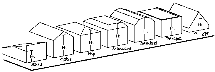
(Ord. 13701, §§ 2, 3, 4-19-2004; Ord. No. 15648, § 1, 4-17-2017; Ord. No. 16466, §§ 2, 8, 10-22-2024; Ord. No. 16567, §§ 1—5, 12-15-2025)
Sec. 35-52. - Single-family and two-family residential lot design standards.
A.
Density and dimensional standards. Maximum height, as well as the minimum lot size, depth, width and building setbacks for single-family and two-family developments shall comply with the applicable zoning district standards and the standards established in exhibit 35-51A.
B.
Principal buildings/lot. Only one principal building is permitted on a lot except when associated with an approved PUD Planned Unit Development District.
Sec. 35-53. - Multi-family residential design standards.
A.
General density. Maximum height, as well as the minimum lot size, depth, width and building setbacks for multiple family developments shall comply with the applicable zoning district standards and the standards established in exhibit 35-51A.
B.
Principal buildings/lot. Multi-family residential uses may have more than one building located on the lot.
(Ord. No. 16466, § 1, 10-22-2024)
Sec. 35-54. - Cluster subdivision and compact housing provisions.
A.
Purpose and intent. Cluster subdivisions and compact housing developments may be authorized according to the provisions of this section to preserve environmentally-sensitive areas, open space and agricultural lands. The intent of this section is to authorize a developer to decrease lot sizes and leave the land "saved" by so doing as open space or conservation areas, thereby lowering development costs and increasing the amenity of the project without increasing the density beyond what would be permissible if the land were subdivided into the size of lots required by the underlying zoning district.
B.
Applications.
1.
Cluster subdivision. (Where subdivision of land is involved; processed concurrently with major or minor subdivision). Applications for cluster subdivision shall be simultaneously processed as a (i) special exception use permit under the zoning code in conformance with subsection 35-73.D, and (ii) according to the requirements for major or minor subdivision, as appropriate. All such submissions shall be labeled "Cluster Subdivision."
2.
Compact housing development. (Where subdivision of land is not involved). Applications for compact housing developments shall be processed as a special exception use permit in conformance with subsection 35-73.D. All such submissions shall be labeled "Compact Housing Development."
C.
Permitted zoning districts. A developer may create a cluster subdivision or compact housing development in a standard residential zoning district which includes lots that are smaller and arranged differently than those required by the underlying zoning district regulations if the application conforms to this section.
D.
Housing types. Housing types within a cluster subdivision or compact housing development shall be as authorized by the underlying zoning district, shown in exhibit 35-28, Land use matrix; and subject to exhibit 35-54A and the additional standards of this section.
E.
Project size and density. There is no minimum or maximum acreage limitation for a cluster subdivision. The maximum allowable residential density shall not exceed the maximum density allowed in the underlying zoning district. Maximum allowable residential density shall be calculated by using exhibit 35-51A, units/acre.
F.
Lot dimension and setback requirements.
1.
There are no prescribed minimum lot dimensions. Lot widths and depths shall be sufficient to accommodate the use and minimum building setbacks required for the housing type.
2.
Zero lot line development may transfer all or part of the side setback to one side; such that one side may be zero if the opposite side setback is 20 feet. No mechanical equipment, roof overhang, or object attached to or associated with the dwelling unit may overhang the lot line.
3.
No side setback is required on the interior or "attached" side of an attached dwelling.
4.
For buildings containing more than one dwelling unit, the front, side and rear yard setbacks listed in exhibit 35-54A shall be measured from the perimeter of the building.
5.
A minimum of 20 feet must be provided between multiple family buildings on the same parcel or lot.
6.
The preliminary and final subdivision plats shall indicate all setback lines for all proposed buildings and upon all proposed lots, including designation of all "zero" lot lines.
Exhibit 35-54A: Lot and Setback Standards for Cluster Subdivision Developments1
Notes:
1 See the underlying zoning district regulations for maximum density allowed.
2 See subsection 35-51.B.5 for garage setback requirements.
3 Reflects transfer of all of the required side setback to one side.
4 Reflects the "0" setback on "attached" side of an attached dwelling; 10 feet setback on the opposite side.
5 See subsection 35-54.F for setbacks required between multiple family buildings on the same parcel.
G.
Required open space, how calculated. The amount of open space or conservation area which must be set aside shall be determined as follows:
1.
Cluster subdivisions. The amount of open space or conservation area which must be set aside in cluster subdivisions shall be based on the difference between the total area contained within all cluster lots and the total area which would have been contained within an equivalent number of standard lots based on the minimum lot requirements of exhibit 35-51A according to the zoning district in which the project is located. All lot reductions shall be compensated for by an equivalent amount of land in open space or common area to preserve and maintain in accordance with the provisions of this section.
2.
Compact housing development. All land within a compact housing development not covered by buildings, parking lots or streets shall be reserved as common land and open space.
H.
Open space standards.
1.
Ownership and maintenance of open space.
a.
The developer shall provide for the ownership and continued maintenance of all open space created under one or more of the methods stated below. City approval of the form of dedication or conveyance shall be required:
(1)
Offer to dedicate land to the public;
(2)
Convey open space to be held in common; or
(3)
Where agricultural land is to be preserved, create an agricultural easement over that portion of the property to be protected.
b.
Open space which is to be held in common shall be owned and maintained by an organization established by the applicant and approved by the City. The applicant shall submit covenants and restrictions regarding permanent maintenance of the open space, including provisions addressing:
(1)
Maintenance duties of the organization;
(2)
The manner in which lot owners will be assessed by the organization;
(3)
Conditions of default; and
(4)
The manner of enforcement by the City.
c.
Open space which is to be dedicated for public use shall be located to provide access to or provide protection of adjacent public lands.
2.
Open space allocation. Open space shall be provided for each phase of a development. If common open space will not be provided proportionally by phase, the applicant shall execute a reservation of common open space by grant of an easement or covenant in favor of the City, authorizing the City to dedicate all or a portion of such reserved area to common open space in the event that the development is not completed.
3.
Open space design and improvements.
a.
Open space areas shall be linked to existing and planned public open space and greenways wherever possible.
b.
Open space areas shall be arranged to maximize access and use by residents of the cluster development.
c.
Where open space improvements are provided, a safe, secure and barrier-free system of trails, paths, walkways and bikeways shall be designed. Walkways and bikeways may link with recreation areas, schools, commercial areas and public facilities.
d.
Improvements may include paved pedestrian paths located in public rights-of-way, pedestrian easements, paved bikeways, or other agreed-upon improvements.
I.
Project landscaping and compatibility requirements.
1.
Development buffer. The perimeter of a cluster subdivision or compact housing development shall be buffered from adjacent residential property with a type A bufferyard. Project landscaping design shall be established in conjunction with the preliminary plat approval.
2.
Design and installation.
a.
A project landscape, open space and screening plan shall be prepared and shall include the following information:
(1)
Location of all plant materials including a key that indicates type and size referenced to a landscape schedule.
(2)
Landscape schedule showing species, size, color, and quantity of landscape materials shown on plan.
(3)
General information about planting, erosion control, scheduling of installation and irrigation.
(4)
Location of berms or screening walls.
b.
The applicant will be required to establish a permanent ground cover in the landscape area to stabilize the soil to prevent erosion.
c.
Berms or screening walls where proposed or required shall be as approved by the City and completed prior to the issuance of any residential building permits within the project. Material colors for screening walls shall be limited to earthtone colors. The color shall be uniform for the entire length of the wall.
d.
All landscaping plants shall be maintained in sound, healthy, and vigorous living condition.
J.
Off-street parking. Off-street parking shall be provided in accordance with section 35-58.
K.
Phasing. An applicant may propose that a cluster subdivision or compact housing development project be developed in phases, or the City may require the applicant to divide the project into phases in order to meet requirements and standards contained in these regulations. Each phase must be self sufficient, meeting the requirements, standards and conditions applicable to that portion of the project, including open space provisions. Each phase of the project shall be supported by adequate public facilities.
Exhibit 35-54B: Conventional and Cluster Subdivision Compared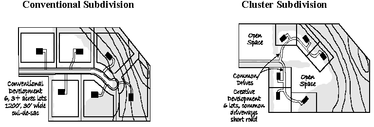
Sec. 35-55. - Visual clear zones (sight triangles).
A.
General. All intersections of public rights-of-way and driveway intersections with public rights-of-way shall have a visual clear zone (VCZ) that is free of any obstruction to vision of a motorist or pedestrian. The VCZ shall include an area within the public right-of-way and on private property as described below. The VCZ shall be kept clear of visual obstructions between three feet and ten feet above the curb line. Where there is no curb, the height shall be measured from the crown of the street. The VCZ shall be kept free of obstructions that include but are not limited to trees, shrubs, fences, walls and signs. See exhibit 35-55A. The types of VCZ are addressed below.
Exhibit 35-55A: Visual Clear Zone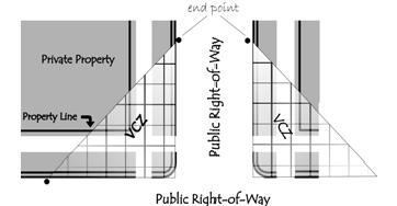
B.
Visual clear zones.
1.
At street intersections/corner lots. The VCZ shall be a triangular area formed by lines that follow the back of curb, or street pavement edges where there is no curb, and a line connecting them 35 feet from their point of intersection at the corner, including the straight-line extension of the hypotenuse to the center of the street right-of-way.
2.
At driveway intersections with public streets. The VCZ at driveway intersections shall be a triangular area formed by lines that follow the back of curb, or pavement edges where there is no curb, and a line connecting them 35 feet from the driveway's intersection with the public right-of-way, including the straight-line extension of the hypotenuse to the center of the street right-of-way.
C.
Exceptions.
1.
On corner lots, other than those located in the C-3 and PUD districts, where either required front yard is less than 25 feet, structures may be erected in the sight triangle on private property with the approval of the Board of Adjustment.
2.
In the C-3 Central Commercial District, the Director may waive the VCZ requirements if consistent with the development practices in the district.
3.
In the PUD Districts, structures may be erected in the VCZ upon the approval of the Planning and Zoning Commission.
4.
The Director may permit the placement of trees or pole signs in the VCZ on private property if the tree canopy or the sign face will not obstruct vision.
Sec. 35-56. - Sidewalks.
In some cases, the City Code, specifically chapter 32, Streets and sidewalks, and chapter 33, Subdivisions, requires the construction of sidewalks along existing or new streets. All proposed developments, whether permitted, conditional, special exception or those in PUD Planned Unit Development districts, shall comply with chapter 32, Streets and sidewalks.
(Ord. No. 14023, § 4, 3-20-2006; Ord. 14277, § 4, 11-19-2007)
Sec. 35-57. - Outdoor lighting standards.
A.
Purpose. The purpose of these regulations is to regulate the spillover of light and glare from outdoor lighted uses onto abutting property, rights-of-way, pedestrians and motor vehicles.
B.
Applicability. The following standards shall apply to all uses that operate during hours of darkness and to off-street parking areas but do not apply to public street lighting, or other lighting that is specifically exempted.
C.
Flickering and flashing lights. Flickering and flashing lights shall not be permitted.
D.
Lighting plan required. An exterior lighting plan shall be submitted for review prior to the installation or substantial modification of any exterior lighting, whenever a building permit is sought, or as part of a site plan or other development plan review process outlined in section 35-70.
E.
Location of light sources. Light luminaries or light sources shall not be located upon easements or right-of-way and shall be shielded to prevent glare and light from illuminating areas not within the site.
F.
Maximum illumination and luminaire height. Exhibits 35-57A, 35-57B and 35-57C show the maximum foot-candles of illumination allowed on the site and maximum luminaire height.
1.
Luminaires without cutoffs or light shields. When the light source or luminaire has no cutoff or shield, the standards of exhibit 35-57A shall apply:
Exhibit 35-57A. Standards for Luminaires Without Cutoff
2.
Luminaires with total cutoff angle of 90 degrees or more. When a Luminaire has a total cutoff angle or light shield angle of 90 degrees or more the standards of exhibit 35-57B shall apply:
Exhibit 35-57B. Luminaires with Total Cutoff Angle 90 Degrees or More
3.
Luminaires with total cutoff angle of less than 90 degrees. When a luminaire has total cutoff angle or light shield angle of less than 90 degrees and is located so that the bare light bulb, lamp, or light source is completely shielded from the direct view of an observer five feet above the ground at the point where the cutoff angle intersects the ground, the standards in exhibit 35-57C shall apply:
Exhibit 35-57C. Luminaires with Total Cutoff Angle of 90 Degrees or Less
G.
Outdoor lighting standards for specified uses.
1.
Outdoor public recreation uses within 500 feet of residential lots. Because of their unique requirements for nighttime visibility and their limited hours of operation, public recreation uses such as ball fields and similar sports fields, tennis courts, and swimming pools, shall be subject to the outdoor lighting standards of this sub-section.
a.
Luminaires shall be less than 80 feet high;
b.
Not more than two foot candles of light shall fall upon the abutting property.
2.
Planned districts. Outdoor lighting in Planned Districts shall comply with the standards of this section.
3.
Vehicle display lots. Outdoor display lighting used in conjunction with a vehicle sales or leasing use shall adhere to the following standards:
a.
Luminaires shall have a total cutoff angle of 90 degrees or less
b.
Luminaires shall have a maximum height of 40 feet.
c.
Maximum foot candles for illumination of the display lot area shall be ten footcandles, however, maximum foot candles for areas within 50 feet of a residentially zoned district shall be four foot candles.
d.
Luminaries shall be shielded to prevent glare and light from illuminating areas not within the site.
4.
Vehicle canopy lighting. Canopy lighting for uses such as gasoline stations, convenience stores with gasoline sales, and drive through banks shall adhere to the following standards:
a.
Luminaires shall have a total cutoff angle of 90 degrees or less
b.
Maximum foot candles for illumination of the area under the canopy shall be ten footcandles. For canopies located within 50 feet of a residentially zoned district, maximum foot candles for illumination of the area under the canopy shall be four footcandles.
c.
Luminaires shall be shielded to prevent glare and light from illuminating areas not within the site.
H.
Measurement of lighting.
1.
Equipment. A direct-read, portable light meter, with a color and cosine-corrected sensor consisting of multiple scales that reads within an accuracy of plus or minus five percent shall be required to measure foot candles of light projecting onto abutting property.
2.
Measurement method. The meter sensor shall be mounted not more than six inches above ground level in a horizontal position. Readings shall be taken only after the cell has been exposed long enough to provide a constant reading. Measurements shall be made after dark when the light source in question is turned on, then when it is turned off. The difference between the two readings shall be compared to the maximum permitted illumination and property line at ground level. This procedure eliminates the effects of moonlight and other ambient light.
I.
Lighting curfews.
1.
On all nonresidential properties which contain four or more parking lots or display lot light poles, maximum outdoor lighting levels shall be reduced by at least 50 percent of the permitted level after the close of business, or after 11:00 p.m., whichever is later, by dimming parking lot lighting levels or by turning off 50 percent of the parking lot lights.
(Ord. No. 14982, § 3, 6-18-2012)
Sec. 35-58. - Off-street parking and loading.
A.
Purpose. The purpose of required parking spaces is to provide enough off-street parking to accommodate the majority of traffic generated by the range of uses permitted by the site development plan. The application of these standards will improve compatibility and the appearance of such facilities, provide relief from unshaded paved areas and reduce heat gain associated with parking areas.
B.
Off-street parking requirements. This section sets minimum standards for off-street parking requirements for land uses and developments including new construction and expansion of or changes to existing land uses. A site plan shall be required for new construction, and changes to an existing parking lot, in conformance with section 35-71. The parking lot site plan may be incorporated with the development plans for a building or project. The site plan shall include the details indicating compliance with the standards in this section.
1.
Land uses for which parking must be provided. Exhibit 35-58A shows the off-street parking requirements for various land uses and developments.
EXHIBIT 35-58A: OFF-STREET PARKING REQUIREMENTS
sf: square feet GFA: gross floor area N/A: not applicable
a.
Uses not identified. The Director shall determine the parking requirement for uses which do not correspond to the categories listed in Exhibit 35-58A. In such instances, the applicant shall provide adequate information by which the proposal can be reviewed, which includes but may not necessarily be limited to the following:
(1)
Type of uses;
(2)
Number of employees;
(3)
Building design capacity;
(4)
Square feet of sales area, service area, etc.;
(5)
Parking spaces proposed on-site;
(6)
Parking spaces provided elsewhere; and
(7)
Hours of operation.
b.
Minimum number of spaces required. The minimum number of parking spaces required for vehicle parking shall be as indicated in exhibit 35-58A, however, if the adopted fire code has a more restrictive requirement based on the fire code occupancy rating, the number of parking spaces shall be in conformance with the adopted fire code/occupancy requirements.
c.
Computation. Parking spaces computed for the primary use of the site shall take precedence over the computation of parking spaces based on floor area.
d.
Multiple uses within the building. When more than one type of use that has a parking requirement is located within the building and at least 20 percent of the gross floor area is devoted to that use, the parking needs for that use shall be calculated separately from the other uses. For example, a 20,000 square foot building with 5,000 square feet of office space and 15,000 square feet of warehouse space would require 17 parking spaces for the office and 15 parking spaces for the warehouse space for a total of 32 parking spaces.
e.
Shared parking facilities. Off-street parking requirements of a given use may be met with off-site or off-street parking facilities of another use when and if, all of the following conditions are met:
(1)
The location shall comply with the provisions of subsection 35-58.B.4;
(2)
The parking demands of the individual uses, as determined by the Director based upon parking demand information supplied by the applicant or other sources, are such that the total parking demand of all the uses at any one time is less than the total parking stalls required; and
(3)
A written agreement between the owners and lessees is executed for a minimum of five years, approved by the Director, recorded, and a copy maintained in the project file. Should the lease expire or otherwise terminate, the use for which the off-site parking was provided shall be considered a violation. Any and all approvals, including special exception use or conditional use permits, shall be subject to revocation. Continuation or expansion of the use shall be prohibited unless the use is brought into compliance with the parking regulations of this ordinance.
f.
Temporary use of unpaved parking facilities. The use of an unpaved off-street parking lot may be authorized for a maximum of six months, provided the location, construction and design of same shall be first approved by the Director.
2.
Exceptions to required number of spaces.
a.
Reduced parking for uses near municipal parking lots. Where there is a municipal parking lot within 500 feet, the parking spaces required for non-residential uses and mixed uses may be reduced by ten percent of the total spaces in the municipal lot or lots. Where ten percent of the municipal spaces are equal to or exceed the spaces required for the use, the parking requirements are satisfied.
b.
Reduced parking for uses with adjacent on-street parking.
(1)
Where on-street parking exists on a street adjacent to a new or expanded use located within the Old Town District, as defined in chapter 25, the required number of off street parking spaces for the new or expanded use may be reduced by one space for each 25 feet of frontage on the street, with a maximum reduction for a single parcel as follows:
(a)
For single-family and multi-family residential uses: one space per unit up to a maximum reduction for a single parcel of five spaces.
(b)
For non-residential uses: a maximum reduction of five spaces for a single parcel. Where the five space reduction is equal to or exceeds the spaces required for the use, the parking requirements are satisfied.
(2)
Reduction of required parking granted by this subsection shall not grant exclusive use or ownership of adjacent on-street parking spaces nor shall prevent the City from eliminating or otherwise modifying on-street parking.
c.
Reduced on-site parking with parking management plan. The Director may reduce the number of required parking spaces up to 25 percent when the applicant provides a parking management plan. The parking management plan shall include transportation alternatives such as shared-ride programs, carpooling and vanpooling programs, transit and commuter use, shared parking and other off-site parking that reduce the need for parking spaces. Prior to the issuance of a certificate of occupancy, or approval of a business license, the applicant shall provide evidence that such parking management plans exist. The evidence must include copies of any contracts, lease agreements, purchase agreements and other documentation showing that such transportation alternatives have occurred or are about to occur. The evidence shall report the number of participants involved, the percentage of the maximum work force participating in the parking management plan, the number and types of vehicles used and the percentage of parking spaces normally used by the employees. The applicant shall record a covenant, the content and form of which shall be approved by the Director, which binds all successors in title to the commitments approved and the applicant shall include a clause in all leases which binds all tenants to this commitment made by the applicant. No change in the approved plans shall take place without a review by the Director. Approval of the parking management plan does not relieve the applicant of an ongoing requirement to provide off-street parking spaces if demand increases.
d.
Variance in parking requirements. The Director shall have the authority to vary the parking requirement, by up to 20 percent of the required parking, if one or more of the following circumstances exists:
(1)
Expected automobile ownership or use patterns of employees, tenants, or other users varies from what is typical in the community or typical for the use.
(2)
The parking demand varies throughout the day in relation to parking supply.
(3)
The nature of operational aspects of the use warrants unique parking arrangements.
(4)
Actual parking practice in the community demonstrates that the parking standard may be too high.
3.
Parking in C-3 Central Commercial District, Large Office Buildings. Structured parking rather than surface parking shall be required for office buildings or other uses in the C-3 district that exceed 75,000 square feet for office use.
4.
Location.
a.
The parking area shall be provided on the same parcel as the principal use or structure wherever practicable.
b.
Off-site parking for non-residential uses shall be located within 450 feet of the site, on land which is zoned for parking lot use as shown in exhibit 35-28.
c.
Parking for multi-family dwellings shall be located on the same lot as the main building, or within 100 feet thereof, on land which is zoned for parking lot use as shown in exhibit 35-28.
d.
Parking for single-family and two-family dwellings shall be located on the same lot with the building,
e.
All off-street parking spaces shall be located off the City right-of-way and parked vehicles shall not overhang onto the City right-of-way or abutting property.
5.
Parking lot landscaping. The minimum landscaping requirements of this section are intended to improve air quality, to reduce heat and glare, and add to the aesthetic quality of our living environment. Trees appreciably reduce the dangerous carbon dioxide content of the air, are proven producers of oxygen, and play a vital role, through transpiration and otherwise, in purifying the air we breathe. Trees are valuable physical and aesthetic community assets in that they provide cooling shade, reduce noise levels and glare, and break the monotony of large parking areas and other human developments. A variety of species of trees is encouraged to reduce the impact of potential disease or insect infestations, and to provide variety in shape, texture and seasonal color.
a.
Relationship to other required landscaping, screening and buffering. Bufferyard and perimeter landscaping may also be required, in accordance with section 35-59 or other applicable sections of this ordinance. Parking lot landscaping shall not be counted toward the satisfaction of bufferyard or screening required by section 35-59 and other applicable sections of this ordinance. Where specific parking lot landscaping provisions exist, such as applicable to big box/superstore developments in section 35-41, those provisions shall prevail.
b.
General requirements. Landscape plantings shall be installed on any parking lots containing more than ten spaces. Such plantings may, with a permit issued by the City Forester, be in public right-of-way adjacent to the parking lot. Such plantings shall consist of the number of standard canopy trees from the approved planting list needed to shade at least 35 percent of the parking lot when the trees are mature (see definition in article IX and approved tree lists in appendix A). The amount of shade provided by a mature tree shall be the area contained within the perimeter of the tree's leaf canopy projected vertically to the ground. The canopy diameter of a mature specie of tree shall be based on the Manual of Woody Landscape Plants, Michael A. Dirr, 4th Edition, published by Stipes Publishing Company, Champaign, Illinois, 1990, or latest edition. The required trees shall not be concentrated in a few areas but shall be distributed throughout the entire lot.
c.
Protection from vehicular encroachment. All landscaped areas shall be protected from vehicular encroachment by curbing or anchored wheel stops. Planting islands shall be at least four feet wide and 100 square feet to protect trees and vegetation from bumper overhang and swinging doors. Plantings shall be located to minimize damage caused by door or bumper overhang.
d.
Areas between trees. Land between trees shall be covered with shrubs, grass or other living groundcover, or non-living groundcover.
e.
Large parking lots containing 150 spaces or more.
(1)
Maximum lot size. No parking area shall contain more than 150 spaces. If a greater number is required, separate parking spaces of not more than 150 spaces shall be provided and shall be separated by a landscaped area at least ten feet in width. The use of berms and evergreen trees in the landscaped strip is encouraged but not mandated. Up to ten percent of the length of the strip may be opened to permit pedestrian and vehicular access between parking areas.
(2)
The amount of shade provided by mature parking lot trees in large parking lots may be reduced to 25 percent in cases where the landscape plan makes effective use of berms, landscaped strips or landscaped areas within the interior of the parking lot.
(3)
A minimum of three different species of trees is required in large parking lots to reduce the impact of potential disease or insect infestations, and to provide variety in shape, texture and color.
f.
Plan required. Trees shall be installed in accordance with the plan approved by the appropriate approval authority and in accordance with the standards of this section. A plan shall not be approved unless it is directed toward the attainment of the purposes stated in subsections 5 and 5a above. The plan shall include a set of standard notes which indicates the planting detail and type of trees to be planted, including the Latin species and variety, cultivar and common name.
g.
Planting detail. Trees shall be planted in accordance with the standard tree planting detail in appendix B-1 or B-2 as site conditions dictate.
h.
Variance provision. If the property owner can prove that for reasons of rock or other unusual characteristics, such planting is not possible, this requirement may be varied by the Board of Adjustment. A variance, if granted, shall be limited to the minimum variance necessary to resolve, in whole or in part, the particular problem of the applicant.
i.
Maintenance of plantings; and enforcement.
(1)
Trees and shrubs shall be maintained in good condition and replaced where necessary to ensure the continuation of the planting or landscape plan as approved. Failure to maintain required trees in good condition and replace them when necessary shall be pursued as a violation of this ordinance. The Director shall have the power to prohibit parking until maintenance or replacement is completed provided that at least 45 days has elapsed since the notice of violation was sent.
(2)
The landscape plantings shall be considered as an element of a project in the same manner as paved parking, building construction and materials, storm water drainage, and other elements. A building permit shall not be issued prior to the approval of the planting plan, except a building permit for only the footings and foundations of a structure may be issued prior to the approval of the planting plan, provided however, no parking lot paving shall be accomplished under said footing and foundation permit and, further provided, all plantings called for in the approved planting approval planting plan shall be installed prior to the issuance of a final certificate of occupancy. If, at the time of the request for the certificate the plantings cannot be installed or would be jeopardized by weather, an instrument signed by the owner specifying the materials will be installed in the next planting season may be accepted to allow the issuance of a temporary certificate of occupancy.
6.
Minimum improvements and maintenance standards. Parking areas, automobile and truck sales lots, parking garages and driveways serving these areas shall conform with the following improvements and maintenance standards:
a.
Paving requirement and classification.
(1)
Exhibit 35-58B shows the paving classification and the type and thickness of paving material by general land use.
(2)
Those parts of parking areas which may be subject to frequent heavy truck traffic area required to meet the standards for the heavy classification. Heavy truck traffic areas may include, but are not necessarily limited to, trash disposal areas, loading and unloading areas, and drives leading to such areas.
(3)
A final decision on the need for light, medium or heavy classification will be made by the Director at the time an application for a building permit is filed.
Exhibit 35-58B. Paving Requirements and Classification
b.
Driveway standards.
(1)
All entrances and exits to parking lot areas shall be located to minimize traffic congestion on the public street system, in accordance with standards adopted by the Department of Planning and Protective Services.
(2)
Private driveway approaches, when located on public right-of-way shall be designed and constructed in accordance with the standards adopted by the Department of Planning and Protective Services.
(3)
The full width and length of all driveways shall be paved, except that the Director may authorize a reduction in the width or length of the paved driveway as provided below:
(a)
Where a single-family residential structure is located more than 50 feet from the right-of-way line; provided the paved portion of the driveway extends from the driveway intersection with the street to the setback line, or a minimum of 25 feet from the right-of-way line, which ever is greater.
(b)
Driveways serving overflow or seasonal parking lots or low traffic storage yards shall be paved from their intersection with the public street a minimum length of 25 feet beyond the right-of-way line.
(c)
An existing driveway with less than the required width which serves an existing residential structure containing one or two dwelling units may nevertheless be paved. Where existing curb cuts or driveways are less than 12 feet they may be paved or rebuilt without increasing the width with approval from the Director.
(4)
Driveways serving parking lots for multiple family units and non-residential uses shall be designed for either one-way or two-way traffic. Direction of traffic shall be indicated upon the site plan.
(5)
Driveways and their driving lanes shall be subject to the additional standards of exhibit 35-58C.
(6)
No part of a private drive approach or radius shall encroach upon the adjacent property.
(7)
Abutting and common driveways.
(a)
One- and two-family residential lots may abut their respective driveways, provided that each maintains the minimum width required, as measured from the property line in common to the edge of each respective driveway.
(b)
Multiple family residential and commercial properties may abut driveways or may provide common driveways, upon approval by the Director. Adequate access and circulation must be ensured for each affected property, evidenced by access agreements and easements, to be submitted and approved with the site plan and recorded in the office of the Cole County Recorder of Deeds upon approval of the site plan.
(8)
No land located in a residential district shall be used for a driveway or parking area for any commercial or industrial use unless otherwise permitted.
Exhibit 35-58C. Driveway Standards.
c.
Stormwater plan. The parking lot drainage and stormwater plan shall be approved by the Director.
d.
Parking space and driveway directional marking. The location of each parking space and the location and direction of movement along the driveways providing access thereto shall be indicated by painting upon the surface, by raised directional signs, or by markers or other similar measures placed in the surfacing.
e.
Lighting required. Parking lots with more than ten parking spaces that are used during hours of darkness shall be lighted in conformance with section 35-57.
f.
Parking lot signage. A sign shall be installed showing the ownership of the parking lot or parking garage and the permitted use thereof. If the lot or garage is so operated that a charge is made for the use of the parking facilities, the rates for parking shall be shown legibly upon the sign.
7.
Overflow or seasonal parking lots and low traffic storage yards.
a.
Overflow or seasonal parking lots. Overflow parking, defined as parking in addition to the minimum required by ordinance and which is designed to be used more than ten times per year, may be surfaced with chip and seal or may be gravel surfaced. A dust palliative shall be used to prevent fugitive dust.
b.
Low traffic storage yards. A low-traffic storage yard may be surfaced with chip and seal or may be gravel surfaced. A dust palliative shall be used to prevent fugitive dust. For purposes of this subsection 7.b., a "low traffic storage yard" shall mean and refer to "a storage area generating less than 30 ADT (average daily trips)".
c.
Maintenance. All surfaces shall be maintained in good condition free of weeds, dust, trash and debris. All vehicular traffic areas shall meet or exceed adopted City construction standards.
8.
Parking stall and aisle design.
a.
Parking stalls and aisles shall be arranged to accommodate safe circulation of vehicles and pedestrians.
b.
Compact car parking. Not more than 20 percent of the parking spaces required for a land use or development shall be allocated to compact car parking. Compact car parking spaces shall be identified upon the site plan and clearly signed in the parking lot.
c.
Parking stall and aisle dimensions shall comply with exhibits 35-58D—F.
9.
Off-street parking for persons with disabilities. Off-street parking facilities shall be designed and constructed in accordance with all requirements of the Americans with Disabilities Act (ADA)and the Uniform Federal Accessibility Standards.
Exhibit 35-58D
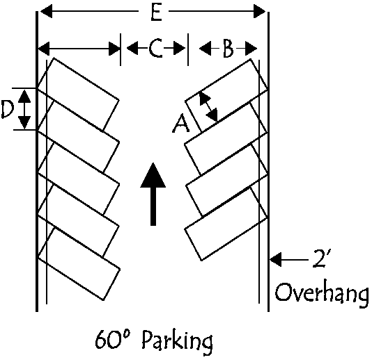
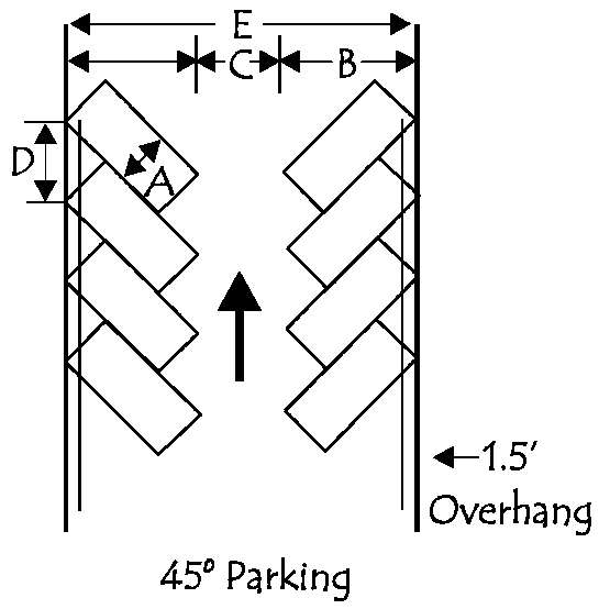 |
45° Angle
Parking Design | Minimum Dimensions | |
| Standard | Compact | ||
| A stall width | 9.0' | 7.5' | |
| B stall depth | 19.0' | 16.0' | |
|
C aisle width
1-way (shown) 2-way | 12.0' 24.0' | 12.0' 24.0' | |
| D car curb length | 12.5' | 10.5' | |
|
E lot width (B+B+C=D)
1-way (shown) 2-way | 50.0' 62.0' | 44.0' 56.0' | |
Exhibit 35-58E
 |
60° Angle
Parking Design | Minimum Dimensions | |
| Standard | Compact | ||
| A stall width | 9.0' | 7.5' | |
| B stall depth | 20.0' | 16.5' | |
|
C aisle width
1-way (shown) 2-way | 18.0' 24.0' | 15.0' 24.0' | |
| D car curb length | 10.5' | 8.5' | |
|
E lot width (B+B+C=D)
1-way (shown) 2-way | 58.0' 64.0' | 48.0' 57.0' | |
Exhibit 35-58F
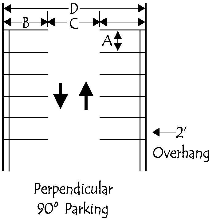 |
90° Angle
Parking Design | Minimum Dimensions | |
| Standard | Compact | ||
| A stall width | 9.0' | 7.5' | |
| B stall depth | 19.0' | 15.0' | |
|
C Aisle Width
1-way 2-way (shown) | 24.0' 24.0' | 22.0' 24.0' | |
|
D Lot Width (B+B+C=D)
1-way 2-way (shown) | 62.0' 62.0' | 52.0' 54.0' | |
10.
Parking lot attendant shelter. A shelter for the use of a parking lot attendant may be maintained on the lot provided the location, construction and design of same shall be first approved by the Director.
11.
Parking lot/garage maintenance. The parking lot or garage shall be maintained free of dust, paper and other loose particles. All adjacent sidewalks shall be kept free from dirt in a safe condition for use by pedestrians. All signs, markers, or any other method used to indicate direction of traffic movement and location of parking spaces shall be maintained in a neat and legible condition. Likewise, any walls, trees and shrubbery, as well as surfacing of the parking lot or garage, shall be maintained in good condition throughout its use for parking purposes and the Director shall prohibit the use of the area for parking purposes unless and until proper maintenance, repair or rehabilitation is completed.
12.
Violation of standards. The Director shall prohibit parking in areas where the paving and landscape improvements do not meet the minimum improvement requirements which were in effect at the time the improvements were installed. Before prohibiting parking on any area, the Director shall notify the owner, in writing, of the work that shall be required to bring the area into compliance with the minimum improvement standards for off-street parking. Such improvements shall be completed within six months of such notification in conformance with Article VIII.
C.
Off-street loading.
1.
General. Site plans for proposed business, commercial or industrial uses shall show provisions for loading/unloading areas on the premises. These areas shall be reviewed for their impact on the site, the adjacent streets and the adjacent land uses.
2.
Number and size of loading spaces. Loading spaces, a minimum size of 14 feet wide by 50 feet long with a minimum vertical clearance of 18 feet, shall be provided for new buildings and uses and expansions or modifications of existing uses as shown in exhibit 35-58G.
3.
Standards for C-3 Central Commercial District. The Director shall have the authority to reduce the off-street loading requirements for a land use in the C-3 Central Commercial District by one space if acceptable alternatives exist which are consistent with current practice in the area.
Exhibit 35-58G
Minimum Number of Loading Spaces Required for Specified Land Uses
(Ord. No. 14982, § 4, 6-18-2012; Ord. No. 15344, § 1, 11-17-2014; Ord. No. 15686, § 3, 7-17-2017; Ord. No. 16466, § 7, 10-22-2024)
Sec. 35-59. - Screening and bufferyard standards.
A.
Purpose and intent. The intent of this section is to establish standards to protect and enhance community appearance with the installation of appropriate landscaping and screening materials within the City; to maintain and increase the value of land by incorporating a minimum amount of landscaping into development; to encourage prudent and skilled workmanship for the installation and maintenance of all plant materials; and to establish procedures and standards for the administration and enforcement of this ordinance. Developments shall comply with the requirements of all applicable sections. Parking lot landscaping required by section 35-58.B.5 shall not be counted toward the satisfaction of other landscaping and buffering required by this ordinance.
B.
Landscape plans. Landscape plans for parking lot landscaping, screening and bufferyards shall accompany the site plan. Required landscape areas shall be designated as such on site development plans. Landscaping shall be installed as shown on the approved site plan. All changes shall be approved by the Director, unless otherwise specified in this ordinance. The landscape plans shall be drawn to the same scale as the site plan, and shall indicate the plant locations and schedule of the type, size, number and species of the plant material and the time for planting.
C.
General landscape standards. All landscaping required by this ordinance shall comply with the following minimum standards.
1.
Plant types.
a.
Trees and shrubs shall be hardy and of a species common to or adapted to mid-Missouri, shall be matched to the site, and shall not be of nuisance type species. Trees that release fruit, nuts, large seed pods or similar materials are discouraged from being used where they abut the right-of-way and in parking lots. The applicant shall ensure that a mix of species, color, texture, and form are used.
b.
Required landscaping shall be selected from the approved planting list, included as appendix A. Updates to the approved planting list shall be adopted by the Planning and Zoning Commission, and shall be reviewed from time-to-time by the City Forester to ensure the continued viability of listed plants. Manual of Woody Landscape Plants, Michael A. Dirr, 4th Edition, published by Stipes Publishing Company, Champaign, Illinois, 1990, or the latest edition, shall be referred to for size and characteristics of trees and shrubs.
c.
Alternative varieties of trees and shrubs may be approved by the Director, subject to review of plant characteristics to ensure that the general landscape standards are met.
2.
Use of existing landscaping. Existing landscaping may be used to meet the requirements of this ordinance provided it meets the purpose and intent of this ordinance and is included on the approved landscape plan. Such landscaping shall be protected during all phases of site development.
3.
Minimum plant size at time of planting. The following minimum requirements shall apply to parking lot landscaping and plantings within required bufferyards:
a.
Canopy trees: Canopy trees shall be deciduous, two inch caliper, measured six inches above the ground.
b.
Conifer/evergreen trees: Five feet tall
c.
Hedges/live barrier features: Shall be evergreen, one gallon container.
d.
Understory plantings and deciduous shrubs: One gallon container
e.
Groundcover: Living or non-living groundcover shall be spaced or applied according to nurseryman's specifications.
f.
Turf grass: Seed, sod or plug, spaced or applied according to nurseryman's specifications.
4.
Installation. Plants shall be installed in accordance Standard Tree Planting Detail or Standard Tree Planting Detail for Compacted Soils, promulgated by the Urban and Community Forestry Division of the Missouri Department of Conservation, included as Appendix B. All plant materials shall be installed prior to issuance of certificate of occupancy. A temporary certificate of occupancy (TCO) may be issued prior to installation of plant materials provided that a written assurance and a financial guarantee is furnished to the Director to insure the installation of required materials within six months of the issuance of the TCO. The financial guarantee shall be equal to two times the cost of the materials, estimated by the applicant's landscape architect, architect, land planner or nurseryman, and may be in the form a letter of credit, bond or cash.
5.
Maintenance of landscape areas and plants. Areas not covered by vegetation shall be covered with gravel, cobble, rocks, mulch, wood chips, barks chips or similar natural materials three inches in depth to prevent weed growth, erosion and blowing dust. All plants shall be maintained in a healthy condition in accordance with generally accepted professional horticultural and arboricultural standards and practices such as recommended in ANSI Standard A-300. Plants which die or are unhealthy shall be replaced in accordance with the approved landscape plan. Regular pruning and trimming shall be applied to maintain health and to permit the plants to achieve their intended form and height.
6.
Use of the public right-of-way.
a.
Unless specifically permitted, no portion of the public right-of-way shall be used to meet the landscape requirements of this ordinance.
b.
The Department of Parks and Recreation Forestry Division shall approve any and all trees authorized for planting on public right-of-way.
c.
Irrigation systems on public right-of-way shall be approved by the Director prior to installation.
7.
Use of utility easements. No utility easement may be used for required landscaping or bufferyard barrier feature unless approved in writing by the appropriate official of each affected utility. Evidence of such approval shall be (1) indicated by signature block upon the landscape plan or (2) by letter submitted with the landscape plan. Where specifically permitted to be used for the required landscaping, the plantings on utility easements shall be limited to small canopy trees, shrubs and hedges, ground covers and turf grass. Each medium or large canopy tree required by this section may be replaced by two small canopy trees if required by the utility company official.
8.
Visual clear zones. Landscaping and buffering height shall comply with the provisions of section 35-55, Visual clear zones.
9.
Parking or storage within landscaped areas prohibited. No parking, storage, or outdoor display shall occur within a required bufferyard area.
10.
Multiple landscaped areas or buffers. Where multiple landscape areas or buffers are required in the same general location (e.g. parking lot perimeter landscaping and zoning district boundary buffering), the more stringent bufferyard and screening standard shall prevail.
D.
Bufferyard and screening standards.
1.
Purpose. The purpose of the bufferyard and screening standards is to provide visual separation of intensive uses from less intensive uses; to preserve and enhance property values by ensuring that yards, open spaces, and parking lots are constructed and maintained with plants and landscape materials; and to provide flexibility in the provision of required landscape materials and designs. It is the intent of this section to require all new development and redevelopment to install bufferyards based on the zoning and use of the adjacent property as required by exhibit 35-59A.
2.
Applicability. Bufferyards shall be provided wherever specifically required within the text of this ordinance or by exhibit 35-59A.
a.
Bufferyards with specific planting criteria may be required by the approving body during the course of review of a conditional use permit or special exception permit if it is found that a specific type of bufferyard or screening is required for the proposed use or for the protection of adjacent properties.
b.
New single-family residential development in any zoning district is not required to install bufferyards, unless specifically required by the provisions of section 35-27, Planned unit development, or section 35-54, cluster subdivision and compact housing provisions.
3.
Buffering requirements for parking lots. Parking lots with 50 or more spaces shall provide a type B bufferyard along all street frontages and along all property lines which abut residential uses located in RS-1, RS-2, RS-3, RS-4, RD, PUD and N-O zoning districts. A bufferyard between parking lots and buildings located on the same lot or within a complex is not required
4.
Bufferyard orientation. Unless specified otherwise at the time of development approval, to ensure proper maintenance of the plant materials the buffer area space and vegetation shall be provided on the inside of any barrier feature (i.e. on the side of the property required to provide the buffer regardless of which property the barrier is located).
5.
Bufferyard location. Bufferyards may be located adjacent to or within required yards, subject to the restrictions of section 35-55, Visual clear zone, and subsection 35-59.C.7, Use of utility easements.
6.
Bufferyard types, options. The types of bufferyards and their features are described below and in exhibit 35-59B, Bufferyard types and options. The minimum bufferyard required to be installed is indicated by option 1 under each bufferyard type. The remaining options present bufferyards which may be established at the owner's discretion based on the available space. In each option, mature tree sizes were matched to the bufferyard width. A combination of plantings matched to the available space shall be selected. Areas between trees and shrubs shall be planted with groundcover, turf grasses or mulched to prevent erosion and weeds. Exhibit 35-59C generally illustrates bufferyard types and features. In the event of a conflict between exhibit 35-59B and exhibit 35-59C, exhibit 35-59B shall control.
a.
Type A bufferyard: The type A bufferyard is intended to provide landscape beautification and screening between developments. No barrier feature is required.
b.
Type B bufferyard: The type B bufferyard is intended to provide buffering and screening to shield neighboring properties from adverse effects of adjacent parking lots and moderately incompatible land uses. A barrier feature providing solid screening from the ground to a minimum height of three feet is required.
c.
Type C bufferyard: The type C buffer is intended to separate highly incompatible uses using a combination of space, dense vegetation or barriers. A barrier feature providing solid screening from the ground to a minimum height of six feet is required.
d.
Redevelopment situations. In redevelopment situations, where pre-existing structures preclude the installation of a bufferyard in the width required, the Director may approve the following:
(1)
The bufferyard may be reduced by up to 50 percent of the minimum required width for the situation, however, the remaining features shall not be reduced and the intent of the bufferyard type shall be preserved.
(2)
In extreme situations which cannot meet the standards of paragraph d(1) above, a fence, wall, hedge or shrub border meeting the height requirements may be authorized, however, the intent of the bufferyard shall be preserved.
e.
Use of natural undisturbed or natural forested bufferyard areas. Existing natural forested and natural undisturbed areas may be used as bufferyards, in accordance with the following standards:
(1)
A natural bufferyard may be used along all property lines which require a buffer, however, a natural undisturbed bufferyard shall be located at least 25 feet from the street right-of-way.
(2)
Natural undisturbed bufferyard, where used to meet a bufferyard requirement of this chapter, shall remain undisturbed during development and construction and shall remain undisturbed until such time as it is replaced with another bufferyard option from exhibit 35-59B.
(3)
Natural forested bufferyard, where used to meet the bufferyard requirement of this chapter, may be enhanced through trimming, brush removal and addition of trees, shrubs or other plantings.
(4)
A natural bufferyard shall possess the minimum width as shown in exhibit 35-59B.
f.
Use of open space bufferyard areas. Open space may be used as bufferyards in accordance with the following standards:
(1)
An open space bufferyard may be used along all property lines required to meet the type A and type B bufferyard requirements of exhibit 35-59A, except that where parking lot screening is required, a planted bufferyard shall be installed in accordance with one of the options outlined in exhibit 35-59B.
(2)
An open space bufferyard shall possess the minimum widths as shown in exhibit 35-59B in order to satisfy the requirements of this section.
E.
Use of fences, walls and berms in required bufferyards. Where used in combination with a bufferyard, fences, walls and berms shall comply with the following standards:
1.
Berms.
a.
Minimum height. Two and one-half feet.
b.
Minimum width of crest. One foot.
c.
Maximum slope. Three horizontal feet for each one vertical foot.
d.
Planting area. Required trees and shrubs shall be planted on the crest. The remainder of crest and side slopes shall be planted with groundcover and/or sod.
2.
Fences. Fences used as a barrier feature in a required bufferyard shall consist of concrete, natural-finished wood, maintenance-free vinyl, or combination, shall be solid and of a two-sided design. Such fence shall be located within three feet of the property line.
3.
Walls. Walls used as a barrier feature in a required bufferyard shall be constructed of solid masonry finished on both sides. Finish may consist of stucco, brick, stone, versa-lock; and other materials as approved by the Director; minimum six inches thick. Unfinished concrete block is not permitted. The wall shall be located within three feet of the property line.
4.
Combined height. Where a fence or wall is combined with a berm, the maximum height of the fence shall be reduced by the additional height of the berm.
5.
Back-to-back placement. Nothing in this ordinance shall require the "back-to-back" placement of fences or walls where an existing fence or wall on an adjoining property substantially meets the requirements of this section. An existing, solid fence which meets all of the above requirements, except for type, may be substituted for the required wall provided the width of the landscape strip is increased such that at the time of development approval an equivalent amount of buffering between properties is provided.
6.
Exception due to topography. Where topography results in a required bufferyard fence providing little or no screening, the Director may waive the screening fence requirement, however, required trees shall still be installed.
F.
Standards for fences and walls.
1.
Standards in all districts. No fence shall be erected without a permit. At a minimum, unless specified otherwise at the time of development approval, fences and walls erected shall comply with the following:
a.
Visual clear zone. Fences and walls shall comply with the provisions of section 35-55, Visual clear zone.
b.
Fences and walls erected by public entities exception. Fences and walls erected by public entities for public recreational and other public purposes, including but not necessarily being limited to fencing for tennis courts and baseball fields, shall be exempt from the fence height regulations provided that the fence is more than 25 feet from the nearest property line.
c.
Fences and walls erected for public utilities exception. Public utilities may erect fences and walls up to a maximum of 10 feet in height for public utility sites including but not necessarily limited to water towers, telecommunication towers, and electrical substations, provided that the fence is located 25 feet from the nearest property line. Barbed wire may be used provided the lowest strand of barbed wire shall be located at least six feet above the ground. No concertina wire shall be permitted. Design standards for fences for public utility purposes may be established by the Board of Adjustment when ruling on a conditional use permit.
d.
Maintenance and design standards.
(1)
The property owner shall repair or replace rotted, fire damaged, or broken wooden slats and support posts. Broken or severely bent metal posts or torn, cut, or ripped fencing materials shall be repaired or replaced. Loose brick, stone, rock, mortar, or similar materials on masonry walls shall be rebounded or similarly repaired. Peeling, flaking, and chipped paint shall be eliminated and surfaces repainted.
(2)
No more than two different types of fencing material (such as wood and chain link or two types of wood) are permitted. Missing boards, pickets, or posts shall be replaced with material of the same type.
(3)
Permitted fencing materials shall include wood, brick, composite, vinyl, chain link, and decorative metal. Other materials manufactured for permanent fencing and compatible with the character of the area may be approved by the Director.
(4)
No fence shall be made of, in whole or in part, cloth, canvas, or sheet metal, plywood, rolled plastic, debris, junk, or any other materials not specifically manufactured for permanent fencing. Barbed wire, chicken wire, and hog wire is permitted only when associated with a legal nonconforming or permitted agricultural activity or in conformance with subsection 35-59.F.3.b below. Concertina wire is prohibited in all districts.
(5)
The finished side of the fence shall face outward. Posts and support beams must face in toward the subject property or shall be designed as an integral part of the finished surface.
2.
Standards for fences and walls in the RU, RC, RS, RA, MU, and N-O Districts.
a.
Except as modified by section 35-55, Visual clear zone, fences and walls having a height of four feet or less may be located on any part of the lot.
b.
Except as modified by section 35-55, Visual clear zone, fences and walls having a height of six feet or less may be erected on those parts of a lot that are as far back or farther back from the street than the front plane of the main building.
c.
For through lots (as defined in section 35-92 and as distinguished from corner lots) fences and walls having a height of six feet or less may extend into the yard area at the rear of the building subject to a minimum ten-foot setback from the right-of-way line or, where houses front said right-of-way, at a setback equal to or greater than houses on adjacent lots, whichever is greater.
3.
Standards for fences and walls in the C and M Districts.
a.
Except as modified by Section 35-55 Visual Clear Zone, fences and walls having a height of four feet or less may be erected on any part of a lot and fences and walls having a height of ten feet or less may be erected on those parts of a lot that are as far back or farther back from the street than the front plane of the main building or the front setback line, whichever is less.
b.
Barbed wire may be used on fences or walls provided the lowest strand of barbed wire shall be located at least six feet above the ground.
4.
Standards for fences and walls in the PUD Planned Unit Development District. Height of fences and walls shall be determined under the plan review procedures set forth in subsection 35-74.C.
Exhibit 35-59A. Landscaping, Screening & Bufferyards Between Zoning Districts
Bufferyard Key 1 : A - Type A B - Type B C - Type C ( -) - No Bufferyard Required
Notes:
1 Bufferyard types are outlined in exhibit 35-59B.
2 Refer to subsection 35-59.D.2. for applicability. Non-residential uses and other specified developments in the RS zoning districts are required to provide a bufferyard as specified above or by specific requirements elsewhere in this ordinance.
Exhibit 35-59B. Bufferyard Types and Options
Notes:
1. Option 1 in each bufferyard type is the minimum required. Minimum width may be reduced only in certain redevelopment situations.
2 Size of tree is prescribed by this Exhibit, dependent on width of bufferyard.
3 Natural buffer and open space buffer permitted in accordance with the additional standards of this section.
EXHIBIT 35-59C: SAMPLE BUFFERYARDS
(Refer to exhibit 35-59B for Specific Requirements)
(See Approved Planting List in the Appendix)
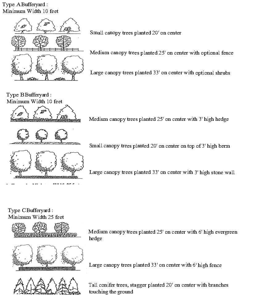
(Ord. No. 14982, § 1, 6-18-2012; Ord. No. 15434, §§ 1, 2, 3, 9-21-2015)
Sec. 35-60. - Traffic impact analysis.
A.
Purpose. Traffic impact analysis (TIAs) are specialized studies of the transportation needs and traffic impacts of a development. A TIA is specifically concerned with site traffic generation, directional distribution and assignment of site traffic onto available or future streets, public safety requirements and the determination of transportation needs of the site and surrounding street system. In all cases, access plans for a development must be integrated with access to adjacent developments, and must consider the impacts of other developments that are under construction, have received land use approvals or have submitted applications.
B.
Applicability. An applicant or developer shall submit a traffic impact analysis for the following types of developments unless specifically waived by the Director:
1.
All developments expected to generate more than 100 new peak-hour vehicle trips on the adjacent street, except that residential developments with fewer than 75 single-family lots or 50 two-family units shall not be required to submit a TIA.
2.
A development which will change the site traffic generation by more than 15 percent, where at least 100 new peak-hour trips are involved;
3.
Necessary development agreements to determine "fair share" contributions to major roadway improvements.
C.
Traffic impact analysis report content. The TIA shall be performed under the supervision of a registered, professional engineer qualified and experienced in transportation engineering. The TIA shall follow standard transportation engineering practices and methods and shall include the following minimum information:
1.
Analysis of existing conditions and issues;
2.
Analysis of forecasted traffic conditions. Trip generation and pass-by trip estimates for proposed developments may be obtained from the Institute of Transportation Engineers, Trip Generation (6th edition, 1997) or the most recent edition.
3.
Analysis of alternatives where appropriate;
4.
Findings, conclusions, and recommendations.