
Johnson City City Zoning Code
ARTICLE VI
USE REQUIREMENTS BY DISTRICT
6.1 - R-1 LOW DENSITY RESIDENTIAL DISTRICT
6.1.1
PERMITTED USES:
Within the R-1 Low Density Residential District the following uses are permitted:
6.1.1.1
Single-family residences;
6.1.1.2
Customary general farming, but not the raising of farm animals or poultry;
6.1.1.3
Public utility stations, provided all lot area requirements of the district in which they are located are met;
6.1.1.4
Municipal, county, state, or federal buildings or land uses;
6.1.1.5
Group homes for eight or fewer unrelated mentally retarded, mentally handicapped, or physically handicapped residents, which may include two additional persons, approved by the licensing agency to act as house parents or guardians, and who need not be related, provided that:
A.
Prior to admission to the facility, all resident applicants are screened by the appropriate sponsoring agency, such as Watauga Mental Health Center or Dawn of Hope, in order to exclude violence-prone or other potentially dangerous persons;
B.
The facility is fully licensed/certified by the appropriate overseeing state agency (e.g. the State Department of Mental Health and Mental Retardation);
C.
The facility is operated as a residential home only and does not include teaching or training activities for non-residents; and
D.
The facility is located not closer than 1,320 feet to any other group home or temporary shelter.
6.1.1.6.
Family child care homes and group child care homes, as defined, established to offer instruction to persons of pre-school, elementary, and secondary school age, provided:
A.
The facility meets all requirements imposed by the state licensing board, including, but not limited to, maximum allowable enrollment, adequate play and work space, and noise and safety controls.
B.
Hours of operation are permitted between 6:00 a.m. and 7:00 p.m.
C.
With the exception of driveways, parking is prohibited in the front yard.
6.1.2
USES PERMITTED BY APPROVAL AS SPECIAL EXCEPTIONS:
The following uses are permitted when approved by the Board of Zoning Appeals as Special Exceptions as provided by Section 15.4:
6.1.2.1
Schools offering general education, churches with parish houses, and Sunday school buildings, provided:
A.
They are located on an arterial or collector street; and
B.
The buildings are placed not less than 30 feet from side property lines.
6.1.2.2
Alternative tower structures.
6.1.3
AREA REGULATIONS:
All buildings and uses, unless otherwise specified in this Code, shall comply with the following setback, coverage, and area requirements:
6.1.3.1
Minimum Lot Size:
A.
Minimum lot size shall be 21,780 square feet.
B.
Minimum lot width shall be 100 feet at the front building line.
6.1.3.2
Yard Area:
A.
Front Yard: Minimum front yard setback shall be as follows:
B.
Side Yards: Minimum side yard setback shall be 15 feet for a one-story building, 20 feet for a two-story building, and 25 feet for a three-story building.
C.
Rear Yard: Minimum rear yard setback shall be 30 feet.
6.1.4
MAXIMUM LOT COVERAGE:
The principal building and all accessory buildings shall cover not more than 30 percent of the total lot area.
6.1.5
HEIGHT REGULATIONS:
Principal buildings shall not exceed the height of 35 feet.
6.1.6
SIDEWALK REQUIREMENT:
Sidewalks shall be required along the public street frontages of churches, day-care centers, government buildings, public utility stations, and schools in accordance with Article IX, Sidewalk Regulations, and The Standards of Design for Streets and Drainage.
(Ord. No. 4738-20, § 1(Exh. A), 7-2-2020; Ord. No. 4757-20, § 1(Exh. A), 3-4-2021)
6.2 - R-2 LOW DENSITY RESIDENTIAL DISTRICT
6.2.1
PERMITTED USES:
Within the R-2 Low Density Residential District the following uses are permitted:
6.2.1.1
All uses permitted in the R-1 Low Density Residential District provided all other R-2 requirements are observed;
6.2.1.2
Publicly owned recreational facilities and grounds;
6.2.1.3
Cemeteries; and
6.2.1.4
Local or counsel headquarters of national, nonprofit organizations providing for the education, attainment of high morals, good citizenship, and character of young men and women from the ages of nine to 16 years inclusive provided:
A.
The buildings are placed no less than 50 feet from the side property lines;
B.
The lot area contains no less than 50,000 square feet; and
C.
No external evidence of such use of the property other than a sign attached to the principal building, not more than two square feet in area.
6.2.2
USES PERMITTED BY APPROVAL AS SPECIAL EXCEPTION:
The following uses are permitted when approved by the Board of Zoning Appeals as Special Exceptions as provided by Section 15.4:
6.2.2.1
All special exceptions permitted in the R-1 Low Density Residential District.
6.2.2.2
Swimming clubs, tennis clubs, and similar recreational facilities, provided:
A.
They are owned and operated by private clubs organized as nonprofit associations, whether incorporated or not, conducting noncommercial recreational activities for the exclusive use of club members and their guests;
B.
Community recreational facilities must be located on an arterial or collector street as designated on the city's Zoning Map and have a minimum lot size of ten acres. A neighborhood recreational facility may be located on a minor street and must have a minimum lot size of one-half acre. Membership to the neighborhood facility will be limited to families residing in the subdivision or a designated neighborhood and shall not exceed 200 memberships;
C.
All buildings, machinery, and equipment shall meet the minimum setback requirements of the district in which the facility is located;
D.
The sale of merchandise, excluding refreshments to be consumed on the premises by members and their guests, shall be prohibited;
E.
One identification sign, with an area not to exceed 12 square feet, shall be permitted;
F.
Noise and glare shall be minimized. Outdoor loud speakers, juke boxes, public address systems, electric amplifiers, and similar electronic devices shall not be permitted; and
G.
Neighborhood recreational facilities shall have no parking requirements.
6.2.2.3
Golf courses provided:
A.
Minimum size for a par three golf course shall be 20 acres; for an executive golf course, 50 acres; and for a regulation golf course, 120 acres;
B.
Location shall be on a collector or arterial street with direct access provided by such street unless waived by the Board of Zoning Appeals as a result of conditions unique to the site;
C.
A generalized site plan drawn to a scale of not less than one inch equals 100 feet shall be submitted depicting the following: the identification of existing and/or planned uses surrounding the site; the location and size of all holes (including tees and greens); proposed driveways; off-street parking areas; accessory uses including clubhouse, pro-shop, snack bar, maintenance and storage buildings or similar uses; putting greens; driving ranges; walkways; landscaping; screening; fencing; and buffering;
D.
Orientation of driving tees shall direct golf balls away from any abutting streets and residences, or suitable screens or netting shall be required;
E.
Driving ranges and night lighting shall not be permitted on par three golf courses and allowed only at the discretion of the BZA on executive and regulation golf courses; and
F.
Any additional requirements to ensure the protection of the surrounding neighborhood.
6.2.3
AREA REGULATIONS:
All buildings and uses, unless otherwise specified in this Code, shall comply with the following setback, coverage, and area requirements:
6.2.3.1
Minimum lot size:
A.
Minimum lot size shall be 15,000 square feet.
B.
Minimum lot width shall be 90 feet at the front building line.
6.2.3.2
Yard area:
A.
Front yard: Minimum front yard setback shall be 25 feet on an arterial or collector street and 20 feet on all other streets. Front-facing garages shall have a minimum setback of 25 feet on all streets.
B.
Side yard: Minimum side yard setback shall be ten feet.
C.
Rear yard: Minimum rear yard setback shall be 30 feet.
6.2.4
MAXIMUM LOT COVERAGE:
The principal building shall cover not more than 30 percent of the total lot area.
6.2.5
HEIGHT REGULATIONS:
Principal buildings shall not exceed the height of 35 feet.
6.2.6
SIDEWALK REQUIREMENT:
Sidewalks shall be required for all uses required in R-1, Subsection 6.1.6, and for headquarters of non-profit organizations (youth), recreational clubs, and public owned recreation facilities and grounds along their public street frontages in accordance with Article IX, Sidewalk Regulations, and The Standards of Design for Streets and Drainage.
(Ord. No. 4738-20, § 1(Exh. A), 7-2-2020; Ord. No. 4757-20, § 1(Exh. A), 3-4-2021)
6.3 - R-2A LOW DENSITY RESIDENTIAL DISTRICT
6.3.1
PERMITTED USES:
Within the R-2A Low Density Residential District the following uses are permitted:
6.3.1.1
All uses permitted in the R-2 Low Density Residential District provided all other R-2A requirements are observed.
6.3.2
USES PERMITTED BY APPROVAL AS SPECIAL EXCEPTION:
The following uses are permitted when approved by the Board of Zoning Appeals as Special Exceptions as provided by Section 15.4:
6.3.2.1
All Special Exceptions permitted in the R-2 Low Density Residential District.
6.3.3
AREA REGULATIONS:
All buildings and uses, unless otherwise specified in this Code, shall comply with the following setback, coverage, and area requirements:
6.3.3.1
Minimum Lot Size:
A.
Minimum lot size shall be 12,000 square feet.
B.
Minimum lot width shall be 80 feet at the front building line.
6.3.3.2
Yard Area:
A.
Front Yard: Minimum front yard setback shall be 25 feet on an arterial or collector street and 20 feet on all other streets. Front-facing garages shall have a minimum setback of 25 feet on all streets.
B.
Side Yard: Minimum side yard setback shall be ten feet.
C.
Rear Yard: Minimum rear yard setback shall be 30 feet.
6.3.4
MAXIMUM LOT COVERAGE:
The principal building shall cover not more than 30 percent of the total lot area.
6.3.5
HEIGHT REGULATIONS:
Principal buildings shall not exceed the height of 35 feet.
6.3.6
SIDEWALK REQUIREMENT:
Sidewalks shall be required for all uses required in R-2, Subsection 6.2.6, along their public street frontages in accordance with Article IX, Sidewalk Regulations, and The Standards of Design for Streets and Drainage.
(Ord. No. 4738-20, § 1(Exh. A), 7-2-2020)
6.4 - R-2B LOW DENSITY RESIDENTIAL DISTRICT
6.4.1
PERMITTED USES:
Within the R-2B Low Density Residential District the following uses are permitted:
6.4.1.1
All uses permitted in the R-2A Low Density Residential District provided all other R-2B requirements are observed.
6.4.2
USES PERMITTED BY APPROVAL AS SPECIAL EXCEPTION:
The following uses are permitted when approved by the Board of Zoning Appeals as Special Exceptions as provided by Section 15.4:
6.4.2.1
All Special Exceptions permitted in R-2A Low Density Residential Districts.
6.4.3
AREA REGULATIONS:
All buildings and uses, unless otherwise specified in this Code, shall comply with the following setback, coverage, and area requirements:
6.4.3.1
Minimum Lot Size:
A.
Minimum lot size shall be 9,000 square feet.
B.
Minimum lot width shall be 75 feet at the front building line.
6.4.3.2
Yard Area:
A.
Front Yard: Minimum front yard setback shall be 25 feet on an arterial or collector street and 20 feet on all other streets. Front-facing garages shall have a minimum setback of 25 feet on all streets.
B.
Side Yard: Minimum side yard setback shall be eight feet.
C.
Rear Yard: Minimum rear yard setback shall be 30 feet.
6.4.4
MAXIMUM LOT COVERAGE:
The principal building shall cover not more than 35 percent of the total lot area.
6.4.5
HEIGHT REGULATIONS:
Principal buildings shall not exceed the height of 35 feet.
6.4.6
SIDEWALK REQUIREMENT:
Sidewalks shall be required for all uses required in R-2, Subsection 6.2.6, along their public street frontages in accordance with Article IX, Sidewalk Regulations, and The Standards of Design for Streets and Drainage.
(Ord. No. 4738-20, § 1(Exh. A), 7-2-2020)
6.5 - R-2C LOW DENSITY RESIDENTIAL DISTRICT
6.5.1
PERMITTED USES:
Within the R-2C Low Density Residential District the following uses are permitted:
6.5.1.1
All uses permitted in the R-2B Low Density Residential District provided all other R-2C requirements are observed.
6.5.2
USES PERMITTED BY APPROVAL AS SPECIAL EXCEPTION:
The following uses are permitted when approved by the Board of Zoning Appeals as Special Exceptions as provided by Section 15.4:
6.5.2.1
All Special Exceptions permitted in the R-2B Low Density Residential District.
6.5.3
AREA REGULATIONS:
All buildings and uses, unless otherwise specified in this Code, shall comply with the following setback, coverage, and area requirements:
6.5.3.1
Minimum Lot Size:
A.
Minimum lot size shall be 6,000 square feet.
B.
Minimum lot width shall be 60 feet at the front building line.
6.5.3.2
Yard Area:
A.
Front Yard: Minimum front yard setback shall be 25 feet on an arterial or collector street and 20 feet on all other streets. Front-facing garages shall have a minimum setback of 25 feet on all streets.
B.
Side Yard: Minimum side yard setback shall be eight feet.
C.
Rear Yard: Minimum rear yard setback shall be 25 feet.
6.5.4
MAXIMUM LOT COVERAGE:
The principal building shall cover not more than 40 percent of the total lot area.
6.5.5
HEIGHT REGULATIONS:
Principal buildings shall not exceed the height of 35 feet.
6.5.6
SIDEWALK REQUIREMENT:
Sidewalks shall be required for all uses required in R-2, Subsection 6.2.6, along their public street frontages in accordance with Article IX, Sidewalk Regulations, and The Standards of Design for Streets and Drainage.
(Ord. No. 4738-20, § 1(Exh. A), 7-2-2020)
6.6 - R-3 MEDIUM DENSITY RESIDENTIAL DISTRICT
6.6.1
PERMITTED USES:
Within the R-3 Medium Density Residential District the following uses are permitted:
6.6.1.1
All uses permitted in the R-2C, Low Density Residential District, provided all other R-3 requirements are observed;
6.6.1.2
Two-family and multi-family dwellings;
6.6.1.3
Boarding or rooming houses;
6.6.1.4
Churches with parish houses and Sunday school buildings, provided all buildings have a minimum side yard setback of 25 feet;
6.6.1.5
Group homes for ten or fewer unrelated mentally retarded, mentally handicapped, or physically handicapped residents, which may include two additional persons, approved by the licensing agency to act as houseparents or guardians, and who need not be related, provided:
A.
Prior to admission to the facility, all resident applicants are screened by the appropriate sponsoring agency, such as Watauga Mental Health Center or Dawn of Hope, in order to exclude violence-prone or other potentially dangerous persons;
B.
The facility is fully licensed/certified by the appropriate overseeing state agency (e.g. the State Department of Mental Health and Mental Retardation);
C.
The facility is operated as a residential home only and does not include teaching or training activities for non-residents; and
D.
The facility is located not closer than 1,320 feet to any other group home or temporary shelter.
6.6.1.6
Residential homes for the aged, provided:
A.
Such a home shall be licensed and shall meet all requirements of the minimum standards and regulations of nursing homes except nursing services by a professional nurse;
B.
Such a home shall meet all building and fire safety codes as required by the State of Tennessee Department of Public Health; and
C.
Density shall be based on bedrooms per acre and shall be calculated as two times the number of dwelling units allowed in the zoning district. In the R-3 district, maximum allowable density shall be 14 bedrooms per acre.
6.6.1.7
Emergency or temporary shelters, provided:
A.
The shelter houses no more than eight persons for no more than 30 days per person. Length of stay may be extended when extenuating circumstances can be shown to the Shelter Director;
B.
Prior to admission to the facility, all shelter applicants are screened by the appropriate sponsoring agency, in order to exclude violence-prone or other potentially dangerous persons;
C.
The facility meets the "Shelter Service and Performance Standards" as recognized by the State Department of Human Services; and
D.
The facility is located no closer than 1,320 feet to any other temporary shelter or group home as defined in Article II.
6.6.1.8
Adult day-care centers, provided:
A.
The facility has a maximum allowable enrollment of 30 people and adequate work space (25 square feet per person);
B.
Parking shall not be permitted in the required front yard;
C.
For emergency purposes, including ambulances, emergency vehicles, and fire vehicles, the facility shall be located on an arterial or collector street, or a minor street provided it is not a cul-de-sac and the street has a minimum right-of-way width of 50 feet with a minimum paved width of 29 feet, including curbs; and
D.
A paved driveway for the off-street loading and unloading of handicapped persons provides a separate entrance and exit to and from the property from an arterial or collector street without backing into the street.
6.6.1.9
Bed-and-breakfast homes, provided:
A.
There shall be no more than six registered guests at one time and a current guest register shall be kept by the owner;
B.
Parking shall be located at the rear or side of the building;
C.
There shall be no more than one bed-and-breakfast home located within 1,500 feet (determined by a straight line and not street distance) of the establishment;
D.
All necessary state and city permits, certifications, or requirements shall be obtained as a condition of approval of a bed-and-breakfast home service; and
E.
No exterior alterations, other than those necessary to assure safety of the structure, shall be made to any building for the purpose of providing bed-and-breakfast.
6.6.1.10
Mortuary establishments provided:
A.
Primary access shall be from a collector or arterial street;
B.
Minimum lot size shall be three acres;
C.
A Type 2 buffer shall be required along all property lines that abut R-1 through R-6 zoning districts;
D.
A ground-mounted sign with a maximum of 32 square feet shall be allowed for each street granting access. If two or more individual signs are allowed due to multiple street frontage, they may be substituted for one ground-mounted sign with a maximum size of 64 square feet; and
E.
A site plan shall be approved by the Planning Commission; said plan shall contain the following:
1.
Location, size, and height of all proposed structures;
2.
A traffic circulation plan including the location of all parking areas, driveways, and points of ingress and egress;
3.
Location, extent, and composition of all proposed buffering; and
4.
Other information as required by the Planning Commission.
F.
Minimum front yard setback shall be 25 feet, side yard setback shall be 25 feet except where said side yard abuts a residential district in which case said side yard shall be 50 feet; and rear yard setback shall be 50 feet.
6.6.2
USES PERMITTED BY APPROVAL AS SPECIAL EXCEPTION:
The following uses are permitted when approved by the Board of Zoning Appeals as Special Exceptions as provided by Section 15.4:
6.6.2.1
All Special Exceptions permitted in the R-2C Low Density Residential District;
6.6.2.2
Libraries, museums, art galleries and other cultural facilities, offices and facilities of non-profit and civic organizations, and social service organizations provided:
A.
The use shall be located in a discontinued school or similar public building;
B.
Pick-up and delivery of goods shall be restricted to access only from a collector or arterial street and only between the hours of 7:00 a.m. and 7:00 p.m.;
C.
Parking and loading docks shall be located at the rear or side of the building and not be visible from any public right-of-way (excluding alleys) or residential property;
D.
No exterior alterations, other than those necessary to assure the safety of the structure, shall be made to any building; and
E.
No exterior storage shall be permitted.
6.6.2.3
Alternative tower structures.
6.6.3
AREA REGULATIONS:
All buildings and uses, unless otherwise specified in this Code, shall comply with the following setback, coverage, and area requirements:
6.6.3.1
Minimum Lot Size:
A.
Minimum lot size shall be 9,000 square feet.
B.
Minimum lot width shall be 75 feet at the front building line.
6.6.3.2
Density: Maximum density shall be seven dwelling units per acre.
6.6.3.3
Yard Area:
A.
Front Yard: Minimum front yard setback shall be 25 feet on an arterial or collector street and 20 feet on all other streets. Front-facing garages shall have a minimum setback of 25 feet on all streets.
B.
Side Yard: Minimum side yard setback shall be eight feet.
C.
Rear Yard: Minimum rear yard setback shall be 30 feet.
6.6.4
MAXIMUM LOT COVERAGE:
The principal building shall cover not more than 35 percent of the total lot area.
6.6.5
HEIGHT REGULATIONS:
Principal buildings shall not exceed the height of 35 feet.
6.6.6
SIDEWALK REQUIREMENT:
Sidewalks shall be required for all uses required in R-2, Subsection 6.2.6, and for adult day-care centers and multi-family developments along their public street frontages in accordance with Article IX, Sidewalk Regulations, and The Standards of Design for Streets and Drainage.
6.6.7
CONCEPT PLAN REQUIRED:
Each application for a rezoning request shall be accompanied by five sets of a concept plan as described in Article XIV, Subsection 14.3.1. The review and approval process for such concept plan shall be as described in Subsection 14.3.2.
(Ord. No. 4738-20, § 1(Exh. A), 7-2-2020)
6.7 - R-4 MEDIUM DENSITY RESIDENTIAL DISTRICT
6.7.1
PERMITTED USES:
Within the R-4 Medium Density Residential District the following uses are permitted:
6.7.1.1
All uses permitted in the R-3 Medium Density Residential District provided all other R-4 requirements are observed.
6.7.1.2.
Child care centers and drop-in child care centers, as defined, provided:
A.
The facility meets all requirements imposed by the state licensing board, including, but not limited to, maximum allowable enrollment, adequate play and work space, and noise and safety controls; and
B.
A paved driveway for the off-street loading and unloading of children such that all movement to and from the property is in a forward direction.
6.7.2
USES PERMITTED BY APPROVAL AS SPECIAL EXCEPTION:
The following uses are permitted when approved by the Board of Zoning Appeals as Special Exceptions as provided by Section 15.4:
6.7.2.1
All Special Exceptions permitted in the R-3 Medium Density Residential District;
6.7.2.2
Golf courses provided:
A.
The golf course consists of a minimum of ten acres open space;
B.
The property was previously used for a golf course within the last five years, and such use was found then to be a satisfactory and compatible use, and is considered to still be satisfactory and compatible by review by the Board of Zoning Appeals;
C.
The golf course is located on an arterial or collector street, and all access to the golf course, including its parking areas, club house, etc. is gained from the designated arterial or collector;
D.
The clubhouse, parking, and any accessory buildings are no closer than 50 feet to any property line;
E.
The sale of merchandise is limited to an enclosed area no larger than 400 square feet, and this use shall be clearly incidental to the golf course use;
F.
The sale of food is restricted to the club house, is limited to no more than 400 square feet, and is clearly incidental to the golf course function;
G.
One sign shall be permitted and shall be oriented to the street giving access to the property. The size, setbacks, and any lighting restrictions shall be the same as for other nonresidential uses permitted within the applicable zone; and
H.
Noise and glare are to be minimized as follows: loud speakers, juke boxes, public address systems, electric amplifiers, and similar electronic devices shall not be permitted.
6.7.2.3
Restaurants, museums, or art galleries provided:
A.
The structure was constructed prior to 1864;
B.
The use shall be allowed only in structures that are recognized as architecturally, historically, or culturally significant and that, through renovation and use as a restaurant, museum, or art gallery, will contribute significantly to the ambiance, character, or economic revitalization of the neighborhood. In demonstrating compliance with this condition, the petitioner shall provide a brief history of the residence that illustrates its architectural, historical, or cultural significance;
C.
The structure shall be located on an arterial or collector street;
D.
The structure shall be adjacent to a nonresidential zoning district;
E.
No exterior alterations, other than those necessary to assure safety of the structure or are consistent with the architectural, historical, or cultural significance of the structure shall be permitted;
F.
Parking shall be located at the rear or side of the building and not be visible from any public right-of-way (excluding alleys) or adjacent residential property; and
G.
Noise is to be minimized. Outdoor loudspeakers, public address systems, and similar electronic devices shall not be permitted.
6.7.2.4
Bed-and-breakfast inns, provided:
A.
There shall be no more than 12 registered adult guests at one time and a current guest register must be kept by the owner (or manager);
B.
The owner (or manager) must reside on the premises;
C.
Parking shall not be visible from any public right-of-way (excluding alleys) or adjacent property;
D.
All necessary state and city permits, certifications, or requirements be obtained as a condition of a bed-and-breakfast inn service;
E.
No exterior alterations, other than those necessary to assure safety of the structure, shall be made to any building for the purpose of providing bed-and-breakfast;
F.
No bed-and-breakfast inn may be located within 1,500 feet (determined by a straight line and not street distance) of another;
G.
The structure shall be located on an arterial or collector street; and
H.
The property shall be a minimum lot size of one acre.
6.7.3
AREA REGULATIONS:
All buildings and uses, unless otherwise specified in this Code, shall comply with the following setback, coverage, and area requirements:
6.7.3.1
Minimum Lot Size:
A.
Minimum lot size shall be 7,000 square feet; and
B.
Minimum lot width shall be 50 feet.
6.7.3.2
Density: Maximum density shall be 14 dwelling units per acre.
6.7.3.3
Yard Area:
A.
Front Yard: Minimum front yard setback shall be 25 feet on an arterial or collector street and 20 feet on all other streets. Front-facing garages shall have a minimum setback of 25 feet on all streets.
B.
Side Yard: Minimum side yard setback shall be eight feet.
C.
Rear Yard: Minimum rear yard setback shall be 30 feet.
6.7.4
MAXIMUM LOT COVERAGE:
The principal building shall cover not more than 35 percent of the total lot area.
6.7.5
HEIGHT REGULATIONS:
Principal buildings shall not exceed the height of 35 feet.
6.7.6
SIDEWALK REQUIREMENT:
Sidewalks shall be required for all uses required in R-3, Subsection 6.6.6, and for dance schools, golf courses, and multi-family developments along their public street frontages in accordance with Article XI, Sidewalk Regulations, and The Standards of Design for Streets and Drainage.
6.7.7
CONCEPT PLAN REQUIRED:
Each application for a rezoning request shall be accompanied by five sets of a concept plan as described in Article XIV, Subsection 14.3.1. The review and approval process for such concept plan shall be as described in Subsection 14.3.2.
(Ord. No. 4738-20, § 1(Exh. A), 7-2-2020; Ord. No. 4757-20, § 1(Exh. A), 3-4-2021)
6.8 - R-5 HIGH DENSITY RESIDENTIAL DISTRICT
6.8.1
PERMITTED USES:
Within the R-5 High Density Residential District the following uses are permitted:
6.8.1.1
All uses permitted in the R-4 Medium Density Residential District provided all other R-5 requirements are observed;
6.8.1.2
Schools, public and private, offering general education, provided:
A.
They are located on an arterial or collector street; and
B.
The buildings are placed not less than 50 feet from the side property lines.
6.8.1.3
Swimming clubs, provided:
A.
They are owned and operated by private clubs organized as non-profit associations, whether incorporated or not, conducting noncommercial recreational swimming activities and other related recreational activities for the exclusive use of club members and their guests;
B.
The minimum lot area is two acres with the total lot area to be calculated on the basis of one acre for each 100 families in the membership of the club or organization;
C.
They are located on arterial or collector streets as the same are designated on the Official Zoning Map of the city of Johnson City;
D.
No recreational activity takes place nor any building, machinery, or equipment is located within 50 feet of any side, front, or rear property lines;
E.
The sale of merchandise, excluding refreshments to be consumed on the premises by members and their guests, shall be prohibited;
F.
One identification sign, with an area not to exceed 12 square feet, erected flat against a fence or the front or side of the building shall be permitted. Lighting of such sign shall be prohibited; and
G.
Noise and glare are to be minimized. Outdoor loud speakers, juke boxes, public address systems, electric amplifiers, and similar electronic devices shall not be permitted.
6.8.1.4
Emergency or temporary shelters, provided:
A.
The shelter houses no more than 15 persons for no more than 30 days per person. Length of stay may be extended when extenuating circumstances can be shown by the Shelter Director; and
B.
All applicable conditions for approval listed in Subsection 6.6.1.7 are met.
6.8.2
USES PERMITTED BY APPROVAL AS SPECIAL EXCEPTION:
The following uses are permitted when approved by the Board of Zoning Appeals as Special Exceptions as provided by Section 15.4:
6.8.2.1
Nursing homes, provided:
A.
They are located on an arterial or collector street; and
B.
The buildings are placed not less than 50 feet from side property lines.
6.8.2.2
Golf courses, subject to the provisions of Subsection 6.7.2.3.
6.8.2.3
Group homes for 11 to 15 unrelated mentally retarded, mentally handicapped, or physically handicapped residents, provided:
A.
Supervisor(s) or houseparents(s), certified by the appropriate overseeing agency (e.g. the State Department of Mental Health and Mental Retardation), be on-premise at all times;
B.
Prior to admission to the facility, all resident applications are screened by the appropriate sponsoring agency, such as Watauga Mental Health Center or Dawn of Hope, in order to exclude violence-prone or other potentially dangerous persons;
C.
The facility is fully licensed by the appropriate overseeing state agency; and
D.
The facility is located not closer than 1,320 feet to any group home or temporary shelter.
6.8.2.4
Alternative tower structures.
6.8.3
AREA REGULATIONS:
All buildings and uses, unless otherwise specified in this Code, shall comply with the following setback, coverage, and area requirements:
6.8.3.1
Minimum Lot Size:
A.
Minimum lot size shall be 6,000 square feet.
B.
Minimum lot width shall be 50 feet at the front building line.
6.8.3.2
Density: Maximum density shall be 22 dwelling units per acre.
6.8.3.3
Yard Area:
A.
Front Yard: Minimum front yard setback shall be 25 feet on an arterial or collector street and 20 feet on all other streets. Front-facing garages shall have a minimum setback of 25 feet on all streets.
B.
Side Yard: Minimum side yard setback shall be eight feet.
C.
Rear Yard: Minimum rear yard setback shall be 30 feet.
6.8.4
MAXIMUM LOT COVERAGE:
The principal building shall cover not more than 35 percent of the total lot area.
6.8.5
HEIGHT REGULATIONS:
Principal buildings shall not exceed the height of 65 feet.
6.8.6
SIDEWALK REQUIREMENT:
Sidewalks shall be required for all uses required in R-4, Subsection 6.7.6, and for swimming clubs and multi-family developments along their public street frontages in accordance with Article XI, Sidewalk Regulations, and The Standards of Design for Streets and Drainage.
6.8.7
CONCEPT PLAN REQUIRED:
Each application for a rezoning request shall be accompanied by five sets of a concept plan as described in Article XIV, Subsection 14.3.1. The review and approval process for such concept plan shall be as described in Subsection 14.3.2.
(Ord. No. 4738-20, § 1(Exh. A), 7-2-2020; Ord. No. 4757-20, § 1(Exh. A), 3-4-2021)
6.9 - R-6 HIGH DENSITY RESIDENTIAL-UNIVERSITY DISTRICT
6.9.1
PERMITTED USES:
Within the R-6 High Density Residential-University District the following uses are permitted:
6.9.1.1
All uses permitted in the R-5 High Density Residential District provided all other R-6 requirements are observed; and
6.9.1.2
Fraternity and sorority houses.
6.9.2
USES PERMITTED BY APPROVAL AS SPECIAL EXCEPTION:
The following uses are permitted when approved by the Board of Zoning Appeals as Special Exceptions as provided by Section 15.4.
6.9.2.1
All Special Exceptions permitted in the R-5 High Density Residential District; and
6.9.2.2
Student activity centers, provided:
A.
Minimum side yard setbacks shall be 50 feet; and
B.
No living quarters are provided, except for not more than two persons employed as custodians.
6.9.3
AREA REGULATIONS:
All buildings and uses, unless otherwise specified in this Code, shall comply with the following setback, coverage and area requirements:
6.9.3.1
Minimum Lot Size:
A.
Minimum lot size shall be 6,000 square feet.
B.
Minimum lot width shall be 50 feet at the front building line.
6.9.3.2
Density: Maximum allowable density for residential uses shall be 25 dwelling units per acre. For multi-family units consisting of four or more bedrooms, maximum density shall be 18.75 dwelling units per acre. (See also Article II (Family) and Subsection 11.3.3.7).
6.9.3.3
Yard Area:
A.
Front Yard: Minimum front yard setback shall be 25 feet on an arterial or collector street and 20 feet on all other streets. Front-facing garages shall have a minimum setback of 25 feet on all streets.
B.
Side Yard: Minimum side yard setback shall be eight feet.
C.
Rear Yard: Minimum rear yard setback shall be 30 feet.
6.9.4
MAXIMUM LOT COVERAGE:
The principal building shall cover not more than 35 percent of the total lot area.
6.9.5
HEIGHT REGULATIONS:
Principal buildings shall not exceed the height of 65 feet.
6.9.6
SIDEWALK REQUIREMENT:
Sidewalks shall be required for all uses required in R-5, Subsection 6.8.6, student activity centers, and multi-family residential developments along their public street frontages in accordance with Article XI, Sidewalk Regulations, and The Standards of Design for Streets and Drainage.
6.9.7
CONCEPT PLAN REQUIRED:
Each application for a rezoning request shall be accompanied by five sets of a concept plan as described in Article XIV, Subsection 14.3.1. The review and approval process for such concept plan shall be as described in Subsection 14.3.2.
(Ord. No. 4738-20, § 1(Exh. A), 7-2-2020)
6.10 - RP-2, RP-3, RP-4, AND RP-5 PLANNED RESIDENTIAL DISTRICTS
6.10.1
GENERAL DESCRIPTION:
6.10.1.1
The regulations established in this section are intended to provide optional methods of land development which encourage more imaginative solutions to environmental design problems. Residential areas thus established would be characterized by a unified building and site development program, open space for recreation, and provision for commercial, religious, education, and cultural facilities which are integrated with the total project by unified architectural and open space treatment.
6.10.1.2
District regulations shall be as outlined in the following paragraphs and shall be the same for RP-2, RP-3, RP-4, and RP-5 districts except for the density permitted in each district.
6.10.1.3
Each planned residential development shall be compatible with the surrounding or adjacent districts. Such compatibility shall be determined by the Planning Commission and Board of Commissioners by review of a Concept Plan.
6.10.1.3.1
Any substantial deviation from the approved Concept Plan shall require approval by the Planning Commission and City Commission as an amended plan. A substantial deviation includes but is not limited to: (1) increase in the number of dwelling units; (2) change in the type and location of dwelling units that would impact adjoining property; (3) change in access to the proposed development that would negatively impact adjoining property; and (4) an increase, exceeding ten percent, in the amount of projected traffic resulting from the proposed development.
6.10.2
USES PERMITTED ON REVIEW:
All uses listed below shall be approved as part of the Concept Plan. Any change of use shall require approval of an amended Concept Plan.
6.10.2.1
Single-family, two-family, and multi-family dwellings;
6.10.2.2
Recreation uses including a community center, a golf course, a swimming pool, or parks, playground or other public or private recreational uses, and non-profit clubs such as country clubs, swimming and/or tennis clubs;
6.10.2.3
Public and semi-public uses which are designed to primarily serve the RP district.
6.10.2.4
Home occupations as defined in Subsection 6.1.1.7;
6.10.2.5
Private day nurseries and kindergartens, as regulated in Subsection 6.8.1.4;
6.10.2.6
Alternative tower structures;
6.10.2.7
Commercial Uses: In planned residential developments of 20 acres or more, commercial uses may be permitted which conform with permitted uses in the B-1 Neighborhood Business District—Article 6.14. Commercial uses shall further be governed by the following:
A.
No commercial facilities shall be permitted in developments of less than 200 dwelling units;
B.
One acre of land may be set aside for commercial development for each 200 dwelling units in the development plan. Commercial uses shall not be constructed until a minimum of 200 residential units have been constructed; and
C.
Commercial development shall be compatible, in scale with surrounding residential development as determined by the Planning Commission and Board of Commissioners.
6.10.3
AREA REGULATIONS:
All structures and uses shall meet the following requirements:
6.10.3.1
Minimum Lot Size:
A.
Minimum lot size for a detached single-family unit shall be 4,000 square feet and;
B.
Minimum lot width shall be 40 feet.
6.10.3.2
Yard Area:
A.
Front Yard. No front yard setback shall be required except for detached single-family residential structures. Minimum front yard setback shall be 25 feet on an arterial or collector street and ten feet on all other streets. Front-facing garages shall have a minimum setback of 25 feet on all streets.
B.
Side Yard. No side yard setback shall be required except for drainage and utility easements where necessary.
C.
Rear Yard. The rear yard setback on lots adjoining a non-RP District shall be the same as the setback of the adjacent yard in the non-RP District, provided the rear yard setback in the RP District shall not be required to be greater than 25 feet. All other lots not adjoining a non-RP District shall maintain a rear yard setback for drainage and utility easements where necessary.
6.10.3.3
Height Regulations. Principal buildings located in an RP-2 or RP-3 district shall not exceed the height of 35 feet. Principal buildings located in the RP-4 and RP-5 district shall not exceed the height of 35 feet on local streets and 65 feet on collector and arterial streets.
6.10.3.4
Open Space and Recreational Areas. Fifteen percent of the overall RP-zoned area shall be set aside and developed for common open space or recreational uses not including building setbacks and stormwater detention facilities, except as provided in Article XVII, Open Space, for detached single family residential developments. Said open space shall be designated as common area.
6.10.3.5
Sidewalk Requirement. Sidewalks shall be required for all residential uses, churches, schools, recreational facilities and grounds, libraries, museums, and historic monuments and sites, private day nurseries and kindergartens, and multi- family developments along their public street frontages in accordance with Article IX, Sidewalk Regulations, and The Standards of Design for Streets and Drainage.
6.10.4
UNIT DENSITY:
A.
For attached dwelling units i.e. duplexes, apartments, townhouses, and condominiums, the maximum density shall be as follows:
6.10.4.1
RP-2 DISTRICT: Maximum density shall be three and four-tenths dwelling units per acre.
6.10.4.2
RP-3 DISTRICT: Maximum density shall be eight and one-half dwelling units per acre.
6.10.4.3
RP-4 DISTRICT: Maximum density shall be 15.3 dwelling units per acre.
6.10.4.4
RP-5 DISTRICT: Maximum density shall be 27.2 dwelling units per acre.
B.
For detached single-family units, the maximum density shall be dictated by the minimum lot size of not less than 4,000 square feet per lot.
6.10.5
ADMINISTRATIVE PROCEDURE FOR A PLANNED RESIDENTIAL DEVELOPMENT:
6.10.5.1
Application shall be made to the Planning Commission for rezoning to RP-2, RP-3, RP-4, or RP-5 in accordance with the regulations set forth in Article XIV of this Code. The application shall be accompanied by a Concept Plan including the following information:
1.
Use(s) including the number and type of dwelling units;
2.
Buffers and/or screening;
3.
Approximate building location, size and height, with setbacks;
4.
Parking and driveway areas;
5.
Entrance and exit locations;
6.
Internal vehicular circulation pattern (if appropriate);
7.
Private streets must be indentified, if proposed;
8.
The location of the required 15 percent of open space; and
6.10.5.2
The Planning Commission shall review the proposed development and forward its recommendation to the Board of Commissioners which shall review and give final approval or reject the proposed plan.
6.10.5.3
A.
The Planning Commission shall review the conformity of the proposed development recognizing the objectives of the Comprehensive Plan and neighborhood compatibility;
B.
The Planning Commission and the Board of Commissioners may impose conditions regarding layout, circulation, and performance of the proposed development and may require that appropriate deed restrictions be filed;
C.
The proposed development must be designed to produce an environment of compatible and desirable character not out of harmony with its surrounding neighborhood and must provide standards of recreation and open space, transportation, and areas for parking adequate for the occupancy proposed; and
D.
A final plat of the development shall be recorded in the office of the appropriate county Registrar of Deeds and shall show property lines, common land, streets, easements, and other applicable features required by the Subdivision Regulations. Building permits may be issued prior to final subdivision approval. However, no certificate of occupancy will be issued prior to the recording of the final plat.
(Ord. No. 4738-20, § 1(Exh. A), 7-2-2020; Ord. No. 4839-23, § 2(Exh. B), 5-4-2023)
6.11 - RM-3, RM-4, AND RM-5 MANUFACTURED HOME PARK DISTRICTS
6.11.1
GENERAL DESCRIPTION:
6.11.1.1
The regulations established in this subsection are intended to provide optional methods of land development which encourage more imaginative solutions to environmental design problems. Manufactured home parks thus established would be characterized by a unified building and site development program.
6.11.1.2
District regulations shall be as outlined in the following paragraphs and shall be the same for RM-3, RM-4, and RM-5 districts except for the dwelling unit density permitted in each district.
6.11.1.3
Each manufactured home park shall be compatible with the surrounding or adjacent districts. Such compatibility shall be determined by the Planning Commission by review of development plans for the district. Any use considered on review shall be judged by the Planning Commission to be an integral and necessary function in the design of the manufactured home park.
6.11.2
GENERAL PROVISIONS:
6.11.2.1
The manufactured home park shall be located on a well-drained site, properly graded to insure rapid drainage and freedom from stagnant pools of water.
6.11.2.2
No building or structure erected or stationed in the park shall have a height greater than one story or 15 feet.
6.11.2.3
A manufactured home park shall be entirely enclosed, exclusive of driveways, at its external boundaries by an opaque wall not less than seven feet in height or an opaque buffer yard, as described in Section 12.4 in this code.
6.11.2.4
Each Manufactured Home Park shall be permitted a sign as described in Article VII, Sign Regulations.
6.11.2.5
Each manufactured home space shall be of sufficient size that, in addition to the manufactured home, the following areas shall be provided:
A.
Each manufactured home space shall be at least 30 feet wide and such space shall be clearly defined by permanent markers;
B.
There shall be a front yard setback of ten from all access roads within the manufactured home park;
C.
Manufactured homes shall be so harbored on each space so that there shall be at least a 20-foot clearance between manufactured homes, provided, however, with respect to manufactured homes parked end-to-end, the end-to-end clearance shall be not less than 12 feet. No manufactured home shall be located closer than 20 feet from any building within the manufactured home park;
D.
Parking spaces may be located in the rear or side yard of said manufactured home space; and
E.
Each manufactured home space shall be provided with a paved patio of at least 200 square feet and having a storage locker of at least 100 cubic feet. Storage lockers may be located in locker compounds.
6.11.2.6
Common Parking, Access Points, Access Roads, Trailer Spaces, and Walkways:
A.
Access roads within a manufactured home park shall be paved to a width of not less than 24 feet. Where access roads are paved to a width of 32 feet or more, the required guest parking area shall be waived;
B.
Manufactured home spaces may abut upon a driveway of not less than 20 feet in width, which shall have unobstructed access to the access road within the manufactured home park. The sole vehicular access shall not be by the alley, and all dead-end driveways shall include adequate vehicular turning space or a cul-de-sac;
C.
All access roads and driveways shall be constructed with a six-inch stone base and a two-inch layer of asphalt. Extruded concrete roll curbs, the face of which shall not be less than five and one-half inches high, shall be installed along the entire length of all such access roads;
D.
A minimum of six inches of compacted gravel or other suitable pavement material shall be installed for each manufactured home space. Size of pads shall be as follows:
1.
Five percent—10 feet x 40 feet or larger.
2.
Ninety percent—10 feet x 50 feet or larger.
3.
Five percent—10 feet x 60 feet or larger.
E.
Walkways not less than two feet wide shall be provided from the manufactured home spaces to service buildings.
6.11.2.7
Each manufactured home space shall be provided with a connection to a sanitary sewer line.
6.11.2.8
A park and recreation area with a minimum of 150 square feet for each manufactured home space shall be provided. Areas shall be consolidated into usable areas with minimum dimensions of not less than 30 feet.
6.11.2.9
Each manufactured home park shall be provided with a management office and service buildings as necessary to provide facilities for mail distribution, storage space for suppliers, maintenance materials and equipment, and laundry facilities. Outside laundry drying yards shall be enclosed with a six-foot high solid fence.
6.11.2.9.1
Trailers, with or without toilet facilities, that cannot be connected to a sanitary sewer line shall not be permitted in a manufactured home park.
6.11.2.10
Prohibited Uses:
A.
Cabanas and other similar enclosed structures are prohibited; and
B.
Manufactured homes shall not be used for commercial, industrial, or other non-residential uses within the manufactured home park.
6.11.2.11
Each manufactured home shall have a non-combustible, corrosive resistant skirt extending from the bottom of the manufactured home to the pad pavement. Said skirt shall be provided with an access way with a door measuring at least 18 inches by 24 inches; and the skirt shall be constructed to prohibit insect and rodent infestation.
6.11.3
AREA REGULATIONS:
All buildings and manufactured homes shall be set back from street right-of-way lines and the periphery of the project to comply with the following requirements:
6.11.3.1
No manufactured home park shall be established to occupy less than five acres nor contain less than 25 manufactured home spaces at the time of first occupancy. However, the park, upon completion, must be designed for a minimum of 50 manufactured home units.
6.11.3.2
The manufactured home park shall be subject to the density provisions of the district in which it is located, provided, however, there shall be not less than 3,000 square feet of lot area for each space provided on the site. This space ratio shall include access roads, automobile parking, accessory building space, and recreational area.
6.11.4
DENSITY:
With net area being calculated on the basis of total area less all access roads and driveways, common parking space and accessory building space.
6.11.4.1
RM-3 DISTRICT: Maximum density shall be four manufactured homes per net acre.
6.11.4.2
RM-4 DISTRICT: Maximum density shall be eight manufactured homes per net acre.
6.11.4.3
RM-5 DISTRICT: Maximum density shall be ten manufactured homes per net acre.
6.11.5
ADMINISTRATIVE PROCEDURE FOR MANUFACTURED HOME PARK DEVELOPMENT:
6.11.5.1
Application shall be made to the Planning Commission for rezoning to RM-3, RM-4, or RM-5 in accordance with the regulations set forth in Article XIV of this Code. Any application shall be accompanied by:
A.
A general site plan showing tentative street plans, public facilities, building arrangements, and manufactured home space locations.
B.
Preliminary sketches and specifications showing the proposed architectural design and type of construction.
6.11.5.2
Within one year after an area is rezoned RM-3, RM-4, or RM-5 there shall have been filed with the Planning Commission a written application for review and approval. Said application shall be accompanied by the following information:
A.
The application shall be accompanied by an overall development plan showing the use or uses, dimensions and locations of proposed streets, parks, playgrounds, school sites, and other open spaces, with such other pertinent information as may be necessary to determine the contemplated arrangement or use which makes it acceptable to develop a manufactured home park as proposed;
B.
Where several buildings are to be constructed, architectural sketches and data should be provided to insure an aesthetically-acceptable design for all buildings;
C.
At least the following construction plans must be submitted: profiles of proposed streets, sanitary sewers and storm water sewers with grading sizes and elevations indicated, proposed water distribution system showing pipe sizes, location of valves and fire hydrants, and complete grading plan; and
D.
The proposed development plan and all construction plans shall be prepared by and have the seal of an architect or engineer duly registered to practice in the State of Tennessee.
6.11.5.3
The Planning Commission shall review the proposed development and forward its recommendation to the Board of Commissioners which shall review and may, by resolution, give final approval or reject the proposed development:
A.
The Planning Commission shall review the conformity of the proposed development recognizing principles of civic design, land-use planning and landscape architecture. The final design must conform with the original application to the satisfaction of the Planning Commission.
B.
The Planning Commission and the Board of Commissioners may impose conditions regarding layout, circulation, and performance of the proposed development and may require that appropriate deed restrictions be filed.
C.
No building permit or zoning compliance permit shall be issued until a final plat of the proposed development is approved by the Board of Commissioners and recorded. No occupancy permit shall be issued until the Chief Building Official has determined that the project, as constructed, meets all the requirements of the approved plan. The tract or parcel of land involved must be either in one ownership or the subject of an application filed jointly by the owners of all the property.
D.
The proposed development must be designed to produce an environment of stable and desirable character not out of harmony with its surrounding neighborhood and must provide standards of open space and areas for parking adequate for the occupancy proposed. It must include provisions for recreation areas to meet the anticipated population.
E.
A plat of the development shall be recorded in the office of the appropriate county Registrar of Deeds and shall show building lines, common land, streets, easements, and other applicable features required by the Johnson City Regional Planning Commission's Subdivision Regulations for final subdivision plats, provided, however, that the approval of said plat does not constitute the approval of a subdivision within the meaning of the Subdivision Regulations.
6.11.5.4
Upon abandonment of a particular project authorized by this Section or upon the expiration of three years from the authorization hereunder of a manufactured home park which has not by then been completed (or commenced and an extension of time for completion granted), the authorization shall expire and the Planning Commission shall consider whether to extend the RM zoning, to rezone the property to the zoning district that existed prior to the current zoning, or to apply a different and more appropriate zoning classification. Should the Planning Commission extend the RM zoning, such extension shall be reviewed after one year.
6.11.5.5
Failure to file an application for review and approval of the Manufactured Home Park within one year of the RM-3, RM-4, and RM-5 zoning shall require review of the zoning by the Planning Commission as stipulated in Subsection 6.11.5.4.
6.11.6
MANUFACTURED HOME PARKS WHICH PROVIDE FOR THE SALE OF INDIVIDUAL LOTS:
Manufactured home park developments which are intended to provide for the sale of individual lots are authorized within the RM-3, RM-4, and RM-5 Zoning Districts provided the following regulations are satisfied:
6.11.6.1
General Requirements: The proposed development must satisfy the requirements set forth in Subsection 6.11.1 of this Zoning Code.
6.11.6.2
Preliminary Plan Requirements: Application for rezoning to RM-3, RM-4, or RM-5 shall include a Concept Plan which meets the requirements of the Subdivision Regulations, provided all manufactured home developments shall be served by a sanitary sewer system and all streets shall be public streets constructed in conformance with the Subdivision Regulations.
6.11.6.3
Final Plat Requirements: Within one year from the date of preliminary approval, unless an extension of time is applied for and approved by the Planning Commission, the developer shall submit to the Planning Commission a final plat which shall:
A.
Conform to the requirements of the Subdivision Regulations; and
B.
Contain certified copies of all deed restrictions, covenants, owner association agreements (if any), etc. which provide for the maintenance of any common use recreation or service facilities. Upon final approval by the Planning Commission and all necessary certifications, the original copy of the final plat shall be maintained by the Planning Commission with other subdivision plats. A copy of the approved final plat shall be provided to the developer for recording in the office of the County Registrar.
6.11.6.4
Area Requirements:
A.
A manufactured home park development which provides for the sale of individual lots shall occupy a site not less than five acres in area;
B.
The maximum density of the development shall conform to the requirements of Subsection 6.11.4. In no case shall a lot contain less than 3,000 square feet of area;
C.
Each manufactured home lot shall have a minimum of 30 feet frontage on a public street and a minimum lot width of 30 feet; and
D.
Each manufactured home lot shall contain a paved pad which is no smaller in width or length than the manufactured home to be placed on said pad. Each pad shall be no closer than ten feet to each side lot line and no closer than 30 feet to any public right-of-way. Rear yard setback shall be no less than six feet, except that all setbacks from the periphery of the manufactured home development shall be at least 30 feet.
6.11.7
SIDEWALK REQUIREMENT:
Sidewalks shall be required for all multi-family developments along their public street frontages in accordance with Article IX, Sidewalk Regulations, and The Standards of Design for Streets and Drainage.
6.12 - RO-1 HIGH DENSITY RESIDENTIAL-PROFESSIONAL OFFICE DISTRICT
6.12.1
PERMITTED USES:
Within the RO-1 High Density Residential-Professional Office District the following uses are permitted:
6.12.1.1
Single-family, two-family, and multi-family dwellings;
6.12.1.2
Adult day-care centers, dance schools, child care centers, and drop-in child care centers subject to the conditions of Subsection 6.7.1.2;
6.12.1.3
Churches, including parish houses and Sunday school buildings;
6.12.1.4
Fraternal organizations and clubs not operated for profit;
6.12.1.5
Student activity centers;
6.12.1.6
Public utility stations;
6.12.1.7
Municipal, county, state, or federal buildings or land uses;
6.12.1.8
Elementary and secondary schools, colleges, universities, and similar institutions, public or private with or without students in residence;
6.12.1.9
Fraternity or sorority houses;
6.12.1.10
Libraries, museums, and art galleries;
6.12.1.11
Clinics;
6.12.1.12
Office buildings: government and private office buildings, including professional offices. For the purposes of this Section, a permitted office building is defined as a building having not less than 50 percent of its total floor area occupied by medical, dental, governmental, private, or professional office uses;
6.12.1.13
Drug stores, located within a permitted office building as defined in Subsection 6.12.1.12;
6.12.1.14
Barber and beauty shops, located within a permitted office building as defined in Subsection 6.12.1.12;
6.12.1.15
Branch banks, located within a permitted office building as defined in Subsection 6.12.1.12;
6.12.1.16
Bed-and-breakfast inns, provided:
A.
There shall be no more than 12 registered adult guests at one time and a current guest register must be kept by the owner (or manager);
B.
The owner (or manager) must reside on the premises;
C.
Parking shall be located at the rear or side of the building and not be visible from any public right-of-way (excluding alleys) or adjacent property;
D.
All necessary state and city permits, certifications, or requirements be obtained as a condition of a bed-and-breakfast inn service; and
E.
No exterior alterations, other than those necessary to assure safety of the structure, shall be made to any building for the purpose of providing bed-and-breakfast.
6.12.1.17
Group homes, subject to the requirements of Subsection 6.6.1.5;
6.12.1.18
Residential homes for the aged, subject to the requirements of Subsection 6.6.1.6;
6.12.1.19
Emergency or temporary shelters, provided:
A.
The shelter houses no more than 25 persons for no more than 30 days per person. Length of stay may be extended when extenuating circumstances can be shown to the Shelter Director; and
B.
All other applicable conditions for approval listed in Subsection 6.6.1.7 are met.
6.12.1.20
Portrait studio, provided:
A.
The use shall be located on an arterial or collector street; and
B.
Off-street parking shall be provided in either the side or rear yard at one space per 300 square feet of floor area used in conjunction with the business; and
6.12.1.21
Professional Services.
6.12.2
USES PERMITTED BY APPROVAL AS SPECIAL EXCEPTION:
The following uses are permitted when approved by the Board of Zoning Appeals as Special Exceptions as provided by Section 15.4:
6.12.2.1
Restaurants, provided:
A.
Food is prepared to be consumed within the principal building only; and
B.
The restaurant is located within a permitted office building as defined in Subsection 6.12.1.12.
6.12.2.2
Mortuary establishments, provided such establishments will not cause undue traffic congestion or create a traffic hazard;
6.12.2.3
Hospitals for the treatment of human ailments, provided they are located on an arterial or collector street, on a street constructed to industrial or commercial standards, or where a portion of the property lies within 500 feet of an arterial or collector street;
6.12.2.4
Gasoline service stations, provided:
A.
Service stations principal and accessory buildings shall not be constructed closer than 40 feet to any side or rear lot line nor closer than 45 feet to any street right-of-way;
B.
Gasoline pump islands shall not be located closer than 30 feet to any street right-of-way line nor closer than 40 feet to any side or rear lot line which abuts an RO-1 or more restrictive zone but which does not abut a street right-of-way; and
C.
Canopies shall not be constructed closer than 30 feet from any street right-of-way. (Since the code states that variances may only be given when special conditions prevent the beneficial use of land, if a gasoline station may be constructed on a lot, the land has resulted in beneficial use; and, therefore, no waiver may be given permitting the canopy to extend closer than 30 feet to the street right-of-way.)
6.12.2.5
Golf courses, subject to the provisions of Subsection 6.7.2.3;
6.12.2.6
Group homes, subject to the requirements of Subsection 6.8.2.3;
6.12.2.7
Antique sales and home decorating service;
6.12.2.8
Alternative tower structures; and
6.12.2.9
Tearoom provided:
A.
The structure shall be located on an arterial street;
B.
The use shall be located either in a residential structure or bed-and-breakfast inn with the owner residing on the premises of the residential structure of the bed-and-breakfast inn. Tearooms not part of a bed-and breakfast inn shall provide a minimum of five off-street parking spaces located in the side or rear yard;
C.
No exterior alterations designed to increase seating capacity shall be permitted;
D.
Kitchen facilities shall meet applicable code requirements;
E.
Outside dining shall be screened from adjacent residential uses by a six-foot opaque wooden fence, Type 1 buffer, or other acceptable screening approved by the BZA;
F.
Operation shall be limited to the hours of 11:00 a.m. to 7:00 p.m., seven days a week; and
G.
Any other conditions deemed appropriate by the BZA to ensure protection of surrounding residential uses.
6.12.3
AREA REGULATIONS:
All buildings and uses, unless otherwise specified in this Code, shall comply with the following setback, coverage, and area requirements:
6.12.3.1
Minimum Lot Size:
A.
Minimum lot size shall be 6,000 square feet.
B.
Minimum lot width shall be 50 feet at the front building line.
6.12.3.2
Density: Maximum density shall be 35 dwelling units per acre.
6.12.3.3
Yard Area:
A.
Front Yard: Minimum front yard setback shall be 25 feet on an arterial or collector street and ten feet on all other streets. Front-facing garages shall have a minimum setback of 25 feet on all streets.
B.
Side Yard: Minimum side yard setback shall be eight feet.
C.
Rear Yard: Minimum rear yard setback shall be 30 feet.
6.12.4
MAXIMUM LOT COVERAGE:
The principal building shall cover not more than 35 percent of the total lot area.
6.12.5
HEIGHT REGULATIONS:
Unlimited.
6.12.6
SIDEWALK REQUIREMENT:
Sidewalks shall be required for all adult day care centers, churches, dance schools, day-care centers, fraternal organizations, government buildings, hospitals, libraries/museums/art galleries, public utility stations, schools, student activity centers, bed-and-breakfast inns, golf courses, multi-family residential, office, and commercial developments along their public street frontages in accordance with the Article IX, Sidewalk Regulations, and The Standards of Design for Streets and Drainage.
6.12.7
CONCEPT PLAN REQUIRED:
Each application for a rezoning request shall be accompanied by five sets of a concept plan as described in Article XIV, Subsection 14.3.1. The review and approval process for such concept plan shall be as described in Subsection 14.3.2.
(Ord. No. 4738-20, § 1(Exh. A), 7-2-2020; Ord. No. 4757-20, § 1(Exh. A), 3-4-2021)
6.13 - MS-1 MEDICAL SERVICES DISTRICT
6.13.1
INTENT:
This district is intended to provide space for the harmonious development of medical facilities, services, and related support uses. The Medical Services District is intended to be protected from encroachment by land uses adverse to the location, operation, and expansion of medical use development.
6.13.2
PERMITTED USES:
Within the MS-1 Medical Services District the following uses are permitted:
6.13.2.1
Apothecaries, drug stores, and pharmacies;
6.13.2.2
Artificial limb and brace, therapeutic establishments, including the manufacturing, wholesale, and retail sales of products;
6.13.2.3
Banks;
6.13.2.4
Barber and beauty shops;
6.13.2.5
Bookstores including card and gift shops;
6.13.2.6
Churches, including parish houses;
6.13.2.7
Clinics;
6.13.2.8
Family child care homes and group child care homes subject to the conditions of Subsection 6.1.1.6 and child care centers and drop-in child care centers subject to the conditions of Subsection 6.7.1.2.;
6.13.2.9
Florist shops;
6.13.2.10
General office uses and office buildings, including professional and governmental;
6.13.2.11
Group homes, subject to the requirements of Subsection 6.8.2.3;
6.13.2.12
Hospitals for the treatment of human ailments, including psychiatric hospitals;
6.13.2.13
Laboratories—medical, dental, optical, pharmaceutical and related;
6.13.2.14
Medical, surgical, and dental supply businesses, both wholesale and retail;
6.13.2.15
Municipal, county, state or federal buildings or land uses;
6.13.2.16
Motels and hotels;
6.13.2.17
Nursing homes, rest homes, and convalescent homes;
6.13.2.18
Parking garages;
6.13.2.19
Public utility stations;
6.13.2.20
Residential homes for the aged, subject to the requirements of Subsection 6.6.1.5;
6.13.2.21
Restaurants, including drive-in services;
6.13.2.22
Retail sales and service establishments pertaining to any medically oriented product or service;
6.13.2.23
Schools;
6.13.2.24
Multi-family residences;
6.13.2.25
Alternative tower structures; and
6.13.2.26
Heliports subject to compliance with the most recent edition of Federal Aviation Administration Circular 150/5390-2A.
6.13.2.27
Beer serving/sales establishments.
6.13.2.28
Nonresidential opioid treatment program facilities as defined under Tennessee Rule 0940-05-42 of the Department of Mental Health and Developmental Disabilities.
6.13.3
USES PERMITTED BY APPROVAL AS SPECIAL EXCEPTION:
The following uses are permitted when approved by the Board of Zoning Appeals as Special Exceptions as provided by Section 15.4:
6.13.3.1
Mortuary establishments, provided such establishments will not cause undue traffic congestion or create a traffic hazard;
6.13.3.2
Tower Structures.
6.13.4
SIDEWALK REQUIREMENT:
Sidewalks shall be required for all developments along their public street frontages, in accordance with Article IX, Sidewalk Regulations, and The Standards of Design for Streets and Drainage.
6.13.5
AREA REGULATIONS:
All buildings and uses, unless otherwise specified in this Code, shall comply with the following setback, coverage, and area requirements:
6.13.5.1
Minimum Lot Size: Not restricted.
6.13.5.2
Yard Area:
A.
Front Yard: Minimum front yard setback shall be 45 feet on an arterial street, 35 feet on a collector street, and 25 feet on all other streets.
B.
Side Yards: The minimum total depth of the two side yards shall be 12 feet for the first story; eight additional feet for each of the next two stories, and four additional feet for each of the next five stories, and zero additional feet for each additional story. At least one-third of the total depth shall be provided on the smaller side, provided that neither side yard shall be less than six feet in depth.
C.
Rear Yard: The minimum depth of the rear yard shall be 30 feet.
D.
Maximum density is 14 units per acre.
6.13.6
MAXIMUM LOT COVERAGE:
The principal building shall cover not more than 50 percent of the total lot area.
6.13.7
HEIGHT REGULATIONS:
Unlimited.
6.13.8
CONCEPT PLAN REQUIRED:
Each application for a rezoning request shall be accompanied by five sets of a concept plan as described in Article XIV, Subsection 14.3.1. The review and approval process for such concept plan shall be as described in Subsection 14.3.2.
(Ord. No. 4738-20, § 1(Exh. A), 7-2-2020; Ord. No. 4757-20, § 1(Exh. A), 3-4-2021; Ord. No. 4780-21, § 1 (Exh. A), 7-29-2021; Ord. No. 4787-21, § 1(Exh. A), 9-2-2021)
6.14 - B-1 NEIGHBORHOOD BUSINESS DISTRICT
6.14.1
INTENT:
The B-1, Neighborhood Business District is located to provide limited commercial and personal service facilities of a convenience nature, servicing persons residing in adjacent residential areas without adversely impacting the residential character of the area. Commercial uses should be in scale and character with the adjacent residential uses and do not encourage the generation of additional traffic from outside the area. Pedestrian uses are encouraged and districts are typically located on collector/arterial streets. Residential uses on the upper floors of buildings are encouraged.
6.14.2
PERMITTED USES:
Within the B-1 Neighborhood Business District the following uses are permitted:
6.14.2.1
Alternative tower structures;
6.14.2.2
Bakery;
6.14.2.3
Beer serving/sales establishments;
6.14.2.4
Financial institutions;
6.14.2.5
Home occupations (subject to Section 6.1.1.7);
6.14.2.6
Laundromats, dry-cleaning and laundry establishments not exceeding 1,500 square feet;
6.14.2.7
Municipal, county, state, or federal buildings, or land uses;
6.14.2.8
Neighborhood convenience center, provided:
A.
Auto servicing operations such as oil changes shall be permitted, however, no vehicle repair shall be permitted;
B.
A one-bay drive-thru car wash shall be permitted only in conjunction with the neighborhood convenience center; and
C.
Canopies shall not be constructed closer than 15 feet to any street right-of-way. Since the Code states that variances may only be given when special conditions prevent the beneficial use of land, if a neighborhood convenience center can be constructed on a lot, the land has resulted in beneficial use. Therefore, no waiver shall be given permitting a pump island or canopy to be constructed closer than 15 feet to any right-of-way.
6.14.2.9
Personal and professional services limited to 1,500 square feet of gross floor area for each use;
6.14.2.10
Pharmacies, limited to 4,000 square feet;
6.14.2.11
Public utility stations;
6.14.2.12
Residential uses, on upper stories of multi-story buildings;
6.14.2.13
Restaurants and eating places which are established to serve neighborhood residents, provided:
A.
Total floor area does not exceed 2,000 gross square feet;
B.
Total patron seating does not exceed 40;
C.
Noise and glare are minimized; public address systems, electric amplifiers, video games, amusements, loud speakers, and similar devices shall be prohibited; and
D.
Drive through windows are permitted provided there is indoor seating.
6.14.2.14
Temporary uses not to exceed 90 days; and
6.14.2.15
Child care centers and drop-in child care centers subject to the conditions of Subsection 6.7.1.2.
6.14.3
USES PERMITTED BY APPROVAL AS SPECIAL EXCEPTION:
The following uses are permitted when approved by the Board of Zoning Appeals as Special Exceptions as provided for in Section 15.4:
6.14.4
AREA REGULATIONS:
6.14.4.1
Yard Area:
A.
Front Yard: The minimum depth of the front yard shall be as follows:
B.
Side Yards: No side yard is required; unless it abuts a single-family district in which instance, it shall be a minimum of ten feet.
C.
Rear Yard: The minimum depth of the rear yard shall be 25 feet.
6.14.5
MAXIMUM LOT COVERAGE:
No restrictions.
6.14.6
HEIGHT REGULATIONS:
Principal buildings shall not exceed the height of 35 feet.
(Ord. No. 4738-20, § 1(Exh. A), 7-2-2020; Ord. No. 4757-20, § 1(Exh. A), 3-4-2021)
6.15 - B-2 CENTRAL BUSINESS DISTRICT
6.15.1
INTENT:
The intent of the B-2, Central Business District is to promote a compact urban core with a mixture of commercial, office, institutional, and residential uses which facilitate pedestrian accessibility.
6.15.2
PERMITTED USES:
Within the B-2 Central Business District the following uses are permitted:
6.15.2.1
Alternative tower structures;
6.15.2.2
Amusements, and recreation, including theaters;
6.15.2.3
Auction houses;
6.15.2.4
Bakeries;
6.15.2.5
Beer serving/sales establishments;
6.15.2.6
Churches, parish houses, Sunday school buildings, cemeteries, and other church related activities;
6.15.2.7
Clinics;
6.15.2.8
Cultural, civic, and institutional uses;
6.15.2.9
Financial institutions;
6.15.2.10
Fraternal organizations and clubs, not operated for profit;
6.15.2.11
Graphics, printing, and newspaper publishing facilities;
6.15.2.12
Home occupations (subject to Section 6.1.1.7);
6.15.2.13
Hotels;
6.15.2.14
Liquor stores;
6.15.2.15
Micro breweries and distilleries;
6.15.2.16
Municipal, county, state, or federal buildings and uses;
6.15.2.17
Offices, both private and governmental;
6.15.2.18
Parking lots and garages with first floor retail encouraged;
6.15.2.19
Personal, business, and professional services;
6.15.2.20
Pharmacies;
6.15.2.21
Public utility stations;
6.15.2.22
Radio and television stations;
6.15.2.23
Residential dwellings, subject to the area regulations of Subsection 6.15.4.4;
6.15.2.24
Restaurants (without drive-thru facilities);
6.15.2.25
Schools, public and private;
6.15.2.26
Stores and shops conducting retail trade;
6.15.2.27
Taxi facilities, train stations, and bus stations;
6.15.2.28
Temporary uses not to exceed 90 days; and
6.15.2.29
Warehousing, not including self-service storage facilities.
6.15.3
USES PERMITTED BY APPROVAL AS SPECIAL EXCEPTION:
The following uses are permitted when approved by the Board of Zoning Appeals as a Special Exception as provided by Section 15.4:
6.15.3.1
Production and assembly of hand crafted items and custom designed products provided:
A.
Such uses shall not produce exterior smoke, dust, noise, odor, unusual lighting, vibrations, fumes, hazards, or other objectionable, noxious or injurious conditions and shall and shall conform to applicable building and fire codes;
B.
The front of the building at street level shall remain open and visible from the sidewalk with a view of the activities inside; and
C.
A showroom or display area, or a sales area shall be provided.
6.15.3.2
Sidewalk dining provided:
A.
No sidewalk dining shall be permitted except for a restaurant. Restaurant shall be defined as any place kept, used, maintained, advertised and held out to the public as a place where food is prepared and served;
B.
Sidewalk dining includes the serving and consumption of both food and beverages within the permitted sidewalk dining area. The serving or consumption of food shall occur within the hours of operation, not to exceed 11:00 p.m. The serving of alcohol shall be limited to the hours of 11:00 a.m. through 11:00 p.m. No serving or consumption of food or beverage shall occur within the permitted sidewalk dining area after 11:00 p.m. No cooking or food preparation shall be conducted on the sidewalk at any time;
C.
Sidewalk dining shall be permitted only along that length of sidewalk and/or public property immediately adjoining the building containing the restaurant;
D.
A four-foot unobstructed pedestrian way shall be maintained on all sidewalks at all times. The unobstructed pedestrian way shall be measured and maintained from the back of the curb toward the building along a line perpendicular to the building;
E.
All outer boundaries of the permitted sidewalk dining area shall be clearly delineated. A scaled drawing of the proposed permitted sidewalk dining area shall be submitted with the special exception request;
F.
The restaurant shall keep in full force and effect a minimum of $1,000,000.00 commercial general liability insurance policy naming the City of Johnson City, Tennessee, as additional insured and, at the time of renewal of the special exception, shall provide proof thereof to the Risk Management Department of the City of Johnson City, Tennessee;
G.
Outside furniture shall be suitable for outdoor use and able to withstand the elements. Furniture shall not be attached, chained, or permanently placed within the right-of-way or on the sidewalk. No alterations or modifications of any kind, including but not limited to penetration of the sidewalk, shall be made to any part of the sidewalk or public right-of-way;
H.
No table umbrellas shall be permitted that encroach into the four-foot unobstructed pedestrian way, and all umbrellas shall be fastened to a secure base properly weighted to prevent the umbrella's movement; umbrellas shall not contain messages, symbols, or advertising, in any form;
I.
Any trash receptacles provided by the restaurant shall have the recommendation of the Johnson City Development Authority;
J.
When granted a special exception, the restaurant may serve, and its patrons may display and consume, any alcoholic beverages for which the restaurant has a license, within the permitted sidewalk dining area at permitted times. No alcoholic beverages shall be served, displayed, or consumed outside of the permitted sidewalk dining area at any time or within the permitted sidewalk dining area beyond the permitted time;
K.
The restaurant shall comply with all state and local regulations regarding the sale, possession, and/or consumption of alcoholic beverages;
L.
The special exception granted herein shall be reviewed by the Board of Zoning Appeals at any time to assure continued compliance with the criteria set forth above. No special exception shall be considered to be permanent, and no special exception shall be considered as attached to, appurtenant to, or a part of the property to which it applies. The special exception shall, instead, be considered applicable only to the restaurant to which it is granted and only for so long as the restaurant is operating and in compliance with the criteria set forth above. A restaurant's failure to comply with any of the criteria set forth above or its failure to maintain furniture, umbrellas, and the premises in good condition and free of trash shall be cause for the Board of Zoning Appeals to revoke the special exception. Notwithstanding the date that a special exception is granted by the Board of Zoning Appeals, all permits are valid for three years and shall expire on June 30th of the third year;
M.
The restaurant shall provide any additional information required by the Board of Zoning Appeals to ensure compliance with these regulations.
N.
Outdoor dining on public property, in addition to the right-of-way adjoining the restaurant, may be permitted by special exception if the following terms and conditions are met and satisfied and the Board of Zoning Appeals approves such requests:
1.
Approval for outdoor dining use requires a yes/no recommendation from the City Manager with a yes/no recommendation from the appropriate city department responsible for maintenance and use of the public property;
2.
Dining space shall not exceed 25 percent or 250 square feet whichever is less of the public property in question and shall adjoin the restaurant with an impervious surface;
3.
The area of dining space shall be determined in a manner that does not impede, restrict, or otherwise diminish the use of the remaining public property, as determined by the appropriate city department; and
4.
Special exception approval shall require compliance with all applicable conditions for sidewalk dining.
6.15.4
AREA REGULATIONS:
To create an interesting and visually stimulating environment, all buildings, excluding civic and institutional uses, should be located at the sidewalk edge. Civic and institutional uses, such as churches, museums, and publicly-owned buildings, are encouraged to be set back from the street with a plaza or lawn. Blank or monotonous facades create a hostile and uninviting environment and are to be avoided on all buildings by using doors, windows, display areas, sculptures, columns, and other architectural features.
6.15.4.1
Building Placement: All buildings, excluding cultural, civic, and institutional uses, shall be set back no further than five feet from the front lot line for at least 90 percent of the front facade, unless an outdoor eating area is provided which extends from the front building line to within five feet of the front lot line. Corner lots shall be considered to have front lot lines for all sides of the lot adjoining a public right-of-way, excluding alleys.
6.15.4.2
Exterior Building Treatment:
A.
Cultural, civic, and Institutional Uses: A minimum of 25 percent of the street level facade of all buildings shall be windows, doors, display areas, or similar architectural features.
B.
All Other Buildings: A minimum of 65 percent of the street level facade of all buildings, shall be windows, doors, display areas, or similar architectural features.
6.15.4.3
Building Height: All buildings will be a minimum of two stories in height.
6.15.4.4
Residential Dwelling Options: Any building in the B-2 district shall primarily reserve ground floor space along principal street frontages for non-residential uses. Alternatively, ground floor residential dwellings may be permitted in the following special circumstances:
A.
Access: Access points to ground or upper floor residential spaces may be located at any point on the front, side, or rear of a building, which may include an access point adjacent to any ground floor non-residential space along the primary street front.
B.
Frontage: Ground floor residential dwellings may front upon (including access and fenestration) any private or non-street public space, including but not limited to courtyards, alleys, parking areas, and walkways, under the following circumstances:
1.
Notwithstanding any building code provisions, frontage upon private property shall provide a permanent access easement to the closest public right-of-way.
2.
Frontage upon public rights-of-way, including but not limited to alleys and walkways, may include minor encroachments, such as a stoop or awning, but any encroachment shall not impede vehicular or pedestrian movement.
C.
Live-Work Unit: Pursuant to the building code provisions related to live-work units, horizontal or vertical live-work units may be provided as new construction or redevelopment of an existing building under the following circumstances:
1.
Horizontal live-work units may only be provided on the ground (first or main) floor where the residential dwelling portion is accessed via the commercial space. Access to the commercial space via the residential dwelling is prohibited.
2.
Vertical live-work units may be provided from the ground floor upwards or between a basement and ground floor. In the case of a basement to ground floor live-work unit, the residential dwelling portion shall be located in the basement.
(Ord. No. 4738-20, § 1(Exh. A), 7-2-2020; Ord. No. 4753-20, § 1(Exh. A), 10-1-2020)
6.16 - B-3 SUPPORTING CENTRAL BUSINESS DISTRICT
6.16.1
INTENT:
The B-3, Supporting Central Business District is intended to promote uses and services which are compatible with the downtown uses. Residential uses are encouraged in order to enhance housing opportunities for downtown employees, as well as existing and future residents and the expansion of the B-2 district.
6.16.2
PERMITTED USES:
Within the B-3 Supporting Central Business District the following uses are permitted:
6.16.2.1
All uses permitted in the B-2 Central Business District provided all other B-3 requirements are observed;
6.16.2.2
Child care centers and drop-in child care centers subject to the conditions of Subsection 6.7.1.2;
6.16.2.3
Elderly housing including: assisted living; congregate care; and retirement housing;
6.16.2.4
Emergency or temporary shelters, provided:
A.
The shelter houses no more than 25 persons for no more than 30 days per person. Length of stay may be extended when extenuating circumstances can be shown to the Shelter Director; and
B.
All other conditions for approval listed in Subsection 6.6.1.7 are met.
6.16.2.5
Fraternity and sorority houses;
6.16.2.6
Funeral homes and mortuary establishments;
6.16.2.7
Group homes;
6.16.2.8
Hospitals;
6.16.2.9
Multi-bay car washes;
6.16.2.10
Neighborhood convenience centers, provided:
A.
Service stations, principal accessory buildings, and gasoline pumps shall not be constructed closer than 40 feet to any residential district;
B.
Gasoline pump islands shall not be located closer than 20 feet to any street right-of-way line; however, where pump islands are constructed perpendicular to the pavement edge, the pump island shall be located not less than 30 feet back of the right-of-way line;
C.
Canopies shall not be constructed closer than 15 feet from any street right-of-way. (Since code states that variances may only be given when special conditions prevent the beneficial use of land, if a gasoline station may be constructed on a lot, the land has resulted in beneficial use; and, therefore, no waiver may be given permitting the canopy to extend closer than 15 feet to the street right-of-way); and
D.
Any vehicle repair shall be conducted within an enclosed building.
6.16.2.11
Single-family, two-family, and multi-family dwellings, provided the development meets all requirements of an RO-1 High Density Residential-Professional Office District;
6.16.2.12
Vehicular sales and services;
6.16.2.13
Veterinary Clinics and Animal Hospitals.
6.16.2.14
Wholesale businesses and warehouses.
6.16.3
USES PERMITTED BY APPROVAL AS SPECIAL EXCEPTION:
The following uses are permitted when approved by the Board of Zoning Appeals as Special Exceptions as provided by Section 15.4:
6.16.3.1
Tower structures, provided the provisions of Subsection 10.3.2.2 are complied with.
6.16.4
AREA REGULATIONS:
All structures and uses shall meet the following requirements:
6.16.4.1
Yard area:
A.
Front yard: Minimum front yard setback shall be as follows:
B.
Side yard: No side yard setback shall be required.
C.
Rear yard: No rear yard setback shall be required.
6.16.5
MAXIMUM LOT COVERAGE: Not restricted.
6.16.6
HEIGHT REGULATIONS: Not restricted.
(Ord. No. 4744-20, § 1(Exh. A), 6-11-2020; Ord. No. 4757-20, § 1(Exh. A), 3-4-2021)
6.17 - B-4 PLANNED ARTERIAL BUSINESS DISTRICT
6.17.1
INTENT:
The B-4, Planned Arterial Business District is designed to encourage a unified development approach along the major highway corridors. The principal uses of land are devoted to commercial establishments which cater specifically to motor-vehicle-oriented trades and services. It is further intended to provide appropriate space and sufficient depth from the street to provide for the orderly development and concentration of appropriate highway and arterial commercial uses at suitable locations, and to encourage the clustered development of such uses to minimize traffic hazards and interference with other uses in the vicinity, rather than to encourage the spread of strip commercial development. The introduction of residential uses in buildings with two or more stories with residential uses permitted on the upper floors may be appropriate in certain instances.
6.17.2
PERMITTED USES:
Within the B-4 Planned Arterial Business District the following uses are permitted:
6.17.2.1
Alternative tower structures;
6.17.2.2
Amusements, and recreation, including theaters;
6.17.2.3
Beer serving/sales establishments;
6.17.2.4
Bus terminals and taxi facilities;
6.17.2.5
Churches; parish houses, Sunday school buildings, cemeteries, and other related church activities;
6.17.2.6
Clinics;
6.17.2.7
Cultural, civic, and institutional uses;
6.17.2.8
Child care centers and drop-in child care centers subject to the conditions of Subsection 6.7.1.2;
6.17.2.9
Financial institutions;
6.17.2.10
Fraternal organization and clubs, not operated for profit;
6.17.2.11
Funeral homes and mortuary establishments;
6.17.2.12
Golf driving range;
6.17.2.13
Home occupations (subject to Section 6.1.1.7);
6.17.2.14
Hospitals;
6.17.2.15
Hotels, motels, and extended stay facilities;
6.17.2.16
Liquor stores;
6.17.2.17
Manufactured homes, boats, and recreational vehicle sales;
6.17.2.18
Micro breweries and distilleries;
6.17.2.19
Multi-bay car washes;
6.17.2.20
Municipal, county, state, or federal buildings or land uses;
6.17.2.21
Neighborhood convenience centers, provided:
A.
Service stations, principal accessory buildings, and gasoline pumps shall not be constructed closer than 40 feet to any residential district;
B.
Gasoline pump islands shall not be located closer than 20 feet to any street right-of-way line; however, where pump islands are constructed perpendicular to the pavement edge, the pump island shall be located not less than 30 feet back of the right-of-way line;
C.
Canopies shall not be constructed closer than 15 feet from any street right-of-way. (Since code states that variances may only be given when special conditions prevent the beneficial use of land, if a gasoline station may be constructed on a lot, the land has resulted in beneficial use; and, therefore, no waiver may be given permitting the canopy to extend closer than 15 feet to the street right-of-way); and
D.
Any vehicle repair shall be conducted within an enclosed building.
6.17.2.22
Offices, both governmental and private;
6.17.2.23
Parking lots and garages;
6.17.2.24
Personal, business, and professional services;
6.17.2.25
Pharmacies;
6.17.2.26
Public utility stations;
6.17.2.27
Radio and television stations;
6.17.2.28
Residential dwellings on the upper floors of buildings;
6.17.2.29
Restaurants;
6.17.2.30
Schools, public and private;
6.17.2.31
Stores and shops conducting retail trade;
6.17.2.32
Temporary uses, not to exceed 90 days;
6.17.2.33
Vehicular sales and services; and
6.17.2.34
Veterinary Clinics and Animal Hospitals.
6.17.2.35
Wholesale businesses, warehouses, and storage buildings.
6.17.3
USES PERMITTED BY APPROVAL AS SPECIAL EXCEPTION:
The following uses are permitted when approved by the Board of Zoning Appeals as Special Exceptions as provided by Section 15.4:
6.17.3.1
Light manufacturing, provided no more than 50 employees are working per shift;
6.17.3.2
Outdoor storage yards, but not including junk yards, provided they are buffered (Type 1 buffer) from public view from streets granting access;
6.17.3.3
Pet daycare provided:
A.
All facilities shall provide a fenced area in the rear yard;
B.
All facilities shall not be located within 200 feet of a single-family use or district, including RP districts, measured from property line to property line; and
C.
The outside keeping of animals shall be between the hours of 8:00 a.m. to 10:00 p.m.
6.17.3.4
Self-service storage units and mini warehouses provided:
A.
All service storage units and mini warehouse buildings shall be constructed perpendicular to the street where the visual impact is the greatest;
B.
No exterior storage shall be permitted with the exception of recreation vehicles, boats, and other watercraft;
C.
The site shall be fenced and, as a minimum, a Type I evergreen buffer shall be provided on three sides. No buffer shall be required along the front property line; however, a row of evergreen shrubs spaced a maximum of five feet on center and approved by the City Forrester shall be provided adjacent to the fence; and
D.
Parking shall be provided for accessory uses and shall not be permitted in required setback areas.
6.17.3.5
Tower structures, provided the provisions of subsection 10.3.2.2 are complied with.
6.17.4
AREA REGULATIONS:
The following area regulations shall apply to each project in the B-4 zoning district developed under an approved site plan. Setbacks shall apply to the perimeter of each tract; no additional setback regulations shall apply to interior lots created within a single comprehensive development.
6.17.4.1
Front Yard: The minimum depth of a front yard and any yard abutting a public street shall be:
6.17.4.2
Side Yard:
A.
Where adjacent to an R-1, R-2, R-2A, R-2B, or R-2C zone, the minimum depth of the side yard setback shall be 12.5 feet for a one-story building and ten feet times the number of stories for a multi-story building.
B.
Where adjacent to an R-3, R-4, R-5, R-6, RP, RM, RO-1, or MS-1 zone, the minimum depth of the side yard setback shall be the same as the adjacent zoning district.
C.
Where adjacent to any other zoning district, there shall be no required minimum side yard setback.
6.17.4.3
Rear Yard: The minimum rear yard setback shall be 25 feet except where abutting a residential zone, in which case the minimum shall be 40 feet.
6.17.5
MAXIMUM LOT COVERAGE:
No restrictions.
6.17.6
HEIGHT REGULATIONS:
No restrictions.
6.17.7
SUBDIVISION SITE PLAN REQUIRED:
Within the B-4 District, any subdivision of land shall be accompanied by a site plan that addresses: stormwater management, curb-cut number and location, buffering and landscaping, pedestrian walkway, utility system design, and similar factors prior to construction. Within the B-4 District, the subdivision on permanent private easements shall be permitted, subject to meeting other requirements of this code, and approval of the subdivision plat in accordance with the Subdivision Regulations. Please refer to Article V.
(Ord. No. 4744-20, § 1(Exh. A), 6-11-2020; Ord. No. 4738-20, § 1(Exh. A), 7-2-2020; Ord. No. 4757-20, § 1(Exh. A), 3-4-2021; Ord. No. 4780-21, § 1 (Exh. A), 7-29-2021)
6.18 - B-5 PLANNED COMMUNITY BUSINESS DISTRICT
6.18.1
INTENT:
This District is intended to provide for selected community retail sales, service, office, and public use establishments in an orderly, coordinated manner so that any adverse impact on the area's existing character, surrounding uses, and traffic circulation can be minimized.
6.18.2
PERMITTED USES:
Within the B-5 Planned Community Business District the following uses are permitted:
6.18.2.1
All uses permitted in the B-4, Planned Arterial Business District with the exception of 6.17.2.17, Liquor stores.
6.18.3
USES PERMITTED BY APPROVAL AS SPECIAL EXCEPTION:
The following uses are permitted when approved by the Board of Zoning Appeals as Special Exceptions as provided by Section 15.4:
6.18.3.1
All special exception uses permitted in the B-4, Planned Arterial Business District.
6.18.4
PROHIBITED USES:
6.18.4.1
Liquor stores.
6.18.5
AREA REGULATIONS:
All buildings and uses, unless otherwise specified in this Code, shall comply with the following area requirement:
6.18.5.1
Minimum lot size: Not restricted.
6.18.5.2
Front Yard: The minimum depth of the front yard shall be:
6.18.5.3
Side Yard: The minimum width of the side yard shall be as follows:
A.
Where adjacent to an R-1, R-2, R-2A, R-2B, or R-2C zone, the minimum depth of the side yard setback shall be 12.5 feet for a one-story building and ten feet times the number of stories for a multi-story building.
B.
Where adjacent to an R-3, R-4, R-5, R-6, RP, RM, RO-1, or MS-1 zone, the minimum depth of the side yard setback shall be the same as in the adjacent zoning district.
C.
Where adjacent to any other zoning district, there shall be no required minimum side yard setback.
6.18.5.4
Rear Yard: The minimum depth of the rear yard setback shall be 25 feet except where abutting a residential zone in which case the minimum depth shall be 40 feet.
6.18.6
MAXIMUM LOT COVERAGE:
No Restrictions.
6.18.7
HEIGHT RESTRICTIONS:
No Restrictions.
6.18.8
SUBDIVISION SITE PLAN REQUIRED:
Within the B-5 District, any subdivision of land shall be accompanied by a site plan that addresses: stormwater management, curb-cut number and location, buffering and landscaping, pedestrian walkway, utility system design, and similar factors prior to construction. Within the B-5 District, the subdivision on permanent private easements shall be permitted, subject to meeting other requirements of this code, and approval of the subdivision plat in accordance with the Subdivision Regulations. Please refer to Article V.
6.19 - I-1 LIGHT INDUSTRIAL DISTRICT
6.19.1
INTENT:
The I-1 Light Industrial District is designed to accommodate wholesale, warehouse, storage, research and development, and manufacturing activities whose external effects are restricted to the site and have no detrimental effects on the surrounding area. The I-1 district generally permits the manufacture, compounding, processing, packaging, assembly and treatment of finished or semi-finished products from previously prepared material or materials. The sale of goods produced on-site may be allowed with certain restrictions. It is not the intent of this district to permit the processing of raw materials, unless such activity is minor and accessory to the permitted use and where there is no external evidence of such activity.
6.19.2
PERMITTED USES:
Within the I-1 Light Industrial district the following uses are permitted:
6.19.2.1
Accessory structures and uses;
6.19.2.2
Alternative tower structures;
6.19.2.3
Auction houses, not including flea markets where merchandise is sold at retail;
6.19.2.4
Bottling works;
6.19.2.5
Building materials yards;
6.19.2.6
Business services;
6.19.2.7
Carpenters' shops;
6.19.2.8
Clinics;
6.19.2.9
Cloth bag manufacturing;
6.19.2.10
Coal yards;
6.19.2.11
Contractors' yards;
6.19.2.12
Reserved;
6.19.2.13
Dry cleaning and laundry establishments;
6.19.2.14
Electric or acetylene welding shops;
6.19.2.15
Equipment rental and repair establishments;
6.19.2.16
Gasoline, propane, oil, or alcohol storage above ground, provided no storage tank shall be closer than 50 feet to any property line other than a property line abutting a railroad right-of-way;
6.19.2.17
The fabrication, compounding, assembly, processing, repair, manufacturing, or packaging of finished or semi-finished materials and products where all operations, including storage of materials and finished goods are contained within closed buildings. Such allowed uses shall not produce exterior smoke, dust, noise, odor, unusual lighting, vibrations, fumes, fire hazards, or other objectionable, noxious, or injurious conditions;
6.19.2.18
Municipal, county, state, or federally owned buildings or land uses;
6.19.2.19
National fraternal organizations not operated for profit;
6.19.2.20
Offices;
6.19.2.21
Parking lots and garages;
6.19.2.22
Printing and engraving establishments;
6.19.2.23
Public utilities, including buildings, necessary structures, storage yards, and related uses;
6.19.2.24
Research, development, or testing laboratories and facilities;
6.19.2.25
Service, communication, and distribution centers not conducting on-site retail sale of merchandise;
6.19.2.26
Self-service storage and mini warehouses;
6.19.2.27
Showroom featuring the display and sale of goods produced or assembled on-site. The total floor area devoted to the display and sale of goods shall be no greater than the total floor area devoted for production and front office uses;
6.19.2.28
Stone cutting and polishing;
6.19.2.29
Supervised vocational, recreational, or institutional activities;
6.19.2.30
Truck terminals;
6.19.2.31
Vehicular sales and/services;
6.19.2.32
Warehouses; and
6.19.2.33
Wholesale establishments.
6.19.3
USES PERMITTED BY APPROVAL AS SPECIAL EXCEPTION:
The following uses are permitted when approved by the Board of Zoning Appeals as special exceptions as provided by Section 15.4:
6.19.3.1
All structures which exceed the height of 35 feet and located within 100 feet of a residential zone.
6.19.3.2
Child care centers and drop-in child care centers provided:
A.
The principal building shall have a minimum rear yard setback of 50 feet and a minimum side yard setback of 25 feet;
B.
A paved driveway for the off-street loading and unloading of children provides a separate entrance and exit to and from the property without backing into the street;
C.
Sufficient evidence is presented to the BZA to ensure that children will be isolated from any real or potential industrial hazards. The BZA may impose additional requirements to ensure the safety of the children; and
D.
All necessary state licensing and city permits, certifications, and requirements shall be obtained.
6.19.3.3
Tower structures.
6.19.3.4
Adult-oriented businesses provided:
A.
The use shall be located a minimum distance of 1,000 feet from any residential use or residential district;
B.
The use shall be located a minimum distance of 1,000 feet from any other adult-oriented business;
C.
The use shall be located a minimum distance of 1,000 feet from any school, public or private educational facility, child daycare facility, nursery school, preschool, kindergarten, elementary school, private school, intermediate school, junior high school, middle school, high school, vocational school, secondary school, continuing school, special education school, community college, junior college, college, university, playground, public park, indoor or outdoor swimming pool under city management or used by members paying membership dues to either a public or private entity, publicly owned athletic field under the ownership or management of any governmental entity, publicly owned basketball or tennis court under the ownership or management of any governmental entity, public or private or family cemetery, church, synagogue, mosque, temple, or building used primarily for religious worship and related religious activities; and
D.
The use shall be located a minimum distance of 1,000 feet from any premises licensed pursuant to State or local law or regulation concerning the sale of alcoholic beverages, whether such beverages are sold on-premises or off-premises.
E.
For the purpose of Subsections A—D above, measurement shall be made in a straight line, without regard to the intervening structures or objects, from the nearest point of the property lines used as part of the premises where an adult-oriented business is conducted, to the nearest point of the property lines of the premises of a use listed in Subsections A—D above. The presence of a city, county, or other political subdivision boundary shall be irrelevant for purposes of calculating and applying the distance requirements of this subsection.
F.
The applicant shall submit maps showing existing land use and zoning within one-half mile of the proposed site along with site plans, surveys, or other such special information as might be reasonably required by the Board of Zoning Appeals for use in making a thorough evaluation of the application.
6.19.3.5
Security housing provided:
A.
The dwelling unit shall be considered an accessory use to the principal use;
B.
The dwelling unit shall be only used by an employee of the property owner, existing business, or lessor. Members of the employee's immediate family (spouse and dependent children) may also reside in the dwelling unit;
C.
The dwelling unit shall meet all applicable building codes;
D.
On sites of ten acres or greater a separate structure not exceeding 2,500 square feet in floor area may be used for security housing purposes;
E.
If at any time, a portable structure intended for security housing remains vacant for a period of six months or more, it shall be removed from the site;
F.
The structure shall not be located in any front yard; and
G.
Any additional requirements of the Board of Zoning Appeals.
6.19.3.6
Solar Farms.
A.
All on-site utility and transmission lines shall, to the extent feasible, be placed underground;
B.
A solar collection device or combination of devices are designed and located to avoid glare or reflection onto adjacent properties and adjacent roadways and shall not interfere with traffic or create a safety hazard;
C.
All mechanical equipment of principal solar energy systems including any structure for batteries or storage cells, shall be completely enclosed by a minimum eight-foot high fence with a self-locking gate, and provided with screening in accordance with the landscaping provisions of the municipal subdivision and land development ordinance;
D.
Screening, capable of providing year-round screening, is provided along all sides that do not collect energy;
E.
Height. Solar power electric generation structures shall not exceed the height of 25 feet;
F.
Setback. Active solar system structures must meet the following setbacks; and
G.
Ground-mounted solar systems. Ground-mounted solar energy systems shall meet the minimum zoning setback for the zoning district in which located, or 25 feet, whichever is strictest.
6.19.3.7
Veterinary Clinics and Animal Hospitals.
6.19.4
MINIMUM STANDARDS:
6.19.4.1
Front Yard: The minimum depth of the front yard shall be as follows:
6.19.4.2
Side Yards: The minimum depth of the side yard shall be ten feet or one-half of the principal building height whichever is greater except:
A.
Where an interior sprinkling system is provided as approved by the Fire Marshal in which case the minimum side yard shall be ten feet.
B.
Where adjacent to any residential zone, in which case the setback shall be 40 feet.
6.19.4.3
Rear Yard: The minimum depth of the rear yard shall be 25 feet, except:
A.
Where adjacent to any residential zone, in which case the setback shall be 40 feet.
B.
Where adjacent to a railroad right-of-way, in which case there shall be no required setback if such is needed to obtain desirable rail service.
6.19.5
HEIGHT REGULATIONS:
Not restricted except as provided in Subsection 6.19.3 above.
6.19.6
PROTECTION FOR SURROUNDING AREAS:
The following site design considerations shall be required to reduce potentially adverse impacts by the industry:
6.19.6.1
All parking shall be located outside of the required front yard with the exception of ten or fewer visitor parking spaces;
6.19.6.2
All site design work shall be done by a state-certified architect, engineer, or surveyor;
6.19.6.3
All transportation, storage, and use of hazardous material shall comply with the Federal Environmental Protection Agency (EPA) and Tennessee Department of Health and Environment regulations; and
6.19.6.4
The City Engineer may require additional submittals to evaluate on-site and off-site stormwater drainage controls and traffic improvements.
6.19.7
APPEAL PROCESS:
If the developer believes that the staff-determined requirements are unreasonable, an appeal may be submitted to the Planning Commission for relief. The developer and the appropriate staff shall submit in writing their disagreements and justifications and present the same to the Planning Commission at its earliest convenient meeting. The decision by the Planning Commission shall be included fully in the minutes.
6.19.8
SITE PLAN APPROVAL:
All development and redevelopment must meet the provisions of Article V, Site Plan Approval Process.
(Ord. No. 4744-20, § 1(Exh. A), 6-11-2020; Ord. No. 4757-20, § 1(Exh. A), 3-4-2021; Ord. No. 4780-21, § 1 (Exh. A), 7-29-2021)
6.20 - I-2 HEAVY INDUSTRIAL DISTRICT
6.20.1
INTENT:
The I-2, Heavy Industrial District is intended to provide areas in which the principal uses permitted are manufacturing, wholesaling, or warehousing and which are accessible to major transportation routes. The regulations of this district are designed to minimize the adverse impact such uses may have on nearby districts.
6.20.2
PERMITTED USES:
Within the I-2 Heavy Industrial district, the following uses are permitted:
6.20.2.1
All uses permitted in the I-1 Light Industrial District, including the outdoor storage of goods and materials;
6.20.2.2
Any manufacturing process which does not cause injurious or obnoxious noise, vibrations, smoke, gas, fumes, odors, dust, fire hazards, or other objectionable conditions; and
6.20.2.3
Railroad yards.
6.20.3
USES PERMITTED BY APPROVAL AS SPECIAL EXCEPTION:
The following uses are permitted when approved by the Board of Zoning Appeals as special exceptions as provided by Section 15.4:
6.20.3.1
All Special Exceptions permitted in the I-1 Light Industrial District;
6.20.4
MINIMUM STANDARDS:
6.20.4.1
Front Yard: The minimum depth of the front yard shall be as follows:
6.20.4.2
Side Yards: The minimum depth of the side yard shall be 25 feet, except:
A.
Where adjacent to any residential zone, in which case the setback shall be 40 feet.
6.20.4.3
Rear Yard: The minimum depth of the rear yard shall be 25 feet, except:
A.
Where adjacent to any residential zone, in which case the setback shall be 40 feet.
B.
Where adjacent to a railroad right-of-way, in which case there shall be no required setback if such is needed to obtain desirable rail service.
6.20.5
HEIGHT REGULATIONS:
Not restricted except as provided in Subsection 6.20.3.
6.20.6
PROTECTION FOR SURROUNDING AREAS:
The following site design considerations shall be required to reduce potentially adverse impacts by the industry:
6.20.6.1
All parking shall be located outside of the required front yard with the exception of 30 or fewer visitor parking spaces;
6.20.6.2
All site design work shall be done by a state-certified architect, engineer, or surveyor;
6.20.6.3
All transportation, storage, and use of hazardous material shall comply with the Federal Environmental Protection Agency (EPA) and Tennessee Department of Health and Environment regulations; and
6.20.6.4
The City Engineer may require additional submittals to evaluate on-site and off-site stormwater drainage controls and traffic improvements.
6.20.7
APPEAL PROCESS:
If the developer believes that the staff-determined requirements are unreasonable, an appeal may be submitted to the Planning Commission for relief. The developer and the appropriate staff shall submit in writing their disagreements and justifications and present the same to the Planning Commission at its earliest convenient meeting. The decision by the Planning Commission shall be included fully in the minutes.
6.20.8
SITE PLAN APPROVAL:
All development and redevelopment must meet the provisions of Article V, SITE PLAN APPROVAL PROCESS
6.21 - A-1 AGRICULTURAL DISTRICT
6.21.1
INTENT:
This district is intended to provide space for agricultural and similar rural uses and activities. A second intent is to conserve the city's active farms, agricultural lands, and other rural areas until urban development occurs and the appropriate zoning changes are made.
6.21.2
PERMITTED USES:
Within the A-1 Agricultural District the following uses are permitted:
6.21.2.1
Agricultural uses, including the raising of crops, horticulture, and floriculture;
6.21.2.2
The raising of animals, fowl, and poultry, provided approval of the city health officer is obtained;
6.21.2.3
Agricultural industries or businesses including fruit packing plants, wineries, dairies, orchards, nurseries, feed mills, and similar fiber or food processing uses where products are produced on the premises;
6.21.2.4
Bed-and-breakfast inns, subject to the conditions of Subsection 6.12.1.18;
6.21.2.5
Churches and cemeteries;
6.21.2.6
Clubs and lodges whether civic, patriotic, or fraternal;
6.21.2.7
Family child care homes and group child care homes subject to the conditions of Subsection 6.1.1.6;
6.21.2.8
Fairgrounds;
6.21.2.9
Golf courses and driving ranges;
6.21.2.10
Home occupations, subject to the conditions of Subsection 6.1.1.9;
6.21.2.11
Marinas and boat-launching facilities;
6.21.2.12
Public uses and buildings such as community centers, schools, offices, and parks, which are owned or operated by local, state, or federal agencies;
6.21.2.13
Public utility stations and facilities for the distribution of local service; and
6.21.2.14
Single-family residences.
6.21.3
USES PERMITTED BY APPROVAL AS SPECIAL EXCEPTION:
The following uses are permitted when approved by the Board of Zoning Appeals as Special Exceptions as provided by Section 15.4:
6.21.3.1
Commercial kennels, veterinary services, and animal hospitals, provided:
A.
Except where animals are confined in soundproof air-conditioned buildings, no structure or area occupied by animals shall be closer than 500 feet to any residential lot line. In no case shall any such structure be located closer than 200 feet to any residential lot line;
B.
For non-soundproofed animal confinements, an external fence or wall not less than six feet in height shall be provided; and
C.
In all cases, animals shall be confined in an enclosed building from 10:00 p.m. to 6:00 a.m.
6.21.3.2
Horse show grounds and related support structures and uses provided:
A.
Fencing and other methods of animal confinement are maintained at all times;
B.
Loud speakers, public address systems, and similar electronic devices shall not be operated between the hours of 10:00 p.m. and 8:00 a.m.; and
C.
Riding rings and other riding surfaces shall be covered and maintained with a material such as pine bark to minimize dust and erosion.
6.21.3.3
Sawmills, planing mills, and woodyards, provided:
A.
No structure and no storage of lumber, logs, or timber shall be located closer than 100 feet to any lot line;
B.
Activities shall be restricted to materials grown and harvested on the premises; and
C.
No sawing, planing, chipping, or operation of other processing machinery shall occur between 7:00 p.m. and 7:00 a.m.
6.21.3.4
Wayside stand, provided:
A.
The sale of agricultural products shall be limited to produce grown on the premises; and
B.
Structures shall not exceed 500 square feet in aggregate floor area.
6.21.3.5
Tower structures and alternative tower structures.
6.21.4
AREA REGULATIONS:
All buildings and uses, unless otherwise specified in this Code, shall comply with the following setback, coverage, and area requirements.
6.21.4.1
Minimum Lot Size:
A.
Minimum lot size shall be three acres for single-family residences and one acre for non-residential uses.
B.
Minimum lot width shall be of 125 feet at the front building line.
6.21.4.2
Yard Area:
A.
Front Yard: The minimum depth of the front yard setback shall be as follows:
B.
Side Yards: The minimum depth of each side yard setback shall be 25 feet.
C.
Rear Yard: The minimum depth of the rear yard shall be 50 feet.
6.21.5
MAXIMUM LOT COVERAGE:
The principal building shall cover not more than 30 percent of the total lot area.
6.21.6
HEIGHT REGULATIONS:
Principal buildings shall not exceed the height of 35 feet and accessory buildings shall not exceed the height restrictions per Article 4.13 with the exception of agricultural buildings, barns, silos, windmills, and other agricultural structures not intended for dwelling purposes.
(Ord. No. 4738-20, § 1(Exh. A), 7-2-2020; Ord. No. 4757-20, § 1(Exh. A), 3-4-2021)
6.22 - BP BUSINESS PARK DISTRICT
6.22.1
INTENT:
The purpose of the BP Business Park District is to provide for a variety of office, wholesale, distribution, warehouse, light manufacturing, and service uses in a planned, coordinated development. Development within the district is expected to be of high quality design for buildings, site design, and site amenities. Development will be expected to conform to higher levels of standards to protect adjacent residential areas as well as to enhance development within the district. To assure that any proposal for a BP district can fulfill the intent of the district and to encourage planned developments, the minimum area necessary for the initial establishment of a BP district is 20 acres.
6.22.2
PERMITTED USES:
Within the BP Business Park District the following uses are permitted:
6.22.2.1
Manufacturing, fabrication, compounding, assembly, processing, repair, or packaging of finished or semi-finished materials and products. Such uses shall not produce: exterior smoke, dust, noise, odor, unusual lighting, vibrations, fumes, fire hazards or objectionable, noxious, or injurious conditions, or other factors detrimental to the health, safety, and welfare of the area;
6.22.2.2
Business, professional, corporate, or governmental offices;
6.22.2.3
Research, medical, dental, and optical laboratories;
6.22.2.4
Service, communication, or distribution center not conducting on site retail sale of merchandise;
6.22.2.5
Financial institutions;
6.22.2.6
Child care centers and drop-in child care centers subject to the conditions of Subsection 6.7.1.2;
6.22.2.7
Graphics and printing facilities;
6.22.2.8
Manufacturer's representatives, including offices and repair and service facilities;
6.22.2.9
Wholesale sales including warehousing within an enclosed building, but excluding self-service storage units;
6.22.2.10
Federal, State, County, City, or public utility buildings and uses;
6.22.2.11
Parking structures;
6.22.2.12
Computer and data processing services;
6.22.2.13
Business incubator facilities and services;
6.22.2.14
Engineering, surveying, architectural, and design services;
6.22.2.15
Alternative tower structures.
6.22.3
USES PERMITTED BY APPROVAL AS SPECIAL EXCEPTION:
The following uses are permitted when approved by the Board of Zoning Appeals as special exceptions as provided by Section 15.4:
6.22.3.1
Tower structures.
6.22.4
AREA REGULATIONS:
All buildings and uses, unless otherwise specified in this Code, shall comply with the following setback, coverage, and area requirements:
6.22.4.1
Minimum District Area: 20 acres.
6.22.4.2
Minimum Lot Area: One acre.
6.22.4.3
Minimum Lot Width: 150 feet.
6.22.5
MINIMUM YARD REQUIREMENTS:
6.22.5.1
Front Yard: 50 feet. Parking in the front yard is not permitted within 25 feet of the right-of-way line.
6.22.5.2
Side Yard: 30 feet.
6.22.5.3
Street Side Yard: Same as Front Yard.
6.22.5.4
Rear Yard: Same as Side Yard.
6.22.5.5
No loading or unloading areas permitted in any front or side yard.
6.22.6
MAXIMUM BUILDING HEIGHT:
There shall be no maximum height, provided all minimum yards are increased five feet for each story over 35 feet.
6.22.7
MAXIMUM LOT COVERAGE:
Not more than 35 percent of the lot may be covered by structures.
6.22.8
APPLICATION AND APPROVAL PROCEDURE:
Site plan approval shall be subject to the provisions of Subsection 6.17.4.
6.22.9
Development standards shall be subject to the provisions of Subsection 6.17.5.
(Ord. No. 4738-20, § 1(Exh. A), 7-2-2020; Ord. No. 4757-20, § 1(Exh. A), 3-4-2021)
6.23 - RTP RESEARCH/TECHNOLOGY PARK DISTRICT
6.23.1
INTENT:
The purpose of the RTP Research/Technology Park District is to provide a planned employment district within a park-like atmosphere. The RTP District is oriented toward education, research and development, offices, medical uses, and high technology activities and uses. Development within the district is characterized by a landscaped environment with emphasis on architectural, aesthetic, and environmental considerations.
6.23.2
PERMITTED USES:
Within the RTP Research/Technology Park district the following uses are permitted, provided no outside storage shall be allowed:
6.23.2.1
Laboratories for research, development, testing, and related production activities;
6.23.2.2
Medical research and manufacturing facilities including but not limited to pharmaceuticals, biomedical technologies medical instruments and supplies, surgical appliances and supplies, dental equipment and supplies, x-ray apparatus, and electromedical equipment;
6.23.2.3
Educational, scientific, and research activities;
6.23.2.4
Federal, State, County, City, or public utility buildings, and uses;
6.23.2.5
Clinics;
6.23.2.6
Laboratories—medical, dental, optical, pharmaceutical, and related;
6.23.2.7
Hospitals for the treatment of human ailments, including psychiatric hospitals;
6.23.2.8
Computer programming and other software and telecommunications services and uses;
6.23.2.9
Office buildings: medical, government, and professional;
6.23.2.10
Branch banks; personal services; business services; and professional services; restaurants, excluding drive-thru facilities; and day-care centers not to exceed 25 percent of the gross floor area within a permitted multi-story building on a single or collective basis. Outdoor uses associated with a day-care facility shall be located in the rear yard and shall be screened from view from any adjoining public right-of-way;
6.23.2.11
Medical, surgical, and dental production and supply businesses, both wholesale and retail;
6.23.2.12
Alternative tower structures;
6.23.2.13
Business incubator facilities; and
6.23.2.14
Child care centers and drop-in child care centers subject to the conditions of Subsection 6.7.1.2.
6.23.3
USES PERMITTED BY APPROVAL AS SPECIAL EXCEPTION:
The following uses are permitted when approved by the Board of Zoning Appeals as special exceptions as provided by Section 15.4:
6.23.3.1
Tower structures.
6.23.4
AREA REGULATIONS:
All buildings and uses, unless otherwise specified in the Code shall comply with the following setback, coverage, and area requirements:
6.23.4.1
Minimum Lot Area: Not restricted.
6.23.4.2
Minimum Lot Width: Not restricted.
6.23.5
MINIMUM YARD REQUIREMENTS:
6.23.5.1
Front Yard: 25 feet.
6.23.5.2
Side Yard: 25 feet.
6.23.5.3
Street Side Yard: 50 feet.
6.23.5.4
Rear Yard: 50 feet.
6.23.5.5
No loading or unloading areas shall be permitted in any front or side yards.
6.23.6
MAXIMUM BUILDING HEIGHT:
There shall be no maximum height, provided all minimum yards are increased five feet for each story over 35 feet.
6.23.7
MAXIMUM LOT COVERAGE:
Not more than 50 percent of the lot may be covered by structures.
6.23.8
APPLICATION AND APPROVAL PROCEDURE:
Site plan approval shall be subject to the provisions of Subsection 6.17.4.
6.23.9
DEVELOPMENT STANDARDS:
Development standards shall be subject to the provisions of Subsection 6.17.5.
6.23.10
PARKING:
A.
Parking in front of the building shall be as follows: No more than two rows of parking with a travel aisle between;
B.
No more than a total of 30 percent of the parking on the side(s) of the building; and
C.
All remaining parking shall be located in the rear of the building.
6.23.11
CONCEPT PLAN REQUIRED:
Each application for a rezoning request shall be accompanied by five sets of a concept plan as described in Article XIV, Subsection 14.3.1. The review and approval process for such concept plan shall be as described in Subsection 14.3.2.
(Ord. No. 4757-20, § 1(Exh. A), 3-4-2021; Ord. No. 4780-21, § 1 (Exh. A), 7-29-2021)
6.24 - MX MIXED USE DISTRICT
6.24.1
INTENT:
The purpose of the MX Mixed Use District is to accommodate the development of a wide-range of residential and compatible non-residential uses (including major employment and institutional activities) which are designed and developed within the framework of a coordinated master plan. To encourage high quality design and innovative arrangement of buildings and open space, the district provides flexibility from conventional use and dimension requirements of other zoning districts. Structures with commercial, service, or office uses on the first floor and upper level residential uses are encouraged. Outside storage is prohibited except in conjunction with one and two-family residential uses.
6.24.2
PERMITTED USES:
Within the MX Mixed Use District the following uses are permitted:
6.24.2.1
Residential dwellings not exceeding 22 units per acre;
6.24.2.2
Light manufacturing, fabrication, compounding, assembly, processing, repair, or packaging of finished or semi-finished materials and products. Such uses shall not produce: exterior smoke, dust, noise, odor, unusual lighting, vibrations, fumes, fire hazards or objectionable, noxious or injurious conditions, or other factors detrimental to the health, safety, and welfare of the area;
6.24.2.3
Business, professional, corporate, or governmental offices;
6.24.2.4
Research, medical, dental, and optical laboratories;
6.24.2.5
Neighborhood retail and service establishments allowed in the B-1 district, Subsection 6.14.1, except that Subsection 6.14.1.14 shall not apply to accessory buildings;
6.24.2.6
General retail and service establishments which are more intense than neighborhood retail, subject to the conditions of Subsection 6.24.4.1;
6.24.2.7
Child care centers and drop-in child care centers subject to the conditions of Subsection 6.7.1.2;
6.24.2.8
Computer programming and other software services;
6.24.2.9
Educational, scientific, and research activities;
6.24.2.10
Group homes, subject to the provisions of Subsection 6.6.1.5;
6.24.2.11
Home occupations, subject to the provisions of Subsection 6.1.1.9;
6.24.2.12
Nursing and convalescent homes;
6.24.2.13
Retirement communities;
6.24.2.14
Cultural uses;
6.24.2.15
Federal, State, County, City, or public utility buildings and uses;
6.24.2.16
Accessory dwelling units subject to the provisions of Subsection 6.24.4.2.D; and
6.24.2.17
Alternative tower structures.
6.24.3
USES PERMITTED BY APPROVAL AS SPECIAL EXCEPTION:
The following uses are permitted when approved by the Board of Zoning Appeals as special exceptions as provided by Section 15.4.
6.24.3.1
Tower structures.
6.24.4
DEVELOPMENT STANDARDS:
6.24.4.1
General retail and service developments as referenced in Subsection 6.24.2.6 shall be subject to the development standards set forth in this entire section, Subsection 6.24.4, unless a different standard is specified below.
A.
General retail and service establishments shall include those uses permitted in the B-4 District, Subsection 6.17.2.
B.
All uses shall be located within a 750 foot radius of the intersection of a freeway and a collector or arterial street as measured at the right-of-way lines at the intersection.
C.
No individual use, including required parking, landscaping, accessory uses, and open space, or any assembly or collection of uses or comprehensive development shall occupy more than 25 acres.
D.
No single building or group of adjoining buildings shall exceed 100,000 square feet in area. Only one business or occupancy within a building may exceed 20,000 square feet in area and it shall not exceed 40,000 square feet in area.
E.
Local streets shall have a maximum pavement width of 28 feet from back of curb to back of curb. On-street parking may be allowed on at least one side of the street.
F.
Buildings shall have a maximum setback of 75 feet from the front property line. In no case shall the property line adjacent to a freeway be designated as the front property line.
G.
The maximum building height shall be 60 feet.
6.24.4.2
General Development Standards for the MX District are as follows:
A.
Streets, curb cuts, and internal circulation:
1.
Local streets (defined as all streets other than freeways, collectors, and arterials) shall have a pavement width of 24 feet from back of curb to back of curb with parking on one side of the street or 32 feet with parking on both sides of the street. Where medians or traffic calming devices are provided these local street standards may be varied and must be approved by the City Engineer. Other street classifications shall comply with the pavement widths set forth in Article IV of the Subdivision Regulations of the Johnson City Regional Planning Commission. Any street exceeding 36 feet in width shall have a raised landscaped median a minimum of eight feet wide.
2.
Street intersections and intersections of driveways with streets shall be as close to 90 degrees as possible. Where a local street intersects any other street, the curb radius shall not exceed 20 feet. These standards may be exceeded if it can be demonstrated to the City Engineer that compliance is not possible or feasible.
3.
All streets, except local streets, shall contain bike lanes which, at a minimum, meet AASHTO standards. Lanes may be a part of, or separate from the street.
4.
Lots with 200 feet or less of frontage on a collector or arterial street and lots with 100 feet or less of frontage on a local street shall be permitted only one curb cut or access point. No lot shall have more than two curb cuts or access points on any street regardless of length of frontage. Cross access agreements and shared accesses between non-residential properties are required except where it can be demonstrated that such an agreement is not feasible.
5.
Driveways shall not exceed 24 feet in width at the property line unless a raised median a minimum of five feet wide is provided as part of the driveway. No driveway shall exceed 50 feet in total width.
6.
Streets shall be designed to connect with other streets whenever possible. Culs-de-sac should be avoided except in cases of severe topographic or other physical conditions. Where culs-de-sac are provided, other non-vehicular connections to nearby streets shall be provided.
B.
Sidewalks: Sidewalks which are a minimum of five feet wide are required along all street frontages and are to be separated from the back of curb by a strip consisting of landscaping or decorative pavement which is a minimum of four feet wide. Trees shall be placed in this strip as specified in the Subsection 6.24.4(F) of this Code. All buildings must have a defined pedestrian connection to the sidewalk system along all street frontages. Internal sidewalk connection between properties is encouraged to facilitate pedestrian movement.
C.
Area regulations: There are no required minimum setbacks or maximum lot coverage specified in the MX zoning district. Minimum setbacks from the street are encouraged.
1.
All buildings shall have the primary entrance visible and accessible from the street.
2.
All nonresidential buildings are encouraged but not required to have awnings or covered walkways along public walkways and streets.
3.
The maximum amount of impervious surface permitted on any lot shall not exceed 85 percent.
4.
The maximum building height shall be 35 feet unless uses are mixed vertically (i.e. ground floor commercial with office or residential in upper floors) in which case the maximum height may be increased to 45 feet.
D.
Accessory structures: A maximum of two accessory structures, one of which may contain an accessory residential unit, may be permitted if the following requirements are met:
1.
One accessory structure may exceed 100 square feet and it must be constructed of similar exterior building materials as the primary building.
2.
The cumulative area of all structures which are accessory to residential uses shall not exceed 50 percent of the square foot area of the principal structure.
3.
Accessory structures shall be located to the rear of the primary building.
4.
Accessory structures which are less than 100 square feet may be located on the side or rear property line and structures which are 100 square feet or larger must be set back a minimum of three feet from the property line except where existing easements require a larger setback.
E.
Parking: A mixed use district will contain uses which experience parking demands at different times, allowing them to take advantage of shared parking. It can accommodate more activities with fewer vehicle trips by providing a variety of uses in a pedestrian setting. The following standards are designed to encourage a reasonable balance between the private automobile, the pedestrian, and alternative means of transportation.
1.
On-street parking located adjacent to any lot may be counted toward meeting the parking requirements for that lot as set forth in Article XI of this Code.
2.
All off-street parking lots shall be located in the rear or side yard of any building.
3.
Shared parking is encouraged between appropriate uses and can be approved as part of the site plan review process. Approval shall not require a Special Exception approval by the Board of Zoning Appeals as specified in Section 11.5.
4.
Any public parking or commonly owned parking lots may be counted toward meeting the required parking for uses on other lots within 1,000 feet of the common lot. The allocation of such spaces shall be documented as part of the Comprehensive Development Plan and will be approved through that process.
5.
Any development which exceeds current requirements with design features which encourage and facilitate pedestrian movement between uses may reduce the parking required by Article XI of this Code by a maximum of ten percent.
F.
Landscaping: The MX District shall be subject to Article XII Landscape Regulations; excluding: Section 12.2 Landscape Yards, 12.4 Buffer Yards, and 12.5 Protective Screening.
G.
Screening and buffering:
1.
The MX District shall be exempt from buffering requirements of this Code. All buffers between uses shall be identified on the concept plan and detailed on the Comprehensive Development Plan and site plan.
2.
Loading docks, dumpsters, and satellite dishes shall be screened from public streets and walkways by walls, trellises, fences, or opaque landscaping. Walls and fences must be constructed of similar exterior building materials as that of the primary building.
3.
Except for single-family and two-family residential properties, mechanical equipment shall be screened from public view.
H.
Utilities:
1.
No overhead utility lines may be installed in the MX District.
2.
All street lighting shall be designed to address pedestrian as well as vehicular needs.
3.
Reseeding or sodding of any cleared or graded site shall be required when no building activity has occurred within a three month period. This may be extended to six months by the Development Coordinator if justification is presented.
4.
All development shall comply with the erosion control and drainage specified in the Subdivision Regulations and all water and sewer improvements shall comply with the "Standards of Design for Water and Sewer Lines" as adopted by the Board of Commissioners.
6.24.5
APPROVAL PROCESS FOR MX ZONING:
The following process shall be required for any development within the MX District.
6.24.5.1
Concept plan: Application to the Planning Commission for rezoning to MX must contain, at a minimum, a general description of all proposed uses with their intensity, location, relationship to each other, and densities. This requirement may be met in writing or graphically, provided there is sufficient detail for adequate review.
6.24.5.2
Comprehensive development plan (CDP): A CDP is a generalized plan for the coordinated development of areas within the Mixed Use (MX) zoning district. The purpose of this plan is to examine the impacts of various types of uses with respect to land use, site design, aesthetics, harmony, compatibility, intensity, phasing, the need for off site improvements, and conformance to the Comprehensive Plan.
Prior to the development of any property with a zoning designation of MX, five copies of the CDP will be required to be submitted to the Development Coordinator. If the CDP conforms to the concept plan referenced in Subsection 6.24.5.1, only staff review and approval will be required. If there has been no rezoning or concept plan approved by the City Commission, if the CDP varies significantly from the approved concept plan, or if an approved concept plan is to be significantly amended, approval shall be by the City Commission following Planning Commission and staff review and recommendation. At a minimum, the CDP shall include the following:
A.
Required plans, drawings, and illustrations:
1.
A development plan identifying each type of land use with acreage tabulations and proposed phasing. The plan shall show the placement of proposed uses and buildings, the number and size of residential units, the square footage of non-residential buildings, a layout of lots, open space designations, location of landscaped and buffer areas, on and off street parking, loading facilities, conceptual utility location and connection, and refuse collection locations.
2.
The plan must show site accessibility, internal and external, involving all vehicular and pedestrian traffic.
3.
An overall drainage plan with sufficient detail to demonstrate orderly collection and disposal of stormwater from the development site, taking into account the impact that any discharge will have on downstream properties. The quality of stormwater discharged must be acceptable as regulated by State and Federal agencies.
4.
Conceptual architectural elevations and sketches demonstrating style, colors, textures, and materials in sufficient detail to evaluate compatibility.
B.
Analysis of the following factors:
1.
Compatibility of proposed and existing uses and potential impact on adjoining and surrounding uses.
2.
Impacts on surrounding natural or architectural features in terms of design compatibility, harmony, and intensity of the proposed development.
3.
Impacts on the health and safety of customers, residents, employees, and the general population, specifically as related to environmental factors such as, but not limited to, noise, odors, hazardous materials, fire, fumes, vibration, and traffic.
4.
Impact of traffic and parking areas particularly as related to pedestrian, transit, and bicycle provisions.
5.
Adequacy of existing municipal facilities and services to support the development. Consideration should be given to, but not limited to, water, sanitary sewer, stormwater, fire protection, street systems, public safety, schools, and recreational facilities.
6.
Consistency of the proposed CDP with the intent of the MX district, the adopted Comprehensive Plan, and sound planning and development practices.
Upon approval of a Comprehensive Development Plan, two copies of that plan shall be signed by the applicant and the City Manager or designee. Signed copies shall be retained on file by the Development Coordinator and the applicant.
6.24.5.3
SITE PLAN APPROVAL. The site plan is the detailed engineering document which must be submitted and approved prior to the issuance of any clearing, grading, development, construction, or building permit. Each site plan for development in an MX district shall conform to the appropriate recorded CDP. Each MX site plan shall be submitted and reviewed in conformance with the regulations set forth in Subsection 6.17.4 of this Code.
(Ord. No. 4738-20, § 1(Exh. A), 7-2-2020; Ord. No. 4757-20, § 1(Exh. A), 3-4-2021)
6.25 - MX-1 MIXED USE NEIGHBORHOOD
6.25.1
INTENT:
The purpose of the MX-1 Mixed Use Neighborhood District is to accommodate the development of a combination of wide-range residential and compatible nonresidential uses, which are designed and developed within the framework of a coordinated master plan or utilized to accommodate infill opportunities as a transition zone or neighborhood edge/node. The district provides flexibility from conventional use and dimension requirements of other zoning districts in order to encourage affordable, high-quality design and an innovative arrangement of buildings and open space. Structures with commercial, service, or office uses on the first floor and upper level residential uses are encouraged.
6.25.2
PERMITTED USES:
Within the MX-1 Mixed Use Neighborhood District the following uses are permitted:
6.25.2.1
Residential dwellings, excluding single-family detached dwellings, not to exceed one and a half times the density of developed property within 1,000 feet radius of the property line of the proposed development excluding non-residential and undeveloped parcels. At no time will the residential density exceed 14 units per acre;
6.25.2.2
Family child care homes and group child care homes; subject to the conditions of Subsection 6.1.1.6, and child care centers and drop-in child care centers, subject to the conditions of Subsection 6.7.1.2;
6.25.2.3
Nursing homes, convalescent homes, and assisted living facilities;
6.25.2.4
The following non-residential uses shall be permitted provided they do not exceed 2,000 square feet of floor area, excluding patios, decks and porches:
A.
Business, professional, corporate, or government offices;
B.
General and specialty retail and service establishments;
C.
Cultural uses;
D.
Federal, State, County, City, or public utility buildings and uses;
E.
Animal hospitals;
F.
Bakery;
G.
Bed and breakfast homes and inns;
H.
Beer serving/sales establishments;
I.
Financial institutions;
J.
Laundromats, dry-cleaning and laundry establishments not exceeding 1,500 square feet;
K.
Pharmacies;
L.
Restaurants. Subject to the following standards:
1.
For outdoor dining, a masonry wall or wood fence shall be constructed between the outdoor dining area and neighboring residential uses to completely screen patrons from the residential use; and
2.
Serving or food/alcohol consumption shall not extend beyond 10:00 p.m.
3.
Drive-through windows shall be located along a non-street building frontage.
6.25.2.5
Accessory structures and uses, and customary, incidental, home occupations, subject to Section 4.13 of this ordinance; and
6.25.2.6
Live-Work Units; and
6.25.2.7
Religious institutions.
6.25.3
AREA REGULATIONS:
All structures and uses shall meet the following requirements:
6.25.3.1
Setbacks and Development Standards:
A.
Front Yard: No front yard setback shall be required. However, there may be a seven and one-half foot drainage and utility easement along the property line.
B.
Side Yard: No side yard setback shall be required. However, there may be a seven and one-half foot drainage and utility easement along the property line.
C.
Rear Yard: No rear yard setback shall be required. However, there may be a seven and one-half foot drainage and utility easement along the property line.
D.
Garages, for vehicle parking or storage, which face the street shall have a minimum setback of 25 feet to the garage door.
E.
Lot Area: No minimum lot area.
F.
All buildings shall have the primary entrance visible and accessible from the street.
G.
The maximum building height shall be 35 feet unless uses are mixed vertically (i.e. ground floor commercial with office or residential in upper floors) in which case the maximum height may be increased to 45 feet.
H.
If a mixed-use development is proposed, commercial space shall be constructed concurrently with or after the construction of the residential units, and no certificate of occupancy for such accessory commercial space shall be issued until certificates of occupancy have been issued for at least 50 percent of the dwelling units to be constructed within the said development.
6.25.4
SITE STANDARDS:
6.25.4.1
Pedestrian systems: All buildings shall have a defined pedestrian connection to all street frontages. Internal sidewalk connection between properties is encouraged to facilitate pedestrian movement.
6.25.4.2
Street design: A street design including a pedestrian system that deviates from the typical street cross-sections of the city's Subdivision Regulations may be approved provided such departure does not destroy the intent of those regulations.
6.25.4.3
Parking: A mixed-use district may contain uses that experience parking demands at different times, allowing them to take advantage of shared parking. It can accommodate more activities with fewer vehicle trips by providing a variety of uses in a pedestrian setting. The following standards are designed to encourage a reasonable balance between the private automobile, the pedestrian, and alternative means of transportation.
A.
On-street parking located adjacent to any lot shall be counted toward meeting the parking requirements for that lot as set forth in Article XI of this ordinance.
B.
All off-street parking lots shall be located in the rear or side yard. Side yard parking lots shall account for no more than 25 percent of required parking and shall be screened from the street by a combination of landscaping and a wall or fence that is a minimum of three feet in height.
C.
Parking lots shall not abut a street intersection.
D.
Shared parking is encouraged between appropriate uses and may be approved as part of the comprehensive development plan review process. Approval shall not require special exception approval by the Board of Zoning Appeals as specified in Section 11.5.
E.
Any public parking or commonly owned parking lots may be counted toward meeting the required parking for uses on other lots within 300 feet of the common lot. The allocation of such spaces shall be documented as part of the comprehensive development plan and will be approved through that process.
F.
In view of the pedestrian-oriented nature of this district, the parking requirements for commercial or mixed uses included in Subsection 6.25.2 shall be 75 percent of the number of spaces required for uses in Article XI, Subsection 11.3.
6.25.4.4
Landscaping: The MX-1 District shall be subject to Article XII Landscape Regulations; excluding: Section 12.2 Landscape Yards, 12.4 Buffer Yards, and 12.5 Protective Screening.
6.25.4.5
Screening and buffering:
A.
The proposed concept plan shall not be required to follow the buffering requirements of this Code. However, any and all buffers between uses shall be identified on the concept plan and detailed on the comprehensive development plan and site plan.
B.
Loading docks and dumpsters shall be screened from public streets and walkways by walls, trellises, fences, or opaque landscaping. Walls and fences shall be constructed of similar exterior building materials as that of the primary building.
6.25.4.6
Utilities:
A.
All street lighting shall be designed to address pedestrian as well as vehicular needs.
B.
If surrounding properties are served with overhead utilities, the proposed development may, subject to the approval of the Planning Commission and the City Commission, use overhead utilities, provided the property does not lie within an overlay district prohibiting overhead utilities.
6.25.4.7
Architecture: The architectural style and material shall be compatible with the residential character of the surrounding area.
6.25.5
APPROVAL PROCESS FOR MX-1 ZONING:
The following process shall be required for any development within the MX-1 District.
6.25.5.1
Neighborhood meeting: The developer shall hold a neighborhood meeting to inform abutting property owners of the proposed development prior to making application to the Planning Commission. Property owners within 200 feet of the proposed development shall be notified in writing at least ten days prior to the proposed neighborhood meeting.
6.25.5.2
Concept plan: Rezoning to MX-1 District requires a concept plan subject to Article XIV.
6.25.5.3
Comprehensive development plan (CDP). A CDP is a generalized plan for the coordinated development of areas within the Mixed-Use Neighborhood (MX-1) zoning district. The purpose of this plan is to examine the impacts of various types of uses with respect to land use, site design, aesthetics, harmony, compatibility, intensity, phasing, the need for off-site improvements, and conformance to the comprehensive plan.
6.25.5.4
Prior to the development of any property with a zoning designation of MX-1, a copy of the CDP shall be submitted to the development services department. If the CDP conforms to the concept plan referenced in Subsection 6.24.5.1, only staff review and approval will be required. If there has been no rezoning or concept plan approved by the City Commission, only staff review and approval is required. If the CDP varies significantly from the approved concept plan, or if an approved concept plan is to be significantly amended, approval shall be by the City Commission following Planning Commission and staff review and recommendation. At a minimum, the CDP shall include the following:
A.
Required plans, drawings, and illustrations:
1.
A development plan identifying each type of land use with acreage tabulations and proposed phasing. The plan shall show the placement of proposed uses and buildings, the number and size of residential units, the square footage of non-residential buildings, a layout of lots, open space designations, location of landscaped and buffer areas, on and off street parking, loading facilities, conceptual utility location and connection, and refuse collection locations.
2.
The plan must show site accessibility, internal and external, involving all vehicular and pedestrian traffic.
3.
An overall drainage plan with sufficient detail to demonstrate orderly collection and disposal of stormwater from the development site, taking into account the impact that any discharge will have on downstream properties. The quality of stormwater discharged must be acceptable as regulated by State and Federal agencies.
4.
Conceptual architectural elevations and sketches demonstrating style, colors, textures, and materials in sufficient detail to evaluate compatibility.
B.
Analysis of the following factors:
1.
Compatibility of proposed and existing uses and potential impact on adjoining and surrounding uses.
2.
Impacts on surrounding natural or architectural features in terms of design compatibility, harmony, and intensity of the proposed development.
3.
Impacts on the health and safety of customers, residents, employees, and the general population, specifically as related to environmental factors such as, but not limited to, noise, odors, hazardous materials, fire, fumes, vibration, and traffic.
4.
Impact of traffic and parking areas particularly as related to pedestrian, transit, and bicycle provisions.
5.
Adequacy of existing municipal facilities and services to support the development. Consideration should be given to, but not limited to, water, sanitary sewer, stormwater, fire protection, street systems, public safety, schools, and recreational facilities.
6.
Consistency of the proposed CDP with the intent of the MX-1 district, the City's adopted Comprehensive Plan, and sound planning and development practices.
Upon approval of a Comprehensive Development Plan, two copies of that plan shall be signed by the applicant and the City Manager or designee. Signed copies shall be retained on file by the Development Coordinator and the applicant.
6.25.5.5
Site plan approval: The site plan is the detailed engineering document which must be submitted and approved prior to the issuance of any clearing, grading, development, construction, or building permit. Each site plan for development in a MX-1 district shall conform to the appropriate recorded Comprehensive Development Plan. Any significant deviation between the final site plan and any Comprehensive Development Plan approved by the City Commission shall be resubmitted to the Planning Commission and City Commission for approval. Any significant deviation between the final site plan and any Comprehensive Development Plan approved by the Staff shall be resubmitted to the Development Services Department for approval. Examples of significant deviations include but are not limited to: increase in density, change of use, change of circulation or parking patterns, significant change in size or location of buildings, or significant change in the architectural appearance of the buildings.
(Ord. No. 4738-20, § 1(Exh. A), 7-2-2020; Ord. No. 4761-20, § 1(Exh. A, 3-4-2021)
6.26 - HCZO HISTORIC/CONSERVATION OVERLAY DISTRICT
6.26.1
INTENT:
The Historic/Conservation Overlay District provisions are established in order that appropriate measures may be taken to ensure preservation of structures of historic value to Johnson City pursuant to the authority contained in Section 13-7-401 of the Tennessee Code Annotated. The general intent includes, among others, the following specific purposes:
A.
To preserve and protect the historical and/or architectural value of buildings, other structures, or historically significant areas;
B.
To regulate exterior design, arrangement, texture, and materials proposed to be used within the historic district to ensure compatibility;
C.
To create an aesthetic appearance which complements the historic buildings or other structures;
D.
To stabilize and improve property values;
E.
To foster civic beauty;
F.
To strengthen the local economy; and
G.
To promote the use of Historic/Conservation Overlay Districts for the education, pleasure, and welfare of the present and future citizens of Johnson City.
6.26.2
CREATION OF HISTORIC/CONSERVATION OVERLAY DISTRICT:
The Historic District and/or Conservation District boundaries shall be shown on the zoning map or on special overlays thereto and are made a part of this Code and noted by name on said map. Any Historic District and/or Conservation District shall be created by the Johnson City Board of Commissioners upon the recommendations of the Johnson City Regional Planning Commission and the Historic Zoning Commission. Within an Historic District no structure shall be constructed, relocated, demolished, or altered unless the action complies with the requirements set forth in this Code. Within a Conservation District, no structure shall be constructed, relocated, demolished, or increased in habitable area unless the action complies with the requirements set forth in this Code.
6.26.3
DEFINITION OF HISTORIC/CONSERVATION OVERLAY DISTRICT:
A Historic/Conservation Overlay District shall be defined as a geographic area which possesses a significant concentration, linkage, or continuity of sites, buildings, structures, or objects which are united by past events or aesthetically by plan or physical development, and which meets one or more of the following criteria:
6.26.3.1
Associated with an event which has made a significant contribution to local, state, or national history; or
6.26.3.2
Includes structures associated with the lives of persons significant in local, state, or national history; or
6.26.3.3
Contains structures or groups of structures which embody the distinctive characteristics of a type, period, or method of construction, or that represents the work of a master, or someone that possesses high artistic values, or that represent a significant and distinguishable entity whose components may lack individual distinction; or
6.26.3.4
Yielded or may be likely to yield archaeological information important in history or prehistory; or
6.26.3.5
Is listed in the National Register of Historic Places.
6.26.4
CREATION OF A HISTORIC ZONING COMMISSION:
A Historic Zoning Commission is hereby created for the city of Johnson City, Tennessee, consisting of seven members who shall have a demonstrated interest, experience, or knowledge in historic preservation and are residents of Johnson City at the time of their appointment and who shall continue to so eligible as long as they serve.
6.26.4.1
Membership on the Historic Zoning Commission: Membership on the Historic Zoning Commission shall be composed of at least the following members: a) one architect who is a member, or meets membership requirements, of the American Institute of Architects; b) one member of the Johnson City Regional Planning Commission; c) one member with knowledge of the history of Johnson City; and d) remaining members selected from the community at large.
6.26.4.2
Appointment to the Historic Zoning Commission: Members of the Historic Zoning Commission shall be appointed by the Johnson City Board of Commissioners.
6.26.4.3
Terms of Appointment, Removal, and Vacancies: The members of the Historic Zoning Commission shall serve five-year terms. All members shall serve without compensation and may be removed from membership by the Board of Commissioners for just cause. Any vacancies on the Historic Zoning Commission shall be filled in the manner herein provided for the appointment of such member. Such appointment shall be for the duration of the expired term.
6.26.4.4
Election of Officers, Rules, and Meetings: The Historic Zoning Commission shall elect from its members a Chairman and Vice-Chairman. The Commission shall adopt rules of procedure and shall keep records of application and action thereon, which shall be public record. Meetings of the Commission shall be held at the call of the Chairman and at such times as two or more members of the Commission may determine. All meetings shall be open to the public. At least three members of the Commission shall constitute a quorum for the transaction of its business. Actions and recommendations of the Commission shall be by majority vote. The Secretary of the Historic Zoning Commission, who shall be the Planning Director or designee, shall conduct all official correspondence, keep the minutes and records of the Commission, give adequate public notice of meetings, keep a file on each item which comes before the Commission, and attend to such other duties as are normally the function of a Secretary.
6.26.4.5
Conflict of Interest: When any member of the Historic Zoning Commission shall have a conflict of interest in a matter before the Commission, it is expected that he or she declare that conflict of interest prior to considering whether to vote upon the matter.
6.26.5
POWERS AND DUTIES OF THE HISTORIC ZONING COMMISSION:
6.26.5.1
The Historic Zoning Commission shall review applications regarding the creation of Historic Districts and/or Conservation Districts. The review of such applications shall be in accordance with the criteria set forth in the Definition of Historic/Conservation Overlay District in this Article. The Commission shall furnish to the Planning Commission, in writing, its recommendations regarding the creation of any Historic District and/or Conservation District.
6.26.5.2
Prior to the establishment of a Historic District and/or Conservation District, and subsequent to Board of Commissioners adoption of the District, the Historic Zoning Commission shall adopt for each such proposed District a set of review guidelines, which it will apply in ruling upon the granting or denial of a certificate of appropriateness as provided for in this Code. Such review guidelines shall be consistent with the purposes of this Code and with regulations and standards adopted by the Secretary of the Interior pursuant to the National Historic Preservation Act of 1966, as amended, applicable to the construction, alteration, rehabilitation, relocation or demolition of any building, structure, or other improvement situated within a Historic District and/or Conservation District. Reasonable public notice and opportunity for public comment, by public hearing or otherwise, shall be required before the adoption of any such review guidelines.
6.26.5.3
It shall further be the duty of the Historic Zoning Commission to make the following determinations with respect to the Historic District and/or Conservation District when applicable:
A.
Appropriateness of altering or demolishing any building or structure within the Historic District and/or Conservation District. The Commission may require interior and exterior photographs, architecturally measured drawings of the exterior, or other notations of architectural features to be used for historical documentation as a condition of any permission to demolish a building or structure, such photographs, drawings, etc. shall be at the expense of the Commission.
B.
Appropriateness of exterior architectural features, including signs and other exterior fixtures, of any new buildings and structures to be constructed within the Historic District and/or Conservation District.
C.
Appropriateness of front yards, side yards, rear yards, off-street parking spaces, location of entrance drives into the property, sidewalks along the public right-of-way, which might affect the character of any building or structure within the Historic District and/or Conservation District.
D.
Appropriateness of the general exterior design, arrangement, texture, material, of the building or other structure in question and the relation of such factors to similar features of buildings in the immediate surroundings and entire district. However, the Historic Zoning Commission shall not consider interior arrangement or design.
E.
That all work to be undertaken in the Historic District and/or Conservation District complies with the applicable review guidelines, with primary consideration to be given to:
1.
Historical or architectural value of the present structure;
2.
The relationship of the exterior architectural features of such structure to the rest of the structures, to the surrounding area, and to the character of the District;
3.
The general compatibility of exterior design, arrangement, texture, and materials proposed to be used; and
4.
To any other factor, including aesthetic, which is reasonably related to the purpose of this Article.
6.26.5.4
Right of Entry Upon Land: The Commission, its members and employees, in the performance of its work, may enter upon any land within its jurisdiction and make examinations and surveys and place or remove public notices as required by this Code, but there shall be no right of entry into any building without the consent of the owner.
6.26.6
SUBMITTAL OF APPLICATION TO THE HISTORIC ZONING COMMISSION:
Prior to issuance of any building permit for the construction, alteration, repair, demolition, or relocation of a building or other structure within any Historic District and/or Conservation District, the applicant shall first receive a Certificate of Appropriateness from the Historic Zoning Commission. Application for such certificate shall be made by the applicant to the Secretary of the Historic Zoning Commission and shall include all plans, elevations, or other information as may be required to determine the appropriateness of the proposed actions.
6.26.7
MEETINGS ON APPLICATION:
The Historic Zoning Commission shall meet within 15 days after notification by the Secretary of the Historic Zoning Commission of the filing of an application relating to the Historic District and/or Conservation District.
6.26.8
APPROVAL BY THE HISTORIC ZONING COMMISSION:
Upon approval of any application, the Historic Zoning Commission shall forthwith transmit a report to the Chief Building Official stating the basis upon which such approval was made and cause a Certificate of Appropriateness to be issued. The provisions of the Certificate of Appropriateness, and any conditions attached thereto, shall become a part of the Building Permit upon issuance. Upon failure of the Historic Zoning Commission to take final action with 30 days after receipt of the application, the case shall be deemed approved, except when mutual agreement has been made for an extension of the time limit. When a Certificate of Appropriateness has been issued, a copy thereof shall be transmitted to the Chief Building Official, who shall from time to time inspect the construction or alteration of the exterior approved by such certificate, and report to the Historic Zoning Commission any work not in accordance with such certificate before issuing a certificate of occupancy.
6.26.9
DISAPPROVAL BY THE HISTORIC ZONING COMMISSION:
In the case of disapproval of any application, the Historic Zoning Commission shall state the reasons therefore in a written statement to the applicant, in terms of design, arrangement, texture, color, material, and the like of the property involved. Notice of such disapproval and a copy of the written statement of reasons therefore shall also be transmitted to the Chief Building Official.
6.26.10
APPROVAL OF REMOVAL OR DEMOLITION:
In the event an application for removal or demolition of a building or other structure within a Historic District and/or Conservation District is submitted or such demolition is required, the governmental agency receiving such request or initiating such action shall transmit a copy thereof to the Historic Zoning Commission and said Commission shall have a period of 30 days from the date the application was filed to act upon the application. Upon failure of the Historic Zoning Commission to take final action within 30 days after the filing of the application, the case shall be deemed approved, except when mutual agreement has been made for an extension of the time limit.
6.26.11
DETERMINATION OF ECONOMIC HARDSHIP:
Any applicant denied a Certificate of Appropriateness by the Commission within 30 days thereafter and any applicant seeking demolition of a landmark or contributing structure within a district may make application for a Certificate of Economic Hardship from the Commission.
6.26.11.1
The applicant shall submit all the following information by affidavit for an application to be considered:
A.
The assessed value of the property and/or the structure. In the case of a demolition, two recent assessments;
B.
For the previous two years, the real property taxes paid;
C.
The amount paid for the property by the owner, the date of purchase, the name of the party from whom it was purchased, and a description of the relationship, if any, between the current owner and the previous owner;
D.
The current balance of any mortgage or any other financing secured by the property owner and the annual debt service, if any, for the previous two years;
E.
All appraisals obtained within the previous two years by the owner or applicant in connection with purchase, offerings for sale, financing, or ownership of the property, or state that none were obtained;
F.
All listings of the property for sale or rent, price asked and offers received, if any, within the previous four years, or state that none were obtained;
G.
All studies commissioned by the owners as to profitable renovation, rehabilitation, or utilization of any structures or objects on the property for alternative use, or a statement that none were obtained;
H.
For income producing property, itemized income and expense statements from the property for the previous two years;
I.
Estimate of the cost of the proposed alteration, construction, demolition, or removal and an estimate of any additional cost that would be incurred to comply with the recommendations of the Commission for changes necessary for it to approve a Certificate of Appropriateness; and
J.
Form of ownership or operation of the property, whether sole proprietorship, for-profit, or not-for-profit corporation, limited partnership, joint venture, or other.
6.26.11.2
In the event that the information required to be submitted by the applicant is not reasonably available, the applicant shall file with the affidavit a statement of the information that cannot be obtained and shall describe the reasons why such information is unavailable.
6.26.11.3
Not withstanding the submission of the above information, the Commission may require additional evidence.
6.26.11.4
The Commission shall hold a public hearing on the application within 30 days following receipt of the completed application form.
6.26.11.5
The determination by the Commission shall be made within 45 days following the close of the public hearing and submission of all information, documentation, or evidence requested by the Commission. The determination shall be accompanied by findings of fact.
6.26.11.6
The Commission shall not grant approval of any application involving demolition, unless the Commission determines, upon clear and convincing evidence that one or more of the following circumstances applies:
A.
The structure is not subject to this article; or
B.
Denial of a demolition permit would result in a hardship to the property owner so great that it would effectively deprive the owner of all reasonable use of the structure. The extent of any demolition permitted shall be limited to the amount necessary to allow reasonable use of the structure. Where the condition of the structure is not the result of the acts of neglect of the owner or his predecessors in title occurring in whole or in part after August 1, 1988.
6.26.11.7
If the determination of the Commission is to disapprove the application for a Certificate of Economic Hardship, the applicant shall be notified within five business days. The notice shall include a copy of the findings of fact and report.
6.26.12
APPEALS FROM DECISION OF THE HISTORIC ZONING COMMISSION:
Appeals from any decision of the Historic Zoning Commission may be taken to a court of competent jurisdiction as provided for by law.
Nothing in this article shall be interpreted as giving the Historic Zoning Commission any authority to consider, review, examine, or control the use of property classified as a conservation zoning district. Use shall be controlled solely by the zoning of such property prior to its classification as a Historic District and/or Conservation District or as may be rezoned by subsequent amendments.
(Ord. No. 4658-18, § 1, 5-3-2018)
6.27 - PB PLANNED BUSINESS DISTRICT
6.27.1
INTENT:
The purpose of the PB Planned Business District is to ensure that certain retail, office, and service developments are designed and constructed to minimize any negative impact or nuisance on adjacent residential development prior to the approval of the rezoning. It is further intended to permit the establishment of such districts only where planned business districts with carefully-related buildings, parking and service area, and landscaped areas will serve clearly demonstrated public needs, reduce traffic impact, and protect property values in surrounding neighborhoods. This district is also intended to serve infill commercial needs where compatibility with adjoining neighborhoods is of primary importance. Location on a collector street is required as a minimum.
6.27.2
PERMITTED USES:
Within the PB Planned Business District the following uses are permitted:
6.27.2.1
Alternative tower structures;
6.27.2.2
Amusements, and recreation, including theaters;
6.27.2.3
Beer serving/sales establishments;
6.27.2.4
Clinics;
6.27.2.5
Child care Centers and Drop-In Child care Centers subject to the conditions of Subsection 6.7.1.2;
6.27.2.6
Financial institutions;
6.27.2.7
Home occupations (subject to Section 6.1.1.7);
6.27.2.8
Municipal, county, state, or federal building or land uses;
6.27.2.9
Neighborhood convenience center, provided:
A.
Auto servicing operations such as oil changes shall be permitted; however, no vehicle repair shall be permitted;
B.
A one-bay drive-thru car wash shall be permitted only in conjunction with the neighborhood convenience center; and
C.
Canopies shall not be constructed closer than 15 feet to any street right-of-way. Since the Code states that variances may only be given when special conditions prevent the beneficial use of land, if a neighborhood convenience center can be constructed on a lot, the land has resulted in beneficial use. Therefore, no waiver shall be given permitting a pump island or canopy to be constructed closer than 15 feet to any right-of-way.
6.27.2.10
Offices; both governmental and private;
6.27.2.11
Personal, business, and professional services;
6.27.2.12
Pharmacies;
6.27.2.13
Residential uses on the upper floors of buildings;
6.27.2.14
Restaurants;
6.27.2.15
Stores and shops conducting retail trade; and
6.27.2.16
Temporary uses not to exceed 90 days.
6.27.3
USES PERMITTED BY APPROVAL AS SPECIAL EXCEPTION:
The following uses are permitted when approved by the Board of Zoning Appeals as Special Exceptions as provided by Section 15.4:
6.27.3.1
Tower structures, provided the provisions of Subsection 10.3.2.2 are complied with.
6.27.4
AREA REGULATIONS:
The following area regulations shall apply to each project in the PB zoning district developed under an approved Concept Plan. Setbacks shall apply to the perimeter of each tract; no additional setback regulations shall apply to interior lots created within a single comprehensive development.
6.27.4.1
Front yard: The minimum depth of a front yard and any yard abutting a public street shall be:
6.27.4.2
Side yard:
A.
Where adjacent to an R-1, R-2, R-2A, R-2B, or R-2C zone, the minimum depth of the side yard setback shall be 12.5 feet for a one-story building and ten feet times the number of stories for a multi-story building.
B.
Where adjacent to an R-3, R-4, R-5, R-6, any RP, any RM, RO-1, RO-2, or MX-1 zone, the minimum depth of the side yard setback shall be the same as the adjacent zoning district.
C.
Where adjacent to any other zoning district, there shall be no required minimum side yard setback.
6.27.4.3
Rear yard: The minimum rear yard setback shall be 25 feet except where abutting a residential zone, in which case the minimum shall be 40 feet.
6.27.4.4
Maximum lot coverage: No restrictions.
6.27.4.5
Height regulations: No more than one-story above the tallest surrounding building as measured within 200 feet from property line to property line.
6.27.5
CONCEPT PLAN REQUIRED:
6.27.5.1
Each application for a rezoning request to PB shall be accompanied by five sets of a Concept Plan as described in Article XIV, Subsection 14.2.2.1. The review and approval process for such Concept Plan shall be as described in Subsection 14.2.2.2.
(Ord. No. 4738-20, § 1(Exh. A), 7-2-2020; Ord. No. 4757-20, § 1(Exh. A), 3-4-2021; Ord. No. 4780-21, § 1 (Exh. A), 7-29-2021)
6.28 - CO CORRIDOR OVERLAY DISTRICT
6.28.1
INTENT:
The purpose of this overlay district is to establish higher environmental, aesthetic, and design standards for designated areas of Johnson City that includes properties visible from specified roadways. Because these standards shall apply without regard to the underlying use of the land, they are created in a special overlay district which shall be applied over any zoning district located along a designated roadway.
6.28.2
APPLICABILITY:
The Corridor Overlay District shall be in effect in all zoning districts along designated roadways. The district as measured generally extends 300 feet from the right-of-way line of the designated street, as shown on the zoning map. Any parcel having area within the overlay is subject to these requirements. As an overlay, this district is applied in addition to those standards of the underlying district. Any developments within the geographic limits of this district shall conform to the requirements of both districts or the more restrictive of the two. Single-family and two-family land uses shall be exempt from the provisions of this overlay. Development that is not visible from the specified street due to natural topographical features will not be required to comply with section 6.28.3.3, Building facades; see section 6.28.3.7.
6.28.3
DEVELOPMENT STANDARDS:
The following standards and guidelines shall apply to all applicable development, construction, reconstruction, or alteration:
6.28.3.1
Utilities: All new utility lines, including, but not limited to, electric, telephone, and TV cable, shall be placed underground (with exception for electric power lines in excess of 100 amp, three phase, 2500 KVA, which may be placed aboveground).
6.28.3.2
Mechanical Equipment: Ground-mounted mechanical equipment shall not be located in the front yard. All ground-mounted mechanical equipment shall be screened from view from the designated street by the use of walls, fences, or landscaping. All roof-mounted mechanical equipment shall be properly screened to minimize visual impact from the designated street, where such screening will be effective. Where screening will not be effective, the color of the equipment shall be the same as or complementary to the building.
6.28.3.3
Building Facades: Buildings shall be designed and constructed to avoid lengthy, unbroken facades with no scale, detailing, or fenestration. Examples of architectural details include: recessed or articulated wall surfaces; columns and beams; windows and other openings that reflect and enhance the character and style of the building; and defined rooflines. The use of sloped roofs in combination with flat roofs, may be used to vary the building profile and to provide equipment screening.
Painted smooth-faced concrete block may be utilized, in an amount not to exceed five percent. No unpainted concrete block, shiny/galvanized corrugated metal, or vinyl siding may be visible from the designated street.
6.28.3.4
Service, Loading, and Equipment Storage Areas: Service areas, including storage, special equipment, maintenance, and loading areas, shall be screened so as to minimize visibility from the designated roadway. Refuse collection areas shall be located in the side or rear yard and shall be screened so as to minimize visibility. If architectural elements are employed for screening, they shall be of the same building materials as the principal structure.
6.28.3.5
Signage: All signage located within this overlay shall comply with the requirements of the underlying zoning unless modified below.
No freestanding or development identification sign shall exceed 30 feet in height as measured from the surface grade at the base of the sign or from the surface grade of the highway to which this overlay is applied. The surface grade of the designated highway shall be measured from the centerline of the travel lane closest to the sign. No freestanding sign or development identification sign shall exceed 200 square feet in sign area. If the distance from the outside driving lane of the adjacent right-of-way to the property line is greater than 60 feet, then the setback for a permitted freestanding or development identification sign may be reduced to ten feet.
6.28.3.6
Lighting: Direct light and glare from lights can be both a hazard and a nuisance to drivers and neighboring residential development. Exterior lighting shall not emit any light above a horizontal plane. Searchlights, laser source lights, or any similar high intensity light for advertising purposes shall be prohibited. The maximum height of lights not located in the public right-of-way shall be 35 feet.
6.28.3.7
Evidence of exemption from section 6.28.3.3, Building facades. Evidence that a proposed development would not be visible from the specified street due to natural topographical features shall consist of at least three elevation drawings that depict the proposed development three feet above grade from the specified street, accompanied by a line-of-site map that shows topographical information and the vantage points of the elevation drawings. Staff may require additional vantage points to substantiate that a development is exempt from the requirements of section 6.28.3.3, Building facades.
6.28.4
PROHIBITED USES:
The following uses shall be prohibited in the CO district:
A.
Adult-oriented businesses;
B.
Transmission tower structures;
C.
Manufactured home sales; and
D.
Salvage and/or junk yards.
6.28.5
USES PERMITTED BY APPROVAL AS SPECIAL EXCEPTION:
When allowed in the underlying district, the following use is permitted when approved by the Board of Zoning Appeals as a Special Exception as provided by Section 15.4:
A.
Self Service Storage, as a primary use: provided that 1) all buildings adhere to the development standards; 2) all storage buildings on site are located perpendicular to the primary adjoining public right-of-way; 3) decorative fencing (examples: wood, wrought iron, vinyl, aluminum) is installed along adjoining right-of-way(s); 4) chain link fencing may be used on side and rear property lines, provided that it is not adjoining a public right-of-way or residential use, and the fencing is buffered by maintained landscaping; and 5) the colors utilized for all buildings shall be compatible earth tones.
(Ord. No. 4845-23, § 1(Exh. B), 11-2-2023)
6.29 - HVO HIGHWAY VISTA OVERLAY DISTRICT
6.29.1
INTENT:
The purpose of this overlay district is to establish higher environmental, aesthetic, and design standards for designated areas of Johnson City which are visible from specified highways. Because these standards shall apply without regard to the underlying use of the land, they are created in a special overlay district which can be applied over any zoning district located along a designated highway.
6.29.2
APPLICABILITY:
The Highway Vista Overlay District shall be in effect in all zoning districts along designated highways. Any parcel with more than half of its area within the overlay is subject to these requirements. As an overlay, this district is applied in addition to those standards of the underlying district. Any development within the geographic limits of this district shall conform to the requirements of both districts or the more restrictive of the two. Single-family and two-family land uses shall be exempt from the provisions of this overlay.
6.29.3
DEVELOPMENT STANDARDS:
The following standards and guidelines shall apply to all development, construction, reconstruction, or alteration:
6.29.3.1
Utilities: All new utility lines, including, but not limited to, electric, telephone, and TV cable, shall be placed underground.
6.29.3.2
Mechanical equipment: All ground-mounted mechanical equipment shall be screened from view from the designated highway by the use of walls, fences, or landscaping. All roof-mounted mechanical equipment shall be properly screened to minimize visual impact, where such screening will be effective. Where screening will not be effective, the color of the equipment shall be the same as the building.
6.29.3.3
Building facades: Buildings which have their back or side facing the designated highway shall be designed and constructed to avoid lengthy, unbroken facades with no scale, detailing, or fenestration or they shall be required to plant shade or evergreen trees on 25 foot centers within 12 feet of the rear or side of the building, except in front of entrances or signage. In the area in front of wall signs, there shall be a row of hedges a minimum of eight feet on center.
6.29.3.4
Service, loading, and equipment storage areas: Service areas, including storage, special equipment, maintenance, and loading areas, shall be screened with landscaping and/or architectural treatment, so as not to be visible from the highway. Refuse collection areas shall be visually screened with a solid perimeter wall consisting of materials and colors compatible with those of the adjacent structure and shall be roofed if the contents are visible from the highway.
6.29.3.5
Signage: All freestanding and development identification signs shall be ground-mounted signs that do not exceed ten feet in height and 200 square feet in sign area.
6.29.3.6
Building heights: No building shall exceed 35 feet in height, measured as the vertical distance from the mean grade elevation taken at the fronting street side of a structure. Towers, spires, steeples, and enclosed roof top mechanical equipment are not counted in the height measurements.
6.29.3.7
Prohibited uses: The following use shall be prohibited in the HVO district:
A.
Tower structures.
6.29.3.8
Uses permitted by approval as special exception: The following use is permitted when approved by the Board of Zoning Appeals as a Special Exception as provided by Section 15.4:
A.
Alternative tower structure.
6.30 - DO DESIGN OVERLAY DISTRICT
6.30.1
INTENT:
The purpose of this overlay district is to establish higher environmental, aesthetic, and design standards for designated areas of Johnson City that includes properties visible from specified streets. Building walls should reflect and complement the traditional materials and construction techniques of the Johnson City region. They should express the construction techniques and structural constraints of traditional, long-lasting, building materials. Because these standards shall apply without regard to the underlying use of the land, they are created in a special overlay district which can be applied over any zoning district located along a designated street.
6.30.2
APPLICABILITY:
The Design Overlay District shall be in effect in all zoning districts along designated streets. The district as measured generally extends 300 feet from the right-of-way line of the designated street, as shown on the zoning map. Any parcel having area within the overlay is subject to these requirements. As an overlay, this district is applied in addition to those standards of the underlying district. Any developments within the geographic limits of this district shall conform to the requirements of both districts or the more restrictive of the two. Single-family and two-family land uses shall be exempt from the provisions of this overlay. Development that is not visible from the specified street due to natural topographical features will not be required to comply with section 6.30.3.3, Building facades; see section 6.30.3.8.
6.30.3
DEVELOPMENT STANDARDS:
In the DO district, architectural building elements and/or elevations shall be submitted in conjunction with plans for site plan approval (Article V) depicting sufficient detail to determine conformance with this district.
The following standards and guidelines shall apply to all applicable development, construction, reconstruction, or alteration:
6.30.3.1
Utilities: All new utility lines, including, but not limited to, electric, telephone, and TV cable, shall be placed underground. With exception for electric power lines in excess of 100 amp, three phase, 2500 KVA, which may be placed aboveground.
6.30.3.2
Mechanical equipment: Ground-mounted mechanical equipment shall not be located in the front yard. All ground-mounted mechanical equipment shall be screened from view from the designated street by the use of walls, fences, or landscaping. All roof-mounted mechanical equipment shall be properly screened to minimize visual impact from the designated street, where such screening will be effective. Where screening will not be effective, the color of the equipment shall be the same as or complementary to the building.
6.30.3.3
Building facades: Buildings shall be designed and constructed to avoid lengthy, unbroken facades with no scale, detailing, or fenestration. Examples of architectural details include: recessed or articulated wall surfaces; columns and beams; windows and other openings that reflect and enhance the character and style of the building; and defined rooflines. The use of sloped roofs in combination with flat roofs, may be used to vary the building profile and to provide equipment screening.
For all exterior building walls, excluding glass, that are visible from the public right-of-way of the specified street shall be comprised from materials as follows:
A.
Primary materials: A minimum of 75 percent of natural clay brick; and/or natural quarried stone products.
B.
Alternate primary materials for buildings, or portions of buildings, that are 35 feet or taller: Any of the listed secondary materials in section 6.30.3.3.C, or alternate secondary materials approved pursuant to section 6.30.3.3.D, may be used for the upper portions of a building's exterior facades, provided the bottom 15 feet of the facade, meets the primary material requirements of section 6.30.3.3.A. This provision is not applicable in the West Walnut Street District.
C.
Secondary materials: A maximum of 20 percent: hard-coat stucco; concrete materials (not limited to architectural split-face block; synthetic stucco (EIFS); fiber-cement siding.
D.
Alternate secondary materials: If a secondary material not listed in section 6.30.3.3.B is requested, the builder/developer may submit the request to staff for consideration by the Planning Commission. The request shall be submitted to the Development Services Director no later than ten days before the next regularly scheduled Planning Commission meeting, and shall include the following information: complete description of the material and its installation methods, example photographs, explanation of how the material would meet the intent of the district, and the reason for the request. The information shall be provided to the Planning Commission for their review. The builder/developer shall attend the meeting to make the request and answer questions from the Planning Commission. The Planning Commission's decision is final.
E.
Tertiary materials: A maximum of five percent: painted smooth-faced concrete block, wood, architectural metal, and/or other materials differing from those used as primary and secondary materials.
F.
No unpainted concrete block, shiny/galvanized corrugated metal, or vinyl siding may be visible from the designated street.
6.30.3.4
Service, loading, and equipment storage areas: Service areas, including storage, special equipment, maintenance, and loading areas, shall be screened so as to minimize visibility from the designated roadway. Refuse collection areas shall be located in the side or rear yard and shall be screened so as to minimize visibility. If architectural elements are employed for screening, they shall be of the same building materials as the principal structure.
6.30.3.5
Signage: All signage located within this overlay shall comply with the requirements of the underlying zoning unless modified below.
No freestanding or development identification sign shall exceed 30 feet in height as measured from the surface grade at the base of the sign or from the surface grade of the highway to which this overlay is applied. The surface grade of the designated highway shall be measured from the centerline of the travel lane closest to the sign. No freestanding sign or development identification sign shall exceed 200 square feet in sign area. If the distance from the outside driving lane of the adjacent right-of-way to the property line is greater than 60 feet, then the setback for a permitted freestanding or development identification sign may be reduced to ten feet.
6.30.3.6
Parking: A landscaped pedestrian way, a minimum of five feet in width, shall be provided between the rows of parking that lead into the primary customer entrance(s) of the business establishment. Parking shall not encroach into the pedestrian way.
6.30.3.7
Lighting: Direct light and glare from lights can be both a hazard and a nuisance to drivers and neighboring residential development. Exterior lighting shall not emit any light above a horizontal plane. Searchlights, laser source lights, or any similar high intensity light for advertising purposes shall be prohibited. The maximum height of lights not located in the public right-of-way shall be 35 feet.
6.30.3.8
Evidence of exemption from section 6.30.3.3, Building facades. Evidence that a proposed development would not be visible from the specified street due to natural topographical features shall consist of at least three elevation drawings that depict the proposed development three feet above grade from the specified street, accompanied by a line-of-site map that shows topographical information and the vantage points of the elevation drawings. Staff may require additional vantage points to substantiate that a development is exempt from the requirements of section 6.30.3.3, Building facades.
6.30.4
PROHIBITED USES:
The following uses shall be prohibited in the DO district:
A.
Adult-oriented businesses;
B.
Transmission tower structures;
C.
Auto repair, as a primary use;
D.
Manufactured home sales;
E.
Self-service storage, as a primary use; and
F.
Salvage and/or junk yards.
(Ord. No. 4845-23, § 1(Exh. C), 11-2-2023)
6.31 - UPO UNIVERSITY PARKWAY OVERLAY DISTRICT
6.31.1
INTENT:
It is the intent of the Overlay District to ensure that any nonresidential development proposed is given the highest standard of review possible by the citizens most affected by the development and the civic leaders sworn to serve the residents of the city. Additionally, it is the intent of the city that zoning within the University Parkway Overlay District shall be consistent with the goals, objectives, and policies of the city's Comprehensive Plan. To ensure this consistency, any rezoning request, excluding residential and historic rezoning requests, within the specified overlay district shall be deferred until the following procedures are completed.
6.31.2
SCHEDULING OF PUBLIC MEETING AND NOTICE:
Following the submission of a rezoning request to the Planning Department, the Planning Department shall coordinate a public meeting between the Planning Department staff, the petitioner seeking the rezoning, and the residents of the University Parkway Overlay District. Notice of the meeting shall be given to the property owners within the Overlay District by certified mail no later than 14 days prior to the date of the meeting and no longer than 30 days prior to the date of the meeting. The petitioner shall be responsible for: (1) obtaining property owners' names and addresses as they appear in the records of the Washington County Assessor of Property; (2) preparing the letters and envelopes for certified mail delivery; and (3) paying all costs associated with the certified mail notification. Prior to the meeting with property owners, the petitioner shall provide the Planning Department with a list of all property owners to whom certified letters were sent and a map indicating each parcel whose owner was notified.
6.31.3
PUBLIC MEETING OF RESIDENTS AND PETITIONER:
At the scheduled public meeting, the residents of the Overlay District and the petitioner shall compile a list of questions and comments regarding the proposed development. To the best of its ability, the petitioner shall within 30 days answer each question proffered at the meeting. The list of questions and comments as well as the list of answers proffered by the petitioner shall be provided to the Planning Department staff, the Planning Commission, and the City Commission.
6.31.4
PLANNING COMMISSION PUBLIC HEARING:
Following the submission of the list of answers by the petitioner to the Planning Department or after the expiration of 30 days following the scheduled public meeting between the Overlay District residents and the petitioner, whichever is first, the Planning Commission shall schedule a public hearing at the earliest convenient regularly scheduled meeting to discuss the proposed rezoning and development. At the conclusion of the public hearing, upon motion being properly made, seconded and approved by a majority of those present, the Planning Commission may extend the public hearing for whatever purpose deemed necessary, said extension shall not exceed 39 days. Re-opening of the public hearing shall be conducted at a regularly scheduled meeting of the Planning Commission. Once the public hearing is re-opened, the Chairperson shall call for a vote at such time it is determined that debate on the rezoning has been exhausted.
6.31.5
PLANNING COMMISSION VOTE:
A positive vote by the majority of the Planning Commission for the rezoning shall forward the rezoning request to the City Commission in ordinance form. A negative vote by the majority of the Planning Commission shall terminate the request; however, a negative vote is subject to appeal to the City Commission by the petitioner. Passage of the ordinance on three readings shall allow the development to proceed in accordance with the terms and conditions set forth by the City Commission.
6.32 - RO-2 MEDIUM DENSITY RESIDENTIAL-PROFESSIONAL OFFICE DISTRICT
6.32.1
PERMITTED USES:
Within the RO-2 Medium Density Residential-Professional Office District the following uses are permitted:
6.32.1.1
Single-family, two-family, and multi-family dwellings;
6.32.1.2
Adult day-care centers, dance schools, family child care homes and group child care homes subject to the conditions of subsection 6.1.1.6 and child care centers and drop-in child care centers subject to the conditions of subsection 6.7.1.2;
6.32.1.3
Churches, including parish houses and Sunday school buildings;
6.32.1.4
Fraternal organizations and clubs not operated for profit;
6.32.1.5
Public utility stations;
6.32.1.6
Municipal, County, State, or Federal buildings or land uses;
6.32.1.7
Elementary and secondary schools, colleges, universities, and similar institutions, public or private with or without students in residence;
6.32.1.8
Libraries, museums, and art galleries;
6.32.1.9
Clinics;
6.32.1.10
Office Buildings: government and private office buildings, including professional offices. For the purposes of this Section, a permitted office building is defined as a building having not less than 50 percent of its total floor area occupied by medical, dental, governmental, private, or professional office uses;
6.32.1.11
Drug stores, located within a permitted office building as defined in Subsection 6.12.1.12;
6.32.1.12
Barber and beauty shops, located within a permitted office building as defined in Subsection 6.12.1.12;
6.32.1.13
Branch banks, located within a permitted office building as defined in Subsection 6.12.1.12;
6.32.1.14
Bed-and-breakfast inns, provided:
A.
There shall be no more than 12 registered adult guests at one time and a current guest register must be kept by the owner (or manager);
B.
The owner (or manager) must reside on the premises;
C.
Parking shall be located at the rear or side of the building and not be visible from any public right-of-way (excluding alleys) or adjacent property;
D.
Reserved.
E.
All necessary state and city permits, certifications, or requirements be obtained as a condition of a bed-and-breakfast inn service; and
F.
No exterior alterations, other than those necessary to assure safety of the structure, shall be made to any building for the purpose of providing bed-and-breakfast; and
6.32.1.15
Residential homes for the aged, subject to the requirements of Subsection 6.6.1.6;
6.32.1.16
Portrait studio, provided:
A.
The use shall be located on an arterial or collector street; and
B.
Off-street parking shall be provided in either the side or rear yard at one space per 300 square feet of floor area used in conjunction with the business; and
6.32.1.17
Professional services.
6.32.2
USES PERMITTED BY APPROVAL AS SPECIAL EXCEPTION:
The following uses are permitted when approved by the Board of Zoning Appeals as Special Exceptions as provided by Section 15.4:
6.32.2.1
Restaurants, provided:
A.
Food is prepared to be consumed within the principal building only; and
B.
The restaurant is located within a permitted office building as defined in Subsection 6.12.1.12.
6.32.2.2
Mortuary establishments, provided such establishments will not cause undue traffic congestion or create a traffic hazard;
6.32.2.3
Hospitals for the treatment of human ailments, provided they are located on an arterial or collector street, on a street constructed to industrial or commercial standards, or where a portion of the property lies within 500 feet of an arterial or collector street;
6.32.2.4
Group homes subject to the requirements of Subsection 6.6.1.5;
6.32.2.5
Group homes subject to the requirements of Subsection 6.8.2.3;
6.32.2.6
Antique sales and home decorating service;
6.32.2.7
Alternative tower structures;
6.32.2.8
Tearoom provided:
A.
The structure shall be located on an arterial street;
B.
The use shall be located either in a residential structure or bed-and-breakfast inn with the owner residing on the premises of the residential structure of the bed-and-breakfast inn. Tearooms not part of a bed-and breakfast inn shall provide a minimum of five off-street parking spaces located in the side or rear yard;
C.
No exterior alterations designed to increase seating capacity shall be permitted;
D.
Kitchen facilities shall meet applicable code requirements;
E.
Outside dining shall be screened from adjacent residential uses by a six-foot opaque wooden fence, Type 1 buffer, or other acceptable screening approved by the BZA;
F.
Operation shall be limited to the hours of 11:00 a.m. to 9:00 p.m., seven days a week; and
G.
Any other conditions deemed appropriate by the BZA to ensure protection of surrounding residential uses.
6.32.2.9
Emergency or temporary shelters provided:
A.
The shelter houses no more than eight persons for no more than 30 days per person. Length of stay may be extended when extenuating circumstances can be shown to the Shelter Director; and
B.
All other applicable conditions for approval listed in Subsection 6.6.1.7 are met.
6.32.3
AREA REGULATIONS:
All buildings and uses, unless otherwise specified in this Code, shall comply with the following setback, coverage, and area requirements:
6.32.3.1
Minimum lot size:
A.
Minimum lot size shall be 6,000 square feet.
B.
Minimum lot width shall be 50 feet at the front building line.
6.32.3.2
Density: Maximum density shall be 14 dwelling units per acre.
6.32.3.3
Yard area:
A.
Front yard: Minimum front yard setback shall be 25 feet on an arterial or collector street and ten feet on all other streets. Front-facing garages shall have a minimum setback of 25 feet on all streets.
B.
Side yard: Minimum side yard setback shall be eight feet.
C.
Rear yard: Minimum rear yard setback shall be 30 feet.
6.32.4
MAXIMUM LOT COVERAGE:
The principal building and all accessory buildings shall cover not more than 35 percent of the total lot area.
6.32.5
HEIGHT REGULATIONS:
Principal buildings shall not exceed the height of 65 feet.
6.32.6
SIDEWALK REQUIREMENT:
Sidewalks shall be required for all adult day care centers, churches, dance schools, day-care centers, fraternal organizations, government buildings, hospitals, libraries/museums/art galleries, public utility stations, schools, bed-and-breakfast inns, multi-family residential, office, and commercial developments along their public street frontages in accordance with the Article IX, Sidewalk Regulations, and The Standards of Design for Streets and Drainage.
6.32.7
CONCEPT PLAN REQUIRED:
Each application for a rezoning request shall be accompanied by five sets of a concept plan as described in Article XIV, Subsection 14.3.1. The review and approval process for such concept plan shall be as described in Subsection 14.3.2.
(Ord. No. 4738-20, § 1(Exh. A), 7-2-2020; Ord. No. 4757-20, § 1(Exh. A), 3-4-2021)
6.33 - GO GATEWAY OVERLAY DISTRICT
6.33.1
INTENT:
The purpose of this overlay district is to establish higher environmental, aesthetic, and design standards for designated areas of Johnson City that includes properties visible from specified streets. Because these standards shall apply without regard to the underlying use of the land, they are created in a special overlay district which can be applied over any zoning district located along a designated street.
6.33.2
APPLICABILITY:
The Gateway Overlay District shall be in effect in all zoning districts along designated streets. The district as measured generally extends 300 feet from the right-of-way line of the designated street, as shown on the zoning map. Any parcel having area within the overlay is subject to these requirements. As an overlay, this district is applied in addition to those standards of the underlying district. Any developments within the geographic limits of this district shall conform to the requirements of both districts or the more restrictive of the two. Single-family and two-family land uses shall be exempt from the provisions of this overlay. Development that is not visible from the specified street due to natural topographical features will not be required to comply with section 6.33.3.3, building facades; see section 6.33.3.8.
6.33.3
DEVELOPMENT STANDARDS:
In the GO district, architectural building elements and/or elevations shall be submitted in conjunction with plans for site plan approval depicting sufficient detail to determine conformance with this district.
The following standards and guidelines shall apply to all development, construction, reconstruction, or alteration:
6.33.3.1
Utilities: All new utility lines, including, but not limited to, electric, telephone, and TV cable, shall be placed underground. With exception for electric power lines in excess of 100 amp, three phase, 2,500 KVA, which may be placed aboveground.
6.33.3.2
Mechanical equipment: Ground-mounted mechanical equipment shall not be located in the front yard. All ground-mounted mechanical equipment shall be screened from view from the designated street by the use of walls, fences, or landscaping. All roof-mounted mechanical equipment shall be properly screened to minimize visual impact from the designated street, where such screening will be effective. Where screening will not be effective, the color of the equipment shall be the same as or complementary to the building.
6.33.3.3
Building facades: Buildings shall be designed and constructed to avoid lengthy, unbroken facades with no scale, detailing, or fenestration. Examples of architectural details include: recessed or articulated wall surfaces; columns and beams; windows and other openings that reflect and enhance the character and style of the building; and defined rooflines. The use of sloped roofs in combination with flat roofs, may be used to vary the building profile and to provide equipment screening.
All exterior building walls, excluding glass, that are visible from the public right-of-way of the specified street shall be comprised from materials as follows:
A.
Primary materials: A minimum of 70 percent: brick; stone; hard- coat stucco; pre-cast concrete; or synthetic stucco (EIFS).
B.
Alternate primary materials for buildings, or portions of buildings, that are 35 feet or taller: Any of the listed secondary materials in section 6.33.3.3.C, or alternate secondary materials approved pursuant to section 6.33.3.3.D, may be used for the upper portions of a building's exterior facades, provided the bottom 15 feet of the facade, meets the primary material requirements of section 6.33.3.3.A.
C.
Secondary materials: a maximum of 25 percent of colored split-faced block.
D.
Alternate secondary materials: If a secondary material not listed in section 6.33.3.3.C is requested, the builder/developer may submit the request to staff for consideration by the Planning Commission. The request shall be submitted to the Development Services Director no later than ten days before the next regularly scheduled Planning Commission meeting, and shall include the following information: complete description of the material and its installation methods, example photographs, explanation of how the material would meet the intent of the district, and the reason for the request. The information shall be provided to the Planning Commission for their review. The builder/developer shall attend the meeting to make the request and answer questions from the Planning Commission. The Planning Commission's decision is final.
E.
Tertiary materials: a maximum of five percent of painted smooth-faced concrete block may be utilized.
F.
No unpainted concrete block, shiny/galvanized corrugated metal, or vinyl siding may be visible from the designated street.
6.33.3.4
Service, loading, and equipment storage areas: Service areas, including storage, special equipment, maintenance, and loading areas, shall be screened so as to minimize visibility from the designated roadway. Refuse collection areas shall be located in the side or rear yard and shall be screened so as to minimize visibility. If architectural elements are employed for screening, they shall be of the same building materials as the principal structure.
6.33.3.5
Signage: All signage located within this overlay shall comply with the requirements of the underlying zoning unless modified below.
No freestanding or development identification sign shall exceed 30 feet in height as measured from the surface grade at the base of the sign or from the surface grade of the highway to which this overlay is applied.
The surface grade of the designated highway shall be measured from the centerline of the travel lane closest to the sign. No freestanding sign or development identification sign shall exceed 200 square feet in sign area. If the distance from the outside driving lane of the adjacent right-of-way to the property line is greater than 60 feet, then the setback for a permitted freestanding or development identification sign may be reduced to ten feet.
6.33.3.6
Parking: A landscaped pedestrian way, a minimum of five feet in width, shall be provided between the rows of parking that lead into the primary customer entrance(s) of the business establishment. Parking shall not encroach into the pedestrian way.
6.33.3.7
Lighting: Direct light and glare from lights can be both a hazard and a nuisance to drivers and neighboring residential development. Exterior lighting shall not emit any light above a horizontal plane. Searchlights, laser source lights, or any similar high intensity light for advertising purposes shall be prohibited. The maximum height of lights not located in the public right-of-way shall be 35 feet.
6.33.3.8
Evidence of exemption from § 6.33.3.3, Building facades. Evidence that a proposed development would not be visible from the specified street due to natural topographical features shall consist of at least three elevation drawings that depict the proposed development three feet above grade from the specified street, accompanied by a line- of-site map that shows topographical information and the vantage points of the elevation drawings. Staff may require additional vantage points to substantiate that a development is exempt from the requirements of § 6.33.3.3, Building facades.
6.33.4
PROHIBITED USES:
The following uses shall be prohibited in the GO district:
A.
Adult-oriented businesses;
B.
Transmission tower structures;
C.
Manufactured home sales; and
D.
Salvage and/or junk yards.
6.33.5
USES PERMITTED BY APPROVAL AS SPECIAL EXCEPTION:
When allowed in the underlying district, the following use is permitted when approved by the Board of Zoning Appeals as a Special Exception as provided by Section 15.4:
A.
Self Service Storage, as a primary use: provided that 1) all buildings adhere to the development standards; 2) all storage buildings on site are located perpendicular to the primary adjoining public right-of-way; 3) decorative fencing (examples: wood, wrought iron, vinyl, aluminum) is installed along adjoining right-of-way(s); 4) chain link fencing may be used on side and rear property lines, provided that it is not adjoining a public right-of-way or residential use, and the fencing is buffered by maintained landscaping; and 5) the colors utilized for all buildings shall be compatible earth tones.
6.33.6
ACCESSORY USES EXCEPTIONS
On non-residential lots where the building faces multiple public streets and private drives that are used as main public access points, and there is no other reasonable option on the site, accessory structures may utilize the following to provide quality design:
1.
The structure is the same exterior materials and architectural style as the principal structure.
2.
No accessory structure shall exceed the height of the principal structure.
3.
Canopies for drive-through restaurants may encroach into a street facing front setback up to 50 percent and a side setback up to 25 percent.
4.
Dumpsters and other commercial accessory structures may be placed on the street facing sides provided that the minimum setbacks are met, and the structure does not encroach into landscape or buffer yards.
(Ord. No. 4845-23, § 1(Exh. D), 11-2-2023; Ord. No. 4819-22, § 1(Exh. A), 8-4-2022)
6.34 - WWD WEST WALNUT STREET DISTRICT
6.34.1
INTENT:
The intent of the West Walnut Street District is to promote a compact urban corridor with a mixture of commercial, office, and residential uses that promotes bicycling and pedestrian mobility and supports the University, the Downtown, and surrounding residential areas.
6.34.2
PERMITTED USES:
Within the West Walnut Street District, the following uses are permitted:
6.34.2.1
Amusements and recreation, including theaters;
6.34.2.2
Bakeries;
6.34.2.3
Beer serving/sales establishments;
6.34.2.4
Churches, parish houses, Sunday school buildings, and other church related activities;
6.34.2.5
Cultural, civic, and institutional uses;
6.34.2.6
Financial institutions;
6.34.2.7
Fraternal organizations and clubs, not operated for profit;
6.34.2.8
Graphics, printing, and newspaper publishing facilities;
6.34.2.9
Home occupations (subject to Section 4.13.5);
6.34.2.10
Hotels;
6.34.2.11
Liquor stores;
6.34.2.12
Micro-breweries and distilleries;
6.34.2.13
Municipal, county, state, or federal buildings and uses;
6.34.2.14
Offices, both private and governmental;
6.34.2.15
Outdoor dining, drinking, music, entertainment areas or places designed for congregating or gathering of people shall be allowed along the north side of W. Walnut Street. Outdoor dining shall be allowed along the south side of W. Walnut Street under the following conditions:
A.
The outdoor dining area shall be located in the front or side of the building. No outdoor dining, drinking, music, entertainment areas or places designed for congregating or gathering of people shall be allowed in the rear or roof of the property. The outdoor dining area shall not extend beyond the rear of the building;
B.
For side yard dining, an eight-foot tall masonry wall or wood fence shall be constructed between the outdoor dining area and rear of the property (see Figure 1). When architectural elements are employed for screening, they shall be of the same building materials as the principal structure; and
C.
The serving or consumption of food or alcohol shall not occur after 11:00 p.m.
6.34.2.16
Parking lots and garages with first floor retail encouraged;
6.34.2.17
Personal, business, and professional services;
6.34.2.18
Pharmacies;
6.34.2.19
Public utility stations;
6.34.2.20
Residential dwellings on the upper floors of buildings;
6.34.2.21
Restaurants;
6.34.2.22
Schools, public and private;
6.34.2.23
Stores and shops conducting retail trade;
6.34.2.24
Warehousing associated with a permitted use in the district.
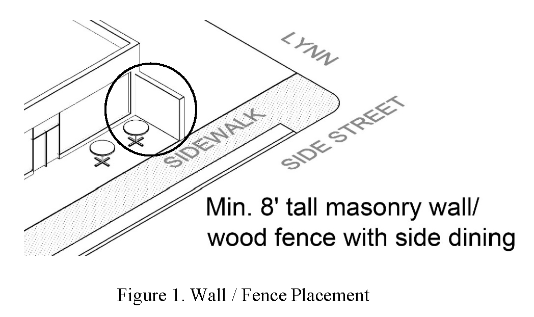
6.34.3
USE PERMITTED BY APPROVAL AS SPECIAL EXCEPTION:
The following use is permitted when approved by the Board of Zoning Appeals as a Special Exception as provided by Section 15.4.
6.34.3.1
Sidewalk dining in accordance with Section 6.15.3.2. The serving or consumption of food or alcohol shall occur within the hours of operation, not to exceed 11:00 p.m.
6.34.4
AREA REGULATIONS:
6.34.4.1
Building placement: All buildings shall be set back no further than 15 feet from the adjoining property line of West Walnut Street. There is no setback for other streets (see Figure 2).
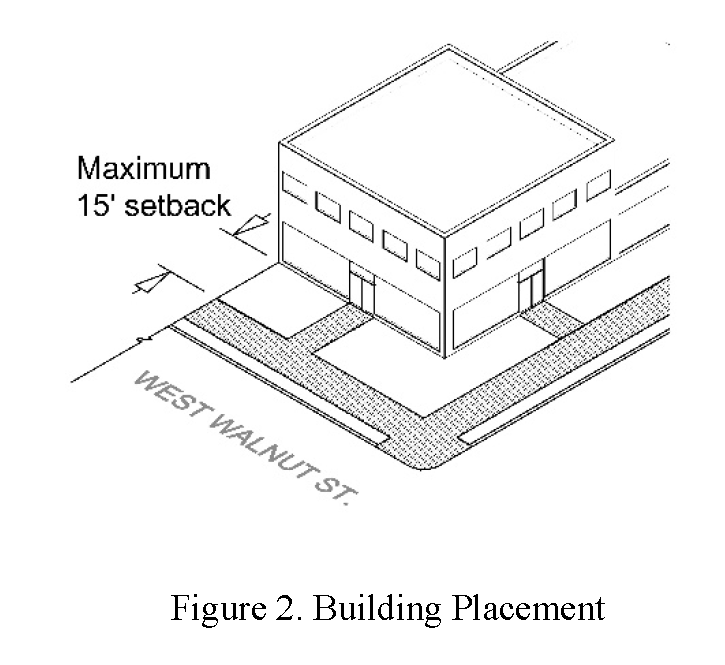
6.34.4.2
Exterior building treatment: A minimum of 50 percent and a maximum of 70 percent of the street level facade shall be transparent glass. Openings above the street level on the principal frontage shall be a minimum of 25 percent and a maximum of 50 percent of that level's wall area. (See Figure 3).
This section applies to the following streets: State of Franklin Road, W. Walnut Street, Ashe Street, University Parkway, Buffalo Street, and Watauga Avenue.
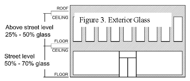
6.34.4.3
Building facades: Building facades conform to Design Overlay, Section 6.30.3.3.
6.34.4.4
Building height: The maximum height of buildings along the south side of W. Walnut Street shall be two stories. There is no height limit for buildings along the north side of W. Walnut Street. (See Figure 4).
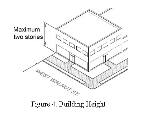
6.34.5
SIGN REGULATIONS:
The signs in this district shall comply with the B-2, Central Business requirements under Section 7.3.3.
6.34.6
PARKING:
Off-premise parking shall be approved by the Board of Zoning Appeals and shall be exempt from the following provisions of Article 11.4, Off-Premise Parking:
A.
The property shall lie within 400 feet of the main entrance of the principal use;
B.
The property shall not be separated from the principal use by a collector or arterial street as designated on the zoning map and shall be located on the same street as the principal use; and
C.
Such spaces shall not exceed 50 percent of the required parking.
6.34.7
PARKING LOT SCREENING:
When on-site parking is provided for properties along the south side of W. Walnut Street, a minimum four foot tall masonry wall or wood fence shall be required along Lynn Street/Lynn Alley whenever a new principal building is built or the gross floor area of an existing principal building is expanded by 25 percent or greater (see Figure 5). When architectural elements are employed for screening, they shall be of the same building materials as the principal structure.
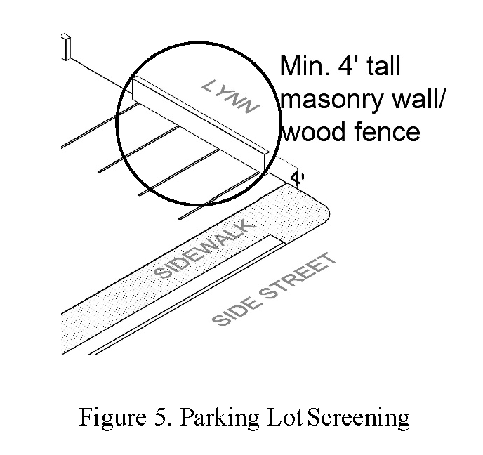
When on-site parking adjoins State of Franklin Road, in addition to the landscape requirements under Section 12.2, Landscape Yard, a minimum two-foot tall landscaped berm shall be constructed with a row of evergreen shrubs spaced a maximum of five feet on center which grow to a minimum height of two feet. (See Figure 6).
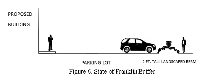
6.34.8
UTILITIES:
All new utility lines, including, but not limited to, electric, telephone, and TV cable, shall conform to Section 6.30.3.1.
6.34.9
MECHANICAL EQUIPMENT:
The installation of mechanical equipment shall conform to Section 6.30.3.2.
6.34.10
SERVICE, LOADING, AND EQUIPMENT STORAGE AREAS:
Service areas, including storage, special equipment, maintenance, and loading areas, shall be screened shall conform to Section 6.30.3.2.
6.34.11
LIGHTING:
All lighting shall conform to Section 6.30.3.7. The maximum height of lights not located in the public right-of-way shall be 15 feet.
6.34.12
SPECIAL USE PERMIT:
A Special Use Permit, obtained from the Building Division and approved by the City Commission, shall be required for outdoor events extending past 11:00 p.m. Outdoor events include, but are not limited to, festivals, outdoor music/entertainment, and other similar activities. Sidewalk dining is excluded in order to be considered for City Commission approval, a completed Special Use Permit shall be received by the Building Division no later than 30 days prior to the City Commission meeting at which it is to be considered.
(Ord. No. 4738-20, § 1(Exh. A), 7-2-2020)