
Juneau City Zoning Code
CHAPTER 49
70 - SPECIFIED AREA PROVISIONS1
Cross reference— Building regulations, CBJ Code tit. 19.
ARTICLE III. - SENSITIVE AREAS[2]
Administrative Code of Regulations cross reference—Sensitive areas and parks, Part IV, § 04 CBJAC 020.010 et seq.
ARTICLE IV. - FLOOD HAZARD AREAS[3]
Cross reference— Building regulations, tit. 19.
ARTICLE V. - HISTORIC DISTRICT[4]
Cross reference— Building regulations, CBJ Code tit. 19.
ARTICLE VIII. - RESERVED[5]
Editor's note— Serial No. 2006-15, § 25, adopted June 5, 2006, effective July 6, 2006, repealed Art. VIII, §§ 49.70.800—49.70.820, which pertained to height district. See also the Code Comparative Table.
ARTICLE IX. - RESERVED[6]
Editor's note— Serial No. 2021-13, § 3, adopted September 13, 2021, and effective October 14, 2001, amended the Code by repealing former art. IX, §§ 49.70.900—40.79.960, in its entirety. Former art. IX pertained to coastal management, and derived from Serial No. 87-49 of 1987; Serial No. 90-51 of 1990; Serial No. 92-41 of 1992; Serial No. 2005-29(am), adopted October 10, 2005.
ARTICLE X. - RESERVED[7]
Editor's note— Sec. 3 of Serial No. 2022-47, adopted April 17, 2023, and effective May 18, 2023, repealed art. X, which pertained to wetlands management, consisted of §§ 49.70.1000—49.70-1097, and derived from Serial No. 95-42, 1992; and Serial No. 95-35, 1995.
ARTICLE XI. - RESERVED[8]
Editor's note— Sec. 14 of Serial No. 2015-03(c)(am), adopted Aug. 31, 2015, repealed and reserved, art. XI, which pertained to remote subdivision areas, consisted of §§ 49.70.1100—49.70.1120, and derived from Serial No. 99-34, adopted Jan. 24, 2000; and Serial No. 2006-15, adopted June 5, 2006.
ARTICLE XII. - ALTERNATIVE DEVELOPMENT OVERLAY DISTRICT[9]
Editor's note— Sec. 2 of Serial No. 2021-36, adopted September 12, 2022, repealed and replaced art. XII in its entirety to read as herein set out. Former art. XII pertained to the same subject matter, and derived from Serial No. 2017-16, adopted June 26, 2017; Serial No. 2019-27, adopted July 22, 2019; Serial No. 2020-028(b), adopted July 13, 2022; Serial No. 2021-19, adopted August 2, 2021; and Serial No. 2021-34, adopted August 23, 2021.
49.70.110 - Purpose.
The purpose of the new growth area classification is to provide for flexibility in land use controls for a specific new growth area as designated in the comprehensive plan, while protecting the public health, safety and welfare by ensuring that the development will be consistent with the comprehensive plan and the carrying capacity of the land. The new growth areas classification accommodates new communities with a full range of uses and densities. Before development, each area shall be the subject of a master plan prepared by the developer. The plan shall establish use, density and design of development, and when approved by the assembly becomes an amendment to the comprehensive plan and this title. After an area has been designated and a master plan approved, specific phases or projects shall be processed pursuant to this title, with the master plan as the principal criterion for approval.
(Serial No. 87-49, § 2, 1987)
49.70.120 - Characteristics.
New growth areas should have the following characteristics:
(1)
Site conditions. The site should be:
(A)
Physically capable of supporting urban level development;
(B)
Equipped with potentially good land access, water access, or both; and
(C)
Under unified ownership or control.
(2)
Uses. Except as otherwise specified in the comprehensive plan, new growth areas should be mixed-type residential communities supported by an adequate level of recreational, public, industrial and commercial services, and should be capable of other support uses.
(3)
Size. A new growth area project should include at least the number of residential units demonstrated by the developer as sufficient to create a viable community and to efficiently support roads and utilities, including community-level water, sewer, and drainage systems. The department will calculate the minimum acreage requirement for the project using a minimum density of four dwellings per acre and including additional acreage to accommodate open space, future expansion, and recreational, public and commercial uses.
(4)
Design. The master plan should address and ensure:
(A)
Aesthetically pleasing and energy efficient siting, design and construction techniques;
(B)
Efficient provision and long-term maintenance of sewer, water, roads, schools and other public facilities;
(C)
Preservation of vegetation, views, and other natural features;
(D)
Provision of passive and active recreational activities, including pedestrian and bicycle access generally consistent with standards adopted by the American Society of Highway Transportation Officials and water access, open space, and community recreational facilities generally consistent with the standards adopted in the parks and recreation comprehensive plan; and
(E)
Mitigation of land use conflicts.
(Serial No. 87-49, § 2, 1987; Serial No. 97-25, § 2, 1997)
49.70.130 - Concept review.
(a)
Preapplication conference. The purpose of the preapplication conference is to:
(1)
Provide an opportunity for the proponents of a new growth area to explain the concept of their development to the department;
(2)
Allow the department to explain to the developer the requirements of City and Borough land use laws and the potential impacts of this title and the plans adopted therein; and
(3)
Allow the department to outline the concerns of the City and Borough with regard to the potential hazards inherent in the development of wetlands, steep slopes and hazard areas, and the conservation of marginal lands and open spaces having environmental value.
(b)
Submittal requirements. The submittal requirements for a preapplication conference shall be:
(1)
Documents.
(A)
A legal description;
(B)
A statement of the goals and objectives of the development; and
(C)
An explanation of any unique features of the property proposed for new growth area.
(2)
Maps showing existing site and vicinity conditions and including:
(A)
Topography contour lines at intervals of ten feet or less;
(B)
The location of streams, lakes, wetlands, drainage courses, floodplain areas, and other water features;
(C)
The nature and extent of existing stands of trees and shrubs, ground cover and other vegetation;
(D)
Existing access to and within the site including roads, peripheral roads, trails and sidewalks;
(E)
Avalanche and landslide hazard areas, soils, and surface geology; and
(F)
Sensitive area boundaries.
(3)
A sketch plan showing proposed:
(A)
Topography and water features;
(B)
Streets, pedestrian, and bicycle access;
(C)
Conceptual uses and densities; and
(D)
Open space and recreational areas.
(c)
Preapplication conference comments. The department will review the preapplication conference submittal materials and provide written comments to the applicant not more than 30 days after the date of the conference. The comments shall advise the applicant on the consistency of the proposal with the intent of this chapter, with adopted City and Borough plans, laws, and regulations, and on the compatibility of the proposed development with the surrounding area.
(d)
Subdivision review committee. Prior to formal submittal, the master plan shall be reviewed for conceptual approval by the subdivision review committee of the commission.
(Serial No. 87-49, § 2, 1987; Serial No. 97-25, § 3, 1997)
49.70.140 - Master plan submittal procedure.
(a)
The master plan shall be provided by the developer and shall propose:
(1)
The uses to be permitted;
(2)
The total number and type of dwelling units;
(3)
The total amount of commercial, industrial and office gross floor area;
(4)
Principal drainage systems or drainage requirements;
(5)
Principal circulation elements;
(6)
Open space and common facilities, and the method for maintaining them;
(7)
Schools, playgrounds, fire stations and other public facilities;
(8)
Public and private utilities, and the method for maintaining them;
(9)
Proposed phasing of the development; and
(10)
Such other requirements as may be applicable.
(b)
The plan shall include the following basic development information for each phase of the development:
(1)
Permitted, accessory and conditional uses;
(2)
Minimum lot size;
(3)
Minimum yard requirements;
(4)
Maximum lot coverage;
(5)
Maximum height of structures;
(6)
Signs;
(7)
Parking;
(8)
Loading;
(9)
Open space and landscaping;
(10)
Vehicular, pedestrian, and bicycle access;
(11)
The number of dwelling units or the gross building area of commercial or industrial structures; and
(12)
An estimated schedule of any phased development.
(Serial No. 87-49, § 2, 1987; Serial No. 97-25, § 4, 1997; Serial No. 97-49, § 5, 1998)
49.70.150 - Commission action.
The commission shall consider the application and shall thereafter either forward it to the assembly with a recommendation for approval or conditional approval or will deny the application. Commission review shall be based on how well the proposal meets the requirements of this title, the comprehensive plan policies for new growth areas, and general community development principles. The commission may place conditions on any aspect of the development. The commission may require the developer to post bonds securing completion of the project in substantial compliance with the approved development plan in accordance with a timetable specified by the developer and approved by the commission.
(Serial No. 87-49, § 2, 1987; Serial No. 97-25, § 5, 1997)
49.70.160 - Assembly action.
The assembly shall consider the commission recommendation and shall then deny, approve, or conditionally approve the master plan by ordinance. Approval of the master plan shall include any necessary comprehensive plan amendments and zone changes. The boundary of the master development plan and any specific use districts shall be shown on the official zoning maps.
(Serial No. 87-49, § 2, 1987)
49.70.170 - Phasing.
Review of a proposal for phased development shall include analysis of whether each phase will, in combination with all previous phases, provide public utilities, public services, a circulation system, open space, and all other pertinent aspects of the overall master plan. The separate construction of any phase of a development shall require the appropriate permit approval under chapter 49.15. The permit review and approval of any initial phase of the development may take place concurrently with the master plan approval. The commission may require the developer to post bonds securing completion of the project in substantial compliance with the approved development plan in accordance with a timetable specified by the developer and approved by the commission.
(Serial No. 87-49, § 2, 1987; Serial No. 97-25, § 6, 1997)
49.70.180 - Amendment of a master plan.
(a)
After review and recommendation of the commission, the developer shall obtain approval by ordinance from the assembly for the following amendments to a new growth area master plan:
(1)
Any increase in the total number of authorized dwelling units in the development;
(2)
Any decrease in the total open space acreage;
(3)
Any increase in the total gross floor area of commercial or industrial structures;
(4)
Any addition or deletion of any permitted principal use, conditional use or accessory use;
(5)
Any change of more than one year in the development schedule for a phased development;
(6)
Any density amendment that will result in a 25 percent or greater cumulative increase or decrease in the number of dwelling units in any phase of a phased development; or
(7)
Any change in the acreage of any phase or phases of a phased development equal to or more than 25 percent of the total acreage of the development.
(b)
The developer shall obtain approval by the commission for the following amendments to a new growth area master plan:
(1)
Any change of density between phased development areas that will result in a cumulative increase or decrease of more than ten percent but less than 25 percent in the number of dwelling units in any phase of a phased development; and
(2)
Any change in the acreage of any phase or phases of a phased development equal to more than ten percent but less than 25 percent of the total acreage of the phased development.
(c)
All decisions of the director and commission on master plan amendments shall be final unless appealed by the developer to the commission or assembly as appropriate.
(Serial No. 87-49, § 2, 1987; Serial No. 97-49, § 6, 1998)
49.70.190 - Zoning map.
Identification of new growth areas. Approved new growth areas shall be identified on the zoning map by the acronym "NGA" followed by a serial number.
(Serial No. 87-49, § 2, 1987)
49.70.200 - Purposes.
The purposes of this article are to:
(1)
Ensure that hillside development provides erosion and drainage control to protect adjoining parcels;
(2)
Protect waterways from sedimentation and pollution;
(3)
Minimize injury or damage to people or property from natural or artificial hazards in hillside development; and
(4)
Minimize any adverse aesthetic impact of hillside development.
(Serial No. 87-49, § 2, 1987)
49.70.210 - Applicability and scope.
(a)
This article applies to all development on hillsides in the City and Borough that involves the following:
(1)
Removal of vegetative cover;
(2)
Excavation of any slope in excess of 18 percent;
(3)
Creation of a new slope in excess of 18 percent for a vertical distance of at least five feet; and
(4)
Development in moderate and severe avalanche hazard areas shown on the Avalanche Hazard Designation Mapping, dated April 27, 2022, and attached to Serial No. 2023-18(am) as Appendix A.
(b)
All hillside development endorsement applications shall be reviewed by the planning commission, except the following may be reviewed by the director:
(1)
An excavation below finished grade for basements and footings of a building, a retaining wall or other structure authorized by a building permit, provided that this shall not exempt any fill made with the material from such excavation nor any excavation having an unsupported height greater than two feet after the completion of the associated structure.
(2)
Graves.
(3)
Mining, quarrying, excavating, processing, or stockpiling of rock, sand, gravel, aggregate or clay provided such operations do not affect the location or peak volume of runoff, the location or amount of standing water, or the lateral support for, the stresses in, or the pressure upon, any adjacent or contiguous property.
(4)
Exploratory excavations less than 200 square feet in area and under the direction of a civil engineer with knowledge and experience in the application of geology in the design of civil work.
(5)
An excavation which:
(A)
Is less than two feet in depth and covers less than 200 square feet; or
(B)
Does not create a cut slope greater than five feet in height or steeper than one and one-half horizontal to one vertical.
(6)
A fill less than one foot in depth and intended to support structures which fill is placed on natural terrain with a slope flatter than five horizontal to one vertical, which does not exceed 20 cubic yards on any one lot and which does not obstruct a drainage course.
(7)
A fill less than three feet in depth and not intended to support structures which fill is placed on natural terrain on a slope flatter than five horizontal to one vertical, which does not exceed 50 cubic yards on any one lot and which does not obstruct a drainage course.
(8)
Minor development.
(Serial No. 87-49, § 2, 1987; Serial No. 2006-15, § 22, 6-5-2006; Serial No. 2015-03(c)(am), § 51, 8-31-2015; Serial No. 2023-18(am), § 6, 12-11-2023, eff. 1-11-2024)
49.70.220 - Hillside development endorsement application.
(a)
All development on hillsides shall be pursuant to a hillside development endorsement.
(b)
The developer shall apply for and obtain a hillside development endorsement prior to any site work other than land and engineering surveys and soils exploration.
(Serial No. 87-49, § 2, 1987; Serial No. 2015-03(c)(am), § 52, 8-31-2015)
49.70.230 - Fees.
The City and Borough shall charge the developer the gross hourly rate for professional review of the application and for inspection. The developer shall deposit one percent of the value of the site development, excluding that portion of the site determined by the engineer to be subject to a public transmission facility permit, in a specially designated reserve account, against which the City and Borough may bill its documented time and expenses. The developer shall promptly replenish this amount when requested, and no endorsement may be issued if there is any deficiency in the developer's reserve account. All unexpended funds in the reserve account shall be returned to the developer upon final approval of development or when the engineer is satisfied that the work under the hillside development endorsement has been completed and the requirements of this chapter have been met.
(Serial No. 87-49, § 2, 1987)
49.70.240 - Application.
The application shall be accompanied by the following materials, which shall be signed and stamped by a civil engineer, architect, geologist or land surveyor licensed in the State of Alaska:
(1)
A vicinity map, at a clear and legible scale, showing roads, place and street names and natural waterbodies.
(2)
Site maps, showing the present condition of the site at a clear and legible scale compatible with the size of the development and including:
(A)
Two-foot contours for flat terrain or five-foot contours for steep terrain and extending 50 feet in all directions beyond the development site; 12 percent line, 30 percent line;
(B)
Water bodies, tidelands and drainage ways from the development site to accepting natural waterbody;
(C)
Lot boundaries and easements for the site and adjacent lots; and
(D)
Existing improvements on the site and adjacent lots, including structures, roads, driveways and utility lines.
(3)
The application shall include a finished proposed site plan at a clear and legible scale that includes the following information:
(A)
Finished grade at two-foot contours for flat terrain or five-foot contours for steep terrain and extending 50 feet in all directions beyond the development site; 12 percent line, 30 percent line.
(B)
Water bodies, tidelands and drainage ways, and temporary and permanent drainage systems from the development site to the accepting natural waterbody.
(C)
Lot boundaries, easements and setback lines.
(D)
The location of improvements including structures, roads, driveways, utility lines, culverts, walls and cribbing.
(E)
Clearing limits of existing vegetative cover.
(F)
A cross-section of the development site.
(4)
The application shall include detailed engineering drawings of roads, driveways, parking areas, structural improvements for foundations, off-site stormwater runoff systems; cross sections and road elevations.
(5)
A description of the source and type of any off-site fill, and the site for depositing excess fill.
(6)
A landscaping plan, including all trees to be retained in excavation areas, all plant species and locations; temporary slope protection measures; erosion and siltation control measures; seeding or sodding materials, a planting and maintenance program; and methods of stabilization and protection of bare slopes.
(7)
An engineering geologic report, including a summary of the relevant surface and bedrock geology of the site, a discussion of active geologic processes with conclusions and recommendations regarding the effect of geologic factors on the proposed development; data regarding the nature, distribution and relevant parameters of existing soils, recommendations for grading procedures; design criteria for corrective measures as necessary, and recommendations covering the suitability of the site for the proposed development.
(8)
A work schedule, by phase.
(9)
Such other different or more detailed submissions as may be required.
(Serial No. 87-49, § 2, 1987; Serial No. 2015-03(c)(am), § 54, 8-31-2015)
49.70.250 - Standards for approval.
Hillside development shall meet the following minimum standards:
(1)
Roads. The City and Borough road standards shall apply to hillside development, except that:
(A)
Modification of standards. The engineer or planning commission may modify road standards as identified in subsections (1)(B) and (C) of this section, if:
(i)
The developer's traffic analysis and circulation, land ownership, and development patterns indicate future use of the roadway at less than collector street levels;
(ii)
The modification would enable the development to meet, or more closely approximate, the criteria set forth in section 49.70.260; and either
(iii)
The proposed road or access in question would result in a permanent cul-de-sac; or
(iv)
A secondary access to the proposed development exists or will be developed as a part of the project.
(B)
Road width. The width of a section of residential roadway may be narrowed to 20 feet, with a single four-foot pedestrian way and underground storm drain system, if:
(i)
The section is not more than 200 feet in length, and is separated from other such sections by at least 100 feet of standard roadway;
(ii)
No entrances, intersections or parking are allowed in the section;
(iii)
Guard rails, if any, are designed to permit the passage of plowed snow;
(iv)
There is at least a 200-foot line of sight along the centerline of the section;
(v)
The section enables the development to meet, or more closely approximate, the criteria set forth in section 49.70.260;
(vi)
Grouped off-street parking spaces are provided at the entry to the section; and
(vii)
Adequate provision is made for storage of snow.
(C)
Road grade. The grade of a section of residential roadway may be increased to a maximum of 15 percent if:
(i)
The section is not more than 200 feet in length and separated from other such sections by at least 100 feet of roadway;
(ii)
No entrances or intersections are allowed in the section;
(iii)
Through intersections at the end of the section have approaches at least 50 feet long measured from the edge of the traveled way of the crossroad and are at a grade of eight percent or less; intersections requiring a full stop have approaches no less than 20 feet long at a grade of two percent or less, or no less than 50 feet long at a grade between two and six percent;
(iv)
Any guard rails are designed to permit the passage of plowed snow;
(v)
All sight distances conform to standards of the American Association of State Highway and Transportation Officials; and
(vi)
The section enables the development to meet, or more closely approximate, the criteria set forth in section 49.70.260.
(2)
Weather. The engineer may prohibit a developer from earthmoving during periods of very wet soil conditions, in which case the permit shall be extended by a like period.
(3)
Sediment. The developer shall not allow any increase in sediment to flow off-site during or after construction if such would be likely to cause an adverse impact on a down slope lot or waterbody.
(4)
Peak discharge. The developer shall ensure that during and after construction of major development, the peak discharge of all streams and natural drainage ways at the down slope boundary shall be no greater than that occurring prior to excavation.
(Serial No. 87-49, § 2, 1987)
49.70.260 - Criteria.
The commission or director shall consider the extent to which the development meets the following criteria:
(1)
Soil erosion. Soil disturbance and soil erosion shall be minimized and the effects thereof mitigated.
(2)
Existing vegetation. Depletion of existing vegetation shall be minimized.
(3)
Contours. The developer shall recontour the finished grade to natural-appearing contours which are at or below 30 percent or the natural angle of repose for the soil type, whichever is lower, and which will hold vegetation.
(4)
Time of exposure and soil retention. The developer shall minimize the period of time that soil is exposed and shall employ mats, silt blocks or other retention features to maximize soil retention.
(5)
Replanting. The developer shall mat, where necessary, and plant all exposed soil in grass or other soil-retaining vegetation and shall maintain the vegetation for one full growing season after planting.
(6)
Drainage. The developer shall minimize disturbance to the natural course of streams and drainage ways. Where disturbance is unavoidable, the developer shall provide a drainage system or structures which will minimize the possibility of sedimentation and soil erosion on-site and downstream and which will maintain or enhance the general stream characteristics, spawning quality, and other habitat features of the stream and its receiving waters. Where possible, development shall be designed so lot lines follow natural drainage ways.
(7)
Foundations. The developer shall ensure that buildings will be constructed on geologically safe terrain.
(8)
Very steep slopes. The developer shall minimize excavation on slopes over 30 percent.
(9)
Soil retention features. The developer shall minimize the use of constructed retention features. Where used, their visual impact shall be minimized through the use of natural aggregate or wood, variation of facade, replanted terraces, and the like.
(10)
Wet weather periods. The developer shall minimize exposure of soil during the periods of September 1—November 30 and March 1—May 1.
(Serial No. 87-49, § 2, 1987; Serial No. 2015-03(c)(am), § 54, 8-31-2015)
49.70.270 - Conditions on approval.
The commission or director may place conditions upon a hillside development endorsement as necessary or desirable to ensure that the spirit of this chapter will be implemented in the manner indicated in the application. Fulfillment of conditions shall be certified by the engineer. The conditions may consist of one or more of the following:
(1)
Development schedule. The commission or director may place a reasonable time limit on or require phasing of construction activity associated with the development or any portion thereof, in order to minimize construction-related disruption to traffic and neighbors or to ensure that the development is not used or occupied prior to substantial completion of required improvements.
(2)
Dedications. The commission or director may require conveyances of title or other legal or equitable interests to public entities, public utilities, a homeowner's association, or other common entities. The developer may be required to construct any public facilities, such as drainage retention areas, to City and Borough standards prior to dedication.
(3)
Construction guarantees. The commission or director may require the posting of a bond or other surety or collateral providing for whole or partial releases, in order to ensure that all required improvements are constructed as specified in the approved plans.
(4)
Lot size. If justified by site topography, the commission or director may require larger lot areas than prescribed by zoning requirements.
(Serial No. 87-49, § 2, 1987; Serial No. 2015-03(c)(am), § 55, 8-31-2015)
49.70.300 - Avalanche hazard areas.
(a)
Generally.
(1)
Minimize risks. Development in all avalanche hazard areas should minimize the risk of loss of life or property due to avalanches.
(2)
Avalanche hazard maps. The boundaries of avalanche hazard areas are shown on the Avalanche Hazard Designation Mapping, dated April 27, 2022, and attached to Serial No. 2023-18(am) as Appendix A.
(3)
Reserved.
(4)
Hazard boundary adjustment. If a developer disagrees with the boundaries shown on the maps, the developer may seek departmental relocation of the boundaries by submitting site specific studies prepared by a civil engineer licensed in the State of Alaska or a licensed geotechnical engineer. Such studies shall include detailed analyses of topography, vegetation, potential snow accumulation, and other factors. The results should indicate actual hazard area boundaries and potential debris flow direction, time, distance, and mass. If, in the opinion of the director of engineering and public works, the studies clearly establish that the map boundaries are inaccurate and the proposed development is outside a moderate or severe avalanche area, the department shall proceed accordingly.
(5)
The director for moderate avalanche hazard areas and the commission for severe avalanche hazard areas may require mitigating measures certified as effective by a professional engineer for development in avalanche areas. Such measures may include dissipating structures or dams, special structural engineering, or other techniques designed for the site. Mitigating measures may also include reduction in the proposed density, occupancy, and development.
(b)
Moderate and severe avalanche hazard area standards. Notwithstanding any other provision of this title, no development or any part of a development may occur in a moderate or severe avalanche hazard area except as provided in this section.
(1)
Director approval in a moderate avalanche hazard area. The director may only approve the following in a moderate avalanche hazard area:
(A)
A permit for a single dwelling unit per parcel;
(B)
A hazard boundary line adjustment;
(C)
A lot line adjustment when the resulting lots are more compliant with this title and the resulting lots would likely reduce the risk to life and property; and
(D)
A lot consolidation.
(2)
Commission approval in a moderate or severe avalanche hazard area. The commission may approve developments in the moderate and severe avalanche hazard areas—including accessory dwelling units—via the conditional use permit process with the following additional requirements:
(A)
The development application must include site specific engineering for peak drainage, special foundations or high-wall engineering, debris flow diversion mechanisms, and any other information required by the commission, for the commission to evaluate the potential effects of the development on public health and safety; and
(B)
No subdivision shall be approved that creates a lot lacking sufficient building space outside a severe avalanche area—without the need for a variance—unless a lot in a severe avalanche area is platted as a public use lot (section 49.15.422); and
(C)
The commission is prohibited from approving a development application that increases residential density in the severe avalanche hazard area, except that the commission may authorize development of one dwelling unit on a vacant lot in a severe avalanche hazard area.
(c)
Warning and disclaimer of liability. Avalanches may occur outside mapped hazard areas and in excess of engineering expectations. The location and severity of the event may be increased by human or natural causes. This article does not imply that land outside of mapped hazard areas, or uses permitted within such areas, will be free from danger or damage. This article shall not create liability on the part of the City and Borough of Juneau or any officer or employee thereof for any damages that result from reliance of this article, or any administrative decision made under this article.
(Serial No. 87-49, § 2, 1987; Serial No. 90-03, § 1, 1990; Serial No. 2006-15, § 23, 6-5-2006; Serial No. 2023-18(am), § 7, 12-11-2023, eff. 1-11-2024)
49.70.305 - Landslide hazard assessment disclaimer.
The following disclaimer should appear on or be associated with Tetra Tech's mapping related to the Landslide Hazard Designation figures 1.6a—j (ten pages), dated, April 27, 2022 [attached to Serial No. 2023-18(am) as Appendix A]:
The City and Borough of Juneau did not adopt these landslide hazard assessment maps. The landslide hazard assessment maps do not consider any human-made structures or mitigating measures. The landslide hazard assessment maps do not provide an indication of risk as would be necessary to determine whether landslide hazards actually pose a threat to specific properties. A more detailed site-specific investigation and evaluation would be required to determine risk to, and appropriate mitigations for, specific properties.
(Serial No. 2023-18(am), § 9, 12-11-2023, eff. 1-11-2024)
49.70.310 - Marine mammal habitat protections.
(a)
Development in the following areas is prohibited:
(1)
On Benjamin Island within the Steller sea lion habitat;
(2)
Within 50 feet from the ordinary high water mark of streams designated in Appendix B of the comprehensive plan of the City and Borough of Juneau, 2013 Update; and
(3)
Within 50 feet from the ordinary high water mark of lakeshores designated in Appendix B of the comprehensive plan of the City and Borough of Juneau, 2013 Update.
(b)
In addition to the above requirements there shall be no disturbance in the following areas:
(1)
Within 25 feet from the ordinary high water mark of stream corridors designated in Appendix B of the comprehensive plan of the City and Borough of Juneau, 2013 Update; and
(2)
Within 25 feet from the ordinary high water mark of lakeshores designated in Appendix B of the comprehensive plan of the City of Borough of Juneau, 2013 Update.
(c)
The following developments or disturbances are exempt from the setback prohibitions of this section:
(1)
Docks, bridges, culverts and public structures whose purpose is access to or across the stream or lake; and
(2)
Uses which must be in or adjacent to the stream or lake in order to function, such as mining activities, fish culturing, water supply intakes and similar uses.
Except for the setback area necessary for such developments or disturbances, the remaining setback shall be vegetated or revegetated, where feasible and prudent, and such vegetation or revegetation shall be kept or arranged to maximize shade on the stream or lake. A variance is required for any other development or disturbance in the setback prohibitions of this section.
(Serial No. 87-49, § 2, 1987; Serial No. 2008-30, § 3, 10-20-2008; Serial No. 2013-26(am), § 4, 11-4-2013, eff. 12-5-2013; Serial No. 2017-29, § 5, 1-8-2018, eff. 2-8-2018; Serial No. 2021-13, § 4, 9-13-2021, eff. 10-14-2021; Serial No. 2023-29, § 2, 7-10-2023, eff. 8-10-2023)
49.70.320 - Watersheds.
Development in watersheds designated in the comprehensive plan of the City and Borough of Juneau, 2013 Update, shall not cause degradation of the existing water quality or ground water recharge capabilities of the site according to standards established by the state department of environmental conservation. Upon request of the director, the developer shall provide evidence of compliance by certification of a professional engineer.
(Serial No. 87-49, § 2, 1987; Serial No. 2008-30, § 4, 10-20-2008;Serial No. 2013-26(am), § 5, 11-4-2013, eff. 12-5-2013; Serial No. 2023-29, § 2, 7-10-2023, eff. 8-10-2023)
49.70.330 - Anadromous habitat protections.
(a)
Development in the following areas is prohibited:
(1)
Within 50 feet from the ordinary high water mark of streams designated in Appendix B of the comprehensive plan of the City and Borough of Juneau, 2013 Update; and
(2)
Within 50 feet from the ordinary high water mark of lakeshores designated in Appendix B of the comprehensive plan of the City and Borough of Juneau, 2013 Update.
(b)
In addition to the above requirements there shall be no disturbance in the following areas:
(1)
Within 25 feet from the ordinary high water mark of stream corridors designated in Appendix B of the comprehensive plan of the City and Borough of Juneau, 2013 Update; and
(2)
Within 25 feet from the ordinary high water mark of lakeshores designated in Appendix B of the comprehensive plan of the City of Borough of Juneau, 2013 Update.
(c)
The following developments or disturbances are exempt from the setback prohibitions of this section:
(1)
Docks, bridges, culverts, and public structures whose purpose is access to or across the stream or lake; and
(2)
Uses which must be in or adjacent to the stream or lake in order to function, such as mining activities, fish culturing, water supply intakes and similar uses; and
(3)
During construction of a development, work may be conducted within the 35-foot to 50-foot buffer in order to construct a permitted project; and
(4)
The following standards shall apply:
(A)
Prior to issuance of a building or grading permit, the developer must submit a vegetation or revegetation plan to the director for approval.
(B)
Such vegetation or revegetation shall be kept or arranged to maximize shade on the stream or lake.
(C)
The area disturbed shall be vegetated with native species according to the Alaska Department of Fish and Game's Stream Revegetation and Protection: A Guide for Alaska.
(D)
Except for the setback area necessary for such developments or disturbances, the remaining setback shall be vegetated or revegetated within one growing season.
(Serial No. 2023-29, § 2, 7-10-2023, eff. 8-10-2023)
49.70.400 - Floodplain.
(a)
Purpose. The purpose of this article is to promote the public health, safety, and general welfare and to minimize public and private losses due to flood conditions in specific areas. Other purposes are to:
(1)
Reserved;
(2)
Prevent the erection of structures in areas unfit for human usage by reason of danger from flooding, unsanitary conditions, or other hazards;
(3)
Minimize danger to public health by protecting the water supply and promoting safe and sanitary drainage;
(4)
Reduce the financial burdens imposed on the community, its governmental units, and its individuals by frequent and periodic floods and overflow of lands;
(5)
Reserved;
(6)
Ensure that potential buyers are notified that property is in a special flood hazard area; and
(7)
Ensure that those who occupy the special flood hazard area assume financial responsibility for their development.
(b)
Interpretation.
(1)
In the interpretation and application of this article, all provisions are considered minimum requirements and are liberally construed in favor of the governing body.
(2)
This article is not intended to repeal, abrogate, or impair any existing easements, covenants, or deed restrictions. Where the provisions of this article and another ordinance conflict or overlap, whichever imposes the more stringent restrictions shall prevail.
(3)
This article shall apply to all areas of special flood hazard areas (SFHAs) within the jurisdiction of the City and Borough of Juneau.
(4)
The special flood hazard areas identified by the Federal Insurance Administrator (FIA) in a scientific and engineering report entitled the "Flood Insurance Study" (FIS) and the flood insurance rate maps (FIRMs) dated September 18, 2020 for the City and Borough of Juneau, Alaska are adopted. The FIS and FIRMs shall be on file with the community development department and available to the public at 155 South Seward Street, Juneau, Alaska.
(c)
Implementation. The director is responsible for administering and implementing the provisions of this chapter and is responsible for maintaining for public use and inspection appropriate records and information relevant to implementation of this chapter. Such records and information must include:
(1)
Actual elevations, in relation to mean lower low water, of the lowest floor, including basement, of all new or substantially improved structures located in the special flood hazard area (SFHA), and whether or not such structures have basements;
(2)
Actual elevations, in relation to mean lower low water, of all new and substantially improved floodproofed structures and the required floodproofing certifications;
(3)
Flood insurance studies (FISs);
(4)
Flood insurance rate maps (FIRMs);
(5)
Any reports or studies on flood hazards in the community, such as written reports by the U.S. Army Corps of Engineers, U.S. Geological Survey, or private firms provided to the director; and
(6)
A file of all floodplain permit applications, permits, exceptions, and supporting documentation.
(d)
Enforcement. Enforcement of this chapter is per CBJ 49.10.600—49.10.660.
(e)
Floodplain development permit required. A floodplain development permit is required for any development or industrial uses located within a special flood hazard area, including placement of manufactured homes. The director must:
(1)
Review all floodplain development permit applications for development in the special flood hazard area for compliance with the provisions of this chapter, and to determine if other permits may be necessary from local, state, or federal governmental agencies.
(2)
Interpret the location of the special flood hazard area boundaries and regulatory floodway. If there appears to be a conflict between a mapped boundary and actual field conditions, the director must determine and interpret the documents. When base flood elevation data has not been provided, the director shall obtain, review, and reasonably utilize base flood elevation and floodway data available from any federal, state, municipal, or any other source to implement the provisions of this chapter.
(3)
If the director determines that a proposed development is within a special flood hazard area, a permit fee must be collected and the following information must be provided before processing a floodplain development permit:
(A)
Elevation of the lowest floor, including a basement, of all structures;
(B)
Elevation to which any structure has been floodproofed;
(C)
Certification by an engineer or architect that the floodproofing methods for any nonresidential structure meet generally accepted floodproofing standards;
(D)
Description of the extent to which any watercourse will be altered or relocated as a result of proposed development;
(E)
Description of the plan for maintenance of the altered or relocated portion of the watercourse so that the flood-carrying capacity is not diminished; and
(F)
When base flood elevation data have not been provided, the director shall obtain, review and reasonably apply any base flood elevation and floodway data available from federal, state or other sources.
(f)
Methods of reducing losses. In order to accomplish its purpose, this article includes methods and provisions to:
(1)
Restrict or prohibit uses that are dangerous to health, safety, and property due to water or erosion hazards, or that result in damaging increases in erosion or flood heights or velocities;
(2)
Require that uses vulnerable to floods, including facilities that serve such uses, be protected against flood damage at the time of initial construction;
(3)
Control the alteration of natural floodplains, stream channels, and natural protective barriers, which help accommodate or channel floodwaters;
(4)
Control filling, grading, dredging, and other development that may increase flood damage; and
(5)
Prevent or regulate the construction of flood barriers that will unnaturally divert floodwaters or that may increase flood hazards in other areas.
(g)
General standards for flood hazard protection. In special flood hazard areas the following standards apply:
(1)
Anchoring.
(A)
Design, modify, and anchor new construction and substantial improvements to prevent flotation, collapse, or lateral movement of the structure(s).
(B)
A manufactured home must be anchored to prevent flotation, collapse, or lateral movement and be installed using methods and practices that minimize flood damage. Anchoring methods may include, but are not limited to, use of over-the-top or frame ties to ground anchors.
(C)
An alternative method of anchoring may be used if the system is designed to withstand a wind force of 90 miles per hour or greater. Certification must be provided to the director that this standard is met.
(2)
Construction materials and methods.
(A)
Construct new construction and substantial improvements with materials and utility equipment resistant to flood damage.
(B)
Use methods and practices that minimize flood damage for new construction and substantial improvements.
(C)
Design or locate electrical, heating, ventilation, plumbing, and air conditioning equipment and other service facilities so as to prevent water from entering or accumulating within the components during conditions of flooding.
(D)
Require adequate drainage paths around structures on slopes to guide floodwaters away from existing and proposed structures for new construction and substantial improvements within zones AH and AO.
(3)
Utilities.
(A)
Design new and replacement water supply systems to minimize or eliminate infiltration of floodwaters into the system.
(B)
Design new and replacement sanitary sewage systems to minimize or eliminate infiltration of floodwaters into the systems and discharge from the systems into floodwaters.
(C)
Locate on-site waste disposal systems to avoid impairment to them or contamination from them during flooding.
(4)
[Subdivision and development proposal criteria.] Subdivision and development proposals must meet the following criteria:
(A)
Be designed to minimize flood damage;
(B)
Locate and construct utilities and facilities, such as sewer, gas, electrical, and water systems to minimize flood damage;
(C)
Provide adequate drainage to reduce exposure to flood damage; and
(D)
Include base flood elevation data if the development consists of at least 50 lots or five acres, whichever is the lesser. If base flood elevation data is not available, the proposal must provide the data and backup information for how the base flood elevation data was generated for the proposal.
(5)
[Floodplain development permit requirements.] Review of floodplain development permits must include:
(A)
Review of the flood insurance rate map and flood insurance study for flood zone determinations for new or substantially improved structures;
(B)
For new or substantially improved structures:
(i)
Submittal of the proposed and finished lowest floor elevations in zones A, AE, AO, and AH.
(ii)
Submittal of the proposed and finished bottom elevation of the lowest horizontal structural member of the lowest floor and its distance from the mean lower low water mark in zones V and VE; and
(iii)
Submittal of specific requirements for zones V and VE as set forth in subsection 49.70.400(i).
(C)
In zones A and V, where elevation data are not available through the flood insurance study or from another authoritative source, applications for floodplain development permit shall be reviewed to ensure that proposed construction will be reasonably safe from flooding. The test of reasonableness is a local judgment and may be based on historical data, high water marks, photographs of past flooding, and other similar or relevant data. Failure to elevate construction at least two feet above grade in these zones may result in higher insurance rates.
(D)
Provision of an elevation certificate to demonstrate that the lowest floor of a structure is at or above base flood elevation. The certification must be provided on a form approved by the National Flood Insurance Program and prepared by a registered land surveyor or professional engineer who is licensed in the State of Alaska and authorized to certify such information. This requirement may be waived by the director if an approved record elevation demonstrates that the lowest floor is substantially above the base flood elevation due to natural ground level.
(6)
Other permits. The applicant must certify that all other necessary permits have been obtained from any federal or state governmental agencies.
(7)
[Maintaining watercourse.] Maintain altered or relocated portions of a special flood hazard area mapped watercourse so that the flood-carrying capacity is not diminished. The department must notify the state coordinating agency, if any, and the Federal Emergency Management Agency prior to issuance of a floodplain development permit that seeks to alter or relocate any watercourse within a special flood hazard area.
(h)
Specific standards for flood hazards protection. In special flood hazard areas where base flood elevation data is provided, the following provisions are required:
(1)
New structures or substantial improvements. Fully enclosed areas below the lowest floor of new construction or substantial improvements, that are useable solely for parking of vehicles, building access, or storage in an area other than a basement, must automatically equalize hydrostatic flood forces on exterior walls by allowing for the entry and exit of floodwaters. Designs for meeting this requirement must either be certified by a registered professional engineer or architect licensed in the State of Alaska or must meet or exceed the following minimum criteria:
(A)
Provide a minimum of two openings having a total net area of not less than one square inch for every square foot of enclosed area subject to flooding;
(B)
Height of the bottom of all openings must be no higher than one foot above grade; and
(C)
Openings may be equipped with screens, louvers, or other coverings or devices provided that the automatic entry and exit of floodwaters is allowed.
(2)
Residential construction. New construction and substantial improvement of any residential structure:
(A)
Construct the lowest floor, including basement, elevated to or above the base flood elevation within zones A, AE, or AH; or
(B)
Construct the lowest floor elevated to the base flood depth number specified on the flood insurance rate map, or higher, or if no depth number is specified, at least two feet above the highest adjacent natural grade within zone AO.
(3)
Manufactured homes. New or substantially improved manufactured homes must:
(A)
Be placed at or above, the base flood elevation, within zones A, AH, or AE, and shall be elevated to, or above, the base flood elevation, and comply with subsection (g); or
(B)
Elevate the lowest floor to the depth number specified on the flood insurance rate map, or higher, or if no depth number is specified, at least two feet above the highest adjacent natural grade within zone AO; and meet the provisions of subsection (g)(1).
(4)
Recreational vehicles. Recreational vehicles placed within any special flood hazard area must be:
(A)
Situated on the site for fewer than 180 consecutive days;
(B)
Fully licensed, operational, and approved for road use; or
(C)
Meet the requirements of subsection (h)(3).
(5)
Nonresidential construction. New construction or substantial improvement of any nonresidential structure must:
(A)
Elevate the lowest floor, including basement, to or above the base flood elevation within zones A, AE, and AH;
(B)
Elevate the lowest floor to the depth number specified on the flood insurance rate map, or higher, or if no depth number is specified, at least two feet above the highest adjacent natural grade within zone AO; or
(C)
Floodproof the area below the base flood elevation within zones A, AE, AH, and AO, so that:
(i)
The structure and utility and sanitary facilities are watertight with walls substantially impermeable to the passage of water;
(ii)
Structural components shall have the capability of resisting hydrostatic and hydrodynamic loads and effects of buoyancy;
(D)
A floodproof structure must be designed by an engineer or architect licensed in the State of Alaska, certifying that the design and methods of construction are in accordance with accepted standards of practice for meeting provisions of this subsection based on the engineer's or architect's development or review of the structural design, specifications, and plans. Certification must be provided to the director;
(E)
Applicants proposing to floodproof nonresidential buildings must be notified at the time of floodplain development permit application that flood insurance premiums are based on rates that are one foot below the floodproofed level.
(6)
Industrial uses. Industrial uses within the special flood hazard area are subject to the following provisions:
(A)
Sand and gravel operations, recreation activities, open space, and parking lots may be allowed in 100-year floodplains if the use does not increase the flood hazard.
(B)
Industrial equipment and raw materials stored in 100-year floodplains must be adequately bermed or otherwise protected.
(C)
Disposal of hazardous materials in 100-year floodplains is prohibited. No new development that involves storage of hazardous materials will be permitted in the 100-year floodplain unless there is no feasible and prudent alternative and adequate safety measures are provided to prevent accidental discharge.
(D)
Establishment of sanitary landfills in floodplains is prohibited.
(7)
Increasing water surface elevation in special flood hazard area mapped watercourses where floodways are not mapped. Notwithstanding any other provisions of this article, development in zones A, AE, and AH may increase the water surface elevation of the base flood:
(A)
Up to one foot with the submittal of an analysis completed by an engineer licensed in the State of Alaska demonstrating the cumulative effects of the proposed, existing and anticipated, development to the base flood; or
(B)
By more than one foot only after a conditional letter of map revision and final letter of map revision is approved by the Federal Emergency Management Agency flood insurance administrator.
(i)
Additional provisions in floodways.
(1)
Residential and nonresidential structures are prohibited in floodways, no exceptions apply. Culverts and bridges are not subject to this prohibition.
(2)
Encroachments, including fill, new construction, and other development, except subdivisions, within a floodway are prohibited unless an engineer licensed in the State of Alaska submits a hydrologic and hydraulic analyses to the director indicating that the encroachment would not result in any increase in flood levels during the occurrence of the base flood discharge. The hydrologic and hydraulic analyses must be performed in accordance with standard engineering practice acceptable by the Federal Emergency Management Agency.
(3)
Development along a floodway cannot increase the water surface elevation unless a conditional letter of map revision and final letter of map revision that revises the floodway are approved by the Federal Emergency Management Agency.
(j)
Additional provisions in zones VE and V.
(1)
New construction and substantial improvements in zones V and VE must be elevated on pilings and columns so that:
(A)
The bottom of the lowest horizontal structural member of the lowest floor, excluding the pilings or columns, is elevated to or above the base flood elevation; and
(B)
The pile or column foundation and structure attached thereto is anchored to resist flotation, collapse and lateral movement due to the effects of wind and water loads acting simultaneously on all building components. Wind and water loading values must each have a one percent chance of being equaled or exceeded in any given year (100-year mean recurrence interval). Wind loading values used are those required by applicable state statute and local code. A registered professional engineer or architect licensed in the State of Alaska must develop or review the structural design, specifications, and plans for the construction and must certify that the design and methods of construction to be used are in accordance with accepted standards of practice for meeting the provisions of subsections (j)(1)(A) and (B) of this section.
(C)
The use of fill for structural support of buildings is prohibited.
(2)
In zones VE and V, new habitable construction must be located landward of the reach of mean high tide.
(3)
In zones VE and V, new construction and substantial improvements must have the space below the lowest floor either free of obstruction or constructed with nonsupporting breakaway walls, open wood latticework, or insect screening intended to collapse under wind and water loads without causing collapse, displacement, or other structural damage to the elevated portion of the building or supporting foundation system.
(4)
Breakaway walls must have a design safe loading resistance of not less than ten pounds per square foot and no more than 20 pounds per square foot. Use of breakaway walls that exceed a design safe loading resistance of 20 pounds per square foot (either by design or when so required by local or state codes) may be permitted only if a registered professional engineer or architect licensed in the State of Alaska certifies that the designs proposed meet the following conditions:
(A)
Breakaway wall collapse must result from a water load less than that which would occur during the base flood; and
(B)
The elevated portion of the building and supporting foundation system must not be subject to collapse, displacement, or other structural damage due to the effects of wind and water loads acting simultaneously on all building components (structural and nonstructural). Maximum wind and water loading values to be used in this determination must each have a one percent chance of being equaled or exceeded in any given year (100-year mean recurrence interval). Wind loading values used shall be those required by applicable state statute and local code.
(C)
Enclosed space within breakaway walls are limited to parking of vehicles, building access, or storage. Such space must not be used for human habitation.
(k)
Warning and disclaimer of liability. The degree of flood protection required by this article is intended for minimum regulatory purposes only and is based on general scientific and engineering principles. Floods larger than expected, can and will occur. Flood heights may be increased by human or natural causes. This article does not imply that land outside the areas of special flood hazards or uses permitted within such areas will be free from flooding or flood damages. This article shall not create liability on the part of the City and Borough, any officer or employee thereof for any flood damages that result from reliance on this article or any administrative decision made thereunder.
(Serial No. 87-49, § 2, 1987; Serial No. 90-46, §§ 2—9, 1990; Serial No. 2013-19(b), § 2, 7-15-2013; Serial No. 2020-42, § 2, 8-24-2020, eff. 9-23-2020; Serial No. 2021-06, § 2, 4-26-2021, eff. 5-26-2021)
49.70.410 - Exceptions.
(a)
The planning commission shall hear all applications for an exception from the provisions of this article, and are limited to the powers granted in this article and those necessarily implied to ensure due process and to implement the policies of this article.
(b)
In passing upon such application, the planning commission must consider all technical evaluations, relevant factors, standards specified in other sections of this article, and:
(1)
The danger that materials may be swept onto other lands and cause injury to other persons or property;
(2)
The danger to life and property due to flooding or erosion damage;
(3)
The susceptibility of the proposed facility and its contents to flood damage and the effect of such damage on the individual owner;
(4)
The importance of the services provided by the proposed facility to the community;
(5)
The necessity to the facility of a waterfront location, where applicable;
(6)
The availability of alternative locations for the proposed use which are not subject to flooding or erosion damage;
(7)
The compatibility of the proposed use with existing and anticipated development;
(8)
The relationship of the proposed use to the comprehensive plan and floodplain management program for that area;
(9)
The safety of access to the property in times of flood for ordinary and emergency vehicles;
(10)
The expected heights, velocity, duration, rate of rise, and sediment transport of the floodwaters and the effects of wave action, if applicable, expected at the site; and
(11)
The costs of providing governmental services during and after flood conditions, including maintenance and repair of public utilities and facilities such as sewer, gas, electrical, and water systems, and streets and bridges.
(c)
Exceptions may be issued for new construction and substantial improvements to be erected on a lot of one-half acre or less in size contiguous to and surrounded by lots with existing structures constructed below the base flood level, providing subsections (b)(1)—(b)(11) of this section have been fully considered. As the lot size increases beyond the one-half acre, the technical justification required for issuing the exception increases.
(d)
Upon consideration of the factors of subsection (b) of this section and the purposes of this article, the commission may deny or grant the application and may attach such conditions to the grant of an exception as it deems necessary to further the purposes of this article.
(e)
Exceptions may be issued for the reconstruction, rehabilitation or restoration of structures listed on the National Register of Historic Places or the state inventory of historic places, without regard to the procedures set forth in the remainder of this section.
(f)
Exceptions must not be issued within any designated floodway if any increase in flood levels during the base flood discharge would result.
(g)
Exceptions must only be issued upon a determination that the exception is the minimum necessary, considering the flood hazard, to afford relief.
(h)
Exceptions must only be issued upon:
(1)
A showing of good and sufficient cause;
(2)
A determination that failure to grant the exception would result in exceptional hardship to the applicant; and
(3)
A determination that the granting of an exception will not result in increased flood heights, additional threats to public safety, extraordinary public expense, create nuisances or conflict with existing local laws or ordinances.
(i)
Reserved.
(j)
Warning and disclaimer of liability. The degree of flood protection required by this article is intended for minimum regulatory purposes only and is based on general scientific and engineering principles. Floods larger than expected, can and will occur. Flood heights may be increased by manmade or natural causes. This article does not imply that land outside the areas of special flood hazards or uses permitted within such areas will be free from flooding or flood damages. This article shall not create liability on the part of the City and Borough, any officer or employee thereof, or the Federal Insurance Administration for any flood damages that result from reliance on this article or any administrative decision lawfully made thereunder.
(Serial No. 87-49, § 2, 1987; Serial No. 90-46, § 10, 1990; Serial No. 2021-06, § 3, 4-26-2021, eff. 5-24-2021)
49.70.500 - Purpose.
The superimposed historic district shall be used in conjunction with other zoning districts and is established to define those areas of the City and Borough that meet state or federal standards for historic districts or that otherwise have special historic significance that merit additional consideration in land use regulation.
(Serial No. 87-49, § 2, 1987)
49.70.510 - Map.
There is adopted for the purpose of defining the HST district in the City and Borough, the Juneau Downtown Historic District map, dated January 28, 2013, as the same may be amended from time to time by the assembly by ordinance. Additional height requirements shall be as specified in chapter 49.25, article IV. The map, as adopted or as amended, may identify special historic districts within the general historic district for the purpose of applying special regulations aimed at preserving or enhancing the special characteristics of the identified districts.
(Serial No. 87-49, § 2, 1987; Serial No. 2006-15, § 24, 6-5-2006; Serial No. 2013-01, § 2, 1-28-2013)
49.70.520 - Historic district design review and approval required.
No person may alter or change the exterior of, or erect any structure, or authorize, permit or cause the same to be done within the HST superimposed historic district except in accordance with a site development plan approved under the provisions of section 49.70.530.
(Serial No. 87-49, § 2, 1987; Serial No. 99-22, § 11, 1999)
49.70.530 - Standards for historic district design review.
(a)
Historic district design review shall be conducted by the department in the case of minor developments and by the commission in the case of major developments. The reviewing agency may approve a site development plan located within a historic district when it is satisfied that the site development under the plan as submitted or as ordered changed by the agency will:
(1)
In the case of modifications to existing buildings, preserve the outward historical appearance and original design; or
(2)
In the case of new construction, preserve the harmony of scale, architectural style, sidewalk level use and materials of the existing locale.
(b)
In reviewing an application within a historic district, the reviewing agency shall use applicable guidelines and policies contained in the downtown historic district development plan and any other plan or program adopted by the assembly, acting as the Juneau historic district commission. The commission may adopt, and the agency shall apply, regulations establishing downtown historic district standards as set forth in section 49.75.220.
(Serial No. 87-49, § 2, 1987; Serial No. 99-22, § 12, 1999)
49.70.700 - Transition zones, generally.
(a)
Purpose. A transition zone is an overlay zone district for certain lands located in the urban service boundary that are set aside for higher density development after public water and sewer have been provided. Transition zones shall be identified as such by the designator "T" on the official zoning maps adopted pursuant to section 49.25.110. The overlay district specifies the current lower density zoning classification as well as the proposed increase. The increase in density will take place at the time public services are provided.
(b)
Applicability. All properties in transition zones shall comply with the provisions of this article.
(Serial No. 87-49, § 2, 1987)
49.70.710 - Subdivisions in transition zones shadow platting.
(a)
Contents of application. When a plat is submitted under chapter 49.15, article IV for a subdivision of five or more lots in a transition zone, the application shall include a shadow plat of the property. The shadow plat shall be a sketch plat overlay of the actual lot layout proposed. This overlay shall reflect as nearly as possible the future resubdivision of the parcels into smaller lots, based upon the density and lot size allowed after public sewer and water are provided.
(b)
Decision. The director for minor subdivisions and the commission for major subdivisions shall review and approve the application based on how well the proposed lot layout will lend itself to future resubdivision as well as other requirements of this title.
(Serial No. 87-49, § 2, 1987; Serial No. 2015-03(c)(am), § 56, 8-31-2015)
49.70.720 - Zoning upgrade.
(a)
The director will have the authority to upgrade the zoning of a parcel located within a transition zone from a lower density classification to a pre-determined higher density classification once public water, sewer, or other required improvements are provided to the parcel. The director may also upgrade zoning in cases where an approved development project will provide the required services.
(b)
The director may grant a zoning upgrade only to the classification indicated by the prefix (T) on the official zoning maps. A change to any other classification, or to the classification indicated by the prefix (T) on the official zoning maps before meeting the public improvement requirements for rezoning, shall be considered pursuant to section 49.75.130.
(Serial No. 87-49, § 2, 1987; Serial No. 93-45, § 2, 1993; Serial No. 2025-15am, § 2, 4-7-2025, eff. 5-6-2025)
49.70.1200 - Purpose.
The purpose of this article is to establish optional alternative dimensional standards for residential development that are consistent with the built environment in established neighborhoods, reduce the number of nonconforming situations, and support public health, safety, and welfare.
(Serial No. 2021-36, § 2, 9-12-2022, eff. 10-13-2022)
49.70.1210 - Applicability.
(a)
This article applies to property within the Downtown Juneau Alternative Development Overlay District (ADOD) boundary as shown on the map entitled Serial No. 2021-36, Appendix A.
(b)
Participation in the Downtown Juneau ADOD to facilitate conforming residential development is optional.
(c)
Property subject to or permitted by this article is limited to residential uses only.
(d)
This article specifically modifies certain dimensional standards. Unless noted in this section, all remaining requirements of the underlying zoning district apply.
(e)
This article does not modify permissible uses or the processes outlined in chapter 49.15, article II.
(f)
When a landowner chooses to develop according to Downtown Juneau ADOD standards, the development must conform to all the standards outlined in sections 49.70.1230 and 49.70.1240.
(g)
Downtown Juneau ADOD standards may be applied to a new subdivision within the ADOD boundary.
(h)
Existing nonconforming lots and structures may be further developed following Downtown Juneau ADOD standards. Expansion of nonconforming structures must meet either the Downtown Juneau ADOD standards or the underlying zoning standards. The two standards cannot be combined.
(Serial No. 2021-36, § 2, 9-12-2022, eff. 10-13-2022)
49.70.1220 - Downtown Juneau Alternative Development Overlay District Procedure.
(a)
An applicant affirms their participation in the Downtown Juneau Alternative Development Overlay District by submitting an alternative development permit application with their development permit application, and any other applications that may be required.
(b)
The processes will be governed by corresponding permit type in accordance with chapter 49.15.
(Serial No. 2021-36, § 2, 9-12-2022, eff. 10-13-2022)
49.70.1230 - Downtown Juneau Alternative Development Overlay District Standards.
The following dimensional standards apply to lots within the Downtown Juneau ADOD boundary regardless of their underlying zoning district designation.
(a)
Lot size.
(1)
Minimum lot size is 3,000 square feet.
(2)
Minimum lot size for a duplex is 4,500 square feet.
(3)
Minimum lot size for a common wall structure is 3,000 square feet.
(b)
Lot width.
(1)
Minimum lot width is 25 feet.
(c)
Minimum vegetative cover is 15 percent.
(d)
Structure height.
(1)
Maximum height for primary uses is 35 feet.
(2)
Maximum height for accessory uses is 25 feet.
(e)
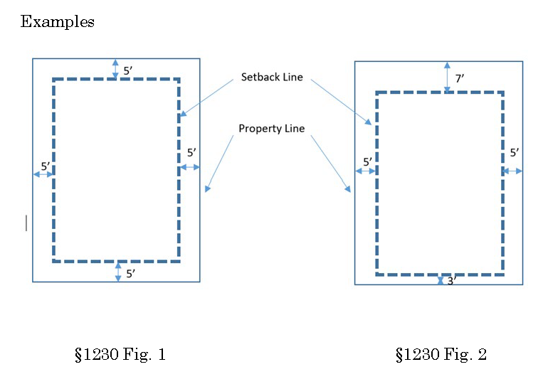
Setbacks.
(1)
Setbacks will be measured from the structure closest to the lot line.
(2)
The minimum setback for any lot line is three feet.
(3)
Cumulative setback amount:
(A)
The sum of all setbacks must equal at least 20 feet.
(B)
If lot size is less than required in this section, the required setback sum may be reduced proportionally. In no case shall the required setback sum for the lot be less than 12 feet and in no case shall any setback be less than three feet.
(Serial No. 2021-36, § 2, 9-12-2022, eff. 10-13-2022)
49.70.1240 - Yard setback exceptions.
(a)
Purpose. This section clarifies the setback exceptions that apply in the Downtown Juneau Alternative Development Overlay District. Exempted elements do not count toward the setback total.
(b)
Exception categories.
(1)
Architectural features and roof eaves may project into a required yard, but not closer than two feet from the side or rear lot lines.
(2)
Access structures, such as stairways, ramps, and landings with or without roofs, may extend to the lot line abutting a public right-of-way provided the structure does not exceed five feet in internal width exclusive of support structure.
(3)
A parking deck is exempt from the setback requirements of this chapter.
(4)
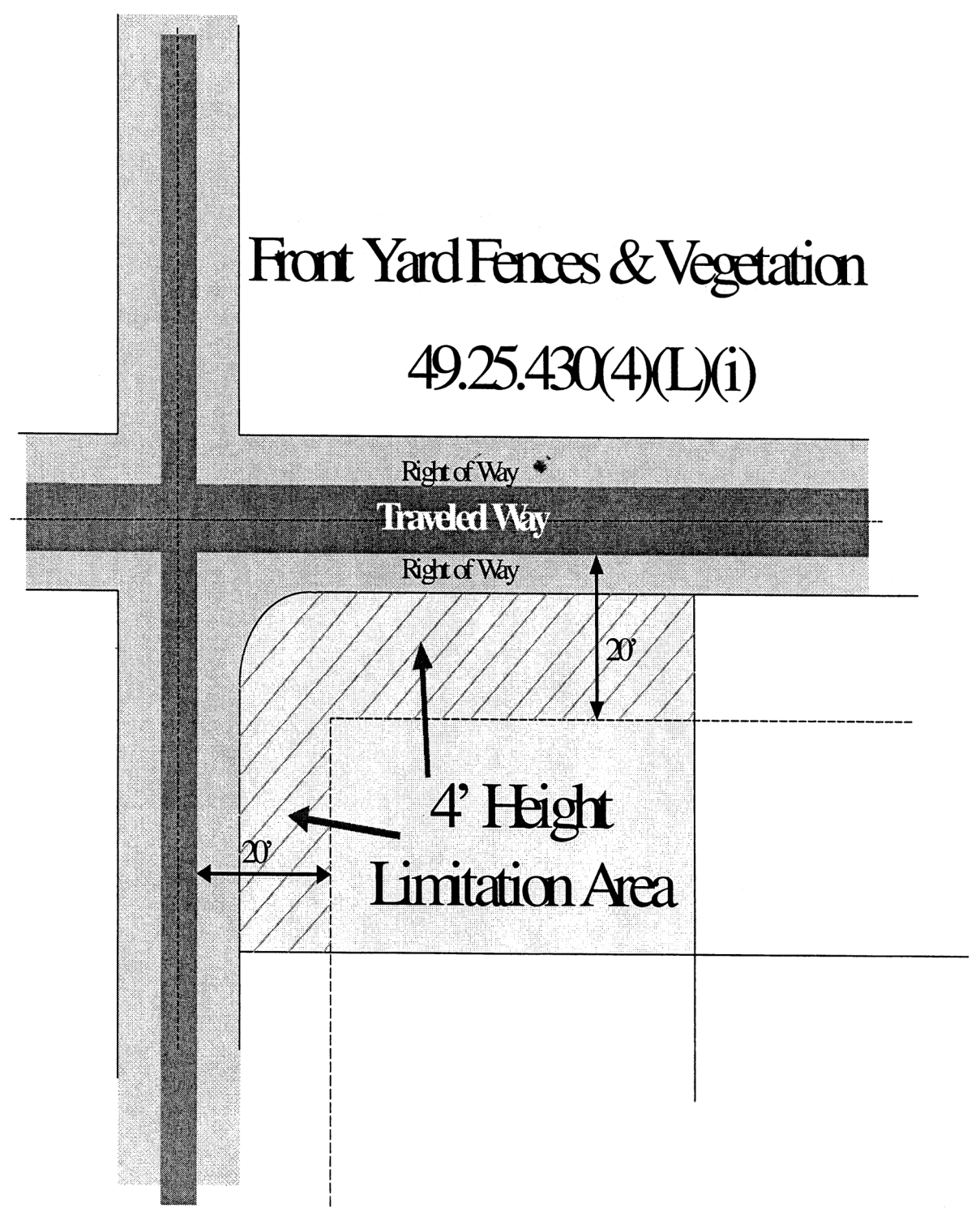
Fences and vegetation. For this section, a "traveled way" is defined as the edge of the roadway shoulder or the curb closest to property.
(A)
The maximum height of a sight obscuring fence or vegetation shall not exceed four feet within 20 feet of the edge of the traveled way. Trees are allowed within 20 feet of the edge of the traveled way provided they do not obscure view from a height of four feet to a height of eight feet above the ground;
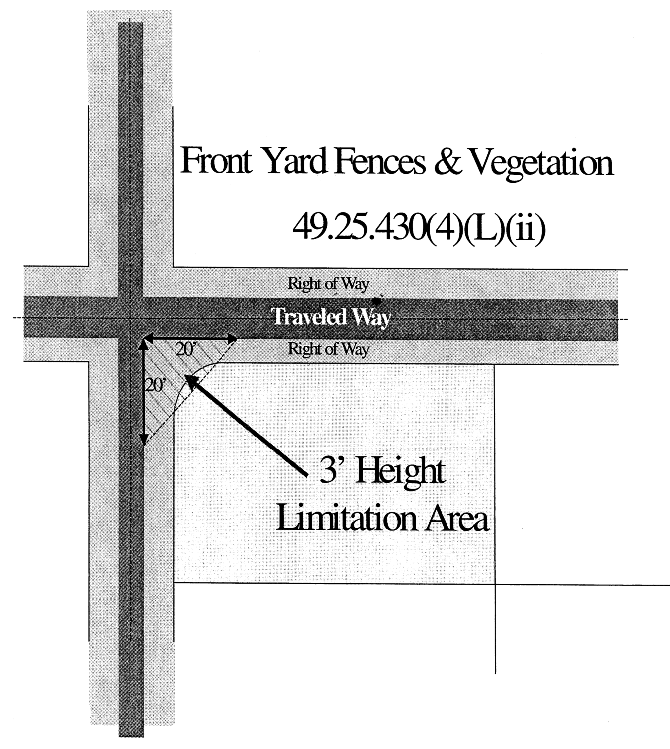
(B)
On corner lots the maximum height of a sight-obscuring fence or vegetation located within 20 feet of a street intersection shall not exceed three feet. The area in which sight-obscuring fences and vegetation is restricted shall be determined by extending the edge of the traveled ways to a point of intersection, then measuring back 20 feet, then connecting the points. In this area, vegetation shall be maintained to a maximum height of three feet. Trees are allowed in this area provided the trees do not obscure view from a height of three to eight feet above the ground.
(5)
Energy efficiency. Energy efficiency improvements that do not increase interior square footage, such as exterior insulation, may project up to eight inches into a required yard. An energy efficiency improvement may not be approved under this section if it projects into the right-of-way or across a property line.
(Serial No. 2021-36, § 2, 9-12-2022, eff. 10-13-2022)