
Juneau City Zoning Code
CHAPTER 49
15 - PERMITS1
Administrative Code of Regulations cross reference—Subdivision survey requirements, Part IV, § 04 CBJAC 005.010; platting requirements, Part IV, § 04 CBJAC 010.010.
ARTICLE IV. - SUBDIVISIONS[2]
Editor's note— Sec. 10 ofSerial No. 2015-03(c)(am), adopted Aug. 31, 2015, repealed and reenacted art. IV in its entirety to read as herein set out. Former art. IV pertained to similar subject matter, consisted of §§ 49.15.410—49.15.410, and derived from Serial No. 87-49, 1987; Serial No. 95-27, 1995; Serial No. 95-40, 1996; Serial No. 96-41, 1996; Serial No. 99-34, adopted Jan. 24, 2000; Serial No. 2005-06, adopted May 23, 2005; and Serial No. 2009-14(b), adopted June 29, 2009.
Administrative Code of Regulations cross references—Survey, monumentation, and platting standards, Part IV, § 04 CBJAC 005.010 et seq.; platting requirements, Part IV, § 04 CBJAC 010.010 et seq.
Cross reference— Public ways and property, CBJ Code tit. 62; utilities, CBJ Code tit. 75.
ARTICLE V. - CBJ AND STATE PROJECT REVIEW[4]
Editor's note—Secs. 11—13 of Serial No. 2015-03(c)(am), adopted Aug. 31, 2015, amended art. V in its entirety to read as herein set out. Former art. V pertained to design review permits, consisted of § 49.15.580, and derived from Serial No. 87-49, 1987.
49.15.110 - Permits required.
No person may perform or cause to be performed any development work within the City and Borough except in accordance with a valid development permit, or early start or fast track authorization approved under the provisions of chapter 19.01 of the building code.
(Serial No. 87-49, § 2, 1987; Serial No. 97-26, § 3, 1997)
49.15.120 - Who may submit permit applications.
(a)
Applications for permits will be accepted only from persons who have, or upon issuance of the permit, will have the legal authority to take action in accordance with the permit. All applications must be signed by the owners or lessees of the land to be subject to the permit.
(b)
The director may require an applicant to submit evidence of authority to submit an application in accordance with subsection (a) of this section.
(Serial No. 87-49, § 2, 1987)
49.15.130 - Complete applications.
(a)
All applications for permits must be complete, signed and accompanied by the applicable fee before the permit-issuing authority can accept the application.
(b)
An application is complete when it contains all of the information necessary to determine if the development will comply with all of the requirements of the permit applied for.
(c)
Permit applications shall contain a permission form signed by the applicant and the property owner granting permission to City and Borough officials, employees, and agents to enter upon the site during reasonable hours, to examine and inspect the site as part of the permitting procedure.
(d)
Incomplete applications will be rejected and notice regarding the incomplete status of the application will be sent to the address included on the application.
(Serial No. 87-49, § 2, 1987; Serial No. 91-51, § 2, 1991; Serial No. 2025-15am, § 2, 4-7-2025, eff. 5-6-2025)
49.15.140 - Application format and submittals.
The director shall decide the form and type of information required for each type of application, and may, when a particular application warrants, authorize less or require more information than normally specified.
(Serial No. 87-49, § 2, 1987)
49.15.150 - Application cancellation and withdrawal.
(a)
A permit application may be cancelled for inactivity if an applicant fails to respond to the department's written request for revisions, corrections, or additional information within 180 days of the date of the request. The director may extend the response period up to an additional 180 days. If an application is cancelled due to inactivity, the application fee shall be forfeited.
(b)
For an application filed prior to the effective date of this ordinance, the director shall assess the status of the application. If the director determines the application is incomplete, the applicant shall be informed in writing of the additional information needed and that the application will be cancelled for inactivity if the applicant fails to provide the requested information within 180 days from the date of notice. The director shall not extend the response period beyond the initial 180 days from the date of notice.
(c)
A development permit shall become void, and the application fee forfeited, 18 months after its effective date if no associated building permit, right-of-way permit or similar permit for construction has been issued and substantial construction progress pursuant thereto made, or if no plat has been issued in accordance with the plans for which the development permit was authorized. A development permit shall become void if all building permits issued for the development expire or become void.
(d)
An applicant or property owner may withdraw a permit application at any time. If an application is withdrawn less than seven days before the public hearing on the application, the application fee shall be forfeited.
49.15.160 - Amendments of approved permits.
(a)
Request for amendment.
(1)
A permitholder may request an amendment to an approved permit through an application on a form provided by the department.
(2)
Application must be filed with any required fees, scale-drawn site plans and floor plans, and any other materials required by the department at the time of submittal.
(3)
The director will inform the permitholder within 15 business days of receipt of a complete request whether the request shall be processed as a minor amendment or major amendment.
(b)
Minor amendment. The director may authorize minor amendments to approved permits if the changes:
(1)
Do not involve any expansion, intensification, or increase in size of the land use or structure beyond the original approval;
(2)
Would have an insignificant change in the outward appearance of the development;
(3)
Would have insignificant impacts on surrounding properties;
(4)
Result in insignificant modification in the location or siting of buildings or common open space;
(5)
Do not involve a feature of the project that was a basis for conditions of approval for the permit;
(6)
Do not involve a feature of the project that was a specific consideration by the review authority in granting the permit;
(7)
Do not reduce the number of parking spaces below that are required by the original permit; or
(8)
Do not create a delay greater than one year in the construction or completion schedule for the project or, in the case of a phased project, the phase for which the amendment is requested.
(c)
Major amendment. All other amendments shall be reviewed by the same review authority as the original approval. The same public notice and hearing requirements that applied to the original approval also apply to the requested major amendment.
(d)
Exceptions.
(1)
Amendments related to exploration and mining permits are governed by Chapter 49.65, Article I, Exploration and mining permits.
Serial No. 2025-15am, § 2, 4-7-2025, eff. 5-6-2025)
49.15.210 - Type of development permit required.
The type of development permit required for a particular use shall be as specified in the Table of Permissible Uses in chapter 49.25, article III.
(Serial No. 87-49, § 2, 1987)
49.15.220 - Minor and major development.
The intent of this chapter is to require a shortened approval process for minor developments and a more detailed review by the commission for major developments according to the following:
(1)
Unless otherwise specified in this title, minor development shall require department approval. If the director determines that a series of applications for minor developments, taken together, constitute a major development, the applications shall be subject to the appropriate major development permit procedures and standards.
(2)
Except as otherwise specified in this title, a major development shall require one or more of the following approvals or permits:
(A)
Allowable use permit;
(B)
Conditional use permit;
(C)
Preliminary plat approval;
(D)
Final plat approval.
(Serial No. 87-49, § 2, 1987)
49.15.230 - Public notice.
The purpose of the following public notice requirements is to reasonably inform interested parties that an application or matter is scheduled to be considered by the planning commission at a specific date, time, and place. The public notice must generally describe the application or matter. Unless otherwise provided, public notice of planning commission consideration of development permits and rezonings shall be provided as follows:
(1)
Permit consideration shall be included as an item in the posted agenda.
(2)
Notice of the commission meeting and the agenda item shall be published in a newspaper of general circulation in the City and Borough for a minimum of ten days prior to the date of the meeting.
(3)
The developer shall post a sign at the site or other location approved by the director at least 14 days prior to the meeting. The sign shall be visible from a public right-of-way. Signs shall be between four square feet and 32 square feet in area, shall have a red background, and shall indicate in white lettering, 216-point font or larger, that a development permit or rezoning, as applicable, has been sought for the site, the date of the hearing, and that further information is available from the director. The developer shall maintain the sign and shall remove it within 14 days after final action on the application.
(4)
The director shall mail notice of the application and the public hearing to the owners of record of all property and all neighborhood associations listed with the municipal clerk in accordance with CBJ 11.35 located within 500 feet of the property subject to the permit or rezoning. The actual cost of mailing shall be paid by the applicant.
(5)
The applicant shall deliver individual written notice by certified mail, return receipt requested of the application and the initial meeting thereon to each tenant of any multifamily residential development for which the application seeks a change in use.
(6)
The director may require more than one sign and may mail notice to additional owners of record of properties beyond 500 feet of the property under section (4) upon a determination that such expanded notice is required in order to provide reasonable public notice.
(7)
The director may conduct one or more neighborhood meetings prior to the commission meeting. The purpose of a neighborhood meeting is to make application materials available to interested parties, to solicit input regarding an application, and for the department to describe the application review process.
(Serial No. 87-49, § 2, 1987; Serial No. 99-15, § 2, 1999; Serial No. 2015-03(c)(am), § 6, 8-31-2015)
49.15.239 - Effective date.
(a)
Major development permits and other planning commission decisions are effective on the date the notice of decision is filed with the municipal clerk.
(b)
Minor development permits and other director approvals are effective on the date the director signs the permit.
(Serial No. 97-01, § 4, 1997; Serial No. 2015-03(c)(am), § 7, 8-31-2015)
49.15.240 - Reserved.
Editor's note— Sec. 8 of Serial No. 2015-03(c)(am), passed Aug. 31, 2015, repealed § 49.15.240, which pertained to development permit expiration and derived from Serial No. 87-49, 1987; and Serial No. 97-01, 1997.
49.15.250 - Development permit extension.
Upon an application submitted at least 30 days before the expiration of an existing major development permit, the commission shall hold a hearing to consider whether the permit should be extended. At least ten days prior to the hearing, notice thereof shall be mailed to the property owners of record adjacent to the land included in the application and at least two days prior to the hearing a general notice thereof shall be printed in a newspaper of general circulation in the municipality. At the hearing, the burden of proof for the justification for a permit extension shall rest with the applicant. Upon written findings that such burden has been met, the commission may grant an extension not to exceed 18 months, but shall not delete from, amend or add to the conditions contained in the permit. Upon written findings that the applicant's burden has not been met, or that the conditions contained in the permit should be changed, or both, the commission shall deny the application whereupon the applicant may submit the entire project, including the previously authorized use, to a full review by the commission as though it were a new application. Upon application and consideration pursuant to this section, the commission may grant no more than one additional extension, the maximum duration of which shall be 18 months.
(Serial No. 87-49, § 2, 1987)
49.15.310 - Department approval.
(a)
Purpose. The department shall review minor developments to ensure compliance with this title.
(b)
Application form. The director shall provide a minor development application form to be submitted as part of the application process for a building permit.
(c)
Preapplication conference. Prior to submitting an application, the applicant shall be afforded the opportunity to discuss with the director such facts, issues and proceedings as may be relevant to the application.
(d)
Community development director procedure.
(1)
Review of application. The director shall review the application, consult with the applicant, and approve a minor development permit unless:
(A)
The application is incomplete;
(B)
Issuance of the requested permit is beyond the director's authority according to the table of permissible uses; or
(C)
The development as proposed will not comply with one or more requirements of this title.
(2)
Conditions on approval. The director may condition department approval as necessary to ensure compliance with this title.
(Serial No. 87-49, § 2, 1987)
49.15.320 - Allowable use permit.
(a)
Purpose. An allowable use permit is established for uses allowed in a particular zoning district but which, due to size, intensity or particular characteristics must be reviewed and approved by the planning commission. To ensure the compatibility of the use with the location, the commission may attach conditions to the permit to help mitigate external impacts. Conditions that may be attached to the permit are limited to those listed in subsection (f) of this section.
(b)
Preapplication conference. Prior to submission of an application, the developer shall meet with the director for the purpose of discussing the site, the proposed development activity, and the allowable use permit procedure. The director shall discuss with the developer, regulations which may limit the proposed development as well as the standards or bonus regulations which may create opportunities for the developer. It is the intent of this section to provide for an exchange of general and preliminary information only and no statement by either the developer or the director shall be regarded as binding or authoritative for purposes of this title. A copy of this subsection shall be provided to the developer at the conference.
(c)
Submission. The developer shall submit to the director one copy of the completed application together with all attachments and the permit fee.
(d)
Application review procedure.
(1)
The director shall endeavor to determine whether the application is complete as intended by the developer, shall advise the applicant whether or not the application is acceptable and, if it is not, what corrective action may be taken.
(2)
After accepting the application, the director shall schedule it for a hearing before the commission and shall give notice to the developer and the public in accordance with CBJ 49.15.230.
(3)
Copies of the application or the relevant portions thereof shall be transmitted to interested agencies as specified on a list maintained by the director for that purpose. Referral agencies shall be invited to respond within 15 days unless an extension is requested and granted in writing for good cause by the director.
(4)
The director shall forward the application to the commission together with a report setting forth the directors's recommendation for approval or denial, with or without conditions together with the reasons therefor.
(e)
Decision. The commission shall consider the allowable use permit application. The commission shall review the director's recommendation with respect to:
(1)
Whether the application is complete;
(2)
Whether the requested permit is appropriate according to the table of permissible uses;
(3)
Whether the development as proposed will comply with the other requirements of this title; and
(4)
Whether conditions are necessary for approval. The commission shall approve the application and grant the permit unless it finds, by a preponderance of the evidence, that one or more of the criteria have not been met. In either case the commission shall adopt written findings setting forth the basis for its decision.
(f)
Conditions on approval; allowable uses. The commission may condition an allowable use permit upon one or more of the following:
(1)
Development schedule. A reasonable time limit may be imposed on construction activity associated with the development, or any portion thereof, to minimize construction-related disruption to traffic and neighbors, to ensure that development is not used or occupied prior to substantial completion of required public or quasi-public improvements, or to implement other requirements.
(2)
Use. Use of the development may be restricted to that indicated in the application.
(3)
Owners' association. The formation of an association or other agreement among developers, homeowners or merchants, or the creation of a special district may be required for the purpose of holding or maintaining common property.
(4)
Dedications. Conveyance of title, easements, licenses or other property interests to government entities, public utilities, owners' associations, or other common entities may be required.
(5)
Performance bonds. The commission may require the posting of a bond or other surety or collateral approved as to form by the city attorney to guarantee the satisfactory completion of all improvements required by the commission. The instrument posted shall provide for partial releases of no less than ten percent of the original amount posted.
(6)
Commitment letter. The commission may require a letter from a public utility or public agency legally committing it to serve the development if such service is required by the commission.
(7)
Covenants. The commission may require the execution and recording of covenants, servitudes or other instruments satisfactory in form to the city attorney as necessary to ensure permit compliance by future owners or occupants.
(8)
Revocation of permits. The permit may be automatically revoked upon the occurrence of specified events. In such case, it shall be the responsibility of the owner to apply for a new permit. Any order revoking a permit shall state with particularity the grounds therefor and the requirements for reissuance. Compliance with such requirements shall be the sole criterion for reissuance.
(9)
Habitat. Development in the following areas may be required to minimize environmental impact:
(A)
Developments in wetlands and intertidal areas, including freshwater marshes, saltwater marshes and intertidal flats.
(10)
Sound. Conditions may be imposed to discourage sound in excess of 65 dBa at the property line during the day or 55 dBa at night.
(11)
Screening. The commission may require construction of fencing or plantings to screen the development or portions thereof from public view.
(12)
Drainage. The commission may require on and off-site drainage improvements in excess of the minimum requirements of this title.
(Serial No. 87-49, § 2, 1987; Serial No. 2017-29, § 2, 1-8-2018, eff. 2-8-2018)
49.15.330 - Conditional use permit.
(a)
Purpose. A conditional use is a use that may or may not be appropriate in a particular zoning district according to the character, intensity, or size of that or surrounding uses. The conditional use permit procedure is intended to afford the commission the flexibility necessary to make determinations appropriate to individual sites. The commission may attach to the permit those conditions listed in subsection (g) of this section as well as any further conditions necessary to mitigate external adverse impacts. If the commission determines that these impacts cannot be satisfactorily overcome, the permit shall be denied.
(b)
Preapplication conference. Prior to submission of an application, the developer shall meet with the director for the purpose of discussing the site, the proposed development activity, and the conditional use permit procedure. The director shall discuss with the developer, regulation which may limit the proposed development as well as standards or bonus regulations which may create opportunities for the developer. It is the intent of this section to provide for an exchange of general and preliminary information only and no statement by either the developer or the director shall be regarded as binding or authoritative for purposes of this code. A copy of this subsection shall be provided to the developer at the conference.
(c)
Submission. The developer shall submit to the director one copy of the completed permit application together with all supporting materials and the permit fee.
(d)
Director's review procedure.
(1)
The director shall endeavor to determine whether the application accurately reflects the developer intentions, shall advise the applicant whether or not the application is acceptable and, if it is not, what corrective action may be taken.
(2)
After accepting the application, the director shall schedule it for a hearing before the commission and shall give notice to the developer and the public in accordance with CBJ 49.15.230.
(3)
The director shall forward the application to the planning commission together with a report setting forth the director's recommendation for approval or denial, with or without conditions together with the reasons therefor. The director shall make those determinations specified in subsections (1)(A)—(1)(C) of subsection (e) of this section.
(4)
Copies of the application or the relevant portions thereof shall be transmitted to interested agencies as specified on a list maintained by the director for that purpose. Referral agencies shall be invited to respond within 15 days unless an extension is requested and granted in writing for good cause by the director.
(5)
Even if the proposed development complies with all the requirements of this title and all recommended conditions of approval, the director may nonetheless recommend denial of the application if it is found that the development:
(A)
Will materially endanger the public health or safety;
(B)
Will substantially decrease the value of or be out of harmony with property in the neighboring area; or
(C)
Will not be in general conformity with the land use plan, thoroughfare plan, or other officially adopted plans.
(e)
Review of director's determinations.
(1)
At the hearing on the conditional use permit, the planning commission shall review the director's report to consider:
(A)
Whether the proposed use is appropriate according to the table of permissible uses;
(B)
Whether the application is complete; and
(C)
Whether the development as proposed will comply with the other requirements of this title.
(2)
The commission shall adopt the director's determination on each item set forth in paragraph (1) of this subsection (e) unless it finds, by a preponderance of the evidence, that the director's determination was in error, and states its reasoning for each finding with particularity.
(f)
Commission determinations; standards. Even if the commission adopts the director's determinations pursuant to subsection (e) of this section, it may nonetheless deny or condition the permit if it concludes, based upon its own independent review of the information submitted at the hearing, that the development will more probably than not:
(1)
Materially endanger the public health or safety;
(2)
Substantially decrease the value of or be out of harmony with property in the neighboring area; or
(3)
Lack general conformity with the comprehensive plan, thoroughfare plan, or other officially adopted plans.
(g)
Specific conditions. The commission may alter the director's proposed permit conditions, impose its own, or both. Conditions may include one or more of the following:
(1)
Development schedule. A reasonable time limit may be imposed on construction activity associated with the development, or any portion thereof, to minimize construction-related disruption to traffic and neighborhood, to ensure that development is not used or occupied prior to substantial completion of required public or quasi-public improvements, or to implement other requirements.
(2)
Use. Use of the development may be restricted to that indicated in the application.
(3)
Owners' association. The formation of an association or other agreement among developers, homeowners or merchants, or the creation of a special district may be required for the purpose of holding or maintaining common property.
(4)
Dedications. Conveyance of title, easements, licenses, or other property interests to government entities, private or public utilities, owners' associations, or other common entities may be required.
(5)
Performance bonds. The commission may require the posting of a bond or other surety or collateral approved as to form by the city attorney to guarantee the satisfactory completion of all improvements required by the commission. The instrument posted may provide for partial releases.
(6)
Commitment letter. The commission may require a letter from a public utility or public agency legally committing it to serve the development if such service is required by the commission.
(7)
Covenants. The commission may require the execution and recording of covenants, servitudes, or other instruments satisfactory in form to the city attorney as necessary to ensure permit compliance by future owners or occupants.
(8)
Revocation of permits. The permit may be automatically revoked upon the occurrence of specified events. In such case, it shall be the sole responsibility of the owner to apply for a new permit. In other cases, any order revoking a permit shall state with particularity the grounds therefor and the requirements for reissuance. Compliance with such requirements shall be the sole criterion for reissuance.
(9)
Avalanche areas. Development in moderate and severe avalanche hazard areas shown on the Avalanche Hazard Designation Mapping, dated April 27, 2022, and attached to Serial No. 2023-18(am) as Appendix A, must minimize the risk to life and property.
(10)
Habitat. Development in the following areas may be required to minimize environmental impact:
(A)
Developments in wetlands and intertidal areas.
(11)
Sound. Conditions may be imposed to discourage production of more than 65 dBa at the property line during the day or 55 dBa at night.
(12)
Traffic mitigation. Conditions may be imposed on development to mitigate existing or potential traffic problems on arterial or collector streets.
(13)
Water access. Conditions may be imposed to require dedication of public access easements to streams, lake shores and tidewater.
(14)
Screening. The commission may require construction of fencing or plantings to screen the development or portions thereof from public view.
(15)
Lot size or development size. Conditions may be imposed to limit lot size, the acreage to be developed or the total size of the development.
(16)
Drainage. Conditions may be imposed to improve on and off-site drainage over and above the minimum requirements of this title.
(17)
Lighting. Conditions may be imposed to control the type and extent of illumination.
(18)
Other conditions. Such other conditions as may be reasonably necessary pursuant to the standards listed in subsection (f) of this section.
(Serial No. 87-49, § 2, 1987; Serial No. 2006-15, § 2, 6-5-2006; Serial No. 2015-03(c)(am), § 9, 8-31-2015; Serial No. 2017-29, § 3, 1-8-2018, eff. 2-8-2018; Serial No. 2023-18(am), § 3, 12-11-2023, eff. 1-11-2024)
DIVISION 4. - RESERVED[3]
Editor's note—Sec. 3 of Serial No. 2016-26(b), effective May 3, 2017, repealed and reserved Division 4, which pertained to Privately Maintained Access in Rights-of-Way, consisted of §§ 49.15.430—49.15.435, and derived from Serial No. 2015-03(c)(am), adopted Aug. 31, 2015.
49.15.580 - State and City and Borough project review.
(a)
CBJ project review: The commission shall review all proposed City and Borough capital improvement projects estimated to cost $500,000 or more for consistency with this title. The commission may review, at the director's discretion, all proposed City and Borough capital projects estimated to cost more than $250,000 but less than $500,000. The commission may recommend conditions on and modifications to any project reviewed by the commission through a notice of recommendation. The notice of recommendation shall be forwarded to the assembly for further action.
(b)
State project review: The commission shall review proposed Alaska State capital improvement projects for consistency with this title pursuant to AS 35.30.010 and may impose conditions on and modifications to such projects. If the commission approves or approves with conditions or modifications, a notice of decision shall be issued. A notice of decision becomes final 90 days from the date the project was submitted unless modified or disapproved by the assembly. If the commission disapproves, a notice of recommendation and draft resolution shall be forwarded to the assembly for further action.
49.15.590 - Right-of-way acquisitions.
(a)
Generally. The minor subdivision permit process shall govern right-of-way acquisition plats, except commission review through the major subdivision process shall be required if the acquisition of property for a right-of-way would create a nonconforming lot, use, or structure. The commission may approve creation of nonconforming lots, uses, or structures if each lot has at least one practical building site that may be reasonably developed. The commission may condition its approval.
(b)
Application requirements.
(1)
Signatures of the owners or lessees of the subject parcels are not required.
(2)
The owner of land subject to a right-of-way acquisition may offer to sell or enter into a contract to sell land to the state or City and Borough before a final plat of the subdivision has been prepared, approved, filed, and recorded in accordance with this chapter.
(3)
Applications for preliminary right-of-way acquisition plat approval shall comply with the requirements of CBJ 49.15.411, provided, however, that the following subsections are not applicable:
(A)
CBJ 49.15.411(i)(3), unless the director determines that the proposed reduction in lot area of an existing parcel without public sewer access causes it to become unsuitable for on-lot waste disposal.
(B)
CBJ 49.15.411(i)(5), Water.
(C)
CBJ 49.15.411(i)(7), Traffic study.
(D)
CBJ 49.15.411(i)(8), Shadow plats.
(c)
Final plat submittal.
(1)
All applications for right-of-way acquisition plats must comply with the requirements of CBJ 49.15.412, provided, however, that the following sections are not applicable:
(A)
CBJ 49.15.412(e)(5), Proof of construction plan approval.
(B)
CBJ 49.15.412(e)(3), Utility statements.
(C)
CBJ 49.15.412(e)(6), Improvement guarantee draft.
(D)
CBJ 49.15.412(f)(2), Improvement guarantee final.
(E)
CBJ 49.15.412(f)(3), Deeds, easements, or rights-of-way.
(d)
Design. Right-of-way acquisition plats must comply with the design requirements of this title, provided, however, that the following sections are not applicable:
(1)
CBJ 49.15.420, Lots.
(2)
CBJ 49.35.210, Streets.
(e)
Improvements. The requirement to construct public improvements according to CBJ 49.35 is waived except where the acquisition of right-of-way and subsequent change to property boundaries results in the loss of access to public utilities or street frontage for an existing lot necessitating replacement of these public improvements.
(f)
Survey and monumentation standards. All applications for right-of-way acquisition plats must comply with the requirements of CBJ 49.15, article IV, division 6, except CBJ 49.15.453 is modified to require that only corners located along the new right-of-way line be monumented.
(g)
Right-of-way maps. After completion of a right-of-way project, a final right-of-way map that identifies all required survey and monumentation information shall be submitted. The final right-of-way map will be reviewed by the director of the engineering and public works department for completeness and then recorded at the State Recorder's Office at Juneau at the applicant's expense.
49.15.600 - Purpose.
The general purpose of the planned unit development code is to permit flexibility in the regulation and use of land in order to promote its most appropriate use; to facilitate the adequate and economical provisions of streets and utilities; to preserve the natural and scenic qualities of open space; and to encourage, consistent with the goals and objectives of the comprehensive plan, residential developments that are planned, designed, and developed to function as integral units. The specific purposes of the planned unit development code are to:
(a)
Encourage uses of land that are efficient, aesthetic, in harmony with the surrounding area, and consistent with the comprehensive plan and available public services;
(b)
Encourage innovation in site design and building layout, pedestrian and vehicular circulation, parking facilities and streets, configuration and use of open space, and mixing of housing types and compatible land uses;
(c)
Encourage economy and efficiency in common facilities;
(d)
Preserve and protect natural features, streams, lakes, wetlands, natural drainage channels, vegetation, and vistas;
(e)
Avoid avalanche and flood hazard areas; and
(f)
Encourage development of quality housing at a reasonable price.
(Serial No. 97-12, § 2, 1997; Serial No. 2023-18(am), § 5, 12-11-2023, eff. 1-11-2024)
49.15.610 - General provisions.
(a)
Zoning districts. A residential planned unit development is allowed in zoning districts RR, D-1, D-3, D-5, D-10 SF, D-10, D-15, D-18, and LC.
(b)
Permitted uses. The uses allowed in the underlying zoning district, according to section 49.25.300, table of permissible uses, are permitted in all planned unit developments. The following additional uses are permitted in a residential planned unit development:
(1)
A mixture of single-family, two-family, and multifamily housing; and
(2)
A recreational facility or a planned unit development community center.
(Serial No. 97-12, § 2, 1997; Serial No. 2007-39, § 2, 6-25-2007, eff. 6-25-2007)
49.15.620 - Planned unit development review process.
(a)
General procedure. A proposed planned unit development shall be reviewed according to the requirements of section 49.15.330, conditional use permit, and in the case of an application proposing a change in the number or boundaries of lots, section 49.15.402, major subdivisions, except as otherwise provided in this article. Approval shall be a two-step process, preliminary plan approval and final plan approval. In cases involving a change in the number or boundaries of lots, the preliminary and final plat submissions required by section 49.14.430 shall be included with the preliminary and final plan submissions required by this chapter.
(b)
Preapplication conference. Prior to submission of an application, the director shall conduct an informal preapplication conference with the developer to discuss the proposed planned unit development. The purpose of the preapplication conference shall be to exchange general and preliminary information and to identify potential issues. The developer may discuss project plans and the director may provide an informal assessment of project permit eligibility, but no statement made by either party shall be regarded as binding, and the result of the conference shall not constitute preliminary approval by the department. The conference shall include a discussion of the zoning, size, topography, accessibility, and adjacent uses of the development site; the uses, density and layout of buildings, parking areas, the open space and landscaping proposed for the development; the common facilities; the street layout and the vehicle and pedestrian circulation; the development schedule and the planned unit development permit procedures. The developer shall provide a sketch of the proposed planned unit development.
(Serial No. 97-12, § 2, 1997)
49.15.630 - Preliminary planned unit development plan approval.
(a)
Application. The developer shall submit to the department one copy of a complete planned unit development application, which shall include an application form, the required fee, any information required in subsection 49.15.430(1), the information required by this section, and any other information specified by the director.
(b)
Required submissions. The application shall include the following material:
(1)
Ownership. The application shall identify, and shall be signed by or upon, the included written authorization of, all owners, lessees, and optionees of land within the boundaries of all phases of the planned unit development.
(2)
Preliminary development plan. The application shall include a preliminary development plan, explaining how the proposed planned unit development will achieve the purposes set forth in section 49.15.600. The preliminary development plan shall summarize the different land uses proposed, including the amount of land for housing, common open space, streets, and parking; the number and types of housing units and proposed density; the natural features to be protected and hazards to be avoided; and the public and private services to be provided.
(3)
Design. The application shall describe the design of the planned unit development, with particular attention to building massing, color, and architectural features; the layout of buildings, parking, and streets; and the circulation of traffic and pedestrians.
(4)
Common open space, facilities, and general landscaping. The preliminary plat shall show and describe improved and undisturbed common open space.
(5)
Description of phased development. The preliminary development plan for a phased planned unit development shall include:
(A)
A drawing and development schedule for each phase and for the entire planned unit development;
(B)
The size and general location of proposed land uses for each phase at a projected level of density;
(C)
A description of the streets connecting all the phases and where they will connect at the planned unit development boundaries;
(D)
A description of how the developer will address the cumulative impacts of the phased development on the neighborhood and the natural environment;
(E)
A description of the overall design theme unifying the phases; and
(F)
An analysis of how each phase in the project will meet the requirements of subsection 49.15.650(b).
(c)
Department review. The director shall advise the developer whether the planned unit development application is complete, and, if not, what the developer must do to make it complete. Within 45 days after determining an application is complete, the director shall schedule the preliminary plan for a public hearing before the commission. The director shall give notice to the developer and the public according to section 49.15.230.
(d)
Commission action. The commission shall approve a planned unit development preliminary plan if it meets the requirements of section 49.15.330 and:
(1)
The design effectively provides for clustered buildings, mixed uses, or mixed housing types;
(2)
The development protects natural features and avoids natural hazards by reserving them as undisturbed open space;
(3)
The development is consistent with the land use code;
(4)
The development incorporates boundary buffers sufficient to separate adjacent property from dissimilar uses;
(5)
Utilities proposed for connection to the City and Borough system meet City and Borough standards, and all others are consistent with sound engineering practices, as determined by the City and Borough engineering department;
(6)
The configuration of the development provides for economy and efficiency in utilities, housing construction, streets, parking and circulation;
(7)
If the approval is for a phased development, that each phase is consistent with the preliminary development plan and design of the entire planned unit development; and
(8)
Adequately addresses the cumulative impacts of the phased development on the neighborhood and the natural environment.
(e)
Expiration. Approval of a preliminary plan shall expire 18 months after the commission notice of decision unless a final plan for the entire project or, in the case of a phased development, the first phase thereof, is submitted to the department for commission action. An application for extension of a preliminary plan shall be according to section 49.15.250, development permit extension.
(Serial No. 97-12, § 2, 1997)
49.15.640 - Final planned unit development plan approval.
(a)
Application. Upon completion of all conditions of the preliminary plan, the developer shall submit an application, fee, and a final plan for commission approval.
(b)
Homeowners' association.
(1)
The articles of incorporation and bylaws of the homeowners' association, required under AS 34.08, or this chapter, shall be prepared by a lawyer licensed to practice in the state.
(2)
The association documents shall specify how common facilities shall be operated and maintained. The documents shall require homeowners to pay periodic assessments for the operation, snow removal, maintenance and repair of common facilities. The documents shall require that the governing body of the association adequately maintain common facilities.
(3)
If planned unit development utilities or streets are not accepted for maintenance by the City and Borough, the homeowners' association documents shall clearly indicate that a special assessment may be levied in the future for extraordinary repairs or to perform necessary work in order to connect or dedicate common facilities to the City and Borough system. If the planned unit development is phased, the association documents shall specify how the cost to build, operate, and maintain improved common open space and common facilities shall be apportioned among homeowners of the initial phase and homeowners of later phases.
(4)
The homeowners' association documents shall be recorded with the approved final plat, as required by state law, or both.
(c)
Commission action. The commission shall approve the final plan if it substantially conforms to the approved preliminary plan and all requirements of this article.
(d)
Expiration. An approved final plan shall expire 18 months after recording if the applicant fails to obtain an associated building permit and make substantial construction progress. An application for extension of a final plan shall be according to section 49.15.250, development permit extension.
(Serial No. 97-12, § 2, 1997)
49.15.650 - Phased development.
(a)
Phasing allowed. An applicant may develop a planned unit development in phases, provided the initial application includes a preliminary development plan sufficient to assess the cumulative effects of the entire planned unit development on the neighborhood and the environment according to the standards in subsection 49.15.630(b)(5)
(b)
Completion of an individual phase. Each phase shall be so designed and implemented that, when considered with reference to any previously constructed phases but without reference to any subsequent phases, it meets the design and density standards applicable to the entire planned unit development. Construction and completion of common open space and common facilities serving each phase in a planned unit development shall proceed at a rate no slower than that of other structures in that phase. No phase shall be eligible for final plan approval until all components of all preceding phases are substantially complete.
(c)
Standards for phases. Each phase of a planned unit development shall be reviewed according to the provisions of this chapter then current. Each phase of a planned unit development shall maintain design continuity with earlier phases. At no point during a phased development shall the cumulative density exceed that established in the approved preliminary plan.
(Serial No. 97-12, § 2, 1997)
49.15.660 - Reserved.
Editor's note— Sec. 2 of Serial No. 2025-15am, adopted April 7, 2025, deleted § 49.15.660, which pertained to amendments to approved planned unit development plan, and derived from Serial No. 97-12, 1997.
49.15.670 - Planned unit development design standards.
(a)
Zoning district standards. The standards applicable to a planned unit development shall be those of the underlying zoning district except as provided in this section.
(b)
Minimum site. The minimum site area for a residential planned unit development, or the first phase of a phased development, shall be 2.0 acres in the D-10 SF, D-10, D-15, D-18, and LC districts and 3.0 acres in the RR, D-1, D-3, and D-5 districts.
(c)
Lot size. There is no required minimum lot size within a planned unit development. Lot sizes will be established as part of the preliminary plan approval.
(d)
Building height and spacing. No structure shall exceed 35 feet in height as calculated in section 49.25.420, height of building. Each dwelling structure must be located at least ten feet from any other dwelling unless structurally attached thereto.
(e)
Perimeter buffer. There shall be a buffer of no less than 25 feet between the exterior boundary of the planned unit development and the nearest structure, road, or parking area within the development, unless the development includes a perimeter of transitional lots meeting the minimum dimensional standards in the zoning district. No building structures or parking areas may be located within the perimeter buffer.
(f)
Common open space.
(1)
At least 30 percent of a residential planned unit development in the D-10 SF, D-10, D-15, D-18, and LC zoning districts, and 40 percent in the RR, D-1, D-3, and D-5 zoning districts shall be common open space.
(2)
Common open space shall be conveniently and appropriately located throughout the planned unit development in relation to the dwellings and natural features and in a manner reasonably accessible to all residents. At least 70 percent of the total common open space shall be provided as a single, contiguous unit.
(g)
Density.
(1)
The number of dwelling units permitted in the development shall be calculated by multiplying the maximum number of dwelling units per gross acre permitted in the underlying zoning district by the number of acres in the planned unit development and rounding to the nearest whole number.
(2)
Land and water bodies used in calculating allowable density shall be delineated on the preliminary and final plans in a manner allowing confirmation of acreage and density computations.
(3)
The commission may award a density bonus as an incentive to add enhancements to the development. The total bonus shall not exceed 15 percent of the density provided in subsection (g)(1) of this section and rounded to the nearest whole number and shall be the sum of individual density bonuses of up to:
(A)
One percent for each ten percent increment of common open space in excess of that required to a maximum bonus of five percent for open space 50 percent in excess of that required;
(B)
Five percent for a mixture of housing units, at least 15 percent of which are designed for purchase via a monthly mortgage payment of no more than 30 percent of the median income in the City and Borough, as calculated by the Alaska Department of Labor;
(C)
Three percent for a continuous setback of greater than 50 feet, designated in the plan as undisturbed open space along important natural water bodies, including anadramous fish streams, lakes, and wetlands;
(D)
Five percent for excellence in siting, design, landscaping, and provision of common facilities and additional amenities that provide a distinctive development and unusual enhancement to the general area; and
(E)
Five percent for dedication of a public right-of-way accessible to all lots.
(4)
A density bonus may be limited or denied to avoid the creation of:
(A)
Inconvenient or unsafe access to the development;
(B)
Unreasonable adverse effects on adjacent property;
(C)
Traffic congestion in the streets adjoining the development; or
(D)
An excessive burden on sewer, water, parks, recreational facilities, schools or other existing or proposed public facilities.
(h)
Access, pedestrian and vehicular circulation, and parking.
(1)
The standards in chapter 49.40, access, parking, and traffic apply except as provided in this section.
(2)
In a residential planned unit development, common parking and maneuvering areas shall be set back at least 25 feet from any point on the exterior boundary of the planned unit development and from any boundary of a phase not contiguous with a completed phase. A landscaped yard of at least ten feet shall be provided between a common parking area and a lot line within the planned unit development.
(3)
Pedestrian or bicycle pathways shall be provided to facilitate movement within the development and to ensure access to common open space, common facilities and to public services, where available.
(4)
The development shall have access to a public right-of-way. A planned unit development which adjoins undeveloped land shall provide for a right-of-way between the undeveloped land and an existing public right-of-way, where appropriate.
(5)
Access to each dwelling unit shall be via a public right-of-way or a private street or pedestrian way owned by the individual property owner or in common planned unit development ownership.
(i)
Services.
(1)
All common facilities shall be developed to Code standards as established in chapter 49.35 and chapter 49.40, unless waived or modified by the planning commission upon the recommendation of the engineering department. Water and sewer systems within 500 feet of the public system shall be developed to Code standards and connected to the public system.
(2)
Private utilities such as a community water or sewer system shall be designed by a licensed engineer and approved by the engineering department. The homeowners' association shall annually retain a licensed engineer to inspect the private utility system and provide a report on its condition to the engineering department.
(3)
An on-site disposal system shall be designed and approved by a licensed, qualified engineer and may be constructed to serve two or more dwelling units. The disposal system may be placed in the common open space. The applicant shall provide evidence that the site has soils of sufficient permeability to accommodate the proposed on-site system. The disposal system shall be designated on the final plan and any final plat.
(4)
Private streets must at a minimum meet Code street construction requirements for roadbed design and slope erosion control, as specified in Code engineering standard details. Other street requirements may be waived by the commission upon recommendation of the engineering department and its own finding that any internal street intended to serve the planned unit development shall provide adequate ingress and egress; access shall be of a width adequate to serve anticipated traffic; design features of the planned unit development make standard street widths unnecessary; and the street will not create hazardous conditions for vehicular, bicycle or pedestrian traffic. Private streets must provide adequate fire safety and emergency access as approved by the fire chief, and shall include adequate provision for snow removal and storage.
(j)
Stormwater management. Facilities for the control and disposal of stormwater must be adequate to serve the development site and areas draining through the site. Management shall be in accordance with the Stormwater Best Management Practices manual. Where appropriate, natural drainage channels, swales, or other similar areas within the common open space may be used for stormwater management at the development. The homeowners' association shall provide the engineering department with an evaluation of offsite drainage outfalls for the additional runoff contributed by the planned unit development. The commission may require construction of offsite drainage improvements necessary to accommodate additional runoff from the development.
(Serial No. 97-12, § 2, 1997; Serial No. 2007-39, §§ 3, 4, 6-25-2007, eff. 6-25-2007; Serial No. 2015-03(c)(am), § 15, 8-31-2015)
49.15.680 - Reserved.
Editor's note— Sec. 16 of Serial No. 2015-03(c)(am), adopted Aug. 13, 2015, repealed and reserved § 49.15.680, which pertained to definitions, and derived from Serial No. 97-12, 1997.
49.15.700 - Purpose.
The purpose of this article is to:
(a)
Provide for development of housing that responds to changing demographics and smaller-sized households;
(b)
Provide for single-family cottage ownership in a neighborhood setting;
(c)
Support the efficient use of land and higher density in-fill in developed areas;
(d)
Provide additional opportunity for housing development; and
(e)
Provide standards for cottage housing development and design.
(Serial No. 2005-52(b), § 3, 1-30-2006)
49.15.710 - General provisions.
(a)
Zoning districts. A cottage housing development shall be permitted in the D-3, D-5, D-10, and D-10 SF residential districts.
(b)
Common interest community form of ownership required. A cottage housing development must be developed as a common interest community pursuant to AS 34.08.010—34.08.995.
(c)
Water and sewer. Cottage housing development shall be permitted only in areas served by municipal water and sewer at the time of application.
(Serial No. 2005-52(b), § 3, 1-30-2006; Serial No. 2007-39, § 5, 6-25-2007, eff. 6-25-2007)
49.15.720 - Cottage housing development review process.
(a)
General procedure. A proposed cottage housing development shall be reviewed according to the requirements of section 49.15.330, conditional use permit, and this article. Approval shall be a two-step process, preliminary plan approval and final plan approval.
(b)
Preapplication conference. Prior to submission of an application, the applicant shall attend an informal preapplication conference with the community development department to discuss the proposed cottage housing development. The purpose of the preapplication conference shall be to exchange general and preliminary information and to identify potential issues. The developer shall provide a sketch, drawn to scale, of the proposed cottage housing development. The developer may discuss project plans and the director may provide an informal assessment of project permit eligibility, but no statement by either party shall be regarded as binding, and the result of the conference shall not constitute preliminary approval by the department.
(c)
Neighborhood meeting. The project applicant for a cottage housing development shall be required to hold at least one neighborhood meeting after the preapplication conference but before application submittal under CBJ 49.15.730. The purpose of the neighborhood meeting is to provide the public with a means of obtaining information about the proposal and an opportunity to comment on it at the early stages of the development. Public notice of the meeting shall be published in a newspaper of general circulation a minimum of ten days prior to the date of the meeting.
(Serial No. 2005-52(b), § 3, 1-30-2006)
49.15.730 - Preliminary plan approval.
(a)
Application. The developer shall submit to the department one copy of a complete cottage housing development application, which shall include an application form, the required fee, the information required by this section, and any other information specified by the director.
(b)
Required submissions. The application shall include the following material:
(1)
Preliminary development plan. The application shall include a preliminary development plan illustrating how the proposed cottage housing development will achieve the purposes and standards set forth in this article. The preliminary development plan shall consist of a site plan prepared on paper, drawn to scale by an architect or architectural drafter, and shall display the following information:
(A)
The location, size, configuration, and dimensions of the lot on which the cottage housing development will be developed;
(B)
The location and footprint for each cottage;
(C)
A depiction of "ghost lines" that delineate the spacing around each cottage;
(D)
A delineation of the common open area;
(E)
The height and net floor area of each cottage;
(F)
The parking locations, layout, circulation, ingress and egress;
(G)
The location, if applicable, of any buildings to be used in common by the residents of the cottage housing development;
(H)
The layout and dimensions of pedestrian circulation from the parking areas to the cottages, and connecting the cottages;
(I)
A design checklist listing the design features that constitute the required design points for each cottage, with illustrations;
(J)
A depiction of the driveway access from a publicly maintained street to the cottage housing development parking areas, with its dimensions; and
(K)
Any other information the director finds necessary to ensure compliance with this title.
(c)
Department review. The director shall determine when the cottage housing development application is complete and advise the developer. Within 60 days of determining that an application is complete, the director shall schedule the preliminary plan for a public hearing before the commission. The department shall give notice of the hearing pursuant to CBJ 49.15.230.
(d)
Commission action. The commission shall review the preliminary plan and approve, approve with conditions, or disapprove it pursuant to CBJ 49.15.330 and this article.
(e)
Preliminary plan approval. The notice of decision on the preliminary plan shall constitute a final agency decision.
(f)
Expiration. Pursuant to CBJ 49.15.240, approval of a preliminary plan shall expire 18 months after the commission's notice of decision is filed with the municipal clerk. An extension of a preliminary plan shall be according to section 49.15.250, development permit extension.
(Serial No. 2005-52(b), § 3, 1-30-2006; Serial No. 2007-55, § 2, 9-24-2007)
49.15.740 - Final plan approval.
(a)
Application for final approval. Upon completion of all conditions of the preliminary plan, the developer may submit for commission review a final plan drawn on mylar at the same scale as the approved preliminary plan or according to other specifications by the department.
(b)
Unit owners' association. The common interest community declaration, articles of incorporation, and bylaws of the unit owners' association shall be prepared by an attorney licensed to practice in Alaska. The association documents shall specify how the common elements and associated off-site improvements are to be maintained, and shall require unit owners to pay assessments for snow removal and other maintenance. Declarations, bylaws, and other documents shall be recorded as required by AS 34.08.010—34.08.995.
(c)
Commission action. The commission shall approve the final plan if it complies with this title, substantially conforms to the approved preliminary plan, and all applicable conditions have been satisfactorily completed or for which a guarantee has been provided pursuant to CBJ 49.55.010.
(d)
Expiration. Pursuant to CBJ 49.15.240, an approved final plan shall expire 18 months after the notice of decision is filed with the municipal clerk. An extension of a final plan shall be according to section 49.15.250, development permit extension.
(Serial No. 2005-52(b), § 3, 1-30-2006)
49.15.750 - Reserved.
Editor's note— Sec. 2 of Serial No. 2025-15am, adopted April 7, 2025, deleted § 49.15.750, which pertained to amendments to approved cottage housing development plan, and derived from Serial No. 2005-52(b), adopted January 30, 2006.
49.15.760 - Cottage housing development standards.
(a)
General. The standards applicable to a cottage housing development shall be those of the underlying zoning district except as provided in this article.
(b)
Density, lot area, and number of dwellings. The intent of the density and lot area standards is to establish the density for a cottage housing development in the specified residential zoning districts.
(1)
Density. A cottage housing development shall not exceed one dwelling unit per 4,500 square feet in the D-3 Zoning District, one dwelling unit per 3,600 square feet in the D-5 Zoning District, or one dwelling unit per 3,000 square feet in the D-10 SF and D-10 Zoning Districts inclusive of property line setbacks, parking and access, spacing around cottages, and the common open area within the cottage housing development.
(2)
Number of dwellings allowed. The minimum number of dwellings in a cottage housing development is four units. The maximum number of dwellings in a cottage housing development is 12 units, provided, however, that in a D-10 zoning district the maximum shall be 14 units.
(c)
Dimensional and site requirements. It is the intent of the dimensional and site requirements section to provide for cottage housing developments that fit readily into existing residential neighborhoods by specifying maximum height and lot coverage; and to preserve the unique design and layout of a cottage housing development by addressing common area requirements and spacing between structures.
(1)
Right-of-way frontage. At least one lot line of a cottage housing development lot must abut a public right-of-way for a distance of at least 30 feet.
(2)
Lot coverage. Maximum lot coverage for all structures in a cottage housing development shall not exceed 60 percent of the lot area.
(3)
Setbacks and spacing.
(A)
Cottage housing development lot setbacks. Setbacks shall be as provided for the zoning district in which the cottage housing development lot is located.
(B)
Spacing between cottages.
(i)
Cottages shall be no less than five feet, and no more than 15 feet, from the common open area, measured from the facade of the cottage to the nearest delineation of the common open area.
(ii)
Cottages shall be separated from each other by at least ten feet.
(4)
Common open area.
(A)
A minimum of 250 square feet of common open area per cottage shall be included in every cottage housing development.
(B)
At least 50 percent of the front of each cottage shall face the common open area.
(C)
At least two sides of the common open area shall have cottages along its perimeter.
(D)
The perimeter of the common open area may have no more than seven changes of direction.
(Serial No. 2005-52(b), § 3, 1-30-2006; Serial No. 2007-39, § 6, 6-25-2007, eff. 6-25-2007)
49.15.770 - Exterior design standards for cottages.
(a)
Purpose. It is the intent of the design standards section:
(1)
To ensure that cottage design is based on a coherent architectural concept;
(2)
To ensure that cottages possess architectural finish;
(3)
To ensure that cottages contribute positively to the architectural character of the neighborhood; and
(4)
To provide flexibility in design and contrast among individual cottages, while assuring attention to design amenities.
(b)
Exterior design requirements. Each cottage in a cottage housing development must be designed to include a minimum of 34 points from the following table, including the specified minimum number of points from each category.
1 Wood or hardi-plank. Exposed siding must be between four inches and seven inches in width.
2 A maximum of three points may be allowed for architectural and/or shake shingle roofing.
3 Must be commercial quality with hidden fasteners.
4 Shall not also be used for gabled porch roof or porch roof overhang.
5 Shall not also be used for a change of plane of front facade or as a gable dormer or gabled porch roof.
6 Exposed rafter tail painted or decoratively cut; soffit finished in shiplap or similar treatment.
7 Minimum of two. Must be divided-lite windows with grillwork on the inside and outside of the window.
8 Must include cornice molding, jamb molding, and sill for all windows.
9 Must have cornice molding, parting bead, and plinth blocks.
10 Not less than two, or more than three, feet high.
11 Must include at least one dozen perennial bushes and/or trees native to the area or tolerant of local climate conditions. Landscaping does not include lawns.
(c)
Cottage floor area. The intent of the floor area section is to ensure that the overall size of cottages remains smaller and incurs less visual impact than standard sized single-family dwellings, particularly given the increased density of cottage dwellings; to provide variety in cottage housing developments through a mixture of building sizes and footprints. Interior space is limited to the main floor and second floor or loft area of each cottage.
(1)
Interior space limitation.
(2)
Main floor. At least 50 percent of the cottages in a cottage housing development shall have first floor areas not exceeding 700 square feet, net floor area. The maximum first floor area for each cottage shall be no more than 800 square feet, net floor area.
(3)
Net floor area. The net floor area of each cottage shall not exceed either one and one-half times the area of the first floor or 1,200 square feet, whichever is less.
(4)
Exceptions. The following areas shall not be considered part of the net floor area:
(A)
Interior spaces with a ceiling height of five feet or less, such as in a second floor area under the slope of the roof.
(B)
Arctic entries of not more than 40 square feet, net floor area.
(5)
Plat or plan note required. The total square footage of a cottage shall not be increased from its permitted size. A note shall be placed on the final plan or plat stating this limitation.
(d)
Porches required. The intent of the porch requirement is to create outdoor space in each cottage that is visually and physically connected to the common open area and to other cottages.
(1)
Each cottage shall have an unenclosed, covered front porch of at least 80 square feet, with no porch side measuring less than eight feet.
(e)
Height limit and roof pitch.
(1)
A cottage shall have a gable roof or a hipped roof. A cottage shall not have a flat roof.
(2)
The maximum height of a cottage shall be 21 feet, provided, however, that the maximum height of a cottage with a roof slope of 6:12 shall be 25 feet.
(Serial No. 2005-52(b), § 3, 1-30-2006; Serial No. 2007-55, § 3, 9-24-2007)
49.15.780 - Access and parking.
(a)
Purpose. The intent of the access and parking standards is to minimize the visual impact of vehicles and parking areas for residents of the cottage housing development and adjacent properties, and to provide for adequate off-street parking for cottage housing developments.
(1)
Access. Access to a cottage housing development shall be via a driveway not less than 22 feet in width for the driving lanes and not more than 800 feet in length, or via a public right-of-way. Driveway length shall be measured from the edge of the publicly maintained roadway where the driveway begins, to the lot line of the cottage housing development.
(2)
Parking requirement. Each cottage housing development shall have two parking spaces per cottage. Cottage housing parking requirements are eligible for waivers as provided by CBJ 49.40.210(d)(6).
(3)
Onsite parking required. All parking for a cottage housing development shall be located on the cottage housing development lot.
(4)
Garages and carports. Parking for one vehicle per cottage may be in a structure such as a garage or carport, provided the parking structure is adjacent to other parking spaces. Parking layout shall be designed to minimize the walking distance to the cottages.
(5)
Screening. Driveway and parking areas shall be screened from properties adjacent to the cottage housing development lot by a buffer strip or a fence.
(6)
Adjoining spaces. Parking spaces, including carports or garages, shall be in groups of not more than six adjoining parking spaces.
(Serial No. 2005-52(b), § 3, 1-30-2006; Serial No. 2016-46, § 2, 3-6-2017, eff. 4-4-2017)
49.15.800 - Purpose.
It is the purpose of this chapter to authorize canopy and awning encroachments into public ways, to provide standards for construction of canopies and awnings, and to provide a permitting process. The CBJ requires canopies in the Historic District, and encourages the construction of canopy and awning treatments to protect pedestrians from the elements in all zoning districts.
(Serial No. 2007-11, § 2, 4-23-2007)
49.15.810 - Application.
Canopies and awnings are permitted in all zoning districts. The permitting provisions of this chapter apply to canopies and awnings located above public ways, including the Seawalk. In the Downtown Historic District, canopies, consistent with the Downtown Historic District design guidelines, are required for all new construction and when exterior work is proposed to exceed a value of $25,000.
(Serial No. 2007-11, § 2, 4-23-2007)
49.15.820 - Canopy permit required.
(a)
No person shall construct or maintain a canopy, awning, or cornice without a canopy permit issued pursuant to this chapter.
(b)
The canopy permit application shall include the following:
(1)
A complete application for a building permit, and the required building permit fee.
(2)
A site plan, along with scaled drawings of the existing structure to which the canopy will be affixed, showing the full width of the public way upon which the encroachment is proposed, and the extent of the requested encroachment. The Engineering Director, in his or her discretion, may require additional information.
(c)
The application shall be reviewed and a permit issued upon a finding that the proposed construction or other work complies with the building code, the canopy and awning standards listed in section 49.15 below, the setback provisions in CBJ 49.25.430, and any other applicable code requirements.
(Serial No. 2007-11, § 2, 4-23-2007)
49.15.830 - Canopy and awning standards.
(a)
Canopies and awnings shall comply with the following:
(1)
Canopies or awnings shall be approved only if a sidewalk, curb, and gutter extending the entire length of the property frontage exists or is to be constructed under the same permit application as the awning or canopy.
(2)
Vertical support structures from the pedestrian way are prohibited.
(3)
Canopies shall be designed to direct drainage water into an approved drainage way.
(4)
No awning or canopy shall be constructed in a location or manner which would obstruct, obscure, or interfere with traffic, a traffic control device, street sign, streetlight or utility pole.
(b)
In the MU zoning district, canopies and awnings shall meet the following requirements in addition to those in subsection (a), above.
(1)
Canopies and awnings shall span the entire frontage of a building.
(2)
Canopy height, as measured from the sidewalk to the lowest point on the canopy, shall be a minimum of eight feet and a maximum of ten feet above the sidewalk. Canopies shall match the existing canopy heights of adjacent structures, where practicable.
(3)
For new construction, any clerestory must be located above any canopy or awning.
(Serial No. 2007-11, § 2, 4-23-2007)
49.15.850 - Indemnification.
Permittees shall sign an agreement, on a form provided by CBJ, containing the following indemnity and hold harmless provision, and are bound by the following provision: "The holder of a canopy permit issued under this chapter, and the holder's successors, heirs and assigns agrees to forever indemnify, hold harmless, and defend the City and Borough of Juneau against all claims and suits of any nature arising in any manner out of the issuance or existence of the permit, the existence of the canopy, awning, cornice, or other encroachment in the public way, or for any other reason related to the existence of the canopy, awning, cornice, or other encroachment, provided, no indemnification is required on account of injury to persons or damage to property caused by the sole negligence of CBJ."
(Serial No. 2007-11, § 2, 4-23-2007)
49.15.900 - Purpose.
The general purpose of this article is to provide reasonable minimum standards and procedures for unit-lot residential communities in which all or some of the lots do not substantially conform to the minimum requirements for a traditional subdivided lot. This article provides a housing option to allow dwellings on unit-lots to be conveyed by long-term leases, less than fee-simple ownership, or fee-simple ownership, including condominium and other common-interest communities. The specific purpose of this article is to permit flexibility in the regulation and use of land in order to promote its most appropriate use for unit-lot residential communities; to encourage residential developments that are planned, designed and developed to function as integral units with common facilities; to encourage developments that provide different types of housing options; to encourage development of quality affordable housing; to facilitate the adequate and economical provisions of access and utilities; and to encourage developments that are in harmony with the surrounding area.
49.15.910 - Application.
The provisions of this article apply when a parent lot is subdivided into developable unit-lots and where a portion of the parent lot remains.
49.15.920 - General provisions.
(a)
General. The requirements of this title apply except as provided in this article.
(b)
Zoning districts. An alternative residential subdivision is only allowed in the following zoning districts: RR, D-1, D-3, D-5, D-10SF, D-10, D-15, D-18, and LC.
(c)
Lot size. The parent lot shall be at least 150 percent of the minimum lot size for the zoning district in which it is located. There is no minimum size for the unit-lots.
(d)
Other dimensional standards. The minimum lot dimensions, lot coverage, and vegetative coverage shall be applied to the parent lot and not the unit-lots.
(e)
Density.
(1)
The number of dwelling units permitted in the development shall be calculated by multiplying the maximum number of dwelling units per gross acre permitted in the underlying zoning district by the number of acres in the alternative residential subdivision and rounding to the nearest whole number.
(2)
Land and water bodies used in calculating the number of dwelling units permitted shall be delineated on the preliminary and final plans in a manner allowing confirmation of acreage and density computations.
(3)
The commission may award a density bonus as an incentive for enhancements to the development. The total bonus shall not exceed 50 percent in the RR, D1, D3, D5, D10 zoning districts, and 25 percent in the D-10SF, D15, D18 and LC zoning districts of the density provided in subsection (e)(1) of this section and rounded to the nearest whole number and shall be the sum of individual density bonuses as follows:
(A)
Five percent for each ten percent increment of open space in excess of that required in the zoning district to a maximum bonus of 15 percent for open space in excess of that required;
(B)
Five percent for a continuous setback greater than 50 feet or ten percent for a continuous setback greater than 50 feet on both sides of a stream, if applicable, designated in the plan as undisturbed open space along important natural water bodies, including anadromous fish streams, lakes, and wetlands;
(C)
Fifteen percent for a mixture of housing units restricted by a recorded document for a period of 30 years from the first sale:
(i)
In which ten percent of the dwelling units are set aside for lower income households earning no more than 80 percent of the area median income; or
(ii)
In which 20 percent of the dwelling units are set aside for workforce households earning no more than 120 percent of the area median income.
(D)
Up to ten percent for provision of common facilities and additional amenities that provide an unusual enhancement to the general area, such as siting, landscaped buffers, or the creation or preservation of view corridors;
(E)
Ten percent for dedication of a public right-of-way accessible to all unit-lots consistent with chapter 49.35;
(F)
Five percent in the RR, D-1, D-3, D-5, and D-10SF zoning districts, and ten percent in the D-10, D-15, D-18 and LC zoning districts for providing shared use pathways to facilitate safe pedestrian and bicycle movement within the development and to ensure non-vehicular access to open space, common facilities and to public services;
(G)
Five percent for designing all dwelling structures to a five-star plus energy efficiency rating; ten percent for designing all dwelling structures to a six-star energy efficiency rating; and
(H)
Up to ten percent for using high-efficiency primary heating methods, such as heat pumps, in all dwelling structures.
(4)
A density bonus may be limited or denied if it will more probably than not:
(A)
Materially endanger public health or safety;
(B)
Substantially be out of harmony with property in the neighboring area;
(C)
Lack general conformity with the comprehensive plan or another adopted plan; or
(D)
Create an excessive burden on roads, sewer, water, schools, or other existing or proposed public facilities.
(f)
Frontage and access. The parent lot shall front on and be accessed by a publically maintained right-of-way. Access within the development may be exempted from [chapter] 49.35 and be privately owned and maintained if it complies with the following requirements:
(1)
The access shall be located completely on the parent lot;
(2)
The access does not endanger public safety or welfare and provides for safe pedestrian and vehicular traffic circulation;
(3)
The access complies with the emergency service access requirements of CBJ [chapter] 19.10;
(4)
Access to and within the development is paved;
(5)
The developer submits adequate evidence that upon approval of the development, a homeowners' association will be formed, can obtain liability insurance, and is solely responsible for maintaining the private access—including winter maintenance; and
(6)
The alternative residential subdivision does not abut a developable parcel that lacks alternative and practical frontage on a publically maintained right-of-way.
(g)
Utilities. An alternative subdivision is required to connect each dwelling unit to public sewer and water. A master meter for water shall be installed by the developer.
(h)
Parking. Parking required for each dwelling unit may be located on either the parent lot or the unit-lot.
(i)
Open space. Open space is required as follows: 25 percent in the RR and D-1 zoning districts; 20 percent in the D-3, D-5 and D-10 zoning districts; 15 percent in the D-10SF district. Open space is not required in the D-15, D-18, or LC zoning districts.
(j)
Buffer. There are no setback requirements on the unit-lots. A perimeter buffer is required in lieu of the setback requirements of this title on the parent lot. The presumptive buffer width shall not be less than the setback set by the underlying zoning district to ensure neighborhood harmony and minimize off-site impacts. The commission may enlarge a buffer or a portion of a buffer up to 25 feet in total width, and the commission may reduce a buffer or a portion of a buffer by 75 percent of the setback for the underlying zoning district. The commission may only enlarge or reduce the buffer width upon considering, but not limited to: type of buffer, location of the subdivision structures and uses therein; the location and type of surrounding uses or development; topography; and the presence of existing visual and sound buffers. A buffer shall be vegetated unless the commission requires non-vegetated screening. A buffer may include fencing, natural berm, or other similar features. No parking areas, dwelling units, unit-lots, or permissible uses may be located within the perimeter buffer. Access to the development may cross a portion of the buffer.
(k)
Parent lot. Portions of the parent lot not subdivided into unit-lots shall be owned in common by a homeowners' association, or similar entity, comprised of the owners of the unit-lots located within the parent lot.
(l)
Stormwater management. Facilities for the control and disposal of stormwater must be adequate to serve the development and areas draining through the development. Management shall be in accordance with the Stormwater Best Management Practices manual. Where appropriate, natural drainage channels, swales, or other similar areas within the open space may be used for stormwater management at the development. The developer shall provide the CBJ Engineering and Public Works Department with an evaluation of offsite drainage outfalls for the additional runoff contributed by the alternative residential subdivision. The commission may require construction of offsite drainage improvements necessary to accommodate additional runoff from the development.
(m)
Permitted uses. No primary uses are permitted on the parent lot except a recreational center, community facility, or a child care center. Consistent with the table of permissible uses, 49.25.300, only residential uses and associated accessory structures are allowed on the unit-lots. Accessory dwelling units are prohibited on the parent lot and on any unit-lots. A home occupation or a child care home is permissible on the unit-lots. If an alternative residential subdivision creates a lot that complies with the table of dimensional standards, 49.25.400, for the underlying zoning district, the accessory dwelling unit prohibition of this subsection does not apply.
(n)
Street sign. Street signage is required. The developer shall install a street sign provided by the City and Borough of Juneau at the developer's expense. The director shall determine the type of street sign—addresses or street name—upon considering public health, safety, and welfare given the size of the subdivision.
(o)
Mailboxes. Upon consultation with the United States Postal Service, the director shall determine the placement location of mailboxes. The director may require additional improvements and design changes to enable efficient mail delivery and to minimize traffic interferences and compliance with CBJ standard details.
49.15.930 - Alternative residential subdivision review process.
(a)
General procedure. A proposed alternative residential subdivision shall be reviewed according to the requirements of section 49.15.330, conditional use permit, and in the case of an application proposing a change in the number or boundaries of unit-lots, section 49.15.402, major subdivisions, except as otherwise provided in this article. Approval shall be a two-step process, preliminary plan approval and final plan approval. In cases involving a change in the number or boundaries of unit-lots, the preliminary and final plat submissions required by section 49.15.402 shall be included with the preliminary and final plan submissions required by this chapter.
(b)
Preapplication conference. Prior to submission of an application, the director shall conduct an informal preapplication conference with the developer to discuss the proposed alternative residential subdivision. The purpose of the preapplication conference shall be to exchange general and preliminary information and to identify potential issues and bonuses. The developer may discuss project plans and the director may provide an informal assessment of project permit eligibility, but no statement made by either party shall be regarded as binding, and the result of the conference shall not constitute preliminary approval by the department. The conference shall include a discussion of the zoning, size, topography, accessibility, and adjacent uses of the development site; the uses, density and layout of buildings, parking areas, the open space and landscaping proposed for the development; the common facilities; provision of utilities, including solid waste and recycling collection; the access, the vehicle and pedestrian circulation, and winter maintenance including snow removal locations; the development schedule and the alternative residential subdivision permit procedures. The developer shall provide a sketch of the proposed alternative residential subdivision.
49.15.940 - Preliminary alternative residential subdivision plan approval.
(a)
Application. The developer shall submit to the department one copy of a complete alternative residential subdivision application, which shall include an application form, the required fee, any information required in subsection 49.15.402, the information required by this section, and any other information specified by the director.
(b)
Required submissions. The application shall include the following material:
(1)
Ownership. The application shall identify, and shall be signed by or upon, the included written authorization of, all owners, lessees, and optionees of land within the boundaries of all phases of the alternative residential subdivision.
(2)
Preliminary development plan. The application shall include a preliminary development plan, explaining how the proposed alternative residential subdivision will achieve the purposes set forth in section 49.15.900. The preliminary development plan shall summarize the different land uses proposed, including the amount of land for housing, open space, buffer, access, parking and pedestrian circulation; the number and types of housing units and proposed density; the natural features to be protected and hazards to be avoided; and the public, if any, and private services to be provided.
(3)
Design. The application shall describe the design of the alternative residential subdivision, with particular attention to building siting, massing, access, parking, and architectural features; provision of utilities including drainage and trash collection; provision of winter maintenance for access and parking areas; and the circulation of traffic and pedestrians.
(4)
Open space, common facilities, and general landscaping. The preliminary plat shall show and describe common facilities, pedestrian circulation to common facilities and amenities, open space, buffers, landscaping, and similar features.
(5)
Request for density bonuses. If a density bonus is being applied for, the application shall include a narrative describing the justification for the requested bonus, and the application shall show the nature and extent of the requested bonus.
(6)
Description of phased development. The preliminary development plan for a phased alternative residential subdivision shall include:
(A)
A drawing and development schedule for each phase and for the entire alternative residential subdivision;
(B)
The size and general location of proposed land uses for each phase at the maximum level of density, including maximum allotment of density bonuses;
(C)
A description of the access (pedestrian and vehicular) connecting all the phases and where they will connect at the alternative residential subdivision boundaries;
(D)
A description of how the developer will address the cumulative impacts of the phased development on the neighborhood and the natural environment;
(E)
A description of the overall design theme unifying the phases;
(F)
An analysis of how each phase in the project will meet the requirements of subsection 49.15.960(b); and
(G)
A sketch plat consistent with section 49.15.410.
(c)
Department review. The director shall advise the developer whether the alternative residential subdivision application is complete, and, if not, what the developer must do to make it complete. Within 45 days after determining an application is complete, the director shall schedule the preliminary plan for a public hearing before the commission. The director shall give notice to the developer and the public according to section 49.15.230.
(d)
Commission action. The commission may approve an alternative residential subdivision preliminary plan if it meets the following requirements:
(1)
The development protects natural features and avoids natural hazards by reserving them as open space;
(2)
The development is consistent with the land use code;
(3)
The development incorporates perimeter buffers sufficient to minimize off-site impacts of the subdivision and to maximize harmony with the neighborhood;
(4)
Utilities proposed for connection to the City and Borough system meet City and Borough standards, and all others are consistent with sound engineering practices, as determined by the City and Borough Engineering and Public Works Department;
(5)
The configuration of the development provides for economy and efficiency in utilities, housing construction, access, parking and circulation;
(6)
If the approval is for a phased development, that each phase is consistent with the preliminary development plan and design of the entire alternative residential subdivision;
(7)
Adequately addresses the cumulative impacts of the phased development on the neighborhood and the natural environment; and
(8)
If the approval includes an allotment of a density bonus, the density bonus complies with subsection 49.15.920(e)(4).
(e)
Expiration. Approval of a preliminary plan shall expire 18 months after the commission notice of decision unless a final plan for the entire project or, in the case of a phased development, the first phase thereof, is submitted to the department for commission action. An application for extension of a preliminary plan shall be according to CBJ 49.15.250, development permit extension.
49.15.950 - Final alternative residential subdivision plan approval.
(a)
Application. Upon completion of all conditions of the preliminary plan, the developer shall submit an application, fee, and a final plan for commission approval.
(b)
Homeowners' association. The formation of a homeowners' association, or similar entity, is required.
(1)
The articles of incorporation and bylaws of the homeowners' association, required under A.S. 34.08 or this chapter, shall be prepared by a lawyer licensed to practice in the state.
(2)
The homeowners' association shall be responsible for the maintenance of open space, water and sewer utilities, and stormwater control features and drainages. The association documents shall specify how any other common facilities shall be operated and maintained. The association documents shall require homeowners to pay periodic assessments for the operation, maintenance and repair of common facilities. The documents shall require that the governing body of the association adequately maintain common facilities.
(3)
If the alternative residential subdivision is phased, the association documents shall specify how the cost to build, operate, and maintain improved open space and common facilities shall be apportioned among homeowners of the initial phase and homeowners of later phases.
(4)
The homeowners' association documents shall be recorded with the approved final plat.
(c)
Commission action. The commission may approve the final plan if it substantially conforms to the approved preliminary plan and all requirements of this article.
(d)
Expiration. An approved final plan shall expire 18 months after recording if the applicant fails to obtain an associated building permit and make substantial construction progress. An application for extension of a final plan shall be according to CBJ 49.15.250, development permit extension.
49.15.960 - Phased development.
(a)
Phasing allowed. An applicant may develop an alternative residential subdivision in phases, provided the initial application includes a preliminary development plan sufficient to assess the cumulative effects of the entire alternative residential subdivision on the neighborhood and the environment according to the standards in CBJ 49.15.940.
(b)
Completion of an individual phase. Each phase shall be so designed and implemented that, when considered with reference to any previously constructed phases but without reference to any subsequent phases, it meets the design and density standards applicable to the entire alternative residential subdivision. Construction and completion of open space and common facilities serving each phase in an alternative residential subdivision shall proceed at a rate no slower than that of other structures in that phase. No phase shall be eligible for final plan approval until all components of all preceding phases are substantially complete and homeowners' association documents have been approved.
(c)
Standards for phases. Each phase of an alternative residential subdivision shall be reviewed according to the provisions of this chapter then current. Each phase of an alternative residential subdivision shall maintain design continuity with earlier phases. At no point during a phased development shall the cumulative density exceed that established in the approved preliminary plan.
49.15.970 - Reserved.
Editor's note— Sec. 2 of Serial No. 2025-15am, adopted April 7, 2025, deleted § 49.15.970, which pertained to amendments to approved alternative residential subdivision plan, and derived from Serial No. 2018-41(c), adopted December 17, 2018.
49.15.400 - Purpose and applicability.
(a)
The purpose of this article is to facilitate the subdivision of land to promote the public health, safety, and general welfare of the citizens of the CBJ in accordance with the Comprehensive Plan of the City and Borough of Juneau, Alaska. To meet this objective, this article is intended to:
(1)
Establish a process that facilitates the fair and predictable division of land;
(2)
Encourage the efficient and cost-effective provision of public services;
(3)
Address traffic and circulation to reduce congestion;
(4)
Provide for flexibility in the division and establishment of residential and commercial lots;
(5)
Establish procedures for subdividing land to accommodate a variety of housing types; and
(6)
Accomplish uniform monumentation for land subdivision and facilitate accurate legal descriptions for land conveyance.
(b)
This article shall apply to any division or redivision of real property within the City and Borough. This article shall not apply to cemetery plots or land leases.
49.15.401 - Minor subdivisions.
(a)
Permit required. A minor subdivision permit is required for the following:
(1)
Thirteen or fewer lots. A minor subdivision permit is required for all subdivisions resulting in 13 or fewer lots. No minor subdivision application may be filed or approved:
(A)
If it is a part of or is made in connection with a present or projected major subdivision development as determined by the director;
(B)
If the property is within a parcel any part of which has been subdivided by a minor subdivision within the preceding 24 months, unless the proposed subdivision creates no new lots; or
(C)
For the subdivision of a parcel any part of which is within an avalanche area identified as such in the comprehensive plan, attachments thereto, other adopted maps, or in accordance with CBJ 49.70.300.
(2)
Accretion surveys. The minor subdivision process shall be used for the review and recording of accretion surveys, regardless of the number of lots affected.
(3)
Conservation lot subdivisions. The minor subdivision process shall be used for the review and recording of conservation lot subdivisions, regardless of the number of lots affected.
(4)
Lot line adjustments. The minor subdivision process shall be used to review adjustments to any number of lot boundary lines if the subdivision does not result in an increase in the number of lots.
(5)
Right-of-way acquisition plats. The minor subdivision process shall be used for the review and recording of right-of-way acquisition plats filed by an agency of government regardless of the number of lots affected, in accordance with CBJ 49.15.590 unless such acquisition creates any nonconforming lot, use, or structure.
(b)
Pre-application conference. A pre-application conference is required prior to submitting an application for a minor subdivision. A sketch plat may be required at the director's discretion.
(c)
Preliminary plat. The director shall be responsible for review and approval of the application for a preliminary plat.
(1)
An applicant for a preliminary plat shall submit an application on a form provided by the department, accompanied by a draft preliminary plat and the appropriate fee. The draft plat shall meet the standards set forth in CBJ 49.15.411.
(2)
For subdivisions of four or fewer lots, the department shall mail written notice of the application to the owners of abutting property following the director's determination that the application is complete. For subdivisions of five to 13 lots, the department shall mail notice of the application to the owners of record of all property, and all neighborhood associations listed with the municipal clerk in accordance with CBJ 11.35, located within 500 feet of the property being subdivided, following the director's determination that the application is complete. The actual cost of mailing shall be paid by the applicant.
(3)
The director or applicant may request review by the subdivision review committee.
(4)
Review and approval. The director shall approve the application if the following criteria are met:
(A)
The preliminary plat complies with CBJ 49.15.411;
(B)
The applicable subdivision development standards of this title are met, or can reasonably be met with conditions;
(C)
The proposed subdivision will provide building sites suitable for the zoning district;
(D)
The proposed street names are unique in the City and Borough or are continuations of existing streets and are otherwise acceptable; and
(E)
The director of engineering and public works has reviewed the application and determined that:
(i)
The subdivision can be constructed to conform to applicable drainage and water quality requirements;
(ii)
The streets, pioneer paths, and pedestrian ways as proposed accommodate anticipated traffic, align, and, where appropriate, connect with streets and pedestrian ways serving adjacent properties;
(iii)
Any proposed improvements conform to the requirements of this title and can feasibly be constructed in accordance with this title; and
(iv)
Where public sewer is not required, the applicant has shown that soils are suitable for individual on-lot wastewater treatment and disposal or has shown the feasibility of alternative methods for wastewater treatment and disposal.
(5)
The director will issue and sign a notice of decision listing any conditions or plat notes required for final plat approval. If the preliminary plat is denied, the applicant may submit a revised plat application, without paying additional application fees, within 180 days from the date of the notice of decision.
(d)
Construction plans. Upon approval of the preliminary plat, the applicant shall submit complete sets of construction plans for all required improvements to the department for review by the director of engineering and public works for compliance with CBJ 49.35.140.
(e)
Survey and monumentation. Once the construction plans are approved, the applicant shall complete required surveying and monumentation in accordance with CBJ 49.15, article IV, division 6.
(f)
Final plat. An application for a final plat shall be on a form provided by the department, accompanied by a final plat and the appropriate fee. The director may place conditions upon the granting of final plat approval as are necessary to preserve the public welfare. The application shall be approved if the following criteria are met:
(1)
The applicant has complied with any conditions or plat notes required by the director in the notice of decision approving the preliminary plat;
(2)
The applicant has constructed all required improvements or provided a financial guarantee in accordance with CBJ 49.55.010; and
(3)
The final plat meets the criteria set forth in CBJ 49.15.412.
(g)
Plat recording.
(1)
The director shall sign the plat upon a determination that the final plat meets all of the requirements of this title, that all plat certificates have been signed and notarized, and that all required documents have been submitted for recording with the final plat in accordance with CBJ 49.15.412.
(2)
The department shall file the original plat, at the applicant's expense, with the State Recorder's Office at Juneau.
(Serial No. 2015-03(c)(am), § 10, 8-31-2015; Serial No. 2023-18(am), § 4, 12-11-2023, eff. 1-11-2024)
49.15.402 - Major subdivisions.
(a)
[Permit required.] A major subdivision permit is required for subdivisions resulting in 14 or more lots.
(b)
Pre-application conference and sketch plat. A pre-application conference and sketch plat (CBJ 49.15.410) is required prior to submitting an application for a major subdivision.
(c)
Preliminary plat. The commission shall be responsible for approval of the preliminary plat.
(1)
Application for a preliminary plat shall be on a form provided by the department, accompanied by a draft preliminary plat and the appropriate fee. The draft plat shall meet the standards set forth in CBJ 49.15.411.
(2)
Public notice of the application shall be provided pursuant to CBJ 49.15.230.
(3)
Reserved.
(4)
The director shall prepare and submit a report to the commission noting any conditions of approval or plat notes recommended and addressing the following criteria:
(A)
Whether the preliminary plat complies with CBJ 49.15.411;
(B)
Whether the applicable subdivision development standards of this title are met, or can reasonably be met with conditions;
(C)
Whether the proposed subdivision will provide building sites suitable for the zoning district;
(D)
Whether the proposed street names are unique in the City and Borough or are continuations of existing streets and are otherwise acceptable;
(E)
Whether the director of engineering and public works has reviewed the application and determined that:
(i)
The subdivision can be constructed to conform to applicable drainage and water quality requirements;
(ii)
The streets, pioneer paths, and pedestrian ways as proposed accommodate anticipated traffic, align, and, where appropriate, connect with streets and pedestrian ways serving adjacent properties;
(iii)
Any proposed improvements conform to the requirements of this title and can feasibly be constructed in accordance with this title; and
(iv)
Where public sewer is not required, the applicant has shown that soils are suitable for individual on-lot wastewater treatment and disposal or has shown the feasibility of alternative methods for wastewater treatment and disposal.
(5)
In issuing its notice of decision on a preliminary plat, the commission may accept, amend, or reject the director's proposed recommendations. The decision of the commission approving or denying a preliminary plat application will be set forth in a notice of decision, and will specify any conditions or plat notes required for final plat approval. If the preliminary plat is denied, the applicant may submit a revised plat application, without paying additional application fees, within 180 days from the date of the notice of decision.
(d)
Construction plans. Upon approval of the preliminary plat, the applicant shall submit complete sets of construction plans for all required improvements to the department for review by the director of engineering and public works for compliance with CBJ 49.35.140.
(e)
Survey and monumentation. Once the construction plans are approved, the applicant shall complete required surveying and monumentation in accordance with CBJ 49.15, article IV, division 6.
(f)
Final plat. An application for a final plat shall be on a form provided by the department, accompanied by a final plat and the appropriate fee. The final plat shall meet the standards set forth in CBJ 49.15.412.
(1)
Once the application is deemed complete, the director shall schedule the final plat for commission action. If commission action on the final plat will occur more than 12 months after approval of the preliminary plat, public notice of impending commission action on the final plat may be required.
(2)
The director shall prepare and submit a report to the commission that addresses compliance of the final plat with this title and the criteria for final plat approval, and that specifies any conditions of approval or plat notes recommended by the director.
(3)
The commission may place conditions upon the granting of final plat commission as are necessary to preserve the public welfare. The commission shall approve the application for a final plat if the following criteria are met:
(A)
The applicant has complied with any conditions or plat notes required in the notice of decision approving the preliminary plat;
(B)
The applicant has constructed all required improvements or provided a financial guarantee in accordance with CBJ 49.55.010; and
(C)
The final plat meets the standards set forth in CBJ 49.15.412.
(g)
Plat recording.
(1)
The chair of the commission shall sign the plat upon a determination that the final plat meets all of the requirements of this title, that all plat certificates have been signed and notarized, and that all required documents have been submitted for recording with the final plat in accordance with CBJ 49.15.412.
(2)
The department shall file the original plat, at the applicant's expense, with the State Recorder's Office at Juneau.
(Serial No. 2015-03(c)(am), § 10, 8-31-2015; Serial No. 2020-06, § 2, 3-16-2020, eff. 4-16-2020)
49.15.403 - Lot consolidations.
(a)
An application for the consolidation of two or more abutting lots shall be submitted on a form provided by the department along with the application fee. Unless waived by the director, an applicant must also submit a plat prepared by a professional land surveyor licensed to practice in Alaska. If the director determines that a plat is not required, the applicant shall submit a drawing, satisfactory to the director, indicating all existing and proposed lot lines. If a plat is required, the minor subdivision process shall apply.
(b)
An application shall be approved if the following criteria are met:
(1)
All lots proposed for consolidation are under common ownership;
(2)
CDD receives certification from the CBJ Treasurer that all real property taxes and special assessments levied against the property have been paid in full, or, if the certificate is sought between January 1 and the date of levy, that there is on deposit with the Treasurer an amount sufficient to pay estimated real property tax for the current year. Special assessments levied against a parcel to be subdivided must be paid in full prior to issuance of the certificate;
(3)
The lots are located in the same zoning district;
(4)
Consolidation of the lots will not create a zoning or building code violation; and
(5)
The director of engineering and public works has reviewed and approved the lot consolidation proposal for conformity with the requirements of this title.
(c)
The director will issue and sign a notice of decision. Upon director approval, the department shall prepare and provide to the applicant a letter of lot consolidation. The letter shall provide for acceptance of the consolidation by notarized signature thereon by the owner or owners of the new lot, and upon such execution, the department shall record the document at the applicant's expense.
49.15.404 - Public way vacations.
(a)
[Applicability of section.] This section applies to petitions to vacate any portion of an existing public way, public easement, or any other area dedicated to the public. This section does not apply to property owned by the City and Borough in its proprietary capacity.
(b)
Pre-application conference. A pre-application conference is required prior to submitting an application for a public way vacation.
(c)
Application. Applications for public way vacations shall be submitted on a form provided by the department, and must be accompanied by the following:
(1)
A petition by the City and Borough or a request signed by the owners of a majority of the land fronting the area sought to be vacated;
(2)
A deed, or other sufficiently reliable legal instrument, describing the owners of the land fronting the area sought to be vacated;
(3)
A sketch plat and all relevant submittals required by CBJ 49.15.410 showing the area proposed to be vacated and the proposed configuration of all adjoining parcels that would be modified if the vacation application were approved;
(4)
A deed, or other sufficiently reliable legal instrument, describing how title to the vacated area will be allocated consistent with this section;
(5)
The application fee;
(6)
If required, an appraisal by a qualified appraiser; and
(7)
If required by the director, a traffic impact analysis in accordance with CBJ 49.40, article III.
(d)
Commission review process.
(1)
After determining the application is complete, the department shall provide public notice consistent with CBJ 49.15.230.
(2)
The director may transmit copies to other public or private entities that may have an interest in the proposal for their comments.
(3)
The director of engineering and public works shall review the application and present written comments, including any recommended conditions of approval, to the director of community development.
(4)
The director or applicant may request review and comment by the subdivision review committee.
(5)
The director shall submit a recommendation to the commission addressing the following:
(A)
Whether the area proposed to be vacated is a right-of-way acquired under the former 43 U.S.C. 932 (RS 2477 right-of-way);
(B)
Whether there is any current or anticipated future public purpose to retain the area proposed to be vacated;
(C)
Whether the proposed vacation will have a detrimental effect on the adjacent property or on the neighborhood; and
(D)
Whether the proposed vacation is in the best interest of the public.
(6)
The commission shall consider requests to vacate public ways after public hearing. The commission shall presume that all public ways and similar public areas are of value and of benefit to the public. The petitioner has the burden to prove otherwise.
(7)
After public hearing, the commission shall make a recommendation to the assembly to approve, approve with modifications, or deny the proposed vacation request. The commission shall prepare written findings in support of its recommendation, which shall be forwarded to the assembly for its consideration. If the commission recommends approval of the request or approval with modifications, the commission must also make the necessary findings to determine how title to the vacated area should be ordered as detailed below.
(A)
The title to the public area vacated on a plat attaches to the lot or land bordering the area in equal proportions. If the public area was originally dedicated by different persons, original boundary lines shall be adhered to so that the portion of the public area that lies on each side of the boundary line shall attach to the abutting property on each respective side. The portion of a vacated public area that lies inside the limits of a platted addition attaches to the lots of the platted addition bordering on the area. If a public square is vacated, the title to it vests in the City and Borough. If the property vacated is a lot, title vests in the rightful owner.
(B)
If the City and Borough acquired the vacated area for legal consideration, or by express dedication to and acceptance by the City and Borough other than as a subdivision platting requirement, then before final vacation the fair market value of the vacated area shall be deposited with the platting authority to be transferred to the City and Borough upon final vacation as required by CBJ 53.09.600.
(8)
If the commission recommends approval of the request or approval with modifications, the director shall forward an ordinance along with the commission's written recommendation to the assembly for its consideration.
(e)
Assembly review. A vacation is not valid without approval by the assembly in its legislative capacity and the recording of a plat. If the assembly approves the vacation, the assembly shall approve the vacation by ordinance. If the assembly does not approve the vacation, a subsequent vacation application cannot be filed until one year has elapsed from the date of the commission's recommendation.
(f)
[Approved vacation.] If the vacation of public way is approved, the property added to a parcel shall be platted per the subdivision requirements below.
(1)
If the request involves a vacation that includes the resubdivision of 13 or fewer lots, the submittal and platting requirements for a minor subdivision shall apply.
(2)
If the request involves a vacation that includes the resubdivision of more than 13 lots, the submittal and platting requirements for a major subdivision shall apply.
49.15.410 - Sketch plat.
(a)
The sketch plat serves the following purposes:
(1)
To inform the applicant of the City and Borough's subdivision requirements, public improvement requirements, and platting procedures before substantial costs are incurred by the developer in preparation of a subdivision application;
(2)
To inform the department of the applicant's development plans; and
(3)
To identify issues with the proposed subdivision, such as issues with the subdivision layout, the extent and nature of required improvements, the location and protection of sensitive areas, impacts to adjoining properties, and traffic, platting, drainage, and utilities requirements.
(b)
A sketch plat is required for major subdivisions. A sketch plat may be required, at the director's discretion, for minor subdivisions.
(c)
A sketch plat shall include the following:
(1)
A scaled drawing of the property, at a scale no smaller than 200 feet to an inch;
(2)
The size of the original tract or tracts being subdivided;
(3)
A north arrow. The plat shall be oriented with north toward the top of the sheet;
(4)
The name of the owner;
(5)
The approximate locations of existing lot layouts of adjoining properties;
(6)
Any existing rights-of-way, easements, or other encumbrances;
(7)
The approximate location of existing structures;
(8)
The approximate location and sizes of existing sewer lines, water lines, culverts, and other underground structures;
(9)
Proposed phasing, if applicable;
(10)
The number, dimensions, and approximate areas of all proposed lots;
(11)
The locations and names of all planned streets or other public ways within the subdivision;
(12)
If the sketch plat submitted covers only a part of the tract under the control of the applicant, the prospective street system of the unplatted part must also be shown;
(13)
The approximate location of any parcels proposed to be set aside for public use or for the use of all the property owners within the proposed subdivision, if applicable;
(14)
Proposed connections to sewer and water or a plan for any on-lot wastewater disposal; and
(15)
Proposed plans for collecting and discharging drainage water.
49.15.411 - Preliminary plat requirements.
(a)
The preliminary plat shall be prepared by a professional land surveyor, registered in the State of Alaska.
(b)
The preliminary plat shall be submitted on 22- by 34-inch sheets. The director of engineering and public works may approve alternate sheet sizes.
(c)
The preliminary plat shall be drawn with black ink to a scale of one-inch to 100 feet or less, or other suitable scale approved by the director of engineering and public works.
(d)
The preliminary plat shall be oriented with north toward the top of the sheet. A vicinity map shall be located in the upper right-hand corner of the sheet. The vicinity map shall be oriented in the same direction as the plat. A suitable north arrow shall be shown for the plat and vicinity map.
(e)
All line work and lettering must be of professional quality, and all line widths and lettering sizes must be of such size that all information can be clearly shown without overlap or confusion.
(f)
A preliminary plat shall contain the following information:
(1)
An enclosed title block in the lower right-hand corner containing the following information:
(A)
The proposed name of the subdivision;
(B)
The legal description of the parcel to be subdivided including U.S. Survey, U.S. Mineral Survey, A.T.S. number or section, township, and range number, as applicable;
(C)
"City and Borough of Juneau, Alaska";
(D)
"State Recorder's Office at Juneau";
(E)
The date the preliminary plat was prepared and revised;
(F)
The horizontal scale;
(G)
The name and address of the owner of record;
(H)
The case number for the preliminary plat;
(I)
The parcel numbers of the property; and
(J)
The name, address, and telephone number of the surveyor preparing the preliminary plat.
(2)
Lot, block, and street information:
(A)
The area of each lot;
(B)
The dimensions in feet and hundredths of a foot;
(C)
An identifying number and letter for lots and blocks;
(D)
Lots numbered consecutively, commencing with the number "1," with no omissions or duplications;
(E)
If the remainder of an original parcel being subdivided is relatively large, it shall be designated as a "tract" with an identifying number;
(F)
All parcels of land intended to be dedicated for public use or reserved for the use of all of the property owners in the proposed subdivision shall be shown as lots, and consecutively numbered. The purpose and any conditions or limitations on the use of the parcel shall be noted on the plat;
(G)
Abutting properties shall be shown with dashed lines, numbers, and/or letters;
(H)
For resubdivisions or public way vacations, the lines and legal description of the previous lots shall be shown with light dashed lines, numbers, and/or letters, or by a separate plat on the same sheet showing the previous lot lines;
(I)
The minimum data shown for each curve shall be as follows:
(i)
Length;
(ii)
Central angle;
(iii)
Radius; and
(iv)
Bearing and distance of long chord.
(J)
Setbacks shall be shown on all corner lots and any lots with multiple frontage. Setbacks shall be shown on typical lots.
(3)
Boundary lines:
(A)
All boundary lines of the subdivision with bearings and distances described;
(B)
All retraced boundary lines shall show record and measured bearings and distances where they differ. Record dimension information shall be shown within parentheses and include a record source identification;
(C)
The exterior boundary lines of the subdivision shall be a solid black opaque line that is of a width that distinguishes it from all other property lines shown on the plat; and
(D)
If phasing is proposed, then the boundaries and number of each phase, sequential lot numbering, and a subdivision name consistent with previous phases shall be shown.
(4)
Monumentation:
(A)
The monuments used to establish the basis of bearing;
(B)
Each monument found or set shall be identified on the plat by a symbol;
(C)
A complete description of the monument, including type and all information printed on the cap. A typical drawing shall be shown for each type of monument cap set;
(D)
A legend showing the symbols for all the types of monuments; and
(E)
The identification, description location, elevation, and datum of the benchmark used to establish vertical control.
(5)
Site access, circulation, and utilities:
(A)
The widths and names of existing rights-of-way within the subdivision and within 100 feet of the subdivision boundary;
(B)
Proposed rights-of-way, including their widths and proposed names;
(C)
The grades of existing and proposed streets within these rights-of-way;
(D)
The width, ownership, use, and record reference of all proposed and existing easements within the subdivision and within 100 feet of the subdivision boundary;
(E)
The width, ownership, and use of all proposed easements;
(F)
All proposed and existing easements shall have sufficient dimensions shown to determine their location on the ground;
(G)
Existing trails or pathways within the subdivision and within 100 feet of the subdivision boundary, including the width of any associated rights-of-way or easements;
(H)
Proposed trails or pathways and widths of their rights-of-way; and
(I)
If the plat submitted covers only a part of the tract under the control of the applicant, a sketch plat of the prospective street system of the unplatted part shall be submitted.
(6)
Topographic information:
(A)
For slopes of less than five percent, show one-foot contour lines and include spot elevations at all breaks in grade, along all drainage channels or swales, and at selected points not more than 100 feet apart in all directions;
(B)
For slopes between five percent and ten percent, show two-foot contour lines;
(C)
For slopes greater than ten percent, show five-foot contour lines;
(D)
Every fifth elevation contour shall be distinctive and clearly labeled;
(E)
Dashed lines shall represent existing contours;
(F)
Mapping shall include any significant features which can materially affect the design of the subdivision, including, but not limited to, structures, fences, walls, and utility poles;
(G)
If irregular slopes or special features are present, additional contour information may be required by the director of engineering and public works for planning or construction purposes. Additional required information may include projecting the topography of the site after grading has taken place, showing such items as:
(i)
Pad elevations and drainage patterns for each lot;
(ii)
Tops and toes of all manufactured slopes, including daylight lines; and
(iii)
Existing and proposed retaining wall locations and heights.
(H)
For subdivisions located in hillside areas with slopes greater than 18 percent, additional requirements apply in accordance with CBJ 49.70, article II.
(7)
Sewer and water:
(A)
Existing sewer and water mains within the tract with pipe sizes and grades; and
(B)
A draft plan for proposed water and sewer lines showing the size, approximate slope, and connection points with elevations for the purpose of determining the feasibility of construction.
(g)
Multisheet plats. When a plat requires more than one sheet, exclusive of a certificate sheet, an index sheet shall be included. When a plat requires more than three sheets, a cover sheet shall also be included, showing the subdivision title, a key map, and all certificates. Each additional sheet shall include the following data:
(1)
North arrow;
(2)
Legend;
(3)
Surveyor's seal and signature;
(4)
Title block;
(5)
Sheet ___ of ___;
(6)
Scale;
(7)
All plat notes; and
(8)
Vicinity map.
(h)
The preliminary plat shall be submitted with the following required documents:
(1)
A lot closure report; and
(2)
Disclosure of all known environmental hazards and any proposed mitigation measures recommended in the applicable environmental document.
(i)
Additional mapping or reports. If required by this title or by the director, the following additional mapping or reports shall be submitted with the preliminary plat:
(1)
Any portion of a special flood hazard area, landslide or avalanche area, habitat area as defined by CBJ 49.70.310, or watersheds, either existing at the proposed subdivision site or shown on the overlay maps, adopted pursuant to this title, to exist at the proposed subdivision site, must be depicted on the preliminary plat;
(2)
The boundaries of any wetland areas must be depicted on the preliminary plat. Boundaries must be determined by a person qualified to perform wetland delineations;
(3)
Soils report. A soils report prepared by an engineer licensed by the State of Alaska shall be required if the proposed subdivision is located farther from the existing public sewer system than specified in CBJ 49.35, and the applicant chooses to provide on-lot waste disposal rather than to connect to the public system. A soils report shall include the following:
(A)
Certification that the proposed lots are large enough and have soil of sufficient permeability to permit the construction of approved waste treatment systems for on-lot waste disposal;
(B)
The location and size of drain fields for each lot;
(C)
The locations and logs of test borings, percolation test results, and a hydrological evaluation of on-site sewage disposal;
(D)
If the soils report indicates that the soils found on the site are not of sufficient permeability or the lots are not large enough to permit the construction of systems for on-lot waste disposal, the size of the proposed lots must be increased or alternate methods for waste disposal proposed; and
(E)
The soils report shall describe the nature of the subsurface soils and any soil conditions that would affect the design of the proposed development. The soils report shall state whether the proposed subdivision plan is feasible and provide general solutions for all known geotechnical conditions or problems.
(4)
Drainage report. A preliminary report specifying the method by which the applicant proposes to manage surface and subsurface drainage for the subdivision and the effect of such method on adjacent areas. Unlike the drainage plan required by CBJ 49.35.510, the preliminary drainage report does not need to be prepared by a licensed engineer. The report must address the following:
(A)
A calculation of the increase in stormwater runoff resulting from the proposed development as well as the runoff from all drainage areas associated with the site. Runoff calculations shall be based on a fully-developed subdivision and a 25-year storm event;
(B)
How drainage from the proposed subdivision will join an established drainage channel or channels, unless the director of engineering and public works approves use of an alternative drainage way;
(C)
An evaluation of existing drainage ways and structures located between the subdivision and the receiving water body, and verification that the existing drainage ways can accommodate the increased runoff. If the increased runoff cannot be handled, the plan must propose solutions to the problem; and
(D)
All required improvements, on or off site, that are shown on the construction plans in accordance with CBJ 49.35, article V, and that will be constructed as part of the subdivision.
(5)
Water.
(A)
For subdivisions of five or more lots, including major subdivisions, the following shall be included, where applicable, in accordance with CBJ 49.15.412:
(i)
If a proposed subdivision is located at greater distance from the existing public water system than specified in CBJ 49.35, article III, and the applicant chooses not to connect to the public system, a statement that the applicant will provide a community water system or that individual wells will be used;
(ii)
A report by a registered engineer or geologist that clearly supports the legal and physical availability of adequate water. Methods for proof of water availability and the standards for quantity are listed in CBJ 49.35, article III; and
(iii)
A copy of the state application for a permit to appropriate water in the quantity required to meet the subdivisions demands.
(B)
This section does not apply to remote subdivisions unless: the subdivider of the remote subdivision chooses to provide potable water, a public water system is available and the subdivision falls within the criteria outlined in CBJ 49.35.310(a), or the subdivision has four or fewer lots.
(C)
The director for minor subdivisions, and the planning commission for major subdivisions, may, for good cause, temporarily waive the requirement to provide a water report and proof of water, and condition the approval of the preliminary plat upon the provision of both documents as part of the final plat application and approval process.
(6)
Erosion control. A report explaining the method by which the applicant proposes to control erosion and manage runoff, and potential impacts to adjacent properties or water bodies. The report shall include a plan for preservation of ground cover in areas where runoff and resulting erosion need to be minimized.
(7)
Traffic study. A traffic impact analysis may be required with the preliminary plat in accordance with CBJ 49.40.300.
(8)
Shadow plats. For subdivisions of five or more lots in transition areas, a shadow plat shall be submitted according to CBJ 49.70.710. The shadow plat shall consist of a sketch superimposed on the proposed subdivision layout. This sketch shall reflect any future resubdivision of the parcels into smaller lots consistent with the higher density and the lot size allowed under the transition zoning.
49.15.412 - Final plat requirements.
(a)
All final plats must meet the requirements set forth in CBJ 49.15.411.
(b)
The director for minor subdivisions, and the commission for major subdivisions, may place such conditions upon the granting of final plat approval as are necessary to preserve the public welfare. When such a condition of approval entails a restriction upon the use of all or part of the property being subdivided, a note specifying such restrictions shall be placed on the face of the plat. The note shall constitute a restriction in favor of the municipality and the public, and shall run with the land, enforceable against all subsequent owners. Any such restriction may be enforced against the applicant or any subsequent owner by the municipality, by injunction or other appropriate action, in the same manner as a permit or permit condition, or by any specifically affected member of the public.
(c)
Certifications.
(1)
The following notarized certificates shall appear on all plats. The certificates shall be certified, dated, and signed before a notary public in accordance with A.S. 09.63, and must contain the relevant form of acknowledgment specified by A.S. 09.63.100.
(A)
Ownership Certificate:
I (we)(corporate name) hereby certify that I am (we are)(the corporation is) the owner(s) of the property shown and described hereon and that I (we)(it) hereby adopt this plat of subdivision with my (our)(its) free consent, and dedicate all streets, alleys, walks, parks and other open spaces to public or private use as noted.
(B)
Surveyor's certificate:
I, (name), in my capacity as a professional Land Surveyor registered in the State of Alaska, certify that this plat represents the survey made by me or under my direct supervision, that the accuracy of the survey is within the limits required by Title 04 of the Community Development Regulations and Title 49 of the Code of the City and Borough of Juneau, that all dimensional and relative bearings are correct, and that monuments are set in place and noted upon this plat as presented.
(2)
The following director's certificate shall appear on minor subdivision plats, signed by the director and attested to by the municipal clerk:
I hereby certify that the plat hereon has been found to comply with Title 49 of the Code of the City and Borough of Juneau and is approved by the City and Borough of Juneau, Department of Community Development, for recording in the office of the Juneau Recording District, Juneau, Alaska.
(3)
The following certificate shall appear on all major subdivision plats, signed by the chair of the planning commission and attested to by the municipal clerk.
I hereby certify that the subdivision plat shown hereon has been found to comply with the subdivision regulations of the City and Borough of Juneau, Alaska and that said plat has been approved by the Planning Commission by Plat Resolution No. ___, dated _______, 20___, and that the plat shown hereon has been approved for recording in the office of the District Recording Office, Juneau, Alaska.
(d)
Certificate sheet. The director may require a certificate sheet to be included with the final plat for clarity. The certificate sheet will include a title block, sheet number, and all certificates, statements, and acknowledgements required by this chapter.
(e)
Other documents. While not required to be placed on the plat, the following documents are required, except as noted below:
(1)
Certification from the CBJ treasurer that all real property taxes and special assessments levied against the property have been paid in full, or, if the certificate is sought between January 1 and the date of levy, that there is on deposit with the treasurer an amount sufficient to pay estimated real property tax for the current year. Special assessments levied against a parcel to be subdivided must be paid in full prior to issuance of the certificate;
(2)
Any certificates of approval required under CBJ 49.35.310 or 49.35.410;
(3)
A statement from each private utility company that will be serving the subdivision, stating that the easements shown on the final plat are satisfactory for use by that utility company for service to the proposed subdivision and that arrangements have been made to convey such easements to the appropriate utility company that will use them;
(4)
Proof that all conditions of preliminary plat approval have been satisfactorily completed;
(5)
Proof of construction plan approval;
(6)
A draft improvement guarantee in accordance with CBJ 49.55 if the applicant is proposing to record the plat prior to the completion of all required improvements.
(f)
Submittals for final plat recording. After the director or commission has approved the final plat for recording, the following additional materials must be submitted for recording:
(1)
One original reproducible plat on 22- by 34-inch sheets. The director may approve other suitable sheet sizes and will determine whether additional copies of the plat are required. The plat shall be drawn with black ink at a scale of one-inch equals 100 feet or less. The director may approve other suitable scales;
(2)
Any improvement guarantee in accordance with CBJ 49.55;
(3)
Deeds, easements, or rights-of-ways for land that the applicant is transferring to public agencies that are not dedicated or granted by the landowner's certificate on the final plat; and
(4)
Written evidence of rights-of-entry or permanent easements on or across private property not within the proposed subdivision where it may be necessary to grant slope rights or allow access for maintenance and construction of subdivision improvements, or any other similar needs.
49.15.413 - Plat expiration.
A preliminary plat shall expire five years from the effective date of the notice of decision unless substantial progress has been made in construction of required improvements or an application for the final plat has been accepted.
49.15.414 - Plat effective date.
Once the plat has been approved in accordance with this article, the plat shall become effective upon recordation with the State Recorder's Office at Juneau.
49.15.415 - Recorded plats legalized.
(a)
Generally. All plats recorded before March 30, 1953, whether executed and acknowledged in accordance with AS 40.15.050 or not, are validated and all streets, alleys or public thoroughfares on these plats are considered to have been dedicated to public use. This section does not prohibit the abandonment of a plat recorded before March 30, 1953, if a subsequent plat is filed indicating abandonment. The streets, alleys, or thoroughfares shown on the last plat of the area are deemed to be dedicated to public use. The streets, alleys, or thoroughfares shown on an earlier plat of the same area, or any part of it which is in conflict with those shown on the official plat, are deemed to have been abandoned and vacated.
(b)
Missing plats. Where a recorded plat is missing and no present record is available except by reference to the missing plat, a counterpart copy, approved by the planning commission, may be recorded. After recordation the counterpart copy will be considered effective as of the original date of the missing plat and will have the same legal effect and notice as the original missing plat.
49.15.420 - Lots.
(a)
Generally.
(1)
Subdivision lots shall meet the minimum dimensional standards established by CBJ 49.25.400, except as provided in CBJ 49.15.421 and CBJ 49.15.422.
(2)
The shape, orientation, and setback lines of lots shall be appropriate for the development proposed. The director may require yard setbacks to be listed or labeled on the preliminary plat.
(3)
Each lot must have at least one practical building site.
(4)
Side lot lines should be at 90-degree angles to straight streets and radial to curved streets unless topographic conditions require otherwise.
(b)
Double frontage lots. Except for corner lots, lots served by an alley, or where a frontage road or interior access road is required, double frontage lots should be avoided. When such lots are permitted by the commission or the director, the plat shall indicate which abutting street is not approved for access when access restrictions are deemed appropriate in order to:
(1)
Prevent direct access to a collector or arterial street;
(2)
Restrict access to prevent unsafe sight distances;
(3)
Prevent the construction or maintenance of driveways near intersections; or
(4)
Protect public health, safety and general welfare.
(c)
Shadow plats. When the applicant is required to submit a shadow plat in accordance with CBJ 49.70.710, the director in the case of a minor subdivision, or the commission in the case of a major subdivision, shall review and approve the application based on how well the proposed lot layout will lend itself to future resubdivision as well as other requirements of this title.
49.15.421 - Cul-de-sac lots.
If a proposed lot fronts on a cul-de-sac or a similar sharply curved right-of-way and the director for minor subdivisions, or the commission for major subdivisions makes a determination that meeting minimum lot width at the front building line in accordance with the table of dimensional standards in CBJ 49.25.400 is impractical, the minimum width may be reduced as necessary to achieve a reasonable lot configuration.
49.15.422 - Public use lots.
The director for minor subdivisions, or the commission for major subdivisions, may waive the dimensional standards of the public use lot for minimum lot size and lot width as set forth in CBJ 49.25.400, for lot frontage and access requirements as set forth in CBJ 49.15.420, and the provision of public improvements as set forth in CBJ 49.35, if the proposed use of the lot is for open space, natural area park, public or private utilities, conservation lot, or similar use, and if the following requirements are met:
(1)
The director or the commission finds that there is no public purpose or need that would be served by requiring the parcel to meet these code provisions and that the provisions are not applicable for the proposed public or quasi-public use of the lot;
(2)
Restriction of building development, further subdivision, and other limitations or restrictions shall be noted on the plat in accordance with CBJ 49.15.412;
(3)
For uses restricted from any building development, the land must be put into some form of permanent protected status through the use of conservation easements, deed restriction, or other instruments to assure building development will not occur where prohibited; and
(4)
Unless otherwise provided, the minimum yard setback requirements may not be waived with respect to lots abutting the public use lot.
(Serial No. 2015-03(c)(am), § 10, 8-31-2015; Serial No. 2021-28, § 2, 8-23-2021, eff. 9-22-2021)
49.15.423 - Panhandle lots.
(a)
Panhandle lots may be created by subdivision under this section if the new lots meet the following requirements:
(1)
Dimensional requirements.
(A)
The front and panhandle lots must meet all the dimensional and area requirements of this title.
(B)
No part of the panhandle portion of the lot shall be less than 20 feet wide.
(C)
The panhandle portion of the lot shall not be longer than 300 feet.
(D)
No buildings are allowed to be built or placed in the panhandle portion of the lot.
(E)
In a D-1 zoning district, 30 feet of the width of the panhandle of the rear lot may be used in determining the width of the front lot.
(F)
The lot width for the panhandle lot shall be the distance between its side lot lines measured behind the back lot line of the front lot.
(2)
Setbacks
(A)
A lot fronting on a right-of-way may establish a front yard setback or a street side yard setback adjoining the right-of-way or the panhandle. (See Figure 1)
(B)
The front yard setback for the panhandle lot shall be measured from behind the back lot line of the front lot. (See Figure 1)
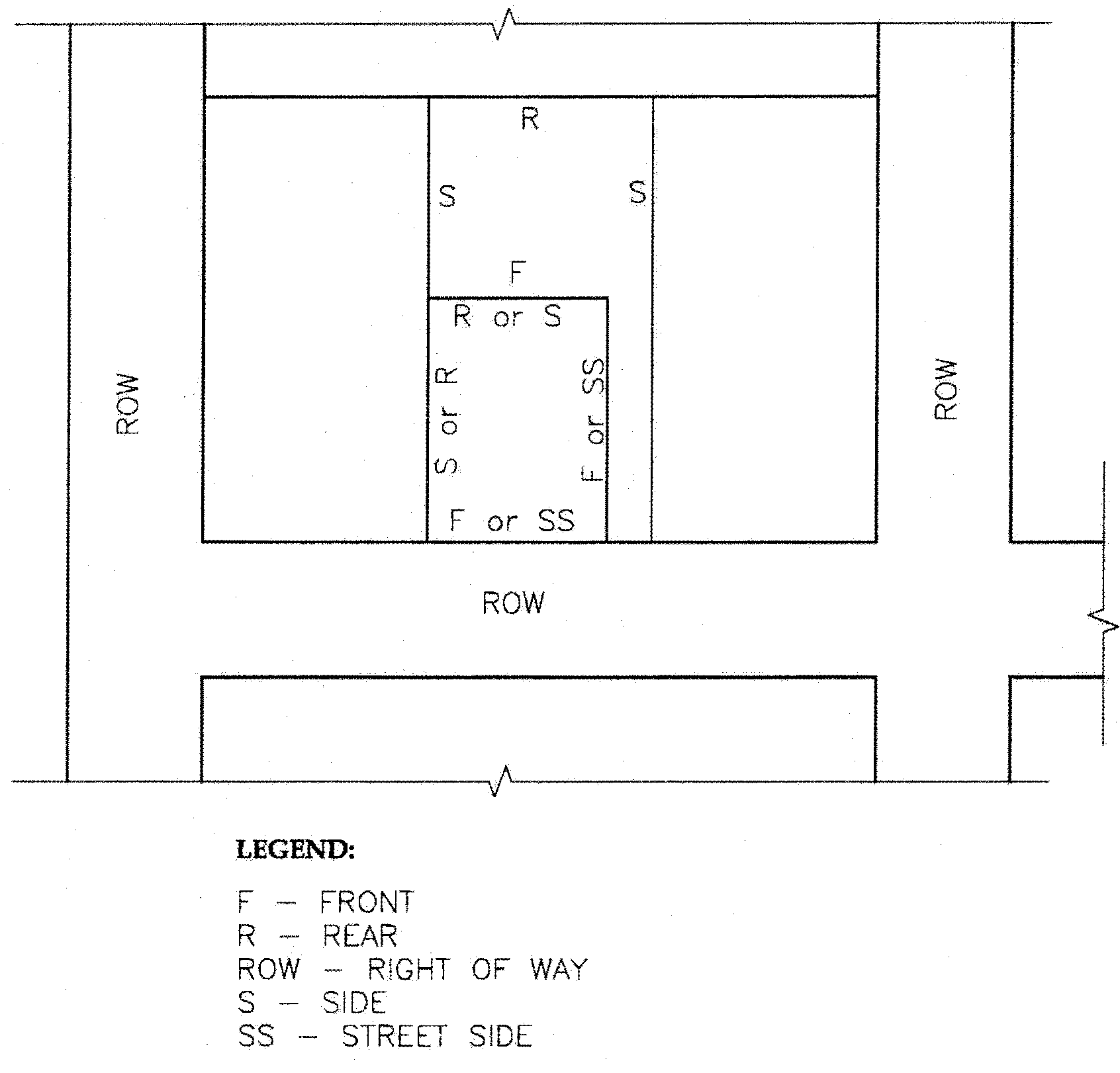
Figure 1
(3)
Access and parking.
(A)
Access for the lots shall be located in the panhandle. A lot fronting a right-of-way may have a separate and additional access if approved by the government entity that controls rights-of-way. Access to each lot shall be designated on the plat in the form of an easement.
(B)
Off-street parking shall be provided in an amount sufficient to meet the requirements of CBJ 49.40, article II.
(C)
A driveway and parking plan that shows the feasibility of off-street parking shall be submitted and approved by the director prior to recording the plat.
(D)
Back out parking is prohibited unless approved by the director.
(E)
The applicant must provide assurance in the form of an easement, plat note referencing the maintenance agreement, and a maintenance agreement that is recorded with the subdivision, on forms acceptable to the director, ensuring the required access and parking areas will be constructed and maintained by all future property owners.
(F)
Any portion of a driveway not located in a public right-of-way shall comply with emergency service access as required by CBJ 19.10. A profile of the proposed driveway centerline shall be submitted as part of the plat application, and must meet Alaska Department of Transportation and Public Facilities or CBJ driveway standards, as appropriate based on ownership of the right-of-way.
(G)
Existing driveways and access points not meeting the requirements of this section must be abandoned, and improvements thereto removed and relocated prior to plat recordation.
(H)
The portion of the driveway in the right-of-way or the first 20 feet from the edge of the public roadway shall be paved, whichever length is greater.
(b)
No lot resulting from a panhandle subdivision may be further divided into another panhandle subdivision.
(Serial No. 2015-03(c)(am), § 10, 8-31-2015; Serial No. 2017-25, § 2, 11-6-2017, eff. 12-7-2017; Serial No. 2021-28, § 3, 8-23-2021, eff. 9-22-2021)
49.15.424 - Reserved.
Editor's note— Sec. 2 of Serial No. 2016-26(b), effective May 3, 2017, repealed and reserved § 49.15.424, which pertained to access and derived from Serial No. 2015-03(c)(am), adopted Aug. 31, 2015.
49.15.440 - Remote subdivisions.
The purpose of this section is to provide for design and improvement requirements specific to privately-owned remote subdivisions.
49.15.441 - Applicability and restrictions.
(a)
A remote subdivision is a subdivision solely accessed by either a navigable waterbody or a pioneer path. The boundary of the remote subdivision accessed by pioneer path must be at least one-half mile from the roaded service area.
(b)
A remote subdivision may not be located within the roaded service area or the fire service area, or accessible by vehicular traffic weighing more than 1,000 pounds gross vehicle weight or having an overall width greater than 48 inches.
(c)
The owners of lots or parcels within a remote subdivision accessible by pioneer path are prohibited from subdividing within two years from the creation of the remote subdivision.
(d)
Remote subdivisions accessed by pioneer path shall be limited to 13 or fewer lots and are reviewed by the commission using the minor subdivision process. The commission may impose any conditions and restrictions deemed necessary to protect public health, safety, and welfare.
49.15.442 - Improvement standards.
The following improvement standards apply to remote subdivisions:
(1)
CBJ 49.35.250, Access.
(2)
CBJ 49.35.240, Improvement standards.
(3)
CBJ 49.35.310, Water systems.
(4)
CBJ 49.35.410, Sewer systems.
(Serial No. 2015-03(c)(am), § 10, 8-31-2015; Serial No. 2016-26(b), § 4, 4-3-2017, eff. 5-3-2017)
49.15.450 - Licensed surveyor required.
All land subdivided in accordance with CBJ Title 49 shall be surveyed by a professional land surveyor licensed in the State of Alaska.
49.15.451 - Boundary lines, basis of bearing.
(a)
Each existing boundary line of the proposed subdivision shall be retraced to an existing monument of record. If a boundary consists of a U.S. Survey line, Mineral Survey line, or an Alaska Tidelands Survey line, the nearest recorded primary monument on each side of the proposed subdivision shall be located.
(b)
A monumented centerline of a right-of-way must be considered in making the surveys and in preparing the plat. All monuments found shall be indicated and proper references made to field notes or maps of public record relating to the monuments. If the points were reset by ties, that fact shall be stated.
(c)
The basis of bearing referred to on the plat shall be a line defined by two found monuments shown on the same record bearing and shall be clearly delineated or identified on the plat and in the basis of bearing statement.
(d)
A basis of bearing statement is required. The statement shall include the monument description, corner description, record bearing and the record documentation source with recording date.
(e)
A note listing all plats of record, with recording information, pertinent to the boundary and property resolution must be listed on the plat.
49.15.452 - Accuracy of survey.
A survey and traverse of the boundaries of the subdivision and all lots and blocks shall close within a limit of error of one foot in 10,000 feet of perimeter for field closures and one foot in 20,000 feet for calculated distances.
49.15.453 - Monumentation.
(a)
The following monumentation is required for subdivisions of six or more lots:
(1)
Primary monuments. Primary monuments shall conform to the following requirements:
(A)
All exterior corners, points of curvature and points of tangency shall be monumented with a minimum two-inch diameter metal pipe, at least 30 inches long, with a minimum four-inch flange at the bottom. A minimum two and one-half inch diameter metal cap shall be permanently attached at the top. If both the cap and the pipe are of nonferrous metal, then additives with magnetic qualities shall be permanently attached at both the top and bottom of the monument. Every primary monument cap shall be permanently stamped with the year set, the surveyor's registration number, year which the monument was set, initials of subdivision, and the corner identification. This data shall be orientated so that the data may be read when the reader is facing north. Monuments and accessories found in a disturbed condition shall be returned to the original position and condition as nearly as possible or replaced so as to perpetuate the position.
(B)
No portion of a survey or subdivision may be more than 1,320 feet from a primary monument.
(C)
If an exterior boundary line is less than 2,640 feet, but more than 1,320 feet long, then the intermediate primary monument shall be set as close to the midpoint as practical.
(2)
Witness corners. If the point for a primary monument is in a place that would be impractical to monument because of natural obstacles, a witness corner shall be set. The witness distance must be shown on the plat of survey, from the existing monument, as set, to the true corner position. Witness corners shall be set on a survey property line and at a distance considered reasonable and practical from the true corner point. Witness corners shall comply with the standards for primary monuments.
(3)
Alternate monuments. If conditions make it impractical to set a primary monument, one of the following methods may be substituted:
(A)
A two and one-half inch brass or aluminum cap may be grouted firmly into a boulder; or
(B)
A five-eighths inch minimum drive rod may be driven to a depth necessary to provide a stable base for an aluminum cap. The depth of all drive rods shall be noted on the plat.
(4)
Secondary monuments. All lot corners, interior angle points and interior curvature control points shall be monumented with at least a five-eighths inch metal rod three feet in length with a one and one-quarter inch cap.
(5)
Monumentation installation.
(A)
Monuments shall be installed by the applicant's land surveyor at points designated on the final plat.
(B)
The applicant's surveyor must install monuments before the final plat is filed with the State of Alaska recorder's office. The director of engineering may require that monumentation be certified prior to final acceptance of the subdivision improvements to ensure that any monuments disturbed or destroyed during construction are reset.
(C)
If construction begins prior to submittal of the final plat, all lot corners adjacent to any proposed improvements must be staked throughout construction.
(b)
The following monumentation is required for subdivisions of five or fewer lots:
(1)
All exterior corners of the plat and all corners of each lot shall be monumented with a five-eighths inch by 30-inch pipe or bar capped and marked as required by the director of engineering and public works; provided, if a plat or lot corner is identical with a United States Survey, a United States Mineral Survey, or an Alaskan Tidelands Survey, the primary monument shall be shown on the plat or reestablished and shown if not found.
(2)
Monumentation must meet all the requirements listed in subsection (a), above, with the exception that the type of monument set may be a secondary monument.