
Juneau City Zoning Code
CHAPTER 49
35 - PUBLIC AND PRIVATE IMPROVEMENTS1
Cross reference— Public ways and property, CBJ Code tit. 62.
ARTICLE II. - STREETS[2]
Cross reference— Public ways and property, CBJ Code tit. 62.
ARTICLE III. - WATER SYSTEM[3]
Cross reference— Utilities, CBJ Code tit. 75.
ARTICLE IV. - SANITARY SYSTEMS[4]
Cross reference— Utilities, CBJ Code tit. 75.
ARTICLE V. - DRAINAGE[5]
Cross reference— Utilities, CBJ Code tit. 75.
ARTICLE VI. - PUBLIC ACCESS[6]
Editor's note—Sec. 37 of Serial No. 2015-03(c)(am), adopted Aug. 31, 2015, repealed and reenacted art. VI to read as herein set out. Former art. VI pertained to pedestrian access, consisted of §§ 49.35.610—49.35.630, and derived from Serial No. 87-19, 1987; and Serial No. 2002-20, adopted Aug. 5, 2002.
ARTICLE VII. - UTILITIES[7]
Cross reference— Utilities, CBJ Code tit. 75.
49.35.110 - Purpose.
The purpose of this chapter is to:
(1)
Establish design and development criteria for public and private improvements; and
(2)
Outline the procedures and responsibilities of the developer for furnishing plans and completing the improvements.
(Serial No. 87-49, § 2, 1987; Serial No. 2016-26(b), § 6, 4-3-2017, eff. 5-3-2017)
49.35.120 - Improvements; generally.
(a)
The developer must install all of the required improvements within the boundaries of the development, and may be required to make improvements beyond the development boundary in order for all of the improvements to function properly. In addition, improvements must be designed and constructed to provide for future extension to adjoining lands.
(b)
If a publicly maintained street serves an area outside the roaded service area boundary as a result of a subdivision, the roaded service area boundary, and if appropriate, the fire service area, shall be extended to include the roaded area and newly created subdivision.
(Serial No. 87-49, § 2, 1987; Serial No. 95-27, § 5, 1995; Serial No. 2002-20, § 2, 8-5-2002; Serial No. 2015-03(c)(am), § 21, 8-31-2015; Serial No. 2016-26(b), § 7, 4-3-2017, eff. 5-3-2017)
49.35.130 - Standard specifications.
(a)
Compliance with specifications. Except as otherwise provided, all subdivision improvements shall be in accordance with the latest revision of the City and Borough subdivision standard specifications and details on file in the engineering and public works department.
(b)
The director of engineering and public works may prescribe different or additional standards if unusual or unforeseen conditions exist in a particular development, and the alternative meets or exceeds the intent of the original standard.
(c)
Change of standards. Prior to a substantial change in the standards generally applicable to required subdivision improvements, the director of engineering and public works or the director of engineering and public works' designee shall hold a public hearing on the proposed change. The hearing shall be preceded by ten days' published notice. The standards may be changed in response to comments received at the hearing or received at any other time prior to the effective date. The standards shall become effective 30 days after the first notice of the hearing is published. The manager may shorten the notice period or waive the requirement for a hearing and may specify an earlier effective date if the manager finds an emergency exists or that other conditions warrant such action. If the hearing is held with less than three days' published notice, a second hearing preceded by ten days' published notice shall be held.
(Serial No. 87-49, § 2, 1987; Serial No. 92-09, § 2, 1992; Serial No. 99-34, § 5, 1-24-2000; Serial No. 2002-20, § 3, 8-5-2002; Serial No. 2015-03(c)(am), § 22, 8-31-2015)
49.35.140 - Construction plans.
(a)
Generally. The developer must submit construction plans for all proposed public improvements and associated private improvements and utilities within and outside the proposed development's boundary.
(b)
Construction plan submittal.
(1)
Plan sets. Prior to submittal of the final plat, and before the start of any construction, the developer must furnish to the City and Borough Permit Center complete sets of construction plans, profiles, details, and special construction provisions for all existing and proposed improvements. The director of engineering and public works shall determine the number of plan sets to be submitted. Plan sets will be forwarded to the appropriate City and Borough departments and agencies.
(2)
Engineer's stamp. Construction plans must be stamped by the professional engineer licensed in the State of Alaska who is responsible for the improvement designs. Multiple engineer stamps are required for plans with multiple discipline designs, e.g., civil, electrical, structural engineering.
(c)
Construction plan—Details.
(1)
Size. All construction plans shall be submitted on 22- by 34-inch sheets. The director of engineering and public works may approve alternative sheet sizes.
(2)
Information. The drawings must contain the following information:
(A)
Name of subdivision.
(B)
Type of work.
(C)
Date.
(D)
Name of engineer preparing the drawings and the engineer's stamp.
(E)
Space for approval signature by the director of engineering and public works.
(F)
A north arrow and scale.
(3)
Scale. Horizontal scale must be one inch equals 50 feet or greater. Vertical scale must be one inch equals five feet or less with a minimum scale of one inch equals ten feet. The director of engineering and public works may approve alternative scales.
(4)
Benchmarks. The locations, elevations and description of datum of permanent benchmarks must be shown.
(5)
Street profiles. Profiles of streets shall indicate finished and existing grades for centerline of the street and shall extend a minimum of 200 feet beyond the limits of the proposed project or, if intersecting an existing street, extend to the far side of the existing street.
(6)
[Details to be included.] Plans and profiles, where applicable, shall include location, elevation, size, materials, and all other details of the proposed improvements.
(7)
[Complete data.] Complete survey data must be shown for all horizontal and vertical curves.
(8)
[Location of utilities.] Construction plans shall include the location of all existing and proposed utilities.
(d)
As-built drawings. The developer, upon completion of required improvements, must submit a reproducible and digital format copy of as-built plans unless otherwise required by the director of engineering and public works.
(Serial No. 87-49, § 2, 1987; Serial No. 2015-03(c)(am), § 23, 8-31-2015)
49.35.310 - Water systems.
(a)
[All new development.] For new development, the developer must construct a public water system that provides for daily water supply and fire protection needs if the following criteria are met:
(1)
If development of five or more lots is proposed within 500 feet of an existing public water system; or
(2)
If development of four or fewer is proposed within 200 feet of an existing public water system.
(b)
Nonresidential development. The developer must provide an evaluation by an Alaska-licensed engineer and submit the written evaluation to the director of engineering and public works for review and approval to determine the specific quantity and distribution requirements.
(c)
Distance. For the purpose of this section, distance is measured as the radial distance from the closest water main to the nearest point of the subdivision boundary.
(d)
Fire protection. Fire protection requirements are based on whether the development is located within or outside the fire protection service area. All public water distribution systems constructed according to subsections (a) or (b) of this section must be sized and constructed to meet fire flow and hydrant requirements, and provide the necessary fire flows for fire protection. All improvements must be constructed according to the International Fire Code (IFC). The director of engineering and public works and the City and Borough fire marshal must approve all plans.
(e)
Private water systems required. If a proposed development is located at greater distances from the existing public water system than specified in subsection (a), and the developer chooses to not connect to the public system, the developer must construct a water system that provides for daily water supply and fire protection needs according to the following:
(1)
Development of five or more lots.
(A)
For development of five more lots, the developer must construct a water system adequate to supply water for daily use. There are two types of systems the developer may construct:
(i)
Community water system. A developer can choose to construct a community water system if the following requirements are met:
a.
The community system meets the quantity standards specified by this section.
b.
Any proposed water system must be approved by the Alaska Department of Environmental Conservation and any other agency having jurisdiction. The developer must submit proof of approval to the department.
c.
All improvements must meet the City and Borough standards for construction of public water systems. The community system must provide a separate service to the boundary of each proposed lot.
d.
The developer must submit the appropriate documents that show the continued maintenance of the community water system is guaranteed. The City and Borough may review and comment on the documents, but is not responsible for their content or enforcement of any provisions.
(ii)
Individual wells. A developer can also choose the option of individual wells to supply daily water needs, if the following requirements are met:
a.
The developer must clearly demonstrate to the satisfaction of the director of engineering and public works, through test wells, draw down tests, and other suitable methods, that the quantity standards specified in this section can be met for all proposed lots.
b.
The proposed source and supply system must be approved by the Department of Natural Resources and other agencies having jurisdiction. Proof of the approval must be submitted to the department.
(B)
Quantity requirements for development of five or more lots are as follows:
(i)
Residential use. The proposed source and system for residential use must be capable of producing and delivering not less than 75 gallons per capita per day and a peak hour factor of 150 percent.
(ii)
Nonresidential development. To determine quantity and distribution requirements for nonresidential development, the developer must provide an evaluation by an engineer licensed in the State of Alaska and submit the written evaluation to the director of engineering and public works for review and approval.
(iii)
Water rights. The developer must show proof that the appropriate permit to appropriate water has been obtained from the State of Alaska for water rights for the source of water being proposed for use in the development.
(C)
Fire protection. For a development of five or more lots proposed within the fire service area and not connecting to the public water system, the developer must construct a water supply system that will provide adequate fire protection. This distribution system must meet all the requirements of CBJ 49.35.310(d) above and may be separated or combined with the domestic water supply system.
(2)
Development of four or fewer lots.
(A)
Neither a community water system, nor individual wells are required if the development is of four or fewer lots.
(B)
Fire protection requirements will be determined at the time the individual lots are developed.
(3)
Exception for remote subdivisions. This section does not apply to remote subdivisions, unless the subdivider of the remote subdivision chooses to provide potable water or a public water system is available and the subdivision falls within the criteria outlined in subsection (a).
(Serial No. 87-49, § 2, 1987; Serial No. 99-34, § 6, 1-24-2000; Serial No. 2003-02, § 2, 2-10-2003; Serial No. 2015-03(c)(am), § 28, 8-31-2015)
49.35.320 - Reserved.
Editor's note— Sec. 29 of Serial No. 2015-03(c)(am), adopted Aug. 31, 2015, repealed and reserved § 49.35.230, which pertained to fire flow, and derived from Serial No. 87-49, 1987.
49.35.330. - Reserved.
Editor's note— Serial No. 2006-15, § 9, adopted June 5, 2006, effective July 6, 2006, repealed § 49.35.330, which pertained to the municipal water system plan. See also the Code Comparative Table.
49.35.340 - Oversizing lines.
When the subdivider is required to install connecting lines, to increase the size of existing public lines, or to install a distribution system as part of a subdivision proposal, the director for minor subdivisions and the commission for major subdivisions, after reviewing a recommendation from the director of engineering and public works, may require any or all parts of such installation to be oversized if the director of engineering and public works finds it likely that within the expected life of the new construction an increase in capacity will be required to serve other areas.
(Serial No. 87-49, § 2, 1987; Serial No. 2015-03(c)(am), § 30, 8-31-2015)
49.35.410 - Sewer systems.
(a)
For new development, the developer must construct a public sewer system connecting to the existing public sewer system if the following criteria are met:
(1)
If development of five more lots is proposed within 500 feet of an existing public sewer system.
(2)
If development of four or fewer lots is proposed within 200 feet of an existing public sewer system.
(3)
For the purpose of this section, distance is measured as the radial distance from the closest sewer main to the nearest point of the boundary of the proposed subdivision.
(b)
If a proposed development is located at greater distances from the existing public sewer system than specified above, unless the developer chooses to connect to the public system, then a private system is required. Either of the following acceptable private systems may be installed:
(1)
Community and cluster wastewater systems. Community wastewater systems, which have shared collection, treatment, and disposal and cluster wastewater systems, which have individual on-site treatment with a shared collection and disposal system are acceptable if the following requirements are met:
(A)
The developer must provide a report and certification by a registered, qualified engineer licensed by the State of Alaska, which clearly shows that the proposed community or cluster wastewater system will operate satisfactorily, and how it will meet all other state and federal standards, to the satisfaction of the director of engineering and public works.
(B)
The director of engineering and public works must review the report and make a recommendation to the commission. The director of engineering and public works will not make independent findings, but will make a recommendation as to the adequacy of the methodology and data provided in the report.
(C)
All improvements must meet the City and Borough standards of construction for public sewer systems.
(D)
The proposed wastewater systems must be approved by the Alaska Department of Environmental Conservation and any other agencies having jurisdiction. Proof of approval must be submitted to the department.
(2)
On-site wastewater systems. Wastewater systems, which have individual on-site treatment and individual on-site disposal shall be acceptable if all the following requirements are met:
(A)
The developer must provide a report and certification by a registered, qualified engineer or geologist licensed by the State of Alaska, which clearly shows that the proposed lots are large enough and have existing soils of sufficient permeability to permit the construction of on-site wastewater treatment and disposal systems.
(B)
The director of engineering and public works shall review the report and make a recommendation to the director for minor subdivisions and to the commission for major subdivisions. The director of engineering and public works will not make independent findings but will make a recommendation as to the adequacy of the data provided and of the methodology proposed in the report for wastewater treatment and disposal.
(C)
If adequate soils are not available onsite, the applicant can propose alternative methods for individual on-site wastewater systems. Alternative methods may include mound systems, marine outfalls, or other suitable wastewater systems. Review and approval of a proposal under this section must meet the applicable requirements of subsections (i) and (ii) of this section.
(c)
Residential wastewater systems—Property owner responsibility. The responsibilities of individual property owners for their individual wastewater systems are as follows:
(1)
Permitting. All the owners of lots in new minor and major residential subdivisions using cluster or on-site wastewater systems must obtain a City and Borough on-site wastewater treatment and disposal system (OWTDS) permit from the engineering and public works department, and have completed construction and inspection of the system prior to issuance of any certificate of occupancy. The requirements for obtaining a wastewater treatment and disposal system permit, and the permit fees, shall be established by regulations issued by the manager pursuant to CBJ 01.60.
(2)
Limited maintenance contract required. In addition, the property owners in new residential minor and major subdivisions shall be required to enter into a contract with the department of public works or its designee for inspection, monitoring, and treatment plant pumping of the private wastewater facility. All other maintenance of the wastewater system is the responsibility of the property owner.
(3)
Violation of this section is an infraction.
(d)
Compliance with (b) of this section does not exempt the developer or individual property owners from meeting all requirements of the Alaska State Department of Environmental Conservation regarding approval of wastewater systems.
(Serial No. 87-49, § 2, 1987; Serial No. 2003-02, § 3, 2-10-2003; Serial No. 2015-03(c)(am), § 31, 8-31-2015)
49.35.420 - Oversizing lines.
When the subdivider is required to install connecting lines, to increase the size of existing public lines, or to install a distribution system as part of a subdivision proposal, the director for minor subdivisions and the commission for major subdivisions, after reviewing a recommendation from the director of engineering and public works, may require any or all parts of such installation to be oversized if the director of engineering and public works finds it likely that within the expected life of the new construction an increase in capacity will be required to serve other areas.
(Serial No. 87-49, § 2, 1987; Serial No. 2015-03(c)(am), § 32, 8-31-2015)
49.35.430 - Reserved.
Editor's note— Sec. 33 of Serial No. 2015-03(c)(am), adopted Aug. 31, 2015, repealed and reserved § 49.35.430, which pertained to private treatment systems, and derived from the 1970 Code; Serial No. 87-49, 1987; and Serial No. 2005-16(b), adopted June 13, 2005.
49.35.510 - Drainage plan.
(a)
[Plan required.] The developer must provide a total surface drainage plan, prepared by a civil engineer licensed to practice in the State of Alaska, for approval by the director of engineering and public works. The plan must show all drainage facilities, and must include:
(1)
The calculated increase in stormwater runoff resulting from the proposed development as well as the runoff from the total drainage area(s) associated with the site. Runoff calculation shall be based on a fully developed subdivision and a 25-year storm event.
(2)
An evaluation of existing drainage ways and structures located between the development and the receiving water body shall verify that the existing drainage ways can accommodate the increased runoff.
(3)
All public and any required private drainage facilities.
(4)
A demonstration of how drainage from the proposed subdivision will outlet into an established drainage channel, unless an alternative drainage way is approved by the director of engineering and public works.
(b)
Easements. All development must be provided with necessary drainage easements, and drainage facilities adequate to prevent increased surface or subsurface runoff to abutting properties.
(c)
Drainage systems required. The developer must install all on and off-site improvements necessary to deal with increases in or changes to existing flows as shown on the approved drainage plan.
(d)
Construction timing. Any drainage improvements required by this section must be constructed and approved prior to or at the same time as the completion of any street construction.
(Serial No. 87-49, § 2, 1987; Serial No. 95-27, § 9, 1995; Serial No. 2002-20, § 6, 8-5-2002; Serial No. 2015-03(c)(am), § 34, 8-31-2015)
49.35.520 - Systems required.
The developer shall install all on and off-site improvements shown on the plan except as otherwise noted.
(Serial No. 87-49, § 2, 1987)
49.35.530 - Reserved.
Editor's note— Sec. 35 of Serial No. 2015-03(c)(am), adopted Aug. 31, 2015, repealed and reserved § 49.35.530, which pertained to municipal planned area drainage systems, and derived from Serial No. 87-49, 1987.
49.35.540 - Reserved.
Editor's note— Sec. 36 of Serial No. 2015-03(c)(am), adopted Aug. 31, 2015, repealed and reserved § 49.35.540, which pertained to easements, and derived from Serial No. 87-49, 1987.
49.35.610 - Pedestrian and bicycle access in the roaded service area.
(a)
Shared use pathways. Shared-use pathways for pedestrian and bicycle use within the roaded service area may be required through blocks longer than 600 feet, or where deemed necessary to provide reasonable circulation within and between residential areas, or to provide access to schools, playgrounds, shopping centers, transportation or other community facilities according to the following:
(1)
Shared-use pathway width. The width of a shared use path must not be less than ten feet.
(2)
Construction standards. Shared-use pathways, where required, must be constructed according to the Alaska Department of Transportation and Public Facilities preconstruction manual on "Bicycle Ways." The director of engineering and public works may approve alternative construction when deemed appropriate to the conditions of the site.
(3)
Right-of-way width. A shared-use pathway must be located in dedicated right-of-way with a minimum width of 15 feet. The width of the right-of-way may be modified by the director for minor subdivisions and by the commission for major subdivisions, to accommodate the width of the fully constructed pathway and/or topographic features of the site.
(4)
Construction timing. Shared-use pathways must be constructed prior to occupancy of any dwellings on lots located adjacent to the pathway, or at the time of all subdivision improvements are accepted by the City and Borough, whichever comes first.
(b)
Sidewalks. The subdivider shall construct sidewalks according to table 49.35.240 in any residential subdivision, in all streets furnished with curbs and gutters, and in any commercial subdivision within the urban service area.
(1)
Minimum width. The minimum width of sidewalks is five feet.
(2)
Waiver. The director, after consulting with the director of engineering and public works, may waive the requirement for sidewalks and allow alternative pedestrian improvements to be constructed upon a written finding that the alternative will:
(A)
Take advantage of natural features of the site or implement the Juneau Non-Motorized Transportation Plan; and
(B)
Provide a safety, quality, and functional equivalent to the requirement being waived.
49.35.620 - Streams and bodies of water.
The developer shall convey such easements or make such dedications as may be made necessary in order to provide public access to all streams and public bodies of water.
49.35.630 - Trailhead dedications or easements.
The developer shall convey such easements or make such dedications as may be made necessary in order to provide public access to existing trails.
49.35.640 - Acceleration and deceleration lanes.
(a)
If a driveway serves right-turning traffic from a parking area providing 200 or more parking spaces, and the road has a peak-hour traffic volume exceeding 750 vehicles per hour, an acceleration lane at least 200 feet long and at least ten feet wide measured from the driveway to the acceleration lane shall be provided.
(b)
If a driveway serves as an entrance to a land development providing 100 or more parking spaces, a deceleration lane shall be provided for traffic turning right into the driveway from the road. The deceleration lane shall be at least 200 feet long and at least 13 feet wide measured from the road curb radius. A minimum 35-foot curb return radius shall be used from the deceleration lane in the driveway.
49.35.710 - Underground utilities. (Reserved)
Cross reference— Public utility transmission facilities, CBJ Code ch. 62.40.
49.35.720 - Utility access.
(a)
Public rights-of-way or easements, together with the right of ingress and egress, shall be provided where necessary for public utilities. Where easements are required, and approved for public water systems, sanitary sewers, storm drainage facilities, or other similar public uses, the following requirements apply:
(1)
Width. All easements must be accessible for maintenance and must have adequate space within the easement to accomplish maintenance, excavation, and stockpiling of material. The minimum width for a public easement that does not abut a public right-of-way is 20 feet, unless otherwise required by the director of engineering and public works.
(2)
Surface. Easements shall be graded and compacted to provide a suitable surface for access and maintenance.
(3)
Restricted access. Where easements adjoin a public street, the director of engineering and public works may require improvements to prevent access by the public.
(b)
The director or planning commission shall require easements to be shown on a plat that grants access or other rights in the favor of certain properties. These private easements are not dedicated to or maintained by the public and must be noted as such on the plat.
(c)
A note must be added to the plat stating the purpose of the easement, the grantee of the easement, restrictions on the easement use, and whether the easement is permanent or temporary, or private or public.
49.35.730 - Construction plans.
Construction plans required under this chapter shall include the location of all existing and proposed utilities.
(Serial No. 87-49, § 2, 1987)
49.35.800 - Sustainable building standards for construction and renovation of buildings.
(a)
New construction and renovation of existing buildings and facilities by the City and Borough. The City and Borough shall construct and renovate its public facilities and buildings to sustainable building standards through the use of the U.S. Green Building Council's Leadership in Energy and Environmental Design (LEED) rating system, and shall be responsible for ensuring that public facilities and buildings meet the requirements as set out in this section and are operated accordingly.
(1)
LEED shall be the quantitative measurement for how well standards are met;
(2)
All public facilities and buildings utilizing municipal funds and costing over $5,000,000.00 (either general or bonded), including new private construction for Municipal leasing or renting, shall be designed and constructed in such a fashion as to achieve a minimum level of LEED Certified;
(A)
The City and Borough Engineering Department shall determine if attainment of specific LEED credits will be required within the credits pursued for LEED Certification. These required credits shall be documented in CBJ policy and shall be reviewed and updated each time a new version of the LEED standard is issued. Such update shall occur within three months of the issuance of a new LEED standard.
(b)
Application. The sustainable building standards for municipal buildings and facilities, including but not limited to, the Juneau School District, the Juneau International Airport, and Bartlett Regional Hospital, shall apply to facilities and buildings where the principal use is regularly occupied space, including, but not limited to, buildings occupied for office, retail, classroom, healthcare, or assembly purposes.
(1)
As used in this section, occupied means a facility or building whose primary purpose is for people to work, assemble, or intend to remain within to perform functions (other than routine maintenance) of the principal use of the building. Industrial facilities, such as maintenance, warehouse, and vehicle storage, are excluded from this section.
(c)
Exception procedure. If the Manager, with the consent of the Assembly, after consideration of the recommendation of the Sustainability Commission, determines that it would not be economically feasible to satisfy the prerequisites for LEED Certification in the case of a specific project, that project shall be exempt from the requirement for LEED Certification.
(d)
Effective date. This ordinance shall become effective on July 1, 2011. Existing projects with fully executed contracts for design services on the effective date shall be exempt from this ordinance.
(Serial No. 2010-42, §§ 2—4, 1-10-2011, eff. 7-1-2011)
49.35.210 - Street system.
(a)
[In general.] Subdivision street systems shall be designed for the most advantageous development of the entire neighborhood area and shall meet the following criteria:
(1)
The street system shall provide for connecting streets into adjoining unsubdivided lands.
(2)
Subdivision street systems shall be designed to maximize the number of connecting streets in a given area in order to reduce the volume of traffic and traffic delays on major streets (arterials and major collectors), to minimize bypass and through trips on residential streets, and to increase the number of local street connections facilitating safer bicycle and pedestrian travel.
(3)
Traffic calming should be taken into account in street layout and design.
(b)
Major and minor arterials. Except as provided in subsection (3) of this section, if a new subdivision involves frontage along an arterial street:
(1)
The plat shall note that no lots shall access directly onto the arterial;
(2)
Access shall be provided onto an interior access street or a separate frontage road.
(3)
A parcel of land with less than 500 feet of frontage on a street, or with less than 350 feet in depth may be subdivided so as to allow access directly onto a minor arterial street if all of the following conditions are met:
(A)
All of the resulting lots must meet the minimum lot area standard for a single-family dwelling in the D-1 zoning district (36,000 square feet).
(B)
All of the lots must share a common access point and further subdivision of the newly created lots is not allowed.
(C)
Common access to all lots is required and back out parking is prohibited. The applicant must submit a plan that shows the feasibility of off street parking for all lots and an adequate area for a turnaround to prevent back out parking.
(D)
The applicant must provide assurance in the form of an easement, plat note, and a maintenance agreement that is recorded with the subdivision, all of which must be acceptable to the director, that ensures the required common access will be constructed and maintained by the property owners.
(E)
The proposed subdivision must meet all other applicable subdivision standards and requirements.
(c)
Collector streets. Collector streets in adjoining subdivisions shall be continued in the new subdivision as needed.
(1)
Major collectors. Except as provided in subsection (C) of this section, if a new subdivision involves frontage along a major collector street:
(A)
The plat shall note that no lots shall access directly onto the major collector.
(B)
Access shall be provided onto an interior access street or a separate frontage road.
(C)
Exception a parcel of land with less than 500 feet of frontage or less than 350 feet of depth may be subdivided so as to allow access directly onto a major collector street.
(2)
Minor collectors. Access for lots is allowed directly onto minor collector streets if no other restrictions apply.
(Serial No. 87-49, § 2, 1987; Serial No. 95-27, § 6, 1995; Serial No. 2002-20, § 4, 8-5-2002; Serial No. 2015-03(c)(am), § 24, 8-31-2015)
49.35.220 - Street names.
(a)
New streets. Street names must be unique in order to avoid confusion. When streets are extended, the name must remain the same for the new segment. Proposed street names shall be shown on preliminary plats. The names of streets fronting 13 or fewer lots shall be approved by the director through the minor subdivision processes. The names of streets fronting more than 13 lots shall be approved by the commission at the time of preliminary plat approval for major subdivisions.
(b)
Existing streets. The commission shall approve applications to change the name of any existing public street or right-of-way.
(1)
Application. The application must be on a form provided by the department and accompanied by:
(A)
The application fee.
(B)
Signed letters of approval from a majority of property owners whose properties have access to the public street proposed for the name change.
(2)
Procedure. After public hearing, the commission shall review the proposed street name change for consistency with this section, and, upon a finding that the change is consistent with this section and that the majority of property owners whose properties have access to the public street proposed for the name change approve of the change, shall approve the application.
(3)
Sign replacement. If the name change is approved, the applicant shall be responsible for replacing all existing street name signs as specified by the department.
(Serial No. 87-49, § 2, 1987; Serial No. 95-27, § 7, 1995; Serial No. 2015-03(c)(am), § 25, 8-31-2015)
49.35.230 - Roadway classification map.
There are adopted roadway classification maps A—D, dated June 5, 2006, as the same may be amended from time to time by ordinance. These maps set forth the classification of streets and roadways within the CBJ. The roadway classification maps will govern references to streets in this title.
(Serial No. 2015-03(c)(am), § 26, 8-31-2015)
Editor's note— Sec. 26 of Serial No. 2015-03(c)(am), adopted Aug. 31, 2015, repealed and reenacted § 49.35.230 in its entirety to read as herein set out. Former § 49.35.230 pertained to design criteria and derived from Serial No. 87-49, 1987; and Serial No. 95-27, 1995.
49.35.240 - Improvement standards.
(a)
Right-of-way widths. The minimum right-of-way width of proposed streets is as follows:
(1)
Arterials: 100 feet; minor, 80 feet.
(2)
Collectors: 60 feet.
(3)
Streets other than arterials and collectors: 60 feet.
(4)
Cul-de-sacs: temporary or permanent turnaround: a diameter of 120 feet.
(5)
Alleys: 20 feet.
(6)
Stairways and other non-motorized access routes: 15 feet.
(7)
Half streets. Whenever there exists a dedicated or platted half street or alley adjacent to the tract of land to be developed, the other half of the street or alley must be platted, dedicated, and the entire street or alley constructed to current improvement standards.
(8)
Substandard width. Any previously platted right-of-way with less than the minimum standards identified for the traffic generated shall be improved to meet the minimum requirements established by this title.
(b)
Right-of-way minimum width reductions. The director may reduce minimum right-of-way width requirements:
(1)
For a collector, the right-of-way width may be reduced by up to ten feet.
(2)
For streets with less than 500 average daily trips, or a privately maintained access road in a right-of-way, the width may be reduced by up to 25 feet.
(3)
Where the dedicated right-of-way abuts and runs parallel to an exterior property line, will serve as a half-street, and will be developed as a low volume street or a driveway in a right-of-way, the width may be reduced by up to 30 feet.
(4)
Alleys and stairway right-of-ways may be reduced by up to five feet.
(5)
The director shall make written findings supporting right-of-way minimum width reductions granted under this section. The director's findings shall state that:
(A)
The applicant has provided room for electric utility features and demonstrates that if the road is upgraded in the future to include additional sidewalks that there is sufficient right-of-way for construction of the sidewalks without need for retaining walls over two feet in height.
(B)
There is sufficient right-of-way or easements to allow for drainage improvements required by construction of the sidewalks.
(C)
That any driveways shall be constructed to accommodate the elevations of future sidewalks.
(D)
No additional right-of-way width will be required in order to provide for sufficient access to abutting lands.
(E)
There is sufficient room for snow storage.
(c)
Sight distance. Sight distances for intersection, passing and stopping must be in accordance with the specifications set forth in "A Policy on Geometric Design of Highways and Streets".
(d)
Street grades. Street grades are as follows:
(1)
Maximum. Grades on arterial streets must not exceed six percent. Grades on other streets must not exceed 12 percent.
(2)
Minimum. The minimum grade for all streets is one-half percent.
(3)
Cross slope. The minimum cross slope on all streets is three percent.
(4)
Exception. Grades for all streets in hillside areas may be increased under certain circumstances according to chapter 49.70, article II, hillside development.
(e)
Intersections.
(1)
Corner sight distance. Corner sight distance must be in accordance with CBJ 49.35.240, however, in no case shall the sight distance be less than 200 feet.
(2)
Intersection angle. Intersections of right-of-way lines must not be less than 60 degrees. The intersection of the centerline of the constructed roadway must not be less than 80 degrees.
(3)
Grade. The grade for the approach leg of a new roadway at an intersection must not exceed two percent for the first 30 feet, measured from the edge of the existing roadway. The grade for the next 70 feet of the new roadway must not exceed six percent (See Figure 1).
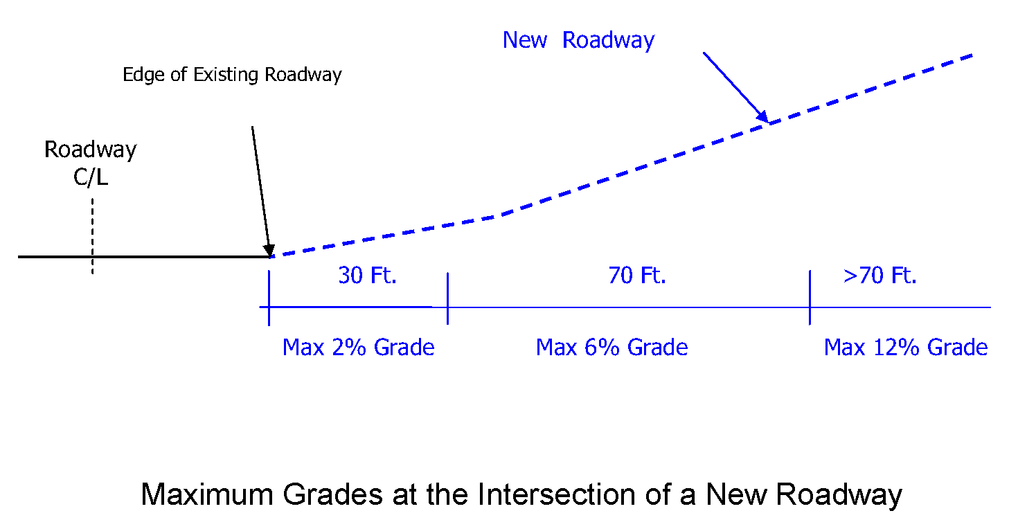
Figure 1
(4)
Adjustment to grade. In certain circumstances, the director of engineering and public works may require the centerline grade to be adjusted to ensure the grades along the edge of the intersecting street do not exceed the maximum grades listed above.
(5)
Alignment. A proposed street that will intersect with an existing cross street shall, whenever practicable, align with an existing street intersection on the opposite side of the cross street. Street jogs that have center line offsets of less than 100 feet, shall not be permitted (See Figure 2).
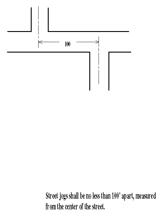
Figure 2
(f)
Curves.
(1)
Design. Curves shall be designed in accordance with "A Policy on Geometric Design of Highways and Streets."
(2)
Vertical curve. The minimum length of vertical curves is 200 feet unless otherwise approved by the director of engineering and public works.
(g)
Cul-de-sacs.
(1)
Length. Streets designed to have one end permanently closed shall be no more than 600 feet and not less than 150 feet in length measured from the center of the intersection to the radius point of the turnaround. The director for minor subdivisions, and the commission for major subdivisions, may authorize a longer or shorter cul-de-sac if it is found that the unique characteristics of the site warrant modification to the length.
(2)
Temporary cul-de-sacs. Temporary cul-de-sacs will be allowed where a street can practically be extended to provide for connecting streets into an adjoining undeveloped land, is located in a right-of-way or in an easement for public access, and if the following are met:
(A)
The temporary portions of the cul-de-sac shall be easements on the plat rather than as dedicated right-of-way. Such easements shall allow for public access and maintenance as if it were dedicated right-of-way until such time the easements are vacated. The easements shall not contribute towards lot area.
(B)
All of the cul-de-sac must be constructed to permanent street construction standards except as noted in (G) below.
(C)
The CBJ will record a release of the easements for the temporary portions of the cul-de-sac at the state recorder's office at Juneau at the time the cul-de-sac is removed and the street improvements have been extended.
(D)
Easement lines for the temporary cul-de-sac will be considered front property lines for determining building setbacks.
(E)
All improvements, including utilities and private driveways, must be designed to accommodate the eventual extension of the street and reversion of the temporary cul-de-sac to adjoining properties. The construction plans shall demonstrate those improvements connecting through a temporary cul-de-sac will still comply with CBJ standards after the temporary cul-de-sac is removed.
(F)
Temporary cul-de-sacs must provide required access and minimum frontage on a publically maintained right-of-way to all lots using the cul-de-sac as access. If the cul-de-sac is not extended to the adjoining property, the maximum length of an unconstructed right-of-way between the temporary cul-de-sac and the adjoining property shall be the minimum lot width for the zoning district. If the right-of-way is located in more than one zoning district, the shortest minimum lot width shall be used. The right-of-way between the constructed temporary cul-de-sac and the adjoining property shall be subject to the stub street requirements of this Title (See Figure 3).
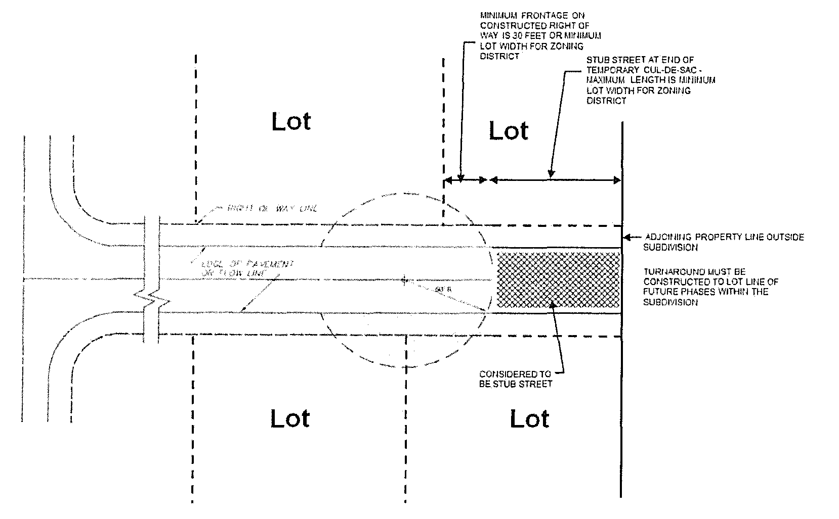
Figure 3
(G)
The temporary cul-de-sac may be located on property within the subdivision intended for future subdivision phases in conjunction with a platted right-of-way. It may also be located outside the subdivision boundary entirely within an easement (See Figure 4). If the temporary cul-de-sac is constructed on property outside of the subdivision boundary, then curb, gutter, and sidewalks are not required for the temporary cul-de-sac.

Figure 4
(H)
The plat shall include the following note "Temporary cul-de-sac easement shall be vacated upon extension of street unless the director determines all or a portion of the cul-de-sac may remain."
(I)
When the developer of adjoining property is required to connect to the temporary cul-de-sac, the temporary portions of the cul-de-sac shall be removed. The director, after considering public safety, costs, and recommendations of the director of engineering and public works department and of the fire marshal, shall determine if the developer may leave all or part of the temporary portions of the cul-de-sac. If any temporary cul-de-sac portion is removed, then the resulting constructed right-of-way shall conform to CBJ standards.
(3)
Hammerhead turnarounds. Hammerhead turnarounds may be built in lieu of a temporary cul-de-sac, upon approval by the director of engineering and public works.
(h)
Streets construction standards.
(1)
Arterials. The subdivider is not responsible for the construction of arterial streets, but may be required to dedicate the necessary right-of-way during the platting process.
(2)
Other streets. Other than arterials, street shall comply with the following:
_____
Table 49.35.240 Table of roadway construction standards
i Or as required by the Fire Code at CBJ 19.10.
ii ROW width may be reduced as prescribed at CBJ 49.35.240.
iii Except as provided by CBJ 49.35.262(b)(9).
_____
(3)
Signs and markings. The subdivider must install street name signs, traffic control signs, and traffic control pavement markings in accordance with approved plans and the requirements of the current issue of the Manual on Uniform Traffic Control Devices, including the current Alaska Traffic Manual Supplement, published by the Alaska Department of Transportation and Public Facilities.
(i)
Street waivers. The director, after considering the recommendations of the director of the engineering and public works department and of the fire marshal, may waive the following and no other street improvement requirements:
(1)
Right-of-way relocation. If a plat is submitted for the purpose of relocating a right-of-way, the director may waive all or some of the construction requirements under the following conditions:
(A)
The proposed relocation will improve access to abutting or neighboring property not otherwise adequately served.
(B)
The subdivider has provided sufficient engineering information to demonstrate to the director of engineering and public works the feasibility of constructing a public street at the location of the relocated right-of-way.
(C)
The relocated right-of-way and the resulting subdivision layout will conform to all the other standards of this chapter.
(D)
The improvements required in the new right-of-way will not be less than those in the existing right-of-way.
(E)
No additional lots are being platted.
(2)
Stub streets.
(A)
The director for minor subdivisions and the commission for major subdivisions may waive the full construction of a roadway within a right-of-way that is required to provide access to a bordering property, and does not provide required access to any lot within the subdivision. A developer requesting a stub street waiver shall demonstrate in the construction plans that a street can reasonably be constructed to CBJ standards in the right-of-way. The commission or director may require provision of a roadbed, utility line extensions, or other appropriate improvements (See Figure 5).
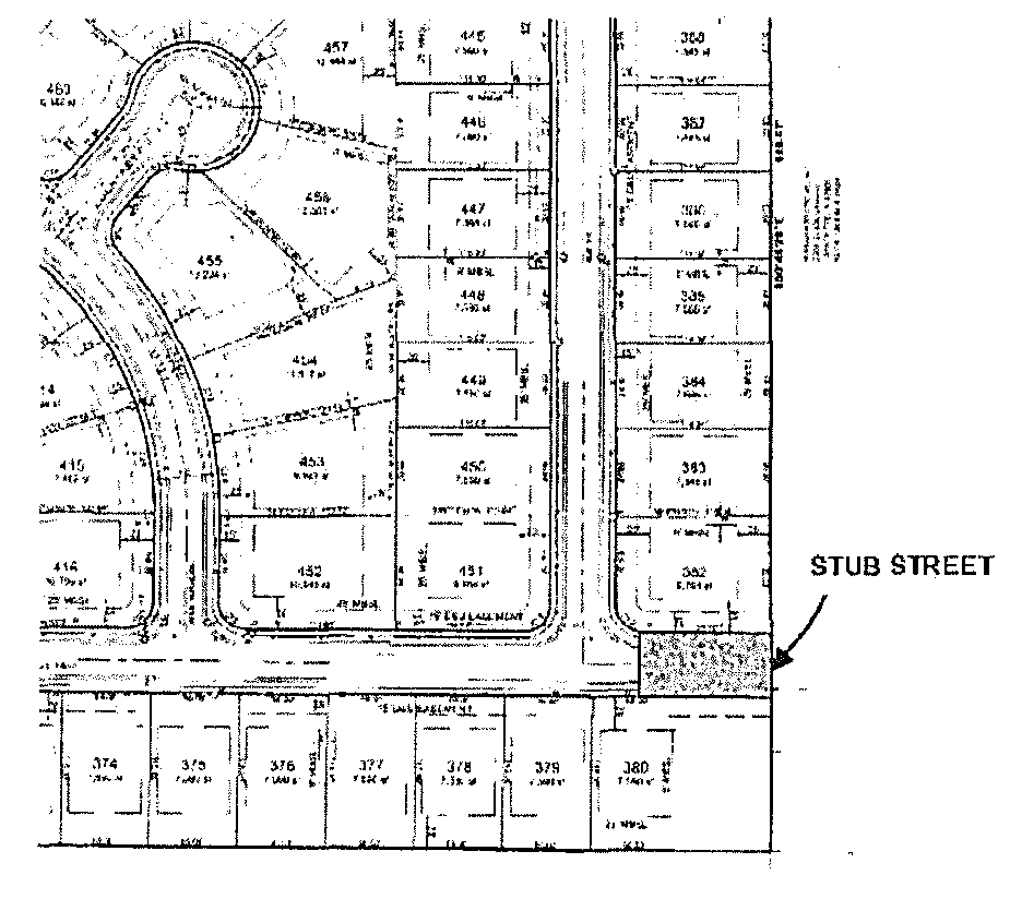
Figure 5
(B)
Reserved.
(C)
When the developer of adjoining property is required to connect to the stub street, then the developer of the adjoining property will be required to construct the stub street to City and Borough standards at the time.
(3)
Remote subdivisions accessible by navigable water. The commission and the director may waive roadway improvements and other street construction requirements for remote subdivisions accessed solely by navigable water.
(4)
Roadway construction standards waivers. Roadway construction standards identified in Table 49.35.240 may be waived in accordance with this subsection for any street reconstruction project, not including routine maintenance; or any new street construction project located in a right-of-way platted before 1987. Waivers shall be in writing.
(A)
Roadway construction standards may be waived by the director if:
(i)
The existing roadway does not comply with the roadway construction standards identified in Table 49.35.240;
(ii)
There are unique circumstances that make compliance with the requirements of the table unreasonable;
(iii)
The proposed project will not aggravate the intent of the requirements of this chapter; and
(iv)
The proposed project complies with the American Association of State Highway and Transportation Officials' guidelines.
(B)
Roadway construction standards may be waived by the commission if:
(i)
The existing roadway does not comply with the roadway construction standards identified in Table 49.35.240;
(ii)
There are unique circumstances that make compliance with the requirements of the table unreasonable;
(iii)
The proposed project will not aggravate the intent of the requirements of this chapter; and
(iv)
Unique circumstances make compliance with the American Association of State Highway and Transportation Officials' guidelines unreasonable, and the commission requires sufficient safeguards to protect public health, safety, and welfare under the circumstances.
(j)
Pioneer path standards. The following standards shall apply to remote subdivisions accessed by pioneer paths.
(1)
Interior access shall be provided solely by pioneer path in a right-of-way. The right-of-way width of a pioneer path within a remote subdivision shall be 60 feet.
(2)
Grades for pioneer paths must not exceed 18 percent. The maximum cross slope grade must not exceed five percent.
(3)
The width of a pioneer path shall not exceed 54 inches of tread, and must be located within a six-foot corridor.
(4)
Pioneer paths shall be designed and constructed to prohibit vehicular traffic wider than 48 inches from using the path, which may include the use of boulders, bollards, or any other similar structure.
(k)
Responsibility for improvements. Unless otherwise provided, it shall be the responsibility of the subdivider to pay the cost of all right-of-way and street improvements caused by any development, as determined by the director.
(Serial No. 87-49, § 2, 1987; Serial No. 88-30, § 2, 1988; Serial No. 2002-20, § 5, 8-5-2002; Serial No. 2006-15, § 8, 6-5-2006; Serial No. 2010-41, § 2, 1-10-2011; Serial No. 2015-03(c)(am), § 27, 8-31-2015; Serial No. 2016-26(b), 4-3-2017, eff. 5-4-2017; Serial No. 2018-08, § 2, 3-5-2018, eff. 4-5-2018; Serial No. 2019-08, § 2, 4-22-2019, eff. 5-23-2019)
49.35.250 - Access.
(a)
Principal access to the subdivision. Except as provided below, the department shall designate one right-of-way as principal access to the entire subdivision. Such access, if not already accepted for public maintenance, shall be improved to the applicable standards for public acceptance and maintenance. It shall be the responsibility of the subdivider to pay the cost of the right-of-way improvements.
(1)
Principal access to remote subdivisions. The department shall designate the principal access to the remote subdivision. Such access may be by right-of-way.
(b)
Publicly maintained access within a subdivision. Unless otherwise provided in this section or in 49.15.420(a)(1), all lots must satisfy the minimum frontage requirement and have direct and practical access to the right-of-way through the frontage. The minimum frontage requirement on a right-of-way is 30 feet or the minimum lot width for the zoning district or use as provided in CBJ 49.25.400. These requirements for frontage and access can be accomplished by:
(1)
Dedication of a new right-of-way with construction of the street to public standards. This street must connect to an existing publicly maintained street;
(2)
Use of an existing publicly maintained street;
(3)
Upgrading the roadway within an existing right-of-way to public street standards. This existing right-of-way must be connected to another publically maintained street; or
(4)
A combination of the above.
(c)
Privately maintained access within a subdivision. Lots shall front and have direct access to a publically maintained street except as:
(1)
Privately maintained public access. A subdivision may create new lots served by a privately maintained access within a public right-of-way not maintained by an agency of government as provided by CBJ 49.35, article II, division 3. All lots must have either a minimum of 30 feet of frontage on a right-of-way, or the minimum lot width for the zoning district or use as provided in CBJ 49.25.400.
(2)
Private shared access. A lot in a subdivision is exempt from having the minimum frontage on a public right-of-way when a shared access is approved pursuant to CBJ 49.35, article II, division 2. All lots served by a shared access shall have a minimum of 30 feet of frontage on the shared access.
(d)
Remote subdivisions accessible by navigable waterbodies. All lots in a remote subdivision solely accessible by navigable waterbodies must have a minimum of 30 feet of frontage on, and direct and practical access to, either the navigable water or a right-of-way. The right-of-way must have direct and practical access to the navigable water.
(e)
Access within remote subdivisions accessible by pioneer paths. All lots must either have direct and practical access with a minimum of 30 feet of frontage on the right-of-way, or the minimum lot width for the zoning district or use as provided in CBJ 49.25.400.
(Serial No. 2016-26(b), § 9, 4-3-2017, eff. 5-3-2017)
49.35.260 - Purpose.
Shared access serving four or fewer lots without frontage on a right-of-way may be constructed within a private easement consistent with this division.
(Serial No. 2016-26(b), § 10, 4-3-2017, eff. 5-3-2017)
49.35.261 - Application.
An applicant must submit the following to request shared access:
(1)
A preliminary plan and profile of the proposed shared access; and
(2)
A proposed access easement, drainage and utility agreement.
(Serial No. 2016-26(b), § 10, 4-3-2017, eff. 5-3-2017)
49.35.262 - Standards.
(a)
Agency review. The director shall forward the complete application to the fire department and to the engineering and public works department for review.
(b)
Approval criteria. The director may approve a subdivision, with or without conditions, that has a shared access if all of the following criteria are met:
(1)
The shared access will be located in a private easement completely on the lots served.
(2)
The shared access serves four or fewer lots. If a subsequent common wall residential subdivision is intended to be served by shared access, the common wall parent lot shall count as two lots.
(3)
The shared access does not endanger public safety or welfare.
(4)
The shared access complies or can be improved to comply with the emergency service access requirements of CBJ 19.10.
(5)
The use of each lot served by the shared access shall be limited to one single-family residence and an accessory apartment.
(6)
The total average daily trips resulting from the subdivision shall not exceed 70.
(7)
Shared access is only allowed in RR and D-1, D-3, D-5, and D-10 SF zoning districts defined by CBJ 49.25.210.
(8)
Shared access is prohibited if the subdivision abuts a parcel that does not have alternative and practical frontage on a publicly maintained right-of-way.
(9)
The portion of the shared access in the right-of-way shall be paved or surfaced with materials consistent with the adjacent public roadway. The length of the portion of the shared access in the right-of-way shall consist of a minimum two-foot apron or as required by the governing agency of the right-of-way.
(10)
Lots must meet the minimum standards for the zone district according to the table of dimensional standards excluding the shared access easement. A buildable area must exist without the need for a variance.
(c)
Approval process.
(1)
Upon preliminary plat approval by the director, the applicant shall construct the shared access pursuant to the corresponding standard in Table 49.35.240 for a roadway with zero to 70 average daily trips. A financial guarantee cannot be used as a condition of construction.
(2)
The shared access easement shall be recorded.
(3)
The following shall be noted on a plat or in a recorded decision that contains a shared access:
(i)
The private easement is for access, drainage, and if applicable utilities, and shall be specifically identified.
(ii)
The owner(s) of the lots served by the private access easement acknowledge the City and Borough is not obligated and will not provide any maintenance or snow removal in the private easement.
(iii)
The owner(s) of the lots served by the private access easement shall be responsible and liable for all construction and maintenance of the shared access from the edge of the publicly maintained travel lane.
(iv)
Except a subsequent common wall subdivision depicted on this plat, the lots served by the private access easement are prohibited from subdividing unless the access is upgraded to a public street, dedicated to, and accepted by the City and Borough.
(v)
Owner of a lot served by the private access easement shall automatically abandon all rights to and usage of the private access easement except for utilities, if any, if a publicly maintained street serves that lot.
(vi)
A lot with frontage on a public street and on the shared access is prohibited from having vehicular access to the public street except through the shared access.
(Serial No. 2016-26(b), § 10, 4-3-2017, eff. 5-3-2017; Serial No. 2020-11, § 2, 4-27-2020, eff. 5-28-2020)
49.35.263 - Other shared access requirements.
(a)
If a shared access is approved, the applicant must apply for and receive a right-of-way permit to construct the shared access.
(b)
If the director determines that a street sign is required for a health, safety, or welfare reason, the applicant shall install a street sign provided by the City and Borough at the applicant's expense.
(c)
The front yard setback shall be measured from the shared access easement.
(d)
The width of the shared access easement may be reduced up to 20 feet if the director finds there is sufficient area for the provision of utilities, drainage, snow storage, and that it is unlikely for the shared access easement to expand in the future to a public street.
(e)
The director shall determine the placement location of mailboxes. The director may require additional improvements and design changes to enable efficient mail delivery and minimize traffic interferences.
(f)
The standards identified in this article do not apply to any preexisting shared access previously permitted by the department.
(Serial No. 2016-26(b), § 10, 4-3-2017, eff. 5-3-2017)
49.35.270 - Purpose.
A privately maintained access road serving 13 or fewer lots located outside the urban service area may be constructed within a public right-of-way and constructed to less than full public street construction standards.
(Serial No. 2016-26(b), § 11, 4-3-2017, eff. 5-3-2017)
49.35.271 - Application.
On a preliminary plat application, the applicant must submit the following to request approval for a privately maintained access in a right-of-way:
(1)
A preliminary plan and profile of the proposed privately maintained access road and any proposed public or private utilities; and
(2)
A proposed access agreement as required by 49.35.272.
(Serial No. 2016-26(b), § 11, 4-3-2017, eff. 5-3-2017)
49.35.272 - Access agreement.
(a)
An access agreement must be executed between the City and Borough and all property owners proposed to be served by a privately maintained access road. The agreement must identify the parties and the property, all signatures must be notarized, and the agreement must include the following provisions:
(1)
In exchange for the grantee not being required to construct a road that can be accepted for maintenance by the City and Borough, and for the City and Borough not being responsible for maintaining the privately maintained access road, the parties execute this agreement with the intent for it to run with the land and bind all heirs, successors, and assigns consistent herein;
(2)
The grantee acknowledges that the City and Borough is not obligated to provide any maintenance, including snow removal, for the privately maintained access. The grantee is required to arrange for year-round reasonable maintenance for the privately maintained access, including snow removal, sufficient to meet weather conditions and to allow for safe vehicular traffic;
(3)
The grantee and the grantee's heirs, successors, and assigns will defend, indemnify, and hold harmless the City and Borough from any claim or action for any injury, loss, or damage suffered by any person arising from the location, design, maintenance, or use of the privately maintained access;
(4)
The grantee will ensure that use of the privately maintained access road will not block vehicular or pedestrian access by the public in the right-of-way;
(5)
The City and Borough will have unimpeded access in the right-of-way.
(6)
The grantee is required to arrange for maintenance of the right-of-way. The grantee and the grantee's heirs, successors, and assigns will maintain the privately maintained access road and public right-of-way according to the conditions established in this agreement;
(7)
The City and Borough will record a copy of the agreement, at the grantee's expense, with the state recorder's office for each lot or parcel of land either, in the case of existing lots, those adjoining the segment of right-of-way in which the privately maintained access is to be located; or, in the case of lots created by subdivision and served by the privately maintained access, those lots so created;
(8)
The owners of the lots subject to this agreement are required to pay for right-of-way upgrades when existing or proposed development served by the privately maintained access exceeds 211 average daily trips as determined by the director;
(9)
The owners of the lots subject to this agreement are prohibited from subdividing unless the privately maintained access is upgraded or all the property owners served by the privately maintained access execute a new access agreement;
(10)
Any development that increases the estimated traffic above 211 average daily trips, as determined by the director, shall pay a proportionate share of the costs of the right-of-way upgrades, which will offset the costs imposed on the existing owners served by the privately maintained access. The proportionate share shall be the percentage increase in average daily trips;
(11)
The owners of the lots subject to this agreement authorize the City and Borough to amend this access agreement by adding a new owner only upon presentation of a written and fully executed maintenance agreement between all the existing property owners subject to the original access agreement and the new property owner proposing to be served by the existing privately maintained access. Any amended access agreement supersedes an existing access agreement. After recording, the new access agreement shall be sent to all the owners subject to it; and
(12)
The owners agree to maintain in full force and effect any insurance policy required by the City and Borough until and unless the roadway is accepted for maintenance by the City and Borough.
(b)
Prior to the City and Borough executing the access agreement:
(1)
The owners of the lots subject to the agreement shall create an owner's association for the purpose of continuing the duties contained in the agreement; and
(2)
The association shall obtain liability insurance of a type and in the amount deemed necessary by the City and Borough to provide coverage for claims arising out of or related to the use, occupancy, and maintenance of the privately maintained access road. The City and Borough shall be named as an additional insured on any required policy.
(Serial No. 2016-26(b), § 11, 4-3-2017, eff. 5-3-2017)
49.35.273 - Standards.
(a)
Agency review. The director shall forward the complete application to the fire department and to the engineering and public works department for review.
(b)
Approval criteria. A subdivision may be approved, with or without conditions, with privately maintained access in a public right-of-way if all of the following criteria are met:
(1)
The subdivision is located outside of the Urban Service Boundary;
(2)
The proposed privately maintained access would abut and provide access to 13 or fewer lots each limited to a single-family residence, or the proposed access road could serve 13 or fewer lots;
(3)
The proposed privately maintained access will be located in a public right-of-way that has not been accepted for public maintenance;
(4)
The proposed privately maintained access does not endanger public safety or welfare;
(5)
The proposed privately maintained access will be improved to provide for emergency service access;
(6)
A privately maintained access shall only serve property in which the maximum allowable residential density uses do not exceed 211 average daily trips as determined by the director; and
(7)
Property served by the privately maintained access shall include accessory apartment traffic, if allowed with or without a conditional use permit, even if accessory apartments are not currently proposed.
(8)
Privately maintained access is prohibited unless:
(A)
The abutting parcels have alternative and practical frontage on a publicly maintained right-of-way; or
(B)
The property owners of all abutting parcels are signatories of the access agreement required by CBJ 49.35.272.
(c)
Approval process.
(1)
All of the requirements of this Title and the conditions identified in the preliminary plat notice of decision have been satisfied.
(2)
Area for the right-of-way has been dedicated to the City and Borough. The privately maintained access has been constructed consistent with corresponding standard in 49.35.240 for a roadway with zero to 211 average daily trips.
(3)
The access agreement is recorded prior to recording the final plat.
(4)
The director may impose conditions necessary for public, health, safety, and welfare upon approving the subdivision.
(Serial No. 2016-26(b), § 11, 4-3-2017, eff. 5-3-2017)
49.35.274 - Other requirements.
(a)
If a preliminary plat with a privately maintained access in the public right-of-way is approved, the applicant must apply to the engineering and public works department for a permit to construct the privately maintained access as required by CBJ 62.05, accompanied by final construction plans. Additional fees and bonding may be required for final plan review, inspection, and construction of the access road and utilities.
(b)
The applicant shall install a street sign, to be provided by the City and Borough, which shall indicate that the privately maintained access is not maintained by the City and Borough.
(c)
The director shall determine the placement location of mailboxes. The director may require additional improvements and design changes to enable efficient mail delivery and minimize traffic interferences.
(Serial No. 2016-26(b), § 11, 4-3-2017, eff. 5-3-2017)