
Juneau City Zoning Code
CHAPTER 49
25 - ZONING DISTRICTS1
Cross reference— Building regulations, CBJ Code tit. 19; one- and two-family dwellings, CBJ Code ch. 19.10; docks and harbors board, CBJ Code § 49.05.170; public ways and property, CBJ Code tit. 62.
ARTICLE V. - DENSITY DETERMINATION[2]
Administrative Code of Regulations cross reference—Density bonus standards and criteria, Part IV, § 04 CBJAC 020.010 et seq.
49.25.110 - Zoning maps.
(a)
Adopted. The maps contained in the atlas entitled "Zoning Maps of the City and Borough of Juneau, Alaska," dated June 5, 2006, and consisting of sheets 1—184, as the same may be amended from time to time by the assembly by ordinance, are adopted and made a part of this title.
(b)
Maintained on file. The official zoning maps shall remain on file in the department and shall be identified by signatures of the City and Borough municipal clerk and mayor.
(c)
Amendment. If, in accordance with the provisions of this chapter, changes are made in the district classification, such changes shall be entered on the official zoning map promptly after the amendment has been adopted by the assembly by ordinance.
(d)
Final authority. The official zoning map shall be the final authority as to the current zoning status of land in the City and Borough, regardless of the existence of copies of the official zoning map which may be published from time to time.
(e)
Replacement of official map. In the event that the official zoning map becomes damaged, destroyed, lost or difficult to interpret because of the nature or number of changes and additions, the assembly may by resolution adopt a new copy of the official zoning map, which shall supersede the prior copy of the official zoning map, but no such replacement shall have the effect of amending the contents or meaning of the original official zoning map. The prior map or any significant parts thereof remaining shall be preserved, together with all available records pertaining to its adoption or amendment.
(f)
District boundary lines. Except where reference is made on the zoning map to a street line, political boundary or other designated line, the district boundary lines are intended to follow property lines, centerlines of streets, alleys, streams, or the extension of such lines as they existed on the date of adoption of the ordinance codified in this title.
(g)
Public way vacations. Whenever any street, alley or other public way is vacated as provided by CBJ 49.15.404, the zoning districts adjoining the side of such public way shall automatically be extended to follow property lines legally created by such vacation.
(h)
Reserved.
(Serial No. 87-49, § 2, 1987; Serial No. 2006-15, § 3, 6-5-2006; Serial No. 2015-03(c)(am), § 17, 8-31-2015)
49.25.120 - Districts adjoining water or tidelands.
Areas under water or tidelands which are not shown as included within any district shall be subject to the regulation of the adjacent district.
(Serial No. 87-49, § 2, 1987)
49.25.130 - Unmapped areas.
All areas of the City and Borough not shown on the official zoning map are in the RR, rural reserve zoning district.
(Serial No. 87-49, § 2, 1987)
49.25.200 - RR, rural reserve district.
The RR, rural reserve zoning district, is intended for lands primarily in public ownership managed for the conservation and development of natural resources and for future community growth. In addition, recreation cabins, lodges and small seasonal recreational facilities may be allowed.
(Serial No. 87-49, § 2, 1987)
49.25.210 - Residential districts.
The following districts are established to provide a healthy, safe and pleasant environment for residential living protected from incompatible and disruptive activities:
(a)
The D-1, residential district, is intended to accommodate primarily single-family and duplex residential development in areas outside the urban service boundary at a density of one dwelling unit per acre. Certain D-1 zoned lands, however, may exist within the urban service boundary in transition areas if public sewer or water are absent but planned for. The D-1 classification will be changed to a higher density upon provision of services.
(b)
The D-3, residential district, is intended to accommodate primarily single-family and duplex residential development at a density of three dwelling units per acre. D-3 zoned lands are primarily located outside the urban service boundary where public utilities are not provided. The density reflects the existing pattern of development of properties in the district. There is a limited amount of D-3 zoned lands located within the urban service boundary. These are lands for which a lower density is deemed appropriate or, in the case of transition zones, where the zoning will be changed to a higher density when sewer and water are provided.
(c)
The D-5, residential district, is intended to accommodate primarily single-family and duplex residential development at a density of five dwelling units per acre. D-5 zoned lands are located in the urban service boundary and are served or can be served by public water and sewer.
(d)
The D-10 SF, residential district, is intended to accommodate primarily single-family residential development at a density of ten dwelling units per acre. This is the highest-density single-family residential district.
(e)
The D-10 and D-15, residential districts, are intended to accommodate primarily multifamily residential development at ten and 15 units per acre respectively. These are relatively low-density multifamily districts.
(f)
The D-18, residential district, is intended to accommodate primarily multifamily development at a density of 18 dwelling units per acre. This is a high density multifamily zoning district intended to accommodate midrise-type development.
(Serial No. 87-49, § 2, 1987; Serial No. 2007-39, § 7, 6-25-2007)
49.25.220 - Mixed use districts.
The mixed use and mixed use 2 districts are established to accommodate a mix of appropriate commercial and residential uses.
(a)
The MU, mixed use district, reflects the existing downtown development pattern and is intended to maintain the stability of the downtown area. Multifamily residential uses are allowed and encouraged.
(b)
The MU2, mixed use 2 district, is intended to place a greater emphasis on residential development than is the case in the MU district. A range of residential development types is allowed. Multifamily residential uses are allowed at a density of up to 80 units per acre.
(c)
The MU3, mixed use 3 district, is intended to place a greater emphasis on the integration of small-scale commercial uses within high-density residential structures. Flexible setback regulations are deliberate to promote cohesive neighborhoods and encourage the development of pedestrian-oriented buildings.
(Serial No. 87-49, § 2, 1987; Serial No. 98-09, § 3, 1998; Serial No. 2012-24, § 2, 5-14-2012, eff. 6-14-2012; Serial No. 2021-35(am), § 2, 2-7-2022, eff. 3-10-2022)
Administrative Code of Regulations cross reference—Mix use development, Part IV, § 04 CBJAC 035.010.
49.25.230 - Commercial districts.
The following districts are established to accommodate commercial activities:
(a)
The LC, light commercial district, is intended to accommodate commercial development that is less intensive than that permitted in the general commercial district. Light commercial districts are primarily located adjacent to existing residential areas. Although many of the uses allowed in this district are also allowed in the GC, general commercial district, they are listed as conditional uses in this district and therefore require commission review to determine compatibility with surrounding land uses. A lower level of intensity of development is also achieved by stringent height and setback restrictions. Residential development is allowed in mixed- and single-use developments in the light commercial district.
(b)
The GC, general commercial district, is intended to accommodate most commercial uses. Commercial activities are permitted outright in the zone except for those few uses that are listed as conditional uses to ensure compatibility. Residential development is allowed in mixed- and single-use developments in the general commercial district.
(c)
The NC, neighborhood commercial district, is intended to encourage the development of lively, mixed-use neighborhoods that are compact and walkable. Greater emphasis is placed upon medium density residential as the primary use with neighborhood-scale commercial activity that is less intensive than that permitted in the light commercial, general commercial and mixed-use zoning districts. Neighborhood commercial zoning districts are primarily used as a buffer between commercial and mixed-use zoning districts and single-family and lower density multifamily residential zoning districts.
(Serial No. 87-49, § 2, 1987; Serial No. 2012-24, § 2, 5-14-2012, eff. 6-14-2012; Serial No. 2021-35(am), § 2, 2-7-2022, eff. 3-10-2022)
Cross reference— Business regulations, CBJ Code tit. 20.
49.25.240 - I, industrial district.
The I, industrial district, is intended to accommodate industrial activity which includes manufacturing, processing, repairing and assembling goods. Because of noise, odors, waste and other impacts inherent in industrial activity, performance standards are applied.
(Serial No. 87-49, § 2, 1987; Serial No. 2012-24, § 2, 5-14-2012, eff. 6-14-2012)
Cross reference— Business regulations, CBJ Code tit. 20.
49.25.250 - Waterfront districts.
The following districts are established to accommodate those uses that are dependent or directly related to the water, a waterfront location, or both. These districts regulate development of the waterfront to take advantage of the unique attributes and limitations of its lands:
(a)
The WC, waterfront commercial district, is intended to provide both land and water space for uses which are directly related to or dependent upon a marine environment. Such activities include private boating, commercial freight and passenger traffic, commercial fishing, floatplane operations, and retail services directly linked to a maritime clientele. Other uses may be permitted if water-dependent or water-oriented. Residential development is allowed in mixed- and single-use developments in the waterfront commercial district.
(b)
The WI, waterfront industrial district, is intended for industrial and port uses which need or substantially benefit from a shoreline location. In addition, many of the uses that are allowed in the WC, waterfront commercial district, are also allowed in the WI, waterfront industrial district. Residential uses are limited to permitted caretaker units in the waterfront industrial district.
(Serial No. 87-49, § 2, 1987; Serial No. 90-52, § 2, 1990; Serial No. 2012-24, § 2, 5-14-2012, eff. 6-14-2012; Serial No. 2025-15am, § 2, 4-7-2025, eff. 5-6-2025)
Cross reference— Water and harbors, CBJ Code tit. 85.
49.25.300 - Determining uses.
(a)
(1)
Listed uses. There is adopted the table of permissible uses, table 49.25.300. The uses permitted in a zoning area shall be determined through the table of permissible uses by locating the intersection of a horizontal, or use axis and a vertical, or zone axis. The conditions and procedures applicable to the use in the zone thus located shall be as indicated thereat by the digits "1," "2," or "3" as more fully set out in this section and by letters of the alphabet as more fully set out by footnotes in the table. The absence of a digit at the intersection of use and zone axes means that the identified use is not permitted in the identified zone.
(2)
Unlisted uses. The permissibility of a use not listed shall be determined pursuant to section 49.20.320.
(3)
Uses listed more than once. Where a use might be classified under more than one category, the more specific shall control. If equally specific, the more restrictive shall control.
(4)
Accessory uses. Uses constituting an incidental or insubstantial part of a permissible use and commonly associated with the permissible use may be allowed as an accessory use.
(5)
Nonconforming uses. Nonconforming uses, including nonconforming residential densities, are subject to chapter 49.30.
(b)
(1)
When used in conjunction with a particular use in the table of permissible uses, the number "1" indicates that the use requires department approval pursuant to chapter 49.15, article III, in conjunction with the issuance of a building permit. The use is allowed in the district, but limited conditions may be attached to the approval.
(2)
The number "2" indicates the use requires an allowable use permit from the planning commission. Such uses are allowed in the district, but specified conditions may be attached to the allowable use permit by the commission. The permit procedure is outlined in chapter 49.15, article I.
(3)
The number "3" indicates the use requires a conditional use permit from the commission. The use may or may not be allowed at a particular location, depending on a determination of its compatibility with surrounding or proposed land uses. The planning commission may attach any condition to ensure the compatibility of the proposed use. The conditional use permit procedure is outlined in chapter 49.15, article I.
(c)
A combination of digits such as "1, 3" or "2, 3" indicates that the approval procedure for the identified use in the identified zone will vary depending on whether the project is a major or minor development.
(1)
If the project is a minor development the first number of the combination shall indicate the applicable procedure.
(2)
If the project is a major development the second number shall indicate the applicable procedure.
(3)
Minor development means development which is classified by zoning district as follows:
(A)
Any combination of the following within the rural reserve district: A residential development containing two or fewer dwelling units; a nonresidential building totaling less than 10,000 square feet or using less than one acre of land in total; any accessory dwelling units (ADUs) compliant with CBJC 49.25.512.
(B)
Any combination of the following within single-family residential districts: A residential development containing two or fewer dwelling units on a lot; a nonresidential building totaling less than 5,000 square feet or using less than 10,000 square feet of land in total; any accessory dwelling units (ADUs) compliant with CBJC 49.25.512.
(C)
Any combination of the following within multifamily residential districts: A residential development that meets the density standards of the underlying zone district; a nonresidential building totaling less than 5,000 square feet or using less than 10,000 square feet of land in total; any accessory dwelling units (ADUs) compliant with CBJC 49.25.512.
(D)
Any combination of the following within commercial and mixed use districts: A residential development that meets the density standards of the underlying zone district; a nonresidential building totaling less than 10,000 square feet or using less than one-half acre of land in total; any accessory dwelling units (ADUs) compliant with CBJC 49.25.512.
(E)
Any combination of the following within industrial districts: Non-residential buildings totaling 15,000 square feet or using less than one acre of land in total; accessory caretaker units compliant with CBJC 49.25.514.
(4)
"Major development" means all development activity that is not a minor development.
(5)
Exceptions to the use of minor and major development classifications as a method of determining the applicable approval procedure shall be as noted in the table of permissible uses.
(Serial No. 87-49, § 2, 1987; Serial No. 89-01, § 2, 1989; Serial No. 89-14, § 2, 1989; Serial No. 89-16, § 2, 1989; Serial No. 89-20, § 2, 1989; Serial No. 89-28, § 2, 1989; Serial No. 89-29, § 2, 1989; Serial No. 89-30, § 2, 1989; Serial No. 89-31, § 2, 1989; Serial No. 90-21, § 2, 1990; Serial No. 90-52, § 3, 1990; Serial No. 90-54, §§ 2, 3, 1991; Serial No. 91-01, § 3, 1991; Serial No. 91-36, § 2, 1991; Serial No. 92-09, § 3, 1992; Serial No. 93-05, § 2, 1993; Serial No. 93-46, §§ 2—4(Exh. A) and (Exh. B), 1993; Serial No. 94-07, §§ 2, 3(Exh. A) and (Exh. B), 1994; Serial No. 94-40, § 2(Exh. A), 1994; Serial No. 95-09, §§ 2, 3(Exh. A) and (Exh. B), 1995; Serial No. 97-10, § 2(Exh. A), 1997; Serial No. 97-19, § 2(Exh. A), 1997; Serial No. 97-47, §§ 2, 3(Exh. A), 1997; Serial No. 98-09, § 4(Exh. A), 1998; Serial No. 98-39, §§ 2—4(Exh. A), 1998; Serial No. 98-40, § 2(Exh. A), 1999; Serial No. 99-22, § 7, 1999; Serial No. 2000-46, § 2(Exh. A), 11-20-2000; Serial No. 2001-12, § 2(Exh. A), 4-02-2001; Serial No. 2010-22, §§ 2, 3(Exh. A), 7-19-2010; Serial No. 2015-07(b)(am), § 2, 2-23-2015, eff. 3-26-2015; Serial No. 2015-03(c)(am), § 18, 8-31-2015; Serial No. 2019-37, § 2, 3-16-2020, eff. 4-16-2020; Serial No. 2025-15am, § 2, 4-7-2025, eff. 5-6-2025)
TABLE OF PERMISSIBLE USES - CBJC 49.25.300
Key:
1.
Department approval requires the department of community development approval only.
1, 3.
Department approval required if minor development, conditional use permit required if major development.
2.
Allowable use permit requires planning commission approval.
3.
Conditional use permit requires planning commission approval.
2, 3.
Allowable use permit required if minor development, conditional use permit required if major development.
Notes:
A.
A mobile home may only be used as a caretaker unit which complies with CBJA 49.25.514.
B.
Reserved.
C.
Reserved.
D.
Reserved.
E.
See special use regulations for mobile homes, chapter 49.65, article III.
F.
See special use regulations for recreational vehicles, chapter 49.65, article IV. This use allowed by service area designation not zoning district.
G.
All uses subject to additional performance standards, chapter 49.65, article VIII.
H.
Reserved.
I.
Reserved.
J.
Applies to over 2 acres of harvest area.
K.
See special use regulations, chapter 49.65, article I. Mining operations are a conditional use in the urban mining district and an allowable use in the rural mining district.
L.
See special use regulations, chapter 49.65.200, article II.
M.
Only applicable to the commercial or private stabling of more than three farm animals, or where the running or stabling area is closer than 100 feet to the nearest residence other than the owner for any number of farm animals.
N.
Use must be water-dependent, water-related, or water-oriented.
O.
Standards for collection structures: containers must be well maintained and allow no spillage of contents; a specific person or group must be responsible for maintenance of the structure and that person or group shall have a contact telephone number posted on the collection structure; collection structure must be situated so as to not affect traffic or parking; directional signs shall be limited to six square feet and identification signs shall be limited to 24 square feet; such signs will not be included in total sign area allowed for a complex; and the structure shall not exceed a height of six feet. Identification is to be in the following format: greater prominence, the City and Borough recycling logo and the recyclable material identification; lesser prominence, the sponsor name and the contact phone number.
P.
Preexisting allowable or conditional use permit: If recycling activity is determined by the director to be an accessory use to a use previously permitted under either an allowable or a conditional use permit, the activity may be approved by the department. Other conditions may be required before recycling activity is permitted.
Q.
Must be in conjunction with an approved state or municipal public road construction project, and must be discontinued at the completion of the project. Road construction by private parties for subdivision development is excluded except as provided in this title. Rock crushed on-site must be used on-site. Crushing shall be limited to 8:00 a.m.—5:00 p.m. unless the director authorizes otherwise.
R.
Towers shall: be for amateur use only; meet the setback requirements of the zoning district; be unlit except as required by the Federal Aviation Administration. Towers shall be installed in conformance with a valid building permit, application for which shall include a copy of the applicant's amateur station license.
S.
Limited to lots directly fronting on Glacier Highway West of Industrial Boulevard.
T.
Must be associated with a unique site specific feature in order to function. Example: Glacier research station - Juneau Icefield location.
U.
No storage permitted on the first floor of a building.
V.
Primarily intended for rooftop locations in urban areas.
W.
The capacity of a park shall be determined by the Director of the Community Development Department or designee in consultation with the Director of the Parks and Recreation Department.
X.
Special requirements apply to accessory dwelling unit applications. See CBJC § 49.25.512.
Z.
Snow storage may be permitted for a maximum of five years. After five years a new application must be filed.
AA.
Does not apply to wireless communication facilities.
AB.
Use is prohibited in the urban service area but allowed outside the urban service area. An owner or manager must live on site.
AC.
Use is prohibited within 1,000 feet of recognized neighborhood association established in accordance with CBJ chapter 11.35.
(Serial No. 2002-14, § 2, 4-1-5-2002; Serial No. 2002-29, § 2, 11-4-2002; Serial No. 2003-27am, § 5, 6-16-2003; Serial No. 2003-41, § 2, 9-22-2003; Serial No. 2003-41, § 2, 9-8-2003; Serial No. 2004-09, § 2, 4-12-2004; Serial No. 2006-07, § 2, 4-3-2006; Serial No. 2007-39, § 8, 6-25-2007; Serial No. 2009-22(b), § 2, 10-12-2009; Serial No. 2010-22, § 3(Exh. A), 7-19-2010; 2014-32(e)am, §§ 6—8, 9-29-2014, eff. 10-29-2014; Serial No. 2015-07(b)(am), §§ 2—4, 2-23-2015, eff. 3-26-2015; Serial No. 2015-34(am), § 2, 7-20-2015, eff. 8-20-2015; Serial No. 2015-03(c)(am), § 19, 8-31-2015; Serial No. 2015-32, §§ 2, 3, 8-10-2015; Serial No. 2015-38(b)(am), § 6, 5-2-2016, eff. 6-2-2016; Serial No. 2015-39(am), §§ 2—7, 11-9-2015; Ord. No. 2018-31, § 2, 6-4-2018, eff. 7-5-2018; Serial No. 2021-35(am), § 3(Exh. A), 2-7-2022, eff. 3-10-2022; Serial No. 2025-15am, § 2, 4-7-2025, eff. 5-6-2025)
49.25.400 - Minimum dimensional standards.
There is adopted the table of minimum dimensional standards, table 49.25.400. Minimum dimensional standards for all zoning districts shall be according to the table of minimum dimensional standards, subject to the limitations of the following sections and as otherwise specifically noted in the special area or use sections, chapters 49.65 and 49.70.
(Serial No. 87-49, § 2, 1987; Serial No. 89-32, § 2, 1989; Serial No. 98-09, § 5(Exh. B), 1998; Serial No. 98-20, § 2(Exh. A), 1998; Serial No. 2004-13, § 2, 9-27-2004; Serial No. 2006-13, § 2, 5-15-2006; Serial No. 2007-13, § 2, 4-2-2007; Serial No. 2012-24, § 3, 5-14-2012, eff. 6-14-2012; Serial No. 2021-28, § 4, 8-23-2021, eff. 9-22-2021)
TABLE 49.25.400
TABLE OF DIMENSIONAL STANDARDS
Notes:
1.
Minimum lot size is existing lot or area shown on chart in square feet.
2.
Sixty feet between nonresidential and designated or actual residential site; 80 feet between industrial, extractive and other uses.
3.
Where one district abuts another the greater of the two setbacks is required for both uses on the common property line.
4.
(Height Bonus) Reserved.
5.
(Pedestrian Amenities Bonus) Reserved.
6.
Zero-foot setback for the portion of the dwelling with a common wall, five-foot setback or five-foot wide easement for the portion of the dwelling at the common lot line without a common wall, and ten-foot setback for the remaining side yards of the lot.
7.
Zero-foot setback for the portion of the dwelling with a common wall, five-foot setback or five-foot wide easement for the portion of the dwelling at the common lot line without a common wall, and five-foot setback for the remaining side yards of the lot.
8.
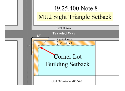
On corner lots, buildings shall be set back 15 feet from a street intersection. The area in which buildings shall be prohibited shall be determined by extending the edge of the traveled ways to a point of intersection, then measuring back 15 feet, then connecting the points.
9.
Special restrictions apply to construction on bungalow lots. See special use provisions 49.65.600.
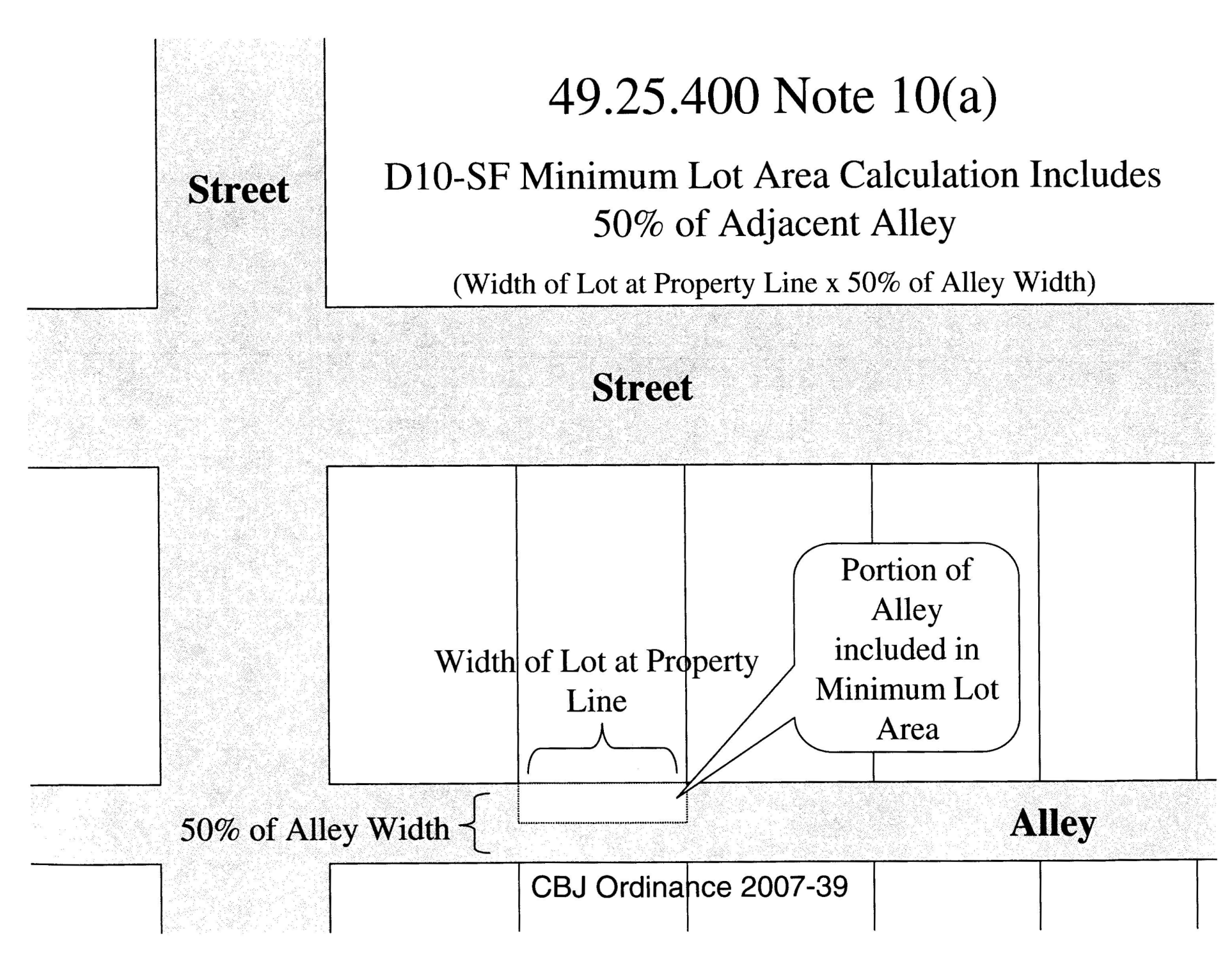
10.
For lots adjacent to an alley, the following reductions to the dimensional standards apply:
(a)
Minimal lot area includes 50% of adjacent alley (see graphic).
(b)
Reserved.
(c)
Minimum front yard setback of ten feet.
11.
Additional setbacks apply when lot abuts a multi-family or single-family residential zoning district.
(Serial No. 2008-04, § 2, 2-25-2008, eff. 3-27-2008; Serial No. 2012-24, § 3, 5-14-2012, eff. 6-14-2012; Serial No. 2021-28, § 4, 8-23-2021, eff. 9-22-2021; Serial No. 2021-35(am), § 4(Exh. B), 2-7-2022, eff. 3-10-2022)
(Serial No. 2007-39, § 9, 6-25-2007; Serial No. 2007-40, § 2, 6-25-2007)
_____
49.25.410 - Reserved.
Editor's note— Serial No. 2021-28, § 5, adopted August 23, 2021, and effective September 22, 2021, repealed former § 49.25.410 in its entirety. Former 49.25.410 pertained to lot dimensions, and derived from Serial No. 87-49, of 1987.
49.25.420 - Height of building.
(a)
The height of a building is the vertical distance above a reference datum measured to the highest point of the coping of a flat roof or to the deck line of a mansard roof or to the average height of the highest gable of a pitched or hipped roof. Roofs with slopes greater than 75 percent shall be regarded as walls. The height of a stepped or terraced building is the height of the highest segment thereof.
(b)
The reference datum shall be whichever of the following yields the greater height of building:
(1)
The highest point within a horizontal distance of five feet from the exterior wall of the building, when such point is not more than ten feet above the lowest point within said five-foot radius.
(2)
An elevation ten feet higher than the lowest grade, when the highest point described in subsection (b)(1) of this section is more than ten feet above the lowest point.
(c)
Exceptions.
(1)
Height limitations stipulated in this section shall not apply to tanks, church spires, belfries, cupolas, monuments, fire and hose towers, chimneys, flagpoles, masts, aerials, antennas, telecommunication and electrical transmission towers and other similar structures or facilities.
(2)
Height calculations shall disregard any fill or construction which the director finds to have no significant purpose other than elevating the reference datum. In reaching such finding, the director shall consider only those architectural, structural, safety, aesthetic, access or other purposes claimed by the developer and supported by reasonable evidence.
(Serial No. 87-49, § 2, 1987; Serial No. 99-26, § 2, 2000)
49.25.430 - Yard setbacks.
No portion of any of the items listed in subsection (1) of this section may be located on any lot closer to any lot line or to the street right-of-way line or centerline than is authorized in the table of dimensional standards in table 49.25.400, except as otherwise noted in this section. An alley or walkway is not subject to front setbacks unless it is the primary access to the lot.
(1)
Buildings, as building is defined in 49.80.120, and the following items:
(A)
Motor vehicle fuel dispensing pumps and associated overhead canopies or roofs;
(B)
Carports;
(C)
Radio and television antennas, masts and towers (including telecommunications towers), any of which are 25 feet or greater in height or 25 square feet or greater in area at the base or foundation; and dishes greater than five feet in diameter; and
(D)
Above ground fuel and water storage tanks with a volume greater than 660 gallons.
(2)
Street right-of-way line determined. The street right-of-way line shall be determined by reference to a recorded map, monuments, right-of-way easements, right-of-way maps, or other means. The setback shall be measured from such right-of-way line.
(3)
Multiple frontage lots. Buildings on lots bordered by two or more rights-of-way must meet the front yard setback from one lot line adjoining the rights-of-way. Setbacks from the remaining lot lines adjoining rights-of-way will be considered street side yards.
On undeveloped corner lots or corner lots on which existing buildings conform to required setbacks, the owner may establish the rear yard opposite either right-of-way frontage. The remaining yard(s) not fronting on a street right-of-way will be considered a side yard(s).
On lots with existing buildings that have nonconforming setbacks, setbacks for yards shall be established based on the yard that most closely meets the respective setback requirement.
Lots bordered by three or more rights-of-way shall not be required to provide a rear yard setback.
A front yard for a lot not bordered by a right-of-way shall be established on the lot line where access is provided to the lot.
(4)
Projections into required yards.
(A)
Architectural features. Architectural features and roof eaves may project into a required yard four inches for each foot of yard setback required but no closer than two feet to the side and rear lot lines.
(i)
In the MU2 zoning district, architectural features, roof eaves, and canopies may project into a required front or street side yard setback to the front or street side yard property line.
(B)
Enclosures. Bay windows, garden windows, chimney and ventilation shafts, and other similar enclosed structures that do not increase the building's floor area may project four feet into any required yard provided that the maximum length of projection along the building does not exceed 15 lineal feet for any one yard. In no instance shall the projecting structure be closer than three feet to a lot line.
(C)
Structures unheated. The following unheated structures are allowed in required yard setbacks, as provided below, and provided that roof eaves associated with these structures may be no closer than two feet to any side or rear lot line.
(i)
Unenclosed balconies, connecting deck stairways, walkways, ramps and landings with or without roofs, may extend to the front lot line or street side lot lines provided the structure does not exceed five feet in internal width exclusive of support structure and is no closer than three feet to a side or rear lot line;
(ii)
Arctic entries not exceeding 65 square feet gross floor area, and no closer than five feet to any property line;
(iii)
Enclosures for outdoor fuel tanks, detached storage sheds, greenhouses, playhouses, refuse containers, woodsheds, and similar accessory buildings, if less than four feet high in a front or street side yard and ten feet high in a side yard, and 12 feet high in a rear yard. The total encroachment into a yard, regardless of the number of encroaching buildings, shall be no more than 40 square feet in a front yard, 65 feet in a side yard, and 120 square feet in a rear yard. Where a structure is located in more than one setback, the more restrictive standards shall prevail. In no instance shall the enclosure be closer than three feet to a lot line;
(iv)
Temporary boat or recreational vehicle shelters consisting of a plastic, canvas or similar cover material applied to a frame for winter storage provided that the cover and associated framework are removed during the period of April 15 through September 30 and provided that the shelter is no closer than three feet to a lot line;
(v)
Other enclosures, devices, structures or accessories deemed by the director to be similar to a building or to those other items listed in this subsection.
(D)
Uncovered porch, terrace, or patio. An uncovered porch, terrace, or patio extending no more than 30 inches above the finished grade may be no closer than three feet to a side lot line and no closer than ten feet to a front, street side or rear lot line.
(E)
Unenclosed porches or decks. Unenclosed first story porches or decks, with or without roof, and with or without non-sight obscuring safety rails less than 44 inches in height, may project no more than six feet into any yard setback, provided, however, such projection is no closer than five feet to a lot line. Eaves may project a maximum of three feet from these structures.
(F)
Sloping lots. If the natural gradient of a sloping lot, from front to rear, exceeds 25 percent, the front yard setback shall not be less than the established yard of a dwelling, not including accessory structures, such as garages and storage buildings, which occupies an adjoining lot. In no instance shall the setback be less than five feet.
(G)
Shoreline properties. In any zoning district, yard setbacks are not required from tidewater lot lines.
(H)
Carports and garages. A minimum setback of five feet from any property line shall apply to carports and garages in any residential zoning district if:
(i)
The topography of the lot makes construction a hardship;
(ii)
The carport or garage has a maximum height of 17 feet measured from the finished garage floor level, instead of from the datum established in 49.25.420(b), and a maximum gross floor area of 600 square feet;
(iii)
Sight distance is approved by the director; and
(iv)
Enclosed space directly under the garage shall be subject to the above setback exception, and no additional stories are allowed on top of the garage.
(I)
Parking decks. A parking deck, no part of which exceeds one foot above the level of the adjoining roadway, and which does not include other uses, is exempt from the setback requirements of this chapter; provided a non-sight-obscuring safety rail not more than 42 inches in height is allowed.
(J)
Substandard lots. If the lot width is less than required, the corresponding side, street side, or rear setbacks may be reduced to the same percentage that the lot width bears to the zoning district requirements, except that in no case shall the side, street side, and rear yard setbacks be less than half those required by this chapter, or five feet, whichever is greater.
(K)
Existing substandard setbacks. A new building may have a front yard setback equal to the average front yard setback of the three closest adjacent buildings, or a street side yard setback equal to the average street side yard setback of the three closest adjacent buildings, or a rear yard setback equal to the average rear yard setback of the three closest adjacent buildings. The average calculation shall be made using one building per lot. If any of the three buildings used in the averaging calculation is located a greater distance from the required setback, then the required front yard setback, or street side yard setback, or rear yard setback shall be used to calculate the average. An existing building located on the subject lot may be used as one of the three buildings to calculate the setback determination.
For purposes of this section, the buildings used in averaging must be either conforming or legally nonconforming enclosed buildings or carports and have a wall or column height of at least seven feet measured from the finished grade. Porches, bay windows, and temporary buildings allowed to project into setbacks cannot be used for averaging. In no instance shall the required setback be less than half that required by this chapter or ten feet, whichever is greater.
If there are fewer than three buildings within 500 feet of the subject property, then the required setback shall be the average of front yard setbacks, or street side yard setbacks, or rear yard setbacks, of such fewer buildings, using a maximum of one building per lot.
(L)
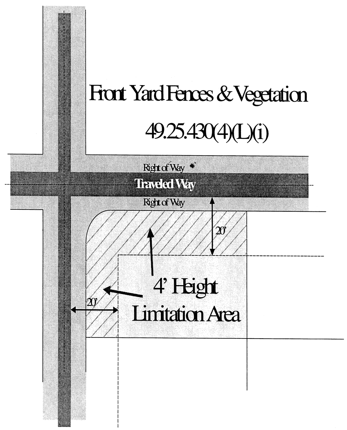
Fences and vegetation. For this section a "traveled way" is defined as the edge of the roadway shoulder or the curb closest to property.
(i)
The maximum height of a sight obscuring fence or vegetation shall not exceed four feet within 20 feet of the edge of the traveled way. Trees are allowed within 20 feet of the edge of the traveled way provided they do not obscure view from a height of four feet to a height of eight feet above the ground;
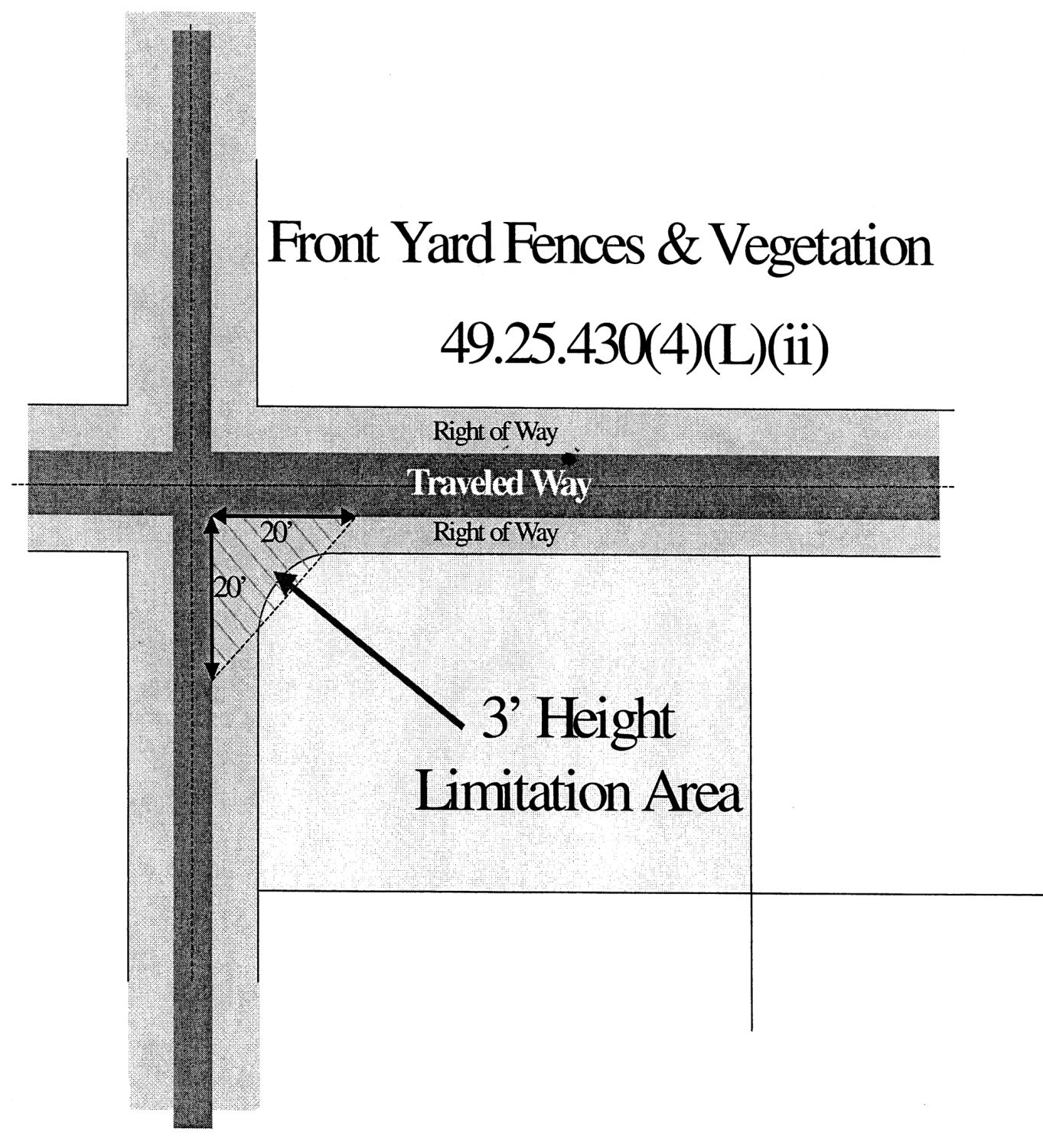
(ii)
On corner lots the maximum height of a sight-obscuring fence or vegetation located within 20 feet of a street intersection shall not exceed three feet. The area in which sight-obscuring fences and vegetation is restricted shall be determined by extending the edge of the traveled ways to a point of intersection, then measuring back 20 feet, then connecting the points. In this area, vegetation shall be maintained to a maximum height of three feet. Trees are allowed in this area provided the trees do not obscure view from a height of three to eight feet above the ground.
(M)
Additional stories. The commission, through the conditional use permit process, may allow the addition of a second or third story atop or below an existing enclosed structure which projects into a required yard setback if the structure is either nonconforming or if a variance was previously granted for the structure. The commission may deny such request if it finds that the structure, with the addition, would result in excessive blockage of views, excessive restriction of light and air, or other deleterious impacts.
(N)
Parcels adjoining publicly owned land. The commission, through the conditional use permit process, may allow structural projections into required side or rear yard setbacks if the affected yard adjoins publicly owned land which has been placed in a park, open space, or similarly restrictive land management classification; provided such projections are minimized and are necessary to prevent substantial hardship to the applicant. The commission may deny such requests if it finds that the structure, with the addition, would result in excessive blockage of views, excessive restriction of light and air, or other deleterious impacts.
(O)
Energy efficiency. Energy efficiency improvements that do not increase interior square footage, such as exterior insulation, may project up to eight inches into a required yard. An energy efficiency improvement may not be approved under this section if it projects into the right-of-way or across a property line.
(5)
Replacement and reconstruction of nonconforming structures. The replacement and reconstruction of nonconforming structures in residential districts shall be governed by chapter 49.30.
(6)
Maintaining building façade continuity. A new building in the NC or MU3 zoning districts shall have a front yard setback and street side yard setback equal to the average front yard setback of the three closest conforming buildings sharing a frontage and within a 150-foot radius.
(7)
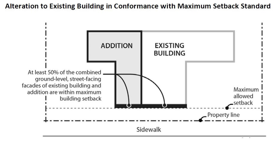
Maximum building setback for NC and MU3. At least 50 percent of the length of the ground level, street-facing façade of a new or altered building shall be within the maximum setback for the underlying zoning district. Where there is more than one building on a lot, the maximum standard applies to the combined ground level, street-facing façades of all the buildings.
(8)
NC and MU3 parcels abutting residential zoning districts. When a building 15 feet or taller in the NC or MU3 zoning district abuts a residential zoning district the following setbacks and landscaping requirements apply:
(Serial No. 87-49, § 2, 1987; Serial No. 89-05, § 2, 1989; Serial No. 91-03, § 3, 1991; Serial No. 95-33, § 7, 1995; Serial No. 97-49, § 2, 1998; Serial No. 2004-13, § 3, 9-27-2004; Serial No. 2006-15, § 4, 6-5-2006; Serial No. 2007-40, § 3, 6-25-2007; Serial No. 2012-36, § 2, 9-17-2012; Serial No. 2015-03(c)(am), § 20, 8-31-2015; Serial No. 2018-06, § 2, 3-5-2018, eff. 4-5-2018; Serial No. 2019-37, § 3, 3-16-2020, eff. 4-16-2020; Serial No. 2021-28, § 6, 8-23-2021, eff. 9-22-2021; Serial No. 2021-35(am), § 5, 2-7-2022, eff. 3-10-2022)
Cross reference— Right-of-way encroachment permits, CBJ Code ch. 62.55.
49.25.440 - Lot coverage.
Notwithstanding the lot coverage standards set forth in section 49.25.400, in the RR, rural reserve district, and the D-1, residential district, if the area of a lot is less than the minimum lot size, the corresponding maximum lot coverage for a dwelling may be increased in the same proportion as the inverse of the ratio of the actual lot area to the required lot area, except that in no case shall lot coverage exceed 50 percent.
(Serial No. 91-50, § 2, 1991)
49.25.500 - Density.
The maximum number of dwelling units allowed per acre shall be as provided in the following table:
(Serial No. 87-49, § 2, 1987; Serial No. 98-02, § 2, 1998; Serial No. 98-09, § 6, 1998; Serial No. 2007-39, § 10, 6-25-2007; Serial No. 2010-22, § 4, 7-19-2010; Serial No. 2012-24, § 4, 5-14-2012, eff. 6-14-2012; Serial No. 2021-35(am), § 6, 2-7-2022, eff. 3-10-2022)
49.25.510 - Special density considerations.
(a)
Fractions of units. If a density calculation results in fractions of dwelling units allowable, such fractions shall be rounded to the nearest whole number.
(b)
Factors precluding maximum density. The number of units allowed by section 49.25.500 is a maximum, achievement of which may be prevented by other factors, including topography, dimensional standards or dedication requirements.
(c)
Mobile home subdivisions. Mobile home subdivisions shall meet the density requirements of the zoning district in which they are located, regardless of the lot size allowed.
(d)
Two-unit dwellings.
(1)
Duplexes. The minimum lot size for a duplex dwelling shall be at least 150 percent of the square footage required for a single-family dwelling in the same zoning district, except in multi-family, mixed-use, and commercial zoning districts, where duplexes may be constructed on any lot of sufficient size for two dwelling units.
(2)
Reserved.
(e)
Detached single-family dwellings. Two detached single-family dwellings located on a single lot within the Rural Reserve D1 and D3 zoning districts shall each meet 100 percent of the applicable square-footage requirement.
(f)
Reserved.
(g)
Duplex and common wall structures. The commission, through the conditional use permit process, may allow duplex and common wall structures on lots of less than the required size if the applicant can demonstrate that the same number of dwelling units already exist on the lot or may lawfully be created on the lot as a result of the nonconforming development provisions of chapter 49.30. Applications of this provision include the following:
(1)
Common wall subdivision lots of less than the required size may be created if the original parcel contains a common wall structure that was lawfully built and all other common wall structure requirements can be met.
(2)
A duplex or a two unit common wall structure may be built on a pair of existing lots of record which together are less than the required size for a duplex or a two unit common wall structure, provided each of the lots could have been developed with a single-family dwelling when the lots were created.
(h)
Building a two unit common wall structure. The commission, through the conditional use permit process, may approve the building of a two unit common wall structure on less than the required lot area if the lot was legally platted prior to November 9, 1987; the subdivision or a portion thereof was designed specifically for two unit common wall structures; and 60 percent or more of the lots in the subdivision or of the portion thereof designed specifically for two unit common wall structures have been developed with two unit common wall structures.
(i)
Subdivision rights-of-way. In calculating the number of dwelling units and thereby the number of lots allowed within a proposed single-family subdivision, any proposed rights-of-way shall be included in the total square footage of the parcel. In multifamily subdivisions, rights-of-way shall not be so included.
(j)
Single-room occupancies with private facilities. A permit to construct single-room occupancies may be issued by the Director or the Planning Commission, as specified in the Table of Permissible Uses, CBJ 49.25.300, if all of the requirements of this subsection are met.
(1)
Single-room occupancies shall be efficiency units not exceeding 400 square feet in net floor area.
(A)
Areas common to more than one dwelling unit, including entry ways, furnace rooms, laundry rooms, common storage areas, and interior stairways, shall not be included in the computation of net floor area.
(2)
Each single-room occupancy with private facilities shall count as one-half of a dwelling unit for purposes of calculating density, permitting requirements, and land use permit application fees.
(Serial No. 87-49, § 2, 1987; Serial No. 89-33, § 2, 1989; Serial No. 91-01, § 2, 1991; Serial No. 94-07, § 4, 1994; Serial No. 95-33, § 8, 1995; Serial No. 97-49, § 3, 1998; Serial No. 2001-12, § 3, 4-2-2001; Serial No. 2006-15, §§ 5, 6, 6-5-2006; Serial No. 2007-39, § 11, 6-25-2007; Serial No. 2009-22(b), § 3, 10-12-2009; Serial No. 2012-24, § 4, 5-14-2012, eff. 6-14-2012; Serial No. 2012-36, § 3, 9-17-2012; Serial No. 2015-7(b)(am), § 5, 2-23-2015, eff. 3-26-2015; Serial No. 2019-37, § 4, 3-16-2020, eff. 4-16-2020; Serial No. 2025-15am, § 2, 4-7-2025, eff. 5-6-2025)
49.25.512 - Accessory dwelling units (ADUs).
(a)
Permit. An ADU permit is required for the creation of an ADU.
(1)
ADU permits require an application. The application must be completed and submitted to the department on a form provided by the department.
(2)
An application must be filed with any required fees, scale-drawn site plans and floor plans, and any other materials required by the department at the time of submittal to be considered complete. Incomplete applications will not be considered.
(b)
ADU development standards. ADUs are subject to the following development standards:
(1)
Density. ADUs are exempt from the density requirements of the underlying zone district.
(2)
Number of ADUs.
(A)
One ADU per principally permitted residence is allowed and up to two ADUs per parcel.
(3)
Relationship to principal structures.
(A)
An ADU may be within, attached to, or detached from a single- or multi-family residential structure.
(B)
An ADU must contain complete independent living facilities for one or more people.
(C)
If a lot contains an existing single-family home 1,000 square feet in size or less, the existing home may be designated as an ADU as part of a project to construct a new single-family home on the lot.
(4)
Lot size, lot coverage, height, and setbacks.
(A)
ADUs are not subject to minimum lot size or minimum lot width standards.
(B)
ADUs are subject to the same lot coverage standards that apply to primary dwellings in the underlying zone district.
(C)
ADUs are subject to the same height standards that apply to primary dwellings in the underlying zone district.
(D)
ADUs are subject to the same front and side setbacks that apply to primary dwellings in the underlying zone district.
(E)
ADUs are subject to a minimum five-foot rear yard setback. If the underlying zone district's rear yard setback standard is less than five feet, the smaller setback applies.
(F)
ADUs created through the conversion of an existing legal structure which does not conform to height and setback standards are considered to be in compliance if the conversion does not make the existing legal structure more nonconforming.
(5)
Maximum unit size.
(A)
A detached ADU may not exceed 1,000 square feet in net floor area.
(B)
An attached ADU may not exceed 1,000 square feet or 40 percent of the floor area of the principal residential structure, whichever is greater.
(C)
Areas common to more than one dwelling unit - including entry ways, furnace rooms, laundry rooms, and interior stairways - are not to be included in net floor area calculations.
(6)
Parking. ADU parking is governed by 49.40.210 with the following exception:
(A)
When an existing covered parking space is converted into living space for an ADU, replacement parking is not required for the eliminated parking space.
(Serial No. 2025-15am, § 2, 4-7-2025, eff. 5-6-2025)
49.25.514 - Caretaker units.
(a)
Permit. A permit is required for the creation of a caretaker unit.
(1)
Caretaker unit permits require an application. The application must be complete and submitted to the department on a form provided by the department.
(2)
An application must be filed with any required fees, scale-drawn site plans and floor plans, and any other materials required by the department at the time of submittal to be considered complete. Incomplete applications will not be considered.
(b)
Caretaker development standards. Caretaker units are subject to the following development standards:
(1)
Accessory use.
(A)
The caretaker unit, whether attached or detached to a principal structure, is an accessory use to the principal use of the lot upon which it is located.
(2)
Residency.
(A)
In order to qualify as a caretaker unit under this Code, the unit must be used exclusively as a residence by a caretaker and their family.
(3)
Lot size, lot coverage, height, and setbacks.
(A)
Caretaker units are subject to the lot coverage, height, and setback requirements of the underlying zone district.
(B)
Caretaker units are exempt from lot size requirements of the underlying zone district.
(4)
Density.
(A)
Caretaker units are exempt from density requirements of the underlying zone district.
(5)
Number of caretaker units.
(A)
One caretaker unit per lot is allowed.
(6)
Size.
(A)
The maximum size of a caretaker unit is 1,000 square feet in net floor area.
(B)
For attached caretaker units, areas shared with the principal use - including entry ways, furnace rooms, laundry rooms, storage areas, garages, workspaces, and interior stairways - are not to be included in the computation of the net floor area.
(Serial No. 2025-15am, § 2, 4-7-2025, eff. 5-6-2025)
49.25.520 - Multiple buildings; density determinations.
The number of dwelling units allowed on a lot in a multifamily zone shall be determined pursuant to this chapter without regard to whether the units are constructed in the same building or different buildings.
(Serial No. 87-49, § 2, 1987)